ps rainbow 1860 - 1864 maritime archaeological survey · ps rainbow 1860 - 1864 maritime...
TRANSCRIPT

PS Rainbow 1864: Maritime Archaeological Survey Page 1
PS RAINBOW 1860 - 1864
Maritime Archaeological Survey
June 2004 – March 2005
Report prepared by: Sean McMahon, March 2005.

PS Rainbow 1864: Maritime Archaeological Survey Page 2
Front cover: Side Lever at wreck site. Photo Sean McMahon
Table of Contents 1 INTRODUCTION........................................................................................................................ 3
2 SURVEY AIMS............................................................................................................................ 3
3 METHODOLOGY....................................................................................................................... 4 3.1 SITE VISITS ............................................................................................................................. 4 3.2 SURVEY APPROACHES AND EQUIPMENT DEPLOYMENT ............................................................... 4 3.3 CONSTRAINTS ......................................................................................................................... 5
4 THE PHYSICAL SETTING ........................................................................................................ 6 4.1 ENVIRONMENT ........................................................................................................................ 6
5 HISTORY OF THE SITE ............................................................................................................ 7 5.1 P.S. RAINBOW ......................................................................................................................... 7 5.2 WRECK EVENT ........................................................................................................................ 9 5.3 DISTURBANCE ....................................................................................................................... 11
6 FIELD WORK ........................................................................................................................... 11 6.1 LOCATION ............................................................................................................................. 11 6.2 SURVEY RESULTS .................................................................................................................. 12
7 ASSESSMENT OF SIGNIFICANCE ........................................................................................ 17
8 FUTURE MANAGMENT.......................................................................................................... 17 8.1 CONSERVATION..................................................................................................................... 17 8.2 DISPLAY AND PUBLIC ACCESS ............................................................................................... 17 8.3 MANAGEMENT RECOMMENDATIONS ...................................................................................... 18
9 CONCLUSIONS......................................................................................................................... 18
10 BIBLIOGRAPHY...................................................................................................................... 19
Table of Figures Figure 1: Trio Boiler. Photograph by Sean McMahon ............................................................................. 3 Figure 2: Exposed timbers near Trio Boiler. Photograph by Sean McMahon ........................................... 4 Figure 3: Side Lever and baseline. Photograph by Sean McMahon………………………………………..5 Figure 4: Location map and chart of Sugarloaf Point NSW………………………………………………..6 Figure 5: Gutters leading out from the beach. Photograph by Sean McMahon……………………………11 Figure 6: Site from rock platform. Photograph by Sean McMahon………………………………………..12 Figure 7: First Cylinder. Photo by Sean McMahon………………………………………………………...13 Figure 8: Second Cylinder. Photo by Sean McMahon……………………………………………………..13 Figure 9: First Pipe. Photo by Sean McMahon…………………………………………………………….13 Figure 10: Side Lever. Photo by Sean McMahon………………………………………………………….14 Figure 11: Second Pipe. Photo by Sean McMahon………………………………………………………...14 Figure 12: Joined Pipes. Photo by Sean McMahon………………………………………………………...14 Figure 13: Shaft and Bearing. Photo by Sean McMahon…………………………………………………..15 Figure 14: Lever. Photo by Sean McMahon………………………………………………………………..15 Figure 15: Wreck site plan of observed features to December 2004……………………………………….16
PS Rainbow 1864: Maritime Archaeological Survey Page 3
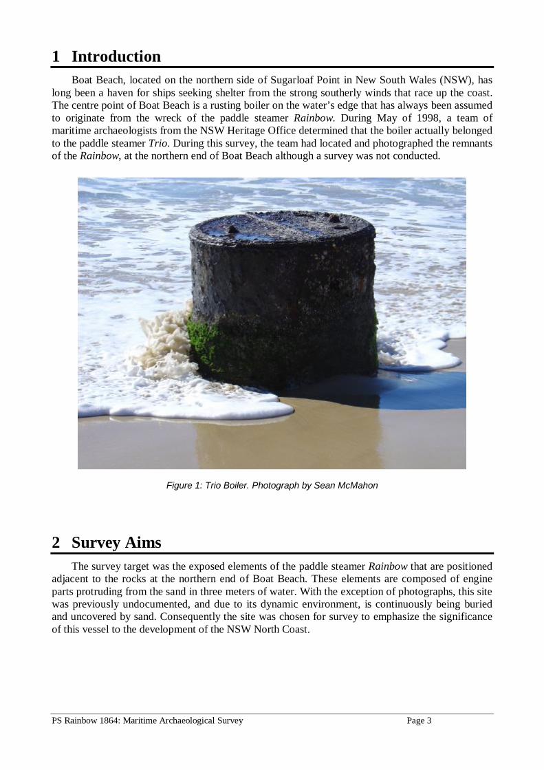
1 Introduction Boat Beach, located on the northern side of Sugarloaf Point in New South Wales (NSW), has
long been a haven for ships seeking shelter from the strong southerly winds that race up the coast. The centre point of Boat Beach is a rusting boiler on the water’s edge that has always been assumed to originate from the wreck of the paddle steamer Rainbow. During May of 1998, a team of maritime archaeologists from the NSW Heritage Office determined that the boiler actually belonged to the paddle steamer Trio. During this survey, the team had located and photographed the remnants of the Rainbow, at the northern end of Boat Beach although a survey was not conducted.
Figure 1: Trio Boiler. Photograph by Sean McMahon
2 Survey Aims The survey target was the exposed elements of the paddle steamer Rainbow that are positioned
adjacent to the rocks at the northern end of Boat Beach. These elements are composed of engine parts protruding from the sand in three meters of water. With the exception of photographs, this site was previously undocumented, and due to its dynamic environment, is continuously being buried and uncovered by sand. Consequently the site was chosen for survey to emphasize the significance of this vessel to the development of the NSW North Coast.

PS Rainbow 1864: Maritime Archaeological Survey Page 4
3 Methodology
3.1 Site Visits Survey work was conducted on the site over four separate visits. These visits were dependant
on tide and weather conditions to ensure diving could be conducted on all visits. The initial survey dive was conducted on the 26th June 2004 in which a mud map was drawn up and compass bearings and locations marks taken. The next two visits on the 9th and 10th October 2004 consisted of the survey measurements, depth recording and photography. The final visit on the 3rd December 2004 was used for photography and to confirm the drawn map.
Figure 2: Exposed timbers near Trio Boiler. Photograph by Sean McMahon
3.2 Survey approaches and equipment deployment A non-disturbance survey was carried out on the site with a focus on producing a detailed and reasonably accurate site plan. As the site was concentrated to a small area and consisted of a small number of major elements, this was achievable with the limited resources available. Thought was also given to the two anchors slipped in the bay, both with a long lead of cable, however this would require a coordinated search of a large area of the bay that was beyond the capabilities of the survey. Survey Techniques Due to the site being on a relatively flat bottom with all elements in close proximity to each other, the main underwater surveying technique employed was ‘offset surveying’. A baseline was established passing through a reference datum point located on the edge of the main side lever. This baseline was set up on the sand using star pickets and a tensioned line on a bearing of 330 degrees magnetic. Pre-established points on the mud map were measured along the baseline and then at right angles from the baseline to the features to be drawn. The features themselves were also measured and drawn to scale at a later date. This technique was chosen, as it is sufficiently accurate in the small distances encountered. Depth measurements were also taken at several points around the site.

PS Rainbow 1864: Maritime Archaeological Survey Page 5
Photography Still photographs and video footage was taken of the site as a visual aid when both the mud map and final site plan were drawn up. However no measurements were taken from either of these two mediums. Still photography was taken with a digital Sony 5 megapixal camera in an Ikelite housing. Video photography was taken with a Sony 3CCD digital video camera in a Light & Motion housing.
3.3 Constraints The remains of the Rainbow are located
against a rock wall in the surf zone of an isolated beach. Although the site was small, the environmental factors in terms of isolation and conditions provided the greatest challenge to the survey project. Access Access to Seal Rocks is via a dirt road through a National Park. While this road is in good condition and maintained due to regular tourist traffic, it can become hazardous in times of high rainfall. Boat beach is located below the small headland that the general store is located on. A narrow dirt road leads past the shop to the fishing fleet and parking area near the beach that is located at the opposite end to the wreck site. Once on the beach adjacent to the site, access is relatively easy provided the sea conditions are favorable.
Figure 3: Side Lever and baseline. Photograph by Sean McMahon
Weather & Sea The main limiting factor at the site was the tide. To be able to conduct an effective dive a full tide was required. At the top of the tide a window of around an hour was all that was available before the visibility dropped and the waves began to build. Other factors that directly influenced access were the swell and the wind. The beach itself is a reasonably large sheltered bay with a northerly aspect, protected from southerly weather. However when the wind and sea is from the north to east it can become rough with a dangerous shore break. Diving on the Rainbow wreck site required a wind either from the south or preferably from the west. West to southwest wind flattens out the bay and improves water visibility, increasing the effective time on site. These winds are most prevalent during late winter. Diving Due to the site being in only three meters of water at high tide, there are no restrictions on scuba equipment other than managing to stay on the bottom. For the majority of the survey work snorkeling was conducted, however for offset and major element measuring scuba was employed. This equipment consisted of a 25cf pony bottle mounted on a backpack with webbing straps. In a shallow site such as this the pony bottle provided over half an hour’s bottom time. Carrying four

PS Rainbow 1864: Maritime Archaeological Survey Page 6
kilograms of lead weight provided just enough stability against the surge, however it was easy to see how a ship and peoples lives were lost so close to the shore. The main constraint on the diving equipment side was transporting the gear from the car park to the site. Research Not a great deal of information was available on the Rainbow; this was most likely due to her being a small coastal vessel. The majority of information came from contemporary newspaper articles from the northern rivers of NSW with the occasional mention in shipping reference books. The most disappointing of which was the lack of a lithograph or photograph.
4 The Physical Setting
4.1 Environment The site is located near the village of Seal Rocks on the Mid North Coast of New South
Wales. This area is part of the Myall Lakes National Park and access to Seal Rocks village is via an unsealed road through the National Park from the Lakes Way at Bungwal. Although not large the village has a camping area that is predominately full during holiday periods. Fishermen and divers from as far away as Port Stevens in the south and Forster / Tuncurry in the north use the area on weekends throughout the year.
Boat Beach, where the wreck is located, is a flat sandy beach between two headlands, with Bird Rock located off the eastly headland. It is home to a fleet of beach launched wooden fishing boats operating from a small area in the center of the beach. Facing nor’nor’east the beach is sheltered from southerly weather, however very exposed to north eastly winds, which quickly build up a large surf. The rocks located at each end of the beach are angular and run out in a series of parallel gutters from the beach.
Figure 4: Location map and chart of Sugarloaf Point, NSW

PS Rainbow 1864: Maritime Archaeological Survey Page 7
5 History of the Site
5.1 P.S. Rainbow The side wheel paddle steamer Rainbow represents one of the first steamships to operate on
the on the New South Wales north coast. She was built on the Macleay River in 1860 by a Mr Cocoran and owned by a Mr Marshall of Balmain. Her registration number was 33/1860 and official number was 36852. Constructed of timber, Rainbow was rigged as a two masted schooner and was 39 meters long, 6 meters wide and with a draft of 2 meters. She had a registered gross tonnage of 110 and a net tonnage of 75 (Richards, M., 1980, North Coast Run). Her machinery consisted of a ‘high pressure’ boiler and a pair of side leaver engines by Young and Mather, providing 70 horsepower (The Clarence & Richmond River Examiner, 28 April 1863).
In early 1863 the Clarence and Richmond River Steam Navigation Company (C.R.R.S.N. Co) purchased the Rainbow for the sum of ₤4000. They intended to use her for coastal trade between the northern rivers and ports to the south, notably Sydney. Following repairs and alterations at a further cost of ₤1000, Rainbow made her first voyage to the northern rivers under new owners in April of 1863. She was under the command of Captain Petley who was a well-known commander in the Hunter River Company’s steamers. The Rainbow was licensed to carry 75 passengers, out of which 17 were accommodated in the cabin. The Clarence and Richmond River Examiner heralds the arrival of the Rainbow in their 28th April 1863 edition however they give an unfavourable review of her as a sea going vessel:
“The Rainbow left Sydney on Friday week, called at Newcastle; left there at 4 p.m , on Saturday, and came as far as Smokey Cape, where she arrived at 6 30 p.m , on Sunday, when she encountered a very heavy gale from the N.E.,E.S.E., with high sea running, which continued up to Tuesday, at 8 p.m., when it increased in violence, and Captain Petley deemed it prudent to place the vessel before the wind, which he did, and ran back to Newcastle, arriving there at 2 p.m., on Wednesday ; and left again on Thursday morning, at 8 a.m. ; arrived off the Clarence bar, at 2 p.m., on Saturday, but owing to the strong current, occasioned by the fresh in the river, was unable to take the bar, and was compelled to lay too off the heads all night and came in at 1 p.m., on Sunday.
In our opinion the Rainbow is about the most ill adapted vessel for the trade she is intended that it is possible to conceive, not having sufficient power as a sea-going vessel to steam against a head wind, although with a fair wind she can sail remarkably fast. Of her speed there can be no doubt – she is miserably slow. As an instance, the Rainbow left the Heads in company with the Ulmarra, and when the latter entered the mouth of the channel of the South Arm, after calling at Rocky Mouth, the Rainbow was not in sight ; and after passing through South Arm, the Ulmarra reached Grafton fully half an hour before her.
The Rainbow left for the lower part of the river yesterday to take in a load of fresh corn, and proceed to Sydney direct. On her return she will be employed droughing on the river, but is, we believe, ultimately intended for the Richmond River trade, but how far she is likely to answer the expectations of either the Company or the settlers time will tell” (The Clarence & Richmond River Examiner, 28 April 1863).
Also appearing in the 28th April 1863 edition of the Clarence and Richmond River Examiner was a separate article regarding the Rainbow’s crossing of the Clarence river bar. Titled ‘Excursion to the Heads’ the article show the Rainbow’s inability to cross the bar became an excuse for a few Grafton residents to spend a weekend on the river. It also gives an insight into the rapidly changing face of the northern rivers as the European settlers moved in.
“Some misapprehension having been felt as to the safety of the Rainbow, and being desirous of ascertaining the state of the bar, it was resolved by a few gentlemen to endeavour to induce the agent to allow the Ulmarra to proceed to the Heads, which he did, and on Saturday morning the little craft left Fisher’s wharf at 9 a.m., and after calling at South Grafton and Ulmarra proceeded down the North Arm to Rocky Mouth, and thence the Heads, where she arrived at 3 p.m. the same afternoon. The passengers were all quickly landed and the Rainbow, at that time, was off the bar. Having remained at the Heads during the night, the Ulmarra got up steam, and after waiting to see the Rainbow safely enter, left her moorings at 1 p.m. on Sunday, and steamed up the river as far as Rocky Mouth, where having taken a

PS Rainbow 1864: Maritime Archaeological Survey Page 8
mail on board, she proceeded up the south Arm, to Grafton, thus affording her passengers an opportunity of viewing those beautiful but hitherto very little known parts of our most magnificent river, which is now thickly studded with new settlers – the thick scrub of which is giving way to the strong arm of the yeoman, and in lieu of scrub the banks are waving with corn crops. The excursion passed off admirably, every one being pleased with the trip ; and the reception met with at the Heads, far exceeded the most sanguine expectations of the visitors ; but the residents at the Heads have become proverbial for their hospitality. We trust that on some future occasion a public excursion will be got up, in order to allow our townsfolk to view the beauties of the North and South Arms. Captains Creer and Maides accompanied the steamer, and universal satisfaction was manifested on learning the Rainbow was safe. The Ulmarra reached Fisher’s wharf at 9 p.m. on Sunday, when the company quietly dispersed, highly delighted with their trip” (The Clarence & Richmond River Examiner, 28 April 1863).
The following is a list of items unloaded from the Rainbow upon arrival at Grafton and it gives an indication of how reliant the settlers were on these little ships. Of note is that the newspaper printed the name of the local recipient along with the goods they received.
39 bags sugar, 120 bags flour, 10 cases jams, 10chests tea, 2 truck boots, 1 case sundries, 11 bags salt, 6 boxes tobacco, 2 packages, 2 casks biscuits, 1 case confectionary, 1 case ironmongery. R. Dixon
1 quarter-cask cherry, 1 hogshead rum, 4 casks bottled beer, 4 cases brandy, 4 cases old tom, 4 cases gin, 2 cases cyder, 1 case pickles, 3 bags sugar, 1 box soap, 1 case, 1 quarter-case wine, 1 bag salt, 6 half-chests tea. E. Loveday
1 bag potatoes, J. Bryce ; 2 packages hops, 1 chest 2 half-chests 2 boxes tea, 2 boxes candles, 1 box raisins, 40 bags flour, 10 mats sugar, 2 cases, 1 case matches. F. Gare 16 bags sugar, 10 boxes soap, 2 half-chests tea. L. J. Smith 20 bags rice, 7 mats sugar, 6 bags salt, 1 chest 4 boxes tea, 3 boxes soap, 1 case vestas, 1 case 1 cask ironmongery, 1 truss drapery, 1 case saddlery, 1 package paper. G. Wilson 2 cases, 1 can oil, 1 quarter-case 4 cases brandy, 2 cases whisky, 1 box candles, 2 boxes soap. Weir 10 bags flour, 4 bags bran. Bundock Barnes and Co. 2 cases, 1 tin, 1 box. J. Proctor 10 bags flour, 4 casks beer, 1 box, 2 boxes soap, 1 case rasins, 1 half-cask currents, 1 case kerosene, 1 case tinware, 4 chests tea, 1 half-keg tobacco, 2 cases pickles, 2 cases soap, 1 drum tar, 4 dray boxes, 1 truss, 1 case, 2 spades. H. Gordon (The Clarence & Richmond River Examiner, 28 April 1863)
The Rainbow served the Clarence and Richmond River Steam Navigation Company for a year and a half before her loss. Her final voyage north to the rivers was linked to the area where she would shortly be lost. The Breckenridge faimly were pioneers in the Great Lakes Region of NSW, particularly the development of Forster and Tuncurry. In 1857 James Breckenridge set up a steam sawmill at Pumpkin Point, four miles down the Karuah River from Stroud. In 1864 he set out for the Richmond River and found a spot at Wyrallah for the establishment of a milling village and by May much of the machinery at Pumpkin Point was awaiting transport. James chartered the paddle steamer Rainbow and took his people and machinery to the Richmond establishing the Wyrallah sawmill complex. It was on the return journey to Sydney that the Rainbow, having picked up passengers and a cargo of timber, was lost (Great Lakes Historical Society Ltd, Australia).

PS Rainbow 1864: Maritime Archaeological Survey Page 9
5.2 Wreck Event On Thursday 2nd and Friday 3rd June 1864 a fierce southerly gale raced up the NSW coast.
The aftermath of this gale was the loss of four ships, with the most serious in regards to loss of life, being the Rainbow. A detailed report on the loss of the Rainbow appeared in the Sydney Morning Herald on the 8th June 1864, with follow up stories contained in the 10th and 11th June editions. The news however took almost two weeks to reach the people of the Northern Rivers. The following article was published in the Clarence and Richmond River Examiner on the 14th June 1864:
“By telegram, we learn that the C. and R. R. S. N. Company’s steamer Rainbow has been lost ; but the information that has reached us is of a very meagre character, and gives no particulars ; nor has the Manager of the Company, even condescended to furnish their own local agent with any information on the subject. We presume, however, that she must have been on her passage from Sydney to the Richmond River, for as will be seen on reference to our shipping column, she left the Richmond River for that port on the 28th ultimo. We are not aware of the number of hands lost, but we regret to state that amongst those who have perished are Mr. and Mrs. Rankin, the National school teachers at Lismore, who were passengers at the time. We understand the vessel was wrecked in the early part of last week, and we presume that had the overland mail been able to travel, we should have been in a position to publish all the particulars in to-day’s issue” (The Clarence & Richmond River Examiner, 14 June 1864).
Of note is that the newspaper assumes the Rainbow was on her return voyage north at the time of her loss. A full five days had elapsed between her clearing the Richmond River bar at Ballina and her loss at Seal Rocks. The Clarence and Richmond River Examiner then publishes a full account of the loss of the Rainbow in the 21st June edition. This article is almost identical to the Sydney Morning Herald’s 8th June article except it contains additional details relevant to the Northern Rivers. The following is a transcript of Captain Petley’s account of the voyage taken from this article, including the reason for the delay travelling south:
“The Rainbow left the Richmond River on Saturday, the 28th May, at 8 a.m., with a light southwest breeze, which shifted to southeast and blew a perfect gale. During the night the vessel stood to off the land under fore and aft canvas; on Sunday at 8 a.m., wore ship and steamed to the southward. On Monday morning the weather was fine, with a fresh southerly breeze, the ship close in shore, standing into Trial Bay, where she came to anchor, at 6 p.m. and remained until, Wednesday, at 2 p.m., when she got underway with a light breeze from sou’sou’west. On Thursday morning a fresh gale came up from the southward, and the vessel took shelter in Seal Rocks Bay. 8 p.m., the night very dark and blowing fresh from the southwest, gave the ship fifteen fathoms more chain, and got the chain ready for slipping, if required during the night, a reef being in the trysail, and everything being ready for any emergency ; kept the steam well up , my barometer not indicating any sudden change. At 10 p.m., while speaking to the engineer, it suddenly chopped round to the E. and E. N. E., with a heavy sea coming in with the wind ; called all hands, and jumped on the bridge, and Mr Hunter, the engineer, went to the engines ; the steam full up, turned ahead instantly to slip and get out if possible, as the sea commenced rolling in fearfully, but as the engines went a-head, a heavy sea caught her on the port bow, and snapped the port chain ; as her head slew off rapidly for the rocks, I instantly let go the anchors, which brought her head up to the sea again, and turned a-head full speed, and the chain began to slack, but almost instantly with her moving a-head, a fearful sea broke right abreast, driving in the port bulwark, forecastle, and gangway, carrying everything before it. I saw the only chance was to slip the starboard chain and get her on shore in the best possible place to save life, the wind blowing a hurricane, with fearful thunder and lightening, and tremendous sea. I called to Mr. Hunter, the chief engineer, to give her all the steam he could, and well and nobly did he stand to the engines. Passing out the starboard chain, she seemed to draw a-head into the little bay. By this time several of the hands were on the bridge with me, we being fearfully close to the tremendous breakers on the rocks at the west end of the bay. As we drew a-head a little, a heavy sea broke aboard, carrying away the deck-house and everything aft. The next sea brought us down fearfully on the rocks, the bridge and everything breaking up. In the heavy flash of lightening, I saw the rocks almost bare on the starboard bow, and the mate and seven of the hands jumped ashore and got up the rocks. Another fearful sea then broke over everything, smashing up right and left. At that time there was Thomas Laws, steward ; James Todhunter, cook ; and myself hanging on to the foretrysail yards ; the foremast still standing. I helped them along the gaff and yards as soon as possible; at this time the squall was fearfully heavy with wind and rain, and lightening very vivid and bitter cold. The cook was strong and active, but poor Laws, the steward very weak and dispirited, begging of us not

PS Rainbow 1864: Maritime Archaeological Survey Page 10
to leave him ; we told him we were not going to, and it would all be right yet. The foremast then came down on the portside with a crash, and we were lifted bodily higher up. The last chance was come – the chain cat-stopper was hanging down from the bow, and as the heavy sea receded from the rocks the cook dropped down by the stopper. We then passed poor Laws over the bows to him and he got him in his arms, but he seemed perfectly helpless. I then attempted to go, but another fearful sea came over everything, tearing the bows asunder, and carrying me right down in the middle of it. I got severely knocked about, and felt my left arm and leg nearly crushed, but held on hard with the right arm, as I had never let go the cat stopper. After recovering a bit, I found I could do nothing but hold on as long as I could, the bone of the left leg bare ; I remained thus till about four a.m., next morning, when I managed to crawl up the sand and rocks from the small remainder of the wreck, and get up out of the reach of the sea. During this time the gale, if anything, increased in violence. When daylight broke, a fearful scene of wreck and ruin presented itself, everything crushed up, and the timber high up on the rocks and beach. When broad daylight came I found the cook hanging to the rock close to me. He told me poor Laws was washed out of his arms in the last heavy sea, and himself knocked about greatly. The mate and the men came down to me and a truly miserable appearance all had. I then found Mr. and Mrs. Rankin (teachers of the National School, Lismore) and Professor Testo, passengers ; Ellis, Elliott, G. Phillips, Thomas Laws, and Mr. Hunter (chief engineer and brother of Mrs. D. Stewart of Ulmarra), were missing” (The Sydney Morning Herald, 8 June 1864).
The initial report by the Sydney Morning Herald on the 8th June lists a total of seven people drowned; three passengers and three crew with one other unnamed crewmember also drowned. The Herald’s 10th June edition adds two more names to the list, crewmembers Ellis and Phillips bringing the total drowned to eight. The Clarence and Richmond River Examiner’s 21st June article states in its opening paragraph that seven people perished. As this article goes on to list the full eight names of those who died, it seems the original number stated comes from the Sydney Morning Herald’s 8th June article, as both opening paragraphs are identical. Captain Petley was also badly injured in the wreck and he continues his story:
“I told them (the crew) I was severely injured, and they must carry me up a little higher. As there was no food or any possibility of getting any, the crew and mate then left for Port Stephens. The cook came to me, and told me he would stick by me till assistance came – this was Friday morning. We then remained (the cook and myself), without covering or any fire, on the beach till Sunday morning. When I found neither of us could hold up much longer, the cook started by himself for Port Stevens to get assistance for me, and I remained by myself till 2 p.m. on Monday, when Mr. Burrell and his son made their appearance, having been attracted by part of the wreck. They in the kindest manner put me on their horse, and took me home ; Mrs. Bramble finding me a dressing for my leg, which was very bad, and promised me to go out directly on the track of the cook. On coming down the Myall lakes into Port Stephens, in Mr. Bramble’s boat, we fell in with the Telegraph ketch, they had got the cook on board, and had everything ready for a search for me in the morning. We landed in the evening at Mr. Myer’s, about thirteen miles from Raymond Terrace, who kindly entertained us, and drove us on the Terrace in time for the Collaroy. On arriving at Newcastle, Captain Allen, the harbour master, told me the crew had gone down to Sydney by the previous day’s boat, and immediately he heard from them about the wreck he had sent the Government steam tug Dorothy to Rock Bay in search of us” (The Sydney Morning Herald, 8 June 1864).
After walking for sixty miles, the mate and crew arrived on the north side of Port Stephens on Saturday 4th June. Exhausted, suffering from exposure and a lack of food and water they were forced to remain here for a further twenty-four hours while they attempted to attract the attention of passing vessels. Eventually the crew of the schooner Roderick Dhu (wrecked in Newcastle bight in 1866) spotted them and transported them to the opposite shore. The master of the Roderick Dhu, on hearing of the condition in which Captain Petley had been left on the beach, set sail for Seal Rocks leaving the survivors to walk overland once again. They arrived in Newcastle at 10.30 a.m. on Tuesday 7th June where Captain Allen, the Harbour Master, supplied them with food and clothing. A passage was soon organised for them on the Coonanbara and they arrived in Sydney on the Tuesday evening.

PS Rainbow 1864: Maritime Archaeological Survey Page 11
5.3 Disturbance The Rainbow was not insured at the time of her loss and no records of her fate after the loss
were found. It is likely that the wreck was put up for public auction, however as the engines and boiler were not removed, it is possible that no salvage attempts were made. Local settlers may have utilized wreckage washed up on the beach as Captain Petley’s rescuers were attracted to the area by the wreckage, however no evidence exists of salvage attempts to date. Any ‘items of value’ if they still remain in situ, would be located well under the sand and present no temptation of removal or interference to the site.
In 1870, six years after the Rainbow’s loss, the paddle steamer Trio was wrecked on the beach a few hundred meters from the Rainbow and her boiler is still visible at the waters edge today. During 1896 the Sydney based salvage ship Sophia Ann was recovering gold sovereigns from the wreck of the SS Catterthun and spent weeks at a time anchored in the bay waiting for suitable conditions to continue with the salvage.
6 Field Work
6.1 Location The wreck is located in 2 - 3 meters of water against the rocks at the western end of boat
beach. Due to its close proximity to the shore and lack of suitable marks the easiest way to locate the site is to enter the water against the rock wall and swim through the surf approximately 100 meters until the side lever is located. This is the central object to the site and the edge of which was used as the datum for the wreck site plan.
Figure 5: Gutters leading out from the beach. The wreck site is located near the gutter’s further most tip in this photograph, which was taken at low tide. Photograph by Sean McMahon

PS Rainbow 1864: Maritime Archaeological Survey Page 12
Figure 6: Site from rock platform. Photograph by Sean McMahon
6.2 Survey Results The survey of the site revealed the exposed elements have been dispersed by wave action, with
smaller items moved inshore. The larger side lever and two cylinders are located in close proximity to each other, which seems to indicate the point that the Rainbow came to rest. In Captain Petley’s account of the wreck he stated that the Rainbow grounded facing bow to shore with seven of the crew climbing over the side and onto the rocks. The seas described would have driven a timber vessel with only a two-meter draft well inshore. There also exists the likelihood that a portion of the hull remains beneath the sand as timbers from the Trio wreck, which also lay in the surf zone, are exposed from time to time. However as this was a non-disturbance survey no attempt was made to prove this.
The visible remains consist of eight items; all engine parts, and appear to be constructed from cast iron. They all have a thick covering of concretion and marine growth. Despite its location within a surf zone, the site is stable with all items remaining submerged even at the lowest tides and well protected by the concretion. Sand movement does take place, however due to large rocky headlands at each end of the beach it is minimal and not likely to expose any deeper buried elements. The visible items are listed below commencing from the seaward or northern side of the site.

PS Rainbow 1864: Maritime Archaeological Survey Page 13
1st Cylinder This is the more intact of the two cylinders and appears to have slide guides still attached to the piston shaft. It also has what appears to be a slide valve attached to the cylinder body. This item is most likely constructed of cast iron.
Figure 7: First Cylinder. Photo by Sean McMahon
2nd Cylinder This cylinder is lying against the side lever and has a half-rounded hole on its side. It also has what appears to be a slide valve attached to the cylinder body. This item is most likely constructed of cast iron.
Figure 8: Second Cylinder. Photo by Sean McMahon
1st Pipe Protruding from the sand near the side lever it has an outer diameter of 150mm. This pipe has an unusual shaped flange protruding from one side only. It is difficult to tell what this item is made of due to the thick concretion. This concretion gives the appearance that it is cast iron rather than a more likely copper pipe. During December of 2004 a rounded piece of shiny brass was noticed at sand level between this pipe and the side lever. It appeared to be relatively large under the sand and well secured to the site. Figure 9: First Pipe. Photo by Sean McMahon

PS Rainbow 1864: Maritime Archaeological Survey Page 14
Side Lever This is the most obvious item at the site and the eastern edge of which was used as the datum point for the survey. The lever has a good layer of concretion however the ‘design’ on the face of the lever is visible. It is two meters long, 400mm wide at the center and 120mm thick with three 80mm holes in it. The center hole appears to be still attached to a section of the engine and comes together near the second cylinder under the sand. Figure 10: Side Lever. Photo by Sean McMahon
2nd Pipe This pipe is located underneath one side of the side lever running north / south. It is the same size as the 1st pipe and also has the same strange shaped flange. It is also appears to be constructed of cast iron due to the concretion.
Figure 11: Second Pipe. Photo by Sean McMahon
Joined Pipes Located further inshore from the previous items they are protruding from the sand and joined by a long flange. This is a possible explanation for the flanges on the first two pipes. Again they appear to be constructed from cast iron rather than copper due to their size and level of concretion.
Figure 12: Joined Pipes. Photo by Sean McMahon

PS Rainbow 1864: Maritime Archaeological Survey Page 15
Shaft and Bearing This is an interesting item as it shows a small shaft with a 300mm wide bearing block. Both items are fused together with heavy concretion, which again gives the impression of both items being constructed from cast iron. It would seem more likely that the bearing block should be made of brass but this may not be the case.
Figure 13: Shaft and Bearing. Photo by Sean McMahon
Lever The only other lever visible at the site, it is 1.8 meters long with only two holes. This lever is located with the bearing block and is most likely constructed of cast iron.
Figure 14: Lever. Photo by Sean McMahon

PS Rainbow 1864: Maritime Archaeological Survey Page 16
Figure 15: Wreck site plan of observed features to December 2004.

PS Rainbow 1864: Maritime Archaeological Survey Page 17
7 ASSESSMENT OF SIGNIFICANCE Significance has been assessed in accordance with the nature and degree of significance of the
sites primary attributes. These attributes relate to historical, social, scientific and interpretative archaeological significance. Historical The Rainbow was one of the first steamships to be built and employed on the New South Wales Northern Rivers (Daley, L.T., 1968, Men and a River, Richmond River District 1828-1895). She is an early example of the lifeline between the coastal settlers and the rest of the colony, particularly Sydney. The Rainbow is also interwoven into the history of the Great Lakes region both before and after her loss. Social The loss of a well-known ship and eight lives including both of the school teachers from the Government School at Lismore had a large impact on the people of the Clarence and Richmond Rivers (Daley, L.T., 1968, Men and a River, Richmond River District 1828-1895). Scientific The site offers a limited scientific potential at a non-disturbance level, however there remains the potential to extract some information from the exposed elements. A disturbance survey of the engine and any remaining hull timbers would yield information on colonial timber hull construction on the northern rivers of NSW as well as early steam engine construction. This type of survey would need to be greatly justified, as the site is very stable and accessible to the general public. Interpretative The Rainbow is most significant as an interpretive wreck site. This is due to the following factors; a shallow accessible wreck site, large visible elements in a stable environment, the significance of the ship to the early settlers of NSW and the tragic loss of life so close to shore.
8 FUTURE MANAGMENT
8.1 Conservation The wreck site is not in need of conservation in the medium to long term. The exposed elements have a full covering of concretion and are well embedded in the sand. Wave action and sand movement is causing no short-term effects and minimal long-term effects. The site is well away from boat traffic and rarely visited by divers.
8.2 Display and Public Access Today the small headland that the Rainbow was wrecked against is a first stop for the majority of visitors to Seal Rocks. The community’s general store and parking area are located on top of the headland with a natural viewing area of Boat Beach and the coastline to the north. This highly photogenic location has two commemorative plinths, one detailing the loss of the Catterthun in 1895 and the other a whale stranding at Seal Rocks in 1990. The headland would be a poignant location for an interpretative plinth as it is directly above and in full view of where the disaster took place. With the right conditions the wreck site is accessible to the public and once in the water the visible remains are very noticeable. This would also help to dispel local belief that the boiler on the beach and anchor outside the general store belong to the Rainbow and not the Trio. Currently the only source of information for visitors in the area regarding the Rainbow, is the Great Lakes

PS Rainbow 1864: Maritime Archaeological Survey Page 18
Historical Society. Their informative website contains a brief account of the wreck in 1864 and references to the Trio boiler.
The Rainbow is protected as an historic shipwreck under the Commonwealth Historic Shipwrecks Act 1976. This act provides access to underwater cultural heritage sites as long as the visitor does not disturb the heritage remains.
8.3 Management Recommendations As a result of this surveys historical research and wreck inspection it is recommended that: 1. No further survey of this site is required until such time that the largely buried remains are
exposed to a greater extent. 2. A non-disturbance survey is carried out on the timber hull near the Trio Boiler when it is again
exposed from the sand. 3. Interested local groups are encouraged to look at ways to further promote the site. This would
include, but is not limited to, informing the general public of the Rainbow’s history, the ease of access to the remains and its importance as an archaeological site.
9 Conclusion The Rainbow wreck site is an archaeological link to the early days of steamship construction on
the northern rivers of New South Wales. The Rainbow was built at a time when European settlement of this region was in its infancy and throughout her short career she continued to have a large impact on these settlers.
PS Rainbow 1864: Maritime Archaeological Survey Page 19
Bibliography Clarence River Historical Society INC, Australia. Available At http://www.nor.com.au/community/museums
Daley, L.T., (1968) Men and a River, Richmond River District 1828-1895. Melbourne University Press, Carlton, Vic.
Great Lakes Historical Society Ltd, Australia. Available At Http://greatlakeshistorical.museum.com Loney, J., (1993) Wrecks On The New South Wales Coast. Ocean Enterprises, Yarram Vic.
O’rourke, J., (31 May 1998), The Boiler On The Beach, The Sydney Morning Herald, Sydney Australia.
Parsons, R., (1986), Australian Ship Owners And Their Fleets, Book One,
Richards, M., (1980) North Coast Run (Men And Ships Of The NSW North Coast). Turton & Armstrong, Wahroonga
Nsw.
The Australian National Shipwreck Database, Available At Http://Ocenas1.Customer.Netspace.Net.Au/Nsw-
Wrecks.Html
The Clarence & Richmond River Examiner 28 April 1863, Rainbow – Imports, Grafton, Australia.
The Clarence & Richmond River Examiner 28 April 1863, The Rainbow, Grafton, Australia.
The Clarence & Richmond River Examiner, 14 June 1864, Wreck Of The C. And R. R. S. N. Co.’S Steamer Rainbow,
Grafton, Australia.
The Clarence & Richmond River Examiner, 21st June 1864, Total Wreck Of The Steamer Rainbow - With The Loss Of
Seven Lives, Grafton, Australia.
The Clarence & Richmond River Examiner, 28 April 1863, Excursion To The Heads, Grafton, Australia.
The Sydney Morning Herald, 8 June 1864, The Late Heavy Gale - Wrecks Of A Steamer And Three Sailing Vessels -
With The Loss Of Ten Lives, Sydney, Australia.