prospecting rpt priske twp
TRANSCRIPT

Claim 4211126: PRlSKE
MAR 0 9 2009 GEOSCIENCE ASSESSMENT
OFFICE
AMERICAN BONANZA c.OLn CORP.
CLAIM 4211126
In SCHREIBER - PRISKE Township - ONTARIO
REPORT ON EXPLORATION CAMPAIGN
DURING SEPTEMBER 2008
November 2008. Reviewed March 5th 2009.
Michel LE GRAND. Geologist (OGQ : 426)
1200 - 3eme Avenue Ouest VAL D'OR J9P 1 VI

- .\\lLBI( AN J
-'_ r -r- .,..- -r ,T#.' ~ _" -..' ~ ~ r-: " ~ /-.1, J ~
), jl 1: IjKP C/aim4211126: PRISKE
TABLE OF CONTENTS.
1 - LOCATION AND ACCESS ..................................................................................... 1
2 - HISTORY OF EXPLORATION IN THIS AREA ....................................... 1
3 - DESCRIPTION OF THE PROPERTY ...................................................................... 3
4 -GRIDS ........................................................................................................................ 5
5 - REGIONAL GEOLOGY ........................................... " ............................................... 5
6 - 2008 FIELD WORKS ............................................................................................ 5
7 - CONCLUSIONS FROM THE 2008 CAMPAIGN ................................................ 11
Certificate ...................................................................................................................... 12
MAP 1 - Location of the property in Ontario ............................... , ...... , ...... , .. 2 MAP 2 - Claims of American Bonanza in Schreiber ..... " ................................... 4 MAP 3 - Details of field work on claim 4211126 ........... , ............. , ............. 7 - 8 MAP 4 - Location of samples in 4211126 claim ............................................. 10
APPENDIX
ALS CHEMEX CERTIFICATE

~ \ :\, I It I (AN <
,r"- -"".- .-- -,..- -~
~ :~-- ~ J> ~ r: ~ " /~.l!.jl~ , 1)1 II (lJt{p Claim 4211126: PRISKE
1 - LOCATION AND ACCESS
The present report describes the field works carried out by American Bonanza Gold Corp on claim 4211126 located on the west side of Schreiber point.
This claim is located in Priske Township, in the municipality of Schreiber, on the west side of Worthington Bay, on the North bank of Lake Superior. Worthington Bay is 4.4 km South of Schreiber village, a small town located along the Highway No 17,60 km West of Marathon. At Schreiber is an important railway station. (Map 1 on the following page)
The access to the property is by the Worthington Bay Road, a 5 km gravel road, from the highway No 17. The entry is 3.5 km east of Schreiber, 100 m east of a bridge where highway No 17 overpass the railway. The gravel road, which is a private one for the main part, was used without any improvements by American Bonanza Gold Corp in September 2007, and during the winter for exploration works carried out on their main property known as NorthShore.
From Worthington Bay is a trail reaching Mount Gwynne. Our vehicles used this trail during exploration campaigns in 2007 and 2008, crossing parcel LOC N02 and B1122. All vehicles must stop at the limit between B1122 and TB5528 1.8 km from Worthington Bay. Further, the trail is only a path for trekkers going to Mt Gwynne, and this path can be followed for 1.6 km to the North-South limit on the eastern side of the 4211126 claim. There is no trail crossing the claim 4211126 that is covered by dense forest.
Some access is also possible by boat, by accosting in some places along the shore on the south and western sides of the claim.
2 - HISTORY OF EXPLORATION IN THIS AREA.
This part describes the main discoveries on the Eastern side of this claim, where American Bonanza Gold owns the surface and mining rights. Schreiber area is one of the oldest gold camps in Ontario, where free gold was discovered. In 1898, Peter McKellar discovered gold on the Northshore property, then McKellar - Longworth Ltd discovered 14 veins and during several periods mined out some tonnage until 1932.
Northshore Gold Mines, between 1935 and 1937 produced 3.808 tons of ore containing 2.441 ounces of gold (Le. 0.641 ounce of gold per ton), and silver. An old mill was formerly built near the Lake Superior shore and according local information, the ore was sent from the hill down to the mill through a gravity spout.
1

9()"O'O''W 80'O'O'W 70'O'O"W
~ ~---------------------------------------------------------------, o p g
LO LO
ONTARIO
NORTHSHORE PROJECT
(Claim 4211126)
QUEBEC
American Bonanza Gold Corp.
Northshore Project
\ ~I rI ~ l f l
3c~"'2a:J.~~
Dale: N"" 2008
Northshore Project Location Schreiber (Ontario)
(Claim 4211126)
Fie: LocaIisation_Ortario,mxd
80 'O'O'W
2
I ("I
--
~ o o
z b p ~
Claim 4211126: PRISKE
Noranda Exploration and Hemlo Gold through an option on the property camed out geological mapping, geophysical and geochemical surveys, between 1988 and 1992; then stripping, trenching and drilling. The main part of drilling 20 holes C"NR" series) for 2494,6 m was done on a called Afric Zone and an economic tonnage was estimated to 140 000 ounces of gold.
In 1995 Santa Fe optioned the property but did not any exploration work.
Cyprus Canada Inc. explored the property in 1997. Cyprus did not evaluate totally this property and targeted mainly the Afric zone as giving the best economic future. Also Cyprus decided to explore the Christianson property on the north to find an additional tonnage for Afric zone targets: this property had received only little exploration work formerly.
Cyprus carried out geophysical surveys - IP - VLF-EM and magnetic, a humus geochemical survey and geological mapping: these works were focusing on Afric zone and similar StruCturf$ but covered also part of the present claim - at that time No 1224895.
International TAURUS Resources Inc. in 1999, acquired an option to purchase 100 % of the patented Northshore property, including the surface rights, from Autotrac Ltd. In March 2005, International TAURUS Inc. joined AMERICAN BONANZA GOLDING Corp., which became AMERICAN BONANZA GOLD Corp.
The present 4211126 claim was staked 100% in the name of American Bonanza Gold Corp, by Peplinski Michael Walter, on October 29th 2006, and recorded on November 21 st 2006. Map 2 on the following page shows the claim near the other parts of American Bonanza property in the Schreiber area.
3 - DESCRIPTION OF THE PROPERTY.
From the North-West angle according a clockwise contour we have the following points:
01 02 03 05 04
16U 478036 16U 478808 16U 478779 16U 478036 16U 477770
5402520 5402518 5401260 5402121 5402116
North-West corner North-East corner South-East corner East of Schreiber Point near Schreiber Point
Altitude of the Lake Superior is 183 m (above sea level), and the highest point in this area is Mount Gwynne at 442 m. The whole area is covered by dense forest. This claim includes 6 units and the total calculated surface is 90.8 ha.
On the following page is Map 2 showing the claim 4211126 and the other Bonanza mining properties.
3

o o <D • ... o ~ ~
0 0 co ci 0 ~ ~
:3 0 ci 0 ~ ~
478,000 479,000
J
021XlO
Legend
Property Bonanza Claims
D oren Kravchik Claims
David Christianson
Claim 4211126
478,000 479,000
480,000
I
I I
481,000
.-
_ I - 121l>!j64
, , .. ....... ..--. .. _~ I
;;- \ t CNO.
1
.'y ~ \ .... ,,- LOCNO. 2 . -------......,.
B.I1 22 t
•
BJ123
482,000
\111, rio III American Bonanza Gold Corp.
Northshore Project 30naTlza
4I!4 ICOOE
480,000
L
Date: Nov 2008
Worthington Bay Area Schreiber· Ontario
Claim Map NTS: 32POS, 32P07 . 32Pl0. 32Pll Projection: UTM Nad83 Zone 16 File : Clalm_Northshore_2mxd
481,000 482,000
,_.1011"1
- ........
"
o o o o o ~ ...,

Claim 4211126: PRISKE
4- GRIDS
One grid was formerly prepared by Cyprus and only the old Base Line appears on the Northeast comer of the claim, for around 300 m with a 1290
- 3090 direction.
On the Cyprus maps also 4 lines appear. But on the field we did not see any trace of these lines, neither in the 4111126 claim, nor on the 4205993 we walked through while following the old base line to reach our 4211126 claim.
5 - REGIONAL GEOLOGY The Schreiber area is underlain by Archean rocks, which are part of the Hemlo-Schreiber greenstone belt in the Superior Province. On the property several units appear: - a feldspar or a quartz-feldspar porphyry is the main unit on the Afric zone. The rock is pink or greyish to greenish and aphanitic or more often porphyritic with fine to medium grained feldspar crystals and quartz flecks. This unit is the main host of the Afric zone mineralization.
- Intermediate or felsic volcanics showing lightly greyish coloured tuffaceous structures.
- Mafic rocks: medium to dark greyish green colour are on the western part and were not encountered in the present DDH campaigns,
- the Northshore syenite is well developed on the northern limit of North shore Property: it is massive and unaltered; the colour is greyish with some pink to red parts.
Mafic dykes of diabase and gabbroic bodies cut these four main units. They were met in the southern part of the property during the trenching and drilling programs. These mafic rocks are barren.
6 - 2008 - FIELD WORKS
The field work was carried out by two people - the author, and Mr Luc Richard from Gracefield (Quebec) - during the period Sat September 20th 2008 to Sat 27th September 2008.
This includes 2 days for travelling from the Ontario border to Schreiber and returning (1570 km).
In fact, it was the first time the author tried to reach this claim, and we had no exact idea how was the access. As maps indicated one trail going from Worthington Bay to the NE comer of 4211126 claim, we thought access was possible through this trail. But all vehicles must stop at the Northshore property limit and then 1.6 km is to be walked to reach the claim on a very rough walking trail among big fallen rocks.
5

--,-, ,\:\ILH1( ,-\N' r-~ ~ -~ ;; -;""" ~
""' ...... ,."J ... ~ .... ,.....l_~ , I it L. ( {sliP ~ Claim 4211126: PRISKE
The main aim of our fieldwork was then to find the easiest way to carty out exploration works, which initially should include line cutting.
- By land On Sept. 21 st by entering the claim through the walking trail, we reached the NE comer and did some identification of rock types present on this part, to fmd some sulphides. We sampled some outcrops without finding evidence of mineralization. All the samples we picked up were located using GPS.
On Sept 22nd, on the NE comer of the claim, we followed some relief zone to have outcrops and
find some mineralization. This appears on the map showing the zones we walked through.
On Thr 23 rd , as the access through the NE comer was very time consuming, we followed the old
base line cut by Cyprus, walking from DDH NS 06-05 drilled by American Bonanza in 2006 to the 4211126 claim East limit. The old base line 129 - 3090 is visible but not the other perpendicular lines. This gave us access to the middle part of the Eastern limit. At this limit we followed some outcrops of mafic volcanics, located by GPS and sampled some rocks showing very weak traces of mineralization, mainly very fine pyrite.
Only a small part of the property was covered by exploration during Cyprus period.
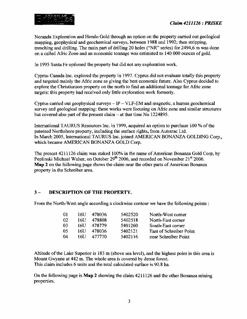
- By boat On Thu 24th, we reached the western side of the property by boat, from Terrace Bay.
Local people don't like going on Superior Lake and usually prefer the small lakes in the area. Only a few boats are big enough to go on Superior Lake. We found one boat available only for one day to explore the Southern and Western shores of Schreiber point. This kind of boat must be launched from Terrace Bay. There is no place in Schreiber.
We did not see any trail from the shore. For the main part shoreline is made of steep cliffs and because of waves we were able to accost only on 2 places to sample some outcrops.
During summer it should be possible to access the claim by canoe from Schreiber beach that is 2.6 km from the northern limit of 4211126 claim. The eastern limit is 3.2 km from Worthington Bay. A canoe will allow to stop at several places along the shore to enter the claim and to cut some lines on the property. This seems to be the best way to start an exploration program.
Maps of these different traverses carried out during these 4 days are shown on Map 3 - pages 7 and 8. Coordinates of the claim comers are described in par 3.
6

Claim 4211126 : PRlSKE
MAP 3 : DETAILS OF FIELD WORK ON CLAIM 421126 - SCHREIBER.
lliQ) '\ ns02
o _
;1PJJ1 "0
First survey on Sept 21 st (yellow)
~.~.~.~ ...... ... eo
-....... --.~
. l , 150m
Otitail de 13 carta GP
Survey carried out on Sept 22D (yellow)
7
Claim 4211126 : PRlSKE
...
• 1274ml
Examination on Sept 24 (yellow)
.1259ml
• 15llm D.ta~ de ta c ..... GPS
Two access for sampling by boat on Sept. 25 - from Terrace Bay.
8

Claim 4211126: PRISKE
- Sampling The samples locations appear on Map 4 - page 10.
Most of outcrops we observed are mafic volcanic. They are massive and dark to dark green color. Generally very fine grained, they are fresh and are unaltered. In some samples we observed very fine grained pyrite but only in very small quantities - not more than 1 %.
On the Northern limit we observed a diabase dyke: this rock is also common on the other parts of American Bonanza, near Worthington Bay: diabase is known as a barren formation.
On the southern part, along the shore some dykes of intermediate pink volcanic rocks appear. They are vertical, massive, fme grained and on the samples we gathered, do not carry any sulfides.
Samples carrying some sulphides were sent for analysis for Au by ALS Chemex in Val d'Or. The following table on Page 9, shows the results we get from these samples.
9

Sc"
Lake Superior
Claim 4211126 : PRlSKE
Jll 0
~36 ~ o !illfTh
\TIl r&' o 23 VegetatiO~
.1QQ1] ~ o Li " o :>
0
e- P
C aim 21 1126 7 7 1P .~mel"iCGI BOl.Gl.ZG
00
¢9
V"geta~ '"n
,
Vegetab"flI ~
0
0031
Location of samples in Claim 4211126 - Nbrs are the WP nbrs American Bonanza Gold Corp.
10
~
~dO
I 200 m I

- .\'\1LItI( ,,"N
~:~ ~ ~~ ;:'.~~ ;7-1~~~ ;,()) II ( (IkP Claim 4211126: PRISKE
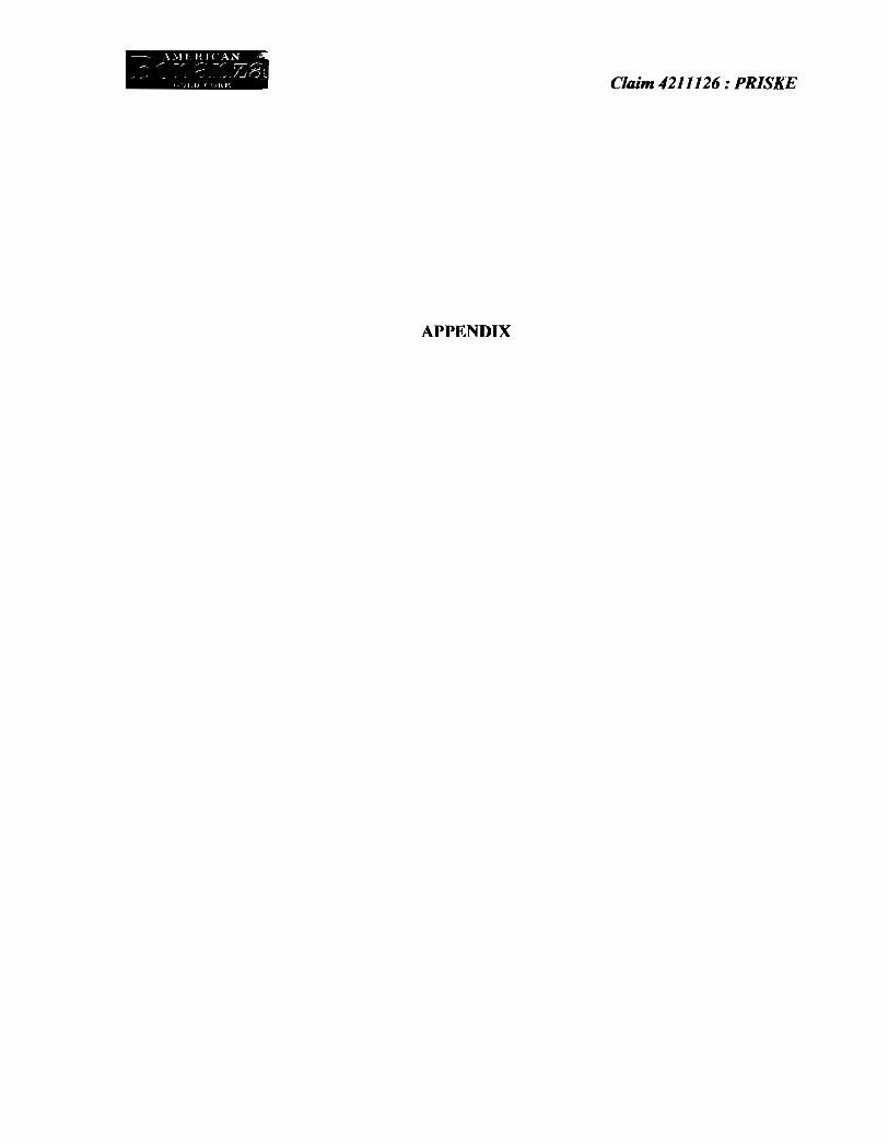
None of these samples returned any good value.
WAYPOINT ANALYSIS VALUE Au Nbr. Nbr ppm LOCATION UTM
21 418401 -0.005 16 U 478723 5402255 22 418402 -0.005 16U4786935402217
23 418403 -0.005 16 U 478679 5402198 I 13 _~_ 0.017 16 U 478762 5402409
25 -0.005 16 U 478661 5402128
27 418406 -0.005 16 U 478640 5402138 29 418407 -0.005 16 U 478605 5402168 69 418413 -0.005 16 U 478795 5401929 71 418415 0.006 16 U 478743 540~ 74 418417 0.013 16 U 478766 5401900 18 418423 -0.005 16 U 478767 5402270
36 418424 -0.005 16 U 478662 5402303 r---34 418425 -0.005 16 U 478586 5402239 88 418426 -0.005 16 U 478707 5401332
7 - CONCLUSIONS FROM THE 2008 CAMPAIGN:
The 2008 campaign we carried out was to have some sampling from the accessible points of this property, and to find an easy way and access to start an exploration program on this claim. The sampling we carried out, did not return any economic value, but this represents only a small part of the property.
For the next step of exploration, we will use a canoe to reach the western side of 4211126 claim from the Schreiber pebble beach. Some places will allow accosting a canoe and start SouthNorth lines and complete some geological and geochemical survey for Au. According what we observed, in many places overburden is only 2 or 3 m thick and previously geochemical surveys by Cyprus gave some interesting results. We recommend to complete this geochemical survey on the western part of the claim
Respectfully submitted on November 6th - 2008
Re-submitted on March OS" 2009 J
Michel Le Grand D.Sc .. P.Geo h' I ('tJ,',ft Y'-"~:f' /.~ ,vL\.. , /' f '", I ~
Consultant for American Bonanza Gold Corp. -
11

- \\lLIU( .\N r -.r- -~ -,.- -~
.. :"' _ _ ~ ~ 7_.n~ ~ i, ,j I. ((,HI' Clo:im 4211126: PRlSKE
CERTIFICATE,
I, Michel Le Grand, Consultant for American Bonanza Gold Corp. certify that :
- I am a graduate of the University Lyon (France) - Doctorat en Sciences de la Terre in 1969,
- I have practised my profession as geologist in mining exploration or in Earth Sciences since 1969 for more than 25 years,
- I am legally registered in the "Ordre des Geologues du Quebec" (OGQ) under the Nbr 426,
- I have NO beneficial interest, express or implied in American Bonanza Gold Corp or its affiliates, nor in share securities or business interest, and I do not expect any interest.
Signed in Val D'Or on November 6th - 2008
Michel Le Grand - D.Sc. - P.Geo. /)
OGQ Nbr 426 f J._ I(.'.J.!~ ~~ ~~/ ,\,.. l' . [I . __
12
- \\11 Hl< AN ~ ... r -~ ;: -r ;Z.7i
-' ___ ... -J..r."
, )J J) < ';HI' Claim 4211126: PRISKE
APPENDIX
•
•
•
-~ \'>11 HI( \N . _~ ,.- _,..-- ~ _r" -;-~-
_ ~ .Ir";'. " OJ D {uHI' Claim 4211126 : PRISKE
None of these samples returned a good value.
WAYPOINT ANALYSIS VALUE Au Nbr. Nbr m LOCATION UTM
21 418401 -0.005 22 418402 -0.005
23 418403 -0.005 13 418404 0.017 16 U 478762 5402409
25 418405 -0.005 16 U 478661 5402128
27 418406 -0.005 16 U 478640 5402138
29 418407 -0.005 16 U 478605 5402168
69 418413 -0.005 16 U 478795 5401929
71 418415 0.006 16 U 478743 540
74 418417 0.013 16 U 478766 5401900
18 418423 -0.0 78767 5402270
36 418424 -0.0
34 418425 U4785865402239
88 18426 -0.005 U4787075401332
7- CONCLUSIONS FROM THF. 200R CAMPAIGN!
The 2008 campaign we carried out was mainly to find an easy way and access to start an exploration program on this claim.
We will use a canoe to reach the 4211126 claim from the Schreiber pebble beach. Some places will allow accosting a canoe and start South-North lines and complete some geological and geochemical survey for Au. The overburden is only 2 or 3 m thick and previously geochemical surveys gave some interesting results.
Respectfully submitted :
Michel Le Grand- D.Sc .. P.Geo
Consultant for American Bonanza Gold Corp.
~ \\11 HI( AN _, r-' -?~ :: -r '7 ,~
... --" ~~~,; .. /....,;1 • .-1:')
f I, ( ')HP Claim 4211126: PRISKE
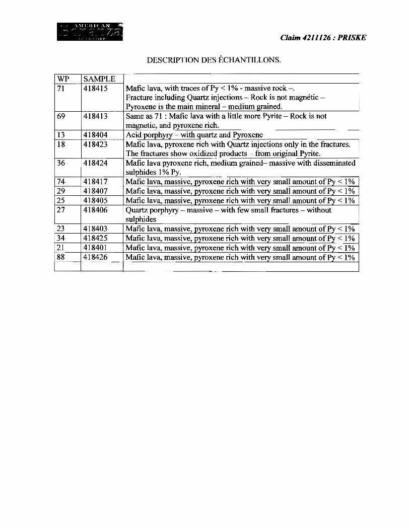
DESCRIPTION DES ECHANTILLONS.
WP SAMPLE 71 418415 Mafic lava, with traces of Py < 1 % .. rock-.
Fracture including Quartz injections Rock is not magnetic -Pyroxene is the main mineral- medium grained.
69 418413 Same as 71 : Mafic lava with a little more Pyrite Rock is not magnetic, and pyroxene rich.
13 418404 Acid porphyry - with quartz and Pyroxene 18 418423 Mafic lava, pyroxene rich with Quartz injections only in the fractures.
The fractures show oxidized products - from original Pyrite. 36 418424 Mafic lava pyroxene rich, medium grained- massive with disseminated
sulphides 1 % Py. 74 418417 Mafic lava, massive, pyroxene rich with very small amount of Py < 1 % • 29 418407 Mafic lava, massive, pyroxene rich with very small amount of Py < 1 % 25 418405 Mafic lava, massive, pyroxene rich with very small amount of Py < 1 % • 27 418406 Quartz porphyry massive - with few small fractures - without
sulphides 23 418403 Mafic lava, massive, pyroxene rich with very small amount of Py < 1 % 34 418425 Mafic lava, massive, pyroxene rich with very small amount of Py < 1 % 2] 418401 Mafic lava, massive, pyroxene rich with very small amount of Py < 1 % 88 418426 Mafic lava, massive, pyroxene rich with very small amount of Py < 1 %

ALS Chemex A: AMERICAN BONANZA GOLD CORP. 290 GENTRY WAY STE 6
Page: 1 Finalisee date: 20-0CT-200B Cette copie a fait un rapport sur
4·NOV·2008 Compte: AMEBON
EXCELl.ENCE EN ANAl. YSE CHIMIQUE ALS Canada Ltd
212 Brooksi)ank Avenue North Vancouver Be V7J 2C1 Telephone: 604 984 Q221 Telecopieur S04 984 0218 www.alschemex.com
RENO NV 89502 USA
CERTIFICAT V008136975 PREPARATION ECHANTILLONS
Projet42 HI 26
Bon de commande #:
Ce rapport s'applique aux 14 echantillons de roche soumis a notre laboratoire de Val d'Or, QC, Canada Ie 29-SEPT·200B.
Les resultats sont transmis a: A • .JNE LECLERC I MICHEL LEGRAND
A. AMERICAN BONANZA GOLD CORP. ATTN: MICHEL LEGRAND 1200, 3E AVE VAL·OOR QC J9P 1V1
I
CODE ALS
WEI·:!1
CRU-QC
LOG-22
CRU-31
SPL-21
PUL-31
CODE ALS
Au-AA23
Ce rapport est final et rem place tout autre rapport preliminaire portant ce numero de certifica! Les resultats s'appllquent aux echanlillons soumis. Toutes les pages de ce rapport ont ate verifiees et approuvees avant publication
DESCRIPTION
Foids echantillon recu
Test concassage QC
Entree achantillon - Recu sans code barre
Granulation - 70 % <2 mm
Ecnant. fractionne • div riffles
Pulverise a 85 % <75 um
PROCEDURES ANAL YTIQUES DESCRIPTION INSTRUMENT
Au 30 9 fini FA-AA AAS
Signature: ~-----Colin Ramshaw, Vancouver Laboratory Manager

Methode OI_ftt \lctit_
o.lICriptlo .. "'hanlillon L.D,
418401 418402 418403 418404 418405
418406 418407 418413 418415 418417
418423 418424 418425 418426
ALS C!hemex EXCELLENCE EN ANAL YSE CHIMIQUE ALS Canada Ltd.
212 Brooksbank Avenue North Vancouver Be V7J 2C1 Telepl'lOne: 604 984 0221 rehkopieur: 604 984 0216 www.alschemex.com
WEI·2' Au·AA23
POlds ret;U Au
<9 ppm o Q2 0.005
0.95 <0005 0.90 <0.005 0.56 <0.005 0.64 0.017 043 <0.005
0.61 <0.005 023 <0.005 0.45 <0.005 075 0.006 0.82 ;).013
0.52 <0.00:5 0.47 <0005 0.84 <0.005 0.89 <0.005
A: AMERICAN BONANZA GOLD CORP, 290 GENTRY WAY SrE 6 RENO NV 89502 USA
Projs!: 42 III 26
r CERTIFICAT D'ANAL YSE
Page: 2 • A Nombre total de pages: 2 (A)
Finalisee date: 20·0CT·2008 Compte: AMEBON
V008136975