proposed water-supply investigations in sidamo province
TRANSCRIPT

Proposed Water-Supply Investigationsin
Sidamo Province, Ethiopia
David A. Phoenix
U.S. Geological Survey
U.S. GEOLOGICAL SURVEY OPEN-FILE REPORT 74-1085
February 1966
Contents
Page
^ ̂ » »^^ » » ». » » » » » » » .^.^.^ .^ ii » »«* »«* » ». * » 1
_tr IT O j/QCLUC w -L tj XI *""*"" ^ ̂ *"" ^ " ^ «"»^ « » ^ B ^
Previous Investigations and Available~Ro c! "i o "Dfl ~t~ fl ^^^^ « « . . . ^ . B « « «* » » «* ! ^ ^ rj
Physical Features 10
Location and Extent of Area 10
Climate and Vegetation , 12
Topography and Drainage 18
Q-gnl ofirv" __ _ ______ ___ ___________________________ 20
Existing Water Resources Development 23
Surface Water Uo
Results of Present Reconnaissance U8
Proposed Program of Investigation 5^-
Working and Living Conditions 57
Project Requirements 60
P^T* sonncl ^ oO
Housing in Field Area 62
Bibliography 66
Orthography 67
A T)T)^T1 (3.1 Y - - - - - - « . - _.-. »«. »_»»» . . "Tl

Illustrations
Page
Figure 1. Map showing Availability of WaterSupplies, Sldamo Province, Ethiopia In Pocket
2-20 Photographs showing:
2. lavello (Yavello), Principal Administrative Center of Sidamo Province 11
3. Mixed Cedar, Thorn Bush and EuphoriaForest in Hills, 8 km West of lavello 15
U. Air View of Thorn Bush and Acacia-with Undercover of Grasses, 50 km West of Mega. Air Photo from 150 m Altitude 16
5- Grassy Plains in Wildlife Area, kQ kmSouthwest of lavello IT
6. Salt Lake in Floor of El Sod, An Explosion Crater about l6 km North of Mega. Capping on Crater Rim are Basalt Flows; The Inner Walls are Metamorphic Rocks of the Basement Complex 22
T. Borana Family Village near lavelloSurrounded by Thorn Bush Enclosure 25
8. Herdsmen Water Livestock along theDawa Parma River 26
9. Air View Soghidda Wells, ill km Northeast of Mega. Air photograph from 300 m Altitude 29
\10. Thorn Bush Enclosure and Entrance Way to
El Melbana (well), 35 km Southeast of Mega 30
Illustrations (cont'd)
Page
Figure 11. Incline Leading down to Cattle WateringStage in Foreground. Well near Mega 31
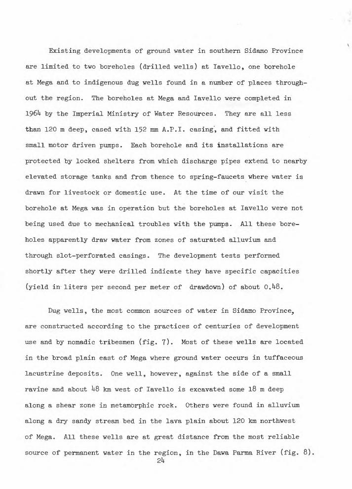
12. Cattle Water Stage, 7 m "below GeneralLand Surface at El Melbana 32
13. Uppermost Lifting Stage, 18 m aboveWater Level at El Melbana 33
1^4. Watering Cattle from Well near Spring,1.6 km South of Mega 3^
15. Watering Cattle from Well near Spring,1.6 km South of Mega 35
16. Herdsmen Watering Cattle and Removing Silt from Small Stock Pond, 37 km Northeast of Mega Ul
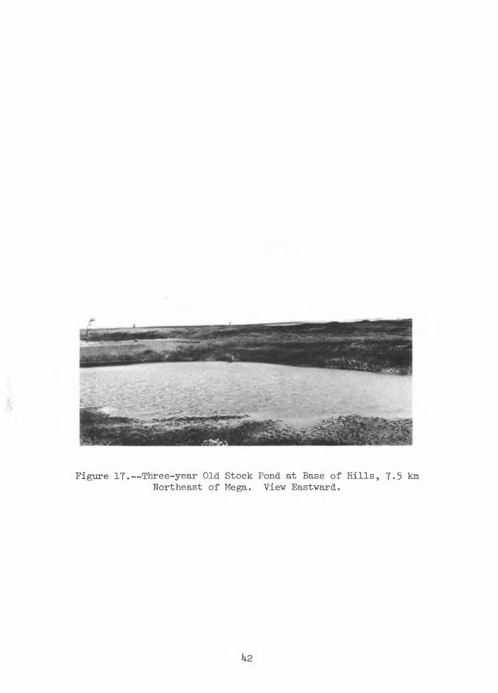
17. Three-year Old Stock Pond at Base ofHills, 7-5 km Northeast of Mega h2
18. Three-year Old Stock Pond at Base ofHills, 7-5 km Northeast of Mega 1*3
19- Digalu Stock Pond, 35 km Southeastof lavello U6
20. Eroded Surface of Precambrian Basement Complex Rocks at Digalu Stock Pond, 35 km Southeast of lavello

Table
Page
Table 1. Analyses of Waters from Wellsand Springs in Southern SidamoProvince, Ethiopia 38

Preface
For centuries, the rich grazing lands of southern Sidamo Province,
Ethiopia have been explored for water by nomadic herdsmen following a
powerful incentive--thirst. Their results - small ephemeral catchments
for surface runoff and dug wells tapping shallow ground water - have
not always been adequate to stabilize their precarious and migratory
existence. Their contribution to the development of Ethiopia is
correspondingly hampered. This challenge to the steady economic
development of Ethiopia is not new to today's frontiersmen - scientists,
engineers, agriculturalists and businessmen - but their teamwork is
required. Specialists in range management and veterinary controls
working with geologists and hydrologists in their search for permanent
water supplies must attempt to improve herds of livestock so that
businessmen can systematically market the product. There are reasons
to believe that these attempts will be successful, will parallel other
developments in Ethiopia and will provide greater stability to the
people of this remote region.

Abstract
The present report describes the results of an air and ground
hydrologic reconnaissance of some 32,000 square kilometers in Sidamo
Province of southern Ethiopia. Existing (1966) water resources
developments, chiefly for livestock and village supplies, include
surface reservoirs, a few drilled wells, several clusters of dug
wells in the Mega area, several scattered springs, and the perennial
Dawa Parma River. Surface-water reservoirs range from hand-dug
ponds of a few hundred cubic meters capacity to large machine-
constructed excavations built to hold 62,000 cubic meters of water.
All the existing drilled wells tap saturated alluvium at depths of
less than 120 meters. The dug wells tap water-bearing zones in
tuffaceous lacustrine deposits or stream-channel alluvium generally
at depths of less than 30 meters. The springs mostly rise from
fractured Precambrian quartzite and individual discharges are all
less than 75 liters per minute. The report also outlines the terms
of reference for a longer term water-resources investigation of the
region including staffing, housing and equipment requirements and
other logistic support.

Introduction
The following report by the writer, a hydrologist of the U.S.
Geological Survey, is based upon field reconnaissance of some 32,000e~)
square kilometers (km ) of Sidamo Province, southern Ethiopia during
February 1966 made possible by use of light aircraft and U-wheel drive
vehicles. The report evaluates the requirements and objectives of
a water-resources appraisal and development program in Sidamo Province
as a part of a long-range livestock marketing scheme proposed for
support to the Imperial Ethiopian Government under the auspices of
the U.S. Agency for International Development. Attention was mainly
directed to ways and means for improving water supplies along about
1*50 km of the major marketing and livestock migratory route connecting
the towns of Moyale in the extreme south consecutively northward with
Mega, lavello, Alghe, and Dilla. Water-supply conditions along
cattle routes and grazing areas subsidiary to the main route were
also examined from the air. Data held by the Imperial Ministry of
Public Works, by the Geophysical Observatory, and the Imperial
Ministry of Agriculture, Livestock Division, and discussions with
officials of these and other development and research institutions
of the Imperial Ethiopian Government provided valuable guidance to
this evaluation. Particularly helpful was the experience in air
reconnaissance methods provided by air pilot, MF.- Charles A. Temple,
and the intimate and first-hand knowledge of the country and its live
stock problems provided by Ato Gebrehiwet Zere, Deputy Director, Live
stock Division, Imperial Ministry of Agriculture, and Mr. Samuel T. Logan,
2

Acting Chief, Agriculture Division, USAID/Ethiopia. These men
accompanied the writer during the 11-day reconnaissance investigation.
The development of water supplies for livestock in southern
Ethiopia has until very recently "been left to practical and ingenious
methods employed through centuries of practice by nomadic herdsmen.
Within the limitations of their resources, every conceivable natural
situation favorable to the accumulation of water has been employed.
Old corral sites, pot holes in granitic rocks, shallow excavations
below rocky hill sides,all are used to collect and temporarily store
the infrequent rainfall and runoff. Certain types of phreatophytic
plants which are sustained by shallow ground water are also known to
the nomads and places in which these plants grow are invariably the
sites of dug wells. In fact, many of these dug wells have been used
so long and persistently that they are now nearing the limits of the
nomads' ingenuity as useful watering points.
Succinctly, the herdsman is probably as knowledgeable and
resourceful concerning his strategic sources of water, whether it be
from ephemeral streams or shallow ground water, as the most sophisti
cated hydrolegist, geologist, or modern day livestock expert.
Unfortunately, he is nearing the limits of even his most ingenious
and persistent efforts for discovery and maintenance of water supply
due partly to increase in livestock population and partly to the
increasing demands upon existing water supplies. Estimates, for
Sidamo Province, place the livestock population at about 1-1/2
million animals and reportedly it is not uncommon for several3

thousand to be watered at an individual site in a day. Two solutions
to the water shortage problem appear evident and practical. The first
would require a decrease in the numbers of dependent animals and here
the efficient reduction in numbers, and this by steady and reliable
marketing, would strengthen the pastoral economy of these people. The
second would require new and increased water supplies from hitherto
inaccessible or untapped sources and for which several are believed
available.
It is concluded that the exploration for and development of water
supplied in this remote and underdeveloped part of southern Ethiopia
are both desirable and justified, but that it is attendant to difficult
living and working conditions and to a high risk of failure if not
supported by well-directed engineering assistance and by special
preliminary geologic and hydrologic guidance. Partly, the risks can
be reduced by careful studies leading to the selection of appropriate
new watering points, from both surface and underground sources and the
improvement of existing water points. These studies may also provide
guidance to other exploitable resources and hence increased economic
interest in the region. Accurate base maps and improved roads and
communication, essential to the infrastructure of the region, will
facilitate the compilation of the required hydrologic and geologic
data and, thus reduce other risks. A large measure of engineering
talent will be required in these phases of work. Above all, successful
utilization of both the ground and surface-water resources, and
ultimately livestock management,will require a careful blending of

traditional practices with improved "but uncomplicated methods of water
utilization and management.
If taken alone, the problems to "be encountered "by even the "best of
intentions in range management and livestock improvements in this
remote and relatively inaccessible region are many. Certainly without
access roads and engineering guidance, even of the most expedient type,
drilling operations and the continuing logistic requirements of supply
in servicing wells and in constructing and maintaining stock ponds will
become difficult if not well-nigh impossible. Also, without geologic
guidance necessary to the siting of wells, to the accurate description
and correlation of sub-surface strata, and hence to proper well-drilling
design and development, it is quite likely that an entire well-drilling
program could become a repetitive succession of failures. As for stock
pond construction, differences in the vegetative cover, in the thickness
and physical properties of the surficial alluvium and in the composition,
permeability, and porosity of the underlying consolidated rocks control
not only the sediment transported by streams but also to a large
degree the incidence of runoff. Throughout very large parts of Sidamo
Province stream runoff is a rare event and is probably a direct function
of a balance between factors of climate, topography, geology, and
vegetation. In Sidamo Province these factors are unevaluated, but it
is quite conceivable that the mere construction of reservoirs will be
discouragingly inadequate to satisfy requirements for permanent water
throughout the long dry season. If the shrubs and trees with which the
area is abundantly supplied were wholly or even partly eliminated, will
5

this upset the delicate "balance of nature in the region and create even
greater problems? One might also ask such pertinent questions as
"Where are the rocks favorable to the occurrence of ground water?"
"Will the pumping imposed on the ground water supply exceed its safe
yield?" "Are there areas where the temporary impoundment of water will
effectively recharge the ground water?" "Will the yield from windmill
wells "be great enough to meet the minimum needs for domestic and stock
use?" "Where are the springs?" "Can they be improved?" These and
similar and now unanswerable questions can only be satisfactorily
solved by systematic areal studies of the relations between runoff,
geology, vegetation, and climate.
At present, outstanding deterrents to all but the most basic and
exploratory type of water development include a serious lack of roads,
communication, housing, schooling, medical, and supply facilities
throughout the area. It is not within the scope of this report to
propose specific support to strengthen these desirable and necessary
aspects of the long-range improvement of the infrastructure. However,
the writer is familiar with practical methods employed in opening new
and remote country, and it is to these and to the special preliminary
studies that attention is directed.
The bare manpower necessities for the successful completion of
even the most exploratory of projects in this remote and largely
roadless region will require a well-organized and we11-coordinated
input from engineers, geologists, and bulldozer mechanics and operators
and well drillers who are willing and capable of "roughing it" and6

"coping" under frontier working conditions. However, without the
requisite technical equipment and without conditions suitable for
effective work, the best qualified and experienced personnel can
accomplish little. Therefore, it is recommended that the provision
of adequate equipment and housing be recognized as prerequisite for
effective operations of personnel assigned to the project, and that
personnel not arrive until these essentials are available.
The following sections describe past investigations and water-
resources development, the physical features of the region, and project
of proposed investigations.
Previous Investigations and Available Basic Data
At present large parts of Ethiopia are remote from routes of
travel and therefore little is known concerning natural resources of
these areas, and this is particularly true for large parts of
southern Ethiopia. Published maps, the basic prerequisites to the
assessment of these resources^ are adequate only for the most general of
reconnaissance purposes. In Sidamo Province these include maps at a
scale of 1:500,000 and 1:1,000,000. Rudimentary topography, altitudes
of some major landmarks, and the location of strategic towns, roads,
trails and water holes are illustrated on the generally available
2-degree quadrangles, scale 1:500,000 compiled by the Geographical
Section, British General Staff and published by the War Office, 19^6.
The adjoining 2-degree quadrangles Stephanie (N.B. 37*0* Neghelli
(N.B. 375), Rudolf (N.A. 371) and Moyale (N.A. 372) covering, in all,
^-degrees of latitude and ^-degrees of longitude were used in the
present field reconnaissance to plot geological and hydrologic data
and the air routes travelled. The broad physiographic features of
southern Ethiopia also are shown on the U.S. Air Force 1:1,000,000
World Aeronautical charts and their equivalent but later compilations
by the British War Office, the Lake Margherita and Marsabit quadrangles,
The base map for figure 1 showing the availability of water supplies
in a part of Sidamo Province, Ethiopia has been prepared from adjoining
parts of these two quadrangles.

To assist in all phases of resource investigations in Ethiopia,
the U.S. Mapping Mission has since October 1963 "been systematically
obtaining air photo coverage of the country at scales of 1:50,000 and
1:25,000. Overlapping air photos, scale 1:50,000, along east-west
flight lines are now available for most of southern Ethiopia and of
the proposed project area.
The results of reconnaissance geologic studies of southern Ethiopia
are summarized by Mohr (1961) and are illustrated on the geologic map
of Ethiopia, scale 1:2,000,000; the general rainfall and air movement
patterns over Ethiopia are illustrated and described by Kebede Tato
(196^); and the classification of soils and native vegetation sufficient
to provide initial guidance to the recovery and management of water
supplies in southern Ethiopia are described by Murphy (1959) and von
Breitenbach (1961). Other general information, in part applicable to
water-supply problems in Sadamo Province, include a discussion of water
laws in Moslem countries by Caponera (195^-), and reports on general
geology and hydrology of the Upper Nile Basin in Ethiopia (l96Ua,b)
and of mineral resources in Ethiopia (i960), prepared by the U.S.
Bureau of Reclamation.
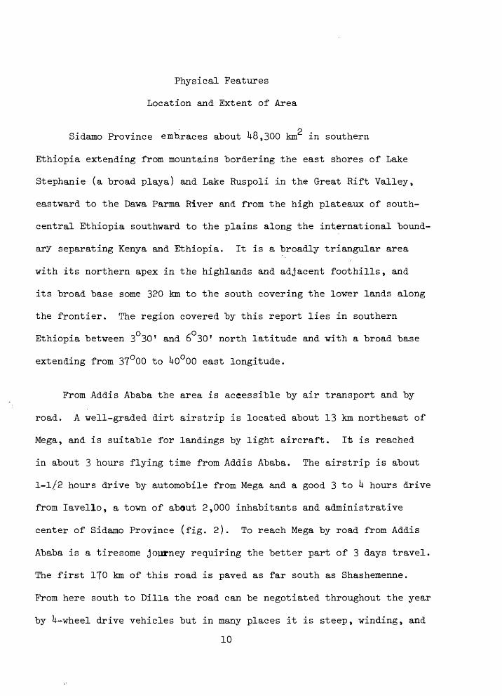
Physical Features
Location and Extent of Area
r~) Sidamo Province embraces about U8,300 km in southern
Ethiopia extending from mountains bordering the east shores of Lake
Stephanie (a broad playa) and Lake Ruspoli in the Great Rift Valley,
eastward to the Dawa Parma River and from the high plateaux of south-
central Ethiopia southward to the plains along the international bound
ary separating Kenya and Ethiopia. It is a broadly triangular area
with its northern apex in the highlands and adjacent foothills, and
its broad base some 320 km to the south covering the lower lands along
the frontier. The region covered by this report lies in southern
Ethiopia between 3 30' and 6 30' north latitude and with a broad base
extending from 3T°00 to Uo°00 east longitude.
From Addis Ababa the area is accessible by air transport and by
road. A well-graded dirt airstrip is located about 13 km northeast of
Mega, and is suitable for landings by light aircraft. It is reached
in about 3 hours flying time from Addis Ababa. The airstrip is about
1-1/2 hours drive by automobile from Mega and a good 3 to k hours drive
from lavello, a town of about 2,000 inhabitants and administrative
center of Sidamo Province (fig. 2). To reach Mega by road from Addis
Ababa is a tiresome journey requiring the better part of 3 days travel.
The first 170 km of this road is paved as far south as Shashemenne.
From here south to Dilla the road can be negotiated throughout the year
by U-wheel drive vehicles but in many places it is steep, winding, and
10

Figure 2. lavello (Yavello), Principal Administrative Center of Sidamo Province. View toward North
11

rough and requires considerable caution to negotiate safely. From
Dilla south to Mega and beyond, the road is one long series of washouts
ruts and detours, and travel is reduced to the almost full-time second
or low gear speeds of a well-equipped Jeep or Landrover.
Climate and Vegetation
The mean annual rainfall ranges from about HOO (mm) millimeters
in the southern plains of Sidamo Province to 1,200 mm in the highlands
to the north. It is probably less than 600 mm throughout most of the
southern plains. At Moiale on the Ethiopian border and at an altitude
of about 1,200 (m) meters the mean annual rainfall for 5 years of record
is 819.5 mm. but at Dilla in the highlands some 320 km to the north
and at an altitude of about 1,600 m the mean annual rainfall for 6 years
of record is 1,^07.2 mm. In the highlands the rainfall is monsoonal
with a distinct dry season extending from late October to mid-March.
In the highlands also, a period of intermittent rains, "the small
rains," introduces the heavy rainy season, which usually begins in May
or June and ends in mid-October. In the southern plains, at lower
altitudes, the period of small rains in March, April; and May is
followed by a distinct dry season until the rains again occur
during October and November. In the southern plains there are
between 80 and 100 days during the year during which rains occur,
and most of these are of short duration. Clear sunny days prevail
12

throughout most of the year and day-time temperatures frequently exceed
35°C. The nights, however, are invariably clear, crisp and cool.
Generally speaking in the highlands of southern Ethiopia working
conditions are ideal throughout the dry season. In the plains at lower
altitude ideal working weather prevails through the period from March
to October and is uncomfortably hot only during the middle of the day
for the rest of the year.
Wind movement in southern Ethiopia during the period from June to
early September is predominated by warm moist southeasterlies from the
Indian Ocean. After a short period of fluctuation wind direction
changes abruptly and during the dry season from early October through
the following May the prevailing direction is toward the southwest
(ftebede Tato, 19&0. The duration and rates of wind movement are not
known for Sidamo Province, but in general, air movement ceases
throughout most of the night hours and is again resumed during the mid-
morning hours. The province is subject to occasional violent winds that
accompany thunderstorms but these are of short duration. Wind velocities
are believed to be adequate to operate windmills during at least 8 hours
almost every day.
The various plant assemblages found in southern Ethiopia are mapped
and described by von Brietenbach (1961) sufficiently to provide the
student with guidance as to their identity and hence their relationships
to water supply and range management. In Sidamo Province as well as
elsewhere in Ethiopia the distribution and types of native vegetation
13

are believed to be largely as a result of differences in soils and
climate. These are in turn related to differences in physical and
chemical properties of the underlying rocks and upon altitude. In the
basalt plateau near Alghe and Dilla where the native vegetation has
not been removed for farm lands and coffee plantations, and locally in
the highland areas surrounding lavello and Mega, there are various
forest species of trees and tall plants intermingled with dense
thickets of high shrubs (fig. 3). Outstanding among these forests are
species of Acacia, Juniperus, Podocarpus, Porteria, Euphorbia and
Fieus. At lower altitudes and throughout the foothills and plains
country of southern Ethiopia where soils cover metamorphic and intrusive
rocks, the forests give way to an arid to semi-arid type of woody
vegetation consisting of short-stemmed shrubs, 2 to h m high, overtopped
from place to place by umbrella-shaped trees up to 7 m high - the
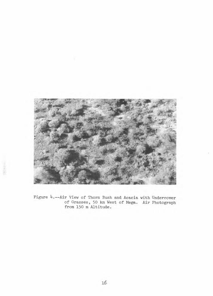
savannah woodlands of Acacia and thorn bush .(fig. *0« Almost every
where these trees and shrubs are underlain by a carpet of short-stemmed
perennial grasses intermingled with annual grasses and herbs. In the
most arid areas, notably in the lava plains west and northwest of Mega,
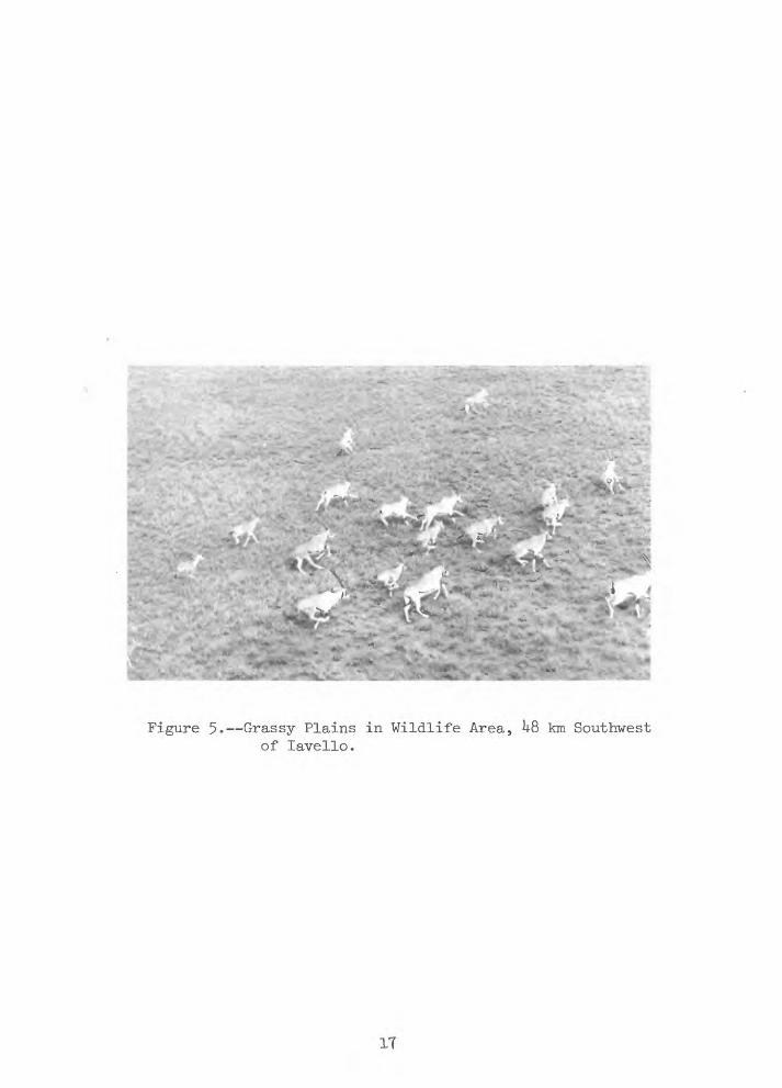
grasses form the entire vegetative cover over many tens of square km
(fig. 5).
The writer's observations with respect to plant, soil and water
relationships were necessarily limited to impressions gained during
flight and traverses. In the foothills east of lavello and northward
to Alghe where rainfall may exceed 7&0 mm per year, plant growth is so
dense that ground visibility is reduced to 15 m or less. At lower
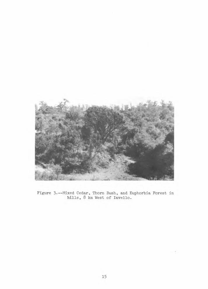
Figure 3. Mixed Cedar, Thorn Bush, and Euphorbia Forest in hills, 8 km West of lavello.
I
;^rf^F- '-<? ik^* '-'i^iii-'i-r;^.. .-.* " - , ..** r<
Figure k. Air Viev of Thorn Bush and Acacia with Undercover of Grasses, 50 km West of Mega. Air Photograph from 150 m Altitude.
1.6-
*-"-.4
L<!*
.» *
Figure 5. Grassy Plains in Wildlife Area, ^8 km Southwest of lavello.
IT

altitudes ground visibility is much greater, with extensive vistas of
tree-studded parks and grasslands. Throughout these areas the valleys
are lined with trees and shrubs and with interconnected meadows, but
evidence for stream runoff through them is in most places limited to
dry ill-connected depressions and to narrow and shallow grass-covered
channels. Furthermore, there is little evidence to indicate that
cattle find the trees and shrubs a palatable forage. In other places
some trees and shrubs also seem to prefer areas of shallow ground water
where there are springs and seep areas. These include Ficus, Euphorbia,
Acacia, Salix, Lobelia and Tamarindus. Most of these plants are
phreatophytes, that is, plants which send their roots to the permanent
water table and depend upon ground water for their nourishment. These
plants should be studied more carefully as they may indicate the
presence of hitherto untapped ground-water resources.
Topography and Drainage
Sidamo Province occupies parts of two physiographic provinces in
Ethiopia. These include the Southern Highlands, a high plateau on
which altitudes lie between 2,500 to 3,000 m above mean sea level and
to the south of this, separated by a broad belt of foothills, the
Lowlands, a broad planar belt broken here and there by inselbergs and
clusters of volcanic cones. Altitudes in the Lowlands lie between
1,000 and 1,500 m above mean sea level.
The tectonic trench of the Great Rift Valley with eight associated
interior lake basins lies along the west side of the report area and on
18
the east Sidamo Province is "bordered by the Dawa Parma River which
flows southeastward into the GaJiale Doria (juba, Giuba) River. On the
south a steep escarpment, along which altitudes drop abruptly over
600 m, limits most of the report area.. This escarpment
faces southward over vast lava plains of northern Kenya, and parallels
the international boundary from the vicinity of Moyale westward for
almost 130 km before it arcs northward and dies out midway between
and somewhat west of the longitude of Mega. The escarpment is marked
by numerous faults and clusters of deep explosion craters.
Southerly trending discontinuous linear ridges extend southward
from the Southern Highlands near Alghe and merge with the northwestern
end of the escarpment. These ridges form a somewhat sinuous and ill-
defined drainage divide that separates the lowland area into nearly
equal eastern and western segments. East of the divide, drainage is
toward the Ganale Doria and Dawa Parma Rivers or, farther south, and
2 east of Mega, onto a broad sloping surface covering almost 12,000 km
of the Southern Lowlands. West of the divide, from the vicinity of
Alghe southward to the western slopes of mountains surrounding lavello,
drainage is westerly toward the interior lake basins of the Rift
Valley. Further south and from the slopes of the frontier escarp
ment, drainage is southerly toward the lava plains of Kenya. It is
along and adjacent to this drainage divide extending from the highlands
near Alghe to the Ethiopian-Kenyan boundary at Moyale that water
supplies are most needed to support the marketing routes for livestock
from southern Sidamo Province.19

Geology
The geologic map of Ethiopia, scale 1:2,000,000, indicates that
basaltic rocks of Tertiary age underlie the highlands in the northern
part of Sidamo Province and that a basement complex of intrusive and
metamorphic rocks of Precambrian age underlie most of the southern part.
The metamorphic rocks include all types from those clearly of sedimentary
origin gradational to schists and gneisses so thoroughly altered that
their origin is obscure. In most places the metamorphic rocks are
highly distorted by isoclinal folding. Massive granite and granodiorite
commonly intrude the metamorphic rocks. Pegmatites are common among
the basement complex rocks west of lavello and probably elsewhere as
well. In the southwestern part of the province the Precambrian rocks
are overlain extensively by crystalline basalts comprising the Trap
Series of Tertiary age; in the south-central part they are overlain
by lacustrine deposits of Quaternary age. In most places the con
solidated rocks are mantled by unconsolidated deposits including
Holocene alluvial sand and gravel in stream channels and valleys,
eluvial clay and clay-rich soils on the hill slopes, and poorly-sorted
colluvial coarse sand and gravel along the base of steep escarpments.
The consolidated rocks are also exposed in the walls of explosion
craters about 13 km northeast of Mega and at other localities west and
northwest of Mega. El Sod, an. explosion crater about l6 km northeast
of Mega, is about 1.6 km in diameter and 300 m deep (fig. 6).
20

The near-vertical walls of this crater are formed of metamorphic
rocks of the Precambrian "basement complex "but its rim rocks are composed
of near horizontal flows of "basalt some 60 to 90 m thick. Magado, an '
explosion crater about 35 km soutwest of Mega at the "base of the
escarpment, appears from the air to "be somewhat larger and deeper than
El Sod. Its inner walls appear to "be composed of rocks of the Pre
cambrian complex overlain by several hundred feet of basalt. G. Gori,
a crater about 83 km west of Mega and well within the lava fields, has
walls about 180 m high that are believed to be composed entirely of
basalt. Bedded tuffaceous deposits and other fragmental detritus
ejected from these explosive craters may well comprise most of the
rocks shown as lacustrine deposits of Quaternary age on the geologic
map of Ethiopia.
The most striking structural feature in the region is the
escarpment adjacent to the Ethiopian-Kenyan frontier. The southern
face of this escarpment is a complex of southward dipping normal faults
along which total vertical displacement is probably 600 m or more. In
other parts of the lowlands area in southern Sidamo Province faulting
is not apparent and may be of little importance in controlling the
movement of either ground or surface water.
21

%*&& :**-k, ;f" '"" '-i**^* 1 ^*^r*^Tii"i^"^irr-:f^- * *~ - *
is^^%^-«!*fs*Saft^*f«^» :-^;! "*»^s»."* ->r*#" *"-^atr**^^. .-»j »* ^^-**"i-\* ^r -v^^iur % _ *- * -_
,^i:;n .3^^- '^:,{'"i .;v>* - % *'-,- Nf'Vi -. (i .^..~«/i v-*" ' 'm^si^u^y1 ; -^s^*s- : ^*m¥'' ':*': .; f^PIP' M^^'l
?'*% --. ;->- W-.»f"'-*" :"«',^ '-< ' --.
Figure 6. Salt Lake in Floor of El Sod, an Explosion Crater about l6 km North of Mega. Capping on Crater Rim are Basalt Flows; the Inner Walls are Meta- morphic Rocks of the Precambrian Basement Complex, View North-ward.
22

Existing Water Resources Development
Ground Water
In general, ground water occurs under conditions where recharge is
available from precipitation or stream flow and where the soils and rocks
are sufficiently permeable to absorb infiltrating recharge and to permit
it to percolate into the saturated zone. However, much of the water
which falls as precipitation is intercepted and returned to the
atmosphere by evaporation and plant transpiration before it reaches
permanent "bodies of ground water. In southern Sidamo Province ground
water occurs in the tuffaceous lacustrine deposits widely distributed
east and southeast of Mega; in zones of fractured rock associated with
faults along the frontier escarpment near the Ethiopian-Kenyan boundary;
in stream valley alluvium overlying the "basaltic rocks of the lava
plains west of Mega; in beds of fractured Precambrian quartzite; and
locally in. alluvium along the valley floors of stream courses which
descend from the highland areas surrounding Mega, lavello and Alghe.
The rocks, which probably contain little ground water or in which it
may be too deep or difficult to reach and hence of limited importance,
include the massive metamorphic and igneous rocks or Precambrian age
and the basaltic rocks of the Trap Series of Tertiary age that underlie
extensive areas of southern Sidamo Province in the lowlands. With few
exceptions the location of water-bearing zones and the quantities of
ground water available to wells, even in the most favorable situations,
cannot be predicted with any degree of certainty from transient obser
vations made during this reconnaissance study.
23
Existing developments of ground vater in southern Sidamo Province
are limited to two "boreholes (drilled wells) at lavello, one "borehole
at Mega and to indigenous dug wells found in a number of places through
out the region. The "boreholes at Mega and lavello were completed in
196^ "by the Imperial Ministry of Water Resources. They are all less
than 120 m deep, cased with 152 mm A.P.I, casing, and fitted with
small motor driven pumps. Each "borehole and its installations are
protected "by locked shelters from which discharge pipes extend to nearby
elevated storage tanks and from thence to spring-faucets where water is
drawn for livestock or domestic use. At the time of our visit the
"borehole at Mega was in operation "but the "boreholes at lavello were not
"being used due to mechanical troubles with the pumps. All these bore
holes apparently draw water from zones of saturated alluvium and
through slot-perforated casings. The development tests performed
shortly after they were drilled indicate they have specific capacities
(yield in liters per second per meter of drawdown) of about 0.^8.
Dug wells, the most common sources of water in Sidamo Province,
are constructed according to the practices of centuries of development
use and by nomadic tribesmen (fig. 7). Most of these wells are located
in the broad plain east of Mega where ground water occurs in tuffaceous
lacustrine deposits. One well, however, against the side of a small
ravine and about hQ km west of lavello is excavated some 18 m deep
along a shear zone in metambrphic rock. Others were found in alluvium
along a dry sandy stream bed in the lava plain about 120 km northwest
of Mega. All these wells are at great distance from the most reliable
source of permanent water in the region, in the Dawa Parma River (fig. 8)2k

Figure 7. Borana Family Village near lavello Surrounded "by Thorn Bush Enclosure.

Figure 8. Herdsmen Watering Livestock along the Dava Parma River,
26
The wells east of Mega commonly occur in clusters covering
several acres. However, not all wells in a cluster can "be used. Some
are in good repair and show evidence of recent use, others are rubble-
filled depressions, long since abandoned. The wells in use are generally
surrounded by thorn brush enclosures and entered through a small
holding corral. From the corral, cattle are led down a narrow inclined
trench to a watering stage some 7 to 8 m below the general land
surface. The well shaft, usually 2 to 3 m in diameter and nearly
vertical is separated from the watering stage by mud-walled troughs
and a low barrier of eribbed rock. Depth to water in many of these
wells is l8 to 25 m below the subsurface entrance and 25 to 30 m below
the surrounding general land surface. To provide access to the wat^r
each well shaft is equipped with a number of crude log platforms of
"stages," depending upon its depth, that are connected by ladders of
precariously wedged tree limbs. While watering their cattle, the
herdsmen descend into the shaft in sufficient numbers so that water in
leather buckets can "be conveniently passed from hand to hand upwards to
the watering stage, and as a full bucket goes up an empty one comes down.
The process is as efficient and productive as the agility and energy
of the individuals can make it. Undoubtedly, an occasional bucket of
water or even footing is lost in this rather dangerous operation. The
results, however, are satisfactory. It is reported that some 75 to 115
liters per minute are hoisted upwards in this fashion and that the work
goes on sufficiently to water at least a thousand cattle per day at
each well (figs. 9 to 15, inclusive).
27

It seems inconceivable that these dug wells are the result
of a single bold enterprise to obtain water. All those wells
examined by the writer occur in settings where, under normal conditions,
one might expect the water table to have been at some time in the
past, either at or very near the land surface. Those wells east of
Mega are located along the axes of very broad, gently sloping
valleys leading from the highland areas surrounding Mega. In many
places these valleys seem to have been open grassland glades under
lain by shallow ground water. It is interesting also that amongst
the various abandoned wells in each cluster there are those that seem
once to have been simply open shallow depressions whereas others lack
the entrance way so typical of the present-day deeper structures. The
evidence is inconclusive but it would appear as though the nomadic
herdsmen are now and over a long period of time have been mining water
and gradually deepening well-shafts in pursuit of the declining water
table.
Direct sources of ground water are springs which rise in the
highland areas and small seepage lakes in the floors of extinct
explosion craters. Among the springs visited during the reconnaissance,
were one about 1.5 km south of Mega, two near lavello, and another near
larbu Hobok about 125 km west-northwest of Mega.
The spring near Mega rises from a thick, fractured bed of quartzite
into a boulder strewn and tree-lined ravine. The bed of quartzite
28

Figure 9 Air View of Soghidda Wells, U3 km Northeast of Mega. Air Photograph from 300 m Altitude.
29

Figure 10. Thorn Bush Enclosure and Entranceway to El Melbana (well), 35 km Southeast of Mega.
30

Figure 11.^-Incline Leading down to Cattle Watering Stage in Foreground. Well near Mega,
31
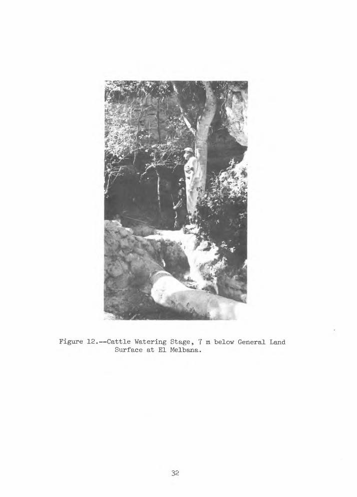
Figure 12. Cattle Watering Stage, 7 m below General Land Surface at El Melbana.
32

Figure 13. Uppermost Lifting Stage, 18 m above water level at El Melbana.
33
-*&'* * s*T*>; ^y4^W NT-w-,
-^Ok,\ Nff«&.^S*
Figure 1^. Watering Cattle from Well near Spring, 1.6 km South of Mega.

JL .*^»*». *i-»aKHB**toargS
't&^^riim?
,^<*^V^*^.'-*.'V.;^':'V^ ^/
* ">*, ,» » > '; ""- -' , £" .ijt/«j»» .
Figure 15. Watering Cattle from Well near Spring, 1.6 km South of Mega.
35

dips gently southward from the hills surrounding Mega and probably
receives recharge from precipitation which falls in these hills. At
the uppermost spring head, water discharges directly from the quartzite
with a flow of less than U liters Per minute. Downstream, however,
cattle are watered from open pools in alluvium, which are probably
sustained by discharge from the quartzite, and also, in one locality,
from a 7 to 9 m deep well (figs. lU and 15). Reportedly, a thousand
or more cattle are watered here each day and if so, the total dis
charge from the quartzite must be at least 75 liters per minute.
At lavello, one of the springs discharges into a small open reser
voir is 3 to k m above the roadway in a nearby canyon and it seems
likely that the water could be fed by gravity pipelines or siphons
from the reservoir to nearby watering points. There is, however, no
observable overflow from the reservoir. The second spring near lavello
is on a south facing hillside at the head of a large canyon about
2..h km northeast of the town. This spring rises from a nearly
horizontal bed of fractured quartzite and is developed by a well-
constructed spring box. This spring was improved at considerable
expense and effort by Italian forces, who once occupied lavello, but
the entire installation including the spring box, discharge pipe, a
2 x 3 x 1 m concrete cistern and two 12 m long concrete watering
troughs has been neglected since their departure and are no longer
serviceable. The spring yields a small water supply used for domestic
supply by nearby villagers and is also used for water livestock. A
chemical analysis, given in table 1, indicates a calcium-sodium
36

bicarbonate water of moderate hardness and a relatively low content
(l8U milligrams per liter) of total dissolved solids. Based on this
analysis the water would be suitable for domestic, livestock, irri
gation and most other uses.
The spring near larbu-Hobok issues from an'alluvium composed of
volcanic debris in an area underlain by Trap basalt. A chemical
analysis given in table 1 indicates a very hard, brackish water
(l,110 mg/1 dissolved solids) of sodium-magnesium bicarbonate
type. The water also contains a high nitrate content (37 »g/3) which
may indicate pollution. The water is usable for livestock but poor
for human consumption.
Water in the explosion craters occurs in shallow lakes, small
peripheral springs and seeps adjacent to the lakes in the floors and
in deeper ground water beneath crater floors. In most places the
lakes are saline and are used locally as sources of salt. The small
seeps and springs around the lake peripheries may be less saline than
the water in the lakes but they are at best meager sources of water.
In most places the lake water in the explosion crater is believed to
be unfit for livestock or human consumption. These crater lakes
suggest that the regional water table in their vicinities is at
great depth below the general land surface.
At El Sod crater (fig. 6) about l6 km north of Mega, the writer
visited a well dug to a depth of about 2k m in the bottom of and adja
cent to the south wall of the crater. The water level was about 23 m37

Tabl
e 1.--Analyses of
Wat
ers
from Wells an
d Sp
rings
in So
uthe
rn S
idam
o Province,
Ethiopia
Anal
yses
by R
. T. Ri
ser,
U.S. Geological Survey
Cons
titu
ents
, in milligrams
per
liter, except
as in
dica
ted
CO
I/
2/
lavello
Spri
ng
=/
Hobo
k Spring -
/El S
od wel
l -*'
Dat
e of
Co
llec
tio
n o
f S
ampl
e
Cal
cium
(C
a)M
agne
sium
(M
g)S
odiu
m
(Na)
Pota
ssiu
m
(K)
Bic
arbonat
e (H
C03
)S
ulf
ate
(S
O^)
Chlo
ride
(Cl)
Flu
oid
e (F
)N
itra
te
(N03
)B
oron
(B
)S
ilic
a
(Si0
2)
To
tal
Har
dnes
s as
C
aCO
^T
ota
l D
isso
lved
Soli
ds
(calc
ula
ted)
Spec
ific
C
ondu
ctan
ce
(Mic
rom
tsos
at
25°C
)pH P
erce
nt
Sod
ium
Sod
ium
Abso
rpti
on R
atio
(S
AR
)
Feb
. 2
2,
1966
19 6 19 6.7
118 2.
716 0.
33-
70
.152 72 184
260 7-
234 1
.0
Feb
. 16
, 19
66
84 71 200 18 820 57 136 0.
637 0
.210
750
01,
110
1,68
0 7.8
45 3-9
Feb
. 18
, 19
66
124
156
1,43
0 96 388
1,29
01,
790 0
.6 3.0
1.7
78 950
5,l6
o7,
530 8.
074 20
_!/ Spring ab
out
2.4
km n
orth
east
of
lav
ello
,
_2/ Sp
ring
ne
ar la
rbu-
Hobo
k ab
out
123
km
west-northwest o
f Me
ga.
3/ At El S
od c
rater
abou
t 16
km
""
nort
h of Mega.

below the general level of the crater floor. A chemical analysis
given in table 1 indicates a sodium chloride water with considerable
sulfate, a high dissolved solids concentration (5,l60 mg/1), and
also a relatively high concentration of boron (1.7 mg/l) that may
reflect the volcanic environment.
39

Surface Water
The "behavior and quantities of surface water runoff from any area
depend in large measure upon the frequency and duration of precipitation,
the absorptive characteristics of soils and rocks, the soil moisture
and plant requirements, and the slopes and drainage areas involved. The
retention and storage of runoff in reservoirs and hence their usefulness
as watering points depends upon proper reservoir site selection so as to
minimize the loss or retardation of runoff. 'Ideally, each site should
be selected by an individual intimately familiar with the runoff charac
teristics of the drainage basin above the site and with the water reten
tion properties of the soils and rocks at the site selected for a reservoir,
The only perennial streams in the area are the Dawa Parma River
and a few small unnamed streams along the frontier escarpment. Supplies
of surface water for livestock in most of southern Sidamo Province must
therefore come from runoff that originates chiefly during the rainy
season and that probably continues for only short periods of time.
Surface-water reservoirs have been constructed throughout southern
Sidamo Province as watering sites for livestock. In most places they
have been built and are maintained through hand labor by the nomadic
tribesmen (fig. 16) but a few (figs. IT and 18) of more recent origin
have been constructed with earth-moving equipment provided by the Imperial
Department of Water Resources. The capacity of the hand-constructed
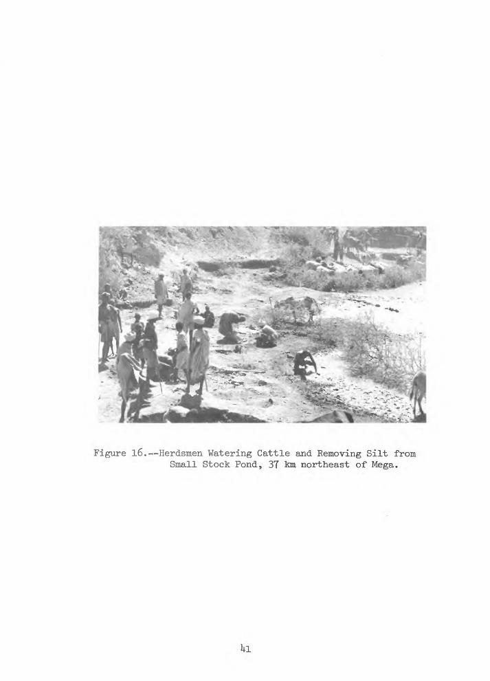
Figure 16. Herdsmen Watering Cattle and Removing Silt from Small Stock Pond, 37 km northeast of Mega.
I
Figure IT. Three-year Old Stock Pond at Base of Hills, 7.5 km Northeast of Mega. View Eastward.

Figure 18. Three-year Old Stock Pond at Base of Hills, 7.5 km Northeast of Mega. View Southeastward.
1*3

oreservoirs is in most places considerably less than 1,200 m of water;
the larger machine-constructed reservoirs are built to hold approxi-
omately 62,000 m . In general the small reservoirs are located on or
below rocky hillsides where rates of runoff are high and where the
surficial materials insure against water losses by seepage, through
underlying rocks such as the granites of the basement complex (figs. 19
and 20). In some places old corrals have been selected for reservoir
sites, probably because at these places the movement of livestock has
created a more or less impermeable floor to prevent losses by seepage.
In other places natural basins in crystalline rocks are used as water
ing sites. Most of these small reservoirs probably contain sufficient
water to provide for only a few weeks use during the dry season. At
least 30 of them were seen during the writer's reconnaissance of the-
region and the greater number are located in foothills surrounding
Mega and lavello. At the time of the writer's visit the "small rains"
had just commenced and many of these small reservoirs contained water
and were being used for livestock watering.
Four large machine-constructed surface-water reservoirs were
examined during the air reconnaissance of southern Sidamo Province.
One is on the eastern foothills of the mountain surrounding Mega,
another is in the extreme southeast part of the region and about 51 km
northeast of Moyale, a third is on foothillls about 6l km southeast of
lavello and a fourth is about 1.6 km downstream from the mountainous
entrance leading to the valley occupied by lavello. Each of these
reservoirs is of the same design and of approximately the same size.
kk

They are all rectilinear excavations measuring approximately
135 x 135 m by 3 m deep, and each is bordered on the downstream and
lateral sides by an earth embankment about h m high. Reportedly, these
reservoirs had been completed some 2 or 3 years prior to the writer's
inspection. Among these four installations only one contained water
(figs. 17 and 18) and the amount in storage was but a small fraction
of the available capacity. The absence of water-marks in the reservoir
slopes and along the base of the small ditch leading to the reservoir
suggested that only small quantities of surface runoff had reached it
since its construction. Livestock in the immediate vicinity numbered
no more than a few dozen animals and the general lack of footprints in
the reservoir area indicated that it was not being heavily used by
livestock.

Figure 19. Digal-a Stock Pond, 35 km Southeast of lavello,

Figure 20. Eroded Surface of Precambrian Basement Complex Rocks at Digalu Stock Pond, 35 km southeast of lavello.
Results of Present Reconnaissance
The results of the present (1966) reconnaissance are summarized in
figure 1,which illustrates areas favorable, semi-favorable , and
unfavorable to the development of water supplies in southern Sidamo
Province. Two classifications are indicated, one of which identifies
areas for the development of ground water and the other which identifies
areas for the development of surface water. The map provides a general
assessment of large areas and with exception of a few sites for
exploratory boreholes does not provide specific locations for new or
improved installations. More detailed geologic and hydrologic guidance
in the selection of specific sites is recommended.
The large areas classified as unfavorable to the development of
water are those where (l) it will be difficult and costly to drill
boreholes, (2) there is probably insufficient rainfall to meet
requirements for all but the most ephemeral of stock ponds, and (3)
there are rocks in which the possible occurrence of ground water is
difficult to assess. Rocks underlying these areas are basaltic lavas
of the Trap Series of Tertiary age and metamorphic and igneous rocks of
Precambrian age. No known springs or seeps discharge from these rocks
except in the bottoms of the deep explosion craters and the discharge
from these places is meager and in most places chemically unsuitable
for livestock. In most places alluvium covering these rocks is thin
and is not water-bearing.
U8

The areas classified as semi-favorable to boreholes and stock
ponds are those in which ground water occurs in deposits of sand and
gravel underlying the beds and flood plains of ephemeral streams. In
these places reservoirs will receive surface water largely as the
result of occasional flash floods. In many places measures to recover
water will compete with the water requirements of native vegetation
including thorn bush and acacia, with fluctuating water tables, and
with limited ground-water supplies. The construction of boreholes and
reservoirs in these areas should not be difficult but sites should be
selected to obtain the maximum thickness of saturated alluvium and to
avoid the destructive effects of floods.
Areas classified as favorable to boreholes only are underlain by
stratified deposits of volcanic ash and by deposits of permeable sand
and gravel. Recharge to ground water in these deposits originates from
water falling as precipitation in the mountainous areas that reaches
the ground water in stratified deposits by the infiltration of stream
runoff. Discharge of this water is by evaporation and plant transpi
ration and by manual draft from dug wells to satisfy the requirements
of livestock. In areas west of lavello and northwest of Mega ground
water moves laterally towards large pans or sumps where it is lost by
evaporation or by transpiration of non-beneficial vegetation. The
interception of this water by boreholes is probably feasible in many
places. In areas east of Mega ground water either circulates laterally
and very slowly or not at all. Also it is contained in broad shallow
basins formed by the filling of pre-existing topographic depressions in
a surface of the Precambrian rocks-with deposits of air-or water-
borne volcanic ash. The thickness of these ash deposits is not known
but their physical character and related water-bearing properties may be
associated with the areal distribution of the explosion craters. Ground
water in the .ash deposits occurs in joints and fractures and in places
may also occur in the coarser-textured stratified materials. Withdrawals
of water from these deposits locally and from depths exceeding 2h m, are
from hand dug wells clustered in at least six widely separated localities.
Yield of the well clusters by hand methods is 'sufficient at times to
provide the water required by several thousand cattle per day. The
active producing wells are surrounded by abandoned wells in various
stages of development. It is possible that the current (1966) withdrawal
from these wells may be exceeding the natural replenishment, and if this
be the case then increased production from boreholes may jeopardize the
life of the existing water supply. It is recommended that two test
boreholes in the vicinity of a cluster of dug wells be constructed for
observations of the shallow ground water and the water table. No more
than three or four boreholes, however, should be constructed in these
aquifers until fuller information is obtained concerning their potential
long-term yield.
The areas classified as semi-favorable to stock ponds only are those
in which the evidence for runoff, i.e., dry stream beds, is negligible.
These areas include foothills where upland surfaces support extensive
grassland parks and valley floors are lined with thickets of shrubs and
trees. The underlying rocks are dense unfractured intrusives
50

and metamorphics.and the alluvium mantling them, largely clay and silty
clay, is probably nowhere sufficiently thick or permeable to provide
reliable year-around supplies of ground water. Any replenishment to
ground water will probably be in competition with the water required by
evaporation and vegetation (transpiration).
Areas classed as favorable to stock ponds only lie in the foothills
surrounding the mountainous areas, where rainfall and runoff are believed
sufficient to support both perennial and intermittent surface-water
reservoirs and where igneous and metamorphic rocks prevail and hence are
generally unfavorable to the construction of productive boreholes. In
some places these rocks crop out over large areas but generally they are
covered by alluvial deposits of silty clay, silt, and fine-grained sand.
The thickness of the alluvium ranges from a featheredge on hillsides to
probably several tens of feet in the valley floors. Locally, these
deposits of alluvium may be relatively thick and permeable and if
saturated may yield water to dug wells and boreholes. Sandy stream
beds traverse the valley floors in many places. Both the hillsides and
valleys are covered by moderately dense to dense woodlands. Therefore
with the exception of those areas in which the rocks are exposed, the
runoff required to sustain surface-water reservoirs would probably be
competitive with the water requirements of evaporation and vegetation
(transpiration). The elimination of certain types of non-beneficial
vegetation from drainage basins would probably be needed before water
sufficient to sustain surface-water reservoirs and to support the year-
around requirements of livestock could be obtained from surface runoff.
51

In some places the vegetation is particularly vigorous and these places
may reflect areas favorable to the development of small perennial springs.
Areas classified as favorable to stock ponds and springs are
mountainous regions where the rocks crop out over large areas and where
rainfall and runoff are believed sufficient to support both perennial
and intermittent surface-water reservoirs. In these areas the rocks are
also sufficiently fractured so that in many places they store ground
water; and also where their structure is favorable, they give rise to
springs. The probability of high incidence of rainfall and reoccurrence
of thunderstorms in these areas may also give rise to occasional heavy
runoff or flash floods. Surface-water reservoirs should be constructed
with the probability of short-term, high-intensity events in mind. The
springs in these mountainous areas nearly everywhere occur in the
headwaters of canyons floored by permeable deposits of sand and gravel
and overgrown with water-loving vegetation. In these places the water
now available to livestock is probably only a part of the total amount
of water discharged from the rocks^ and methods need to be employed to
increase and to localize this water supply. This work should not be
undertaken without geologic and engineering guidance sufficient to
obtain data on the physical properties of the water-bearing rocks and
their geologic structure and the design and cost of appropriate
containing and distributing spring-development structures.
Areas of existing water supplies are in the highlands, north of Alghe
and in areas peripheral to the Dawa Parma River and its major tributaries

The occurrence and distribution of water in these areas appears to be
adequate, both in quality and quantity, to meet needs for livestock
without special installations or attention. These areas, however,
should be carefully studied to determine (l) the location and
distribution of springs, their mode of occurrence, and rates of flow
and (2) the location, distribution, and quantities of available surface-
water supplies.
53

Proposed Program of Investigation
Based on the present (1966) reconnaissance the writer recommends
a 4-year program of water-supply investigations and pilot development
in Sidamo Province that would include the following elements, special
equipment and objectives.
Element Special Equipment Objective
Drilling of exploratory and test boreholes.
Determine water bearing properties of sediments penetrated by boreholes
Continuing record of water-level fluctuations (to start as soon as possible)
Measurement of depth to water in wells.
Determination of conductivity of water and other chemical proper- toes such as pH, total iron, nitrate, fluoride and alkalimity.
Rotary rig (available in Ethiopia)
Electric logger, (available in Ethiopia)
Automatic water-level recorder (Stevens A-35)
Steel Tapes (30 and 100meters)
Conductivity meter and Each field kit
Search geologically favorable areas for ground water.
Accurate delineation of aquifers and confining layers and improved correlation of strata., plus selection of zones most suitable for development
Identification of factors affecting water- levels, such as use of water from nearby wells, and periodicity and amount of recharge.
Same as above.
Determine variation in geochemistry of water geologically and in depth
54

Measurement of water discharge
50 mm (2-inch) flowmeters
Measurement of water temperatures
Measurement of stream flow
Geologic and hydrologic mapping
Geological mapping
Geological mapping
Compilation of data working office
Communication
Records
Thermometers 20° to 212° F (0° to 100° C)
Price pygmy current meter and wading rod
Air photographs scale 1:50,000 overlapping plus controlled mosaics
Brunton compass
Hand lens
"Stripped" 9 n (30-foot) trailer with chairs and drafting stool and tables
2-way short-wave radio
Filing cabinet with lock (in trailer)
Determine amount of water required by livestock and hence efficiency of wind mills as a source of supply
Determine source of water
Determine stage and/or discharge of surface water
Determine geologic and hydrologic boundary properties of rocks and over burden, calculate drainage areas and run-off
Determine inclination of strata; their structure and position in the subsurface
Determine mineralogic and physical properties of rocks and their differences
Keep field observation and other records up- to-date, prepare maps and reports
Requests for assistance, spare parts, etc., advise on progress
Categorize data, pre serve records and other valuables
55
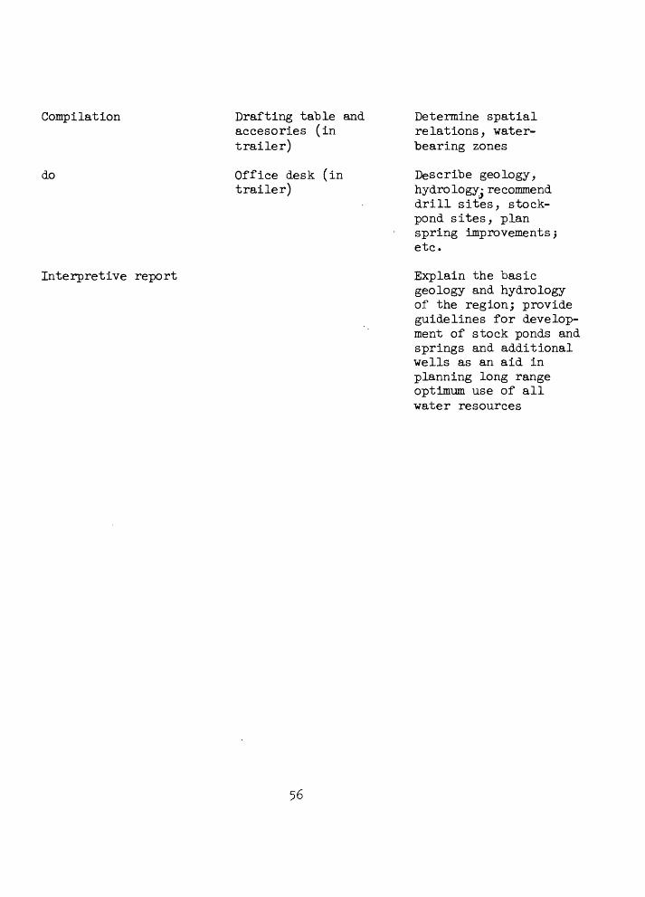
Compilation Drafting table and Determine spatialaccesories (in relations, water- trailer) bearing zones
do Office desk (in Describe geology,trailer) hydrologyj recommend
drill sites, stock- pond sites, plan spring improvements 5 etc.
Interpretive report Explain the basicgeology and hydrology of the region; provide guidelines for develop ment of stock ponds and springs and additional wells as an aid in planning long range optimum use of all water resources

Working and Living Conditions
During the field season the geologic and hydrologic investigations
team will logically be based at lavello. The nearest US AID office is
at Addis Ababa, capital of Ethiopia and U8o. km north of lavello.
lavello has an Ethiopian population of about 2,000 people and small
group of "expatriate" missionaries probably numbering no more than 2 or
3 families. The town is the center for the administrative affairs of
southern Sidamo Province and hence the governor and the heads of
military and police affairs also reside here. Amharic is the official
language. English and Italian are spoken but not by sufficient numbers
of people to avoid the necessity for an interpreter or better yet,
learning to speak Amharic. Foreigners are treated with utmost kindness
and courtesy and this makes up in large measure for the lack of modern
facilities and conveniences. Water must be hauled from the nearby
spring and boiled and filtered, laundry is done by hand, and cooking
and lights are obtained via Coleman or butane lanterns and stoves. All
provisions must be well stocked before leaving Addis Ababa and in a
manner befitting one who is going into the field. During the writer's
brief stay in lavello and elsewhere he lived in tents, and employed the
assistance of a cook and driver-mechanic, both of whom could speak some
English. During the dry season of the year a bus reaches lavello about
once a weekt from towns to the north and trucks loaded with supplies
arrive almost daily. During the wet season transport of any kind is
quite unpredictable. Expatriate families with children do not live at
57

lavello, but the adventuresome wife -will find it a hospitable and
interesting setting for an occasional visit.
Working in the field will require a good deal of camping out,
probably for periods of up to a week or 10 days at a time, and for
reasons of both safety and companionship field work would be carried
out by teams of American scientists and experienced Ethiopian geologists
or hydrologists. This relation also provides opportunity for the
exchange of ideas and field methods between American scientists and
Ethiopian scientists and engineers. Geologic mapping and reconnaissance
hydrological investigations will necessarily resort to photointer-
pretation and considerable footwork accompanied and assisted at times
by packboard, pack mules, donkeys, or camels. All-weather roads are
non-existent and bush roads are few and far between. With care, however,
much of the country can be traversed by a stout vehicle of the power
wagon variety. Field men should bring a light over-under ,22-shotgun,
.30 caliber rifle and an effective side arm for procuring camp meat and
for defense purposes. Thorn bush fences surround all native villages
and compounds as protection against night marauders and either this or
all-night fires will be required at most camp sites. The area abounds
in many species of antelope, giraffe, ostrich, and zebra as well as
jackels, hyena, and several species of felines, including lions and
leopards. As discussed earlier these "opening" investigations will
require a good measure of frontier living under rugged conditions.
58

Notwithstanding this, the technical aspects of the work appear to "be
extraordinarily interesting and challenging as do the non-tecnical
aspects.
Ethiopia is a post for which there is considerable interest
among American personnel assigned overseas. All "US AID families
attached to the above development phases of the marketing program
will maintain permanent headquarters in the capital city of Addis
Ababa; they will join a close-knit American community that throughout
the years has maintained a good deal of esprit de corps among its
members.
59

Project Requirements
Personnel
The overall requirements in personnel for the opening of remote
country both at home and abroad have been reiterated so frequently that
they have become almost a part of the educational-curricula for U. S.
geologists, engineers, and hydrologists alike. Above all individuals
selected for this assignment must exercise good judgement, have a healthy
constitution, the desire to work hard,and the ability to "cope" in a part
of Ethiopia for which local communications and supplies are practically
non-existent.
The reconnaissance investigation carried out in the area indicates
that the chief handicaps to effective work will be great distances, a
dearth of roads, and an all too prevalent lack of communication, supply
and.repair facilities. The young Ethiopian who accompanied us on our
trip is a good example of the type who should be recruited for this job.
Although not a geologist he has the right attributes for being a good
one. He is young (28) and eager to learn. He has entered the area with
confidence, travelled alone by all means of conveyance, purchased cattle
from nomadic tribesmen and in general most resourcefully set the stage
for the livestock marketing program from this remote area. Recommen
dations as to technical personnel are as follows:
Chief of Party;..-Mature, hydrologist with sufficient training in
qualitative and quantitative methods so that he can act independently,
preferably over ^0, and probably in a present grade of GS-13-
60
He should have considerable experience in dealing with related
geologic and hydrologic (including ground water) projects.
Field Hydrologist and Geologist: These two men should be of equal
grade, probably GS-11 or 12, preferably unmarried, or if married,
accustomed to periods of separation from home and family, and with
experience in quantitative and qualitative field methods employed in
geology and hydrology. It is expected that the Imperial Government of
Ethiopia will assign at least one well-qualified field geologist to
work with the technical staff and be based in the same field station.
This would provide excellent opportunities for cultural exchange,
one side contributing U.S. techniques and methods, the other a
knowledge of the local conditions and problems. There is also a
prospect that the project staff will include an Ethiopian hydrologist.
Such addition to the staff would be welcomed, in order to develop
competent technicians for carrying on when the project is completed.
Other major questions outside the field of hydrology but related
to it are the social and economic effects of water-supply developments;
a subject of particular interest to the Imperial Ministry of Agriculture
It is realized that such studies will require visits to all sources of
water supply and must depend in part upon data that are the concern of
the geologist and hydrologist. No specific proposal has been made, but
someone specializing in this field may be assigned to work closely with
the project staff.
61

Housing in Field Area
At present there is no suitable space in lavello, either for office
or domicile. Realizing that the project cannot commence effectively
until such space become available it is recommended that US AID make all
efforts to provide such space before initiation .of field work. Require
ments in the field would include three 9 m (30-foot) house trailers, one
of which can be fitted out with drafting facilities under local super
vision, to serve as an office. Ancillary equipment should also include
a small. 10 HP motor-driven skid-mounted generator (2,000 watt capacity),
washing machine, hot-water heater, an outdoor prefab type shower? and
2-wheel trailer mounted with a water tank of about 755 liters (200
gallons) capacity. Camp construction crews should bear in mind that
trailers should be grouped at a site that will provide drainage, suffi
cient head for gravity feet to the plumbing system and a minimum, of
radio interference. Provisions should also be made for servants'
quarters. All vehicles assigned to the project should be equipped with
sturdy ball and socket trailer hitch.
Communication with Addis Ababa must be efficient. It is recom
mended that short-wave radio receiver and transmitter in addition to
and compatible with equipment already ordered for use by the livestock
marketing program be obtained for the work. A mobile unit is not
required.
Two power systems will be required^ one electric for lights, radio^
and all electric-driven motorSjand a second propane for running a hot
water heater, stoves, and a compact deep freeze.
62

Equipment
Following is a tentative list of equipment that will be needed.
The "approximate costs" include many estimates, without benefit of
catalogs, and may be highly approximate.
Items from U.S. Manufacturer
Estimated Cost
2 Water-level rec orders, continuous,type A-35 Stevens .$1,000.00
2 Water-meters, Sparling type 2-inch 400.00
1 Conductivity meter battery operated 300.00
2 Hack chemical kits for nitrate, iron, pH.Alkalinity, etc. 100.00
1 Leroy drafting set 50.00
1 Proportional divider, 12-inch 25.00
1 set Ships curves, triangles, drafting pens and pencils 20.00
1 Planimeter, K and E type 70.00
1 Drafting or drawing set 50-00
1 set Air photos, contact prints * 2,000.00
1 set Print laydowns, 1:125,000*
1 Generator (2,000-watt capacity) 400.00
1 10 HP motor unit in combination with above 200.00
1 Wagoneer Jeep Station Wagon 2,500.00
2 Dodge Power Wagons, open bed, canvas cover,or equivalent 6,000.00
1 Two-wheel trailer with .springs and 200-galloncapacity tank 800.00
63
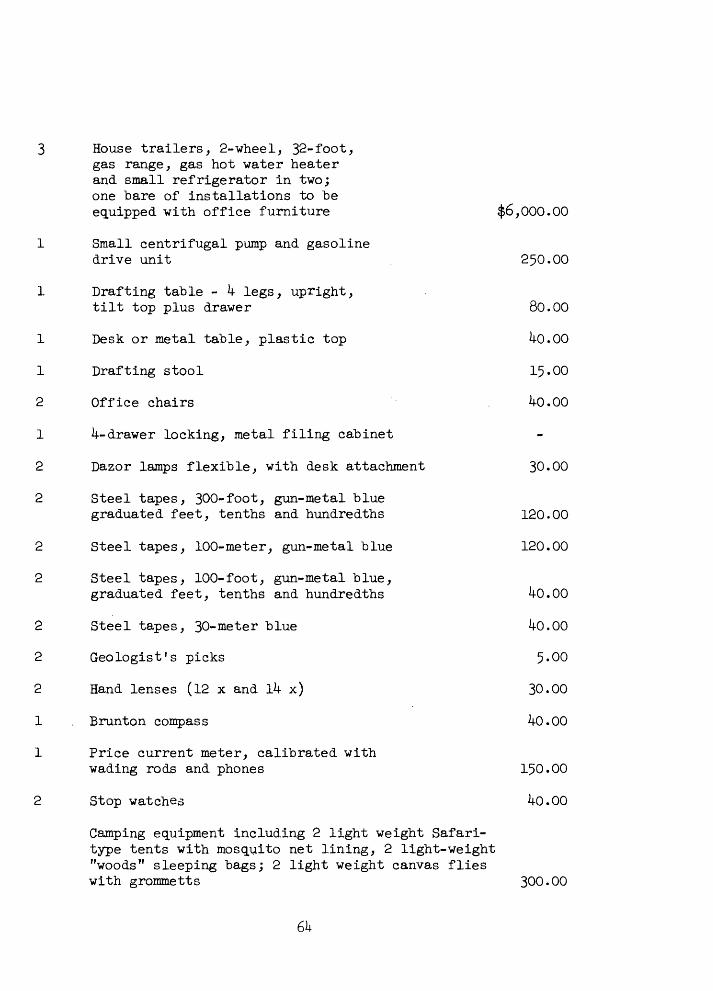
3 House trailers, 2-wheel, 32-foot, gas range, gas hot water heater and small refrigerator in two; one "bare of installations to "be equipped with office furniture $6,000.00
1 Small centrifugal pump and gasolinedrive unit . 250.00
1 Drafting table - k legs, upright,tilt top plus drawer 80.00
1 Desk or metal table, plastic top 1*0.00
1 Drafting stool 15.00
2 Office chairs . 40.00
1 k- drawer locking, metal filing cabinet
2 Dazor lamps flexible, with desk attachment 30.00
2 Steel tapes, 300-foot, gun-metal bluegraduated feet, tenths and hundredths 120.00
2 Steel tapes, 100-meter, gun-metal blue 120.00
2 Steel tapes, 100-foot, gun-metal blue,graduated feet, tenths and hundredths 1*0.00
2 Steel tapes, 30-meter blue 1*0.00
2 Geologist's picks 5.00
2 Hand lenses (12 x and Ik x) 30.00
1 . Brunton compass 40.00
1 Price current meter, calibrated withwading rods and phones 150.00
2 Stop watches 40.00
Camping equipment including 2 light weight Safari- type tents with mosquito net lining, 2 light-weight "woods" sleeping bags; 2 light weight canvas flies with grommetts 300.00

2 Trapper Nelson type pack boards with canvas bags $ 35-00
2 Cots, folding - 36-inch width 30.00
2 Air mattresses 30.00
2 Stoves, Coleman 3-^urner 30.00
4 Lamps, Coleman, single mantle 2^.00
2 Cooking kits, nest, 4-man ___8.00$21, ij-12.00
* For beginning phases of the overall project and for use in this
proposed project 1,000 individual photographs, scale 1:50,000
should be provided to cover the 1-degree quadrangles in Ethiopia.
(1) 3°00' N to 4°00' N Latitude; 38°00' E to 39°00' E Longitude
(2) 4°00' N to 5°00' N ;
(3) 5°00' N to 6°00 f N ;
Each 1-degree quadrangle should be illustrated by print-laydowns»
scale 1:125,000.

Bibliography
Bureau of Reclamation, 1960, Geology and mineral resources of Ethiopia; U.S. Department of the Interior, Bureau of Reclamation; Geology Working Papers No. 10 (Thomas G. Murdock Report), 264 p., illustrations and maps.
Bureau of Reclamation, 1964, Land and water resources of the Blue Nile Basin, Ethiopia, Appendix II--Geology; prepared for Department of State,Agency for International Development by the U.S. Department of the Interior, Bureau of Reclamation, 221 p., figures and maps.
Bureau of Reclamation, 1964, Land and water resources of the Blue Nile Basin, Ethiopia, Appendix III Hydrology; prepared for the Depart ment of State, Agency for International Development by the U.S. Department of the Interior, Bureau of Reclamation, 257 P«> maps, tables and graphs.
Caponera, Dante A., 1954, Water laws in Moslem countries; Food and Agriculture Organization of the United Nations; FAO Development Paper No. 43, 202 p.
Kebede, Tato, 1964, Rainfall in Ethiopia; Ethiopian Geographical Journal, vol. 2, no. 2, pp. 28-36.
Emmanuel, H. W., The Imperial Ethiopian Mapping Geography Institute:a review; Ethiopian Geographical Journal, vol. 2, no. 2, pp. 37-39-
Mohr, Paul .A., 196l, The Geology of Ethiopia; University College of Addis Ababa Press, 263 p., 20 figs., 20 tables.
Murphy, H. F., 1959* A report on the fertility status of some soils of Ethiopia, Imperial Ethiopian College of Agriculture and Mechanical Arts, Experiment Station Bulletin No. 1, 201 p., figs., tables and index maps.
von Breitenbach, F., 196l, Forest and woodlands of Ethiopia; Ethiopian Forestry Review, Ethiopian Forestry Association, Addis Ababa, Ethiopia, No. 1, June, pp. 5-l6, maps and illustrations.
66

Orthography
The spelling of names for physical and cultural features in
Ethiopia presents numerous problems in consistency, chiefly
because of difficulties of transliterating Amharic, Galla, Arabic,
Italian and other locally used languages into exact English
equivalents. The following list correlates geographic names used
in this report with standard names approved by the Board of
Geographic Names (BGN) , where possible to verify. Where no
standard name is given in the following list, the name is not
verified. Where part of the name is underlined, the use of the
part not underlined is optional.
67

Report Name Board on Geographic Names(BGN)
Addis AbabaAlgheAsmara EritreaAselleAdamitulloAgaroAmar CoccheAreroAuata stm
Addis AbabaAlgaAsmaraAsalaAdamitulloAgaroAmar CoccheAreroNot verified(nv)
BongaBoleBulchiBacoBurgiBorrodaBillate stm
BongaBoleBulchiBakoBurjiBoroddaBillate
CaraCenciaGossa
CaraCenciaKosa
Dawa Parma River
Dilla Dime Dalle Digalu stock pond
Dawa (Ethi)Dawa Parma
Dilla Dime Dalle
(Ital and Br)
El Melbana well El Sod crater
MeIbana El Sod
68

Great Rift ValleyGanale-Doria (Ethi)GimmaGiarsoGogeb stmGardullaG. Gorai
Great Rift Valley stm Ganale-Dorya
Jima Giarso Gojab Gardula
Hora Abgiata Hosanna Hula Hobok Spring
lake Hora AbgiataHosaenaHula
lavello Spring(Yavello) larbu-Hobok
Yabelo nv
Kenya Republic of Kenya
Lake Stephanie Lake Ruspolt Lake Zuai L. Langanno L. Scialla L. Uombo Lake Rudolf Lake Auasa Lake Myluis Lake Marguerita
playa(Kenya) 1st? IfanosLake RuspoliZewayLanganaSholanvLake RudolfAwusaLake MyliusLake Marguerita
(Ethi)
69

MegaMagadoMassuauaMoyaleMoialeMarauaMagado
craterEritrea
(Kenya) (Ethi)
area
Mega
MassauaMoyaleMoyaleMarauaMagado
Neghelle North Horr (Kenya)
Nagele North Horr
Omo Bottego stm Omo Bottego
Ririba stm Ririba
Sidamo ProvinceShashenenneSodduSaganSoghidda wells
Sidamo Shashamani So do Sagan
Uondo Uabi stm Webe
Yirga Alem(Yrgalem) Yirga Alem
TO

Appendix
A long-range Regional Livestock Development program for southern
Ethiopia including development of the water supply is a basic enterprise
of the Ethiopian government. A part of this program calls for contract
documents covering the drilling of exploratory and test boreholes in the
development region, and initiation of this work as soon as possible.
Figure 1 indicates 6 sites chosen for exploratory boreholes in areas
where they should have a reasonable chance of encountering sufficient
water for livestock. Three of these sites are south of Mega, in the
central part of a broad valley leading southward from the hills sur
rounding Mega; two are northwest of Mega along the axis of a similar
valley and one is in a low-lying area ©bout 1 mile northeast of the air
strip at Mega. The sites can be reached by road with short intervals
of cross-country driving.
The three borehole sites south of Mega are believed to be under
lain by tuffaceous deposits covered with a thin veneer of alluvial sand
and clay. These deposits probably rest uncomformably igneous and meta-
morphic rocks of the same type that crop out in the hills of Mega. A
borehole at the site nearest the hills of Mega may encounter only a thin
section of tuffaceous deposits or it may penetrate from alluvium directly
into metamorphic rocks. This borehole would be the least likely to
encounter water-bearing rocks among the three sites south of Mega.
Boreholes at the two southernmost sites should encounter water in tuffa
ceous deposits between 25 and 35 m below land-surface datum.
Tl

The two borehole sites northwest of Mega are believed to be under
lain by poorly stratified alluvial deposits of sandy silt. These
deposits may in turn rest upon volcanic or metamorphic rocks. Very
little can be predicted concerning the depth to water, the nature of the
water-bearing sediments, or the yield of boreholes at these two sites,
but the prevalence of green vegetation along the axis of the valley
suggests that ground water may be present at shallow depth in alluvium.
The borehole site about 1,6 km northeast of the Mega air strip is
believed to be underlain by volcanic rocks that have originated from
nearby explosion craters. The thickness and physical properties of
these deposits are not known. They are believed to rest unconformably
upon metamorphic rocks. Ground water may be encountered in the lower
part of the volcanic sequence directly above the metamorphic basement
rocks.
At none of the proposed borehole sites should drilling be attempted
beyond depths at which metamorphic or igneous rocks of the basement
complex are first encountered.
Provision in a contract covering drilling activities at these sites
should include the following requirements:
1. Representative samples of all strata penetrated at each bore
hole shall be collected at 3 m vertical intervals and at
any interval in depth at which water-bearing rocks are first
encountered or where drilling rates or other conditions
indicate a change in the physical properties of the strata.
72

These samples should "be logged "by a qualified geologist and
the cuttings, in appropriate wooden containers, and the logs,
turned over to representatives of US AID.
2. Electric logs including a resistivity and self-potential
log shall "be provided "by the contractor and "become a part
of the documentation of each "borehole.
3. Boreholes shall "be of sufficient diameter to accommodate 152 mm
(6-inch I.D. A.P.I.) casing. Casing shall "be installed
throughout the depth of the "borehole and slotted
sufficiently to allow optimum conditions for entry of
water and elimination of detritus from walls of the
"borehole.
4. Each "borehole shall "be developed over a sufficient period
of time to insure the removal of drilling mud from water
bearing strata and other fine-grained sediment that might
during its subsequent use, impair its efficiency or cause
damage to installations.
5. Casing shall "be recovered at abandoned "boreholes and the
cost of the casing less the cost of its installation and
recovery shall "be reimbursable to the contracting agency
at prices and rates stipulated by the contract.
6. Each borehole initiated by the contractor must be
originated by a work order from the contracting agency
representative in-charge documenting the design and
objectives of the borehole and its estimated cost.
73
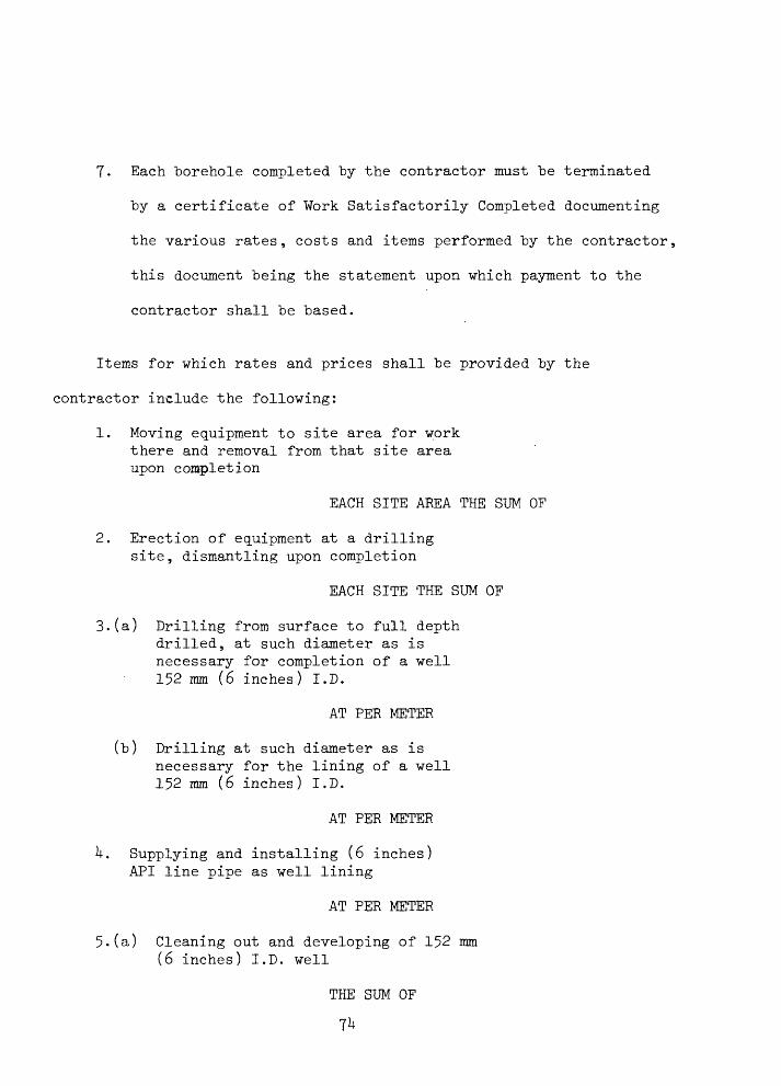
T. Each borehole completed by the contractor must be terminated
by a certificate of Work Satisfactorily Completed documenting
the various rates, costs and items performed by the contractor,
this document being the statement upon which payment to the
contractor shall be based.
Items for which rates and prices shall be provided by the
contractor include the following:
1. Moving equipment to site area for work there and removal from that site area upon completion
EACH SITE AREA THE SUM OF
2. Erection of equipment at a drilling site, dismantling upon completion
EACH SITE THE SUM OF
3.(a) Drilling from surface to full depth drilled, at such diameter as is necessary for completion of a well 152 mm (6 inches) I.D.
AT PER METER
(b) Drilling at such diameter as isnecessary for the lining of a well 152 mm (6 inches) I.D.
AT PER METER
k. Supplying and installing (6 inches) API line pipe as well lining
AT PER METER
5.(a) Cleaning out and developing of 152 mm (6 inches) I.D. well
THE SUM OF

5.("b) Provide and install airliftequipment in 152 mm (6 inches) I.D, well and compressor also, remove upon completion of testing
THE SUM OF
(c) Operate compressor for airlift pumping
AT PER HOUR
75