proposed quarry development, moree cultural …...proposed quarry development, mooree chmp 12482...
TRANSCRIPT

Proposed Quarry Development, Moree
Cultural Heritage Management Plan
AAV Management Plan Identifier: 12482
Sponsor: Justin Bartlett on behalf of Ararat Quarrying Company Pty Ltd
Cultural Heritage Advisor: Bianca Di FazioAuthors: Bianca Di Fazio and Luke Falvey
February 21, 2013


Title PageACTIVITY: Proposed Quarry DevelopmentLOCATION: Nareen Rd, MoreeLEVEL OF ASSESSMENT: Desktop, StandardSIZE OF ACTIVITY: LargeAAV PLAN IDENTIFIER: 12482DATE OF COMPLETION: February 21, 2013SPONSOR: Justin Bartlett on behalf of Ararat Quarrying Company
Pty LtdABN: 0400 054 904CULTURAL HERITAGE ADVISOR: Bianca Di FazioAUTHOR: Bianca Di Fazio
Luke Falvey
Acknowledgements
Heritage Insight Pty Ltd would like to acknowledge and thank the following people for their assistanceand participation in this study:
The Sponsor
Justin Bartlett on behalf of Ararat Quarrying Company Pty Ltd
Gunditj Mirring Traditional Owner Aboriginal Corporation
Keicha DayNicole HudsonJohn King
Heritage Insight Staff
Katarina Audy – GIS MappingSamantha Brown – Background Research and Compilation; Field Assistance

Proposed Quarry Development, MooreeCHMP 12482
Heritage Insight Pty Ltd
Disclaimer
The information contained in this Cultural Heritage Management Plan (CHMP) has been compiled fromthe standard heritage database sources and is accurate as far as Heritage Insight Pty Ltd is aware.However, within the timeframes available for technical heritage reporting, it is not possible to carry outcomprehensive research of all published or unpublished manuscripts, journals, maps or oral history whichmay pertain to the study area. No responsibility can be taken for errors or omissions in primary andsecondary source material cited in this report. Any opinions expressed in this report are those of HeritageInsight Pty Ltd and do not necessarily represent those of Justin Bartlett or Ararat Quarrying CompanyPty Ltd. Heritage Insight Pty Ltd has endeavoured to actively consult with representatives of theAboriginal community group who is, to the best of our knowledge and advice, the legal and properrepresentative of the local Aboriginal community. The consultants cannot, however, be held responsiblefor opinions or actions which may be expressed by dissenting persons or organisations. This CHMP hasbeen prepared to comply with the Approved Form under Clause r.64 (a) of the Aboriginal HeritageRegulations 2007 “Aboriginal Cultural Heritage Management Plan for the Purposes of the AboriginalHeritage Act 2006”. However, Heritage Insight Pty Ltd cannot be responsible for any changes in policy onthe part of the Victorian Government, its agencies, or Registered Aboriginal Parties in the period sincelodging a Notice of Intention to Prepare a CHMP.
Copyright Notice
This report is copyright. Apart from any fair dealing for the purposes of private study, research, criticismor review as permitted under the Copyright Act, no part may be reproduced, stored in a retrieval system,or transmitted in any form or by any means, whether electronic, mechanical, photocopying, recording orotherwise without prior written permission. Enquiries should be made to Justin Bartlett at AraratQuarrying Company Pty Ltd or Heritage Insight Pty Ltd.

Proposed Quarry Development, MooreeCHMP 12482
Heritage Insight Pty Ltd
Page | i
Executive Summary
This Cultural Heritage Management Plan (CHMP) has been undertaken at the request of Justin Bartletton behalf of Ararat Quarrying Company Pty Ltd in order to provide a detailed assessment of the culturalheritage values associated with the land and proposed activity at 3807 Coleraine-Nareen-Moo Road,Moree. A Cultural Heritage Management Plan (CHMP) is a mandatory requirement for the proposedactivity because:
Part of the proposed activity occurs in an area of cultural heritage sensitivity (AboriginalHeritage Regulations 2007, Division 1, 6(a)); and
The proposed activity is a high impact activity (Aboriginal Heritage Regulations 2007,Division 1, 6(b)).
Part of the Activity Area is within 200m of a named watercourse, Pigeon Ponds Creek, and therefore fallswithin an area of cultural heritage sensitivity as defined in the Aboriginal Heritage Regulations 2007 r.23(Waterways):
r.23 Waterways
(1) Subject to subregulation (2), a waterway or land within 200 metres of awaterway is an area of cultural heritage sensitivity.
The proposed works are for development of a basalt quarry. This is a high impact activity as defined inthe Aboriginal Heritage Regulations 2007 r.48 (Activities requiring earth resource authorisations):
r.48 Activities requiring earth resource authorisations
An activity is a high impact activity if it is an activity-
(a) for which an earth resource authorisation is required before the activity may becarried out; and
(b) that would result in significant ground disturbance.
Sponsor for the CHMP
The sponsor for this CHMP is the Ararat Quarrying Company Pty Ltd (ABN: 86 158 640 709).
Notice of Intent to Prepare a CHMP
A Notice of Intent (NOI) to Prepare a CHMP (Appendix 1) was submitted on 8 January 1213 to theDeputy Director of Aboriginal Affairs Victoria (AAV) pursuant to Section 54 of the Aboriginal HeritageAct 2006. AAV replied to the NOI on 8 January 2013 and allocated this project with the CHMP number12482.
The NOI was also submitted to the Gunditj Mirring Traditional Owners Aboriginal Corporation(GMTOAC) who are the Registered Aboriginal Party for the region encompassing the Activity Area. TheGMTOAC responded to the NOI, indicating that they would evaluate the CHMP on submission(Appendix 2).
Name, Qualifications and Experience of Cultural Heritage Advisor
The cultural heritage advisor for the CHMP is Bianca Di Fazio (MA, BA (Hons). Ms Di Fazio has sixteenyears of experience as a professional archaeologist working in the fields of Aboriginal and non-Aboriginal

Proposed Quarry Development, MooreeCHMP 12482
Heritage Insight Pty Ltd
Page | ii
cultural heritage. She has extensive experience in undertaking both field assessments and management inrelation to Aboriginal cultural heritage in south-eastern Australia.
Location of the Activity Area
The Activity Area is located at 13807 Coleraine-Nareen-Moo Road, Moree (Section CP103951; Volume91432, Folio 469; West Wimmera Shire; Parish of Mooree) and is approximately 16 hectares (160,000m2)in size (Map 1). The area is currently undulating open pasture used for grazing stock (Figure 1).
Land Owners
The land is currently owned by Mr Nevill McClure.
RAPs with Responsibility for the Activity Area
The Registered Aboriginal Party (RAP) for the region encompassing the Activity Area is the GunditjMirring Traditional Owners Aboriginal Corporation (GMTOAC). The RAP has provided confirmationthat they intend to evaluate the CHMP.
Results of the Assessment
Desktop Assessment
The desktop assessment for the Activity Area has allowed a site prediction model to be developed. A siteprediction model is intended for use as an indication of the types of archaeological sites that may occur ina given area. The site prediction model can later be tested against results of field survey and/or sub-surface testing.
In general the following statements can be made about the current Activity Area:
No previously recorded Aboriginal Places are located within the Activity Area. There are noplaces recorded within 200m of the Activity Area;
Two other Aboriginal Places were within the geographic region. Both are scarred treesapproximately 500m to the west;
Four relevant reports have been completed within the geographic region. These reports suggest alikelihood of scarred trees within the region with a possibility of stone artefact scatters. Allreports cite a lack of archaeological work undertaken in the region as the primary reason for thelow number of registered heritage places;
The Activity Area lies within an area administered by the Gunditj Mirring Traditional OwnersAboriginal Corporation which incorporates the descendants of the Jagwadjali language group;
Plant resources within the region of the Activity Area are presently comprised of a small numberof large eucalypts, in addition to medium trees, grasses, herbs, shrubs and weeds. Fauna wouldhave primarily consisted of birds such as the black and white Cockatoos, the common Australianwood duck, and other species common south west Victoria.
There are no known stone resources suitable for the manufacture of stone tools found within theActivity Area. However, suitable material for the manufacture of stone artefacts may have beenavailable in the broader region, and quartzite quarries are known at Mt. Talbot;

Proposed Quarry Development, MooreeCHMP 12482
Heritage Insight Pty Ltd
Page | iii
Europeans first settled in the region of the Activity Area during the late 1830s, and were firmlyestablished by 1840. The Activity Area was originally owned by a squatter named Thomas Norrisand was visited by G.A. Robinson in 1941;
G.A. Robinson recorded the presence of Aboriginal peoples in the broader region, hisencounters with the peoples at Kout Narin and describes a structure made for bird catching;
Aerial photography from the late twentieth-century shows a landscape sparsely populated bytrees and predominantly used for grazing. There has clearly been little to no disturbance withinthe Activity Area.
From these statements it can be considered that although the Activity Area has likely undergone somedisturbance as a result of land clearance activities in the early pastoral period, there is still someprobability that some Aboriginal cultural material will exist there. This is due to:
A known and recorded Aboriginal presence in the area at the time of European contact;
The presence of scarred trees in the immediate area and recorded sites within the broaderJagwadjali language group region;
The abundance of water and food resources available to Aboriginal peoples at the confluence ofthe Glenelg River and Pigeon Ponds Creek;
The most likely site types to be located within the Activity Area are scarred trees found in close proximityto Pigeon Ponds Creek. It is also considered possible that surface or sub-surface scatters of lithic artefactswill be found on any rises in proximity to the creek.
Standard Assessment
No archaeological sites were located during the Standard Assessment.
The Standard Assessment found that the gradient would almost certainly preclude sites from beinglocated on the sides of the basalt hill, which is the principal focus of the proposed quarry. The remainingsections of the Activity Area were considered more likely to contain Aboriginal cultural material,however, given the more level ground surface adjacent to Pigeon Ponds Creek (beyond the Activity Areaboundary) even the lower-lying parts of the Activity Area were not considered to retain high levels ofpotential for cultural material.
Recommendations
General Recommendation: Site Induction/Cultural Awareness Training
In order to provide a system for notification of the discovery of Aboriginal cultural heritage duringconstruction works, it will first be necessary to provide an induction to any future project managers andconstruction workers about the discovery of Aboriginal cultural heritage on-site.
A site induction or inductions must be held with project managers and any construction workers on-site.The purpose of the induction/s will be to describe items of Aboriginal cultural heritage to personnelengaged in construction, to create an awareness of their cultural value and to inform personnel about theprocedure for reporting suspected Aboriginal cultural heritage. This induction must be presented by arepresentative of the Gunditj Mirring Traditional Owners Aboriginal Corporation (GMTOAC) and acultural heritage advisor. Details of the site induction process can be found in Section
Proposed Quarry Development, MooreeCHMP 12482
Heritage Insight Pty Ltd
Page | iv
There will also need to be a system of reporting any possible Aboriginal cultural heritage items that arediscovered during works, and this must be built into any development or environmental managementplan (EMP) for the site (see Section 8.4, below). Contingency plans for notifying the discovery ofAboriginal cultural heritage are contained in Section 8 and must be incorporated into the development orEnvironmental Management Plan for the project. A copy of this management plan must be held on-siteat all times.
Specific Cultural Heritage Management Recommendations
At the time of the Standard Assessment, recommendations for the ongoing management of the ActivityArea were discussed on site with Ms Hudson and Mr King of the GMTOAC. Given the low groundsurface visibility within the Activity Area generally it was concluded that there was some potential forcultural material to remain within the areas designated for proposed access and stockpiling, although thispotential was somewhat reduced given the proximity of slightly more favourable camping locations closerto the creek.
For this reason, in combination with the generally poor ground surface visibility observed within theActivity Area, it is recommended that a program of archaeological monitoring be undertaken byrepresentatives of the GMTOAC during the initial stages of works in all areas beyond the base of thebasalt hill. These areas include the location of access tracks and the stockpile and loading area and anyother areas where the surface of the ground will be disturbed.
If Aboriginal cultural heritage material is located during the archaeological monitoring, the contingenciesfor the unexpected discovery of Aboriginal cultural heritage material outlined in Section 10 are to befollowed.
The GMTOAC must be notified seven days in advance of works commencing. An official written requestfor site representatives must be submitted to the GMTOAC schedule a GMTOAC representative in forparticipation in the monitoring program.
All GMTOAC costs for participation in the monitoring program must be met by the Sponsor.
The contingency plans contained in Section 8 of this report form part of the Cultural HeritageManagement Plan and must be incorporated into the development or Environmental Management Planfor the project. A copy of this management plan must be held on-site at all times.

Proposed Quarry Development, MooreeCHMP 12482
Heritage Insight Pty Ltd
Page | v
Table of ContentsEXECUTIVE SUMMARY ...............................................................................................................I
PART ONE: ASSESSMENT ........................................................................................................1
1.0 INTRODUCTION ..................................................................................................................1
2.0 ACTIVITY DESCRIPTION............................................................................................... 42.1 STATEMENT OF POTENTIAL IMPACTS ......................................................................................................................... 4
3.0 EXTENT OF ACTIVITY AREA COVERED BY THE CHMP....................................... 6
4.0 DOCUMENTATION OF CONSULTATION.................................................................. 74.1 CONSULTATION IN RELATION TO THE ASSESSMENT ............................................................................................... 74.2 PARTICIPATION IN THE CONDUCT OF THE ASSESSMENT ........................................................................................ 74.3 CONSULTATION IN RELATION TO THE MANAGEMENT RECOMMENDATIONS ................................................... 74.4 SUMMARY OUTCOMES OF CONSULTATION ................................................................................................................ 7
5.0 REPORT ON THE RESULTS OF THE DESKTOP ASSESSMENT............................. 85.1 METHODOLOGY FOR DESKTOP ASSESSMENT ........................................................................................................... 85.2 RESULTS OF DESKTOP ASSESSMENT............................................................................................................................ 8
5.2.1 Search of the Victorian Aboriginal Heritage Register ................................................................................................ 85.2.2 The Geographic Region.............................................................................................................................................. 95.2.3 Landforms and Geomorphology of the Activity Area............................................................................................... 105.2.4 Resources Available to Aboriginal People within the Activity Area ........................................................................ 115.2.6 Aboriginal Places in the Geographic Region ............................................................................................................ 125.2.7 Previous Work in the Geographic Region ................................................................................................................ 135.2.8 Historical and Ethno-Historical Accounts in the Geographic Region....................................................................... 155.2.9 Post-Contact History of Land Use and Disturbance in the Activity Area............................................................... 16
5.3 SITE PREDICTION MODEL AND CONCLUSIONS FROM THE DESKTOP ASSESSMENT ........................................ 18
6.0 REPORT ON THE RESULTS OF THE STANDARD ASSESSMENT........................ 206.1 METHODOLOGY FOR STANDARD ASSESSMENT ...................................................................................................... 206.2 RESULTS OF GROUND SURVEY ................................................................................................................................... 21
6.2.1 Area Surveyed......................................................................................................................................................... 216.2.2 Ground Surface Visibility and Other Constraints on Field Survey.......................................................................... 216.2.3 Survey Results ......................................................................................................................................................... 23
6.3 CONCLUSIONS FROM THE GROUND SURVEY ........................................................................................................... 28
7.0 CONSIDERATION OF SECTION 61 MATTERS – IMPACT ASSESSMENT............ 29
PART TWO: CULTURAL HERITAGE MANAGEMENT RECOMMENDATIONS........... 30
7.0 CULTURAL HERITAGE MANAGEMENT REQUIREMENTS................................. 307.1 GENERAL RECOMMENDATION: SITE INDUCTION/CULTURAL AWARENESS TRAINING................................. 307.2 SPECIFIC CULTURAL HERITAGE MANAGEMENT RECOMMENDATIONS ............................................................. 30
8.0 CONTINGENCY PLANNING....................................................................................... 328.1 SECTION 61 MATTERS................................................................................................................................................... 328.2 DISPUTE RESOLUTION ................................................................................................................................................. 328.3 DISCOVERY OF ABORIGINAL CULTURAL HERITAGE DURING WORKS ............................................................... 33
8.3.1 Unexpected Discovery of Human Remains .............................................................................................................. 338.3.2 Unexpected Discovery of Isolated or Dispersed Aboriginal Cultural Heritage.......................................................... 358.3.3 Unexpected Discovery of Stratified Occupation Deposits .......................................................................................... 368.3.4 Unexpected Discovery of a Coastal Shell Midden .................................................................................................... 378.3.5 Unexpected Discovery of a Fresh Water Shell Midden ............................................................................................ 388.3.6 Unexpected Discovery of a Mound Site.................................................................................................................... 398.3.7 Unexpected Discovery of a Quarry .......................................................................................................................... 408.3.8 Unexpected Discovery of a Stone Arrangement ........................................................................................................ 418.3.9 Unexpected Discovery of Other Aboriginal Cultural Heritage ................................................................................. 42
8.4 REPORTING DISCOVERY OF ABORIGINAL CULTURAL HERITAGE DURING WORKS ........................................ 438.5 MANAGEMENT OF ABORIGINAL CULTURAL HERITAGE DISCOVERED DURING WORKS................................ 438.6 REVIEWING COMPLIANCE WITH THE PLAN ............................................................................................................. 448.7 RESOLUTION OF NON-COMPLIANCE WITH THE PLAN .......................................................................................... 45
Proposed Quarry Development, MooreeCHMP 12482
Heritage Insight Pty Ltd
Page | vi
9.0 OTHER CONSIDERATIONS ........................................................................................ 479.1 COMMUNICATION.......................................................................................................................................................... 47
BIBLIOGRAPHY.......................................................................................................................... 48
APPENDIX 1: CHMP NOTIFICATION................................................................................ 49
APPENDIX 3: GLOSSARY....................................................................................................... 54
Maps
MAP 1: LOCATION OF ACTIVITY AREA AT 3807 COLERAINE-NAREEN-MOO ROAD (SECTION CP103951;VOLUME 9143 FOLIO 469; WEST WIMMERA SHIRE; PARISH OF MOOREE) ........................................... 3
MAP 2: DEVELOPMENT PLAN OF ACTIVITY AREA AT 3807 COLERAINE-NAREEN-MOO ROAD (SECTIONCP103951; VOLUME 9143 FOLIO 469; WEST WIMMERA SHIRE; PARISH OF MOOREE)....................... 5
MAP 3: EXTENT OF THE ACTIVITY AREA............................................................................................................... 6MAP 4: GEOGRAPHIC REGION IN WHICH THE ACTIVITY AREA IS LOCATED................................................. 9MAP 5: GEOLOGY WITHIN THE ACTIVITY AREA ................................................................................................ 10MAP 6: PRE-1750 ECOLOGICAL VEGETATION COMMUNITIES WITHIN THE ACTIVITY AREA .................. 12MAP 7: STANDARD ASSESSMENT SURVEY MAP ................................................................................................... 20MAP 8: LOCATION OF AREAS REQUIRING ARCHAEOLOGICAL MONITORING ............................................... 31
Figures
FIGURE 1: PARISH OF MOOREE LOCALITY (ACTIVITY AREA OUTLINED IN RED)........................................ 17
Tables
TABLE 1: SUMMARY OF LANDSYSTEM DATA ENCOMPASSING THE ACTIVITY AREA .................................. 11TABLE 2: SUMMARY OF REGISTERED ABORIGINAL PLACES WITHIN THE GEOGRAPHIC REGION .......... 13TABLE 3: TABLE OF PREVIOUSLY RECORDED ABORIGINAL PLACES WITHIN THE GEOGRAPHIC REGION
............................................................................................................................................................................. 13TABLE 4: SELECTED AERIAL PHOTOGRAPHS SHOWING THE CONDITIONS WITHIN THE ACTIVITY AREA
BETWEEN 1973 AND 2010 (CONTINUED OVER PAGE) ............................................................................. 17TABLE 5: EXAMPLES OF GROUND SURFACE VISIBILITY WITHIN THE ACTIVITY AREA (B. DI FAZIO
18/01/2013) (CONT. OVER PAGE) ................................................................................................................ 22TABLE 6: PHOTOGRAPHS FROM STANDARD ASSESSMENT (B. DI FAZIO 18/01/2013) (CONT. OVER
PAGE) ................................................................................................................................................................. 25
Abbreviations
AAA – Australian Archaeological AssociationAAV – Aboriginal Affairs VictoriaASHA – Australasian Society of Historical ArchaeologyASL – Above Sea LevelGMTOAC – Gunditj Mirring Traditional Owners Aboriginal CorporationCHA – Cultural Heritage AdvisorCHMP – Cultural Heritage Management PlanEMP - Environmental Management PlanEVC – Ecological Vegetation ClassLGM – Last Glacial MaximumRSP – Radial Shovel ProbeSTP – Shovel Test PitTP – Test Pit
Proposed Quarry Development, MooreeCHMP 12482
Heritage Insight Pty Ltd
Page | 1
Part One: Assessment
1.0 Introduction
Reasons for Preparing a CHMP
This Cultural Heritage Management Plan (CHMP) has been undertaken at the request of Justin Bartletton behalf of Ararat Quarrying Company Pty Ltd in order to provide a detailed assessment of the culturalheritage values associated with the land and proposed activity at 3807 Coleraine-Nareen-Moo Road,Moree. A Cultural Heritage Management Plan (CHMP) is a mandatory requirement for the proposedactivity because:
Part of the proposed activity occurs in an area of cultural heritage sensitivity (AboriginalHeritage Regulations 2007, Division 1, 6(a)); and
The proposed activity is a high impact activity (Aboriginal Heritage Regulations 2007,Division 1, 6(b)).
Part of the Activity Area is within 200m of a named watercourse, Pigeon Ponds Creek, and therefore fallswithin an area of cultural heritage sensitivity as defined in the Aboriginal Heritage Regulations 2007 r.23(Waterways):
r.23 Waterways
(2) Subject to subregulation (2), a waterway or land within 200 metres of awaterway is an area of cultural heritage sensitivity.
The proposed works are for development of a basalt quarry. This is a high impact activity as defined inthe Aboriginal Heritage Regulations 2007 r.48 (Activities requiring earth resource authorisations):
r.48 Activities requiring earth resource authorisations
An activity is a high impact activity if it is an activity-
(c) for which an earth resource authorisation is required before the activity may becarried out; and
(d) that would result in significant ground disturbance.
Sponsor for the CHMP
The sponsor for this CHMP is the Ararat Quarrying Company Pty Ltd (ABN: 86 158 640 709).
Notice of Intent to Prepare a CHMP
A Notice of Intent (NOI) to Prepare a CHMP (Appendix 1) was submitted on 8 January 1213 to theDeputy Director of Aboriginal Affairs Victoria (AAV) pursuant to Section 54 of the Aboriginal HeritageAct 2006. AAV replied to the NOI on 8 January 2013 and allocated this project with the CHMP number12482.
The NOI was also submitted to the Gunditj Mirring Traditional Owners Aboriginal Corporation(GMTOAC) who are the Registered Aboriginal Party for the region encompassing the Activity Area. TheGMTOAC responded to the NOI, indicating that they would evaluate the CHMP on submission(Appendix 2).

Proposed Quarry Development, MooreeCHMP 12482
Heritage Insight Pty Ltd
Page | 2
Name, Qualifications and Experience of Cultural Heritage Advisor
The cultural heritage advisor for the CHMP is Bianca Di Fazio (MA, BA (Hons). Ms Di Fazio has sixteenyears of experience as a professional archaeologist working in the fields of Aboriginal and non-Aboriginalcultural heritage. She has extensive experience in undertaking both field assessments and management inrelation to Aboriginal cultural heritage in south-eastern Australia.
Location of the Activity Area
The Activity Area is located at 13807 Coleraine-Nareen-Moo Road, Moree (Section CP103951; Volume91432, Folio 469; West Wimmera Shire; Parish of Mooree) and is approximately 16 hectares (160,000m2)in size (Map 1). The area is currently undulating open pasture used for grazing stock (Map 3).
Land Owners
The land is currently owned by Mr Nevill McClure.
RAPs with Responsibility for the Activity Area
The Registered Aboriginal Party (RAP) for the region encompassing the Activity Area is the GunditjMirring Traditional Owners Aboriginal Corporation (GMTOAC). The RAP has provided confirmationthat they intend to evaluate the CHMP.

Proposed Quarry Development, MooreeCHMP 12482
Heritage Insight Pty Ltd
Page | 3
Map 1: Location of Activity Area at 3807 Coleraine-Nareen-Moo Road (Section CP103951; Volume 9143Folio 469; West Wimmera Shire; Parish of Mooree)

Proposed Quarry Development, MooreeCHMP 12482
Heritage Insight Pty Ltd
Page | 4
2.0 Activity Description
The proposed activity is the development of a basalt quarry with an area of approximately 15 hectares(Map 3).
2.1 Statement of Potential Impacts
The proposed development will involve extensive soil disturbance to both surface and buried soildeposits. Quarrying of basalt will necessarily involve land clearance in preparation for large scaleexcavation works. Activities which will occur during the course of the development are:
Site preparation which will include site clearance, where vegetation and surface rock will beremoved from the site;
Stripping/removing of overburden including topsoil with heavy machinery. The topsoil will bestockpiled for later use in reclamation works within the Activity Area;
Drilling and blasting of subsurface basalt deposits;
Loading and hauling of the extracted basalt for transport from the site.
These activities will impact on the entire Activity Area, and therefore will impact on any Aboriginalcultural heritage if present.

Proposed Quarry Development, MooreeCHMP 12482
Heritage Insight Pty Ltd
Page | 5
Map 2: Development Plan of Activity Area at 3807 Coleraine-Nareen-Moo Road (Section CP103951; Volume 9143 Folio 469; West Wimmera Shire; Parish of Mooree)

Proposed Quarry Development, MooreeCHMP 12482
Heritage Insight Pty Ltd
Page | 6
3.0 Extent of Activity Area Covered by the CHMP
The Activity Area is located at 13807 Coleraine-Nareen-Moo Road, Moree (Section CP103951; Volume91432, Folio 469; West Wimmera Shire; Parish of Mooree) and is approximately 16 hectares (160,000m2)in size (Map 1). The area is currently undulating open pasture used for grazing stock, and is shown in Map3.
Map 3: Extent of the Activity Area

Proposed Quarry Development, MooreeCHMP 12482
Heritage Insight Pty Ltd
Page | 7
4.0 Documentation of Consultation
A Notice of Intention to Prepare a CHMP (NOI) (Appendix 1) was submitted to the Deputy Director ofAboriginal Affairs Victoria (AAV) pursuant to Section 54 of the Aboriginal Heritage Act 2006 on January 8,2013. A notice of acceptance was received from AAV on the January 8, 2012 and this CHMP wasallocated the CHMP number 12482.
The NOI was also submitted to the Gunditj Mirring Traditional Owners Aboriginal Corporation(GMTOAC) who are the Registered Aboriginal Party for the region encompassing the Activity Area. TheGMTOAC responded to the NOI, indicating that they would evaluate the CHMP on submission(Appendix 2).
4.1 Consultation in Relation to the Assessment
The Gunditj Mirring Traditional Owners Aboriginal Corporation (GMTOAC) is the RegisteredAboriginal Party for the region encompassing the Activity Area.
4.2 Participation in the Conduct of the Assessment
This CHMP is a Desktop and Standard level CHMP. Project inception consultation was undertaken atthe outset of the project via email with Keicha Day (Cultural Heritage Coordinator GMTOAC). NicoleHudson and John King (GMTOAC field representatives) participated in the Standard Assessment.
4.3 Consultation in Relation to the Management Recommendations
The results of the Standard Assessment were discussed in the field with Nicole Hudson and John King.Both Ms Hudson and Mr King agreed that there was a low likelihood of locating any cultural materialwithin the Activity Area, however both were in agreement that some further monitoring of works wouldbe required at the time the development commences.
A summary of the CHMP management recommendations reflecting this outcome were submitted toKeicha Day for comment following the completion of the Desktop and Standard Assessments.
4.4 Summary Outcomes of Consultation
Keicha Day (Cultural Heritage Coordinator GMTOAC) was contacted via email following the StandardAssessment and was provided with a summary of the report outcomes and the proposed managementrecommendations. Ms Day responded to this email with some requested amendments to therecommendations which are reflected in Part 2 of this CHMP.

Proposed Quarry Development, MooreeCHMP 12482
Heritage Insight Pty Ltd
Page | 8
5.0 Report on the Results of the Desktop Assessment
In accordance with Clause 8, Schedule 2 of the Aboriginal Heritage Regulations 2007, this section containsthe results of the desktop assessment.
5.1 Methodology for Desktop Assessment
The aim of the desktop assessment was to produce an archaeological site prediction model, which wouldassist in the design of the management recommendations. The desktop assessment involved a review of:
Standard ethnographic sources to identify the likely traditional owners and a review of anywritten and oral local history regarding Aboriginal people in the area;
Environmental resources available to Aboriginal people within the region of the Activity Area;
The site registry at AAV and previous archaeological studies, to identify any previously registeredAboriginal Places either within or surrounding the Activity Area and the results of previousarchaeological assessments; and
The land-use history of the Activity Area, particularly evidence for the extent and nature of pastland disturbance.
The landforms or geomorphology of the Activity Area and identification and determination ofthe geographic region of which the Activity Area forms a part. This may be relevant to anyAboriginal cultural heritage that may be present in the Activity Area.
This information was used to produce an archaeological site prediction model. The site prediction modelassists in determining the type of archaeological sites which may potentially occur within the ActivityArea, the possible contents of these sites, the possible past use of the landscape by Aboriginal people andthe likely extent of ground disturbance to archaeological sites.
5.2 Results of Desktop Assessment
5.2.1 Search of the Victorian Aboriginal Heritage Register
The Victorian Aboriginal Heritage Register (VAHR) was accessed through Aboriginal Cultural HeritageRegister and Information Services (ACHRIS) to identify any previously registered Aboriginal Placeswithin the geographic region of Mooree, in addition to archaeological reports or CHMPs pertaining tothose sites. The Register was accessed on January 11, 2012.
The results of the ACHRIS search are discussed and summarised below in Sections 5.2.5 and 5.2.6.

Proposed Quarry Development, MooreeCHMP 12482
Heritage Insight Pty Ltd
Page | 9
5.2.2 The Geographic Region
The geographic region for the purposes of this desktop assessment is the parish of Mooree. This regioncharacterizes the geological and environmental conditions associated with riverine conditions of thesouth-western Wimmera. The location of the Activity Area within the geographic region is shown in Map4.
Map 4: Geographic Region in which the Activity Area is Located

Proposed Quarry Development, MooreeCHMP 12482
Heritage Insight Pty Ltd
Page | 10
5.2.3 Landforms and Geomorphology of the Activity Area
Description of Geology, Landforms and Soils
The Activity Area is situated across two geological units. The west of the Activity Area lies over theNangkita Granite, an igneous granite intrusion formed during the Palaeozoic (Ordovician) period some440 to 420 million years ago, and is likely represented in the landscape by the large hill that is focus of theproposed quarry works. The east of the Activity Area lies over the Bacchus Marsh formation, aPalaeozoic (Permian) sedimentary (non-marine) formation comprised of tillite, diamicite, sandstone,mudstone and conglomerates, laid down approximately 300 to 252 million years ago (Department ofPrimary Industries 2012).
The soils within and around the Activity Area are comprised of Black Vertosols and Black Sodosolsaround the igneous intrusion hill, and Grey Sodosols on the surrounding plains (as per Australian SoilClassifications) and fall under the Dundas Tillite Land Unit.
The soils are generally dark greyish brown, sandy topsoil overlying mottled clay. The depth of sand isvariable, often deeper than 50cm, this site, and can be as deep as two metres in some areas. Ferruginousnodules are common on the clay horizon (Department of Primary Industries 2012).
The Geology of the Activity Area is shown in Map 5. Specific landsystem data related to the landformand soils within the Activity Area can be found in Table 2.
Map 5: Geology within the Activity Area

Proposed Quarry Development, MooreeCHMP 12482
Heritage Insight Pty Ltd
Page | 11
Table 1: Summary of Landsystem Data encompassing the Activity Area
Landsystem Code -Landsystems of
Victoria at 1: 250,000Landsystem Summary Description
2.3RLfvgTP6-1 Geomorphic Unit: Dissected Tablelands - Dundas TablelandsLandform: Terraces and Floodplains (Glenelg, Wannon Rivers)
Lithology:Igneous granite intrusionSedimentary (non-marine) tillite, diamicite, sandstone,mudstone and conglomerates
Soils: Yellow duplex soils with high compaction, pH <5.5
Pre-1750 EVCs: EVC 55 Plains Grassy Woodland
Climate:
Mean Max Temp.Highest: February 27.3° Data from 1957-2011Lowest: July 13.4° Data from 1957-2011
Mean Min Temp.Highest: February 12.1° Data from 1957-2011Lowest: July 4.9° Data from 1957-2011
Rainfall (mean rainfall)Annual: 658.4 Data from 1956-2012Highest: August 86.3mm Data from 1956-2012Lowest: February 24.3 mm Data from 1956-2012
(Bureau of Meteorology 2012)Nearest FreshWater Source: Pigeon Ponds Creek – ca.200m west
5.2.4 Resources Available to Aboriginal People within the Activity Area
Plant Resources and Pre-Contact Vegetation
In the past, the broader region of plant resources and vegetation was predominantly Damp Sands Herb-rich Woodland (EVC3), Plains Grassy Woodland (EVC 55), Creekline Grassy Woodland (EVC 68).These three vegetation classes generally include 15%-20% River Red Gums, Swamp Gums, Manna Gumsand Brown Stringybark Eucalypts, in addition to medium trees, grasses, herbs, shrubs and weeds and aresituated on well drained sands (Department of Primary Industries 2012). EVC data is shown in Map 6.

Proposed Quarry Development, MooreeCHMP 12482
Heritage Insight Pty Ltd
Page | 12
Map 6: Pre-1750 Ecological Vegetation Communities within the Activity Area
Information on Fauna of the Activity Area
The fauna common to the geographic region include the sulphur crested Cockatoo (white cockatoo), thered tailed and yellow tailed black Cockatoo, both of which served as totems for the Jardwadjali peoples(see below). Additional fauna common in the geographic region includes the Wedge-tailed Eagle, theEastern Grey Kangaroo, the Red-neck Wallaby, and Bearded Dragon. The Australian Wood Duck hasbeen recorded within the activity area itself. It is likely most of these animals would have been frequentedthe Activity Area due to its proximity to Pigeon Ponds Creek and the Glenelg River.
5.2.6 Aboriginal Places in the Geographic Region
Two registered Aboriginal Places were located within the geographic region (Table 3) and both wereScarred Trees located on a drainage line approximately 1km - 1.2km west of the Activity Area. Summarydetails of these sites are presented in Table 4.
No Aboriginal Places have previously been recorded in the Activity Area itself.

Proposed Quarry Development, MooreeCHMP 12482
Heritage Insight Pty Ltd
Page | 13
There have been a number of reports and CHMPs undertaken within the geographic region at both aregional and local level. The nearest CHMP was completed for a property within 450m of the ActivityArea and is discussed in Section 5.2.7 along with other relevant reports.
Table 2: Summary of Registered Aboriginal Places within the Geographic Region
Component Type Frequency (No.) Frequency (%)Scarred Tree 2 100Total Components 2Total Registered Places 2
Table 3: Table of Previously Recorded Aboriginal Places within the Geographic Region
VAHR Identification Distance toActivity Area
Proximity toFreshwater Place Type Place Contents Landform
7123-0085Mooree 1 1.2km west <50m Scarred Tree
Scar on tree approx. 2.3 m inlength and 0.4 m in widthfacing east
Tree located at rim ofdrainage line
7123-0086Mooree 2 1km west <50m Scarred Tree
Scar on tree approx. 1.9 m inlength and 0.5 m in widthfacing west
Tree located at rim ofdrainage line
5.2.7 Previous Work in the Geographic Region
A review of the existing reports and CHMPs on the Victorian Aboriginal Heritage Register (VAHR)indicated that the Activity Area has not been subject to any prior heritage investigation.
However, one local study was undertaken within 500m of the Activity Area, one CHMP was undertakenless than two kilometres from the Activity Area and two regional studies of the broader South-WesternWimmera region are relevant to the Activity Area. These are summarised below:
Debney 2008Mooree Sand Extraction Site, Mooree, SW Victoria: CHMP 10577
Biosis Research Pty. Ltd was commissioned to undertake a Standard Assessment level CHMP todetermine the potential impact of sand mining on registered or unregistered sites at an existing Boral sandmine at on Mooree Rd, Mooree. The Activity Area was approximately 500 x 500 metres and representedan expansion of the sand mining operations on the north bank of the Glenelg River. Their study area waslocated approximately 1.5km to the north west of the present Activity Area.
The Desktop Assessment argued that in light of a lack in cultural heritage work undertaken west of theGrampians, there was a high potential for Aboriginal quartz artefacts, shell middens, and scarred treesalong or near the adjacent waterway. The Standard Assessment concluded that all landforms within thestudy area were minimally disturbed. Effective ground surface visibility was only observed inapproximately 20% of the 28,170m² survey area.
No Aboriginal Places were identified during the survey, though Debney argued that there was a potentialfor sites to exist embedded within the river bank.
Bird 1990Aboriginal Sites in the Horsham Region
Bird conducted a regional study of the broader western Victoria region from the South Australian borderto Stawell in the east, from the Glenelg River in the south to the Murray River in the north, withHorsham at its centre. The current Activity Area falls within Bird’s southern Wimmera plainsenvironmental region which encompassed an area south of Little Desert down to the Glenelg River and isknown for Aeolian sand dunes and chains of lakes and swamps.

Proposed Quarry Development, MooreeCHMP 12482
Heritage Insight Pty Ltd
Page | 14
Bird identified 23 aboriginal sites in the broader south west region of the study area, comprised largely ofscarred trees (48%), mounds (17%), isolated artefacts and artefact scatters (17%), and with a rareoccurrence of burials (8%), art sites (5%), and fish traps (5%). Bird largely attributes these findings to alack of archaeological work undertaken in the southern Wimmera plains region at that time. Additionally,due to the rarity of appropriate stone quarries in the Wimmera plains region, stone resources were likelyto have been conserved and discarded less frequently, resulting in smaller, less diverse and moreinconspicuous sites.
Bird argued that a quarry at Mt. Talbot, associated with the Grampians sandstones, was the likely sourcefor local quartzite artefacts, and that stone artefact scatters were likely to occur along drainage lines.
Rhoades and Bird 2000An Archaeological Survey of the South-West Wimmera
Rhoades and Bird were commissioned in 1990 by the Victoria Archaeological Survey (VAS) to direct anarchaeological survey of the Aeolian sand plains to the west and north of the Glenelg River, an area ofsome 10,000 square kilometres, to the immediate north of the present activity area. The fieldwork wasconducted over a period of six months in 1990 and comprised a survey of five 10km x 10km grid squares,each of which were statistically chosen to provide a sample of predominant and rare landforms across theregion.
The resulting survey identified 428 sites, including 231 (54%) scarred trees, 137 (32%) isolated artefactsand 60 (14%) artefacts scatters. In some rare cases artefact scatters included hearths or shell material. Nomounds were identified.
Rhoades and Bird concluded that large dense artefact scatters were generally located near permanentwater courses, scarred trees were found in extant red gum and grey box trees, and all were generallycommon within the river red gum and gum/box/buloke woodlands, whilst the lowest density of sitesoccurred at the sand plains and stringybark woodlands.
Localised Studies within 500m of Activity Area
Weaver, F. 2000Proposed basalt quarry, Corner of Mooree Rd and Chetwynd Junction Rd, Mooree/ChetwyndEast, Western Victoria.
Practical Archaeological Services were commissioned to undertake an archaeological survey to identifyand assess the significance of Aboriginal or Historical archaeological sites for a planned basalt quarry atMoree. The study area was located to the south west of Mooree, some 500m to the west of the currentactivity area, and was comprised of a large hill which forms part of a ridge oriented north-east to south-west.
Weaver conducted the survey on 28 September 2000, and identified two scarred trees located amongmature river red gums on a drainage line at the northern base of the ridge. These sites (VAHR 7123-0085:Mooree 1, and VAHR 7123-0086: Mooree 2), however, were located outside of the quarry’s proposeddevelopment area. Weaver notes that the scars on these two trees were ambiguous and were notindicative of conventional scar types such as shield, canoe or containers.
No Aboriginal places were identified within the quarry’s development area, yet Weaver believed thatstone artefact scatters were likely to be present and recommended monitoring of the works.
Conclusions and Synthesis of Previous Archaeological Work
Based on these archaeological studies in the local geographic region it is evident that the Activity Area islocated in an area of low to moderate Aboriginal archaeological potential. There is a rarity of sites in the

Proposed Quarry Development, MooreeCHMP 12482
Heritage Insight Pty Ltd
Page | 15
local area which suggests that the region was either not extensively utilised by Aboriginal peoples in thepast (which is highly unlikely), or is indicative of the scarcity of archaeological studies which have beenconducted in the region.
Based on the results of these studies, the most likely site types to occur in the Activity Area are scarredtrees, which account for the entirety of sites recorded within a 5km radius. Across the broader geographicregion, scarred trees generally comprise 48% – 53% of known sites, whilst artefact scatters and isolatedartefacts are also common. Surface scatters are likely to be dominated by quartz with the possibility ofquartzite sourced from Mt. Talbot (see Section 5.3, Site Prediction Model).
These regional studies suggest that the probable location of sites will reflect the distribution and reliabilityof water sources. In this case, sites will likely be located along the Pigeon Ponds Creek and associateddrainages, with a high probability of being scarred trees or low density artefact scatters (see Section 5.3,Site Prediction Model).
5.2.8 Historical and Ethno-Historical Accounts in the Geographic Region
This section of the report discusses Aboriginal occupation of the region encompassing the Activity Area.It is included to provide an understanding of the people whose lifeways and traditions were carried out inthis area for thousands of years prior to the arrival of Europeans, as well as to assist with thedevelopment of a predictive model for Aboriginal site location. The history of Aboriginal land-use on theproperty can be gleaned from several different sources, which can include written European historicalaccounts after 1835, Aboriginal oral history and tradition, and archaeological evidence. In this case, theinterpretation of the Aboriginal history of the Activity Area relies heavily upon written European history,and must therefore be used with caution.
Prior to European settlement, a number of Indigenous language groups became evident across the state.In western Victoria, Jardwadjali language group spanned the South West Wimmera from the Little Desertin the north, to the Wannon River and the Grampians in the south and to the east. The range of thislinguistic landscape saw three regional dialects: the Nundadjali, spoken at the Glenelg River region; theJabbadjali, spoken in the Horsham region; and the Jagwadjali, spoken in the far north of the group aroundLake Buloke. The Jardwadjali language group is noted to share some 90% of its vocabulary with the Djabwurrung language group to the south east, and indeed Barwick (1984, pp.104–105) notes that these regionsshared cultural traditions and ties which were maintained by intermarriage and common interest.Additionally, the tribes of the Jardwadjali language group were likely to participate in the great meetingsheld at Lake Buloke and Lake Wirrengren, along with tribes of the Wergaia and Djab wurrung languageregions (Masola 1970b: 6).
Each tribe within the language group had a totem, and each individual within a tribe also had a totem,which would guide the group in social organisation and would offer individual protection and identifysocial stratification. Totems were drawn from the surrounding landscape unique to each group (Howitt1904: 144-155). The individuals of the Jagwadjali tribes passed the totem down through the motherreinforcing a matrilineal moiety organisation across the language group. Such totems included the majorGamadj (black cockatoo) or Grugidj (white cockatoo), in addition to other totems including the BlackSnake, Goanna, Buff Coloured Snake, Crow, Eaglehawk, Gull, Native Cat, Blackheaded Snake and others(Clark 1990: 237) which represent fauna local to the Jagwadjali region (Weaver 2000).
Clark (1990: 263) records the group nearest to the Activity Area as the Kanal Gundidj, a group whichcovered a region around the Chetwynd River and Pigeon Ponds Creek. They were later dispossessed byThomas Norris and his establishment of ‘Kout Narin’ station and the associated sheep run. No clan heador moiety of the Kanal Gundidj was recorded by early Europeans. G.A. Robinson cites a description of abird catcher in a grassy gully eight miles east of the Chetwynd River on his trip to Kout Narin. Thecatcher was set up at a water hole on red granite landform complete with bent sticks and hut. He later

Proposed Quarry Development, MooreeCHMP 12482
Heritage Insight Pty Ltd
Page | 16
records his visit with members of the Kanal Gundidj tribe at Kout Narin station in June 1841 whoperformed a corroboree for his party and Mr. Norris (Presland 1980).
At Harrow, eight miles (approximately 13km) north east of the Activity Area, a total of 364 Jagwadjalipeople were recorded in 1869, and this had declined to 70 across the region by 1877 who were relocatedeither forcefully or voluntarily to the Ebeneezer or Lake Condah missions. Only 54 Jagwadjali people wereidentified in June 1957.
Today, the interests of the Jagwadjali are represented by the Gunditj Mirring Traditional OwnersAboriginal Corporation, who are Registered Aboriginal Party (RAP), the Traditional Owners, and thecustodians of the area.
5.2.9 Post-Contact History of Land Use and Disturbance in the Activity Area
The region in which the Activity Area was located originally on the squatter’s station ‘Kout Narin’ held byThomas Norris, which spanned an estimated 280 square kilometres to the north and south of the GlenelgRiver. Norris settled the run in April 1840 and was visited by G.A. Robinson, the Chief Protector ofAborigines in Port Phillip, in 1841 who recorded that the land at Pigeon Ponds Creek was: ‘…not thecountry represented by Mitchell. Rather pretty but poor soil. Saw no pigeons on the ponds but a magpieand a kingfisher” (Presland 1980). The land was taken up by Edward Willis and Charles LambertSwanston around 1846.
The run went through a number of subdivisions over the following 30 years, being subdivided in 1852,and then again in 1859, by which time it was solely owned by Charles Lambert Swanston under the title‘Mooree’. The lease for the run was forfeited in 1882 (Spreadborough and Anderson 1983, 155) and an1882 parish map of Victoria shows the establishment of the Parish of Mooree under the County ofDundas covering the Activity Area. A 1965 reproduced parish map of Mooree shows that the study areafalls on a property called Pigeon Ponds owned by C.L. Swanston (Fig 1).

Proposed Quarry Development, MooreeCHMP 12482
Heritage Insight Pty Ltd
Page | 17
Figure 1: Parish of Mooree locality (Activity Area outlined in red)
Aerial photography shows that in 1973, 1982, and later in 2010 (see Table 4, below), the land was stillbeing used primarily for livestock grazing with little noticeable change in the landscape. These imagesshow that the Activity Area was devoid of buildings or other signs of disturbance and was still sparselypopulated by trees throughout the mid-twentieth-century to the present day. It is clear in these imagesthat the land has been used predominantly for livestock grazing over the past 162 years, and hasundergone little if any ground disturbance beyond that associated with pastoral land clearance activities.
Table 4: Selected Aerial Photographs Showing the Conditions within the Activity Area between 1973 and2010 (continued over page)
1973 – Aerial photograph of the Activity Area. There are no buildings in the Activity Area (DSE Laverton)

Proposed Quarry Development, MooreeCHMP 12482
Heritage Insight Pty Ltd
Page | 18
1982 - Aerial photograph of the Activity Area. There has been little change in the Activity Area (DSE Laverton)
2010 - Aerial photograph of the Activity Area. There has been little change in the Activity Area (Google Earth)
5.3 Site Prediction Model and Conclusions from the Desktop Assessment
Based on the evidence discussed in the Desktop Assessment, a site prediction model for the Activity Areacan be drawn from the following statements.

Proposed Quarry Development, MooreeCHMP 12482
Heritage Insight Pty Ltd
Page | 19
No previously recorded Aboriginal Places are located within the Activity Area. There are noplaces recorded within 200m of the Activity Area;
Two other Aboriginal Places were within the geographic region. Both are scarred treesapproximately 500m to the west;
Four relevant reports have been completed within the geographic region. These reports suggest alikelihood of scarred trees within the region with a possibility of stone artefact scatters. Allreports cite a lack of archaeological work undertaken in the region as the primary reason for thelow number of registered heritage places;
The Activity Area lies within an area administered by the Gunditj Mirring Traditional OwnersAboriginal Corporation which incorporates the descendants of the Jagwadjali language group;
Plant resources within the region of the Activity Area are presently comprised of a small numberof large eucalypts, in addition to medium trees, grasses, herbs, shrubs and weeds. Fauna wouldhave primarily consisted of birds such as the black and white Cockatoos, the common Australianwood duck, and other species common south west Victoria.
There are no known stone resources suitable for the manufacture of stone tools found within theActivity Area. However, suitable material for the manufacture of stone artefacts may have beenavailable in the broader region, and quartzite quarries are known at Mt. Talbot;
Europeans first settled in the region of the Activity Area during the late 1830s, and were firmlyestablished by 1840. The Activity Area was originally owned by a squatter named Thomas Norrisand was visited by G.A. Robinson in 1941;
G.A. Robinson recorded the presence of Aboriginal peoples in the broader region, hisencounters with the peoples at Kout Narin and describes a structure made for bird catching;
Aerial photography from the late twentieth-century shows a landscape sparsely populated bytrees and predominantly used for grazing. There has clearly been little to no disturbance withinthe Activity Area.
From these statements it can be considered that although the Activity Area has likely undergone somedisturbance as a result of land clearance activities in the early pastoral period, there is still someprobability that some Aboriginal cultural material will exist there. This is due to:
A known and recorded Aboriginal presence in the area at the time of European contact;
The presence of scarred trees in the immediate area and recorded sites within the broaderJagwadjali language group region;
The abundance of water and food resources available to Aboriginal peoples at the confluence ofthe Glenelg River and Pigeon Ponds Creek;
The most likely site types to be located within the Activity Area are scarred trees found in close proximityto Pigeon Ponds Creek. It is also considered possible that surface or sub-surface scatters of lithic artefactswill be found on any rises in proximity to the creek.

Proposed Quarry Development, MooreeCHMP 12482
Heritage Insight Pty Ltd
Page | 20
6.0 Report on the Results of the Standard Assessment
In accordance with Clause 8, Schedule 2 of the Aboriginal Heritage Regulations 2007, this section containsthe results of the standard assessment.
6.1 Methodology for Standard Assessment
A standard assessment is a surface archaeological survey. This may locate evidence of surface sites butwill not necessarily find buried archaeological deposits. The methodology for the standard assessment isinformed by the desktop assessment and the site prediction model.
The field survey was carried out by a team of four people over a three hour period. The ground surfacecovering the entire Activity Area was inspected during the survey (Map 7).
Surface survey was employed in order to:
Identify any surface evidence of cultural heritage sites; and Identify areas of potential sensitivity for sub-surface deposits of Aboriginal cultural material
Map 7: Standard Assessment Survey Map

Proposed Quarry Development, MooreeCHMP 12482
Heritage Insight Pty Ltd
Page | 21
Due to the topographic nature of the Activity Area and the heavy vegetation cover across much of itssurface the planned survey methodology (transects) was not considered appropriate. Nicole Hudson ofthe GMTOAC had previously visited the property and proposed a survey methodology which wasadopted by the survey team. The methodology involved the inspection of the base and crest of theprincipal hill, as well as around the mid-slope where it was possible to walk given the gradient. This partof the survey was undertaken with a survey spacing of approximately 10m. The remaining area wasinvestigated by targeting areas with higher visibility, such as exposures within the paddocks and alongfencelines. The general percentage (%) of ground surface visibility was recorded throughout the ActivityArea. All evidence of prior ground disturbance was also recorded. All mature trees within the ActivityArea were examined for the presence of cultural scarring. The Activity Area was also examined for thepresence of caves, cave entrances or rock shelters. A range pole with increments of 200mm was includedin all photographs.
If any surface archaeological sites were located during the assessment the following would be undertaken:
Complete a standard recording form; Photograph the general location of the surface site and cultural material; Draw a plan of the site in relation to landmarks within the Activity Area and prominent man-
made and local features;
A discussion of the results of the survey took place on-site with the field representatives from the GunditjMirring Traditional Owners Aboriginal Corporation (GMTOAC) (see Section 4.3).
6.2 Results of Ground Survey
6.2.1 Area Surveyed
The Standard Assessment was undertaken at the location of the proposed quarry on January 18, 2013.The survey team comprised Nicole Hudson and John King of the Gunditj Mirring Traditional OwnersAboriginal Corporation (GMTOAC); Bianca Di Fazio (Executive Archaeologist and Cultural HeritageAdvisor for this CHMP) and Samantha Brown (Technical Archaeologist) of Heritage Insight P/L. MrHarry Reed, licensed surveyor acting for the CHMP sponsor, the Ararat Quarrying Company, was alsopresent.
The field team visually inspected 100% of the Activity Area during the survey (Map 5).
6.2.2 Ground Surface Visibility and Other Constraints on Field Survey
Although it was possible to physically access the entire Activity Area during the survey, ground surfacevisibility was estimated at only 0-5% around the sides of the basalt hill. The crest of the hill and the lower-lying and more level sections of the Activity Area had higher levels of visibility, with an overall estimationof 20%-25%. There were no other constraints on the field survey.

Proposed Quarry Development, MooreeCHMP 12482
Heritage Insight Pty Ltd
Page | 22
Table 5: Examples of Ground Surface Visibility within the Activity Area (B. Di Fazio 18/01/2013) (cont.over page)
Plate 1: Ground surface visibility in stockpile andloading area
Plate 2: Example of surface exposure south east of basalthill (facing south)

Proposed Quarry Development, MooreeCHMP 12482
Heritage Insight Pty Ltd
Page | 23
Plate 3: Ground surface visibility western side of basalthill (facing east)
Plate 4: Ground surface visibility on the crest of the hill
Plate 5: Ground surface visibility in access track area
6.2.3 Survey Results
The Standard Assessment showed that the basalt hill, which is the primary focus of the proposed quarryworks, was extremely steep (Plates 6 and 8). The hill itself is covered with thick vegetation (see Table 5,above), much of it in excess of one metre high, although some small exposures were observed at the baseof the hill, particularly on the southern side. A largely vertical exposure of basalt was observed on the

Proposed Quarry Development, MooreeCHMP 12482
Heritage Insight Pty Ltd
Page | 24
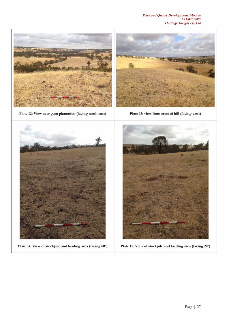
south western side of the hill (Plate 9). The crest of the hill was largely characterised by exposed basaltfloaters, boulders and short but dense grass cover (see Table 5, above). North east of the basalt hill is arecent gum plantation (Plates 10, 12 and 17).
Beyond the basalt hill, the Activity Area was shown to comprise rolling paddocks that have been largelycleared of native vegetation with the exception of a small number of large gum trees (Plates 11, 13-16,18).
The Activity Area does not contain any built structures, although some farm building are located to eastof the proposed works area.

Proposed Quarry Development, MooreeCHMP 12482
Heritage Insight Pty Ltd
Page | 25
Table 6: Photographs from Standard Assessment (B. Di Fazio 18/01/2013) (cont. over page)
Plate 6: Basalt hill showing gum plantation on the right(facing 240º)
Plate 7: Base of hill (facing south)

Proposed Quarry Development, MooreeCHMP 12482
Heritage Insight Pty Ltd
Page | 26
Plate 8: Western side of basalt hill (facing east)
Plate 9: Basalt exposure on western side of hill (facing northeast)
Plate 10: Northern side of basalt hill, showing gumplantation (facing 100º)
Plate 11: Basalt boulders on crest of hill looking overstockpile and loading area plantation (facing east north east)
Proposed Quarry Development, MooreeCHMP 12482
Heritage Insight Pty Ltd
Page | 27
Plate 12: View over gum plantation (facing north east) Plate 13: view from crest of hill (facing west)
Plate 14: View of stockpile and loading area (facing 60º) Plate 15: View of stockpile and loading area (facing 20º)

Proposed Quarry Development, MooreeCHMP 12482
Heritage Insight Pty Ltd
Page | 28
Plate 16: View of stockpile and loading area (facing east) Plate 17: South east corner of gum plantation (facing 250º)
Plate 18: View of proposed access track (facing 70º) Plate 19: Very large gum tree south of proposed access track(facing north)
6.3 Conclusions from the Ground Survey
The site prediction model and desktop assessment indicated that there was some potential for Aboriginalcultural heritage to be present within the Activity Area, particularly the possibility of isolated artefacts,small artefact scatters or scarred trees, if trees of a sufficient age were present. Despite this earlyassessment, however, no Aboriginal cultural heritage was identified on the surface within the ActivityArea (though poor ground surface visibility constrained the effectiveness of the field survey). Similarly, noscarred trees were identified in the Activity Area.
All survey participants agreed that the gradient would almost certainly preclude sites from being locatedon the sides of the basalt hill. The remaining sections of the Activity Area were considered more likely tocontain Aboriginal cultural material, however, given the more level ground surface adjacent to PigeonPonds Creek (beyond the Activity Area boundary) even the lower-lying parts of the Activity Area werenot considered to retain high levels of potential for cultural material.

Proposed Quarry Development, MooreeCHMP 12482
Heritage Insight Pty Ltd
Page | 29
7.0 Consideration of Section 61 Matters – Impact Assessment
In accordance with Section 61 of the Aboriginal Heritage Act 2006, a Cultural Heritage Management Planmust consider whether the activity will be conducted in a way that avoids harm to Aboriginal culturalheritage.
The proposed quarry works and their associated activities cannot be carried out in a way that would avoidharm to Aboriginal cultural heritage if located within the Activity Area. However, the above assessmenthas outlined that the presence of Aboriginal cultural heritage within the Activity Area is unlikely.
Although it is unlikely that Aboriginal cultural heritage would be present within the Activity Area, theassessment must contain contingencies relating to the identification of cultural heritage during theproposed works. In the event that Aboriginal cultural heritage is located during the proposed works, thecontingency plans provided in Section 8 of this CHMP must be followed and implemented.

Proposed Quarry Development, MooreeCHMP 12482
Heritage Insight Pty Ltd
Page | 30
Part Two: Cultural Heritage Management Recommendations
Please note that once this CHMP is approved these recommendations become compliance requirements.
7.0 Cultural Heritage Management Requirements
7.1 General Recommendation: Site Induction/Cultural Awareness Training
In order to provide a system for notification of the discovery of Aboriginal cultural heritage duringconstruction works, it will first be necessary to provide an induction to any future project managers andconstruction workers about the discovery of Aboriginal cultural heritage on-site.
A site induction or inductions must be held with project managers and any construction workers on-site.The purpose of the induction/s will be to describe items of Aboriginal cultural heritage to personnelengaged in construction, to create an awareness of their cultural value and to inform personnel about theprocedure for reporting suspected Aboriginal cultural heritage. This induction must be presented by arepresentative of the Gunditj Mirring Traditional Owners Aboriginal Corporation (GMTOAC) and acultural heritage advisor. Details of the site induction process can be found in Section
There will also need to be a system of reporting any possible Aboriginal cultural heritage items that arediscovered during works, and this must be built into any development or environmental managementplan (EMP) for the site (see Section 8.4, below). Contingency plans for notifying the discovery ofAboriginal cultural heritage are contained in Section 8 and must be incorporated into the development orEnvironmental Management Plan for the project. A copy of this management plan must be held on-siteat all times.
7.2 Specific Cultural Heritage Management Recommendations
At the time of the Standard Assessment, recommendations for the ongoing management of the ActivityArea were discussed on site with Ms Hudson and Mr King of the GMTOAC. Given the low groundsurface visibility within the Activity Area generally it was concluded that there was some potential forcultural material to remain within the areas designated for proposed access and stockpiling, although thispotential was somewhat reduced given the proximity of slightly more favourable camping locations closerto the creek.
For this reason, in combination with the generally poor ground surface visibility observed within theActivity Area, it is recommended that a program of archaeological monitoring be undertaken byrepresentatives of the GMTOAC during the initial stages of works in all areas beyond the base of thebasalt hill. These areas include the location of access tracks and the stockpile and loading area and anyother areas where the surface of the ground will be disturbed (Map 8).
If Aboriginal cultural heritage material is located during the archaeological monitoring, the contingenciesfor the unexpected discovery of Aboriginal cultural heritage material outlined in Section 10 are to befollowed.
The GMTOAC must be notified seven days in advance of works commencing. An official written requestfor site representatives must be submitted to the GMTOAC schedule a GMTOAC representative in forparticipation in the monitoring program.
All GMTOAC costs for participation in the monitoring program must be met by the Sponsor.

Proposed Quarry Development, MooreeCHMP 12482
Heritage Insight Pty Ltd
Page | 31
Map 8: Location of areas requiring archaeological monitoring

Proposed Quarry Development, MooreeCHMP 12482
Heritage Insight Pty Ltd
Page | 32
8.0 Contingency Planning
The approved form for a CHMP states that in accordance with Clause 13(1) Schedule 2 of the AboriginalHeritage Regulations 2007, a management plan must also include specific contingency plans for:
(a) the matters referred to in Section 61 of the Aboriginal Heritage Act 2006;
(b) the resolution of any disputes between the sponsor and the Gunditj. in relation to theimplementation of the plan or the conduct of the activity;
(c) the management of Aboriginal cultural heritage found during the activity;
(d) the notification, in accordance with the Aboriginal Heritage Act 2006, of the discovery ofAboriginal cultural heritage during the carrying out of the activity; and
(e) reviewing compliance with the Management Plan and mechanisms for remedying non-compliance.
Contingency plans are required even in situations where it has been assessed that there is a low probabilityof Aboriginal archaeological sites being located within an Activity Area.
8.1 Section 61 Matters
Section 61 of the Aboriginal Heritage Act 2006 is concerned with the avoidance and/or minimisation ofharm to Aboriginal cultural heritage and any specific measures required for the management of Aboriginalcultural heritage during and following the activity. Section 61 matters pertaining to the site discoveredduring this CHMP are discussed in Section 8. Section 61 matters pertaining to undiscovered culturalheritage that may become exposed during the activity are discussed in Section 10.3.
8.2 Dispute Resolution
In the event of a dispute between the Sponsor and the Gunditj Mirring Traditional Owners AboriginalCorporation (GMTOAC) over the implementation of this CHMP, the following should occur:
Details of the dispute should be documented by both the GMTOAC and the Sponsor;
Representatives of the Sponsor and the GMTOAC should organise a meeting as soon as possibleto attempt to resolve the dispute;
The understanding of the issue by both parties should be clearly stated by the relevantrepresentatives during the course of the meeting;
If desired by both parties, external mediation by a third party may occur during the meeting;
The objective of the meeting should be to discuss and arrive at an understanding of the matterbeing disputed and reach a negotiated settlement of the dispute. This may include a formalprotocol between the Sponsor and the GMTOAC; and
The resolution to the dispute should be recorded in writing and signed off on by both parties.

Proposed Quarry Development, MooreeCHMP 12482
Heritage Insight Pty Ltd
Page | 33
8.3 Discovery of Aboriginal Cultural Heritage during Works
8.3.1 Unexpected Discovery of Human Remains
Although it is highly unlikely that Aboriginal human burials will occur within the Activity Area, theconsultants are obliged to provide advice in the event that a human burial is discovered.
If any suspected human remains are found during any activity, works must cease. The Victoria Police andthe State Coroner’s Office should be notified immediately. If there are reasonable grounds to believe thatthe remains are Aboriginal, the Department of Sustainability and Environment’s EmergencyCoordination Centre must be contacted immediately on 1300 888 544.
Any such discovery at the Activity Area must follow these steps.
1. Discovery:
If suspected human remains are discovered, all activity in the vicinity must stop to ensureminimal damage is caused to the remains; and
The remains must be left in place, and protected from harm or damage.
2. Notification:
Once suspected human skeletal remains have been found, the Coroner’s Office and the VictoriaPolice must be notified immediately;
If there are reasonable grounds to believe that the remains could be Aboriginal, the DSEEmergency Co-ordination Centre must be immediately notified on 1300 888 544;
The GMTOAC be independently informed of the discovery;
All details of the location and nature of the human remains must be provided to the relevantauthorities;
If it is confirmed by these authorities that the discovered remains are Aboriginal skeletal remains,the person responsible for the activity must report the existence of the human remains to theSecretary, DVC in accordance with s.17 of the Act; and
Do not contact the media.
3. Impact Mitigation or Salvage:
The Secretary, after taking reasonable steps to consult with any Aboriginal person or body withan interest in the Aboriginal human remains, will determine the appropriate course of action asrequired by s.18(2)(b) of the Act; and
An appropriate impact mitigation or salvage strategy as determined by the Secretary must beimplemented (This will depend on the circumstances in which the remains were found, thenumber of burials found and the type of burials and the outcome of consultation with anyAboriginal person or body).
Note: In consultation with the GMTOAC a sponsor may consider incorporating a contingency plan toreserve an appropriate area for reburial of any recovered human remains that may be discovered duringthe activity. This may assist the Secretary in determining an appropriate course of action.

Proposed Quarry Development, MooreeCHMP 12482
Heritage Insight Pty Ltd
Page | 34
4. Curation and further analysis:
The treatment of salvaged Aboriginal human remains must be in accordance with the direction ofthe Secretary.
5. Reburial:
Any reburial site(s) must be fully documented by an experienced and qualified cultural heritageadvisor, clearly marked and all details provided to AAV; and
The GMTOAC RAP group should be involved in any reburial process.
Appropriate management measures must be implemented to ensure that the remains are not disturbed inthe future.
No photography, excepting that required by the Coroners Act, shall be taken of any Aboriginal humanremains without the express prior permission of the Wurundjeri Tribe Land and Compensation CulturalHeritage Council Inc.
There has been no indication that there is any sensitive information within relation to the Activity Area.Protocols for handling sensitive information with relation to human remains have been outlined abovewithin Section 10.3.1. Should an issue arise which the cultural heritage advisor or GMTOAC findsensitive, the issue must only be discussed between the GMTOAC, the cultural heritage advisor and theSponsor. The information must not be discussed with the media and must not be discussed with anyparties who are outside of the project.

Proposed Quarry Development, MooreeCHMP 12482
Heritage Insight Pty Ltd
Page | 35
8.3.2 Unexpected Discovery of Isolated or Dispersed Aboriginal Cultural Heritage
The following procedure must occur in the event of the discovery of isolated or dispersed culturalheritage:
The GMTOAC and a Cultural Heritage Advisor (CHA) should be contacted in the first instance.This would include an on-site investigation and assessment of the significance of the culturalheritage.
In addition, the following must occur:
The location of the suspected Aboriginal cultural heritage must be fenced off withtemporary webbing;
All works must cease within 10 metres of where the suspected Aboriginal culturalheritage is located and a cultural heritage advisor must immediately be notified of thediscovery;
Work may continue in other parts of the Activity Area, away from the 10 metre bufferaround the webbing;
A qualified cultural heritage advisor must attend the find within 48 hours of discovery;
The suspected Aboriginal cultural heritage must be examined by a qualified culturalheritage advisor, a relevant representative of the GMTOAC and a representative of theSponsor. The cultural heritage advisor must complete site records and advise onmanagement strategies for the feature; and
Within a period of 3 working days a decision/recommendation must be made by thecultural heritage advisor, in consultation with the GMTOAC and the sponsor, on aprocess to be followed to manage or salvage the Aboriginal cultural heritage in a mannerwhich complies with the Aboriginal Heritage Regulations 2007 and which is culturallyappropriate.
Works may recommence within the area of exclusion:
When the appropriate protective measures have been taken; and
When the relevant Aboriginal cultural heritage records have been updated and/orcompleted.
If the site cannot be retained within the development, then the site must be salvaged using an appropriatemethodology as defined in the AAV Guide to Preparing Cultural Heritage Management Plans 2010 (AboriginalAffairs Victoria 2010).

Proposed Quarry Development, MooreeCHMP 12482
Heritage Insight Pty Ltd
Page | 36
8.3.3 Unexpected Discovery of Stratified Occupation Deposits
The following must occur in the event of the discovery of stratified occupation deposits:
The GMTOAC and a CHA should be contacted in the first instance. This would include an on-site investigation and assessment of the significance of the cultural heritage.
In addition, the following must occur:
The location of the suspected stratified occupational deposit must be fenced off withtemporary webbing;
All works must cease within 10 metres of where the suspected stratified occupationaldeposit is located and a cultural heritage advisor must immediately be notified of thediscovery;
Work may continue in other parts of the Activity Area, away from the 10 metre bufferaround the webbing;
A qualified cultural heritage advisor must attend the find within 48 hours of discovery;
The suspected stratified occupational deposit must be examined by a qualified culturalheritage advisor, a relevant representative of the GMTOAC and a representative of theSponsor. The cultural heritage advisor must complete site records and advise onmanagement strategies for the feature; and
Within a period of 3 working days a decision/recommendation must be made by thecultural heritage advisor, in consultation with the GMTOAC and the sponsor, on aprocess to be followed to manage or salvage the suspected stratified occupationaldeposit in a manner which complies with the Aboriginal Heritage Regulations 2007 andwhich is culturally appropriate.
Works may recommence within the area of exclusion:
When the appropriate protective measures have been taken; and
When the relevant Aboriginal cultural heritage records have been updated and/orcompleted.
If the site cannot be retained within the development, then the site must be salvaged using an appropriatemethodology as defined in the AAV Guide to Preparing Cultural Heritage Management Plans 2010 (AboriginalAffairs Victoria 2010).

Proposed Quarry Development, MooreeCHMP 12482
Heritage Insight Pty Ltd
Page | 37
8.3.4 Unexpected Discovery of a Coastal Shell Midden
The following must occur in the event of the discovery of a coastal shell midden:
The GMTOAC and a CHA should be contacted in the first instance. This would include an on-site investigation and assessment of the significance of the cultural heritage.
In addition, the following must occur:
The location of the suspected midden must be fenced off with temporary webbing;
All works must cease within 10 metres of where the suspected midden is located and acultural heritage advisor must immediately be notified of the discovery;
Work may continue in other parts of the Activity Area, away from the 10 metre bufferaround the webbing;
A qualified cultural heritage advisor must attend the find within 48 hours of discovery;
The suspected midden must be examined by a qualified cultural heritage advisor, arelevant representative of the Wurundjeri Tribe Land and Compensation CulturalHeritage Council Inc. and a representative of the Sponsor. The cultural heritage advisormust complete site records and advise on management strategies for the feature; and
Within a period of 3 working days a decision/recommendation must be made by thecultural heritage advisor, in consultation with the Wurundjeri Tribe Land andCompensation Cultural Heritage Council Inc. and the sponsor, on a process to befollowed to manage or salvage the suspected midden in a manner which complies withthe Aboriginal Heritage Regulations 2007 and which is culturally appropriate.
Works may recommence within the area of exclusion:
When the appropriate protective measures have been taken; and
When the relevant Aboriginal cultural heritage records have been updated and/orcompleted.
If a coastal shell midden were to be located within the Activity Area, it would be considered a very rareoccurrence and as such every effort must be made to retain the site within the development. If the sitecannot be retained within the development, then the site must be salvaged using an appropriatemethodology as defined in the AAV Guide to Preparing Cultural Heritage Management Plans 2010 (AboriginalAffairs Victoria 2010).

Proposed Quarry Development, MooreeCHMP 12482
Heritage Insight Pty Ltd
Page | 38
8.3.5 Unexpected Discovery of a Fresh Water Shell Midden
The following must occur in the event of the discovery of a fresh water shell midden:
The GMTOAC and a CHA should be contacted in the first instance. This would include an on-site investigation and assessment of the significance of the cultural heritage.
In addition, the following must occur:
The location of the suspected midden must be fenced off with temporary webbing;
All works must cease within 10 metres of where the suspected midden is located and acultural heritage advisor must immediately be notified of the discovery;
Work may continue in other parts of the Activity Area, away from the 10 metre bufferaround the webbing;
A qualified cultural heritage advisor must attend the find within 48 hours of discovery;
The suspected midden must be examined by a qualified cultural heritage advisor, arelevant representative of the GMTOAC and a representative of the Sponsor. Thecultural heritage advisor must complete site records and advise on management strategiesfor the feature; and
Within a period of 3 working days a decision/recommendation must be made by thecultural heritage advisor, in consultation with the GMTOAC and the sponsor, on aprocess to be followed to manage or salvage the suspected midden in a manner whichcomplies with the Aboriginal Heritage Regulations 2007 and which is culturally appropriate.
Works may recommence within the area of exclusion:
When the appropriate protective measures have been taken; and
When the relevant Aboriginal cultural heritage records have been updated and/orcompleted.
If a freshwater shell midden were to be located within the Activity Area, it would be considered a rareoccurrence and as such every effort must be made to retain the site within the development. If the sitecannot be retained within the development, then the site must be salvaged using an appropriatemethodology as defined in the AAV Guide to Preparing Cultural Heritage Management Plans 2010 (AboriginalAffairs Victoria 2010).

Proposed Quarry Development, MooreeCHMP 12482
Heritage Insight Pty Ltd
Page | 39
8.3.6 Unexpected Discovery of a Mound Site
The following must occur in the event of the discovery of a mound site:
The GMTOAC and a CHA should be contacted in the first instance. This would include an on-site investigation and assessment of the significance of the cultural heritage.
In addition, the following must occur:
The location of the suspected mound site must be fenced off with temporary webbing;
All works must cease within 10 metres of where the suspected mound is located and acultural heritage advisor must immediately be notified of the discovery;
Work may continue in other parts of the Activity Area, away from the 10 metre bufferaround the webbing;
A qualified cultural heritage advisor must attend the find within 48 hours of discovery;
The suspected mound must be examined by a qualified cultural heritage advisor, arelevant representative of the GMTOAC and a representative of the Sponsor. Thecultural heritage advisor must complete site records and advise on management strategiesfor the feature; and
Within a period of 3 working days a decision/recommendation must be made by thecultural heritage advisor, in consultation with the GMTOAC and the Sponsor, on aprocess to be followed to manage or salvage the suspected mound in a manner whichcomplies with the Aboriginal Heritage Regulations 2007 and which is culturally appropriate.
Works may recommence within the area of exclusion:
When the appropriate protective measures have been taken; and
When the relevant Aboriginal cultural heritage records have been updated and/orcompleted.
If a mound site were to be located within the Activity Area, it would be considered a rare occurrence andas such every effort must be made to retain the site within the development. If the site cannot be retainedwithin the development, then the site must be salvaged using an appropriate methodology as defined inthe AAV Guide to Preparing Cultural Heritage Management Plans 2010 (Aboriginal Affairs Victoria 2010).

Proposed Quarry Development, MooreeCHMP 12482
Heritage Insight Pty Ltd
Page | 40
8.3.7 Unexpected Discovery of a Quarry
The following must occur in the event of the discovery of a quarry site:
The GMTOAC and a CHA should be contacted in the first instance. This would include an on-site investigation and assessment of the significance of the cultural heritage.
In addition, the following must occur:
The location of the suspected quarry site must be fenced off with temporary webbing;
All works must cease within 10 metres of where the suspected quarry is located and acultural heritage advisor must immediately be notified of the discovery;
Work may continue in other parts of the Activity Area, away from the 10 metre bufferaround the webbing;
A qualified cultural heritage advisor must attend the find within 48 hours of discovery;
The suspected quarry must be examined by a qualified cultural heritage advisor, arelevant representative of the GMTOAC and a representative of the Sponsor. Thecultural heritage advisor must complete site records and advise on management strategiesfor the feature; and
Within a period of 3 working days a decision/recommendation must be made by thecultural heritage advisor, in consultation with the GMTOAC and the sponsor, on aprocess to be followed to manage or salvage the suspected quarry in a manner whichcomplies with the Aboriginal Heritage Regulations 2007 and which is culturally appropriate.
Works may recommence within the area of exclusion:
When the appropriate protective measures have been taken; and
When the relevant Aboriginal cultural heritage records have been updated and/orcompleted.
If a quarry site were to be located within the Activity Area, it would be considered a significantoccurrence and as such every effort must be made to retain the site within the development. If the sitecannot be retained within the development, then the site must be salvaged using an appropriatemethodology as defined in the AAV Guide to Preparing Cultural Heritage Management Plans 2010(AboriginalAffairs Victoria 2010).

Proposed Quarry Development, MooreeCHMP 12482
Heritage Insight Pty Ltd
Page | 41
8.3.8 Unexpected Discovery of a Stone Arrangement
The following must occur in the event of the discovery of a stone arrangement:
The GMTOAC and a CHA should be contacted in the first instance. This would include an on-site investigation and assessment of the significance of the cultural heritage.
In addition, the following must occur:
The location of the suspected stone arrangement must be fenced off with temporarywebbing;
All works must cease within 10 metres of where the suspected stone arrangement islocated and a cultural heritage advisor must immediately be notified of the discovery;
Work may continue in other parts of the Activity Area, away from the 10 metre bufferaround the webbing;
A qualified cultural heritage advisor must attend the find within 48 hours of discovery;
The suspected stone arrangement must be examined by a qualified cultural heritageadvisor, a relevant representative of the GMTOAC and a representative of the Sponsor.In addition, an anthropologist must be engaged to provide, if possible, furtherinformation pertaining to the stone arrangement. The cultural heritage advisor mustcomplete site records and advise on management strategies for the feature; and
Within a period of 3 working days a decision/recommendation must be made by thecultural heritage advisor, in consultation with the GMTOAC and the Sponsor, on aprocess to be followed to manage the site in a manner which complies with theAboriginal Heritage Regulations 2007 and which is culturally appropriate.
Works may recommence within the area of exclusion:
When the appropriate protective measures have been taken; and
When the relevant Aboriginal cultural heritage records have been updated and/orcompleted.
If a stone arrangement were to be located within the Activity Area, it would be considered a significantoccurrence and as such must be retained within the development. If the site cannot be retained within thedevelopment, then the site must be salvaged using an appropriate methodology as defined in the AAVGuide to Preparing Cultural Heritage Management Plans 2010 (Aboriginal Affairs Victoria 2010).

Proposed Quarry Development, MooreeCHMP 12482
Heritage Insight Pty Ltd
Page | 42
8.3.9 Unexpected Discovery of Other Aboriginal Cultural Heritage
The following must occur in the event of the discovery of any other suspected Aboriginal culturalheritage:
The GMTOAC and a CHA should be contacted in the first instance. This would include an on-site investigation and assessment of the significance of the cultural heritage.
In addition, the following must occur:
The location of the suspected Aboriginal cultural heritage must be fenced off withtemporary webbing;
All works must cease within 10 metres of where the suspected Aboriginal culturalheritage is located and a cultural heritage advisor must immediately be notified of thediscovery;
Work may continue in other parts of the Activity Area, away from the 10 metre bufferaround the webbing;
A qualified cultural heritage advisor must attend the find within 48 hours of discovery;
The suspected Aboriginal cultural heritage must be examined by a qualified culturalheritage advisor, a relevant representative of the GMTOAC and a representative of theSponsor. The cultural heritage advisor must complete site records and advise onmanagement strategies for the feature; and
Within a period of 3 working days a decision/recommendation must be made by thecultural heritage advisor, in consultation with the GMTOAC and the Sponsor, on aprocess to be followed to manage or salvage the Aboriginal cultural heritage in a mannerwhich complies with the Aboriginal Heritage Regulations 2007 and which is culturallyappropriate.
Works may recommence within the area of exclusion:
When the appropriate protective measures have been taken; and
When the relevant Aboriginal cultural heritage records have been updated and/orcompleted.
If the feature cannot be retained within the development, then the feature must be salvaged using anappropriate methodology as defined in the AAV Guide to Preparing Cultural Heritage Management Plans 2010(Aboriginal Affairs Victoria 2010).

Proposed Quarry Development, MooreeCHMP 12482
Heritage Insight Pty Ltd
Page | 43
8.4 Reporting Discovery of Aboriginal Cultural Heritage during Works
In order to provide a system for notification of the discovery of Aboriginal cultural heritage duringconstruction works, it will be necessary to provide an induction for project managers and constructionworkers about the discovery of Aboriginal cultural heritage on-site prior to the commencement of work.The purpose of the induction will be to describe items of Aboriginal cultural heritage to personnelengaged in the development, to create an awareness of their cultural value and to inform personnel aboutthe procedure for reporting suspected Aboriginal cultural heritage. This induction must be presented by arepresentative of the GMTOAC l in association with a cultural heritage advisor. This induction must bearranged and paid for by the Sponsor or site contractors.
There will also need to be a system of reporting any possible Aboriginal cultural heritage items which arediscovered which must be built into any development or environmental management plan (EMP) for thesite.
The project manager must appoint a qualified cultural heritage advisor for the duration of the project whowill be available to give advice and act on the discovery of suspected Aboriginal cultural heritage. Thecultural heritage advisor will need to:
Be available to visit the site and inspect any items of suspected Aboriginal cultural heritage thatmay be found during any development;
Document any items of Aboriginal cultural heritage that are found during any development andreport the sites to AAV by means of completing an AAV site card and registering the site;
Complete the site documentation in association with a representative of GMTOAC;
Advise on appropriate treatment or salvage of any Aboriginal cultural heritage; and
Provide adequate reporting on the treatment of any Aboriginal cultural heritage to standardsrequired by AAV.
8.5 Management of Aboriginal Cultural Heritage Discovered during Works
In any case where previously unrecorded Aboriginal cultural material is located during the assessment, itwill be the responsibility of the cultural heritage advisor to:
Catalogue the Aboriginal cultural heritage;
Label and package the Aboriginal cultural heritage with reference to provenance; and
With the relevant community representative, arrange storage of the Aboriginal cultural heritage ina secure location with copies of the catalogue and assessment documentation.
Custody of any Aboriginal cultural heritage material identified during the activity will be given to theGMTOAC as the RAP for the area. This material will either be re-buried in consultation with theSponsor or kept at the GMTOAC offices.
Proposed Quarry Development, MooreeCHMP 12482
Heritage Insight Pty Ltd
Page | 44
8.6 Reviewing Compliance with the Plan
The Sponsor must ensure that compliance with this plan is reviewed. A review process must beincorporated in the Environmental Management Plan (EMP) or similar document for the project. It isrecommended that each of the management actions recommended in Section 9 above be listed in theEnvironmental Management Plan. There must be a mechanism included in the plan (such as a checklistor database) to indicate when the recommended actions for Aboriginal cultural heritage have been carriedout. The project manager should be responsible for maintaining this list. Any associated documentationwhich accompanies the actions should be recorded on the checklist or database.
The record of compliance must be maintained by the project manager at all times and must be availablefor inspection by either an Inspector under the Aboriginal Heritage Act 2006 or other representative of theSecretary.
It is illegal to harm cultural heritage outside of the recommendations contained within this managementplan. Inspectors from Aboriginal Affairs Victoria may conduct CHMP compliance audits.
A checklist is provided below that specifies what measures will be undertaken to review compliance withthe CHMP. The site manager must verify that the measures specified below have been undertaken.
Checklist for Reviewing Compliance with CHMP 12465Yes No
Prior to works occurring1: Has the site induction been completed by GMTOAC representatives?2: Have the contingency plans contained in Section 10.3 of this report been incorporated into thedevelopment or JEHA (Job Environment & Heritage Assessment) for the project?
Identification of Aboriginal Cultural Heritage1: Has all activity within 10m ceased if 1-5 artefacts have been located or within the general area if adense artefact scatter, in situ deposits, shell midden, hearth feature, stone or earth feature has beenlocated?2: Has the GMTOAC been notified?3: Has a cultural heritage advisor been notified?4: Have the artefacts been left in place?5: Has the find/s been protected (e.g. with fencing) if required?6: In relation to suspected human remains, have the Coroner’s Office and Victoria Police beennotified?7: Has an appropriate mitigation/salvage strategy been developed?8: Have the mitigation/salvage works been implemented?9: Have the salvaged finds/remains been treated in accordance with the direction of the WurundjeriCouncil?
Reburial Procedure: Human Remains1: Has a suitably qualified archaeologist been engaged to fully document the reburial site?2: Has the reburial site been clearly marked?3: Have all details been provided to AAV?4: Has a strategy been developed to ensure no further disturbance (such as Section 173 in the Planningand Provision Act)?
Review of this CHMP can be undertaken at any time by project delegates representing the Sponsor, or byan agreed independent reviewer to ensure that all parties are complying with the terms of this CHMP.

Proposed Quarry Development, MooreeCHMP 12482
Heritage Insight Pty Ltd
Page | 45
8.7 Resolution of Non-Compliance with the Plan
To ensure compliance with the terms of this CHMP, the site manager must verify that the measuresspecified in the above checklist have been undertaken. If any of the following breaches occur, the sitemanager must action the relevant remedy. The aim of this process is to resolve non-compliance issues byimmediately actioning processes to remedy non-compliance through consultation with the Aboriginalrepresentatives and the cultural heritage advisor.
If mechanisms for remedying non-compliance are not actioned and resolution cannot be reached thenultimately the Minister may order a cultural heritage audit to be carried out. Details of cultural heritageaudits can be obtained from Part 6, Division 1 of the Aboriginal Heritage Act 2006.
Potential Breach RemedyPrior to works occurring1: Contingency plans contained in Section 10.3of this report have not been incorporated intothe development or JEHA (Job Environment &Heritage Assessment) for the project.
The site manager must ensure that the Contingency plans areincorporated within 48 hours. All employees must be made awareof the contingency requirements.
During Development1: Activity has not ceased within 10m ifAboriginal cultural heritage has been located.
Activity must cease immediately within 10m of the find and theSecretary notified within 48 hours. A cultural heritage advisormust immediately be notified to assess the find.
2: The Secretary has not been notified of anyAboriginal cultural heritage
Notify the Secretary within 48 hours
3: Harm to Aboriginal cultural heritage hasoccurred.
Work within 10m of the Aboriginal cultural heritage must ceaseimmediately. The Sponsor must notify the Secretary with 48hours. The Sponsor must immediately notify a cultural heritageadvisor to assess the level of harm and Aboriginal representativesin the following order of priority: the RAP; registered Native TitleHolder; Native Title party; relevant Aboriginal persons withtraditional or familiar links; relevant Aboriginal body ororganisation with historical or contemporary links. The Sponsorand the RAP or Aboriginal representatives must undertake thefollowing process:
Details of the harm must be documented by theSponsor, the cultural advisor and Aboriginalrepresentatives;
A meeting must be held within 48 hours to attempt tomitigate further harm;
The understanding of the issue by both parties must beclearly stated by the relevant representatives during thecourse of the meeting;
The parties must reach a resolution;
The objective of the meeting is to discuss and arrive atan understanding of the matter being disputed and reacha negotiated settlement of the dispute. This may includea formal protocol between the Sponsor and Aboriginalrepresentatives; and
The resolution to the dispute must be recorded in writing

Proposed Quarry Development, MooreeCHMP 12482
Heritage Insight Pty Ltd
Page | 46
and signed off on by both parties.
4: Activity has not ceased if potential skeletalremains have been located.
Work within 10m of the Aboriginal cultural heritage must ceaseimmediately. The Sponsor must immediately action the procedureoutlined in Contingency 10.3.1.
It is illegal to harm cultural heritage outside of the recommendations contained within this managementplan. Inspectors from Aboriginal Affairs Victoria may conduct CHMP compliance audits.

Proposed Quarry Development, MooreeCHMP 12482
Heritage Insight Pty Ltd
Page | 47
9.0 Other Considerations
9.1 Communication
The Project Manager and any personnel involved with supervision of future construction must read theCHMP and be aware of the legal requirements and contingency procedures concerning Aboriginalheritage within the Activity Area. The Project Manager (or other relevant supervisory staff) must beresponsible for implementing any conditions contained in the CHMP.
The Project Manager must set in place internal processes of communication to ensure that they arenotified prior to any contractors conducting works (including archaeological contractors) at any of thearchaeological sites on the property.
Contact Details for Sponsor
Justin BartlettArarat Quarrying CompanyMobile: 0400 054 904
Contact Details for the Gunditj Mirring Traditional Owners Aboriginal Corporation
Keicha DayCultural Heritage CoordinatorGunditj Mirring Traditional Owners Aboriginal Corporation
Phone: (03) 55 271 427Email: [email protected]

Proposed Quarry Development, MooreeCHMP 12482
Heritage Insight Pty Ltd
Page | 48
Bibliography
Legislation
Aboriginal Heritage Act 2006Aboriginal Heritage Regulations 2007
Organisations
DSE Laverton historic aerial photography archivePublic Records Office of VictoriaState Library of Victoria
Websites
Bureau of Meteorology (www.bom.gov.au/climate/data/)Department of Primary Industries – Interactive Geological Maps (www.dpi.vic.gov.au)Department of Sustainability and Environment – Interactive Biodiversity Maps (www.dse.vic.gov.au)Victorian Resources Online Website (www.dpi.vic.gov.au/vro)
Databases
Viridans Biological Databases, 2012. Just-a-Minute Victorian Animals, Viridans Biological Databases.
Published Sources/Consultants Reports
Barwick, D., 1984. Mapping the Past: an Atlas of Victorian Clans 1835-1904. Part 1. Aboriginal History,8(1-2), pp.100–131.
Clark, I.D., 1990. Aboriginal Languages and Clans: An Historical Atlas of Western and Central Victoria, 18001900, Melbourne: Department of Geography and Environmental Science Monash University.
Debney, T., 2008. Mooree Sand Extraction Site, Mooree, SW Victoria CHMP 10577, Port Melbourne,Victoria: BIOSIS Research Pty. Ltd.
Howitt, A.W., 1904. The Native Tribes of South-East Australia, Canberra: Aboriginal Studies Press.
Massola, A. 1969 Journey to Aboriginal Australia, Rigby, Melbourne.
Presland, G. ed., 1980. Journals of George Augustus Robinson January – May to August 1841 No. 11,Melbourne: Ministry for Conservation Publication.
Rhoades, J. W. and C.F.M. Bird, 2000. An Archaeological Survey of the South-West Wimmera,Melbourne, Victoria: Aboriginal Affairs Victoria.
Spreadborough, R. and H. Anderson, 1983. Victorian Squatters, Red Rooster Press, Ascot Vale.
Weaver, F., 2000. Proposed Basalt Quarry Corner of Mooree Rd and Chetwynd Junction RdMooree/Chetwynd East, Western Victoria, Belmont, Victoria: Practical Archaeological Services Pty. Ltd.

Proposed Quarry Development, MooreeCHMP 12482
Heritage Insight Pty Ltd
Page | 49
Appendix 1: CHMP Notification

Proposed Quarry Development, MooreeCHMP 12482
Heritage Insight Pty Ltd
Page | 50

Proposed Quarry Development, MooreeCHMP 12482
Heritage Insight Pty Ltd
Page | 51

Proposed Quarry Development, MooreeCHMP 12482
Heritage Insight Pty Ltd
Page | 52
Appendix 2: Gunditj Mirring Traditional Owners AboriginalCorporation Response to Notice of Intent

Proposed Quarry Development, MooreeCHMP 12482
Heritage Insight Pty Ltd
Page | 53

Proposed Quarry Development, MooreeCHMP 12482
Heritage Insight Pty Ltd
Page | 54
Appendix 3: Glossary
Proposed Quarry Development, MooreeCHMP 12482
Heritage Insight Pty Ltd
Page | 55
GLOSSARY
Adze A flake with stepped retouch along lateral marginsthat can be hafted for use as a tool.
Anvil A flat object on which a core was placed to flakematerial from. Anvils often have a small pit/groove usuallyin the centre of the object as a result of this action.
Archaeology The study of cultural remains from pastcultures and generations.
Artefact Scatter The material remains of past Aboriginalpeople’s activities. Usually contain stone artefacts, butother material may also be present, including charcoal,animal bone, shell and ochre. An artefact scatter is usuallyrepresented by a single stone flake or a concentration offlaked stone pieces (or fragments).
Assemblage A collection of artefacts that are derived fromthe same site.
Backed Blade forms part of the small tool tradition. Theyand are characterised by unidirectional or bidirectionalretouch found along a lateral margin, thought to be bluntfor hafting (Holdaway & Stern 2004: 260).
Basalt A fine grained rock occurring from lava flows.
Bifacially Flaked Flakes removed from two faces of anobject such as a core.
Blade A flake that is twice as long as it is wide.
Bondi Point an asymmetrical blade with a point at oneend, with backing retouch. Part of the small tool tradition.
Burial Human remains, normally found as concentrationsof human bones or teeth, exposed by erosion orearthworks. They are sometimes associated with charcoalor ochre, although shell, animal bone and stone tools mayalso be present. Tend to be located in soft soils and sand,although can occur in rock shelters, caves and dead trees.
Burin A truncated flake formed by snapping or retouchingalong one lateral margin that then forms a platform andsmall flakes are removed forming a triangular scar that actsas a working edge (Holdaway & Stern 2004: 241-243).
Chert compact, fine-grained rock made of crypto-crystalline silica and can occur in a variety of colours,usually red, green or black.
Core a specimen of rock that has undergone a process ofreduction through the removal of a number of flakes andas a result they have negative flake scars. Cores can containa single platform, have two platforms or have had flakesremoved in multi-directions.
Cortex the original surface of a mineral or rock that hasbeen subject to weathering by the elements.
Cultural Material any material remains which areproduced by human activity.
Debitage Includes cores, flakes, and flaked pieces involvedin the reduction process.
Dry stone wall a wall formed of a number of courses ofrock (usually basalt or limestone) with no bond or bindingcomponent. Walls are usually tapered, have two faces andcan have hearting (packing), or plugging.
Earthenware non-vitreous whiteware, porous, usually usedfor domestic tablewares. Most earthenware is glazed anddecorated (transfer printed or left plain) (Davies & Buckley1987: 186).
Earth Feature Includes mounds, rings, hearths, postholesand ovens. Mounds generally appear as raised areas ofdarker soil. They are commonly found in the volcanicplains of western Victoria or on higher ground near waterbodies. Mounds often contain charcoal, burnt clay orstone heat retainers from cooking ovens, animal bones,shells, stone tools and sometimes, Aboriginal burials.Earth rings are banked circles of soil, often associated withstone arrangements, which had a ceremonial purpose forAboriginal people in the past.
Excavation A controlled means of soil disturbance(digging) allowing for detailed recording of the soil profile,features and artefacts exposed.
Flake A stone artefact that contains characteristics such asa the presence of a platform, bulb of percussion andtermination which reveal that the stone has been struckfrom a core and is the result of stone working (Holdaway& Stern 2004: 5).
Flake core A flake that has subsequently been used as acore and had other flakes removed from it.
Flaked Piece Small fragments of stone that have beenremoved from flakes resulting in tool maintenance or toolproduction (Holdaway & Stern 2004: 17). Flaked pieces donot display the characteristics evident in a complete flake.
Flint Similar to chert, with a pale cortex, conchoidalfracture, occurring usually in limestones (Roberts 1998: 65).
Geometric Microlith part of the small tool tradition andare symmetrical in form, pointed at both ends, can bebacked along a lateral margin (Holdaway & Stern 2004:262).
Greenstone a metamorphic rock derived from basaltcontaining feldspar and quartz and is made green bychlorite and epidote. Often used for the manufacture ofhand axes.
Grindstone A flat slab of rock with central depressionused to grind, crush or pound seeds, ochre, or sharpentools etc. Grindstones are usually made on sedimentaryrocks, with an abrasive surface and can be used inconjunction with a muller.
Ground edge axes sharpening process – flaking peckingand polishing, usually along a single lateral margin. Theaxes are generally hafted with the worked edge forming
Ground surface visibility an assessment of grounddisturbance that allows the ground to be seen
Hammerstone a hard rock or mineral used to flakefragments of stone from a core. (Holdaway & Stern 2004:4).

Proposed Quarry Development, MooreeCHMP 12482
Heritage Insight Pty Ltd
Page | 56
Hearth The remains of a fireplace containing charcoal andsometimes burnt earth, bone stone artefacts or otherorganic material.
In situ An artefact or feature that remains in its originalposition, or where it was left.
Manuport A stone block that displays no attributes ofbeing either a core or a flake.
Microblade has the same characteristics of a blade but justof smaller portions (Holdaway & Stern 2004: 17)
Oven Mound Mounds are usually circular or oval in shapeand are often situated close to a water source. They wereused to cook in and contain a rich greasy organic mix ofsoil and organic material. A mound contains charcoal,burnt clay, stone tools, bones, shell and on occasionsburials (AAV Mini Poster 4).
Ochre earth varying in colour from yellow to red, used as apigment.
Organic compounds formed from living organisms (plantsor animals).
Platform the surface from which the flake was struck offthe core – natural flaked or abraded (Holdaway & Stern2004: 120)
Point a flake that has two edges that form a point and hasretouch along one or both lateral margins (Holdaway &Stern 2004: 16).
Post-contact after contact between Aboriginal people andEuropeans
Pre-contact before contact between Aboriginal people andEuropeans
Quarry An outcrop of stone or ochre that has beenquarried by Aboriginal people in the past. Generallyassociated with a large amount of broken stone and flakes.The outcrop (cores) bear negative scars from flaking.
Quartz a mineral that commonly occurs in sedimentary,igneous and metamorphic rocks. Quartz can come in anumber of forms including crystal, rose, and smoky.
Quartzite a metamorphic rock, formed by the re-crystalization of quartz. Quartz is rich in sandstone andlimestone (Roberts 1998: 109).
Retouch a worked edge, or modification of a flake formedby removing a number of small flakes along an edge. Thiscan be done as a form of maintenance or to produce a tool.
Rock Art Paintings created on the rock surfaces of cavesand rock shelters and engravings in limestone caves.Artwork includes stencils, prints and drawings. The paintconsists of ochres, clays and charcoal mixed with fats.
Scarred Tree A tree, which has had a slab of barkremoved, exposing the sapwood on the trunk or branch ofa tree. Aboriginal people used the bark to make shelters,containers (coolamons) and canoes.
Scraper a flake with at least one edge that has continuousretouch. Scraper types include, steep edged, end, side, nosescraper (Holdaway & Stern 2004: 16).
Shell Midden A surface and /or sub-surface depositcomposed of shell and sometimes stone artefacts, charcoaland bone. Middens are normally found in association. withcoastlines, rivers, creeks and swamps – wherever coastal,riverine or estuarine shellfish resources were available andexploited.
Silcrete a fine grained rock derived from shale or siltstonemixed with silica.
Spit A horizontal unit of soil removed during excavation.Spits can be arbitrary (dug to a depth of 50, 100, 200,300mm, etc.) or can be confined to a particular soil type orcontext. The excavation of spits allows for greaterunderstanding, analysis and interpretation of the soilprofile.
Stone Feature Includes cairns, rock wells, stonearrangements, fish traps, stone structures and grindinggrooves. May be a natural feature, which was used ormodified to be used, by Aboriginal people in the past (rockwell, stone arrangement) or a stone feature which has beendeliberately constructed for a specific purpose (fish trap,stone structure, cairn) or is the result of a specific activitycarried out by Aboriginal people in the past (grindinggrooves).
Stratification The position of sediments and rocks insequence throughout time.
Sub-surface testing a method of excavation that involvesground disturbing works to identify the potential forcultural material. Can take the form of hand excavation,backhoe scrapes etc.
Survey An inspection of land either by foot or by car(windscreen survey) noting conditions on surface visibilityand … etc
Termination The shape of the distal end (Holdaway &Stern 2004: 129) – feather hinge step plunge
Tool Modified flakes usually with retouch present along anedge – altered shape (Holdaway & Stern 2004: 33)
Transect An excavated stretch of ground can be of varyinglengths in a straight line.
Trench An area confined by excavation usually in the formof a square (eg. 2x2m) or rectangular (eg. 1.5x1m).
References
AAV Mini Posters (1-7)
Davies, M & K. Buckley (1987) Port Arthur Conservation &Development Project: Archaeological Procedures Manual. OccasionalPaper No.13. Department of Lands, Parks and Wildlife,Tasmania.
Holdaway & Stern (2004) A Record in Stone: The Study of Australia’sFlaked Stone Artefacts, Victoria Museum, Melbourne.
Roberts, J.L. (1998) A Photographic Guide to Minerals, Rocks andFossils, New Holland, London