proposed national environmental standard for plantation ... · revised proposed national...
TRANSCRIPT
Proposed National Environmental
Standard for Plantation Forestry
Information booklet on the revised proposal
Published in May, 2011 by the Ministry for the Environment Manatū Mō Te Taiao PO Box 10362, Wellington 6143, New Zealand ISBN: 978–0–478–37233–5 (print)
978–0–478–37234–2 (electronic) Publication number: ME 1053 (print) ME 1054 (electronic) Other publications in this series include: Proposed National Environmental Standard for Plantation Forestry: Discussion Document. 2010. © Crown copyright New Zealand 2011 This document is available on the Ministry for the Environment’s website: www.mfe.govt.nz
Revised Proposed National Environmental Standard for Plantation Forestry iii
Contents
1 Introduction 1
1.1 Background 1
1.2 Purpose of this document 2
1.3 Structure of this document 2
1.4 The 2010 consultation 2
1.5 A collaborative process to develop a revised policy 4
1.6 Supporting documents not contained in this booklet 6
2 Modifications to the proposed NES 7
2.1 Outcome and objectives 7
2.2 Options 9
2.3 Key issues raised by submitters 10
2.4 General issues relating to the proposal 13
3 Overview of the revised NES 16
3.1 Scope 16
3.2 Activity statuses in the revised proposal 17
4 Revised policy 20
4.1 Ability to be more stringent 20
4.2 Afforestation 25
4.3 Replanting 33
4.4 Mechanical land preparation 37
4.5 Harvesting 42
4.6 Pruning and thinning to waste 53
4.7 Earthworks 55
4.8 Quarrying 64
4.9 River crossings 68
5 What happens next? 82
5.1 Making comments 82
5.2 What happens to comments? 82
5.3 Discussion questions 82
Appendix 1 83
Appendix 2 86
Appendix 3 90
Appendix 4 93

iv Revised Proposed National Environmental Standard for Plantation Forestry
Appendix 5 96
Appendix 6 98
Abbreviations 102
Glossary 103
Tables
Table 1: Environmental outcomes 9
Table 2: Key issues raised by submitters, and responses 10
Table 3: Overview of the revised NES framework 17
Table 4: The revised policy 20
Figures
Figure 1: The NES development process 1
Figure 2: Categories of submitters to the NES proposal 3
Figure 3: Breakdown of submissions, by position 4
Figure 4: Breakdown of position, by category 4
Figure 5: The main working group and subgroups 5

Revised Proposed National Environmental Standard for Plantation Forestry 1
1 Introduction
1.1 Background In September 2010 the Minister for the Environment released a Proposed National Environmental Standard for Plantation Forestry: Discussion Document (the proposed NES). The Minister received a total of 117 submissions on the proposal (see http://www.mfe.govt.nz/laws/standards/ forestry/index.html for a copy of these submissions). Following the consultation phase the project entered the re-design phase (see figure 1). Figure 1: The NES development process
As part of this re-design phase, the Ministry for the Environment (the Ministry) established a number of working groups to develop recommendations. These working groups included a main working group and four subgroups. The subgroups were established to provide feedback to the
2 Revised Proposed National Environmental Standard for Plantation Forestry
main working group on some of the more technical issues raised by submitters, while the main working group focused on more generic, high-level issues (see section 1.5 for more detail on the working groups). This document summarises the resulting changes to the proposed policy. This ‘comments phase’ is an additional step for this particular NES and gives submitters and iwi authorities the opportunity to provide further feedback to the Ministry.
1.2 Purpose of this document This information booklet has been prepared to:
help you understand the changes that have been made to the proposed policy
help you prepare comments to the Ministry for the Environment.
1.3 Structure of this document This booklet presents a revised proposal based on recommendations from the main working group. It outlines what has changed and what has not changed since the Proposed National Environmental Standard for Plantation Forestry: Discussion Document was released in September 2010. Section 1 provides an introduction, section 2 outlines the amended policy outcome and objectives, and sections 3 and 4 set out the revised proposal for a National Environmental Standard for Plantation Forestry.
1.4 The 2010 consultation
Submissions on the proposed NES on Plantation Forestry In October 2010 the Minister for the Environment received 117 submissions on the NES proposal. Figure 2 shows the different categories of submitters and the number of submissions in each category.

Revised Proposed National Environmental Standard for Plantation Forestry 3
Figure 2: Categories of submitters to the NES proposal
Submissions were grouped into four categories according to their position on the proposal, as follows:
1. support – clear support was indicated for the proposed NES
2. support conditionally – support was indicated for an NES, but more than minor changes to the proposal were requested
3. opposition – clear opposition to the proposed NES was stated
4. not stated – no clear statement of support or opposition was given, and this could not be determined from the content of the submission.
Figure 3 shows the breakdown of submissions by their position (the number indicates the number of submissions in that category). Figure 4 then shows a further breakdown of position by category of submitter.

4 Revised Proposed National Environmental Standard for Plantation Forestry
Figure 3: Breakdown of submissions, by position
Figure 4: Breakdown of position, by category
The public submissions highlighted a number of issues. Table 2 in section 2.3 provides a summary of some of the main concerns submitters had about the September 2010 proposal.
1.5 A collaborative process to develop a revised policy
Since the public submission period closed in October 2010 the Ministry has been working with a selection of key stakeholders. As figure 5 shows, five working groups were established, including a main working group and four subgroups. The subgroups focused on issues raised in submissions which were broadly grouped into topics relating to biosecurity (principally wilding trees), erosion susceptibility, water management, and the interface between the Climate Change Response Act 2002 and the proposed NES (primarily the issue of deforestation liabilities).

Revised Proposed National Environmental Standard for Plantation Forestry 5
Figure 5: The main working group and subgroups
The working groups were made up of stakeholders from the following groups:
the forestry sector (including the New Zealand Forest Owners Association (NZFOA) and New Zealand Farm Forestry Association representatives (NZFFA))
central government (the Department of Conservation, Ministry of Agriculture and Forestry)
local government (district and regional council representatives)
non-governmental organisations (Environment and Conservation Organisations of Aotearoa New Zealand (ECO), Forest and Bird, Fish and Game New Zealand)
crown research institutes (Scion, Landcare, National Institute of Water and Atmospheric Research)
universities (University of Canterbury)
private consultancies. The Ministry for the Environment had a facilitation role in the working group process, including facilitating connections between the various working groups. The main working group has made recommendations to the Ministry, and these recommendations are the basis for the revised policy proposal. This comments phase is the next stage in the collaboration process. Your comments on the revised policy will be assessed by the Ministry and used to inform the final policy proposal recommended to the Minister for the Environment.

6 Revised Proposed National Environmental Standard for Plantation Forestry
1.6 Supporting documents not contained in this booklet
Bloomberg M, Davies T, Visser R, Morgenroth J. 2011. Erosion Susceptibility Classification and Analysis of Erosion Risks for Plantation Forestry. Brown & Pemberton Planning Group. 2010. Review of 12 Regional Council and 4 Unitary Authority RMA Plan Provisions Relating to Plantation Forestry. Brown & Pemberton Planning Group. 2010. Review of 23 District Council RMA Plan Provisions Relating to Plantation Forestry. Covec. 2010. Preliminary Cost-benefit Analysis of the Proposed NES for Plantation Forestry. Ministry for the Environment. 2010. Proposed National Environmental Standard for Plantation Forestry: Discussion Document. Wellington: Ministry for the Environment. Review of authority rules (ROAR). 2011. www.mfe.govt.nz/laws/standards/forestry/index.html

Revised Proposed National Environmental Standard for Plantation Forestry 7
2 Modifications to the proposed NES
2.1 Outcome and objectives The main working group reworked the previous objective and replaced it with an outcome statement for the policy in the context of the problem. It also established clear statements about desired end states (objectives). These objectives are seen by the working group as being vital for assessing various solutions and for monitoring the effectiveness of the preferred option in the long term. The new outcome emphasises the importance of managing forestry resources in a sustainable way to achieve consistency. It also places more emphasis on the incorporation of good practice.
Outcome statement The objective proposed in the NES discussion document was:
Bringing about a more consistent and appropriate plantation forestry management framework, while facilitating the sustainable management of natural and physical resources.
The outcome statement established by the main working group is:
Bringing about the consistent and sustainable management of natural and physical resources, using good forestry practices.
Objectives The main working group has established the following objectives. 1. Reduced litigation of plan provisions
Areas open to litigation are reduced across the board where relevant, resulting in less need for participation by key stakeholders (the forestry sector, NGOs and councils) in RMA processes, including plan reviews.
A national-level tool is developed to bring about clarity on what should be contained in plans.
2. Unnecessary resource consents reduced
The use of robust permitted activity conditions and of a hierarchy of consent activity classes is maximised.
Duplication of function between local authority councils is eliminated (a clear distinction between functions is established).

8 Revised Proposed National Environmental Standard for Plantation Forestry
Communication among and integration between local and regional councils is improved.
Relevant, targeted, defensible and efficient conditions are included in plans. 3. Variation between consent conditions reduced
Clear standards for similar activities are established (where effects are similar). 4. Inappropriate use of bundling addressed
Where consents are required, a best practice approach for bundling is considered. 5. Good environmental outcomes
Protection mechanisms for the environment are incorporated via measurable outcomes and benchmarks.
The primary environmental outcomes listed in Table 1 are achieved. 6. Consistency with other legislation / government policies
Policy is made consistent with existing legislation and government policies, including the Climate Change Response Act 2002, the Biosecurity Act 1993 and national policy statements.
7. Use of good practice/self-management regimes
A robust, audited self-management regime is promoted internally and externally.
Re-inventing the wheel is avoided: existing codes of practice, accords and New Zealand Standards are considered.
Initial on-site assessment is incorporated into the policy.
Innovations and new technologies are used to mitigate adverse environmental effects. 8. Clear bottom line standards established
Performance is enhanced: operational activities are linked to environmental consequences.
9. Whole forestry cycle considered (certainty of harvest)
Clarity around where afforestation is appropriate is achieved to improve certainty for investors.
10. Option easily monitored
Clear and transparent rules that can be effectively monitored by local and regional authorities are promoted.
Certainty about who should monitor and what should be monitored is achieved.
Clarity around self-auditing is achieved. 11. Cost effective
Costs and benefits for the forestry sector, local government, central government and the environment are considered.
Revised Proposed National Environmental Standard for Plantation Forestry 9
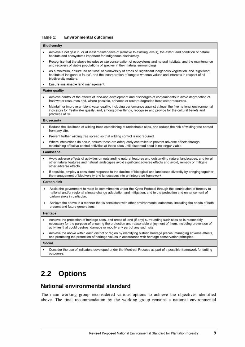
Table 1: Environmental outcomes
Biodiversity
Achieve a net gain in, or at least maintenance of (relative to existing levels), the extent and condition of natural habitats and ecosystems important for indigenous biodiversity.
Recognise that the above includes in situ conservation of ecosystems and natural habitats, and the maintenance and recovery of viable populations of species in their natural surroundings.
As a minimum, ensure ‘no net loss’ of biodiversity of areas of ‘significant indigenous vegetation’ and ‘significant habitats of indigenous fauna’, and the incorporation of tangata whenua values and interests in respect of all biodiversity matters.
Ensure sustainable land management.
Water quality
Achieve control of the effects of land-use development and discharges of contaminants to avoid degradation of freshwater resources and, where possible, enhance or restore degraded freshwater resources.
Maintain or improve ambient water quality, including performance against at least the five national environmental indicators for freshwater quality, and, among other things, recognise and provide for the cultural beliefs and practices of iwi.
Biosecurity
Reduce the likelihood of wilding trees establishing at undesirable sites, and reduce the risk of wilding tree spread from any site.
Prevent further wilding tree spread so that wilding control is not required.
Where infestations do occur, ensure these are adequately controlled to prevent adverse effects through maintaining effective control activities at those sites until dispersed seed is no longer viable.
Landscape
Avoid adverse effects of activities on outstanding natural features and outstanding natural landscapes, and for all other natural features and natural landscapes avoid significant adverse effects and avoid, remedy or mitigate other adverse effects.
If possible, employ a consistent response to the decline of biological and landscape diversity by bringing together the management of biodiversity and landscapes into an integrated framework.
Carbon sink
Assist the government to meet its commitments under the Kyoto Protocol through the contribution of forestry to national and/or regional climate change adaptation and mitigation, and to the protection and enhancement of carbon sinks in particular.
Achieve the above in a manner that is consistent with other environmental outcomes, including the needs of both present and future generations.
Heritage
Achieve the protection of heritage sites, and areas of land (if any) surrounding such sites as is reasonably necessary for the purpose of ensuring the protection and reasonable enjoyment of them, including prevention of activities that could destroy, damage or modify any part of any such site.
Achieve the above within each district or region by identifying historic heritage places, managing adverse effects, and promoting the protection of heritage values in accordance with heritage conservation principles.
Social
Consider the use of indicators developed under the Montreal Process as part of a possible framework for setting outcomes.
2.2 Options
National environmental standard The main working group reconsidered various options to achieve the objectives identified above. The final recommendation by the working group remains a national environmental

10 Revised Proposed National Environmental Standard for Plantation Forestry
standard (NES) in the short term, but the group wants to clearly signal that an NES should not be a stand-alone solution and in the long-term could be supported by other options, as follows.
Audited self-management (ASM) ASM is a term coined to describe a process whereby resource consent thresholds for various forestry operations are lifted for forestry operators under agreed terms. These agreed terms are subject to those operators having an approved system for management risk (the self-management aspect), and an audit of processes and outcomes by an external party (the audit aspect). The benefit of such a process is that it has the potential to address environmental and management risk sources across the whole forestry management cycle. If an NES is adopted, there is an opportunity to provide incentives for ASM in future revisions of the instrument. An ASM regime could include an accreditation process and could be designed so that it can be scaled up or down and have a management focus, with tailored assurance systems. Environmental risk would require careful consideration.
Non-statutory mechanisms to improve interaction The working group identified that many of the problems facing key stakeholders involved in plantation forestry stem from poor interaction between the various parties (the forestry sector and government agencies, the forestry sector and NGOs, and the forestry sector and iwi). The working group felt that various non-statutory mechanisms could be used to improve the interaction between these groups, including guidance, education and relationship building.
2.3 Key issues raised by submitters A large number of issues were raised by submitters. Table 2 outlines some of the key ones. Table 2: Key issues raised by submitters, and responses
Issues identified by submitters The Ministry’s response to issues as informed by the main working group
Problem/objective Submissions were split on whether the problem statement was accurate. Some felt the problem statement was too narrow or that the problem did not exist. Many submitters commented that the objective should focus more on environmental outcomes.
The overall outcome and objectives for the project were changed to reflect the priority of sustainable management of the environment. Establishing clear objectives for the project has helped to clarify the current problems.
Options Submissions were split on whether an NES is the most appropriate solution. The majority felt it was, but some submitters felt the NES would fail to meet the stated objective or the purpose of the RMA. Best management practice was cited by many as an alternative.
The main working group revisited other options and agreed with the majority of submitters that an NES is the most appropriate tool for achieving the outcome and objectives identified. However, there was a strong recommendation from the main working group that an NES should not be a stand-alone solution. The group signalled that audited self-management should be considered in the future. Best management practice was incorporated as much as possible into the revised proposal. There was also a clear recommendation for non-statutory mechanisms being pursued to improve interactions between the forestry sector and key stakeholders (local government, central government, NGOs and iwi).

Revised Proposed National Environmental Standard for Plantation Forestry 11
Issues identified by submitters The Ministry’s response to issues as informed by the main working group
Permitted baseline Submitters were concerned about the concept of a permitted baseline (effects being disregarded based on what the proposed NES says about permitted activities). Submissions were split between the view that an NES should only cover forestry-specific activities, and that all activities that relate to forestry should be covered.
The revised policy does not resolve the potential implications of a permitted baseline. If the proposed option remains, a final cost−benefit analysis will need to attempt to quantify the implications of the proposal on a permitted baseline.
Scope Some submitters felt that associated activities such as agrichemical use and burning should be covered in the NES. Submitters also thought various other activities should be outside the scope of the NES.
The main working group revisited what should be inside and outside of the NES. Their conclusions are outlined in the revised policy below.
Ability to be more stringent
Submitters commented on various activities that should be removed from the ‘ability to be more stringent’ list. Many submitters thought there were too many items in the list.
The main working group worked through the issues in the ‘ability to be more stringent’ list and reassessed whether a more stringent standard is required, and if not, whether a national benchmark can be applied. As a result, some issues have been moved either outside of scope or into the policy wording.
Status quo Some submitters felt the NES would be more stringent than the status quo, while others thought it would be more lenient. Some felt there had not been a balanced approach.
In response to submitters’ concerns, a preliminary review of regional, unitary and district plans has been undertaken (a ROAR analysis). This system has been devised to determine where the final policy sits in relation to the status quo nationally. The results are being made available to local authorities for review. Once finalised, the ROAR system will help to inform the final cost−benefit analysis, plus provide decision-makers with a clear idea of the policy’s impact.
Iwi issues Some concerns were expressed relating to iwi management plan processes and heritage/wāhi tapu sites.
Advice was specifically sought from iwi authorities during the consultation phase. Additional advice has been sought from a selection of iwi representatives, the Historic Places Trust and the Ministry of Culture and Heritage.
Implementing NES A number of issues were raised about interpretation and implementation of the proposed NES. These include plan changes and monitoring/compliance of the standards.
The Ministry always produces guidelines on implementing an NES and holds workshops around the country. The ROAR system (described above) will help to more clearly determine what the implications an NES would have.
Costs versus benefits
Some submitters contend that the NES will increase costs for councils and industry. There was also concern over increased environmental costs plus concern over increased compliance costs for smaller players
A final cost−benefit analysis (CBA) will be prepared once the proposed policy is finalised. Submitters’ comments on costs versus benefits will be considered throughout this process. The results of the ROAR analysis will help to determine location-specific costs and benefits more easily. The CBA will also focus on quantifying environmental costs and benefits in more detail than the preliminary CBA.
Bundling Submitters were concerned that when the activity status of different activities under one proposal differs, the entire proposal may be assessed against the most stringent activity status, a process known as ‘bundling’.
Bundling potential was considered by the working group when assigning activity statuses to the various activities.

12 Revised Proposed National Environmental Standard for Plantation Forestry
Issues identified by submitters The Ministry’s response to issues as informed by the main working group
Definitions There were numerous concerns about definitions, especially for: ‘best practical option’, ‘plantation forestry’ (including size threshold), ‘rural zones’ and ‘earthworks’.
A new definition has been developed by the main working group for ‘plantation forestry’. Under the revised proposal, the NES applies to all zones (except urban).
Other suggestions from submitters for definitions will be addressed when the proposal is being finalised. If an NES is confirmed, undefined terminology used in the proposal will be refined during the legal drafting stage.
Ministry submissions process
Submitters said there was not enough information provided to comment on because the proposed NES is in a draft state. Submitters requested another chance to comment on a final version of the NES.
The erosion mapping classification system has been finalised for this comments phase.
The NES process is different to a plan process in that a final version of the policy is determined by a Cabinet process, not by a submission process.
This comments phase goes over and above the formal consultation phase.
Erosion mapping and front loading
Submitters held concerns that the front loading of conditions in high erosion zones would deter afforestation.
The final cost−benefit analysis will attempt to quantify the impact of the erosion mapping system. Afforestation is permitted in green and yellow areas. Afforestation will require a consent in orange and red areas. This is consistent with the working group’s desire to front-load afforestation to give a signal to land owners. Coupled with this approach is more certainty at the harvesting stage. Increasing certainty is likely to have a positive effect on encouraging afforestation in appropriate areas.
Climate change Submitters thought that land owners would have unacceptable liabilities under the New Zealand Emissions Trading Scheme (NZ ETS). They thought there should be an exemption for liabilities where land owners have no control over the decision to replant (because of setback requirements, etc).
A climate change response Act/NES interface subgroup was established to look at the issue. It is important to note that this is an issue whether Cabinet adopts the NES or not (ie, if a local authority requires setbacks through a resource management plan, liabilities could still be triggered). This issue is complex, and a solution may not be found before the report-back date to Cabinet. The final cost−benefit analysis will attempt to quantify the potential costs of these liabilities.
Water Many submitters thought that local authorities should be able to be more stringent with regard to water quality issues, especially near regionally significant water bodies.
A water issues subgroup was established, and this group made recommendations back to the main working group. The revised proposal refers to regionally significant water bodies in the ‘ability to be more stringent’ list.
Biosecurity Some submitters said that the NES should deal with wilding trees.
A biosecurity subgroup was established to look at the issue. The revised policy moves wilding trees out of the ‘ability to be more stringent’ list into main policy, with a wilding tree risk calculator incorporated in the policy. The proposal is that legacy issues will continue to be dealt with by the Biosecurity Act therefore it is not included in replanting conditions
Mechanical land preparation
Submitters thought there should be a limit on the type of mechanical land preparation (MLP) that can occur as a permitted activity.
MLP types that affect only top soils are permitted; types that affect subsoil now require a consent in orange areas. All MLP requires a consent in red areas.
River crossings Submitters thought river crossings should have a stricter activity status.
River crossings are still a permitted activity in green and yellow zones but require consent in orange and red zones. New engineering specifications have been added to permitted activity conditions.

Revised Proposed National Environmental Standard for Plantation Forestry 13
2.4 General issues relating to the proposal
Erosion susceptibility classification One of the main motivations for this comments phase is to give submitters the opportunity to consider the detail of the erosion susceptibility classification mapping system that was referred to in the NES proposed in September 2010. Erosion susceptibility has a major impact on the forestry cycle. Knowledge of underlying erosion susceptibility is crucial when formulating a framework for plantation forestry management. The erosion mapping is used throughout the revised policy. For example, afforestation is a permitted activity with conditions, where adverse environmental effects (such as accelerated erosion and sedimentation of water bodies) can readily be managed, mitigated, or avoided. The classification uses data from the New Zealand Land Resource Inventory (NZLRI) to group land in New Zealand into four categories based on its inherent erosion susceptibility. This means that the classification has been developed on the basis of the pre-disposition of the land to erode, rather than based on an assessment of the suitability of the land for plantation forestry. A four tier classification has been developed, from low to very high potential. The four areas have been used to determine whether activities are permitted or require consent under the revised proposal. The classification areas are:
Green low erosion susceptibility Yellow moderate erosion susceptibility Orange high erosion susceptibility
Red very high erosion susceptibility. The University of Canterbury’s School of Forestry, which was responsible for developing the classification system, engaged specialist land management consultants to assist with the process. Regional council and unitary authority staff were also used to validate the classification in their respective regions. The Ministry also commissioned an independent expert peer review of the methodology and classification. For more information, please visit our website for a map of the erosion susceptibility classification http://www.mfe.govt.nz/laws/standards/forestry/index.html.
Receiving environments The proposed policy published in September 2010 alluded to the use of the Fresh Water Ecosystems New Zealand (FENZ) system to determine values for freshwater receiving environments. The water subgroup recommended to the main working group that FENZ not be used at this stage because it is not yet sufficiently developed to be incorporated into a national tool.

14 Revised Proposed National Environmental Standard for Plantation Forestry
Climate Change Response Act interface with the NES The first draft of the proposed NES highlighted that there are potential financial liabilities that could arise from the interface between the Climate Change Response Act 2002 and the proposed NES. The main problem is the potential for liabilities under the Act, for the deforestation of pre-1990 forest land and post-1989 forest land registered in the Emissions Trading Scheme, as a result of policy in the proposed NES. In particular, the proposed NES prevents the replanting of exotic tree species within prescribed setback zones where these forests have been harvested. The land in the setback zones may fall within the definition of ‘deforestation’ under the Act (if they do not regenerate) and may have an associated liability to surrender New Zealand Units. These potential liabilities and potential solutions have been investigated by the Climate Change Response Act/NES interface subgroup, consisting of Ministry for the Environment and Ministry of Agriculture and Forestry (MAF) officials, as well as forestry industry representatives. A number of solutions were discussed, but the subgroup could not recommend a final solution for this problem to the main working group. As a result, the main working group has proposed two different scenarios for setbacks: one scenario where a solution to the interface issues has been found and another where a solution cannot be found. In the meantime, Ministry and MAF officials are continuing to work on a solution.
Assessing the status quo: review of authority rules (ROAR) Many submitters raised concerns about how the proposed NES would affect particular districts or regions. In response, the Ministry has undertaken a survey of local authorities’ resource management plans to determine what rules currently exist for plantation forestry activities. This survey compares the stringency of the policy in the proposed NES to existing rules in regional, unitary and district council plans. All regional and unitary authorities have been surveyed, but only 23 district councils were looked at as these councils contain roughly two-thirds of New Zealand’s plantation forest area. The assessment involved comparing conditions for all plantation forestry activities in the proposed NES one by one against existing rules (and terms and conditions) in each plan. If a condition in a plan is more or less stringent, it is accordingly assigned a positive or negative value. The scores were tallied in spreadsheets to give a total stringency score for each council. Only rules in rural zone were considered. Reasons for difference between authorities (eg. land classes, receiving environments) were not considered. Once confirmed, these scores will be able to show where the proposed NES sits in terms of the status quo. Establishing the status quo allows the Ministry to:
determine how the conditions of the proposed NES compare to existing plans (see whether they are more or less stringent than the status quo)
find gaps in proposed policy
compare revisions of the policy
estimate the likely uptake of the ‘ability to be more stringent’ exceptions
inform the final cost–benefit analysis process
have a snapshot of plan rules so that the effectiveness of the policy can be monitored.

Revised Proposed National Environmental Standard for Plantation Forestry 15
This comments phase provides an opportunity for councils to ground-truth the analysis (see question 9 in appendix 6). A copy of the ROAR system, including instructions for use, can be found at: www.mfe.govt.nz/laws/standards/forestry/index.html

16 Revised Proposed National Environmental Standard for Plantation Forestry
3 Overview of the revised NES
3.1 Scope The main working group spent some time on the definition of plantation forestry. This definition is important because it determines which plantation forestry activities are inside the scope of the revised NES and which are outside the scope. Those plantation forestry activities that are not captured by the definition would still be regulated under district or regional plans.
Definition of plantation forestry The definition of plantation forestry in the NES discussion document was:
A forest (native or exotic) deliberately established for commercial purposes. The revised definition is as follows:
Forestry / plantation forestry:
(a) means at least 1 hectare of forest cover of forest species1 that has been planted and has/or will be; harvested and/or replanted,
(b) including all associated internal infrastructure but
(c) not including:
(i) a shelter belt2 of forest species, where the tree crown cover has, or is likely to have, an average width of less than 30 metres; or
(ii) forest species in urban areas3
(iii) nurseries and seed orchards
(iv) fruit and nut crops
(v) long-term ecological restoration planting of forest species
(vi) willows and poplars space planted for soil conservation purposes
1 Forest species: indigenous or non-indigenous tree species. 2 Shelter belt: a hedge or fence of trees designed to lessen the force of the wind and reduce erosion. 3 Urban areas: land that a relevant operative or proposed district or regional plan zones for urban activities.
Effects and activities outside the NES scope The revised NES does apply to the activities listed in table 4. The revised NES does not apply to any effects not addressed directly in the policy. There are also many activities that fall outside the policy. The following list is not exhaustive, but gives an indication of effects and activities intentionally kept outside of its scope:
agrichemical use
air quality (burning)
boundaries
Revised Proposed National Environmental Standard for Plantation Forestry 17
buildings and associated activities (eg, parking)
contaminated land
fire risk
hazards (natural)
helicopter use
infrastructure
lighting
milling and processing of logs
nuisance issues (construction, including noise, dust, vehicle movements)
other rural land uses
point source discharges
roading outside of property (traffic movements)
signage
recreational activities.
3.2 Activity statuses in the revised proposal The overall framework for the revised NES remains similar to the original proposal in that it is shaped by the underlying erosion susceptibility (see table 3). However, some of the activity statuses have been revised. Table 3: Overview of the revised NES framework
Activity Green area Yellow area Orange area Red area All areas
Afforestation Permitted with terms and conditions (defaults to discretionary if archaeological condition not met)
(defaults to controlled or restricted discretionary if other conditions not met)
Permitted with terms and conditions (defaults to discretionary if archaeological condition not met)
(defaults to controlled or restricted discretionary if other conditions not met)
Restricted discretionary (no notification)
Restricted discretionary
Wilding tree risk 12−16* (restricted discretionary)
Wilding tree risk > 16* (prohibited)
Replanting Permitted with terms and conditions (defaults to discretionary if archaeological condition not met)
(defaults to controlled if other conditions not met)
Permitted with terms and conditions (defaults to discretionary if archaeological condition not met)
(defaults to controlled if conditions not met)
Permitted with terms and conditions (defaults to discretionary if archaeological condition not met)
(defaults to controlled if other conditions not met)
Restricted discretionary
N/a
18 Revised Proposed National Environmental Standard for Plantation Forestry
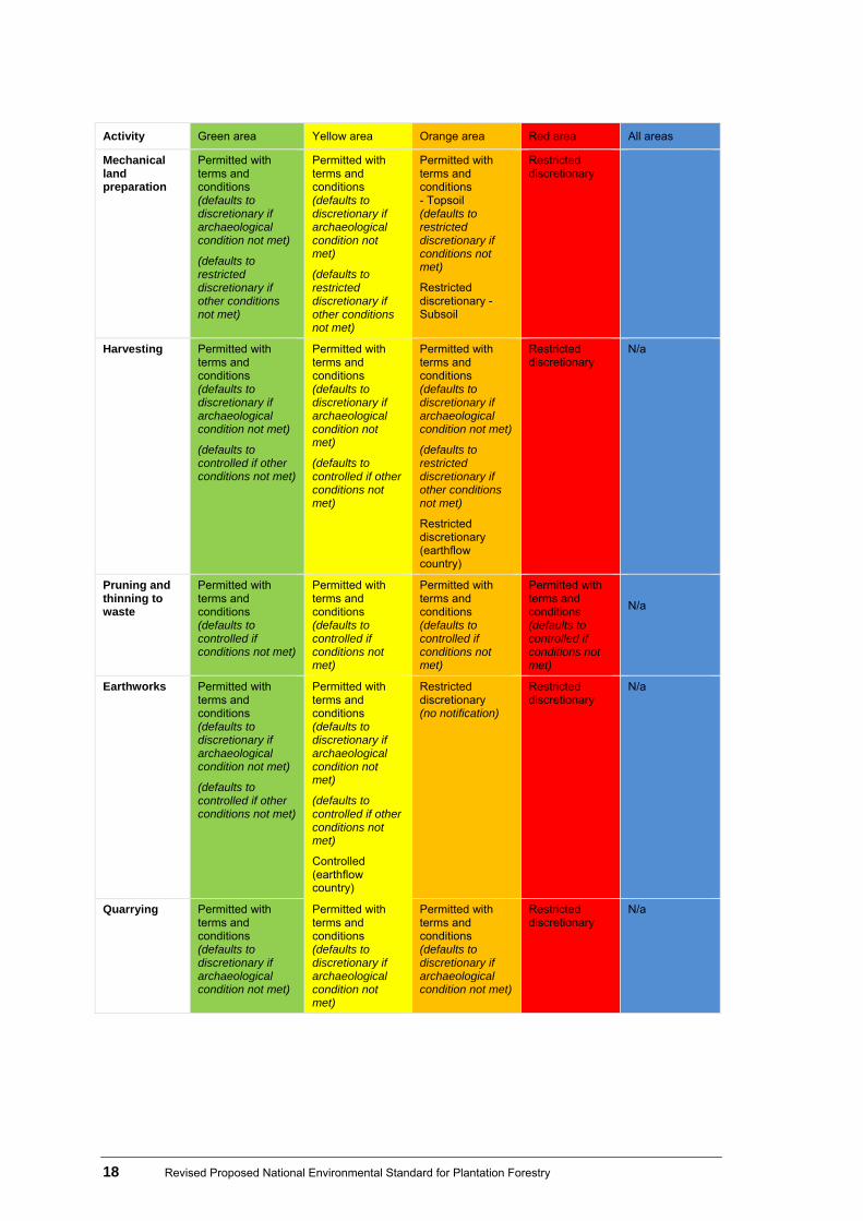
Activity Green area Yellow area Orange area Red area All areas
Mechanical land preparation
Permitted with terms and conditions (defaults to discretionary if archaeological condition not met)
(defaults to restricted discretionary if other conditions not met)
Permitted with terms and conditions (defaults to discretionary if archaeological condition not met)
(defaults to restricted discretionary if other conditions not met)
Permitted with terms and conditions - Topsoil (defaults to restricted discretionary if conditions not met)
Restricted discretionary - Subsoil
Restricted discretionary
Harvesting Permitted with terms and conditions (defaults to discretionary if archaeological condition not met)
(defaults to controlled if other conditions not met)
Permitted with terms and conditions (defaults to discretionary if archaeological condition not met)
(defaults to controlled if other conditions not met)
Permitted with terms and conditions (defaults to discretionary if archaeological condition not met)
(defaults to restricted discretionary if other conditions not met)
Restricted discretionary (earthflow country)
Restricted discretionary
N/a
Pruning and thinning to waste
Permitted with terms and conditions (defaults to controlled if conditions not met)
Permitted with terms and conditions (defaults to controlled if conditions not met)
Permitted with terms and conditions (defaults to controlled if conditions not met)
Permitted with terms and conditions (defaults to controlled if conditions not met)
N/a
Earthworks Permitted with terms and conditions (defaults to discretionary if archaeological condition not met)
(defaults to controlled if other conditions not met)
Permitted with terms and conditions (defaults to discretionary if archaeological condition not met)
(defaults to controlled if other conditions not met)
Controlled (earthflow country)
Restricted discretionary (no notification)
Restricted discretionary
N/a
Quarrying Permitted with terms and conditions (defaults to discretionary if archaeological condition not met)
Permitted with terms and conditions (defaults to discretionary if archaeological condition not met)
Permitted with terms and conditions (defaults to discretionary if archaeological condition not met)
Restricted discretionary
N/a
Revised Proposed National Environmental Standard for Plantation Forestry 19
Activity Green area Yellow area Orange area Red area All areas
(defaults to restricted discretionary if other conditions not met)
(defaults to restricted discretionary if other conditions not met)
(defaults to restricted discretionary if other conditions not met)
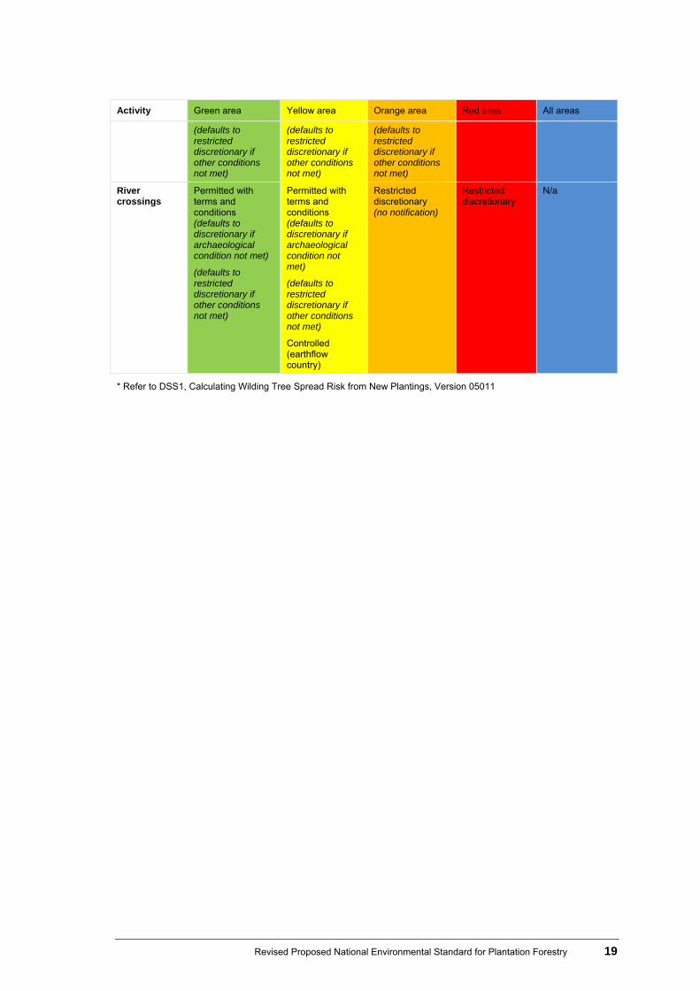
River crossings
Permitted with terms and conditions (defaults to discretionary if archaeological condition not met)
(defaults to restricted discretionary if other conditions not met)
Permitted with terms and conditions (defaults to discretionary if archaeological condition not met)
(defaults to restricted discretionary if other conditions not met)
Controlled (earthflow country)
Restricted discretionary (no notification)
Restricted discretionary
N/a
* Refer to DSS1, Calculating Wilding Tree Spread Risk from New Plantings, Version 05011

20 Revised Proposed National Environmental Standard for Plantation Forestry
4 Revised policy
The following table outlines specific changes to the proposed NES for Plantation Forestry. Blue highlights show where consensus was not reached by the main working group (see appendix 6 for questions about these highlighted areas and changes outlined in this table). Table 4: The revised policy
4.1 Ability to be more stringent Where these circumstances or issues apply in relation to the activity, local authorities would be able to either:
impose more stringent rules in plans, or more stringent conditions on resource consents; or
(in relation to permitted activities) specify conditions in their plans that relate to effects not dealt with in the proposed standard.
Aff
ores
tati
on
Rep
lan
tin
g
Mec
hani
cal l
and
prep
arat
ion
Har
vest
ing
Pru
nin
g an
d t
hin
nin
g to
was
te
Ear
thw
ork
s
Qu
arry
ing
Riv
er c
ross
ing
Key: X No ability to be more stringent Ability for councils to be more stringent Was included in first proposal but is not included in the revised proposal X Was not included in first proposal but is included in the revised proposal
Original policy proposal (in discussion document) Changes to policy proposal Reason for any changes Activity applicable to:
Able to be more stringent where: Coastal marine area: Setbacks from
the coastal marine area. In many locations the coastal marine area (CMA) has important values, such as landscape and habitat values. The CMA also has many issues associated with it, such as coastal hazards. In some cases, rules for appropriate setbacks are more
X X X
Revised National Environmental Standard for Plantation Forestry 21
Original policy proposal (in discussion document) Changes to policy proposal Reason for any changes Activity applicable to:
appropriately determined at a local or regional level. Having this issue in the ‘ability to be more stringent’ list also allows for alignment with the New Zealand Coastal Policy Statement.
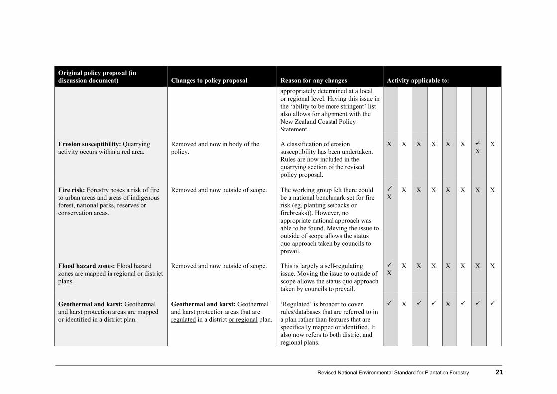
Erosion susceptibility: Quarrying activity occurs within a red area.
Removed and now in body of the policy.
A classification of erosion susceptibility has been undertaken. Rules are now included in the quarrying section of the revised policy proposal.
X
X
X
X
X
X
X
X
Fire risk: Forestry poses a risk of fire to urban areas and areas of indigenous forest, national parks, reserves or conservation areas.
Removed and now outside of scope.
The working group felt there could be a national benchmark set for fire risk (eg, planting setbacks or firebreaks)). However, no appropriate national approach was able to be found. Moving the issue to outside of scope allows the status quo approach taken by councils to prevail.
X
X
X
X
X
X
X
X
Flood hazard zones: Flood hazard zones are mapped in regional or district plans.
Removed and now outside of scope.
This is largely a self-regulating issue. Moving the issue to outside of scope allows the status quo approach taken by councils to prevail.
X
X
X
X
X
X
X
X
Geothermal and karst: Geothermal and karst protection areas are mapped or identified in a district plan.
Geothermal and karst: Geothermal and karst protection areas that are regulated in a district or regional plan.
‘Regulated’ is broader to cover rules/databases that are referred to in a plan rather than features that are specifically mapped or identified. It also now refers to both district and regional plans.
X
X

22 Revised Proposed National Environmental Standard for Plantation Forestry
Original policy proposal (in discussion document) Changes to policy proposal Reason for any changes Activity applicable to:
Hazards: Coastal and natural hazard areas mapped in regional plans.
Removed and now outside of scope. Natural hazards such as flooding, coastal hazards, tsunami, liquefaction and streambed erosion are considered ‘outside of scope’ of this NES.
X X X X X X
X
X
Heritage values: There are areas of known cultural or heritage value identified through regional or district plans, iwi management plans or the Historic Places Act, including wāhi tapu, sites of significance to Māori and archaeological sites.
Heritage values: There are places and areas of known cultural or heritage value identified in regional or district plans iwi management plans or the Historic Places Act including wāhi tapu and sites of significance to Māori. and archaeological sites’.
This was amended after receiving advice from the Ministry of Culture and Heritage and the Historic Places Trust. It provides protection for values that are not directly protected under the Historic Places Act. References to iwi management plans have been removed, as these plans must be taken into account when preparing or changing regional and district plans.
X
Indigenous vegetation clearance: Indigenous vegetation is cleared as a result of [activity].
No change There was some discussion in the working group about removing this from the ‘ability to be more stringent’ list and incorporating it into the proposed policy wording. However, this was not done largely because a Proposed National Policy Statement on Indigenous Biodiversity is currently being scoped.
X

Revised National Environmental Standard for Plantation Forestry 23
Original policy proposal (in discussion document) Changes to policy proposal Reason for any changes Activity applicable to:
Infrastructure: Network utility infrastructure is identified by district councils as needing setbacks for safety or function reasons.
Removed and now outside of scope.
Moving the issue to outside of scope allows the status quo approach taken by councils to prevail.
X
X
X
X
X
X
X
X
Nationally significant water bodies: Setbacks from nationally significant wetlands, rivers or lakes are required.
Nationally outstanding freshwater bodies: Setbacks from nationally significant wetlands, rivers, lakes outstanding freshwater bodies are required.
Amended to align with the terminology in the National Policy Statement for Freshwater Management.
X
X
Nuisance issues: There are nuisance issues, including dust, noise, vibration, vehicle movements and road damage.
Removed and now outside of scope.
Moving the issue to outside of scope allows the status quo approach taken by councils to prevail.
X
X
X
X
X
X
X
X
Outstanding natural features and landscapes: Outstanding natural features and landscape areas are identified in district or regional plans.
Outstanding natural features and landscapes: the activity takes place in an outstanding natural feature and landscape area as identified in district or regional plans.
Some members of the working group felt that this issue should be dealt with within the policy.
X
X
X
X
X
X
X
Regionally significant freshwater bodies: Setbacks from regionally significant freshwater bodies (excluding artificial freshwater bodies) identified in a district or regional plan, including wetlands, lakes, mainstem rivers and streams.
The working group could not reach an agreement about an appropriate setback distance from regionally significant freshwater bodies. Some in the working group considered there should be precise values-driven setbacks within the policy (for example a 20m setback requirement), while others considered it more appropriate for councils to determine such setbacks (hence it being in the ability to be
X
X

24 Revised Proposed National Environmental Standard for Plantation Forestry
Original policy proposal (in discussion document) Changes to policy proposal Reason for any changes Activity applicable to:
more stringent list). There was a lot of disagreement around whether ‘mainstems’ should be referred to.
Significant natural areas: Significant indigenous vegetation and significant habitats of indigenous fauna are identified in district or regional plans, including significant natural areas.
Significant natural areas: the activity taking place in an area of significant indigenous vegetation or and significant habitat of indigenous fauna as identified in district or regional plans, including significant natural areas.
Clarification
X
X
Water yield: Catchments are identified in a district or regional plan for the management of water yield (including ground water) for the purposes of achieving a desired flow or water supply.
Removed and now outside of scope. The working group considered that there are too many technical uncertainties and difficulties for this issue to be dealt with at a national level. Removing to outside of scope means that councils can apply more stringent or more lenient rules for water yield, which are applicable to their region.
X
X X X X X X X
Wilding trees: Areas have the potential for wilding tree spread.
Removed and now in the body of the policy (section 4.2, Afforestation).
See explanation in section 4.2, Afforestation.
X
X X X X X X X

Revised Proposed National Environmental Standard for Plantation Forestry 25
4.2 Afforestation
Original policy proposal (in discussion document) Revised policy proposal Reason for any changes
Permitted activity: Afforestation in a rural zone (subject to conditions)
Permitted activity: Afforestation in a rural zone of plantation forestry in green or yellow areas (subject to conditions)
The revised policy clarifies where afforestation requires a consent, based on the new erosion susceptibility mapping system. References to ‘rural zone’ have been removed as the new definition of plantation forestry refers to all zones apart from urban zones.
Conditions: District Conditions: Regional
Wilding tree risk Afforestation not being carried out in an area with a score in the wilding tree risk calculator of greater than 11.
On advice from the biosecurity subgroup, the main working group determined that an existing mechanism for establishing wilding tree risk (a wilding tree risk calculator) could be incorporated into the NES proposal rather than including the issue in the ‘ability to be more stringent’ list. It applies to afforestation activities only as it was considered that legacy issues are best dealt with under the Biosecurity Act. Refer to the wilding tree risk calculator in appendix 1.
Archaeological Afforestation not being carried out in a historic heritage area unless it is carried out on an archaeological site in
Archaeological Afforestation not being carried out in a historic heritage area unless it is carried out on an archaeological site
Archaeological No alteration of an archaeological site scheduled in a district plan or regional plan taking place unless it is carried
Amended after receiving advice from the Ministry of Culture and Heritage and the Historic Places Trust.
26 Revised Proposed National Environmental Standard for Plantation Forestry
Original policy proposal (in discussion document) Revised policy proposal Reason for any changes accordance with the Historic Places Act 1993. If any archaeological site, as defined by the Historic Places Act 1993, is exposed or identified before or during plantation forestry activities, the following procedures applying.
All site works in the immediate vicinity of the discovery ceasing immediately.
The area being secured to prevent further disturbance until relevant NZ Historic Places Trust authorisation has been obtained.
Works being carried out in accordance with the authorisation.
in accordance with the Historic Places Act 1993. If any archaeological site, as defined by the Historic Places Act 1993, is exposed or identified before or during plantation forestry activities, the following procedures applying.
All site works in the immediate vicinity of the discovery ceasing immediately.
The area being secured to prevent further disturbance until relevant NZ Historic Places Trust authorisation has been obtained.
Works being carried out in accordance with the authorisation.
out on an in accordance with the Historic Places Act 1993. If any archaeological site, as defined by the Historic Places Act 1993, is exposed or identified before or during plantation forestry activities, the following procedures apply.
All site works in the immediate vicinity of the discovery ceasing immediately.
The area being secured to prevent further disturbance until relevant NZ Historic Places Trust authorisation has been obtained.
Works being carried out in accordance with the authorisation.
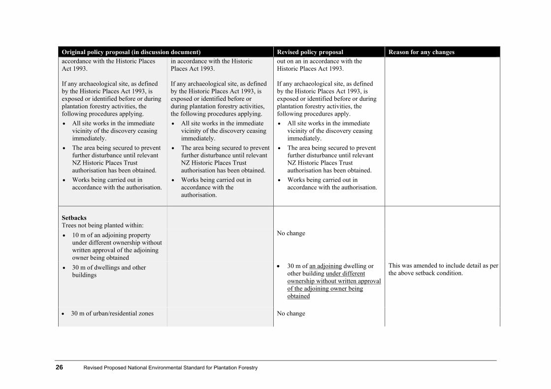
Setbacks Trees not being planted within:
10 m of an adjoining property under different ownership without written approval of the adjoining owner being obtained
No change
30 m of dwellings and other buildings
30 m of an adjoining dwelling or other building under different ownership without written approval of the adjoining owner being obtained
This was amended to include detail as per the above setback condition.
30 m of urban/residential zones No change

Revised Proposed National Environmental Standard for Plantation Forestry 27
Original policy proposal (in discussion document) Revised policy proposal Reason for any changes public road areas where:
vegetation could shade a paved road between the hours of 10 am and 2 pm on the shortest day of the year.
public road areas where: vegetation
could shade a paved formed road between the hours of 10 am and 2 pmon the shortest day of the year.
There was disagreement within the working group about the definition of a road. ‘Paved’ roads would include sealed only, whereas ‘formed’ would include both sealed and unsealed. There is concern about the combined effects of shading and logging trucks on unsealed roads (turning to slush) and the subsequent effects on other non-forestry traffic using the roads. Forest Sector representatives on the working group were reluctant to agree unless the same rules could be applied to new horticultural and farm shelterbelts, where the effects of shade on roads are considered identical.
Exceptions for circumstances where:
topography already causes shading
the written consent of the relevant road-controlling authority is obtained, confirming that the road-controlling authority is satisfied that the vegetation does not pose a safety risk, having had regard to:
the physical characteristics of the road
the degree of potential shading of the road
the nature and extent of the vegetation
the surrounding topography
No change
28 Revised Proposed National Environmental Standard for Plantation Forestry
Original policy proposal (in discussion document) Revised policy proposal Reason for any changes
potential weather effects on the road, including consideration of icing risk.
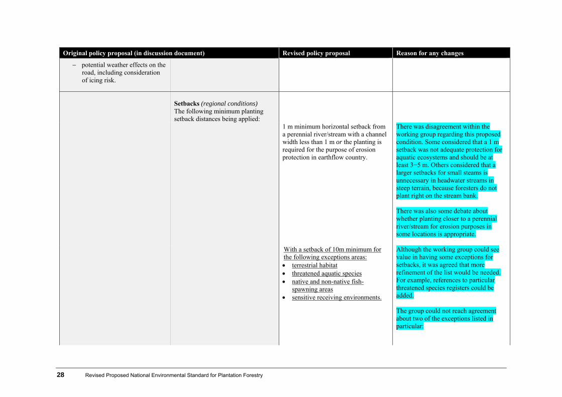
Setbacks (regional conditions) The following minimum planting setback distances being applied:
1 m minimum horizontal setback from a perennial river/stream with a channel width less than 1 m or the planting is required for the purpose of erosion protection in earthflow country.
There was disagreement within the working group regarding this proposed condition. Some considered that a 1 m setback was not adequate protection for aquatic ecosystems and should be at least 3−5 m. Others considered that a larger setbacks for small steams is unnecessary in headwater streams in steep terrain, because foresters do not plant right on the stream bank. There was also some debate about whether planting closer to a perennial river/stream for erosion purposes in some locations is appropriate.
With a setback of 10m minimum for the following exceptions areas: terrestrial habitat threatened aquatic species native and non-native fish-
spawning areas sensitive receiving environments.
Although the working group could see value in having some exceptions for setbacks, it was agreed that more refinement of the list would be needed. For example, references to particular threatened species registers could be added. The group could not reach agreement about two of the exceptions listed in particular:
Revised Proposed National Environmental Standard for Plantation Forestry 29
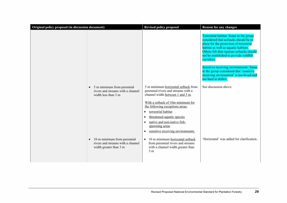
Original policy proposal (in discussion document) Revised policy proposal Reason for any changes Terrestrial habitat: Some in the group considered that setbacks should be in place for the protection of terrestrial habitat as well as aquatic habitats. Others felt that riparian setbacks should not be established to provide wildlife corridors. Sensitive receiving environments: Some in the group considered that ‘sensitive receiving environment’ is too broad and too hard to define.
5 m minimum from perennial rivers and streams with a channel width less than 3 m
5 m minimum horizontal setback from perennial rivers and streams with a channel width between 1 and 3 m. With a setback of 10m minimum for the following exceptions areas:
terrestrial habitat
threatened aquatic species
native and non-native fish-spawning areas
sensitive receiving environments.
See discussion above.
10 m minimum from perennial rivers and streams with a channel width greater than 3 m
10 m minimum horizontal setback from perennial rivers and streams with a channel width greater than 3 m
‘Horizontal’ was added for clarification.
30 Revised Proposed National Environmental Standard for Plantation Forestry
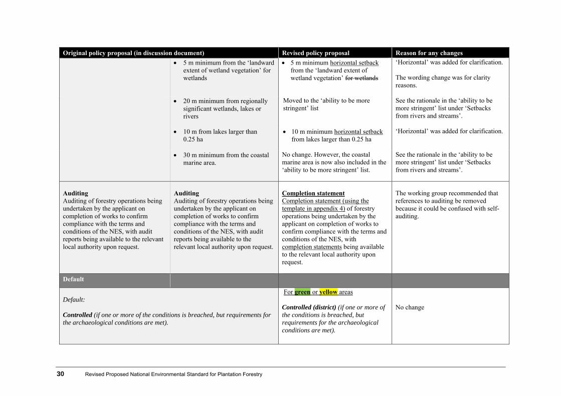
Original policy proposal (in discussion document) Revised policy proposal Reason for any changes 5 m minimum from the ‘landward
extent of wetland vegetation’ for wetlands
5 m minimum horizontal setback from the ‘landward extent of wetland vegetation’ for wetlands
‘Horizontal’ was added for clarification. The wording change was for clarity reasons.
20 m minimum from regionally significant wetlands, lakes or rivers
Moved to the ‘ability to be more stringent’ list
See the rationale in the ‘ability to be more stringent’ list under ‘Setbacks from rivers and streams’.
10 m from lakes larger than 0.25 ha
10 m minimum horizontal setback from lakes larger than 0.25 ha
‘Horizontal’ was added for clarification.
30 m minimum from the coastal marine area.
No change. However, the coastal marine area is now also included in the ‘ability to be more stringent’ list.
See the rationale in the ‘ability to be more stringent’ list under ‘Setbacks from rivers and streams’.
Auditing Auditing of forestry operations being undertaken by the applicant on completion of works to confirm compliance with the terms and conditions of the NES, with audit reports being available to the relevant local authority upon request.
Auditing Auditing of forestry operations being undertaken by the applicant on completion of works to confirm compliance with the terms and conditions of the NES, with audit reports being available to the relevant local authority upon request.
Completion statement Completion statement (using the template in appendix 4) of forestry operations being undertaken by the applicant on completion of works to confirm compliance with the terms and conditions of the NES, with completion statements being available to the relevant local authority upon request.
The working group recommended that references to auditing be removed because it could be confused with self-auditing.
Default
Default: Controlled (if one or more of the conditions is breached, but requirements for the archaeological conditions are met).
For green or yellow areas Controlled (district) (if one or more of the conditions is breached, but requirements for the archaeological conditions are met).
No change

Revised Proposed National Environmental Standard for Plantation Forestry 31
Original policy proposal (in discussion document) Revised policy proposal Reason for any changes Non-complying (afforestation in a rural zone when archaeological conditions are not met).
Restricted discretionary (regional) (if one or more of the conditions is breached, but requirements for the archaeological conditions are met). Discretionary (district and regional) if archaeological condition is not met.
The default for permitted activities if any other conditions have not been met has changed from ‘controlled’ to ‘restricted discretionary’ for regional councils, as this allows local authorities the ability to refuse consents if necessary. The default for permitted activities if the archaeological condition has not been met has been changed from ‘non-complying’ to ‘discretionary’, because the test for a non-complying activity would be reduced if the relevant plan does not have any objectives or policies relating to the issue in their plan.
Conditions: Matters over which control is reserved:
shading/icing effects
Conditions: Matters over which control is reserved:
ecological effects
Matters over which control is reserved:
shading/icing effects
Matters over which discretion is limited:
location of afforestatio potential effects from future
harvesting (including timing) and earthworks activities (including ecological, geotechnical and slope stability effects)
forest species
No change Added due to new activity status.
Consent
Restricted discretionary activity
Restricted discretionary activity: Afforestation of plantation forestry in
This continues with the previous front loading approach for afforestation for

32 Revised Proposed National Environmental Standard for Plantation Forestry
Original policy proposal (in discussion document) Revised policy proposal Reason for any changes Afforestation in red areas Afforestation in a rural zone on terrain classed as having severe, very severe or extreme erosion susceptibility.
orange or red areas (subject to conditions). Note there is a non-notification proviso for consents in orange areas.
high risk and very high risk areas. Note that for orange areas a non-notification requirement for councils. Some members considered that such a move needs more consideration.
Restricted discretionary activity (district council): Afforestation of plantation forestry in all areas where there is a score in the wilding tree risk calculator of 12−16.
As a result of submissions and after receiving advice from the biosecurity subgroup, the main working group identified that a national benchmark for wilding tree prevention could be incorporated into the policy. A calculator sourced from the New Zealand Wilding Conifer Management Group has been incorporated into the revised policy.
Prohibited activity(district council): Afforestation of plantation forestry in all areas where there is a score in the wilding tree risk calculator of greater than 16
See above
Matters over which discretion applies:
location of afforestation
potential effects from future harvesting and earthworks activities (including ecological, geotechnical and slope stability effects).
Matters over which discretion applies:
location of afforestation
potential effects from future harvesting (including timing) and earthworks activities (including ecological, geotechnical and slope stability effects)
forest species.
An additional matter was added to reflect the addition of the wilding tree provisions above.

Revised Proposed National Environmental Standard for Plantation Forestry 33
4.3 Replanting
Original policy proposal (in discussion document) Revised policy proposal Reason for any changes
Permitted activity: Replanting in a rural zone (subject to conditions)
Permitted activity: Replanting in a rural zone of plantation forestry in green, yellow or orange areas (subject to conditions)
The revised policy clarifies where replanting requires a consent based on the new erosion susceptibility mapping system. References to ‘rural zone’ have been removed as the new definition of plantation forestry refers to all zones apart from urban zones. Some members of the working group felt that more consideration should be given to controlling the effects of replanting in orange areas.
Conditions: District Conditions: Regional
Archaeological Replanting not being carried out in a historic heritage area unless it is carried out on an archaeological site in accordance with the Historic Places Act 1993. If any archaeological site, as defined by the Historic Places Act 1993, is exposed or identified before or during plantation forestry activities, the following procedures applying.
All site works in the immediate vicinity of the discovery ceasing immediately.
See proposed amendments in Afforestation, section 4.2.
See explanation in Afforestation, section 4.2.

34 Revised Proposed National Environmental Standard for Plantation Forestry
Original policy proposal (in discussion document) Revised policy proposal Reason for any changes
The area being secured to prevent further disturbance until relevant NZ Historic Places Trust authorisation has been obtained.
Works being carried out in accordance with the authorisation.
The area being secured to prevent further disturbance until relevant NZ Historic Places Trust authorisation has been obtained.
Works being carried out in accordance with the authorisation.
Understorey vegetation clearance as a result of replanting The clearance or conversion of indigenous vegetation being limited to vegetation that:
has grown up under (or may have overtopped) production species; or
is within an area of failed planting (within the last rotation); or
is within an area of regenerating cutover.
Clearance of indigenous vegetation within a productive area in preparation for replanting The clearance or conversion of indigenous vegetation being limited to vegetation that:
has grown up under (or may have overtopped) production species; or
is within an area of failed planting (within the last rotation); or
is within an area of regenerating cutover; or
vegetation overgrowing a pre-existing access way.
These words were changed for clarification. One working group member supported an additional setback requirements from set aside indigenous vegetation areas (outside of productive areas) where there is evidence of adverse effects at the replanting stage. Others were concerned that this would mean that such setbacks would start to encroach into productive forestry areas over time. Other working group members raised concerns about ‘productive areas’ being too loose. Between rotations, vegetation may establish on internal forest access roads. This needs to be cleared to allow access for maintenance and harvesting.
Setbacks See original wording in Afforestation, section 4.2
See proposed amendments in Afforestation, section 4.2
For replanting, the main working group made recommendations for setbacks from water bodies under two scenarios. This is because setbacks

Revised Proposed National Environmental Standard for Plantation Forestry 35
Original policy proposal (in discussion document) Revised policy proposal Reason for any changes
potentially have a direct influence on liabilities triggered under the Climate Change Response Act 2002. The first scenario reflects good practice under the scenario that the ETS liability problem is solved by some other means (eg, legislative amendments to the Climate Change Response Act). Scenario 2 has been prepared for the scenario whereby the ETS liability problem cannot be solved. (For an outline of scenario 2, see appendix 5.) The final scenario that is settled on must be appropriate for the resource management purpose of the RMA.
Auditing Auditing of forestry operations being undertaken by the applicant on completion of works to confirm compliance with the terms and conditions of the NES, with audit reports being available to the relevant local authority upon request.
Auditing Auditing of forestry operations being undertaken by the applicant on completion of works to confirm compliance with the terms and conditions of the NES, with audit reportsbeing available to the relevant local authority upon request.
See proposed amendments in Afforestation, section 4.2
See explanation in Afforestation, section 4.2.
Default
Default: Controlled (if one or more of the conditions is breached, but requirements for the archaeological conditions are met). Non-complying (replanting in a rural zone when archaeological conditions are not met).
For green yellow or orange areas Controlled (district and regional (if one or more of the conditions is breached, but requirements for the archaeological conditions are met).
No change

36 Revised Proposed National Environmental Standard for Plantation Forestry
Original policy proposal (in discussion document) Revised policy proposal Reason for any changes
Discretionary (district and regional) if archaeological condition is not met.
See explanation in Afforestation, section 4.2.
Matters over which control is reserved:
ecological effects
location of replanting.
Matters over which control is reserved:
ecological, including aquatic effects
location of replanting
The future effect of afforestation on aquatic systems should also be considered.
Consent
Restricted discretionary activity: Replanting of plantation forestry in red areas
Clarifies where replanting requires a consent based on the new erosion susceptibility mapping system.
Matters over which discretion applies:
location of replanting
potential effects from future harvesting (including timing) and earthworks activities (including ecological, geotechnical and slope stability effects).
Added due to new activity status.
Revised Proposed National Environmental Standard for Plantation Forestry 37
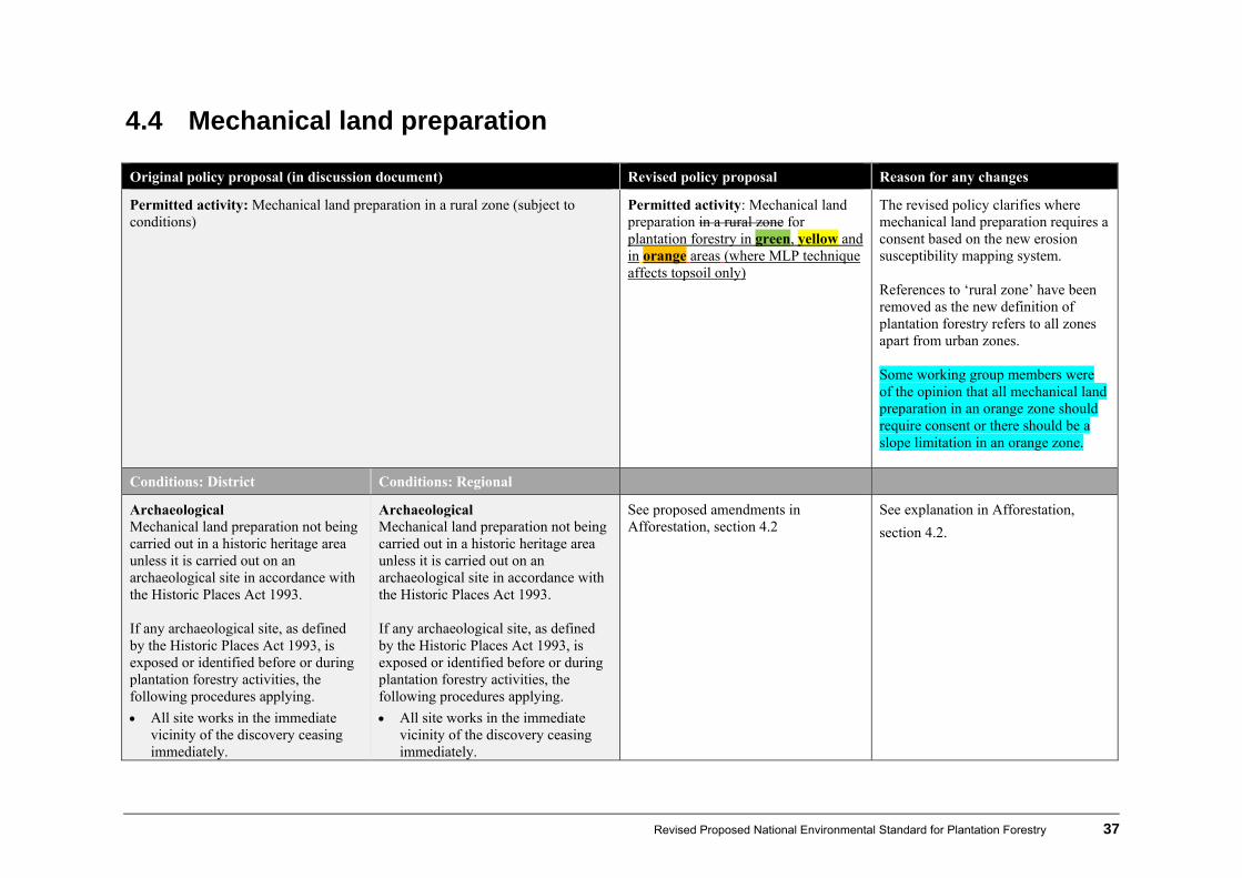
4.4 Mechanical land preparation
Original policy proposal (in discussion document) Revised policy proposal Reason for any changes
Permitted activity: Mechanical land preparation in a rural zone (subject to conditions)
Permitted activity: Mechanical land preparation in a rural zone for plantation forestry in green, yellow and in orange areas (where MLP technique affects topsoil only)
The revised policy clarifies where mechanical land preparation requires a consent based on the new erosion susceptibility mapping system. References to ‘rural zone’ have been removed as the new definition of plantation forestry refers to all zones apart from urban zones. Some working group members were of the opinion that all mechanical land preparation in an orange zone should require consent or there should be a slope limitation in an orange zone.
Conditions: District Conditions: Regional
Archaeological Mechanical land preparation not being carried out in a historic heritage area unless it is carried out on an archaeological site in accordance with the Historic Places Act 1993. If any archaeological site, as defined by the Historic Places Act 1993, is exposed or identified before or during plantation forestry activities, the following procedures applying.
All site works in the immediate vicinity of the discovery ceasing immediately.
See proposed amendments in Afforestation, section 4.2
See explanation in Afforestation,
section 4.2.

38 Revised Proposed National Environmental Standard for Plantation Forestry
Original policy proposal (in discussion document) Revised policy proposal Reason for any changes
The area being secured to prevent further disturbance until relevant NZ Historic Places Trust authorisation has been obtained.
Works being carried out in accordance with the authorisation.
The area being secured to prevent further disturbance until relevant NZ Historic Places Trust authorisation has been obtained.
Works being carried out in accordance with the authorisation.
Understorey vegetation clearance as a result of mechanical land preparation The clearance or conversion of indigenous vegetation being limited to vegetation that:
has grown up under (or may have overtopped) production species; or
is within an area of failed planting (within the last rotation); or
is within an area of regenerating cutover.
Clearance of indigenous vegetation within a productive area as a result of mechanical land preparation The clearance or conversion of indigenous vegetation being limited to vegetation that:
has grown up under (or may have overtopped) production species; or
is within an area of failed planting (within the last rotation); or
is within an area of regenerating cutover; or
vegetation overgrowing a pre-existing access way.
See explanation in Replanting, section 4.3.
Fuel No machinery refuelling or storing of fuel in locations where fuel might enter water bodies.
No change
Methods Mechanical land preparation (aside from roller crushing and downhill ripping) being carried out parallel to the contour, where practical.
No change
Revised Proposed National Environmental Standard for Plantation Forestry 39
Original policy proposal (in discussion document) Revised policy proposal Reason for any changes
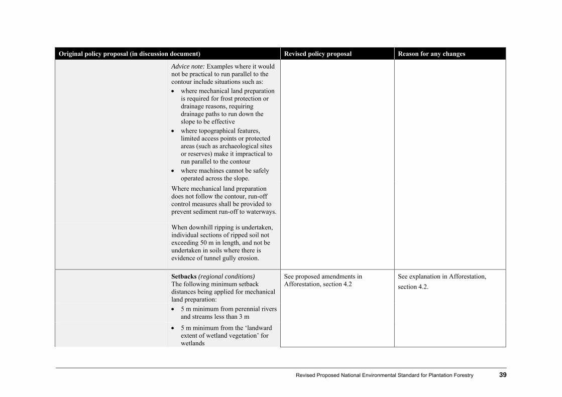
Advice note: Examples where it would not be practical to run parallel to the contour include situations such as: where mechanical land preparation
is required for frost protection or drainage reasons, requiring drainage paths to run down the slope to be effective
where topographical features, limited access points or protected areas (such as archaeological sites or reserves) make it impractical to run parallel to the contour
where machines cannot be safely operated across the slope.
Where mechanical land preparation does not follow the contour, run-off control measures shall be provided to prevent sediment run-off to waterways.
When downhill ripping is undertaken, individual sections of ripped soil not exceeding 50 m in length, and not be undertaken in soils where there is evidence of tunnel gully erosion.
Setbacks (regional conditions) The following minimum setback distances being applied for mechanical land preparation:
See proposed amendments in Afforestation, section 4.2
See explanation in Afforestation,
section 4.2.
5 m minimum from perennial rivers and streams less than 3 m
5 m minimum from the ‘landward extent of wetland vegetation’ for wetlands

40 Revised Proposed National Environmental Standard for Plantation Forestry
Original policy proposal (in discussion document) Revised policy proposal Reason for any changes
10 m minimum from perennial rivers and streams with a channel width greater than 3 m
10 m minimum from lakes larger than 0.25 ha
20 m minimum from regionally significant wetlands, lakes or rivers
30 m minimum from the coastal marine area.
Nesting times (district council) Where threatened indigenous bird species are known to nest in the cutover in a region of forest, processes being in place to identify nest sites or the nesting season and once identified, protect those areas from disturbance by mechanical land preparation.
The working group incorporated this for good practice reasons.
Auditing Auditing of forestry operations being undertaken by the applicant on completion of works to confirm compliance with the terms and conditions of the NES, with audit reports being available to the relevant local authority upon request.
Auditing Auditing of forestry operations being undertaken by the applicant on completion of works to confirm compliance with the terms and conditions of the NES, with audit reportsbeing available to the relevant local authority upon request.
See proposed amendments in Afforestation, section 4.2
See explanation in Afforestation,
section 4.2.
Default
Default: Restricted discretionary (if one or more of the conditions is breached, but requirements for the archaeological conditions are met).
For green yellow or orange areas
Restricted Discretionary (district and regional) (if one or more of the conditions is breached, but requirements for the archaeological
No change

Revised Proposed National Environmental Standard for Plantation Forestry 41
Original policy proposal (in discussion document) Revised policy proposal Reason for any changes
conditions are met).
Non-complying (mechanical land preparation in a rural zone when archaeological conditions are not met).
Discretionary (district and regional) if archaeological condition is not met.
See explanation in Afforestation, section 4.2.
Discretion restricted to:
ecological and aquatic effects (including effects on water quality)
location of work in relation to water bodies and wetlands
measures taken to address erosion and sediment run-off.
Discretion restricted to:
ecological and aquatic effects (including effects on water quality)
location of work in relation to coastal marine areas, rivers, streams, lakes and wetlands
measures taken to address erosion and sediment run-off
type of mechanical land preparation and method employed
Discretion was changed for clarification purposes.
Consent
Restricted discretionary activity: Mechanical land preparation for plantation forestry in orange areas(where MLP technique affects subsoil) and in red areas.
The revised policy clarifies where mechanical land preparation requires a consent based on the new erosion susceptibility mapping system.
Discretion restricted to:
ecological and aquatic effects (including effects on water quality)
location of work in relation to coastal marine areas, rivers, streams, lakes and wetlands
measures taken to address erosion and sediment run-off
type of mechanical land preparation and method
Discretion was added for new rule requirement.

42 Revised Proposed National Environmental Standard for Plantation Forestry
4.5 Harvesting Original policy proposal (in discussion document) Revised policy proposal Reason for any changes
Permitted activity: Harvesting in rural zones (subject to conditions), including:
associated discharges of bark to land
production thinning
soil disturbance associated with harvesting (excluding earthworks − see Earthworks, section 4.7)
edge damage of adjacent indigenous vegetation
the damaging or removal of indigenous vegetation within the understory of a plantation forest, where it is necessary to harvest a plantation forest, including vegetation that:
has grown up under (or may have overtopped) production species, or
is within an area of failed planting (within the last rotation), or
is within an area of regenerating cutover.
Permitted activity: Harvesting in rural zones of plantation forestry in green, yellow or orange areas (subject to conditions), including :
associated discharges of slash to land
production thinning
soil disturbance associated with harvesting (excluding earthworks − see Earthworks, section 4.7)
edge damage of adjacent indigenous vegetation
the damaging or removal of indigenous vegetation within the understory of a plantation forest, where it is necessary to harvest a plantation forest, including vegetation that:
has grown up under (or may have overtopped) production species, or
is within an area of failed planting (within the last rotation), or
is within an area of regenerating cutover, or
vegetation overgrowing a pre-existing access way.
The revised policy clarifies where harvesting requires a consent based on the new erosion susceptibility mapping system. Some working group members were of the opinion that harvesting in an orange zone should be a ‘controlled’ activity rather than a ‘permitted’ activity so that conditions can be imposed concerning erosion susceptibility (including partial catchment harvesting, log suspension and mandatory replanting if essential). Others disagreed and said such a move would move beyond the status quo. Between rotations vegetation may establish on internal forest access roads. This needs to be cleared to allow access for maintenance and harvesting.

Revised Proposed National Environmental Standard for Plantation Forestry 43
Original policy proposal (in discussion document) Revised policy proposal Reason for any changes
Conditions: District Conditions: Regional
Notification Notice of commencement of harvesting activities being given to the relevant district council at least 20 working days prior to commencement of operations.
No change
Notification (regional conditions)
Notice of commencement of harvesting activities being given to the relevant regional council at least 20 working days prior to commencement of operations.
No change
A harvest plan, appropriate to the assessment of the operational risks to the environment, being prepared demonstrating means of compliance with the conditions below.
A harvest plan (using template in appendix 2), appropriate to the assessment of the operational risks to the environment, being prepared demonstrating means of compliance with the conditions below.
More detail on what the harvest plan would look like has been prepared (see appendix 2).
Details in the harvest plan to include:
an assessment and mapping of water-body values and riparian areas to identify risks associated with operations
a demonstration of how permitted activity conditions will be complied with.
Details in the harvest plan to include:
an assessment and mapping of water-body values, riparian, geothermal and karst areas, significant natural areas, and significant fauna habitat to identify the risks associated with operations
a demonstration of how permitted activity conditions will be complied with (completion statement).
The scope of the harvest plan was amended to include more detail about special values.
The harvest plan and any subsequent changes being available to the relevant regional council at least 20 working days
No change

44 Revised Proposed National Environmental Standard for Plantation Forestry
Original policy proposal (in discussion document) Revised policy proposal Reason for any changes
prior to commencement of operations or annually upon agreement with the relevant council.
All harvesting being carried out in accordance with the harvest plan and any subsequent harvest plan changes.
No change
Archaeological Harvesting not being carried out in a historic heritage area unless it is carried out on an archaeological site in accordance with the Historic Places Act 1993. If any archaeological site, as defined by the Historic Places Act 1993, is exposed or identified before or during plantation forestry activities, the following procedures applying.
All site works in the immediate vicinity of the discovery ceasing immediately.
The area being secured to prevent further disturbance until relevant NZ Historic Places Trust authorisation has been obtained.
Works being carried out in accordance with the authorisation.
See proposed amendments in Afforestation, section 4.2
See explanation in Afforestation, section 4.2.

Revised Proposed National Environmental Standard for Plantation Forestry 45
Original policy proposal (in discussion document) Revised policy proposal Reason for any changes
Fuel No machinery refuelling or storing of fuel occurring in locations where fuel might enter water bodies.
No change
Methods Ground disturbance Heading changed because the following two conditions focus on minimising ground disturbance.
Stem butts being lifted clear of the ground during extraction, wherever practicable.
The best practicable option being used when harvesting to minimise excessive soil erosion and/or sediment discharge to water bodies.
Moved from second condition to first for clarity. Some members thought that if soil disturbance associated with harvesting impacts on the subsoil it should have greater controls. Those members also felt that there should be conditions around harvesting techniques at high value sites. For example full suspension being required in some situations near mainstems of regionally significant rivers was discussed.
The best practicable option being used when harvesting to minimise excessive soil erosion and/or sediment discharge to water bodies.
Stem butts being lifted clear of the ground during extraction, wherever practicable.
Moved from first condition to second for clarity.
Stabilisation to avoid adverse effects of sediment in water bodies or accelerated erosion
Stabilisation, revegetation or replanting of exposed soil caused by harvesting being undertaken as soon as practicable
Condition removed The working group considered that the condition is difficult to measure and will be ineffective because revegetation of the exposed soil normally occurs within 18 months naturally.

46 Revised Proposed National Environmental Standard for Plantation Forestry
Original policy proposal (in discussion document) Revised policy proposal Reason for any changes
in the spring or autumn immediately following the completion of soil disturbance, to achieve 80% ground cover within 18 months of the operation being completed.
Riparian disturbance
Harvest planning The harvesting plan process including prior assessment of water bodies and their riparian areas to identify risks associated with operations, including the disturbance of indigenous vegetation.
No change
Water bodies and protected riparian areas being identified and mapped, and details of their management included in the harvest plan.
No change
Operational Where safe and practical, trees being felled and extracted away from the water body or riparian zone. If unavoidable, trees being felled directly across the water body for full-length extraction before de-limbing or heading.
Avoid felling into the water body or riparian zone except where unsafe and impractical to do so. If unavoidable, trees being felled directly across the water body for full-length extraction before de-limbing or heading.
Order of wording changed to indicate the priority of avoidance.
Where extraction across perennial water bodies and riparian vegetation is the best practicable option, methods such as hauling through corridors, butt extraction and maximum suspension of loads being used to minimise disturbance to the water body and riparian vegetation.
No change

Revised Proposed National Environmental Standard for Plantation Forestry 47
Original policy proposal (in discussion document) Revised policy proposal Reason for any changes
Harvesting machinery not being operated within 5 m of perennial water bodies, with the exception of water-body crossing points.
Harvesting machinery not being operated within 5 m of perennial water bodies, with the exception of water-body crossing points, where slash needs to be removed and where access essential to assist in the directional falling of trees to minimise disturbance to the riparian margin.
In some cases machinery needs to be used to remove slash where it cannot be removed manually. Some members of the working group thought that the 5m setback should be from a riparian setback area rather thana perennial waterbody so that the machinery setback correlates with the riparian setback.
When harvesting within or across a riparian zone, all disturbed vegetation, soil or debris being deposited or placed in a position where it will not enter any watercourse to the extent that it causes diversion, damming or erosion of any river or stream, or degradation of any aquatic or riparian habitat, or damage to downstream infrastructure.
When harvesting within or across a riparian zone, all disturbed vegetation, soil or debris being deposited or placed in a position where it will not enter any watercourse to the extent that it causes diversion, damming or erosion of any river or stream, or degradation of any aquatic or riparian habitat, or damage to downstream infrastructure, property or receiving environments.
The working group added this in response to submissions.
Slash and debris management
Harvest planning As part of the harvest planning process the party managing the activity having a documented system for assessing and managing the effects and potential risks of slash, appropriate to the scale and level of risk of their activities.
No change
Some members of the working group recommended that the installation of slash traps should be a permitted activity as it is a mitigation measure.
Operational planning Slash management requirements relating to water bodies and slash storage at processing sites being identified and clearly documented before the operation starts.
Operational planning Slash management requirements relating to perennial waterbodies and slash storage at skids sites being identified and clearly documented in a harvest plan before the operation starts.
This links slash management to the harvest plan requirement.

48 Revised Proposed National Environmental Standard for Plantation Forestry
Original policy proposal (in discussion document) Revised policy proposal Reason for any changes
Management of slash at processing sites Slash accumulations at skids sites being placed onto stable ground and managed to avoid accumulation to levels that could cause erosion or instability of land.
Added upon recommendation from working group
Installation and maintenance of appropriate water and sediment controls, to prevent build-up that could lead to a potential land collapse.
Added upon recommendation from working group.
Avoiding slash reaching water bodies Harvesting being planned and carried out so as to prevent, as far as practicable, the amount of slash that is deposited into perennial water bodies, lakes or wetlands when harvesting adjacent to perennial water bodies.
Avoiding slash reaching water bodies Harvesting being planned and carried out so as to prevent, as far as practicable, the entry amount of logging slash that is deposited into perennial water bodies, lakes or wetlands. when harvesting adjacent to perennial water bodies.
The working group added this in response to submissions.
Advice note: i. Environmental risks of logging
slash entering perennial water bodies need to be assessed against the environmental risks associated with additional landing, roading and tracking in steep uns terrain to keep logging slash out of perennial water bodies.
Removing slash Whenever safe and practicable to do so, potentially unstable slash being removed from perennially flowing water bodies where flood flows have the potential to mobilise and cause:
Removing slash Whenever safe and practicable to do so, potentially unstable slash being removed from perennially flowing water bodies where flood flows have the potential to mobilise and cause:
The working group added this in response to submissions.
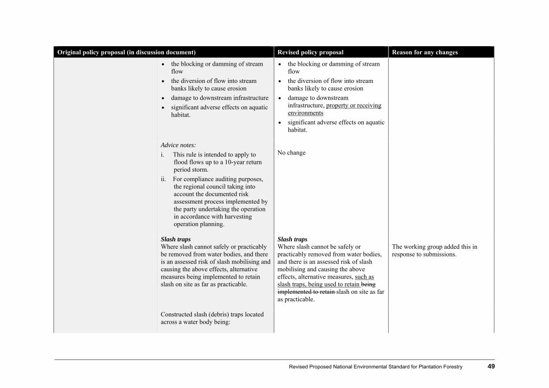
Revised Proposed National Environmental Standard for Plantation Forestry 49
Original policy proposal (in discussion document) Revised policy proposal Reason for any changes
the blocking or damming of stream flow
the diversion of flow into stream banks likely to cause erosion
damage to downstream infrastructure
significant adverse effects on aquatic habitat.
the blocking or damming of stream flow
the diversion of flow into stream banks likely to cause erosion
damage to downstream infrastructure, property or receiving environments
significant adverse effects on aquatic habitat.
Advice notes:
i. This rule is intended to apply to flood flows up to a 10-year return period storm.
ii. For compliance auditing purposes, the regional council taking into account the documented risk assessment process implemented by the party undertaking the operation in accordance with harvesting operation planning.
No change
Slash traps Where slash cannot safely or practicably be removed from water bodies, and there is an assessed risk of slash mobilising and causing the above effects, alternative measures being implemented to retain slash on site as far as practicable.
Slash traps Where slash cannot be safely or practicably removed from water bodies, and there is an assessed risk of slash mobilising and causing the above effects, alternative measures, such as slash traps, being used to retain being implemented to retain slash on site as far as practicable.
The working group added this in response to submissions.
Constructed slash (debris) traps located across a water body being:
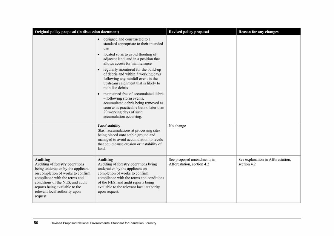
50 Revised Proposed National Environmental Standard for Plantation Forestry
Original policy proposal (in discussion document) Revised policy proposal Reason for any changes
designed and constructed to a standard appropriate to their intended use
located so as to avoid flooding of adjacent land, and in a position that allows access for maintenance
regularly monitored for the build-up of debris and within 5 working days following any rainfall event in the upstream catchment that is likely to mobilise debris
maintained free of accumulated debris – following storm events, accumulated debris being removed as soon as is practicable but no later than 20 working days of such accumulation occurring.
Land stability
Slash accumulations at processing sites being placed onto stable ground and managed to avoid accumulation to levels that could cause erosion or instability of land.
No change
Auditing Auditing of forestry operations being undertaken by the applicant on completion of works to confirm compliance with the terms and conditions of the NES, and audit reports being available to the relevant local authority upon request.
Auditing Auditing of forestry operations being undertaken by the applicant on completion of works to confirm compliance with the terms and conditions of the NES, and audit reports being available to the relevant local authority upon request.
See proposed amendments in Afforestation, section 4.2
See explanation in Afforestation, section 4.2
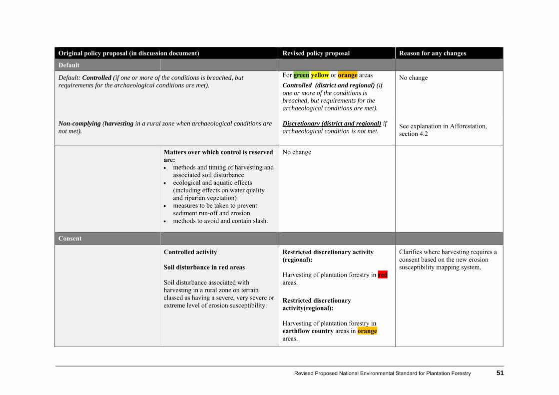
Revised Proposed National Environmental Standard for Plantation Forestry 51
Original policy proposal (in discussion document) Revised policy proposal Reason for any changes
Default
Default: Controlled (if one or more of the conditions is breached, but requirements for the archaeological conditions are met).
For green yellow or orange areas
Controlled (district and regional) (if one or more of the conditions is breached, but requirements for the archaeological conditions are met).
No change
Non-complying (harvesting in a rural zone when archaeological conditions are not met).
Discretionary (district and regional) if archaeological condition is not met.
See explanation in Afforestation, section 4.2
Matters over which control is reserved are: methods and timing of harvesting and
associated soil disturbance ecological and aquatic effects
(including effects on water quality and riparian vegetation)
measures to be taken to prevent sediment run-off and erosion
methods to avoid and contain slash.
No change
Consent
Controlled activity Soil disturbance in red areas Soil disturbance associated with harvesting in a rural zone on terrain classed as having a severe, very severe or extreme level of erosion susceptibility.
Restricted discretionary activity (regional): Harvesting of plantation forestry in red areas.
Restricted discretionary activity(regional): Harvesting of plantation forestry in earthflow country areas in orange areas.
Clarifies where harvesting requires a consent based on the new erosion susceptibility mapping system.
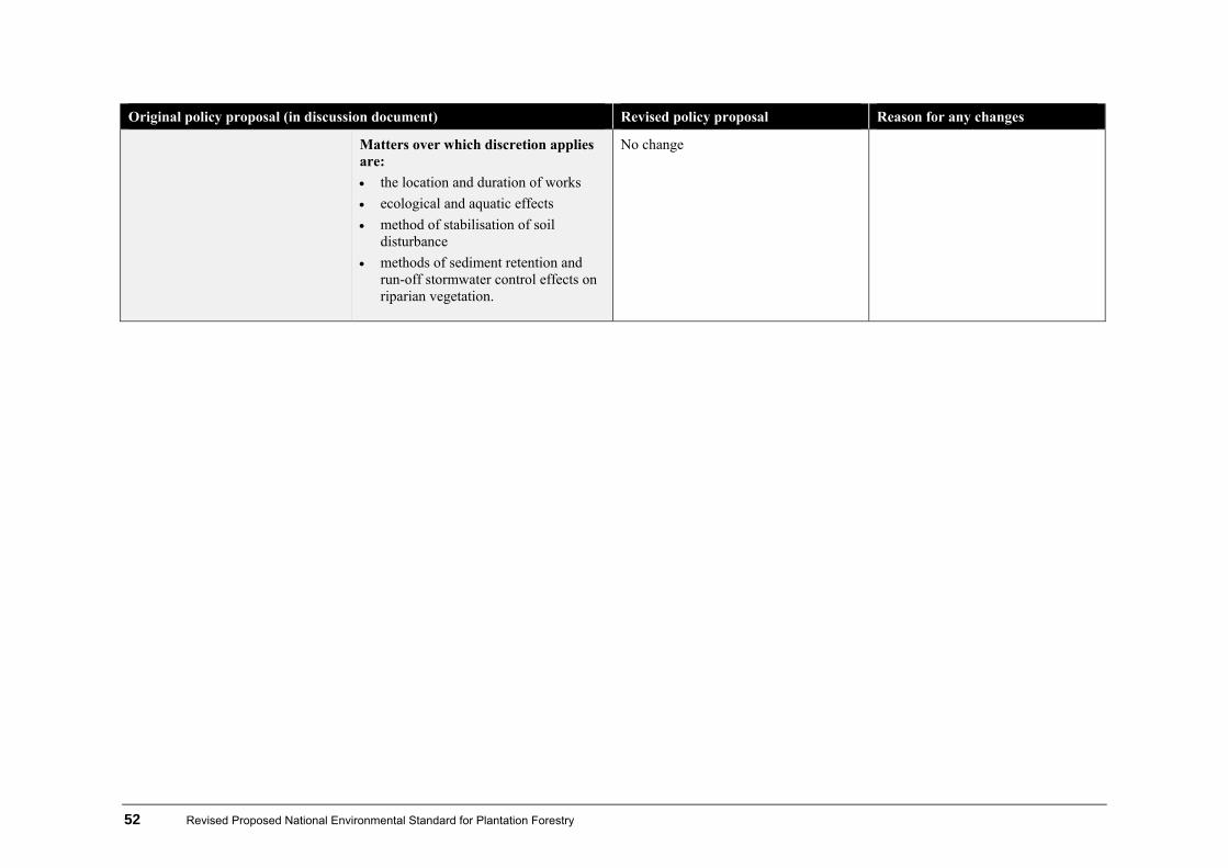
52 Revised Proposed National Environmental Standard for Plantation Forestry
Original policy proposal (in discussion document) Revised policy proposal Reason for any changes
Matters over which discretion applies are:
the location and duration of works
ecological and aquatic effects
method of stabilisation of soil disturbance
methods of sediment retention and run-off stormwater control effects on riparian vegetation.
No change

Revised Proposed National Environmental Standard for Plantation Forestry 53
4.6 Pruning and thinning to waste
Original policy proposal (in discussion document) Revised policy proposal Reason for any changes
Permitted activity: Pruning and thinning to waste in a rural zone (subject to conditions)
Permitted activity: Pruning and thinning to waste in a rural zone for plantation forestry in the green, yellow, orange and red areas (subject to conditions).
The revised policy clarifies that pruning and thinning does not require a consent for any of the four erosion susceptibility classes as mapped. Some working group members wanted to add a requirement that 150 stems per hectare remain.
Conditions: District Conditions: Regional
Slash No debris from thinning and pruning being deposited where it may enter a perennial water body.
No change
Some working group members felt that slash placement should also be avoided where it may crush sensitive indigenous vegetation.
Fuel No machinery refuelling or storing of fuel in locations where fuel might enter water bodies.
No change
Default
None For green yellow orange or red areas
Controlled (regional) (if one or more of the conditions is breached, but requirements for the archaeological conditions are met).
A default has been added for clarification.
Matters over which control is reserved:
ecological, including aquatic

54 Revised Proposed National Environmental Standard for Plantation Forestry
Original policy proposal (in discussion document) Revised policy proposal Reason for any changes
effects

Revised Proposed National Environmental Standard for Plantation Forestry 55
4.7 Earthworks
Original policy proposal (in discussion document) Revised policy proposal Reason for any changes
Permitted activity: Earthworks associated with forestry activities in a green area (subject to conditions): earthworks in a rural zone on terrain classed as having negligible or low susceptibility to erosion;
and
Permitted activity: Earthworks associated with forestry activities for plantation forestry activities in a green or yellow area (subject to conditions)
and
The revised policy clarifies where earthworks requires a consent based on the new erosion susceptibility mapping system.
the maintenance and upgrade of existing earthworks associated with forestry activities in a green, orange or red area in a rural zone (subject to conditions).
the maintenance and upgrade of existing earthworks for plantation forestry activities in a green, yellow, orange or red area (subject to conditions except for slope).
Conditions: District Conditions: Regional
Notification The party undertaking the earthworks advising the district council at least 20 working days prior to works commencing on site.
No change
Notification Commencement advice The reference to notification was removed because it was confusing.
The party undertaking the earthworks advising the regional council at least 20 working days prior to works commencing on site.
No change
An earthworks plan demonstrating compliance with terms and conditions (or demonstrating an adequate methodology for compliance) being provided to the appropriate local authority at least 20 working days prior to commencement of works.
An earthworks plan (using template in appendix 3) demonstrating compliance with terms and conditions (or demonstrating an adequate methodology for compliance) being provided to the appropriate local authority at least 20 working days prior to commencement of works.
The template for the earthworks plan must be used as a guide to how permitted activity status is achieved. The template will also:
encourage good practice
allow effective monitoring through provision of standardised

56 Revised Proposed National Environmental Standard for Plantation Forestry
Original policy proposal (in discussion document) Revised policy proposal Reason for any changes
information. (With the earthworks plan being able to be
provided annually upon agreement with the relevant local authority.)
No change
Detail in the earthworks plan to include:
a monitoring log of sediment discharge concentrations in Class A water, completed under the supervision of an approved contractor.
Condition removed
There is no longer a monitoring requirement for water quality (see ‘sediment discharge concentrations’ below).
All earthworks being carried out in accordance with the earthworks plan and any subsequent changes to the earthworks plan.
No change
Archaeological Earthworks not being carried out in a historic heritage area unless they are carried out on an archaeological site in accordance with the Historic Places Act 1993. If any archaeological site, as defined by the Historic Places Act 1993, is exposed or identified before or during plantation forestry activities, the following procedures applying.
All site works in the immediate vicinity of the discovery ceasing immediately.
The area being secured to
Archaeological Earthworks not being carried out in a historic heritage area unless they are carried out on an archaeological site in accordance with the Historic Places Act 1993. If any archaeological site, as defined by the Historic Places Act 1993, is exposed or identified before or during plantation forestry activities, the following procedures applying.
All site works in the immediate vicinity of the discovery ceasing immediately.
The area being secured to prevent further disturbance until relevant NZ Historic Places Trust authorisation has been obtained.
Work being carried out in accordance with the authorisation.
See proposed amendments in Afforestation, section 4.2
See explanation in Afforestation, section 4.2

Revised Proposed National Environmental Standard for Plantation Forestry 57
Original policy proposal (in discussion document) Revised policy proposal Reason for any changes
prevent further disturbance until relevant NZ Historic Places Trust authorisation has been obtained.
Work being carried out in accordance with the authorisation.
Fuel
No machinery refuelling or storing of fuel in locations where fuel might enter water bodies.
No change
Design matters
Maximum culvert spacing not exceeding values given for various road gradients and soil types in figure 113 of the NZ Forest Roading Manual (LIRO), with road water table culverts having a minimum of 325 mm internal diameter.
Maximum water table drainage culvert spacing not exceeding values given for various road gradients and soil types in figure 113 of the NZ Forest Roading Manual (LIRO), with road water table culverts having a minimum internal diameter of 325 mm.
Added for clarity
Tracks being aligned and managed such that run-off is diverted to minimise the concentration of channelled flows.
No change
Landing-fill areas being benched and compacted to prevent slumping.
No change
Temporary tracks and other earthworks not required for future operations being deactivated to control run-off, and stabilisation of the track being undertaken.
No change
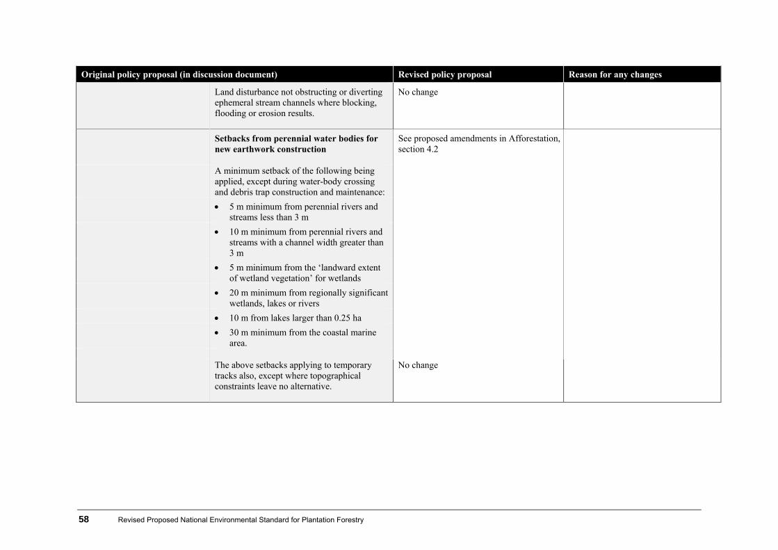
58 Revised Proposed National Environmental Standard for Plantation Forestry
Original policy proposal (in discussion document) Revised policy proposal Reason for any changes
Land disturbance not obstructing or diverting ephemeral stream channels where blocking, flooding or erosion results.
No change
Setbacks from perennial water bodies for new earthwork construction
See proposed amendments in Afforestation, section 4.2
A minimum setback of the following being applied, except during water-body crossing and debris trap construction and maintenance:
5 m minimum from perennial rivers and streams less than 3 m
10 m minimum from perennial rivers and streams with a channel width greater than 3 m
5 m minimum from the ‘landward extent of wetland vegetation’ for wetlands
20 m minimum from regionally significant wetlands, lakes or rivers
10 m from lakes larger than 0.25 ha 30 m minimum from the coastal marine
area. The above setbacks applying to temporary
tracks also, except where topographical constraints leave no alternative.
No change
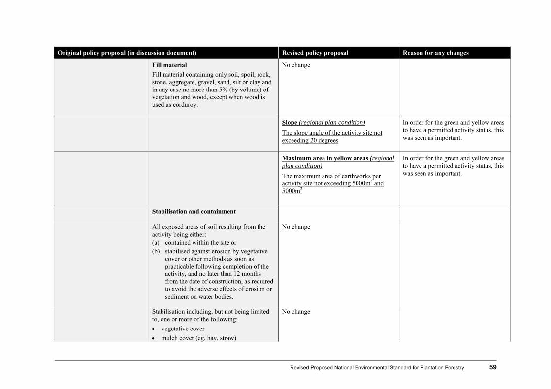
Revised Proposed National Environmental Standard for Plantation Forestry 59
Original policy proposal (in discussion document) Revised policy proposal Reason for any changes
Fill material
Fill material containing only soil, spoil, rock, stone, aggregate, gravel, sand, silt or clay and in any case no more than 5% (by volume) of vegetation and wood, except when wood is used as corduroy.
No change
Slope (regional plan condition)
The slope angle of the activity site not exceeding 20 degrees
In order for the green and yellow areas to have a permitted activity status, this was seen as important.
Maximum area in yellow areas (regional plan condition)
The maximum area of earthworks per activity site not exceeding 5000m3 and 5000m2
In order for the green and yellow areas to have a permitted activity status, this was seen as important.
Stabilisation and containment
All exposed areas of soil resulting from the activity being either: (a) contained within the site or (b) stabilised against erosion by vegetative
cover or other methods as soon as practicable following completion of the activity, and no later than 12 months from the date of construction, as required to avoid the adverse effects of erosion or sediment on water bodies.
No change
Stabilisation including, but not being limited to, one or more of the following:
vegetative cover
mulch cover (eg, hay, straw)
No change

60 Revised Proposed National Environmental Standard for Plantation Forestry
Original policy proposal (in discussion document) Revised policy proposal Reason for any changes
slash cover
engineering techniques such as rock armouring.
Note: Stabilisation requirements do not apply to firebreaks.
No spoil being directly deposited into a permanently flowing water body, lake or the sea, or deposited in a position where it can readily enter or be carried into these.
No change
Spoil and fill not being placed over indigenous vegetation, outside of a production area, or placed in a position where it can produce sediment in a water body.
No change
Fill, batters and side castings being stabilised, as required, to minimise erosion and sedimentation, by measures such as seeding, compacting, drainage or revegetation.
No change
Sediment and stormwater control measures
Stormwater and sediment control measures being installed and maintained to avoid sediment discharge to water bodies and prevent erosion, scour and sedimentation off-site.
No change
Sediment discharge concentrations Entire section removed There is no longer a monitoring requirement for water quality as a number of members of the working group regarded such measurement did not provide data that could be used for any practical purpose and it is
Sediment from land, after reasonable mixing, not reducing the annual medium visual clarity of receiving waters, measured against a reference, before harvest or an appropriate reference catchment by more than:

Revised Proposed National Environmental Standard for Plantation Forestry 61
Original policy proposal (in discussion document) Revised policy proposal Reason for any changes
20% for Class A waters (where visual
clarity is an important characteristic of the water body)
40% for all other waters or during single events (including flood events), by more than 100 g/m3, unless the background level (ie, upstream of the activity or in a suitable reference stream) is close to or above 100 g/m3, in which case the increase in suspended solids after reasonable mixing shall not be greater than 40% above the background level. No production of any conspicuous oil or grease films, scum or foams, floatable or suspended materials at or beyond a 20 m radius from the discharge point occurring. The concentration of contaminants not exceeding: 20 mg/m3 of total petroleum hydrocarbons
beyond a 200 m radius of the discharge.
expensive.
Auditing
Auditing of forestry operations being undertaken by the applicant on completion of works to confirm compliance with the terms and conditions of the NES, and audit reports being made available to the relevant local authority upon request.
Auditing
Auditing of forestry operations being undertaken by the applicant on completion of works to confirm compliance with the terms and conditions of the NES, and audit reports being made available to the relevant local authority upon request.
See proposed amendments in Afforestation, section 4.2
See explanation in Afforestation, section 4.2
Default
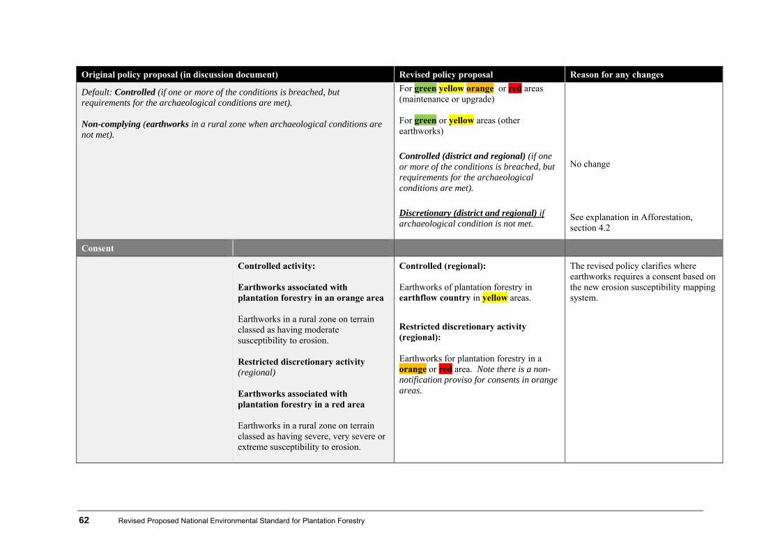
62 Revised Proposed National Environmental Standard for Plantation Forestry
Original policy proposal (in discussion document) Revised policy proposal Reason for any changes
Default: Controlled (if one or more of the conditions is breached, but requirements for the archaeological conditions are met). Non-complying (earthworks in a rural zone when archaeological conditions are not met).
For green yellow orange or red areas (maintenance or upgrade) For green or yellow areas (other earthworks)
Controlled (district and regional) (if one or more of the conditions is breached, but requirements for the archaeological conditions are met).
Discretionary (district and regional) if archaeological condition is not met.
No change See explanation in Afforestation, section 4.2
Consent
Controlled activity: Earthworks associated with plantation forestry in an orange area Earthworks in a rural zone on terrain classed as having moderate susceptibility to erosion. Restricted discretionary activity (regional) Earthworks associated with plantation forestry in a red area Earthworks in a rural zone on terrain classed as having severe, very severe or extreme susceptibility to erosion.
Controlled (regional): Earthworks of plantation forestry in earthflow country in yellow areas.
Restricted discretionary activity (regional): Earthworks for plantation forestry in a orange or red area. Note there is a non-notification proviso for consents in orange areas.
The revised policy clarifies where earthworks requires a consent based on the new erosion susceptibility mapping system.
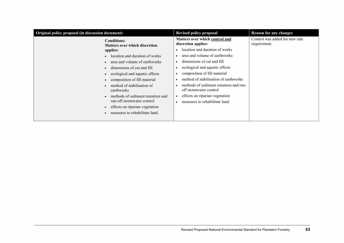
Revised Proposed National Environmental Standard for Plantation Forestry 63
Original policy proposal (in discussion document) Revised policy proposal Reason for any changes
Conditions: Matters over which discretion applies:
location and duration of works
area and volume of earthworks
dimensions of cut and fill
ecological and aquatic effects
composition of fill material
method of stabilisation of earthworks
methods of sediment retention and run-off stormwater control
effects on riparian vegetation
measures to rehabilitate land.
Matters over which control and discretion applies:
location and duration of works
area and volume of earthworks
dimensions of cut and fill
ecological and aquatic effects
composition of fill material
method of stabilisation of earthworks
methods of sediment retention and run-off stormwater control
effects on riparian vegetation
measures to rehabilitate land.
Control was added for new rule requirement.
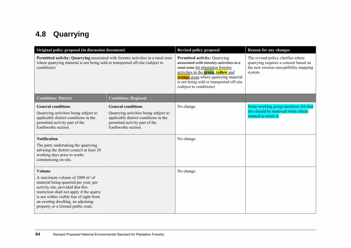
64 Revised Proposed National Environmental Standard for Plantation Forestry
4.8 Quarrying
Original policy proposal (in discussion document) Revised policy proposal Reason for any changes
Permitted activity: Quarrying associated with forestry activities in a rural zone where quarrying material is not being sold or transported off-site (subject to conditions)
Permitted activity: Quarrying associated with forestry activities in a rural zone for plantation forestry activities in the green, yellow and orange areas where quarrying material is not being sold or transported off-site (subject to conditions)
The revised policy clarifies where quarrying requires a consent based on the new erosion susceptibility mapping system.
Conditions: District Conditions: Regional
General conditions
Quarrying activities being subject to applicable district conditions in the permitted activity part of the Earthworks section.
General conditions
Quarrying activities being subject to applicable district conditions in the permitted activity part of the Earthworks section.
No change Some working group members felt that this should be removed while others wanted to retain it.
Notification
The party undertaking the quarrying advising the district council at least 20 working days prior to works commencing on-site.
No change
Volume
A maximum volume of 2000 m³ of material being quarried per year, per activity site, provided that this restriction shall not apply if the quarry is not within visible line of sight from an existing dwelling, an adjoining property or a formed public road.
No change
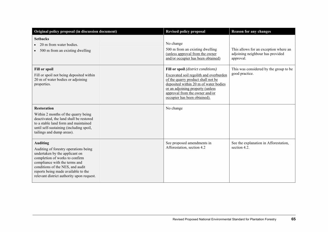
Revised Proposed National Environmental Standard for Plantation Forestry 65
Original policy proposal (in discussion document) Revised policy proposal Reason for any changes
Setbacks
20 m from water bodies. No change
500 m from an existing dwelling 500 m from an existing dwelling (unless approval from the owner and/or occupier has been obtained)
This allows for an exception where an adjoining neighbour has provided approval.
Fill or spoil
Fill or spoil not being deposited within 20 m of water bodies or adjoining properties.
Fill or spoil (district conditions)
Excavated soil regolith and overburden of the quarry product shall not be deposited within 20 m of water bodies or an adjoining property (unless approval from the owner and/or occupier has been obtained).
This was considered by the group to be good practice.
Restoration
Within 2 months of the quarry being deactivated, the land shall be restored to a stable land form and maintained until self-sustaining (including spoil, tailings and dump areas).
No change
Auditing
Auditing of forestry operations being undertaken by the applicant on completion of works to confirm compliance with the terms and conditions of the NES, and audit reports being made available to the relevant district authority upon request.
See proposed amendments in Afforestation, section 4.2
See the explanation in Afforestation, section 4.2.

66 Revised Proposed National Environmental Standard for Plantation Forestry
Original policy proposal (in discussion document) Revised policy proposal Reason for any changes
Default
Default: Restricted discretionary (if one or more of the conditions is breached, but requirements for the archaeological conditions are met).
For green yellow or orange areas
Restricted Discretionary (district)(if one or more of the conditions is breached, but requirements for the archaeological conditions are met).
No change
Non-complying (quarrying in a rural zone when archaeological conditions are not met).
Discretionary (district and regional) if archaeological condition is not met.
See the explanation in Afforestation, section 4.2.
Conditions:
Matters over which discretion applies:
location and duration of works
area and volume of earthworks
dimensions of cut and fill
ecological and aquatic effects
method of stabilisation of earthworks
method of sediment retention and run-off stormwater control
effects on riparian vegetation
measures to rehabilitate land.
No change
Consent
Restricted discretionary activity(regional): Quarrying for plantation forestry in a red area
The revised policy clarifies where quarrying requires a consent based on the new erosion susceptibility mapping system.
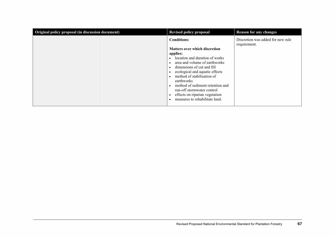
Revised Proposed National Environmental Standard for Plantation Forestry 67
Original policy proposal (in discussion document) Revised policy proposal Reason for any changes
Conditions: Matters over which discretion applies: location and duration of works area and volume of earthworks dimensions of cut and fill ecological and aquatic effects method of stabilisation of
earthworks method of sediment retention and
run-off stormwater control effects on riparian vegetation measures to rehabilitate land.
Discretion was added for new rule requirement.
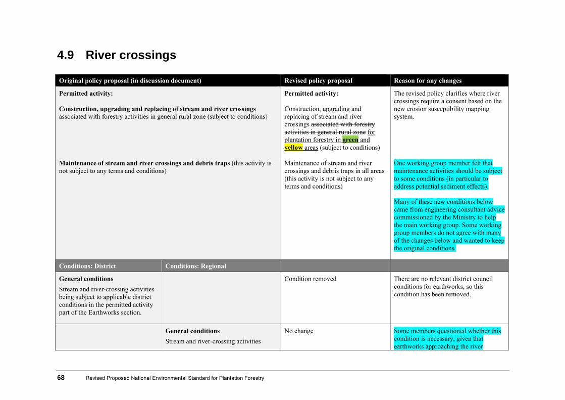
68 Revised Proposed National Environmental Standard for Plantation Forestry
4.9 River crossings
Original policy proposal (in discussion document) Revised policy proposal Reason for any changes
Permitted activity: Construction, upgrading and replacing of stream and river crossings associated with forestry activities in general rural zone (subject to conditions)
Permitted activity: Construction, upgrading and replacing of stream and river crossings associated with forestry activities in general rural zone for plantation forestry in green and yellow areas (subject to conditions)
The revised policy clarifies where river crossings require a consent based on the new erosion susceptibility mapping system.
Maintenance of stream and river crossings and debris traps (this activity is not subject to any terms and conditions)
Maintenance of stream and river crossings and debris traps in all areas (this activity is not subject to any terms and conditions)
One working group member felt that maintenance activities should be subject to some conditions (in particular to address potential sediment effects). Many of these new conditions below came from engineering consultant advice commissioned by the Ministry to help the main working group. Some working group members do not agree with many of the changes below and wanted to keep the original conditions.
Conditions: District Conditions: Regional
General conditions
Stream and river-crossing activities being subject to applicable district conditions in the permitted activity part of the Earthworks section.
Condition removed There are no relevant district council conditions for earthworks, so this condition has been removed.
General conditions
Stream and river-crossing activities
No change Some members questioned whether this condition is necessary, given that earthworks approaching the river
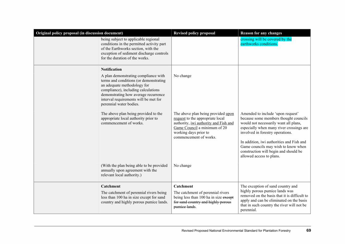
Revised Proposed National Environmental Standard for Plantation Forestry 69
Original policy proposal (in discussion document) Revised policy proposal Reason for any changes
being subject to applicable regional conditions in the permitted activity part of the Earthworks section, with the exception of sediment discharge controls for the duration of the works.
crossing will be covered by the earthworks conditions.
Notification
A plan demonstrating compliance with terms and conditions (or demonstrating an adequate methodology for compliance), including calculations demonstrating how average recurrence interval requirements will be met for perennial water bodies.
No change
The above plan being provided to the appropriate local authority prior to commencement of works.
The above plan being provided upon request to the appropriate local authority, iwi authority and Fish and Game Council a minimum of 20 working days prior to commencement of works.
Amended to include ‘upon request’ because some members thought councils would not necessarily want all plans, especially when many river crossings are involved in forestry operations. In addition, iwi authorities and Fish and Game councils may wish to know when construction will begin and should be allowed access to plans.
(With the plan being able to be provided annually upon agreement with the relevant local authority.)
No change
Catchment
The catchment of perennial rivers being less than 100 ha in size except for sand country and highly porous pumice lands.
Catchment
The catchment of perennial rivers being less than 100 ha in size except for sand country and highly porous pumice lands.
The exception of sand country and highly porous pumice lands was removed on the basis that it is difficult to apply and can be eliminated on the basis that in such country the river will not be perennial.

70 Revised Proposed National Environmental Standard for Plantation Forestry
Original policy proposal (in discussion document) Revised policy proposal Reason for any changes
There was still concern from some members of the working group that catchment size is not an appropriate trigger for culvert status – particularly in free draining areas such as pumice or sand forests, where runoff response is significantly lower and most 100ha catchments would not support a perennial flow. An alternative preferred by some was to use the design culvert size based on storm flow calculations as the trigger, with a culvert above a given design size requiring a consent (the approach used by some regional councils). It was felt this would give a more consistent assessment of relative risk across a range of catchments.
Fuel
No machinery refuelling or storing of fuel in locations where fuel may enter water bodies.
No change
Erosion/flooding (regional conditions)
No change
The activity not exacerbating riverbank or riverbed erosion, or flooding effects upstream or downstream.
The structure not causing more than a temporary impediment during the construction phase to the passage of flood debris.
Water course and levels Alignment and water levels Altered for clarity.
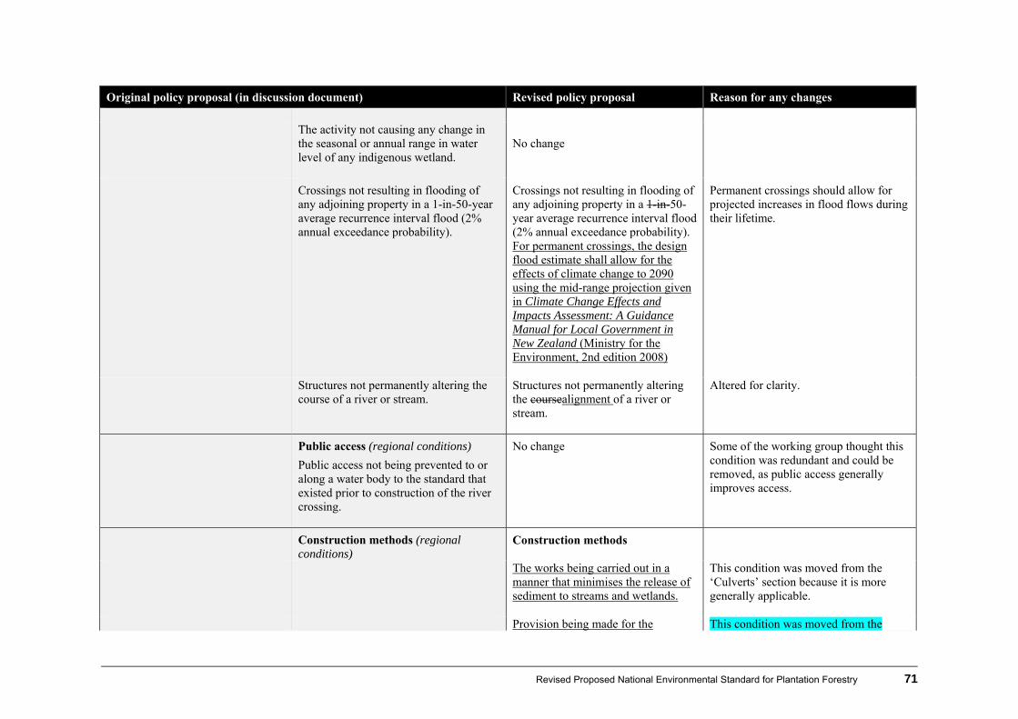
Revised Proposed National Environmental Standard for Plantation Forestry 71
Original policy proposal (in discussion document) Revised policy proposal Reason for any changes
The activity not causing any change in
the seasonal or annual range in water level of any indigenous wetland.
No change
Crossings not resulting in flooding of any adjoining property in a 1-in-50-year average recurrence interval flood (2% annual exceedance probability).
Crossings not resulting in flooding of any adjoining property in a 1-in-50-year average recurrence interval flood (2% annual exceedance probability). For permanent crossings, the design flood estimate shall allow for the effects of climate change to 2090 using the mid-range projection given in Climate Change Effects and Impacts Assessment: A Guidance Manual for Local Government in New Zealand (Ministry for the Environment, 2nd edition 2008)
Permanent crossings should allow for projected increases in flood flows during their lifetime.
Structures not permanently altering the course of a river or stream.
Structures not permanently altering the coursealignment of a river or stream.
Altered for clarity.
Public access (regional conditions)
Public access not being prevented to or along a water body to the standard that existed prior to construction of the river crossing.
No change Some of the working group thought this condition was redundant and could be removed, as public access generally improves access.
Construction methods (regional conditions)
Construction methods
The works being carried out in a manner that minimises the release of sediment to streams and wetlands.
This condition was moved from the ‘Culverts’ section because it is more generally applicable.
Provision being made for the This condition was moved from the

72 Revised Proposed National Environmental Standard for Plantation Forestry
Original policy proposal (in discussion document) Revised policy proposal Reason for any changes
temporary diversion of a river or stream around the extent of the works while the activity is taking place.
‘Fish passage’ section, because it is more generally applicable. However, there was some disagreement about whether it should be included. Some members thought it isn’t always possible to apply to small forestry creeks on steep country and could create more adverse effects.
Any temporary diversion having capacity for at least a 2-year average recurrence interval flood (50% annual exceedance probability), unless it can be programmed for a maximum of 5 days when settled weather is forecast, and the diversion has capacity for the flow expected at the time of year.
This condition was added to reduce the risk of sediment release resulting from inadequate diversion capacity. However, not all members agreed, and felt it would be impractical to program works around five day settled weather forecast.
Any erosion diversion occurring as a result of the diversion and discharge of water being remedied as soon as practicable.
Reflects good practice.
Any temporary diversion being reinstated after the works have been completed.
Reflects good practice.
The structure being constructed to retain integrity during flood flows.
No change
The entry and exit points of the structure being constructed and maintained to prevent surface erosion, river bank erosion, and outflanking by water-course diversion.
Condition removed Covered by new culverts and ford conditions.
All structures being constructed from durable materials.
No change
The mixing and pouring of construction No change
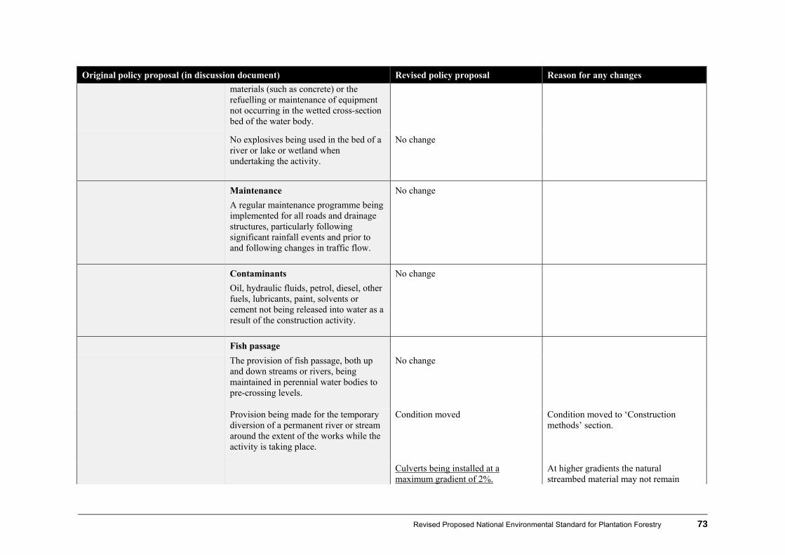
Revised Proposed National Environmental Standard for Plantation Forestry 73
Original policy proposal (in discussion document) Revised policy proposal Reason for any changes
materials (such as concrete) or the refuelling or maintenance of equipment not occurring in the wetted cross-section bed of the water body.
No explosives being used in the bed of a river or lake or wetland when undertaking the activity.
No change
Maintenance
A regular maintenance programme being implemented for all roads and drainage structures, particularly following significant rainfall events and prior to and following changes in traffic flow.
No change
Contaminants
Oil, hydraulic fluids, petrol, diesel, other fuels, lubricants, paint, solvents or cement not being released into water as a result of the construction activity.
No change
Fish passage
The provision of fish passage, both up and down streams or rivers, being maintained in perennial water bodies to pre-crossing levels.
No change
Provision being made for the temporary diversion of a permanent river or stream around the extent of the works while the activity is taking place.
Condition moved Condition moved to ‘Construction methods’ section.
Culverts being installed at a maximum gradient of 2%.
At higher gradients the natural streambed material may not remain
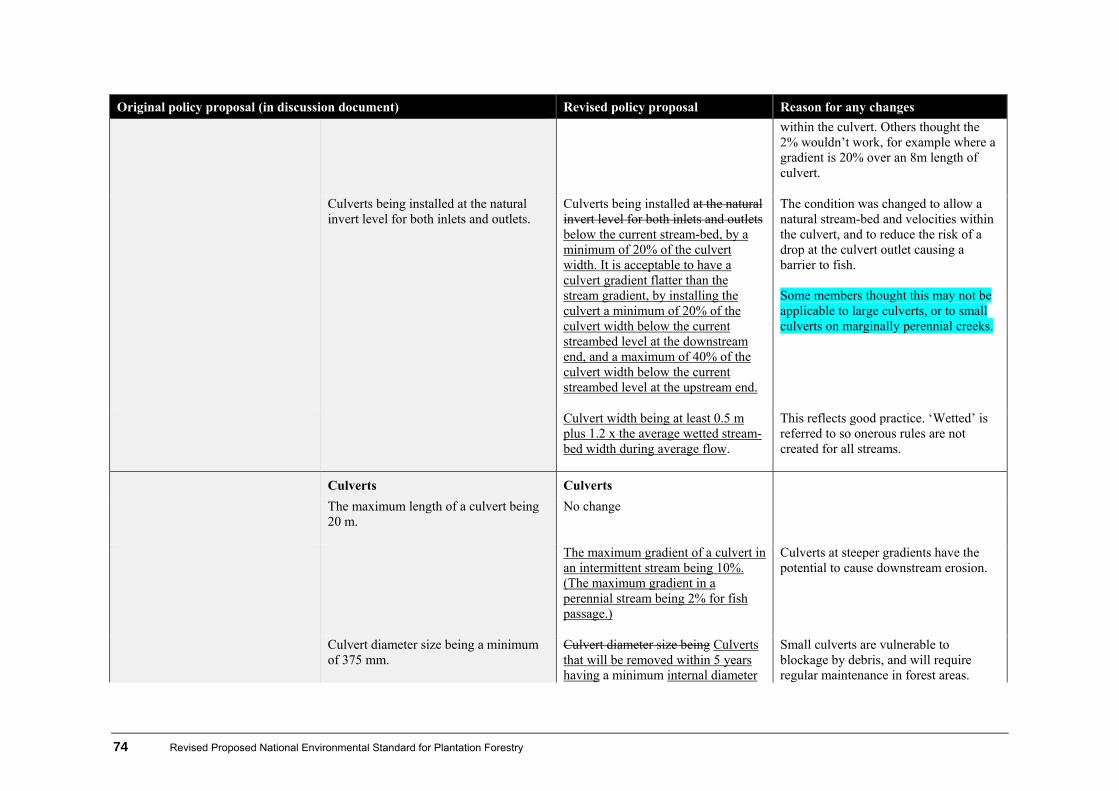
74 Revised Proposed National Environmental Standard for Plantation Forestry
Original policy proposal (in discussion document) Revised policy proposal Reason for any changes
within the culvert. Others thought the 2% wouldn’t work, for example where a gradient is 20% over an 8m length of culvert.
Culverts being installed at the natural invert level for both inlets and outlets.
Culverts being installed at the natural invert level for both inlets and outlets below the current stream-bed, by a minimum of 20% of the culvert width. It is acceptable to have a culvert gradient flatter than the stream gradient, by installing the culvert a minimum of 20% of the culvert width below the current streambed level at the downstream end, and a maximum of 40% of the culvert width below the current streambed level at the upstream end.
The condition was changed to allow a natural stream-bed and velocities within the culvert, and to reduce the risk of a drop at the culvert outlet causing a barrier to fish. Some members thought this may not be applicable to large culverts, or to small culverts on marginally perennial creeks.
Culvert width being at least 0.5 m plus 1.2 x the average wetted stream-bed width during average flow.
This reflects good practice. ‘Wetted’ is referred to so onerous rules are not created for all streams.
Culverts Culverts
The maximum length of a culvert being 20 m.
No change
The maximum gradient of a culvert in an intermittent stream being 10%. (The maximum gradient in a perennial stream being 2% for fish passage.)
Culverts at steeper gradients have the potential to cause downstream erosion.
Culvert diameter size being a minimum of 375 mm.
Culvert diameter size being Culverts that will be removed within 5 years having a minimum internal diameter
Small culverts are vulnerable to blockage by debris, and will require regular maintenance in forest areas.
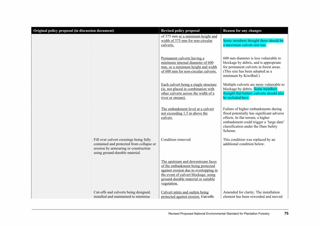
Revised Proposed National Environmental Standard for Plantation Forestry 75
Original policy proposal (in discussion document) Revised policy proposal Reason for any changes
of 375 mm or a minimum height and width of 375 mm for non-circular culverts.
Some members thought there should be a maximum culvert size too.
Permanent culverts having a minimum internal diameter of 600 mm, or a minimum height and width of 600 mm for non-circular culverts.
600 mm diameter is less vulnerable to blockage by debris, and is appropriate for permanent culverts in forest areas. (This size has been adopted as a minimum by KiwiRail.)
Each culvert being a single structure (ie, not placed in combination with other culverts across the width of a river or stream).
Multiple culverts are more vulnerable to blockage by debris. Some members thought that battery culverts should also be included here.
The embankment level at a culvert not exceeding 1.5 m above the culvert.
Failure of higher embankments during flood potentially has significant adverse effects. In flat terrain, a higher embankment could trigger a ‘large dam’ classification under the Dam Safety Scheme.
Fill over culvert crossings being fully contained and protected from collapse or erosion by armouring or construction using ground-durable material.
Condition removed This condition was replaced by an additional condition below.
The upstream and downstream faces of the embankment being protected against erosion due to overtopping in the event of culvert blockage, using ground-durable material or suitable vegetation.
Cut-offs and culverts being designed, installed and maintained to minimise
Culvert inlets and outlets being protected against erosion. Cut-offs
Amended for clarity. The installation element has been reworded and moved

76 Revised Proposed National Environmental Standard for Plantation Forestry
Original policy proposal (in discussion document) Revised policy proposal Reason for any changes
sediment delivery to streams and wetlands and to prevent scour, rilling, gullying or slope failure.
and culverts being designed, installed and maintained to minimise sediment delivery to streams and wetlands and to prevent scour, rilling, gullying or slope failure.
to the ‘Construction methods’ section. There is a separate section for maintenance.
Any erosion occurring as a result of the structure being remedied as soon as practicable.
This is a new condition to reflect good practice.
Culverts being constructed so that alignment and gradient are the same as those of the subject water body.
Culverts being constructed so that alignment and gradient are, as far as practicable, the same as those of the subject water body.
Allows for straightening of the alignment and profile within the length of the culvert.
Culverts that will be removed within 5 years being designed to accommodate a 2-year average recurrence interval flood (50% annual exceedance probability) without the upstream water level exceeding the culvert soffit level.
A condition for temporary culverts was missing.
All permanent culverts being designed to accommodate a 1-in-50-year flood (2% annual exceedance probability) without ‘heading up’.
All permanent culverts being designed to accommodate a 1-in-50- 10-year average recurrence interval flood (102% annual exceedance probability), including allowance for the effects of climate change to 2090 using the mid-range projection given in Climate Change Effects and Impacts Assessment: A Guidance Manual for Local Government without the upstream water level “heading up”.exceeding the culvert soffit level.
This less severe condition is considered reasonable. Culverts will normally pass significantly higher flows before any overtopping of the embankment. ‘Heading up’ was not clear. The glossary definition of soffit to: “the top of a waterway opening, being the underside of a bridge, or the top internal surface of a culvert”.

Revised Proposed National Environmental Standard for Plantation Forestry 77
Original policy proposal (in discussion document) Revised policy proposal Reason for any changes
Fords (regional conditions) Fords (regional conditions)
The ford not resulting in a vertical drop or discontinuity in flow under any flow conditions.
No change
The ford not causing the raising of the level of the bed, and the ford waterway cross-section being no less than the general water cross-section of the river adjacent to the ford.
The condition was moved and expanded to reflect good practice.
No spoil being deposited onto the water-course bed during construction of the approaches.
No spoil being deposited onto the water-course river bed during construction of the approaches.
Amended to use the defined term.
The ford not increasing flooding or risk of flooding.
Condition removed Unnecessary in conjunction with the other conditions.
The ford being able to pass a 1-in-50-year flood event (2% annual exceedance probability).
Condition removed Unnecessary in conjunction with the other conditions.
The river being diverted and work area dewatered before bed material is excavated and wet concrete poured.
No change
Fords being on natural gravel or rock surfaces or on a constructed platform resistant to erosion and scour.
No change
The entry and exit points of the ford being constructed and maintained to prevent erosion of the bed and banks.
This distinguishes between erosion of approaches and scour downstream of the ford.
Ford approaches and downstream channel areas being protected against
Ford approaches and The downstream channel areas being
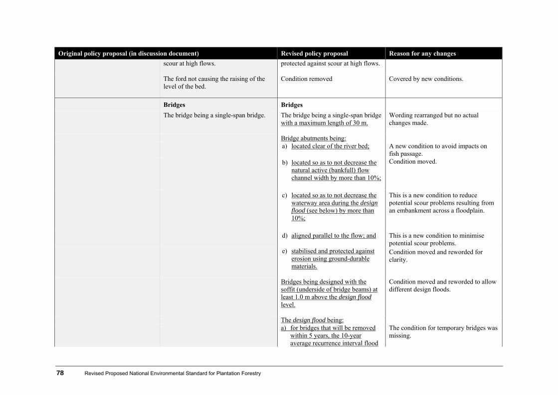
78 Revised Proposed National Environmental Standard for Plantation Forestry
Original policy proposal (in discussion document) Revised policy proposal Reason for any changes
scour at high flows.
protected against scour at high flows.
The ford not causing the raising of the level of the bed.
Condition removed Covered by new conditions.
Bridges Bridges
The bridge being a single-span bridge.
The bridge being a single-span bridge with a maximum length of 30 m.
Wording rearranged but no actual changes made.
Bridge abutments being: a) located clear of the river bed; A new condition to avoid impacts on
fish passage. b) located so as to not decrease the
natural active (bankfull) flow channel width by more than 10%;
Condition moved.
c) located so as to not decrease the waterway area during the design flood (see below) by more than 10%;
This is a new condition to reduce potential scour problems resulting from an embankment across a floodplain.
d) aligned parallel to the flow; and This is a new condition to minimise potential scour problems.
e) stabilised and protected against erosion using ground-durable materials.
Condition moved and reworded for clarity.
Bridges being designed with the soffit (underside of bridge beams) at least 1.0 m above the design flood level.
Condition moved and reworded to allow different design floods.
The design flood being: a) for bridges that will be removed
within 5 years, the 10-year average recurrence interval flood
The condition for temporary bridges was missing.
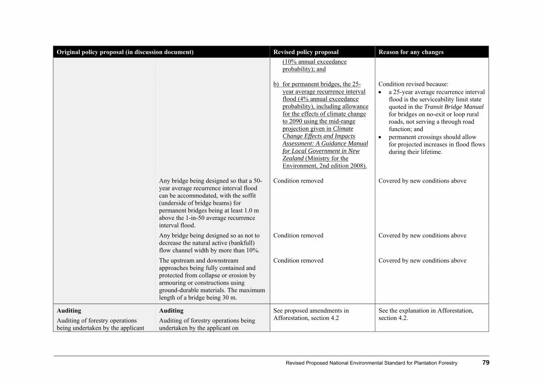
Revised Proposed National Environmental Standard for Plantation Forestry 79
Original policy proposal (in discussion document) Revised policy proposal Reason for any changes
(10% annual exceedance probability); and
b) for permanent bridges, the 25-
year average recurrence interval flood (4% annual exceedance probability), including allowance for the effects of climate change to 2090 using the mid-range projection given in Climate Change Effects and Impacts Assessment: A Guidance Manual for Local Government in New Zealand (Ministry for the Environment, 2nd edition 2008).
Condition revised because: a 25-year average recurrence interval
flood is the serviceability limit state quoted in the Transit Bridge Manual for bridges on no-exit or loop rural roads, not serving a through road function; and
permanent crossings should allow for projected increases in flood flows during their lifetime.
Any bridge being designed so that a 50-year average recurrence interval flood can be accommodated, with the soffit (underside of bridge beams) for permanent bridges being at least 1.0 m above the 1-in-50 average recurrence interval flood.
Condition removed Covered by new conditions above
Any bridge being designed so as not to decrease the natural active (bankfull) flow channel width by more than 10%.
Condition removed Covered by new conditions above
The upstream and downstream approaches being fully contained and protected from collapse or erosion by armouring or constructions using ground-durable materials. The maximum length of a bridge being 30 m.
Condition removed Covered by new conditions above
Auditing
Auditing of forestry operations being undertaken by the applicant
Auditing
Auditing of forestry operations being undertaken by the applicant on
See proposed amendments in Afforestation, section 4.2
See the explanation in Afforestation, section 4.2.
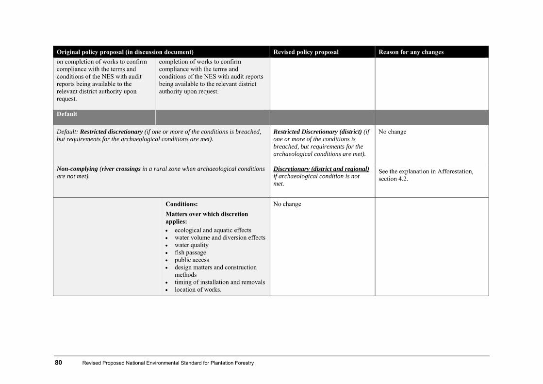
80 Revised Proposed National Environmental Standard for Plantation Forestry
Original policy proposal (in discussion document) Revised policy proposal Reason for any changes
on completion of works to confirm compliance with the terms and conditions of the NES with audit reports being available to the relevant district authority upon request.
completion of works to confirm compliance with the terms and conditions of the NES with audit reports being available to the relevant district authority upon request.
Default
Default: Restricted discretionary (if one or more of the conditions is breached, but requirements for the archaeological conditions are met).
Restricted Discretionary (district) (if one or more of the conditions is breached, but requirements for the archaeological conditions are met).
No change
Non-complying (river crossings in a rural zone when archaeological conditions are not met).
Discretionary (district and regional) if archaeological condition is not met.
See the explanation in Afforestation, section 4.2.
Conditions:
Matters over which discretion applies: ecological and aquatic effects water volume and diversion effects water quality fish passage public access design matters and construction
methods timing of installation and removals location of works.
No change

Revised Proposed National Environmental Standard for Plantation Forestry 81
Original policy proposal (in discussion document) Revised policy proposal Reason for any changes
Consent
Controlled activity(regional): River crossings for plantation forestry in earthflow country areas in yellow areas.
Restricted discretionary activity(regional): River crossings for plantation forestry in a orange or red area. Note there is a non-notification proviso for consents in orange areas.
Some working group members questioned whether it is appropriate to determine activity statuses for river crossing activities based on the erosion risk of the surrounding country.
Matters over which control and discretion applies: ecological and aquatic effects water volume and diversion
effects water quality fish passage public access design matters and construction
methods.
Limits of control and discretion was added for new rule requirement.
82 Revised Proposed National Environmental Standard for Plantation Forestry
5 What happens next?
5.1 Making comments A three-week comments period is provided to allow people who submitted on the first proposal and iwi authorities to provide comments on the revised proposal. During this period the Ministry will be holding three workshops to make presentations and answer questions about the revised policy in this booklet. Please include the following information with your comments:
1. your name and postal address, phone number, and email address (where applicable)
2. the title of the proposed standard you are making the comments about
3. whether you support or oppose the standard
4. your comments, with reasons for your views
5. any changes you would like made to the standard
6. the decision you wish the Minister for the Environment to make. You must forward your comments to the Ministry for the Environment, PO Box 10362, Wellington 6143, or by email to [email protected], in time to be received no later than 5.00 pm Monday 13 June 2011. Note: Your comments and any attached information (including your name, but excluding your contact details) may be published on the Ministry for the Environment website and may be required to be disclosed in response to any requests under the Official Information Act 1982.
5.2 What happens to comments? Once all comments have been compiled, they will be considered during the development of the final proposed standard, should this option be pursued. The Ministry will prepare a report with recommendations on the subject matter of the standard for the Minister for the Environment, including a section 32 (cost-benefit) analysis. If the Minister’s approval is given to continue developing the proposed standard, the final wording will be drafted and the proposed standard made into regulations.
5.3 Discussion questions Your comments may address any aspect of the proposed subject matter of the revised proposal. However, the Ministry for the Environment would also greatly appreciate it if you followed the template in appendix 6.

Revised Proposed National Environmental Standard for Plantation Forestry 83
Appendix 1
Calculating wilding spread risk from new plantingsa, b
(DSS 1. Version 05011)
(Select score applicable for each of the five categories)
1. SPECIES – GROWTH (score for one species only)
Spreading vigour varies with species
Redwoods, Leyland cypresses, cedars and spruces (very low risk – no need to proceed further)
0
Radiata (P. radiata) and ponderosa (P. ponderosa) pine, Lawsons cypress (C. lawsoniana) 1 Muricata (P. muricata) and maritime (P. pinaster) pine and larches (Larix spp) 2 Corsican (P. nigra) and mountain/dwarf mountain (P. uncinata/mugo) pine 3 Douglas-fir (Ps. menziesii), Scots pine (P. sylvestris) 4 Lodgepole/contorta pine (P. contorta) 5 Enter score (0, 1, 2, 3, 4 or 5) here
2. SPECIES – PALATABILITY
Palatability varies with species
Radiata, maritime and ponderosa pine 1 Lodgepole and muricata pine and European larch 2 Scots and mountain/dwarf mountain pine and Douglas-fir 3 Corsican pine 4
Enter score (0, 1, 2, 3 or 4) here
3. SITING OF NEW PLANTINGc, d
Trees are located on …
Sites well sheltered from prevalent and strong winds 0 Flat sites (< 100), partially exposed to strong/prevalent winds 1 Lee slopes where strong eddy gusts are likely 2 Flat sites (< 100), fully exposed to strong/prevalent winds 3 Either elevated ‘take-off’ sites (ridge-tops, or base of exposed slopes > 100)
or sloping land, fully exposed to strong/prevalent winds 4
Enter score (0, 1, 2, 3 or 4) here
4. DOWNWIND LAND USE – GRAZING
Wilding establishment influenced by grazing (particularly with sheep)
Intensive grazing on developed pasture 0d Regular mob stocking with sheepe 1d Semi-improved grazing (sheep/cattle) / occasional mob stocking with sheep 2d Extensive grazing onlye 3d No grazing 4d
Enter score (0, 1, 2, 3 or 4) here

84 Revised Proposed National Environmental Standard for Plantation Forestry
5. DOWNWIND VEGETATION COVER (if Douglas-fir involved, see g in Notes)
Wilding establishment influenced by competition from existing vegetation
Plantation forest and developed pasture (carrying intensive grazing) 0d
Native forest,h shrubland/tussock/grassland with a continuous and dense vegetation cover 1d
Forest/shrubland/tussock/grassland with few gaps 2d
Open forest and/or scattered patches of dense shrubland/tussock/grassland with many gaps 3d
Open slips/rockland and/or light, low-stature shrubland/tussock/grassland 4d
Enter score (0, 1, 2, 3 or 4) here
TOTAL SCORE
(See Assessment below for interpretation)
Assessment A score of 12 or more indicates a high risk of spread from the planted site. But, if a score of 0 is obtained in 1. SPECIES – GROWTH, or 4. DOWNWIND LAND USE – GRAZING, or 5. DOWNWIND VEGETATION COVER, the total score automatically becomes 0 (ie, there is no risk of wilding spread). Although, note the need to test long-distance spread risk from exposed sites (scoring 3 or 4 in 3. SITING OF NEW PLANTING). A high risk does not necessarily mean that trees should not be planted. A change of species, or siting or downwind land management can significantly lower spread risk. Alternatively, a commitment to wilding removal can be made: this may not be onerous, particularly for scattered trees (often outliers from distant spread).
Notes a Multiple calculations. As the above score sheet indicates, there is a range of factors
influencing the risk of spread. The impact of these will vary from site to site, both within a single forest and on the surrounding land. Therefore, spread risk will need to be calculated not just once, but a number of times to accommodate the range of sites represented within and outside the forest.
b Risk assessment location. This Decision Support System (DSS) was compiled primarily
for use in the drier hill and high country areas of the eastern South Island, where low-stature grasslands (and, to a lesser extent, shrublands) often dominate, and where opportunities for wilding establishment are greatest. Wilding spread risk is considerably less in the warmer, wetter parts of New Zealand (mostly present in the North Island), due to higher-stature vegetation covers being more vigorous and complete, and to poorer seed production in some species (such as Douglas-fir).
c Altitude. The coning ability of some species drops off quickly with increasing altitude.
Contorta and mountain pine will readily establish and cone above the native treeline. Scots pine and Douglas-fir will establish at the tree line. Corsican pine and Douglas-fir coning drops off quickly above 800 and 1100 m, respectively; the limit for Scots pine coning is unknown. Radiata pine is a reluctant spreader above 600−700 m, except on the warmer sites. The altitudinal establishment and coning limits for muricata pine and larch are unknown.

Revised Proposed National Environmental Standard for Plantation Forestry 85
d Long-distance spread. This is quite possible if a score of 3 or 4 is scored in ‘Siting’ (in 3), especially if Douglas-fir, larch or Corsican, contorta, mountain or Scots pines are involved (all have light seed, which is readily dispersed greater distances by wind). In these circumstances, the risk of spread relative to grazing (4) and vegetation cover (5) needs to be scored out to beyond the ‘fringe’ area, to a distance of 2 km. (‘Fringe’ implies a distance from seed source of 1–200 m.)
e Regular mob stocking. If the pasture is only semi-improved and the seed rain is heavy,
such as alongside mature conifers (particularly Corsican pine – the least palatable conifer), regular mob stocking may not prevent wilding establishment over the long term.
f Light grazing. This will reduce wilding establishment, but given enough time some
wildings will eventually grow to above browse height. The palatability of introduced conifers is (in decreasing order): radiata > ponderosa > contorta > larch > Scots pine > Douglas-fir > Corsican pine.
g Douglas-fir. This species is more shade tolerant than the other common conifers.
Therefore, it is more likely to invade under forest canopy gaps and within low-stature (< 2 m tall) shrublands.
h Native forests v. plantations of introduced trees. Man-made plantations are much more
likely to have a continuous canopy cover than are existing native forests, where disturbance and canopy gaps are a normal part of the natural succession cycle.
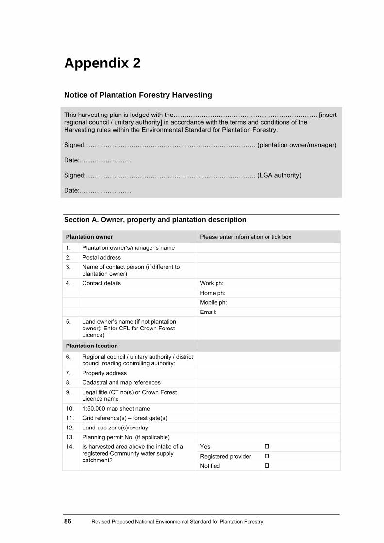
86 Revised Proposed National Environmental Standard for Plantation Forestry
Appendix 2
Notice of Plantation Forestry Harvesting
This harvesting plan is lodged with the…………………………………………………………. [insert regional council / unitary authority] in accordance with the terms and conditions of the Harvesting rules within the Environmental Standard for Plantation Forestry.
Signed:……………………………………………………………………. (plantation owner/manager)
Date:……………………
Signed:……………………………………………………………………. (LGA authority)
Date:……………………
Section A. Owner, property and plantation description
Plantation owner Please enter information or tick box
1. Plantation owner’s/manager’s name
2. Postal address
3. Name of contact person (if different to plantation owner)
4. Contact details Work ph:
Home ph:
Mobile ph:
Email:
5. Land owner’s name (if not plantation owner): Enter CFL for Crown Forest Licence)
Plantation location
6. Regional council / unitary authority / district council roading controlling authority:
7. Property address
8. Cadastral and map references
9. Legal title (CT no(s) or Crown Forest Licence name
10. 1:50,000 map sheet name
11. Grid reference(s) – forest gate(s)
12. Land-use zone(s)/overlay
13. Planning permit No. (if applicable)
14. Is harvested area above the intake of a registered Community water supply catchment?
Yes
Registered provider
Notified

Revised Proposed National Environmental Standard for Plantation Forestry 87
Section B: Permitted activity conditions applying to the harvesting activities
Section B1: Mapping of special values and slash storage sites
Plantation map (ideally 1:10,000 or 1:5,000 or with a maximum of 5m contours interval) Or attach as a separate page
Complete the legend below table to explain the map symbols used to represent special values
North
Forest boundary
Scale 1: when printed on A4 or A3 paper (Specify paper size)
Riparian planting setback zone (specify width)
Map source
Rivers/streams (show point where channel width exceeds 3m)
Geothermal and karst areas
Lakes
Significant natural areas
Wetlands
Significant fauna habitat
Coastal marine area
Slash storage sites
Indigenous vegetation
Slash traps
Other
Cable hauler (Yarder tower) setting and log haul or skid trail direction

88 Revised Proposed National Environmental Standard for Plantation Forestry
Section B2: Protection of special values
Management details (enter N/a for not applicable) Reference
Rivers/streams
Best Management Practices – Waterways Crossings 95%) of NZFOA ECoP 2007
Lakes
Wetlands
Coastal marine area
Indigenous vegetation
Principles for Commerical Plantation in New Zealand and the New Zealand Forest Accord
Geothermal and karst areas
Significant natural areas (SNAs)
Significant indigenous fauna (List any threatened or endangered native species known to be present, including the nesting season for vulnerable ground birds)
NZFA Rare Species guidance at http://rarespecies.nzfoa.org.nz
Historic sites Best Management Practices – Historical and Heritage Sites (s12) in NZFOA ECoP 2007
Other
Section B3: Management of logging slash
Management details Reference
Pre-harvest planning (Estimate of risk of slash mobilisation from slopes or slash deposition in stream)
Operational planning
Operational Planning Section 1 of NZFOA ECoP 2007
Measures to avoid slash reaching water bodies
Best Management Practices – Slash (s4) in NZFOA ECoP 2007
Slash removal procedure

Revised Proposed National Environmental Standard for Plantation Forestry 89
Management details Reference
Slash traps: (Design and maintenance procedure)
Measures to ensure landing stability
Best Management Practices – Operational Monitoring (s16) in NZFOA ECoP 2007
Other
Stakeholders consulted (Eg, regional councils, Department of Conservation, Fish & Game NZ, Historic Places Trust)
Section B4: Relevant permitted activity conditions
Conditions Please enter information below (or append)
Tick box to show compliance Reference
Notification (The regional council authority must be given at least 20 working days notice before commencement of operations)
Harvesting activities will commence on: .…../……/…………
Archaeological
Best Management Practices – Historical and Heritage Sites (s12) in NZFOA ECoP 2007
Fuel
Best Management Practices – Fuel and oil (s14) in NZFOA ECoP 2007
Ground disturbance
Best Management Practices – Harvesting (s14) in NZFOA ECoP 2007
Section C: Compliance with regional council guidance
Guidance Please enter information or tick box to demonstrate compliance
Title of guidance document
Any harvesting guidance prepared by the regional council / unitary authority compiled with.
……………………………………………………….
Section D: Authorisation Please enter information Plan prepared by Signature Date

90 Revised Proposed National Environmental Standard for Plantation Forestry
Appendix 3
Plantation Forestry Earthworks Plan
Notice of Plantation Forestry Earthworks
This earthworks plan is lodged with the…………………………………………………………. [insert regional council / unitary authority] in accordance with the terms and conditions of the Harvesting rules within the Environmental Standard for Plantation Forestry. Signed:……………………………………………………………………. (plantation owner/manager)
Date:……………………
Signed:……………………………………………………………………. (LGA authority) Date:……………………
Section A. Owner, property and plantation description
Plantation owner Please enter information or tick box
1. Plantation owner’s/manager’s name
2. Postal address
3. Name of contact person (if different to plantation owner)
4. Contact details Work ph:
Home ph:
Mobile ph:
Email:
5. Land owner’s name (if not plantation owner). Enter CFL for Crown Forest Licence)
Plantation location
6. Regional council / unitary authority / district council roading controlling authority
7. Property address
8. Cadastral and map references
9. Legal title (CT no(s) or Crown Forest Licence name
10. 1:50,000 map sheet name
11. Grid reference(s) – forest gate(s)
12. Land-use zone(s)/overlay
13. Planning permit No. (if applicable)
14. Is area where earthworks will be undertaken above the intake of a registered community water supply catchment?
Yes
Registered provider
Notified

Revised Proposed National Environmental Standard for Plantation Forestry 91
Section B: Permitted activity conditions applying to earthworks activities Section B1: Protection of special values
Management details (enter N/a for not applicable)
Reference
Rivers/streams
Best Management Practices – Waterways Crossings 95%) of NZFOA ECoP 2007
Lakes
Wetlands
Coastal marine area
Indigenous vegetation
Principles for Commerical Plantation in New Zealand and the New Zealand Forest Accord
Geothermal and karst areas
Significant natural areas (SNAs)
Significant indigenous fauna (List any threatened or endangered native species known to be present, including the nesting season for vulnerable ground birds)
NZFA Rare Species guidance at http://rarespecies.nzfoa.org.nz
Historic sites Best Management Practices – Historical and Heritage Sites (s12) in NZFOA ECoP 2007
Other
Section B2: Relevant permitted activity conditions
Conditions Please enter information below (or append)
Tick box to show compliance Reference
Notification (The regional council authority must be given at least 20 working days notice before commencement of operations)
Harvesting activities will commence on: .…../……/…………
Archaeological
Best Management Practices – Historical and Heritage Sites (s12) in NZFOA ECoP 2007
Fuel
Best Management Practices – Fuel and oil (s14) in NZFOA ECoP 2007

92 Revised Proposed National Environmental Standard for Plantation Forestry
Conditions Please enter information below (or append)
Tick box to show compliance Reference
Design matters
Best Management Practices – Earthworks (s2) in NZFOA ECoP 2007
Machine setback distances from perennial water bodies
Fill material
Stabilisation and containment
Sediment and stormwater control measures
NZFOA Forest Road Engineering Manual (in preparation 2011)
Section C: Compliance with regional council guidance
Guidance Please enter information or tick box to demonstrate compliance
Title of guidance document
Any earthworks guidance prepared by the regional council / unitary authority compiled with.
……………………………………………………….
Section D: Authorisation
Please enter information
Plan prepared by Signature Date

Revised Proposed National Environmental Standard for Plantation Forestry 93
Appendix 4
Plantation Forestry Activity Completion Statement
This plan is lodged with the…………………………………………………………. [insert local government authority] in accordance with the terms and conditions of the Environmental Standard for Plantation Forestry. Signed:……………………………………………………………………. (plantation owner/manager) Date:…………………… Signed:………………………..........……............……………………………………. (council officer) Date:……………………
Section A. Owner, property and plantation description
Plantation owner Please enter information or tick box
1. Plantation owner’s/manager’s name 2. Postal address 3. Name of contact person (if different to
plantation owner)
4. Contact details Work ph: Home ph: Mobile ph: Email: 5. Land owner’s name (if not plantation owner):
Enter CFL for Crown Forest Licence)
Plantation location 6. Regional council / unitary authority / district
council
7. Property address 8. Cadastral and map references 9. Legal title (CT no(s) or Crown Forest Licence
name
10. 1:50,000 Map sheet name 11. Grid reference(s) – forest gate(s) 12. Land-use zone(s)/overlay 13. Planning permit No. (if applicable)
Section B: Office use only (to be filled in by council officer) Conditions Detail Have all NES conditions in Section C below been complied with? Yes No
Is further enforcement action needed? Yes No
Date .…../……/…………
Name

94 Revised Proposed National Environmental Standard for Plantation Forestry
Section C1: Permitted activity conditions applying to afforestation, replanting, mechanical land preparation and harvesting activities Tick to confirm you have complied with NES conditions
Arc
hae
olo
gica
l
Pla
ntin
g se
tbac
ks
Fue
l
Mec
hani
cal l
an
d pr
epar
atio
n m
eth
ods
Mec
hani
cal l
an
d pr
epar
atio
n se
tbac
ks
Nes
ting
times
Com
men
cem
ent
ad
vice
Gro
und
dis
turb
ance
Rip
aria
n di
stur
banc
e
Sla
sh a
nd d
ebri
s m
ana
gem
ent
Afforestation
Comments
Replanting
Comments
Mechanical land preparation
Harvesting Comments

Revised Proposed National Environmental Standard for Plantation Forestry 95
Section C2: Permitted activity conditions applying to earthworks, quarrying and river crossings Tick to confirm you have complied with NES conditions
Arc
hae
olo
gica
l
Com
men
cem
ent
adv
ice
Fue
l
Set
back
s
Fill
mat
eria
l
Slo
pe
Sta
bilis
atio
n an
d co
ntai
nmen
t
Sed
imen
t an
d st
orm
wat
er
cont
rol m
eas
ures
Vol
ume
Res
tora
tion
Earthworks
Comments
Quarrying
Comments
Section C3: Permitted activity conditions applying to river crossings Tick to confirm you have complied with NES conditions
Ear
thw
orks
co
nditi
ons
com
plie
d w
ith (
Sec
tion
C2)
Com
men
cem
ent
adv
ice
Cat
chm
ent
Fue
l
Ero
sio
n/flo
odi
ng
Wat
er c
ours
e a
nd le
vels
Pub
lic a
cces
s
Con
stru
ctio
n m
etho
ds
Mai
nte
nanc
e
Con
tam
ina
nts
Fis
h pa
ssag
e
Cul
vert
s
For
ds
Brid
ges
River crossings
Comments

96 Revised Proposed National Environmental Standard for Plantation Forestry
Appendix 5
Setback scenarios There are two possible scenarios for replanting setbacks in the proposed NES. These options have been prepared in response to the issue of potential liabilities triggered under the Emissions Trading Scheme (ETS), as outlined in section 2.4. Which option is eventually adopted depends on whether or not a solution that promotes the sustainable management purpose of the RMA can be found that also helps manage issues raised by the ETS.
Scenario 1 This scenario involves adopting good practice setbacks and ignoring any liabilities triggered under the ETS. Scenario 1 is the preferred option and will be adopted if a solution is found to the ETS issue. This scenario is included in table 4 of this document under replanting.
Scenario 2 This scenario involves adopting setbacks that would not trigger any liabilities under the ETS. They are based on current Ministry of Agriculture and Forestry ETS mapping standards, which allow for either 15 m or 1 ha gaps in the canopy cover not to be mapped as deforestation. Deforestation liabilities arise where:
internal setbacks on pre-1990 forest land and post-1989 forest land registered in the ETS create a crown to crown spacing of greater than 15 metres, or
where there is any setback on the outer boundary of an area of pre-1990 forest land and post-1989 forest land registered in the ETS.
Scenario 2 will be adopted if no solution is found to the ETS issue provided it is able to meet the sustainable management purpose of the RMA. The good practice setbacks from scenario 1 have been incorporated where possible. The following setbacks will apply to pre-1990 forest land and post-1989 forest land registered in the ETS:
Rivers and streams
1 m minimum horizontal setback from the banks of a perennial stream with a channel width less than 1 m or if the planting is required for the purpose of erosion protection in earthflow country.*
5 m minimum horizontal setback from the banks of a permanently flowing river/stream with a channel width between 1 and 3 m.*
10 m minimum horizontal setback from the banks of a permanently flowing river/stream with a channel width between 5 and 10 m.
No setbacks for rivers or streams falling on the edge of pre-1990 forest land and post-1989 forest land registered in the ETS or for rivers greater than 30 m wide.
For all other permanently flowing rivers with a channel width greater than 10 m: the setbacks must be the maximum distance possible without creating a crown to crown spacing of greater than 15 m (or 30 m from planted stem butt to planted stem butt – as a tree crown is assumed to grow to 7.5 m from the trunk of each tree).
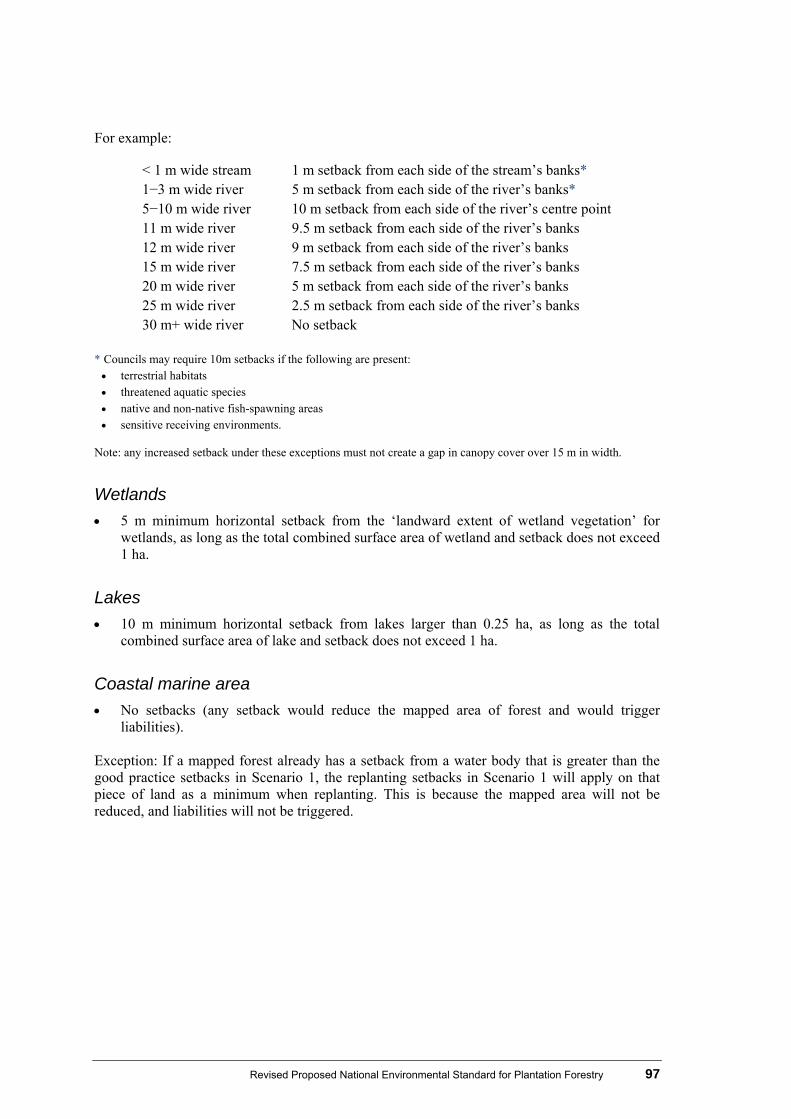
Revised Proposed National Environmental Standard for Plantation Forestry 97
For example:
< 1 m wide stream 1 m setback from each side of the stream’s banks* 1−3 m wide river 5 m setback from each side of the river’s banks* 5−10 m wide river 10 m setback from each side of the river’s centre point 11 m wide river 9.5 m setback from each side of the river’s banks 12 m wide river 9 m setback from each side of the river’s banks 15 m wide river 7.5 m setback from each side of the river’s banks 20 m wide river 5 m setback from each side of the river’s banks 25 m wide river 2.5 m setback from each side of the river’s banks 30 m+ wide river No setback
* Councils may require 10m setbacks if the following are present: terrestrial habitats threatened aquatic species native and non-native fish-spawning areas sensitive receiving environments.
Note: any increased setback under these exceptions must not create a gap in canopy cover over 15 m in width.
Wetlands
5 m minimum horizontal setback from the ‘landward extent of wetland vegetation’ for wetlands, as long as the total combined surface area of wetland and setback does not exceed 1 ha.
Lakes
10 m minimum horizontal setback from lakes larger than 0.25 ha, as long as the total combined surface area of lake and setback does not exceed 1 ha.
Coastal marine area
No setbacks (any setback would reduce the mapped area of forest and would trigger liabilities).
Exception: If a mapped forest already has a setback from a water body that is greater than the good practice setbacks in Scenario 1, the replanting setbacks in Scenario 1 will apply on that piece of land as a minimum when replanting. This is because the mapped area will not be reduced, and liabilities will not be triggered.

98 Revised Proposed National Environmental Standard for Plantation Forestry
Appendix 6
Template for comments on the proposed NES for Plantation Forestry If you wish to make a comment, please complete the following form and forward your comments to the Ministry for the Environment, PO Box 10362, Wellington 6143, or by email to [email protected], in time to be received no later than 5.00 pm on Monday 13 June 2011. This template is also available at www.mfe.govt.nz/laws/standards/forestry/index.html You do not need to remake points made in your original submission.
Name
Organisation/agency
Postal address
Phone number
Q1: Do you agree with the changes to the afforestation section? Yes No
Comment
Q2: Do you agree with the changes to the replanting section? Yes No
Comment

Revised Proposed National Environmental Standard for Plantation Forestry 99
Q3: Do you agree with the changes to the mechanical land preparation section?
Yes No
Comment
Q4: Do you agree with the changes to the harvesting section? Yes No
Comment
Q5: Do you agree with the changes to the pruning and thinning to waste section?
Yes No
Comment

100 Revised Proposed National Environmental Standard for Plantation Forestry
Q6: Do you agree with the changes to the earthworks section? Yes No
Comment
Q7: Do you agree with the changes to the quarrying section? Yes No
Comment
Q8: Do you agree with the changes to the river crossings section? Yes No
Comment

Revised Proposed National Environmental Standard for Plantation Forestry 101
Q9: Do you have comments on the detail of the ROAR system? Comment
Q10: Where the working group could not reach consensus, the areas in table 4 were highlighted blue. Do you have any comments about these issues?
Comment
102 Revised Proposed National Environmental Standard for Plantation Forestry
Abbreviations
ASM Audited self management CBA Cost benefit analysis DSS Decision support system ECO Environment and conservation organisations of Aotearoa New Zealand ECoP Environmental Code of Practice FENZ Fresh Water Ecosystems New Zealand MAF Ministry of Agriculture and Forestry NES National environmental standard NGOs Non-governmental organisation NIWA National Institute of Water and Atmospheric Research NPS National policy statement NZ ETS New Zealand Emissions Trading Scheme NZFOA New Zealand Forest Owner’s Association NZLRI New Zealand Land Resource Inventory RMA Resource Management Act 1991 ROAR Review of Authority Rules

Revised National Environmental Standard for Plantation Forestry 103
Glossary
Original policy proposal (in discussion document) Revised policy proposal Reason for any changes
Afforestation: new planting on land not previously planted in plantation forest.
No change
Aggregate: crushed rocks, gravel and sand, which is produced by quarries.
No change
Agrichemical: any substance, whether organic or inorganic, man-made or naturally occurring, modified or in its natural state, that is used to eradicate, modify or control flora or fauna.
any chemical substance, whether organic or inorganic, man-made or naturally occurring, modified or in its natural state, that is used to eradicate, modify or control flora or fauna.
Amended for clarification.
Annual exceedance probability (AEP):
the chance of a flood of a given size (or larger) occurring in any one year, usually expressed as a percentage. Note: NIWA’s flood discharge model, WRENZ (available at http://wrenz.niwa.co.nz), gives an estimate of the 1% AEP flood (in cubic metres per second) for designated rivers and streams in New Zealand.
No change
Archaeological site:
has the same meaning as in section 2 of the Historic Places Act 1993.
No change
Armouring: the placement of riprap, composed of large pieces of quarried angular rock material of sufficient mass, or the use of other rigid methods to resist scour in flood flows and/or to contain a stream in defined channels.
No change
104 Revised National Environmental Standard for Plantation Forestry
Original policy proposal (in discussion document) Revised policy proposal Reason for any changes
Average recurrence level (ARI):
the long-term average of the number of years between the occurrence of a flood as big as (or larger than) the specified event. For example, floods with a discharge as great as (or greater than) the 50-year ARI design flood will occur on average once every 50 years. ARI is another way of expressing the likelihood of the occurrence of a flood event.
No change
Battery culvert: a stream crossing structure using multiple culvert or box pipes to handle low flows through the pipes, and designed to allow major flows and debris to overtop the entire structure (also known as a vented ford).
No change
Best practicable option:
the best method for preventing or minimising adverse effects on the environment having regard, among other things, to:
(a) the nature of the option and the sensitivity of the receiving environment to adverse effects
(b) the financial implications, and the effects on the environment, of that option when compared with other options
(c) the current state of technical knowledge and the likelihood that the option can be successfully applied.
No change
Blading: use of a bulldozer, skidder or excavator with blade to remove logging slash and organic soil
Definition removed No reference within revised policy
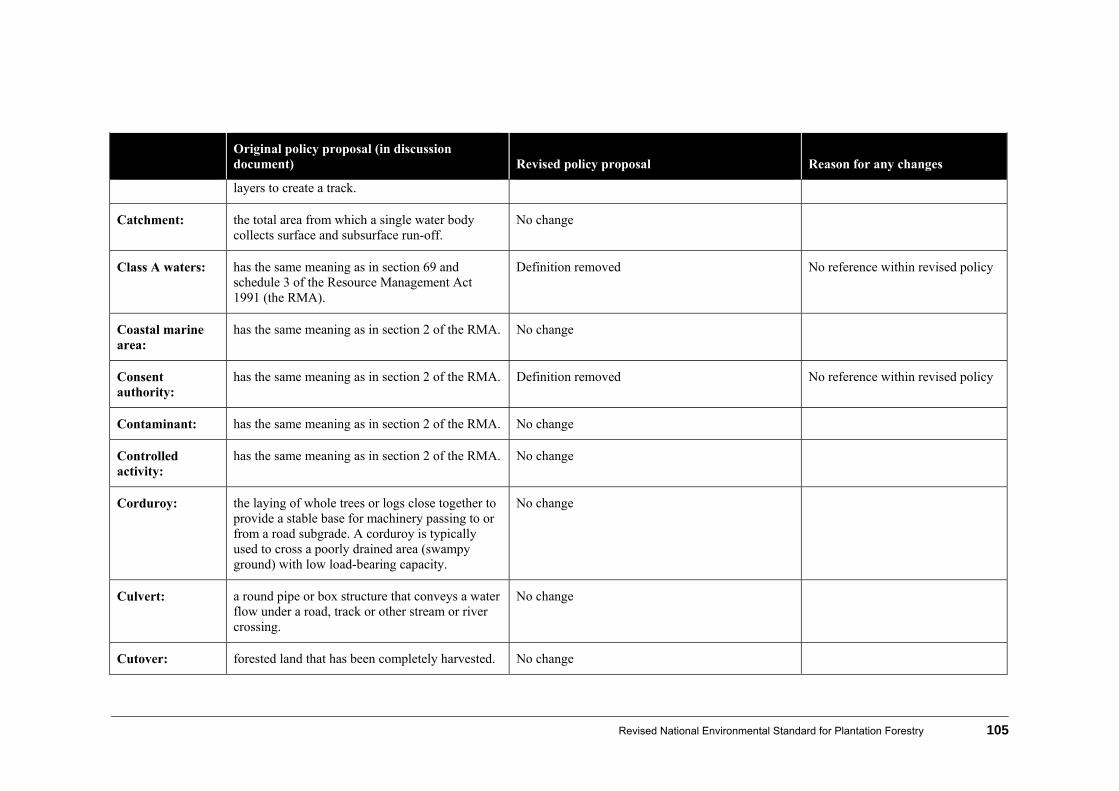
Revised National Environmental Standard for Plantation Forestry 105
Original policy proposal (in discussion document) Revised policy proposal Reason for any changes
layers to create a track.
Catchment: the total area from which a single water body collects surface and subsurface run-off.
No change
Class A waters: has the same meaning as in section 69 and schedule 3 of the Resource Management Act 1991 (the RMA).
Definition removed No reference within revised policy
Coastal marine area:
has the same meaning as in section 2 of the RMA. No change
Consent authority:
has the same meaning as in section 2 of the RMA. Definition removed No reference within revised policy
Contaminant: has the same meaning as in section 2 of the RMA. No change
Controlled activity:
has the same meaning as in section 2 of the RMA. No change
Corduroy: the laying of whole trees or logs close together to provide a stable base for machinery passing to or from a road subgrade. A corduroy is typically used to cross a poorly drained area (swampy ground) with low load-bearing capacity.
No change
Culvert: a round pipe or box structure that conveys a water flow under a road, track or other stream or river crossing.
No change
Cutover: forested land that has been completely harvested. No change

106 Revised National Environmental Standard for Plantation Forestry
Original policy proposal (in discussion document) Revised policy proposal Reason for any changes
Debris: the accumulation of remains, including vegetation and soil, from forestry operations.
No change
Diversion: the act of diverting For clarification of slash rules in 4.5.
Discretionary activity:
has the same meaning as in section 2 of the RMA. No change
Drift decks: a stream crossing structure composed of a series of inverted “U” shaped precast concrete elements, bearing a concrete slab that passes low flows through the structure, and designed to allow major flows and debris to overtop the entire structure.
Definition removed No reference within revised policy
Dwelling: any permanent structure that is occupied or intended to be occupied in whole or in part as a residence, and includes (but is not limited to) travellers’ accommodation.
No change
Earthflow: rapid flowing of soil and underlying weathered material on moderate slopes. Characterised by an overthrust bulging dome at the toe, a depressed, fissured and disrupted centre upslope, and slipping or slumping at the head. Transverse cracks at prominent, particularly in the upper region of the movement.
Term referred to in policy
Earthworks: the disturbance of the land surface by machinery, including blading (including V-blading), boring, contouring, drilling, moving, removing, placing or replacing soil or earth; or by excavating; or by
the disturbance of the land surface for the construction of roads, tracks and landings by machinery, including blading (including V-blading), boring, contouring, drilling, moving,
Amended to clarify what earthworks activities are applicable.

Revised National Environmental Standard for Plantation Forestry 107
Original policy proposal (in discussion document) Revised policy proposal Reason for any changes
a cutting or filling operation. It excludes tracking and associated soil disturbance due to the movement of wheeled or tracked machines used in or around cut-over areas at time of harvest.
removing, placing or replacing soil or earth; or by excavating; or by a cutting or filling operation. It excludes tracking and associated soil disturbance due to the movement of wheeled or tracked machines used in or around cut-over areas at time of harvest.
Ecological corridor:
a strip of vegetation which is important for connection corridors or habitats for animals and plants.
Definition removed No reference within revised policy
Edge damage: the damage to indigenous vegetation bordering plantation forestry.
No change
Erosion: the detachment and movement of topsoil by the action of wind and flowing water.
the processes of the wearing away of the land surface (including soil, regolith or bedrock) by natural agents and the transport of the derived material. Erosion includes erosion from natural causes, and erosion induced or accelerated by human activity.
New definition from Gisborne District Council district plan
Fill material: earth placed (normally under a strict compaction regime) to raise the land surface.
deposited material from earthworks (and quarrying) placed (normally under a strict compaction regime) to raise the land surface.
Amended for clarification
First schedule consultations:
as set out in Schedule 1 (3) of the RMA. Definition removed No reference within revised policy
Fish passage: the natural movement of fish between the sea and any river, including upstream or downstream in that river or stream.
No change

108 Revised National Environmental Standard for Plantation Forestry
Original policy proposal (in discussion document) Revised policy proposal Reason for any changes
Flood hazard areas:
zones mapped in regional or district plans that have the potential for damage to property or persons due to flooding.
No change
Ford: a natural shallow area in a water body able to be crossed by light 4WD vehicle or log truck (but not a log skidder extracting logs), or an artificially built-up bed designed to facilitate the crossing of a water body.
a structure within the bed of a river (that is permanently or frequently overtopped by water) that provides a hard surface designed to facilitate the crossing of a water body.
Definition amended for clarification and incorporates text from Waikato Regional Council’s regional plan
Forestry / plantation forestry:
a forest (native or exotic) deliberately established for commercial purposes.
Forestry / plantation forestry:
(a) means at least 1 hectare of forest cover of forest species that has been planted and has/or will be; harvested and/or replanted,
(b) including all associated internal infrastructure but
(c) not including:
(i) a shelter belt of forest species, where the tree crown cover has, or is likely to have, an average width of less than 30 metres; or
(ii) forest species in urban areas
(iii) nurseries and seed orchards
(iv) fruit and nut crops
See explanation for new definition in section 3.1
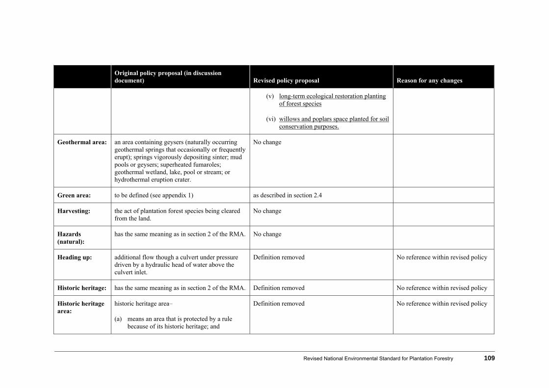
Revised National Environmental Standard for Plantation Forestry 109
Original policy proposal (in discussion document) Revised policy proposal Reason for any changes
(v) long-term ecological restoration planting of forest species
(vi) willows and poplars space planted for soil conservation purposes.
Geothermal area: an area containing geysers (naturally occurring geothermal springs that occasionally or frequently erupt); springs vigorously depositing sinter; mud pools or geysers; superheated fumaroles; geothermal wetland, lake, pool or stream; or hydrothermal eruption crater.
No change
Green area: to be defined (see appendix 1) as described in section 2.4
Harvesting: the act of plantation forest species being cleared from the land.
No change
Hazards (natural):
has the same meaning as in section 2 of the RMA. No change
Heading up: additional flow though a culvert under pressure driven by a hydraulic head of water above the culvert inlet.
Definition removed No reference within revised policy
Historic heritage: has the same meaning as in section 2 of the RMA. Definition removed No reference within revised policy
Historic heritage area:
historic heritage area–
(a) means an area that is protected by a rule because of its historic heritage; and
Definition removed No reference within revised policy

110 Revised National Environmental Standard for Plantation Forestry
Original policy proposal (in discussion document) Revised policy proposal Reason for any changes
(b) to avoid doubt, includes an area that is protected by a rule because it is a site of significance to Māori.
Indigenous vegetation:
vegetation that occurs naturally in New Zealand or that arrived in New Zealand without human assistance.
No change
Infrastructure: has the same meaning as in section 2 of the RMA. No change
Iwi: a set of people bound together by descent from a common ancestor or ancestors.
a set of people bound together of Māori descent from a common ancestor or ancestors.
Amended for clarification.
Iwi authority: has the same meaning as in section 2 of the RMA. No change
Karst protection area:
an area of limestone geology with underground streams and many cavities.
No change
Kyoto Protocol: an international agreement linked to the United Nations Framework Convention on Climate Change. The major feature of the Kyoto Protocol is that it sets binding targets for 37 industrialised countries and the European community for reducing greenhouse gas (GHG) emissions.
Definition from the United Framework Convention on Climate Change
Lake: has the same meaning as in section 2 of the RMA. No change
Landing: a log production and assembly area within a forest.
No change
Land-use described in appendix 1. Definition removed No reference within revised policy

Revised National Environmental Standard for Plantation Forestry 111
Original policy proposal (in discussion document) Revised policy proposal Reason for any changes
capability (LUC):
Local authority: has the same meaning as in section 2 of the RMA. No change
Log crossings: a stream crossing structure composed of a series of logs, often bound together by wire rope that passes low flows under the structure (also known as a skid bridge).
Definition removed No reference within revised policy
Mainstem rivers: the primary downstream segment of a river, as contrasted to its tributaries.
New reference within revised policy
Maintenance and upgrade of existing earthworks:
includes activities to upgrade existing earthworks (roadways and landings), minor reshaping of existing forest roads, clearing of water tables and installation of water controls and road metalling. Upgrade does not include road widening.
includes activities to maintain existing earthworks (roadways and landings), minor reshaping of existing forest roads, clearing of water tables and installation of water controls and road metalling. Upgrade does not include road widening.
Mechanical land
preparation:
root raking, discing, mounding and spot mounding, contour and downhill ripping, roller crushing and other cultivation of land and associated removal of vegetation. V-blading involving disturbance of subsoil will be considered under earthwork rules.
Note: mechanical land preparation is not included in the definition of earthworks.
discing, mounding and spot mounding, contour and downhill ripping and roller crushing (without tracking) and other cultivation of land and associated removal of vegetation. V-blading involving disturbance of subsoil will be considered under earthwork rules.
Note: mechanical land preparation is not included in the definition of earthworks.
Amended to exclude tracking
Mechanical raking:
the process of making a windrow of slash. It generally involves a rake on an excavator boom, or a root rake on a bulldozer but not lowered into the subsoil.
Definition removed No reference within revised policy

112 Revised National Environmental Standard for Plantation Forestry
Original policy proposal (in discussion document) Revised policy proposal Reason for any changes
Mounding: a term to encompass a variety of site preparation treatments involving mechanical disturbance of soil or sub soil.
Definition removed
Natural character:
those qualities and values of wetlands, lakes and rivers and their margins which derive from the presence of natural features and natural processes. Although not excluding structures and human activities, areas of natural character derive their predominant influence, character or identity from the presence of natural values and processes.
Definition removed
New Zealand Land Resources Inventory (NZLRI):
a spatial database containing land information (described in Appendix 1).
No change
Non-complying activity:
has the same meaning as in section 2 of the RMA. No change
Orange area: to be defined (see Appendix 1) as described in section 2.4
Outstanding natural features and landscapes:
features that are considered as being of national or regional significance, including land forms, geological features, natural character and view shafts.
natural landscapes and features that are considered as being of national or regional significance, importance, as provided by s6(b) of the RMA. including land forms, geological features, natural character and view shafts.
Amended to link with the RMA
Perennial river or stream:
a stream that maintains water in its channel throughout the year, or maintains a series of discrete pools that provide habitats for the continuation of the aquatic ecosystem.
No change

Revised National Environmental Standard for Plantation Forestry 113
Original policy proposal (in discussion document) Revised policy proposal Reason for any changes
Permitted activity:
has the same meaning as in section 2 of the RMA. No change
Production thinning:
thinning tree stems for sale. thinning of tree stems and extraction for sale. Amended for clarification
Pruning: removal of branches from the lower section (up to 8 m) of a tree to produce high-quality clear-wood logs.
removal of branches from the lower section (up to 8 m) of a tree to produce high-quality clear-wood logs.
Amended to remove height limit
Public access: unobstructed admission to space that is available for public use.
No change
Quarry: area where hard rock or cemented gravel is extracted for processing and storage, which includes areas where associated activities, such as vehicle movement, transfer of rock for processing occur, stockpiling of aggregate and loading of products to transport trucks.
No change
Red area: to be defined (see Appendix 1). As described in section 2.4
Regional council: a regional council named in Part 1 of Schedule 2 of the Local Government Act 2002.
No change
Regionally significant:
Includes one or more of the following:
is rare or unique within the region; or is found only in the region, or
contributes to the unique character of the region,
New definition from Southland Regional Council’s Regional Policy Statement
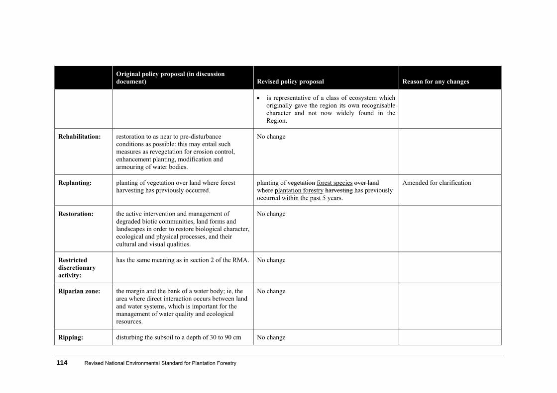
114 Revised National Environmental Standard for Plantation Forestry
Original policy proposal (in discussion document) Revised policy proposal Reason for any changes
is representative of a class of ecosystem which originally gave the region its own recognisable character and not now widely found in the Region.
Rehabilitation: restoration to as near to pre-disturbance conditions as possible: this may entail such measures as revegetation for erosion control, enhancement planting, modification and armouring of water bodies.
No change
Replanting: planting of vegetation over land where forest harvesting has previously occurred.
planting of vegetation forest species over land where plantation forestry harvesting has previously occurred within the past 5 years.
Amended for clarification
Restoration: the active intervention and management of degraded biotic communities, land forms and landscapes in order to restore biological character, ecological and physical processes, and their cultural and visual qualities.
No change
Restricted discretionary activity:
has the same meaning as in section 2 of the RMA. No change
Riparian zone: the margin and the bank of a water body; ie, the area where direct interaction occurs between land and water systems, which is important for the management of water quality and ecological resources.
No change
Ripping: disturbing the subsoil to a depth of 30 to 90 cm No change

Revised National Environmental Standard for Plantation Forestry 115
Original policy proposal (in discussion document) Revised policy proposal Reason for any changes
with a single or double tine or (winged) ripper mounted on an agricultural tractor or bulldozer in order to break up highly compacted soil or a subsurface soil pan prior to planting, to improve drainage and tree-root penetration.
River: has the same meaning as in section 2 of the RMA. No change
River crossings: temporary or permanent culverts, battery culverts (also known as vented fords or dry fords overtopped during floods) and bridges.
No change
Road: has the same meaning as in section 2 of the RMA. No change
Roading: earthworks of 3 m or more in width carried out in order to form, construct or reconstruct a road or formed track, but excluding normal maintenance operations (grading, re-metalling, water table clean-outs).
Definition removed No reference within revised policy
Roller crushing: a large roller weighing several tonnes released down a slope from a ridge or track, crushing and breaking up vegetation in its path: on flatter terrain rollers can be towed by a bulldozer or tractor.
No change
Rural zone: land that a relevant operative or proposed district or regional plan classifies as being primarily for rural activities.
Definition removed No reference within revised policy
Sediment: solid material, both mineral and organic, that is in suspension, is being transported, or has been moved from site of origin by air, water, gravity or
No change

116 Revised National Environmental Standard for Plantation Forestry
Original policy proposal (in discussion document) Revised policy proposal Reason for any changes
ice and has come to rest on the earth’s surface, either above or below water.
Sediment control measures:
measures designed to capture sediment that has been eroded and entrained in overland flow before it enters the receiving environment.
No change
Sediment discharge concentration:
the concentration of suspended sediment in a water body.
No change
Setback: the measured distance from a feature that creates a buffer within which activities cannot take place.
No change
Shelter belt: a row or rows of trees or hedges planted to partially block wind flow, primarily on cultivated land.
New definition taken from Gisborne District Council’s District Plan
Significant natural areas:
areas with significant indigenous vegetation and significant habitats of indigenous fauna, as outlined in section 6(c) of the RMA.
No change
Skid site: an area of land in the forest, often specially prepared and surfaced, where logs or tree lengths extracted from the forest are accumulated, processed and loaded onto trucks for removal. Also referred to as a landing.
Definition removed No reference within revised policy
Slash: branches, tops, chunks, cull logs, uprooted stumps, slovens, broken trees and other waste wood left behind after harvesting.
No change

Revised National Environmental Standard for Plantation Forestry 117
Original policy proposal (in discussion document) Revised policy proposal Reason for any changes
Slash and debris traps:
traps set in water bodies to trap slash and debris from forestry operations.
No change
Soffit: the underside of a bridge. No change
Soil disturbance: the disturbance of the ground surface by harvesting activities such as dragging logs, but excluding earthworks.
No change
Spoil: the by-product of excavations and earthworks (soil or rock).
No change
Stabilisation: providing adequate measures, vegetative and/or structural, that will protect exposed soil to minimise erosion.
No change
Stream: see River. No change
Subsoil: the layer of soil below a depth of 25cm. Added for clarification as mechanical land preparation now splits into topsoil and subsoil.
Suspended solids: small solid particles that remain in suspension in water.
No change
Territorial authority:
a city council or district council named in Part 2 of Schedule 2 of the Local Government Act.
No change
Thinning: selective removal of trees within a stand to achieve an optimal stocking rate for the final crop. Production thinning involves the removal of the thinned trees for sale. Thin-to-waste
No change
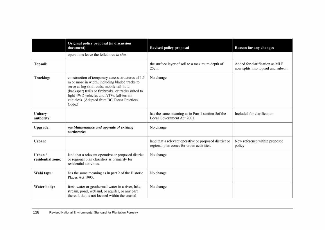
118 Revised National Environmental Standard for Plantation Forestry
Original policy proposal (in discussion document) Revised policy proposal Reason for any changes
operations leave the felled tree in situ.
Topsoil: the surface layer of soil to a maximum depth of 25cm.
Added for clarification as MLP now splits into topsoil and subsoil.
Tracking: construction of temporary access structures of 1.5 m or more in width, including bladed tracks to serve as log skid roads, mobile tail-hold (backspar) trails or firebreaks, or tracks suited to light 4WD vehicles and ATVs (all-terrain vehicles). (Adapted from BC Forest Practices Code.)
No change
Unitary authority:
has the same meaning as in Part 1 section 5of the Local Government Act 2001.
Included for clarification
Upgrade: see Maintenance and upgrade of existing earthworks.
No change
Urban: land that a relevant operative or proposed district or regional plan zones for urban activities.
New reference within proposed policy
Urban / residential zone:
land that a relevant operative or proposed district or regional plan classifies as primarily for residential activities.
No change
Wāhi tapu: has the same meaning as in part 2 of the Historic Places Act 1993.
No change
Water body: fresh water or geothermal water in a river, lake, stream, pond, wetland, or aquifer, or any part thereof, that is not located within the coastal
No change

Revised National Environmental Standard for Plantation Forestry 119
Original policy proposal (in discussion document) Revised policy proposal Reason for any changes
marine area.
Water yield: the amount of water run-off coming out of a catchment over a specific period of time.
Definition removed No reference within revised policy
Wetland: has the same meaning as in section 2 of the RMA. No change
Wilding trees: the natural regeneration or seedling spread of exotic trees, occurring in areas not managed for forest production.
No change
Windrowing: slash from forest harvesting which is mechanically piled into rows.
Definition removed No reference within revised policy
Woodlots: small plot of plantation forest, commonly on farms.
small plot of plantation forest, frequently on farms. Amended for clarification
Yellow area: as described in section 2.4 New erosion susceptibility mapping colour.