proposed loan and administration of loan pt. jawa satu power … · 2018-06-27 · the business of...
TRANSCRIPT

Resettlement Plan
Project No. 51112-001 June 2018
Proposed Loan and Administration of Loan PT. Jawa Satu
Power and PT. Jawa Satu Regas Jawa-1 LNG-to-Power
Project (Indonesia)
Prepared by PT ERM Indonesia for PT Jawa Satu Power
The Resettlement Plan is a document of the borrower. The views expressed herein do not necessarily represent
those of ADB’s Board of Directors, Management or staff, and may be preliminary in nature.
In preparing any country program or strategy, financing any project, or by making any designation of or reference to a
particular territory or geographic area in this document, the Asian Development Bank does not intend to make any
judgments as to the legal or other status of any territory or area.
The business of sustainability
PLTGU Jawa 1 Independent Power
Project
Resettlement Plan
Prepared for:
PT Jawa Satu Power (JSP)
26 June 2018
www.erm.com

ENVIRONMENTAL RESOURCES MANAGEMENT PT JAWA SATU POWER
RESETTLEMENT PLAN
EXECUTIVE SUMMARY
Overview of Project
The PLTGU Jawa-1 Project (the Project) involves the development of a Combined
Cycle Gas Turbine (CCGT) Power Plant, a Liquefied Natural Gas (LNG) Floating
Storage and Regasification Unit (FSRU) and a 500kV power transmission line and
Substation. These project elements will be developed within the Subang, Karawang
and Bekasi Regencies of West Java, Indonesia.
The Government of Indonesia has set the target to build 35,000 Megawatt (MW) of
electricity by 2019 to achieve a 100% electrification rate by 2024. Out of that amount,
19,400 MW will be utilized to supply electricity in Java Island. The Indonesian
electricity business is largely conducted by the State and carried out by the State
owned enterprise (PT PLN). However, operative, private sector and local enterprises
have an opportunity to participate in the electricity business as Independent Power
Producers (IPPs). As such, PT Pertamina (Persero), Sojitz Corporation and Marubeni
Corporation (together, the “Sponsors”) have concluded an agreement to develop this
IPP Project via the project company named PT. Jawa Satu Power (JSP). The aim is to
commence construction of this 1,760 MW Project by late 2018, anticipating operations
in 2021. The Project includes the following main components:
• Installation and operation of an FSRU;
• Construction and operation of seawater intake and seawater discharge
pipelines;
• Construction and operation of an onshore gas receiving facility (ORF);
• Construction and operation of a jetty;
• Gas supply pipelines, both subsea and terrestrial;
• 1,760 MW CCGT power plant and associated facilities;
• A 52 km 500 kV transmission line; and
• An electricity substation in Karangraharja Village, Bekasi.
The LNG is expected to be supplied mainly from BP’s Tangguh project in West Papua
and delivered via LNG carriers. The FSRU will store and regassify the LNG, prior to
delivery to an ORF located adjacent to the CCGT Power Plant. Following gas
treatment within the ORF, the gas will be piped to the CCGT Power Plant with
electricity dispatched to the transmission line and substation.
Scope of the Resettlement Impacts
The total area required for the development of the Project is approximately 2,684,969
m2. This includes not only lands procured from individual private owners and private
entities, but land leased from government owned private entities and land
compensated for due to restrictions on use or access. The land acquired for the Project
is 762,671 m2, leased lands total 180,000 m2 and land with restrictions due to the
transmission line construction of 1,742,298 m2.

ENVIRONMENTAL RESOURCES MANAGEMENT PT JAWA SATU POWER
RESETTLEMENT PLAN
No physical displacement is anticipated due to the above land acquisition activities
however, economic displacement will occur, primarily due to the loss of paddy fields
and fishponds. In total, 132 landowners and 27 land users will be impacted by the
land required for the tower footings, substation and coastal area project components.
While there are approximately 724 private landowners, 3 government entities
(Perusahaan Umum Jasa Tirta, Binamarga, and Village Authorities), and also one
private entity (Pertamina) who will receive compensation for lands, building, and
trees within the transmission line Right of Way.
The vulnerability profile of the above impacted peoples was evaluated based on the
following criterion:
• Households with an income below the poverty line;
• The landless or those without legal title to land;
• The elderly (older than 65 years old assumed to be an unproductive group) as
the head of household;
• Female-headed households; and
• Indigenous people and ethnic minorities.
Based on these categories, the total number of the vulnerable people affected by the
land acquisition is 71 people (20 households). As such the Project is expected to
support these households by establishing sustainable effective livelihood restoration
activities; for example implemented via Livelihood Restoration Plan (LRP).
Policy Framework
The RP was prepared in accordance with laws, regulations and policies related to land
acquisition of the Indonesia National Policy on Land Acquisition as well as the
Involuntary Resettlement of Safeguard Policy Statement of ADB (SPS 2009), Japan
Bank for International Cooperation (JBIC) and International Finance Corporation
(IFC). Acquisition of land for the transmission line tower footings, substation, access
road, pipeline right of way and jetty will be through negotiated via a willing seller-
willing buyer basis. Imposition of land use/access restriction for the land owners
under the transmission line right of way will be conducted through negotiated
settlement where the land owners will not have the right to refuse such restrictions.
Compensation Standard
Compensation for the acquired lands from individual private owners agreed based
on the willing buyer willing seller principle. The price negotiation considered the
object taxable value (NJOP), current market price, and land owners’
expectation/value of his/her land. The compensation for the transmission line right
of way will be calculated based on the market rate approved by an independent
appraiser adhering the Regulation of Ministry of Energy and Mineral Resources Indonesia
(MoMR) Number 38/2013.

ENVIRONMENTAL RESOURCES MANAGEMENT PT JAWA SATU POWER
RESETTLEMENT PLAN
Public Consultation and Grievance Redress Mechanism
The land acquisition team has started the consultation in May 2017 by approaching
the village heads of the impacted area. Consultation to the land owners of the tower
footings and substation was conducted directly typically involving village authorities.
For the transmission line RoW land use restrictions, two rounds of public
consultations with the landowners have been undertaken in each village within the
project component area to disclose the project plan and compensation mechanism.
A grievance mechanism has been established to receive, investigate and respond to
stakeholder including land owners complaints. In relation to the land acquisition
process, typically grievances are submitted through phone calls to land acquisition
team and resolved immediately.
The Project has already disclosed the mechanism during consultations with the
landowners and is logging all current grievances.
Implementation
The land acquisition process for the transmission line tower and substation has been
underway since May 2017 and will continue until July 2018 when all compensation is
expected to be completed with the transfer of all deeds finalized. Compensation of the
transmission line RoW has been disbursed approximately to 80% of the impacted
person and expected to complete by July 2018. Meanwhile, the land acquisition in the
coastal area is expected to be completed by September 2018.
Livelihood Restoration
A total of 20 households have been identified as vulnerable and as such eligible for
livelihood restoration support from the Project. These households will be offered
support in the form of Project employment during construction upon, procurement
of goods and services form female headed households during construction,
implementation of a scholarship program/vocation training activities and support in
terms of small scale agriculture. The activities will be implemented over a period of
three years during construction and will be monitored and reported on bi annually to
ensure program sustainability and restoration of livelihoods.
Resettlement Budget
An estimated budget of IDR 426,300 million has been allocated for procurement of
land through the negotiated settlements. The budget includes: (i) detailed costs of
land acquisition, (ii) source of funding, (iii) administrative cost, including staff
training, (iv) monitoring cost, and (v) arrangement costs for approval and
responsibilities, the flow of funds and contingency arrangements. JSP will ensure
timely fund’s disbursement and will prepare all the necessary plans.
Monitoring and Evaluation
Based on good practice and the lender’s standards internal monitoring will be
undertaken by JSP throughout the land acquisition process. Monitoring will be used
to assess progress and change, at least every six months during construction. It will

ENVIRONMENTAL RESOURCES MANAGEMENT PT JAWA SATU POWER
RESETTLEMENT PLAN
be linked to the various stages of the implementation of this plan. The internal
monitoring report of the implementation of the land acquisition process will be
included in Project progress reports and updated based on requirements from the
lenders.

ENVIRONMENTAL RESOURCES MANAGEMENT PT JAWA SATU POWER
RESETTLEMENT PLAN
i
TABLE OF CONTENTS
1 INTRODUCTION .................................................................................................. 1-1
1.1 PROJECT OVERVIEW....................................................................................... 1-1
1.2 STRUCTURE OF THIS RESETTLEMENT PLAN (RP) ....................................... 1-4
2 PROJECT DESCRIPTION .................................................................................... 2-1
2.1 PROJECT LOCATION ....................................................................................... 2-1
2.2 PROJECT COMPONENTS ................................................................................. 2-1
2.3 ALTERNATIVES CONSIDERED ....................................................................... 2-3
3 SCOPE OF THE LAND ACQUISITION AND RESETTLEMENT ............... 3-1
3.1 REQUIRED LAND FOR THE PROJECT ............................................................. 3-1
3.2 POTENTIAL IMPACTS RESULTING FROM THE LAND ACQUISITION ........... 3-3
3.2.1 CCGT Power Plant ........................................................................ 3-3
3.2.2 500 KV Transmission Line and Cib atu Baru II/Suk atani Sub station ....................................................................................... 3-3
3.2.3 500 KV Transmission Line Right o f Way (Clearance Zone) . 3-4
3.2.4 Onshore Pipe line , Access Road , and Je tty Area ...................... 3-5
4 RESETTLEMENT POLICY FRAMEWORK AND ENTITLEMENTS .......... 4-1
4.1 NATIONAL REG ULATIONS ............................................................................. 4-1
4.2 INTERNATIONAL APPLICABLE STANDARDS ................................................ 4-2
4.2.1 Asian Deve lopment Bank (ADB) ............................................... 4-2
4.2.2 Japan Bank for Inte rnational Cooperation (JBIC) .................. 4-4
4.2.3 Inte rnational Finance Corporation (IFC) .................................. 4-5
4.3 GAP ANALYSIS OF NATIONAL AND INTERNATIONAL REQUIREMENTS .. 4-7
4.4 PROJECT RESETTLEMENT POLICY ............................................................... 4-11
4.4.1 General Pro ject Resettlement Po licy ....................................... 4-11
4.4.2 Proje ct Resettlement Policy for Tower Footings and Sub station ..................................................................................... 4-12
4.4.3 Proje ct Resettlement Policy for Transmission Line ROW (Clearance Zone) .......................................................................... 4-15
4.4.4 Proje ct Resettlement Policy for Coastal Area ........................ 4-18
4.4.5 Proje ct Resettlement Policy for CCGT Power Plant ............. 4-18
4.5 ENTITLEMENT MATRIX ................................................................................ 4-19
4.6 CUT-OFF DATE ............................................................................................. 4-22
5 INFORMATION DISCLOSURE, CONSULTATION AND PARTICIPATION ................................................................................................... 5-1
5.1 APPLICABLE STANDARDS AND REQUIREMENTS RELATED TO
INFORMATION DISCLOSURE, CONSULTATION, AND PARTICIPATION. ... 5-1
5.2 THE PROJECT’S COMMITMENT RELATED TO INFORMATION DISCLOSURE, CONSULTATION, AND PARTICIPATION. ...................................................... 5-1
ENVIRONMENTAL RESOURCES MANAGEMENT PT JAWA SATU POWER
RESETTLEMENT PLAN
ii
6 GRIEVANCE REDRESS MECHANISM ........................................................... 6-1
7 SOCIO-ECONOMIC INFORMATION ............................................................. 7-1
7.1 CENSUS METHODOLOGY .............................................................................. 7-1
7.2 DEMOG RAPHIC PROFILE ............................................................................... 7-2
7.3 ECONOMIC PROFILE ....................................................................................... 7-6
7.4 COMMUNITY HEALTH PROFILE .................................................................... 7-8
7.5 VULNERABILITY PROFILE .............................................................................. 7-9
8 IMPLEMENTATION OF THE PROJECT RESETTLEMENT POLICY ........ 8-1
8.1 TOWER FOOTINGS AND SUBSTATION ......................................................... 8-1
8.2 TRANSMISSION LINE RIGHT OF WAY (CLEARANCE ZONE)....................... 8-3
8.3 COASTAL AREA .............................................................................................. 8-6
8.4 CCGT POWER PLANT .................................................................................... 8-7
8.5 EXTENT AND IMPACT OF DISPLACEMENT ................................................... 8-8
9 LIVELIHOOD RESTORATION .......................................................................... 9-1
9.1 LIVELIHOOD RESTORATION STRATEGY ....................................................... 9-1
9.2 PROPOSED LIVELIHOOD RESTORATION PROGRAMS ................................ 9-2
10 LAND ACQUISITION BUDGET AND IMPLEMENTATION SCHEDULE .................................................................................................................................. 10-1
10.1 LAND ACQUISITION BUDGET ..................................................................... 10-1
10.2 IMPLEMENTATION SCHEDULE .................................................................... 10-2
11 MONITORING AND REPORTING OF THE RP .......................................... 11-1
11.1 INTERNAL MONITORING ............................................................................ 11-1
Reporting...................................................................................................... 11-1
11.2 EXTERNAL MONITORING ............................................................................ 11-2
Resettlement Completion Audit .............................................................. 11-2
12 INSTITUTIONAL ARRANGEMENTS ............................................................ 12-1
ANNEXES

ENVIRONMENTAL RESOURCES MANAGEMENT PT JAWA SATU POWER
RESETTLEMENT PLAN
iii
LIST OF TABLES
Table 3-1 Required Land for the Project (approximate) .............................................. 3-2
Table 3-2 Tower Type and Required Land for Transmission Line ............................. 3-3
Table 3-3 Minimum Vertical Clearance Distance from Transmission Line ............... 3-4
Table 3-4 Potential Impact from the Land Acquisition ............................................... 3-6
Table 4-1 Applicable IFC Compensation Framework Requirements .......................... 4-6
Table 4-2 Lenders and Government of Indonesia Standards Comparison .................. 4-8
Table 4-3 The Project’s Entitlement Matrix ............................................................. 4-19
Table 4-4 Cut Off Dates ............................................................................................ 4-22
Table 5-1 National Regulation Framework for Stakeholder Consultation and
Information Disclosure ............................................................................... 5-3
Table 6-1 Keys Steps in the Grievance Mechanism Process ....................................... 6-2
Table 7-1 Village Impacts by the Transmission Line and Sub station ....................... 7-2
Table 7-2 Landowners and Land Users by Gender ..................................................... 7-3
Table 7-3 Landowners and Land Users Age Group .................................................... 7-4
Table 7-4 Landowners and Land Users Religion Group ............................................. 7-4
Table 7-5 Landowners and Land Users Ethnic Groups .............................................. 7-5
Table 7-6 Landowners and Land Users Family Number ............................................ 7-5
Table 7-7 Landowners and Land Users Residential Duration .................................... 7-5
Table 7-8 Landowners and Land users Livelihood Sources ........................................ 7-6
Table 7-9 Landowners and Land users Income Group ............................................... 7-7
Table 7-10 Landowners and Land users Education Level ............................................. 7-7
Table 7-11 Disease Information in Karawang District ................................................. 7-8
Table 7-12 Disease Information in Bekasi District ....................................................... 7-8
Table 7-13 Identified Impacted Elderly People ............................................................ 7-10
Table 7-14 List of Identified Impacted Female-Headed Household ............................. 7-11
Table 8-1 Land Acquisition for the Coastal Area ........................................................ 8-6
Table 9-1 Proposed LRP Activities ............................................................................. 9-2
Table 10-1 Tentative Land Acquisition Budget and Financing .................................. 10-1
Table 10-2 Estimated Implementation for Land Acquisition ...................................... 10-3
Table 11-1 Suggested Monitoring Indicators of the Project ....................................... 11-2
Table 12-1 Responsible Institutions for Delivery of Entitlements .............................. 12-1

ENVIRONMENTAL RESOURCES MANAGEMENT PT JAWA SATU POWER
RESETTLEMENT PLAN
iv
LIST OF FIGURES
Figure 1-1 Project Overview ......................................................................................... 1-2
Figure 4-1 Land Acquisition Process for the Tower Footings and Substation .......... 4-14
Figure 4-2 Land Acquisition Steps for Transmission Line RoW................................ 4-17
Figure 6-1 The Project’s Grievance Tracking Redress Mechanism .............................. 6-1
Figure 12-1 Organization Structure for Implementing the Land Acquisition &
Resettlement Activities ............................................................................. 12-3

ENVIRONMENTAL RESOURCES MANAGEMENT PT JAWA SATU POWER
RESETTLEMENT PLAN
v
LIST OF ANNEXES
Annex 1 : Detail Comparison of the NJOP, Market Price, and the Received Compensation by the Land Owners of the TF and Substation
Annex 2: Detail Land And Other Objects Under The Clearance Zone.
Annex 3a: Land Acquisition Consultation Records for Tower Footings and Substation
Annex 3b: Land Acquisition Consultation Records for Transmission Line RoW
Annex 4: Detail Re-Route Of Tower Footings
Annex 5: Breakdown of the Size of the Acquired Land and the Remaining Land Holdings per Land Owner
Annex 6: Grievance Log Related To LAQ in TL RoW
Annex 7: Example of Memorandum of Understanding between Pertagas and Land Users
Annex 8a: Material of Row Socialization 1
Annex 8b: Material of Row Socialization 2
Annex 9: Market Price of Land under the TL RoW by Independent Appraiser

ENVIRONMENTAL RESOURCES MANAGEMENT PT JAWA SATU POWER
RESETTLEMENT PLAN
vi
LIST OF ABBREVIATIONS
ADB Asian Development Bank
AMDAL Analisis Mengenai Dampak Lingkungan
AOI Area of Influence
APH Akta Pelepasan Hak/ Ownership Transfer Letter
BPN Badan Pertanahan Nasional / National Land Agency
CCGT Combined Cycle Gas Turbine
COD Commercial Operation Date
CSR Corporate Social Responsibility
EHS Environmental, Health and Safety
EIA Environmental Impact Assessment
ESIA Environmental and Social Impact Assessment
EP Equator Principles
EPC Engineering, Procurement and Construction
FC Financial Close
FSRU Floating Storage and Regasification Unit
GE General Electric
GOI Government of Indonesia
GTRM Grievance Tracking Redress Mechanism
HIV/AIDS Human Immunodeficiency Virus / Acquired Immune
Deficiency Syndrome
IFC International Finance Corporation
IP Indigenous People
IPP Independent Power Producer
IPPKH Ijin Pinjam Pakai Kawasan Hutan / Licence to Borrow of Forest
Area
JBIC Japan Bank for International Cooperation
JSP Jawa Satu Power
LRP Livelihood Restoration Plan
LNG Liquefied Natural Gas
MOEF Ministry of Environment and Forestry
MOMR Ministry of Energy and Mineral Resources
MW Megawatt
NEXI Nippon Export and Investment Insurance
NGO Non-Governmental Organisation
NJOP Nilai Jual Objek Pajak / Taxable Value of Property
NTP Notice To Proceed
ORF Onshore Gas Receiving Facility
PKK Pembinaan Kesejahteraan Keluarga / Village Women’s
Organisation
PLN Perusahaan Listrik Negara
PLTGU Pembangkit Listrik Tenaga Gas dan Uap / Gas and Steam Power
Plant
PPA Power Purchase Agreement
PPI Pertamina Power Indonesia

ENVIRONMENTAL RESOURCES MANAGEMENT PT JAWA SATU POWER
RESETTLEMENT PLAN
vii
PS Performance Standard
ROW Right of Way
RP Resettlement Plan
SHGB Sertifikat Hak Guna Bangunan / Land Certificate
SPS Safeguard Policy Statement
SS Sub Station
TL Transmission Line
TOR Terms Of Reference
UUPA Undang-Undang Pokok Agraria / Basic Agrarian Law

ENVIRONMENTAL RESOURCES MANAGEMENT PT JAWA SATU POWER
RESETTLEMENT PLAN
1-1
1 INTRODUCTION
1.1 PROJECT OVERVIEW
The PLTGU Jawa-1 Project (the Project) involves the development of a Combined
Cycle Gas Turbine (CCGT) Power Plant, a Liquefied Natural Gas (LNG) Floating
Storage and Regasification Unit (FSRU) and a 500kV power transmission line and
Substation. These project elements will be developed within the Subang, Karawang
and Bekasi Regencies of West Java, Indonesia. The Project location and main elements
are depicted in Figure 1-1.
The Government of Indonesia has set the target to build 35,000 Megawatt (MW) of
electricity by 2019 to achieve a 100% electrification rate by 2024. Out of that amount,
19,400 MW will be utilized to supply electricity in Java Island1. The Indonesian
electricity business is largely conducted by the State and carried out by the State
owned enterprise (PT PLN). However, operative, private sector and local enterprises
have an opportunity to participate in the electricity business as Independent Power
Producers (IPPs). As such, PT Pertamina (Persero), Sojitz Corporation and Marubeni
Corporation (together, the “Sponsors”) have concluded an agreement to develop this
IPP Project via the project company named PT. Jawa Satu Power (JSP). The aim is to
commence construction of this 1,760 MW Project by late 2018, anticipating operations
in 2021. The Project includes the following main components:
• Installation and operation of an FSRU;
• Construction and operation of seawater intake and seawater discharge
pipelines;
• Construction and operation of an onshore gas receiving facility (ORF);
• Construction and operation of a jetty;
• Gas supply pipelines, both subsea and terrestrial;
• 1,760 MW CCGT power plant and associated facilities;
• A 52 km 500 kV transmission line; and
• An electricity substation in Karangraharja Village, Bekasi.
1 Source: https://databoks.katadata.co.id/datapublish/2017/09/22/separuh-pembangkit-35000-mw-untuk-memenuhi-kebutuhan-listrik-jawa

ENVIRONMENTAL RESOURCES MANAGEMENT PT JAWA SATU POWER
RESETTLEMENT PLAN
1-2
Figure 1-1 Project Overview

ENVIRONMENTAL RESOURCES MANAGEMENT PT JAWA SATU POWER
RESETTLEMENT PLAN
1-3
The LNG is expected to be supplied mainly from BP’s Tangguh project in West Papua
and delivered via LNG carriers. The FSRU will store and regassify the LNG, prior to
delivery to an ORF located adjacent to the CCGT Power Plant. Following gas
treatment within the ORF, the gas will be piped to the CCGT Power Plant with
electricity dispatched to the transmission line and substation.
A consortium of lenders (Japan Bank for International Corporation (JBIC), Nippon
Export and Investment Insurance (NEXI) and the Asian Development Bank (ADB)
leading), and a number of commercial banks represented by Societe Generale are
considering financing the Project. As such, an Environment and Social Impact
Assessment (ESIA) will be required to demonstrate the Project’s alignment with the
expectations of the following international Lender Environmental and Social
standards and expectations:
• The ADB’s Safeguard Policy Statement 2009 (SPS) and other social requirements
including the Social Protection Strategy (2001), Public Communication Policy
(2011), and Gender and Development Policy (1998);
• Equator Principles III (EPIII) 2013;
• IFC Performance Standards 1-8 (IFC PS) 2012;
• The World Bank Group EHS Guidelines (general, thermal power and
transmission lines); and
• JBIC and NEXI’s Guidelines for Confirmation of Environmental and Social
Considerations (The Guidelines).
The Project has undertaken the regulatory Environmental Impact Assessment (EIA)
process, locally referred to as AMDAL (Analisis Mengenai Dampak Lingkungan). This
process which was concluded in June 2018.
In order to design and construct the Project the Sponsors have commissioned a
number of contractors, namely the Engineering Procurement and Construction
Consortium composed of PT Meindo Elang Indah (Meindo), General Electric (GE)
and Samsung C&T. Furthermore, given the level of land acquisition required the
Sponsors have also contracted PT Kwarsa Hexagon (Kwarsa) to undertake the
Project’s land acquisition process for the transmission line right of way, tower
footings, sub-station, access roads and parts of pipeline right of way and jetty.
In addition, PT ERM Indonesia (ERM) has been commissioned by the Sponsors to
support in complying with the applicable environmental and social standards. As
part of this process the Sponsors are required to prepare a Resettlement Plan (RP) for
lands to be acquired by the Project2. This RP has been developed in order to meet the
requirements set out by the ADB namely the ADB’s Safeguard Policy Statement and
the Safeguard Requirement 2 (Involuntary Resettlement Safeguards), as well as JBIC
2 It should be noted that the Project commenced the land acquisition process in May 2017 and as such has completed a number of activities prior to the development of this RP (the transmission line tower footing land).

ENVIRONMENTAL RESOURCES MANAGEMENT PT JAWA SATU POWER
RESETTLEMENT PLAN
1-4
and NEXI’s Environmental and Social Requirements and the IFC’s Performance
Standard 5 (Land Acquisition and Involuntary Resettlement).
This document presents the details of the land acquisition process that has been
conducted by the Project (as of 25th May 2018) as well as the overarching policy and
guidelines for future land acquisition.
1.2 STRUCTURE OF THIS RESETTLEMENT PLAN (RP)
This RP is structured as follows:
Chapter 1: Introduction;
Chapter 2: Project Description;
Chapter 3: Scope of the Land Acquisition and Resettlement;
Chapter 4: Resettlement Policy Framework and Entitlements;
Chapter 5: Information Disclosure, Consultation and Participation;
Chapter 6: Grievance Redress Mechanism;
Chapter 7: Socio-Economic Information;
Chapter 8: Implementation of the Project Resettlement Policy;
Chapter 9: Income Restoration and Rehabilitation;
Chapter 10: Resettlement Budget and Financing Plan;
Chapter 11: Institutional Arrangements;
Chapter 12: Implementation Schedule; and
Chapter 13: Monitoring and Reporting.

ENVIRONMENTAL RESOURCES MANAGEMENT PT JAWA SATU POWER
RESETTLEMENT PLAN
2-1
2 PROJECT DESCRIPTION
2.1 PROJECT LOCATION
The Project is located within the Subang, Karawang and Bekasi Regencies of West
Java, Indonesia, approximately 108 km east of Jakarta. As stated in Chapter 1 the main
components of the project consist of a transmission line, power plant and FSRU. The
FSRU will be located and moored offshore of Ciasem Bay within the Subang Regency
at a distance of approximately 14 kilometers (km) off the north Ciasem Bay coast and
at the depth of 16 meters (m) of sea level. The power plant will be located in the
administrative area of Cilamaya Village, Cilamaya Wetan District, Karawang
Regency. The 500 kV transmission line then traverses Karawang Regency for a
distance of 52 km before joining the Cibatu Baru II /Sukatani EHV Substation in
Karangraharja, Bekasi Regency.
The pipeline right of way (RoW) traverses along the same corridor as an existing
Pertagas pipeline on shore. In the 4 km area closest to shore, the RoW passes across
some fishpond areas as well as a Protected Forest area (mainly paddy and fishponds).
Similarly, part of the access road to be constructed from the shoreline to the Power
Plant, traverses through private paddy lands and fishpond areas owned
predominately by villagers from Muara.
The transmission line traverses largely through paddy fields and some residential
areas with the substation land being paddy fields in the village of Karangraharja.
2.2 PROJECT COMPONENTS
The proposed Project includes the following main components:
• Floating Storage and Regasification Unit (FSRU): An FSRU with a nominal
capacity of 82,000 metric tons at design draught (or 86,400 metric tons at
summer draught), 295 m in length and 43 m in width will be permanently
moored 9 km offshore perpendicular to the coastline of Subang Regency. The
FSRU will receive LNG deliveries via Carriers, mainly from BP Tangguh’s
LNG Carriers. The FSRU will be equipped with facilities to regasify the LNG
for delivery gas via the Gas Delivery pipelines to an Onshore Receiving
Facility (ORF);
• Mooring Facilities and Offshore Unloading Platform - The Project offshore
facilities includes a construction of mooring arrangement i.e. mooring
dolphins and a gas offshore unloading platform.
• Gas Delivery Pipelines – A subsea gas pipeline of approximately 14 km will be
required to deliver gas from the FSRU to the shore. An onshore pipeline of
approximately 7 km from the landfall point on the shore front to an Onshore
Receiving Facility (ORF) located at the CCGT Power Plant site. Both pipelines
will be buried 2 m below the surface;
• Seawater Water Intake and Wastewater Discharge Pipelines – A submerged sea
ENVIRONMENTAL RESOURCES MANAGEMENT PT JAWA SATU POWER
RESETTLEMENT PLAN
2-2
water intake will deliver seawater via gravity to a seawater pumping station
located on the shore front and nearby the jetty. A seawater supply pipeline of
approximately seven (7) km will deliver seawater from the seawater pumping
station to the CCGT Power Plant. A water pipeline of similar length will
discharge wastewater from the CCGT Power Plant to a submerged
wastewater outfall. All pipelines will be buried;
• Jetty – A Jetty will be built to support delivery of heavy equipment and
material during construction activities. After the construction is complete, the
Jetty will remain to support emergency operations and CCGT Power Plant
maintenance activities; 1,760 MW Combined Cycle Gas Turbine (CCGT) Power
Plant – The CCGT Power Plant will occupy an area of approximately 36.7 Ha.
This will house the gas and steam turbine buildings, heat recovery steam
generators, cooling towers, a 500kV substation and associated facilities and
infrastructure. A staff housing complex for approximately 85 persons will be
constructed on a 12,100 �� of land located at 720 m to the west of power plant.
An Onshore Receiving Facility (ORF) will also be developed to treat gas prior
delivery to the Gas Turbines within CCGT Power Plant. In addition, CCGT
Power Plan will also include Main Buildings i.e. Turbine Buildings, Control
and Electrical (CEB) Buildings, Administration Building, Workshop and
Warehouse and associated facilities e.g. Gas and Steam Turbines, Generator,
Heat Recovery Steam Generator (HSRG), ORF, Cooling Towers etc.
• 500 kV Transmission Line – Approximately 52 kilometre transmission line will
be developed to transfer electricity from the CCGT Power Plant to the
Cibatu Baru II/Sukatani substation;
• Cibatu Baru II/Sukatani Substation – A 500kV substation will be developed
to connect the 500kV transmission line to the Java-Bali grid; and
• Construction and Access Roads – The construction road will be a temporary road
between the CCGT Power Plant and the shore front which will be used for the
installation of pipelines. A permanent access road will then be constructed
between the Jetty and the CCGT Power Plant. Initially, this will be used for
the delivery of heavy equipment and materials during construction. After the
construction is complete, the Jetty will remain to support emergency
operations and CCG Power Plant maintenance activities. The access road will
be six (6) m in width and have a one (1) m slope on both sides.
The Project’s Power Purchase Agreement3 (PPA) became effective on 15th September
2017 and as such the deadline for Financial Close (FC) is 15th September 2018. The
Commercial Operation Date (COD) is estimated in September 2021.
3 The PPA secures the payment stream for this independent power plant (IPP) and is between the Sponsors and PT PLN (as the offtaker).

ENVIRONMENTAL RESOURCES MANAGEMENT PT JAWA SATU POWER
RESETTLEMENT PLAN
2-3
2.3 ALTERNATIVES CONSIDERED
The Project is committed to avoid where possible and/ or reduce the impacts resulting
from the land acquisition activities. This is reflected in several alterations to the Project
design during the initial project planning phase:
1. The CCGT power plant has optimized Pertagas’ land to avoid resettlement
impacts to private owners. As such, the land acquisition for the power plant will
only impact those who currently use the land informally for grazing purposes.
This will be discussed subsequently.
2. Tower footing locations for the transmission line have been rerouted 45 times
(Annex 4) to minimize resettlement impacts (physical and economic), impacts
to the community resulting from the construction and operation of the
transmission line, and also to avoid transaction with land owners with
incomplete administrative documents.
Land acquisition in the coastal area for the onshore pipeline, jetty, and access road
has been minimized by optimizing the use of the existing Pertagas RoW. Where
requested, the Project has acquired additional unviable land to support the
livelihoods of the land owners.
ENVIRONMENTAL RESOURCES MANAGEMENT PT JAWA SATU POWER
RESETTLEMENT PLAN
3-1
3 SCOPE OF THE LAND ACQUISITION AND
RESETTLEMENT
3.1 REQUIRED LAND FOR THE PROJECT
The total area required for the development of the Project is approximately 2,684,969
m2. This includes lands procured from individual private owners and private entities,
land leased from private entities (e.g. Pertagas) and land that is subject to use/access
restrictions due to the transmission line right of way. The detailed breakdown of the
land to be acquired by the Project is presented in Table 3-1.

ENVIRONMENTAL RESOURCES MANAGEMENT PT JAWA SATU POWER
RESETTLEMENT PLAN
3-2
Table 3-1 Required Land for the Project (approximate)
A. Land Acquired
Project Facilities
Private Owners Private Entities
(Pertamina) Government land TOTAL
m2 #owners # users m2 # users m2 #owners # users m2 # private
owners # users
Power plant 0 0 0 367,000 0 0 0 0 367,000 0 0
Onshore pipe and access road 10,000 1 0 0 0 163,000 7* 4 173,000 8 4
Jetty and pump house 0 0 0 0 0 27,000 27,000
Tower Footings of TL 115,671 124 23 0 0 0 0 0 115,671 124 23
Substation 80,000 0 0 0 0 0 80,000
Subtotal 205,671 125 23 367,000 0 190,000 7 4 762,671 132 27
B. Land Leased
Onshore pipe and permanent access road 0 0 0 180,000 0 0 0 0 180,000 0 0
Permanent access road 0 0 0 0 0 0
Laydown area for onshore pipeline
construction
to be determined
Laydown area and access road for TL
construction
to be determined
Land for workers’ camps** To be determined
Subtotal 0 0 0 180,000 0 0 0 0 180,000 0 0
C. Restriction of Land Use and/or Land Access
TL Row 1,612,272 724 0 2,275 0 127,751 3*** 0 1,742,298 724 0
TOTAL 2,684,969 856 27 *The land belongs to the Ministry of Environment and Forestry however, there are 7 private owners who have evidence of land ownership although it is located in the land owned by the Ministry of Environmental and Forestry (please see section 8.3) **Worker accommodation will be managed by the EPCs sub contractors; as such final arrangements are unknown. *** The lands belong to Perusahaan Umum Jasa Tirta, Binamarga, and Village Authorities

ENVIRONMENTAL RESOURCES MANAGEMENT PT JAWA SATU POWER
RESETTLEMENT PLAN
3-3
3.2 POTENTIAL IMPACTS RESULTING FROM THE LAND ACQUISITION
No physical displacement is anticipated due to the above land acquisition activities
however economic displacement will occur, primarily due to the loss of paddy fields
and fish ponds. This section describes the current conditions of land to be acquired
and potential impacts resulted from the land acquisition
3.2.1 CCGT Power Plant
The Pertamina Group (under Pertagas) currently owns the land where the CCGT Power Plant will be constructed and two of the tower footings next to the proposed plant in Cilamaya. As such, Pertagas is in the process of handing over the land to the Project. The date for the transfer of deeds is still under discussion. The land proposed for the Power Plant (roughly 36,7 ha or 367,000 m2) had been cultivated under an annual land user agreement for over 10 years by 36 land users for paddy farming activities as part of Pertagas’ Corporate Social Responsibility (CSR) program, which was terminated in November 2016. Pertagas consulted with the land users and both parties signed a Memorandum of Understanding (Annex 7) to agree that the land users would no longer use the land nor submit a complaint about lost income. Since then, Pertagas has developed an alternative CSR program focused on sheep farming to replace the previous CSR program. An estimated 50% of the land users are now participating in this activity to support their income; while the other 50% declined to participate citing issues with distance to the new location and a preference to conduct other livelihood activities instead. No grievances on this issue have been received by Pertagas. The vacant land is currently informally utilised by local farmers for goat grazing purposes as it is unfenced.
3.2.2 500 KV Transmission Line and Cibatu Baru II/Sukatani Substation
The Project will construct 118 tower footings along 52 km from Karawang to Bekasi
Regency passing through 37 villages. Two of the tower footings will be located on
Pertagas’ land and the other 116 towers will be constructed on privately owned land
totalling 115,671 m2. Six types of towers will be constructed based on the elevation
namely type AA, BB, CC, DD, EE, and FF (dead end tower). Each type requires a
different size of land in accordance with the requirement set by PLN as presented in
Table 3-2.
Table 3-2 Tower Type and Required Land for Transmission Line
Source: Processed from PLN and Kwarsa Hexagon, 2017
Tower
Type Elevation (o) Height (m)
Minimum
dimension (m) Size (m2)
No of
Tower
AA 0-5 65-72 28 x 28 784 75
BB 0-10 65-72 34 x 34 1,156 18
CC 10-30 65-72 34 x 34 1,156 11
DD 30-60 72-81 39 x 39 1,521 9
EE 60-90 72-81 39 x 39 1,521 4
FF Dead end tower 72-81 42 x 42 1,764 2

ENVIRONMENTAL RESOURCES MANAGEMENT PT JAWA SATU POWER
RESETTLEMENT PLAN
3-4
For the substation, the Project will acquire 80,000 m2 located in Karangraharja Village,
Cikarang Utara District, Bekasi Regency. All of the land for the tower footings and
substation is currently used for paddy field. As such, no physical displacement is
anticipated. The extent of the economic displacement impact will be explained in
Section 8.5.
3.2.3 500 KV Transmission Line Right of Way (Clearance Zone)
The Ministry of Energy and Mineral Resources Regulation Number 18 Year 2015
arranges the Clearance Space and Minimum Clearance Distance of High Voltage
Transmission Lines and Extra High Voltage Transmission Lines.
The clearance will be located away from objects for the health and safety of local
people residing or working nearby. Therefore, the horizontal clearance space for a 500
kV transmission line is 34 m (17 m from each side of the transmission line). Details of
the vertical clearance space are presented in Table 3-3. As such, where the
transmission line passes above a building the minimum vertical conductor distance
will be 9 m above structures.
Table 3-3 Minimum Vertical Clearance Distance from Transmission Line
No. Location 500 KV T/L
1 Open space or open yard 12.5
2 Area with specific situations:
Building and bridge 9.0
Plants, trees, forests, plantation 9.0
Road, train rail 15.0
Public field 18.0
Other high voltage overhead lines, Low voltage
transmission line, medium voltage transmission line,
communication network, antenna, and cable car
8.5
Highest level or point on the mast standing tide 8.5
Source: Ministry of Energy and Mineral Resources Regulation No 18 Year 2015
Based on the inventory process, the total size of the transmission line RoW is 1,742,298
m2 that is currently used as paddy fields, roads, water bodies and vacant land. The
total impacted plots due to this restriction is around 1,381 plots owned by
approximately 724 private owners, 3 government entities (Perusahaan Umum Jasa
Tirta, Binamarga, and Village Authoriries), and also one private entity (Pertamina).
The transmission line passes over a number of assets including a farmer’s hut, food
stall, warehouse, residential houses, and the terrace of a prayer room (mushola), a cow
farm, fish ponds, a family graveyard, and a variety of trees. As such, the vertical
clearance is important to adhere to when reducing operational impacts.
Further detail on this land and assets under the clearance zone is provided in Annex
2. The anticipated impact (expressed during the community consultation) is the
decreased value of the land and restrictions to utilize the area for certain activities as
stipulated in the government regulation. Aside from the tower footing areas, the land

ENVIRONMENTAL RESOURCES MANAGEMENT PT JAWA SATU POWER
RESETTLEMENT PLAN
3-5
will still be owned by the current land owners and normal activities can be carried on
once the transmission line cable has been installed. The Project will provide
compensation for this impact as regulated in the Ministry of Energy and Mineral
Resources Regulation Number 38 of 2013 on Compensation for Land, Building, and
Plant Located below Free Space of High Voltage Aerial network.
3.2.4 Onshore Pipeline, Access Road, and Jetty Area
The Project will lease approximately 180,000 m2 from Pertagas in order to lay and
bury the onshore pipeline and construct the access road between the Jetty and the
Power Plant. The RoW was established in the mid-seventies by Pertagas for its gas
pipeline from the shoreline to the gas compressor station at SKG Cilamaya. In
addition to this, the Project will procure approximately 200,000 m2 in the coastal area.
Out of this number, 190.000 m2 belongs to Ministry of Environment and Forestry
(MOEF) and are categorized as protected forest and 10.000 m2 is owned by private
owners located outside of the protected forest area. The protected forest area is
cultivated by number of local community members for paddy and fish ponds with no
primary forest. These households have cultivated the land for years and possess proof
of ownership including land certificates issued by National Land Agency (Badan
Pertanahan Nasional (BPN)) or village authority. As mandated in the regulation, the
Project must obtain an IPPKH (Ijin Pinjam Pakai Kawasan Hutan) - a licence to borrow
the forest area from the MOEF; this process is underway and likely to be finalized
following approval of the AMDAL. In addition, the Project will also buy the land
from the private owners who have land ownership evidence and compensate the land
users. The identification of the land owners confirmed that 10 individuals have land
ownership evidence. Among the 10 individuals, there are 2 couples (husband and
wife), hence the total number of land owners in the coastal area are 8 households.
Meanwhile, the number of land users are 4 households. The land is currently used as
fish ponds and paddy fields.
The preliminary potential social impacts resulting from the land acquisition are
presented in Table 3-4.

ENVIRONMENTAL RESOURCES MANAGEMENT PT JAWA SATU POWER
RESETTLEMENT PLAN
3-6
Table 3-4 Potential Impact from the Land Acquisition
Facilities Related activities Potential Impact
Jetty and Pump
house
A jetty will be built to support mobilization of heavy equipment and materials
and also during emergencies during operation. The jetty will be constructed at
Muara Village at the shoreline. The Pump House facility will be developed at
the shoreline also close to the jetty. The approximate size for these facilities is
27,000 m2.
Fish/shrimp ponds and some mangroves were identified in the proposed
location; dredging is expected to be carried out during construction.
The proposed location of jetty and pump house is within a
restricted and limited zone (daerah terbatas terlarang) owned by
Pertamina Hulu Energi. As such, no social activities such as
fishing should occur in the location. However, illegal/informal
fishing devices were observed in the area and therefore will
require identification and evaluation for compensation if
impacted by the construction/operation activities. There is no
land acquisition impact to communities as there are existing
use/access restrictions in place.
Access Roads and
On Shore Pipeline
An access road will be constructed between the jetty and the power plant 7 km
length and 6 m in width with a 1 m slope on both sides. The project will acquire
approximately 180,000 m2 for the development of the access road and onshore
pipeline.
The proposed location is currently used for fish farming and
paddy cultivation. As such, the land acquisition may impact the
livelihood activities of the land owners and users in particular if
the activities conducted on this land are the households’ primary
income.
1,760 MW CCGT
Power Plant
The CCGT Power Plant will occupy an area of approximately 367,000 m2. This
will house the gas turbine buildings, cooling towers and supporting
infrastructure. The land title transfer to the Project is underway and will be
completed prior to construction activities commencing. The plant is adjacent to
the existing gas compression station operated by Pertagas and a disused LPG
plant.
As discussed previously Pertagas ended its CSR agricultural
activities of the land users in late 2016 replacing this activity will
an alternative program; since this time no grievances have been
submitted. However some have reported a lower income
therefore this will be considered for further CSR support. In
addition, the land is utilized informally by local farmers for
grazing. Restrictions to this area may cause an inconvenience at
worse given the availability of grazing land in the area.

ENVIRONMENTAL RESOURCES MANAGEMENT PT JAWA SATU POWER
RESETTLEMENT PLAN
3-7
Facilities Related activities Potential Impact
500 kV Transmission
Line
A 52 km transmission line will be erected to transfer electricity from the Power
Plant in Cilamaya to the Cibatu Baru II/ Sukatani substation. The total land
acquired for the tower footings is 115,671 m2.
It is estimated that 20 tower footings can be constructed at one time within 4 to
6 weeks. The EPC will utilize the acquired land of the tower footings to store
materials and equipment. Additional land for temporary access road to the
tower footing is likely during the construction. As such, land arrangements will
be managed by the EPC through direct negotiation with the local village leaders
to agree on land that can be temporarily used and appropriate compensation.
The proposed locations for the tower footing are currently used
as paddy fields. Physical displacement is not anticipated
however loss of land and income from crops is expected to occur.
The impact will be experienced by both land owners and users
will be allowed to harvest their remaining crops prior to
construction and will be provided at least one month notice prior
to the EPCs notice to process (in September 2018).
During the operation of the transmission line, it is anticipated
that the land owners and users will continue to utilize the land
around the acquired land; however, this will be based on the
stipulations from PLN who will take responsibility for the land
following construction since the transmission line will be handed
over to PLN after commissioning of the transmission line.
Transmission Line
Right of Way
(clearance zone)
Following the erection of the tower footings, the cable stringing activities will
be conducted by the EPC from Bekasi to Karawang. The cable will pass over
fields, households and other community infrastructure. This has been mapped
by the Project to understand the necessary vertical heights required.
Impacts resulting from the clearance zone under the transmission
line are anticipated such as potential devaluation of land (largely
perception than reality) and restriction to utilize the area for
certain activities as stipulated in the government regulation. The
landowners and users under the cable will be able to continue
their activities as normal after the establishment of the
transmission line.
Cibatu Baru II/
Sukatani Substation
A 500kV substation will be developed to connect the 500kV transmission line
to the Java-Bali grid located in Karangraharja Village, Cikarang Utara District,
and Bekasi Regency. The substation will occupy 80,000 m2 of land currently
used for paddy fields.
The current location is used as paddy fields as source of income
by the land owners. The land acquisition will impact the
livelihood of the owners and users in particular those who rely
on this income as their primary source.

ENVIRONMENTAL RESOURCES MANAGEMENT PT JAWA SATU POWER
RESETTLEMENT PLAN
4-1
4 RESETTLEMENT POLICY FRAMEWORK AND
ENTITLEMENTS
In addition to the relevant Indonesian Regulations a consortium of lenders (JBIC,
NEXI and ADB leading) are considering financing the Project and as such the
following Applicable Standards are triggered:
• The Asian Development Bank (ADB) Safeguard Policy Statements (SPS);
• Equator Principles III (EPIII) 2013;
• 2012 IFC Performance Standards 1-8 (IFC PS);
• The World Bank Group EHS Guidelines; and
• Japan Bank for International Cooperation (JBIC) Guidelines for Confirmation of
Environmental and Social Considerations (The Guidelines).
Of these, the ADB SPS and IFC PS are of most relevance to this plan. The following
Chapter therefore sets out the Project’s relevant Applicable Standards for this plan
4.1 NATIONAL REGULATIONS
Law No. 5 of 1960, known as the Basic Agrarian Law or UUPA (Undang-Undang Pokok
Agraria) is the legal basis for land rights in Indonesia. The purpose of this law was to
create a uniform national system for land law and land rights, based on customary
laws and the utilisation of customary law norms, concepts, principle, systems and
institutions4. Replacement of land affected by business activities is regulated by
the Regulation of the Minister of Agrarian Affairs Number 5 of 2015 regarding the
Location Permit5. In addition to the amendment of the regulation issued in the
Ministry of Agrarian Affairs and Spatial Planning/ head of National Land Agency of
the Republic of Indonesia Regulation Number 19 of 2017; and the Decree of the
Minister of Agrarian Affairs Number 21 of 1994 regarding Procedures to Obtain Land
Titles for a Company within the Framework of Capital Investment.
The Government of Indonesia enacted Law Number 2/2012 regarding land
acquisition law for development of public interest6 and its implementing regulations
including President of the Republic of Indonesia Regulation Number 71/2012 and
President of the Republic Indonesia Regulation Number 148/2015 on the Fourth
4 UUPA regulates rights to land through the issuance of a Land Certificate by BPN, of which there are:
- Property rights, hereditary rights; the strongest and fullest rights that may belong to people
regarding land.-Right of cultivation (Hak Guna Usaha – HGU); the right to use of State land for
agricultural enterprises, fisheries and animal husbandry. - Right to build (Hak Guna Bangunan –
HGB); the right to build on State land. - Right to use (Hak Pakai); the rights granted to one party to
use the land for any purpose. 5 Location permit is a permit which is granted to companies in order to obtain land which is needed
for investment purposes which also serves as transfer right license, and in order to utilize such land for investment purposes.
6 Public interest means the interest of the people, state, and society that must be realized by the government for best prosperity of the people. Article 10 of the law states that development of power generator, transmission line, substation, network, and electricity distribution are categorized as public interest.

ENVIRONMENTAL RESOURCES MANAGEMENT PT JAWA SATU POWER
RESETTLEMENT PLAN
4-2
Amendment to the President of the Republic of Indonesia Regulation Number 71 of
2012.
Law Number 2 of 2012 provides a mechanism and procedures for land acquisition to
be conducted by the government and government-owned business entities however
does not specifically address some issues related to physical and economic
displacement as outlined in the ADB requirements. A relevant article for land
acquisition with regards to private project development can only be found in Article
121 A of the President Regulation No. 148 of 2015. This states Land acquisition for
development as mentioned in article 10 letter b to r in Law Number 2 Year 2012 regarding
Land Acquisition for public interest which is undertaken by a private entity can be done
through sale transaction, exchange, or other agreed mechanism between the entitled party with
the private entity.
Specifically in the electricity sector, the Minister of Energy and Mineral Resources has
issued Regulation Number 38 of 2013 regarding the Compensation for Land,
Building, and Plant Located below Free Space of High-Voltage Aerial Network and
Extra High-Voltage Aerial Network (see Section 3.2.3).
4.2 INTERNATIONAL APPLICABLE STANDARDS
4.2.1 Asian Development Bank (ADB)7
The ADB’s Safeguard Policy Statement (SPS) combines three of its key safeguard policies; environment, involuntary resettlement and indigenous peoples (IP). It aims to promote sustainability by managing potential environmental and social risks. This RP focusses on the involuntary resettlement aspects (note IPs are not triggered for this Project as discussed in the ESIA).
The involuntary resettlement impacts of an ADB-supported project are considered significant if 200 or more persons will experience major impacts, which are defined as (i) being physically displaced from housing, or (ii) losing 10% or more of their productive assets (income generating). Projects which entail physical and/or economic displacement require the preparation of resettlement plan.
ADB Projects are classified into the following categories:
Category A: a proposed project is likely to have significant involuntary resettlement impacts.
Category B: a proposed project includes involuntary resettlement impacts that are not deemed significant.
Category C: a proposed project has no involuntary resettlement impacts.
In this case the Project triggers a Category B as discussed previously.
The objectives of the involuntary resettlement safeguards are to avoid involuntary
resettlement wherever possible; to minimize involuntary resettlement by exploring
project and design alternatives; to enhance or at least restore the livelihoods of all
7 http://www.adb.org/documents/safeguard-policy-statement

ENVIRONMENTAL RESOURCES MANAGEMENT PT JAWA SATU POWER
RESETTLEMENT PLAN
4-3
displaced persons in real terms relative to pre-project levels; and to improve the
standards of living of the displaced poor and other vulnerable groups. Based on the
ADB’s SPS, there are 12 policy principles related to involuntary resettlement include:
1. Screen the project early to identify past, present, and future involuntary
resettlement impacts and risk. The scope of the resettlement planning is
determined through a survey and/or census of displaced persons, including
gender analysis, specifically related to resettlement impacts and risks.
2. Carry out meaningful consultations with affected persons, host communities,
and concerned non-government organizations. The displaced persons must be
informed of their entitlements and resettlement options, and the Project to
ensure their participation in planning, implementation, and monitoring and
evaluation of resettlement programs. The project must pay attention to and
ensure participation of the vulnerable groups include those below poverty line,
the landless, the elderly, women and children, and indigenous people, those
without legal title to land. Establish grievance mechanism to receive and
facilitate resolution of the affected persons’ concern. Support the social and
cultural institutions of displaced persons and their host population.
3. Improve or at least restore the livelihoods of all displaced persons through (i)
land-based resettlement strategies when affected livelihoods are land based
where possible or cash compensation at replacement value for land when the
loss of land does not undermine livelihoods, (ii) prompt replacement of assets
with access to assets of equal or higher value, (iii) prompt compensation at full
replacement cost for assets that cannot be restored, and (iv) additional revenues
and services through benefit sharing schemes where possible.
4. Provide physically and economically displaced persons with needed assistance,
including the following: (i) if there is relocation, secured tenure to relocation
land, better housing at resettlement sites with comparable access to
employment and production opportunities, integration of resettled persons
economically and socially into their host communities, and extension of project
benefits to host communities; (ii) transitional support and development
assistance, such as land development, credit facilities, training, or employment
opportunities; and (iii) civic infrastructure and community services, as required.
5. Improve the standards of living of the displaced poor and other vulnerable
groups, including women, to at least national minimum standards. In rural
areas provide them with legal and affordable access to land and resources, and
in urban areas provide them with appropriate income sources and legal and
affordable access to adequate housing.
6. Develop procedures in a transparent, consistent, and equitable manner if land
acquisition is through negotiated settlement to ensure that those people who
enter into negotiated settlements will maintain the same or better income and
livelihood status.
7. Ensure that displaced persons without titles to land or any recognizable legal
rights to land are eligible for resettlement assistance and compensation for loss
of non-land assets.

ENVIRONMENTAL RESOURCES MANAGEMENT PT JAWA SATU POWER
RESETTLEMENT PLAN
4-4
8. Prepare a resettlement plan elaborating on displaced persons’ entitlements, the
income and livelihood restoration strategy, institutional arrangements,
monitoring and reporting framework, budget, and time-bound implementation
schedule.
9. Disclose a draft resettlement plan, including documentation of the consultation
process in a timely manner, before project appraisal, in an accessible place and
a form and language(s) understandable to affected persons and other
stakeholders. Disclose the final resettlement plan and its updates to affected
persons and other stakeholders.
10. Conceive and execute involuntary resettlement as part of a development project
or program. Include the full costs of resettlement in the presentation of project’s
costs and benefits. For a project with significant involuntary resettlement
impacts, consider implementing the involuntary resettlement component of the
project as a stand-alone operation.
11. Pay compensation and provide other resettlement entitlements before physical
or economic displacement. Implement the resettlement plan under close
supervision throughout project implementation.
12. Monitor and assess resettlement outcomes, their impacts on the standards of
living of displaced persons, and whether the objectives of the resettlement
plan have been achieved by taking into account the baseline conditions and
the results of resettlement monitoring. Disclose monitoring reports. Land
acquisition will be avoided or at least minimized.
4.2.2 Japan Bank for International Cooperation (JBIC)
JBIC, as one of the lending organizations, also has relevant guidelines that state the
following of relevance for consideration for the Project:
1. People to be resettled involuntarily and people whose means of livelihood will
be hindered or lost must be sufficiently compensated and supported by the
project proponents, etc. in a timely manner. Prior compensation, at full
replacement cost, must be provided as much as possible.
2. The project proponents must make efforts to enable the people affected by the
project, to improve their standard of living, income opportunities and
production levels, or at least to restore them to pre-project levels; and
3. Appropriate participation by the people affected and their communities must
be promoted in planning, implementation and monitoring of involuntary
resettlement plans and measures against the loss of their means of livelihood.
In addition, appropriate and accessible grievance mechanisms must be
established for the people affected and their communities.
In addition, JBIC typically refers to the IFC’s PS (specifically PS 5 on Land Acquisition
and Involuntary Resettlement) as discussed below.

ENVIRONMENTAL RESOURCES MANAGEMENT PT JAWA SATU POWER
RESETTLEMENT PLAN
4-5
4.2.3 International Finance Corporation (IFC)8
IFC policies on resettlement and compensation for land are covered primarily by
Performance Standard 5 (PS 5): Land Acquisition and Involuntary Resettlement. Key
PS 5 principles applicable include the following:
1. Involuntary resettlement should be avoided whenever possible; involuntary
resettlement refers both to physical displacement (relocation or loss of shelter)
and to economic displacement (loss of assets or access to assets that leads to loss
of income sources or means of livelihood) as a result of project-related land
acquisition;
2. If involuntary resettlement is unavoidable, either as a result of a negotiated
settlement or expropriation, a census will be carried out to collect appropriate
socio-economic baseline data to identify the persons who will be displaced by
the project, determine who will be eligible for compensation. Involuntary
resettlement should be conceived as an opportunity for improving the
livelihoods of the affected people and undertaken accordingly;
3. Where involuntary resettlement is unavoidable, all people affected by it should
be compensated fully and fairly for lost assets, with special consideration given
to vulnerable populations;
4. The livelihoods and standards of living of displaced persons should be
improved or at least restored;
5. All people affected by involuntary resettlement should be consulted and
involved in resettlement planning to ensure that the mitigation of adverse
effects as well as the benefits of resettlement are appropriate and sustainable;
6. Compensation for lost assets should be calculated on a replacement cost basis;
7. Living conditions among displaced persons should be improved through
provision of adequate housing with security of tenure9 at resettlement sites;
8. All efforts should be made to explore feasible alternative project designs to
avoid any physical relocation of Indigenous Peoples from their communally
held traditional or customary lands under use; and
9. The client will offer affected communities at least compensation and due
process available to those with full legal title to land in the case of commercial
development of their land under national laws, together with culturally
appropriate development opportunities; land-based compensation or
compensation in-kind will be offered in lieu of compensation case where
feasible.
Other relevant PS 5 policy items are presented in Table 4-1.
8 http://www.ifc.org/wps/wcm/connect/Topics_Ext_Content/IFC_External_Corporate_Site
/IFC+Sustainability/Sustainability+Framework/Sustainability+Framework+-
+2012/Performance+Standards+and+Guidance+Notes+2012/ 9 A resettlement site offers security of tenure if it protects the resettled person from forced evictions.

ENVIRONMENTAL RESOURCES MANAGEMENT PT JAWA SATU POWER
RESETTLEMENT PLAN
4-6
Table 4-1 Applicable IFC Compensation Framework Requirements
Topic Regulation Citation
Avoid/
Minimize
involuntary
resettlement
To avoid or at least minimize involuntary resettlement
wherever feasible by exploring alternative project
designs such as rerouting the transmission line.
PS 5,
Objectives
Mitigation
Methods
To mitigate adverse social and economic impacts from
land acquisition or restrictions on affected persons’
use of land by: (i) providing compensation for loss of
assets at replacement cost; and (ii) ensuring that
resettlement activities are implemented with
appropriate disclosure of information, consultation,
and the informed participation of those affected.
PS 5,
Objectives
Income
Restoration
To improve or at least restore the livelihoods and
standards of living of displaced persons. This will be
implemented if a LRP is deemed necessary in the RP.
PS 5,
Objectives
Replacement
Cost
Compensation for land and other assets should be
calculated at the market value plus the transaction
costs related to restoring the assets. When
displacement cannot be avoided, the client will offer
displaced persons and communities’ compensation
for loss of assets at full replacement cost and other
assistance to help them improve or at least restore
their standards of living or livelihoods.
GN 5, G3
PS 5, para. 8
Compensation
for those with
customary claims
to land
Those who suffer negative social and economic
impacts as a result of the acquisition of land or land
use rights for a project may range from those having
legally recognized rights or claims to the land, to those
with customary claims to land, and those with no
legally recognized claims.
GN 5, G3;
Non-land
acquisition
economic
displacement
compensation
In the event of potential adverse economic, social or
environmental impacts by project activities other than
land acquisition, the client’s Social and
Environmental Assessment process under
Performance Standard 1 should address how these
impacts will be avoided, minimized, mitigated or
compensated for.
GN 5, G10
Entitlements for
poor and
vulnerable
groups
The plan will be designed to mitigate the negative
impacts of displacement, identify development
opportunities, and establish the entitlements of all
categories of affected persons… with particular
attention paid to the needs of the poor and the
vulnerable (see Performance Standard 1, paragraph
12).
PS 5, para 12

ENVIRONMENTAL RESOURCES MANAGEMENT PT JAWA SATU POWER
RESETTLEMENT PLAN
4-7
Topic Regulation Citation
Entitlements:
income
restoration
Provide additional targeted assistance (e.g., credit
facilities, training, or job opportunities) and
opportunities to improve or at least restore their
income earning capacity, production levels, and
standards of living to economically displaced persons
whose livelihoods or income levels are adversely
affected. Provide transitional support to economically
displaced persons, as necessary, based on a reasonable
estimate of the time required to restore their income
earning capacity, production levels, and standards of
living
PS 5, para 20
The IFC’s Policy on Social and Environmental Sustainability highlights the need for
community engagement and broad community support. Specifically, it states that the
IFC is committed to working with the private sector to put into practice processes of
community engagement that ensure the free, prior, and informed consultation of the affected
communities … leading to broad community support for the project within the affected
communities… The IFC’s definition of broad community support is a collection of
expressions by the affected communities, through individuals or their recognized
representatives, in support of the project.
4.3 GAP ANALYSIS OF NATIONAL AND INTERNATIONAL REQUIREMENTS
There are a number of similarities between the objectives and approaches as well as substantial overlaps between the Lenders’ relevant resettlement requirements and the Government of Indonesia’s (GOI) land compensation and land acquisition regulations. However, a number of key differences have also been identified; these are set out in Table 4-2.

ENVIRONMENTAL RESOURCES MANAGEMENT PT JAWA SATU POWER
RESETTLEMENT PLAN
4-8
Table 4-2 Lenders and Government of Indonesia Standards Comparison
Issue Lenders GOI Gaps Java 1 Project Policy
Compensation
Value
ADB SPS 2 requires the
compensation value to be calculated
at full replacement cost, which
includes: (i) fair market value; (ii)
transaction cost; (iii) interest accrued;
(iv) transitional and restoration cost,
and (v) other applicable payments.
Law no 2/2012; Presidential Decree No
71/2012 and Presidential Decree No
148/2015 state that compensation will be
provided based on valuation of independent
appraiser for a parcel by parcel of land that
include (i) land; (ii) over ground and
underground spaces; (iii) building; (iv)
plants; (v) objects related to land and/or; vi)
other appraisable loss such loss of business,
jobs, change of profession, and moving
costs.
The national regulation
regulates that compensation is
only provided for the physical
loss only
The project intends to
adhere to the regulations set
out by the GOI.
Compensation has been
negotiated on a willing
buyer willing seller basis
with all parties confirm to
receive more than double
the current market value
and reaching at least full
replacement cost.
Eligible Parties Persons with formal legal rights and
those without legal rights but have
claims recognizable under national
law will have to be compensated for
the lost land. For those occupying the
land without legal or legally
recognizable title will be
compensated for the loss of non-land
assets.
Law Number 2/2012; Presidential Decree
Number 71/2012 and Presidential Decree
No 148/2015
Land Rights Holders
Right to Manage Holders
Guardian (nadzir) for waqf land
Owner of formerly traditionally owned land
Customary law community
Party who possesses state land with good
faith
Basic holder of land possession
Owner of structures, plants, and other
objects related to land.
No compensation to squatters
and illegal settlements.
The project will apply a
willing seller-willing buyer
approach for the land
acquisition and is
compensating for land
owners identified with legal
land certificates as evidence
of ownership.
Livelihood
Restoration Plan
ADB SPS 2 requires land owners who
suffer economic displacement, a
comprehensive income and
livelihood rehabilitation program,
supported by an adequate budget, to
The Indonesian regulation stipulates that
compensation can be provided in the form
of cash money; replacement land; housing
resettlement; combination from two or more
options above;
No LRP or other form of
livelihood support is required
by the GOI other than
compensation agreed.
The Project will develop an
LRP and a CSR program will
be implemented for the
affected poor and vulnerable
people across the project

ENVIRONMENTAL RESOURCES MANAGEMENT PT JAWA SATU POWER
RESETTLEMENT PLAN
4-9
Issue Lenders GOI Gaps Java 1 Project Policy
be in place to help the displaced
persons improve, or at least restore,
their income and livelihoods.
Preference in the form of
compensation is given to the
displaced person, including
replacement land.
ADB SPS requires special measures
to accomplish income restoration and
provide support, when necessary, for
affected vulnerable households.
For customary asset: development of public
facilities or any other forms useful for the
local welfare; and
Other forms agreed by all related parties.
whereby land owner will be
provided the option of
participating if they choose
to.
Monitoring and
Evaluation
Where land is acquired through
negotiated settlement, ADB SPS SR2
requires that the borrower/client
engage an independent external
party to document the negotiation
and settlement processes.
Monitoring and evaluation of the
performance of land acquisition in the
Public Interest shall be made by the
government.
National Land Agency shall monitor and
evaluate the occupation, ownership, use and
utilization of land acquisition results for the
development in public interests.
The Law No. 2/2012 and PD
No, 71/2012 is silent about
monitoring on resettlement
impact to the entitled parties
and external monitoring by
independent external party
The Project will monitor the
resettlement impacts to the
entitled parties. Given that
this project categorized as B
project, external monitoring
of resettlement
implementation is not
required however. The
lenders will also conduct a
monitoring visit prior to
financial close. An external
party will be hired to audit
the land acquisition
activities. Semi-annual
monitoring reports will be
prepared to describe the
process or resettlement
activities and any
compliance issues and
corrective actions.

ENVIRONMENTAL RESOURCES MANAGEMENT PT JAWA SATU POWER
RESETTLEMENT PLAN
4-10
Issue Lenders GOI Gaps Java 1 Project Policy
Meaningful
Disclosure
Disclosure of relevant information,
consultation, and participation of
affected communities and persons.
Disclosure of information conducted to
explain about the project objective, benefit
for community, as well as to obtain the
community approval or willingness on the
land to be acquired for the project needs;
When objections with regards to the Project
are recorded, additional disclosure and
consultation sessions should be conducted;
Consultation is also conducted in stages to
determine the form and value of
compensation;
Separate consultation are conducted when
any objection to the form and value of
compensation is recorded.
The Indonesian Decree does
not regulate the continuity of
the consultation from
planning to post-
compensation.
Consultation and disclosure
activities undertaken by JSP
and its land consultant have
been ongoing throughout
the initial and negotiation
process and will continue
until all compensation
payments are closed out.
Records of these activities
are presented in Annex 3.

ENVIRONMENTAL RESOURCES MANAGEMENT PT JAWA SATU POWER
RESETTLEMENT PLAN
4-11
4.4 PROJECT RESETTLEMENT POLICY
This RP has been prepared and formulated to meet Indonesian Laws and the ADB’s
SPS; aiming to identify land owners, types of potential impacts and the compensation
procedures for all the Project components of the land acquisition acquired from
individual private owners. The key objective of the RP is to guide the Project’s land
acquisition process to support compliance with Indonesian Law and ADB SPS.
4.4.1 General Project Resettlement Policy
Based on the Applicable Standards the following items will be incorporated into the
land acquisition process undertaken for all the Project components:
1. The land acquisition process is conducted to avoid or at least minimize the
resettlement impact and other negative social impact resulted from the Project.
This will be conducted through adjustment of designs wherever possible.
2. Any persons who own, control, use and utilize land acquisition object are
entitled for compensation regardless of their lack of formal legal title.
3. The principle of full replacement cost will be applied. Full replacement cost
equals the cost of replacing an affected asset of the same or better quality in the
current land. All discussions regarding the compensation will be undertaken in
a fair and timely manner and recorded to ensure appropriate records are in
place.
4. In a case that any structure is affected, compensation at full replacement cost for
affected structures will be determined based on the replacement cost of a new
building/ facilities with adjustment with physical condition.
5. In the case of economic displacement due to loss of access to livelihoods
activities, full replacement cost will be applied.
6. The Project will continue to disclose relevant Project information, conduct
meaningful consultation and participation of affected communities and persons
during the planning, implementation, monitoring and evaluation of the land
acquisition process.
7. Develop and implement a grievance redress mechanism to address concerns
raised by the affected persons.
8. Where severely affected households/vulnerable groups are identified,
livelihood restoration plan will be developed and if required, improvement
assistance will be provided through the Project’s CSR activities.
The Project will not issue the notice to proceed (NTP) for any construction works until
full payment has been fully disbursed to all landowners and users and compensated
landowners and users have cleared the acquired land and harvested their crops in a
timely manner (or been appropriately compensated for their lost income).
Alternatively, the construction works may proceed if the landowners can give written
permission for the Project to allow the construction process to proceed.

ENVIRONMENTAL RESOURCES MANAGEMENT PT JAWA SATU POWER
RESETTLEMENT PLAN
4-12
4.4.2 Project Resettlement Policy for Tower Footings and Substation
In addition to the general resettlement policy stated above, the following policy is
developed for lands acquired from individual private owners for tower footings and
substation.
1. The land acquisition will be conducted through a willing buyer and willing
seller principle. The Project holds no right to expropriate land owners from their
land.
2. The land acquisition is to be undertaken based on negotiation and agreeing an
adequate and fair price with landowners. The negotiation will be conducted in
a fair and transparent manner.
3. Negotiation will be through a meaningful consultation, which is a process that:
a. Begins early in the project preparation stage and is carried out on an ongoing
basis.
b. Provides timely disclosure of relevant and adequate information.
c. Is undertaken in an atmosphere free of intimidation or coercion
d. Is gender inclusive and tailored to the needs of disadvantaged and
vulnerable groups
e. Enables the incorporation of all relevant views of affected people into
decision making.
4. The compensation value will consider the NJOP, market price and land owners’
value for the land. Should the land owners refuse to sell the land, rerouting and
adjustment will be taken to ensure that principle of willing buyer and willing
seller is well-implemented.
5. In addition to fair compensation for land and crops lost the Project will
compensate for damaged crops, temporary restriction of access to agriculture
land during the construction of the transmission line. The amount of the
compensation will be discussed and agreed with the affected persons.
6. JSP will engage an independent party to document the negotiation and
settlement process.
The key steps in the land acquisition for the tower footings and substation are detailed
below:
• Step 1: Approval of transmission lines route and substation from JSP.
• Step 2: Coordination with head impacted head village and district on the
required land.
• Step 3: Confirmation of the land ownership, initial consultation with land
owners and willingness of the landowners to sell.

ENVIRONMENTAL RESOURCES MANAGEMENT PT JAWA SATU POWER
RESETTLEMENT PLAN
4-13
• Step 4: Data verification by land acquisition team (Kwarsa Hexagon). In cases
where proof of ownership is incomplete or difficult to obtain, the position of the
tower will be rerouted.
• Step 5: Price offering from land owners and price negotiation process. In cases
where the price agreement cannot be achieved, the position of tower will be
rerouted.
• Step 6: Initial land measurement involving village head, land owner, and
witness.
• Step 7: Preparation of administrative documents required for ownership
transfer letter (Akta Pelepasan Hak/APH) to be done by notary.
• Step 8: The land owner signs the APH in front of notary and witness indicating
the agreed price.
• Step 9: Payment of 80% of compensation to land owners.
• Step 10: APH is signed by JSP.
• Step 11: Final administrative process for the issuance of the land certificate for
JSP (in the form of building rights title/ Sertifikat Hak Guna Bangunan (SHGB))
including payment of income tax, completion data requirements for issuance of
the certificate to relevant national land agency (BPN) in Karawang or Bekasi
Regency, final measurement by BPN team.
• Step 12: Payment of the remaining 20% of the land compensation to land owner
upon the issuance of the SHGB to JSP.
Figure 4-1 presents the steps of the land acquisition conducted for the tower footings
and substation.
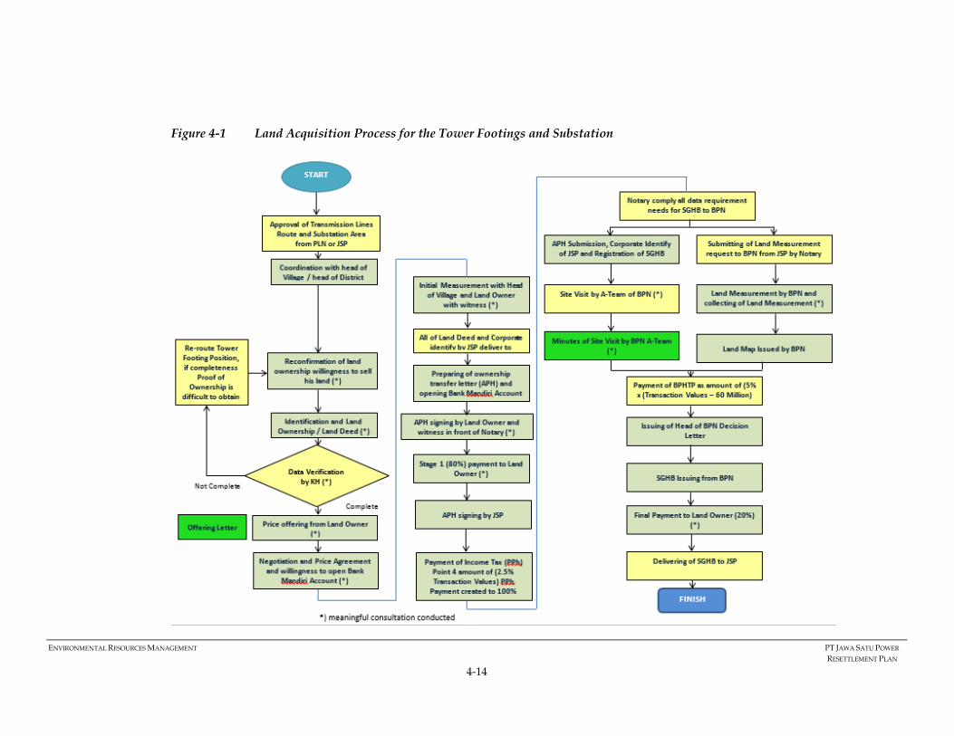
ENVIRONMENTAL RESOURCES MANAGEMENT PT JAWA SATU POWER
RESETTLEMENT PLAN
4-14
Figure 4-1 Land Acquisition Process for the Tower Footings and Substation

ENVIRONMENTAL RESOURCES MANAGEMENT PT JAWA SATU POWER
RESETTLEMENT PLAN
4-15
4.4.3 Project Resettlement Policy for Transmission Line ROW (Clearance Zone)
The project will not acquire the impacted land under the transmission line right of
way (clearance zone). However, the land under the transmission line right of way (34
m wide and 52 km in length) will be subject to restrictions on its use. As such the
Project will apply negotiated settlement for this use/access restriction in line with
SPS, SR2 para 25., however compensation will be paid based on the Regulation of
Ministry of Energy and Mineral Resources Number 38/ 2013 regarding compensation
for land, building, and plants located below free space of high-voltage aerial network
and extra high-voltage aerial network.
As mandated in the regulation, below is the resettlement policy applicable for
transmission line RoW:
1. The Project will conduct socialization on the development plan of the
transmission line prior to installation of the transmission line network via
relevant regency or city authority.
2. The Project will conduct an initial inventory of the affected land, building, and
plants/ trees to be compensated in consultation with the potentially affected
people. The inventory process must record the owners; type of land, size of land
and building; height of trees/plants; location of land, building and trees; as well
as maps of those objects.
2. Inventory results will be announced in the respective village head and district
offices.
3. In cases where the entitled parties refuse the inventory result, they are allowed
to submit the objection/ refusal to the Project via the village and district office
at the latest 14 days after announcement of the inventory result.
4. The project will follow up the objection by conducting reverification of the
ownership and usage of the land, building, and trees. The result of this
reverification will be announced in the respected village and district offices.
This final result will be used as the basis to determine the eligible parties to
receive the compensation.
5. The value of the compensation is calculated by an independent appraiser
proposed by the Project and approved by the Ministry of Energy and Mineral
Resources.
6. The compensation value is calculated based on the following government
criteria:
a. Compensation for land: 15% x size of land x market price of the land
calculated by the independent appraiser.
b. Compensation for buildings: 15% x size of building x market price of the
building (considered as new) calculated by the independent appraiser.
c. Compensation for plants: 100% of market price of the trees calculated by the
independent appraiser.
7. The compensation value determined by the independent appraiser is final and
paid to the owners on a one time basis. Should the land ownership change in
the future (for example due to trading or other forms of transaction), the new
owner is not eligible to receive such compensation.

ENVIRONMENTAL RESOURCES MANAGEMENT PT JAWA SATU POWER
RESETTLEMENT PLAN
4-16
8. The compensation payment must be witnessed by at least two people. In cases
where the land owners refuse the payment or the owners are unknown, the
compensation payment will be consigned in the court and cable stringing
activities will commence.
9. Any damages occurred during the transmission line network installation will
be compensated. The amount of the compensation will be discussed and
agreed together with the affected persons.

ENVIRONMENTAL RESOURCES MANAGEMENT PT JAWA SATU POWER
RESETTLEMENT PLAN
4-17
The key steps of the activities are presented in Figure 4-2.
Figure 4-2 Land Acquisition Steps for Transmission Line RoW

ENVIRONMENTAL RESOURCES MANAGEMENT PT JAWA SATU POWER
RESETTLEMENT PLAN
4-18
4.4.4 Project Resettlement Policy for Coastal Area
The Project will acquire approximately 200,000 m2 of land in Muara and Cilamaya
village, District of Cilamaya Wetan, Karawang Regency. Out of this size, 190.000 m2
are located within the protected forest belonging to the Ministry of Environment and
Forestry and 10,000 m2 located outside the protected forest area) owned by private
owners. In addition to the Project general resettlement policy, below is the policy
applicable for the land acquisition conducted in the coastal area:
1. For the land located within the protected forest area, the Project will obtain
IPPKH (Ijin Pinjam Pakai Kawasan Hutan) - license to borrow forest area from the
Ministry of Environment and Forestry.
2. For the land within the protected areas but also owned by individual land
owners (proof by land certificate issued by national land agency or village
authority), the Project will pay compensation on a basis of a willing seller and
willing buyer principle. (See also Section 4.4.2 that discusses the tower footings
land acquisition policy).
3. For the land owned by individual private owners located outside the protected
areas, the Project will pay compensation on a basis of a willing seller and willing
buyer principle. (See also Section 4.4.2 that discusses the tower footings land
acquisition policy).
4. The Project holds no right to expropriate land owners from their land.
5. The land acquisition is to be undertaken based on negotiation and agreeing a
fair price with landowners. The negotiation will be conducted in a fair and
transparent manner.
6. The compensation value will consider the NJOP, market price and land owners’
value for the land. Should the land owners refuse to sell the land, adjustment
will be made to ensure that principle of willing buyer and willing seller is well-
implemented.
7. In addition to fair compensation for land and crops lost the Project will
compensate for damaged crops, fish ponds or fishing equipment as a result of
the Project construction activities. Compensation will also be provided for the
temporary loss of access to fishing grounds during the laying of the offshore
pipelines. The amount of the compensation will be discussed and agreed with
the affected persons on a case by case basis.
4.4.5 Project Resettlement Policy for CCGT Power Plant
The Project will procure approximately 367,000 m2 from Pertagas for the development
of the CCGT power plant in Cilamaya Village, Karawang Regency. The Project will
acquire the land through direct negotiation on the basis of business to business
transaction. The Process of the land deeds transfer will be carried out in accordance
with applicable Indonesian Regulation. The land deeds will first be transferred from
Pertagas to Pertamina Power Indonesia (PPI). Pending the final transfer of land deeds
to JSP, a lease agreement between PPI and JSP will be signed before financial close.

ENVIRONMENTAL RESOURCES MANAGEMENT PT JAWA SATU POWER
RESETTLEMENT PLAN
4-19
4.5 ENTITLEMENT MATRIX
The Project will provide the entitlements to the landowners and users according to the specifications set out in Table 4-3.
Table 4-3 The Project’s Entitlement Matrix
No Type of Loss Types of Land Owners Entitlement Details
1 Loss of land � Legal owners
� Land owners with heritage
land rights
Compensation at replacement cost
with consideration of the NJOP,
current market value, and owners’
value/ expected price of the land.
• Appropriate price/compensation at a mutually agreed price
with the land owners.
• The value is all inclusive of the market price land value plus
additional transaction costs.
• The project will provide at least 60 days’ notice for agricultural
lands to harvest standing seasonal crops. If notice cannot be
given, compensation for the lost income will be provided
based on a mutually acceptable price.
• Payment of all taxes and administrative costs will be borne by
the Project.
2 Loss of trees, crops,
perennials
Land Owners and
beneficiaries of land use
Compensation based on the
agriculture agency that issues rates
on an annual basis.
The price is based on the age of
plants reflecting the
type/category (seeds,
unproductive and productive); the
compensation rate is based on the
age of plants (current/actual
condition/type of land) as agreed
with the land owners.
• Cash compensation for the loss of trees, crops, perennials
based on a mutually acceptable price.
• The project will allow 60 days advance notice to land owners
to harvest fruits, standing crops, and remove trees, if desired.

ENVIRONMENTAL RESOURCES MANAGEMENT PT JAWA SATU POWER
RESETTLEMENT PLAN
4-20
No Type of Loss Types of Land Owners Entitlement Details
3 Temporary loss of
access to fishing
ground
Local fisher folk during
laying of subsea pipelines
It is not considered that an impact
to income will be incurred due to
the laying of the offshore pipeline.
• Fishermen will be provided at least 30 days notice in advance
of the proposed activities.
• Where feasible, the EPCs will provide local employment
opportunities and procurement of local goods and services
during the construction period.
• JSP to implement a CSR program whereby fisher folk can
participate.
4 Loss/damage of
fishing equipment such
as nets
Local fisher folk during jetty
construction/ laying of
subsea pipelines
� Compensation at replacement
value
• Appropriate price/compensation as mutually agreed based on
the type of equipment damaged/removed with the fisherman
6 Loss/damage to fish
ponds
Fish/shrimp owners � Compensation at replacement
value, including lost assets
� Moving and rehabilitation
assistance
• Appropriate price/compensation as mutually agreed with the
fishpond owners.
• Provision of moving assistance and support in reconstruction
based on a mutually acceptable price.
6 Loss of structure and
businesses.
Property owners � Compensation at replacement
value, including lost assets
� Moving assistance
• Not applicable however if a case is identified an appropriate
price/compensation will be provided as mutually agreed with
the structure owner.
• Moving assistance will be agreed and provided based on in
lump sum payment
7 Significant loss of
income (reduced
income by >10% per
month)
Land owners with significant
loss of income due to loss of
land use
� Priority for Project employment
or provision of goods/services
� Participation in the Projects CSR
• Prioritize employment /procurement of services from JSP (or
EPCs).
• Integrate agriculture and livelihood restoration activities as
part of the CSR open to all identified land owners in this group.

ENVIRONMENTAL RESOURCES MANAGEMENT PT JAWA SATU POWER
RESETTLEMENT PLAN
4-21
No Type of Loss Types of Land Owners Entitlement Details
8 Losses experienced by
vulnerable groups
Vulnerable house-holds
including households headed
by women, elderly, very poor
or those with disabled or
many children
Additional assistance to
households according to
vulnerability levels
• The Project will prioritize employment /procurement of
services from JSP (or EPCs).
• Integrate agriculture and livelihood restoration activities as
part of the CSR activities.
9 Non-land economic
displacement
Households at risk of income
loss
Priority for CSR activities
• Agriculture and other CSR opportunities will be offered.
• JSP/EPCs will provide employment preferences to these land
owners, if appropriate
10 Restriction of land use
within T/L ROW
� Land owners
Compensation at easement fee in
accordance with the Regulation of
Ministry of Energy and Mineral
Resources calculated by the
assigned independent appraiser.
Cash compensation will be calculated by an independent
appraiser and implemented based on the government
regulations:
• Compensation for land: 15% x size of land x market price
of the land calculated by the independent appraiser.
• Compensation for buildings: 15% x size of building x
market price of the building deemed new calculated by
the independent appraiser.
• Compensation for plants: 100% x market price of the trees
calculated by the independent appraiser.
11 Temporary loss of
access to agricultural
land
� Land owners and users
during the transmission line
construction
It is not considered that an impact
to incomes will be incurred due to
the loss of access given the limited
restrictions
• Farmers will be provided notice in advance of the proposed
activities.
• An appropriate agreement will be made through direct
consultation and negotiation between the EPC and the village
leader/land owners on access and compensation that may be
in the form of cash, in kind support and /or project
employment/procurement of goods and services.

ENVIRONMENTAL RESOURCES MANAGEMENT PT JAWA SATU POWER
RESETTLEMENT PLAN
4-22
4.6 CUT-OFF DATE
The cut—off date for eligibility will be established to ensure all land owners and users
the date of completion of the census and eligibility. The cut-off is established by the
Project and typically immediately after the census is completed and disclosed in order
to minimize speculators. The cut-off date will be widely communicated by the Project
in Bahasa which is well understood in the area. Should any persons occupy the project
area/build new structures or grow new crops after cut-off date these new assets will
not be eligible for compensation and/or resettlement assistance.
Table 4-4 Cut Off Dates
Facilities Cut-Off date
Transmission Lines Tower Footing 31st January 2018
Clearance zone of the transmission line 30th June 2018 (expected)
Jetty, Pump House and access road 30th June 2018 (expected)
Pipeline Right of Way 30th June 2018 (expected)
The cut-off date for eligibility will be publicized by JSP to the land owners and village
heads (formally and informally). They will be given adequate time to harvest any
crops on cultivated land and to dismantle and transfer fixed assets or structures as
necessary. It is likely after the cut-off date that the land owners will be allowed to
harvest prior to construction activities. Given the notice to proceed (NTP) is scheduled
for 15th September 2018 the land users and owners will be informed that on this date
land will be handed over to the EPC.

ENVIRONMENTAL RESOURCES MANAGEMENT PT JAWA SATU POWER
RESETTLEMENT PLAN
5-1
5 INFORMATION DISCLOSURE, CONSULTATION
AND PARTICIPATION
This chapter discusses the required approach for consultation and information
disclosure with the Project stakeholders impacted by the land acquisition process. The
approach has been developed to adhere to the requirements set out in the ADB’s SPS,
IFC’s PS, and relevant national laws and regulation.
5.1 APPLICABLE STANDARDS AND REQUIREMENTS RELATED TO
INFORMATION DISCLOSURE, CONSULTATION, AND PARTICIPATION.
Applicable laws and regulations of the Government of the Republic of Indonesia.
Laws and regulations related to stakeholder consultation and disclosure activities
related to land acquisition are summarized in Table 5-1.
The ADB's SPS and Public Communications Policy emphasizes the importance of
consultation and public participation in development projects, particularly with those
people who are likely to experience social impacts as a result. The five elements of
meaningful consultation and disclosure requirements include:
(i) begins early in the project preparation stage and is carried out on an ongoing basis throughout the project cycle;
(ii) provides timely disclosure of relevant and adequate information that is understandable and readily accessible to affected people;
(iii) is undertaken in an atmosphere free of intimidation or coercion; (iv) is gender inclusive and responsive to the needs of disadvantaged and
vulnerable groups; and (v) enables the incorporation of all relevant views of affected people and other
stakeholders into decision making, such as project design, mitigation measures, the sharing of development benefits and opportunities, and implementation issues.
5.2 THE PROJECT’S COMMITMENT RELATED TO INFORMATION
DISCLOSURE, CONSULTATION, AND PARTICIPATION.
The Project understands that meaningful consultation and participation of the
stakeholders including the impacted people is one of the key factors of the successful
implementation of the Project. As such, the Project is committed to implement the
following:
1. The Project is committed to uphold all applicable national laws and regulations
related to stakeholders’ engagement and public participation throughout the
project development.
2. The Project will ensure that all information related to the Project is well
informed and communicated to the communities, groups, or peoples affected
by the Project and conducted continuously throughout the Project cycle
allowing for an effective flow of information.

ENVIRONMENTAL RESOURCES MANAGEMENT PT JAWA SATU POWER
RESETTLEMENT PLAN
5-2
3. The Project will prepare materials that are culturally appropriate, effective,
clear, and understood by the land owners/users. JSP will continue to consult
with the land owners until the compensation process is complete ensuring they
have sufficient information in simple and clear Bahasa language to determine if
they chose to sell and at what price.
4. The Project will ensure that all affected people have access to the information
concerning the Project and its land acquisition. Therefore, the materials will be
made accessible to all affected land owners/users and shared via the head of
village and village board information. At the Project level, the materials will be
communicated and presented by the Project field team and management.

ENVIRONMENTAL RESOURCES MANAGEMENT PT JAWA SATU POWER
RESETTLEMENT PLAN
5-3
Table 5-1 National Regulation Framework for Stakeholder Consultation and Information Disclosure
Regulation Content Citation
Law No 38 of 2013 on
Compensation for Land,
Building, and Plant Located
below Free Space of High-
Voltage Aerial Network
Chapter II details that the holders of business license to supply electricity and holders of operational license before
executing the installation of the high-voltage aerial network shall obliged to socialize plan for the project
development to communities that would be crossed by the network installation trough local regency/ municipal
government office. The holders of business license is also obliged to disclose the result of the impacted land, building,
and plant inventory to the community via local district/ village and district office. Should there is objection from the
impacted owners, the holders of business license shall obliged to follow up the objection by verifying the ownership,
use and utilization of land, building and plant and announce the result of the investigation in local district/ village
office.
Article 2 No 2a, 2 e,
3 and 4.
Law No 32 of 2009 about
“Environmental Protection
and Management.”
Chapter XI details expectations associated with community participation. The community has equal rights and
opportunities to actively participate in and protect the environment as well as part of the planning and
implementation of environmental protection and management.
Articles No. 70
Paragraph 1
Government Regulation (PP)
No. 27 of 2012 on
Environmental Permit
In preparing the AMDAL, the Project Initiator should include the following parties in the process:
Affected communities; Environmental experts; and any party who are affected by any form of decision in the
AMDAL process. Community / public participation as intended in above paragraph are done through
announcement of Business and / or activity plan and public consultation. Community / public participation shall
be made before the preparation of AMDAL Term of Reference; The community shall be entitled to submit
suggestions, opinions, and responses to the business and / or activity plan within 10 working days since the
announcement as referred to point no 2 above.
Article No. 9
Paragraph 1 - 4
Regulation of the State
Minister for Environment No.
17/2012 regarding
Guidelines for Community
Involvement in the Process of
Environmental Impact
This regulation as guarantee and guidelines the implementations of community involvement in the process of
environmental impact assessment and environmental permit.
Stated that the mandatory notification should be using 2 mandatory media i.e.
1. Printed media such as local newspaper and/ or national newspaper (if required by EIA assessment authority 2. Bulletin board which is easily accessible to the affected communities
Chapter II: Part B,
point b
Chapter III: Part B,
point 1.b
ENVIRONMENTAL RESOURCES MANAGEMENT PT JAWA SATU POWER
RESETTLEMENT PLAN
5-4
Regulation Content Citation
Assessment and
Environmental Permit
In addition to mandatory media as mentioned above, the Project could use other supporting media to undertake
notification such as:
1. Printed media such as brochures, pamphlet, or banner; 2. Electronic media such as television, website, social network, short message service (SMS), and/ or radio; 3. Bulletin board in environmental agencies and relevant government agencies in national, province and
regency level; and 4. Other media which can be used
In addition, this regulation also mention that the notification should be conveyed through multimedia which is
effectively accessible to the community such as website and bulletin board in the Project plan location which easily
to reach by the affected community.
Regulation of the Minister of
Environment No 17 of 2012.
• Guidance of community involvement in the process of environmental impact and environmental permit analysis is intended as a reference:
• The implementation of community involvement in the environmental impact analysis process; and
• Implementation of community involvement in the environmental permit process.
• Implementation of community involvement in the EIA and Environmental Permit Process shall be based on the following basic principles: � Providing transparent and complete information; � Equality of positions among the parties involved; � Fair and wise problem solving; and � Coordination, communication and cooperation among the parties concerned / involved.
Article No 1 and 2

ENVIRONMENTAL RESOURCES MANAGEMENT PT JAWA SATU POWER
RESETTLEMENT PLAN
6-1
6 GRIEVANCE REDRESS MECHANISM
A grievance mechanism is a process for systematically receiving, investigating and
responding to stakeholder complaints. Throughout the life cycle of the Project, queries
and grievances from the impacted community may arise hence a Grievance Tracking
Redress Mechanism (GTRM) is established to address grievances raised. The GTRM
will be triggered in all instances where a complaint is received by the Project or its
contractors (such as the land acquisition consultant and the EPCs for the offshore and
onshore activities). The Project’s GTRM is illustrated in Figure 6-1 and explanation of
each step in presented in Table 6-1.
For the land acquisition of the transmission line and substation, grievances related to
the land acquisition are being handled mainly by JSP’s land consultants supported by
JSP Community Relation Officer. The Project has already disclosed the mechanism
during consultations with the land owners and is logging all current grievances. The
telephone number of JSP’s local community relations officer was also disclosed to all.
For the coastal area, Pertamina will directly engage the land owners given their
current relationship with the surrounding communities. The process for reporting
and addressing grievances will be the same
Figure 6-1 The Project’s Grievance Tracking Redress Mechanism

ENVIRONMENTAL RESOURCES MANAGEMENT PT JAWA SATU POWER
RESETTLEMENT PLAN
6-2
Table 6-1 Keys Steps in the Grievance Mechanism Process
Stage Description Responsibility Timeline
1. Receipt of
Grievance � Comments and questions are received and analyzed as part of the standard feedback process. Feedback or
complaints can be received through verbal and writing, follow by registering.
� All communications are subject to the feedback process, which ensures that feedback is documented, incorporated, and responded to as needed.
� When the grievance is identified, stage 2 of the grievance procedure is initiated.
Kwarsa
Hexagon/JSP
Community Liaison
Officer.
2. Record/
Delegate � When a grievance is identified, it is officially registered in a grievance log and given a unique identification
number.
� It is categorized based on the type of complaint and its severity. Grievances are categorized into two categories:
1. Low significance grievance, with characteristics:
• The complaints involve individual affected people only;
• One-off grievance, less probability it will attract media attention; and
• Does not require immediate intervention from managerial level
2. High significance grievance, indicated by the following conditions:
• The complaints involve a large group of affected people;
• Has not been resolved during the time specified in this mechanism
• Recurring and potentially affecting the Project activities schedule;
• Potentially attracting media attention; and
• Requiring immediate intervention from managerial level.
� An initial response is sent to the person(s) who raised the grievance within six (6) working days, acknowledging their feedback and describing the next steps in the grievance process, time estimates for these steps and a contact person.
The issue will be delegated to relevant unit/department to be followed up.
Kwarsa Hexagon/
JSP Community
Liaison Officer
3 days after
the receipt of
Grievance
3. Fact Finding The Project will investigate grievances and their surroundings in a timely manner. Investigations may include
photographs and other evidence, witness statements, interviews with affected stakeholders and other parties,
review of site register, and other information gathering activities.
Kwarsa Hexagon/
JSP Community
Liaison Officer

ENVIRONMENTAL RESOURCES MANAGEMENT PT JAWA SATU POWER
RESETTLEMENT PLAN
6-3
Stage Description Responsibility Timeline
The results of the investigation will be reviewed and a resolution will be proposed. The development of the
resolution may involve consultation with the person(s) involved. The proposed resolution will then be
formally communicated to all parties.
4. Resolution
or Appeal � If the resolution is accepted by all parties, it will be documented, implemented and the grievance is closed.
� If the resolution is not accepted, it will be reconsidered and the following resolution may be proposed:
o If complainant is not satisfied with the proposed resolution either party resorts to a mediator / arbitrator;
o Mediator / Arbitrator then reviews the grievance and seeks resolution;
o Mediator / Arbitrator then propose resolution;
o If both parties are satisfied with the proposed resolution it will be documented, implemented and the grievance is closed;
If both parties are not satisfied with the proposed resolution, then the complainant or Project will resort to the
courts.
Kwarsa Hexagon/
JSP Community
Liaison Officer
6 days
5. Feedback/
Close out After the accepted resolution has been implemented, it will be monitored and its effectiveness will be
evaluated. All parties will be notified that the resolution has been implemented and will have the opportunity
to provide feedback on the grievance process and its implementation.
JSP Community
Liaison Officer 15 days
ENVIRONMENTAL RESOURCES MANAGEMENT PT JAWA SATU POWER
RESETTLEMENT PLAN
7-1
7 SOCIO-ECONOMIC INFORMATION
This section presents a summary of the socio-economic information of the affected
people from the land acquisition process. The information was gathered from a census
of the impacted land owners and users for the tower footings and substation, and
coastal area.
7.1 CENSUS METHODOLOGY
The census of the landowners for the tower footings and substation was undertaken
in the 37 villages between 19th and 29th December 2017 and 17th and 26th January 2018.
The survey aimed to achieve 100% of landowners (and land users). Interviews were
conducted based on data provided by the Project’s land acquisition consultant using
official names registered in the land documentation. In cases where landowners had
passed away, passed the land onto others (e.g. family members), or granted the land
to their heirs interviews were conducted with the family members or their heirs.
During the survey the following challenges were identified:
1. Some landowners own more than one plot of land and often within the same
households there are multiple land owners.
2. Some land required for one tower is owned by more than one person, for
example Tower T94 is owned by three people.
3. On paper, the land has been granted to the owner’ heirs but in reality, the heirs
do not manage the land. There are also cases where the land title has not been
transferred to the current land owner. As such, the land acquisition process
(such as price negotiation and land measurement) has been conducted with the
current owner who understands and manages the impacted land.
Based on the above the total land owners for the tower footings and substation is 124
landowners. Most of the landowners live within the Project Area of Influence (AoI)
i.e. the Karawang and Bekasi Regency. However, some are living outside the AoI such
as in Jakarta, Malang, and Surabaya. Reasonable effort was taken to conduct face-to-
face interviews with those living within Karawang and Bekasi Regency and phone
interviews were undertaken to survey those living outside of the AoI. A total of 114
(92%) land owners were interviewed during the survey period with 10 (8 %) being
unreachable either refusing to participate in the survey or not contactable. Data was
also gathered on the impacted land users by utilizing information provided by the
landowners. All reasonable efforts were made to survey the 23 identified land users.
For the coastal area, information is collected through social survey during 16th to 21st
May 2018 by ERM. The survey confirmed 8 households of land owners and 4 land
users will be impacted. However, one land owner was unreachable during the survey
period. As such, information presented in this RP will be based on the seven land
owners.

ENVIRONMENTAL RESOURCES MANAGEMENT PT JAWA SATU POWER
RESETTLEMENT PLAN
7-2
7.2 DEMOGRAPHIC PROFILE
The focus of the socio-economic field study was on the 13 districts in the Karawang
and Bekasi Regencies. The data presented is sourced from the District in Figures and
interviews undertaken during the field surveys in December 2017 and January 2018.
Table 7-1 presents the 37 villages impacted by the transmission line and substation in
the Karawang and Bekasi Regencies.
Table 7-1 Village Impacts by the Transmission Line and Sub station
Regency District Village
Karawang Cilamaya Wetan Cilamaya Sukatani
Cilamaya Kulon Sukamulya
Pasiruken
Muktijaya
Tegalurung
Manggungjaya
Sumurgede
Tempuran Jayanegara
Purwajaya
Pagadungan
Pancakarya
Lemahduhur
Lemahkarya
Dayeuhluhur
Tanjungjaya-
Rawamerta Sukaraja
Cilebar Sukaratu
Kutawaluya Sindangsari
Sampalan
Waluya
Mulyajaya
Rengasdengklok Karyasari
Kalangsuria
Kalangsari
Karawang Barat Mekarjati
Tunggakjati-
Bekasi Pebayuran Bantarjaya-
Kedungwaringin Karangmekar
Mekarjaya
Karangharum
Cikarang Timur Karangsari
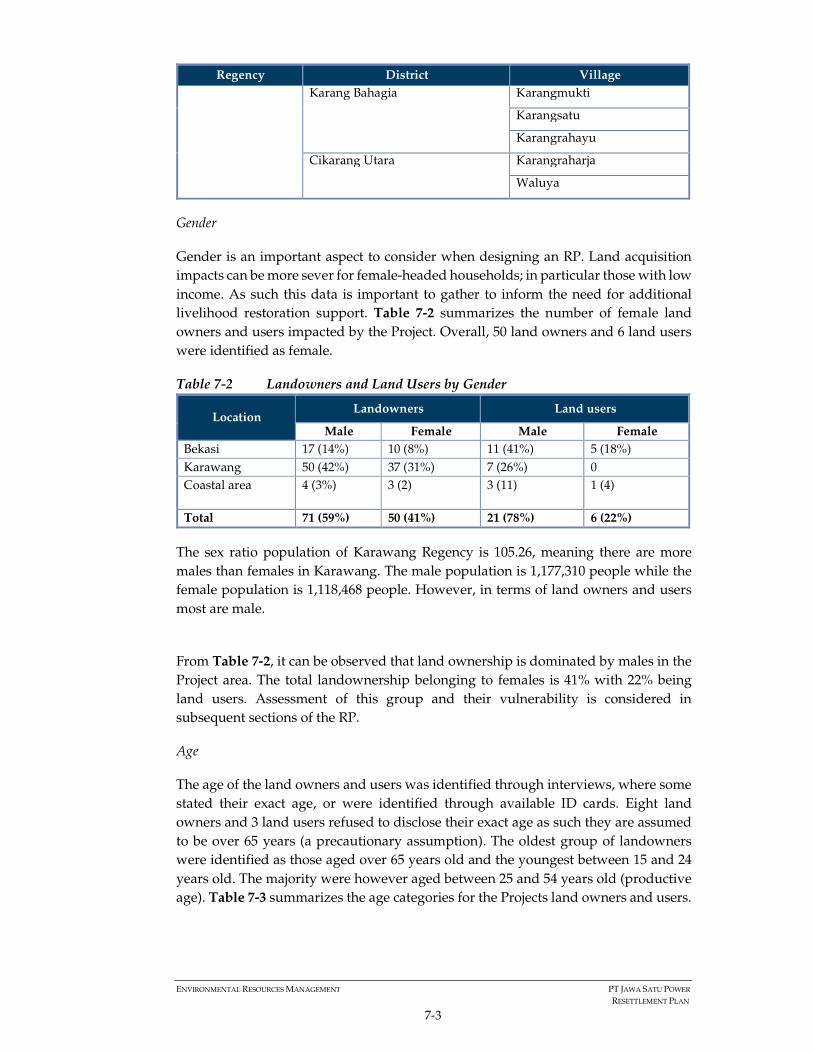
ENVIRONMENTAL RESOURCES MANAGEMENT PT JAWA SATU POWER
RESETTLEMENT PLAN
7-3
Regency District Village
Karang Bahagia Karangmukti
Karangsatu
Karangrahayu
Cikarang Utara Karangraharja
Waluya
Gender
Gender is an important aspect to consider when designing an RP. Land acquisition
impacts can be more sever for female-headed households; in particular those with low
income. As such this data is important to gather to inform the need for additional
livelihood restoration support. Table 7-2 summarizes the number of female land
owners and users impacted by the Project. Overall, 50 land owners and 6 land users
were identified as female.
Table 7-2 Landowners and Land Users by Gender
Location Landowners Land users
Male Female Male Female
Bekasi 17 (14%) 10 (8%) 11 (41%) 5 (18%)
Karawang 50 (42%) 37 (31%) 7 (26%) 0
Coastal area 4 (3%) 3 (2) 3 (11) 1 (4)
Total 71 (59%) 50 (41%) 21 (78%) 6 (22%)
The sex ratio population of Karawang Regency is 105.26, meaning there are more
males than females in Karawang. The male population is 1,177,310 people while the
female population is 1,118,468 people. However, in terms of land owners and users
most are male.
From Table 7-2, it can be observed that land ownership is dominated by males in the
Project area. The total landownership belonging to females is 41% with 22% being
land users. Assessment of this group and their vulnerability is considered in
subsequent sections of the RP.
Age
The age of the land owners and users was identified through interviews, where some
stated their exact age, or were identified through available ID cards. Eight land
owners and 3 land users refused to disclose their exact age as such they are assumed
to be over 65 years (a precautionary assumption). The oldest group of landowners
were identified as those aged over 65 years old and the youngest between 15 and 24
years old. The majority were however aged between 25 and 54 years old (productive
age). Table 7-3 summarizes the age categories for the Projects land owners and users.

ENVIRONMENTAL RESOURCES MANAGEMENT PT JAWA SATU POWER
RESETTLEMENT PLAN
7-4
Table 7-3 Landowners and Land Users Age Group
Location Affected
People
Age Group
Refuse to
disclose
>=65
years
55-64
years
25-54
years
15-24
years
Bekasi Landowners 3 4 2 16 1
Land users 2 1 3 11 0
Karawang Landowners 5 10 15 58 0
Land users 0 0 1 5 0
Coastal
area
Landowners 0 1 2 4
0
Land users 0 0 3 1 0
Total 10 16 26 95 1
Religion
In general, the biggest religion in Bekasi and Karawang is Islam. This is also reflected
in the religion composition of the land owners and users surveyed. The minority
groups mostly consist of Christian Catholics and Protestants. There is no mention of
traditional religious groups in Bekasi and Karawang, though there are 13 affected
people that refused to disclose information about their religion. Table 7-4 details
landowners’ religious preferences.
Table 7-4 Landowners and Land Users Religion Group
Location Affected
People
Religion Group
Refused to
disclose Islam Catholic Protestant
Bekasi Landowners 4 23 0 0
Land users 3 12 0 1
Karawang Landowners 6 79 1 1
Land users 0 7 0 0
Coastal Landowners 0 6 0 1
Land users 0 3 0 1
Total 13 124 1 4
Ethnic Groups
The general composition of ethnicity in Karawang and Bekasi consists of Betawi,
Jawa, Sunda and a mix of ethnicity of Indonesian and foreign descendants. Most of
the landowners could not identify directly their ethnicity group; however based on
the area most can be assumed to be of a Sunda background (the dominant ethnic
group for West Java). Smaller groups of Betawi and Jawa and foreign ethnicity
descendants also exist. The affected people in coastal area mostly came from West
Java area. They are not native people of Karawang but they have been staying in the
project area for more than 10 years purchasing the land for fishponds as an
investment. Table 7-5 presents ethnicity per project location.

ENVIRONMENTAL RESOURCES MANAGEMENT PT JAWA SATU POWER
RESETTLEMENT PLAN
7-5
Table 7-5 Landowners and Land Users Ethnic Groups
Location Affected
People
Ethnic Group
Cannot
Identify Betawi Jawa
Foreign
ethnicity
descendant
Sunda
Bekasi Landowner 15 1 0 0 11
Land user 11 4 0 0 1
Karawang Landowner 56 2 5 1 23
Land users 3 0 0 0 4
Coastal Landowner 0 1 5 0 1
Land users 0 0 3 1 0
Total 85 8 13 2 40
Family Numbers
The number of family members per landowner household in the Project area ranges
from one to 12 persons (main family members not extended). However, the majority
of households have between three and five family members. Table 7-6 summarizes
the family members per household based on the land users and owners.
Table 7-6 Landowners and Land Users Family Number
Location Affected
People
Family Members
1 2 3 4 5 6 7 8 9 12
Bekasi Landowners 1 2 5 9 5 1 1 2 1 0
Land users 1 0 7 6 1 1 0 0 0 0
Karawang Landowners 4 12 17 30 14 5 3 1 0 1
Land users 0 0 1 4 0 2 0 0 0 0
Total 6 14 30 49 20 9 4 3 1 1
Residential Duration
Most of the landowners did not want to disclose how long they have resided in
Karawang and Bekasi. However, for those who shared this information most are
native to the area but do not self-identify as indigenous. Table 7-7 presents the data
gathered by residents.
Table 7-7 Landowners and Land Users Residential Duration
Location Affected
People
Duration of Resident
Refuse to
disclose
More than 10
years
Between 10 to 1
years Native
Bekasi Landowners 14 1 0 12
Land users 11 1 0 5
Karawang Landowners 56 5 3 23
Land users 3 1 0 3
Total 84 8 3 43

ENVIRONMENTAL RESOURCES MANAGEMENT PT JAWA SATU POWER
RESETTLEMENT PLAN
7-6
7.3 ECONOMIC PROFILE
Based on information from the National Statistic Bureau (2016 and 2017), the economy
of Karawang and Bekasi is almost entirely derived from the the manufacturing sector
followed by the agriculture sector. These sectors are the major economic resource for
local revenue; acting as the key source of income and employment for local people.
Sources of income in the agricultural sector include the production of rice-paddy. On
this land farmers also cultivate other crops such as cassava. As well as selling rice and
casava at the local market, produce is used to meet the basic needs for household
consumption.
Livelihoods
Most of the land in the Project Area is used for rice field production; however, the
land users renting the land typically have a number of income streams besides
farming. Most of the land users who are farmers reside in Bekasi Regency. Others land
user activities consist of trading or distributing goods, construction activities, drivers,
mechanics, and civil servants. Only one jobless respondent was recorded as a land
user in the Bekasi Regency.
The compositions of the job options for the landowners is similar to the land users
with most landowners conducting farming as their primary income. Farmers in
Karawang also are entrepreneurs, traders and civil servants; some are also employee
of private companies and fishermen. Only a small percentage of land owners are
considered as unemployed.
Table 7-8 Landowners and Land users Livelihood Sources
Location Affected
People
Livelihood Group Total
Unemployed Other Peasant Private
Employers
Fisherman Farmers
Bekasi Landowners 2 9 1 1 1 15 29
Land users 1 4 0 0 0 11 16
Karawang Landowners 5 33 0 0 1 46 85
Land users 0 0 1 0 0 6 7
Coastal Landowners 1 1 0 1 1 3 7
Land users 1 0 0 0 2 1 4
Total 10 47 2 2 5 82 148

ENVIRONMENTAL RESOURCES MANAGEMENT PT JAWA SATU POWER
RESETTLEMENT PLAN
7-7
Income
The minimum regional wage rate in Karawang Regency (2017) was IDR 3,605,272 per
month and IDR 3,530,438 per month in Bekasi. The majority of land users have a lower
income than the regional minimum wage rate in particular in Bekasi Regency where
most of the land users reside. Despite this, the highest income group of land users
(more than IDR 4m) is also found in the Bekasi Regency. While the majority of
landowners earn more than IDR 4m each month. This number is higher than the
minimum wage for each regency as presented in Table 7-9.
Table 7-9 Landowners and Land users Income Group
Location Affected
People
Income Group (IDR) Total
Unknown Lower
than 1m
1m-2.5m 2.5m-4m > 4m
Bekasi Landowners 4 2 5 4 12 27
Land users 1 3 6 2 4 16
Karawang Landowners 12 3 16 7 49 87
Land users 3 2 0 2 0 7
Coastal Landowners 0 0 0 0 7 7
Land users 1 0 1 1 1 4
Total 21 10 28 16 73 148
Education
Based on the ESIA survey most of the villagers can access formal education at the
various lower levels. With growing difficulties to access higher education at the Senior
High School and University levels.
The formal education level of affected people varies from having no primary
education to having higher education. The majority of affected people only graduate
from primary level education without finishing their primary education. A very small
number of affected people are able to access university education.
Table 7-10 Landowners and Land users Education Level
Location Affected
People
Education Level
Total
Refuse
to
disclose
University
Education
Junior
and
senior
high
school
Primary
school
Not
finishing
primary
school
Bekasi Landowners 2 1 5 10 9 27
Land users 9 1 2 2 2 16
Karawang Landowners 0 11 25 31 20 87
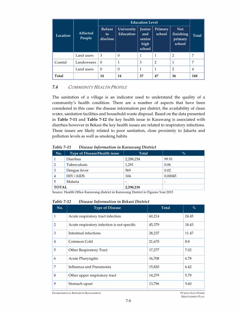
ENVIRONMENTAL RESOURCES MANAGEMENT PT JAWA SATU POWER
RESETTLEMENT PLAN
7-8
Location Affected
People
Education Level
Total
Refuse
to
disclose
University
Education
Junior
and
senior
high
school
Primary
school
Not
finishing
primary
school
Land users 3 0 1 1 2 7
Coastal Landowners 0 1 3 2 1 7
Land users 0 0 1 1 2 4
Total 14 14 37 47 36 148
7.4 COMMUNITY HEALTH PROFILE
The sanitation of a village is an indicator used to understand the quality of a
community’s health condition. There are a number of aspects that have been
considered in this case: the disease information per district, the availability of clean
water, sanitation facilities and household waste disposal. Based on the data presented
in Table 7-11 and Table 7-12 the key health issue in Karawang is associated with
diarrhea however in Bekasi the key health issues are related to respiratory infections.
These issues are likely related to poor sanitation, close proximity to Jakarta and
pollution levels as well as smoking habits
Table 7-11 Disease Information in Karawang District
No. Type of Disease/Health issue Total %
1 Diarrhea 2,288,254 99.91
2 Tuberculosis 1,291 0.06
3 Dengue fever 569 0.02
4 HIV/AIDS 104 0.00045
5 Malaria - -
TOTAL 2,290,218
Source: Health Office Karawang district in Karawang District in Figures Year 2015
Table 7-12 Disease Information in Bekasi District
No. Type of Disease Total %
1 Acute respiratory tract infection 60,214 24.45
2 Acute respiratory infection is not specific 45,379 18.43
3 Intestinal infections 28,237 11.47
4 Common Cold 21,670 8.8
5 Other Respiratory Tract 17,277 7.02
6 Acute Pharyngitis 16,708 6.78
7 Influenza and Pneumonia 15,820 6.42
8 Other upper respiratory tract 14,279 5.79
9 Stomach upset 13,796 5.60
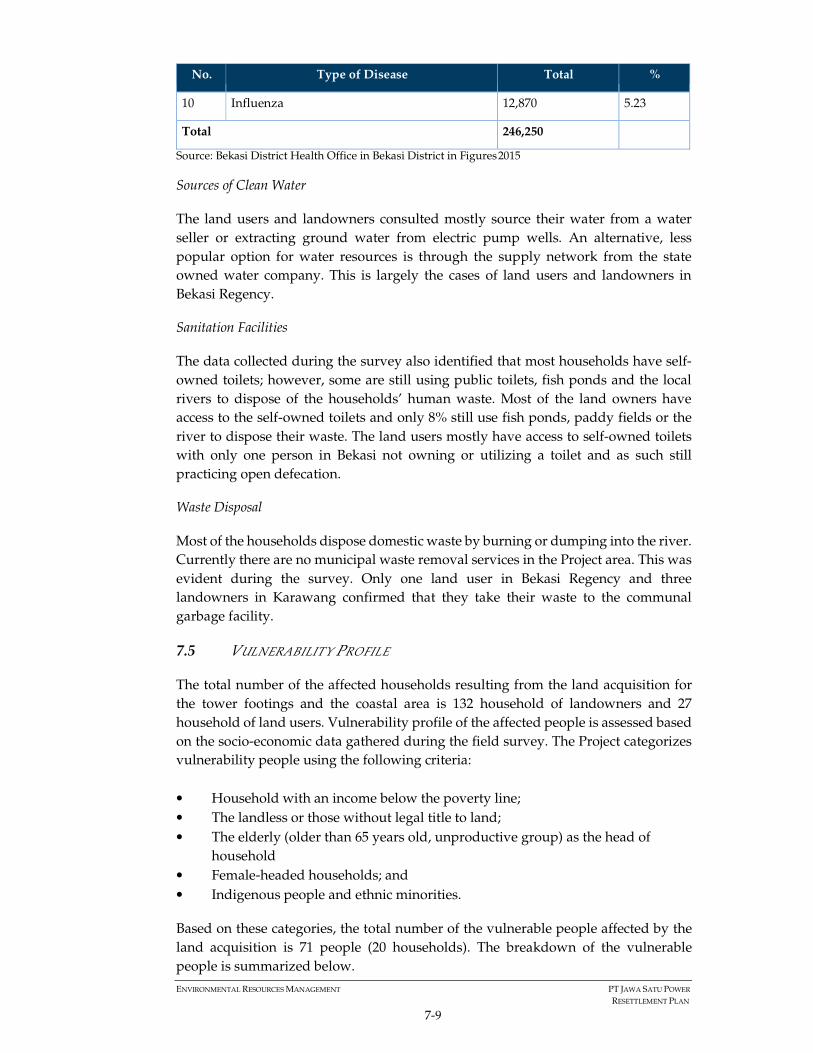
ENVIRONMENTAL RESOURCES MANAGEMENT PT JAWA SATU POWER
RESETTLEMENT PLAN
7-9
No. Type of Disease Total %
10 Influenza 12,870 5.23
Total 246,250
Source: Bekasi District Health Office in Bekasi District in Figures 2015
Sources of Clean Water
The land users and landowners consulted mostly source their water from a water
seller or extracting ground water from electric pump wells. An alternative, less
popular option for water resources is through the supply network from the state
owned water company. This is largely the cases of land users and landowners in
Bekasi Regency.
Sanitation Facilities
The data collected during the survey also identified that most households have self-
owned toilets; however, some are still using public toilets, fish ponds and the local
rivers to dispose of the households’ human waste. Most of the land owners have
access to the self-owned toilets and only 8% still use fish ponds, paddy fields or the
river to dispose their waste. The land users mostly have access to self-owned toilets
with only one person in Bekasi not owning or utilizing a toilet and as such still
practicing open defecation.
Waste Disposal
Most of the households dispose domestic waste by burning or dumping into the river.
Currently there are no municipal waste removal services in the Project area. This was
evident during the survey. Only one land user in Bekasi Regency and three
landowners in Karawang confirmed that they take their waste to the communal
garbage facility.
7.5 VULNERABILITY PROFILE
The total number of the affected households resulting from the land acquisition for
the tower footings and the coastal area is 132 household of landowners and 27
household of land users. Vulnerability profile of the affected people is assessed based
on the socio-economic data gathered during the field survey. The Project categorizes
vulnerability people using the following criteria:
• Household with an income below the poverty line;
• The landless or those without legal title to land;
• The elderly (older than 65 years old, unproductive group) as the head of
household
• Female-headed households; and
• Indigenous people and ethnic minorities.
Based on these categories, the total number of the vulnerable people affected by the
land acquisition is 71 people (20 households). The breakdown of the vulnerable
people is summarized below.
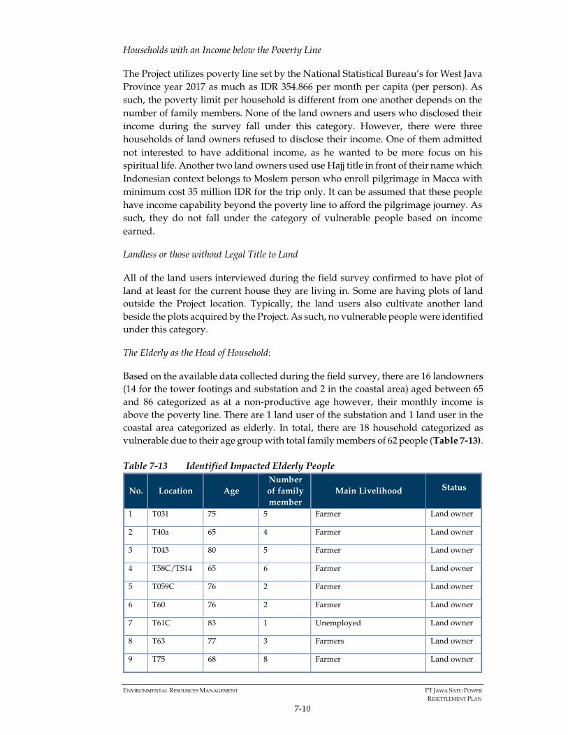
ENVIRONMENTAL RESOURCES MANAGEMENT PT JAWA SATU POWER
RESETTLEMENT PLAN
7-10
Households with an Income below the Poverty Line
The Project utilizes poverty line set by the National Statistical Bureau’s for West Java
Province year 2017 as much as IDR 354.866 per month per capita (per person). As
such, the poverty limit per household is different from one another depends on the
number of family members. None of the land owners and users who disclosed their
income during the survey fall under this category. However, there were three
households of land owners refused to disclose their income. One of them admitted
not interested to have additional income, as he wanted to be more focus on his
spiritual life. Another two land owners used use Hajj title in front of their name which
Indonesian context belongs to Moslem person who enroll pilgrimage in Macca with
minimum cost 35 million IDR for the trip only. It can be assumed that these people
have income capability beyond the poverty line to afford the pilgrimage journey. As
such, they do not fall under the category of vulnerable people based on income
earned.
Landless or those without Legal Title to Land
All of the land users interviewed during the field survey confirmed to have plot of
land at least for the current house they are living in. Some are having plots of land
outside the Project location. Typically, the land users also cultivate another land
beside the plots acquired by the Project. As such, no vulnerable people were identified
under this category.
The Elderly as the Head of Household:
Based on the available data collected during the field survey, there are 16 landowners
(14 for the tower footings and substation and 2 in the coastal area) aged between 65
and 86 categorized as at a non-productive age however, their monthly income is
above the poverty line. There are 1 land user of the substation and 1 land user in the
coastal area categorized as elderly. In total, there are 18 household categorized as
vulnerable due to their age group with total family members of 62 people (Table 7-13).
Table 7-13 Identified Impacted Elderly People
No. Location Age
Number
of family
member
Main Livelihood Status
1 T031 75 5 Farmer Land owner
2 T40a 65 4 Farmer Land owner
3 T043 80 5 Farmer Land owner
4 T58C/TS14 65 6 Farmer Land owner
5 T059C 76 2 Farmer Land owner
6 T60 76 2 Farmer Land owner
7 T61C 83 1 Unemployed Land owner
8 T63 77 3 Farmers Land owner
9 T75 68 8 Farmer Land owner
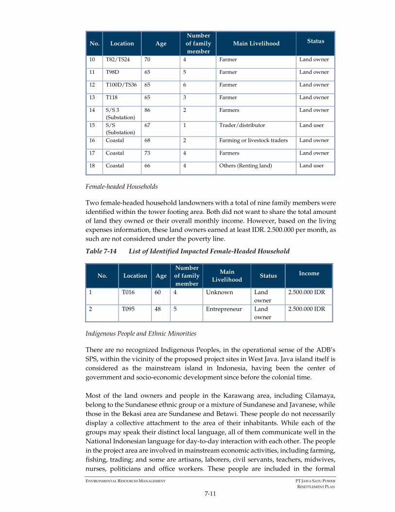
ENVIRONMENTAL RESOURCES MANAGEMENT PT JAWA SATU POWER
RESETTLEMENT PLAN
7-11
No. Location Age
Number
of family
member
Main Livelihood Status
10 T82/TS24 70 4 Farmer Land owner
11 T98D 65 5 Farmer Land owner
12 T100D/TS36 65 6 Farmer Land owner
13 T118 65 3 Farmer Land owner
14 S/S 3
(Substation)
86 2 Farmers Land owner
15 S/S
(Substation)
67 1 Trader/distributor Land user
16 Coastal 68 2 Farming or livestock traders Land owner
17 Coastal 73 4 Farmers Land owner
18 Coastal 66 4 Others (Renting land) Land user
Female-headed Households
Two female-headed household landowners with a total of nine family members were
identified within the tower footing area. Both did not want to share the total amount
of land they owned or their overall monthly income. However, based on the living
expenses information, these land owners earned at least IDR. 2.500.000 per month, as
such are not considered under the poverty line.
Table 7-14 List of Identified Impacted Female-Headed Household
No. Location Age
Number
of family
member
Main
Livelihood Status Income
1 T016 60 4 Unknown Land
owner
2.500.000 IDR
2 T095 48 5 Entrepreneur Land
owner
2.500.000 IDR
Indigenous People and Ethnic Minorities
There are no recognized Indigenous Peoples, in the operational sense of the ADB’s
SPS, within the vicinity of the proposed project sites in West Java. Java island itself is
considered as the mainstream island in Indonesia, having been the center of
government and socio-economic development since before the colonial time.
Most of the land owners and people in the Karawang area, including Cilamaya,
belong to the Sundanese ethnic group or a mixture of Sundanese and Javanese, while
those in the Bekasi area are Sundanese and Betawi. These people do not necessarily
display a collective attachment to the area of their inhabitants. While each of the
groups may speak their distinct local language, all of them communicate well in the
National Indonesian language for day-to-day interaction with each other. The people
in the project area are involved in mainstream economic activities, including farming,
fishing, trading; and some are artisans, laborers, civil servants, teachers, midwives,
nurses, politicians and office workers. These people are included in the formal

ENVIRONMENTAL RESOURCES MANAGEMENT PT JAWA SATU POWER
RESETTLEMENT PLAN
7-12
decision-making bodies, as they are well represented in the local House of
Representatives and in the local governance system. Furthermore, there is no
evidence of any of the ethnic groups being historically, socially or economically
marginalized due to their ethnic identity.

ENVIRONMENTAL RESOURCES MANAGEMENT PT JAWA SATU POWER
RESETTLEMENT PLAN
8-1
8 IMPLEMENTATION OF THE PROJECT
RESETTLEMENT POLICY
This Resettlement Plan covers the impacts of acquisition land for all required facilities
including the CCGT power plant, tower footings and right of way (clearance zone) of
the transmission line and substation, as well as associated facilities in the coastal area
such as the on-shore pipeline, jetty, pump house, and access road from the Jetty to the
Power Plant. The subsequent section discusses the implementation of the
resettlement policy and the land acquisition process conducted by the Project as of
25th May 2018.
8.1 TOWER FOOTINGS AND SUBSTATION
The Project will construct 118 tower footings along 52 km from Karawang to Bekasi
Regency passing through 37 villages. Two of the towers will be located within the
Petagas area. The total plots of the acquired land for 116 tower footings and substation
is 131 plots owned by 124 owners.
The land acquisition process is being conducted by third party advisor, Kwarsa
Hexagon, on behalf of the Project. Kwarsa started the land acquisition process by
approaching the village heads located within the transmission line area in 11-21 May
2017 and 4-5 June 2017. This time was considered early to allow sufficient time for
information disclosure and further consultation and negotiation. The message
conveyed was the importance of support from the village heads to help the
government achieve the electricity national target of 35.000 MW by 2019. Details of
the consultation and process are set out in Chapter 4.4 and Chapter 5.1.
Approach to the village heads was done in accordance with the local custom where
all outsiders who wish to conduct any activities in the village must be acknowledged
by the respected village head. As such, support from the village heads was one of the
key factors that determine the successful of the land acquisition process. All the
approached village heads expressed their support towards the Project development
and committed to be involved throughout the land acquisition process i.e. identifying
and confirming land location and ownership as well as connecting Kwarsa to the
landowners.
The consultation meetings to the land owners started from September 2017, usually
attended by the potential landowners and the village apparatus. Key messages
conveyed in the consultation are:
1. A description of the Project and explanation that the Project is part of the efforts
to support the national government electricity program to develop 35000 MW
by 2019;
2. An explanation on the land area sizes to be acquired based on the needs of the
tower footings;
3. The administrative requirements and process to complete the land purchasing;
and

ENVIRONMENTAL RESOURCES MANAGEMENT PT JAWA SATU POWER
RESETTLEMENT PLAN
8-2
4. Reassurance of the Project’s commitment to community health, safety and
security during construction and PLN’s role during operations.
The consultation records highlight some issues and concerns raised by the
landowners:
1. Impact from radiation and the danger of the transmission line especially during
the rainy season;
2. Potential decrease in price of the land after the construction and electrification
of the transmission line;
3. Impact to agricultural activities and crops;
4. Request to be allowed to continue cultivate the land after the purchase;
5. Compensation price must be sufficient to at least purchase replacement land
with the same size and conditions; and
6. Request for a simple process and documentation of the land acquisition. As
such, the Project instructed its land advisors to record all consultations and
report weekly on progress. Furthermore the land advisors adopted a simple
approach familiar to the land owners including groups discussions with other
land owners in Bahasa language and support of the village leader to further
explain and clarify issues.
The price negotiation process typically started with the price offer from the
landowners; however, there were also cases where the Project offered the land price
first. The Project offered and negotiated compensation to the landowners based on
the following considerations:
• The taxable value of property (Nilai Jual Objek Pajak/ NJOP). NJOP is set by the
Ministry of Finance with considerations provided by the respective Mayor/
Regent10. The value of the NJOP was gathered from the landowners’ tax
statement letter and information from the village authority. The value in
Karawang and Bekasi ranges from IDR 7,150 / m2 to IDR 82,000 / m2. Given
Bekasi is closer to Jakarta and more developed the land price is higher.
• The current market price information was gathered from discussions with the
village heads with an assumption that all land transactions in the village were
acknowledged by the respective village heads. The market price information
was also gathered from other nearby landowners that recently acquired or sold
land. The market price in the transmission line location varied from roughly
IDR 60,000/m2 to IDR 150,000 m2 with a few valued at up to 400,000 m2.
• Landowners’ expectation of their land value.
The process is applying the willing seller and willing buyer principle coupled with a
fair and transparent negotiation process. As such, the price is mutually agreed by both
parties through informed and iterative discussions. The process took up to 4 times
negotiation and bargaining to achieve agreed price for each of the landowners. In
cases where the owner did not agree to sell their land, the land owner could withdraw
from the negotiation process and the Project adjusted the design. The transmission
line has been rerouted at approximately 45 locations for the following reasons:
10 http://www.pajak.go.id/content/seri-pbb-ketentuan-umum-pajak-bumi-dan-bangunan-pbb

ENVIRONMENTAL RESOURCES MANAGEMENT PT JAWA SATU POWER
RESETTLEMENT PLAN
8-3
• 24 locations were rerouted because the sellers were unwilling to sell from the
beginning;
• 5 locations were rerouted due to failure in price negotiation, i.e. the seller
demanded for a very high price;
• 3 locations were rerouted to avoid the right of way being in close proximity to
sensitive receptors;
• 4 locations were rerouted due to incomplete documentations of land ownership;
• 1 location was rerouted because the land was in dispute;
• 3 locations were rerouted because transaction could not be done as the land
belongs to Village entity, not individual;
• 4 locations were rerouted as an impact of reroutes in other locations. For
example, initial location of Tower T. 64, T.65, and T.66 must be moved due to
changes in location of Tower number T.67 to T.68.
Further details of these re-routes are presented in Annex 4.
In all cases, the agreed negotiation price significantly exceeded the NJOP and most
cases at least twice the market price value. This has resulted the land owners being
able to purchase land at least the same size, typically bigger from and the same
condition with the lost land due to the Project’s land acquisition. Annex 1 summarizes
the comparison of the NJOP, market price, and the agreed selling price.
During the process, no grievances have been recorded in relation to land acquisition
for the tower footings and substation as the negotiation and consultation was done
directly to the land owners. In case where the land owners have concerns related to
the process, they typically spoke to the village head and the village head will
communicate further to Kwarsa or the land owners made a phone call to Kwarsa
personnel directly. Typical issues raised was the demand to complete the final
payment immediately. Such issues were solved immediately by providing
information of the current process and expected date to complete.
As of 25th of May 2018, 80% of the compensation payment has been disbursed to all
owners with the land title transfer process is underway. The compensation was paid
through cash and bank transfers as agreed with the landowners. The remaining 20%
will be disbursed after the land deeds transfer is completed, anticipated to be at the
end of July 2018, however this is dependent on the duration of the transfers by the
land agency (BPN).
8.2 TRANSMISSION LINE RIGHT OF WAY (CLEARANCE ZONE)
According to Ministry of Energy and Mineral Resources Regulation Number 38 of
2013, it is mandatory for the Project to provide compensation for the land, buildings,
and trees under the clearance zone prior to cable installation. This one-time payment
is made to compensate for the potential reduced economic value of the land.
As mandated in the regulation, Kwarsa Hexagon, on behalf of the Project conducted
socialization of the Project’s development planning to the community that will be

ENVIRONMENTAL RESOURCES MANAGEMENT PT JAWA SATU POWER
RESETTLEMENT PLAN
8-4
passed by the transmission line. The socialization was conducted in 37 villages from
January to February 2018 attended by village authorities, local coordination boards/
Musyawarah Pimpinan Kecamatan, and potentially impacted owners. The objective of
the consultation was to provide detailed information about the Project and provide
an explanation on the calculation of the compensation for lands/ assets under the
transmission line as well as the negotiation process and payment mechanism. Issues
raised were similar to the tower footing consultations i.e.:
1. Potential damage and disturbance to lands during the construction phase. The
project will compensate on a case by case basis for damage to lands/crops during
construction. This will be discussed with the villages by the EPCs during the
construction activities;
2. Confirmation that the land still belongs to the current owners/users. Kwarsa is
currently finalising the compensation process (due to be finalised by September 2018)
during this process confirmation of ownership is being reiterated;
3. Impact of the transmission line to community health. The ESIA disclosure
activities discuss the impacts and mitigations of the transmission line; and
4. Issues related to administrative matters such as incomplete proof of ownership
Kwarsa has been discussing these issues and providing guidance on land ownership
documentation.
During the socialization Kwarsa also shared its field’s personnel phone numbers so
that community could contact them should any raised concerns have not been cleared.
After the first round of socialization, Kwarsa conducted the inventory of the impacted
land, buildings, and trees under the transmission line’s RoW. The inventory process
identified approximately 1,742,298 m2 of impacted land with most of the affected
lands being paddy fields. A number of farmer’s hut, food stalls, warehouses, houses,
a mushola, cow farm, fish ponds and family graveyards were also identified. The total
plots to be impacted by the transmission line RoW was approximately 1,381 owned
by an estimated 724 private owners, three government entities (Perusahaan Umum
Jasa Tirta, Binamarga, and Village Authorities), and one private entity (Pertamina).
Annex 2 provides further detail on the land and assets identified under the clearance
zone.
The second round of consultation was conducted in April 2018 to the impacted land
owners to confirm further the inventory results, eligible parties to receive
compensation, administrative documents required, and payment mechanism. These
consultations were more technical compared to the first socialization as it targeted
particular impacted land owners. A summary of the second round of the public
consultation is presented in Annex 3b.
As mandated in the regulation, the value of the compensation was calculated by an
independent appraiser. The Project contracted Doli Siregar and Rekan, Valuer and
Property Consultants to undertake this task, agreed by the Ministry of Energy and
Mineral Resources. The compensation value was calculated based on the following
government criteria:

ENVIRONMENTAL RESOURCES MANAGEMENT PT JAWA SATU POWER
RESETTLEMENT PLAN
8-5
a. Compensation for land: 15% x size of land x market price of the land calculated by
the independent appraiser.
The market price for the land was calculated based on the latest (during the last 6
months) commercial land transaction in the area, for example land transaction
conducted by Pertagas in Cilamaya Village; and price offer from the owners. It was
noted that not so many land transactions have occurred recently in the impacted area.
As such, the independent appraiser also gathered information from the respected
village heads.
The Independent appraiser classified the types of the impacted land along the
transmission line RoW into 6 categories below:
• Paddy field without direct access;
• Paddy field with accessible footpath;
• Paddy field with access to soil road;
• Paddy field with access to asphalted/ concrete road;
• Land with access to district road; and
• Land with access to regency road.
Based on the valuation result, the market price of the paddy field without direct access
and paddy field with accessible footpath is the lowest and market price of land with
access to regency road is the highest. For all categories, market price in Bekasi is
higher compared to market price in Karawang Regency. Detail market price of the
impacted land along the transmission line right of way is provided in Annex 9.
b. Compensation for buildings: 15% x size of building x market price of the building
deemed new calculated by the independent appraiser.
The value of the building was calculated based on the new replacement cost principle,
meaning that the value will be enough to construct new building/ structure with the
same condition (materials and size).
c. Compensation for plants: 100% x number of trees x market price of the trees
calculated by the independent appraiser.
The market price of the plants was gathered from the Agriculture Department of
Karawang and Bekasi Regency. Typically, the Agricultural Department issued the
plants price annually. However, it was found that such information in Karawang and
Bekasi has been outdated. As such, the independent appraiser calculated the plants
market price based on the available information from the village heads and
surrounding communities.
The compensation value determined by the independent appraiser was final and used
as the basis to calculate the compensation for all impacted land, building, and plants
along the transmission line. The valuation result was published in the village head
office so that the impacted owners can confirm or refuse the measurement within 14
days of the announcement as regulated in the regulation.

ENVIRONMENTAL RESOURCES MANAGEMENT PT JAWA SATU POWER
RESETTLEMENT PLAN
8-6
As of 25th May 2018, Kwarsa received around 22 grievances from the land owners: 19
cases are the refusal of the measurement hence requested to repeat the measurement;
and 3 cases of refusal to receive the compensation due the small size of the impacted
land hence small amount of compensation. For the first issue, Kwarsa has repeated
the measurement and the result was agreed by the land owners. For cases where the
land owners refuse the compensation, Kwarsa is in the process of preparing the
compensation consignment to the court as mandated in the regulation. Detail
grievances related to land acquisition in the transmission line RoW is provided in
Annex 6.
Approximately 80% of the impacted transmission line RoW land owners have
received the compensation as of 25th May 2018. It is understood that the compensation
will be paid one time only, and should the land ownership change in the future (for
example due to trading or other forms of transaction), the new owner is not eligible
to receive such compensation. The payment witnessed by at least two people. The
payment disbursement is expected to be complete by the end of July 2018.
8.3 COASTAL AREA
The land acquisition in the coastal area covers the Jetty, Pump House, onshore
pipeline, and access road. Table 8-1 presents the land acquisition data for the coastal
area.
Table 8-1 Land Acquisition for the Coastal Area
The land in the coastal area belongs to the MoEF and as such, the Project is required
to obtain an IPKHH, license to borrow forest. The Project has conducted several
Type of Land Land Size
(m2) Strategy to Acquire
Owned by Pertagas privately-
owned land
180,000 To be leased from Pertagas for 25 years.
Owned by individual private
owners outside the protected
forest area
10,000 To be acquired from land owner.
Owned by individual private
owners inside of protected
area under the Ministry of
Environment and Forestry
regulation
163,000 Administratively the land belong to MOEF
and is categorized as protected forest.
However, surrounding communities are
cultivating the land with proof of
ownership. As such, JSP will both apply for
IPPKH (ongoing) and buy the land from
the private owners through a willing buyer
willing seller process.
Shoreline for jetty and pump
house
27,000 Obtaining a special terminal license for
jetty from Ministry of Transportation and
location permit for pump house

ENVIRONMENTAL RESOURCES MANAGEMENT PT JAWA SATU POWER
RESETTLEMENT PLAN
8-7
consultation meetings with the relevant authorities (MoEF, government of Karawang,
National Land Agency, Perhutani and Balai Pemantapan Kawasan Hutan (Forest Area
Designation Bureau)) to confirm the status of the land to be acquired by the Project.
The Project has received a recommendation from Perhutani and Balai Pemantapan
Kawasan Hutan (Forest Area Designation Bureau) to obtain the IPPKH following the
AMDAL approval. Based on consultation with the MoEF the Project is required to
compensate the land owners who have land ownership evidence regardless of the
status of the land (i.e. Protected Forest).
To comply with the requirement from MoEF, the Project, with the support from
village authorities, has conducted informal and formal consultations with the land
owners in the coastal since early 2018. Common issues raised during the consultation
were related to the size of the land to be acquired by the Project and the compensation
payment.
As of 25th May 2018, the Project has started the preparation for IPPKH application
from the MOEF and identification of land owners and users in the coastal area has
been conducted via discussions with the village leaders and the land owners. Eight
(8) household of land owners and four (4) household of land users were identified.
The Project will apply willing buyer willing seller principle to acquire the land from
individual private owners and currently price negotiation is underway led by
Pertamina; again based on the NJOP and market price and fair negotiations.
The Project will continue to consult with the land owners until the land acquisition
process is complete. Currently the compensation negotiation is underway, and
expected to be completed by September 2018.
8.4 CCGT POWER PLANT
As discussed previously, the area proposed for the Power Plant was cultivated by 36
land users for paddy farming activities under Pertagas’ CSR program. This program
provided earnings estimated between IDR 800,000 and IDR 1.1 million per month.
The CSR program ended in November 2016 and an alternative CSR program was
implemented with 50% of the land users participating.
During the ESIA surveys a number of discussions were held with the ex-cultivators:
1. The communal sheep farming location identified by Pertagas is far from their
settlement.
2. They are having difficulty in finding feed for the livestock.
3. Livestock farming in a communal system is difficult to implement due to the
time investment required.
4. The livestock farmers only receive income from the CSR program activities after
4 years of livestock rearing; until this point (estimated at the end of 2020) they
are incurring daily operational costs.
As such adjustment to the livelihood change has not been easy for some of the
households as they are earning a lower income that is less stable than before. Some

ENVIRONMENTAL RESOURCES MANAGEMENT PT JAWA SATU POWER
RESETTLEMENT PLAN
8-8
are now also working as ojek (motorcycle taxi) drivers, daily labourers, etc. Their
expectations from the Project are that:
1. Pertagas provides additional/replacement plots of land to be cultivated by
them.
2. They are allowed to keep the livestock close to their settlement area rather than
in the communal area.
3. Pertagas establish a livestock cooperatives to support them develop their
business/ livelihoods.
4. Pertagas implement other social programs in the surrounding communities.
The Project has committed to implementing its own CSR program within the project
affected villages and as such the land owners and users will have the opportunity to
participate in these community development activities. While the ex-cultivators are
not considered the Project’s affected people they will be able to participate in both
Pertagas’ and the Project’s CSR activities.
The administrative process of ownership transfer to PT JSP is currently underway and
expected to be completed in 2019. Pertagas and JSP has agreed that construction
activities within the CCGT location can be started in parallel with the land ownership
transfer process. Pending the formal transfer of deeds, a lease agreement will be
signed between Pertagas/its subsidiary and JSP.
8.5 EXTENT AND IMPACT OF DISPLACEMENT
As stated previously no physical resettlement will occur as a result of the Project. In
addition, no communal lands will be impacted. The following section presents the
analysis of the extent and impact of economic displacement. The extent of impacts are
assessed based on the loss of productive assets and impact to income generating
activities.
Of the 124 landowners for the tower footings and substation 104 disclosed their land
ownership details. Based on the data, the percentage of land acquires by the Project
compared to land ownership of the land owners is as follows:
• 65 owners lost less than 10% of their productive assets; (268 people within the
households);
• 19 owners lost 10-20% of their productive assets; (86 people within the
households);
• 15 owners lost 20-50% of their productive assets; (68 people within the
households);
• 5 owners lost more than 50% of their productive assets; (15 people within the
households); and
• 10 owners refused to disclose the total land owned. (38 people within the
households).
As such, a total of 39 land owners will lose more than 10% of their productive asset.
A detailed analysis of land lost versus remaining lands is presented in Annex 5.
Further analysis of the socio-economic profile of these people confirms 24 of these
land owners generate income through other activities such as trading, working as a

ENVIRONMENTAL RESOURCES MANAGEMENT PT JAWA SATU POWER
RESETTLEMENT PLAN
8-9
civil servant, and entrepreneur. One land owner confirmed he was unemployed
however was not interested in additional income. Another 14 land owners indicated
farming was their main source of income with 5 also having other income streams
and/or family members who contribute to the household’s income. Given this, only
9 land owners depend solely on farming to generate their income (Annex 9).
In the coastal area, there are 7 land owners and 4 land users surveyed during the
census period. However, income for the land owners in the coastal area is considered
high compared to the minimum regional wage. Furthermore, all of the land owners
have alternative income aside from their fishpond/ farming activities. A breakdown
of income is provided in Annex 5.
As discussed in Section 8.1 the compensation negotiation was based on current market
value with all land owners to date agreeing to more than double this amount.
Consultations with the land owners also confirmed that the Project has offered a
satisfactory price for their land. As such, they will be able to purchase new lands,
fishponds or other productive assets from the compensation money and still have
some margin for saving. Given the above the impact to the land owners is considered
to be minor.
In terms of land users, land to be cultivated within the surrounding area is abundantly
available and as such if they wish to continue working as a cropper the opportunities
are available. The Project will allow for harvesting to be undertaken or alternatively
compensate for the lost income. The land users in the coastal area expect to be
compensated for lost assets and for the replacement capital to cultivate a new
fishpond. This is discussed in the entitlements matrix in Table 8.1. As such, the impact
to the land users is also considered to be minor.
Based on the ADB’s Involuntary Resettlement Impact Categories the Project can be
categorized as B given less than 200 people will experience significant impacts i.e.
losing 10% or more of their productive assets or experiencing physical relocation.

ENVIRONMENTAL RESOURCES MANAGEMENT PT JAWA SATU POWER
RESETTLEMENT PLAN
9-1
9 LIVELIHOOD RESTORATION
The Project recognizes the importance of ensuring livelihoods are restored (or ideally
improved) for all land owners and users impacted by the projects land acquisition
process. It has identified that a total of 20 households are currently vulnerable and as
such, despite the compensation provided, will require further assistance from the
Project.
9.1 LIVELIHOOD RESTORATION STRATEGY
The livelihood restoration strategy that will be implemented will adopt a broader
concept of livelihood restoration than that required by local legislation. It will
promote both income restoration and the social development processes which enable
economically displaced people to maintain and improve their income levels over
time. The strategy will be based on the following principles:
• The Project will play the lead role in implementing the livelihood restoration
strategy for the economically displaced households through planning, finance,
implementation and monitoring the strategy.
• Planning for livelihood restoration will require coordination with the local
government and Pertagas and also require an understanding of regional
economic conditions and the markets for goods, services and labour that will
provide opportunities for displaced households’ business development and
employment.
• The Project will be able to provide long-term employment opportunities for only
a small proportion of displaced households. However, the Project will provide a
greater number of short-term employment opportunities during construction,
which will be important in maintaining affected households’ incomes during the
period immediately following resettlement. It will also promote broader
economic development in the region, which is expected to create increased
demand for goods and services.
The Project has, as part of its AMDAL and ESIA process and this RP development,
gathered a significant body of socio-economic and livelihood data that will be utilized
to monitor and further shape the livelihood activities. Based on the data gathered to
date and consultations with the land owners a number of areas have been identified
including:
• Agriculture/farming support;
• Animal husbandry;
• Business development and financial management;
• Education and scholarships;
• Sanitation, waste management and health monitoring; and
• Vocational skills training and development.

ENVIRONMENTAL RESOURCES MANAGEMENT PT JAWA SATU POWER
RESETTLEMENT PLAN
9-2
9.2 PROPOSED LIVELIHOOD RESTORATION PROGRAMS
Based on the vulnerability profile discussed previously, land owners and users
categorized as vulnerable groups fall under the category of elderly (18 households)
and female-headed household (two households). For the elderly people, employment
opportunity during the construction is not appropriate. However, such opportunity
will be prioritized for appropriate aged family members of the vulnerable land
owners with the assumption that the income generated from the construction
activities will support the overall household income.
For the two female-headed household land owners, where possible, they will be
engaged to supply foods/drinks or other necessary goods required by the Project
during the construction. This is aligned with the Project’s commitment to be inclusive
to women during the construction and operation.
The Project will also implement a scholarship program throughout the construction
period targeting the 20 affected households. If deemed suitable, one student per
household will be provided with a scholarship to further support the households’
development. If this type of program is not accepted by the household alternative
support will be provided in the form of vocational trades training.
Furthermore, the Project will fund a small scale agricultural training program
targeting the 20 households to support them in modernizing their agricultural
practices. Table 9-1 sets out the proposed LRP activities, budget for implementation
and duration of each activities. These activities will be reviewed annually to
understand how effectively livelihoods are being restored and where necessary
adjustments made following evaluation and feedback from the household
participants.
Table 9-1 Proposed LRP Activities
No. LRP Activity Targeted Group Budget
(Rp/yr)* Duration*
1 Project employment
during construction
Working age
household members
(at least one per
household i.e. 11
people)
2,819,180,000 September
2018 – March
2021
2 Procurement of
services during
construction
Household females
(both of the female
headed households
i.e. 2 people)
September
2018 – March
2021
3 Scholarship
program/vocation
training support
Household members
between 11-25 years
old ( at least one per
household i.e. 11
people)
Annually for 3
years

ENVIRONMENTAL RESOURCES MANAGEMENT PT JAWA SATU POWER
RESETTLEMENT PLAN
9-3
*To be revisited on an annual basis based on monitoring results
The Project will seek to partner with reputable local service providers and
government authorities who will oversee the implementation of the activities,
reporting monthly to the Project on progress. In addition, where feasible, the Project
will look to align with Pertagas’ activities given its relationship in the area with the
impacted villages around the power plant. As Pertagas has been implementing CSR
programs in the area for over 10 years the Project will utilise lessons learnt and
relationships to optimize activities implemented in the area.
Although the extent of resettlement impact deemed not significant, there are 39
household identified to lose more than 10% of their productive assets. The Project has
provided a sufficient amount of compensation to purchase at least the same size of
the lost land (see Annex 1). However, there is a possibility that the land owners will
not use the compensation money to buy replacement of the productive assets. As
such, it is important to monitor the livelihood of this group to ensure that it will not
be worsen off after the land acquisition. Should the project detect a decline in
livelihoods of this group, action will be required immediately to ensure their
participation in the activities set out in Table 9-1.
Project CSR activities
The Project will also implement a CSR program during construction and operations
throughout the Project area that targets all affected villages due to the Project
activities. In order to plan these activities the Project will establish good coordination
with the local government to ensure alignment with development priorities and needs
of the surrounding communities.
4 Small scale agricultural
support
Household members
engaged in
agricultural activities
(at least one per
household i.e. 11
people)
Annually for 3
years

ENVIRONMENTAL RESOURCES MANAGEMENT PT JAWA SATU POWER
RESETTLEMENT PLAN
10-1
10 LAND ACQUISITION BUDGET AND
IMPLEMENTATION SCHEDULE
10.1 LAND ACQUISITION BUDGET
An estimated budget of IDR 435,183 million is allocated for procurement of land
through negotiated settlement willing seller-willing buyer ad restrictions of land use
and access. This includes the budget for damaged crops and the estimated easement
fee for the transmission line and implementation of a three year LRP programs.
The budget includes: (i) detailed costs of land acquisition, (ii) source of funding, (iii)
administrative cost, including staff training, (iv) monitoring cost, and (v) arrangement
costs for approval and responsibilities is with JSP for RP, the flow of funds and
contingency arrangements. JSP will ensure timely fund’s disbursement for RP
implementation and will prepare all the necessary plans. The assistance cost will be
allocated and disbursed prior to financial close. A contingency of up to 5% of total
amount will be applied.
Table 10-1 provides a template for the land acquisition budget and cost estimates
based on final asset inventory and prices set by the agricultural agency at the time of
acquisition.
Table 10-1 Tentative Land Acquisition Budget and Financing
Item Estimated Amount (IDR
‘000,000) Source of Funding
A. Compensation for Acquisition of Private Properties
Land for tower footings and
substation
(at replacement cost)
180,000 JSP Fund
Crops
Easement fee for land within
the ROW
145,000
Land in the coastal area 51,000
B. Support Implementation {Estimates based on current rates for salaries, surveys, etc.}
Planning and Negotiations 30,000 JSP fund
Management, Administration
and Staff Training
Budget for Consultation
Activities and management of
Grievance Mechanism
Independent Monitoring &
Evaluation Consultancy (incl.
verification, meetings,
coordination & travel)

ENVIRONMENTAL RESOURCES MANAGEMENT PT JAWA SATU POWER
RESETTLEMENT PLAN
10-2
Item Estimated Amount (IDR
‘000,000) Source of Funding
C. Livelihood Restoration Costs
Sub-Total (IDR) 8,460 JSP
D. Total Costs
Sub-Total (IDR) 414,460
Contingency (5% of the total) 20,723
Grand total (IDR) 435,183
*Assuming 3 years of LRP implementation
10.2 IMPLEMENTATION SCHEDULE
The land acquisition process has been underway since May 2017 and will continue
until July 2018 when all compensation is expected to be completed with the transfer
of all deeds finalised (Table 10-2).

ENVIRONMENTAL RESOURCES MANAGEMENT PT JAWA SATU POWER
RESETTLEMENT PLAN
10-3
Table 10-2 Estimated Implementation for Land Acquisition
# Task 2017 2018 2019 2020 2021
M A M J J A S O N D J F M A M J J A S
1 Public Notification of Land Acquisition:
2 Land Survey, Census and Assets Inventory:
Land Survey
Asset Inventory and Census
Disclosure of Land Survey Results and
Compensation
3 Development of RP
Disclosure of key information
Lenders’ review and approval of updated
RP
4 Compensation Payment:
T/L tower footings payment (80%)
T/L tower footings payment (20%)
Coastal area compensation payment
T/L RoW payment compensation
5 Internal Monitoring
6 External Monitoring
ADB Land Acquisition Audit
Land Acquisition Completion Audit
7 Notice to Proceed
8 LRP Implementation

ENVIRONMENTAL RESOURCES MANAGEMENT PT JAWA SATU POWER
RESETTLEMENT PLAN
11-1
11 MONITORING AND REPORTING OF THE RP
11.1 INTERNAL MONITORING
Monitoring is an essential aspect to the successful implementation of the RP. Based
on good practice and the Lender’s standards internal monitoring will be undertaken
by JSP throughout the land acquisition process.
Monitoring will be used to assess progress and change at regular intervals. It will be
linked to the various stages of the implementation of this plan. As such the Project
will carefully track and record the following items:
• Delivery of the planned resettlement activities i.e. disbursement of the agreed
compensation payment;
• Outcomes of the resettlement activities e.g. vulnerability or damage to crops;
• Public information dissemination and consultation procedures; and
• Adherence to grievance procedures and outstanding issues to be solved by the
Project.
The internal monitoring report of the implementation of the land acquisition process
will be included in Project progress reports and updated every 3 months based on
requirements from the Lenders. The report will contain:
• Accomplishments/progress to date;
• Objectives achieved and not achieved during the period of reporting;
• Encountered challenges; and
• Target for the next period of reporting.
Table 11-1 sets out potential monitoring indicators that will be examined as a part of
the process.
Reporting
Consolidated internal monthly reports with key findings from the on-going
monitoring will be prepared and key findings discussed and suitable actions taken.
Any issues that arise from the monitoring that have not been addressed and require
intervention will be discussed by all the parties concerned.
This monthly progress review will aim to ensure that important issues are
immediately rectified. The Project will prepare quarterly monitoring reports on RP
implementation and submit this to Lenders for review. The Project will prepare a land
acquisition completion report at the end of the RP implementation periods discussed
in Table 11-1.

ENVIRONMENTAL RESOURCES MANAGEMENT PT JAWA SATU POWER
RESETTLEMENT PLAN
11-2
Table 11-1 Suggested Monitoring Indicators of the Project
Monitoring Aspects Suggested Indicators
Delivery of the planned
resettlement activities
1. Entitlements disbursed against the entitlement matrix
2. Delivery of the disbursement against the planned
timelines
Consultation and grievances 1. Conducted consultations against the planned
activities
2. Knowledge of the affected persons regarding the
entitlements
3. Grievance log related to land acquisition and
outstanding issues to be resolved.
Communication and
Participation
1. Number of organized meetings
2. Involvement of women in the activities
3. Availability of the public information relevant to the
Project
Budget and Resources 1. Funds allocation for resettlement activities against the
planned budget
2. Resources assigned (number and level of the involved
personnel) against the allocated resources
11.2 EXTERNAL MONITORING
In addition to internal monitoring, external/ independent monitoring is required to
provide independent assessment against the implementation of the RP periodically
to verify the internal monitoring and reporting and to suggest corrective actions to
delivery mechanism and procedures as necessary.
An External Monitoring Agency may be hired and engaged by the Project to carry out
the tasks as set out in a Terms of Reference (TOR). The independent agency will be
qualified and experienced and not involved in the RP implementation. The external
monitoring activities will be conducted every 6 months during construction with the
reports shared with the Lenders.
Resettlement Completion Audit
The purpose of the Resettlement Completion Audit is to verify the project’s
compliance with the Applicable Lenders’ Standards as well as Indonesian Legislation.
Following receipt of the resettlement completion report from the Project, an external
expert will undertake the resettlement audit which will have the following specific
objectives:
• Assessment of compliance of implementation with laws, regulations and
safeguard policies; Assessment of the fairness, adequacy and promptness of the
compensation and resettlement procedures as implemented;
• Evaluation of the impact of the compensation and resettlement program on
livelihood restoration, measured through incomes and standards of living, with
an emphasis on the “no worse-off if not better-off” requirement; and

ENVIRONMENTAL RESOURCES MANAGEMENT PT JAWA SATU POWER
RESETTLEMENT PLAN
11-3
• Identification of potential corrective actions necessary to mitigate the negative
impacts of the program, if any, and to enhance positive impacts.
The Completion Audit will be based on documents and materials generated by
internal and external monitoring, field assessment with affected people and will be
undertaken in August 2019 by the Lenders’ Consultant.
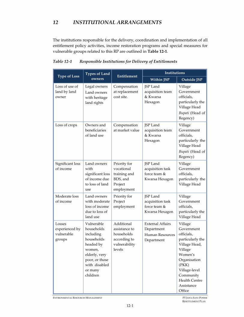
ENVIRONMENTAL RESOURCES MANAGEMENT PT JAWA SATU POWER
RESETTLEMENT PLAN
12-1
12 INSTITUTIONAL ARRANGEMENTS
The institutions responsible for the delivery, coordination and implementation of all
entitlement policy activities, income restoration programs and special measures for
vulnerable groups related to this RP are outlined in Table 12-1.
Table 12-1 Responsible Institutions for Delivery of Entitlements
Type of Loss Types of Land
owners Entitlement
Institutions
Within JSP Outside JSP
Loss of use of
land by land
owner
Legal owners
Land owners
with heritage
land rights
Compensation
at replacement
cost site.
JSP Land
acquisition team
& Kwarsa
Hexagon
Village
Government
officials,
particularly the
Village Head
Bupati (Head of
Regency)
Loss of crops Owners and
beneficiaries
of land use
Compensation
at market value
JSP Land
acquisition team
& Kwarsa
Hexagon
Village
Government
officials,
particularly the
Village Head
Bupati (Head of
Regency)
Significant loss
of income
Land owners
with
significant loss
of income due
to loss of land
use
Priority for
vocational
training and
BDS, and
Project
employment
JSP Land
acquisition task
force team &
Kwarsa Hexagon
Village
Government
officials,
particularly the
Village Head
Moderate loss
of income
Land owners
with moderate
loss of income
due to loss of
land use
Priority for
Project
employment
JSP Land
acquisition task
force team &
Kwarsa Hexagon
Village
Government
officials,
particularly the
Village Head
Losses
experienced by
vulnerable
groups
Vulnerable
households
including
households
headed by
women,
elderly, very
poor, or those
with disabled
or many
children
Additional
assistance to
households
according to
vulnerability
levels
External Affairs
Department
Human Resources
Department
Village
Government
officials,
particularly the
Village Head,
Village
Women’s
Organisation
(PKK)
Village-level
Community
Health Centre
Assistance
Office

ENVIRONMENTAL RESOURCES MANAGEMENT PT JAWA SATU POWER
RESETTLEMENT PLAN
12-2
Type of Loss Types of Land
owners Entitlement
Institutions
Within JSP Outside JSP
(Puskesmas
Pembantu)
Non-land
economic
displacement
Farmers at
risk of income
loss
Priority for
vocational
training or
Community
Development
Plan
Communications
Department
Human Resources
Department
Village
Government
officials,
particularly the
Village Head
Figure 12-1 illustrates the Project’s proposed overall roles and responsibilities for
implementing the RP.
During the compensation payment activities JSP’s land advisors will oversee the
process as illustrated in Figure 12-1, managing grievances and consulting on land
acquisition impacts as well as disclosing key information on the process. Once the
land acquisition payments along the transmission line right of way are compete and
all deeds have been handed over the responsibility of managing grievances,
consultation and disclosure of the LRP, monitoring etc. will sit with JSP who will
identify responsible personnel.

ENVIRONMENTAL RESOURCES MANAGEMENT PT JAVA SATU POWER
RESETTLEMENT PLAN
12-3
Figure 12-1 Organization Structure for Implementing the Land Acquisition & Resettlement Activities

ANNEXES

ANNEX 1:
DETAIL COMPARISON OF THE NJOP, MARKET PRICE, AND
THE RECEIVED COMPENSATION BY THE LAND OWNERS OF
THE TOWER FOOTINGS AND SUBSTATION

No. Tower/Land
Owner CodeLand Size (m2)
Selling Price
of Tax
Object
(Nilai Jual
Objek
Pajak )
[IDR/m2]
Market Price
(IDR/m2)
Formally Agreed
Price (written in the
price negotiation
agreement between
the land owner and
JSP) [IDR/m2]
Final Land Price
Received by Land
Owner (IDR/m2)
T-003 870 10,000 150,000 250,000 250,000
T-04C/TS2 1,600 10,000 150,000 250,000 250,000
T-05C/TS3 1,225 10,000 175,000 250,000 250,000
T-006C 870 10,000 150,000 250,000 250,000
T-007/TS4 1,156 10,000 75,000 250,000 250,000
T-008 784 10,000 75,000 250,000 250,000
T-009 784 10,000 75,000 250,000 250,000
T-010 784 10,000 75,000 250,000 250,000
T-011 784 10,000 75,000 250,000 250,000
T-012/TS5 1,156 10,000 75,000 250,000 250,000
T-013 784 7,150 75,000 140,000 140,000
T-014 784 7,150 60,000 140,000 140,000
T-015 784 7,150 60,000 140,000 140,000
T-016 784 7,150 60,000 140,000 140,000
T-017 784 7,150 60,000 140,000 140,000
T-018 784 7,150 60,000 140,000 140,000
T-019 784 7,150 60,000 140,000 140,000
T-020 784 7,150 60,000 140,000 140,000
T-021 784 7,150 60,000 140,000 140,000
T22/TS6 1,156 7,150 60,000 140,000 140,000
T-023 784 10,000 60,000 140,000 140,000
T-024 784 7,150 60,000 140,000 140,000
T-025C 870 7,150 60,000 140,000 140,000
T-026C 870 7,150 60,000 140,000 140,000
T-027C 870 7,150 80,000 130,000 130,000
T-028 784 7,150 80,000 130,000 130,000
T-029 784 7,150 80,000 130,000 130,000
T-030 784 7,150 80,000 130,000 130,000
T-031 784 7,150 80,000 130,000 130,000
T-032 1,156 7,150 80,000 130,000 130,000
T-033C 870 7,150 80,000 130,000 130,000
T-034 784 7,150 80,000 130,000 130,000
T-035 784 7,150 80,000 130,000 130,000
T-036 784 7,150 80,000 130,000 130,000
T-037 784 7,150 80,000 130,000 130,000
T-038C 870 7,150 80,000 130,000 130,000
T-039 870 7,150 80,000 130,000 130,000
T-040a 600 7,150 80,000 130,000 130,000
T-040b 184 7,150 80,000 130,000 130,000
T-041C 870 7,150 80,000 130,000 130,000
T-042C 1,156 20,000 92,000 130,000 130,000
T-043 784 7,150 60,000 130,000 130,000
T-044 784 7,150 60,000 130,000 130,000
T-045C/TS7 870 7,150 60,000 130,000 130,000
T-046 1,156 7,150 60,000 130,000 130,000
T-047C/TS9 1,225 7,150 60,000 130,000 130,000
T-048C 870 7,150 60,000 130,000 130,000
T-049C 870 7,150 60,000 130,000 130,000
T-050 1,156 7,150 60,000 130,000 130,000
T-051D 870 10,000 65,000 150,000 150,000
T-052 1,156 10,000 65,000 150,000 150,000
T-053C/TS12 1,156 10,000 65,000 150,000 150,000
T-054 784 10,000 65,000 150,000 150,000
T-055D/TS13 1,156 10,000 65,000 150,000 150,000
T-056 784 10,000 65,000 150,000 150,000
T-057C 870 27,000 65,000 150,000 150,000
T-058C/TS14 1,156 10,000 65,000 150,000 150,000
LIST OF LAND AND PRICE (TOWER FOOTING AREA)
Annex 1 DETAIL COMPARISON OF THE NJOP, MARKET PRICE, and FINAL COMPENSATION RECEIVED BY LAND
OWNERS IN TOWER FOOTINGS AND SUBSTATION BASED ON PLOTS

T-059C 870 10,000 65,000 150,000 150,000
T-060C 870 10,000 65,000 150,000 150,000
T-061C 1,521 10,000 65,000 150,000 150,000
T-062C 870 10,000 72,000 150,000 150,000
T-063 1,156 10,000 80,000 175,000 175,000
T-064 784 10,000 80,000 165,000 165,000
T-065 784 20,000 72,000 150,000 150,000
T-066 1,521 20,000 72,000 150,000 150,000
T-067 784 14,000 65,000 180,000 180,000
T-068 784 10,000 80,000 175,000 175,000
T-069 1,156 10,000 65,000 200,000 150,000
T-070 784 10,000 72,000 150,000 150,000
T-071 784 10,000 72,000 150,000 150,000
T-072 784 10,000 72,000 150,000 150,000
T-073.a 525 10,000 72,000 150,000 150,000
T-073.b 465 10,000 72,000 200,000 200,000
T-074 784 10,000 72,000 150,000 150,000
T-075 784 10,000 72,000 250,000 250,000
T-076 1,521 10,000 72,000 250,000 250,000
T-077D 784 10,000 72,000 250,000 250,000
T-078D 784 10,000 72,000 250,000 250,000
T-079 784 10,000 72,000 250,000 250,000
T-080D/TS21 1,156 10,000 90,000 250,000 250,000
T-081 1,156 10,000 90,000 300,000 300,000
T-082C/TS24 1,521 14,000 90,000 300,000 300,000
T-083C/TS25 1,156 10,000 90,000 300,000 300,000
T-084C 784 10,000 90,000 300,000 300,000
T-085C/TS26 1,156 10,000 90,000 400,000 400,000
T-086C 784 10,000 90,000 400,000 400,000
T-087 784 14,000 90,000 400,000 400,000
T-088C/TS27 1,521 14,000 120,000 400,000 400,000
T-089D/TS28 1,156 27,000 120,000 400,000 400,000
T-090D/TS29 1,156 27,000 120,000 400,000 400,000
T-091 1,156 27,000 400,000 1,000,000 1,000,000
T-092 1,200 27,000 120,000 375,000 375,000
T-093 2,000 64,000 200,000 500,000 500,000
T-094.a 321 64,000 100,000 125,000 125,000
T-094.b 193 64,000 100,000 125,000 125,000
T-094.c 270 64,000 100,000 125,000 125,000
T-095 1,521 36,000 120,000 250,000 250,000
T-096C/TS34 1,156 27,000 120,000 300,000 250,000
T-097 784 36,000 120,000 250,000 250,000
T-098D 1,487 64,000 120,000 192,000 192,000
T-099C/TS35 1,156 36,000 100,000 150,000 150,000
T-100D/TS36 1,156 36,000 100,000 150,000 150,000
T-101 784 36,000 100,000 150,000 150,000
T-102 1,000 36,000 100,000 250,000 250,000
T-103 1,600 20,000 150,000 250,000 250,000
T-104 784 36,000 120,000 250,000 250,000
T-105 1,521 20,000 120,000 250,000 250,000
T-106 784 20,000 120,000 250,000 250,000
T-107 1,156 48,000 120,000 325,000 325,000
T-108 784 48,000 120,000 250,000 250,000
T-109D 784 20,000 120,000 250,000 250,000
T-110 1,156 48,000 120,000 250,000 250,000
T-111 784 48,000 120,000 250,000 250,000
T-112 784 82,000 120,000 300,000 300,000
T-113 1,521 48,000 150,000 250,000 275,000
T-114 1,156 27,000 150,000 250,000 250,000
T-115 784 36,000 150,000 250,000 250,000
T-116 1,736 36,000 150,000 275,000 275,000
T-117 1,521 48,000 150,000 450,000 450,000
T-118 1,521 82,000 300,000 1,000,000 1,000,000
COUNT 120
SUM 115,671

No. Substation Land Owner/ Seller CodeLand Size
(m2)
Selling Price of Tax
Object (Nilai Jual
Objek Pajak )
[IDR/m2]
Market Price
(IDR/m2)
Formally Agreed
Price (written in the
price negotiation
agreement between
the land owner and
JSP) [IDR/m2]
Final Land Price Received
by Land Owner (IDR/m2)
S/S SS1 2,422 27,000 160,000 225,000 225,000
S/S SS2 13,185 82,000 160,000 250,000 225,000
S/S SS3 4,306 82,000 160,000 250,000 225,000
S/S SS4 5,792 82,000 160,000 250,000 225,000
S/S SS5 11,111 82,000 160,000 225,000 225,000
S/S SS6 7,644 82,000 160,000 225,000 225,000
S/S SS7 5,025 82,000 160,000 225,000 225,000
S/S SS8 11,000 82,000 160,000 225,000 225,000
S/S SS9 1,805 82,000 160,000 225,000 225,000
S/S SS10 8,973 82,000 160,000 225,000 225,000
S/S SS11 8,737 82,000 160,000 225,000 225,000
COUNT 11
SUM 80,000
LIST OF LAND AND PRICE (SUB STATION AREA)
ANNEX 2:
DETAIL LAND AND OTHER OBJECTS UNDER THE
CLEARANCE ZONE
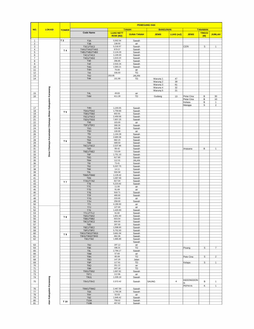
NO. LOKASI
Code Name
1 T 3 T3A 5,562.54 Sawah
2 T3B 138.00 air
3 T3C1/T3C2 5,218.97 Sawah CERI S 1
4 T4A1/T4A2/T4A3 879.37 Sawah
5 T4B1/T4B2/T4B3 2,124.29 Sawah
6 T4C1/T4C2 1,140.43 Sawah
7 T4D1/T4D2 1,610.24 Sawah
8 T4E 296.85 Sawah
9 T4F 2,532.24 Sawah
10 T4G 1,583.21 Sawah
11 T4H 75.00 air
12 T4I 336.00 TD
13 T4J 203.95 JALAN
14 T4K 101.99 TD Warung 1 47
Warung 2 39
Warung 3 61
Warung 4 32
Warung 5 21
15 T4L 49.83 air
16 T4M 411.28 TD Gudang 13 Petai Cina B 30
Petai Cina B 10
Kelapa B 1
Mangga S 2
17 T4N 1,193.05 Sawah
18 T5A1/T5A2 1,759.66 Sawah
19 T5B1/T5B2 602.91 Sawah
20 T5C1/T5C2 2,459.58 Sawah
21 T5D1/T5D2 7,857.25 Sawah
22 T5E 103.00 air
23 T5F1/T5F2 266.26 Sawah
24 T5G 326.98 Sawah
25 T5H 130.00 air
26 T5I 1,164.28 Sawah
27 T5J 2,683.36 Sawah
28 T6A 682.15 Sawah
29 T6B 589.50 Sawah
30 T6C1/T6C2 2,537.86 Sawah
31 T6D 89.42 Sawah Angsana B 1
32 T6E1/T6E2 723.09 Sawah
33 T6F 1,751.10 Sawah
34 T6G 617.80 Sawah
35 T6H 112.31 JALAN
36 T6I 73.41 Sawah
37 T6J 5,337.75 Sawah
38 T6K 14.11 Sawah
39 T6L 555.58 Sawah
40 T6M1/T6M2 1,126.42 Sawah
41 T6N 1,087.58 Sawah
42 T7A1/T7A2 817.04 Sawah
43 T7B 5,223.92 Sawah
44 T7C 11.00 air
45 T7D 91.68 air
46 T7E 918.71 Sawah
47 T7F 490.00 Sawah
48 T7G 220.00 air
49 T7H 258.00 Sawah
50 T7I 4,190.00 air
51 T7J 127.00 air
52 T7K 1,420.00 Sawah
53 T7L1/T7L2 61.82 Sawah
54 T8A1/T8A2 1,851.00 Sawah
55 T8B1/T8B2 603.54 Sawah
56 T8C1/T8C2 604.00 Sawah
57 T8D 297.00 Sawah
58 T8E1/T8E2 1,598.00 Sawah
59 T8F1/T8F2 5,752.00 Sawah
60 T9G1/T9G2/T9G3 3,661.54 Sawah
61 T9H1/T9H2/T9H3 462.36 Sawah
62 T9I1/T9I2 1,985.89 Sawah
Sawah
63 T9J 197.12 air
64 T9K 196.31 TD Pisang S 7
65 T9L 2,784.17 Sawah
66 T9M 57.60 air
67 T9N 85.09 TD Pete Cina S 2
68 T9O 147.29 Jalan
69 T9P 117.91 TD Kelapa S 1
70 T9Q 251.22 air
71 T9R 207.18 TD
72 T9S1/T9S2 1,667.81 Sawah
73 T9T1 112.96 air
74 T9U1 1,335.19 Sawah
75 T9V1/T9V2 2,372.42 Sawah SAUNG 4KEDONGDON
G B 1
PEPAYA K 1
76 T9W1/T9W2 2,467.59 Sawah
77 T9X 1,793.28 Sawah
78 T9Y 52.03 air
79 T9Z 1,946.42 Sawah
80 T10A 758.02 Sawah
81 T10B 457.62 Sawah
TANAH
T 5
T 6
T 7
TOWER
PEMEGANG HAK
JENISTINGGI
(M)JUMLAH
LUAS NETT
ROW (M2)LUAS (m2)GUNA TANAH JENIS
BANGUNAN TANAMAN
De
sa
Su
ka
tan
i K
ec
am
ata
n C
ila
ma
ya
We
tan
Ka
bu
pa
ten
Ka
raw
an
g
T 8
T 9
T 10
De
sa
Cil
am
ay
a K
ec
am
ata
n C
ila
ma
ya
We
tan
Ka
bu
pa
ten
Ka
raw
an
g
T 4
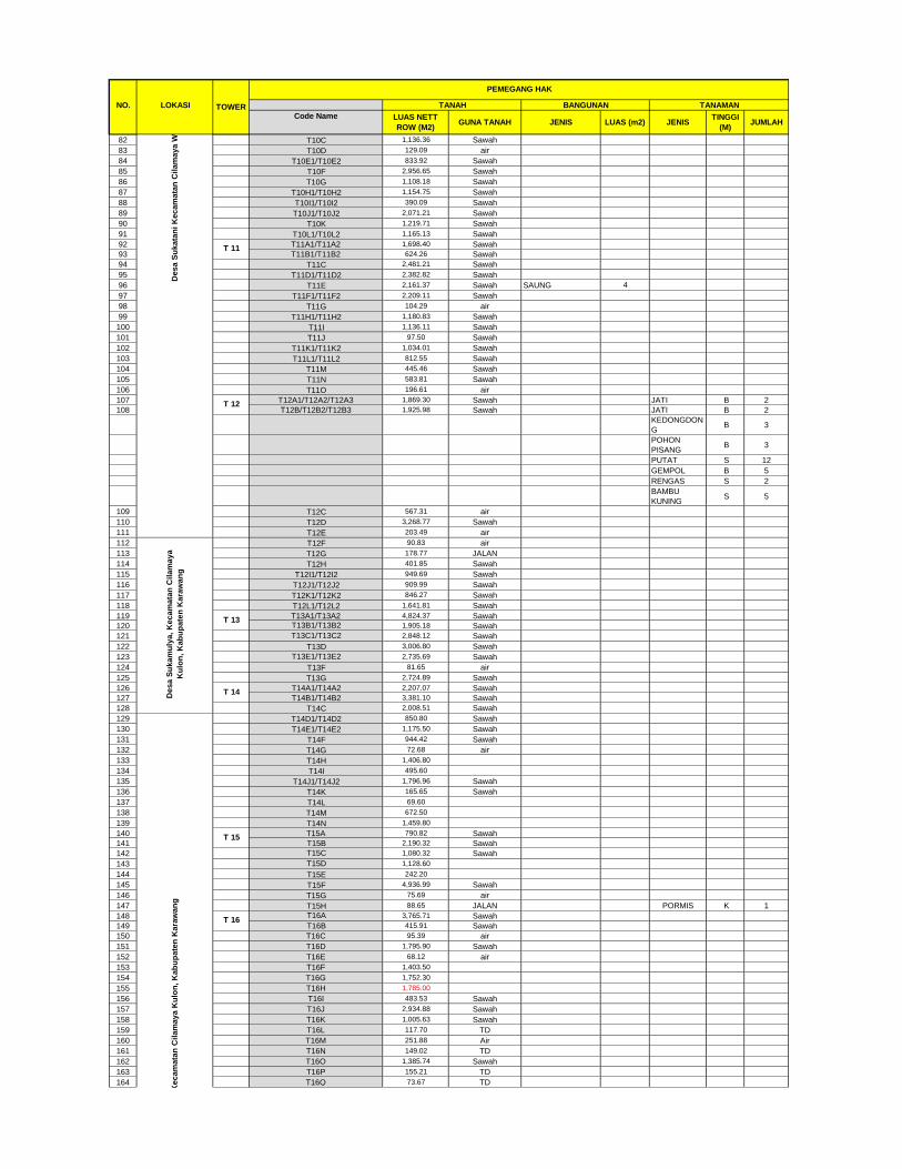
NO. LOKASI
Code Name
TANAHTOWER
PEMEGANG HAK
JENISTINGGI
(M)JUMLAH
LUAS NETT
ROW (M2)LUAS (m2)GUNA TANAH JENIS
BANGUNAN TANAMAN
82 T10C 1,136.36 Sawah
83 T10D 129.09 air
84 T10E1/T10E2 833.92 Sawah
85 T10F 2,956.65 Sawah
86 T10G 1,108.18 Sawah
87 T10H1/T10H2 1,154.75 Sawah
88 T10I1/T10I2 390.09 Sawah
89 T10J1/T10J2 2,071.21 Sawah
90 T10K 1,219.71 Sawah
91 T10L1/T10L2 1,165.13 Sawah
92 T11A1/T11A2 1,698.40 Sawah
93 T11B1/T11B2 624.26 Sawah
94 T11C 2,481.21 Sawah
95 T11D1/T11D2 2,382.82 Sawah
96 T11E 2,161.37 Sawah SAUNG 4
97 T11F1/T11F2 2,209.11 Sawah
98 T11G 104.29 air
99 T11H1/T11H2 1,180.83 Sawah
100 T11I 1,136.11 Sawah
101 T11J 97.50 Sawah
102 T11K1/T11K2 1,034.01 Sawah
103 T11L1/T11L2 812.55 Sawah
104 T11M 445.46 Sawah
105 T11N 583.81 Sawah
106 T11O 196.61 air
107 T12A1/T12A2/T12A3 1,869.30 Sawah JATI B 2
108 T12B/T12B2/T12B3 1,925.98 Sawah JATI B 2
KEDONGDON
G B 3
POHON
PISANG B 3
PUTAT S 12
GEMPOL B 5
RENGAS S 2
BAMBU
KUNING S 5
109 T12C 567.31 air
110 T12D 3,268.77 Sawah
111 T12E 203.49 air
112 T12F 90.83 air
113 T12G 178.77 JALAN
114 T12H 401.85 Sawah
115 T12I1/T12I2 949.69 Sawah
116 T12J1/T12J2 909.99 Sawah
117 T12K1/T12K2 846.27 Sawah
118 T12L1/T12L2 1,641.81 Sawah
119 T13A1/T13A2 4,824.37 Sawah
120 T13B1/T13B2 1,905.18 Sawah
121 T13C1/T13C2 2,848.12 Sawah
122 T13D 3,006.80 Sawah
123 T13E1/T13E2 2,735.69 Sawah
124 T13F 81.65 air
125 T13G 2,724.89 Sawah
126 T14A1/T14A2 2,207.07 Sawah
127 T14B1/T14B2 3,381.10 Sawah
128 T14C 2,008.51 Sawah
129 T14D1/T14D2 850.80 Sawah
130 T14E1/T14E2 1,175.50 Sawah
131 T14F 944.42 Sawah
132 T14G 72.68 air
133 T14H 1,406.80
134 T14I 495.60
135 T14J1/T14J2 1,796.96 Sawah
136 T14K 165.65 Sawah
137 T14L 69.60
138 T14M 672.50
139 T14N 1,459.80
140 T15A 790.82 Sawah
141 T15B 2,190.32 Sawah
142 T15C 1,080.32 Sawah
143 T15D 1,128.60
144 T15E 242.20
145 T15F 4,936.99 Sawah
146 T15G 75.69 air
147 T15H 88.65 JALAN PORMIS K 1
148 T16A 3,765.71 Sawah
149 T16B 415.91 Sawah
150 T16C 95.39 air
151 T16D 1,795.90 Sawah
152 T16E 68.12 air
153 T16F 1,403.50
154 T16G 1,752.30
155 T16H 1,785.00
156 T16I 483.53 Sawah
157 T16J 2,934.88 Sawah
158 T16K 1,005.63 Sawah
159 T16L 117.70 TD
160 T16M 251.88 Air
161 T16N 149.02 TD
162 T16O 1,385.74 Sawah
163 T16P 155.21 TD
164 T16Q 73.67 TD
De
sa
Su
ka
mu
lya
, K
ec
am
ata
n C
ila
ma
ya
Ku
lon
, K
ab
up
ate
n K
ara
wan
g
T 13
T 14
De
sa
Pa
sir
uk
em
, K
ec
am
ata
n C
ila
ma
ya
Ku
lon
, K
ab
up
ate
n K
ara
wa
ng
T 15
T 16
De
sa
Su
ka
tan
i K
ec
am
ata
n C
ila
ma
ya
We
tan
Ka
bu
pa
ten
Ka
raw
an
g
T 11
T 12
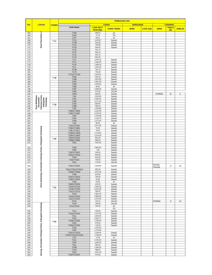
NO. LOKASI
Code Name
TANAHTOWER
PEMEGANG HAK
JENISTINGGI
(M)JUMLAH
LUAS NETT
ROW (M2)LUAS (m2)GUNA TANAH JENIS
BANGUNAN TANAMAN
165 T16R 296.21 air
166 T16S 71.76 TD
167 T16T 85.51 air
168 T17A 1,145.47 Sawah
169 T17B 542.05 Sawah
170 T17C 756.85 Sawah
171 T17D 946.93 Sawah
172 T17E 545.70
173 T17F 566.10
174 T17G 933.70
175 T17H 992.00
176 T17I 1,479.22 Sawah
177 T17J 1,540.00 Sawah
178 T17K 1,486.10 Sawah
179 T17L 1,493.40 Sawah
180 T17M 761.70 Sawah
181 T17N 759.30 Sawah
182 T17O1/T17O2 1,430.61 Sawah
183 T18A 664.18 Sawah
184 T18B 1,813.00 Sawah
185 T18C 1,947.00 Sawah
186 T18D 1,935.00 Sawah
187 T18E 66.00 air
188 T18F 2,460.00 Sawah
189 T18G 575.00 JALAN
190 T18H 859.00 Sawah PORMIS B 5
191 T18I 1,925.00 Sawah
192 T18J 3,460.00 Sawah
193 T18K 2,711.00 Sawah
194 T19A 600.00 Sawah
195 T19B 483.53 Sawah
196 T19C 1,428.88 Sawah
197 T19D1/T19D2 1,210.95 Sawah
198 T19E1/T19E2 2,279.52 Sawah
199 T19F 1,220.88 Sawah
200 T19G 1,126.79 Sawah
201 T19H 1,117.00 Sawah
202 T19I 80.00 air
203 T19J1/T19J2 4,471.00 Sawah
204 T19K1/T19K2 75.00 Sawah
205 T19L1/T19L2 75.00 Sawah
206 T19M1/T19M2 1,740.00 Sawah
207 T19N1/T19N2 2,414.00 Sawah
208 T20A1/T20A2 651.00 Sawah
209 T20B1/T20B2 926.00 Sawah
210 T20C 7,632.00 Sawah
Sawah
211 T20D 2,685.00 Sawah
212 T20E 7.00 Sawah
213 T20F1/T20F2 549.00 Sawah
214 T20G1/T20G2 848.00 Sawah
215 T20H 818.00 Sawah
216 T20I1/T20I2 729.00 Sawah
217 T20J 178.00 JALAN
218 T20K1/T20K2 1,109.00 SawahKacang
Panjang S 10
219 T20L1/T20L2/T20L3 892.00 Sawah
220 T20M1/T20M2 1,373.00 Sawah
221 T20N 643.00 Sawah
222 T20O1/T20O2 790.00 Sawah
223 T20P1/T20P2 43.00 Sawah
224 T20Q 54.00 air
225 T20R1/T20R2 420.00 Sawah
226 T21A1/T21A2 1,063.03 Sawah
227 T21B1/T21B2 3,242.00 Sawah
228 T21C1/T21C2 390.00 Sawah
229 T21D 1,801.00 Sawah
230 T21E1/T21E2 2,890.00 Sawah
231 T21F1/T21F2 1,076.32 Sawah
232 T21G 125.31 JALAN PORMIS S 15
233 T21H 298.00 JALAN
234 T21I1/T21I2 136.00 air
TD
235 T21J 334.00 Sawah
236 T21K1/T21K2 1,274.00 Sawah
237 T21L 1,503.00 Sawah
238 T22A 2,322.77 Sawah
239 T22B1/T22B2 1,435.00 Sawah
240 T22C 476.00 Sawah
241 T22D1/T22D2 115.00 Sawah
242 T22E 1,313.00
243 T22F 1,279.00
244 T22G1/T22G2 1,109.00 Sawah
245 T22H1/T22H2/T22H3 1,768.00 Sawah
246 T22I 71.00 air
247 T22J 2,755.00 Sawah
248 T22K 1,082.00 Sawah
249 T22L 896.00 Sawah
250 T22M 1,060.00 Sawah
251 T22N 986.00 Sawah
252 T22O 1,531.00 Sawah
253 T22P1/T22P2 578.00 Sawah
De
sa
Te
ga
luru
ng
, K
ec
am
ata
n C
ila
ma
ya
Ku
lon
, K
ab
up
ate
n K
ara
wa
ng
T 22
De
sa
Mu
kti
jay
a,
Ke
ca
ma
tan
Cil
am
ay
a K
ulo
n,
Ka
bu
pa
ten
Ka
raw
an
g
T 19
De
sa
Su
ka
mu
lya
, K
ec
am
ata
n C
ila
ma
ya
Ku
lon
, K
ab
up
ate
n K
ara
wa
ng
T 20
T 21
De
sa
Pa
sir
uk
em
, K
ec
am
ata
n C
ila
ma
ya
Ku
lon
, K
ab
up
ate
n K
ara
wa
ng
T 17
T 18

NO. LOKASI
Code Name
TANAHTOWER
PEMEGANG HAK
JENISTINGGI
(M)JUMLAH
LUAS NETT
ROW (M2)LUAS (m2)GUNA TANAH JENIS
BANGUNAN TANAMAN
254 T23A 1,974.00 Sawah
255 T23B 563.00 Sawah
256 T23C 12.87 Sawah
257 T23D 37.90 air
258 T23E 4,527.90 Sawah
259 T23F1/T23F2 408.90 Sawah
260 T23G 56.60 air
261 T23H 108.86 JALAN
262 T23I1/T23I2 53.00 Sawah
263 T23J1/T23J2 2,500.00 Sawah
264 T23K1/T23K2 2,253.00 Sawah
265 T23L1/T23L2 936.00 Sawah
266 T23M 744.00 Sawah
267 T24A1/T24A2 5,239.00 Sawah
268 T24B1/T24B2 547.65 Sawah
269 T24C1/T24C2 2,153.51 Sawah
270 T24D1/T24D2 1,043.96 Sawah
271 T24E 1,427.42 Sawah
272 T24F1/T24F2 5,550.23 Sawah
273 T24G 207.00 TD PISANG B 4
274 T24H 166.00 air
275 T24I 127.00 TD PISANG B 8
276 T24J1/T24J2 1,607.00 Sawah
277 T24K 122.00 air
278 T24L1/T24L2 585.00 Sawah
279 T24M1/T24M2 2,246.00 Sawah
280 T24N 591.00 Sawah
281 T25A 1,198.00 Sawah
282 T25B 707.30 Sawah
283 T25C 1,371.00
284 T25D 695.32
285 T25E 74.50 air
286 T25F1/T25F2 2,240.15 Sawah
287 T25G1/T25G2 2,896.03 Sawah
288 T25H1/T25H2 546.90 Sawah
289 T25I1/T25I2 2,667.89 Sawah
290 T25J 76.30 air
291 T25K1/T25K2 252.20 Sawah
292 T25L 2,132.89 Sawah
293 T25M1/T25M2 980.86 Sawah
294 T26A 747.08 Sawah
295 T26B 1,622.71 Sawah
296 T26C 2,518.49 Sawah
297 T26D 180.00 Sawah
298 T26E1/T26E2 1,813.07 Sawah
299 T26F1/T26F2 1,786.52 Sawah
300 T26G 2,808.70 Sawah
301 T26H 84.70 air
302 T26I1/T26I2 2,957.27 Sawah
303 T26J 105.72 Sawah
304 T26K 187.53 air
305 T26L 101.17 TD
306 T27A 706.30 Sawah
307 T27B 1,389.86 Sawah
308 T27C 833.97 Sawah
309 T27D 335.17 JALAN
310 T27E 646.58 Sawah
311 T27F1/T27F2 3,005.00 Sawah
312 T27G 1,706.49 Sawah
313 T27H1/T27H2 1,660.90 Sawah
314 T27I1/T27I2 1,360.00 Sawah
315 T27J1/T27J2 2,149.36 Sawah
316 T27K1/T27K2 2,235.37 Sawah
317 T28A 773.68 Sawah
318 T28B 2,354.00 Sawah
319 T28C 1,039.00 Sawah
320 T28D 495.00 air
321 T28E 1,836.00 Sawah
322 T28F 3,415.00
323 T28G 3,400.00
324 T28H1/T28H2 66.00 Sawah
325 T28I 69.00 air
326 T28J1/T28J2 1,941.00 Sawah
327 T28K 1,592.00 Sawah
328 T29A 550.00 Sawah
329 T29B 1,586.00 Sawah
330 T29C 49.00 air
331 T29D 4,309.00 Sawah SAUNG 4
332 T29E 4,155.00 Sawah
333 T29F 49.00 air
334 T29G1/T29G2 278.00 Sawah
335 T30A 497.00 Sawah
336 T30B 146.00 Sawah
337 T30C 2,381.89 Sawah
338 T30D 2,736.68 Sawah
339 T30E 243.58 Sawah
340 T30F 40.38 Sawah
341 T30G 90.40 air PISANG B 2
CERI S 1
342 T30H 1,120.93 Sawah
343 T30I1/T30I2 623.40 Sawah
De
sa
Pu
rwa
jay
a,
Ke
ca
ma
tan
Te
mp
ura
n,
Ka
bu
pa
ten
Ka
raw
an
g
De
sa
Su
mu
rge
de
, K
ec
am
ata
n C
ila
ma
ya
Ku
lon
, K
ab
up
ate
n K
ara
wa
ng
T 25
T 26
De
sa
Ja
ya
ne
ga
ra,
Ke
ca
ma
tan
Te
mp
ura
n,
Ka
bu
pa
ten
Ka
raw
an
g
T 27
T 28
T 29
T 30
De
sa
Te
ga
luru
ng
, K
ec
am
ata
n C
ila
ma
ya
Ku
lon
, K
ab
up
ate
n K
ara
wa
ng
T 23
De
sa
Ma
ng
gu
ng
jay
a,
Ke
ca
ma
tan
Cil
am
ay
a
Ku
lon
, K
ab
up
ate
n K
ara
wan
g
T 24

NO. LOKASI
Code Name
TANAHTOWER
PEMEGANG HAK
JENISTINGGI
(M)JUMLAH
LUAS NETT
ROW (M2)LUAS (m2)GUNA TANAH JENIS
BANGUNAN TANAMAN
344 T30J1/T30J2 353.32 Sawah
345 T30K1/T30K2 507.87 Sawah
346 T30L 384.00 Sawah
347 T30M1/T30M2/T30M3 1,155.89 Sawah
348 T30N 2,443.79 Sawah
349 T30O 283.29 JALAN AKASIA B 1
350 T30P1/T30P2 305.47 Sawah
351 T31A 2,425.78 Sawah
352 T31B 945.89 Sawah
353 T31C1/T31C2 44.48 Sawah
354 T31D 1,161.59 Sawah
355 T31E 1,914.77 Sawah
356 T31F 889.38 Sawah
357 T31G1/T31G2 1,557.83 Sawah
358 T31H 395.04 air
359 T31I1/T31I2 7,175.42 Sawah
360 T32A 785.48 Sawah
361 T32B 2,493.55 Sawah
362 T32C 178.15 air
363 T32D 646.48 Sawah
364 T32E 373.24 Sawah
365 T32F1/T32F2 243.60 Sawah
366 T32G 3,876.93 Sawah
367 T32H 106.35 JALAN
368 T32I 3,138.27 Sawah
369 T32J 499.87 Sawah CERI B 4
370 T32K 648.22 Sawah
371 T32L 99.29 air
372 T32M1/T32M2 2,503.06 Sawah
373 T32N 418.59 air
374 T33A 3,211.44 Sawah PISANG S 1
375 T33B 567.75 Sawah PISANG S 1
376 T33C 820.69 Sawah SEPAT B 10
377 T33D 2,641.15 Sawah
378 T33E 1,387.08
379 T33F 1,207.20
380 T33G 1,007.51 Sawah
381 T33H1/T33H2 515.12 Sawah
382 T33I 1,421.43 air
383 T34A 1,498.70 Sawah
384 T34B 1,758.22 Sawah
385 T34C 2,469.72 Sawah
386 T34D 117.03 air
387 T34E 206.08 JALAN
388 T34F 797.08 TD PORNIS B 20
PISANG B 10
389 T34G 909.08 air
390 T34H 324.34 TD
391 T34I 925.19 TD BAMBU B 20
ALBASAH B 1
KELAPA B 1
NANGKA B 2
PISANG B 5
392 T34J1/T34J2 6,264.42 Sawah
393 T34K1/T34K2 2,242.62 Sawah
394 T34L 890.04 Sawah
395 T35A 13.98 Sawah
396 T35B 2,089.78 Sawah
397 T35C 468.63 Sawah
398 T35D 219.39 Sawah
399 T35E 5.28 Sawah
400 T35F 39.88 air
401 T35G 5,087.51 Sawah
402 T35H 2,830.47 Sawah
403 T35I 62.73 air
404 T35J 60.17 JALAN
405 T35K 3,344.80 Sawah
406 T36A 521.10 Sawah
407 T36B 861.10 Sawah
408 T36C1/T36C2 96.30 Sawah
409 T36D 104.15 air
410 T36E1/T36E2 3,318.72 Sawah
411 T36F 134.17 air
412 T36G 4,841.60 Sawah
413 T36H 74.86 air
414 T36I 58.46 JALAN
415 T36J 2,720.33 Sawah
Sawah
416 T36K 840.05 Sawah
417 T36L 374.99 Sawah SAUNG 4
418 T36M 156.19 air
419 T37A 630.53 Sawah
420 T37B 648.21 Sawah
421 T37C 2,535.76 Sawah
422 T37D 277.96 Sawah
423 T37E 798.80 air
424 T37F 231.00 Sawah
425 T37G 6.47 Sawah
426 T37H 227.18 Sawah
427 T37I1/T37I2 1,454.97 Sawah
428 T37J 191.35 air
429 T37K 6,632.89 Sawah
De
sa
Pa
ga
du
ng
an
, K
ec
am
ata
n T
em
pu
ran
, K
ab
up
ate
n K
ara
wa
ng
T 35
T 36
T 37
De
sa
Pu
rwa
jay
a,
Ke
ca
ma
tan
Te
mp
ura
n,
Ka
bu
pa
ten
Ka
raw
an
g
T 31
T 32
T 33
T 34

NO. LOKASI
Code Name
TANAHTOWER
PEMEGANG HAK
JENISTINGGI
(M)JUMLAH
LUAS NETT
ROW (M2)LUAS (m2)GUNA TANAH JENIS
BANGUNAN TANAMAN
430 T37L1/T37L2/T37L3 1,106.07 Sawah
431 T37M 195.91 Sawah
432 T37N 70.88 air
433 T38A 3,295.90 Sawah
434 T38B 770.83 Sawah
435 T38C 62.35 air
436 T38D 385.07 Sawah
437 T38E1/T38E2 2,895.96 Sawah
438 T38F 2,261.63 Sawah
439 T38G 65.78 air
440 T38H 1,108.00
441 T38I 1,055.60
442 T38J 5,215.33 Sawah PISANG B 3
443 T39A 1,063.00 Sawah
444 T39B 407.00 Sawah
445 T39C 2,170.54 Sawah
446 T39D1/T39D2/T39D3 1,031.00
447 T39E1/T39E2 1,388.00
448 T39F 1,263.57 Sawah
449 T39G 101.22 air
450 T39H1/T39H2 632.99 Sawah
451 T39I 5,953.48 Sawah
452 T39J 1,354.88 Sawah SERI B 1
ANGSANA S 1
453 T39L 1,914.64
454 T40A 781.81 Sawah
455 T40B 51.79 Sawah
456 T40C 111.67 Sawah
Sawah
457 T40D 168.21 air
458 T40E 399.56 Sawah
459 T40F1/T40F2 4,038.20 Sawah
460 T40G1/T40G2 1,916.87 Sawah
461 T40H 79.75 Sawah
462 T40I 217.20 air
463 T40J 337.94 Sawah
464 T40K 337.94 JALAN ANGSANA B 3
KELAPA B 2
465 T40L 416.44 air
466 T40M 391.69 TD
467 T40N1/T40N2 135.38 Sawah
468 T40O1/T40O2 51.12 Sawah
469 T41A 3,230.12 Sawah
470 T41B 3,285.25 Sawah
471 T41C1/T41C2 1,883.54 Sawah
472 T41D1/T41D2 7,973.22 Sawah SAUNG 4
473 T41E 2,583.24 Sawah
474 T42A 590.39 Sawah
475 T42B 559.66 Sawah
476 T42C 1,136.43 Sawah
477 T42D1/T42D2 940.63 Sawah
478 T42E 1,254.09 Sawah
479 T42F1/T42F2 815.00 Sawah
Sawah
480 T42G 96.08 air
481 T42H 4,139.02 Sawah
482 T42I 1,346.76 Sawah
483 T42J1/T42J2 45.29 Sawah
484 T42K 2,302.99 Sawah
485 T42L1/T42L2 3,171.43 Sawah
486 T42M 2,848.42 Sawah
487 T42N 56.17 air PORNIS B 3
488 T42O 374.17 air
489 T42P 43.83 Sawah
490 T43A 423.01 Sawah SAUNG 3
491 T43B 52.76 Sawah
492 T43C 4,037.99 Sawah
493 T43D 2,576.58 Sawah
494 T43E 82.30 air
495 T43F1/T43F2 2,537.81 Sawah
496 T43G 432.79 Sawah
497 T43H 2,711.91 Sawah
498 T44A 588.35 Sawah
499 T44B 2,075.12 Sawah
500 T44C 355.32 Sawah
501 T44D 75.05 air
502 T44E 583.66 JALAN
503 T44F 611.00 air
504 T44G 296.87 TD Rumah H.Amah 117
Warung 46
505 T44H 48.14 air
506 T44I1/T44I2 2,167.50 Sawah
507 T44J 1,450.28 Sawah
508 T44K1/T44K2 Sawah SERI B 1
509 T44L1/T44L2 1,214.00
510 T44M1/T44M2 1,214.00
511 T44N1/T44N2 1,105.00
512 T44O1/T44O2 976.00
513 T44P1/T44P2 1,022.00
514 T45A 639.63 Sawah
515 T45B 496.10 Sawah
De
sa
Le
ma
hk
ary
a,
Ke
ca
ma
tan
Te
mp
ura
n,
Ka
bu
pa
ten
Ka
raw
an
g T 45
De
sa
Ta
nju
ng
jay
a,
Ke
ca
ma
tan
Te
mp
ura
n,
Ka
bu
pa
ten
Ka
raw
an
g
T 43
T 44
De
sa
Pa
nc
ak
ary
a,
Ke
ca
ma
tan
Te
mp
ura
n,
Ka
bu
pa
ten
Ka
raw
an
g
T 39
T 40
T 41
T 42
De
sa
Pa
ga
du
ng
an
, K
ec
am
ata
n T
em
pu
ran
, K
ab
up
ate
n K
ara
wa
ng
T 38
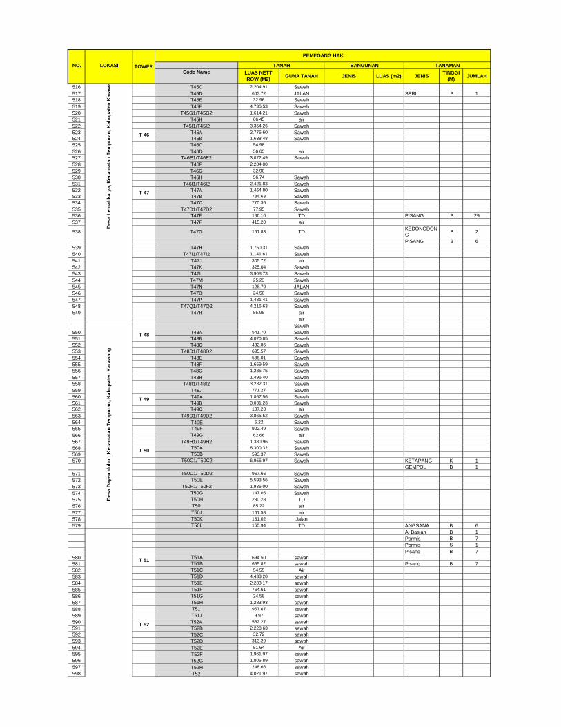
NO. LOKASI
Code Name
TANAHTOWER
PEMEGANG HAK
JENISTINGGI
(M)JUMLAH
LUAS NETT
ROW (M2)LUAS (m2)GUNA TANAH JENIS
BANGUNAN TANAMAN
516 T45C 2,204.91 Sawah
517 T45D 603.72 JALAN SERI B 1
518 T45E 32.96 Sawah
519 T45F 4,735.53 Sawah
520 T45G1/T45G2 1,614.21 Sawah
521 T45H 66.45 air
522 T45I1/T45I2 3,354.26 Sawah
523 T46A 2,776.60 Sawah
524 T46B 1,638.48 Sawah
525 T46C 54.98
526 T46D 56.65 air
527 T46E1/T46E2 3,072.49 Sawah
528 T46F 2,204.00
529 T46G 32.90
530 T46H 56.74 Sawah
531 T46I1/T46I2 2,421.83 Sawah
532 T47A 1,464.80 Sawah
533 T47B 784.63 Sawah
534 T47C 770.36 Sawah
535 T47D1/T47D2 77.95 Sawah
536 T47E 186.10 TD PISANG B 29
537 T47F 415.20 air
538 T47G 151.83 TDKEDONGDON
G B 2
PISANG B 6
539 T47H 1,750.31 Sawah
540 T47I1/T47I2 1,141.61 Sawah
541 T47J 305.72 air
542 T47K 325.04 Sawah
543 T47L 3,908.73 Sawah
544 T47M 25.23 Sawah
545 T47N 128.70 JALAN
546 T47O 24.50 Sawah
547 T47P 1,481.41 Sawah
548 T47Q1/T47Q2 4,216.63 Sawah
549 T47R 85.95 air
air
Sawah
550 T48A 541.70 Sawah
551 T48B 4,070.85 Sawah
552 T48C 432.86 Sawah
553 T48D1/T48D2 695.57 Sawah
554 T48E 588.01 Sawah
555 T48F 1,659.59 Sawah
556 T48G 1,285.75 Sawah
557 T48H 1,496.40 Sawah
558 T48I1/T48I2 3,232.31 Sawah
559 T48J 771.27 Sawah
560 T49A 1,867.56 Sawah
561 T49B 3,031.23 Sawah
562 T49C 107.23 air
563 T49D1/T49D2 3,865.52 Sawah
564 T49E 5.22 Sawah
565 T49F 922.49 Sawah
566 T49G 62.66 air
567 T49H1/T49H2 1,380.96 Sawah
568 T50A 6,300.32 Sawah
569 T50B 593.37 Sawah
570 T50C1/T50C2 6,955.97 Sawah KETAPANG K 1
GEMPOL B 1
571 T50D1/T50D2 967.66 Sawah
572 T50E 5,593.56 Sawah
573 T50F1/T50F2 1,936.00 Sawah
574 T50G 147.05 Sawah
575 T50H 230.28 TD
576 T50I 85.22 air
577 T50J 161.58 air
578 T50K 131.02 Jalan
579 T50L 155.94 TD ANGSANA B 6
Al Basiah B 1
Pormis B 7
Pormis S 1
Pisang B 7
580 T51A 694.50 sawah
581 T51B 665.82 sawah Pisang B 7
582 T51C 54.55 Air
583 T51D 4,433.20 sawah
584 T51E 2,283.17 sawah
585 T51F 764.61 sawah
586 T51G 24.58 sawah
587 T51H 1,283.93 sawah
588 T51I 957.67 sawah
589 T51J 9.97 sawah
590 T52A 562.27 sawah
591 T52B 2,228.63 sawah
592 T52C 32.72 sawah
593 T52D 313.29 sawah
594 T52E 51.64 Air
595 T52F 1,961.97 sawah
596 T52G 1,805.89 sawah
597 T52H 248.66 sawah
598 T52I 4,021.97 sawah
T 50
T 51
T 52
De
sa
Da
ye
uh
luh
ur,
Ke
ca
ma
tan
Te
mp
ura
n,
Ka
bu
pa
ten
Ka
raw
an
g
T 48
T 49
De
sa
Le
ma
hk
ary
a,
Ke
ca
ma
tan
Te
mp
ura
n,
Ka
bu
pa
ten
Ka
raw
an
g
T 46
T 47

NO. LOKASI
Code Name
TANAHTOWER
PEMEGANG HAK
JENISTINGGI
(M)JUMLAH
LUAS NETT
ROW (M2)LUAS (m2)GUNA TANAH JENIS
BANGUNAN TANAMAN
599 T53A 1,264.59 sawah
600 T53B 969.64 sawah
601 T53C 689.07 sawah
602 T53D 68.63 sawah
603 T53E 2,210.72 sawah
604 T53F 1,472.77 sawah
605 T53G 371.30 sawah
606 T53H 265.00 Air
607 T53I 264.93 Air Al Basiah B 4
Gebang B 1
608 T53J 501.77 sawah
609 T53K 1,990.26 sawah
610 T53L 58.49 Air
611 T53M 7,347.10 sawah
612 T54A 707.62 sawah
613 T54B 3,094.55 Batu Kali
614 T54C 316.15 sawah
615 T54D 31.60 sawah
616 T54E 694.57 sawah
617 T54F 6,611.16 sawah
618 T54G 981.27 sawah
619 T54H 9.72 sawah
620 T55A 672.92 sawah
621 T55B 857.31 sawah
622 T55C1/T55C2 1,406.53 sawah
623 T55D 2.48 sawah
624 T55E 1,633.91 sawah
625 T55F 1,580.33 sawah
626 T55G 1,420.15 sawah
627 T55H 1,621.88 sawah
628 T55I 1,451.62 sawah
629 T56A 772.75 sawah
630 T56B 607.21 sawah
631 T56C 1,237.37 sawah
632 T56D 1,499.59 sawah
633 T56E1/T56E2 1,894.92
634 T56F 1,325.97
635 T56G 89.63 sawah
636 T56H 305.79 sawah
637 T56I 319.78 Beton Bertulang
638 T56J 433.17 Air
639 T56K 493.69 Tanah Darat
640 T57A 5,035.52 sawah
641 T57B 2,181.84 sawah Kelapa B 1
Ceri B 1
642 T57C 270.22 sawah
643 T57D 2,381.43 sawah
644 T57E 93.25 sawah
645 T57F 1,279.80 sawah
646 T57G1/T57G2 135.51 Air
647 T57H 4,038.22 sawah
648 T57I 89.52 sawah
649 T57J 741.65 sawah
650 T57K 1,521.82 sawah
651 T57L 1,346.06 sawah
652 T57M 29.27 sawah
653 T57N1/T57N2 182.52 Air
654 T58A 874.23 sawah
655 T58B 1,399.46 sawah
656 T58C 3,050.43 sawah
657 T58D 300.98 sawah
658 T58E 138.16
659 T58F 1,487.57 sawah
660 T58G 3,062.30 sawah
661 T58H 14.41 sawah
662 T58I 571.71 sawah
663 T58J 1,722.26 sawah
664 T58K 1,306.46 sawah
665 T58L 843.56 sawah
666 T58M 20.25 sawah
667 T58N 1,581.67 sawah
668 T58O 322.32 sawah
669 T58P1/T58P2 288.99 Beton Bertulang
670 T59A 829.84 sawah
671 T59B 1,106.92 sawah
672 T59C 16.05 sawah
673 T59D 1,244.34 sawah
674 T59E 2,452.60 sawah
675 T59F 2,712.26 sawah
676 T59G 482.89 sawah
677 T59H 3,940.92 sawah
678 T59I 1,245.35 sawah
679 T59J1/T59J2 106.34 sawah
680 T59K 593.09 sawah
681 T60A 605.79 sawah
682 T60B 832.54 sawah
683T60C
472.38Air dan Tanah
Darat Pisang B
4
Randu B 3
684 T60D 278.49 sawah Gebang B 14
Pisang B 12
685 T60E 718.11 Tanah Darat Randu B 15
T 59
T60
D
e
s
a
S
u
k
a
r
a
t
u
T 54
De
sa
Sin
da
ng
sa
ri,
Ke
ca
ma
tan
Ku
taw
alu
ya
, K
ab
up
ate
n K
ara
wa
ng
T 55
T 56
T 57
T 58
T 53

NO. LOKASI
Code Name
TANAHTOWER
PEMEGANG HAK
JENISTINGGI
(M)JUMLAH
LUAS NETT
ROW (M2)LUAS (m2)GUNA TANAH JENIS
BANGUNAN TANAMAN
Pisang B 6
686 T60F 1,138.93 Air
687 T60G 58.36 sawah
688 T60H 1,805.35 sawah
689 T60I 2,458.11 sawah
690 T60J 85.51 sawah
691 T60K 2,079.36 sawah
692 T60L 159.12 sawah
693 T60M 529.73 sawah
694 T60N 369.36 beton
695 T60O 1,158.75 sawah
696 T60P 1,400.73 sawah
697 T60Q 294.64 sawah
698 T60R 947.13 sawah
699 T60S 363.51 sawah
700 T60T 212.75 sawah
701 T61A 693.87 sawah
702 T61B 1,262.12 sawah
703 T61C 300.70 sawah
704 T61D 1,360.34 sawah
705 T61E 496.80 sawah
706 T61F 4,772.40 sawah Bintaro S 1
707 T61G 1,131.44 sawah
708 T61H 1,253.57 sawah
709 T61I 1,400.65 sawah
710 T61J 1,461.64 sawah
711 T62A 1,691.31 sawah
712 T62B 3,433.24 sawah
713 T62C 234.29 sawah
714 T62D 979.18 sawah
715 T62E 1,069.81 sawah
716 T62F 1,511.40 sawah
717 T62G 2,751.86 sawah
718 T62H 68.41 sawah
719 T62I 62.94 Air
720 T62J1/T62J2 901.54 sawah
721 T62K 1,171.28 sawah
722 T62L1/T62L2 1,302.40 sawah Cabe B 22
723 T63A 4,327.60 sawah Johar S 1
724 T63B 655.23 sawah
725 T63C1/T63C2 1,183.94 sawah
726 T63D 1,245.49 sawah
727 T63E 1,452.45 sawah
728 T63F1/T63F2 3,010.72 sawah
729 T63G 1,708.37 sawah
730 T63H 1,908.14 sawah
731 T63I 1,987.96 sawah
732 T63J1/T63J2 3,779.45 sawah
733 T63K 50.41 Air
734 T63L 1,390.22 sawah
735 T63M 1,526.16 sawah
736 T63N 1,357.50 sawah
737 T64A 482.48 sawah
738 T64B 502.50 sawah
739 T64C1/T64C2 1,907.71 sawah
740 T64D1/T64D2 1,655.93 sawah
741 T64E 1,627.70 sawah
742 T64F 2,172.62 sawah
743 T64G 1,799.60 sawah
744 T64H1/T64H2 216.65 Beton Bertulang
745 T64I 1,980.47 sawah
746 T65A1/T65A2 1,527.75 sawah
747 T65B1/T65B2 873.42 sawah
748 T65C 3,311.46 sawah
749 T65D 239.34 sawah
750 T65E1/T65E2 459.99 sawah
751 T65F 1,386.21 sawah
752 T65G 864.05 sawah
753 T65H 2,761.79 sawah
754 T65I1/T65I2 148.23 sawah
755 T65J 189.64 sawah
756 T65K 51.41 sawah
757 T65L1/T65L2 2,703.81 sawah
758 T65M 100.19 sawah
759 T65N1/T65N2 647.31 sawah
760 T65O 431.89 sawah
761 T65P 1,049.77 sawah
762 T66A 678.88 sawah
763 T66B 1,321.89 sawah
764 T66C 907.66 Palawija
765 T66D1/T66D2 184.95 Tanah
766 T66E 505.00 balong kebun
767T66F
2,170.98 AirPenggarap
Somad
Pormis K 15
Pormis S 2
Al Basiah K 3
Lamtoro K 3
Pisang K 1
Cabe K 8
De
sa
Wa
luya
, K
eca
ma
tan
Ku
taw
alu
ya
, K
ab
up
ate
n K
ara
wa
ng
T 66
T.61
T 62
De
sa
Sa
mp
ala
n,
Ke
ca
ma
tan
Ku
taw
alu
ya
, K
ab
up
ate
n K
ara
wa
ng
T 63
T 64
T 65
De
sa
Sin
da
ng
sa
ri,
Ke
ca
ma
tan
Ku
taw
alu
ya
, K
ab
up
ate
n K
ara
wa
ng

NO. LOKASI
Code Name
TANAHTOWER
PEMEGANG HAK
JENISTINGGI
(M)JUMLAH
LUAS NETT
ROW (M2)LUAS (m2)GUNA TANAH JENIS
BANGUNAN TANAMAN
Penggarap
Estim
Lamtoro B 8
Al Basiah B 2
Al Basiah K 1
Jamblang B 1
Bambu B 2
Pisang B 5
Pisang S 12
Penggaram
Agem
Al Basiah B 3
Mangga B 2
Cabe S 102
Lamtoro S 23
Bayem S 8
Terong S 40
Pepaya K 11
Labu K 1
768 T66G1/T66G2 969.25 sawah
769 T66H 2,650.25 sawah
770 T66I1/T66I2 2,683.23 sawah
771 T67A1/T67A2 3,314.27 sawah
772 T67b1/T67B2 675.70 sawah
773 T67C1/T67C2 1,193.16 sawah
774 T67D 1,352.95 sawah
775 T67E 67.35 sawah
776 T67F 1,566.91 sawah
777 T67G1/T67G2 201.41 Air
778 T67H1/T67H2 1,262.85 sawah
779 T67I1/T67I2 1,543.42 sawah
780 T67J 270.10 Beton Bertulang Warung belut 1 20 Angsana B 3
781 T67K 270.10 Beton Bertulang Warung belut 1 20 Angsana B 3
Pepaya S 5
Al Basiah B 1
Sengon B 1
Mahoni S 1
Lamtoro B 1
Lamtoro S 3
Cabe B 2
Ketapang K 1
782 T67L1/T67L2 2,167.71 sawah -
783 T67M1/T67M2 167.39 sawah -
784 T67N1/T67N2 10,404.50 sawah -
785 T67O 100.24 -
786 T68A 600.57 sawah -
787 T68B 1,253.62 sawah -
788 T68C 494.00
789 T68D 481.00
T68E 1,244.80
790 T68F 690.00
791 T68G 743.00
792 T68H 139.20 Air
793 T68I 21.69 sawah
794 T68J1/T68J2 389.72 sawah
795 T68K1/T68K2 712.64 sawah
796 T68L 2,140.66 sawah
797 T68M 89.04 Air
798 T68N 1,907.51 sawah
799 T68O 442.74 sawah
800 T68P 2,013.05 sawah
801 T69A 1,005.47 sawah
802 T69B 1,029.72 sawah
803 T69C 5,838.22 sawah
804 T69D 362.25 sawah
805 T69E 1,883.70 sawah
806 T69F 362.69 sawah
807 T69G 96.95 Air
808 T69H 371.93 sawah 0 0
809 T69I 1,535.82 sawah 0 0
810 T69J 174.98 sawah 0 0
811 T70A 1,024.29 sawah
812 T70B 1,216.76 sawah - 0 0 0
813 T70C 2,459.82 sawah
814 T70D 4,169.01 sawah - 0 0 0
815 T70E 1,222.40 sawah - 0 0 0
816 T70F 95.76 Air
817 T70G 1,822.87 sawah - 0 0 0
818 T70H 1,255.46 sawah - 0 0 0
819 T70I 968.59 sawah - 0 0 0
820 T70J 512.70 sawah - 0 0 0
821 T70K 133.11 sawah - 0 0 0
822 T70L 2,831.60 sawah - 0 0 0
823 T71A 812.88 sawah - 0 0 0
824 T71B 1,204.51 sawah - 0 0 0
825 T71C 1,274.14 sawah - 0 0 0
826 T71D 54.79 Air - 0 0 0
827 T71E 919.15 sawah
828 T71F 2,948.87 sawah - 0 0 0
829 T71G 148.03 sawah - 0 0 0
De
sa
Wa
luya
, K
eca
ma
tan
Ku
taw
alu
ya
, K
ab
up
ate
n K
ara
wa
ng
T 67
De
sa
Mu
lya
jaya
, K
eca
ma
tan
Ku
taw
alu
ya
, K
ab
up
ate
n K
ara
wa
ng
T 68
T 69
T 70
T 71

NO. LOKASI
Code Name
TANAHTOWER
PEMEGANG HAK
JENISTINGGI
(M)JUMLAH
LUAS NETT
ROW (M2)LUAS (m2)GUNA TANAH JENIS
BANGUNAN TANAMAN
830 T71H 1,175.13 sawah - 0 0 0
831 T71I 533.70 sawah - 0 0 0
832 T71J1/T71J2 387.84 sawah - 0 0 0
833 T71K 2,115.40 sawah - 0 0 0
834 T71L 594.97 sawah - 0 0 0
835 T72A 1,174.34 sawah - 0 0 0
836 T72B 953.12 sawah - 0 0 0
837 T72C 2,461.18 sawah - 0 Poris B 1
838 T72D 417.05 Air - 0
839 T72E 538.36 sawah - 0 0 0
840 T72F 7,863.72 sawah - 0 0 0
841 T72G 185.86 sawah - 0 0 0
842 T72H 206.00 Air - 0 0 0
843 T72I 336.60 sawah - 0
844 T72J 179.07 sawah
845 T73A 645.79 sawah
846 T73B 1,679.56 sawah
847 T73C 899.40 sawah
848 T73D 669.22 sawah
849 T73E 937.10 sawah
850 T73F 2,368.53 sawah
851 T73G 36.01 sawah
852 T73H 407.51 Beton Bertulang
853 T73I 212.94 sawah
854 T73J 720.96 sawah - 0 0 0
855 T73K 563.62 sawah - 0 0 0
856 T73L 12.81 sawah - 0 0 0
857 T73M 957.32 sawah - 0 0 0
858 T73N 136.58 sawah - 0 0 0
859 T73O 4,602.99 sawah - 0 0 0
860 T73P 77.70 sawah - 0 0 0
861 T73Q 2,563.00 sawah - 0 0 0
862 T73R 399.03 sawah - 0 0 0
863 T73S 498.49 sawah - 0 0 0
864 T74A 690.11 sawah - 0 0 0
865 T74B 931.04 sawah - 0 0 0
866 T74C 7,106.34 sawah - 0 0 0
867 T74D 142.38 sawah - 0 0 0
868 T74E 1,808.22 sawah
869 T74F 1,474.50 sawah
870 T74G 1,060.69 sawah
871 T74H 67.69 sawah - 0 0 0
872 T74I 170.93 sawah
873 T75A 920.03 sawah
874 T75B 897.64 sawah
875 T75C 155.23 sawah
876 T75D 483.08 sawah
877 T75E 2,029.76 sawah
878 T75F 84.58 Air
879 T75G 2,662.20 sawah
880 T75H 289.73 sawah
881 T75I 432.91 sawah Kanyere B 2
Jati Belanda B 1
Al Basiah B 1
Sengon K 10
Sengon S 10
Sengon B 10
Johar B 8
Kapuk B 1
Jamblang B 1
882 T75J 437.72 Air
883 T75K 265.49 sawah
884 T75L 283.28
885 T75M 483.94 sawah
886 T75N 1,766.17 sawah
887 T75O 378.85 sawah
888 T76A 780.78 sawah
889 T76B 720.20 sawah
890 T76C 2,873.02 sawah
891 T76D 4,284.12 sawah
892 T76E 1,659.17 sawah
893 T76F 785.41
894 T76G 1,785.41
895 T76H 224.34 sawah
896 T76I 329.29 sawah
897 T76J 1,206.63 sawah - 0 0 0
898 T77A 543.30 sawah - 0 0 0
899 T77B 1,211.14 sawah - 0 0 0
900 T77C 1,279.49 sawah - 0 0 0
901 T77D 1,070.47 sawah
902 T77E 64.52 sawah
903 T77F 1,330.33 sawah
904 T77G 1,260.33 sawah - 0 0 0
905 T77H 69.20 sawah - 0 0 0
906 T77I 2,063.36 sawah - 0 0 0
907 T77J 1,956.73 sawah - 0 0 0
908 T77K 3,113.92 sawah - 0 0 0
909 T77L 787.26 sawah
910 T77M 2,074.48 sawah
911 T78A 9.16 sawah - 0 0 0
912 T78B 471.37 sawah - 0 0 0
913 T78C1/T78C2 1,280.19 sawah - 0 0 0
De
sa
Mu
lya
jaya
, K
eca
ma
tan
Ku
taw
alu
ya
, K
ab
up
ate
n K
ara
wa
ng
T 72
T 73
T 74
De
sa
Ka
rya
sa
ri,
Ke
ca
ma
tan
Re
ng
asd
en
gklo
k,
Ka
bu
pa
ten
Ka
raw
an
g
T 75
T 76
T 77
T 78

NO. LOKASI
Code Name
TANAHTOWER
PEMEGANG HAK
JENISTINGGI
(M)JUMLAH
LUAS NETT
ROW (M2)LUAS (m2)GUNA TANAH JENIS
BANGUNAN TANAMAN
914 T78D 2,111.28 sawah - 0 0 0
915 T78E 2,033.06
916 T78F 2,047.53
917 T78G1/T78G2 1,866.98 sawah - 0 0 0
918 T78H 1,893.45 sawah - 0 0 0
919 T78I 2,069.51 sawah
920 T78J 97.93 sawah
921 T79A 1,481.64 sawah
922 T79B 503.97 sawah
923 T79C 1,536.61 sawah
924 T79D 1,453.20 sawah - 0 0 0
925 T79E 4,820.59
926 T79F 1,493.67
927 T79G 2,580.07 sawah - 0 0 0
928 T79H 54.38 Air - 0 0 0
929 T79I 1,686.29 sawah - 0 0 0
930 T79J 1,789.39 sawah - 0 0 0
931 T80A 648.15 sawah
932 T80B 1,182.95 sawah
933 T80C1/T80C2 2,565.94
934 T80D 1,866.85
935 T80E1/T80E2 1,691.13
936 T80F 657.63
937 T80G 535.70
Gudang milik H.
Enjun30
Rumah milik Risma 42
Rumah milik Rumi 35
Rumah milik Encih 60
Pemilik Dani
Jambu S 1
Lamtoro S 2
Lamtoro B 1
Pisang B 11
Kedondong
Pagar B
1
Singkong B 1
Mangga B 5
Katuk S 20
Pemilik Anang
Mangga S 2
Lamtoro S 3
Cabe S 2
Pisang S 3
Kunyit S 1
Katuk S 2
Terong S 1
Puring K 1
Singkong K 1
Pemilik Buang
Lamtoro S 10
Kedondong
Pagar S
5
Kedondong
Pagar B
2
Mangga B 2
Pisang B 2
Al Basiah B 1
Pemilik Risma
Jamblang B 4
Sukun B 1
Pisang B 2
Lamtoro B 9
Mangga B 3
Angsana B 1
938 T80H 229.24 Beton
939 T80I 486.42 Air
940 T80J 320.73 Tanah Darat
941 T80K1/T80K2 1,559.44 sawah
942 T80L1/T80L2 2,980.87 sawah
943 T80M1/T80M2 50.83 sawah
944 T81A1/T81A2 1,387.13 sawah
945 T81B1/T81B2 880.37 sawah
946 T81C1/T81C2 1,516.40 sawah
947 T81D1/T81D2 1,288.66 sawah
948 T81E1/T81E2 1,531.33 sawah
949 T81F1/T81F2 1,470.55 sawah
950 T82A1/T82A2 654.69 sawah
951 T82B1/T82B2 709.15 sawah
952 T82C1/T82C2 1,990.93 sawah
953 T82D1/T82D2 53.11 sawah
954 T82E1/T82E2 1,513.42 sawah
955 T82F1/T82F2 1,973.55 sawah
956 T82G1/T82G2 1,462.14 sawah
957 T82H1/T82H2 95.40 air
T 80
T 79
T 81
T 82
De
sa
Ka
rya
sa
ri,
Ke
ca
ma
tan
Re
ng
asd
en
gklo
k,
Ka
bu
pa
ten
Ka
raw
an
g

NO. LOKASI
Code Name
TANAHTOWER
PEMEGANG HAK
JENISTINGGI
(M)JUMLAH
LUAS NETT
ROW (M2)LUAS (m2)GUNA TANAH JENIS
BANGUNAN TANAMAN
958 T82I 33.48
959 T82J 1,560.19
960 T82K 19.64
961 T82L 1,986.40
962 T82M 2,019.80
963 T82N1/T82N2 1,164.13 sawah
964 T82O1/T82O2 680.18 sawah
965 T83A1/T83A2 839.82 sawah
966 T83B1/T83B2 976.37 sawah
967 T83C1/T83C2 74.14 sawah
968 T83D 769.75 Tanah Darat Kelapa B 6
Pisang B 4
Lamtoro B 3
969 T83E1/T83E2 3,627.33 sawah
970 T83F1/T83F2 3,499.02 sawah
971 T83G1/T83G2 741.10 sawah
972 T83H1/T83H2 1,806.03 sawah
973 T83I1/T83I2 1,422.45 sawah
974 T83J1/T83J2 1,746.51 sawah Ceri B 1
975 T83K 624.62 sawah
976 T83L 1,477.98 sawah
977 T84A 412.91 sawah
978 T84B 857.95 sawah
979 T84C1/T84C2 1,245.81 sawah
980 T84D1/T84D2 1,093.18 sawah
981 T84E1/T84E2 69.18 sawah
982 T84F sawah
983 T84G1/T84G2 64.53 sawah
984 T84H1/T84H2 3,093.03 sawah
985 T84I1/T84I2 34.84 sawah
986 T84J1/T84J2 2,758.57 sawah
987 T84K1/T84K2 1,139.02 sawah
988 T84L 56.92 Air
989 T84M1/T84M2/T84M3 1,476.60 sawah
990 T85A 1,904.29 sawah
991 T85B 1,359.66 sawah
992 T85C 86.33 sawah
993 T85D 1,684.99 sawah
994 T85E 2,316.54 sawah
995 T85F 664.65 sawah
996 T85G1/T85G2 240.42 sawah
997 T85H 213.18 air
998 T85I 5.08 air
999T85J
226.94BETON
BERTULANG
1000 T85K1/T85K2 2,984.10 sawah
1001 T85L1/T85L2/T85L3 1,636.12 sawah
1002 T85M1/T85M2 1,085.46 sawah
1003 T85N1/T85N2 532.79 sawah
1004 T85O1/T85O2 1,728.93 sawah
1005 T85P 1,238.24 sawah
1006 T85Q 126.20 Air
1007 T85R1/T85R2 647.03 sawah
1008 T86A1/T86A2 598.20 sawah
1009 T86B1/T86B2 313.99 sawah
1010 T86C 16.24 Air
1011 T86D 264.55 sawah
1012 T86E 975.98 sawah
1013 T86F 8.40 sawah
1014 T86G1/T86G2 960.76 sawah
1015 T86H1/T86H2 1,214.67 sawah
1016 T86I1/T86I2 442.64 sawah
1017 T86J1/T86J2 333.69 sawah
1018 T86K1/T86K2/T86K3 951.60 sawah
1019 T86L1/T86L2/T86L3 598.41 sawah
1020 T86M1/T86M2 1,325.26
1021 T86N1/T86N2 1,275.81
1022 T86O 553.70
1023 T86P1/T86P2/T86P3 79.09 sawah
1024 T86Q1/T86Q2/T86Q3 114.28 sawah
1025 T86R1/T86R2/T86R3 2,299.89 sawah
1026 T86S1/T86S2/T86S3 1,883.01 sawah
1027 T86T 40.51 sawah
1028 T86U1/T86U2 651.36 sawah
1029 T86V1/T86V2 1,690.77 sawah
1030 T86W1/T86W2 112.36 sawah
1031 T86N1/T86N2 531.58 sawah
1032 T87A 849.24 sawah
1033 T87B 656.96 sawah
1034 T87C1/T87C2 516.90 sawah
1035 T87D 255.65 Tanah
1036 T87E1/T87E2 1,084.90 sawah
1037 T87F1/T87F2 1,049.65 sawah
1038 T87G1/T87G2/T87G3/T87G4 614.51 sawah
1039 T87H1/T87H2/T87H3/T87H4 775.74 sawah
1040 T87I1/T87I2/T87I3 1,008.17 sawah
1041 T87J1/T87J2/T87J3 946.08 sawah
1042 T87K1/T87K2/T87K3 775.34 sawah
1043 T87L1/T87L2/T87L3 184.04 sawah
1044 T87M1/T87M2 1,307.71
1045 T87N1/T87N2 1,666.30
T 83
T 85
T 84
T 86
T 87
De
sa
Me
ka
rja
ti,
Ke
ca
ma
tan
Ka
raw
an
g B
ara
t, K
ab
up
ate
n K
ara
wa
ng

NO. LOKASI
Code Name
TANAHTOWER
PEMEGANG HAK
JENISTINGGI
(M)JUMLAH
LUAS NETT
ROW (M2)LUAS (m2)GUNA TANAH JENIS
BANGUNAN TANAMAN
1046 T87O1/T87O2 352.26 sawah
1047 T87P1/T87P2 1,458.43 sawah
1048 T87Q1/T87Q2/T87Q3 118.82 sawah
1049 T87R 529.64
1050 T87S1/T87S2 1,026.99
1051 T87T1/T87T2 824.28 sawah
1052 T87U1/T87U2 853.06 sawah
1053 T87V 277.54 sawah
1054 T88A 937.52 sawah
1055 T88B 1,318.92 sawah
1056 T88C1/T88C2 1,573.92 sawah
1057 T88D1/T88D2 1,566.26 sawah
1058 T88E1/T88E2 304.52 sawah
1059 T88F1/T88F2 800.41 sawah
1060 T88G 1,243.08 sawah
1061 T88H 839.03 sawah
1062 T88I1/T88I2 1,374.20 sawah
1063 T88J1/T88J2 1,168.05 sawah
1064 T88K 772.82 sawah Pisang B 13
1065 T88L 1,109.33 air
1066 T88M 648.77 sawah Pisang B 21
1067 T89A 862.80 sawah
1068 T89B 591.86 sawah
1069 T89C 2,374.93 sawah
1070 T89D1/T89D2 3,336.50 sawah
1071 T89E1/T89E2 1,779.74 sawah
1072 T89F 1,807.94 sawah
1073 T89G 1,651.37 sawah
1074 T89H 1,418.07 sawah
1075 T90A 2,323.08 sawah
1076 T90B 885.17 sawah
1077 T90C 1,521.06 sawah
1078 T90D1/T90D2 503.34 sawah
1079 T90E 192.97 sawah
1080 T90F1/T90F2 2,154.53 Tanah
1081 T90G 125.66 air
1082 T90H1/T90H2 2,154.46 sawah
1083 T91A1/T91A2 842.25 sawah
1084 T91B1/T91B2 1,364.06 sawah
1085 T91C1/T91C2 96.87 sawah
1086T91D
653.78BETON
BERTULANG Angsana B
8
Pornis B 1
Ceri B 3
1087 T91E 12,262.60 sawah Pornis B 35
Pisang B 244
Jati S 6
Lamtoro S 2
Mahoni B 26
Mahoni S 5
Mangga B 20
Kelapa B 28
Al Basiah B 1
Jambu Air S 1
1088 T91F1/T91F2 709.82 Tanah Darat
1089 T91G1/T91G2 744.56 Tanah Darat
1090 T92A 2,102.91 Tanah Darat
1091 T92B 935.16 Tanah Darat Pornis B 55
Pisang B 87
Jati S 3
Lamtoro S 1
Mahoni B 19
Mahoni S 4
Kedondong
Pagar B
10
1092 T92C 93.01 Tanah Darat
1093T92D
64.27 Tanah Daratbangunan MCK
PNPM 15 Al Basiah B
1
Waru B 1
Pepaya B 2
1094 T92E 76.99 Tanah Darat teras mushola 7.8
1095 T92F 97.69
T92G 3,418.73 Mindi B 1
Lamtoro B 6
Pepaya B 2
Pisang S 21
1096 T92H 683.70 Tanah Darat
1097 T92I 841.21 Tanah Darat
1098 T92J1/T92J2 2,051.48 Tanah Darat
1099 T92K1/T92K2 822.58 Tanah Darat
1100 T92L 74.76 Tanah Darat
1101 T92M1/T92M2 21.97 Tanah Darat
1102 T 93 T93A 2,546.28 Tanah Darat
Tanah DaratPohon Jati (5
tahun) 7 14
Kedongdong 5 15
Sengon 4 2
Pisang 4 1
Pete Cina 2 35Kebun
Singkong4 10
1103 T93B 9,273.36 Tanah Darat Rumah 30
1104 T93C 3,563.21
DE
SA
BA
NT
AR
JA
YA
KE
CA
MA
TA
N P
EB
AY
UR
AN
KA
BU
PA
TE
N B
EK
AS
I
T 89
T 90
T 91
T 92
De
sa
Me
ka
rja
ti,
Ke
ca
ma
tan
Ka
raw
an
g B
ara
t, K
ab
up
ate
n K
ara
wa
ng
T 88

NO. LOKASI
Code Name
TANAHTOWER
PEMEGANG HAK
JENISTINGGI
(M)JUMLAH
LUAS NETT
ROW (M2)LUAS (m2)GUNA TANAH JENIS
BANGUNAN TANAMAN
1105 T93D 221.11 Tanah Darat
1106 T 94 T94A 1,061.68 sawah
1107 T94B 1,358.08 sawah
1108 T94C1/T94C2 235.55 sawah
1109 T94D 729.33 sawah
1110 T94E 2,003.94 Sungai
1111 T94F 2,740.97 TD
1112 T94G1/T94G2 4,149.71 darat Kandang Sapi :
Pos Timbangan 4 Kedongdong 4 8
Jembatan Timbang 29.75 Pete Cina 4 2
Penampungan Sapi 372 Rumpun 3 1
Kandang Sapi D 520 Cery 3 15
Mess 64 Jeungjing 5 2
Gudang Pakan 120 Gempol 2 1
Kandang 214.5 Albasiah 6 1
Gudang Pupuk 169 Beringin 7 1
Pagar Depan 34 Pohon Kelapa 5 1
Pagar Belakang 34 Angsana 4 9
Nangka 5 1
Mangga 6 1
Pete 5 1
Pepaya 2 25
Bintaro 3 3
1113 T94H 603.81 Jalan
1114 T94I 3,799.99 Darat Pohon Pisang 2 1
Pete Cina 2 3 2
Kedongdong 2 4 2
Jamblang 1 5 1
Angsana 1 4 1
Mangga 2 5 2
1115 T94J 2,523.26 Darat
Kandang Sapi 1 11
Kandang Sapi 2 34
Kandang Sapi 3 62
Kandang Sapi 4 86
Kandang Sapi 5 100
Kandang Sapi 6 130
Kandang Sapi 7 157
Kandang Sapi 8 181
Pagar Beton 177
1116 T94K 188.48 air
1117 T94L 351.92 TD Pohon 4 1
1118 T94M 543.93 air
1119 T94N 218.78 Sawah
1120 T94O 175.52 TD
1121 T 95 T95A 3,001.55 Sawah
1122 T95B1/T95B2 2,043.89 Sawah
1123 T95C 1,047.55 Sawah
1124 T95D 110.71 air
1125 T95E1/T95E2/T95E3 1,896.68 Sawah
1126 T95F1/T95F2 857.54 Sawah
1127 T95G1/T95G2 851.71 Sawah
1128 T95H1/T95H2 3,053.64 Sawah
1129 T95I 32.70 Darat 1 Kolam Ikan 6
Pohon Jati 1 5 1
Mangga 2 4 2
Jambu 1 3 1
Kedongdong 2 4 2
Pohon Kelapa 5 1
Duren 1 3 1
1130 T95J 66.07 Sawah Rumah semi 2.3 Pohon 4 3
Albasiah 1 4 1
1131 T95K 33.32 Rumah semi 2.5 Rumah
Pohon 4 1
Pohon Pisang 1 1
Rambutan 1 6 1
1132 T95L1/T95L2 303.31
1133 T95M 236.15 Jalan
1134 T95N1/T95N2 1,984.87 Sawah
1135 T95O 170.02 Sawah Rumah semi 3.2 Pohon Kelapa 6 8
Pete Cina 3 4 3
Kedongdong 9 4 9
Albasiah 1 6 1
Pisang 4 2 4
Makam Keluarga 5
1136 T95P1/T95P2 2,315.15 Sawah
1137 T95Q 84.80 air
1138 T95R1/T95R2 208.34 Sawah
1139 T 96 T96A 2,534.38 Sawah
Sawah Kolam Ikan 60 Dolken 7 40
Mangga 7 1
Jambu 7 1
Alpukat 7 1
Sawo 7 1
Belimbing 7 1
Albasiah 7 1
1140 T96B 1,380.00
1141 T96C 305.00
1142 T96D 676.00
1143 T96E1/T96E2 217.05 Sawah
1144 T96F1/T96F2/T96F3 1,482.61 Sawah
1145 T96G1/T96G2 1,746.47 Sawah
1146 T96H1/T96H2 3,519.88 Sawah
1147 T 97 T97A1/T97A2 1,721.15 Sawah
1148 T97B 1,973.40 Sawah
DE
SA
BA
NT
AR
JA
YA
KE
CA
MA
TA
N P
EB
AY
UR
AN
KA
BU
PA
TE
N B
EK
AS
I
De
sa
Tu
ng
ga
kja
ti,
Ke
ca
ma
ta
n
Ka
raw
an
g
Ba
rat,
Ka
bu
pa
te
DE
SA
KA
RA
NG
ME
KA
R K
EC
AM
AT
AN
KE
DU
NG
WA
RIN
GIN
KA
BU
PA
TE
N B
EK
AS
I

NO. LOKASI
Code Name
TANAHTOWER
PEMEGANG HAK
JENISTINGGI
(M)JUMLAH
LUAS NETT
ROW (M2)LUAS (m2)GUNA TANAH JENIS
BANGUNAN TANAMAN
1149 T97C1/T97C2 1,330.85 Sawah
1150 T97D 52.09 air
1151 T97E1/T97E2 1,229.01 Sawah
1152 T97F1/T97F2 2,711.96 Sawah
1153 T97G 321.64 Sawah
1154 T97H 881.60 air
1155 T97I 935.56 Sawah
1156 T97K1/T97K2 372.81 Sawah
1157 T 98 T98A 1,486.64 Sawah
1158 T98B 67.07 Sawah
1159 T98C 149.83 Jalan
1160 T98D1/T98D2 1,340.65 Sawah
1161 T98E 1,273.81 Sawah
1162 T98F1/T98F2 1,501.50 Sawah
1163 T98G1/T98G2 1,653.96 Sawah
1164 T98H1/T98H2/T98H1 103.39 Sawah
1165 T98I1/T98I2 481.03 Sawah
1166 T98J1/T98J2 2,484.77 Sawah
1167 T98K 1,106.24 Sawah
1168 T98L 1,366.56 Sawah
1169 T98M 239.52 Sawah
1170 T98N 93.57 air
1171 T98O1/T98O2 1,814.07 Sawah
1172 T98P 1,858.61 Sawah
1173 T99 T99A1/T99A2 2,991.45 Sawah
1174 T99B 2,770.52 Sawah
1175 T99C 835.46 Sawah
1176 T99D1/T99D2 2,487.37 Sawah
1177T99E
214.87 JalanPohon
Kedongdong 1,5 3
1178 T99F 152.81 air
1179 T99G 3,952.64 Sawah
1180 T99H1/T99H2 543.41 Sawah
1181 T 100 T100A 1,807.09 Sawah
1182 T100B 2,692.05 Sawah
1183T100C
5,311.55 Sawah Pohon Kersen 2 3
1184 T100D 274.83 air
1185 T100E1/T100E2 177.35 Sawah
1186 T100F 377.04 Sawah
1187 T100G 1,247.69 Sawah
1188 T100H 1,566.39 Sawah
1189 T100I 163.79 Sawah
1190 T100J 27.79 air
1191 T 101 T101A 1,308.14 Sawah
1192 T101B 6.99 Sawah
1193 T101C 778.91 Sawah
1194 T101D 4,651.03 Sawah
1195 T101E 3,063.95 Sawah
1196 T101F 123.51 air Pete Cina 4 3 4
Pohon Pisang
4 3 4
1197 4,542.53 Sawah
1198 T 102 T102A1/T102A2 2,239.03 Sawah
1199 T102B 1,207.68 Sawah
1200 T102C 1,251.70 Sawah
Sawah
Sawah
Sawah
1201 T 103 T103A 1,632.48 Sawah
1202 T103B 2,134.61 Sawah
1203 T103C 107.00 Sawah
1204 T103D1/T103D2 2,579.66 Sawah
1205 T103E 359.13 Sawah
1206 T103F 5,182.07 Sawah
1207 T103G 915.89 Sawah
1208 T 104 T104A1/T104A2 4,552.53 Sawah
1209 T104B1/T104B2 245.06 Sawah
1210 T104C 20.51 Sawah
1211 T104D 1,433.13 Sawah
1212 T104E1/T104E2 916.31 Sawah
1213 T104F 10.64 Sawah
1214 T104G 2,120.62
1215 T104H1/T104H2 453.83
1216 T104I1/T104I2/T104I3 2,084.98 Sawah
1217 T104J 670.28 Sawah
1218 T104K1/T104K2 117.06 Sawah
1219 T104L 195.18
1220 T104M 292.68
1221 T104N 439.27
1222 T104O 4,184.55
1223 T 105 T105A 1,904.97 Sawah
1224 T105B 3,143.77 Sawah
1225 T105C 174.29 Sawah
1226 T105D 527.87 Sawah
1227 T105E 682.33 Sawah
1228 T105F 85.38 Sawah
1229 T105G 938.00
1230 T105H 2,811.00
1231 T 106 T106A 1,752.49 Sawah
DE
SA
KA
RA
NG
MU
KT
I K
EC
AM
AT
AN
KA
RA
NG
BA
HA
GIA
KA
BU
PA
TE
N B
EK
AS
I D
ES
A M
EK
AR
JA
YA
KE
CA
MA
TA
N K
ED
UN
G W
AR
ING
IN K
AB
UP
AT
EN
BE
KA
SI
DE
SA
KA
RA
NG
MU
KT
I K
EC
AM
AT
AN
KA
RA
NG
BA
HA
GIA
D
ES
A K
AR
AN
G M
EK
AR
KE
CA
MA
TA
N K
ED
UN
G W
AR
ING
IN K
AB
UP
AT
EN
BE
KA
SI

NO. LOKASI
Code Name
TANAHTOWER
PEMEGANG HAK
JENISTINGGI
(M)JUMLAH
LUAS NETT
ROW (M2)LUAS (m2)GUNA TANAH JENIS
BANGUNAN TANAMAN
1232 T106B1/T106B2 1,584.34 Sawah
1233 T106C1/T106C2 1,312.67 Sawah
1234 T106D 402.51 Sawah
1235 T106E 165.06 Tanah Darat Rumpun 1,5 1
Pohon Akasia 3 1
Pohon Pete 3 3 3
Pohon Sengon 3 2
Pohon 3 12
Pohon Gempol 1,5 4
1236 T106F1/T106F2 3,040.49 Tanah Darat
1237 T106G 1,010.27 Tanah Darat
1238 T106H1/T106H2 13.78 Kolam Ikan
1239 T106I 330.93 Sawah
1240 T106J 1,031.28 Sawah
1241 T106K1/T106K2 752.07 Sawah
1242T106L
291.03 Tanah DaratPohon Jati 6
(5 M) 5 6
Pohon Pisang
15 1,5 15
Pohon Kapuk
3 (17 M) 10 3
Pohon
Kedongdong
10 (2 M) 2 10
1243T106M1/T106M2
542.88 Tanah DaratMakam 10
Pohon Jati 5
(15M) 15 5
1244T106N
206.09 Tanah DaratPohon Sirsak
1 3 1
Pohon
Kedongdong
20 2 20
1245T106O
618.98 Tanah DaratPohon Jati 18
(10M) 10 18
Pohon
Kedongdong
11 2 11
Pohon Pete 1 4 1
1246T106P1/T106P2
1,149.60 Tanah DaratMakam 73
Pohon
Beringin2 5 2
Pohon
Mengkudu 1 5 1
Pohon
Kedongdong 5 4 5
Pohon Kapuk
2 6 2
1247T106Q
384.22 Tanah DaratPohon Jati 74
(7M) 7 74
Pohon
Kedongdong
15 5 15
Pohon Kenari
1 5 1
1248 T106R1/T106R2 878.39 Tanah Darat
1249 T106S1/T106S2 743.43 Tanah Darat
1250T106T
64.98 Tanah DaratPohon Kapuk
1 5 1
1251T106U
935.51 Tanah DaratPohon Pisang
13 2 13
Pohon Pepaya
42 0,5 42
Pohon Sengon
1 4 1
Pohon
Kedongdong 1 4 1
1252 T106V 216.98
1253 T106W1/T106W2 369.74 1 Permanen 47
1 semi permanen 39
1 semi permanen 32
1254 T106X 58.26
1255
T106Y
152.82
Pohon
Kedongdong
15 1,5 15
Pohon Pepaya
4 0,5 4
Kebun
Singkong 1 1 1
Pohon Pisang
15 1 1
Pohon Nangka
2 2 2Pohon
Mangga 1 2 1
1256 T106Z 565.13
1257
T106A1
16.96 TDPohon
Kedongdong 26 2
1258 1,377.74 TD
1259 T 107 T107A 1,652.39 Sawah
1260 T107B 4,053.12 Sawah
1261 T107C1/T107C2 599.22 Sawah
1262 T107D 146.89 air
1263 T107E 131.85 air
1264 T107F1/T107F2 666.00
DE
SA
KA
RA
NG
MU
KT
I K
EC
AM
AT
AN
KA
RA
NG
BA
HA
GIA
KA
BU
PA
TE
N B
EK
AS
I D
ES
A K
AR
AN
G S
AT
U K
EC
AM
AT
AN
KA
RA
NG
BA
HA
GIA
KA
BU
PA
TE
N B
EK
AS
I

NO. LOKASI
Code Name
TANAHTOWER
PEMEGANG HAK
JENISTINGGI
(M)JUMLAH
LUAS NETT
ROW (M2)LUAS (m2)GUNA TANAH JENIS
BANGUNAN TANAMAN
1265 T107G1/T107G2 3,837.38
1266 T107H1/T107H2 943.87 Sawah
1267 T107I1/T107I2 2,813.50 Sawah
1268 T107J 15.87
1269 T107K1/T107K2 2,155.26 Sawah
1270 T107L 1,468.90 Sawah
1271 T 108 T108A 2,303.83 Sawah
1272 T108B1/T108B2 340.91 Sawah
1273 T108C1/T108C2 2,299.58 Sawah
1274 T108D1/T108D2 2,311.41 Sawah
1275 T108E1/T108E2 1,698.00 Sawah
1276 T108F1/T108F2 192.60 Sawah
1277 T108G1/T108G2 507.95 Sawah
1278 T108H1/T108H2/T108H3/T108H4 4,192.88 Sawah
1279 T108I 1,306.26 Sawah
1280 T 109 T109A 2,383.76 Sawah
1281 T109B1/T109B2 22.93 Sawah
1282 T109C 777.18 Sawah
1283 T109D1/T109D2 4,056.81 Sawah
1284 T109E1/T109E2 1,903.69 Sawah
1285
T109F
931.25 air Pohon
Kedongdong 2 6 2
1286 T109G 1,081.16
1287 T109H 520.36 Sawah
1288 T109I 548.60 Jalan
1289 T109J 288.00 air
1290 T109K 156.65 Sawah
1291 T109L 529.98 Sawah
1292 T109M 251.19 air
1293 T109N1/T109N2 87.76 Sawah
1294 T109O 280.93 Sawah
1295 T 110 T110A 2,130.48 Sawah
1296 T110B1/T110B2 955.30 Sawah
1297 T110C 238.33 air
1298 T110D 1,691.23 Sawah
1299 T110E1/T110E2 2,216.75 Sawah
1300 T110F 1,074.63 Sawah
1301 T110G 238.33 air
1302 T110H 5,192.00
1303 T110I 3,292.00
1304 T 111 T111A1/T111A2 2,487.89 Sawah
1305 T111B 1,669.06 Sawah
1306 T111C 2,564.48
1307 T111D1/T111D2 587.78 Sawah
1308 T111E1/T111E2 2,614.72 Sawah
1309 T111F 551.07 Sawah
1310 T111G 233.59 Jalan
1311 T111H 398.80 TD
1312 T111I 983.24
1313 T111J1/T111J2 5,443.31 Sawah
1314 T111K1/T111K2 129.01 Sawah
1315 T 112 T112A 1,674.79 Sawah
1316 T112B 1,813.21
1317 T112C1/T112C2 3,214.81 Sawah
1318 T112D 1,129.17 Sawah
1319 T112E 474.57 TD
1320 T112F 419.45 Air
1321 T112G 362.10 Sawah
1322 T112H 2,163.64 Sawah
1323 T112I 1,768.97 Sawah
1324 T 113 T113A 50.66 Sawah
1325 T113B 1,449.00
1326 T113C 1,399.00
1327 T113D 3,396.00
1328 T113E 1,836.78 Sawah
1329 T113F1/T113F2 214.12 Sawah
1330 T113G 1,980.95 Sawah
1331 T113H1/T113H2 332.42 Sawah
1332 T 114 T114A 1,683.59 Sawah
1333 T114B1/T114B2/T114B3 1,692.90 Sawah
1334 T114C 163.98 Jalan
1335 T114D 248.49 air
1336 T114E 1,217.99 Sawah
1337 T114F1/T114F2 1,479.60 Sawah
1338 T114G 1,143.00
1339 T114H 1,148.00
1340 T114I 1,373.00
1341 T114J 1,150.00
1342 T 115 T115A 4,816.58 Sawah
1343 T115B 1,109.65 Sawah
1344 T115C 330.15 air
1345 T115D 420.90 Sawah
1346 T115E1/T115E2 5,142.85 Sawah
1347 T115F 2,997.33 Sawah
1348 T115G1/T115G2 1,878.95 Sawah
1349 T115H 1,371.00
1350 T115I 508.00
1351 T115J1/T115J2 1,224.34 Sawah
1352 T115K 1,839.51 Sawah
1353 T115L 295.41 Sawah
DE
SA
KA
RA
NG
RA
HA
YU
KE
CA
MA
TA
N K
AR
AN
G B
AH
AG
IA K
AB
UP
AT
EN
BE
KA
SI
DE
SA
KA
RA
NG
SA
TU
KE
CA
MA
TA
N K
AR
AN
G B
AH
AG
IA K
AB
UP
AT
EN
BE
KA
SI
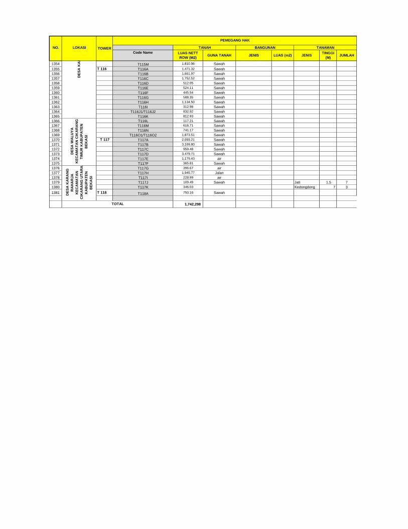
NO. LOKASI
Code Name
TANAHTOWER
PEMEGANG HAK
JENISTINGGI
(M)JUMLAH
LUAS NETT
ROW (M2)LUAS (m2)GUNA TANAH JENIS
BANGUNAN TANAMAN
1354 T115M 1,810.96 Sawah
1355 T 116 T116A 1,471.32 Sawah
1356 T116B 1,661.97 Sawah
1357 T116C 1,752.52 Sawah
1358 T116D 512.05 Sawah
1359 T116E 524.11 Sawah
1360 T116F 445.54 Sawah
1361 T116G 588.35 Sawah
1362 T116H 1,134.50 Sawah
1363 T116I 312.98 Sawah
1364 T116J1/T116J2 832.92 Sawah
1365 T116K 812.93 Sawah
1366 T116L 117.21 Sawah
1367 T116M 616.71 Sawah
1368 T116N 741.17 Sawah
1369 T116O1/T116O2 1,873.51 Sawah
1370 T 117 T117A 2,093.21 Sawah
1371 T117B 3,169.80 Sawah
1372 T117C 959.48 Sawah
1373 T117D 3,479.71 Sawah
1374 T117E 1,179.43 air
1375 T117F 365.81 Sawah
1376 T117G 396.67 air
1377 T117H 1,945.77 Jalan
1378 T117I 228.99 air
1379 T117J 109.49 Sawah Jati 1,5 7
1380 T117K 346.03 Kedongdong 7 3
1381 T 118 T118A 750.16 Sawah
1,742,298
DE
SA
KA
RA
NG
RA
HA
RJ
A
KE
CA
MA
TA
N
CIK
AR
AN
G U
TA
RA
KA
BU
PA
TE
N
BE
KA
SI
TOTAL
DE
SA
KA
RA
NG
RA
HA
YU
KE
CA
MA
TA
N K
AR
AN
G B
AH
AG
IA K
AB
UP
AT
EN
BE
KA
SI
DE
SA
WA
LU
YA
KE
CA
MA
TA
N C
IKA
RA
NG
TIM
UR
KA
BU
PA
TE
N
BE
KA
SI

ANNEX 3A:
LAND ACQUISITION CONSULTATION RECORDS FOR
TOWER FOOTINGS AND SUBSTATION

ANNEX 3a: LAND ACQUISITION CONSULTATION RECORDS for TRANSMISSION LINE

Village District Regency Date Stakeholder Key Messages Issues Raised
Involved
The landowner expressed
concern about the impact
of radiation (due to
electromagnetic from the
Transmission Line) caused
and the danger of
electricity during the rain;
JSP said that it will be
carried out periodic and
proper maintenance and
monitoring to secure the
safety of the community
around the Transmission
Line area.
Sukamulya Cilamaya Karawang 21-09- Landowner JSP delivered the intent and Village government and land
Kulon 2017. s and purpose of the project at the owners are ready to support the
village location of Sukamulya Village. land acquisition of 500 kV
governmen Transmission Line tower.
t Landowners are concerned
about the negative impact of the
500 kV Transmission Line.
Based on experience from other
local power projects, the land
price usually drops after
construction and the area utilized
for Transmission Lines.
Impact of damage during
construction.

Village District Regency Date Stakeholder Key Messages Issues Raised
Involved
The village government expects
the transaction process to be
simplified.
The landowner is willing to sell
their land, as long as the
payment for the land purchase
with agreed price will be
brought to them.
Muktijaya Cilamaya Karawang 05-10- JSP delivered the intent and Landowners inquire about Kulon 2017. purpose of the project at the tower security, construction
location of Muktijaya Village. process & possible damage to
their fields & other rice fields
around it because the location is
in the middle of his land.
Mr. Ali Hidayat as the land
owner asked JSP to be able to
shift the location of the tower to
the south end so that the fields
are not cut off.
The landowner is willing to sell
their land, as long as the
payment for the land purchase
with agreed price will be
brought to them.
The completeness of the file will
be handled by the land owner

Village District Regency Date Stakeholder Key Messages Issues Raised Involved
and the Muktijaya Village
Government.
Pasirukem Cilamaya Karawang 03-10- Landowner JSP delivered the project Landowners asked to Kulon 2017. s and aims and objectives that recheck their land
village are part of the 35,000 accompanied by the
governmen MW government landowners to confirm the
t program. exact location of the required
Cultivation of the land land.
prior to construction The village government said
will be discussed later that the community should
with JSP, Landowners understand the rights and
and Village obligations when and after
Government. the land acquisition.
H. Guntur (Land Owner)
expressed concern about the
diminishing value of land
and danger from the
Transmission Line.
Ade bin Tarli (Landowner)
complained about the status
of cultivation of land after
sale and purchase because it
will be worked on by the
village.
Tegalurung Cilamaya Karawang 05-10- Landowner JSP conveys the intent and Land owners support the Kulon 2017 s purpose of the project at the construction of transmission
Tegalurung Village Site. lines and they’re willing to

Village District Regency Date Stakeholder Key Messages Issues Raised
Involved
sell their land in accordance
with the agreed price; and
The landowner “Anyih”
expects his whole land to be
purchased at once.
Manggunjaya Cilamaya Karawang 22-09- Landowner JSP conveys the purpose and Village Governments and Kulon 2017 s and objectives that is part of the Owners of land (Represented
village activities of the government's by parents) understand and
governmen 35,000 MW program. ready to assist and willing to
t release land for government
programs.
The landowner asked for site
checking and to confirm the
area required to build the 500
kV Transmission Line Tower.
Cultivation of land before
construction is expected to be
permissible to the
landowners.
Sumurgede Cilamaya Karawang 18-09- Landowner JSP conveys the aims and The landowner is willing to Kulon 2017 s objective of the project which is sell their land, as long as the
a government program. payment for the land
purchase with agreed price
will be brought to them.
Jayanegara Tempuran Karawang 14-09- Landowner JSP conveys the purpose and The Village Government is
2017 s and objective of building the 500 kV ready to assist and support
village SUTET line to support the the work that is a
government's program to government program;
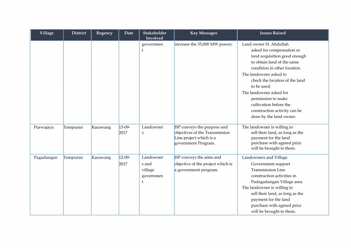
Village District Regency Date Stakeholder Key Messages Issues Raised
Involved
governmen increase the 35,000 MW power; Land owner H. Abdullah
t asked for compensation or
land acquisition good enough
to obtain land of the same
condition in other location.
The landowner asked to
check the location of the land
to be used.
The landowner asked for
permission to make
cultivation before the
construction activity can be
done by the land owner.
Purwajaya Tempuran Karawang 13-09- Landowner JSP conveys the purpose and The landowner is willing to
2017 s objectives of the Transmission sell their land, as long as the Line project which is a payment for the land government Program. purchase with agreed price
will be brought to them.
Pagadungan Tempuran Karawang 12-09- Landowner JSP conveys the aims and Landowners and Village
2017 s and objective of the project which is Government support
village a government program. Transmission Line
governmen construction activities in
t Padagadungan Village area.
The landowner is willing to
sell their land, as long as the
payment for the land
purchase with agreed price
will be brought to them.

Village District Regency Date Stakeholder Key Messages Issues Raised
Involved
The landowner hopes the
land under the tower and
around the Transmission
Line can still be cultivated.
The village government
hopes the documentation
process can be simplified.
Pancakarya Tempuran Karawang 11-09- Landowner JSP conveys the purpose and Village Governments and
2017 s and objectives of the Transmission Land Owners are ready to village Line project which is a support the Transmission
government Program;
governmen
Line land acquisition process.
t The landowner is willing to
sell their land, as long as the
payment for the land
purchase with agreed price
will be brought to them and
they hopes the transaction
process will be simplified.
Tower T.40 is located in 2
land owners (Yudha &
Eneung Rusiti).
The landowner is willing to
sell their land, as long as the
payment for the land
purchase with agreed price
will be brought to them.
Lemahduhur Tempuran Karawang 04-10-207 Landowner JSP conveys the purpose and The village government
s and objectives of the Transmission supports the activities to be

Village District Regency Date Stakeholder Key Messages Issues Raised
Involved
village Line project which is a carried out after JSP conveys
governmen government Program. the purpose and objective of
t the project implementation
which is a national program
in the expansion of 35,000
MW energy.
Epong (Land Owner)
requested to double check his
land to clarify that the
required land is really owned
by him during land
acquisition activities.
The concerns of Racih's
mother is related to the
radiation (due to
electromagnetic fields from the
Transmission Line)
disturbance caused by the 500
kV Transmission Line.
Lemahkarya Tempuran Karawang 13-09- Landowner JSP conveys the purpose and Village government and land
2017 s and objectives of the Transmission owners are ready to support village Line project which is a the land acquisition of 500 kV
government Program.
governmen
Transmission Line with
t agreed price.
Village Governments and
landowners expect the land
acquisition process to be
simplified and as soon as
possible.

Village District Regency Date Stakeholder Key Messages Issues Raised
Involved
The Land ownership
documents of T.45 will be
taken out of the Bank by the
landlord during the
acquisition transaction. The
Land deed is in the Bank for
mortgage
Dayeuhluhur Tempuran Karawang 08-09- Landowner JSP conveys the intention and Landowners and village
2017 s and objectives of the Project which is governments are ready to
village one of the national strategic support land acquisition
governmen projects. activities in accordance with
t the agreed price with JS.
The village government said
that the land acquisition
process needs to be
simplified.
.Landowners are concerned
about the safety of farmers
around the Transmission
Line location.
Sukaraja Rawamerta Karawang 16-09- Landowner JSP conveys the intention The establishment of good 2017 s and and objectives of the relationships between the JSP
village Project which is one of the team and the village
governmen national strategic projects; government.
t and Village Governments and
The establishment of good Landowners understand the
relationships between the purpose and objectives of
JSP team and the village project implementation and are
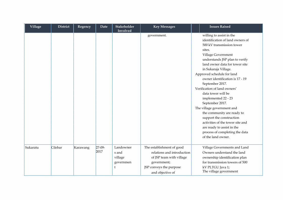
Village District Regency Date Stakeholder Key Messages Issues Raised
Involved
government. willing to assist in the
identification of land owners of
500 kV transmission tower
sites.
Village Government
understands JSP plan to verify
land owner data for tower site
in Sukaraja Village.
Approved schedule for land
owner identification is 17 - 19
September 2017.
Verification of land owners’
data tower will be
implemented 22 - 23
September 2017.
The village government and
the community are ready to
support the construction
activities of the tower site and
are ready to assist in the
process of completing the data
of the land owner.
Sukaratu Cilebar Karawang 27-09- Landowner The establishment of good Village Governments and Land 2017 s and relations and introduction Owners understand the land
village of JSP team with village ownership identification plan
governmen government; for transmission towers of 500
t JSP conveys the purpose
kV PLTGU Java 1; and objective of The village government

Village District Regency Date Stakeholder Key Messages Issues Raised
Involved
coordination and understands the land
socialization; ownership verification plan in
JSP conveyed the plan of Sukaratu Village, Cilebar
tower construction of 500 District; and
kV transmission line; The Village Government
JSP submits the terms / understands about the
requirements (necessary construction plans of the 500
documents) for land kV transmission line towers
acquisition of the RoW as well as the terms and
corridor path; and conditions required for land
There is one tower in acquisition activities.
Sukaratu village so that
the process of land
acquisition will be easier
and faster, but almost all
land is in the process of
national land
certification (Prona) so
that it awaits the results
for land acquisition.
Sindangsari Kutawaluya Karawang 23-09- Landowner JSP conveys the purpose Village Head, Village
2017 s and and objective of Apparatus and Land Owner
village coordination and understand the plan of tower
governmen socialization of the construction and requirements
t government's plan for the for land acquisition tower;
development of Java The area of land acquisition is
PLTGU tower & adjusted to the needs of tower
transmission line 1; and needs;
JSP explains the land Implementation of payment

Village District Regency Date Stakeholder Key Messages Issues Raised
Involved
acquisition of towers that can be done after the validity
must be completed by the of the land is complete and
land owner. supported with complete
administrative data; and
Landowners agree to follow
agreed upon rules.
Sampalan Kutawaluya Karawang 22-09- Landowner JSP conveyed the plan of Village Governments and Land
2017 s and tower building Owners understand the tower
village transmission line 500 kV development plan as a government
governmen PLTGU Java 1; program.
t JSP conveys the terms or conditions of land
acquisition and
Transmission Line;
There are 4 points in
Sampalan Village that
need to be done land
acquisition;
After identification of
land owners, then will be
collected other supporting
documents for land
acquisition;
Payment can be made if
the file requirements are
met, complete and
accountable; and
The area of land
acquisition is adjusted to

Village District Regency Date Stakeholder Key Messages Issues Raised
Involved
the needs of tower area.
Waluya Kutawaluya Karawang 23-09- Landowner JSP conveys the purpose Landowners understand the
2017 s, village and objectives of project terms or conditions of land
leaders, implementation; acquisition tower;
and village JSP explains the the requirements file to be
governmen identification of the owner prepared by the land owner
t of the tower site; and assisted by the village
JSP describes the schedule apparatus for administrative
of identification and completeness;
verification of data Owners of land domiciled
completeness of land outside the village will be
owner tower. immediately contacted by the
village; and
Village and community leaders
are expected to assist the
government's program in
order to run well.
Mulyajaya Kutawaluya Karawang 14-09- Landowner JSP conveys the purpose
2017 s and objective of coordination and
socialization which is
about the government
plan of tower construction
& transmission line of
PLTGU Java 1;
JSP conveys the terms or
conditions for land
acquisition of towers that
must be completed by the

Village District Regency Date Stakeholder Key Messages Issues Raised
Involved
land owner;
The land associated with
the national land
certification program
(PRONA) cannot be paid
before the proof of land
ownership is a Certificate
issued or issued by BPN;
Payment can be made
after the requirements and
provisions of
administered files are
completed; and
Payment is made in front
of a notary public.
Karyasari Rengasdengk Karawang 23-09- Landowner JSP conveyed the plan of Village government and land
lok 2017 s and building tower owners are ready to support
village transmission line 500 kV the development and land
governmen PLTGU Java 1; acquisition program of 500 kV
t There are 6 tower points Transmission Line PLTGU Java
to be released in 1 in Karyasari Village,
Sampalan Village; Rengasdengklok District; and
Land acquisition can be The hope of landowners and
done if the requirements / village government, land
conditions are met. acquisition activities can be
implemented immediately.

Village District Regency Date Stakeholder Key Messages Issues Raised
Involved
Kalangsuria Rengasdengk Karawang 29-09- Landowner JSP conveyed the plan of Village government and lok 2017 s and building of tower site of landowners understand the
village transmission line of 500 tower construction plans and
governmen kV PLTGU Java 1; land acquisition requirements;
t o The construction will be
and
implemented from Payment will be made in the
Cilamaya to Cikarang presence of a notary.
Utara
o There are 3 Tower in
Kalangsuria Village for
land acquisition
o Land requirements will
be adjusted to the type
of tower.
JSP explains the terms /
Requests for land
acquisition and RoW
corridor path.
Kalangsari Rengasdengk Karawang 20-09- Landowner JSP conveyed the plan of Village Governments and
lok 2017 s and tower construction of Landowners understand the
village transmission line of 500 provisions / requirements for
governmen kV PLTGU Java 1 - Cibatu land acquisition and
t Baru; compensation of the ROW
The area of land used for corridor path; and
the tower is adjusted to Payment must be attended by
the needs of the tower; the person whose name is
The payment will be listed in the land deed.
made in front of the
notary; and

Village District Regency Date Stakeholder Key Messages Issues Raised
Involved
The process of completing
documents that the owner
is not placed then can be
sent via email / post.
Mekarjati Karawang Karawang 10-10- Landowner JSP explains the purpose Land document in the form of Barat 2017 s and objective of Certificate of Property (SHM)
coordination and needs to be checked by BPN;
socialization of the Loan of original certificate is
neighboring plan of the made with document receipt;
construction of 500 kV and transmission line tower Some towers need to be
site; and conducted by the state court
JSP conveys the terms because the heirs are still
and conditions of land under age. acquisition for tower land
that must be completed
by the land owner.
Tunggak Jati Karawang Karawang 24-09- Landowner JSP explains the purpose Landowners understand about Barat 2017 s and objective of the construction plan of the
coordination and transmission line tower site;
socialization of the and
neighboring plan of the The results of the socialization
construction of 500 kV to the LDII (Landowners) is
transmission line tower willing to release land for the
site; purpose of government
JSP conveys the terms and programs and related to price
conditions of land negotiations are still waiting
acquisition for tower land

Village District Regency Date Stakeholder Key Messages Issues Raised
Involved
that must be completed by for the decision of LDII
the land owner; leaders.
The area of land
acquisition is adjusted to
the needs of the tower
floor area;
Prices are based on NJOP
and land market prices in
the region; and
Implementation of
payment can be done after
the validity of the land is
complete.
Cilamaya Cilamaya Karawang 30-01- Landowners; Compensation scheme for area Project to have close coordination Wetan 2018
District and / space traversed by the Project and to inform district and village
Village 500 kV Transmission Line. authorities and community prior
Authorities; to conducting any construction Local Police activities;
Project to provide local farmers to and Military;
and harvest their farming product prior conducting the construction
activities;
To optimize local content and
prioritize local workforce where
feasible;

Village District Regency Date Stakeholder Key Messages Issues Raised
Involved
Decrease land price / value to
area / land traversed by TL
ROW; and
Road damage due to Project
traffic mobilization;
Impacts of electric and magnetic
radiation to community health.
Sukatani Cilamaya Karawang 01-02- To be confirmed Compensation scheme for area To be confirmed Wetan 2018 / space traversed by the Project
500 kV Transmission Line.
Sukamulya Cilamaya Karawang 05-02- Landowners; Compensation scheme for area Determination of compensation Kulon 2018 and / space traversed by the Project value;
Village 500 kV Transmission Line. Access to community land after
Authorities being compensated;
Impacts of electric and magnetic
radiation to community health
and
Project community grievance
handling / management
Sindangsari Kutawaluya Karawang 05-02- Landowners; Compensation scheme for area Determination of compensation 2018
District and / space traversed by the Project
value;
Village 500 kV Transmission Line. Project to have close coordination
Authorities; and to inform district and village
authorities and community prior

Village District Regency Date Stakeholder Key Messages Issues Raised
Involved
Local Police to conducting any construction
and Military; activities;
and Eligibility to receive
compensation;
Compensation for damaged crops
due to construction activities; and
Method of compensation
payment.
Sukaratu Cilebar Karawang 06-02- Landowners; Compensation scheme for area Determination of compensation 2018 and / space traversed by the Project value;
Village 500 kV Transmission Line. Eligibility to receive
Authorities compensation;
Method of compensation
payment; and
Maintenance of Transmission
Line;
Sukaraja Rawamerta Karawang 07-02- To be confirmed Compensation scheme for area To be confirmed 2018 / space traversed by the Project
500 kV Transmission Line.

Village District Regency Date Stakeholder Key Messages Issues Raised
Involved
Muktijaya Cilamaya Karawang 07-02- To be confirmed Compensation scheme for area To be confirmed Kulon 2018 / space traversed by the Project
500 kV Transmission Line.
Karang-harum Kedung- Bekasi 07-02- To be confirmed Compensation scheme for area To be confirmed waringin 2018 / space traversed by the Project
500 kV Transmission Line.
Waluya Cikarang Bekasi 08-02- Landowners; Compensation scheme for area Determination of compensation utara 2018
District and / space traversed by the Project
value; and
Village 500 kV Transmission Line. Insufficient amount of
Authorities; compensation if based on
and Ministerial Regulation No.38 Year
Local Police 2013.
Sumurgede Cilamaya Karawang 08-02- Landowners; Compensation scheme for area Eligibility and landownership Kulon 2018
District and / space traversed by the Project
documentation requirement to
Village 500 kV Transmission Line. receive compensation; and
Project community grievance Authorities;
handling / management.
Mekarjaya Kedung- Bekasi 08-02- To be confirmed Compensation scheme for area To be confirmed waringin 2018 / space traversed by the Project
500 kV Transmission Line.

Village District Regency Date Stakeholder Key Messages Issues Raised
Involved
Sampalan Kotawaluya Karawang 09-02- To be confirmed Compensation scheme for area To be confirmed 2018 / space traversed by the Project
500 kV Transmission Line.
Manggung-jaya Cilamaya Karawang 09-02- Landowners; Compensation scheme for area Eligibility and landownership Kulon 2018
District and / space traversed by the Project documentation requirement to
Village 500 kV Transmission Line. receive compensation; and
Project to have close coordination Authorities; and to inform district and village
authorities and community prior
to conducting any construction
activities/
Karang-mekar Kedung- Bekasi 09-02- To be confirmed Compensation scheme for area To be confirmed waringin 2018 / space traversed by the Project
500 kV Transmission Line.
Mulyajaya Kotawaluya Karawang 10-02- To be confirmed Compensation scheme for area To be confirmed 2018 / space traversed by the Project
500 kV Transmission Line.
Karyasari Rengas- Karawang 12-02- To be confirmed Compensation scheme for area To be confirmed dengklok 2018 / space traversed by the Project
500 kV Transmission Line.

Village District Regency Date Stakeholder Key Messages Issues Raised
Involved
Karangsatu Karangbahag Bekasi 12-02- Landowners; Compensation scheme for area Method and determination of ia 2018
District and / space traversed by the Project compensation; and
Village 500 kV Transmission Line. Detail of construction of
Authorities; Transmission Line.
and
Local Police
and Military
Kalangsuria Rengas- Karawang 13-02- Landowners; Compensation scheme for area Impact of Transmission Line to dengklok 2018
District and / space traversed by the Project the underneath vegetation /
Village 500 kV Transmission Line. crops; and
Authorities; Access to community land after
being compensated.
Kalangsari Rengas- Karawang 14-02- To be confirmed Compensation scheme for area To be confirmed dengklok 2018 / space traversed by the Project
500 kV Transmission Line.
Pasirukem Cilamaya Karawang 14-02- Landowners; Compensation scheme for area Timeline of the Transmission Line Kulon 2018
District and / space traversed by the Project construction;
Village 500 kV Transmission Line. Method and determination of
Authorities; compensation; and
and Timeline for the payment of
Local Police compensation of land acquisition
for TL Tower footing.

Village District Regency Date Stakeholder Key Messages Issues Raised
Involved
Karang-mukti Karang Bekasi 15-02- To be confirmed Compensation scheme for area To be confirmed Bahagia 2018 / space traversed by the Project
500 kV Transmission Line.
Mekarjati Karawang Karawang 15-02- Landowners; Compensation scheme for area Legality of the Project; Barat 2018
and / space traversed by the Project Access to community land after
District and 500 kV Transmission Line. being compensated;
Village Impacts of electric and magnetic
Authorities; radiation to community health;
and
Eligibility and landownership
documentation requirement to
receive compensation.
Tunggakjati Karawang Karawang 15-02- To be confirmed Compensation scheme for area To be confirmed Barat 2018 / space traversed by the Project
500 kV Transmission Line.
Tegalurung Cilamaya Karawang 15-02- Landowners; Compensation scheme for area Timeline of the Transmission Line Kulon 2018
District and / space traversed by the Project construction;
Village 500 kV Transmission Line. Access to community land after
Authorities; being compensated; and
and Impacts of electric and magnetic
Local Police radiation to community health.
and Military
Karangsari Cikarang Bekasi 13 July Landowners; Landowners understand the Timur 2017

Village District Regency Date Stakeholder Key Messages Issues Raised
Involved
District and terms or conditions of land
Village acquisition tower;
Authorities; the requirements file to be
prepared by the land owner
assisted by the village
apparatus for administrative
completeness;
Karangrahayu Karang Bekasi 13 July Landowners;
Landowners understand the terms or conditions of land acquisition tower;
the requirements file to be prepared by the land owner assisted by the village apparatus for administrative completeness;
Bahagia 2017 District and
Village
Authorities;
Karangraharja Cikarang Bekasi 13 July Landowners;
Landowners understand the terms or conditions of land acquisition tower;
the requirements file to be prepared by the land owner assisted by the village apparatus for administrative completeness;
Utara 2017 District and
Village
Authorities;
ANNEX 3B:
LAND ACQUISITION CONSULTATION RECORDS FOR
TRANSMISSION LINE ROW

Annex 3b LAND ACQUISITION CONSULTATION RECORDS for RoW
Location (village, district,
regency)
Date Stakeholder Involve
Key Messages Issues Raised Sponsor Feedback
Cilamaya Village,
Cilamaya wetan district,
karawang regency
Tue, 30th January
2018
1. District Leader District Cilamaya Wetan (Hamdani) 2. Polsek Cilamaya Wetan (Dadang. G) 3. Danramil Cilamaya Wetan (Sukirno) 4. Cilamaya Village leader (Kusnadi) 5. Landowners ROW
- each activity will need to coordinate with local authority, especially constructrion and mobilization process - compensation scheme
- a concern about the road condition during the construction process
- socialization will be done before the construction in regard to activity, compensation if any construction activity might disturb the community farm or crops
Sukatani Village,
Cilamaya wetan district,
karawang regency
Thurs, 1st feb 18
1. Muspika District Cilamaya Wetan (Kapolsek Cilamaya Dadang)
2. Sukatani Village leader (H. Masrukin)-RoW
- each activity will need to coordinate with local authority, especially constructrion and mobilization process - local human resource should be prioritized for recruitment - each activity will need to coordinate with local authority, especially constructrion and mobilization process
- Compensation Scheme - Why do the villagers need
JSP, they still have enough electricity?
- 15% compensation of the building on RoW
- The target of electrification in Jawa - Bali

- compensation scheme
Sukamulya Village, Cilamaya kulon district, karawang regency
Mon, 5th feb 18
Village authority
- each activity will need to coordinate with local authority, especially constructrion and mobilization process - compensation scheme
- Compensation Scheme
- Compensation steps
Sindangsari Village, Kutawaluya Disctrict, Karawang regency
Mon, 5th Feb 2018
1. District Leader Secretary District Kutawaluya (H. Agus Sanusi) 2. Polsek Kutawaluya (Supanri) 3. Danposramil Kutawaluya ( Jagurdin) 4. Village Leader Sindangsari (H. Kaning)
- each activity will need to coordinate with local authority, especially constructrion and mobilization process - local human resource should be prioritized for recruitment - each activity will need to coordinate with local authority, especially constructrion and mobilization process - compensation scheme
- Compensation Scheme - Why do the villagers need
JSP, they still have enough electricity?
- 15% compensation of the building on RoW
- The target of electrification in Jawa - Bali
Sukaratu District Cilebar
Regency Karawang
Tue, 6th February 2018
1. District Leader Cilebar (A. Kartiwa) 2. Kapolsek Pedes (Much Sutusna) 3. Sukaratu village leader (Sukanda)
- each activity will need to coordinate with local authority, especially constructrion and mobilization process - compensation scheme
- a concern about the road condition during the construction process - compensation scheme
- socialization will be done before the construction in regard to activity, compensation if any construction activity might disturb the community farm or crops
Karangharum Wed, 7th 1. Village - each activity will need - a concern about the road - socialization will be done before

Village District Karangbahagia Regency Bekasi
February 2018
Leader Karangharum 2. Danramil 3. Polsek 4. Landowners ROW
to coordinate with local authority, especially constructrion and mobilization process - compensation scheme
condition during the construction process - compensation scheme
the construction in regard to activity, compensation if any construction activity might disturb the community farm or crops
Muktijaya Village District Cilamaya Kulon Kabupaten Karawang
Wed, 7th February 2018
1. District Leader Secretary Cilamaya Kulon (Enjang Hermawan)
2. Danramil Cilmaya Kulon (Kapt. Suripno)
3. Village Leader Muktijaya (Sawa Isyirot)
4. Landowners ROW
- each activity will need to coordinate with local authority, especially constructrion and mobilization process - compensation scheme
- a concern about the road condition during the construction process - compensation scheme
- socialization will be done before the construction in regard to activity, compensation if any construction activity might disturb the community farm or crops
Sukaraja Village, Rawamerta – Karawang
Wed, 7th February 2018
1. District Leader Rawamerta Dindin Rachmadhy, S.Sos, MM
2. Kapolsek Rawamerta Agus S.
3. Danramil Rawamerta
- each activity will need to coordinate with local authority, especially constructrion and mobilization process - local human resource should be prioritized for recruitment - each activity will need to coordinate with local authority, especially
- Compensation Scheme - Why do the villagers need
JSP, they still have enough electricity?
- 15% compensation of the building on RoW decided by gov
- The target of electrification in Jawa - Bali

Kapten Infantri Kusnen
4. Village Leader Sukaraja Engki Suhandi
5. Landowners in ROW
constructrion and mobilization process - compensation scheme
Kantor Village Waluya District
Kutawaluya Regency
Karawang
Thurs, 8 Feb 2018
1. District Leader Kutawaluya (Saryadi) 2. Danpospol Kutawaluya (Supandi) 3. Village Leader Waluya (Hermansyah) 4. Landowners in ROW
- each activity will need to coordinate with local authority, especially constructrion and mobilization process - local human resource should be prioritized for recruitment - each activity will need to coordinate with local authority, especially constructrion and mobilization process - compensation scheme
- Compensation Scheme - The villagers questioning on
the compensation amount
- 15% compensation of the building on RoW decided by gov
- The compensation number will be given to villagers, if villagers do not want to take it now, they may take it in the court. This practice is based on national regulation.
Village Sumurgede
District Cilamaya Kulon,
Regency Karawang
Thurs, 8 Feb 2018
1. Village Leader Sumurgede 2. Tim Sosialisasi 3. Landowners in ROW
- each activity will need to coordinate with local authority, especially constructrion and mobilization process - local human resource should be prioritized for recruitment - each activity will need to coordinate with local
- Compensation Scheme - The villagers questioning on
the compensation amount - Grievance mechanism
- 15% compensation of the building on RoW decided by gov

authority, especially constructrion and mobilization process - compensation scheme
Village Mekarjaya
District Kedung Waringin,
Regency Bekasi
Thurs, 08 Feb 2018
1. Village Leader Mekarjaya 2. Wakapolsek Kedung Waringin 3. Representative District Kedung Waringin 4. Landowners in ROW
- each activity will need to coordinate with local authority, especially constructrion and mobilization process - local human resource should be prioritized for recruitment - each activity will need to coordinate with local authority, especially constructrion and mobilization process - compensation scheme
- Compensation Scheme - The villagers questioning on
the compensation amount - Worker Recruitment
- 15% compensation of the building on RoW decided by gov
- Human Resource Recruitment
Village Manggungjaya District Cilamaya Kulon Kabupaten Karawang
Fri, 9 Feb 2018
1. Representative dari District Cilamaya Kulon 2. Representative dari Koramil 3. SekVillage Manggungjaya 4. Landowners in ROW
- each activity will need to coordinate with local authority, especially constructrion and mobilization process - local human resource should be prioritized for recruitment - each activity will need to coordinate with local authority, especially constructrion and mobilization process - compensation scheme
- Compensation Scheme - The villagers questioning on
the compensation amount - Worker Recruitment
- 15% compensation of the building on RoW decided by gov
- Human Resource Recruitment
Village Sampalan,
Fri, 09 Feb 2018
1. District Leader
- each activity will need to coordinate with local
- Compensation Scheme - The villagers questioning on
- 15% compensation of the building on RoW decided by

District Kutawaluya –
Regency Karawang
Kutawaluya diwakili District Leader Secretary
2. Kapolsek Kutawaluya diwakili Babinmas Village Sampalan
3. Danramil Kutawaluya diwakili oleh DanposRamil Village Sampalan
4. Village Leader Sampalan
5. Landowners in ROW
authority, especially constructrion and mobilization process - local human resource should be prioritized for recruitment - each activity will need to coordinate with local authority, especially constructrion and mobilization process - compensation scheme
the compensation amount
gov - The rest of 20 % compensation
on tower footing payment period
Village Karangmekar
District Kedung Waringin
Regency Bekasi
Fri, 09 Feb 2018
1. Village Leader Karangmekar 2. Wakapolsek Kedung Waringin 3. Representative District Kedung Waringin 4. Landowners in RoW ROW
- each activity will need to coordinate with local authority, especially constructrion and mobilization process - local human resource should be prioritized for recruitment - each activity will need to coordinate with local authority, especially constructrion and
- Compensation Scheme
- 15% compensation of the building on RoW decided by gov
- Villagers know and familiar with transmission line

mobilization process - compensation scheme
Kantor Village Mulyajaya, District Kutawaluya – Karawang
Sat, 10 Feb 2018
1. District Leader Kutawaluya diwakili District Leader Secretary (Agus. S)
2. Kapolsek Rengasdengklok (Kompol Suparno)
3. Kepala Village Mulyajaya (Endang A.Md. Komp)
4. Warga pemilik lahan ROW
- each activity will need to coordinate with local authority, especially constructrion and mobilization process - local human resource should be prioritized for recruitment - each activity will need to coordinate with local authority, especially constructrion and mobilization process - compensation scheme
- Compensation Scheme - The villagers questioning on
the compensation amount - Worker Recruitment
- 15% compensation of the building on RoW decided by gov
- Human Resource Recruitment
Village Karangsatu
District Karangbahagia Regency Bekasi
Mon 12 Feb 2018
1. Village Leader Karangsatu 2. Polsek Karangbahagia 3. Koramil Karangbahagia 4. Landowners in RoW ROW
- each activity will need to coordinate with local authority, especially constructrion and mobilization process - local human resource should be prioritized for recruitment - each activity will need to coordinate with local authority, especially constructrion and
- Compensation Scheme - The villagers questioning on
the compensation amount, they want to get 150.000 IDR/metres.
- Worker Recruitment
- 15% compensation of the building on RoW decided by gov
- Human Resource Recruitment

mobilization process - compensation scheme
Village Karyasari, Rengasdengklok – Karawang
Mon, 12 Feb 2018
1. Village Leader Karyasari sekaligus pembukaan acara sosialisasi (Asur Pudian)
2. District Leader Rengasdengklok (Asep Wahyu)
3. WArga pemilik lahan ROW
- each activity will need to coordinate with local authority, especially constructrion and mobilization process - local human resource should be prioritized for recruitment - each activity will need to coordinate with local authority, especially constructrion and mobilization process - compensation scheme
- Compensation Scheme - The villagers questioning on
the compensation amount - Worker Recruitment
- 15% compensation of the building on RoW decided by gov
- Human Resource Recruitment
Village Kalangsuria
District Rengasdengklok
Regency Karawang
Tue, 13 Feb 2018
1. Village Leader Kalangsuria 2. District Leader Secretary District Rengasdengklok 3. Landowners in RoW ROW
- each activity will need to coordinate with local authority, especially constructrion and mobilization process - local human resource should be prioritized for recruitment - each activity will need to coordinate with local authority, especially constructrion and mobilization process - compensation scheme
- Compensation Scheme - Land use
- 15% compensation of the building on RoW decided by gov
- Land use
Village Pasirukem
Wed 14 Feb 2018
1. Village Leader
- each activity will need to coordinate with local
- Compensation Scheme - Land use, harvesting time
- 15% compensation of the building on RoW decided by
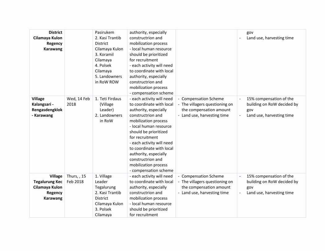
District Cilamaya Kulon
Regency Karawang
Pasirukem 2. Kasi Trantib District Cilamaya Kulon 3. Koramil Cilamaya 4. Polsek Cilamaya 5. Landowners in RoW ROW
authority, especially constructrion and mobilization process - local human resource should be prioritized for recruitment - each activity will need to coordinate with local authority, especially constructrion and mobilization process - compensation scheme
gov - Land use, harvesting time
Village Kalangsari - Rengasdengklok - Karawang
Wed, 14 Feb 2018
1. Teti Firdaus (Village Leader)
2. Landowners in RoW
- each activity will need to coordinate with local authority, especially constructrion and mobilization process - local human resource should be prioritized for recruitment - each activity will need to coordinate with local authority, especially constructrion and mobilization process - compensation scheme
- Compensation Scheme - The villagers questioning on
the compensation amount - Land use, harvesting time
- 15% compensation of the building on RoW decided by gov
- Land use, harvesting time
Village Tegalurung Kec Cilamaya Kulon
Regency Karawang
Thurs, , 15 Feb 2018
1. Village Leader Tegalurung 2. Kasi Trantib District Cilamaya Kulon 3. Polsek Cilamaya
- each activity will need to coordinate with local authority, especially constructrion and mobilization process - local human resource should be prioritized for recruitment
- Compensation Scheme - The villagers questioning on
the compensation amount - Land use, harvesting time
- 15% compensation of the building on RoW decided by gov
- Land use, harvesting time
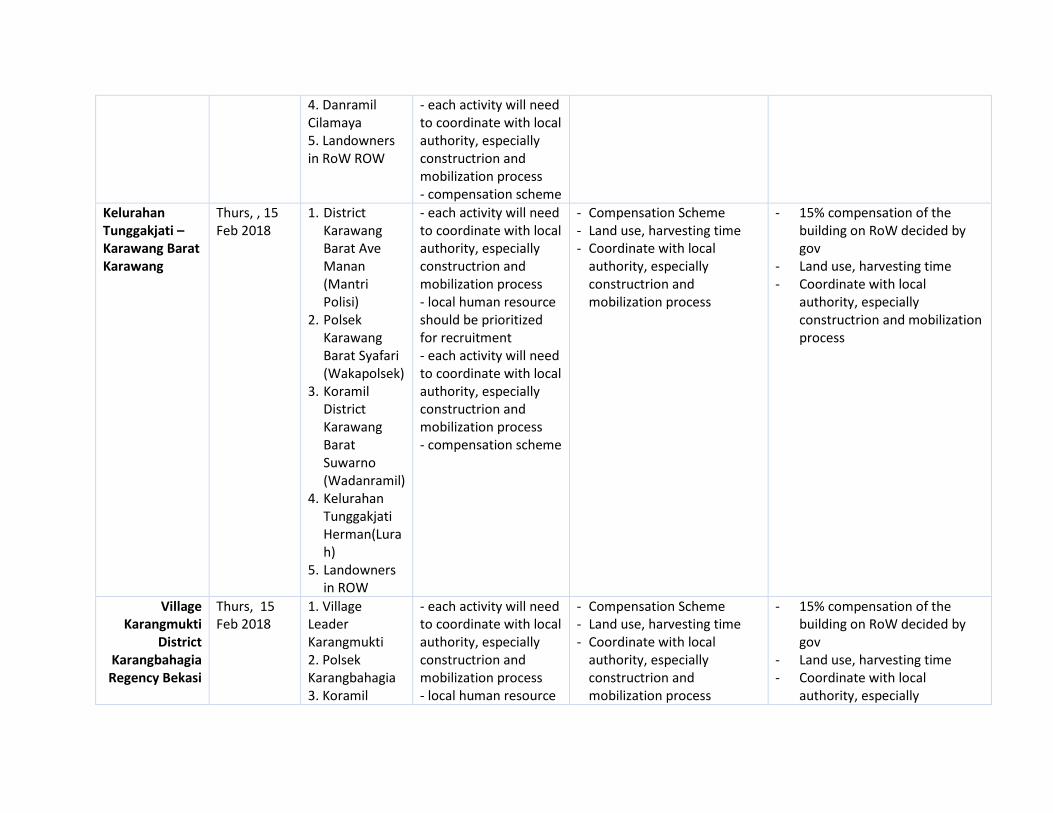
4. Danramil Cilamaya 5. Landowners in RoW ROW
- each activity will need to coordinate with local authority, especially constructrion and mobilization process - compensation scheme
Kelurahan Tunggakjati – Karawang Barat Karawang
Thurs, , 15 Feb 2018
1. District Karawang Barat Ave Manan (Mantri Polisi)
2. Polsek Karawang Barat Syafari (Wakapolsek)
3. Koramil District Karawang Barat Suwarno (Wadanramil)
4. Kelurahan Tunggakjati Herman(Lurah)
5. Landowners in ROW
- each activity will need to coordinate with local authority, especially constructrion and mobilization process - local human resource should be prioritized for recruitment - each activity will need to coordinate with local authority, especially constructrion and mobilization process - compensation scheme
- Compensation Scheme - Land use, harvesting time - Coordinate with local
authority, especially constructrion and mobilization process
- 15% compensation of the building on RoW decided by gov
- Land use, harvesting time - Coordinate with local
authority, especially constructrion and mobilization process
Village Karangmukti
District Karangbahagia Regency Bekasi
Thurs, 15 Feb 2018
1. Village Leader Karangmukti 2. Polsek Karangbahagia 3. Koramil
- each activity will need to coordinate with local authority, especially constructrion and mobilization process - local human resource
- Compensation Scheme - Land use, harvesting time - Coordinate with local
authority, especially constructrion and mobilization process
- 15% compensation of the building on RoW decided by gov
- Land use, harvesting time - Coordinate with local
authority, especially

Karangbahagia 4. Landowners in RoW ROW
should be prioritized for recruitment - each activity will need to coordinate with local authority, especially constructrion and mobilization process - compensation scheme
constructrion and mobilization process
Kelurahan Mekarjati
District Karawang Barat
Regency Karawang
Thurs, , 15 Feb 2018
1. Lurah Mekarjati 2. District Leader Secretary District Karawang Barat 3. Landowners in ROW
- each activity will need to coordinate with local authority, especially constructrion and mobilization process - local human resource should be prioritized for recruitment - each activity will need to coordinate with local authority, especially constructrion and mobilization process - compensation scheme
- Compensation Scheme - Land use, harvesting time - Grievance - Coordinate with local
authority, especially constructrion and mobilization process
- 15% compensation of the building on RoW decided by gov
- Land use, harvesting time - Coordinate with local
authority, especially constructrion and mobilization process
- Grievance mechanism
Village Pancakarya
District Tempuran
Regency Karawang
Mon, 19 Feb 2018
1. Village Leader Pancakarya 2. Village Leader Tanjungjaya 3. Landowners in RoW
- each activity will need to coordinate with local authority, especially constructrion and mobilization process - local human resource should be prioritized for recruitment - each activity will need to coordinate with local authority, especially constructrion and
- Compensation Scheme - Land use, harvesting time - Grievance - Coordinate with local
authority, especially constructrion and mobilization process
- 15% compensation of the building on RoW decided by gov
- Land use, harvesting time - Coordinate with local
authority, especially constructrion and mobilization process
- Grievance mechanism

mobilization process - compensation scheme
Village Waluya District
Cikarang Utara Regency Bekasi
Mon 19 Feb 2018
1. Village Leader Waluya 2. Polsek Cikarang Utara 3. Koramil Cikarang Utara 4. Representative District Cikarang Utara 5. Landowners in ROW
- each activity will need to coordinate with local authority, especially constructrion and mobilization process - local human resource should be prioritized for recruitment - each activity will need to coordinate with local authority, especially constructrion and mobilization process - compensation scheme
- Compensation Scheme - Land use, harvesting time - Grievance - Coordinate with local
authority, especially constructrion and mobilization process
- 15% compensation of the building on RoW decided by gov
- Land use, harvesting time - Coordinate with local
authority, especially constructrion and mobilization process
- Grievance mechanism - Villagers are familiar with the
process. They understand the transmission construction process.
Village Karangsari
District Cikarang Timur Regency Bekasi
Mon 19 Feb 2018
1. Village Leader Karangsari 2. Polsek Cikarang Timur 3. Koramil Cikarang Timur 4. Representative District Cikarang Timur 5. Landowners in RoW
- each activity will need to coordinate with local authority, especially constructrion and mobilization process - local human resource should be prioritized for recruitment - each activity will need to coordinate with local authority, especially constructrion and mobilization process - compensation scheme
- Compensation Scheme - Land use, harvesting time - Grievance - Coordinate with local
authority, especially constructrion and mobilization process
- 15% compensation of the building on RoW decided by gov
- Land use, harvesting time - Coordinate with local
authority, especially constructrion and mobilization process
- Grievance mechanism
Village Purwajaya
District Tempuran
Tue,, 20 Feb 2018
1. Village Leader 2. District Leader
- each activity will need to coordinate with local authority, especially constructrion and
- Compensation Scheme - Land use, harvesting time - Grievance - Coordinate with local
- 15% compensation of the building on RoW decided by gov
- Land use, harvesting time

Regency Karawang
Tempuran 3. Koramil Tempuran 4. Landowners in RoW ROW
mobilization process - local human resource should be prioritized for recruitment - each activity will need to coordinate with local authority, especially constructrion and mobilization process - compensation scheme
authority, especially constructrion and mobilization process
- Coordinate with local authority, especially constructrion and mobilization process
- Grievance mechanism
Village Jayanegara –
District Tempuran –
Regency Karawang
Tue,, 20 Feb 2018
Village Leader Jayanegara (H. Suwanda)
- each activity will need to coordinate with local authority, especially constructrion and mobilization process - local human resource should be prioritized for recruitment - each activity will need to coordinate with local authority, especially constructrion and mobilization process - compensation scheme
- Compensation Scheme - Land use, harvesting time - Grievance - Coordinate with local
authority, especially constructrion and mobilization process
- 15% compensation of the building on RoW decided by gov
- Land use, harvesting time - Coordinate with local
authority, especially constructrion and mobilization process
- Grievance mechanism
Village Dayeuh Luhur District
Tempuran Regency
Karawang
Wed, 21 Feb 2018
1. Village Leader 2. District Leader Tempuran 3. Koramil Tempuran 4. Landowners in ROW
- each activity will need to coordinate with local authority, especially constructrion and mobilization process - local human resource should be prioritized for recruitment - each activity will need to coordinate with local
- Compensation Scheme - Land use, harvesting time - Grievance - Coordinate with local
authority, especially constructrion and mobilization process
- 15% compensation of the building on RoW decided by gov
- Land use, harvesting time - Coordinate with local
authority, especially constructrion and mobilization process
- Grievance mechanism

authority, especially constructrion and mobilization process - compensation scheme
Village Lemah Karya District
Tempuran Regency
Karawang
Thurs, , 22 Feb 2018
1. Village Leader 2. District Leader Secretary Tempuran 3. Landowners in RoW
- each activity will need to coordinate with local authority, especially constructrion and mobilization process - local human resource should be prioritized for recruitment - each activity will need to coordinate with local authority, especially constructrion and mobilization process - compensation scheme
- Compensation Scheme - Land use, harvesting time - Grievance - Coordinate with local
authority, especially constructrion and mobilization process
- 15% compensation of the building on RoW decided by gov
- Land use, harvesting time - Coordinate with local
authority, especially constructrion and mobilization process
- Grievance mechanism
Village Lemahduhur District Tempuram KAbupaten KArawang
Thurs, 22 Feb 2018
1. Village Leader Lemahduhur (Maman. S)
2. Danposmil (Agus RAhmat)
3. District Leader Secretary Tempuran (M. Komarudin FR)
- each activity will need to coordinate with local authority, especially constructrion and mobilization process - local human resource should be prioritized for recruitment - each activity will need to coordinate with local authority, especially constructrion and mobilization process - compensation scheme
- Compensation Scheme - Land use, harvesting time - Grievance - Coordinate with local
authority, especially constructrion and mobilization process
- 15% compensation of the building on RoW decided by gov
- Land use, harvesting time - Coordinate with local
authority, especially constructrion and mobilization process
- Grievance mechanism
Village Pagadungan
Fri,, 23 Feb 2018
1. Village Leader
- each activity will need to coordinate with local
- Compensation Scheme - Land use, harvesting time
- 15% compensation of the building on RoW decided by

District Tempuran
Regency Karawang
Pagadungan 2. District Leader Tempuran 3. Koramil 4. Polsek Tempuran 5. Landowners in RoW ROW
authority, especially constructrion and mobilization process - local human resource should be prioritized for recruitment - each activity will need to coordinate with local authority, especially constructrion and mobilization process - compensation scheme
- Grievance - Coordinate with local
authority, especially constructrion and mobilization process
gov - Land use, harvesting time - Coordinate with local
authority, especially constructrion and mobilization process
- Grievance mechanism
Bantarjaya Village, District
Pebayuran Regency Bekasi
Friday, 23 Feb 2018
1. Village Leader Bantarjaya 2. Danramil 3. Polsek 4. Representative District Pebayuran 5. Landowner in ROW
- each activity will need to coordinate with local authority, especially constructrion and mobilization process - compensation scheme
- a concern about the road condition during the construction process - compensation scheme
- socialization will be done before the construction in regard to activity, compensation if any construction activity might disturb the community farm or crops

ANNEX 4:
DETAIL RE-ROUTE of TOWER FOOTINGS

Detail Reroute of Tower Footings
NO
NO
TOWER
Initial Location of Tower
Footings
Reason for Rerouting
Final Route of Tower Footings
1 T. 51 Agricultural land of H. Yanto
Unwilling to sell Agricultural land of Saman
2 T. 52 Agricultural land of H. Iban
Unwilling to sell Agricultural land of Karsem Mintarsih
3 T. 53 Agricultural land of Engki Suhandi
Avoiding impact to sensitive receptors: TL will be passing through community residential
Agricultural land of H. Kasum
4 T. 54 Agricultural land of H. Amar
Avoiding impact to sensitive receptors: TL will be passing through community residential
Agricultural land of Hj. Kasni
5 T. 55 Agricultural land of isma Avoiding impact to sensitive receptors: TL will be passing through community residential
Agricultural land of Remi
6 T. 56 Agricultural land of Iis Unwilling to sell Agricultural land of Remi
7 T. 64 Agricultural land of Nyi Rainem
Rerouted due to impact from reroute of T.67-T.68
Agricultural land of Onih
8 T. 65 Agricultural land of Tarma Bin Embot
Rerouted due to impact from reroute of T.67-T.68
Agricultural land of Hj. Rumi
9 T. 66 Agricultural land of Diki Pasha
Rerouted due to impact from reroute of T.67-T.68
Agricultural land of Saepudin
10 T. 67 Agricultural land of Ani Unwilling to sell Agricultural land of H. Komarudin
11 T. 68 Agricultural land of H. Tori
Unwilling to sell Agricultural land of Sanah
12 T. 69 Agricultural land of H. Endang Sulaeman
Unwilling to sell Agricultural land of Iden

13 T. 70 Agricultural land of Icah Unwilling to sell Agricultural land of Solihudin
14 T. 71 Agricultural land of H. Endang
Unwilling to sell Agricultural land of Tasan
15 T. 72 Agricultural land of Endang Sulaeman
Incomplete documentations of land ownership
Agricultural land of Dasmi
16 T. 73 Agricultural land of H. Adis
Avoiding impact to sensitive receptors: TL will passing through Village head office
Agricultural land of Endang/H. Nacum
17 T. 76 Agricultural land of H. Enjun Junaedi
Unwilling to sell Agricultural land of Dasih
18 T. 77 Agricultural land of H. Enjun Junaedi
Unwilling to sell Agricultural land of Yati
19 T. 78 Agricultural land of H. Enjun Junaedi
Unwilling to sell Agricultural land of Nurdin
20 T. 79 Agricultural land of H. Enjun Junaedi
Unwilling to sell Agricultural land of Napsiah
21 T. 80 Agricultural land of H. Enjun Junaedi
Unwilling to sell Agricultural land of Animin
22 T. 86 Agricultural land of Mar’ah
Rerouted due to impact from reroute of T.76-T.80
Agricultural land of Mar’ah
23 T. 87 Agricultural land of Ajan Unwilling to sell as the land will be used for residential complex
Agricultural land of Hj. Naswi
24 T. 88 Agricultural land of H. Nala
Unwilling to sell as the land will be used for residential complex
Agricultural land of Heriyanti
25 T. 89 Agricultural land of Samsuri
Unwilling to sell Agricultural land of Caisem
25 T. 90 Agricultural land of Ahya / Yayat
Unwilling to sell Agricultural land of Mintarsih
27 T. 91 Agricultural land of LDII Unwilling to sell as the land will be used for university facility
Agricultural land of Rina
28 T. 92 Land of Wonokoyo Unwilling to sell as the land will be used for factory
Agricultural land of Suyanto

29 T.93 Land of Agus Sukolo
Unwilling to sell as the land will be used for factory
Agricultural land of Hj. Enih
30 T. 94 Land of Pontas Tobing The land is in dispute Agricultural land of Kosim, Hj. Tasmi dan Karno
31 T.97
Agricultural land of Marsan
Incomplete documentations of land ownership
Agricultural land of Camih
32 T.98
Agricultural land of Hj. Rukiyah
Failure of price negotiation: the owner demanded for a very high price
Agricultural land of Danih
33
T.102 Agricultural land of Ejen
Failure of price negotiation: the owners would like the Project to sell all his land (2,2 Ha) with a very high price
Agricultural land of Ujang
34
T.104
Agricultural land of Karangharum Village (land status is owned by village entity)
The land is owned by Village entity, buy and sell transaction can’t be done
Agricultural land of Sumantri
35
T.105
Agricultural land of Karangharum Village (land status is owned by village entity)
The land is owned by Village entity, buy and sell transaction can’t be done
Agricultural land of Idon
36 T.106
Agricultural land of Karangharum Village
The land is owned by Village entity, buy and sell transaction can’t be done
Agricultural land of H. Sidik
37 T.107 Sawah Sumantri
Incomplete documentations of land ownership
Agricultural land of Kuspriadi
38 T.109 Sawah Maemunah
Failure of price negotiation: the owner demanded for a very high price
Agricultural land of Asim Supriadi
39 T.112 Sawah Hj. Khadijah
Failure of price negotiation: the owner demanded for a very high price
Agricultural land of Yati
40 T.113 Sawah H. Uci
Failure of price negotiation: the owner demanded for a very high price
Agricultural land of Osin
41 T.114 Sawah Yatih
Incomplete documentations of land ownership
Agricultural land of Yatih
42 T.115 Sawah H. Uci
Unwilling to sell as the location will be used for subsidized residential complex
Agricultural land of Hatta
43 T.116 Sawah Hj. Omih
Unwilling to sell as the location will be used for subsidized residential complex
Agricultural land of Kodir
44 T.117 Sawah H. Masin
Unwilling to sell as the location will be used for subsidized residential complex
Agricultural land of Anna
45 T.118
Sawah PT. Sri Pertiwi Sejati
Unwilling to sell as the location will be used for subsidized residential complex
Agricultural land of H. Muhidin

ANNEX 5:
BREAKDOWN OF THE SIZE OF THE ACQUIRED LAND AND
THE REMAINING LAND HOLDINGS PER LAND OWNER

Annex 5 BREAKDOWN OF THE SIZE OF THE ACQUIRED LAND AND THE REMAINING LAND
HOLDINGS PER LAND OWNERS
Land owner within Tower Footing and Substation Area
No
Tower No./ Land
Owner Code
Main income
Total size in the TF/
SS Location
Land in Another location
Total Land
Holding
Total Size of the Land
Acquired by the Project
% of the Acquired land Out of Total
Land
1 T003 Enterpreneurs 2600 - 2600 870 33,46
2 T04C/TS2 Others 5000 4.000 9000 1600 17,78
3 T05C/TS3 Traders 7000 - 7000 1225 17,50
4 T006C Daily Labor 6000 - 6000 870 14,50
5 T007/TS4 Farmers 2600 50.025 52625 1156 2,20
6 T008 Enterpreneurs 3500 7.100 10600 784 7,40
7 T009 Enterpreneurs 3500 - 3500 784 22,40
8 T010 Farmers 22800 13.800 36600 784 2,14
9 T011 Farmers 6000 230 6230 784 12,58
10 T012/TS5 Unemployed N/A - N/A 1156 N/A
11 T013 Farmers 784 50.000 50784 784 1,54
12 T014 Farmers 8000 47.250 55250 784 1,42
13 T016 Unemployed N/A - N/A 784 N/A
14 T017 Civil Servant 7000 - 7000 784 11,20
15 T018 Fisherman 10000 40.000 50000 784 1,57
16 T019 Farmers 1400 3.325 4725 784 16,59
17 T020 Enterpreneurs 7000 1.200 8200 784 9,56
18 T021 Farmers 20000 - 20000 784 3,92
19 T022/TS6 Enterpreneurs 3000 - 3000 1156 38,53
20 T023 Civil Servant 3000 35.000 38000 784 2,06
21 T024 Farmers 950 420.000 420950 784 0,19
22 T025C Farmers 3000 20.000 23000 870 3,78
23 T026C Enterpreneurs 50000 50.000 100000 870 0,87
24 T027C Enterpreneurs N/A N/A N/A 870 N/A
25 T028 Enterpreneurs 10000 30.000 40000 784 1,96
26 TO29 Farmers 35000 125.000 160000 784 0,49
27 T030 Farmers 10000 7.000 17000 784 4,61
28 T031 Farmers 2000 1.300 3300 784 23,76
29 T032 Farmers 5300 20.000 25300 1156 4,57
30 T33C Farmers 11000 50.000 61000 870 1,43
31 T34 Farmers 16000 49.000 65000 784 1,21
32 T35 Farmers 40000 - 40000 784 1,96
33 T36 Traders 4000 Refuse to disclose
N/A 784 N/A
34 T37 Civil Servant 40000 - 40000 784 1,96

No
Tower No./ Land
Owner Code
Main income
Total size in the TF/
SS Location
Land in Another location
Total Land
Holding
Total Size of the Land
Acquired by the Project
% of the Acquired land Out of Total
Land
35 T38C Farmers 24300 - 24300 870 3,58
36 T39 Enterpreneurs 10000 1.000 11000 870 7,91
37 T40a Farmers 9900 30.100 40000 600 1,50
38 T40b Others Forget 1.000 N/A 184 N/A
39 T41C Farmers 15000 85.000 100000 870 0,87
40 T42C Farmers 7000 2.500 9500 1156 12,17
41 T043 Farmers 7500 17.000 24500 784 3,20
42 T044 Enterpreneurs 784 40.716 41.500 784 1,89
43 T45C/TS7-T0 and T046
Farmers 20000 6.000 26000 2026 7,79
44 T47C/TS9 Farmers 2700 2.000 4700 1225 26,06
45 T48C Farmers 11000 50.000 61000 870 1,43
46 T49C Farmers 8100 50.000 58100 870 1,50
47 T050 Unemployed 10000 100.000 110000 1156 1,05
48 T51D Farmers 9600 30.000 39600 870 2,20
49 T052 Traders 6000 - 6000 1156 19,27
50 T53C/TS12 Farmers 12000 18.000 30000 1156 3,85
51 T54 Farmers 36000 - 36000 784 2,18
52 T55D/TS13 and T056
Civil Servant 20000 - 20000 1940 9,70
53 T57C Farmers 13245 20.000 33245 870 2,62
54 T58C/TS14 Farmers 10200 - 10200 1156 11,33
55 T59C Farmers 2940 7.000 9940 870 8,75
56 T60C Farmers 4000 10.000 14000 870 6,21
57 T61C Unemployed 1521 - 1521 1521 100,00
58 T62C Farmers 40000 - 40000 870 2,18
59 T63 Farmers 20000 - 20000 1156 5,78
60 T64 Enterpreneurs 12000 - 12000 784 6,53
61 T65 Enterpreneurs 9200 - 9200 784 8,52
62 T66 Others 8000 1.500 9500 1521 16,01
63 T67 Enterpreneurs 50000 200.000 250000 784 0,31
64 T68 Enterpreneurs 2700 - 2700 784 29,04
65 T069 Farmers 18000 850 18850 1156 6,13
66 T070 Enterpreneurs 12000 - 12000 784 6,53
67 T071 Farmers 3300 2.400 5700 784 13,75
68 T72 Enterpreneurs 3000 10.000 13000 784 6,03
69 T073.A Enterpreneurs 1100 1100 525 47,73
70 T073.B Farmers 13000 1.200 14200 465 3,27

No
Tower No./ Land
Owner Code
Main income
Total size in the TF/
SS Location
Land in Another location
Total Land
Holding
Total Size of the Land
Acquired by the Project
% of the Acquired land Out of Total
Land
71 T074 Enterpreneurs 5600 70.000 75600 784 1,04
72 T75 Farmers 2000 - 2000 784 39,20
73 T76 Farmers 2360 40.000 42360 1521 3,59
74 T77D Farmers 3500 - 3500 784 22,40
75 T78D Farmers N/A N/A N/A 784 N/A
76 T079 Farmers 4900 30.000 34900 784 2,25
77 T80D/TS21 Farmers 8000 45.000 53000 1156 2,18
78 T081 Farmers 9000 9000 1156 12,84
79 T82C/TS24 Farmers 30000 60.000 90000 1521 1,69
80 T83C/TS25 Enterpreneurs 10000 - 10000 1156 11,56
81 T84C Farmers 2000 110.000 112000 784 0,70
82 T86C Farmers 2000 6.700 8700 784 9,01
83 T87 Farmers 20000 - 20000 784 3,92
84 T88C/TS27 Pedagang 5000 2.000 7000 1521 21,73
85 T89D/TS28 Karyawan Swasta
3931 30.000 33931 1156 3,41
86 T90D/TS29 Enterpreneurs 4728 3.000 7728 1156 14,96
87 T93 Civil Servant 5000 - 5000 2000 40,00
88 T094.a Farmers 321 10.000 10321 321 3,11
89 T094.c Unemployed N/A N/A N/A 270 N/A
90 T095 Enterpreneurs 4000 Refuse to disclose
N/A 1521 N/A
91 T96C/TS34 Traders 8956 - 8956 1156 12,91
92 T097 Farmers 2000 - 2000 784 39,20
93 T98D Unemployed 1487 20.000 21487 1487 6,92
94 T100D/TS36 Farmers 2149 10.000 12149 1156 9,52
95 T101 Fisherman 1420 - 1420 784 55,21
96 T102 Enterpreneurs 6500 6500 1000 15,38
97 T103 Farmers 2600 10.000 12600 1600 12,70
98 T-105 Farmers 3000 50.000 53000 1521 2,87
99 T-106 Traders 5000 - 5000 784 15,68
100 T-108 Farmers 5500 - 5500 784 14,25
101 T109D Farmers 12000 - 12000 784 6,53
102 T-110 Enterpreneurs 3000 20.000 23000 1156 5,03
103 T-111 Enterpreneurs 14000 14000 784 5,60
104 T-112 Farmers 1000 1.100 2100 784 37,33
105 T-113 Farmers 30000 10.000 40000 1551 3,88
106 T-114 Farmers 12000 - 12000 1170 9,75
107 T-115 Farmers 24000 23.000 47000 784 1,67

No
Tower No./ Land
Owner Code
Main income
Total size in the TF/
SS Location
Land in Another location
Total Land
Holding
Total Size of the Land
Acquired by the Project
% of the Acquired land Out of Total
Land
108 T-116 Farmers 1736 1736 1736 100,00
109 T-118 and 3 plots of SS
Enterpreneurs 24804 55196 80000 24804 31,01
110 S/S Enterpreneurs 2422 1921 4343 2422 55,77
111 S/S Enterpreneurs 11111 16.000 27111 11111 40,98
112 2 plots of SS Farmers N/A - N/A 16381 N/A
113 2 plots of SS Unemployed 20000 Refuse to disclose
N/A 16025 N/A
114 S/S Enterpreneurs 1805 1.600 3405 1805 53,01

ANNEX 6:
GRIEVANCE LOG RELATED TO LAQ IN TL ROW

Log book Grievance
Address Phone Category Significance Description Location Investigation ResolutionComplainant
FeedbackStatus
1 16-May-18 Sukatani RoW Repeated measurements Oni Sahroni have three letters of the land
around the path Row, repeated measurements
carried out to ensure proof of ownership of
land affected by the path Row
Purwajaya Yes Re-measurement to ensure proof of
ownership of land affected by RoW
and landowners and Local Village
Staff
landowners accept
and understand
Clear
2 13-Apr-18 Jayanegara RoW Repeated measurements Measurements were made due to errors from
representatives providing information related
to land boundaries between landowners
affected by RoW lines in Jayanegara Village
Jayanegara Yes Reprocessing to find the extent of land
affected by the RoW path with
landowners and village staff
The land owner
receives the
measurements
Clear
3 13-Apr-18 Jayanegara RoW Repeated measurements Measurements were made due to errors from
representatives providing information related
to land boundaries between landowners
affected by RoW lines in Jayanegara Village
Jayanegara Yes Reprocessing to find the extent of land
affected by the RoW path with
landowners and village staff
The land owner
receives the
measurements
Clear
4 13-Apr-18 Jayanegara RoW Repeated measurements Measurements were made due to errors from
representatives providing information related
to land boundaries between landowners
affected by RoW lines in Jayanegara Village
Jayanegara Yes Reprocessing to find the extent of land
affected by the RoW path with
landowners and village staff
The land owner
receives the
measurements
Clear
5 13-Apr-18 Jayanegara RoW Repeated measurements Measurements were made due to errors from
representatives providing information related
to land boundaries between landowners
affected by RoW lines in Jayanegara Village
Jayanegara Yes Reprocessing to find the extent of land
affected by the RoW path with
landowners and village staff
The land owner
receives the
measurements
Clear
6 13-Apr-18 Sukatani RoW Repeated measurements Measurements were made due to errors from
representatives providing information related
to land boundaries between landowners
affected by RoW lines in Jayanegara Village
Jayanegara Yes Reprocessing to find the extent of land
affected by the RoW path with
landowners and village staff
The land owner
receives the
measurements
Clear
7 13-Apr-18 Jayanegara RoW Repeated measurements Measurements were made due to errors from
representatives providing information related
to land boundaries between landowners
affected by RoW lines in Jayanegara Village
Jayanegara Yes Reprocessing to find the extent of land
affected by the RoW path with
landowners and village staff
The land owner
receives the
measurements
Clear
8 13-Apr-18 Jayanegara RoW Repeated measurements Measurements were made due to errors from
representatives providing information related
to land boundaries between landowners
affected by RoW lines in Jayanegara Village
Jayanegara Yes Reprocessing to find the extent of land
affected by the RoW path with
landowners and village staff
The land owner
receives the
measurements
Clear
9 13-Apr-18 Jayanegara RoW Repeated measurements Measurements were made due to errors from
representatives providing information related
to land boundaries between landowners
affected by RoW lines in Jayanegara Village
Jayanegara Yes Reprocessing to find the extent of land
affected by the RoW path with
landowners and village staff
The land owner
receives the
measurements
Clear
10 17-Apr-18 Pagadungan RoW Repeated measurements Measurements were made due to errors from
representatives providing information related
to land boundaries between landowners
affected by RoW lines in Pagadungan Village
Pagadungan Yes Reprocessing to find the extent of land
affected by the RoW path with
landowners and village staff
The land owner
receives the
measurements
Clear
11 17-Apr-18 Pancakarya RoW Repeated measurements Measurements were made due to errors from
representatives providing information related
to land boundaries between landowners
affected by RoW lines in Pagadungan Village
Pagadungan Yes Reprocessing to find the extent of land
affected by the RoW path with
landowners and village staff
The land owner
receives the
measurements
Clear
12 17-Apr-18 Pagadungan RoW Repeated measurements Measurements were made due to errors from
representatives providing information related
to land boundaries between landowners
affected by RoW lines in Pagadungan Village
Pagadungan Yes Reprocessing to find the extent of land
affected by the RoW path with
landowners and village staff
The land owner
receives the
measurements
Clear
13 27-Apr-18 Pasirukem RoW Repeated measurements Measurements were made due to errors from
representatives providing information related
to land boundaries between landowners
affected by RoW lines in Pasirukem Village
Pasirukem Yes Reprocessing to find the extent of land
affected by the RoW path with
landowners and village staff
The land owner
receives the
measurements
Clear
14 27-Apr-18 Pasirukem RoW Repeated measurements Measurements were made due to errors from
representatives providing information related
to land boundaries between landowners
affected by RoW lines in Pasirukem Village
Pasirukem Yes Reprocessing to find the extent of land
affected by the RoW path with
landowners and village staff
The land owner
receives the
measurements
Clear
15 27-Apr-18 Pasirukem RoW Repeated measurements Measurements were made due to errors from
representatives providing information related
to land boundaries between landowners
affected by RoW lines in Pasirukem Village
Pasirukem Yes Reprocessing to find the extent of land
affected by the RoW path with
landowners and village staff
The land owner
receives the
measurements
Clear
16 27-Apr-18 Pasirukem RoW Repeated measurements Measurements were made due to errors from
representatives providing information related
to land boundaries between landowners
affected by RoW lines in Pasirukem Village
Pasirukem Yes Reprocessing to find the extent of land
affected by the RoW path with
landowners and village staff
The land owner
receives the
measurements
Clear
17 27-Apr-18 Pasirukem RoW Repeated measurements Measurements were made due to errors from
representatives providing information related
to land boundaries between landowners
affected by RoW lines in Pasirukem Village
Pasirukem Yes Reprocessing to find the extent of land
affected by the RoW path with
landowners and village staff
The land owner
receives the
measurements
Clear
18 27-Apr-18 Pasirukem RoW Repeated measurements Measurements were made due to errors from
representatives providing information related
to land boundaries between landowners
affected by RoW lines in Pasirukem Village
Pasirukem Yes Reprocessing to find the extent of land
affected by the RoW path with
landowners and village staff
The land owner
receives the
measurements
Clear
19 27-Apr-18 Pasirukem RoW Repeated measurements Measurements were made due to errors from
representatives providing information related
to land boundaries between landowners
affected by RoW lines in Pasirukem Village
Pasirukem Yes Reprocessing to find the extent of land
affected by the RoW path with
landowners and village staff
The land owner
receives the
measurements
Clear
20 19-Apr-18 Johar RoW Not ready to take Compensation Hj. Sopiah does not want to take the
compensation because the affected area only 5
m
Dayeuhluhur Procces create a power of attorney for taking
land compensation to be awarded
Process
21 22-May-18 Sukatani RoW Not ready to take Compensation Agus martoyo does not want to take the
compensation because the affected area a little
Cilamaya Procces create a power of attorney for taking
land compensation to be awarded
Process
22 22-May-18 Cilamaya RoW Not ready to take Compensation Leman does not want to take the
compensation because the affected area a little
Cilamaya Procces create a power of attorney for taking
land compensation to be awarded
Process
Remarks
Complainant Grievance Update Status and Date of ImplementationGrievance
Form NoLog Date

ANNEX 7:
EXAMPLE OF MEMORANDUM OF UNDERSTANDING
BETWEEN PERTAGAS AND LAND USERS


ANNEX 8A:
MATERIAL OF ROW SOCIALIZATION 1

PLTGU Jawa-1 Project
1760 MW- SOSIALISASI KOMPENSASI JARAK BEBAS –
Karawang, …. Januari 2018
Annex 8b LAND ACQUISITION CONSULTATION MATERIAL 2

SUTET (SALURAN UDARA TEGANGAN EXTRA TINGGI)A
PERATURAN PERUNDANGANB
RUANG BEBAS/ROW (RIGHT OF WAY)C
KOMPENSASI RUANG BEBASD
PERHITUNGAN KOMPENSASIE
KOMPENSASI AREA RUANG BEBAS/RoW (Right of Way)JALUR TRANSMISI 500 kV CILAMAYA – CIBATU BARU JAWA SATU POWER

SUTET (SALURAN UDARA TEGANGAN EXTRA TINGGI)A
PERATURAN PERUNDANGANB
RUANG BEBAS/ROW (RIGHT OF WAY)C
KOMPENSASI RUANG BEBASD
PERHITUNGAN KOMPENSASIE
KOMPENSASI AREA RUANG BEBAS/ROWJALUR TRANSMISI 500 kV CILAMAYA – CIBATU BARU JAWA SATU POWER
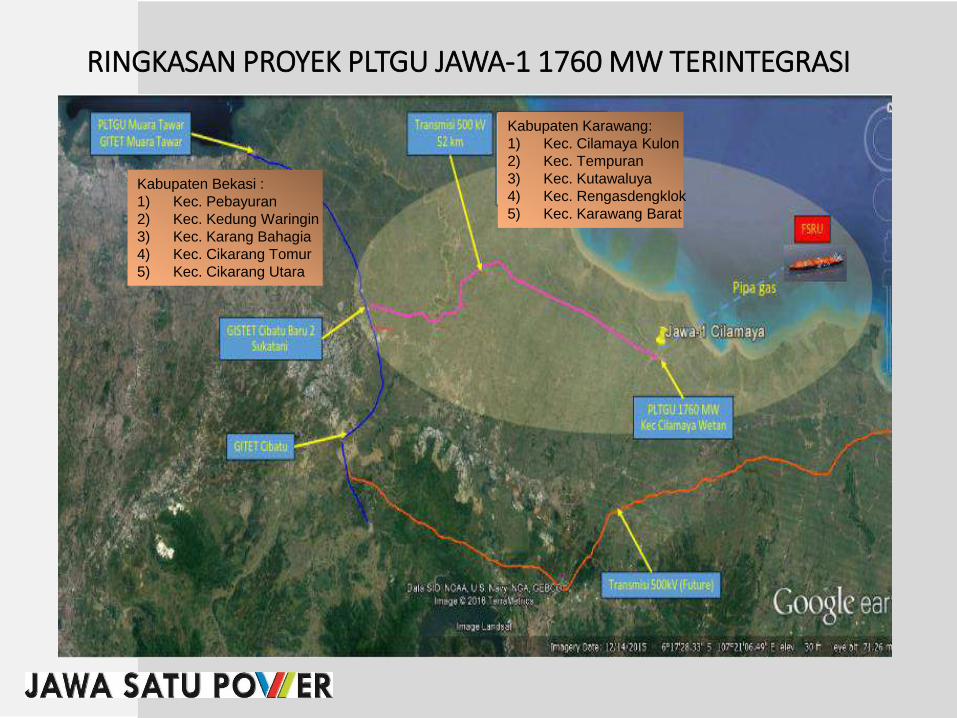
Kabupaten Karawang:
1) Kec. Cilamaya Kulon
2) Kec. Tempuran
3) Kec. Kutawaluya
4) Kec. Rengasdengklok
5) Kec. Karawang Barat
RINGKASAN PROYEK PLTGU JAWA-1 1760 MW TERINTEGRASI
Kabupaten Bekasi :
1) Kec. Pebayuran
2) Kec. Kedung Waringin
3) Kec. Karang Bahagia
4) Kec. Cikarang Tomur
5) Kec. Cikarang Utara

SKEMA SISTEM KELISTRIKAN
TRANSMISI
PEMBANGKIT
GARDU INDUK
GARDU INDUK
DISTRIBUSI
PELANGGAN

SUTET (SALURAN UDARA TEGANGAN EXTRA TINGGI)A
PERATURAN PERUNDANGANB
RUANG BEBAS/ROW (RIGHT OF WAY)C
KOMPENSASI RUANG BEBASD
PERHITUNGAN KOMPENSASIE
KOMPENSASI AREA RUANG BEBAS/ROWJALUR TRANSMISI 500 kV CILAMAYA – CIBATU BARU JAWA SATU POWER

Dasar Hukum
• UU No. 30 Tahun 2009 tentang Ketenagalistrikan:
• Pasal 2: Pembangunan ketenagalistrikan menganut asas keamanan dan keselamatan
• Pasal 44: Setiap kegiatan usaha ketenagalistrikan wajib memenuhi ketentuan
• keselamatan ketenagalistrikan (andal dan aman bagi instalasi, aman dari bahaya bagi manusia dan mahluk hidup, dan ramah lingkungan)
• PP No. 14 Tahun 2012 tentang Usaha Penyediaan Tenaga Listrik
• Pasal 42: Ketentuan keselamatan ketenagalistrikan antara lain meliputi pengamanan instalasi tenaga listrik
• Pasal 35: Obyek Kompensasi adalah tanah, bangunan dan tanaman di bawah ruangbebas SUTT/SUTET
• Permen Energi dan Sumber Daya Mineral No. 38 Th. 2013
tentang :
Kompensasi Atas Tanah, Bangunan, dan Tanaman Yang Berada Di Bawah Ruang BebasSaluran Udara Tegangan Tinggi dan Saluran Udara Tegangan Ekstra Tinggi.

Referensi• SNI 04-6918-2002
Tentang ruang bebas dan jarak bebas minimum pada Saluran Udara Tegangan Tinggi(SUTT) dan Saluran Udara Tegangan Ekstra Tinggi (SUTET).
• SNI 8151-2015
Tentang ruang bebas dan jarak bebas minimum pada Saluran Udara Tegangan TinggiArus Searah (SUTTAS).
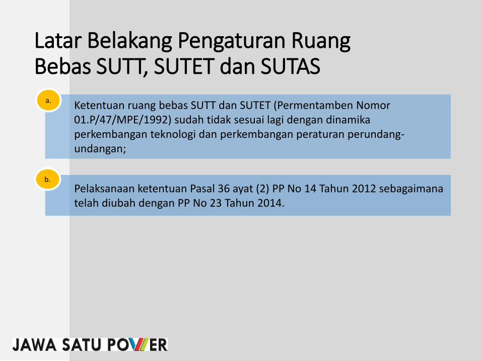
Latar Belakang Pengaturan RuangBebas SUTT, SUTET dan SUTAS
Ketentuan ruang bebas SUTT dan SUTET (Permentamben Nomor01.P/47/MPE/1992) sudah tidak sesuai lagi dengan dinamikaperkembangan teknologi dan perkembangan peraturan perundang-undangan;
a.
Pelaksanaan ketentuan Pasal 36 ayat (2) PP No 14 Tahun 2012 sebagaimanatelah diubah dengan PP No 23 Tahun 2014.
b.

SUTET (SALURAN UDARA TEGANGAN EXTRA TINGGI)A
PERATURAN PERUNDANGANB
RUANG BEBAS/ROW (RIGHT OF WAY)C
KOMPENSASI RUANG BEBASD
PERHITUNGAN KOMPENSASIE
KOMPENSASI AREA RUANG BEBAS/ROWJALUR TRANSMISI 500 kV CILAMAYA – CIBATU BARU JAWA SATU POWER

Istilah-Istilah Penting DalamPeraturan Menteri ESDM No. 18 tahun 2015
• Ruang bebas adalah:
Ruang yang dibatasi oleh bidang vertikal dan horizontal di sekeliling dan di sepanjangkonduktor SUTT, SUTET, atau SUTTAS di mana tidak boleh ada benda di dalamnya demi keselamatan manusia, makhluk hidup dan benda lainnya serta keamanan operasi SUTT, SUTET, dan SUTTAS
• Jarak bebas minimum vertikal adalah:
Jarak terpendek secara vertikal antara konduktor SUTT, SUTET atau SUTTAS denganPermukaan bumi atau benda di atas Permukaan bumi yang tidak boleh kurang dari jarakyang telah ditetapkan demi keselamatan manusia, makhluk hidup dan benda lainnya serta keamanan operasi SUTT, SUTET dan SUTTAS.
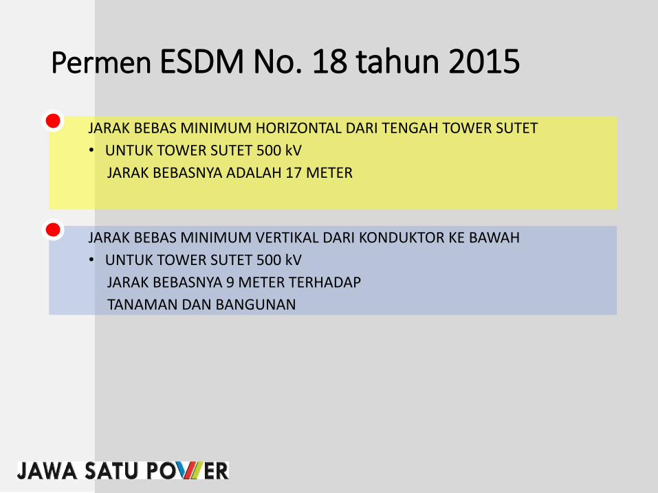
Permen ESDM No. 18 tahun 2015
JARAK BEBAS MINIMUM HORIZONTAL DARI TENGAH TOWER SUTET
• UNTUK TOWER SUTET 500 kV
JARAK BEBASNYA ADALAH 17 METER
JARAK BEBAS MINIMUM VERTIKAL DARI KONDUKTOR KE BAWAH
• UNTUK TOWER SUTET 500 kV
JARAK BEBASNYA 9 METER TERHADAP
TANAMAN DAN BANGUNAN

Land Owner within Coastal Area and Estimated Acquired Land (to be confirmed)
Land Owner
No. Main Income
Total
Size in
Coastal
Project
Location
(m2)
Land in
Another
Location
(m2)
Total
Land
Holding
(m2)
Acquired
Land by
the
Project
(m2)
% of the
Acquired
Land
Out of
Total
Land
1 Farmers
68.000
15.000
83.000
34.000 40,96%
2 Civil Servant
20.000
30.000
50.000
20.000 40,00%
3 Others
27.000
20.000
47.000
20.000 42,55%
4 Others
50.750
90.000
140.750
50.750 36,06%
5 Farmers
40.000
13.000
53.000
40.000 75,47%
6 Worker
20.000
3.500
23.500
20.000 85,11%
7 Farmers
13.850
300.000
313.850
8.080 2,57%

No Saluran Udara
Jarak dari Sumbu
Vertikal
Menara/Tiang ke
Konduktor
L
(m)
Jarak
Horihontal
Akibat Ayunan
Konduktor
H
(m)
Jarak bebas Inpuls Petir
(untuk SUTT dan SUTTAS)
atau Jarak Bebas Inpuls
Switsing (untuk SUTTET)
I
(m)
Total
L + H + I
(m)
Pembebasan
(m)
1. SUTT 66 kV Tiang Baja 1.80 1.37 0.63 3.80 4.00
2. SUTT 66 kV Tiang Beton 1.80 0.68 0.63 3.11 4.00
3. SUTT 66 kV Menara 3.00 2.74 0.63 6.37 7.00
4. SUTT 150 kV Tiang Baja 2.25 2.05 1.50 5.80 6.00
5. SUTT 150 kV Tiang Beton 2.25 0.86 1.50 4.61 5.00
6. SUTT 150 kV Menara 4.20 3.76 1.50 9.46 10.00
7. SUTET 275 kV Sirkit Ganda 5.80 5.13 1.80 12.73 13.00
8. SUTET 500 kV Sirkit Tunggal 12.00 6.16 3.10 21.26 22.00
9. SUTET 500 kV Sirkit Ganda 7.30 6.16 3.10 16.56 17.00
10. SUTTAS 250 kV 7.40 4.30 1.70 13.40 14.00
11. SUTTAS 500 kV 9.00 5.30 3.30 17.60 18.00
JARAK BEBAS MINIMUM HORIHONTAL DARI SUMBU VERTIKAL MENARA/TIANG PADA SUTT, SUTET,
DAN SUTTAS
RUANG BEBAS SUTET 275 kV dan 500 kV SIRKUIT GANDA

JARAK BEBAS MINIMUM VERTIKAL DARI KONDUKTOR
66 kV 150 kV 275 kV 500 kV 250 kV 500 kV
(m) (m) (m) (m) (m) (m)
1. 7,5 8,5 10,5 12,5 7,0 12,5
2. Daerah dengan keadaan tertentu
- Bangunan, jambatan b) 4,5 5,0 7,0 9,0 6,0 9,0
- Tanaman/tumbuhan, hutan,
perkebunan b)
4,5 5,0 7,0 9,0 6,0 9,0
- Jalan/jalan raya/rel kereta
api b)
8,0 9,0 11,0 15,0 10,0 15,0
- Lapangan Umum b) 12,5 13,5 15,0 18,0 13,0 17,0
- SUTT lain, Saluran Udara
Tegangan Rendah (SUTR),
Saluran Udara Tegangan
Menengah (SUTM), saluran
udara komunikasi, antena dan
kereta gantung b)
3,0 4,0 5,0 8,5 6,0 7,0
- Titik tertinggi tiang kapal
pada kedudukan air
pasang/tertinggi pada lalu
l intas air b)
3,0 4,0 6,0 8,5 6,0 10,0
CATATANa)
b) Jarak bebas minimum vertikal dihitung dari kondoktor ke titik tertinggi/terdekatnya
Jarak bebas minimum vertikal dihitung dari konduktor ke permukaan bumi atau
permukaan jalan/rel
JARAK BEBAS MINIMUM VERTIKAL DARI KONDUKTOR
Lapangan terbuka atau daerah
terbuka a)
SUTT SUTET SUTTAS
NO Lokasi

SUTET (SALURAN UDARA TEGANGAN EXTRA TINGGI)A
PERATURAN PERUNDANGANB
RUANG BEBAS/ROW (RIGHT OF WAY)C
KOMPENSASI RUANG BEBASD
PERHITUNGAN KOMPENSASIE
KOMPENSASI AREA RUANG BEBAS/ROWJALUR TRANSMISI 500 kV CILAMAYA – CIBATU BARU JAWA SATU POWER

17 M 17 M
9 Meter
9 Meter
DASAR HUKUM• UU No. 30 Tahun 2009 tentang Ketenagalistrikan
Pasal 27, 30, 31, 32, dan 33
• Kewenangan Pemegang Izin menggunakan/melintasi tanah, bangunan dan tanaman
• Ganti Rugi dan Kompensasi tanah, bangunan dan tanaman
• Tatacara Pemberian Ganti rugi dan Kompensasi sesuai peraturan yang berlaku
• PP No. 14 Tahun 2012 tentang Usaha Penyediaan Tenaga ListrikPasal 33, 35, 36 dan 37
• Kompensasi diberikan untuk penggunaan tanah secara tidak langsung
• Obyek Kompensasi adalah tanah, bangunan dan tanaman di bawah ruang bebas SUTT/SUTET
• Besaran kompensasi ditetapkan oleh Lembaga Penilai Independen
• Permenkeu No. 125/PMK 01 Tahun 2008 tentang Jasa Penilai PublikPasal 2, 3 dan 7
• Penilaian properti (tanah, bangunan dan tanaman) dilakukan oleh Penilai Publik yang profesionaldan independen
• Penilai Publik harus tergabung dalam suatu badan usaha yaitu Kantor Jasa Penilai Publik(KJPP)
• Penilai Publik dan KJPP harus mendapat izin dari Menteri Keuangan

Permen ESDM No. 38 Tahun 2013
• Kompensasi adalah pemberian sejumlah uang kepada pemegang hak atas tanah berikutbangunan, tanaman, dan/ atau benda lain yang terdapat di atas tanah tersebut karenatanah tersebut digunakan secara tidak langsung untuk pembangunan ketenagalistrikantanpa dilakukanpelepasan atau penyerahan hak atas tanah.
• Bangunan, tanah atau tanaman warga yang masuk dalam jalur bebas maka akan diberikankompensasi terhadap warga yang bersangkutan
• Tanaman adalah tanaman keras dengan tinggi tanaman yang berpotensi masuk ke dalamruang bebas.

Permen ESDM No. 38 Tahun 2013• Tahapan pelaksanaan kompensasi diatur mulai dari proses sosialisasi sampai
dengan pembayaran
• Besaran Kompensasi ditetapkan Lambaga Independen (KJPP/Kantor Jasa PenilaiPublik) yang ditunjuk Dirjen/Gubernur/Bupati/Walikota
• Besaran Kompensasi tanaman sebesar Nilai Pasar Tanaman dari LembagaIndependen (KJPP)
• Besaran Kompensasi tanah dan bangunan sebesar 15% Nilai Pasar dari LembagaIndependen (KJPP)
• Ganti kerugian dalam penarikan jaringan SUTT atau SUTET dilakukan secaramusyawarah

FORMULA BESARAN KOMPENSASI
Formula perhitungan untuk kompensasi tanah yaitu :
Kompensasi = 15% x Lt x NP Keterangan :Lt : Luas tanah di bawah ruang bebasNP : Nilai pasar tanah dari lembaga penilai
Formula perhitungan untuk kompensasi tanaman yaitu :
Kompensasi = NPtKeterangan :NPt : Nilai Pasar tanaman dari lembaga penilai
Formula perhitungan untuk kompensasi bangunan yaitu :
Kompensasi = 15% x Lb x NPbKeterangan :Lb : Luas bangunan di bawah ruang bebasNPb : Nilai Pasar bangunan dari lembaga penilai

OBJEK (PENERIMA KOMPENSASI)PP No. 14 Tahun 2012 tentang Usaha Penyediaan Listrik
Kompensasi sebagaimana diberikan untuk penggunaan tanah secarta tidaklangsung oleh pemegang izin usaha penyediaan tenaga listrik yang mengakibatkan berkurangnya nilai ekonomis atas tanah, bangunan dan tanamanyang dilintasi jaringan transmisi tenaga listrik untun SUTT dan SUTET
Kompensasi kepada pemegang hak atas tanah, bangunan dan tanaman diberikanuntuk :a. Tanah di bawah ruang bebas jaringan transmisi tenaga listrik untuk SUTT atau
SUTETb. Bangunan dan tanaman di bawah ruang batas jaringan transmisi tenaga listrk
untuk SUTT atau SUTET

HAK PENERIMA KOMPENSASI
Dalam hal pihak yang berhak atas tanah, bangunan dan tanaman tidakmenerima hasil inventarisasi dan identifikasi, dapat mangajukan keberatankepada pemegang izin atau melalui kantor kelurahan/desa dan kecamatansetempat paling lama 14 hari kerja terhitung setelah diumumkan
Pemegang hak atas yanah yang telah menerima kompensasi dapatmemanfaatkan tanahnya sepanjang pemanfaatan tidak masuk ke ruang bebas
(Permen ESDM No. 18/2015, pasal 3)

KETENTUAN KOMPENSASI
Kompensasi tanah, bangunan dan tanaman yang berada di bawah ruang bebasSUTT atau SUTET hanya dapat diberikan satu kali
Dalam hal telah berpindah tangan kepada pemilik yang baru, maka pemilik barutersebut tidak berhak menuntut pembayaran Kompensasi
Dalam hal calon penerima kompensasi tidak ditemukan atau menolakpemberian kompensasi, Pemegang izin (PT. JSP) melakukan penitipanpembayaran kompensasi kepada kantor Pengadilan Negeri setempat (konsinyasi)

HAK PEMEGANG IZIN (PT JSP)
Pemegang Izin Usaha Penyediaan Tenaga Listrik dan Pemegang Izin Operasi yang telah melakukan pembayaran kompensasi, berhak untukmenebang/memotong/mencabut tanaman yang berada di bawah ruang bebas
Dapat melakukan penarikan jaringan SUTTET atau SUTT setelah melakukanpenitipan pembayaran kompensasi kepada kantor Pengadilan Negeri setempat(konsinyasi) jika calon penerima kompensasi tidak ditemukan atau menolakpemberian kompensasi.

SKEMA PEMBERIAN KOMPENSASITAHAPAN KOMPEBSASI
PROSES PEMBERIAN KOMPENSASI
INVENTARISASI TANAH, BANGUNAN
DAN TANAMAN
PENUNJUKAN LEMBAGA PENILAI
PERHITUNGAN KOMPENSASI
PENETAPAN BESARAN
KOMPENSASI
PELAKSANAAN PEMBAYARAN
1 (Pasal 2) 2 (Pasal 3) 3 (Pasal 4) 4 (Pasal 5) 5 (Pasal 6)
Sosialisasi
Pendataan Awal
Inventarisasi danIdentifikasu
Dokumentasi
Pengumuman
Pengadaan LembagaPenilai
Diusulkan KepadaDirjen/Gubernur/Bupati/Walikota
Evaluasi
PenunjukanLambaga Penilai
Kompensasi Tanah15% x Lt x NP
KompensasiBangunan
15% xLb x NPb
KompensasiTanaman
NPt
Lembaga PenilaiMenetapkan
Besaran Kompensasi
Hasil PenetapanBersifat Final
KompensasiDiberikan Hanya
Satu Kali
Pemilik BerpindahTangan, Maka
Pemilik Baru TidakBerhak Menuntut
PembayaranDisaksikan Minimal
2 Orang Saksi
Apabila Ditolak atauTidak Ditemukan
Pemiliknya, Dilakukan Konsinyasi

GANTI KERUGIAN DALAM PENARIKAN SUTT ATAU SUTET
Ganti kerugian atas kerusakan pada bangunan/tanaman dan tegakan lainnya(tumbuh-tumbuhan bukan tanaman keras) yang terjadi saat penarikan jaringanSUTT atau SUTET dilakukan secara musyawarah

TERIMAKASIH
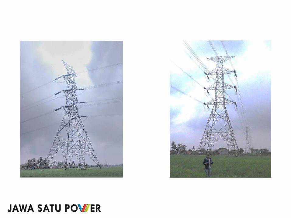

17 M 17 M9 Meter
9 Meter
8,5 Meter
PERSYARATAN ADMINISTRASI KOMPENSASI JARAK BEBAS
- Harga Kompensasi Hasil assesment KJPP
- Copy SPPT PBB 5 (lima) tahun terakhir
- Copy KTP pemilik lahan
- Copy SHM/AJB/Girik/Letter C)
- Surat Keterangan Desa (surat serbaguna)


Tanaman apasaja yang mendapatkan Kompensasi ?.......

Tanaman apa saja yang tidak mendapatkan kompensasi ?.....
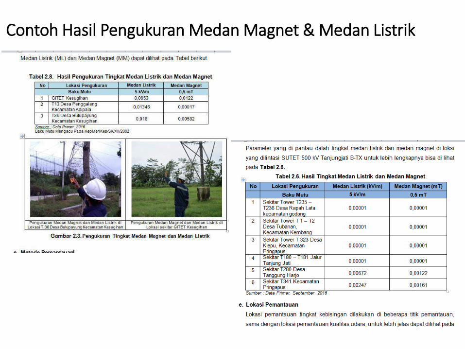
Contoh Hasil Pengukuran Medan Magnet & Medan Listrik


ANNEX 8B:
MATERIAL OF ROW SOCIALIZATION 2
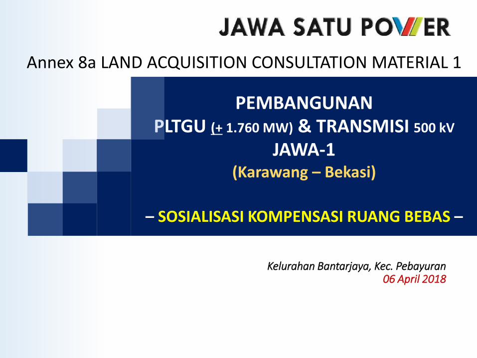
PEMBANGUNAN PLTGU (+ 1.760 MW) & TRANSMISI 500 kV
JAWA-1(Karawang – Bekasi)
– SOSIALISASI KOMPENSASI RUANG BEBAS –
Kelurahan Bantarjaya, Kec. Pebayuran06 April 2018
Annex 8a LAND ACQUISITION CONSULTATION MATERIAL 1

Kabupaten Karawang :1) Kec. Cilamaya Wetan2) Kec. Cilamaya Kulon3) Kec. Tempuran4) Kec. Rawamerta5) Kec. Cilebar6) Kec. Kutawaluya7) Kec. Rengasdengklok8) Kec. Karawang Barat
PROYEK PLTGU JAWA-1 (+ 1.760 MW)
Kabupaten Bekasi :1) Kec. Pebayuran2) Kec. Kedung Waringin3) Kec. Karang Bahagia4) Kec. Cikarang Timur5) Kec. Cikarang Utara
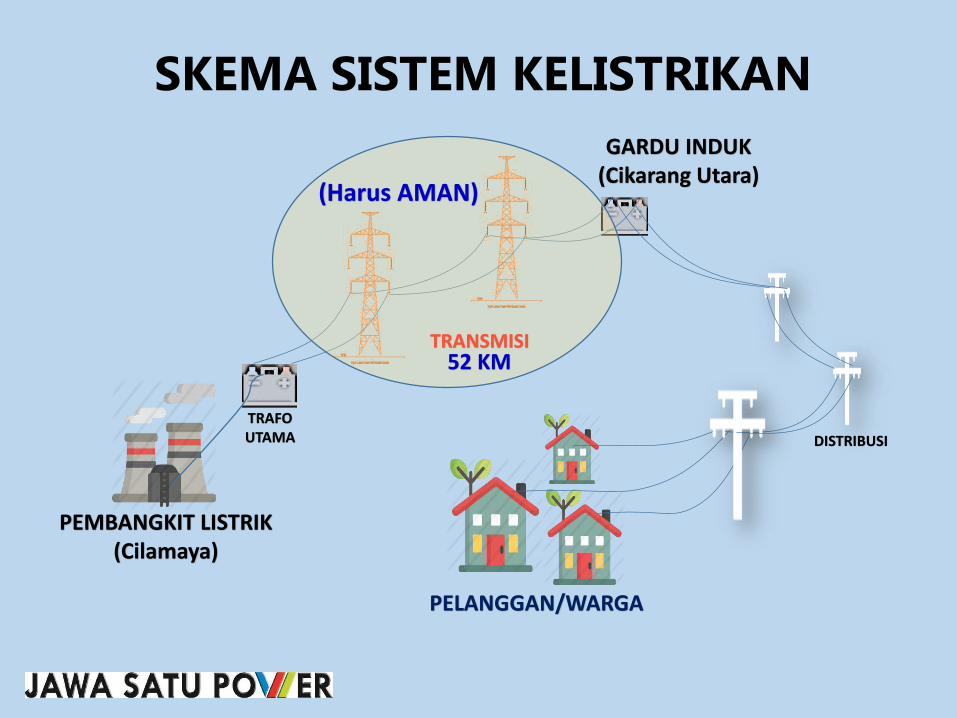
SKEMA SISTEM KELISTRIKAN
TRANSMISI
PEMBANGKIT LISTRIK(Cilamaya)
TRAFO UTAMA
GARDU INDUK(Cikarang Utara)
DISTRIBUSI
PELANGGAN/WARGA
(Harus AMAN)
52 KM

Istilah-Istilah Penting (Dasar Pengertian Transmisi Listrik)
Peraturan Menteri ESDM No. 18 tahun 2015
• RUANG BEBAS :
Ruang yang dibatasi oleh bidang vertikal dan horizontal di sekeliling dan di sepanjang konduktor SUTT, SUTET, atau SUTTAS dimana tidak boleh adabenda di dalamnya demi keselamatan manusia, makhluk hidup dan bendalainnya serta keamanan operasi SUTT, SUTET, dan SUTTAS
• Jarak Bebas Minimum Vertikal adalah:
Jarak terpendek secara vertikal antara konduktor SUTT, SUTET atau SUTTAS denganpermukaan bumi atau benda di atas permukaan bumi yang tidak boleh kurang dari jarakyang telah ditetapkan demi keselamatan manusia, makhluk hidup dan benda lainnya serta keamanan operasi SUTT, SUTET dan SUTTAS.
• Jarak Bebas Minimum Horisontal adalah:
Jarak terpendek secara horisontal dari sumbu vertikal menara/tiang ke bidang vertikalruang bebas bidang vertikal tersebut, sejajar dengan sumbu vertikal menara/tiang dankonduktor.

9 Meter17 M 17 M
9 Meter
18 Meter
9 Meter
RUANG BEBAS (Bawah Kabel Transmisi)

No Saluran Udara
Jarak dari Sumbu
Vertikal
Menara/Tiang ke
Konduktor
L
(m)
Jarak
Horihontal
Akibat Ayunan
Konduktor
H
(m)
Jarak bebas Inpuls Petir
(untuk SUTT dan SUTTAS)
atau Jarak Bebas Inpuls
Switsing (untuk SUTTET)
I
(m)
Total
L + H + I
(m)
Pembebasan
(m)
1. SUTT 66 kV Tiang Baja 1.80 1.37 0.63 3.80 4.00
2. SUTT 66 kV Tiang Beton 1.80 0.68 0.63 3.11 4.00
3. SUTT 66 kV Menara 3.00 2.74 0.63 6.37 7.00
4. SUTT 150 kV Tiang Baja 2.25 2.05 1.50 5.80 6.00
5. SUTT 150 kV Tiang Beton 2.25 0.86 1.50 4.61 5.00
6. SUTT 150 kV Menara 4.20 3.76 1.50 9.46 10.00
7. SUTET 275 kV Sirkit Ganda 5.80 5.13 1.80 12.73 13.00
8. SUTET 500 kV Sirkit Tunggal 12.00 6.16 3.10 21.26 22.00
9. SUTET 500 kV Sirkit Ganda 7.30 6.16 3.10 16.56 17.00
10. SUTTAS 250 kV 7.40 4.30 1.70 13.40 14.00
11. SUTTAS 500 kV 9.00 5.30 3.30 17.60 18.00
JARAK BEBAS MINIMUM HORIHONTAL DARI SUMBU VERTIKAL MENARA/TIANG PADA SUTT, SUTET,
DAN SUTTAS
RUANG BEBAS SUTET 275 kV dan500 kV SIRKUIT GANDA

66 kV 150 kV 275 kV 500 kV 250 kV 500 kV
(m) (m) (m) (m) (m) (m)
1. 7,5 8,5 10,5 12,5 7,0 12,5
2. Daerah dengan keadaan tertentu
- Bangunan, jambatan b) 4,5 5,0 7,0 9,0 6,0 9,0
- Tanaman/tumbuhan, hutan,
perkebunan b)
4,5 5,0 7,0 9,0 6,0 9,0
- Jalan/jalan raya/rel kereta
api b)
8,0 9,0 11,0 15,0 10,0 15,0
- Lapangan Umum b) 12,5 13,5 15,0 18,0 13,0 17,0
- SUTT lain, Saluran Udara
Tegangan Rendah (SUTR),
Saluran Udara Tegangan
Menengah (SUTM), saluran
udara komunikasi, antena dan
kereta gantung b)
3,0 4,0 5,0 8,5 6,0 7,0
- Titik tertinggi tiang kapal
pada kedudukan air
pasang/tertinggi pada lalu
l intas air b)
3,0 4,0 6,0 8,5 6,0 10,0
CATATANa)
b) Jarak bebas minimum vertikal dihitung dari kondoktor ke titik tertinggi/terdekatnya
Jarak bebas minimum vertikal dihitung dari konduktor ke permukaan bumi atau
permukaan jalan/rel
JARAK BEBAS MINIMUM VERTIKAL DARI KONDUKTOR
Lapangan terbuka atau daerah
terbuka a)
SUTT SUTET SUTTAS
NO Lokasi

Permen ESDM No. 18 tahun 2015
JARAK BEBAS MINIMUM HORIZONTAL DARI TENGAH TOWER SUTET
• UNTUK TOWER SUTET 500 kV JARAK BEBASNYA ADALAH 17 METER
JARAK BEBAS MINIMUM VERTIKAL DARI KONDUKTOR KE BAWAH
• UNTUK TOWER SUTET 500 kV
JARAK BEBASNYA 9 METER TERHADAP TANAMAN DAN BANGUNAN

PERBANDINGAN ANTARA PERMENTAMBEN 01.P/47/MPE/1992 JO PERMEN PE NO. 975.K/47/MPE/1999 DENGANKEPMEN ESDM No. 38 TAHUN 2013
PERMENTAMBEN 01.P/MPE/1992 JOKEPMEN PE NO. 975 K/47/MPE/1999
KEPMEN ESDM No. 38 TAHUN 2013
- Tidak Mengatur tahapan pelaksanaankompensasi
- Besaran kompensasi ditetapkan olehpemegang Izin Penyediaan TenagaListrik/Izin Operasi
- Formula besaran kompensasi maksimal10% NJOP
- Ganti kerugian dalam penarikan jaringanSUTT dan SUTET tidak diatur
- Tahapan pelaksanaan kompensasi diaturmulai dari proses sosialisasi sampaidengan pembyaran
- Besaran kompensasi ditetapkan LembagaIndependen yang ditunjukDirjen/Gubernur/Bupati/Walikota
- Besaran kompensasi tanah danbanggunan sebesar 15% Niai Pasar dariLembaga Independen
- Besaran kompensasi tanaman sebesarNilai Pasar Tanaman dari LembagaIndependen
- Ganti kerugian dalam penarikan jaringanSUTT dan SUTET dilakukan secaramusyawarah

Permen ESDM No. 38 Tahun 2013(Ruang Bebas harus di-Kompensasi)
• KOMPENSASI adalah pemberian sejumlah uang kepada PemegangHak atas tanah berikut bangunan, tanaman, dan/ atau benda lain yang terdapat di atas tanah tersebut karena tanah tersebut digunakan secaratidak langsung untuk pembangunan ketenagalistrikan tanpa dilakukanpelepasan atau penyerahan hak atas tanah.
• BANGUNAN, TANAH atau TANAMAN warga yang masuk dalam jalurbebas maka akan diberikan kompensasi terhadap warga yang bersangkutan.
• TANAMAN adalah tanaman keras dengan tinggi tanaman yang berpotensi masuk ke dalam ruang bebas.

• Tahapan pelaksanaan kompensasi diatur mulai dari proses sosialisasisampai dengan pembayaran
• Besaran Kompensasi ditetapkan Lambaga Independen (KJPP/Kantor Jasa Penilai Publik) yang ditunjuk Dirjen/Gubernur/Bupati/Walikota
• Besaran Kompensasi tanaman sebesar Nilai Pasar Tanaman dariLembaga Independen (KJPP)
• Besaran Kompensasi Tanah dan Bangunan sebesar 15% Nilai Pasar dariLembaga Independen (KJPP)
• Ganti kerugian saat penarikan/pembangunan Jaringan SUTT atauSUTET dilakukan secara musyawarah (koordinasi oleh Kontraktor EPC)
Permen ESDM No. 38 Tahun 2013

FORMULA BESARAN KOMPENSASI
Formula perhitungan untuk kompensasi TANAH yaitu :
Kompensasi = 15% x Lt x NPKeterangan :Lt : Luas tanah di bawah ruang bebasNP : Nilai Pasar tanah dari lembaga penilai
Formula perhitungan untuk kompensasi TANAMAN yaitu :
Kompensasi = NPtKeterangan :NPt : Nilai Pasar tanaman dari lembaga penilai
Formula perhitungan untuk kompensasi BANGUNAN yaitu :
Kompensasi = 15% x Lb x NPbKeterangan :Lb : Luas bangunan di bawah ruang bebasNPb : Nilai Pasar bangunan dari Lembaga Penilai

KETENTUAN KOMPENSASI
Kompensasi tanah, bangunan dan tanaman yang berada di bawah ruang bebas SUTT atau SUTET hanya dapat diberikansatu kali
Dalam hal telah berpindah tangan kepada pemilik yang baru, maka pemilik baru tersebut tidak berhak menuntutpembayaran Kompensasi
Dalam hal calon penerima kompensasi tidak ditemukan ataumenolak pemberian kompensasi, Pemegang izin (PT. JSP) melakukan penitipan pembayaran kompensasi kepada kantorPengadilan Negeri setempat (konsinyasi)
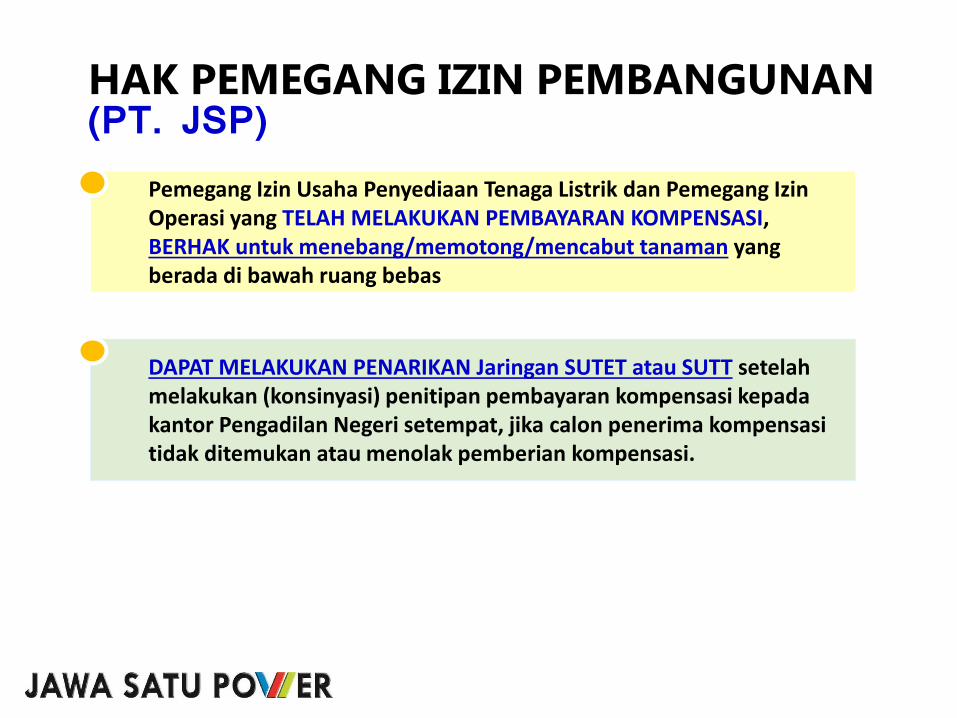
HAK PEMEGANG IZIN PEMBANGUNAN(PT. JSP)
Pemegang Izin Usaha Penyediaan Tenaga Listrik dan Pemegang IzinOperasi yang TELAH MELAKUKAN PEMBAYARAN KOMPENSASI, BERHAK untuk menebang/memotong/mencabut tanaman yang berada di bawah ruang bebas
DAPAT MELAKUKAN PENARIKAN Jaringan SUTET atau SUTT setelahmelakukan (konsinyasi) penitipan pembayaran kompensasi kepadakantor Pengadilan Negeri setempat, jika calon penerima kompensasitidak ditemukan atau menolak pemberian kompensasi.

TAHAPAN PROSES KOMPENSASI
• Pembuatan Peta Kerja, berdasarkan Data Sekunder (i.e. Google Earth)1
• Konfirmasi Kepemilikan ke Desa
• Pengukuran Lapangan
• Identifikasi dan Verifikasi Lapangan
• Pengumpulan & Verifikasi Data Kepemilikan Lahan
• Pengumuman Daftar Nominatif di Kantor Desa
• Penilaian Kewajaran Harga Tanah dari Kantor Jasa Penilai Publik
2
3
4
5
6
7
• Pembayaran Kompensasi8
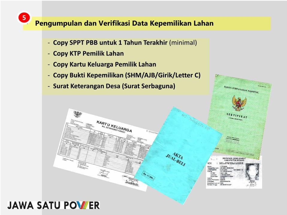
• Pengumpulan dan Verifikasi Data Kepemilikan Lahan5
- Copy SPPT PBB untuk 1 Tahun Terakhir (minimal)
- Copy KTP Pemilik Lahan
- Copy Kartu Keluarga Pemilik Lahan
- Copy Bukti Kepemilikan (SHM/AJB/Girik/Letter C)
- Surat Keterangan Desa (Surat Serbaguna)

• Pengumuman Daftar Nominatif di Kantor Desa6.a

Dalam hal pihak yang berhak atas tanah, bangunan dan TIDAK MENERIMA HASIL INVENTARISASI DAN IDENTIFIKASI, DAPAT MENGAJUKAN KEBERATANkepada Pemegang Izin atau melalui Kantor Kelurahan/Desa dan Kecamatansetempat paling lama 14 Hari Kerja terhitung setelah diumumkan.
• Pengumuman Daftar Nominatif di Kantor Desa6.b

- Berita Acara/Kesepakatan Kompensasi
- Tanda Terima Kompensasi/Kwitansi 2 rangkap
- Dokumentasi
• Pembayaran Kompensasi7
TERIMA KASIHMari Sukseskan Bersama,Listrik untuk Kita Semua

ANNEX 9:
MARKET PRICE OF LAND UNDER THE TRANSMISSION LINE
ROW BY INDEPENDENT APPRAISER

Sawah Tanpa Akses Jalan Langsung Rp 105,000 Rp 105,000 Rp 105,000 Rp 105,000 Rp 105,000 Rp 105,000 Rp 105,000 Rp 105,000
Sawah Jalan Setapak Rp 105,000 Rp 105,000 Rp 105,000 Rp 105,000 Rp 105,000 Rp 105,000 Rp 105,000 Rp 105,000
Sawah Jalan Lingk Tanah Rp 110,000 Rp 110,000 Rp 110,000 Rp 110,000 Rp 110,000 Rp 110,000 Rp 110,000 Rp 110,000
Sawah Jalan Lingk Aspal/cor beton Rp 125,000 Rp 125,000 Rp 125,000 Rp 125,000 Rp 125,000 Rp 125,000 Rp 125,000 Rp 125,000
Darat Jalan Kecamatan Rp 275,000 Rp 275,000 Rp 275,000 Rp 275,000 Rp 275,000 Rp 275,000 Rp 275,000 Rp 275,000
Darat Jalan Kabupaten Rp 275,000 Rp 275,000 Rp 275,000 Rp 275,000 Rp 275,000 Rp 275,000 Rp 275,000 Rp 275,000
Jenis Tanah Kelurahan/Desa
Cilamaya Sukatani Sukamulya Pasirukem Muktijaya Tegalurung Manggungjaya Sumurgede
Sawah Tanpa Akses Jalan Langsung
Sawah Jalan Setapak
Sawah Jalan Lingk Tanah
Sawah Jalan Lingk Aspal/cor beton
Darat Jalan Kecamatan
Darat Jalan Kabupaten
Jenis Tanah
Rp 105,000 Rp 105,000 Rp 105,000 Rp 105,000 Rp 105,000 Rp 105,000 Rp 105,000 Rp 105,000
Rp 105,000 Rp 105,000 Rp 105,000 Rp 105,000 Rp 105,000 Rp 105,000 Rp 105,000 Rp 105,000
Rp 110,000 Rp 110,000 Rp 110,000 Rp 110,000 Rp 110,000 Rp 110,000 Rp 110,000 Rp 110,000
Rp 125,000 Rp 125,000 Rp 125,000 Rp 125,000 Rp 125,000 Rp 125,000 Rp 125,000 Rp 125,000
Rp 275,000 Rp 275,000 Rp 275,000 Rp 275,000 Rp 275,000 Rp 275,000 Rp 275,000 Rp 275,000
Rp 275,000 Rp 275,000 Rp 275,000 Rp 275,000 Rp 275,000 Rp 275,000 Rp 275,000 Rp 275,000
Lemahkarya DayeuhluhurJayanegara Purwajaya Pagadungan Pancakarya Tanjungjaya Lemahduhur
Kelurahan/Desa

Sawah Tanpa Akses Jalan Langsung
Sawah Jalan Setapak
Sawah Jalan Lingk Tanah
Sawah Jalan Lingk Aspal/cor beton
Darat Jalan Kecamatan
Darat Jalan Kabupaten
Jenis Tanah
Rp 105,000 Rp 105,000 Rp 105,000 Rp 105,000 Rp 105,000 Rp 105,000 Rp 105,000 Rp 105,000
Rp 105,000 Rp 105,000 Rp 105,000 Rp 105,000 Rp 105,000 Rp 105,000 Rp 105,000 Rp 105,000
Rp 110,000 Rp 110,000 Rp 110,000 Rp 110,000 Rp 110,000 Rp 110,000 Rp 110,000 Rp 110,000
Rp 150,000 Rp 150,000 Rp 150,000 Rp 150,000 Rp 150,000 Rp 150,000 Rp 150,000 Rp 150,000
Rp 275,000 Rp 275,000 Rp 275,000 Rp 275,000 Rp 275,000 Rp 275,000 Rp 275,000 Rp 275,000
Rp 275,000 Rp 275,000 Rp 275,000 Rp 275,000 Rp 275,000 Rp 275,000 Rp 275,000 Rp 275,000
Waluya Mulyajaya Karyasari KalangsuriaSukaraja Sukaratu Sindangsari Sampalan
Kelurahan/Desa

Sawah Tanpa Akses Jalan Langsung
Sawah Jalan Setapak
Sawah Jalan Lingk Tanah
Sawah Jalan Lingk Aspal/cor beton
Darat Jalan Kecamatan
Darat Jalan Kabupaten
Jenis Tanah
Rp 105,000 Rp 105,000 Rp 105,000 Rp 150,000 Rp 150,000 Rp 150,000 Rp 150,000 Rp 150,000
Rp 105,000 Rp 105,000 Rp 105,000 Rp 150,000 Rp 150,000 Rp 150,000 Rp 150,000 Rp 150,000
Rp 110,000 Rp 110,000 Rp 110,000 Rp 190,000 Rp 190,000 Rp 190,000 Rp 190,000 Rp 190,000
Rp 150,000 Rp 150,000 Rp 150,000 Rp 225,000 Rp 225,000 Rp 225,000 Rp 225,000 Rp 225,000
Rp 275,000 Rp 275,000 Rp 450,000 Rp 450,000 Rp 400,000 Rp 400,000 Rp 400,000 Rp 400,000
Rp 275,000 Rp 275,000 Rp 600,000 Rp 600,000 Rp 600,000 Rp 600,000 Rp 600,000 Rp 600,000
Tunggakjati Bantarjaya Karangmekar Mekarjaya Karangmukti KarangharumKalangsari Mekarjati
Kelurahan/Desa

Sawah Tanpa Akses Jalan Langsung
Sawah Jalan Setapak
Sawah Jalan Lingk Tanah
Sawah Jalan Lingk Aspal/cor beton
Darat Jalan Kecamatan
Darat Jalan Kabupaten
Jenis Tanah
Rp 150,000 Rp 150,000 Rp 150,000 Rp 150,000 Rp 150,000
Rp 150,000 Rp 150,000 Rp 150,000 Rp 150,000 Rp 150,000
Rp 190,000 Rp 190,000 Rp 190,000 Rp 190,000 Rp 190,000
Rp 225,000 Rp 225,000 Rp 225,000 Rp 225,000 Rp 225,000
Rp 400,000 Rp 400,000 Rp 400,000 Rp 400,000 Rp 400,000
Rp 600,000 Rp 600,000 Rp 600,000 Rp 600,000 Rp 600,000
Karangsatu Karangsari Karangrahayu Waluya Karangraharja
Kelurahan/Desa