proposals for a perth foothills regional park and the...
TRANSCRIPT

Page 1
Proposals for a Perth Foothills Regional Park and the consolidation and extension of existing Darling Range National and Regional Parks
Nature Reserves Preservation Group Inc.September 2014
A Foothills Regional Park
Proposed extensions to and the consolidation of Beelu, Gooseberry Hill and Kalamunda’s National and Regional Parks

Page 2
Cover – The proposed Foothills Regional Park shown on an extract of the map Existing and Potential Bushland/Wetlands Linkages Map of the Perth Metropolitan Region (GOWA, 2000b)
Table of Contents
Proposal ................................................................................................................................................... 3Figure 1 Darling Range Regional Park (WAPC, 1995) ..................................................................................... 5Figure 2 Perth Bushland/ Wetland Linkages (GoWA, 2000b) .......................................................................... 6Figure 3 Shire of Kalamunda Wildlife Corridors (EMRC, 1999) ........................................................................ 7Figure 4 Quenda Creek and Kadina Brook Reserves (Hill, 1998) ..................................................................... 8Figure 5 Midgegooroo and Kalleep Munday Heritage Precincts (HRCG, 2002) .................................................9Figure 6a Hasluck’s Green Map Brochure (Wyatt, 2012) .............................................................................. 10Figure 6b Hasluck’s Green Map Brochure (Wyatt, 2012) .............................................................................. 11Figure 6c Hasluck’s Green Map (Wyatt, 2012) ............................................................................................ 11Figure 7a Darling Range Regional Park Area Northern Part K13 Area (WAPC, 1996a) .....................................12Figure 7b Darling Range Regional Park Area Southern Part K13 Area (WAPC, 1996a) .....................................13References ............................................................................................................................................. 14Appendix 1 Extract of Government Gazette Darling Range Regional Park Declaration (WAPC, 1996b) .............17

Page 3
Date: 15 September 2014
TO: Hon. Colin Barnett MLA, Premier of Western Australia Hon. Albert Jacob MLA, Minister for the Environment, Heritage
CC: Ken Wyatt MP, John Day MP
Subject. Proposal for the establishment of a Perth Foothills Regional Park and the Consolidation and extension of existing Darling Range National and Regional Parks.
Dear Premier and Minister,
The NRPG Inc. from Kalamunda requests that you give consideration to this proposal to establish a new Foothills Regional Park, and to systematically consolidate the existing Darling Range Parks. This proposal is designed to assist implementation of Hasluck’s Community Green Map plan, to celebrate and better protect the network of Perth foothills’ important natural and cultural heritage areas and to support the introduction of a carefully planned system of linked district cycle and walk ‘ways’.
This initiative will help to build on four decades of System 6 and Perth Bush Forever bushland and wetland planning and, the identification of catchment precincts of high natural and cultural heritage value and, to sensibly and systematically take the next steps for implementation of the November 1996 Darling Range Regional and National Park Declarations. We consider this important proposal might best be implemented through:
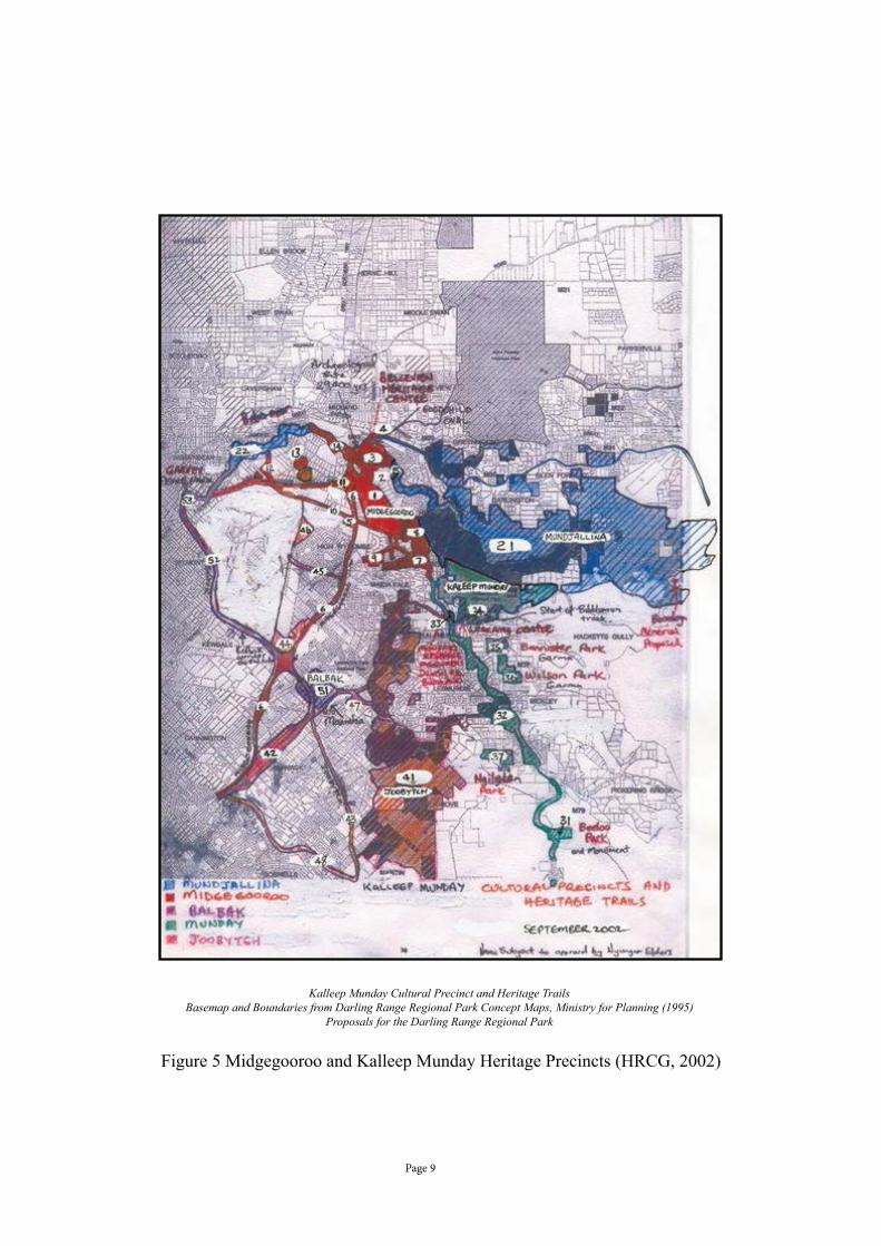
1. Extension of the Beelu National Park to include Hasluck’s Bellevue and Elder Creek land and reserves, the Greenmount, Bellevue and Bushmead railway reserves, Toornaart Creek reserves, Helena Valley’s, Helena River, and Swan’s Kadina Brook reserves, Hazelmere’s Bushmead Rifle Range and nearby natural and cultural heritage areas (Figures 1, 3, 5).
President:
Tony Fowler
Ph: 9293-2283
Vice President
Steve Gates
Ph: 9293 2915
P.O. Box 656
Kalamunda,
W.A., 6926
Nature Reserves Preservation Group, Inc.

Page 4
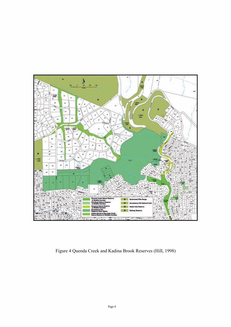
2. Extension of the Gooseberry Hill National Park to include Hasluck’s Gooseberry Hill’s Regional Open Space, Quenda Creek reserves, Huntley St Reserve, the Gooseberry Hill north part of the railway reserves in Darling Range Regional Park Area K13, north of Elizabeth St, Maida Vale Reserve bushland TEC areas and greenway linkages, Bush Forever sites and the Ridge Hill Road Reserves (Figure 4).
3. Establishment of a Boonooloo (Kalamunda Railway Reserve) Regional Park to include the terminus at the beginning of the Bibbulmun Track, Dixon Road reserve, Jorgensen Park and the Kalamunda south part of the (November 1996) Declared Darling Range Regional Park Area K13, with its important greenway, migratory bird habitat, rare and threatened plants linkages. This would secure the parkland link from Kalamunda to Pickering Brook’s Korung National Park (Figure 1, Figure 7a, 7b).
4. Establishment of a Warget (Perth Foothills) Regional Park. Warget is the Nyoongar name for Perth’s foothills soils (Lyon (1833) in Green (1979: P 176)). To be located along the important Perth foothills ecological corridor of naturally and culturally significant bushland and wetland reserves, it will extend from Forrestdale Lake to Brixton St, Hartfield Park, Munday Swamp, Kalamunda Road Swamp, Soldier Swamp, Hazelmere Lakes to Bennett Brook. This will provide recognition and protection for Hasluck’s ecological corridors, the Adelaide St and Great Eastern Highway Bypass Greenways, Hawkevale bushland and Roe Highway Greenways and, wetland reserves in Hazelmere, High Wycombe and Maida Vale, including Poison Gully and Nestle Brae Creek extending from Gooseberry Hill and Maida Vale to Garvey Park in Belmont (Cover).
5. 5 Extension of the Swan River Park to include the Swan and Canning River Tributaries and their
foreshore reserves, in order to formalise their continuing role as wildlife corridors to the important Darling Scarp spring areas connecting the river to the Darling Range Park (Figure 3).
6 Progressively establishing (and celebrating, using traditional names) Hasluck’s and greater Perth’s ‘Warget Way’ dual use walk ‘ways’ and cycle tracks along the boundaries of these new regional park reserves and cultural heritage linkages from Jandakot (and Rockingham) to Joondalup (and Hillarys) (Cover, Figure 2).
7 Progressively further establishing, Hasluck’s dual use walk ‘ways’ and traditionally named cycle tracks along the boundaries of the new Foothills Regional Park’s and Swan River Park’s east ......west tributary reserves, to act as permanent fire access tracks and firebreaks to these valuable ecological corridors (Figure 3, Figure 6c).
8 The facilitation of links with State and Federal natural resource management and cultural heritage conservation and employment and training programmes, to act as the catalyst, assisting and ensuring implementation of these important State heritage and Parks and wildlife works (figures 6a, 6b).
Yours faithfully,
Tony FowlerPresident

Page 5
Figure 1 Darling Range Regional Park (WAPC, 1995)

Page 6
Figure 2 Perth Bushland/Wetland Linkages (GoWA 2000b)

Page 7
Figu
re 3
Shi
re o
f Kal
amun
da W
ildlif
e C
orrid
ors (
EMR
C, 1
999)
Page 8
Figure 4 Quenda Creek and Kadina Brook Reserves (Hill, 1998)
Page 9
Figure 5 Midgegooroo and Kalleep Munday Heritage Precincts (HRCG, 2002)
Kalleep Munday Cultural Precinct and Heritage TrailsBasemap and Boundaries from Darling Range Regional Park Concept Maps, Ministry for Planning (1995)
Proposals for the Darling Range Regional Park

Page 10
Figure 6a Hasluck’s Green Map Brochure (Wyatt, 2012)

Page 11
Figure 6b Hasluck’s Green Map Brochure (Wyatt, 2012)
Figure 6c Hasluck’s Green Map (Wyatt, 2012)

Page 12
Figure 7a Darling Range Regional Park Area Northern Part K13 Area (WAPC, 1996a)

Page 13
Figu
re 7
b D
arlin
g R
ange
Reg
iona
l Par
k A
rea
Sout
hern
Par
t K13
Are
a (W
APC
, 199
6a)
Page 14
References
Armstrong P (1993) Vegetation and Flora Survey of the Shire of Kalamunda Vested Reserves, Vol.1 Report, Vol.2 Reserve Species List, Shire of Kalamunda, March 1993.
Brooker M (2001a) ‘Birds Mammals and Flora of Gooseberry Hill: General Introduction.’ Western Australian Naturalist, 23: 55-61.
Del Marco A, Taylor R, Clarke K, Savage K, Cullity J & Miles C (2004) Local Government Biodiversity Planning Guidelines for the Perth Metropolitan Region, Perth Biodiversity Project, Western Australian Local Government Association, Perth, Western Australia.
Dell J (1983) The importance of the Darling Scarp to fauna, in Majer JD (1983) (Ed) Scarp Symposium: Proceedings of a Meeting held in Perth on October 14 1983 Western Australian Institute of Technology, WAIT Environmental Studies Group, Perth.
Department of Conservation and Environment (1981) The Darling System Western Australia Proposals for Parks and Reserves, The System 6 Study Report to the Environmental Protection Authority, Department of Conservation and Environment, April 1981.
Department of Conservation and Environment (1983) Conservation Reserves for Western Australia as recommended by the Environmental Protection Authority – 1983 The Darling System – System 6, Volume 1 & Volume 2, Department of Conservation and Environment, October 1983.
Department of Planning and Urban Development (1992) Foothills Structure Plan, September 1992.
Department of Transport (2014) Western Australian Bicycle Network Plan 2014-2031, Published by the Department of Transport, March 2014.
Eastern Metropolitan Region Council (1998) Shire of Kalamunda Wildlife Corridor Strategy, Eastern Metropolitan Region Council, Belmont Western Australia, October 1998.
Eastern Metropolitan Region Council (1999) Draft Shire of Kalamunda Wildlife Corridor Strategy, Eastern Metropolitan Region Council, Belmont Western Australia, September 1999.
Eastern Metropolitan Region Council (2000) Shire of Mundaring Wildlife Corridor Strategy, Eastern Metropolitan Region Council, Belmont.
Government of Western Australia (1992) Legislation to create Regional Parks, Saturday, 10 October 1992, Media Release, Government of Western Australia, Perth, Western Australia.
Government of Western Australia (1996) Plans for Darling Range Regional Park released for comment, Tuesday, 7 May 1996, Media Release, Government of Western Australia, Perth, Western Australia.
Government of Western Australia (1996) Plans for creation of Darling Range National Park Tuesday, 15 October 1996, Media Release, Government of Western Australia, Perth, Western Australia.
Government of Western Australia (1996) Reservations boundaries for Darling Range National Park gazetted Friday, 22 November 1996, Media Release, Government of Western Australia, Perth, Western Australia.
Government of Western Australia (1997) Unveiling of commitment to bolster regional parks through metro area, Sunday, 8 June 1997, Media Release, Government of Western Australia, Perth, Western Australia.
Government of Western Australia (1998) Perth’s Bushplan Keeping the Bush in the City, Perth, Western Australia, November 1998.
Government of Western Australia (2000a) Bush Forever: Keeping Bush in the City, Perth, Western Australia, December 2000.
Government of Western Australia (2000b) Perth Bush Forever, Volume 2, Directory of Bush Forever Sites, Department of Environmental Protection, Perth, Western Australia, December 2000.
Government of Western Australia (2005) Monday 11 July 2005, Letter from Margaret Quirk, Parliamentary Secretary to the Premier Geoff Gallup to Mr Alan Evans, Government of Western Australia, Perth, Western Australia.
Government of Western Australia (2010) Final management plan released for Jandakot Regional Park Friday, 1 October 2010 Media Release, Government of Western Australia, Perth, Western Australia.
Government of Western Australia (2011) Swan River Trust Riverbank Grants Scheme open Thursday, 10 February 2011, Media Release, Government of Western Australia, Perth, Western Australia.
Government of Western Australia (2011) State Budget 2011-12: Building the State - $1million to improve Perth park access, walkways, Friday, 3 June 2011, Media Release, Government of Western Australia, Perth, Western Australia.

Page 15
Green N (1984) Broken Spears Aboriginals and Europeans in the South West of Australia, Focus Education Services.
Hallam SJ (1975) Fire and Hearth: a study of Aboriginal Usage and European usurpation in south-Western Australia, Australian Institute of Aboriginal Studies, Canberra.Hallam SJ (1983) The Perth Airport Extension, 1983: Preliminary Report on Prehistoric Aboriginal Sites, University of Western Australia, Unpublished report, February 1983.
Hallam SJ (1987a) Aboriginal Resource Usage along the Swan River, in John J (1987) (Ed) Swan River Estuary Ecology and Management, Curtin University of Technology Environmental Studies Group, Report No 1, Perth.
Hallam SJ (1987b) Coastal does not equal littoral, Aus. Archaeol., 25: 10-29.
Helena River Catchment Group (2002) Midgegooroo and Kalleep Munday Heritage Precincts, Two nomination form applications to the Register of the National Estate of the Australian Heritage Commission, July 19, 2002, Unpublished Report, Helena River Catchment Group Inc., Mundaring.
Hill AL (1996a) Introduction, in Hill AL, Semeniuk CA, Semeniuk V, & Del Marco A (1996a) Wetlands of the Swan Coastal Plain: Wetland Mapping Classification and Evaluation, Main Report, Volume 2a, Water and Rivers Commission and Department of Environmental Protection, Perth.
Hill AL (1998) Quenda Creek and Kadina Brook Reserves of Gooseberry Hill Draft Management Plan, Quenda Creek Subgroup, Nature Reserves Preservation Group Inc., Kalamunda.
Latitude Creative Services, Heritage and Conservation Professionals, National Trust (WA) (2009)Swan and Helena Rivers Management Framework Heritage Audit and Statement of SignificanceFinal Report, Prepared for the Eastern Metropolitan Regional Council, Belmont, 26 February 2009.
Lyon RM (1833) A glance at the manners and language of the Aboriginal inhabitants of Western Australia, in Green N (1979) Nyungar: The People – Aboriginal Customs in the Southwest of Australia, Creative Research in association with Mt Lawley College, Perth.
Macintyre K & Dobson B (1999) Proposed Homeswest Development Lot 608 Dixon Rd Kalamunda, Macintyre Dobson & Associates Pty. Ltd., April 1999.
Marshall J (1989) Shire of Kalamunda Town Planning Scheme No. 13, Survey of reserves proposed to be sold as building sites and of land to be acquired for development, Technical Details, Prepared for the Nature Reserves Preservation Group, September 1989.
Nyungah Circle of Elders (2002) Midgegooroo & Kaleep Munday Natural and Cultural Heritage Precincts Heritage Listing Nominations, Letter of endorsement and support, 20.08.02.
O’Connor R, Quatermaine G and Bodney C (1989) Report on an Investigation into Aboriginal Significance of Wetlands and Rivers in the Perth – Bunbury Region, Western Australian Water Resources Council, Perth, June 1989.
Pearson K & Tedeschi C (1996) (Ed) Bennett Brook Baseline Study of Flora and Fauna, A National Land Care Community Project, funded under the One Billion Trees and Save the Bush Programs 1994-95, Success Hill Action Group Inc., Bassendean 1999.
Report of the Review Group to the State Planning Commission of Western Australia (1987) Planning for the Future of the Perth Metropolitan Region, November 1987, State Planning Commission.
Schwede ML (1990) The Multifaceted Stone: A Regional Prehistory of the Helena River Valley on the Swan Coastal Plain of South Western Australia, Thesis for Doctor of Philosophy of University of Western Australia, Department of Archaeology.
Shire of Kalamunda (1995) Final District Conservation Strategy, Shire of Kalamunda, Kalamunda, August 1995.
Shire of Kalamunda (1998) Draft Management Plan Railway Reserve Shire of Kalamunda 1998-2002, Report prepared by Kabay Environmental Consultants and released by the Shire of Kalamunda to invite public comment, September 1998.Swan Valley Nyungah Community Aboriginal Corporation (2002) Midgegooroo & Kaleep Munday Natural and Cultural Heritage Precincts Heritage Listing Nominations, Letter of endorsement and support, 20.08.02. The Combined Native Title Claimants of the Swan River and Swan Coastal Plains (2002) Midgegooroo & Kaleep Munday Natural and Cultural Heritage Precincts Heritage Listing Nominations, Letter of endorsement and support, 20.08.02.
The Combined Swan River and Swan Coastal Plains and Darling Ranges Native Title Holders and Traditional Owners (2009) Report on Aboriginal Consultations and Site Visits of Elder Creek in Koongamia, Western Australia, Prepared for the Department of Indigenous Affairs, Aboriginal Cultural Material Committee and City of Swan, The Combined Swan River and Swan Coastal Plains and Darling Ranges Native Title Holders and Traditional Owners, March 2009.
Tingay & Associates (1998) A Strategic Plan for Perth’s Greenways Final report, Ministry for Planning, December 1998.
Page 16
Western Australian Planning Commission (1995) Proposals for the Darling Range Regional Park: Final, Western Australian Planning Commission, Perth, October 1995.
Western Australian Planning Commission (1996a) Metropolitan Region Scheme Amendment No. 978/33, Darling Range Regional Park Amendment, Technical Report, Western Australian Planning Commission, Perth, April 1996. Western Australian Planning Commission (1996b) METROPOLITAN REGION SCHEME-SECTION 33 AMENDMENT OUTCOME OF AMENDMENT ‘DARLING RANGE REGIONAL PARK’ File: 809-2-1-45Amendment No: 978/33, 22 November 1996, GOVERNMENT GAZETTE, WA 6589 PD401, Government of Western Australia, Perth, Western Australia.
Western Australian Planning Commission (1997) Parks for People Western Australia, broadsheet, Western Australian Planning Commission, Perth, June, 1997.
Wyatt K (2011) Hasluck’s Green Map, Ken Wyatt MP, Worldwide Online Printing, Cannington.

Page 17
Appendix 1 Extract of Government Gazette Darling Range Regional Park Declaration (WAPC, 1996b)
22 November 1996 GOVERNMENT GAZETTE, WA 6589
PD401WESTERN AUSTRALIAN PLANNING COMMISSIONMETROPOLITAN REGION SCHEME-SECTION 33 AMENDMENTOUTCOME OF AMENDMENT‘DARLING RANGE REGIONAL PARK’File: 809-2-1-45Amendment No: 978/33It is hereby notified for public information that the ‘Darling Range Regional Park’ Amendment to theMetropolitan Region Scheme has been submitted before both Houses of Parliament in accordancewith the provisions of section 33 of the Metropolitan Region Town Planning Scheme Act. During thattime no Notice of Motion to disallow the Amendment was carried by either House.The Amendment as depicted on Western Australian Planning Commission plan numbers 1.350612,1350711, 1.350811, 1.350911, 1.351011, 1.351112 and 1.351211 is therefore effective in the MetropolitanRegion Scheme on and from 14 November 1996.PETER MELBIN, Secretary, Western Australian Planning Commission.