proposal report - westconnex enabling works - airport east precinct · 2019-10-03 · westconnex...
TRANSCRIPT


(blank page)

WestConnex enabling works, airport east precinct i Proposal report
Executive summary Introduction
Roads and Maritime Services (Roads and Maritime) is planning to upgrade roads east of the airport and remove the General Holmes Drive rail level crossing. This will improve traffic flow and access to the airport, Port Botany and, in the future, the WestConnex motorway. Sydney Kingsford Smith Airport and Port Botany are two of Australia’s most important international gateways. The roads around the airport and Port Botany are becoming increasingly congested due to rising numbers of passengers and freight vehicles. A number of options to support future growth, improve access, reduce congestion and improve the movement of freight have been considered. This proposal will support the development of the WestConnex motorway, which will improve access between this area and Western Sydney. It has been assessed as best meeting government, community and transport needs, with the least impacts.
Proposal overview
Key aspects of the proposal include: 1. General Holmes Drive rail level crossing: Remove the existing rail level crossing
and replace it with a road underpass linking General Holmes Drive, Botany Road and Wentworth Avenue to improve the movement of rail freight and improve access to the airport, Mascot and the Eastern Suburbs.
2. Improvements to the Mill Pond Road intersections with General Holmes Drive
and Botany Road to support future traffic growth and efficient access to the airport.
3. Joyce Drive and General Holmes Drive: Widening to three lanes in each direction
between O’Riordan Street and Mill Pond Road to improve traffic flow around the airport and to Port Botany.
Proposal objectives
Proposal objectives are to: • Reduce current levels of congestion and improve the flow of road and rail
traffic. • Provide as a minimum, a light vehicle standard road underpass to replace the
General Holmes Drive rail level crossing. • Provide sufficient traffic capacity to accommodate 2028 projected traffic growth,
where possible. • Maintain or improve road and rail safety. • Minimise environmental and work health and safety risks during road work. • Provide a constructible design solution. • Maintain existing flood immunity.

WestConnex enabling works, airport east precinct ii Proposal report
• Provide a fit-for-purpose urban landscape outcome which complements the surrounding environment.
• Minimise the social and environmental impacts of the development including minimising the property acquisition where possible.
• Provide value for money.
State Government priorities
Road network improvements in this precinct are a priority in key State Government strategies. Aspects of these strategies relevant to the proposal include: • NSW Government State Infrastructure Strategy December 2012. • NSW Long Term Transport Master Plan 2012 • Draft NSW Freight and Ports Strategy 2012. • WestConnex announcement, October 2013.
Technical and environmental considerations
Roads and Maritime has carried out preliminary investigations within the study area (refer Section 1.4). These have included technical investigations of road, traffic, geotechnical, utility and environmental characteristics. The findings of these investigations were used to help identify potential options for road network improvements. The key issues identified were: • Traffic and transport: The performance of the traffic network, including the
outputs of the large-scale traffic model. • Landform, geology, soils and geotechnical considerations: The risk of
discovering soil and groundwater contamination and acid sulphate soils. • Utilities: The number and scale of utility relocations that would be required, in
particular the need to relocate the Southern Division Sub Main of the South West Suburbs Ocean Outfall Sewer (SWSOOS).
• Biodiversity: The impacts on flora and fauna and the proximity to sensitive areas, such as the Mill Ponds.
• Surface water drainage: The impact on water quality during construction. • Ground water: Presence of a high water table and impact on construction
methodology. • Land and ground water contamination: Potential for contamination issues and
impact on workplace health and safety, and waste disposal methods. • Non Aboriginal heritage: The impacts on heritage items within the study area,
including a church, houses, terraces, the SWSOOS Sub Main and Botany rail overbridge.
• Aboriginal heritage: The potential to find unrecorded Aboriginal heritage items. • Noise and vibration: Noise and vibration impacts during construction and
operation, as well as cumulative noise impacts. • Land use, social and economic: The need to acquire private and public land. • Airport: The impacts of the Obstacle Limitation Surfaces associated with
Sydney Airport operational constraints. (The Obstacle Limitation Surface defines the airspace to be protected for aircraft operating during initial and final stages of flight (refer to Section 3.2.6)).

WestConnex enabling works, airport east precinct iii Proposal report
Options
Roads and Maritime has identified five options in consideration of the preliminary technical and environmental considerations. Figures depicting these options are included in Chapter 4 of this report. All of the options would include: • Widening of General Holmes Drive and Joyce Drive between Mill Pond Road
and O’Riordan Street from four to six lanes. • Replacing the General Holmes Drive rail level crossing with a road underpass. Option 1 would involve: • Replacing the General Holmes Drive rail level crossing with a four lane low
clearance, light vehicle road underpass at the same location. • Upgrading Botany Road to three lanes in each direction between Mill Pond
Road and Wentworth Avenue. • Replacing and extending the Botany Road rail bridge. • Adjusting the Joyce Drive and General Holmes Drive intersection to include a
northern approach left turn slip lane from Joyce Drive into General Holmes Drive.
• Widening the existing two northern approach right turn lanes from Botany Road into Mill Pond Road to three right turn lanes.
• Widening the existing two eastern approach left turn lanes from Mill Pond Road into Botany Road to three left turn lanes.
• Realigning and duplicating the Port Botany freight rail line over a distance of about 750 metres.
Option 2 would involve: • Replacing the General Holmes Drive rail level crossing with a four lane low
clearance, light vehicle road underpass at the same location. • Adjusting the Joyce Drive and General Holmes Drive intersection to include a
northern approach left turn slip lane from Joyce Drive into General Holmes Drive.
• Widening the existing two eastern approach left turn lanes from Mill Pond Road into Botany Road to three left turn lanes.
• Minor rail adjustments. Option 3 would involve: • Closing the General Holmes Drive rail level crossing (and the existing access
to Botany Road) and replacing it with a new four lane, heavy vehicle clearance road underpass connecting General Holmes Drive to Botany Road at Wentworth Avenue.
• Adjusting the General Holmes Drive and Joyce Drive intersection to limit access to the eastern intersection leg, adjacent to the closed General Holmes Drive rail level crossing, to left-in and left-out only.
• Changing the Wentworth Avenue and Botany Road intersection from a three way to a four way intersection to accommodate a new road underpass connection to General Holmes Drive. The new western approach at the intersection would have one through lane, one shared through/ left-turn lane, and one right-turn lane.

WestConnex enabling works, airport east precinct iv Proposal report
• Creating a new intersection at General Holmes Drive and Wentworth Avenue. • Removing the existing northbound bus lane and bus stop on Botany Road
between Mill Pond Road and Wentworth Avenue. • Minor rail adjustments. Option 4 is similar to Option 3 but would include an additional dedicated left turn lane, two through lanes and one right turn lane on the new western approach to the intersection of Botany Road and Wentworth Avenue. Option 5 would involve: • Closing the General Holmes Drive rail level crossing (and the existing access
to Botany Road) and replacing it with a new heavy vehicle clearance road underpass (two lanes eastbound and three lanes westbound) connecting General Holmes Drive under the Port Botany freight rail line and Botany Road to Wentworth Avenue.
• Adjusting the General Holmes Drive and Joyce Drive intersection to limit access to the eastern intersection leg, adjacent to the closed General Holmes Drive rail level crossing, to left-in and left-out only.
• Adjusting the Botany Road and Wentworth Avenue intersection to remove the existing eastern approach right turn and left turn access from Wentworth Avenue into Botany Road and reducing the existing southern approach two right turn lanes from Botany Road into Wentworth Avenue to one right turn lane.
• Widening Wentworth Avenue from four to six lanes between Botany Road and Sutherland Street.
• Providing new traffic lights for the intersection of Wentworth Avenue, Johnson Street and Merchant Street.
• Reducing the existing three southern approach right turn lanes from General Holmes Drive into Mill Pond Road to two right turn lanes.
• Minor rail adjustments.
The proposal
Roads and Maritime held a value management workshop which was attended by representatives of Transport for NSW, Sydney Airport Corporation Ltd and the Australian Rail Track Corporation. The purpose of the workshop was to identify the option which would best meet the proposal objectives. The workshop participants selected Option 4 to be further developed as the proposal as it was found to: • Provide the best value for money. • Be the best performing option to reduce congestion. • Provide the greatest opportunity to improve access to and from the airport. • Be the most constructible and feasible option with the least environmental and
property impact.

WestConnex enabling works, airport east precinct v Proposal report
Proposal refinements
The value management workshop participants recommended actions to further develop Option 4. In response to these recommendations and additional technical investigations, Option 4 was subsequently refined to: • Further improve logical access to and from the airport. • Reduce queuing on the Southern Cross Drive off-ramp to Mill Pond Road. • Reduce congestion on Mill Pond Road. • Reduce potential queuing through the road underpass between General
Holmes Drive and Wentworth Avenue. • Improve access and safety for pedestrians and cyclists. The additional proposal refinements include: • Reducing the three existing southern approach right turn lanes from General
Holmes Drive into Mill Pond Road to two right turn lanes. • Closing the existing two western approach left turn slip lanes from Mill Pond
Road into Botany Road. • Banning the northern approach right turn movement from Botany Road into Mill
Pond Road. • Increasing the previously proposed two westbound lanes at the road underpass
to three westbound lanes. • Increasing the previously proposed single westbound left turn lane from the
road underpass to General Holmes Drive to two westbound left turn lanes. • Adjusting the previously proposed new western approach to the intersection of
Botany Road and Wentworth Avenue by increasing the single dedicated left turn lane to two left turn lanes and removing the right turn lane.
• Reinstating the northbound bus lane on Botany Road between Mill Pond Road and Wentworth Avenue and relocating the bus stop to the southern side of the General Holmes Drive intersection.
• Removing the previously proposed pedestrian crossings at the southern, western and northern legs of the intersection of Botany Road and Wentworth Avenue and providing a new pedestrian crossing at the southern leg of the intersection of General Holmes Drive and Botany Road.
• Providing shared user path access on the eastern side of Botany Road north of Wentworth Avenue, crossing to the western side of Botany Road at General Holmes Drive to access Baxter Street and O’Riordan Street.
The way forward
The proposal development process involves a number of stages before a proposal can be built. These stages will involve consultation with the community and stakeholders, and further field and technical investigations leading to concept design and environmental impact assessment. Roads and Maritime will closely review community and stakeholder suggestions when further developing the proposal. Following this, a further value management study will be carried out before confirming the proposal to progress to detailed concept design.
WestConnex enabling works, airport east precinct vi Proposal report
Contents
Executive summary.......................................................................................................i 1 Introduction and proposal justification................................................................. 1 1.1 Proposal overview ........................................................................................... 1 1.2 Proposal objectives ......................................................................................... 1 1.3 Proposal justification ....................................................................................... 2 1.4 Study area overview........................................................................................ 2 1.5 Purpose and structure of this report ................................................................ 2 2 Project development process.............................................................................. 4 2.1 Strategic and policy context ............................................................................ 4 2.2 Study area investigations ................................................................................ 6 2.3 Options development process......................................................................... 6 2.4 Consultation .................................................................................................... 8 3 Technical and environmental considerations .................................................... 10 3.1 Technical considerations............................................................................... 10 3.2 Environmental considerations ....................................................................... 13 4 Development of options .................................................................................... 16 4.1 Option 1......................................................................................................... 18 4.2 Option 2......................................................................................................... 21 4.3 Option 3......................................................................................................... 23 4.4 Option 4......................................................................................................... 26 4.5 Option 5......................................................................................................... 29 4.6 Value management study.............................................................................. 31 5 The proposal ..................................................................................................... 35 5.1 Description of the proposal............................................................................ 35 5.2 How the proposal meets the project objectives............................................. 35 5.3 Refinement of the project proposal ............................................................... 36 6 The way forward................................................................................................ 37 6.1 Stage 6: Concept design and environmental impact assessment................. 38 6.2 Stage 7: Proposal implementation ................................................................ 38 References................................................................................................................ 39 Terms and acronyms used in this report................................................................... 40 Appendix A................................................................................................................ 41 Appendix B................................................................................................................ 47
WestConnex enabling works, airport east precinct 1 Proposal Report
1 Introduction and proposal justification 1.1 Proposal overview Roads and Maritime Services (Roads and Maritime) is planning to upgrade roads east of the airport and remove the General Holmes Drive rail level crossing. This will improve traffic flow and access to the airport, Port Botany and, in the future, the WestConnex motorway. The WestConnex enabling works, airport east precinct (the ‘proposal’) will achieve this by increasing traffic capacity to improve access between the WestConnex motorway and Port Botany and by improving access to the east of the airport. Rail freight throughput will be improved by removing the General Holmes Drive rail level crossing. In addition, allowance will be made for future rail capacity upgrades. Key aspects of the proposal include: 1. General Holmes Drive rail level crossing: Removing the existing rail level
crossing and replacing it with a road underpass linking General Holmes Drive, Botany Road and Wentworth Avenue to improve the movement of rail freight and improve access to the airport, Mascot and the Eastern Suburbs.
2. Improvements to the Mill Pond Road intersections with General Holmes Drive,
Botany Road to support future traffic growth and efficient access to the airport. 3. Joyce Drive and General Holmes Drive: Widening to three lanes in each direction
between O’Riordan Street and Mill Pond Road to improve traffic flow around the airport and to Port Botany.
The proposed road network improvements are identified as priority projects in key State Government strategies, including the: • NSW Government State Infrastructure Strategy December 2012. • NSW Long Term Transport Master Plan 2012. • Draft NSW Freight and Ports Strategy 2012. • WestConnex announcement, October 2013. For more information about these strategies, refer to Section 2.1.
1.2 Proposal objectives The objectives of the proposal are to: • Reduce current levels of congestion and improve the flow of road and rail
traffic. • Provide as a minimum, a light vehicle standard road underpass to replace the
General Holmes Drive rail level crossing. • Provide sufficient traffic capacity to accommodate 2028 projected traffic growth,
where possible. • Maintain or improve road and rail safety. • Minimise environmental and work health and safety risks during road work.

WestConnex enabling works, airport east precinct 2 Proposal Report
• Provide a constructible design solution. • Provide a fit-for-purpose flood immunity solution. • Provide a fit-for-purpose urban landscape outcome which complements the
surrounding urban environment. • Minimise the social and environmental impacts of the development including
minimising the property acquisition footprint where possible. • Provide value for money.
1.3 Proposal justification The proposal is required to facilitate the construction and operation of the WestConnex motorway, and to support the NSW Government’s strategies and plans for infrastructure in NSW (refer to Section 2.1). The proposal would help deliver on the following objectives in these strategies and plans: • Support and strengthen the State economy by providing much-needed
infrastructure (NSW Government, 2012). • Ensure NSW has an integrated, modern transport system (TfNSW, 2012a). • Provide a transport network which allows the efficient flow of goods to their
markets (TfNSW, 2012b). • Enable Sydney Airport to meet forecast passenger growth, and improve access
to and around the airport (SACL, 2013). • Relieve congestion on road network pinch points within the Sydney Airport and
Port Botany precinct (NSW Govt, 2012).
1.4 Study area overview The proposal is located in Mascot, about eight kilometres south of the Sydney central business district and next to Sydney Airport. It is located within the City of Botany Bay local government area (LGA). The study area includes: • General Holmes Drive, from just south of Mill Pond Road to the Botany Road
intersection. • Botany Road between Mill Pond Road and King Street. • Joyce Drive between General Holmes Drive and just east of the O’Riordan
Street intersection. • Wentworth Avenue between Botany Road and Sutherland Street. • Mill Pond Road.
1.5 Purpose and structure of this report The WestConnex motorway is identified as the highest priority project in the NSW Government State Infrastructure Strategy (NSW Government, 2012). The WestConnex enabling works, airport east precinct proposal would: 1. Facilitate implementation of the WestConnex motorway. 2. Support the Sydney Airport Corporation Ltd proposed airport access
improvements. 3. Remove an operational slow point on the Port Botany freight rail line by removing
the General Holmes Drive rail level crossing.

WestConnex enabling works, airport east precinct 3 Proposal Report
This report documents the reasons the proposal is required; the options that have been considered; the advantages and disadvantages of each option; and the preferred option. In the following chapters, the report presents: • The proposal development process, including the strategic and policy context,
the process of study area investigations, options development and consultation (Chapter 2).
• An overview of the technical and environmental considerations arising from investigations (Chapter 3).
• A description of the options identified (Chapter 4). • The proposal (Chapter 5). • The next steps in the project development process (Chapter 6).

WestConnex enabling works, airport east precinct 4 Proposal Report
2 Project development process This chapter presents the key strategies that underpin the planning process for the proposal, the investigations carried out, the options development process, and the consultation process.
2.1 Strategic and policy context The road network servicing the Sydney Airport and Port Botany precinct is an important contributor to the economic prosperity of NSW. The road network is becoming increasingly congested due to the rising volumes of light and heavy vehicles. The need for the proposal is identified in a number of major NSW Government plans and strategies. These include the NSW Government State Infrastructure Strategy (NSW, 2012), the NSW Long Term Transport Master Plan 2012 (TfNSW, 2012a), the Draft NSW Freight and Ports Strategy (TfNSW, 2012b) and the WestConnex announcement (October 2013). These documents address the need to: • Accommodate the future growth of Sydney Airport and Port Botany, and
surrounding areas. • Improve connections to and from the airport and port. • Improve the movement of freight from road to rail, and the capacity of freight
rail lines. • Target road traffic pinch points. • Improve bus and taxi access to and from the airport. The following sections provide an overview of the NSW Government strategies relevant to the proposal.
2.1.1 State Infrastructure Strategy 2012 The State Infrastructure Strategy (NSW Goverment, 2012) is a strategy that identifies and prioritises the delivery of critical public infrastructure to drive productivity and economic growth. The strategy highlights critical deficiencies in urban road capacity and provides strategic options to meet the challenges of population growth and substantial increases in freight volumes. The strategy identifies the Sydney Airport and Port Botany precinct as the location of two of Australia’s most important international air and sea gateways and cites road network pinch points of special concern.
2.1.2 NSW Long Term Transport Master Plan 2012 The NSW Long Term Transport Master Plan (TfNSW, 2012a) provides a framework to deliver an integrated, modern transport system by identifying NSW’s transport actions and investment priorities for the next 20 years. The Master Plan identifies the opportunities and challenges faced by NSW to the year 2032. It includes a precinct action plan to improve the efficiency of the transport network servicing Port Botany and Sydney Airport. The objective of the precinct action plan is to “reduce congestion by targeting traffic pinch points, increasing rail

WestConnex enabling works, airport east precinct 5 Proposal Report
services, investigating additional bus service options to and from Sydney Airport and improving the infrastructure that supports freight flows to and from Port Botany”. The replacement of the General Homes Drive rail level crossing with a grade-separated crossing and related road infrastructure improvements to maintain road network capacity are specific short-term actions within the master plan. The Master Plan also includes a short to medium term action to duplicate the Port Botany freight rail line operated by Australian Rail Track Corporation Ltd (ARTC). This would involve: • Stage 1: Cooks River to Mascot. • Stage 2: Mascot to Port Botany, following removal of the rail level crossing at
General Homes Drive. This action would require accompanying changes to road infrastructure.
2.1.3 Draft NSW Freight and Ports Strategy The Draft NSW Freight and Ports Strategy (TfNSW 2012b) is a core component of the NSW Government’s overall strategic planning framework. It is consistent with the NSW Long Term Transport Master Plan and supports the goals identified in the NSW 2021 – A Plan to Make NSW Number One (NSW Government, 2013). Objectives of the strategy applicable to the proposal include: • Delivery of a freight network that efficiently supports the projected growth of the
NSW economy. • Balancing freight needs with those of the broader community and the
environment. The key actions and tasks from this strategy, which are applicable to the proposal include: • Close the General Holmes Drive rail level crossing. • Upgrade the capacity of the Botany freight line and Botany rail yard. • Separate passenger and freight movements through network improvements at
General Holmes Drive. • Provide funding for the following infrastructure programs:
– WestConnex motorway link to Port Botany.
– Port Botany freight rail line duplication: Cooks River to Mascot.
– Port Botany freight rail line duplication: Mascot to Port Botany.
2.1.4 Preliminary Draft Sydney Airport Master Plan 2033 The Preliminary Draft Sydney Airport Master Plan 2033 (SACL, 2013) was announced on 5 June 2013, and provided an opportunity for community comment. Sydney Airport Corporation Limited (SACL) plans to submit the new draft Master Plan to the Australian Government by the end of 2013, replacing the plan developed in 2009. The preliminary draft Master Plan references the recommendations in the State Infrastructure Strategy for constructing the WestConnex motorway, fixing road pinch

WestConnex enabling works, airport east precinct 6 Proposal Report
points in the Sydney Airport and Port Botany precinct, reducing rail fares to the airport, adding new bus routes to the airport and improving the capacity of the freight rail lines. The draft Master Plan includes a five-year ground transport plan, which includes actions to: • Provide an additional road connection from Shiers Avenue to Qantas Drive at
Robey Street in the T2 and T3 precinct (domestic terminals). • Convert the lower sections of Robey Street and O’Riordan Street into one-way
roads northbound and southbound, respectively. • Advocate for the widening of Joyce Drive and General Holmes Drive between
O’Riordan Street and Mill Pond Road.
2.1.5 WestConnex announcement The WestConnex project was announced in October 2013. WestConnex is one the NSW Government’s key infrastructure projects which aims to ease congestion, create jobs and connect communities. It is the largest integrated transport and urban revitalisation project in Australia. The 33 kilometre project is a feature of the NSW Government State Infrastructure Strategy (December 2012). It brings together a number of important road projects which together form a vital link in Sydney’s Orbital Network. They include a widening of the M4 east of Parramatta, a duplication of the M5 East and new sections of motorway to provide a connection between the two key corridors.
2.2 Study area investigations Roads and Maritime began investigating the study area in April as part of the initial investigation of options for replacement of the lost road network capacity associated with the closure of the rail level crossing at General Holmes Drive. These included preliminary technical investigations of road, traffic, geotechnical, utility and environmental characteristics of the area surrounding the rail level crossing. Due to the complexity of the road network within the Sydney Airport and Port Botany precinct, a combined broad network and localised traffic modelling approach was expanded to include an intermediate network traffic model. This modelling approach seeks to address road congestion issues at a network scale, from Sydney City CBD to Botany Bay, and also between Anzac Parade and Princes Highway. The traffic model identified the wider network improvements associated with the WestConnex enabling works. The traffic model considers: • Forecast growth in road traffic. • Performance of the traffic network in terms of vehicle kilometres travelled
(route distance) and vehicle hours travelled (route duration). • Performance of the traffic network for each option.
2.3 Options development process Roads and Maritime Services developed feasible options for the proposed road network improvements. This process involved:
WestConnex enabling works, airport east precinct 7 Proposal Report
• Reviewing the study area and previous studies. • Conducting field investigations to confirm the technical and environmental
constraints. • Carrying out engineering design to develop project options. • Consulting with stakeholders (SACL, ARTC and utility providers) (refer to
Section 2.4). • Holding an issues workshop to identify issues associated with the project
options. • Carrying out a value management workshop to assess options and identify
a proposal for further development. These steps have culminated in the preparation of this report, which forms the basis for further review and comment by stakeholders and the local community. The main steps in the project development process are shown in Figure 2-1.

WestConnex enabling works, airport east precinct 8 Proposal Report
Figure 2-1 The project development process
2.4 Consultation 2.4.1 Stakeholder consultation The key objective for early consultation is to ensure input from stakeholders is incorporated into each phase of the investigation, from the development of strategic project options to the identification of a project proposal. Roads and Maritime began consulting with SACL and ARTC in 2009 and is ongoing. Roads and Maritime is also consulting with utility companies, including: • Ausgrid (the major supply and distribution electricity company). • Jemena, Savcor, and Qenos (gas providers, asset managers and distributors).
2. Identification of proposal
1. Project identified and objectives agreed
Technical and environmental investigations
Stakeholder consultation
Identification of options
Technical workshops (including issues workshop and value management workshop)
Selection of proposal and preparation of Proposal Report We are here
3. Announcement and community display of proposal
4. Value management study
5. Announce confirmation of the Proposal
6. Concept design and environmental approval
7. Proposal implementation

WestConnex enabling works, airport east precinct 9 Proposal Report
• Telstra, Optus and NBN Co (telecommunications companies). • Sydney Water (Sydney’s water and wastewater utility provider).
2.4.2 Community consultation In the next phase, Roads and Maritime will consult the local community and key stakeholders to obtain feedback on the proposal. Consultation will involve: • Presenting project information to the community and stakeholders, including
the need for the upgrade, its benefits and how potential impacts would be reduced.
• Developing community understanding of the project development process, the decision-making process and the next steps.
• Clearly explaining the consultation process and how community and stakeholder feedback will be incorporated into subsequent stages of the project.

WestConnex enabling works, airport east precinct 10 Proposal Report
3 Technical and environmental
considerations Roads and Maritime has carried out technical and environmental investigations to inform the process of identifying strategic project options. A summary of the technical and environmental considerations undertaken in the development of the strategic project options is provided in this chapter.
3.1 Technical considerations 3.1.1 Traffic and transport Traffic modelling was used to refine project options (refer to Section 2.2). These options were assessed for network traffic performance factors such as: • Average vehicle speed (kilometres per hour). • Vehicle kilometres per trip (VKT). • Vehicle hours per trip (VHT). • Number of trips delayed. • Number of travelling trips. • Released demand (time when the peak hour was completed). The traffic modelling is being utilised as an on-going tool to further refine the proposed option. This will be supplemented with more detailed traffic engineering simulation modelling as the proposal development progresses.
3.1.2 Landform, geology, soils and geotechnical considerations Preliminary geotechnical investigations within the study area are documented in the Preliminary Environmental Investigation (Roads and Maritime, 2013). The landform is generally flat to low undulating and has been modified by past land users. There are remnants of coastal dunes and the associated freshwater systems of the Botany Wetlands, which drain to Botany Bay. Dominant soil landscapes are the Tuggerah soil landscapes in the north-east and disturbed landscapes in the south and east. Tuggerah landscapes are prone to wind erosion, and would need to be managed during construction and operation of the project. Contamination may occur within disturbed soil landscapes, which include controlled and uncontrolled areas of fill. Previous studies (Stuart Hill Pty Ltd, 2009) identified asbestos remnants close to the intersection of Mill Pond Road and Botany Road. The risk of discovering soil and groundwater contamination is considered to be likely, as it is in an area with existing and historical industrial land uses. Contamination would be assessed during the development phase and would need to be appropriately managed during construction, particularly during excavation.
WestConnex enabling works, airport east precinct 11 Proposal Report
Acid sulphate soil risk mapping identified a high probability of occurrence in the south of the study area, near the Mill Ponds. Potential acid sulphate soils will be assessed during the stage two contamination assessment, and if identified, would require management during construction.
3.1.3 Utilities Utility surveys were carried out for the study area. Information was provided by Dial Before You Dig searches, underground detection, “potholing” at select locations and consultation with utility authorities. Utilities are listed in Table 3-1: Table 3-1 Utilities in the study area
Electricity
• 132 kilovolt transmission lines owned by Ausgrid. • High-voltage 11 kilovolt transmission lines across Wentworth Avenue. • Low voltage, overhead distribution power lines.
Gas pipelines
• High-pressure ethane pipeline (10,000 kilopascals) parallel to the northern side of Mill Pond Road. This pipeline is expected generally to be about 8 metres beneath ground level. It is not anticipated that the ethane pipeline would be impacted by the proposal.
• High-pressure ethylene gas pipeline (200 millimetres in diameter, 10 millimetres thick) owned by Savcor and Qenos. The pipeline is on the eastern side of the railway embankment west of Botany Road. It also passes over Botany Road strapped to the northern side-girder of the Botany Road rail overbridge.
• Hydrogen and nitrogen gas pipelines between Botany Road and the Port Botany freight rail line. These are understood to be redundant and planned for decommissioning. This is yet to be confirmed with the pipeline owner.
• A 550 millimetres high-pressure primary gas main adjacent to the eastern side of General Holmes Drive and predominantly within SACL land. Relocation presents significant risks to the community, environment, health and safety.
• A 50 millimetre diameter distribution polythene pipe is located along Botany Road in the western footway.
• A 100 millimetre high-pressure secondary natural gas main on the western side of Botany Road.
• Other low-pressure natural gas distribution mains and polyethylene pipelines near Wentworth Avenue.
Sewer
• The Southern Division Sub Main of the South West Suburbs Ocean Outfall Sewer (SWSOOS Sub Main) is owned by Sydney Water. It is a box structure of nominal dimensions 1800 millimetres by 1300 millimetres, and is converted into twin 1400 mm diameter pipes beneath the proposed approaches to the connection with General Homes Drive. Box structure relocation requirements as initially advised by Sydney Water may require a pumping station with two independent power sources and sufficient hard

WestConnex enabling works, airport east precinct 12 Proposal Report
stand for a fleet of tankers should the temporary pumping system fail during relocation. Similar requirements would be applied to the twin pipes. Relocation presents significant risks to the community, environment, health and safety.
• A sewer main running beneath the intersection of General Holmes Drive and Botany Road and towards the end of the East-West runway is understood to be sufficiently distant from the works to not be impacted, but this is yet to be confirmed.
Stormwater
• An open stormwater channel on the eastern side of General Holmes Drive and south of the rail level crossing, and is currently under the control of the City of Botany Bay Council.
Water
• A 500 millimetre main owned by Sydney Water, in the proximity of the western side footway of Botany Road.
• Other water utilities (375 millimetres, 300 millimetres and 150 millimetres, including rider and distribution mains).
Telecommunications
• Minor assets owned by Optus in various locations. • Underground Telstra distribution network along Wentworth Avenue and
Botany Road. Larger ducting also carries cables belonging to Telstra and other carriers. Some assets are also located on the western side of General Holmes Drive. There is also fibre optic cable within the study area.
• National Broadband Network (NBN) fibre optic cable (ranging from 324 strand to 12 strand).
Rail
• Signalling, electrical and communication cables. • Old tram tracks along Botany Road
Street lighting
• Street lighting particularly along Botany Road, General Holmes Drive and intersections are serviced by a combination of overhead and underground cabling
Road traffic signal infrastructure
• Underground cabling associated with traffic signals, information management (IM) and information technology (IT) requirements.

WestConnex enabling works, airport east precinct 13 Proposal Report
3.2 Environmental considerations In 2009, Roads and Maritime carried out a preliminary environmental investigation as part of the initial options investigations for the rail level crossing at General Holmes Drive (Hill, 2009 in RTA, 2010). In 2013, Roads and Maritime carried out an updated preliminary environmental investigation (Roads and Maritime, 2013). The following sections summarise the outcomes of these investigations.
3.2.1 Biodiversity Most of the study area is built up and heavily urbanised. Accordingly, biodiversity is limited to street landscaping and open land. The vegetated area between General Holmes Drive and Botany Road is heavily affected by weeds, primarily lantana. A number of Grey She-Oak (Casuarina glauca) trees line Botany Road in the vicinity of Wentworth Avenue. The City of Botany Bay Council has carried out some planting next to the eastern footway of General Holmes Drive between Mill Pond Road and Joyce Drive, which may be disturbed by project works. No remnant areas of native vegetation have been identified within the study area. However, there may be potential for the Eastern Suburbs Banksia Scrub threatened ecological community to occur due to its presence in surrounding suburbs. A search of the Office of Environment and Heritage Atlas of NSW Wildlife found no record of endangered flora species within the study area (Hill, 2009 in RTA, 2010; and Lesryk Environmental Consultants, 2013). Green and Golden Bell Frog (Litoria aurea) and Grey-headed Flying-fox (Pteropus poliocephalus) records were found close to but not within the study area. In addition, the Large-eared Pied Bat (Chalinolobus dwyeri), Southern Myotis (Myotis macropus) and Eastern Bentwing Bat (Miniopterus orianae oceanensis) may potentially occur within the study area. The Mill Ponds (located to the south of Mill Pond Road) are recorded as a Nationally Important Wetlands by the Department of Sustainability, Environment, Water, Population and Communities Protected Matters Search Tool. The Mill Pond Road Preliminary Ecological Investigation (Lesryk Environmental Consultants, 2013) states that the Mill Ponds would be part of a local wildlife corridor that would primarily be used by flying, amphibian or water species.
3.2.2 Surface and groundwater
Surface water Surface water in the study area includes Sheas Creek (Alexandra Canal) to the north-west, Mill Ponds to the south and Botany Bay to the south-west. The Mill Pond system (also known as Botany Wetlands) discharges to Botany Bay to the south of the study area. Water quality is dependent on the quality of stormwater, which feeds via stormwater channels to Alexandra Canal and Mill Ponds.

WestConnex enabling works, airport east precinct 14 Proposal Report
Groundwater
Groundwater in the Botany Bay area is characteristic of generally shallow water tables that are tidally influenced and within highly permeable sands (known as the Botany Sands Aquifer). Preliminary geotechnical field investigations found water in boreholes at depths between 2.2 metres and 4.9 metres. The shallow depth of the water table would affect the design of structures, pavement and constructability. The permeability of the sands can present groundwater quality issues due to the ability of any contamination from land use activity to leach into groundwater. In addition, there is potential for contaminants from the Botany Industrial Park to already be located within the aquifer. Natural groundwater flow beneath Botany Industrial Park has led to contaminated plumes of groundwater between the Botany Industrial Park and Botany Bay. Early geotechnical analysis indicated that there may be tidal effects extending towards the proximity of the proposed underpasses. These potential tidal effects are yet to be confirmed. Groundwater would need to be managed during all phases of the project, particularly during construction (refer to Section 3.1.2). Construction methods would be developed to cater for the groundwater issues.
3.2.3 Non-Aboriginal heritage A search of local, state and national heritage databases was undertaken in 2013 to identify non-Aboriginal heritage items within the study area (Roads and Maritime, 2013). The search identified 41 heritage items listed under the Botany Bay Local Environmental Plan 2013, comprising a church, houses, terraces and cottages. The railway overbridge is listed under the RailCorp Section 170 heritage register. A number of heritage items may be affected by the project, and would require consideration in the development of the preferred option. Heritage items that would pose constraints on the project include the railway overbridge. The construction methodology would also need to consider the potential of vibration and other indirect impacts on these heritage items.
3.2.4 Aboriginal heritage The study area is located within the Metropolitan Local Aboriginal Land Council area. The area is highly disturbed. A basic Aboriginal Heritage Information Management System (AHIMS) search was carried out on 12 June 2013 (Roads and Maritime, 2013). The search returned no records of Aboriginal sites or declared Aboriginal places within a 50 metre radius of the study area.
3.2.5 Noise and vibration Stakeholders in the study area likely to be affected by noise include residential properties, commercial and industrial properties, as well as community facilities such as schools, early learning facilities, parks and a church.

WestConnex enabling works, airport east precinct 15 Proposal Report
Noise sources in the study area are typical of the Sydney urban environment and include road, rail, aircraft, residential and recreational. Much of the study area is located directly under the flight path of the east–west runway of Sydney Airport. Additional exposure to road noise and cumulative noise would be considered during development of the options. A number of heritage items may also be susceptible to vibration impacts during construction. Noise and vibration assessment will be carried out, notwithstanding the immediate proximity of planes approaching and departing on the main east-west runway (Runway 07/25) and the immediately adjacent freight rail line.
3.2.6 Land use, social and economic The study area includes a variety of land uses, including open space and recreation, airport, rail and road, industrial, residential and business. Surrounding land is owned by a range of government agencies (Federal, State, Local government) and private owners. The location of the project within an area with various land uses and land use zones may have an impact on the planning approvals pathway and associated project timeframes. The need to acquire Commonwealth land, and associated consultation requirements, may also have an impact on timeframes for the project.
3.2.7 Sydney Airport A large portion of the study area falls under the east–west runway approaches for Sydney Airport. As such, development within this area is subject to the requirements of the Airports (Protection of Airspace) Regulations 1996. An Obstacle Limitation Surfaces (OLS) exists for Sydney Airport, which defines the airspace to be protected for aircraft operating during the departure and final stages of flight. The height of the OLS varies over the study area. The height constraints would need to be considered during option development and project design, and in selecting construction methods and equipment.

WestConnex enabling works, airport east precinct 16 Proposal Report
4 Development of options The development of options has been an iterative process involving a number of inputs, including desktop and field investigations, engineering design, traffic modelling, stakeholder inputs and technical workshops. This process has resulted in the consolidation of all prior investigations, leading to the identification of five options. An overview of these options is shown schematically in Figure 4-1. Appendix A contains the concept design drawings. The following aspects are common to all options: • Widening of General Holmes Drive and Joyce Drive between Mill Pond Road
and O’Riordan Street from four to six lanes. • Replacing the General Holmes Drive rail level crossing with a road underpass. • Adjustment to the following utilities:
- 132 kilovolt electricity transmission lines within the study area. - Street lighting and low voltage power distribution cables. - Gas pipelines: An ethylene pipeline on the eastern side of the railway
embankment; hydrogen and nitrogen pipelines adjacent to Botany Road; natural and polyethylene pipelines adjacent to General Holmes Drive within SACL land; and a secondary natural gas main on the western side of Botany Road.
- An open stormwater channel to the east of General Holmes Drive. - Telecommunications: Optus assets; Telstra distribution network, Telstra
cables within larger ducting and fibre optic cables; and NBN fibre optic cables. - Rail signals, and electrical and communication cables. - Roads and Maritime traffic signal communications lines.
The five options are described in the following sections with a focus on the railway crossing treatment, the rail overbridge and rail adjustments, and intersection and lane changes.

WestConnex enabling works, airport east precinct 17 Proposal Report
Figure 4-1 Options Overview

WestConnex enabling works, airport east precinct 18 Proposal Report
4.1 Option 1 A schematic of Option 1 is presented in Figure 4-2, and a concept design drawing is provided in Appendix A.
Figure 4-2 Option 1
4.1.1 Level crossing treatment Option 1 would involve replacing the level crossing with a low clearance road underpass (there would be about 3.6 metres of clearance). This would accommodate light vehicles, low buses and trucks.
4.1.2 Rail overbridge and rail alignment Option 1 would involve duplicating the rail overbridge over Botany Road to provide space for additional through lanes on Botany Road. To ensure continued use of the Port Botany freight rail line during construction, about 750 metres of rail would potentially require adjustment or upgrade.

WestConnex enabling works, airport east precinct 19 Proposal Report
4.1.3 Intersection and lane adjustments Option 1 would involve widening the approaches to intersections by providing additional through lanes and turning lanes. These would include: • A dedicated left-turn lane from Joyce Drive into General Holmes Drive
(northern approach). • An additional left-turn lane from Mill Pond Road onto Botany Road to connect
to the widened northbound lane on Botany Road. • An additional right-turn lane from Botany Road southbound onto Mill Pond
Road (which would provide three right-turn lanes). • An additional through lane on Botany Road in both directions between Mill
Pond Road and Wentworth Avenue (providing three through lanes).
4.1.4 Technical, environmental and social considerations The technical, environmental and social considerations particular to Option 1 are summarised in Table 4-1. Table 4-1 Technical, environmental and social considerations for Option 1
Technical considerations
• There would be insufficient clearance for high vehicles including trucks and double-decker buses. Vehicles of 3.6 metres or more would be diverted via Mill Pond Road.
• The insufficient height clearance and associated risk of regular bridge hits would result in regular blocking of access to the road underpass, and network congestion.
• This option would result in increased congestion (reduced performance) of Botany Road between Gardeners Road and Mill Pond Road.
• This option would result in the least queuing on General Holmes Drive. • The replacement, duplication and expansion of the Botany Road rail
overbridge would be required, resulting in significant constructability constraints.
• The duplication of the Botany Road rail overbridge and associated rail may result in intrusion into the Obstacle Limitation Surfaces (OLS) for Sydney Airport. In addition, equipment used for piling and retaining wall placement (such as piling rigs and excavators) may breach OLS during construction.
• The upgrade of the Botany Road rail overbridge may require the lowering of Botany Road. Permanent pump-out may also be required during operation at this location.
• The proposed road underpass at General Holmes Drive would probably require a widened road corridor to accommodate the adjustments of rail during construction and to maintain road access during construction.
• The adjustment of rail including embankment widening would create a risk of short- and long-term settlement at track tie-ins, resulting in differential settlement of the tie-ins.
• The ethane pipeline, adjacent to Mill Pond Road, may require structural protection works because of its proximity to potential widening of Mill Pond Road.

WestConnex enabling works, airport east precinct 20 Proposal Report
Technical considerations
• The following utilities would need to be relocated during construction: − The Southern Divisional Sub Main sewer. Relocation of this sewer
would require substantial support equipment such as a pumping station (footprint approximating 30 metres x 30 metres), independent power supply, access to a fleet of tankers and associated hard stand facilities during relocation activities.
− Water utilities (375 millimetres, 300 millimetres and 150 millimetres). • A complex construction and staging strategy would be required. • This option would be the most expensive of all the options considered, with
the greatest cost risk.
Environmental and social considerations
• There would be potential impacts on the Botany Road rail overbridge, two houses and a church, which are listed as local heritage items.
• There would be potential traffic, noise and access impacts associated with relocation of the Southern Division Sub Main sewer. There would also be potential odour and amenity issues should pumping systems fail during relocation.
• Residential and industrial properties would need to be acquired to accommodate the additional lanes proposed for Botany Road.
• The proposed works would provide some disruption to access during construction, to the Park and Fly development on the north-west corner of Botany Road and General Holmes Drive.

WestConnex enabling works, airport east precinct 21 Proposal Report
4.2 Option 2 A schematic of Option 2 is presented in Figure 4-3, and a detailed design drawing is provided in Appendix A.
Figure 4-3 Option 2
4.2.1 Level crossing treatment Option 2 would involve replacing the level crossing at General Holmes Drive with a low-clearance road underpass (there would be about 3.6 metres of clearance) This would accommodate light vehicles and low buses and trucks.
4.2.2 Rail alignment Option 2 would potentially require adjustment or upgrade of more than 300 metres of rail track near the level crossing and road underpass to ensure continued use of the Port Botany freight rail line during construction.

WestConnex enabling works, airport east precinct 22 Proposal Report
4.2.3 Intersection and lane adjustments Option 2 would involve widening the approaches to intersections by providing additional through lanes and turning lanes. These would include: • A dedicated left-turn lane from Joyce Drive into General Holmes Drive
(northern approach). • An additional left-turn lane from Mill Pond Road onto Botany Road (which
would then have three left-turn lanes).
4.2.4 Technical, environmental and social considerations The technical, environmental and social considerations that are particular to Option 2 are summarised in Table 4-2. Table 4-2 Technical, environmental and social considerations for Option 2
Technical considerations
• There would be insufficient clearance for high vehicles including trucks and double-decker buses. Vehicle traffic over 3.6 metres high would be diverted via Mill Pond Road.
• The insufficient height clearance and associated risk of regular bridge hits would result in regular blocking of access to the road underpass, and network congestion.
Environmental and social considerations
• This option would have the least impact on property of the five options. • This option would have a similar adverse impact on access to Park n Fly
development at the corner of General Holmes Drive and Botany Road to Option 1.

WestConnex enabling works, airport east precinct 23 Proposal Report
4.3 Option 3 A schematic of Option 3 is presented in Figure 4-4, and a detailed design drawing is provided in Appendix A.
Figure 4-4 Option 3
4.3.1 Level crossing treatment Option 3 would involve closing the level crossing and providing a road underpass between General Holmes Drive and Wentworth Avenue. The road underpass would have two through lanes in each direction with 4.7 metres of clearance under the rail line. A turnaround facility (cul-de-sac) would be provided adjacent to the General Holmes Drive and Botany Road intersection, and adjacent to the Joyce Drive intersection with General Holmes Drive.
4.3.2 Rail alignment Option 3 would potentially require adjustment or upgrade of about 300 metres of rail track near the proposed road underpass to ensure continued use of the Port Botany freight rail line during construction.

WestConnex enabling works, airport east precinct 24 Proposal Report
4.3.3 Intersection and lane adjustments Option 3 would require the removal of one right-turn lane at the southern approach of the General Holmes Drive and Joyce Drive intersection. In addition, the intersection of Wentworth Avenue and Botany Road would be realigned about 30 metres to the south and converted from a T-junction to a four-way intersection as follows: • Northern approach: One right-turn, one through lane and one left-turn lane. • Southern approach: One left-turn lane, two through lanes and one right-turn
lane. • Eastern approach: Two left-turn lanes, two through lanes and two right-turn
lanes. • Western approach: One shared left/through lane, one dedicated through lane
and one right-turn lane.
4.3.4 New intersections Option 3 would involve a new intersection at General Holmes Drive and Wentworth Avenue as follows: • Northern approach: Three through lanes and one left-turn lane. • Southern approach: Three through lanes and two right-turn lanes. • Eastern approach: One left-turn and two right-turn lanes.
4.3.5 Technical, environmental and social considerations The technical, environmental and social considerations that are particular to Option 3 are summarised in Table 4-3. Table 4-3 Technical, environmental and social considerations for Option 3
Technical considerations
• There is an opportunity to improve this option by reviewing traffic modelling, investigating the interaction of intersections and adjusting intersection configurations as appropriate.
• A high design capacity for flood immunity would be required. Design would also need to manage surface flows, storage requirements and pump-out during operation.
• Equipment used for piling and retaining walls (such as piling rigs and excavators) may breach OLS during construction.
• The following utilities would need to be relocated or protected during construction: − High Pressure gas main, 550 millimetres diameter, would need to be
either relocated or protected with structural components. − The SWSOOS Sub Main sewer. Relocation of this sewer would
require substantial support equipment such as a pumping station about 30 metres x 30 metres, independent power supply, a fleet of tankers and associated parking. The project would pursue protection rather than relocation if possible.

WestConnex enabling works, airport east precinct 25 Proposal Report
− Water utilities (500 millimetres, 375 millimetres, 300 millimetres and 150 millimetres); each of these water utilities would need to be relocated.
Environmental and social considerations
• There would be potential impacts on the bus lane and bus stops on Botany Road.
• There would be potential impacts on two heritage-listed houses and a church hall adjacent to a heritage-listed church.

WestConnex enabling works, airport east precinct 26 Proposal Report
4.4 Option 4 A schematic of Option 4 is presented in Figure 4-5, and a detailed design drawing is provided in Appendix A.
Figure 4-5 Option 4
4.4.1 Level crossing treatment Option 4 would involve closing the level crossing and providing a road underpass between General Holmes Drive and Wentworth Avenue. The road underpass would have two through lanes in each direction with 4.7 metres of clearance under the rail line. A turnaround facility (cul-de-sac) would be provided adjacent to the General Holmes Drive and Botany Road intersection, and adjacent to the Joyce Drive intersection with General Holmes Drive.
4.4.2 Rail alignment Option 4 would potentially require adjustment or upgrade of about 300 metres of rail track near the proposed road underpass to ensure continued use of the Port Botany freight rail line during construction.

WestConnex enabling works, airport east precinct 27 Proposal Report
4.4.3 Intersection and lane adjustments Option 4 would require the removal of one right-turn lane at the southern approach of the General Holmes Drive and Joyce Drive intersection. In addition, the intersection of Wentworth Avenue and Botany Road would be realigned about 30 metres to the south and converted from a T-junction to a four-way intersection as follows: • Northern approach: One right-turn, one through lane and one left-turn lane. • Southern approach: One left-turn lane, two through lanes and one right-turn
lane. • Eastern approach: Two left-turn lanes, two through lanes and two right-turn
lanes. • Western approach: Two left-turn lanes, two through lanes and one right-turn
lane.
4.4.4 New intersections Option 4 would involve a new intersection at General Holmes Drive and Wentworth Avenue as follows: • Northern approach: Three through lanes and one left-turn lane. • Southern approach: Three through lanes and two right-turn lanes. • Eastern approach: One left-turn and two right-turn lanes.
4.4.5 Technical, environmental and social considerations The technical, environmental and social considerations that are particular to Option 4 are summarised in Table 4-4. Table 4-4 Technical, environmental and social considerations for Option 4
Technical considerations
• There is an opportunity to add two left-turn lanes at the Wentworth Avenue and Botany Road intersection to increase efficiency.
• There is an opportunity to improve this option by reviewing traffic modelling, investigating the interaction of intersections and adjusting intersection configurations as appropriate.
• A high design capacity for flood immunity would be required. Design would also need to manage surface flows, detention requirements and permanent pump-out during operation.
• Equipment used for piling and retaining walls (such as piling rigs and excavators) may breach OLS during construction.
• Bridging over the open stormwater canal traversing north-south through to project.
• The following utilities would need to be provided with slab protection rather than relocation: − Sewer Sub-Main, two 1400 millimetre diameter barrels. − Primary High Pressure gas main, 550 mm in diameter.

WestConnex enabling works, airport east precinct 28 Proposal Report
Technical considerations
• The following utilities would need to be relocated during construction: − The high-voltage 11 kilovolt transmission lines across Wentworth
Avenue. − The low-pressure natural gas distribution mains and polyethylene
pipelines, particularly near Wentworth Avenue. − Water utilities (375 millimetres, 300 millimetres and 150 millimetres).
Environmental and social considerations
• There would be potential impacts on the bus lane and bus stops on Botany Road.
• There would be potential impacts on two heritage-listed houses and a church hall adjacent to a heritage-listed church.

WestConnex enabling works, airport east precinct 29 Proposal Report
4.5 Option 5 A schematic of Option 5 is presented in Figure 4-6, and a detailed design drawing is provided in Appendix A.
Figure 4-6 Option 5
4.5.1 Level crossing treatment Option 5 would involve closing the level crossing and providing a road underpass between General Holmes Drive and Wentworth Avenue. The road underpass would have two eastbound through lanes and three westbound through lanes with 4.7 metres of clearance under the rail line. A turnaround facility (cul-de-sac) would be provided at the General Holmes Drive and Botany Road intersection, and on the western side of the railway level crossing location.
4.5.2 Rail alignment Option 5 would potentially require adjustment or upgrade of about 300 metres of rail track near the new road underpass to ensure continued use of the Port Botany freight rail line during construction.

WestConnex enabling works, airport east precinct 30 Proposal Report
4.5.3 Intersection and lane adjustments Option 5 would involve intersection and lane adjustments. These would include: • The removal of one right-turn lane at the southern approach of the General
Holmes Drive and Joyce Drive intersection. • An additional through lane in both directions at Wentworth Avenue between
Botany Road and Sutherland Street. • The removal of one right-turn lane at the southern approach of the General
Holmes Drive and Mill Pond Road intersection. A new intersection would also be provided at Wentworth Avenue and Botany Road, where Wentworth Avenue would pass under Botany Road (with a proposed 4.7-metre clearance under Botany Road, if Botany Road is raised about 200 millimetres). The approaches to this intersection would be as follows: • Northern approach: The left lane would enter an eastbound on-ramp to
Wentworth Avenue. • Southern approach: Two through lanes and one right-turn lane would lead to
an eastbound on-ramp to Wentworth Avenue. • Western and eastern approaches: These approaches would be fully grade
separated, with no connection to Botany Road.
4.5.4 New intersections Option 5 would involve a new intersection at General Holmes Drive and Wentworth Avenue as follows: • Northern approach: Three through lanes and one left-turn lane. • Southern approach: Three through lanes and two right-turn lanes. • Eastern approach: Two left-turn and two right-turn lanes. In addition, traffic lights would be provided at the intersection of Johnson and Merchant streets, and access to and from Wentworth Avenue would be removed from Beresford Street, Hardie Street and Hardie Lane.
4.5.5 Technical, environmental and social considerations The technical, environmental and social considerations that are particular to Option 5 are summarised in Table 4-5. Table 4-5 Technical, environmental and social considerations for Option 5
Technical considerations
• There is an opportunity to improve this option by reviewing traffic modelling, investigating interaction of intersections and adjusting intersection configurations as appropriate.
• This option results in the least congestion on Qantas Drive. • A high design capacity for flood immunity would be required. Design would
also need to manage surface flows, detention requirements and permanent pump-out during operation.

WestConnex enabling works, airport east precinct 31 Proposal Report
• Bridging over the open stormwater canal traversing north-south through to project.
• The following utilities would need to be provided with slab protection rather than relocation: − Sewer Sub-Main, two 1400 millimetre diameter barrels. − Primary High Pressure gas main, 550 millimetres in diameter.
• A Sydney Water 500 millimetre main may need to be incorporated onto the bridge structure at Botany Road.
• The following utilities would need to be relocated during construction: − The high-voltage 11 kilovolt transmission line across Wentworth
Avenue. − The low-pressure natural gas distribution mains and polyethylene
pipelines near Wentworth Avenue. − Water utilities (375 millimetres, 300 millimetres and 150 millimetres).
• A complex construction and staging strategy would be required.
Environmental and social considerations
• Most residences would need to be acquired adjacent to the eastbound side of Wentworth Avenue between Botany Road and Sutherland Street.
• Residents adjacent to Wentworth Avenue would be impacted by construction and operational noise, property acquisition, loss of local heritage, loss of access, and changed local traffic movements.
• Two heritage-listed houses and a church hall adjacent to a heritage-listed church would be impacted. The widening of Wentworth Avenue would also impact on three heritage-listed houses adjacent to Wentworth Avenue.
• Access to and from Wentworth Avenue would be removed from Beresford Street, Hardie Street and Hardie Lane.
• The proposed traffic lights at Johnson Street and Merchant Street would alter traffic movements through local streets.
4.6 Value management study Roads and Maritime held a value management study to evaluate the five project options to ascertain how well they would: • Meet the project objectives. • Perform given the major technical, social and environmental constraints. The findings of previous studies were used to inform the value management study, which included engineering design, technical investigations, traffic modelling and preliminary environmental investigations. The outcomes of the value management study are documented in the Value Management Study Report (Roads and Maritime, 2013), which is summarised below.

WestConnex enabling works, airport east precinct 32 Proposal Report
4.6.1 Value management workshop A key component of the value management study was a value management workshop, which was held on 4 September 2013 and facilitated by the Australian Centre for Value Management (ACVM). The objective of the value management workshop was to harness the detailed specialist knowledge and perspectives of workshop participants to generate value and improve the project outcomes. The stated purpose of the workshop was “to review and assess the options for enabling works to General Holmes Drive, Joyce Drive, Botany Road, Mill Pond Road and Wentworth Avenue (the project) and arrive at consensus as to the preferred option/s that should proceed to detailed planning and consultation” (ACVM, 2013). The workshop was attended by representatives from: • Roads and Maritime. • Sydney Motorways Project Office. • Transport for NSW. • Australian Rail Track Corporation. • M I Engineers. • Sinclair Knight Merz. • Australian Centre of Value Management. At the workshop, participants evaluated the project options against the project objectives (refer to Section 1.2) and agreed evaluation criteria (refer to Section 4.6.2).
4.6.2 Evaluation criteria Evaluation criteria were developed to assist in the comparison of options. Draft evaluation criteria were developed before to the workshop and were based on project sub-objectives derived from the project objectives. These criteria were reviewed, amended, added to and ultimately endorsed by the workshop participants. Issues that would not differentiate between project options were specifically excluded. The criteria were not weighted, nor were the relative importance of criteria formally established. However, there was recognition the criteria that aligned with the project objectives were by default more significant. The final evaluation criteria developed by workshop participants were as follows: • Reduced congestion and improved throughput for road and rail. • Port Botany access for freight (including high vehicles). • Access to Sydney Airport. • Constructability challenges (including staging and phasing). • Utility relocations. • Future proofing (that is, considering the proposed SACL gateway road
improvements and the future ARTC rail line duplication). • Bridge structures. • Level of flood immunity. • Environmental impacts. • Extent of community impact and property acquisitions.

WestConnex enabling works, airport east precinct 33 Proposal Report
• Types of approvals required (for example, from SACL) to meet the 2018 construction timeframe.
• Capital cost.
4.6.3 Options assessment
Meeting the project objectives
Before carrying out a detailed options assessment, the five options were broadly assessed against the project objectives. It was agreed options 2 and 3 would be eliminated from further consideration as they would not meet the project objectives. In particular: • Option 2 would not improve the traffic flow at Botany Road, and would result in
adverse impacts on traffic on Southern Cross Drive. • Option 3 would not provide a dedicated left-turn lane into Botany Road and, as
a result, would not improve traffic flow.
Options assessment
The three remaining options (options 1, 4 and 5) were discussed on a qualitative basis against each criterion and were then given a ranking from 1 (best) to 3 (worst). The results of this assessment are presented in Table 4-6. Table 4-6 Ranking of options based on a qualitative assessment
Criteria Option 1 Option 4 Option 5
Reduced congestion and improved throughput for road and rail 3 1 2
Port Botany access for freight (including high vehicles) 3 1 2
Access to Sydney Airport 3 1 2
Constructability challenges (including staging and phasing) 3 1 1
Utility relocations 3 1 1
Future proofing 3 1 2
Bridge structures 3 2 1
Level of flood immunity 1 1 1
Environmental impacts 2 1 3
Extent of community impact and property acquisitions 2 1 3
Types of approvals required to meet 2018 construction timeframe 1 1 1
Capital cost 3 1 3 Where the rating is equal for all three options, that particular criterion is not able to be used to differentiate the options. Shading denotes the highest rating of 1.

WestConnex enabling works, airport east precinct 34 Proposal Report
4.6.4 Findings and recommendation The value management workshop identified Option 4 as the best option across all assessment criteria. The workshop concluded that, in comparison to Options 1 and 5, Option 4 would: • Provide an optimal configuration for the road underpass in terms of vehicle
clearance and road grade. • Provide opportunities to integrate future developments such as the widening of
Botany Road and the Wentworth Avenue Bridge. • Offer the greatest opportunity to improve bus and taxi access to Sydney
Airport, particularly in the context of potential future improvements at Southern Cross Drive.
• Offer the greatest flexibility for improvements to lane and intersection configurations.
• Require the least amount of utility relocations. • Require less construction and, in general, entail the least overall environmental
impacts. • Entail the least amount of property acquisition. • Provide an efficient solution with the best value-for-money outcome. The workshop participants unanimously agreed to recommend Option 4 as the option to progress for further development. However, it was recognised that further planning and investigations are required as part of project development.

WestConnex enabling works, airport east precinct 35 Proposal Report
5 The proposal This chapter outlines the key aspects of the proposal and how it meets the proposal objectives.
5.1 Description of the proposal Option 4 represents the best technical design outcome to provide network improvements to reduce traffic congestion at General Holmes Drive, Joyce Drive, Mill Pond Road and Botany Road. This option would involve: • Closing the level crossing at General Holmes Drive. • Construction of a road underpass between General Holmes Drive and
Wentworth Avenue. • Providing additional through lanes on General Holmes Drive and Joyce Drive. • Providing a new intersection at General Holmes Drive and Wentworth Avenue. • Amending the intersection at Wentworth Avenue and Botany Road, and
providing a new approach to the intersection. The project proposal and its key aspects are illustrated in Appendix B.
5.2 How the proposal meets the project objectives The proposal would meet the proposal objectives, namely: • Provide sufficient capacity to support increased volumes of taxis and buses
accessing the Sydney Airport precinct. The project proposal would improve network traffic capacity in the study area by providing additional lanes and by amending lane configurations at intersections. The road underpass between Wentworth Avenue and General Holmes Drive would allow full access to heavy vehicles, including buses.
• Allow for the duplication of the Port Botany freight rail line and the separation of
road and rail infrastructure to improve rail freight flow. The project proposal would accommodate the future duplication of the Port Botany freight rail line at the proposed road underpass beneath the freight rail Bridge on Wentworth Avenue extension. The project proposal would also achieve permanent separation of road and rail infrastructure at full clearance height, which would support the increase in rail freight throughput.
• Support the Sydney Airport Corporation Ltd in its development of the adjacent airport gateway road improvements to Joyce Drive and Qantas Drive, Robey Street and O’Riordan Street. The project proposal would tie in and complement the road improvements proposed for Joyce Drive and Qantas Drive. The project proposal would also lead to overall network improvements which would have a positive impact and complement the airport gateway road improvements.

WestConnex enabling works, airport east precinct 36 Proposal Report
5.3 Refinement of the project proposal The project proposal is based on strategic designs completed by Roads and Maritime. These are high-level concept designs which show a typical arrangement for the upgrade. In response to the recommendations from the value management study and additional technical investigations, Option 4 was subsequently refined to: • Further improve logical access to and from the airport. • Reduce queuing on the Southern Cross Drive off-ramp to Mill Pond Road. • Reduce congestion on Mill Pond Road. • Reduce potential queuing on the road underpass between General Holmes
Drive and Wentworth Avenue. • Realignment of the previously proposed pedestrian and cyclist access, to
improve access and safety for pedestrians and cyclists. • Reducing the three existing southern approach right turn lanes from General
Holmes Drive into Mill Pond Road to two right turn lanes. • Closing the existing two western approach left turn lanes from Mill Pond Road
into Botany Road. • Banning the northern approach right turn movement from Botany Road into Mill
Pond Road. • Increasing the previously proposed two westbound lanes at the road underpass
to three westbound lanes. • Increasing the previously proposed single westbound left turn lane from the
road underpass to General Holmes Drive to two westbound left turn lanes. • Adjusting the previously proposed new western approach to the intersection of
Botany Road and Wentworth Avenue by increasing the single dedicated left turn lane to two left turn lanes and removing the right turn lane.
• Reinstating the northbound bus lane on Botany Road between Mill Pond Road and Wentworth Avenue and relocating the bus stop to the southern side of the General Holmes Drive intersection.
• Removing the previously proposed pedestrian crossings at the southern, western and northern legs of the intersection of Botany Road and Wentworth Avenue and providing a new pedestrian crossing at the southern leg of the intersection of General Holmes Drive and Botany Road.
• Providing shared user path access on the eastern side of Botany Road north of Wentworth Avenue, crossing to the western side of Botany Road at General Holmes Drive to access Baxter Street and O’Riordan Street.
Roads and Maritime will continue to refine the design to improve or optimise the project proposal.

WestConnex enabling works, airport east precinct 37 Proposal Report
6 The way forward The development of the project proposal involves seven main stages. These are shown in Figure 6-1. The project is at stage 3 (announcement and display of proposal). This chapter presents the next steps in the project development process, including key points for community consultation. Figure 6-1 The next steps in the project development process
7. Proposal implementation
1. Project identified and objectives agreed
3. Announcement and display of proposal
6. Concept design and environmental impact assessment
2. Identification of proposal
Community consultation
Field and technical investigations
Development of concept design and environmental impact assessment
Environmental impact assessment display
Detailed design
Property acquisition
Construction
Community input opportunity
Community input opportunity
We are here
Community input opportunity
4. Value management study
5. Announce confirmation of the proposal
Value management workshop

WestConnex enabling works, airport east precinct 38 Proposal Report
In this next stage, Roads and Maritime will announce and display the proposal, and carry out consultation with the wider community and other stakeholders. Roads and Maritime will then review the public submissions received during the display period and, where required, may carry out further field and technical investigations. Roads and Maritime will then hold a value management study involving the community and stakeholders to identify opportunities to refine the proposal. The value management study will also assist in the confirmation of the proposal to progress to concept design.
6.1 Stage 6: Concept design and environmental impact assessment
In this stage, Roads and Maritime will engage suitably qualified contractors to conduct the technical studies required for the concept design and environmental impact assessment. The concept design will be informed by submissions received during the display of the proposal. The detailed environmental impact assessment of the concept design will be carried out in accordance with the requirements of the NSW Environmental Planning and Assessment Act 1979, and Environmental Protection and Biodiversity Conservation Act 1999 (Commonwealth). The environmental impact assessment will consider detailed input from technical investigations, the concept design, the community and stakeholders.
6.2 Stage 7: Proposal implementation If the proposal is approved and funding is made available, the proposal would progress to implementation. The main tasks in implementation include: • Detailed design: This would involve creating detailed specifications and
working drawings for the proposal which could be used for detailed costing and construction.
• Property acquisition: Before any construction activities start, Roads and Maritime would need to acquire or lease land needed for construction purposes as well as those within the final road corridor. This would include private property, Commonwealth land and Crown land. Acquisition of private property would be carried out in accordance with the Land Acquisition (Just Terms Compensation) Act 1999 and the process outlined in Roads and Maritime’s Land Acquisition Information Guide (Roads and Maritime, 2012).
• Construction: Construction of the proposal, including the preliminary relocation of utilities, could take two to three years. The timing would depend on gaining necessary project approvals as well as the availability of funding.

WestConnex enabling works, airport east precinct 39 Proposal Report
References Australian Centre for Value Management (ACVM) 2013, WestConnex enabling works, airport east precinct: Identification of the Preferred Option Value Management Review, Draft Workshop Report, September 2013. Roads and Traffic Authority (RTA) 2010, Rail Level Crossing at General Holmes Drive Mascot, Draft Strategic Options Report, April 2010. NSW Roads and Maritime Services (Roads and Maritime) 2012, Land Acquisition Information Guide.
NSW Roads and Maritime Services (Roads and Maritime) 2013, Preliminary Environmental Investigation, July 2013. NSW Government 2012, State Infrastructure Strategy, December 2012. Sydney Airport Corporation Limited (SACL) 2013, Sydney Airport Preliminary Draft Master Plan 2033. Transport for New South Wales (TfNSW) 2012a, NSW Long Term Transport Master Plan, December 2012. Transport for New South Wales (TfNSW) 2012b, Draft NSW Freight and Ports Strategy, November 2012.
WestConnex enabling works, airport east precinct 40 Proposal Report
Terms and acronyms used in this report AHIMS Aboriginal Heritage Information Management System ARTC Australian Rail Track Corporation Grade separated intersection
An intersection where the intersecting transport routes are at different heights (grades) to allow free-flowing traffic
LGA Local government area LTTMP NSW Long Term Transport Master Plan 2012 NBN National Broadband Network NSW New South Wales OLS Obstacle Limitation Surfaces PAP Precinct action plan Rail overbridge Where a rail line passes over a road. Road underpass Where a road passes under another road or rail line. RTA Roads and Traffic Authority, now Roads and Maritime
Services SACL Sydney Airport Corporation Limited SIS NSW Government State Infrastructure Strategy SWSOOS South West Suburbs Ocean Outfall Sewer

Appendix A Concept design drawings
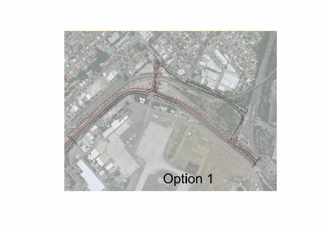


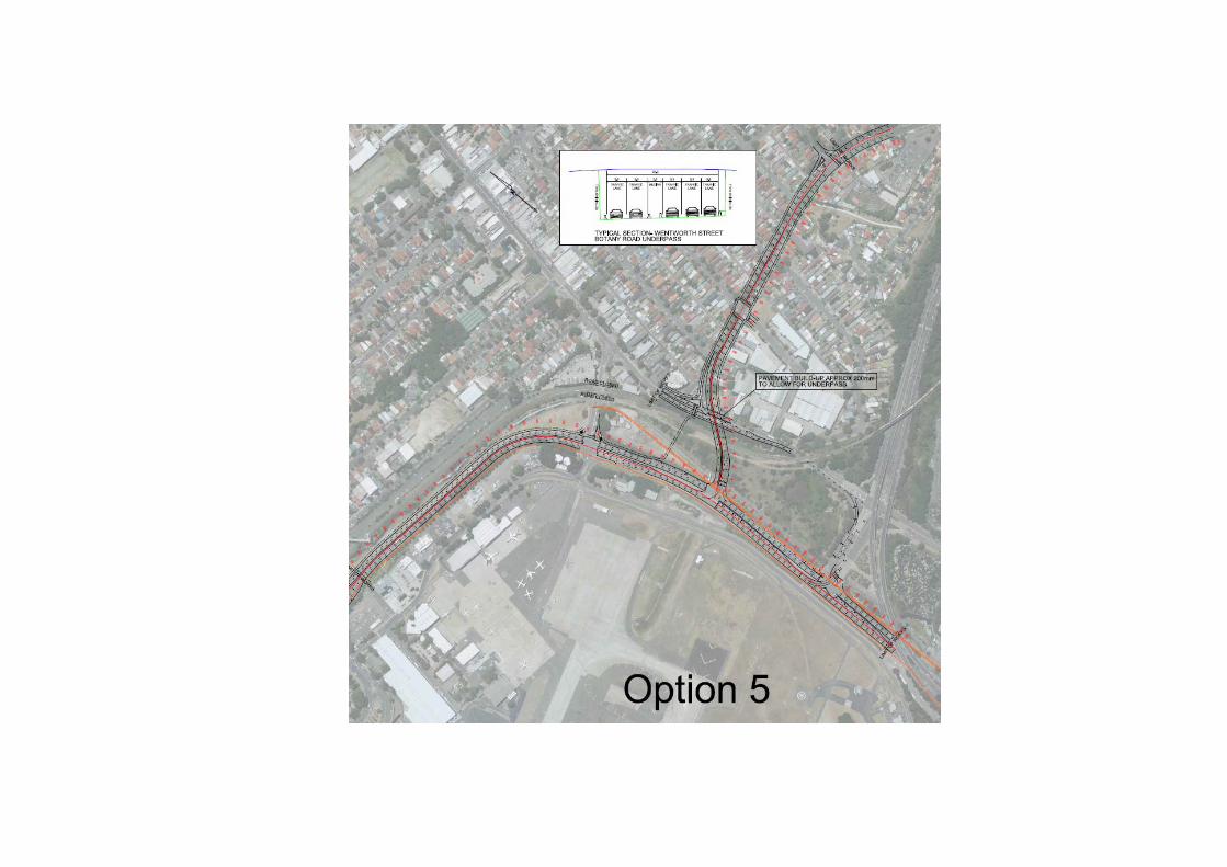

Appendix B Key aspects of the project proposal

