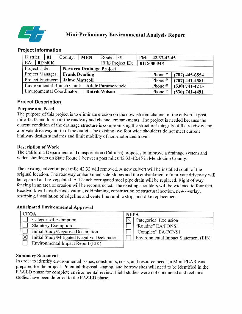
project limits - caltrans - california department of … 1 in mendocino county near albion at...
TRANSCRIPT


01 - MEN - 1 – PM 42.3/42.5
2
1. INTRODUCTION
Project Description: District 1 Advance Planning has prepared this Project Study Report (PSR) for this project in the
SHOPP Roadway Protective Betterment program (201.150). The project is located on State
Route 1 in Mendocino County near Albion at Navarro Ridge Road. See Attachment A for a
Project Location Map. The project proposes to improve the drainage system south of Navarro
Ridge Road, PM 42.32, and to widen shoulders in the area. See Attachment B for the Typical
Cross Section and Attachment C for the Layouts.
Project Limits
(Dist., Co., Rte., PM) 01 - MEN - 1 – PM 42.3/42.5
Number of Alternatives: Two (Including No Build)
Alternative Recommended for
Programming: The Build Alternative
Current Cost
Estimate: (2015)
Escalated Cost
Estimate: (2020)
Current Capital Outlay
Support Estimate: - $1,257,000
Current Capital Outlay
Construction Estimate: $930,000 $1,102,000
Current Capital Outlay
Right of Way Estimate: $164,000 $168,000
Funding Year: 2019/2020
Type of Facility
(conventional, expressway,
freeway):
Two-Lane Conventional Highway
Posted Speed Limit: 55 mph
AADT: 3,150 vpd (2015)
Number of Structures: 0
Anticipated Environmental
Determination or Document:
IS/MND (CEQA)
CE (NEPA)
Legal Description IN MENDOCINO COUNTY NEAR
ALBION AT NAVARRO RIDGE ROAD

01 - MEN - 1 – PM 42.3/42.5
2. RECOMMENDATION A project report at the next phase will serve as approval of the selected alternative.
The build alternative is recommended for programming. It is proposed that this project be programmed into the 2016 State Highway Operation and Protection Program (SHOPP) and funded in the 2019/20 fiscal year through the 201.150 Roadway Protective Betterment program. The current total estimated capital cost of the project is $1,094,000 which includes $930,000 for construction and $164,000 for right of way. See the cost estimate, Attachment D, for specific work items included in this report.
3. BACKGROUND
Existing Facility: State Route 1 (SR 1) is a legislatively designated route that traverses much of California’s Coast. In District 1, SR 1 begins at the Sonoma/Mendocino County line, and continues north along most of the Mendocino Coast, serving several rural communities as well as the cities of Point Arena and Fort Bragg. SR 1 is a popular choice for tourists using both motorized and non-motorized means of travel. This section of SR 1 is a minor arterial and is part of the Interregional Road System.
The facility within project limits is a two-lane conventional highway on rolling terrain with 12 ft wide lanes and 2 ft shoulders. The posted speed limit is 55 miles per hour. Within the project limits are a private driveway and the intersection at Navarro Ridge Road. The adjacent land uses are low density residential and open space rangeland. A coastal access trail and parking area are located 0.4 miles south of the project location. The project location overlooks the Pacific Ocean which lies approximately 1,000 ft to the west.
Project Initiation: The culvert south of Navarro Ridge Road was washed out in a 1998 storm event along with most of the roadway at this location. During the emergency repair that followed, the culvert outlet was relocated approximately 30 ft north of the natural stream channel. Following the repair work, erosion has occurred on the highway embankment and on the private driveway embankment downstream of the culvert outlet. Rock placement and other maintenance work have been performed to alleviate the erosion. These maintenance activities have not proven to stop the erosion. This project was initiated by project sponsor, District 1 Maintenance Hydraulics, in December 2014 to protect the integrity of the highway embankment. A current safety project also in planning stage, 01-0C550K, proposes shoulder widening directly south of the project limits. Shoulder widening was included in this protective betterment project scope to better protect the highway embankment and to provide consistency with the proposed shoulder width south of the project limits.
3

01 - MEN - 1 – PM 42.3/42.5
4. PURPOSE AND NEED STATEMENT
Purpose: The purpose of this project is to reduce erosion at the PM 42.32 culvert outlet and to repair the roadway embankment and channel embankment. Need: The project is needed to protect the highway from erosion and instability. The current condition of the drainage structure is compromising the structural integrity of the roadway and a private driveway north of the outlet. The outlet channel and the driveway embankment have experienced erosion after the culvert outlet was re-aligned to the north of the existing outlet and channel during a 1998 emergency repair. Cracking has occurred on the southbound shoulder of SR 1 near the location of the abandoned culvert outlet. DEFICIENCIES The primary deficiency is that the current condition of the drainage structure is compromising the structural integrity of the roadway and a private driveway north of the outlet. Secondary deficiencies are as follows:
• Channel erosion has undermined a length of right of way fencing north of the outlet channel.
• The existing 2 feet wide shoulders do not meet current highway design standards and limit mobility of non-motorized travel. The 3R standard minimum shoulder width is 8 ft wide given the estimated AADT of 3,150 vehicles per day.
• The existing 8% superelevation does not meet current highway design standards. The HDM index 202.2 standard superelevation is 10% for a 1000 ft radius curve on a 2-lane highway.
5. CORRIDOR AND SYSTEM COORDINATION Protecting the structural integrity of this facility is consistent with statewide, regional, and local planning efforts. The Concept for this segment of SR 1 is a two-lane highway with a minimum of eight foot shoulders. The project location is part of the Pacific Coast Bike Route (PCBR), which is legislatively designated throughout SR 1 in Mendocino County.
Future projects proposed within the project limits are listed below. There is currently a planned safety improvement project, 01-0C550K, immediately south of the limits of this protective betterment project. The safety project proposes installation of metal beam guard rail and shoulder widening (to 4 ft wide) from PM 41.72/PM 42.33. There are no other planned future projects within or near the project limits.
4

01 - MEN - 1 – PM 42.3/42.5
EA County-Route-Post Mile Project Description Program Year
0C550 MEN-001- PM41.72/42.33 Install MBGR and Shoulder Widening 2020
40140 MEN-001- PM42.80/44.30 Replace Salmon Creek Bridge 2018
0E240 MEN-001- PM43.30/44.20 Environmental Mitigation Bank 2018
40110 MEN-001- PM43.30/44.20 Albion River Bridge Replacement 2018
0E200 MEN-001- PM43.60/70.00 Rehabilitate Three Bridges 2017
6. ALTERNATIVES The build alternative and the no build alternative were considered for this project.
Build Alternative: The build alternative proposes to improve the drainage system south of Navarro Ridge Road and to widen shoulders in the area. The existing culvert will be abandoned and a new 36 inch diameter HDPE culvert will be installed. The culvert inlet will remain in the same place and the outlet will be relocated approximately 30 ft to the south for better alignment with the natural channel. A 20 ft by 9 ft rock energy dissipater will be installed at the outlet. The roadway embankment side-slopes and the embankment of a private driveway will be repaired and revegetated. A 12 in CSP drain will be replaced and a new overside drain will be installed. Right of way fencing in an area of erosion will also be reconstructed. Shoulders will be widened to 4 ft. Roadwork will involve cold planning 0.10 ft, excavation and construction of structural section in areas of shoulder widening, correction of superelevation, and new overlay of 0.10 ft open graded friction course (OGFC) from edge of pavement to edge of pavement. The structural section consists of 1.35 ft of Class 2 aggregate base, 0.45 ft of hot mix asphalt (Type A), and 0.10 ft of OGFC. Additional items include restriping, installation of edgeline and centerline rumble strip, and dike replacement.
It is recommended that the project development team investigate adding a left turn pocket at this intersection during the next phase of project development.
No Build Alternative:
If the no build alternative is selected, the highway embankment and the embankment of the private driveway will continue to have integrity deficiencies. Therefore, the no build alternative is not recommended.
7. COMMUNITY INVOLVEMENT Community outreach efforts are not needed for this project during this phase of project development.
8. RIGHT OF WAY A Right of Way Data Sheet was prepared for the project alternatives and is included as Attachment E. The current estimated right of way costs will be evaluated and revised at the next phase. For programming purposes, the build alternative estimated costs have been used.
5

01 - MEN - 1 – PM 42.3/42.5
North Region Right of Way estimates that for the build alternative, Right of Way lead time will require a minimum of 12 months after receipt of appraisal maps, utility conflict maps, environmental clearance, and certificate of sufficiency. A minimum of 12 months before certification will be required from submittal of the last map or revision. A Temporary Construction Easement (TCE) will be needed for access to the culvert outlet. The estimated cost of the TCE is $10,250 including appraisal and title fees.
9. DESIGN EXCEPTIONS Design exceptions were approved for the nonstandard shoulder width in the Design Exception Fact Sheet signed on 06/01/2015 by Chief of North Region Office of Design North and Surveys, Steven Hughes. The fact sheet is included in the project files.
10. ENVIRONMENTAL DETERMINATION/DOCUMENT A Mini-Preliminary Environmental Analysis Report (Mini-PEAR) dated March 10, 2015 was prepared to support programming of the project. The Mini-PEAR for the project is included as Attachment F. The required environmental document is expected to be an Initial Study with Mitigated Negative Declaration to comply with the California Environmental Quality Act and a Categorical Exclusion to comply with the National Environmental Policy Act. The estimated length of time to obtain the environmental approval is 26 months.
The proposed project will require a Section 404 Permit from the United States Army Corps of Engineers, a Section 401 Water Quality Certification from the North Coast Regional Water Quality Control Board, a 1602 Lake or Streambed Alteration Agreement from the California Department of Fish and Wildlife, and a Coastal Development Permit from either the California Coastal Commission or Mendocino County. Consultation and/or coordination with the United States Fish and Wildlife Service and California Department of Fish and Wildlife will also be required.
11. OTHER CONSIDERATIONS
11A. HAZARDOUS WASTE An Initial Site Assessment (ISA) was prepared for this project and is included in the project files. The ISA found that the project likely has one nominal hazardous waste issue related to lead in soils from Aerially Deposited Lead (ADL). This issue will require a Lead Compliance Plan contract item and standard or non standard special provisions (SSPs).
11B. TRANSPORTATION MANAGEMENT PLAN A Transportation Management Plan (TMP) was prepared for this project and is included in the project files. Significant traffic impacts are not anticipated provided that the TMP recommendations and requirements are incorporated into the project. The anticipated traffic control measures are reversing traffic control, intermittent closure, and shoulder closure. One lane closure is permitted within the project limits. A minimum of 12 feet of paved roadway must be open for use by public traffic. Bicyclists shall be accommodated through the work zone. Signage shall be used to alert vehicles of the possible presence of bicyclists.
6

01 - MEN - 1 – PM 42.3/42.5
7
11C. PRELIMINARY HYDRAULICS REPORT
A hydraulics recommendation was provided on March 20, 2015 by District 1 Hydraulics and is included in the project files. The report provided the following: the culvert hydraulics calculations used to select the size and slope of the culvert; the design of the rock energy dissipater; watershed delineation and discharge calculations; climate and hydrologic summaries; and a floodplain evaluation. The project is outside the 100-year floodplain and no floodplain effects are anticipated.
11D. STORM WATER DATA REPORT
North Region Office of Engineering Services prepared a Storm Water Data Report (SWDR) which is included in the project files. The SWDR cover sheet is included as Attachment G. Construction site best management practices (BMPs) are required but the project as scoped does not meet thresholds that would require treatment BMPs. Treatment may be required as a condition of the 401 Certification and changes in the project scope or footprint may require treatment and further evaluation.
11E. MATERIALS:
District 1 Materials Lab provided a preliminary Materials Recommendation which is included in the project files. The report provided recommendations for roadway cold planing, resurfacing, and design of the structural section.
12. FUNDING /PROGRAMMING
This project is eligible for federal-aid funding.
The District recommends that this project be programmed into the 2016 SHOPP for $1,102,000 (2019/2020 FY) in Construction capital costs and for $168,000 (2019/2020 FY) in Right of Way cost. This project qualifies for funding through the 20.10.201.150 Roadway Protective Betterment program. For a detailed cost estimate, see Attachment D.
The estimated support to capital ratio is 98.98%.

01 - MEN - 1 – PM 42.3/42.5
13. SCHEDULE The Programming Sheet, which summarizes the project schedule, is included as Attachment H.
A summary of milestones is included in the table below:
Project Milestone Descriptions Project Milestone Scheduled Delivery Date
(Month, Day, Year) Program Project M015 07/01/2016 Begin Environmental Document (ED) M020 09/01/2016 PA & ED M200 09/01/2018 Right of Way REQTS M224 06/01/2018 PS&E To DOE M377 10/01/2019 PROJECT PS&E M380 12/01/2019 Right of Way Certification M410 02/01/2020 Ready to List M460 03/01/2020 HQ Advertise M480 06/01/2020 Award M495 07/01/2020 Approve Contract M500 08/01/2020 Contract Acceptance M600 10/01/2021 End Project M800 10/01/2023
14. RISK REGISTER A risk register has been prepared for the project and is included as Attachment I.
15. FHWA COORDINATION The project is eligible for federal aid funding and the Federal Highway Administration (FHWA) will review this project for funding approval during a later phase. The project is considered to be State authorized under current FHWA/Caltrans Stewardship agreements.
16. PROJECT REVIEWS
Field Review J. Matteoli Date: 01/26/15 Advance Planning Ralph Martinelli Date: 05/07/15 District Maintenance Tom Fitzgerald Date: 05/07/15 District Safety Review Lena Ashley Date: 05/07/15 Constructability Review Jim McGee Date: 05/07/15 Project Manager Review Frank Demling Date: 05/07/15 District Program Advisor Scott Lee Date: 05/07/15
8

01 - MEN - 1 – PM 42.3/42.5
17. PROJECT PERSONNEL
Name Title Phone Number Jaime Matteoli Project Engineer (707) 441-4581 Frank Demling Project Manager (707) 445-6554 Ralph Martinelli Chief, Advance Planning (707) 441-3969 Richard Mullen Chief, Traffic Operations (707) 445-6377 David Morgan Chief, Traffic Safety (707) 445-6376 Adele Pommerenck Senior Environmental Planner (530) 741-4215 Dotrik Wilson Environmental Coordinator (530) 741-4491 Robert Close Senior Right of Way Agent (707) 441-6582
18. ATTACHMENTS
A. Project Location Map B. Typical Cross Sections C. Project Layouts D. Cost Estimate E. Right of Way Data Sheet F. Mini-Preliminary Environmental Assessment Report G. Storm Water Data Report Cover Sheet H. Programming Sheet I. Risk Register
9

ATTACHMENT A
Vicinity Map

MEN vic MAP.dgn 4/22/2015 9:36:33 AM

ATTACHMENT B Typical Cross Section

X-Sect_DEFS.DGN 5/26/2015 9:27:46 AM

ATTACHMENT C
Layouts

MEN1_Navarro_Drainage_JM_v4_PSR.dgn 5/19/2015 11:38:09 AM

ATTACHMENT D
Cost Estimate

Page 1 of 3 5/8/2015
SUMMARY OF PROJECT COST ESTIMATE
TOTAL ROADWAY ITEMS $930,000
TOTAL STRUCTURE ITEMS $0
SUBTOTAL CONSTRUCTION COSTS $930,000
TOTAL RIGHT OF WAY ITEMS $164,000
TOTAL PROJECT CAPITAL OUTLAY COSTS $1,094,000
Reviewed by District Program Manager________________________ Date____________
Approved by Project Manager_______________________________ Date____________
Navarro Drainage Roadway Protective Betterment Project
Project Study Report Cost Estimate
01-MEN-1
PM 42.33/42.45
EA: 01-0E940K
EFIS: 01 1500 0048
Program Code: 20.XX.201.150
May 2015
PROJECT DESCRIPTION: Navarro Drainage LIMITS: In Mendocino County near Albion at Navarro Ridge Road PROPOSED IMPROVEMENT (SCOPE): The build alternative proposes to improve the drainage system at postmile 42.32 and to widen shoulders in the area. The existing culvert will be abandoned and a new 36 inch diameter HDPE culvert will be installed. The culvert inlet will remain in the same place and the outlet will be relocated approximately 30 ft to the south to for better alignment with the natural channel. A 20 ft by 9 ft rock energy dissipater will be installed at the outlet. The roadway embankment side-slopes and the embankment of a private driveway will be repaired and revegetated. A 12” CSP drain will be replaced and a new overside drain will be installed. Right of way fencing in an area of erosion will also be reconstructed. Shoulders will be widened to 4 ft. Roadwork will involve cold planning 0.10 ft, excavation and construction of structural section in areas of shoulder widening, and new overlay of 0.10 ft open graded friction course (OGFC) from edge of pavement to edge of pavement. The structural section consists of 1.35 ft of Class 2 aggregate base, 0.45 ft of hot mix asphalt (Type A), and 0.10 ft of OGFC. Additional items include restriping, installation of edgeline and centerline rumble strip, and dike replacement.

Page 2 of 3 5/8/2015
I. ROADWAY ITEMS
Section 1 Earthwork Quantity Unit Unit Price Item CostRoadway Excavation 200 CY $75 $15,000Imported Borrow 350 CY $50 $17,500Clearing & Grubbing 1 LS $10,000 $10,000
Subtotal Earthwork $42,500
Section 2 Pavement Section Quantity Unit Unit Price** Item CostCold Plane AC, 0.10' 3,400 SQYD $8 $27,200Aggregate Base (Class 2) 80 CY $60 $4,800Open Graded Friction Course (OGFC), 0.10' PM 42.33/42.45 250 TON $180 $45,000Hot Mix Asphalt (HMA-A), 0.45' - PM 42.33/42.45 330 TON $180 $59,400Geosynthetic Pavement Interlayer (GPI) 140 SQYD $10 $1,400Paint Binder (Tack Coat) 10 TON $900 $9,000Imported Material (Shoulder Backing) 70 TON $70 $4,900Remove Dike 600 LF $6 $3,600Place HMA (Type A) Dike 600 LF $6 $3,600Seal Random Cracks 1 LNMI $5,000 $5,000Profile Grinding - preconstruction inertial profiler (IP) 1 LS $13,000 $13,000
Subtotal Pavement Structural Section $176,900
Section 3 Drainage Quantity Unit Unit Price Item CostAbandon Culvert 140 LF $35 $4,90036" HDPE 120 LF $500 $60,00036" Polymeric Sheet Coated CSP Downdrain 20 LF $500 $10,000Reconstruct Inlet 1 EA $2,000 $2,00012" CSP 80 LF $100 $8,000RSP 1/4 Ton 200 CY $150 $30,000
Subtotal Drainage $114,900
Section 4 Specialty Items Quantity Unit Unit Price Item CostProgress Schedule (Critical Path Method) 1 LS $5,000 $5,000Construction Site Management 1 LS $4,000 $4,000Prepare SWPPP + RQM 1 LS $4,000 $4,000Construction Site BMPs / Site Management (2.5%) 1 LS $19,000 $19,000Lead Compliance Plan 1 LS $3,000 $3,000Price Fluctuations in AC 1 LS $1,000 $1,000Revegetation and Erosion Control 1 LS $48,000 $48,000Wetland Mitigation 1 LS $44,450 $44,450Remove/Replace Fence 200 LF $50 $10,000Remove Roadside Sign 3 EA $130 $390Road Sign - One Post 2 EA $400 $800Road Sign - Two Post 1 EA $600 $600Incentive for Asphalt Concrete (QC/QA) (4% of HMA) 1 LS $2,376 $2,376
Subtotal Specialty Items $142,616
Section 5 Traffic Items Quantity Unit Unit Price Item CostThermoplastic Traffic Stripe (4", Broken) 650 LF $4 $2,600Thermoplastic Traffic Stripe (4", Solid) 1,300 LF $4 $5,200Thermoplastic Pavement Marking 190 SQ FT $15 $2,850Pavement Marker (Type D-Retroflective) 60 EA $25 $1,500Centerline Rumble Strips (Ground-In) 10 STA $250 $2,500Shoulder Rumble Strips (Ground-In) 10 STA $250 $2,500Portable Changeable Message Sign (PCMS) 2 EA $5,000 $10,000Construction Area Signs 1 LS $10,000 $10,000
Subtotal Traffic Items $37,150
Traffic Additions (Added in "TOTAL SECTIONS 1 thru 5) % Item CostTraffic Control System 1 LS (10% Item Subtotal) $51,500Maintain Traffic 1 LS (10% Item Subtotal) $51,500
SUBTOTAL $514,066$617,066TOTAL SECTIONS 1 thru 5 (Plus Traffic Additions)

Page 3 of 3 5/8/2015
Section 6 Minor Items ItemsSubtotal of
Items % Item CostMinor Items 1-5 $617,066 4% $24,683
TOTAL MINOR ITEMS $24,683
Section 7 Roadway Mobilization Items Subtotal of % Item CostMobilization 1-6 $641,749 10% $64,175
TOTAL ROADWAY MOBILIZATION $64,175
Section 8 Roadway Additions ItemsSubtotal of
Items % Item CostSupplemental Work 1-6 $641,749 5% $32,087Contingencies 1-6 $641,749 25% $160,437Time-Related Overhead (TRO) 1-5 10% $61,707Construction Office 1 LS $22,000
TOTAL ROADWAY ADDITIONS $276,231
TOTAL ROADWAY ITEMS (Sections 1-6) $641,749TOTAL ROADWAY ADDITIONS (Sections 7 & 8) $278,699
$921,000
CALL $930,000
II. STRUCTURES ITEMS
SUBTOTAL STRUCTURES ITEMS $0 (Sum of Total Cost for Structures)
Railroad Related Costs: NA
SUBTOTAL RAILROAD ITEMS $0
$0
III. RIGHT OF WAY ITEMS
A. Total Acquisition Cost $4,250B. Appraisal Fees Estimate $5,000C. Mitigation Acquisition & Credits $141,750D. Project Development Permit Fees $6,710E. Utility Relocation (State's Share) $5,000F. Relocation Assistance (RAP) $0G. Clearance/Demolition $0H. Title and Escrow Fees $1,000I. Total Estimated Right of Way Cost $0J. Construction Contract Work $0
$164,000
Anticipated Date of Right of Way Certification December 31, 2019Escalated Amount Pending Prog Sheet
F. Construction Contract WorkNone Required
Estimate Prepared By: Jaime Matteoli Phone # 707.441.4581Estimate Checked By: Carlon Schrieve Phone # 707.441.2079
TOTAL RIGHT OF WAY ITEMS
TOTAL ROADWAY ITEMS
TOTAL STRUCTURES ITEMS

ATTACHMENT E Right of Way Data Sheet


ATTACHMENT F
Mini-Preliminary Environmental Assessment Report


ATTACHMENT G
Storm Water Data Report Cover Sheet

APPENDIX E Short Form - Storm Water Data Report
Dist-County-Route: 01-MEN-1 Post Mile Limits: 42.32 – 42.45 Project Type: Navarro Drainage Project ID (or EA): 01-0E940K Program Identification: 201.150 SHOPP Phase: PID PA/ED PS&E
Regional Water Quality Control Board(s): North Coast Regional Water Quality Control Board 1. Is the project required to consider incorporating Treatment BMPs? Yes No 2. Does the project disturb 5 or more acres of soil? Yes No
3. Does the project disturb more than 1 acre of soil and not qualify for the Rainfall Erosivity Waiver? Yes No
4. Does the project potentially create permanent water quality impacts? Yes No 5. Does the project require a notification of ADL reuse Yes No
If the answer to any of the preceding questions is “Yes”, prepare a Long Form – Storm Water Data Report. Estimate Construction Start Date: 07/01/2019 Construction Completion Date: 10/15/2019 Separate Dewatering Permit (if yes, permit number) Yes Permit # No Erosivity Waiver Yes Date: No
This Short Form – Storm Water Data Report has been prepared under the direction of the following Licensed Person. The Licensed Person attests to the technical information contained herein and the data upon which recommendations, conclusions, and decisions are based. Professional Engineer or Landscape Architect stamp required at PS&E.
Jaime Matteoli, Registered Project Engineer/Landscape
Architect Date
I have reviewed the stormwater quality design issues and find this report to be complete, current and accurate:
[Stamp Required for PS&E only) Sheila Sadkowski, District/Regional SW Coordinator or Designee Date
Caltrans Storm Water Quality Handbooks Project Planning and Design Guide July 2010

APPENDIX E Short Form - Storm Water Data Report
1. Project Description
• District 1 Advance Planning is currently preparing a Project Study Report (PSR) Project Initiation Document for a project in the SHOP Roadway Protective Betterment Program (201.150). The project is located on State Route (SR) 1 in Mendocino County. This project proposes to improve the drainage system at PM 42.32 and to widen shoulders in the area. The existing culvert will be abandoned and a new culvert will be relocated by moving the outlet to the south to improve channel conditions. The roadway embankment side-slopes and the embankment of a private driveway will be repaired and revegetated. A 12” CSP drain will be replaced. Right of way fencing in an area of erosion will also be reconstructed. Roadwork will involve excavation, cold planning, construction of structural section, new overlay, restriping, installation of edgeline and centerline rumble strip and dike replacement.
• The total disturbed soil area (DSA) is 0.3 acres. The DSA includes access, staging and construction areas. The new impervious surface area is 0.07 acres and the reworked area is yet to be determined and will be based on the Materials Recommendation. The existing pavement area is 0.2 acres.
• Receiving waters within project limits: Mendocino Coast HU, Navarro River HA (HSA 111.32). The Navarro River is has a TMDL for Sedimentation/Siltation.
• A 401 Certification is required for this project. Treatment may be required as a condition of the 401 Certification. Additionally, this project may be found to be part of a Common Plan of Development with 01-0C550 by the North Coast Regional Board.
2. Construction Site BMPs
• This project will be constructed under a Contractor prepared WPCP approved by the Resident Engineer. Temporary construction BMP’s include: Prepare WPCP; Job Site Management; Temporary Concrete Washout (portable); Temporary Drainage Inlet Protection and Temporary Soil Stabilization and Temporary Sediment Control BMP’s. The Percent of Total Cost method using Table F-3 on page F6 of the Project Planning and Design Guide (PPDG) was used to determine the percentage of cost for construction site BMP’s based on the total construction costs (not including right-of-way costs). The total cost of construction site BMP’s was estimated to be 2.5% of the total project cost. Additional BMP’s may be identified during the PA&ED and PS&E project phases.
• The attached Construction Site Consideration Form documents concurrence in accordance with North Region directives.
3. Required Attachments1
• Vicinity Map • Evaluation Documentation Form • Construction Site BMP Consideration Form (required at PS&E only)
1 Additional attachments may be required as applicable or directed by the District/Regional Design Storm Water Coordinator (e.g. BMP line item estimate, DPP, CS checklists, etc).
Caltrans Storm Water Quality Handbooks Project Planning and Design Guide August 2010

ATTACHMENT H Programming Sheet

PROGRAMMING SHEET 06/12/2015
EFIS ID: 0115000048 EA:01-0E940 County: MEN Route: 001 PostMile: 42.30/42.40
4616 Noshopp
No
NoPPNO: Program: RTP: PROGRAM YR:
10 Yr SHOPP:
Working Days:Funding Candidate:
YesAADD:
IN MENDOCINO COUNTY NEAR ALBION AT NAVARRO RIDGE ROADProject Description - Long:
Work Description - Long: RECONSTRUCT DRAINAGE
Yes Drainage System Restoration APLOpen for Time: CT Status: RMP: RMP Date:Subprogram:
DEMLING, FRANK CProject Manager: LAW, REBECCA LPM Assistant: Project Nickname: NAVARRO DRAINAGE
SHOPP K-PHASEDist Category: FED Aid Eligible:
Funding Info ($k)
CON CAPROW CapCONROWPS&EPA&EDFund Source
0 0 0 0 0 0 4050201.150
0 0 0 0 0 0 Grand Total:
Capital Cost Estimates
EST DateAmount $k
930 04/24/15
168
0 04/24/15
Roadway
Structures
ROW
Total 1,098
Const Total 930
MS DateMS DescriptionMS
01/12/2015ID NEEDM000 (A) 0.00
06/01/2015APPROVE PIDM010 (T) 0.00
07/01/2016PROG PROJM015 (T) 0.00
09/01/2016BEGIN ENVIROM020 (T) 0.00
08/01/2016BEGIN PROJM040 (T) 0.00
03/01/2018CIRC DPR & DED EXTM120 (T) 0.00
09/01/2018PA & EDM200 (T) 0.00
06/01/2018R/W REQTSM224 (T) 0.00
08/01/2018REGULAR R/WM225 (T) 0.00
10/01/2019PS&E TO DOEM377 (T) 0.00
12/01/2019PROJ PS&EM380 (T) 0.00
02/01/2020R/W CERTM410 (T) 0.00
03/01/2020RTLM460 (T) 2,020.00
05/01/2020FUND ALLOCATIONM470 (T) 2,020.00
06/01/2020HQ ADVERTM480 (T) 2,020.00
07/01/2020AWARDM495 (T) 2,020.00
08/01/2020APPROVE CONTRACTM500 (T) 2,020.00
10/01/2021CONTRACT ACCEPTM600 (T) 2,020.00
10/01/2022FINAL REPORTM700 (T) 2,020.00
10/01/2023END PROJM800 (T) 2,020.00
IS, CE (NEPA), Env Doc:
1,270TOTAL:
1,102CC Escalated $:
3.50%CC Escalation %:
2020
ROW CAPITAL: 168
Capital Cost Estimates PROJECT SUPPORT COSTS
Phase Total
Escalation Rate
Sup/CapPRIOR
ACT $
2015
ETC
2016
(1.50%)
2017
(1.50%)
2018
(1.50%)
2019
(1.50%)
Future
(1.50%)
0 0 0 0 192 198 26 0 32.68% 415
1 0 0 0 0 0 202 203 31.89% 405
2 0 0 0 0 5 20 42 5.28% 67
3 0 0 0 0 0 0 370 29.13% 370
98.98%
TOTAL PROJECT COSTS:
TOTAL SUPPORT COSTS: 1,257
2,527
PROJECT SUPPORT PYs
Division Future
ETC PYs
Total
PYs
PRIOR
ACT PYs
2015
ETC PYs
2016
ETC PYs
2017
ETC PYs
2018
ETC PYs
2019
ETC PYs 0.00ADMN01 0.00 0.00 0.01 0.01 0.00 0.01 0.02
0.00MTCE01 0.00 0.00 0.01 0.01 0.01 0.00 0.03
0.00PPM01 0.00 0.00 0.06 0.06 0.06 0.20 0.38
0.00TROP01 0.00 0.00 0.04 0.04 0.06 0.09 0.23
01 TOTALS: 0.00 0.00 0.00 0.11 0.11 0.14 0.30 0.66
0.00CONS03 0.00 0.00 0.01 0.01 0.03 0.51 0.56
0.00ENVM03 0.00 0.00 0.47 0.54 0.33 1.10 2.45
0.00ESRV03 0.00 0.00 0.03 0.02 0.07 0.20 0.32
0.00PRJD03 0.00 0.00 0.34 0.30 0.39 0.24 1.26
0.00RWLS03 0.00 0.00 0.04 0.03 0.13 0.17 0.37
0.00SURV03 0.00 0.00 0.01 0.04 0.10 0.30 0.44
03 TOTALS: 0.00 0.00 0.00 0.89 0.94 1.05 2.52 5.41
0.00METS59 0.00 0.00 0.00 0.00 0.00 0.02 0.02
0.00OE59 0.00 0.00 0.00 0.00 0.00 0.14 0.14
0.00PPM59 0.00 0.00 0.00 0.00 0.00 0.00 0.01
0.00SP&I59 0.00 0.00 0.00 0.00 0.01 0.01 0.03
59 TOTALS: 0.00 0.00 0.00 0.01 0.01 0.02 0.17 0.20
PROJECT TOTALS: 0.00 0.00 0.00 1.01 1.06 1.20 2.99 6.27
Comments:
1

ATTACHMENT I
Risk Register


Level 2 Risk Register
LEVEL 2 - RISK REGISTER Project Name: DIST- EA 01-0E940Project
Manager
Status ID # Type Category Title Risk Statement Current status/assumptions Probability Cost Impact Cost Score Time Impact Time Score Rationale Strategy Response Actions Risk Owner Updated
Active 150 Threat Environmental Environmental Study Limits
Changes to the environmental study limits may require additional environmental studies, including additional plant surveys. Typically, plant surveys require two seasons. This may result in delays to the project.
Changes in environmental study limit boundaries based on permit
conditions or scope changes as a result comments reveived from members of the public and/or
regulatory agencies
3-Moderate 4 -Moderate 12 4 -Moderate 12
Mendocino County Building & Planning may require
including a coastal trail component to the project that
may increase the project footprint. Residents of
Navarro Ridge Road may
Accept
Environmental study limit boundaries to incorporate suffcient area to address potential scope creep. Construction
capital estimate to incorporate costs for construction of coastal trail and left-turn
lane for Navarro Ridge Road.
Environmental 5/14/2015
Active 151 Threat Environmental Community Opposition
The project is located in a sensitive area with strong community involvement. High levels of public input and/or controversy are anticipated. This may result in delays to the project.
Project location are in close proximity to the Salmon Creek Bridge and the Albion River Bridge and members of
the local community are actively seeking to be involved on
transportation projects along the Mendocino Coast.
3-Moderate 4 -Moderate 12 4 -Moderate 12
Community members continue to be actively
involved in local transportation projects that
affect their community.
Accept
Public outreach to discuss full range of alternatives being considered, potential
environmental impacts from those alternatives and potential mitigation
strategies being discussed with various regulatory agencies
Environmental 5/14/2015
Active 152 Threat Environmental CDPTime delays associated with obtaining the Local Coastal Development Permit may result in delays to the project.
Mendocino County Building and Planning have experienced high volumes of coastal development
permits to consider and have also had staff turnover and permit review
backlogs.
3-Moderate 4 -Moderate 12 8 -High 24
Mendocino County Building and Planning have
experienced increased LCDP workload affecting their ability
to provide accurate turnaround times on staff
reports.
AcceptProvide accurate project information and complete LCDP application and maintain close communication with coastal planner
Environmental 5/14/2015
Active 153 Threat Environmental CDP
Requirements in the Coastal Development Permit may result in conditions that are expensive or not constructable.
Environmental impacts from proposed project under consideration cannot be determined until completion of preliminary studies.
3-Moderate 4 -Moderate 12 8 -High 24
Past practice of CCC staff including extensive highly restrictive permit conditions that required innovative solutions by contractor and Caltrans Construction to look for innovative solutions to construct project
MitigateConduct early outreach with CCC to ensure that conditions are buildable. Appeal permit to state jurisdiction.
Environmental Coordinator
5/14/2015
Active 154 Threat EnvironmentalChallenge to IS/MND and/or
CE
As a result of challenge to the anticipated environmental document
type, additional time may be required to prepare higher level document type for
recirculation
It is expected to take 10 months to complete biological studies
1-Very Low 4 -Moderate 4 8 -High 16
Past challenges by environmental groups, local citizens and government bodies to all or part of environmental documents that call into question either the impacts or amount of mitigation agreed upon with regulatory agencies.
Mitigate
Public outreach to discuss full range of alternatives being considered, potential environmental impacts from those alternatives and potential mitigation strategies being discussed with various regulatory agencies
Environmental Coordinator
5/14/2015
Active 155 Threat Environmental MitigationAs a result of anticpated on-site mitigation requirements
A Mitigation and Monitoring Plan would be developed and on-site and/or offsite mitigation with up to 5 years of post-construction monitoringis anticipated to be required.
2-Low 4 -Moderate 8 8 -High 16
Mitigation banks and in-lieu fees are not available as options for mitigating on-site impacts
Accept
Avoidance or minimization measures may be required. Ensure the availability of anticipated mitigation credits which will allow for the timely delivery of project; reduce the cost of project related off-site mitigation by providing mitigation in advance of construction reducing mitigation ratios.
Biologist 3/19/2015
Active 156 Threat Environmental Nesting birds
Nesting birds protected from harassment under the Migatory Bird Treaty Act may delay construction during nesting season.
Assume that tree and shurbs within construction footprint will be removed outside of the nesting season by the contractor, separate task order activity under contact with another funtional unit (Landscape Architect) or by Caltrans Maintenance
2-Low 2 -Low 4 4 -Moderate 8
Contract award and approval may occur during nesting season
MitigateSchedule contract work to avoid the nesting season or remove nesting habitat before starting work.
PM/RE 5/14/2015
Active 160 Threat DesignShoulder Width Design
Exception
As a result of project's location along a rural highway, requirements for non-standard shoulder widths may result in additional time needed to approve a design exception
Advance Planning is currently expecting to complete the design exception fact sheet before the PID is signed in June, 2015.
2-Low 4 -Moderate 8 4 -Moderate 8
Past practice by State and Local agencies requiring shoulder widths less than desgin standards allow
AcceptReach a consensus of shoulder width as early as possible to reduce time impacts.
Design 5/14/2015
Active 161 Threat Design Left Turn Pocket
As a result of adding a left turn pocket to the scope of the project, additional design and environmental resources will be needed and the capital costs and right of way costs would increase which could lead to a delay in delivering RTL.
The safety review of the PID included the recommendation to investigate a need for a turn pocket at this location. The PDT agreed that the investigation will occur in "0" phase. Current traffic data suggest that a turn pocket investigtaion is merrited. There have been no collisions at this location since 2005.
3-Moderate 2 -Low 6 4 -Moderate 12
Adding a left turn pocket would have low impact on cost as a percentage of total capital cost, however, slope cutting would be needed and would create visual impacts which would increase environmental assessment and potential mitigation.
MitigateMitigate by increasing cost estimate of roadway work.
Design 5/14/2015
Risk AssessmentRisk Identification
Navarro Drainage Frank Demling
Risk Response

Level 2 Risk Register
Active 170 Threat Construction Access/stagingAdequate staging and access areas will require adequate clearance ahead of time.
Determining the amount of area needed for construction staging activities and identifying potential staging locations for inclusion in environmental study limit boundary.
2-Low 4 -Moderate 8 4 -Moderate 8
Limited area for staging areas with close proximity of work site.
Mitigate
Mitigate by clearing needed staging areas prior to PA&ED and including provisions for public access across bridge in traffic management plan included in the alternatives analysis in the project report
Construction 5/14/2015
Active 180 Threat ROW Delay of Right of WayAs a result of a delay in the acquisition of RW, a delay of RW Cert may occur which would lead to a delay of RTL.
Appraisal maps will be complete by M225 and requested lead time is available to complete the acquistitions.
2-Low 2 -Low 4 2 -Low 4
Current schedule provides sufficient lead time for acquisitions.
AcceptBegin appraisal/acquisition work on highest risk parcels first.
ROW 5/14/2015
Active 181 Threat ROW Additional RW is required
As a result of additional right of way requirements, a delay of RW Cert may occur which would lead to a delay of RTL.
Right of way requirements will be determined prior to PAED.
2-Low 2 -Low 4 2 -Low 4
Right of way needs have been identified.
AcceptRe-sequence the work to enable R/W Certification
ROW 5/14/2015
Active 182 Threat ROW Utility Relocations
As a result of utility conflicts not being resolved prior to RW Cert, Rw Cert may be delayed which would lead to a delay in delivering RTL.
Conflict maps will be provided to RW by PAED
2-Low 2 -Low 4 2 -Low 4
Utilities have been identified as being in conflict.
MitigateMitigate delays with timely submittals and reviews
ROW 5/14/2015
Active 183 Threat ROW Delay of PAEDAs a result of a delay in achieving PAED, RW Cert may be delayed which would lead to a delay in delivering RTL.
PAED will be achieved on the scheduled date.
3-Moderate 4 -Moderate 12 4 -Moderate 12
A delay in PAED reduces the lead time for RW Appraisals and Acquisitions which may increase the number of condemnations and delay the delivery of RW Certification.
MitigateMitigate by providing RW with sufficient lead time and delivering PAED on schedule.
ROW 5/14/2015