project formulation study for the establishment of hi-tech...
TRANSCRIPT

Bangladesh Computer Council
Ministry of Science and Information & Communication Technology
Government of the People's Republic of Bangladesh
Final Report
Project Formulation Study for the Establishment of Hi-Tech Park at Kaliakoir, Gazipur
Volume 1: Main Report Volume 2: PCP Volume 3: Annexure
Bureau of Research, Testing and Consultation (BRTC) Bangladesh University of Engineering and Technology (BUET)
Dhaka, Bangladesh
July 2002

i
TT aa bb ll ee oo ff CC oo nn tt ee nn tt ss
Volume 1: Main Report Page Executive Summary iv List of Acronyms/Abbreviations xvi CHAPTER 1 INTRODUCTION 1.1 Context 1 1.2 Project Background 1 1.3 Project Team 1 1.4 Terms of Reference 3 CHAPTER 2 HI-TECH PARKS IN OTHER COUNTRIES 2.1 Objectives 4 2.2 Review of Hi-Tech Parks in Other Countries 4 2.3 Hi-Tech Parks Visited 4 2.4 Important Features 6 2.5 Major Observations 7 2.6 EPZs in Bangladesh 7 CHAPTER 3 CHARACTERISTICS OF PROJECT SITE 3.1 Topography of the Area 9
3.1.1 Methodologies of the Land Survey 9 3.1.2 Findings of the Land Survey 11
3.2 Physical Environment 13 3.3 Climate 15
3.3.1 Rainfall 15 3.3.2 Temperature 19 3.3.3 Humidity 19 3.3.4 Wind Speed 19
3.4 Flood and Drainage 24 3.4.1 River Flood 24 3.4.2 Storm Drainage 29
3.5 Geology 29 3.6 Socio-economic Aspects 30
3.6.1 Socio-Demographic Characteristics 32 3.6.2 Economic Characteristics 33 3.3.3 Housing Characteristics 34 3.6.4 People's Attitude Towards the Hi-Tech Park 34
CHAPTER 4 CONNECTIVITY TO NATIONAL INFRASTRUCTURE 4.1 Road Connectivity 36 4.2 Rail Connectivity 36 4.3 Connectivity to Airport 36 4.4 Gas Transmission Network 37 4.5 Power Supply 37 4.6 Telecom 37

ii
CHAPTER 5 POWER SUPPLY 5.1 Introduction 39 5.2 Present Power Source for the Park 39 5.3 Load Estimation Criteria 39 5.4 Load Forecasting 39 5.5 Selection of Substations 40 5.6 Hi-Tech Park Generating Station 40 5.7 Power Management 41 CHAPTER 6 DATA COMMUNICATION 6.1 Computing and Communication Needs 42 6.2 Connecting the Park to the Information Super Highway 43
6.2.1 Connecting directly to the Submarine Cable 43 6.2.2 Connecting to International Gateway through Satellite 45
6.3 Backbone Network in the Park 45 6.4 Cost Estimation 47
6.4.1 LAN Set Up Cost 47 6.4.2 Backbone Set Up Cost 47 6.4.3 VSAT Installation Cost 48 6.4.4 Summary of Cost Analysis 49
CHAPTER 7 SUITABLE INDUSTRIES 7.1 Definition of Hi-Tech Industries 50 7.2 Factors to Select Industries for Hi-Tech Park 50 7.3 Industry Groups Suitable for Hi-Tech Park 51 CHAPTER 8 DEVELOPMENT PLAN 8.1 Land Use 55 8.1.1 Approach to Land Use Planning 55 8.1.2 The Land Use Plan 55 8.2 Physical Infrastructure 58 8.2.1 Buildings 58 8.2.2 Roads 64 8.3 Environmental Infrastructure 64 8.3.1 Water Supply 64 8.3.2 Sewerage 65 8.3.3 Drainage and Flood Control 65 8.4 Utilities 67 CHAPTER 9 ENVIRONMENTAL ASSESSMENT 9.1 Introduction 68 9.2 Environmental Assessment of Hi-Tech Park Development 68
9.2.1 Description of Major Project Activities 68 9.2.2 Environmental Baseline Information 69 9.2.3 Potential Significant Impacts 71 9.2.4 Mitigation and Abatement Measures 75 9.2.5 Residual Impacts 76 9.2.6 Monitoring Program 77 9.2.7 Conclusions 77

iii
9.3 Solid Waste Management at Hi-Tech Park 77 9.4 Environmental Guidelines 78
CHAPTER 10 COSTS AND BENEFITS OF THE PROJECT 10.1 Cost Estimate 79 10.1.1 Land Development and Infrastructure 79 10.1.2 Construction of Ready-Built Spaces and 79 Other Service Facilities 10.1.3 Development of Hi-Tech University 80 10.1.4 Development of Ancillary Facilities 80 10.2 Project Benefits 89 10.1.1 Direct and Indirect Impacts 90 10.2.2 Slow Growth Projection 90 10.2.3 Medium Growth Projection 90 10.2.4 High Growth Projection 91 10.2.5 Economic Viability of the Project 91 CHAPTER 11 IMPLEMENTATION AND MANAGEMENT OPTIONS 11.1 Introduction 93 11.2 Implementation Modalities 93 11.3 Phasing of Implementation 93 11.4 Human Resource Development 94
11.4.1 Hi-Tech University 94 11.4.2 Tentative Programmes for the Hi-Tech University 94 11.4.3 Required Laboratory Facilities 95 11.4.4 University Development Options 96
11.5 Operation and Maintenance 96 11.6 Management Options 96 11.7 Leasing Options 97 11.8 Benefit Scheme 97 11.9 Marketing Hi-Tech Park 97 11.10 Immediate Action Plan 98
Volume 2: Project Concept Paper (PCP)
Volume 3: Annexure
iv
Project Formulation Study for the Establishment of
Hi-Tech Park at Kaliakoir, Gazipur
EE xx ee cc uu tt ii vv ee SS uu mm mm aa rr yy Introduction Knowledge-based industries, particularly those related to information technology and biotechnology, have been recognised as the top priority sector by countries making transition from agro/ industrial economy to information economy. Hi-Tech parks are being developed in different countries, both developed and developing, to provide a range of infrastructure and administrative support services to create an efficient work environment for development of these industries. In line with world trends, Bangladesh has also recognised that new directions have to be set for the future prosperity of the country. Information technology has been identified as a "thrust sector" for Bangladesh economy. Plans have been prepared to enable Bangladesh to embrace the information age and to become an important player in the global market in information and other high technology sectors. Accordingly, the Government of Bangladesh (GoB) decided to develop a Hi-Tech Park at Kaliakoir, about 40 km from Dhaka City and 25 km from the Zia International Airport in Dhaka. The proposed Hi-Tech Park at Kaliakoir with an area of 119 hectares (with additional 55 hectares available for future expansion) is envisaged as an integrated, ultra-modern techno-township that would be designed to attract some of the large transnational companies and to serve the world class business enterprises. Project Site Studies The Project Formulation study for the establishment of the proposed Hi-Tech Park at Kaliakoir, Gazipur was initiated by Board of Investment (BoI) and Ministry of Science and Information & Technology (MoSICT) of the GoB during middle of the year 2001 and a multi-disciplinary team from BUET was constituted to carry out the study. One of the major criteria in planning and design of the proposed Hi-Tech Park has been to maintain the environmental serenity and preserve the topographical feature of the area. To satisfy such an objective it was required to obtain an accurate and rigorous topographical map of the area. Accordingly, a land survey was conducted and detailed contour maps were developed for the entie project site. The site of the proposed Hi-Tech Park is located just beside the national highway and is well connected to the rest of the country through roadway. The under construction railway line to Bangabandhu (Jamuna) Bridge passes through the site of the park. The area is situated on relatively high land and most part of it is virtually free from normal seasonal flooding.
Conservation of the environment is considered as an integral part of any development planning, in order to ensure that economic development remains sustainable. A baseline environmental study was conducted in order to assess potential environmental impacts of the proposed establishment of a Hi-Tech Park at Kaliakoir.

v
Hi-Tech Parks in Other Countries A review of the existing Hi-Tech Parks in different countries was carried out using Internet. With a view to gathering knowledge about current trends in planning, design, operation and management of Hi-Tech Parks a number of such establishments in India, Malaysia, and Singapore were also visited. The main objective of such visits was to develop a clear understanding about the scope of Hi-Tech Parks, salient features of their planning and management, and direction of their expansion. Most of the Hi-Tech Parks visited in India, Malaysia, and Singapore have almost similar objectives, i.e. to provide a range of modern infrastructure and administrative support services to create an efficient work environment for the development of Information Technology, electronics, telecommunications, engineering and other related industries. However, different Parks have varying characteristic features in respect of development priorities, management, operations, and marketing strategies. A major observation during the visit to the Hi-Tech Parks and similar establishments in India, Malaysia and Singapore, is that all the establishments were developed in an environment friendly way. While encouraging investment in all potential sectors, it was ensured that development take place in a planned and environmentally sustainable manner. For instance, no establishment allowed any manufacturing industry that could potentially pollute the environment. The other very important observation is that all the Hi-Tech establishments have strong linkage with existing or newly built educational institutions/universities for the provisions of highly skilled manpower in relevant sectors. For instance, IIIT and other Engineering Colleges in Bangalore and Hyderabad, to support IT professionals in ITPL, STPI, Hi-Tech City; newly built Multimedia University within MSC in Malaysia; and Singapore Science Park in close proximity to National University, Singapore. All the technology Parks visited are either run by private organizations or autonomous bodies. Most of the Park managements have strong marketing components. All the tenants housed in the Technology Parks enjoy some incentives in one form or another. The incentives range from incubation facilities to tax benefits. Types of Industries By definition, high technology industries are knowledge intensive industries. From this consideration, industries where a good part of the value addition comes from knowledge worker should be considered as a potential candidate for Hi-Tech Park. Choice of industry for Hi-Tech Park in Bangladesh should be based on some common factors such as: i) high technology (R&D) content of the industries ii) entry into the foreign market with state of the art technology iii) development of indigenous technological capability iv) cost advantage v) availability of knowledge rich manpower vi) non-polluting and internationally accepted work environment of the industries vii) labour intensity viii) capital intensity ix) infrastructure readiness x) cyber law and IPR law

vi
The major objectives of the Park are to attract foreign companies to set up operations in Bangladesh in order to (a) develop indigenous technological capability for the development of the local industries, and (b) to enter into foreign market by exporting state-of-the-art technology products. A biotechnology R & D product could be an example of the first kind which can greatly help the local agriculture or agro-processing industry. An HIV cure could be an extreme kind of example for the second objective. Entry into the export market in high technology area is very restrictive in many ways. However, strong plus-points to overcome the barriers are delivery of products with state-of- the-art technology, innovation content and cost advantage. Considering the huge trade imbalance of Bangladesh it would be equally useful if the country could produce import-substitution products in the Park. For either case - be it for export or import substitution product - the potential industries must be supplied with appropriate manpower. It has already been pointed out that the country must have plentiful supply of educated and knowledge rich manpower. Given the economic condition of Bangladesh it is always better if the Park can attract labour (knowledge worker) intensive industries. By default labour intensive industries are relatively less capital intensive. It is also advantageous to local entrepreneurs who have less investment capability. All industries in the Park must be environment friendly. They must not create wastes or by-products which could harm the environment or cause hazards. In addition, all industries must follow the safety standards of ILO, WHO or other standards. Most Hi-Tech Parks are highly populated with information and communication technology related industries. This type of industries is knowledge worker intensive. However, to attract such industries the country's infrastructure readiness must be very high. It includes very good telecom infrastructure, good transportation infrastructure and good legal environment. The latter is ensured if the country has appropriate cyber law and good protection of intellectual property rights. Keeping the above points in view, we have identified potential industries for the Park. The identified industries are grouped into different categories as below and a detail list under each group is presented in Annexure-B.
i. Agro-bio-technology and Genetic Engineering ii. Automobiles and Metal Industries iii. New and advanced materials iv. Medical Supplies and Devices v. Pharmaceutical and Clinical Products vi. Garments and Textile (R&D) vii. Plastics viii. Merchandising and Machinery ix. Design of Electronic Products x. Manufacturing and Assembly of Electronic Products xi. Computer Hardware xii. Computer Software xiii. Communications Hardware xiv. Communications Software xv. IT Enabled Services
vii
xvi. Human Resource Development Institute xvii. Design and Consultancy xviii. Bioinformaties Development Plan The land use plan determines specific uses for definite areas of land allocated for the Hi-Tech Park. The objective has been to produce a unified development, which can be built economically, operated efficiently and maintained at normal expense. The plan has been influenced by the topography of the area. Undulating topographic characteristics made it necessary to consider three alternatives:
1. The land in its natural form can be maintained. This is, however, very difficult because the complex physical requirements of modern living rarely fit the natural form.
2. The natural form may be altered by changing its shape by grading, terracing, or
removing natural ground cover or trees. Unfortunately this approach has been taken too many times in the past without full consideration of the consequences.
3. The most rational approach, however, is to accentuate the essential character of
the site, highlighting notable features and letting them determine the form of plan and elevation. This, although more challenging from planning and design points of view, has been followed in the present case.
The land use plan thus strikes a balance and harmony between nature and the built environment. Considering the types of companies, which will choose to locate in the area, infrastructure, business and administrative support services that will be required in the Park and the time frame for the implementation of the plan, the whole Park has been divided into five land use blocks. Total area available above 10m contour level has been considered for development to avoid inundation even by a 100 year flood. The land use blocks are described below: Block-I: This block will have ready to occupy offices, laboratory facilities, incubators
and factory spaces for Hi-Tech industries (mainly IT and Electronics). Administrative, business and infrastructural support services including housing provisions, community services and recreational facilities will also be located in this block. Companies having insufficient capital to build their own factories will find this block serving their needs. They can start their business here right away. This block is adjacent to the national highway leading to the Bangabandhu (Jamuna) Bridge and is directly accessible from the Dhaka-Tangail road. The block is relatively flatter which make it more suitable for the types of uses mentioned above. Development of this block will be completed in Phase-I.

viii
Block-II: This block is meant for mixed type of development targeting a broad range of companies including information and communication technology, electronics, as well as companies intending to carry out research and development activities on textiles, garments, plastics, metals and metal products etc. This block will have mainly ready-to-occupy plots for the types of companies mentioned above. This block will be developed in Phase-II.
Block-III: Build-to-suit facilities and ready-to-occupy plots will be available for
electronics and IT companies in this block. Larger electronics and IT companies needing larger space and wishing to build their own facilities would find this block serving their needs. Smaller companies starting initially in Block-I and growing bigger gradually may find the existing space limited. Such companies faced with the need for expansion would also be able to move to this block.
Block-IV: This block would be reserved exclusively for medical and bio-technology
related companies such as medical equipment, medical devices, pharmaceuticals, bio-medical research, agri and food research etc. A separate block has been reserved for such companies because of the need to keep them separate due to the nature of their activities.
Block-V: This is the institutional block which will house the institutions of higher
learning for producing highly skilled knowledge workers for industrial and entrepreneurial needs. Institutions focussing on Information Technology, Multimedia and Telecommunications, Engineering, Biotechnology etc. may be set up in this block.
Physical Infrastructure In Block I, the main building called Hi-Tech Tower I would be housing incubation facilities, ready to occupy office spaces, and required administrative support services. In addition a few ready to occupy plots would also be developed in Block I. The Tower is going to accommodate Banks, Freight services and Clearing and forwarding agency, Medical centre, Multi-cultural cuisine food courts, single window clearance facilities, conference facilities including video conferencing, fibre-optic LAN for high-speed data transfer and Incubators. The main circular/ring road passing through all the blocks eventually moves towards Block V. Also approached through a second entry, by the side of this road at Block-V, the Hi-Tech University is proposed. The 15-storied building is proposed to accommodate academic buildings, library, seminar /conference hall and classroom facilities. Water Supply It is essential that adequate and reliable supply of good quality water is ensured in the Hi-Tech Park. The various uses of water may include drinking, commercial, industrial and recreational. A good quality groundwater is available in and around the project site. There is no source of surface water nearby which can be used. It is therefore, suggested that groundwater shall be used as the source of water supply in the proposed Hi-Tech Park.

ix
Initially, two 8" power driven deep tubewells shall be installed - one in Block I and the other in Block V. Pump houses shall be constructed at each well location and water will be directly pumped to user ends through two separate pipe networks in two blocks. Two additional deep tubewells shall be installed in two blocks at some later stage that will serve the purpose of standby pumps according to need. Eventually, as the development of the Park progresses, the entire area shall be covered by a full-fledged, modern piped water supply system with provisions for water reserves in the proposed overhead water tank in Block II to be built in Phase II. Sewerage Ready-built spaces, administrative service areas, incubation facilities, educational institution, housing and other community facilities will be provided with modern water and wastewater appliances. Wastewater that will be generated in the Hi-Tech Park will be disposed of in a manner that is technically efficient, economically viable and environmentally sound. Ultimately, at full development of Hi-Tech Park, a modern sewerage system will be built for the entire Park, with sophisticated tertiary level treatment systems. However, such a system is not economically viable at the initial stages of the project. For the time being, the domestic wastewater disposal system at the Hi-Tech Park complex would consist of septic tank – soak pit arrangements. The efficiency of these systems should be regularly monitored. Certain industrial units within the Park (e.g., pharmaceuticals R&D) may use potentially toxic chemicals and produce waste/effluents that would require processing (e.g., treatment) prior to disposal. Individual industries producing such waste/wastewater (if any) must take appropriate steps following the guidelines set in ECR 1997. Drainage and Flood Control Storm runoff generated from the project area would be drained through natural drainage paths. These drainage paths are through ditches and low-lying areas. The project area is close to the Dhaka city and the rainfall is not much different from that in the Dhaka city. The design intensity-duration-frequency (IDF) curve that has been used in the master plan of storm drainage in the Dhaka Metropolitan area, may therefore be used for designing drainage channel in the project area. A planning decision is that the areas above 10.5 mPWD elevation which is the recorded highest flood level during last 52 years, would be utilized to construct buildings and roads. It is recalled that the river water level of 10.5 mPWD is close to the 100-year flood level. If there is demand for more land at a later stage, lands at lower level say above 7.5 mPWD may be utilized by making provision for flood protection so that land above this elevation remains flood free. This can be achieved by constructing regulator at the drainage outlet near the boundary of the project area in order to control inflow of river water so that river flooding in the project area does not exceed the critical level (controlled flooding) during flood season.

x
Power Supply Among all of the common facilities, power and communication are two vital facilities for the proposed Hi-Tech Park. The primary power supply for the proposed Hi-Tech Park would come from its own generation. Four units of 1 MW generators have been proposed for the Park. The generators would be gas fired and gas cooled. Most importantly, the generator should have very low noise and low pollution level. BPDB and/or REB sources will be treated as the secondary source of power. Although two 230kV overhead transmission lines are passing through the Park, it is not economically viable to install a 230/11kV substation for an estimated load of about 4/5 MW required for the Park. At the medium voltage level, the nearest power source for the Park would be Joydevpur and Mirzapur 33 kV substations. 11 kV lines have to be drawn from both the substations in order to provide the redundancy in the source. Three 33/11/0.4 kV substations have to be built in three different location of the proposed Park. Computing and Communication Needs The proposed Hi Tech Park will house pollution free off-shore Hi-Tech industries as well as their Research and Development (R & D) centers. Scientists and researchers of these R & D centers have to have online access to libraries and databases. Off-shore companies need to have an uninterrupted communication with their mother institutions. The Park is also going to provide incubator facilities for start-up companies. These start-up companies need state-of-the-art computing and communication facilities under their disposition to have a good start of their companies. IT enabled services like Call Centers, Back Office services and Medical Data Transcription for which advanced countries will look into Bangladesh for her cheap and easily trainable manpower will be an added attraction for the proposed Hi-Tech Park. All these IT enabled services require uninterrupted communication links with the rest of the world. The Hi Tech Park will organize a National Web Portal, which might act as a one stop shop on the Internet for providing its citizens with Government information and services. All the Government procurement through tender and bidding can be conducted through this Web Portal. It will save time and effort on the part of the citizens, increase efficiency and reduce workloads of the Government officials. The necessity of the Hi Tech Park to be online 24 hours a day throughout the year and to have a high capacity backbone network is obvious. Since Bangladesh is now not directly connected with the information super highway through submarine cable, the other alternative is to depend on VSAT technology. More than one VSAT facing different satellites will ensure uninterrupted and high capacity transmission. In near future (around 2004) Bangladesh will be connected to the submarine cable. The installed VSAT will then act as a backup support in case of any link failure. For backbone network Gigabyte Ethernet technology might be a fairly good choice. It is based on the long established Ethernet technology, for which skilled manpower for network management and associated jobs are already available locally. A hybrid network of Gigabyte Ethernet and Fast Ethernet technology is proposed for Hi Tech Park’s network, striking a balance between technology, performance and price

xi
factors. To provide high speed and high bandwidth, fiber optic backbone might be suitable to run between buildings in the Hi Tech Park. Under the Jamuna Bridge Railway Link Project (JBRLP) Bangladesh Railway (BR) would be laying 4 (four) pairs of optical fibers from Sirajganj to Dhaka over the new Jamuna Bridge railway link. The link will be interconnected with BR’s existing fiber optic network at Dhaka and Sirajganj and shall have outlets at the railway stations enroute. At Dhaka the fibers will be terminated in the railway telephone exchange at Kamalapur. It is expected that this will be connected to the submarine cable providing access to global information superhighway. Environmental Assessment of Hi-Tech Park Development The Hi-Tech Park at Kaliakoir is being developed to provide infrastructure and administrative support services to create an efficient work environment for development of IT, electronics, telecommunication, engineering, biotechnology and related industries. While this is a very encouraging and timely endeavor, it must be ensured that the development of Hi-Tech Park takes place in a planned and environmentally sustainable manner. Safe water, clean air, and sustainable use of resources are key elements of any approach to development. Utilization of natural resources by any development action must be done with a view to conserving them. Conservation of environment should, in fact, be an integral part of any development planning, in order to ensure that economic development remains sustainable. The project formulation study included an environmental assessment of Hi-Tech Park Development. Broadly, this assessment involves collection of environmental baseline information in and around the project site, identification of potential significant environmental impacts due to project activities (Phase-I), and suggestion of mitigation and abatement measures to offset adverse impacts. Principles of solid waste management at the Hi-Tech Park have been outlined and environmental guidelines for Hi-Tech Park development have also been prepared. Potential significant environmental impacts from the development of the Hi-Tech Park have been identified with respect to the major activities to be carried out as part of this project. These include: (a) Land development, (b) Infrastructure (e.g., buildings, roads, drainage and cable network, and water supply system) development, and (c) Operational phase of the project. All the major environmental parameters covering ecological, physico-chemical and human interest related aspects were considered in identifying the potential impacts due to the three major project activities listed above. Checklists of the environmental parameters for each of the major activities have been prepared. In the checklists, the magnitude of environmental impacts has been classified as none, low, moderate and severe. Long-term and short-term impacts (identified as L and S, respectively) as well as reversible and irreversible (identified as R and I, respectively) have also been identified in the checklist. No severe adverse environmental impact is expected due to land development. Most of the adverse impacts identified are reversible in nature and would cease to exist as soon as the land development activities are completed. Only irreversible impacts would be in the form of loss of wetland and loss of agricultural land, resettlement, loss of some trees. With

xii
appropriate management plans during land development activities, these adverse impacts could be largely mitigated. Most of the adverse impacts during construction phase are reversible in nature and could be mitigated or removed with appropriate environmental management. A number of positive impacts in the form of increased service facilities, employment, transportation of people and goods are expected during the construction phase. A number of long term positive impacts in the form of service facilities and employment, commercial activities, transportation of people and goods, etc are expected during the operational phase. In addition, enhancement of fisheries resources would be possible through planned lake development, especially in Block-V. Plantation activities would make the Park area greener and would have a positive impact on the environment. Better physical and socio-economic environment is expected to improve the general health and nutrition of the people in and around the Park area. Overall, it can be concluded that no environmental component will be severely affected negatively as a result of the project activities. Socioeconomic environment can be considered to be affected positively as the project activities will create new job opportunities for the local people and local commerce and business will get a big boost from the project. All these impacts are likely to contribute to improve the quality of life of the local community, in addition to contributing to national economic growth by initiating a “knowledge intensive” industrialization. Costs of the Project In the first phase, development activities would be concentrated in Block-I and Block-V. Block-I would provide facilities for Hi-Tech industries while the Hi-Tech University has been proposed to be established in Block-V. Considerable land development activities and provision of physical infrastructure facilities would be required in these blocks. In Block-I about 17000 sq.m. of area would be developed for construction of buildings and preparation of plots. An estimated 85 lakh Taka have been earmarked for land preparation for these purposes. Physical infrastructure facilities would include 60 ft. (18.3 m) and 30 ft. (9.15 m) wide roads, footpaths, drains, gas lines and water supply provisions. All these facilities would require an estimated 864 lakh taka to be completed. Block-V which will house the Hi-Tech University will require considerable land development. About 5000 sq.m of area in this block would be developed at an estimated cost of 686 lakh taka having the facilities as in Block-I. Blocks-III, III and IV have been proposed to be developed in phase-2. Total expenditures for provision of physical infrastructures and land development in these blocks, that is, Blocks-II, III and IV have been estimated at 1435 lakh (including fly-over), 568 lakh and 410 lakh Taka respectively. The development of the Hi-Tech Park has been divided in two phases. The first phase includes the development of Block I and Block V within two years. The development includes construction of several high rise buildings to provide Administrative, Ready Built spaces, Incubator spaces and for providing recreational, utilities, housing and community

xiii
services facilities. These facilities would be developed an estimated cost of 17833 lakh taka. The development of the Hi-Tech park would require construction of lined drainage channel and weir with sluice gates. The construction would be divided in two phases at an estimated cost of Tk. 30.0 lakh and Tk. 20.0 lakh in Phase-I and II respectively. For a reliable power source captive power generation will be provided. The national power grid will be the alternative source of power for the park. In order to ensure uninterrupted power supply gas-fired generating station would be installed. The installation of sub-station and generator in phase I and phase II would cost Tk. 1100.0 lakh and Tk. 1000.0 lakh respectively. An ISDN Telephone exchange would be installed in the Hi-Tech Park at the cost of Tk. 50.0 lakh in phase I. Fiber-optic LAN for high speed data transfer is very basic essential element of the Hi-Tech Park . The total installation of LAN, Backbone & VSAT has been planned in two phases with involvement of Tk. 1333.0 lakh in Phase I and the 2483.5 lakh in Phase II. Economic Viability of the Project The Hi-Tech Park Project is expected to generate significant benefit for the nation as a whole. IT sector is likely to dominate the Park. Net return in this sector is very high compared to other sectors. The total economic impacts of the Hi-Tech Park consisting of both direct and indirect impacts would be quite large and the indirect impacts may even be larger than the direct impacts. The direct impacts of the park’s first phase of development would include the creation of about 4000 new Hi-Tech jobs, net profit from export and income from leasing out ready-built spaces and ready-to-occupy plots. Such direct impacts would have multiplier effects in terms of the creation of additional income and employment. The government would also be a gainer through this process as the tax base would improve and significant amounts of direct and indirect taxes would enrich the government exchequer. For carrying out an economic analysis of the proposed hi-tech park at Kaliakoir, three scenarios have been considered based on growth projections. Net Present Value (NPV), Benefit –Cost Ratio (BCR) and Economic Internal Rate of Return (EIRR) have been calculated for the three cases : Slow Growth, Medium Growth and High Growth. First phase of the project is expected to be completed in two years and the life of the project has been assumed to be 20 years although this may be much longer. For calculating NPV, 15% discount rate has been considered. NPV has been found to be positive for all the alternatives including the slow-growth projection. Similarly BCR is also greater than one for all the alternatives including the slow-growth projection. EIRR has been found to be 23%, 29% and 38% for slow, medium and high growth projections respectively, indicating that the project would be economically viable even if the growth rate is low. High growth rate obviously would generate greatest benefit for the national economy. Implementation and Management Options While it is important for an economy like Bangladesh to respond to the present global needs, it is equally important that Bangladesh gives careful considerations to various management options of a Hi-Tech Park so that the investments of its scarce resources
xiv
result in significant improvements in the economy, thereby improving the well-being of its people. These aspects have been taken into consideration while analysing various development approaches. Implementation Modalities The Ministry of Science and Information & Communication Technology may establish a Project Implementation Unit (PIU) headed by a Project Director. Other supporting staff may include engineers, accountants, technicians, secretarial staff and so on. The phase I of the project may be implemented by appointing reputed National/International Consultant and Constructor. A Panel of local advisors may also be formed with members from universities and professional institutions so that a high level of construction standards may be ensured. The Ministry may also take into consideration the procedures as followed by BEPZA in developing its export processing zones. Phasing of Implementation The total development of the Hi-Tech Park has been proposed to be implemented in two phases. Development of Block-I and Block-V should be started and completed in Phase-1. Block-I will have the ready-built spaces and ready-to-occupy plots for Hi-Tech industries. Besides, administrative offices, recreational facilities, utilities, housing provisions and different types of community facilities such as banks, post offices, schools, day-care centres etc. The common facilities to the park need to be developed in phase-1. The first companies ready to start their activities in the park will be given factory and office spaces in this Block. Since the park would require a constant supply of highly skilled knowledge workers, proposed Hi-tech institutions producing knowledge workers should be started right from the beginning. Block-V is therefore proposed to be developed in Phase-1. Blocks-II, III and IV are proposed to be developed in Phase-2. Companies starting in Block-I and attaining some maturity after some time may be faced with different space requirements at a later stage. These companies will be accommodated in Block-II. Block-III will accommodate the needed expansion of Block-II after it reaches its full development. Block-IV will accommodate mainly the bio-medical and bio-technology related research and development activities. This block is proposed to be developed in Phase-2 because of the specific requirements of the activities to be carried out in this block. Once all the blocks of Phase-1 and Phase-2 reach their full development stage further expansion may be needed. Such expansions may be accommodated in the area not yet planned for development. It is worth-mentioning that the Consultants were informed during the first meeting at Kaliakoir that the remaining land (around 140 acres) may be allotted for HTPK, if necessary. Human Resource Development The importance of intellectual capital for economic development is now widely recognised. The growth of software and Hi-Tech industries across the world has generated a huge demand for highly skilled IT manpower. So is the demand for skilled manpower for other high technology industries. Investments in the development of highly skilled professionals in the following areas are most likely to be profitable and at the same time complementary to the objectives of the Hi-Tech Park:

xv
• IT Sector (including IT-enabled Services) • Electro-Mechanical • Pharmaceuticals • Biotechnology
In the land use plan Block-V has been reserved for setting up Hi-Tech Education and Training Institutions in the above mentioned fields. The proposed Hi-Tech University should have programmes that can meet the demand of Hi-Tech manpower. It is, therefore, recommended that the University should be started with the following programmes in the first phase. i. Computer Science (150) ii. Computer Engineering (150) iii. Communications Engineering (50) iv. Biotechnology (50) v. Mechatronics (50) vi. Environmental Science & Technology (50) vii. Business Management (100) The figures in parentheses show the probable annual intakes in the programme. Since the programmes are very much technical and practice oriented, the teacher-student ratio should be high. Experience suggests that there should be at least one teacher for each fifteen students. The government may decide to develop the proposed university by itself. Alternatively, the development of the university may be offered to the private investors. Since the investment would be high to develop buildings and laboratories, the government may relax some of the requirement for existing private university rules for the private sector to invest in the Hi-Tech University. Hi-Tech Park Management Options Actual ownership of the park would determine the organizational structure and management of the park. Ownership may be either single ownership or joint ownership. For instance, the park may be totally owned by the Government of Bangladesh in which case it may form a Hi-Tech Park Authority similar to BEPZA. The composition of the Authority would be by government nominations and would be dependent on the nature of activities. There may also be joint ownership in which case there may be
• partnership between government and local private or limited companies (example is ICICI Knowledge Park, Hyderabad, India)
• partnership between government, local private and international companies (example is ITPL, Bangalore, India)
In case of joint ownership there may be a Management Board with members representing the partners.
xvi
Benefit Scheme The following benefit schemes could be assessed in consultation with the concerned ministries:
• Duty free import and export (computer hardware and software are already exempted from customs duty and taxes; all equipment to be used in KHTP may be exempted from paying duty and taxes)
• Maximum foreign equity (100%) • Exemption from income tax for 10 years • Single window government clearance • Marketing Intelligence • Unrestricted appointments of foreign professionals • Provision for local marketing of services and goods
It is important to note that the benefit scheme as provided by BEPZA for export processing zones in Bangladesh is quite comprehensive and appropriate for inviting foreign investments. It is suggested that similar benefit scheme should be seriously considered for the proposed Hi-Tech Park. Marketing Hi-Tech Park The potential customers for the spaces at the Hi-Tech Park are: i. Local entrepreneurs ii. NRB entrepreneurs iii. Local small & medium size enterprises iv. Local large industrial groups v. MNCs operating in Bangladesh vi. Foreign companies Some works of marketing the Hi-Tech Park may be taken up by the Hi-Tech park authority. These are:
• Carry out an opinion survey on the local and multi-national companies for their requirements.
• Prepare sample business plans/feasibility study for different business areas. • Explore potential organizations for manpower supply in the short term.
Immediate Action Plan 1. It is very important to decide who will own and run the park. If private partnership is
considered then the government should look for prospective local as well as foreign partners.
2. Once the ownership issue is settled, the government should form the park authority
accordingly.

xvii
3. Depending on the private partnership and their stake, the government should arrange necessary funding for the park.
4. Once the park authority is formed various marketing studies may be taken up to
complement the physical development activities. 5. Operation of Hi-Tech University should be started immediately to develop
knowledge workers essential for the park. It may be mentioned that a gestation period is required to develop human resource. The university may start functioning at a temporary location.
6. It is necessary to control the environment of the area adjacent to the Park as well as
the area within the Park. Industries with pollution potentials which will be detrimental to the establishments of the Hi-Tech Park should not be allowed to be installed in the nearby areas. In this regard strict land-use control will be required which should be implemented as early as possible.
xviii
List of Acronym/Abbreviations BCR Benefit Cost Ratio BEPZA Bangladesh Export Processing Zone Authority BMD Bangladesh Meteorological Department BNBC Bangladesh National Building Code BOI Board of Investment BR Bangladesh Railway BRTC Bureau of Research, Testing and Consultation BTTB Bangladesh Telephone and Telegraph Board BUET Bangladesh University of Engineering and Technology BWDB Bangladesh Water Development Board CBD Central business district DNS Domain Name System DWDM Dense Wave Division Multiplexing ECR Environment Conservation Rules EIA Environmental Impact Assessment EIRR Economic Internal Rate of Return EPZ Export Processing Zones GoB Government of Bangladesh GP Grameen Phone HTPK Hi-Tech Park of Kaliakoir ICICI Industrial Credit and Investment Corporation of India IEE Initial Environmental Examination IIIT Indian Institute of Information Technology ILO International Labour Organisation IT Information Technology ITC Information Technology & Communication ITPL International Tech Park Limited JBRLP Jamuna Bridge Railway Link Project LAN Local Area Network MoSICT Ministry of Science and Information & Communication Technology MSC Multimedia Super Corridor NGO Non-government Organization NPV Net Present Value PCP Project Concept Paper PFI Power Factor Improvement PIU Project Implementation Unit PWD Public Works Department R&D Research and Development REB Rural Electrification Board STPI Software Technology Park of India TCS Tata Consultancy Services TPM Technology Park Malaysia VSAT Very Small Aperture Terminal WEBEL West Bengal Electronics Industry Development Corporation WHO World Health Organisation

1
CHAPTER 1 INTRODUCTION 1.1 Context
Knowledge-based industries are increasing rapidly in the present day world. Industries with high value addition in R&D are generally recognised as Hi-Tech industries. The concept of Hi-Tech Park represents an approach towards knowledge intensive industrialization. These Parks are being built in different parts of the world, with the mission of providing suitable habitat for enabling the growth of world class high technology ventures by creating an environment conducive to catalysing and stimulating a generation of knowledge-based community. As information technology has been recognised as the top priority sector by countries making transition from agro/industrial economy to information economy, most Hi-Tech Parks are being developed to provide a range of infrastructure and administrative support services to create an efficient work environment for development of IT, electronics, telecommunications, engineering, biotechnology and related industries. 1.2 Project Background
Since independence, Bangladesh has been striving to develop its agricultural resources and primary industries in an effort to bring welfare to its vast population of about 130 million. In order to further hasten the development process, Bangladesh had to encourage manufacturing activities parallel to agricultural development. Greater emphasis was placed on ready-made garment industries and subsequently Export Processing Zones (EPZ) were established at different parts of the country to accelerate employment generation, export of manufactured goods and thus earn foreign exchange for the country. In line with world trends, Bangladesh has also recognised that new directions have to be set for the future prosperity of the country. Information technology has been identified as a "thrust sector" for Bangladesh economy. Plans have been prepared to enable Bangladesh to embrace the information age and to become an important player in the global market in information and other high technology sectors. Accordingly, the GoB decided to develop a Hi-Tech Park at Kaliakoir, about 40 km from Dhaka City and 25 km from the Zia International Airport in Dhaka (Fig. 1.1). The proposed Hi-Tech Park at Kaliakoir is envisaged as an integrated, ultra-modern techno-township that would be designed to attract some of the large transnational companies and to serve the world class business enterprises. This may be considered as one of the most important steps to the proposed transformation of Bangladesh from agro/industrial economy to knowledge-based industrial/services economy. 1.3 Project Team Establishment of a Hi-Tech Park was originally proposed in a meeting of the Board of Investment in June 1999. The coordination council constituted for the purpose decided to invite the Bureau of Research, Testing and Consultation (BRTC) of the Bangladesh University of Engineering and Technology (BUET) to carry out a project formulation study for the establishment of Hi-Tech Park at Kaliakoir. In response to a request made by the Ministry of Science and Information & Communication Technology, the BRTC of BUET agreed to render the necessary services for carrying out a project formulation study of the proposed Hi-Tech Park.

2

3
Multi-disciplinary teams of experts drawn from various departments of BUET were formed to conduct the study. The teams of consultants include -
– Environmental and Civil Engineering Team – Planning and Architectural Team – Economic and Project Evaluation Team – Electrical and Information Technology Team – Mechanical and Industrial Engineering Team In addition, the advisory services of a senior faculty member, who has been closely associated with IT development in the country, has also been made available to guide the works of the teams of consultants. 1.4 Terms of Reference The activities of the project formulation study for the proposed development of the Hi-Tech Park were accomplished in two phases. Phase I involved some preliminary activities and environmental examination of the proposed development followed by Phase II, which included a more detailed analysis of the various options, as shown below: Phase I Studies under Phase I included the following specific activities: • review of the experiences of similar establishments in other countries, particularly in
India and Malaysia, • field reconnaissance of the proposed land area, • identification of types of industries to be included in the Park, • identification of the requirements for the establishment of the Hi-Tech Park, • other facilities required for a self-contained township, • preliminary land use planning, and • initial environmental examination and socio-economic consequences of the proposed
development Phase II Phase II included the following detailed works: • detailed economic study, • detailed topographical survey of the land area and preparation of contour maps, • preparation of an area plan showing land use and outlining the infrastructure facilities
including all utility services, • environmental impact assessment of the proposed development, • modalities for project implementation, operation and maintenance, • preparation of cost estimate for the total project, • preparation and phasing of implementation plan, • arranging stakeholders meeting / workshop before finalisation of the study report, and • preparation of a formal Project Concept Paper (PCP) for the entire project.

4
CHAPTER 2 HI-TECH PARKS IN OTHER COUNTRIES 2.1 Objectives With a view to gathering knowledge about current trends in planning, design, operation and management of Hi-Tech Parks a number of such establishments in India, Malaysia, and Singapore were visited. The main objective of such visits was to develop a clear understanding about the scope of Hi-Tech Park, salient features of its planning and management, direction of its expansion etc. Preliminary information related to the existing Hi-Tech Parks in India, Malaysia and Singapore, and in other countries was collected. Information on other Hi-Tech Parks has also been collected using Internet. This chapter presents a summary of the review of the Hi-Tech Parks in other countries as well as the experiences of EPZs in Bangladesh. 2.2 Review of Hi-Tech Parks in Other Countries A review of the existing Hi-Tech Parks has been carried out using Internet. The details of the Hi-Tech Parks, shown in Table 2.1, were extracted from their web sites and have been summarised in Annexure-D. 2.3 Hi-Tech Parks Visited The following Technological Parks in India were visited during the period from 17 to 22 June, 2001.
International Tech Park Limited (ITPL), Bangalore Software Technology Park of India (STPI), Bangalore Indian Institute of Information Technology (IIIT), Bangalore ICICI (Industrial Credit and Investment Corporation of India) Knowledge Park, Hyderabad. Hi Tech City, Hyderabad Indian Institute of Information Technology (IIIT), Hyderabad West Bengal Electronics Industry Development Corporation (Webel), Kolkata
In addition to visits to these important places, discussions were held with the Tata Consultancy Services (TCS) and the Department of Information Technology and Communication, Andhra Pradesh, on related matters of special interest such as Smart-Governance programme of TCS and SKIMS programme of the Department of ITC, Andhra Pradesh.

5
Table 2.1 Names of Hi-Tech Parks Reviewed
Country Name of Hi-Tech Park Hi-Tech City, Hyderabad Software Technology Parks of India, Hyderabad IT Park of Kanchipuram, New Kanchi Hitech Park in Noida, New Delhi Hitech Parks of Tamilnadu TIDCO's Petrocken Park, Ennore TIDCO's Hitech Industrial Park SIPCOT Irungattukottai Industrial Park SIPCOT Export Promotion Industrial Park SIPCOT Sriperumbudur Industrial Park TACID ORAGADAM Industrial Park Mahindra Industrial Park International Tech Park, Bangalore
India
STPI, Bangalore Johor Technology Park Kulim Hi-Tech Park Kota Kinabalu Industrial Park Subang Hi-Tech Industrial Park College Valley Industrial Park Seir Sulong Industrial Park Lumut Port Industrial Park Technology Park Malaysia
Malaysia
Industrial Park, Beverly Hills Shun Li Industrial Park Paya Lebar iPark Singapore Science Park 1, 2
Singapore Jurong Industrial Estate Zhuhai Hitech Zone Bapijiao Technological & Industrial Park Xinqing Technological & Industrial Park Sanzhao Technological & Industrial Park
China
Nanpig Technological & Industrial Park UK Cambridge Science Park
A visit was also made to some important Hi-Tech Parks of Malaysia and Singapore in order to gather further knowledge on Hi-Tech Parks in their part of the world. The following Technological/Science Parks in Malaysia and Singapore were visited during the period from 26 July to 01 August, 2001.
Technology Park Malaysia (TPM) Multimedia Super Corridor (MSC) Multimedia University (Cyberjaya Campus) Singapore Science Park, I & II Singapore Telecom (Sing Tel)

6
The regional headquarters of Hewlett Packard in Singapore was also visited where important discussions took place regarding HP operations and possible collaboration with Kaliakoir Hi-Tech Park Project of Bangladesh. 2.4 Important Features Most of the Hi-Tech Parks visited in India, Malaysia, and Singapore have almost similar objectives, i.e. to provide a range of modern infrastructure and administrative support services to create an efficient work environment for the development of Information Technology, electronics, telecommunications, engineering and other related industries. However, different Parks have varying characteristic features in respect of development priorities, management, operations, and marketing strategies. International Technology Park Limited (ITPL), Bangalore, India, is being developed in phases, jointly by Tata Industries and Ascendas of Singapore on 65 acres of land provided by the State Government of Karnataka. Ascendas has the reputation of building Hi-Tech Parks in different countries, e.g., China, Singapore. Around 90 companies, mostly multinational IT Companies and a few R&D and electronic assembly companies, are currently located in this privately managed Park. Software Technology Park of India (STPI) was established in different parts of India by the Ministry of Information Technology, Govt. of India. STPI primarily promotes and facilitates export of software and IT enabled services from India. ICICI Knowledge Park in Hyderabad is entirely devoted to research and development (R&D). Ready to run laboratories with all infrastructural and support facilities are rented by companies involved in biotech, pharmaceuticals, IT and new materials. Cyber Towers in Hyderabad house the IT giants Microsoft, Oracle, Motorola, Ericsson, GE, Citicorp, Baen and HSBC, with all modern civic and IT facilities. The development program of the Technology Park Malaysia (TPM) is clustered around three major technology areas - technology based operations in the Engineering City, biotechnology based industries in Biotech City and multimedia companies in Communication Tech City. A 50 km long and 15 km wide Multimedia Super Corridor (MSC) near Kuala Lumpur is being developed to create a truly high capacity IT environment with all modern infrastructure for e-governance in Putrajaya and for developing innovative multimedia companies and smart homes, smart schools in cyberjaya within the corridor. Singapore Science Park I & II, managed by Ascendas, primarily cater to R&D office needs of technology oriented companies that include, among others, Biomedical sciences, Pharmaceuticals, Electronics, Telecommunications and Information Technology. The work-play environment of Singapore Science Park includes extensive lifestyle amenities and conveniences like conferencing, auditorium, fitness club, swimming pool, tennis and squash courts and bus shuttle services.
7
2.5 Major Observations Environment-Friendly Developments A major observation during the visit to the Hi-Tech Parks and similar establishments in India, Malaysia and Singapore, is that all the establishments were developed in an environment friendly way. While encouraging investment in all potential sectors, it was ensured that development take place in a planned and environmentally sustainable manner. For instance, no establishment allowed any manufacturing industry that could potentially pollute the environment. Furthermore, the ICICI Knowledge Park in Hyderabad, India, declared an area of 25 km radius as "no pollution zone", and a green belt is being developed around the Park. Strong Linkages with Educational Institutions The other very important observation is that all the Hi-Tech establishments have strong linkage with existing or newly built educational institutions/universities for the provisions of highly skilled manpower in relevant sectors. For instance, IIIT and other Engineering Colleges in Bangalore and Hyderabad, to support IT professionals in ITPL, STPI, HiTech City; newly built Multimedia University within MSC in Malaysia; and Singapore Science Park in close proximity to National University, Singapore and Campus of INSEAD, France. Marketing of Available Services All the technology Parks visited are either run by private organizations or autonomous bodies. Most of the Park managements have strong marketing components. Incentives All the tenants housed in the technology Parks enjoy some incentives in one form or another. The incentives range from incubation facilities to tax benefits. 2.6 EPZs in Bangladesh Export Processing Zones in Bangladesh, as established by the Bangladesh Export Processing Zone Authority, are not Hi-Tech Parks in the sense that a wide variety of industries are accommodated in these zones which cannot be categorized as Hi-Tech industries. But these zones have some features similar to those found in Hi-Tech Parks of the countries mentioned above, specially in terms of investment procedures and incentive schemes. This was revealed during visits by the team to the Export Processing Zone Authority and Dhaka Export Processing Zone, in order to gain understanding about their objectives, procedures, development and performance. At present Dhaka and Chittagong EPZs are fully operational while four other EPZs at Mongla, Ishurdi, Comilla and Uttara (at Syedpur) are under implementation. There are 106 industries operating in Chittagong EPZ while 56 industries are in operation in Dhaka EPZ. Investments in EPZs are of three types; 100% foreign owned investments are included under type A while type B investments include joint ventures between foreign and Bangladeshi entrepreneurs. Bangladeshi entrepreneurs resident in Bangladesh and making 100% contribution towards capital investment are included under type C. All foreign investment in EPZs are secured under Foreign Private Investment (Promotion and

8
Protection) Act, 1980. Security and safegards are also available under Multilateral Investment Guarantee Agency (MIGA) of which Bangladesh is a member. A wide range of facilities are available in EPZs which include land and factory buildings on rental basis, electricity, telecommunications, gas and water supply facilities, recreational facilities etc. ‘One Window, Same Day Service’ is also available in EPZs. The EPZ authority can issue work permits to foreign nationals and import and export permits within 24 hours. Fiscal incentives for investors in EPZs include tax holiday for 10 years, exemption of income tax on interest on borrowed capital, complete exemption from dividend tax for the tax holiday period for foreign nationals and exemption of income tax on salaries of foreign technicians for 3 years subject to certain conditions. Duty free import and export facilities are also available. A wide range of non-fiscal incentives are also given which include permission for full repatriation of profit and capital, and repatriation of investment including capital gains. EPZs in Bangladesh, thus, provide ideal conditions for foreign as well as domestic investments. It is no wonder, therefore, that annual investment increased from a meagre of US$ 0.874 million in 1983-84 to US$ 71.60 million in 1998-99. Total cumulative investment in 2000-01 stood at US$ 474.76 million, while total annual export during the same year was US$ 1067.35 million. At present EPZs employ about 109,984 local people indicating the important role played by the EPZs in employment generation.

9
CHAPTER 3 CHARACTERISTICS OF PROJECT SITE
3.1 Topography of the Area The location of the proposed project site is on the Dhaka-Tangail National Highway, about 40 km north-west of Dhaka city. The major part of the proposed site is located in Uttar Boktarpur mouza (JL No. 429) under Atabaha Union (see Figure 3.1). The project site is surrounded by Janurchala mouza (JL No. 354) under Srifaltali Union to the north, Panchalakhsmi mouza (JL. No. 428) under Mouchak Union to the east, Haritakitala mouza (JL. No. 449) under Atabaha Union to the south, and Goalbathan mouza (JL No. 431) under Srifaltali Union to the west. One of the major criteria in planning and design of the proposed Hi-Tech Park has been to maintain the environmental serenity and preserve the topographical feature of the area. To satisfy such an objective, an accurate and rigorous topographical map containing the fine details of the topographical features was required. It was considered that such a map will assist in the planning of landuse, road network, utility systems and communication network. For the development of such a detailed topological map of the project site, a land survey was undertaken. The survey was performed by M/s Zaman Surveyors and Associates Ltd. a highly qualified and well-equipped surveying firm using sophisticated ‘Total Station’, ‘Computerised Data Acquisition System’ and ‘Automatic Plotting System’. The surveyors were also required to provide the digital information for the purpose of 3D modelling. The general purpose of the topographical survey for the proposed Hi-Tech Park at Kaliakoir was to know the location and boundaries of the area, condition of topographical surface, permanent features, water bodies and utilities of the area such as electric/power line, telephone line, and other visible aspects. 3.1.1 Methodologies of the Land Survey Detailed topographical and traverse survey was carried out with the most modern surveying instrument i.e., the Total Station (Brand Leica and Model No. 1102) the performance of which is very precise. The accuracy of close traverse between the control points was better than 1 in 10,000 and the relative accuracy of distance of any two points was better than 1 in 5,000. For linking national datum reference to project benchmark precision levelling instruments (Auto Levels) were used. The accuracy of benchmark established was 10√k mm, where k is distance in km. The following item of works were undertaken during the land survey of the project site.
• Benchmark Survey • Detail Topographical Survey • Contour survey • Data processing • Plotting

10

11
Benchmark Survey: The Benchmark Survey was carried out by Precision Levelling Instrument (Brand Wild Model No. NAK-2). The survey work was started from existing Benchmark which was established by Survey of Bangladesh in Latifpur Food Warehouse compound, beside the Dhaka-Tangail road, the elevation of which is 11.6779m (Sheet No. 78L/04 and Sl. No. 305). The Levelling Survey was carried out by Back Check system and the error in double check has been found within the permissible limit. Six benchmarks were established in the project area which will be used at the time of development and construction of the project area. Detail Topographical Survey: To control the whole Project area, a number of temporary and permanent stations and control points were fixed. For the vertical control the data was collected from Survey of Bangladesh benchmark and for the horizontal control the measured data was input in the PCMC card of the Total Station. These data were transmitted to all control points and station points to control the total survey work. All the data were picked from these control points to prepare the detail topographical plan. Contour Survey: At the time of detail topographical survey the survey team collected data on all prominent objects as well as area of high land, low land, water limit, water depth, top and bottom of mound, slope, shape of the surface. All the data were taken in X,Y,Z co-ordinates and were used to prepare the contours using relevant software (Liscad). Data Processing: The field data was recorded in the PCMC card which is inbuilt in the Total Station. The recorded data was down-loaded to the computer. This data was processed and finalized with the contour and the detail in different layers; the data was then transferred to AutoCad through DXF file. Final drawing was prepared as per requirement and saved in AutoCad. Plotting: After completion of processing all the data, the area plan was plotted. The size of the sheet was A1 and the scale was 1:1000. The covered area in each sheet was 500m x 700m. In a sheet the topographical plan fitted on the top and the information such as, Index to Sheet, Title Box, Legend etc. at the bottom. The contour map of the whole area at a much reduced scale is shown in Figure 3.2. To cover the entire area of 440 acres (which includes areas forming part of BTTB installations and likely to be included in future extension of HTPK), and to present various important aspects of the project site in greater details, the contour map is presented using finer scale in a total of 10 sheets. The contour maps is A3 size sheets in a scale of 1:2200 are included in Annexure E in Volume III of this report. A separate presentation of the contour plans in 10 A1 size sheets and in the scale of 1:1000 was submitted earlier along with the Interim Report. 3.1.2 Findings of the Land Survey The contours developed through the topographical survey revealed that the Hi-Tech Park is located in an undulating terrain on red clayey soil of the Modhupur-Gazipur Tract. The maximum elevation in the area is about 14.5m above MSL (Mean Sea Level) and the minimum is about 2.0m above MSL. There exist prominent ditches on the east, west and northern part of the site. The southern side is relatively flat. The rail line connecting to Jamuna Bridge goes through the southern part of the site. The national highway connecting Jamuna Bridge passes along the western side of the project site.

12
13
There exists flat high land on the southeastern part of the site which will be an ideal place to locate industries. Of the total 265 acres of available land, about 70 acres of land is above 10m elevation and 100 acres above 8m elevation with respect to MSL. The peripheral area is mostly forest area with sparse human settlement. The high land is covered mostly by bush and grass. Within the project site there do not exist any significant forest area with only a few sparsely located trees. It is worth mentioning that several rare species of flora exist in the bush. 3.2 Physical Environment The area proposed for the establishment of the Hi-Tech Park is situated on relatively highland, a large part of which is free from normal seasonal flooding. The terrain of the area is sloping downwards to the northeast direction. The top soil consists of loam, silt, silty loam and very fine sandy loam that made it medium texture soil and semi-stable in character. The area mainly consists of agricultural land, bushes, human settlement and grazing land of animals, birds, insects and other lower living species. There is no natural forest within the project site although the whole area is a part of Madhupur tract forest areas. Rice and vegetables are grown by the local settlers of the area. Majority of the local people around the project site live on agriculture. Some are small traders, rickshaw pullers and day labourers leading a life below poverty line. Dwelling houses are made of locally available materials such as corrugated galvanized sheet, bamboo, straw and mud. A significant portion of the proposed site is covered by agricultural land. Mixed types of lands such as agricultural lands for trees and plants and homesteads are located in and around the site. There are some low-lying areas and wetlands on the northwest of the project site as well as outside the project site. It is expected that the existing land use pattern will be changed as the implementation of the project proceeds. The adjacent area is reasonably built-up and various infrastructure facilities such as electricity, telecommunication etc. exist in the area. Commercial shops and Latifpur bus stand are located approximately 0.5 km from the proposed site. The proposed site is located about 1.5 km southwest of the river Bangshi, a tributary of the river Turag. Project site and adjacent areas have two water regimes with plenty of water in monsoon and scarcity in dry seasons. During wet season, the rivers cannot contain water and overflow a huge land in and around the project site. The annual average rainfall in the vicinity of the project area is 2130 mm. The one hour rainfall pattern of Bangladesh is presented in Figure 3.3. For the proposed site, the one hour rainfall is 85 mm.

14
15
As the terrain is undulated with many depressions and low lying areas, the area has water logging problem from rainwater as well as river water during wet season. Low-lying areas and wetlands around the project site are inundated by seasonal flood water every year for about 2 months. During heavy rainfall for an extended period, some places in the project site are inundated upto a depth of 0.6 to 1.0 m for a period of 2 to 4 weeks. Stagnant water flows towards northeast and falls into the low lying areas. The project site is located in a peri-urban/rural setting outside Dhaka city. The site is however, well-connected with the capital city of Dhaka. There are a few building structures inside the Talibabad Satellite Station. Most of the other houses are semi-pucca and kutcha and are made of bricks, bamboo, wood and metal sheet. Water is supplied through piped network in the premises of Satellite station. Apart from this, there is no piped water supply system or conventional sewerage system in the area. Local people do not have the facility of using electricity and gas although electricity and gas transmission lines cross over the area. Since the area is covered mostly with vegetation and different types of plants and trees, it is important that these are not destroyed indiscriminately due to various development activities. The other important aspect is the natural drainage system of the project site particularly because of existence of some low lying marshy lands and depressions. 3.3 Climate Climatological analysis has been performed by collecting data on rainfall, temperature, humidity and wind speed from secondary sources. Rainfall data has been collected from the Surface Water Hydrology Directorate of the Bangladesh Water Development Board (BWDB) for the period 1962-1999 for three stations that are closest to the project area, and rain gauge locations are shown in Figure 3.4. Data on temperature, humidity and wind speed have been collected from the Bangladesh Meteorological Department (BMD) for two stations Tangail and Dhaka that are about 80 km apart. The project location is nearly at a mid-point between Dhaka and Tangail with an offset towards the north-east as can be seen from Figure 3.4. The periods of available data are 1987-2000 for Tangail and 1953-2000 for Dhaka. 3.3.1 Rainfall Statistics on mean monthly rainfall data from three stations (Mirzapur, Joydevpur and Sreepur) are presented in Table 3.1 and plotted in Figure 3.5. Long-term averages of annual rainfall at three stations lie in the range 1800 to 2200 mm. The rainfall distribution over the months has a seasonal pattern. Approximately 95% of the annual rainfall occur during April to October while more than 50% during June to August. Highest rainfall occurs in the month of July and the long-term average rainfall for this month at three stations lie in the range 390 to 445 mm.

16

17

18

19
Statistics on the number of rainy days are also included in Table 3.1. Long term average of the number of rainy days in a month is in the range 11 to 20 days in the period May to September with the highest number of rainy days being in the month of July. In an extreme year, number of rainy days per month can reach near to 30 days in the months of July and August. Long term average of annual rainy days at three stations is approximately 100 days while the maximum values are in the range 177 to 191 days. 3.3.2 Temperature Statistics on mean monthly temperature and daily extreme temperature data at Tangail and Dhaka are presented in Table 3.2 and plotted in Figure 3.6. Variation of mean monthly temperature over the months is not substantial. Mean monthly temperatures at Tangail and Dhaka during April to October are around 29ºC. Temperature is usually lowest during January and the mean monthly value is around 19ºC. Extreme low and high values of daily temperatures are approximately 5ºC and 41ºC respectively. Statistics on the range of diurnal variation in temperature are included in Table 3.2 and plotted in Figure 3.6. The diurnal range of temperature is higher in the dry season and lower in the wet season. Mean monthly diurnal ranges are approximately 13ºC during November to April with maximum values of about 16ºC. Mean monthly diurnal ranges during May to October are around 6-7ºC with minimum values of about 5ºC. It is noted that the project area is located in a terraced region where the ground elevation is higher than that for Dhaka and Tangail. Though the variation between temperatures at Dhaka and Tangail is not substantial, temperature in the terraced region can be different. Temperature at higher elevations is usually lower. 3.3.3 Humidity Statistics on mean monthly relative humidity at Tangail and Dhaka are presented in Table 3.3 and plotted in Figure 3.7. Mean monthly relative humidity does not vary that much over the months. Its lowest value is 70% in March and highest is 87% in July for Tangail while corresponding values for Dhaka are 63% and 86%. Occasionally the relative humidity goes below 10%. It reaches 100% before rainfall in the wet season as well as in the dry season when dew forms. 3.3.4 Wind speed Statistics on mean monthly wind speed at Tangail and Dhaka are given in Table 3.4 and plotted in Figure 3.8. Wind speed characteristics at the project site can be different since it is located in a terraced region. The lowest value of the mean monthly wind speed is approximately 1 km/hr in December and increases nearly to 4 km/hr in May-June for Tangail. Temperature at Dhaka is not much different from that for Tangail. Data on maximum wind speed ever recorded at Dhaka in different months are included in Table 3.4. These data show wind velocity as high as 176 km/hr.

20

21

22

23
24
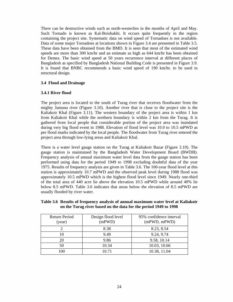
There can be destructive winds such as north-westerlies in the months of April and May. Such Tornado is known as Kal-Boishakhi. It occurs quite frequently in the region containing the project site. Systematic data on wind speed of Tornadoes is not available. Data of some major Tornadoes at locations shown in Figure 3.4 are presented in Table 3.5. These data have been obtained from the BMD. It is seen that most of the estimated wind speeds are more than 300 km/hr and an estimate as high as 644 km/hr has been obtained for Demra. The basic wind speed at 50 years recurrence interval at different places of Bangladesh as specified by Bangladesh National Building Code is presented in Figure 3.9. It is found that BNBC recommends a basic wind speed of 190 km/hr. to be used in structural design. 3.4 Flood and Drainage 3.4.1 River flood The project area is located to the south of Turag river that receives floodwater from the mighty Jamuna river (Figure 3.10). Another river that is close to the project site is the Kaliakoir Khal (Figure 3.11). The western boundary of the project area is within 1 km from Kaliakoir Khal while the northern boundary is within 2 km from the Turag. It is gathered from local people that considerable portion of the project area was inundated during very big flood event in 1988. Elevation of flood level was 10.0 to 10.5 mPWD as per flood marks indicated by the local people. The floodwater from Turag river entered the project area through low-lying areas and Kaliakoir Khal. There is a water level gauge station on the Turag at Kaliakoir Bazar (Figure 3.10). The gauge station is maintained by the Bangladesh Water Development Board (BWDB). Frequency analysis of annual maximum water level data from the gauge station has been performed using data for the period 1949 to 1998 excluding doubtful data of the year 1975. Results of frequency analysis are given in Table 3.6. The 100-year flood level at this station is approximately 10.7 mPWD and the observed peak level during 1988 flood was approximately 10.5 mPWD which is the highest flood level since 1949. Nearly one-third of the total area of 440 acre lie above the elevation 10.5 mPWD while around 40% lie below 8.5 mPWD. Table 3.6 indicates that areas below the elevation of 8.5 mPWD are usually flooded by river water. Table 3.6 Results of frequency analysis of annual maximum water level at Kaliakoir
on the Turag river based on the data for the period 1949 to 1998
Return Period (year)
Design flood level (mPWD)
95% confidence interval (mPWD, mPWD)
2 8.38 8.23, 8.54 10 9.49 9.24, 9.74 20 9.86 9.58, 10.14 50 10.34 10.03, 10.66 100 10.71 10.38, 11.04

25

26

27

28

29
3.4.2 Storm drainage The storm runoff process is influenced by the undulated highland characteristic of the project area. Storm water from highlands quickly accumulates in the adjoining ditches and is gradually drained through low-lying areas. The project area can be divided into 5 drainage zones based on major drainage outlets. The drainage zones have been denoted by DR1 to DR5 in Figure 3.11, and the drainage paths are also shown in the figure. Three drainage zones DR1 to DR3 have been subdivided into sub-zones according to the topography and arial extent. Runoff from the drainage zones DR1 and DR2 flows towards the west and reaches the Kaliakoir Khal as shown in the Figure 3.11. Runoff from the drainage zones DR3 to DR5 mostly flows towards the north and reaches the Turag river. There exist 8 bridge/culverts of which five are on the highway that forms boundary of the project area, and remaining three are inside the area as shown in Figure 3.11. The bridge (DS1) on the highway drains most of the area of the drainage zone DR1. The culvert DS2 on the highway drains a small portion of the zone DR1. A pipe culvert DS3 joins low-lying areas on the two sides of an earth-filled path that links two high lands in the drainage zone DR1. Culverts DS4 to DS6 are on the highway and drain the area of the zone DR2. The culvert DS6 has a critical role since it carries discharge of the important railway culvert DS7 that drains entire area in the northern side of the railway in the drainage zone DR2. The culvert DS8 is on a rural road and drains major portion of the zone DR3. 3.5 Geology The project site is located in Kaliakoir Upazila of the Gazipur district. The area is under greater Dhaka district and lies in the southern part of the Madhupur Tract. Red soils of the Pleistocene Madhupur clay residuum usually form the surface of the Madhupur Tract and are roughly delimited by the Bangshai, Banar - Sitalakhya and Buriganga river systems. Brick-red to yellowish-brown Pleistocene deposits previously known as the Madhupur Formation have been renamed as the Madhupur Clay Residuum. It is well exposed on the Madhupur Tract where it forms inliers standing above the surrounding recent flood plains. The current interpretation of the Geological Survey of Bangladesh is that the clay is a residual soil horizon produced by post-depositional weathering of feldspars in the sand fraction. The base of the Madhupur Clay is therefore gradational with the Dupi Tila sands from which it has been derived. The Madhupur residuum would therefore have been developed on a Pliocene to mid-Pleistocene erosion surface. The age of Madhupur Clay is not definitely known, but is tentatively correlated with the middle - upper Pleistocene "Older Alluvium" of the Ganges valley. The upper clay is brownish-red to brick-red; generally it is red to light brown in the southern part and brick-red to deep-brown in the northern part of the Madhupur Tract. The clay is sticky, plastic, compact when dry and soft when wet, and is intercalated with fine sand and silt. The sands are stained brown and yellow. Brown ferruginous concretions occur particularly in the upper part of the unit; calcareous nodules are found locally. The thickness of the upper clay varies from less than 1 to 14 m.
30
The lower clayey sand is greyish-brown with a mottling of red, brown and orange colours, the upper part is reddish and the lower part is greyish. The clay is sticky, plastic and compact. Sand lenses and calcareous nodules are also present in the clay. Sand grains are mostly of quartz, stained brown and yellow, fine to medium grained; mica, mostly muscovite, is often present in blebs. The proportion of sand below the Lower Clayey Sand was noted to increase with depth and passes into sand, which is now recognised to be the Dupi Tila. In the geotechnical literature the Madhupur Clay is often referred to as the Dhaka Clay. Madhupur Tract as a whole stands higher than the surrounding flood plains. The Dhaka-Tongi block, bounded on all four sides by faults seems to be the most uplifted block. The tract is step faulted on the west, south and east. Geologically, Bangladesh is an extremely active region; being many of the faults are seismically active. At the end of the Pliocene or the early Pleistocene, silty clay belonging to the Dupi Tila Group (or possibly the Girujan Clay) were being deposited across the area. This layer is generally not seen in boreholes except in Dhaka City, where it is more than a hundred metres thick. The silty clay is overlain unconformably by the Dupi Tila sands as a delta was gradually built southwards. Some coarse sand and gravel is present, mainly near the base, highlighting the erosional nature of the contact. The Dupi Tila was followed by a period of erosion, and subsequent deposition of the Lower Alluvial Sequence of the Dihing Series. This probably occurred at the onset of one of the glacial phases of the Pleistocene, but might have followed rapid tectonic uplift to the north. It was apparently at this stage that the relative subsidence of the Jamuna and uplift of the Madhupur was activated. The grain sizes of these deposits indicates a declining energy environment, passing from braided stream to meander belt and finally to a soil horizon which is tentatively correlated with the Madhupur Clay Residuum. The much greater thickness of clay, the deep weathering of the underlying Dupi Tila and the absence of very coarse sediments beneath the Madhupur Clay all point to the Madhupur Tract being an elevated block. Bangladesh has been divided into three seismic zones shown in Figure 3.12 as specified in Bangladesh National Building Code (BNBC-1993). The zoning is based on the severity of the probable intensity of seismic ground motion and damages with Zone 3 being the most severe. The Hi-Tech Park site lies within the moderate Zone 2 with Z=0.15. 3.6 Socio-Economic Aspects The surrounding socio-economic environment is an important factor that should be considered while developing the Hi-Tech Park. A supporting population obviously would be an asset while a hostile population may pose threats to the smooth functioning of the Park. A socioeconomic survey was therefore carried out to understand the socio-economic profile of the surrounding area. A total of 215 households were surveyed in 11 mouzas covering a total population of about 1155. Households were selected using a systematic random sampling procedure.

31

32
3.6.1 Socio-Demographic Characteristics Distribution of the population by sex indicates that there are more males than females in the area. 55% of the population are males while females constitute about 45%. Age distribution of the people indicates that 7.3% are infants, that is, 5 years and below while about 16% fall in the age bracket 6 to 15 years. Nearly 28% of the people belong to the age group 16 to 25 years while those belonging to 26 to 45 year age group constitute about 33.3% of the total population. Only 2.6% of the population are 65 years and older.
Average family size in the area is about 5.4. Nearly 64% of the households have 4 to 6 members while about 20% of the households have 7 to 10 members. Marital status of the people indicates that 54% are married while 41% are single or unmarried. Widows constitute about 2% of the population. Only one divorcee was found in the area. Literacy rate is quite high in the area. About 82% of the population (excluding non-school-age children) are literate in the area which is much higher than the national average indicating that the area has an enlightened population caring for education. It is interesting to note that nearly 50% of the population reached beyond the primary level of education. Those who reached college and university levels constitute about 17% of the population.
Figure 3.13 Population Distribution by Age-Group
7% 7%9%
28%20%
14%
12% 3%
upto 5 yrs6 - 10 yrs11- 15 yrs16-25 yrs26-35 yrs36-45 yrs46-65 yrsOver 65 yrs
Figure 3.14 Population Distribution by Education
18%
32%33%
9%6% 2%
IlliteratePrimarySecondaryHSCBachelor'sMaster's

33
3.6.2 Economic Characteristics The area possesses both urban and rural characteristics. The area includes Kaliakoir - the Upazilla Headquarters which is an urban centre. People's occupation is therefore mixed.
Largest proportion of the population who entered the labour force are engaged in business activities (23%) while farmers constitute only 13% of the same group. It was found that many farm households have their children engaged in non-farm activities. Daily labourers constitute about 5.4% of the labour force while people doing government and private jobs constitute about 7.7% and 11.5% of the labour force respectively. Unemployed people, housewives (doing household works) and people doing different other types of jobs together constitute about 40% of the labour force. Average monthly income in the area is 8462 Taka. Further idea about the economic condition of the people can be obtained from the distribution of income of the households. The survey shows that 44.4% of the households have income upto 5000 Taka while households earning between 5001 and 10000 Taka constitute about 35.6% of the households. This means that 80% of the households earn less than 10000 Taka per month while the rest earn more than this amount. Only 5.4% of the households earn more than 20000 Taka per month.
05
1 01 52 02 53 03 54 0
% o
f lab
our
forc
e
Agricu
lture
Daily L
abou
r
Busine
ss
Govt. S
ervice
Private
Serv
iceOthe
r
O c c u p a tio n
F ig u r e 3 .1 5 O cc u p a tio n a l D istr ib u tio n o f P o p u la tio n
Figure 3.16 Population Distribution by Income Group
44%
36%
13% 2% 5% upto 5000 Tk 5001-10000 Tk 10001-15000 Tk
15001-20000 Tk
Above 20000 Tk

34
The patterns of land ownership is also an important indicator of the kind of socio-economic situation prevailing in an area, especially, a rural area. Land ownership pattern in the study area is extremely uneven. Nearly 57% of the households own 0.5 acres or less while another 27.2% own between 0.51 to 2.50 acres indicating that 84% of the households are small or marginal land-owners. 10.2% of the households have 2.51 to 5.00 acres of land while those owning more than 5.00 acres constitute only about 6% of the households. 3.6.3 Housing Characteristics Land value in the area is about 27000 Taka per decimal (one-hundredth of an acre). Most of the households, that is, nearly 93% have their own lands and built a house (i.e. one hundred of an acre) there. 76.2% of the households mentioned that they inherited the lands while 16.8% of the households bought the lands from others. 4.7% of the households stay in rented houses while the rest live in government quarters. An analysis of the structure of
houses indicates that 18.2% of the houses are pucca, 43% are semi-pucca and the rest 38.8% are kutcha. Nearly 87% of the houses have electricity. Tube-well, however, is the main source of drinking water. About 95% of the households get water from tube-wells while the rest obtain water from ponds and other sources. 3.6.4 People's Attitude towards the Hi-Tech Park An attempt was made to understand the attitude of the people towards the establishment of the Hi-Tech Park. They were asked if they favour the idea of a Hi-Tech Park in the area. Overwhelming majority of the people answered in the affirmative. Thus, about 91% of the respondents supported the idea of establishing a Hi-Tech Park in the proposed area while only about 9% did not support the idea. The respondents were also asked about the reasons for their views. Those who supported the idea gave the following reasons (multiple answers were allowed):
- Job opportunities would increase (93.2%) - Roads and other facilities would increase (45.9%) - Land value would increase (28.5%) - Houses can be built and rented (27.1%) - Opportunities for business would increase (27.1%) - Other (1.4%)
Figure 3.17 Distribution of Houses by Structure
18.20%
43%
38.80% PuccaSemi-PuccaKutcha

35
Those who did not support the idea of establishing a Hi-Tech Park in the area also had their reasons which were as follows: - Natural environment would be disrupted (52.6%) - Social crime would increase (36.8%) - Pressure would increase on agricultural land (31.6%)
- Socio-economic environment would be disrupted (21.1%) - Some people would be displaced (15.8%) - Other (10.5%)
In view of the prevailing economic situation it is no wonder that the people expected largest impact of the Park on job opportunities. Although the Park would be knowledge-based meaning that highly skilled people would be required to man the Park, operation and maintenance activities would certainly create some job opportunities for the local people.
0102030405060708090
100
% o
f R
espo
nden
tsJo
b Opp
ortun
ities
Roads
& O
ther F
acilit
ies
Land
Valu
e
House
Ren
t
Busine
ss O
pport
unitie
sOthe
r
Expected Impacts
Figure 3.18 Distribution of Respondents by Expectation about Positive Impacts of Hi-Tech Park

36
CHAPTER 4 CONNECTIVITY TO NATIONAL INFRASTRUCTURE Availability of infrastructural facility is vitally important for any project. For the functional operability of the establishment at Hi-Tech Parks, fast and safe accessibility as well as electricity, telecommunication and gas supply are essential. Lack of such facilities would impose additional expenses on the project cost thereby reducing benefit-cost ratio or net present value. This chapter illustrates the availability of the infrastructural facilities for the project. 4.1 Road Connectivity For the input and output of products as well as accessibility of the employees working in the Park, road accessibility is essential. With respect to road connectivity the project site is situated at one of the best possible locations. The national highway passes along the western boundary of the project site. The highway connects the project site to Jamuna Multipurpose Bridge and the rest of the country. Along the highway, any part of the country is accessible including the capital Dhaka and the ports at Chittagong and Mongla. The central business district (CBD) of Dhaka city is about 40 km away from the project site. After the completion of the on-going road improvement projects the CBD of Dhaka city can be reached within less than an hour from the site. The completion of the Eastern Bypass Project would further reduce the travel time. Also there exist three alternative roadway routes, to access the CBD from the project site, which reduces the risk. The alternative routes include Kaliakoir-Ashulia-Dhaka, Kaliakoir-Joidebpur-Dhaka and Kaliakoir-Savar-Dhaka. Fig. 4.1 shows the road layout connecting the project site to the rest of the country. 4.2 Rail Connectivity For the transportation of freight as well as of passengers, accessibility through railway increases the attractiveness and potential of land resources. The site selected for the project is blessed with very close proximity to national railway network. National railway passes through the southern side of the project site. The railway connects the project site to Jamuna Multipurpose Bridge and the rest of the country. Construction of this area link has been completed and services should commence within the next few months. Using the railway, almost all parts of the country are accessible, including the capital Dhaka (56 kms. away) and the ports at Chittagong and Mongla. Fig. 4.2 shows the railway layout connecting the project site to the rest of the country. Although railway line passes through the project site, the nearest stations Mirzapur on the west and Mouchak on the east are about 14 and 6 km away from the project site which is shown in Fig. 4.2. Considering the importance of the project and the need for freight, particularly movement of heavy machinery, establishment of a station yard around the project site is highly recommended. 4.3 Connectivity to Airport Considering the quality of the employees of Hi-Tech Parks and the potential investors, particularly the foreign entrepreneurs, executives, scientists and technologists, fast and smooth connectivity to international airport is essential. As shown in Fig. 4.1, Zia
37
International Airport is only 40 km away from the project site and can be accessed within half an hour by national highway. 4.4 Gas Transmission Network For the industrial as well as household activities at the Park, availability of gas is essential. The existing national gas transmission line passes through Gazipur Area which is about 15 km away from the project site. Another gas transmission line is under construction which will connect to the transmission line of the north-western side of the country through Jamuna Multipurpose Bridge. This line is located about 40 km north of the project site. Under the circumstances, it will not be very difficult or expensive to connect the project site to national gas transmission network thereby facilitating supply of gas to the project site. 4.5 Power Supply The nearest power source for the Park would be Joydevpur and Mirzapur 33 kV substations. 11 kV lines have to be drawn from both the substations in order to provide the redundancy in the source. Three 33/11/0.4 kV substations have to be built in three different location of the proposed Parks. 4.6 Telecom The Talibabad Satellite Earth Station, which is one of the national telecommunication gateways operated by BTTB, is located at the center of the Park. The area is already under the mobile communication network established by the private companies. Also, with the recent deregulation of VSAT by the government, there does not exist any barrier for the establishment of VSAT connectivity. So the investing agencies can establish their own VSAT connections. Moreover, Bangladesh Railway will lay fibre optic cable along the railway track and BTTB has plans to expand the fibre optic based telecommunications network in the country along the Jamuna Bridge Access Road. These will ultimately be connected to the submarine cable link from Chittagong to Southeast Asia (e.g. via Singapore) as part of the global information superhighway. These will be highly beneficial for the offices and industries which can be provided with high bandwidth data communication links.

38

39
CHAPTER 5 POWER SUPPLY
5.1 Introduction Uninterrupted power supply is one of the most important features for any Hi Tech Park all over the world. The Hi-Tech Parks that the BUET team visited have the sources of very reliable power supply. Interviewing the officials of the Parks, it is revealed that in order to attract the investment for any industry in the Park the uninterrupted supply must be ensured. Among all of the common facilities, power and communication are two vital facilities for our proposed Park. For that, the primary power supply for the proposed Hi-Tech Park would come from its own generation. Four units of 1 MW generators have been proposed for the Park. The generators would be gas fired and gas cooled. Most importantly, the generator should have very low noise and low pollution level. BPDB and/or REB sources will be treated as the secondary source of power. 5.2 Present Power Sources for the Park Although two 230kV transmission lines are passing over the Park, it is not economically viable to install a 230/11kV substation for an estimated load of about 4/5 MW required for the Park. At the medium voltage level, the nearest power source for the Park would be Joydevpur and Mirzapur 33 kV substations. 11 kV lines have to be drawn from both the substations in order to provide the redundancy in the source. Three 33/11/0.4 kV substations have to be built in three different location of the proposed Park. 5.3 Load Estimation Criteria Depending on the loads in different blocks of the Park the sizes of the substations have to be selected. A 20 percent factor of safety in the load demand should be considered in determining the sizes. The nature of electrical loads should be determined and accordingly the regulating and/or stabilized sources should be ensured. If there are loads which might be the source of harmonic generation, then proper filter equipment should be installed. In the actual load, if there is an appreciable amount of inductive load, then installation of reactive power compensator should be considered for the Park. 5.4 Load Forecasting The whole project will be completed in two phases. Accordingly, the phase-wise load forecasting has been made. The important buildings including the administrative building will be centrally air-conditioned. Loads for the air-conditioning and that for electric lifts on five or more storied buildings have been considered. A load factor of 0.8 has been taken into consideration. The nominal power factor is considered as 0.95 or above. To maintain the level, appropriate sized Power Factor Improvement (PFI) plant has been taken into account. Central harmonic compensators will be installed at each substation in order to avoid the injection of harmonic contents into the system. The following table shows the summary of results on load calculation.
40
Table 5.1 : Summary of the Results on Load Calculations
Phase-I Phase-II Blocks
Load, kW Load, kW #1 665 850 #2 - 170 #5 175 700 Sub-total 840 1720 TOTAL 2560
5.5 Selection of Substations Three 11/0.4 kV substations have been proposed for the Park. Since different blocks are located at remote distances, it will be better to have substations at three locations rather than concentrated at a central place. In fixing up the locations of those three substations different alternatives are studied. Finally a optimum solution has been reached. The components that will be required for the substations are listed in Table 5.2.
Table 5.2 Component list for 11 kV substations
Sl. No. Components Cost, Lac Taka
1 3 X 1 MVA Transformers
45
2 Switch Gear and PFI plants
170
3 11 kV cables 1000 Total 1335
5.6 Hi-Tech Park Generating Station It is planned to install 4(four) numbers of gas-fired generators as the primary source of power for the Park. The cost for the station has been determined from the individual cost of its components. The generating plant will be located at the central position of the Park. That is why a location at the boundary of block – III would be the most suitable place. The cost of installing generating station is given in Table 5.3.
Table 5.3 Generating Station
Sl. No. Components Cost, Lac Taka
1 4 X 1 MVA Generators 1600 2 11 kV Cables and
Accessories 200
3 Generator accessories 100 Total 2000

41
5.7 Power Management The policy of Hi-Tech Park will be to provide every user sufficient numbers of power outlets for their appliances and usual light and fan outlets. A supervisory team will always work for providing 24 hr service for any problem related to power supply. Whenever there will be any interruption in the generator power, the power from the BPDB or REB source will be drawn and thus the uninterrupted power supply will be ensured. In order to manage the power crisis, if any, the whole network will be divided into two part, one as priority zone and the other as non-priority zone. In the crisis period, only the priority zone will be provided with the power.
42
CHAPTER 6 DATA COMMUNICATION 6.1 Computing and Communication Needs The proposed Hi Tech Park will house pollution free off-shore Hi-Tech industries as well as their Research and Development (R & D) centers. Scientists and researchers of these R & D centers have to have online access to libraries and databases. Off-shore companies need to have an uninterrupted communication with their mother institutions. The advent of E-commerce has added a new dimension to business. Today’s business cannot be confined to national boundaries. Most of the enterprises in the Park will be conducting their business through Internet and E-commerce. They need to have dedicated interactive web portal to conduct business with globally dispersed business partners. These web portals will act as showrooms for the goods and services offered by the respective companies. Bangladesh Government is in the process of enacting necessary legislations and cyber laws for financial transaction over the Internet. The Park is going to provide incubator facilities for start-up companies. These start-up companies need state-of-the-art computing and communication facilities under their disposition to have a good start of their companies. IT enabled services like Call Centers, Back Office services and Medical Data Transcription for which advanced countries will look into Bangladesh for her cheap and easily trainable manpower will be an added attraction for the proposed Hi-Tech Park. All these IT enabled services require uninterrupted communication links with the rest of the world. The Hi Tech Park will organize a National Web Portal which might act as a one stop shop on the Internet for providing its citizens with Government information and services. All the Government procurement through tender and bidding can be conducted through this Web Portal. It will save time and effort on the part of the citizens, increase efficiency and reduce workloads of the Government officials. Bangladesh Government has declared IT as the thrust sector and has relaxed policy issues and opened up opportunities for foreign investors. These avenues and opportunities should be advertised through this national web portal to attract foreign investment. Additionally the same web portal can be used to promote tourism. All the Hi Tech Parks around the globe have one unique feature and that is their close proximity to some kind of educational institute. These educational institutes provide the necessary manpower for the Hi-Tech Parks. In the Fifth Five Year Plan it has been proposed to establish twelve more technical universities. One of these can be established in the proposed Hi Tech Park. There is an acute shortage of trainers in IT field. Due to high global demand, we have seen a constant leakage and outflow of skilled IT manpower from the country. The lack of IT trainers has become a bottleneck for human resource development. One of the remedies of this acute problem is distance education via video transmission through radio link. In addition a national digital library and data bank may be established in the proposed Hi Tech Park. The industries in the Park need both internet and intranet services. In addition the Park authority needs to publish Electronic Newsletter and Bulletin board services to disseminate information to its tenants.

43
The aforesaid discussion has pointed out the necessity of the Hi Tech Park to be on online 24 hours a day and to have a high capacity backbone network. Since Bangladesh is now not directly connected with the information super highway through submarine cable, the other alternative is to depend on VSAT technology which is being used in fifteen places throughout India in their Software Technology Parks. VSAT is connected with the international hub through satellite communication. The bandwidth depends on the number of channels hired. More than one VSAT facing different satellites will ensure uninterrupted and high capacity transmission. In near future (possibly by 2004) Bangladesh will be connected to the global information superhighway through submarine cable. In that time, the installed VSAT will act as a backup support in case of any link failure. For backbone network Gigabyte Ethernet technology might be a fairly good choice. It is based on the long established Ethernet technology which ensures availability of skilled manpower for network management and associated jobs. A hybrid network of Gigabyte Ethernet and Fast Ethernet technology is proposed for Hi Tech Park’s network, striking a balance between technology, performance and price factors. To provide high speed and high bandwidth, fiber optic backbone might be suitable to run between buildings in the Hi Tech Park. This fiber optic backbone will terminate to Ethernet switches at each floor of the buildings. To provide resilience and robustness of the network, improving network availability, in the event of link failure, link redundancy must be provided between buildings. As the Park requires more bandwidth from the network, additional concentration points can be provided to meet additional bandwidth requirements. 6.2 Connecting the Park to the Information Super Highway 6.2.1 Connecting directly to the Submarine Cable Under the Jamuna Bridge Railway Link Project (JBRLP) Bangladesh Railway (BR) would be laying 4 (four) pairs of optical fibers from Sirajganj to Dhaka over the new Jamuna Bridge railway link. The link will be interconnected with BR’s existing fiber optic network at Dhaka and Sirajganj and shall have outlets at the railway stations enroute as shown in Figure 6.1. At Dhaka the fibers will be terminated in the railway telephone exchange at Kamlapur. The proposed submarine cable would have a landing point at Chittagong and the railway fiber network would be connected to the submarine cable. After installation and commissioning, the system will be handed over to Grameen Phone (GP) for maintenance of the fibers, providing railway communication facilities and for commercial use of the excess capacity in the fibers. According to the programme, 2 pairs of fibers will be equipped for BR and Grameen Phone uses at the moment. The technology currently used by Grameen Phone for commercial use of BR optical fibers is STM 4 which allows channel capacity of 8000 voice channels (64kbps) per pair of fibers. Conventional technology (STM 16) can raise the capacity of fiber pairs upto 32000 channels.
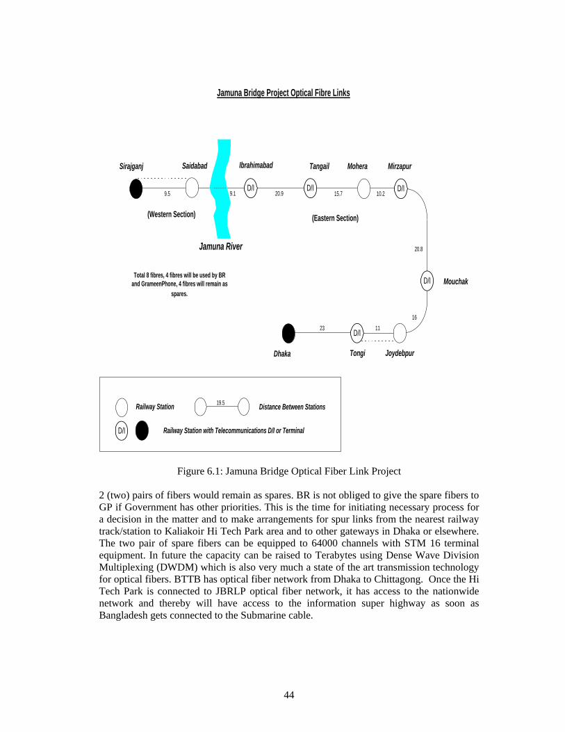
44
Figure 6.1: Jamuna Bridge Optical Fiber Link Project
2 (two) pairs of fibers would remain as spares. BR is not obliged to give the spare fibers to GP if Government has other priorities. This is the time for initiating necessary process for a decision in the matter and to make arrangements for spur links from the nearest railway track/station to Kaliakoir Hi Tech Park area and to other gateways in Dhaka or elsewhere. The two pair of spare fibers can be equipped to 64000 channels with STM 16 terminal equipment. In future the capacity can be raised to Terabytes using Dense Wave Division Multiplexing (DWDM) which is also very much a state of the art transmission technology for optical fibers. BTTB has optical fiber network from Dhaka to Chittagong. Once the Hi Tech Park is connected to JBRLP optical fiber network, it has access to the nationwide network and thereby will have access to the information super highway as soon as Bangladesh gets connected to the Submarine cable.
Jamuna Bridge Project Optical Fibre Links
Jamuna River
Ibrahimabad Tangail Mohera Mirzapur
Mouchak
JoydebpurTongi
Railway Station
Railway Station with Telecommunications D/I or Terminal
19.5 Distance Between Stations
1116
(Eastern Section)
Sirajganj
(Western Section)
20.8
10.215.720.99.5 9.1
Saidabad
Dhaka
23 D/I
D/I D/I
D/I
D/I
D/I
Total 8 fibres, 4 fibres will be used by BRand GrameenPhone, 4 fibres will remain as
spares.

45
6.2.2 Connecting to International Gateway through Satellite VSAT stands for “Very Small Aperture Terminal” and it refers to receive/transmit terminals installed at dispersed sites connecting to a central hub via satellite using small diameter antenna dishes (1.8 m to 4.5 m or in some instances can be higher depending on the speed of transmission). VSAT technology represents a cost effective solution for users seeking an independent communications network connecting a large number of dispersed sites. This technology is widely used in places which either have a poor quality or lack of local infrastructure. The Hi Tech Park can be connected to one or more Internet Exchange service provider through a point-to-point leased line via dedicated satellite link using the VSAT technology. The technology is illustrated in Figure 6.2. There are a number of Internet Exchange service providers throughout the globe. In selecting the service provider we have to be careful in the following aspects. The Internet Exchange provider must be well connected to US and rest of the world via redundant communication link like through SMW-3, APCN, APC, China-US cable network, TPC-5, Japan-US cable network and more. In selecting the International operator, we must ensure that the operator has Network Monitoring Center for monitoring the service with 24 hr X 7 days availability. Moreover the operator must have locally available maintenance team with 24 hr X 7 days availability. The service provider should have bandwidth expandability options, should own multiple satellite system having sufficient number of transponders and wide footprint coverage. Some of the service providers offer Secondary Domain Name System (DNS) services, Domain Name Registration services, Broader Gateway Protocol dynamic routing services and News feed services free of charge. As mentioned earlier, VSAT provides an ideal cost effective platform to support voice, data, fax, video or other telecommunication traffic to countries that presently lack adequate and reliable terrestrial infrastructure. As long as we are not connected directly to the submarine cable, we can reliably meet data communication need using VSAT technology. Even after we get connected to the submarine cable, the installed VSAT will work side by side as a backup support for reliable and uninterrupted communication. 6.3 Backbone Network in the Park It has been proposed to install the VSAT antenna and associated equipment on the roof of six storied part of administrative building located at Block I of the Park. As a result Park network center housing the Satellite modem, Router, all the servers and backbone switches will be placed at nearby floor of the administrative building. This choice is dictated by the fact that development in the 1st and subsequent phases will be mainly concentrated in Blocks I, II and V areas of the Park only. Blocks III and IV will be developed only upon demand in future. From the network center two main optical fiber lines will run along the sides of the main road connecting all the blocks of the Park. The optical fiber lines will terminate at peripheral switches at different computing sites of the Park. Data from the local area networks of individual premises will be fed into these peripheral switches. The peripheral switches will form a star with the backbone switches and each peripheral switch is fed with an additional pair of optical fiber for backup support and redundancy.

46
Fig. 6.2
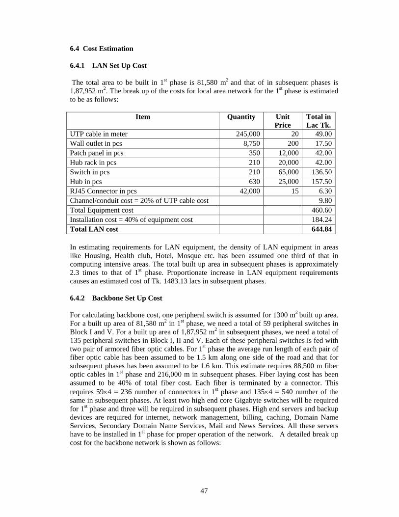
47
6.4 Cost Estimation 6.4.1 LAN Set Up Cost The total area to be built in 1st phase is 81,580 m2 and that of in subsequent phases is 1,87,952 m2. The break up of the costs for local area network for the 1st phase is estimated to be as follows:
Item Quantity Unit Price
Total in Lac Tk.
UTP cable in meter 245,000 20 49.00Wall outlet in pcs 8,750 200 17.50Patch panel in pcs 350 12,000 42.00Hub rack in pcs 210 20,000 42.00Switch in pcs 210 65,000 136.50Hub in pcs 630 25,000 157.50RJ45 Connector in pcs 42,000 15 6.30Channel/conduit cost = 20% of UTP cable cost 9.80Total Equipment cost 460.60Installation cost = 40% of equipment cost 184.24Total LAN cost 644.84 In estimating requirements for LAN equipment, the density of LAN equipment in areas like Housing, Health club, Hotel, Mosque etc. has been assumed one third of that in computing intensive areas. The total built up area in subsequent phases is approximately 2.3 times to that of 1st phase. Proportionate increase in LAN equipment requirements causes an estimated cost of Tk. 1483.13 lacs in subsequent phases. 6.4.2 Backbone Set Up Cost For calculating backbone cost, one peripheral switch is assumed for 1300 m2 built up area. For a built up area of 81,580 m2 in 1st phase, we need a total of 59 peripheral switches in Block I and V. For a built up area of 1,87,952 m2 in subsequent phases, we need a total of 135 peripheral switches in Block I, II and V. Each of these peripheral switches is fed with two pair of armored fiber optic cables. For 1st phase the average run length of each pair of fiber optic cable has been assumed to be 1.5 km along one side of the road and that for subsequent phases has been assumed to be 1.6 km. This estimate requires 88,500 m fiber optic cables in 1st phase and 216,000 m in subsequent phases. Fiber laying cost has been assumed to be 40% of total fiber cost. Each fiber is terminated by a connector. This requires 59×4 = 236 number of connectors in 1st phase and 135×4 = 540 number of the same in subsequent phases. At least two high end core Gigabyte switches will be required for 1st phase and three will be required in subsequent phases. High end servers and backup devices are required for internet, network management, billing, caching, Domain Name Services, Secondary Domain Name Services, Mail and News Services. All these servers have to be installed in 1st phase for proper operation of the network. A detailed break up cost for the backbone network is shown as follows:
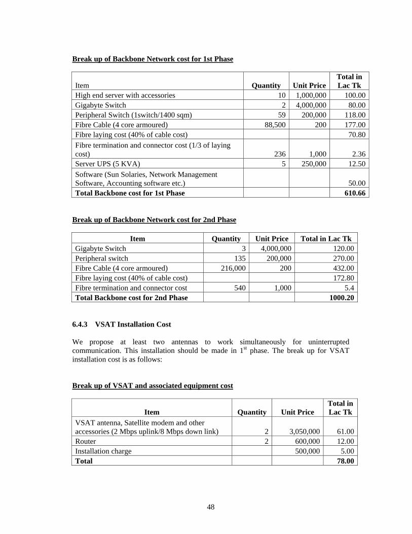
48
Break up of Backbone Network cost for 1st Phase
Item Quantity Unit Price Total in Lac Tk
High end server with accessories 10 1,000,000 100.00Gigabyte Switch 2 4,000,000 80.00Peripheral Switch (1switch/1400 sqm) 59 200,000 118.00Fibre Cable (4 core armoured) 88,500 200 177.00Fibre laying cost (40% of cable cost) 70.80Fibre termination and connector cost (1/3 of laying cost) 236 1,000 2.36Server UPS (5 KVA) 5 250,000 12.50Software (Sun Solaries, Network Management Software, Accounting software etc.) 50.00Total Backbone cost for 1st Phase 610.66
Break up of Backbone Network cost for 2nd Phase
Item Quantity Unit Price Total in Lac Tk Gigabyte Switch 3 4,000,000 120.00Peripheral switch 135 200,000 270.00Fibre Cable (4 core armoured) 216,000 200 432.00Fibre laying cost (40% of cable cost) 172.80Fibre termination and connector cost 540 1,000 5.4Total Backbone cost for 2nd Phase 1000.20
6.4.3 VSAT Installation Cost We propose at least two antennas to work simultaneously for uninterrupted communication. This installation should be made in 1st phase. The break up for VSAT installation cost is as follows: Break up of VSAT and associated equipment cost
Item Quantity Unit Price Total in Lac Tk
VSAT antenna, Satellite modem and other accessories (2 Mbps uplink/8 Mbps down link) 2 3,050,000 61.00Router 2 600,000 12.00Installation charge 500,000 5.00Total 78.00
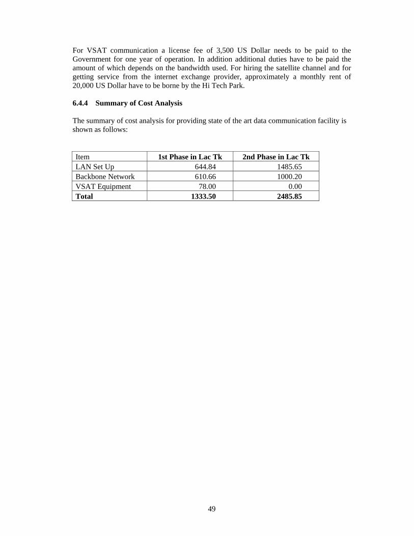
49
For VSAT communication a license fee of 3,500 US Dollar needs to be paid to the Government for one year of operation. In addition additional duties have to be paid the amount of which depends on the bandwidth used. For hiring the satellite channel and for getting service from the internet exchange provider, approximately a monthly rent of 20,000 US Dollar have to be borne by the Hi Tech Park. 6.4.4 Summary of Cost Analysis The summary of cost analysis for providing state of the art data communication facility is shown as follows: Item 1st Phase in Lac Tk 2nd Phase in Lac Tk LAN Set Up 644.84 1485.65 Backbone Network 610.66 1000.20 VSAT Equipment 78.00 0.00 Total 1333.50 2485.85

50
CHAPTER 7 SUITABLE INDUSTRIES 7.1 Definition of Hi-Tech Industries According to US Bureau of Labour Statistics, high technology industries are those whose expenditures for research and development are at least twice as great as the national industry average of 3.1 percent of annual sales. By definition, high technology industries are knowledge intensive industries. An extreme example would be an R & D organization running on commercial basis. From this consideration, industries where a good part of the value addition comes from knowledge worker should be considered as a potential candidate for Hi-Tech Park. 7.2 Factors to Select Industries for Hi-Tech Park Choice of industry for Hi-Tech Park in Bangladesh should be based on some common factors such as: i. high technology (R&D) content of the industries ii. entry into the foreign market with state of the art technology iii. development of indigenous technological capability iv. cost advantage v. availability of knowledge rich manpower vi. non-polluting and internationally accepted work environment of the industries vii. labour intensity viii. capital intensity ix. infrastructure readiness x. cyber law and IPR law The two major objectives of the Park are (a) to develop indigenous technological capability for the development of the local industries, and (b) to enter into foreign market by exporting state-of-the-art technology products. A biotechnology R & D product could be an example of the first kind which can greatly help the local agriculture or agro-processing industry. An HIV cure could be an extreme kind of example for the second objective. Entry into the export market in high technology area is very restrictive in many ways. However, strong plus-points to overcome the barriers are delivery of products with state of the art technology, innovation content and cost advantage. Considering the huge trade imbalance of Bangladesh it would be equally useful if the country could produce import-substitution products in the Park. For either case - be it for export or import substitution product - the potential industries must be supplied with appropriate manpower. It is already pointed out that the country must have plentiful supply of educated and knowledge rich manpower. Given the economic condition of Bangladesh it is always better if the Park can attract labour (knowledge worker) intensive industries. By default labour intensive industries are relatively less capital intensive. It is also advantageous to local entrepreneurs who have less investment capability.

51
All industries in the Park must be environment friendly. They must not create wastes or by-products which could harm the environment or cause hazards. In addition, all industries must follow the safety standards of ILO, WHO or other standards. Most Hi-Tech Parks are highly populated with information and communication technology related industries. This type of industries are knowledge worker intensive. However, to attract such industries the country's infrastructure readiness must be very high. It includes very good telecom infrastructure, good transportation infrastructure and good legal environment. The latter is ensured if the country has appropriate cyber law and good protection of intellectual property rights. 7.3 Industry Groups Suitable for Hi-Tech Park Keeping the above points in view, we have identified potential industries for the Park. The identified industries are grouped into different categories as below and a detail list under each group is presented in Annexure-B. The list shown in the annexure includes a wide range of industries. i Agro-bio-technology and Genetic Engineering (R&D) ii Agro-based Industries (R&D) iii Automobiles and Metal Industries (High-end products) iv New and advanced materials (R&D) v Medical Supplies and Devices vi Pharmaceutical and Clinical Products (R&D) vii Garments and Textile (R&D) viii Plastics (R&D) ix Merchandising and Machinery x Design of Electronic Products xi Manufacturing and Assembly of Electronic Products xii Computer Hardware xiii Computer Software xiv Communications Hardware xv Communications Software xvi IT Enabled Services xvii Human Resource Development Institute xviii Design and Consultancy xix Bioinformatics Biotechnology and genetic engineering is the next prime mover in agricultural development and productivity. Bangladesh being a predominantly agricultural economy, any innovation in these areas would be a natural advantage for the country. Also, biotechnology and genetic engineering is a forefront area of R&D worldwide. Establishing business and R&D firms in the Park is expected to bring in result from both domestic and international market. Agriculture based products in Bangladesh are mostly marketed in the local market. Many of these products have potential for export market provided quality control is administered during production and processing. Also they need to be packaged for transportation and higher shelf-life. R&D works on quality control and packaging, administration of standards etc. for export marketing of agro-based products have good commercial
52
prospect. Business organizations dealing with this type of activities may locate their operation in the park. Main-stream agroprocessing may pollute the park environment and as such should not be targeted as potential enterprise. Automobile is still the largest manufacturing industry in the world. A large volume of parts and components are outsourced by the automobile OEMs. Certain components and control systems of automobile are highly knowledge intensive. Establishment of such export oriented business in the Park may be considered. Development of new and advanced materials is the next industrial revolution in the offing. Development of ceramic components, composite materials, smart materials etc. has already made some impact. Any business in these areas is expected to be in the forefront of the manufacturing world. In developed countries there are more aged people. These countries spend huge money on the health care sector. Industries dealing with medical supplies and devices are expected to have good export market. Alongside huge investment, intensive efforts are being made for the cure of major killer diseases both in the developed and developing world. Also, research on preventive vaccines is also highly valued. Multinational pharmaceuticals themselves are engaged in the research on new medicine and vaccines. They are also in the market to buy the patents of innovations in these areas. Bangladesh has a well-developed, modern pharmaceutical industry. Few of them are engaged in reverse engineering of world class pharmaceutical products with good degree of success. Also, the country has resourceful manpower in the area. National and multinational pharmaceutical firms are expected to be interested in setting up their R&D in the Park. Bangladesh has very strong position in garments manufacturing. The country must develop its textile sector to support the garment sector to survive in the global trade environment. Besides, the garments sector is highly dependent on foreign fashion design. As a result the key decisions on material is based elsewhere. As an integrated approach to support the garment sector, the country must develop in the areas of textile (design and manufacture), fashion design and manufacture. Firms engaged in design and development of these areas may find it profitable to establish business in the Park. In the textile production, software for quality control of products is of prime demand. Software firms engaged in this kind of development work will also be interested in the Park. Plastic is a new-age material. Many products are now made of plastics instead of conventional materials. Plastics industry in Bangladesh has a respectable status. But these industries lack in new product design. Also, they are totally dependent on foreign manufacturers for the molds of their products. This is also one of the reasons why the industry players do not go for new product design. Firms with state of the art product design capability (solid modeling, virtual design and rapid prototyping) as well as mold/die manufacturing facility will definitely enjoy a demanding local market as well as foreign market. It may be mentioned here that the product design and development is a highly computer intensive work and mold/die manufacture is a computer aided high tech manufacturing with minimal adverse impact on environment. Electronics and information technology are interrelated industries. Many developments in IT were the consequence of developments in micro-electronics, a subset of electronics. These two industries command many modern day industrial and consumer products.

53
Products with competitive quality and price have an instant market anywhere in the world. Firms with concerns in electronics and IT are, therefore, common in Hi-Tech Parks around the world. These industries mainly need knowledge rich productive human resources to excel in world market. With a parallel provision to develop such manpower, the Park can attract firms in electronics and IT industry. Firms involved in microelectronics, computer hardware and software, communications hardware and software and IT enabled services are likely to establish operations in the Park. Bioinformatics is a new discipline to generate information from different life forms. This kind of information is an essential input to genetic engineering and biotechnology. Demand of bioinformatics is on the rise due to increased activity in genetic engineering. Bangladesh being a genetically resourceful area, it is likely that bioinformatic firms will be interested in the Park. The basic requirement of Hi-Tech Park is the knowledge rich human resources. Although the country has reasonable supply of educated manpower, it would be necessary to train them in specific skills of IT, biotechnology, design, manufacturing etc. Besides, there is a necessity for education in a number of newly emerging technologies, facilities for which may be conveniently located in the Park. In identifying suitable industries for the Park the macro-characteristics of the industries are more relevant at this stage. Table 7.1 shows the suitability on the basis of some macro-characteristics of the industry groups on a subjective scale assuming that these industries belong to Hi-Tech group. The above assessment may give a rough idea on the nature of the industry type vis-a-vis the standing of Bangladesh. It appears from the Table that the country must develop knowledge rich manpower to compliment the industries that are likely to set up operations in the Park. It is also apparent that in order to attract business operations in information and communication technologies related industries the telecom infrastructure and legal environment of the country must be improved.
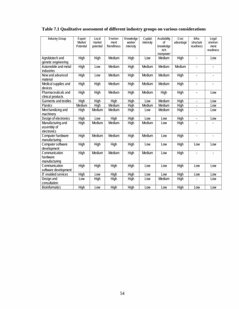
54
Table 7.1 Qualitative assessment of different industry groups on various considerations
Industry Group Export Market
Potential
Local market
potential
Environ-ment
friendliness
Knowledge worker
intensity
Capital intensity
Availability of
knowledge rich
manpower
Cost advantage
Infra-structure readiness
Legal environ-
ment readiness
Agrobiotech and genetic engineering
High High Medium High Low Medium High - Low
Automobile and metal industries
High Low Medium High Medium Medium Medium - -
New and advanced material
High Low Medium High Medium Medium High - -
Medical supplies and devices
High High Medium High Medium Medium High - -
Pharmaceuticals and clinical products
High High Medium High Medium High High - Low
Garments and textiles High High High High Low Medium High - Low Plastics Medium High Medium High Medium Medium High - Low Merchandizing and machinery
High Medium Medium High Low Medium High - Low
Design of electronics High Low High High Low Low High - Low Manufacturing and assembly of electronics
High Medium Medium High Medium Low High - -
Computer hardware manufacturing
High Medium Medium High Medium Low High - -
Computer software development
High High High High Low Low High Low Low
Communication hardware manufacturing
High Medium Medium High Medium Low High - -
Communication software development
High High High High Low Low High Low Low
IT enabled services High Low High High Low Low High Low Low Design and consultation
Low High High High Low Medium High - Low
Bioinformatics High Low High High Low Low High Low Low

55
CHAPTER 8 DEVELOPMENT PLAN 8.1 Land Use The land use plan determines specific uses for definite areas of land allocated for the Hi-Tech Park. The objective has been to produce a unified development which can be built economically, operated efficiently and maintained at normal expense. 8.1.1 Approach to Land Use Planning The plan has been influenced by the topography of the area. Undulating topographic characteristics made it necessary to consider three alternatives:
1. The land in its natural form can be maintained. This is, however, very difficult because the complex physical requirements of modern living rarely fit the natural form.
2. The natural form may be altered by changing its shape by grading, terracing, or
removing natural ground cover or trees. Unfortunately this approach has been taken too many times in the past without full consideration of the consequences.
3. The most rational approach, however, is to accentuate the essential character of
the site, highlighting notable features and letting them determine the form of plan and elevation. This, although more challenging from planning and design points of view, has been followed in the present case.
The land use plan thus strikes a balance and harmony between nature and the built environment. The development objective of the plan is to provide an environment which caters to the needs of knowledge-based companies at various stages of growth. 8.1.2 The Land Use Plan Considering the types of companies which will choose to locate in the area, infrastructure, business and administrative support services that will be required in the Park and the time frame for the implementation of the plan, the whole Park has been divided into five land use blocks as shown in Figure 8.1. Total area in each block and the distribution of areas by contour in each block are presented in Table 8.1. Only the areas above 10 metre contour in each block have been considered for development so as to avoid submersion even by a 100 year flood. The land use blocks are described below: Block-I: This block will have ready to occupy offices, laboratory facilities, incubators and factory spaces for Hi-Tech industries (mainly IT and Electronics). Administrative, business and infrastructural support services including housing provisions, community services and recreational facilities will also be located in this block. Companies having insufficient capital to build their own factories will find this block serving their needs. They can start their business here right away. This block is adjacent to the national highway leading to the Bangabandhu (Jamuna) Bridge and is directly accessible from the Dhaka-Tangail road. The block is relatively flatter which make it more suitable for the types of uses mentioned above. Development of this block will be completed in Phase-I.

56
Figure 8.1: Land Use Plan of Hi-Tech Park at Kaliakoir

57
Block-II: This block is meant for mixed type of development targeting a broad range of companies including information and communication technology, electronics, as well as companies intending to carry out research and development activities on textiles, garments, plastics, metals and metal products etc. This block will have mainly ready-to-occupy plots for the types of companies mentioned above. This block will be developed in Phase-II. Block-III: Build-to-suit facilities and ready-to-occupy plots will be available for electronics and IT companies in this block. Larger electronics and IT companies needing larger space and wishing to build their own facilities would find this block serving their needs. Smaller companies starting initially in Block-I and growing bigger gradually may find the existing space limited. Such companies faced with the need for expansion would also be able to move to this block. Block-IV: This block would be reserved exclusively for medical and bio-technology related companies such as medical equipment, medical devices, pharmaceuticals, bio-medical research, agri and food research etc. A separate block has been reserved for such companies because of the need to keep them separate due to the nature of their activities. Block-V: This is the institutional block which will house the institutions of higher learning for producing highly skilled knowledge workers for industrial and entrepreneurial needs. Institutions focussing on Information Technology, Multimedia and Telecommunications, Engineering, Biotechnology etc. may be set up in this block. Table 8.1 Block-wise areas available at different contour levels Contour, mPWD
Block-I Area above
contour, ha
Block-II Area above
contour, ha
Block-III Area above
contour, ha
Block-IV Area above
contour, ha
Block-V Area above
contour, ha
All Blocks Area above
contour, ha
14.5 0.77 0.28 0.42 0.36 1.8313.5 0.36 3.60 1.44 0.98 0.69 6.7512.5 0.67 7.32 3.06 2.02 0.87 13.9611.5 3.79 9.72 4.86 3.67 1.26 23.3310.5 16.30 14.06 6.15 5.15 1.74 33.379.5 19.99 24.63 9.20 6.81 3.23 57.888.5 23.09 29.89 13.43 9.10 7.18 82.727.5 25.03 34.32 15.98 11.08 10.44 96.866.5 25.72 36.95 17.85 12.05 12.50 105.07Total area of the Block
26.3* 42.28 18.70 13.15 18.60 119.00
* Of the total area of Block-I i.e., 26.27 ha, an area of 9.6 ha could not be surveyed due
to the existing Project Site Office of Samwan Corporation. However, from observation during field visit, the area (9.6 ha) could be assumed to be above 10.5 PWD level.

58
8.2 Physical Infrastructure 8.2.1 Buildings The main circular road entering into the complex from the west divides Block-I into two parts. The eastern part includes a shopping complex, an administration-cum-incubator building and a few ready to occupy plots. Considering public functions to keep isolated outside the whole vicinity the shopping complex is located at the outermost corner near the entrance and opposite to the proposed railway station. The shopping building would be provided with necessary Parking facilities. Being located further adjacent to the shopping building the Administrative building would include various essential functions necessary for functioning the project during phase 1. A part from Parking at the ground floor, this building will provide administrative and incubator facilities covering around 48750 sq.m space. Displaying three dimensional forms in successive layers of 3 and 6 storied (in low-rise block) and 18 and 25 stories (in High-rise block) the proposed building is going to accommodate Banks, Freight services and Clearing and forwarding agency, Medical centre, Multicuisine food courts, conference facilities, single window clearance facilities, conference facilities including video conferencing, fibre-optic LAN for high-speed data transfer and Incubators. Located at close proximity of the administrative building, proceeding further east 25 ready to occupy plots are located for immediate operation of the project. While the northern part of the primary circular road locates the built forms described above, southern part, separated by a central open space, locates ancillary facilities like housing, recreation (including health club, swimming pool, gymnasium) and community facilities etc. Appearing at the end of the Block-I, the circular road forms a fly-over, accommodating the railway track underneath and finally reaches Block-II. The road takes almost an U-turn to form a cul-de-sac thereby locating a hotel tower at its end with modern facilities inside. Three separate spots are also identified for cottages to serve clients preferring individuals private and isolated accommodations. With a three storied low rise block, the hotel building eventually rises upto 8 stories. Beside the entry point of the U-turn, the water tower is placed at the eastern side. An observatory is also proposed on top of the tower. Approaching further, an entry road linking the ready to occupy plots of Blocks II originates, which connects an approximate number of 70 ready to occupy plots. The central mosque is occupying a plot at the centre mean the entrance to Block II and III. The circular/ring road eventually moves towards Block V. Also approached through a second entry, by the side of this road at Block-V, the Hi-Tech University is proposed.

59

60

61

62

63

64
Being a triangular form, the 15-storied building is proposed to accommodate academic buildings, library, seminar/conference hall class room etc. 8.2.2 Roads
The Plan of the road has been adapted to the topography of the area. A 18.28 m wide primary or major road (about 2.6 kms) connects different blocks with each other and also gives the Park access to the nearby regional and national highways. The secondary roads (9.14 m wide) connect the different parts of a block with the major road and also facilitate movements within the blocks and give access to the plots and buildings. Blockwise length of primary and secondary roads are presented in the table below:
Table 8.1 Distribution of Roads by Blocks (in Meter)
Phase- 1 Phase-2 Type of Road Block-1 Block-V Block-11 Block-111 Block-IV
Primary (18.28 m) 714 630 360 465 431 Secondary (9.14 m ) 1692 570 1401 861 445 Total 2406 1200 1761 1326 876 8.3 Environmental Infrastructure 8.3.1 Water Supply It is essential that adequate and reliable supply of good quality water is ensured in the Hi-Tech Park. The various uses of water may include drinking, commercial, industrial and recreational. Both surface and groundwater source were considered for water supply in the Hi-Tech Park area. The waters of rivers Turag and Bangsi were examined for their quantity and quality. It has been reported that the quantity of water from these surface water sources is not adequate for continuous supply round the year. Furthermore, the river waters are being heavily contaminated by the discharge of wastewater from the nearby industries thereby requiring costly treatment prior to any intended use. A good quality groundwater is available in and around the project site. Manually operated hand pump tubewells and power driven tubewells extract good quality groundwater from shallow and deep aquifers. It is therefore, suggested that groundwater shall be used as the source of water supply in the proposed Hi-Tech Park. Initially, two 8" power driven deep tubewells shall be installed - one in Block I and the other in Block V. Pump houses shall be constructed at each well location and water will be directly pumped to user ends through two separate pipe networks in two blocks. Two additional deep tubewells shall be installed in two blocks at some later stage that will serve the purpose of standby pumps according to need. Eventually, as the development of the progresses, the entire area shall be covered by a full-fledged, modern piped water supply system with provisions for water reserves in the proposed overhead water tank in Block II to be built in Phase II.
65
8.3.2 Sewerage Ready-built spaces, administrative service areas, incubation facilities, educational institution, housing and other community facilities will be provided with modern water and wastewater appliances. Wastewater that will be generated in the Hi-Tech Park will be disposed of a manner that is technically efficient, economically viable and environmentally sound. Ultimately, at full development of Hi-Tech Park, a modern sewerage system will be built for the entire Park, with sophisticated tertiary level treatment systems. However, such a system is not economically viable at this stage of the project. For the time being, the domestic wastewater disposal system at the Hi-Tech Park complex would consist of septic tank – soak pit arrangements. The efficiency of these systems should be regularly monitored. Care should be taken to see that any overflow from the soak pit does not occur. Certain industrial units within the Park (e.g., pharmaceuticals R&D) may use potentially toxic chemicals and produce waste/effluents that would require processing (e.g., treatment) prior to disposal. Individual industries producing such waste/wastewater (if any) must take appropriate steps following the guidelines set in ECR 1997. 8.3.3 Drainage and Flood Control Major drainage channel: Storm runoff generated from the project area would be drained through natural drainage paths as shown in Figure 3.11. These drainage paths are through ditches and low-lying areas. The drainage path from the railway culvert (DS7) to the highway culvert (DS6) in the drainage zone DR2 needs to be converted to a lined channel of constant slope in order to reduce resistance to flow and increase the conveyance capacity. Alignment of this drainage channel is shown in Figure 8.2 and it is of approximately 850 m long. The project area is close to the Dhaka city and the rainfall is not much different from that in the Dhaka city. The design intensity-duration-frequency (IDF) curve that has been used in the master plan of storm drainage in the Dhaka Metropolitan area, can be used for designing drainage channel in the project area. To reduce the load on the culvert DS6, the developed area in the zone DR2 on the southern side of the railway should be drained as far as possible through the culvert DS5. Detention reservoir: It is estimated that the peak storm-runoff from a developed area can be more than double the peak runoff from that area in the existing conditions. This is because of extensive concrete/roof surfaces and storm sewers in the post-developed conditions. There is a risk of disruption of national railway communication if the peak discharge exceeds the drainage capacity of the existing railway culvert DS7. The peak runoff at a drainage outlet can be reduced by creating a detention reservoir at the upstream of that outlet. The detention reservoir can also serve aesthetics and recreational purposes. The detention reservoir can be designed on the basis of the requirement that the peak runoff from an area in the post-development conditions should not be greater than the peak runoff in the pre-developed conditions or the capacity of existing drainage structure.

66

67
Creating detention reservoir at the upstream of a drainage outlet/structure would require construction of weir and flushing sluice at upstream of that outlet. Existing ditches and low-lying areas can be utilized to act as detention reservoir. Detention reservoirs are required at upstream of culverts DS7 and DS8, and locations of weir and sluice gate are shown in Figure 8.2. Preliminary estimate of the critical duration for the design storm based on the design IDF relationship for the Dhaka Metropolitan area indicates that required height of the ponding level at the weir is smaller than 1 m above the invert level of the culvert. The bed of the reach between the weir and the culvert should be provided protection against possible bed erosion. Flood control structure for future expansion: A planning decision is that the areas above 10.5 mPWD elevation which is the recorded highest flood level during last 52 years, would be utilized to construct buildings and roads. It is recalled that the river water level of 10.5 mPWD is close to the 100-year flood level. If there is demand for more land at a later stage, lands at lower level say above 7.5 mPWD may be utilized by making provision for flood control so that land above this elevation remains flood free. This can be achieved by constructing regulator at the drainage outlet near the boundary of the project area in order to control inflow of river water so that river flooding in the project area does not exceed the critical level (controlled flooding) during flood season. The area in the drainage zone DR1 that has been kept for future expansion (Figure 8.2) can be utilized easily for such purpose. The bridge (DS1) on the high way that forms the boundary of this area would be most suitable location for flood control regulator. 8.4 Utilities The Hi-Tech Park will be provided with VSAT connectivity and high bandwidth data communication link through fibre optic cable along railway track of Bangladesh Railway and/or BTTB's fibre optic based network in future. Besides the whole Park will be under one telephone exchange connecting all the buildings, industries, university, security offices and all other establishments which will also be linked with the national BTTB's telephone network. The existing national gas transmission line passes through Gazipur area which is about 15 km away from the project site. Another gas transmission line is under construction connecting the transmission line of the north-western side of the country through Jamuna Multipurpose Bridge. Areas in the vicinity of the project site would be connected to the national gas transmission network. The internal network would be constructed to provide adequate gas supply to different buildings and industrial establishments.

68
CHAPTER 9 ENVIRONMENTAL ASSESSMENT 9.1 Introduction The Hi-Tech Park at Kaliakoir is being developed to provide infrastructure and administrative support services to create an efficient work environment for development of IT, electronics, telecommunication, engineering, biotechnology and related industries. While this is a very encouraging and timely endeavor, it must be ensured that the development of Hi-Tech Park takes place in a planned and environmentally sustainable manner. Safe water, clean air, and sustainable use of resources are key elements of any approach to development. Utilization of natural resources by any development action must be done with a view to conserving them. Conservation of environment should, in fact, be an integral part of any development planning, in order to ensure that economic development remains sustainable. Furthermore, environmental advantages can be converted to economic benefits. It is increasingly being observed that investment can be attracted by providing clean environment. It is therefore imperative that environmental dimensions are given due considerations in planning and development of Hi-Tech Park. This chapter provides an environmental assessment of Hi-Tech Park Development. Broadly, this assessment involves collection of environmental baseline information in and around the project site, identification of potential significant environmental impacts due to project activities (Phase-I), and suggestion of mitigation and abatement measures to offset adverse impacts. This chapter also provides principles of solid waste management at the Hi-Tech Park. In addition, environmental guidelines for Hi-Tech Park development have also been developed and presented in this chapter. 9.2 Environmental Assessment of Hi-Tech Park Development 9.2.1 Description of Major Project Activities As mentioned earlier, during Phase I, development activities will be carried out only in Block-I and Block-V. The development activities to be undertaken in Block-I include: (i) Land development, especially for preparing the “ready to occupy” plots, (ii) Construction of Hi-Tech Tower Building –I (that would have administrative offices, incubation spaces and “ready built” spaces), residential houses (one building in Phase-I, out of four planned), one pump house, and community facilities (iii) Construction of drainage systems, (iv) Construction of subsurface cable network, and (v) Construction of roads. The shopping center located in Block-I would be built with private sector participation. Development activities to be carried out in Block-V include: (i) Land development, (ii) Construction of academic building, research centers, administrative building, cafeteria building, student dormitory, and pump house (iii) Construction of drainage systems, (iv) Construction of subsurface cable network, (iv) Construction of security complex at the entry point, and (v) Construction of roads. Thus, for environmental assessment, development activities during Phase-I can be classified as: (a) Land development, (b) Infrastructure (e.g., buildings, roads, subsurface drainage and cable network, and water supply system) development. In addition,

69
operational phase of these facilities has also been considered in the environmental assessment. 9.2.2 Environmental Baseline Information The existing condition of different environmental components before the commencement of the proposed development activities is described as the baseline environment. Environmental baseline is established by examining the existing environment of the project site against which potential impacts from development activities of the project, during both in implementation and operation phases, can be compared. For the environmental assessment of the Hi-Tech Park, three different environmental components namely ecological, physico-chemical and socioeconomic were examined. Project Area: The project area is located within the parts of Atabaha, Mouchak and Srifaltali Unions of Kaliakoir Thana under the district of Gazipur, about 40 km north of Dhaka City. The proposed project site is located at about 0.5 km east of Dhaka-Tangail highway. The project site is bounded by Dhaka-Tangail highway to the west, Mouchak Union to the east, Atabaha Union to the south and Srifaltali Union to the north. The terrain of the area is sloping downwards to the northeast direction. The topsoil consists of loam, silt, silty loam and very fine sandy loam. Land Uses: The proposed Hi-Tech Park site is located within the premises of Talibabad Earth Satellite Station in Kaliakoir Thana under the district of Gazipur. The project area consists of a mixed type land of natural bushes and trees, ditches and wetlands, agricultural land and human settlement. There are significant numbers of trees of economic values in the project. There are considerable areas of wetland, ditches and marshy ground in the proposed site. Various infrastructure facilities such as electricity, telecommunication etc. exist in the area. Hydrology: The project site is located on the highland of Bangladesh and the area is virtually free from normal seasonal flooding. However, as the terrain is undulated with some depressions and low lying areas, the area suffers from water-logging problem resulting from accumulation of rainwater as well as from overflow of river water during wet season. The annual average rainfall in the area is 2130 mm. During heavy rainfall over extended periods, some parts of the proposed project site become inundated with 2 to 3 feet deep water. Accumulated water flows towards northeast and falls into the low-lying areas. Water Quality: The rivers Turag and Bangshai are located within 5 km. of the project site. The rivers receive discharges from some industries located on or adjacent to their banks. These industries include dairy plant, textile dyeing and printing, jute and spinning mills, poultry firms, saw mills, rice mills and some small-scale chemical factories such as mosquito coils manufacturing factory. Most of these industries have no wastewater treatment plant and they discharge their wastewater directly into the rivers Bangshai and Turag. Besides, the river also receives domestic wastewater from the adjacent areas. Navigation activities including engine boating also add some pollution loads to the river, primarily in the form of lube oil, mobil and grease. A good quality of groundwater is available in and around the project site. Manually operated hand pumps and power driven tubewells extract groundwater from a depth of 150 to 200 feet.
70
Air Quality: Air quality data for areas in and around the project site are not available. During field survey, no particular problem with air quality could be noticed. The apparently good air quality is probably due to the fact that there are no big industrial installations near the project site that could serve as a major source of air pollutants. Climate: Bangladesh is located at the central part within the Asiatic monsoon region where the climate is tropical. The mean annual rainfall in the area varies from 2200 mm to 2400 mm with peak rainfall occurring in July and August. The mean monthly maximum temperature for Dhaka varies from 25.3°C in January to 34.4°C in April. A maximum daily temperature of 42.2°C and minimum of 0 to 5°C have been recorded. The mean daily maximum temperatures rise during March and April. Average maximum recorded humidity is 86% and minimum being 71% in July and February, respectively. At normal time, the maximum and minimum wind speed at Dhaka is 11.5 km./ hour and 4.9 km / hour respectively and the prevailing wind direction is southerly during monsoon and north-westerly during winter season. Terrestrial Flora and Fauna: The project area includes rural households and villages, open fields, artificial and natural water bodies, and some tree plantations. The proposed site is located on the highland with mixed plants, crop and vegetation. Crops cultivated at the site mainly include rice, other grains and vegetables. A significant number of different types of fruit trees with economic values have been observed in the project site. The fruit trees include jackfruits and mangos. There are also some immature fruit trees and other trees of economic values in the project site. Considerable amount of lower species trees and bushes in the project site provide habitats for birds and some animals. The composition of plant community includes low growing grasses and vegetation as well as other flora, some are well adapted to regular inundation with water. The data collected from environmental reconnaissance survey suggests that the predominant species are those of cultivated crops and trees. No long-term ecological survey has been carried out at the site, nevertheless a number of avian species were observed in the area including Pariah kite and House crow. These species are typical inhabitants of urban fringe and are considered common on both a local and regional level. In addition to the avian species, the habitat is likely to contain a variety of reptiles, mammals and invertebrates. These may include fox, rodent, rabbits, snakes etc. Aquatic Flora and Fauna: Wetland and ditches of the project site provides a habitat for a wide variety of fish and shelfish species, many of which are of commercial value. These aquatic habitats support a variety of organisms including aquatic plants, algae, macro-invertebrates, plankton and fish. Field observation indicated richness of the project area in both aquatic flora and fauna. Kalmilata (Ipomoea reprans), Shapla (Nymphiaea lotus), Helencha (Altemathera philoxeroides) and Kuchuripana or Water Hyacinth (Eihhcormia crassipes) are the main aquatic flora in the low-lying marshy grounds and wetlands of the project area. The main aquatic faunas in this area are the different types of fishes. A few ponds that remain almost dry in the summer season in this area are used for cultivation of seasonal (wet season) fresh water fish. The fresh water fishes are mainly carp (Rui, Katal, Mrigel, Ghania, Kalibaus etc.). The stretch of the river Turag and Bangshi provides habitat for a wide variety of fishes as well. Tortoise, frogs, water snakes etc. are other aquatic fauna found in the project area.
71
Agriculture: About 85 acres land within 1-km radius of the project site is covered by agricultural activities. The main agricultural products are rice and different types of vegetables. Different varieties of rice such as Shail, Paijam and IRRI are cultivated in the area. Shail rice is cultivated during June-July to September-October and IRRI is cultivated during December-May of the year. Three to four metric tons of rice is produced per acres of the cultivated land. Various types of vegetables are grown mainly on the northern side of the project site. Some of the local people practice limited animal husbandry for the production of milk, eggs or meat. Animals kept include cattle, goats and poultry. Socioeconomic Status: The socioeconomic environment in the project area have been evaluated in terms of population trends, education, employment, income, land use and other issues that play the key roles in peoples lives. The project site is surrounded by a number of villages that include: (i) East-side: Janerchala and Bokhtarpur villages, (ii) West-side: Latifpur and Goalbathan villages, (iii) North-side: Pirerteki and Janerchala villages (part), (iv) South -side: Bakhterpur and Goalbathan villages (part)
Socioeconomic status of the above villages was examined because of the close proximity to the project site. Surrounding Unions of the project sites are Mouchak, Atabaha, Shrifal. More than 100,000 people live in these Unions. The occupation pattern of the households shows that most of the active males are employed as daily laborers, rickshaw-pullers, farmers and small traders. Some people work for NGOs and private organizations. Most of the people are poor having a household income ranging from Taka 2,500 to 3,500 per month. However, there are some well-off people in the surrounding areas of the project site. Dwelling houses are made of mainly bamboo, mud and straw. Some houses have metal sheet roof. Only a few pucca or semi-pucca houses are in the surrounding areas of the project site. The houses are mostly of poor quality with a relatively few houses made of bricks with metal sheet or thatched roof.
Drinking water is supplied to the inhabitants of the surrounding villages by hand tubewell. Most of the households have simple pit latrines and hanging latrines that are not satisfactory from environmental sanitation point of view. Electricity from Rural Electrification Board (REB) is available in some villages. However, there is no supply of electricity in most of the households, and people use either candles or wicks. Almost all of the people are Muslim with a few families belonging to other religions. 9.2.3 Potential Significant Impacts Potential significant environmental impacts from the development of the Hi-Tech Park have been identified with respect to the major activities to be carried out as part of this project these include: (a) Land development, (b) Infrastructure (e.g., buildings, roads, drainage and cable network, and water supply system) development, and (c) Operational phase of the project. All the major environmental parameters covering ecological, physico-chemical and human interest related aspects were considered in identifying the potential impacts due to the three major project activities listed above. Checklists of the environmental parameters for each of the major activities have been presented in Tables 9.1, 9.2 and 9.3. In the checklists, the magnitude of environmental impacts has been classified as none, low, moderate and severe. Long-term and short-term impacts (identified as L and S, respectively) as well as reversible and irreversible (identified as R and I, respectively) have also been identified in the checklist.

72
Table 9.1: Checklist for Environmental Impacts resulting from Land Development
Activities
Environmental Assessment Adverse Impact
Environmental Parameters Positive
Impact No
Impact Low Moderate Severe
1. Ecological Fisheries S, R Aquatic weeds S, R Eutrophication S, R Wetland I Bushes/trees I Animals I Species diversity √ Endangered species √ 2. Physico-chemical Erosion and siltation S Flooding S,R Drainage congestion S, R Air pollution S, R Noise pollution S, R Solid Waste S, R Water pollution S, R 3. Human interest related Loss of agricultural land I Resettlement I Service facilities S Health and Nutrition √ Navigation √ Transport S Employment S Land ownership pattern L Landscape L Industrial activities S As show in Table 9.1, no severe adverse environmental impact is expected due to land development. Most of the adverse impacts listed in Table 9.1 are reversible in nature and would cease to exist as soon as the land development activities are completed. Only irreversible impacts would be in the form of loss of wetland and loss of agricultural land, resettlement, loss of some trees. With appropriate management plans during land development activities, these adverse impacts could be largely mitigated.
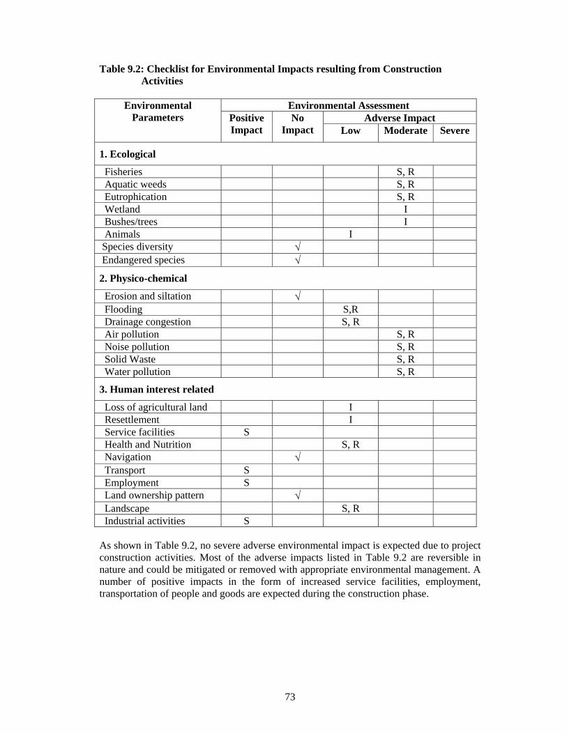
73
Table 9.2: Checklist for Environmental Impacts resulting from Construction Activities
Environmental Assessment Adverse Impact
Environmental Parameters Positive
Impact No
Impact Low Moderate Severe
1. Ecological
Fisheries S, R Aquatic weeds S, R Eutrophication S, R Wetland I Bushes/trees I Animals I Species diversity √ Endangered species √
2. Physico-chemical
Erosion and siltation √ Flooding S,R Drainage congestion S, R Air pollution S, R Noise pollution S, R Solid Waste S, R Water pollution S, R
3. Human interest related
Loss of agricultural land I Resettlement I Service facilities S Health and Nutrition S, R Navigation √ Transport S Employment S Land ownership pattern √ Landscape S, R Industrial activities S As shown in Table 9.2, no severe adverse environmental impact is expected due to project construction activities. Most of the adverse impacts listed in Table 9.2 are reversible in nature and could be mitigated or removed with appropriate environmental management. A number of positive impacts in the form of increased service facilities, employment, transportation of people and goods are expected during the construction phase.

74
Table 9.3: Checklist for Environmental Impacts resulting from Operational Phase of the Project
Environmental Assessment Adverse Impact
Environmental Parameters Positive
Impact No
Impact Low Moderate Severe
1. Ecological Fisheries L Aquatic weeds √ Eutrophication L Wetland √ Bushes/trees L Animals √ Species diversity √ Endangered species √ 2. Physico-chemical Erosion and siltation √ Flooding √ Drainage congestion √ Air pollution L Noise pollution L Solid Waste R Water pollution R 3. Human interest related Loss of agricultural land √ Resettlement √ Service facilities L Health and Nutrition L Navigation √ Transport L Employment L Land ownership pattern L Landscape L Industrial activities L As shown in Table 9.3, no severe adverse environmental impact is expected during the operation phase of the project. On the contrary a number of positive impacts in the form of service facilities and employment, commercial activities, transportation of people and goods, etc are expected. In addition, enhancement of fisheries resources would be possible through planned lake development, especially in Block-V. Plantation activities would make the Park area greener and would have a positive impact on the environment. Better physical and socio-economic environment is expected to improve the general health and nutrition of the people in and around the Park area. Overall, it can be concluded that no environmental component will be severely affected negatively as a result of the project activities. Socioeconomic environment can be considered to be affected positively as the project activities will create new job
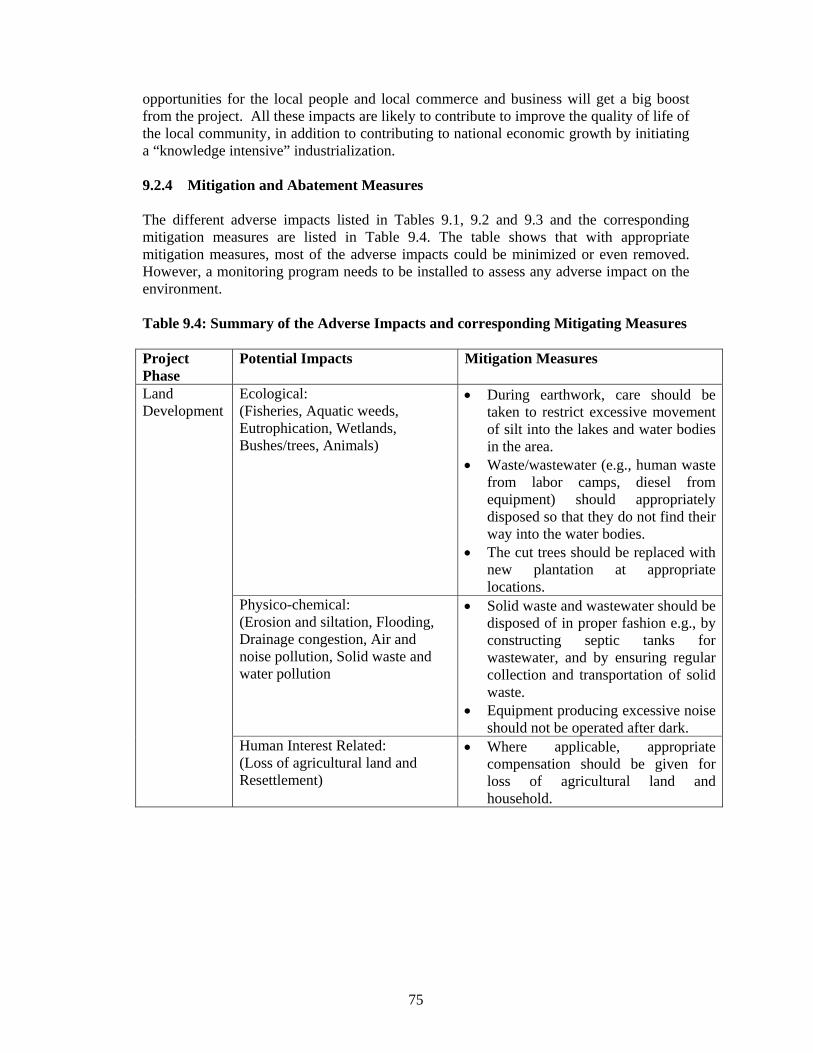
75
opportunities for the local people and local commerce and business will get a big boost from the project. All these impacts are likely to contribute to improve the quality of life of the local community, in addition to contributing to national economic growth by initiating a “knowledge intensive” industrialization. 9.2.4 Mitigation and Abatement Measures The different adverse impacts listed in Tables 9.1, 9.2 and 9.3 and the corresponding mitigation measures are listed in Table 9.4. The table shows that with appropriate mitigation measures, most of the adverse impacts could be minimized or even removed. However, a monitoring program needs to be installed to assess any adverse impact on the environment. Table 9.4: Summary of the Adverse Impacts and corresponding Mitigating Measures Project Phase
Potential Impacts Mitigation Measures
Ecological: (Fisheries, Aquatic weeds, Eutrophication, Wetlands, Bushes/trees, Animals)
• During earthwork, care should be taken to restrict excessive movement of silt into the lakes and water bodies in the area.
• Waste/wastewater (e.g., human waste from labor camps, diesel from equipment) should appropriately disposed so that they do not find their way into the water bodies.
• The cut trees should be replaced with new plantation at appropriate locations.
Physico-chemical: (Erosion and siltation, Flooding, Drainage congestion, Air and noise pollution, Solid waste and water pollution
• Solid waste and wastewater should be disposed of in proper fashion e.g., by constructing septic tanks for wastewater, and by ensuring regular collection and transportation of solid waste.
• Equipment producing excessive noise should not be operated after dark.
Land Development
Human Interest Related: (Loss of agricultural land and Resettlement)
• Where applicable, appropriate compensation should be given for loss of agricultural land and household.

76
Table 9.4 Summary of the Adverse Impacts and corresponding Mitigating Measures (Contd.)
Project Phase
Potential Impacts Mitigation Measures
Ecological: (Fisheries, Aquatic weeds, Eutrophication, Wetlands, Bushes/trees, Animal)
• The lakes, water bodies and lowlands must not be used for disposal of any waste or debris.
• Waste/wastewater (e.g., human waste from labor camps, diesel from equipment) should be appropriately disposed so that they do not flow into adjacent water bodies.
Physico-chemical: (Flooding, Drainage congestion, Air and noise pollution, Solid waste and water pollution
• Solid waste and wastewater should be properly disposed e.g., by constructing septic tanks for wastewater, and by ensuring regular collection and transportation of solid waste.
• Equipment producing excessive noise should not be operated after dark.
Construction Phase
Human Interest Related: (Loss of agricultural land, Resettlement, Health and Nutrition, Landscape)
• Where applicable, appropriate compensation should be given for loss of agricultural land and household.
• During construction work, adequate measures should be taken for ensuring safety of all personnel working in the project.
• The site must be equipped with basic facilities (e.g., first aid) for tackling healthcare emergencies, such as construction related accidents.
Operation Phase
Physico-chemical: (air and noise pollution, solid waste and water pollution
• Appropriate measures should be taken for disposal of solid waste and wastewater. Local authorities (such as Gazipur Municipal authority) should be contacted for proper disposal of solid waste. Septic tank-soak pit arrangement for wastewater disposal should be periodically checked to assess its performance.
9.2.5 Residual Impacts The Hi-Tech Park is expected to attract a wide range of technology-based industries that would primarily carry out their research and development (R&D) activities at these facilities. Although no manufacturing industries would be allow at the Hi-Tech Park

77
premises, R&D activities from a number of industries (e.g., pharmaceuticals, biotechnology, metal and metal products, plastics) may generate waste/wastewater requiring special processing (e.g., treatment) prior to their disposal. These or other industries may also cause air or noise pollution. If and when such industries are developed, appropriate measures must be taken to ensure that they take appropriate measures to manage their waste/wastewater/emissions, following the guidelines set in the Environment Conservation Rules 1997. 9.2.6 Monitoring Program Key parameters related to air, water, and land should be regularly monitored to detect any pollution of these environmental components. Distribution of aquatic flora and fauna should also be monitored, as they often indicate the first sign of pollution. Noise levels at appropriate locations should also be checked periodically. Since the Hi-Tech Park at full development would constitute a center of wide range of activities, it is expected to have a significant socio-economic impact on the surrounding community. While most of these impacts are expected to be positive, monitoring of the socioeconomic condition of the surrounding areas is required to detect any adverse impact and also to enhance the positive impacts. 9.2.7 Conclusion Development of Hi-Tech Park must be carried out in an environment-friendly manner. All suggestions made in the environmental assessment for minimizing or eliminating adverse environmental impact and enhancing positive impacts (during construction phase) should be strictly followed. A similar approach must also be taken during operation phase of the Park. Degraded, polluted and unhealthy environment discourages investment; while a clean and healthy environment at the Park would attract investment and promote economic growth. For example, a number of industries including manufacturing industries have the potential to pollute the environment and hence such units must not be allowed at the Hi-Tech Park. Strict land use control and other measures (discussed below) should be enforced to maintain a healthy environment at the Hi-Tech Park during its operational phase. 9.3 Solid Waste Management at Hi-Tech Park An efficient solid waste management system should be developed for the Hi-Tech Park, possibly in collaboration with the Gazipur Municipal Authority. Alternatively, private waste management option must be considered. The following suggestions /recommendations are made for the development of a modern and efficient solid waste management system. • Within the Hi-Tech Park, there would be no “open” waste container or bin. • In every facility within the complex, recycle/reuse of materials (e.g., paper) should be
made mandatory. • Effort should be made to encourage separation of organic and inorganic waste at the
source. • Daily collection and transportation (outside the Park premises) of solid waste must be
ensured.

78
• Hazardous waste, if any, should be appropriately labeled and stored separately at designated location until their collection/transportation for final disposal.
9.4 Environmental Guidelines For ensuring desired benefits out of the establishment of Hi-Tech Park, it must be developed and operated at all stages in an environment friendly manner. While encouraging investment by all potential sectors, it must be ensured that development takes place in a planned and sustainable manner. Keeping this in mind, the following environmental guidelines have been proposed for the Hi-Tech Park at Kaliakoir. (1) Establishment of only non-polluting industries (belonging to “green” category)
within the Park premises. (2) No manufacturing industries with high pollution potential, belonging to “orange” or
‘red” category (according to ECA, 1995) should be allowed in the Park premises. (3) IEE/EIA must be carried out for establishment of any industries within the Hi-Tech
Park area. (4) All industries must install appropriate waste management system (including
installation of waste treatment system, if required) (5) All industries, commerce, and business must install ISO14001: environmental
management system.
79
CHAPTER 10 COSTS AND BENEFITS OF THE PROJECT 10.1 Cost Estimate 10.1.1 Land Development and Infrastructure In the first phase, development activities would be concentrated in Block-I and Block-V. Block-I would provide facilities for Hi-Tech industries while the Hi-Tech University has been proposed to be established in Block-V. Considerable land development activities and provision of physical infrastructure facilities would be required in these blocks. In Block-I about 17000 sq.m. of area would be developed for construction of building and preparation of plots. An estimated 85 lakh Taka have been earmarked for land preparation for these purposes. Physical infrastructure facilities would include 60 ft. (18.3 m) and 30 ft. (9.15 m) wide roads, footpaths, drains, gas lines and water supply provisions. Construction of 714 metres of 60 ft. (18.3 m) wide road and 1692 metres of 30 ft. (9.15 m) wide road would involve expenditures amounting to 96 lakh and 114 lakh Taka respectively. An estimated 5 lakh Taka have been reserved for construction of central island in the 60 ft. (18.3 m) wide road. Construction cost of pipe drains, gas lines and water supply lines has been estimated at 383 lakh, 36 lakh and 76 lakh Taka respectively. One pump house and a deep tube-well would be required in this block which would require about 50 lakh Taka. Block-V which will house the Hi-Tech University will require considerable land development. About 5000 sq.m of area in this block would require land-filling involving an expenditure of 185 lakh Taka. Road construction in this block would require an estimated 123 lakh Taka while provision of utilities such as pipe drain, water supply line and gas line would require approximately 330 lakh Taka. Total expenditure for providing physical infrastructure facilities in this block has been estimated at 686 lakh Taka as against 969 lakh Taka in Block-1. Blocks-III, III and IV have been proposed to be developed in phase-2. A fly-over would be required for linking these blocks with Block-I as the rail line to Jamuna Bridge passes through this area. Construction of this bridge would require about 800 lakh Taka. Total expenditures for provision of physical infrastructures and land development in these blocks, that is, Blocks-II, III and IV have been estimated at 1435 lakh (including fly-over), 568 lakh and 410 lakh Taka respectively. 10.1.2 Construction of Ready-Built Spaces and Other Service Facilities The development of the Hi-Tech Park has been divided in two phases. The first phase includes the development of Block I and Block V within two years. The development includes construction of several high rise buildings to provide Administrative, Ready Built spaces, Incubator spaces and for providing recreational, utilities, housing and community services facilities. Two high rise tower blocks having total floor area of 71500 sq.m and 49500 sq.m. have been planned in Block-I. The tower building 1 would be constructed upto 48750 sq.m in Phase I at a cost of Tk. 10481 lakh and the rest 22750 sq.m in Phase II at a cost of Tk. 4891.3 lakh. The tower building 2 providing 49500 sq.m area has been proposed to be constructed totally in Phase II at an estimated cost of Tk. 10642.5 lakh.

80
The master plan includes construction of 4 six-storey housing blocks providing 80 flat accommodations for administrative and other professionals engaged in Hi-Tech industries of the park. However, only one housing block would be constructed in Phase I at an estimated cost of Tk. 1503 lakh. The remaining two housing blocks may be constructed in Phase II but would be completed only on demand. A community block providing 7730 sq.m total area would be constructed with 1930 sq.m and 5800 sqm at an estimated cost of Tk. 415 lakh and Tk. 1247 lakh respectively in Phase I and Phase II. Security building and an elegant Gateway would be constructed in Phase I at a cost of Tk. 23 lakh. Health club, swimming pool and gymnasium facilities have also been included in Master Plan but would be constructed in Phase II at a cost of Tk. 1080.4 lakh. Construction of a shopping complex has been included in the Master Plan but it is expected to be completed by private enterprise. The total construction cost of buildings in Block I would be Tk. 12422 lakh and Tk. 19364.2 lakh in Phase I and II respectively. 10.1.3 Development of Hi-Tech University A Hi-Tech University has been planned to be constructed in the Hi-Tech Park for providing educational and training facilities necessary for human resources development. The High-tech University complex includes Academic Building (15 story), Administrative Building (7 story), student Dormitory (10 story), Cafeteria (5 story), Research Facilities Building (6 story), Eco Research Building (5 story), and a Security Office. The development of university has been planned to be completed in two phases. As such, all the buildings would be constructed in two phases providing 27760 sqm and 96590 sqm built up area in phase I and II at an estimated cost of Tk. 5411 lakh and Tk. 19762.2 lakh respectively. 10.1.4 Development of Ancillary Facilities The master plan includes development of an international standard hotel in Block-II for accommodating visitors at a total cost of Tk. 2948.8 lakh. Construction of two-story cottage blocks for providing housing facilities for CEO's of different enterprises at an estimated cost of Tk. 360 lakh. One water tank with an observatory over it and a mosque has also been included in the Master plan. All these have been included in Block-II, adjacent to Block-I, and would be constructed in Phase II at a total estimated cost of Tk. 4468.8 lakh. The development of the Hi-Tech park would require construction of lined drainage channel and weir with sluice gates. The construction would be divided in two phases at an estimated cost of Tk. 30.0 lakh and Tk. 20.0 lakh in Phase-I and II respectively. For a reliable power source captive power generation will be provided. The national power grid will be the alternative source of power for the park. In order to ensure uninterrupted power supply gas-fired generating station would be installed. The installation of sub-station and generator in phase I and phase II would cost Tk. 1100.0 lakh and Tk. 1000.0 lakh respectively.

81
An ISDN Telephone exchange would be installed in the Hi-Tech Park at the cost of Tk. 50.0 lakh in phase I. Fiber-optic LAN for high speed data transfer is very basic essential element of the Hi-Tech Park . The total installation of LAN, Backbone & VSAT has been planned in two phases with involvement of Tk. 1333.0 lakh in Phase I and the 2483.5 lakh in Phase II. The estimated costs of the Phase I and Phase II of the Hi-Tech Park are presented in Tables 10.1 and 10.2. Table 10.1: Estimated Cost of Hi-Tech Park at Kaliakoir – Phase-I Sl. No.
Item Plinth Area (in m2)
Area/ Quantity/ Numbers (in m2)
Cost in Lac Taka
A. Building Construction BLOCK-I 1. Hi-Tech Tower Building-1:
Low-Rise Block:- 3 storey building part 7400 to 3 storey = 22200 4773.0 6 storey building part 5600 to 6 storey = 16800 3612.0 High-Rise Block:- 18 storey building part 650 to 9 storey = 1950 419.0 25 storey building part 1300 to 12 storey = 7800 1677.02. Community Block:
1 storey building part 370 1 storey = 370 79.6 1 storey building part 460 1 storey = 460 99.0 3 storey building part 2300 1 storey = 1100 236.43. Housing:
6 storey building-2 nos. 930 6 storey-1 no. = 5580 837.0 6 storey building-2 nos. 740 6 storey-1 no. = 4440 666.04. Health Club
2 storey building 1580 Nil 5. Swimming pool/Gymnasium
Area 1400 Nil 6. Security 100 100 9.07. Gateway Complete 14.08. Shopping:
4 storey Block 6300 High Rise Block 4400
Expected to be done by Private Enterprise
9. Hi-Tech Tower Building-2:
6 storey building 4500 Nil 16 storey building 2250 Nil Sub Total 12422.0
82
BLOCK-V (Hi-Tech University Block) 1. Academic Building: 15 storey building 5600 GF open+to 2 storey=11200 2408.02. Administrative Building: 7 storey building 1860 GF open+to 2 storey= 3720 799.83. Student Dormitory
10 storey building 1860 GF open+to 3 storey= 5580 837.04. Cafeteria 5 storey building 1300 To 2 storey= 2600 390.05. Research Facilities 6 storey building 1300 GF open+to 2 storey= 2600 559.06. Eco Research Building 5 storey building 930 To 2 storey= 1860 400.07. Security Office 2 storey building 200 To 1 storey= 200 17.2 Sub Total 5411.0 Total (A) 17833.0B. Physical Infrastructures BLOCK-I 1. Land Development 170000 m2 85.02. Road Construction: 18.3m wide road 714 m 96.0 9.15m wide road 1692 m 114.03. Footpath 4812 m 80.04. Central Island 714 m 5.05. Pipe Drain 2406 m 383.06. Gas Line 2406 m 36.07. Water Supply: Pump house & Deep tube-well 1 No. 50.0 Water Supply Line 2406 m 76.08. Cross Drain 50 m 4.09. Barbed Wire Fencing 6452 m 20.0 Sub Total 949.0 BLOCK-V (Hi-Tech University Block) 1. Land Development 5000 m2 185.02. Road Construction: 18.3m wide road 630 m 85.0 9.15m wide road 570 m 38.03. Footpath 2400 m 40.04. Central Island 630 m 4.05. Pipe Drain 1200 m 220.06. Gas Line 1200 m 17.07. Water Supply: Pump house & Deep tube-well 1 No. 50.0 Water Supply Line 1200 m 43.08. Cross Drain 50 m 4.0 Sub Total 686.0 Total (B) 1635.0

83
Estimated Cost of Hi-Tech Park at Kaliakoir – Phase-I
Sl. No.
Item Plinth Area (in m2)
Area/ Quantity/ Numbers (in m2)
Cost in Lac Taka
C. Major Drainage Structure 1. Lined major drainage channel 10.0
2. Weir with sluice gate and downstream protection at 2 locations
20.0
Total (C) 30.0
D. Installation of 3 Sub Station 11/.4KV, 10MVA 1. Transformer 1500 KVA 2 Nos.x3=6 Nos. 120.0
2. H.T. Switch gear 2 Nos.x3=6 Nos. 90.0
3. L.T. Switch gear 2 Nos.x3=6 Nos. 75.0
4. P.F.I. Plant 2 Nos.x3=6 Nos. 45.0
5. Cables, Feeder Pillars 600.0
6. Installation Cost 170.0
Total (D) 1100.0
E. 4MW Generator (GT) Installation 1. 2MW Generator 2 Nos. 800.0
2. Cables and Accessories 100.0
3. Generators Room (with all Facilities)
100.0
Total (E) 1000.0
F. Installation of Telephone Line 1. Installation of Telephone Line 50.00
Total (F) 50.0

84
Estimated Cost of Hi-Tech Park at Kaliakoir – Phase-I
Sl. No.
Item Unit Cost in Tk.
Quantity Cost in Lac Taka
G. LAN, Backbone, VSAT 1. UTP cable in meter 20.00 245000 49.0 Wall outlet in pcs 200.00 8750 17.5 Patch panel in pcs 12,000.00 350 42.0 Hub rack in pcs 20,000.00 210 42.0 Switch in pcs 65,000.00 210 136.5 Hub in pcs 25,000.00 630 157.5 RJ45 Connector in pcs 15.00 42000 6.3 Channel/conduit cost = 20% of UTP cable cost 9.8 Installation cost = 40% of equipment cost 184.2 (i) Sub Total (Lan Cost) 644.82. High end server with accessories 1,000,000.00 10 100.0 Gigabyte Switch 4,000,000.00 2 80.0 Peripheral Switch (1 switch/1400 sqm) 200,000.00 59 118.0 Fibre cable (4 core armoured) 200.00 88500 177.0 Fibre laying cost (40% of cable cost) 70.8 Fibre termination and connector cost 1,000.00 236 2.4 Server UPS (5KVA) 250,000.00 5 12.5 Software (Sun Solaries, Network Management
Software, Accounting software etc.) 50.0
(ii) Sub Total (Backbone Cost) 610.73. VSAT antenna, Satellite modem and other
accessories (2 Mbps uplink/8 Mbps down link) 3,050,000.00 2 60.5
Router 600,000.00 2 12.0 Installation charge 300,000.00 5.0
(iii) Sub Total (VSAT and associated equipment cost)
77.5
Total (G) 1333.0
Grand Total (A+B+C+D+E+F+G) 22981.0

85
Table 10.2 Estimated Cost of Hi-Tech Park at Kaliakoir – Phase-II Sl. No.
Item Plinth Area (in m2)
Area/ Quantity/ Numbers (in m2)
Cost in Lac Taka
A. Building Construction BLOCK-I 1. Hi-Tech Tower Building-1:
Low-Rise Block:- 3 storey building part 7400 Nil 6 storey building part 5600 Nil High-Rise Block:- 18 storey building part 650 to 18 storey = 5850 1257.8 25 storey building part 1300 to 25 storey = 16900 3633.52. Community Block:
1 storey building part 370 Nil 1 storey building part 460 Nil 3 storey building part 2300 to 3 storey = 5800 1247.03. Housing:
6 storey building-2 nos. 930 6 storey-1 no.= 5580 (to be completed on demand)
837.0
6 storey building-2 nos. 740 6 storey-1 no.= 4440 (to be completed on demand)
666.0
4. Health Club
2 storey building 1580 3160 679.45. Swimming pool/Gymnasium
Area 1400 1400 401.06. Shopping:
4 storey Block 6300 High Rise Block 4400
7. Hi-Tech Tower Building-2:
6 storey building 4500 To 6 storey = 27000 5805.0 16 storey building 2250 To 16 storey = 22500 4837.5

86
Estimated Cost of Kaliakoir Hi-Tech Park– Phase-II
Sl. No.
Item Plinth Area (in m2)
Area/ Quantity/ Numbers (in m2)
Cost in Lac Taka
BLOCK-II 1. Hotel
3 storey building 2250 To 3 storey= 6750 1451.3 8 storey building 1100 To 8 storey= 5500 1182.5 Swimming pool 1000 Swimming pool= 1000 315.02. Cottage Block
1 storey building- 3 nos. 800 3 nos. x 800= 2400 360.03. Water Tank + Observatory 1 No. 150.0
4. Mosque 150.0
2 storey building 2300 To 2 storey= 4000 860.0BLOCK-V (Hi-Tech University Block) 1. Academic Building:
15 storey building 5600 to 15 storey= 67200 14448.02. Administrative Building:
7 storey building 1860 to 7 storey= 7440 1599.63. Student Dormitory
10 storey building 1860 to 10 storey= 11160 1674.04. Cafeteria
5 storey building 1300 To 5 storey= 3900 585.05. Research Facilities
6 storey building 1300 to 6 storey= 3900 838.56. Eco Research Building
5 storey building 930 To 5 storey= 2790 599.97. Security Office
2 storey building 200 To 2 storey= 200 17.2 Total (A) 43595.2
87
Estimated Cost of Kaliakoir Hi-Tech Park– Phase-II
Sl. No.
Item Plinth Area (in m2)
Area/ Quantity/ Numbers (in m2)
Cost in Lac Taka
B. Physical Infrastructures BLOCK-II
1. Land Development 180000 m2 90.02. Road Construction:
18.3m wide road 360 m 48.0 9.15m wide road 1401 m 94.03. Footpath 3522 m 57.04. Central Island 360 m 3.05. Pipe Drain 1761 m 277.06. Gas Line 1761 m 15.07. Water Supply Line 1361 m 48.08. Cross Drain 35 m 3.09. Bridge 122 m 800.0
BLOCK-III 1. Land Development 30000 m2 116.02. Road Construction:
18.3m wide road 465 m 63.0 9.15m wide road 861 m 58.03. Footpath 2652 m 43.04. Central Island 465 m 4.05. Pipe Drain 1326 m 228.06. Gas Line 1326 m 12.07. Water Supply Line 1326 m 42.08. Cross Drain 26 m 2.0
BLOCK-IV 1. Land Development 36000 m2 50.02. Road Construction:
18.3m wide road 431 m 60.0 9.15m wide road 445 m 30.03. Footpath 1752 m 29.04. Central Island 431 m 3.0

88
Estimated Cost of Kaliakoir Hi-Tech Park– Phase-II
Sl. No.
Item Plinth Area (in m2)
Area/ Quantity/ Numbers (in m2)
Cost in Lac Taka
5. Pipe Drain 876 m 200.06. Gas Line 876 m 8.07. Water Supply Line 876 m 28.08. Cross Drain 20 m 2.0 Total (B) 2413.0 C. Major Drainage Structure Sl. No.
Item Plinth Area (in m2)
Area/ Quantity/ Numbers (in m2)
Cost in Lac Taka
4. Lined major drainage channel 5.0
5. Weir with sluice gate and downstream protection at 2 locations
15.0
Total (C) 20.0
89
Estimated Cost of Kaliakoir Hi-Tech Park– Phase-II
Sl. No.
Item Unit Cost in Tk.
Quantity Cost in Lac Taka
D. LAN, BACKBONE, VSAT
1. UTP cable in meter 20.00 563500 112.7 Wall outlet in pcs 200.00 20125 40.3 Patch panel in pcs 12,000.00 805 96.6 Hub rack in pcs 20,000.00 483 96.6 Switch in pcs 65,000.00 483 314.0 Hub in pcs 25,000.00 1449 362.3 RJ45 Connector in pcs 15.00 96600 14.5 Channel/conduit cost = 20% of UTP cable cost 22.5 Installation cost = 40% of equipment cost 423.8 (i) Sub Total (Lan Cost) 1483.32. Gigabyte Switch 4,000,000.00 3 120.0 Peripheral Switch (1 switch/1400 sqm) 200,000.00 135 270.0 Fibre cable (4 core armoured) 200.00 216000 432.0 Fibre laying cost (40% of cable cost) 172.8 Fibre termination and connector cost 1,000.00 540 5.4 (ii) Sub Total (Backbone Cost) 1000.2
(iii) Sub Total (VSAT and associated equipment cost)
Total (D) 2483.5
Grand Total (A+B+C+D) 48511.7
E. R&D Facilities
BLOCK-IV 1. Ready to occupy laboratories To be completed on demand
2. Specialised projects To be completed on demand
10.2 Project Benefits The Hi-Tech Park Project is expected to generate significant benefit for the nation as a whole. IT sector is likely to dominate the park. Net return in this sector is very high compared to other sectors. Net return may be as high as 50% of total value of output. In Bangalore, India, where nearly 80000 IT professionals are working, the annual value of output during 2000-2001 was about 7400 crore Indian Rupees. Thus, per IT professional the value of output was about 77000 Rupees per month. Remuneration per IT professional is also high such as 30% of the value of output per professional. In the export processing zones of Bangladesh, wages and salaries constitute only about 10% of the total value of

90
export indicating that Hi-Tech industries may have much larger impacts on the national economy than other types of export-oriented industries. 10.2.1 Direct and Indirect Impacts The total economic impacts that the Hi-Tech Park is expected to generate may be quite large compared to the direct impacts. Thus indirect impacts may be of considerable significance. The direct impacts of the park’s first phase of development would include the creation of about 4000 new Hi-Tech jobs, net profit from export accruing to the local investors and income from leasing out ready-built spaces and ready-to-occupy plots. Such direct impacts would have multiplier effects in terms of the creation of additional income and employment. For example, the creation of new Hi-Tech jobs in the park would enhance consumer spending leading to the expansion in the tertiary sector with new retail establishments and functions. In addition, demand for housing and different types of social services such as education, health, recreation etc. would also increase which would provide further impetus to the creation of new jobs. The Government would also be a gainer through this process as the tax base would improve and significant amounts of direct and indirect taxes enrich the government exchequer. For carrying out an economic analysis of the proposed hi-tech park at Kaliakoir, three scenarios have been considered based on growth projections. These are as follows: 10.2.2 Slow Growth Projection In this case it is assumed that the ready-built spaces that would be created during phase-1 would require five years to be fully occupied. The assumption is that in the first year about 13% of the created space (Ready-built and incubators) would be occupied while during 2nd, 3rd and 4th year about 22%, 36% and 60% respectively of the created space would be occupied. Total benefit (or return) from the project has been based on these assumptions. Benefit is expected to accrue from salary income, net return from export and rent from ready-built spaces. Salary income is assumed to be Taka 20000 per month per professional while net return from export is considered to be 50% of the total value of export. Rent per square metre of ready-built space has been considered as Taka 300 per month. It is further assumed that all the outputs would be exported and domestic investment would constitute about 20% of the total investment. If the domestic investment increases, total benefit to the economy would also increase. Total benefit from the project under this scenario is given below:
Table 10.3 Expected Project Benefits under Slow Growth Projection
Benefit in Lakh Taka Year of Benefit
Salary Income Net Return from Export
Rent from Ready-built
Spaces
Total
1st Year 1044.40 360.10 180.00 1584.50 2nd Year 1745.20 601.80 300.90 2647.90 3rd Year 2916.30 1005.60 502.80 4424.70 4th Year 4873.20 1680.40 840.20 7393.80 5th Year 9360.00 3276.00 1404.00 14859.00 Total 19939.10 6923.90 3227.90
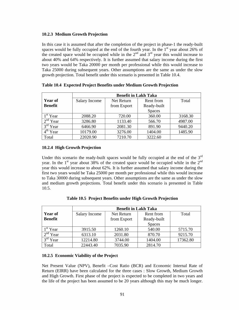
91
10.2.3 Medium Growth Projection In this case it is assumed that after the completion of the project in phase-1 the ready-built spaces would be fully occupied at the end of the fourth year. In the 1st year about 26% of the created space would be occupied while in the 2nd and 3rd year this would increase to about 40% and 64% respectively. It is further assumed that salary income during the first two years would be Taka 20000 per month per professional while this would increase to Taka 25000 during subsequent years. Other assumptions are the same as under the slow growth projection. Total benefit under this scenario is presented in Table 10.4. Table 10.4 Expected Project Benefits under Medium Growth Projection
Benefit in Lakh Taka Year of Benefit
Salary Income Net Return from Export
Rent from Ready-built
Spaces
Total
1st Year 2088.20 720.00 360.00 3168.30 2nd Year 3286.80 1133.40 566.70 4987.00 3rd Year 6466.90 2081.30 891.90 9440.20 4th Year 10179.00 3276.00 1404.00 1485.90 Total 22020.90 7210.70 3222.60
10.2.4 High Growth Projection Under this scenario the ready-built spaces would be fully occupied at the end of the 3rd year. In the 1st year about 38% of the created space would be occupied while in the 2nd year this would increase to about 62%. It is further assumed that salary income during the first two years would be Taka 25000 per month per professional while this would increase to Taka 30000 during subsequent years. Other assumptions are the same as under the slow and medium growth projections. Total benefit under this scenario is presented in Table 10.5.
Table 10.5 Project Benefits under High Growth Projection
Benefit in Lakh Taka Year of Benefit
Salary Income Net Return from Export
Rent from Ready-built
Spaces
Total
1st Year 3915.50 1260.10 540.00 5715.70 2nd Year 6313.10 2031.80 870.70 9215.70 3rd Year 12214.80 3744.00 1404.00 17362.80 Total 22443.40 7035.90 2814.70
10.2.5 Economic Viability of the Project Net Present Value (NPV), Benefit –Cost Ratio (BCR) and Economic Internal Rate of Return (EIRR) have been calculated for the three cases : Slow Growth, Medium Growth and High Growth. First phase of the project is expected to be completed in two years and the life of the project has been assumed to be 20 years although this may be much longer.

92
For calculating NPV, 15% discount rate has been considered. NPV has been found to be positive for all the alternatives including the slow-growth projection. Similarly BCR is also greater than one for all the alternatives including the slow-growth projection. EIRR has been found to be 23%, 29% and 38% for slow, medium and high growth projections respectively, as presented in Table 10.4, indicating that the project would be economically viable even if the growth rate is low. High growth rate obviously would generate greatest benefit for the national economy. Cash flow under economic analysis for various alternative projections are presented in Table 10.7. Table 10.6 Single Value Measures of Economic Viability of the Project
Alternative Projections
Discounted Cost
(in Lakh Taka)
Discounted Benefit
(in Lakh Taka)
Net Present Value
(in Lakh Taka)
Benefit-Cost Ratio
EIRR (%)
Slow Growth
28938.30
44093.90 15155.50 1.52 23
Medium Growth
28938.30 54301.70 25363.40 1.87 29
High Growth
28938.30 69861.10 40922.70 2.41 38
Table 10.7 Cash Flow Table Under Economic Analysis
Total Economic Return
(LakhTaka) Net Economic Return
(Lakh Taka) Year Total Economic
Cost (Lakh Taka) Slow Growth
Projection Medium Growth
Projection
High Growth Projection
Slow Growth Projection
Medium Growth
Projection
High Growth Projection
1 11250.00 -11250.00 -11250.00 -11250.002 11250.00 -11250.00 -11250.00 -11250.003 2500.00 1584.69 3168.37 5715.79 -915.31 668.37 3215.794 2500.00 2648.01 4987.01 9215.80 148.01 2487.01 6715.805 2500.00 4424.83 9440.28 17362.80 1924.83 6940.28 14862.806 2500.00 7393.90 14859.00 17362.80 4893.90 12359.00 14862.807 2500.00 14859.00 14859.00 17362.80 12359.00 12359.00 14862.808 2500.00 14859.00 14859.00 17362.80 12359.00 12359.00 14862.809 2500.00 14859.00 14859.00 17362.80 12359.00 12359.00 14862.80
10 2500.00 14859.00 14859.00 17362.80 12359.00 12359.00 14862.8011 2500.00 14859.00 14859.00 17362.80 12359.00 12359.00 14862.8012 2500.00 14859.00 14859.00 17362.80 12359.00 12359.00 14862.8013 2500.00 14859.00 14859.00 17362.80 12359.00 12359.00 14862.8014 2500.00 14859.00 14859.00 17362.80 12359.00 12359.00 14862.8015 2500.00 14859.00 14859.00 17362.80 12359.00 12359.00 14862.8016 2500.00 14859.00 14859.00 17362.80 12359.00 12359.00 14862.8017 2500.00 14859.00 14859.00 17362.80 12359.00 12359.00 14862.8018 2500.00 14859.00 14859.00 17362.80 12359.00 12359.00 14862.8019 2500.00 14859.00 14859.00 17362.80 12359.00 12359.00 14862.8020 2500.00 14859.00 14859.00 17362.80 12359.00 12359.00 14862.8021 2500.00 14859.00 14859.00 17362.80 12359.00 12359.00 14862.8022 2500.00 14859.00 14859.00 17362.80 12359.00 12359.00 14862.80

93
CHAPTER 11 IMPLEMENTATION AND MANAGEMENT OPTIONS 11.1 Introduction Assessment of the various options for the management of Kaliakoir Hi-Tech Park would be based on the experiences of different parks in India, Malaysia and Singapore, as well as information on Hi-Tech Parks in other countries of the world and analysis of future global trends in growth of knowledge based industries. It is extremely important that local socio-economic and environmental conditions are given due considerations while assessing various development approaches. While it is important for an economy like Bangladesh to respond to the present global needs, it is equally important that Bangladesh gives careful considerations to various management options of a Hi-Tech Park so that the investments of its scarce resources result in significant improvements in the economy, thereby improving the well-being of its people. These aspects have been taken into consideration while analysing various development approaches. 11.2 Modalities The Ministry of Science and Information & Communication Technology may establish a Project Implementation Unit (PIU) headed by a Project Director. Other supporting staff may include engineers, accountants, technicians, secretarial staff and so on. Details of the man-power requirements of this unit presented in the Project Concept Paper (PCP) attached herewith. The phase I of the project may be implemented by appointing reputed National/International Consultant and Constructor. A Panel of local advisors may also be formed with members from universities and professional institutions so that a high level of construction standards may be maintained. The Ministry may also take into consideration the procedures as followed by BEPZA in developing its export processing zones. 11.3 Phasing of Implementation The total development of the Hi-Tech Park has been proposed to be implemented in two phases. Development of Block-I and Block-V should be started and completed in Phase-1. Block-I will have the ready-built spaces and ready-to-occupy plots for Hi-Tech industries. Besides, administrative offices, recreational facilities, utilities, housing provisions and different types of community facilities such as banks, post offices, schools, day-care centres etc. The common facilities to the park need to be developed in phase-1. The first companies ready to start their activities in the park will be given factory and office spaces in this Block. Since the park would require a constant supply of highly skilled knowledge workers, proposed Hi-tech institutions producing knowledge workers should be started right from the beginning. Block-V is therefore proposed to be developed in Phase-1. Blocks-II, III and IV are proposed to be developed in Phase-2. Companies starting in Block-I and attaining some maturity after some time may be faced with different space requirements at a later stage. These companies will be accommodated in Block-II. Block-III will accommodate the needed expansion of Block-II after it reaches its full development. Block-IV will accommodate mainly the bio-medical and bio-technology related research and development activities. This block is proposed to be developed in Phase-2 because of the specific requirements of the activities to be carried out in this block.
94
Once all the blocks of Phase-1 and Phase-2 reach their full development stage further expansion may be needed. Such expansions may be accommodated in the area not yet planned for development. It is worth-mentioning that the Consultants were informed during the first meeting at Kaliakoir that the remaining land (around 140 acres) may be allotted for KHTP, if necessary. 11.4 Human Resource Development The importance of intellectual capital for economic development is now widely recognised. The growth of software and Hi-Tech industries across the world has generated a huge demand for highly skilled IT manpower. So is the demand for skilled manpower for other high technology industries. Investments in the development of highly skilled professionals in the following areas are most likely to be profitable and at the same time complementary to the objectives of the Hi-Tech Park:
− IT Sector (including IT-enabled Services) − Electro-Mechanical − Pharmaceuticals − Biotechnology
In the land use plan Block-V has been reserved for setting up Hi-Tech Education and Training Institutions in the above mentioned fields. 11.4.1 Hi-Tech University In most Hi-Tech Parks in the developing countries there are academic institutions preparing graduates suitable for the Hi-Tech industries both within and outside the park. Multimedia University in the Multimedia Super Corridor in Malaysia, IITT in ITPL, Bangalore and Cybercity in Hyderabad are few examples of complimentary academic institution in Hi-Tech Parks. In the proposed Hi-Tech Park in Kaliakoir similar institution is envisaged. It was observed in Chapter 7 that Bangladesh does not have adequate knowledge-rich manpower specially for ICT related industries. Considering the importance of manpower in Hi-Tech industries it is almost indispensable to have an institution in the park that can develop appropriate manpower on short-term and long-term basis. 11.4.2 Tentative Programmes for the Hi-Tech University The proposed Hi-Tech University should have programmes that can meet the demand of Hi-Tech manpower. It is, therefore, thought that the University should be started with the following programmes in the first phase. i. Computer Science (150) ii. Computer Engineering (150) iii. Communications Engineering (50) iv. Biotechnology (50) v. Mechatronics (50) vi. Environmental Science & Technology (50) vii. Business Management (100)

95
The figures in the bracket shows the probable intakes in the programme. Since the programmes are very much technical and practice oriented, the teacher-student ratio should be high. Experience suggests that there should be at least one teacher for each fifteen students. 11.4.3 Required Laboratory Facilities One of the main emphasis of the proposed university would be to develop manpower with practical skill so that they can contribute to the industries in a very short period. The programmes should be designed accordingly so that the students get ample exposures to practical problems. State-of-the-art laboratories are, therefore, essential for such practice-oriented programmes. A list of probable laboratories required for different programmes are presented below: 1. Computer science, Computer Engineering and Communications Engineering
Programmes i. Electronics Lab. ii. Network Lab. iii. Digital Techniques Lab. iv. VLSI Design Lab. v. Microprocessor and Interfacing Lab. vi. Multimedia Lab. vii. General Computing Lab for Students viii. Faculty Computing Lab. ix. Software Engineering Lab. x. Communications Engineering Lab. 2. Mechantronics Programme i. CAD/CAM Lab. ii. Robotics Lab. iii. Material Science Lab. iv. Solid Mechanics Lab. v. Waves and Optics Lab. vi. Thermofluid Lab. vii. Instrumentation and Measurement Lab. viii. Control Engineering Lab. ix. Simulation Lab. x. Reverse Engineering Lab. 3. Environmental Science and Technology Programme i. Bio-chemical Analysis Lab. ii. Model Lab. iii. Environmental Management Information Lab. 4. Business Management Programme i. Communication Studio ii. Language Lab. iii. Simulation Lab.

96
5. Biotechnology Programme i. Microbiology and Fermentation Lab. ii. Genetic Engineering Lab. iii. Protein Engineering Lab. iv. Biochemistry Lab. v. Plant Tissue Culture Lab. vi. Animal Tissue Culture Lab. 11.4.4 University Development Options The government may decide to develop the proposed university by itself. Alternatively, the development of the university may be offered to the private investors. Since the investment would be high to develop buildings and laboratories, the government may relax some of the requirement for existing private university rules for the private sector to invest in the Hi-Tech University. 11.5 Operation and Maintenance It is recommended that the Project Implementation Unit should be working for at least one year after the completion of phase-I development in connection with the operation and maintenance of the project. Man-power requirements along with the budget for this unit has already been spelled out in the PCP. Meanwhile the Ministry should firm up its decision regarding the management of the park so that the new Management Authority can take over the charge of the park within one year. 11.6 Management Options Actual ownership of the park would determine the organizational structure and management of the park. Ownership may be either single ownership or joint ownership. For instance, the park may be totally owned by the Government of Bangladesh in which case it may form a Hi-Tech Park Authority similar to BEPZA. The composition of the Authority would be by government nominations and would be dependent on the nature of activities. There may also be joint ownership in which case there may be - partnership between government and local private or limited companies (example is
ICICI Knowledge Park, Hyderabad, India)
- partnership between government, local private and international companies (example is ITPL, Bangalore, India)
In case of joint ownership there may be a Management Board with members representing the partners.

97
11.7 Leasing Options Various options that would be considered for leasing may include: Build to Suit Facilities These include customized buildings for laboratory and office facilities which may be leased out. Such faculties would be provided on demand in different Blocks. Ready-Built Facilities Ready-built facility, standard and flatted factories for quick, low-cost and hassle-free start-up, to suit production-cum office operations would be available mainly in Block-I which proposes a mixed development. Ready-to-Occupy Plots Land plots of varying sizes may be offered to set up research centres, pilot plants, assembly plants or corporate buildings. These plots would be available in the Blocks-II and III. Incubators Provisions would also be there especially in Block-I, for fully-fitted incubator units for technology start-ups. 11.8 Benefit Scheme The following benefit schemes could be assessed in consultation with the concerned ministries:
– Duty free import and export (computer hardware and software are already exempted from customs duty and taxes; all equipment to be used in KHTP may be exempted from paying duty and taxes)
– Maximum foreign equity (100%) – Exemption from income tax for 10 years – Single window government clearance – Marketing Intelligence – Unrestricted appointments of foreign professionals − Provision for local marketing of services and goods
It is important to note that the benefit scheme as provided by BEPZA for export processing zones in Bangladesh is quite comprehensive and appropriate for inviting foreign investments. Examples of such benefit scheme have already been discussed in Section 2.6. It is suggested that similar benefit scheme should be seriously considered for the proposed Hi-Tech Park. 11.9 Marketing Hi-Tech Park Marketing the Hi-Tech Park is essentially marketing the spaces and amneties to potential customers. Quality and characteristics of the spaces for sale have already been specified elsewhere in the report.

98
The potential customers for the spaces are organizations or entrepreneurs dealing with hi-tech business or development operations. They could be either from home or from foreign countries. Following is a list of customer categories: i. Local entrepreneurs ii. NRB entrepreneurs iii. local small & medium size enterprises iv. local large industrial groups v. MNCs operating in Bangladesh vi. foreign companies Development of hi-tech park depends a lot on the marketing effort of the park authority. So, physical development must be tied up with the marketing to tap the users demand. At this stage of the project some works of the marketing may be taken up as a ground work for the marketing division of the Hi-Tech park authority. These are listed below: i. Carry out an opinion survey on the local and multi-national companies for their
requirements in terms of physical facilities, manpower requirement, and other requirements.
ii. Prepare sample business plans/feasibility study for different business areas. For example business plan/feasibility study for a typical software firm to be located at the park, or business plan/feasibility study for a biotech firm etc.
iii. explore potential organizations for manpower supply in the short term. Finally, since marketing of the park may start even before the product is ready, it is essential that a proper park authority is establishment/assigned first. 11.10 Immediate Action Plan 1. It is very important to decide who will own and run the park. If private partnership is
considered then the government should look for prospective local as well as foreign partners.
2. Once the ownership issue is settled, the government should form the park authority
accordingly. 3. Depending on the private partnership and their stake, the government should arrange
necessary funding for the park. 4. Once the park authority is formed various marketing studies may be taken up to
complement the physical development activities. 5. Operation of Hi-Tech University should be started immediately to develop
knowledge workers essential for the park. It may be mentioned that a gestation period is required to develop human resource. The university may start functioning at a temporary location.