project for the soil classification and land use … for the soil classification and land use...
TRANSCRIPT
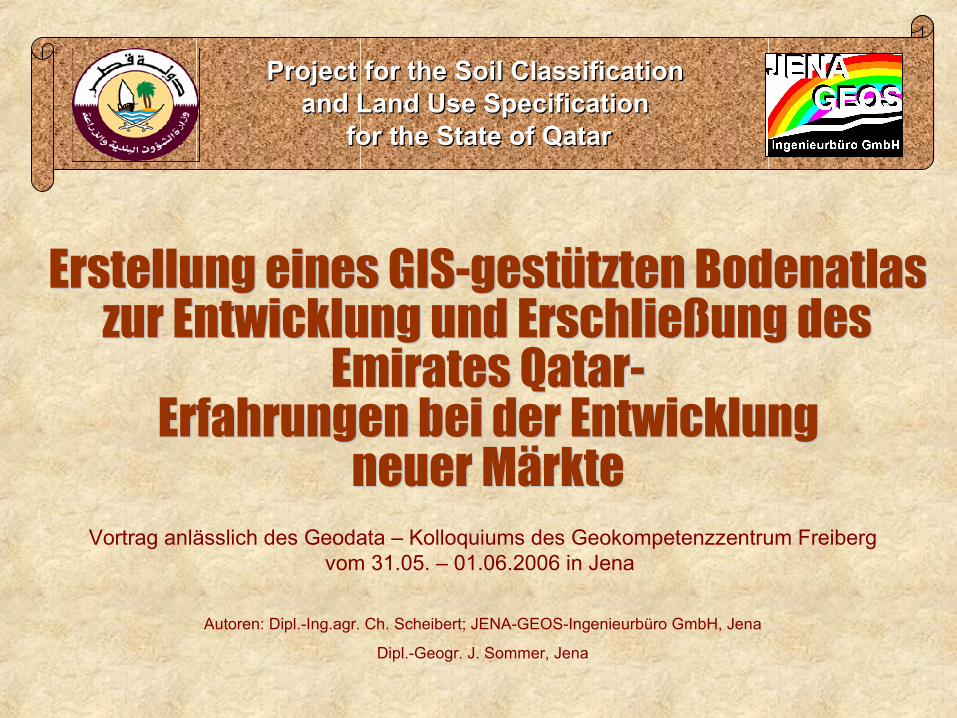
Project for the Soil Classification Project for the Soil Classification and Land Use Specification and Land Use Specification
for the State of Qatarfor the State of Qatar
Vortrag anlässlich des Geodata – Kolloquiums des Geokompetenzzentrum Freiberg vom 31.05. – 01.06.2006 in Jena
Autoren: Dipl.-Ing.agr. Ch. Scheibert; JENA-GEOS-Ingenieurbüro GmbH, Jena
Dipl.-Geogr. J. Sommer, Jena
2
TitelProject for the Soil Classification Project for the Soil Classification
and Land Use Specification and Land Use Specification for the State of Qatarfor the State of Qatar
1. Einführung2. Landeskundliche Angaben
3. Projektinhalte
4. Geodaten
5. Besondere Erfahrungen bei der Erschließung des Marktes
Vortragsgliederung:
3
4
TitelProject for the Soil Classification Project for the Soil Classification
and Land Use Specification and Land Use Specification for the State of Qatarfor the State of Qatar
1. Einführung
2. Landeskundliche Angaben3. Projektinhalte
4. Geodaten
5. Besondere Erfahrungen bei der Erschließung des Marktes
Vortragsgliederung:
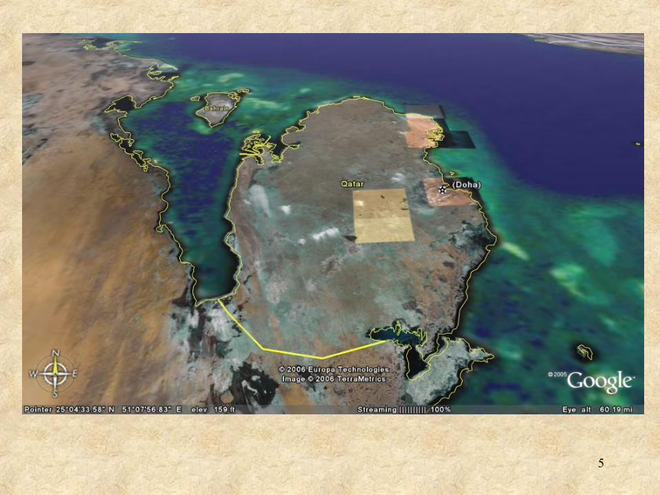
5

6
TitelProject for the Soil Classification Project for the Soil Classification
and Land Use Specification and Land Use Specification for the State of Qatarfor the State of Qatar
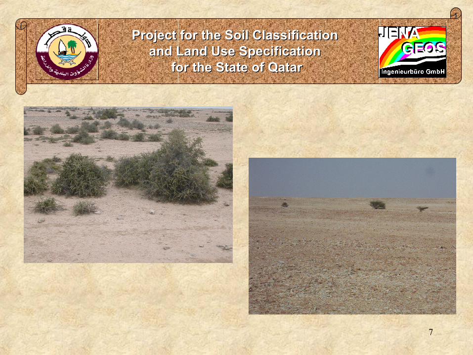
7
TitelProject for the Soil Classification Project for the Soil Classification
and Land Use Specification and Land Use Specification for the State of Qatarfor the State of Qatar

8
TitelProject for the Soil Classification Project for the Soil Classification
and Land Use Specification and Land Use Specification for the State of Qatarfor the State of Qatar
1. Einführung
2. Landeskundliche Angaben
3. Projektinhalte4. Geodaten
5. Besondere Erfahrungen bei der Erschließung des Marktes
Vortragsgliederung:
9
TitelProject for the Soil Classification Project for the Soil Classification
and Land Use Specification and Land Use Specification for the State of Qatarfor the State of Qatar
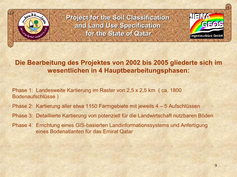
Die Bearbeitung des Projektes von 2002 bis 2005 gliederte sich im wesentlichen in 4 Hauptbearbeitungsphasen:
Phase 1: Landesweite Kartierung im Raster von 2,5 x 2,5 km ( ca. 1800 Bodenaufschlüsse )
Phase 2: Kartierung aller etwa 1150 Farmgebiete mit jeweils 4 – 5 Aufschlüssen
Phase 3: Detaillierte Kartierung von potenziell für die Landwirtschaft nutzbaren Böden
Phase 4: Errichtung eines GIS-basierten Landinformationssystems und Anfertigung eines Bodenatlanten für das Emirat Qatar

10
TitelProject for the Soil Classification Project for the Soil Classification
and Land Use Specification and Land Use Specification for the State of Qatarfor the State of Qatar
Hauptinhalte des Projektes: Datensammlung durch Recherche und Feldbegehungen
Auswertung von Satellitenbilddaten
Bodenkarten entsprechend der USDA Soil Taxonomy verschiedener Maßstabsebenen
Landnutzungskarten verschiedener Maßstabsebenen
Karten der Landdegradation verschiedener Maßstabsebenen
Karten der Landnutzbarkeit gemäß FAO Guidelines for Land Evaluation
Aufbau einer Geodatenbank
Training und Ausbildung lokaler Fachkräfte
laufende Erstellung von Berichten (vierteljährlich, jährlich, Phasenabschluss, Endbericht)
Seminare und Präsentationen
Zusammenstellung aller Ergebnisse im Atlas der Böden des Staates Qatar

Project for the Soil Classification Project for the Soil Classification and Land Use Specification and Land Use Specification
for the State of Qatarfor the State of Qatar
1. Einführung
2. Landeskundliche Angaben
3. Projektinhalte
4. Geodaten5. Besondere Erfahrungen bei der Erschließung des Marktes
Vortragsgliederung:
12
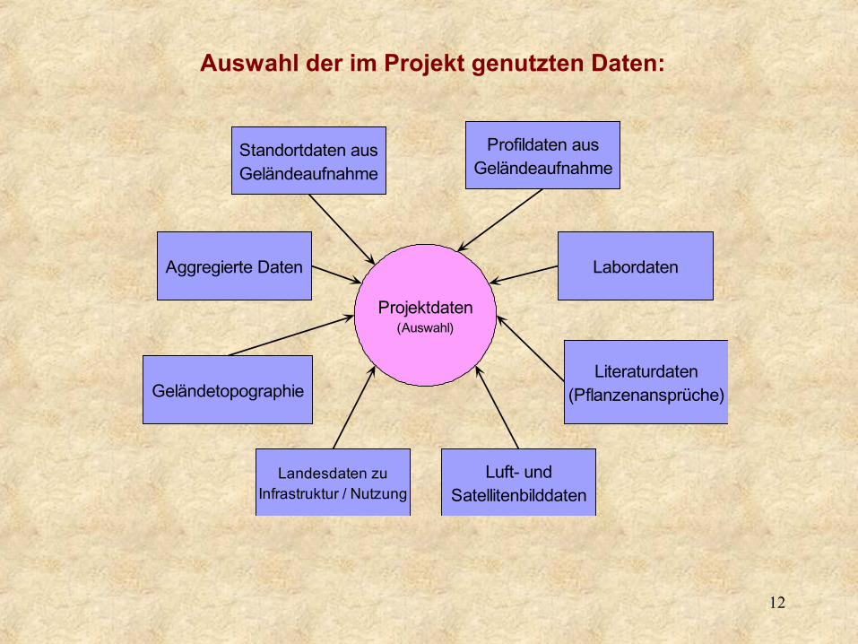
Projektdaten(Auswahl)
Standortdaten ausGeländeaufnahme
Profildaten ausGeländeaufnahme
Labordaten
Literaturdaten(Pflanzenansprüche)
Luft- undSatellitenbilddaten
Landesdaten zuInfrastruktur / Nutzung
Geländetopographie
Aggregierte Daten
Auswahl der im Projekt genutzten Daten:
13
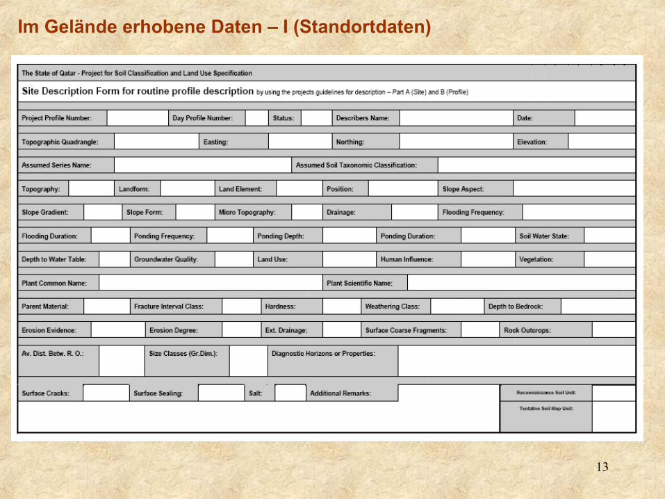
Im Gelände erhobene Daten – I (Standortdaten)

14
Im Gelände erhobene Daten – II (Profildaten)
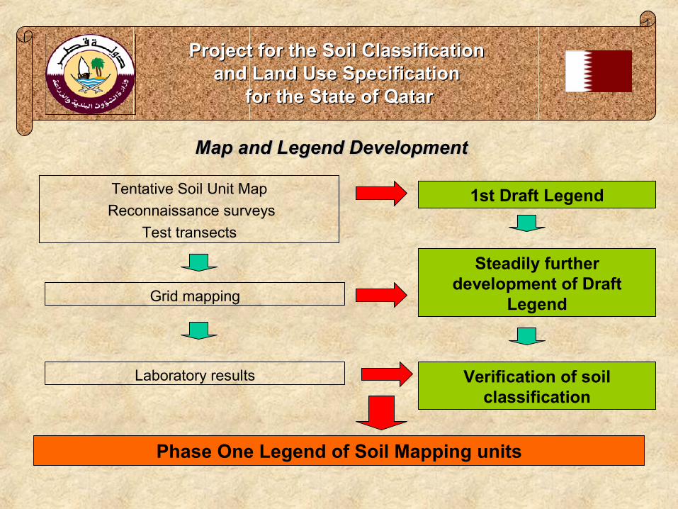
Map and Legend DevelopmentMap and Legend Development
Project for the Soil Classification Project for the Soil Classification and Land Use Specification and Land Use Specification
for the State of Qatarfor the State of Qatar
Tentative Soil Unit Map Reconnaissance surveys
Test transects
1st Draft Legend
Grid mapping
Steadily further development of Draft
Legend
Laboratory results Verification of soil classification
Phase One Legend of Soil Mapping units

16
2. Map and Legend DevelopmentMap and Legend DevelopmentMap and Legend Development
Project for the Soil Classification Project for the Soil Classification and Land Use Specification and Land Use Specification
for the State of Qatarfor the State of Qatar
Reconnaissance Soil Map on a scale of 1:100,000Tentative Soil Unit MapTopographic Maps on a scale of 1 : 50,000Reconnaissance soil surveyTest – TransectsTransects2.5 km Grid mappingLANDSAT scenesGeological Reconnaissance Map
Draft Soil Unit Map
Laboratory analysis
Phase One Soil Unit Map

Project for the Soil Classification Project for the Soil Classification and Land Use Specification and Land Use Specification
for the State of Qatarfor the State of Qatar
Dr. Schramm (JENA-GEOS) explaining petrographic features in the scope of Geological Reconnaissance Survey, May 2003
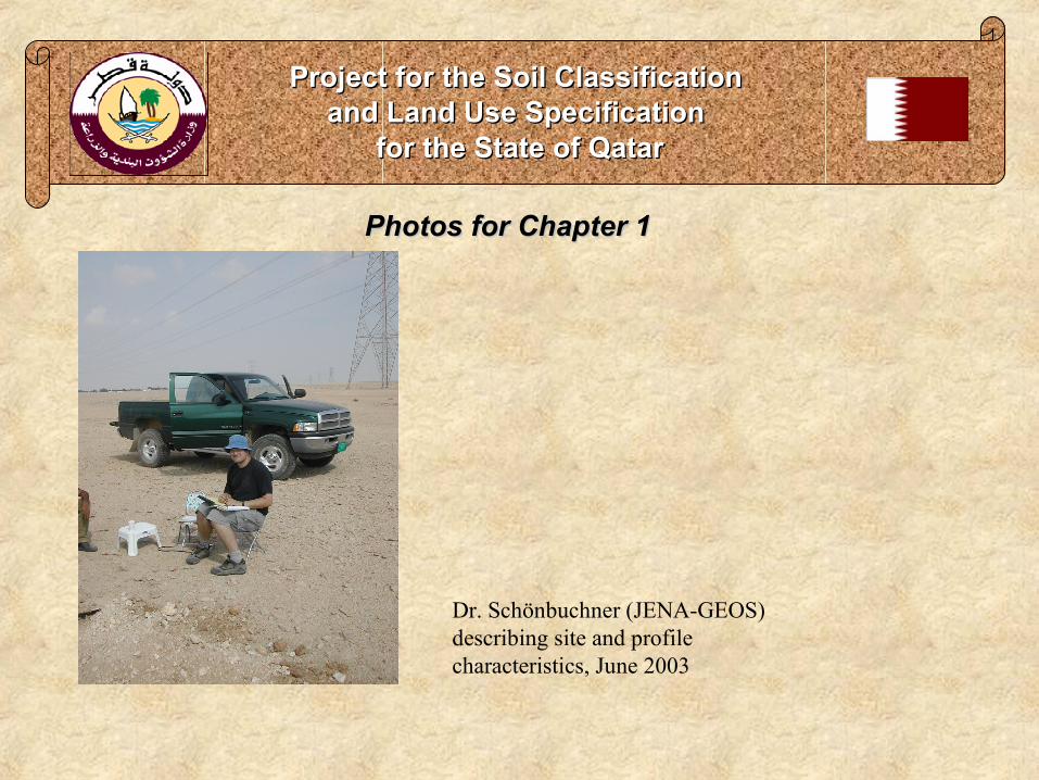
Photos for Chapter 1Photos for Chapter 1
Project for the Soil Classification Project for the Soil Classification and Land Use Specification and Land Use Specification
for the State of Qatarfor the State of Qatar
Dr. Schönbuchner (JENA-GEOS) describing site and profile characteristics, June 2003

Soil SystematicsSoil Systematics
Project for the Soil Classification Project for the Soil Classification and Land Use Specification and Land Use Specification
for the State of Qatarfor the State of Qatar
The categories of USDA Soil TaxonomyThe categories of USDA Soil Taxonomy
Series (optional)Series (optional)
Families (optional)Families (optional)
Subgroups (more than 2,400)Subgroups (more than 2,400)
Great Groups (more than 300)Great Groups (more than 300)
Suborders (64 in this category)Suborders (64 in this category)
Orders (12 in this category)Orders (12 in this category)
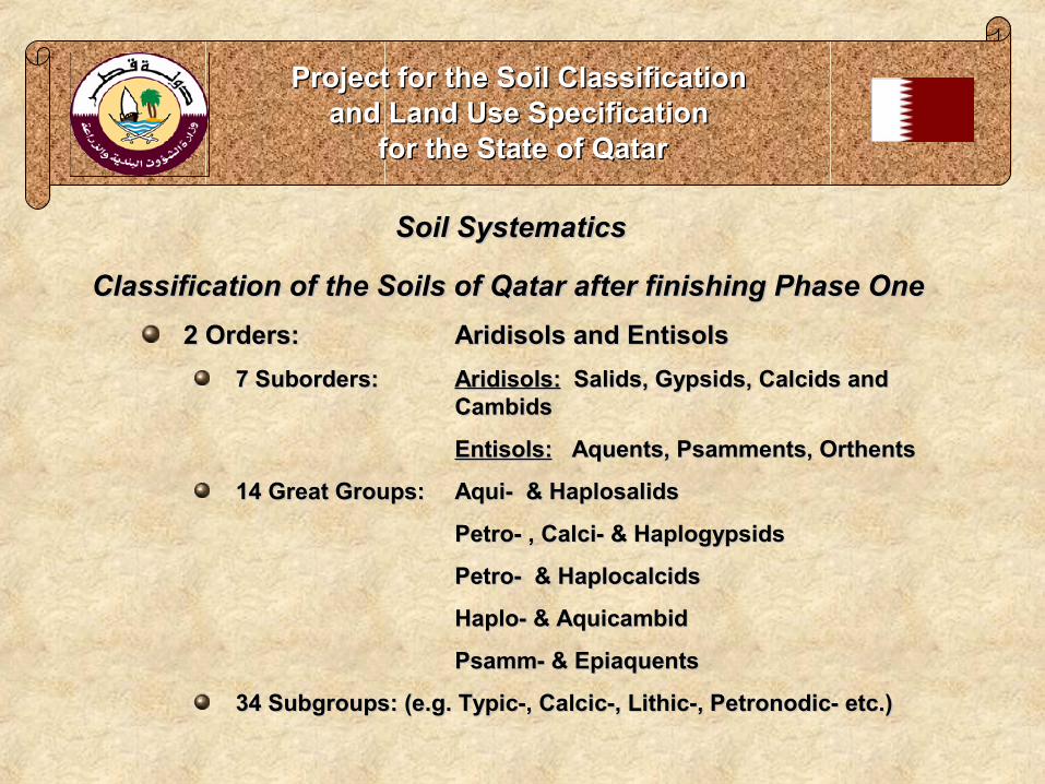
Soil SystematicsSoil Systematics
Project for the Soil Classification Project for the Soil Classification and Land Use Specification and Land Use Specification
for the State of Qatarfor the State of Qatar
Classification of the Soils of Qatar after finishing Phase OneClassification of the Soils of Qatar after finishing Phase One2 Orders: 2 Orders: Aridisols and EntisolsAridisols and Entisols
7 Suborders:7 Suborders: Aridisols:Aridisols: Salids, Gypsids, Calcids and Salids, Gypsids, Calcids and CambidsCambids
Entisols:Entisols: Aquents, Psamments, Orthents Aquents, Psamments, Orthents
14 Great Groups: 14 Great Groups: Aqui- & HaplosalidsAqui- & Haplosalids
Petro- , Calci- & HaplogypsidsPetro- , Calci- & Haplogypsids
Petro- & HaplocalcidsPetro- & Haplocalcids
Haplo- & AquicambidHaplo- & Aquicambid
Psamm- & EpiaquentsPsamm- & Epiaquents
34 Subgroups: (e.g. Typic-, Calcic-, Lithic-, Petronodic- etc.)34 Subgroups: (e.g. Typic-, Calcic-, Lithic-, Petronodic- etc.)

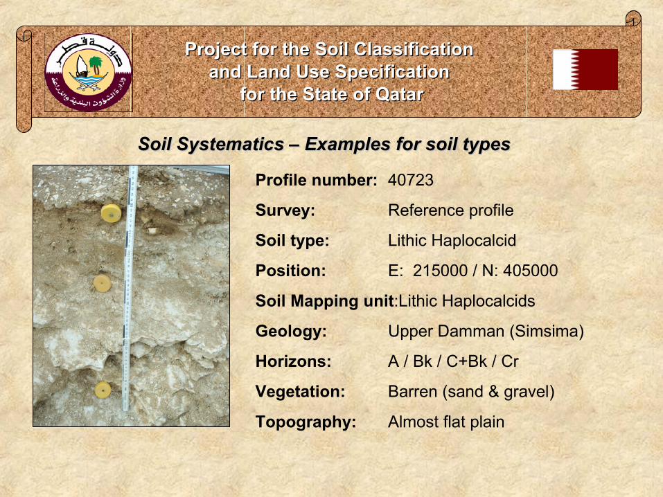
Soil Systematics – Examples for soil typesSoil Systematics – Examples for soil types
Project for the Soil Classification Project for the Soil Classification and Land Use Specification and Land Use Specification
for the State of Qatarfor the State of Qatar
Profile number: 40606
Survey: Reference profile
Soil type: Typic Haplocalcid
Position: E: 207500 / N: 415 000
Soil Mapping unit:Haplocalcids
Geology: Rodah
Horizons: A / Bw / Bk
Vegetation: Barren (sand & gravel)
Topography: Flat Rodah

Soil Systematics – Examples for soil typesSoil Systematics – Examples for soil types
Project for the Soil Classification Project for the Soil Classification and Land Use Specification and Land Use Specification
for the State of Qatarfor the State of Qatar
Profile number: 40623
Survey: Reference profile
Soil type: Typic Torripsamment
Position: E: 162 500 / N: 415 000
Soil Mapping unit:Typic Torripsamments
Geology: Pleist. to holoc. marine sediments
Horizons: A / Bw / Bkw / CBk
Vegetation: Barren (sand & gravel)
Topography: Flat coastal plain
Soil Systematics – Examples for soil typesSoil Systematics – Examples for soil types
Project for the Soil Classification Project for the Soil Classification and Land Use Specification and Land Use Specification
for the State of Qatarfor the State of Qatar
Profile number: 40723
Survey: Reference profile
Soil type: Lithic Haplocalcid
Position: E: 215000 / N: 405000
Soil Mapping unit:Lithic Haplocalcids
Geology: Upper Damman (Simsima)
Horizons: A / Bk / C+Bk / Cr
Vegetation: Barren (sand & gravel)
Topography: Almost flat plain
Project for the Soil Classification Project for the Soil Classification and Land Use Specification and Land Use Specification
for the State of Qatarfor the State of Qatar
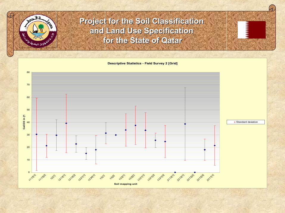
Descriptive Statistics - Field Survey 2 [Grid]
0
10
20
30
40
50
60
70
80
1113
[1]
1113
[2]
12[1]
1213
[1]
1213
[2]
1221
[1]
1234
[1]
13[1]
13[2]
132[1
]
132[2
]
1321
[1]
1321
[2]
1321
[3]
2112
[1]
2212
[1]
2212
[2]
2212
[3]
2311
[1]
Soil mapping unit
CaC
O3
in [
%]
± Standard deviation
Project for the Soil Classification Project for the Soil Classification and Land Use Specification and Land Use Specification
for the State of Qatarfor the State of Qatar
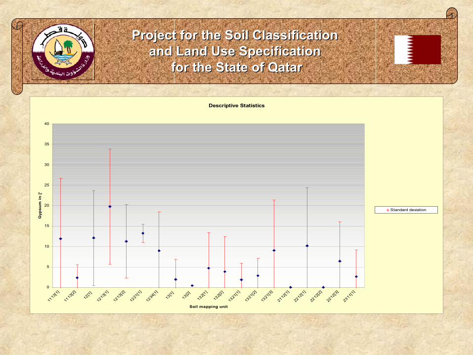
Descriptive Statistics
0
5
10
15
20
25
30
35
40
1113
[1]
1113
[2]
12[1]
1213
[1]
1213
[2]
1221
[1]
1234
[1]
13[1]
13[2]
132[1
]
132[2
]
1321
[1]
1321
[2]
1321
[3]
2112
[1]
2212
[1]
2212
[2]
2212
[3]
2311
[1]
Soil mapping unit
Gyp
sum
in
[%
]
± Standard deviation

Project for the Soil Classification Project for the Soil Classification and Land Use Specification and Land Use Specification
for the State of Qatarfor the State of Qatar
Descriptive Statistics - Field Survey 2 [Grid]
0
1
2
3
4
5
6
7
8
9
10
1113
[1]
1113
[2]
12[1]
1213
[1]
1213
[2]
1221
[1]
1234
[1]
13[1]
13[2]
132[1
]
132[2
]
1321
[1]
1321
[2]
1321
[3]
2112
[1]
2212
[1]
2212
[2]
2212
[3]
2311
[1]
Soil mapping unit
pH
± Standard deviation

Project for the Soil Classification Project for the Soil Classification and Land Use Specification and Land Use Specification
for the State of Qatarfor the State of Qatar
Descriptive Statistics
0
10
20
30
40
50
60
70
80
90
100
1113
[1]
1113
[2]
12[1]
1213
[1]
1213
[2]
1221
[1]
1234
[1]
13[1]
13[2]
132[1
]
132[2
]
1321
[1]
1321
[2]
1321
[3]
2112
[1]
2212
[1]
2212
[2]
2212
[3]
2311
[1]
Soil mapping unit
EC
in
[m
mh
os/
cm
]
± Standard deviation

Project for the Soil Classification Project for the Soil Classification and Land Use Specification and Land Use Specification
for the State of Qatarfor the State of Qatar
Descriptive Statistics - Field Survey 2 - [Grid]
0
2
4
6
8
10
12
14
16
18
20
1113
[1]
1113
[2]
12[1]
1213
[1]
1213
[2]
1221
[1]
1234
[1]
13[1]
13[2]
132[1
]
132[2
]
1321
[1]
1321
[2]
1321
[3]
2112
[1]
2212
[1]
2212
[2]
2212
[3]
2311
[1]
Soil mapping unit
Cla
y fo
r P
arti
cle
Siz
e C
on
tro
l S
ecti
on
in
[%
]
± Standard deviation

29
TitelProject for the Soil Classification Project for the Soil Classification
and Land Use Specification and Land Use Specification for the State of Qatarfor the State of Qatar
Satellitenbilddaten:
Scene Information
Sensor: Landsat 7 ETM +Acquisition date: 15th and 22nd January 2002Full scene: Path 162 | Row 043Floating scene-two scenes: Path 163 | Row 041 - 044
Sensor Information
Panchromatic mode: 15 m ground resolutionMultispectral mode: 30 m ground resolutionThermal mode: 60 m ground resolution

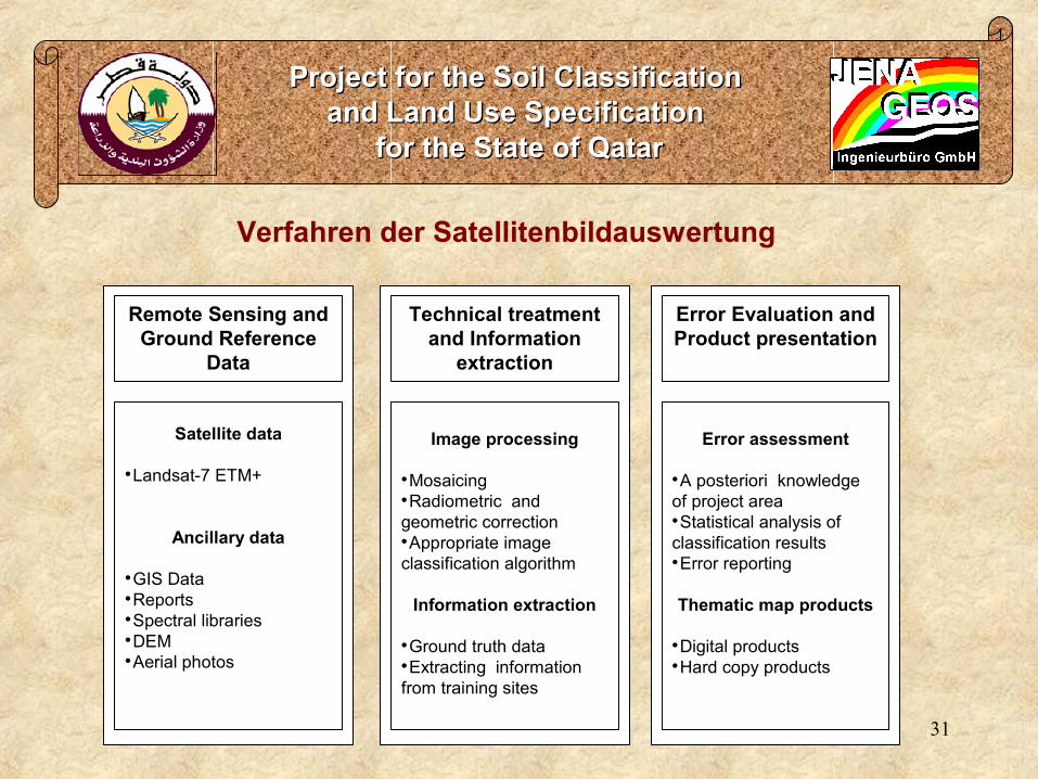
Remote SensingRemote Sensing
Project for the Soil Classification Project for the Soil Classification and Land Use Specification and Land Use Specification
for the State of Qatarfor the State of Qatar
Acquiring of three scenes Landsat 7 Acquiring of three scenes Landsat 7 ETM+ from the USGS from the 15th and ETM+ from the USGS from the 15th and 22nd January 200222nd January 2002
Path-Row: 163-42, 163-43 and 162-43Path-Row: 163-42, 163-43 and 162-43
Importing to DI-SoftwareImporting to DI-Software
Procecssing of all scenes and Procecssing of all scenes and mosaicing to one imagemosaicing to one image
Geodetic Transformation: Geodetic Transformation: Geographic Projection from UTM Zone Geographic Projection from UTM Zone 39 N to Qatar National Grid (QNG)39 N to Qatar National Grid (QNG)
Datum from WGS 84 to Qatar National Datum from WGS 84 to Qatar National Datum Datum
31
TitelProject for the Soil Classification Project for the Soil Classification
and Land Use Specification and Land Use Specification for the State of Qatarfor the State of Qatar
Satellite data
•Landsat-7 ETM+
Ancillary data
•GIS Data•Reports•Spectral libraries•DEM•Aerial photos
Remote Sensing and Ground Reference
Data
Technical treatment and Information
extraction
Image processing
•Mosaicing•Radiometric and geometric correction•Appropriate image classification algorithm
Information extraction
•Ground truth data•Extracting information from training sites
Error Evaluation and Product presentation
Error assessment
•A posteriori knowledge of project area•Statistical analysis of classification results•Error reporting
Thematic map products
•Digital products•Hard copy products
Verfahren der Satellitenbildauswertung

32
TitelAbleitung der Land Cover nach LCCS der FAO:
33
TitelProject for the Soil Classification Project for the Soil Classification
and Land Use Specification and Land Use Specification for the State of Qatarfor the State of Qatar
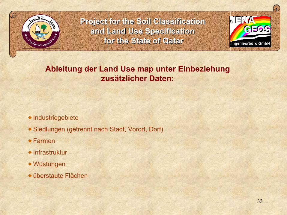
Ableitung der Land Use map unter Einbeziehung zusätzlicher Daten:
Industriegebiete
Siedlungen (getrennt nach Stadt, Vorort, Dorf)
Farmen
Infrastruktur
Wüstungen
überstaute Flächen
34
TitelProject for the Soil Classification Project for the Soil Classification
and Land Use Specification and Land Use Specification for the State of Qatarfor the State of Qatar
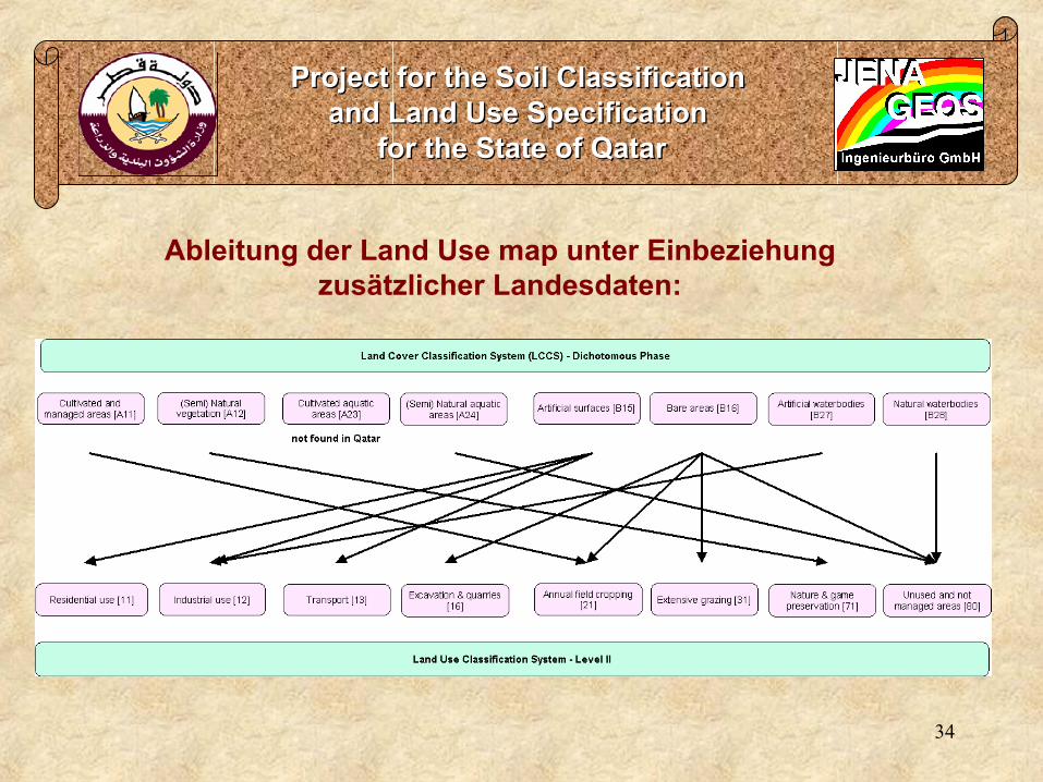
Ableitung der Land Use map unter Einbeziehung zusätzlicher Landesdaten:

35
Type of land degradation Abbreviation Consideration within Phase One activities for assessment land degradation in the State of Qatar
Water erosion W
Loss of topsoil / surface erosion Wt Important, has to be consideredGully erosion / gullying Wg Only few places with gully erosion, not considered
Mass movements Wm Not observed Coastal erosion Wc Not observed
Riverbank erosion Wr Not applicable, because there are no riversOffsite degradation effects Wo Important, has to be considered
Wind erosion E
Loss of topsoil Et Important, has to be consideredDeflation and Deposition Ed Its considered within Et – loss of topsoil
Offsite degradation effects Eo Important, has to be consideredChemical deterioration C
Fertility decline and reduced organic matter content
Cn Important, has to be considered
acidification Ca Not applicable because of the high CaCO3 content
Soil pollution Cp Important, has to be consideredSalinisation / alkalinisation Cs Important, has to be considered
Physical deterioration P
Compaction Pc Important, has to be consideredSealing and crusting Pk Important, has to be considered
Waterlogging Pw Not observed Subsidence of organic soils, settling of soils Ps Not applicable, because there are no organic soils
Loss of bio-productive function due to other activities (eg construction, mining etc.)
Pu Important, has to be considered
Aridification / soil moisture problems Pa Not observed
Typen der Land Degradation nach LADA

36
TitelProject for the Soil Classification Project for the Soil Classification
and Land Use Specification and Land Use Specification for the State of Qatarfor the State of Qatar
Ableitung der Land Degradation Class:

Land Degradation Map & LegendLand Degradation Map & Legend
Project for the Soil Classification Project for the Soil Classification and Land Use Specification and Land Use Specification
for the State of Qatarfor the State of Qatar
Land Degradation effects according to the land degradation scala is:Land Degradation effects according to the land degradation scala is:Strong below average is 21,585 ha (1.9 %)Strong below average is 21,585 ha (1.9 %)
Moderate below average is 279,793 ha (24.3%)Moderate below average is 279,793 ha (24.3%)
Slight below average is 80278 ha (7%)Slight below average is 80278 ha (7%)
Slight above average is 569,436 ha (49.5%)Slight above average is 569,436 ha (49.5%)
Moderate above average is 27,517 ha (2.4%)Moderate above average is 27,517 ha (2.4%)
Strong above average is 46513 ha (7.3%)Strong above average is 46513 ha (7.3%)

Project GIS IProject GIS I
Project for the Soil Classification Project for the Soil Classification and Land Use Specification and Land Use Specification
for the State of Qatarfor the State of Qatar
Geodatabase based on MS-AccessGeodatabase based on MS-AccessDatabase principle: RDBMSDatabase principle: RDBMS
Importing master lists to MS-Access tablesImporting master lists to MS-Access tables
Check for consistency and updating informationCheck for consistency and updating information
Definition of field types of entities and attributesDefinition of field types of entities and attributes
Setting relationships between master tables resp. selection of Setting relationships between master tables resp. selection of tablestables
Creation of the general outlook of the Geodatabase and its Creation of the general outlook of the Geodatabase and its components (mask and forms for later data entry through intranet/ components (mask and forms for later data entry through intranet/ internet)internet)
Integration of functions to other applicationsIntegration of functions to other applications
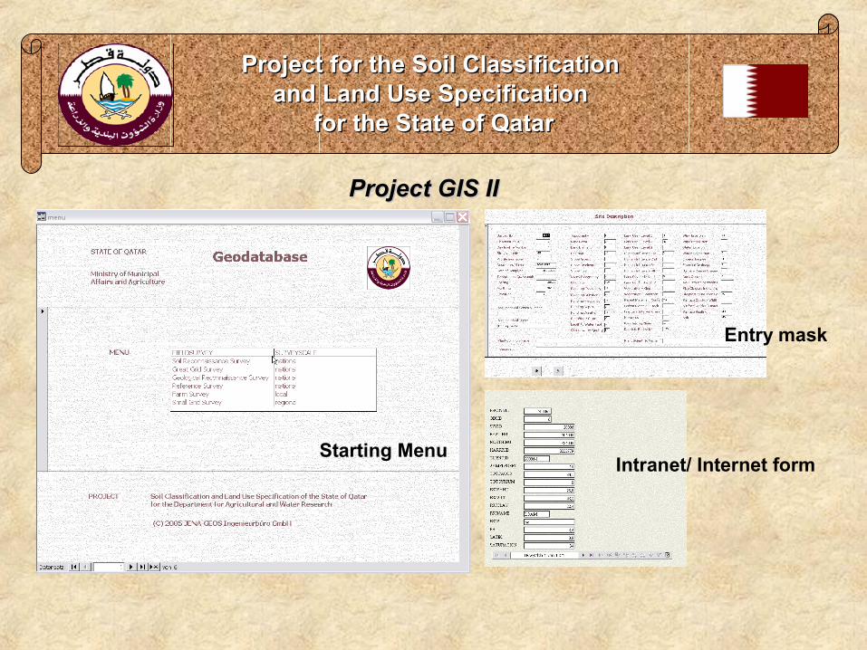
Project GIS IIProject GIS II
Project for the Soil Classification Project for the Soil Classification and Land Use Specification and Land Use Specification
for the State of Qatarfor the State of Qatar
Entry mask
Starting MenuIntranet/ Internet form

40
0. Main ContentsProject for the Soil Classification Project for the Soil Classification
and Land Use Specification and Land Use Specification for the State of Qatarfor the State of Qatar
1. Einführung
2. Landeskundliche Angaben
3. Projektinhalte
4. Geodaten
5. Besondere Erfahrungen bei der Erschließung des Marktes
Vortragsgliederung:
41
TitelProject for the Soil Classification Project for the Soil Classification
and Land Use Specification and Land Use Specification for the State of Qatarfor the State of Qatar
Wichtigste Erfahrungen in Bezug auf Management von Geodaten:
Arc View genießt weltweite Akzeptanz und Verbreitung
Anwendung von GIS (Arc View) ist beispielsweise in Qatar viel stärker verbreitet
Wert von Geodaten ist den Auftraggebern sehr bewusst
Die Lagerung und Verarbeitung der Daten mit MS ACCESS führte im Projekt an die
Grenzen der Handhabbarkeit
Internationale Kartierungs- und Auswertungsalgorithmen (USDA, FAO) sind sehr stark auf
die statistische Auswertung von Geodaten ausgerichtet
die Anwendung solcher Auswertungsroutinen beinhaltet ein großes Betätigungsfeld auf
dem internationalen Markt
speziell am Beispiel Qatar ist der große Nutzen solcher Projekte gut darzustellen

42
TitelProject for the Soil Classification Project for the Soil Classification
and Land Use Specification and Land Use Specification for the State of Qatarfor the State of Qatar
Wichtigste Erfahrungen im neuen Markt Mittlerer Osten:
International bietet sich ein großer Markt für geowissenschaftlich arbeitende Unternehmen
Eine externe (interkulturelle) Beratung bietet große Vorteile.
Eine dauerhafte Präsenz vor Ort und ständige Kommunikation mit dem AG ist notwendig.
Die Absicherung des Währungsrisikos bleibt beim AN hängen.
Große Sorgfalt bei der Auswahl der lokalen Partner ist dringend notwendig.
Ausreichende finanzielle Reserven des Unternehmens sind unverzichtbar.
Fazit: Große Chancen und große Risiken

back