producing custom maps with google maps apiproducing custom maps with google maps api john d. coryat,...
TRANSCRIPT

Producing Custom Maps
with Google Maps API
John D. Coryat, USNaviguide LLC
1

This discussion is aimed at those who understand the basic
workings of Google Maps API, have reasonably good skills in
Javascript and have used server side languages and techniques.
2

Presented by:
John D. CoryatUSNaviguide LLC
http://www.usnaviguide.comhttp://maps.huge.info
3

4
Markers and Polylines
http://code.google.com/apis/maps/documentation/examples/polyline-geodesic.html
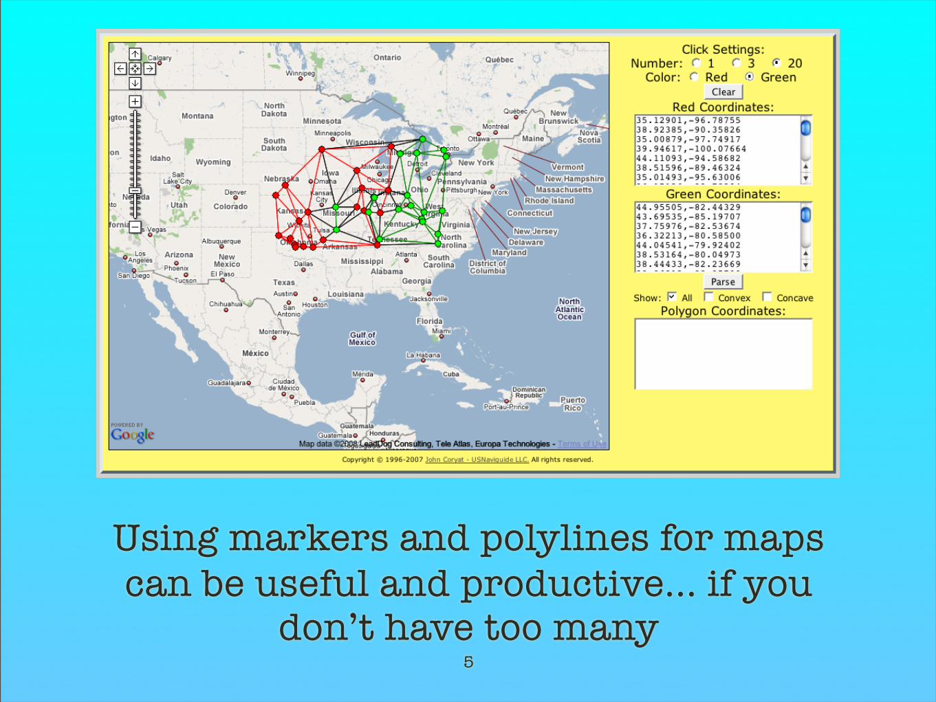
Using markers and polylines for maps can be useful and productive... if you
don’t have too many5

The maximum number of markers and polylines change depending on the browser and computer running the page. Too many and this happens.
6

7
Conclusion:Markers and polylines work fine for smaller,
less data intensive applications.
For anything more detailed, image overlays will be a more workable solution.
Markers and Polylines

Map Image Overlays
Whole Image Overlays
and
Tile Overlays
8

GGroundOverlay
Flat projectionImage dimensions less important
No opacity optionsPerformance penalty
9

Image requires clever and elaborate Javascriptto be stretched into the Mercator projection.
GGroundOverlay
10
Unprojected image Image stretched and fitted into map

11
Demonstration:
GGroundOverlay
GGroundOverlay Fitterhttp://www.usnaviguide.com/ws-2008-02/ggroundoverlayfitter.htm
GGroundOverlay Fitted Examplehttp://www.usnaviguide.com/ws-2008-02/ggroundoverlay_example.htm
US County Flat Projected Imagehttp://www.usnaviguide.com/ws-2008-02/images/us_counties.png

12
Conclusion:
GGroundOverlay works well for unprojected images, it’s easy to implement but suffers
from performance issues and limited options.
GGroundOverlay

ProjectedOverlay
Mercator Projected ImagesImage Dimensions critical
Opacity OptionsFast and Efficient
13

Very simple Javascript with fairly good performance. Opacity options allow some flexibility.
Requires image to be fit closely to the map.Images should fit the map viewport
ProjectedOverlay
14
Mercator projected image Image fitted into map

15
Demonstration:
ProjectedOverlay Examplehttp://www.usnaviguide.com/ws-2008-02/projectedoverlay_example.htm
US County Mercator Projected Imagehttp://www.usnaviguide.com/ws-2008-02/images/us_counties_projected.png
US County Overlay Created from Data on Demandhttp://www.usnaviguide.com/ws-2008-02/countyoverlay.htm
US County Polygon Data (PostgreSQL dump format)http://www.usnaviguide.com/ws-2008-02/data/counf.zip
ProjectedOverlay

16
Conclusion:
ProjectedOverlay images work well for areas that consist of a single map viewport and a single zoom setting. Excellent for program created images. Applications that require
larger coverage need a more robust solution.
ProjectedOverlay

17
Tile Overlays
Extremely EfficientRuns easily on all map capable browsers
Coverage from zoom 0 to 17 and overCapable of displaying large areasSomewhat complex to generate
More difficult to understandRequires a robust server

The tiling system consists of a series of images with a dimension of 256x256 pixels.
Each successive zoom level divides the previous zoom level’s images into four new images,
resulting in a map that displays one forth the area at twice the resolution of the previous level.
Zoom level 0 is the lowest level, there is no theoretical upper zoom level limit.
Tile Structure
18
Tile Overlays

Tile Structure
Tile Overlays
Zoom System
Numbering Scheme
Pixel Calculations
19

The world as one tile: zoom 0 (4**0)
20
Tile Structure
Tile No.:x:0 y:0
Pixels:Top (y): 0Left (x): 0
Bottom: 255Right: 255

The world as four tiles: zoom 1 (4**1)
21
Tile No.:x:0 y:0Pixels:
Top (y): 0Left (x): 0
Bottom: 255Right: 255
Tile No.:x:1 y:0Pixels:Top (y): 0Left (x): 256Bottom: 255Right: 511
Tile No.:x:0 y:1Pixels:
Top (y): 256Left (x): 0
Bottom: 511Right: 255
Tile No.:x:1 y:1Pixels:Top (y): 256Left (x): 256Bottom: 511Right: 511

The world as 16 tiles: zoom 2 (4**2)
22
Tile No.:x:0 y:0Pixels:
Top (y): 0Left (x): 0
Bottom: 255Right: 255
Tile No.:x:3 y:0Pixels:Top (y): 0Left (x): 768Bottom: 255Right: 1023
Tile No.:x:3 y:3Pixels:Top (y):768Left (x): 768Bottom: 1023Right: 1023
Tile No.:x:0 y:3Pixels:
Top (y): 768Left (x): 0
Bottom: 1023Right: 255

Number of tiles per zoom level = 4**zoomNumber of pixels per zoom level = 4**(zoom + 8)
Zoom Equation Tiles Equation Pixels0 4 ** 0 1 4**(0+8) 655361 4 ** 1 4 4**(1+8) 2621442 4 ** 2 16 4**(2+8) 1 mil.3 4 ** 3 64 4**(3+8) 4 mil.4 4 ** 4 256 4**(4+8) 16 mil.5 4 ** 5 1024 4**(5+8) 67 mil.
17 4 ** 17 17+ mil. 4**(17+8) A lot!
Tile Structure
23

24
Demonstration:
Demonstrate Tile Structurehttp://www.usnaviguide.com/ws-2008-02/demotilestructure.htm
Tile Structure

Tiles cut from images
Static data tiles
Dynamic data tiles
25
Tile Overlays

Uses:Obsolete and historical mapsAerial and panoramic photos
Circuit boards, plans, engineering drawingsOther documents, books, magazines, photo albums
Advantages:Easily integrated, great user interface
Disadvantages:Pixilation, Mercator stretching, image geolocation errors
Tiles cut from images
26

Resources:MapCruncher Beta for Microsoft Virtual Earth
Great alignment options, limited to non-commercial use, non-Google tile numbering
Automatic Tile Cutter for Photoshop - Mapki.comRequires Photoshop CS or better, alignment web tool available
Unix Command Line Tile Cutter - crazedmonkey.comRuns under Linux/Unix/Mac OSX, uses ImageMagick, GPL, no image alignment tool
Perl tile cutter - USNaviguide.comRuns under Linux/Unix/Mac OSX, uses GD, GPL, no image alignment tool
Tiles cut from images
27

Tiles cut from images
28
Source image: 5462 x 2920 zoom 7

Tiles cut from images
29
Source image: 5462 x 2920 zoom 7lower and higher zooms pixilated
Zoom5
Zoom6
Zoom7
Zoom8
Zoom9
http://www.usnaviguide.com/ws-2008-02/countyimagetiles.htm

30
Demonstration:
US County Tile Overlay from an Imagehttp://www.usnaviguide.com/ws-2008-02/countyimagetiles.htm
Program to Cut Tiles from a Mercator Projected ImageCommand Line Execution: tilecutter.pl <zoom> <South>,<West> <North>,<East> <Source>
Tiles cut from images

31
Conclusion:
Tiles cut from images are useful for many purposes, but suffer when extending to more
than a few zoom levels due to pixilation. Difficult to align to the map.
Complex to use over large areas.
Tiles cut from images

Uses:Displaying points of interest, heat maps, borders, other thematic data
Advantages:Allows creation of nearly perfect tiles
Fast browser response regardless contentGreat for polygons, markers and lines
Disadvantages:Requires significant server side programming experience
Tiles generated on a schedule, not great for time sensitive appsDifficult to use with client side options
Static data tiles
32

33
Tiles from data offer better quality images
Zoom5
Zoom6
Zoom7
Zoom8
Zoom9
http://www.usnaviguide.com/ws-2008-02/countytiles.htm
Static data tiles

34
Demonstration:US County Tile Overlay
http://www.usnaviguide.com/ws-2008-02/countytiles.htm
Program to Generate TilesCommand Line Execution: countytiles.pl <zoom> <South>,<West> <North>,<East>
US County Polygon Data (PostgreSQL dump format)http://www.usnaviguide.com/ws-2008-02/data/counf.zip
Static data tiles

35
Conclusion:
Static tiles created from data are extremely fast and efficient, can be made to work with
any zoom level and any area. They don’t suffer from pixilation and are easily aligned to the map. Since they require building in advance, time sensitive and user driven requirements
are difficult to address.
Static data tiles

Uses:Simulating markers, User driven data, time sensitive data
Advantages:Tiles custom tailored to the user
Solve the “too many markers” problem
Disadvantages:Requires significant server side programming experience
Requires significant server side processing power
Dynamic data tiles
36

37
Demonstration:
Data Tile Layer Generated “on the fly”http://www.usnaviguide.com/ws-2008-02/demotilecookies.htm
US County Polygon Data (PostgreSQL dump format)http://www.usnaviguide.com/ws-2008-02/data/counf.zip
Program to generate “bigcity” from Geoname.org US.zipCommand line execution: bigcitytilename.pl
Geonames.org US.zip data as “bigcity” filehttp://www.usnaviguide.com/ws-2008-02/data/bigcity.zip
Dynamic data tiles

38
Conclusion:
Dynamic tiles created “on the fly” offer great functionality at a stiff price - increased time to
process and heavy load on the server. The benefits of dynamic tiles over static ones have
to be weighed for each application.
Dynamic data tiles

Producing Custom Mapswith
Google Maps API
Questions?
39

Getting HelpGoogle Maps API Discussion Group
http://groups.google.com/groups/Google-Maps-API
Google Mapkihttp://mapki.com
Google Searchhttp://www.google.com
40

Software and Dataused in this discussion
Perl 5.8 with DBI, GD and CGI modulesUSNaviguide_Google_Relpix Perl moduleUSNaviguide_Google_Tiles Perl modulePostgreSQL 8.2 with PostGIS Extension
Apache 2.0 webserverProjectedImage.js Javascript
US Census Cartographic Boundary County ShapefilesGeonames.org’s US.zip data file
Download examples and data used in this discussion:http://www.usnaviguide.com/ws-2008-02/download.zip
Special thanks to Marcelo Montagna for helpwith some examples used in this discussion.
41