processes affecting the geochemical composition … affecting the geochemical composition of wetland...
TRANSCRIPT

Processes Affecting the Geochemical Composition of Wetland Sediment
By Mark R. Stanton, David L. Fey, Stanley E. Church, and Charles W. Holmes
Chapter E25 ofIntegrated Investigations of Environmental Effects of Historical Mining in the Animas River Watershed, San Juan County, ColoradoEdited by Stanley E. Church, Paul von Guerard, and Susan E. Finger
Professional Paper 1651
U.S. Department of the InteriorU.S. Geological Survey

Contents
Abstract .....................................................................................................................................................1033Introduction...............................................................................................................................................1034Field and Analytical Methods ................................................................................................................1034
Core Locations.................................................................................................................................1034Core and Auger Samples ...............................................................................................................1034
Forest Queen Detailed Study ...............................................................................................1034Aqueous Samples and Analyses ..................................................................................................1036
Acid-Volatile Sulfide (AVS) and Acid-Extractable (6N HCl) Element Analyses ...........1036Alteration Types and Geology .......................................................................................................1036Mining History .................................................................................................................................1037
Results and Discussion ...........................................................................................................................1037South Fork Mineral Creek ..............................................................................................................1037
Core 97ABS321 .......................................................................................................................1037Core 97ABS322 .......................................................................................................................1040Aqueous Chemistry ...............................................................................................................1041
Mineral Creek ..................................................................................................................................1041Core 999292 .............................................................................................................................1041Aqueous Chemistry ...............................................................................................................1043
Cement Creek ..................................................................................................................................1043Core 97ABS324 .......................................................................................................................1043
Premining Sediment .....................................................................................................1045Mining Sediment ...........................................................................................................1046Postmining/Remediation Sediment ............................................................................1046
Iron and Aluminum Chemistry at the Site ..........................................................................1048Animas River ....................................................................................................................................1048
Sulfate Reduction as a Metal Sequestration Mechanism ..............................................1048Forest Queen Wetland Site ..................................................................................................1048Core Descriptions, HCl-Extractable Metal Concentrations, and AVS Recovery ...........1051
Core FQ3 .........................................................................................................................1051Acid-Extractable Element Concentrations and AVS ......................................1051
Core FQ4 .........................................................................................................................1054Total Element Concentrations ............................................................................1054Acid-Extractable Metal Concentrations and AVS ..........................................1054
Core FQ5 .........................................................................................................................1054Total Element Concentrations ............................................................................1054Acid-Extractable Element Concentrations and AVS ......................................1056
Core FQ7 .........................................................................................................................1056Total Element Concentrations ............................................................................1056Acid-Extractable Element Concentrations and AVS ......................................1056
Core FQ9 .........................................................................................................................1059Acid-Extractable Element Concentrations and AVS ......................................1059
Summary of Acid-Extractable Element Concentrations and Acid-Volatile Sulfidefor Animas River Cores .............................................................................................1059
Conclusions...............................................................................................................................................1062
Importance of Metal-Rich Inflow as a Control on Metal Content of Wetlands ....................1062
Relative Importance of Different Sorbents or Contributors within Individual Wetlands .........1062
Spatial Relationship of Metal Enrichment within Forest Queen Wetland .............................1063
Stability of Wetlands and Wetland Functions Through Time and Implications for Wetland Management and Water Quality ..............................................................1063
References Cited......................................................................................................................................1063
Figures
1. Map of Animas River watershed study area, showing wetland core locations, drainages, and generalized distribution of major rock units and alteration types ..........................................................................................................................................1035
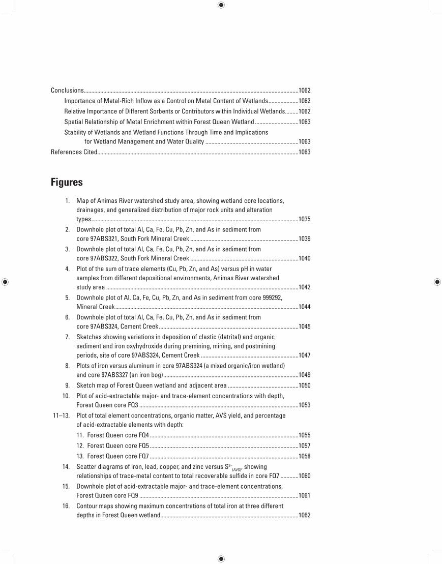
2. Downhole plot of total Al, Ca, Fe, Cu, Pb, Zn, and As in sediment from core 97ABS321, South Fork Mineral Creek ........................................................................1039
3. Downhole plot of total Al, Ca, Fe, Cu, Pb, Zn, and As in sediment from core 97ABS322, South Fork Mineral Creek ........................................................................1040
4. Plot of the sum of trace elements (Cu, Pb, Zn, and As) versus pH in water samples from different depositional environments, Animas River watershed study area ................................................................................................................................1042
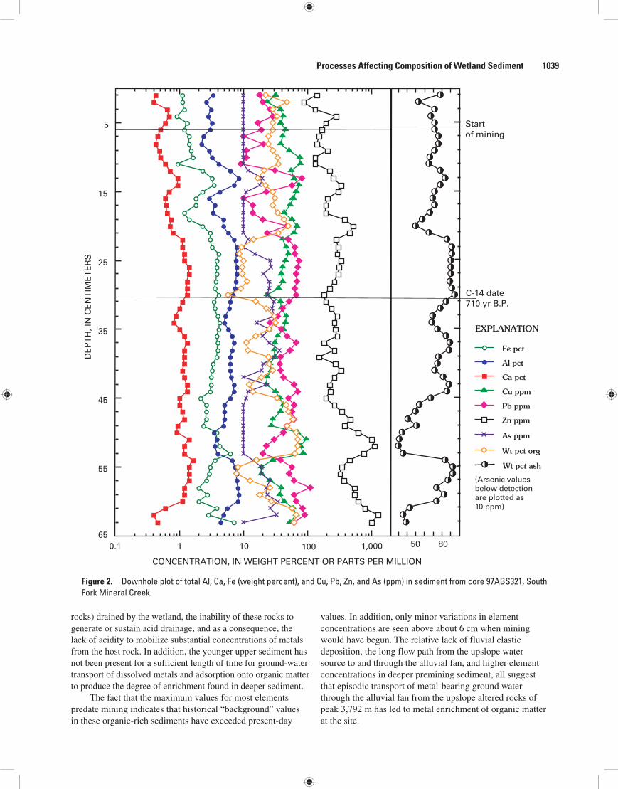
5. Downhole plot of Al, Ca, Fe, Cu, Pb, Zn, and As in sediment from core 999292, Mineral Creek ..........................................................................................................................1044
6. Downhole plot of total Al, Ca, Fe, Cu, Pb, Zn, and As in sediment from core 97ABS324, Cement Creek .............................................................................................1045
7. Sketches showing variations in deposition of clastic (detrital) and organic sediment and iron oxyhydroxide during premining, mining, and postmining periods, site of core 97ABS324, Cement Creek .................................................................1047
8. Plots of iron versus aluminum in core 97ABS324 (a mixed organic/iron wetland) and core 97ABS327 (an iron bog) ..........................................................................................1049
9. Sketch map of Forest Queen wetland and adjacent area ...............................................1050
10. Plot of acid-extractable major- and trace-element concentrations with depth, Forest Queen core FQ3 ..........................................................................................................1053
11–13. Plot of total element concentrations, organic matter, AVS yield, and percentage of acid-extractable elements with depth:
11. Forest Queen core FQ4 ...................................................................................................1055
12. Forest Queen core FQ5 ...................................................................................................1057
13. Forest Queen core FQ7 ...................................................................................................1058
14. Scatter diagrams of iron, lead, copper, and zinc versus S2–(AVS), showing
relationships of trace-metal content to total recoverable sulfide in core FQ7 ............1060
15. Downhole plot of acid-extractable major- and trace-element concentrations, Forest Queen core FQ9 ..........................................................................................................1061
16. Contour maps showing maximum concentrations of total iron at three different depths in Forest Queen wetland............................................................................................1062

Tables 1. Summary statistics for total concentrations of major (Al, Fe, Ca (weight percent))
and trace (Cu, Pb, Zn, As (ppm)) elements in wetland sediment, South Fork Mineral Creek and Mineral Creek .........................................................................................1038
2. Individual and summary statistics of aqueous major- and trace-element concentrations (µg/L), calcium and sulfate concentrations (mg/L), and water chemistry parameters from wetlands, South Fork Mineral Creek and Mineral Creek .........................................................................................................................................1043
3. Water chemistry parameters from five Forest Queen monitoring wells .......................1051 4. Summary statistics for acid-extractable concentrations of major and trace
elements from Forest Queen wetland cores ......................................................................1052 5. Summary statistics for total concentrations of major and trace elements from
Forest Queen wetland cores .................................................................................................1052

AbstractGeochemical analyses of sediment core and water samples
from five wetlands along four major drainages of the Animas River watershed study area were undertaken to characterize wetland chemistry in an acid drainage regime. The objectives of this study were to determine the capability of the wetlands to retain or release metals produced by acid weathering processes that occur in the area, to examine the past and present effect of these weathering processes on the geochemistry of the wetland systems, and to investigate how these processes affect the com-position of wetland sediment. Geochemical profiles in wetland cores and dating of cores by 14C, 210Pb, and 137Cs chronology provided records of historical changes in the metal flux to the various wetlands.
Analysis of nine sediment cores for major- and trace-element abundances (total and HCl-extractable concentra-tions), organic and mineral matter content, acid-volatile sulfide, and secondary iron oxyhydroxide revealed that, compared to iron bogs (iron-rich wetlands) in the same region, wetland sediment is characterized by higher organic content (10–90 weight percent) and generally lower concentrations of iron and aluminum. Mean concentrations from all nine cores range from 1.5 to 34.5 weight percent iron and from 3.9 to 6.9 weight percent aluminum. In individual samples, however, maximum concentrations of total iron and aluminum are as high as 50.1 and 12.0 weight percent, respectively.
Trace-element content of wetland sediment varies widely. Maximum total concentrations of trace elements in wetland sediment are as follows: Cement Creek, 770 ppm copper, 1,600 ppm lead, 7,000 ppm zinc, and 88 ppm arsenic; Mineral Creek, 330 ppm copper, 700 ppm lead, 2,600 ppm zinc, and 57 ppm arsenic; South Fork Mineral Creek, 760 ppm cop-per, 190 ppm lead, 3,000 ppm zinc, and 37 ppm arsenic. The ranges of acid-extractable trace-element concentrations are copper, 17–200 ppm; lead, 17–640 ppm; zinc, 70–1,720 ppm; and arsenic, from below detection to 48 ppm. The percentage of an individual element that is acid extractable ranges from 0 to about 15 percent. Based on these iron, aluminum, and trace-element values, the wetlands appear to concentrate some elements within solid phases.
Four water samples from South Fork Mineral Creek showed low concentrations of dissolved iron and aluminum (<1 ppm), zinc (<50 ppb), and arsenic (below detection; <10 ppb). The sample from the westernmost locality was highly acidic (pH 3.2) with relatively higher concentrations of dissolved major and trace elements, but sediment from the associated wetland had among the lowest total abundances of solid-phase metals. This results from decreased metal adsorp-tion at lower pH and low availability of metals from surround-ing rock units that are not highly mineralized or hydrother-mally altered. The easternmost wetland sediment had slightly higher total metal abundances, and copper, in particular, was enriched in the sediment. These two samples illustrate the increasing importance of adsorptive processes with higher pH, and the increased availability of metals from altered or miner-alized rocks (or windborne metal-bearing detritus) farther east along South Fork Mineral Creek.
A water sample from mainstem Mineral Creek had 2–18 times higher concentrations of elements than South Fork Mineral Creek samples, a result of Mineral Creek draining an acid-sulfate alteration zone. A nearby wetland sediment was also enriched in most elements, probably through deposition of windborne metal-rich detritus.
One site, the Forest Queen wetland along the upper Animas River, was cored in detail (five cores) to determine the role of sulfate reduction and resulting sulfide mineral formation in the sequestration of metals from influent acidic, metal-rich water. Acid-leaching (6N HCl) of sediment with recovery of acid-volatile sulfide (AVS) was used to exam-ine associations of metals with authigenic sulfide minerals. High concentrations of extractable metals generally were not associated with the highest AVS yields, indicating that although metals may be sequestered in iron monosulfide phases, the process is unevenly distributed throughout the wetland. The maximum total concentrations of trace elements in Forest Queen wetland sediment are copper, 215 ppm; lead, 1,600 ppm; zinc, 3,250 ppm; and arsenic, 73 ppm. Proximity to the source water and metal flux to core sites are important factors in metal enrichment. Element enrichment in the upper 60 cm and deeper than 80 cm indicate two possible flow paths and (or) sources of metal in the wetland.
Chapter E25Processes Affecting the Geochemical Composition of Wetland Sediment
By Mark R. Stanton, David L. Fey, Stanley E. Church, and Charles W. Holmes

Water samples showed mixtures of dissolved ferric and ferrous iron in the presence of varying levels of dissolved sul-fide, suggesting that several redox processes were occurring in close spatial proximity in ground water. Inflow surface water had a pH of 4.7, ground water within the wetland had pH near 7, and the pH of outflow water was 5.9. These pH values sug-gest that processes that buffer or neutralize incoming acidic waters are occurring in the Forest Queen wetland but may not be active in all areas.
The studied wetlands act to trap metals through adsorption onto organic matter or detrital mineral surfaces, or through precipitation as authigenic metal sulfides or iron oxy-hydroxide. Iron oxyhydroxide in near-surface layers of some wetland sediment sequesters substantial amounts of metals. This is primarily a seasonal phenomenon associated with lowered water tables and precipitation of metal-bearing iron solids on the surface. In some areas, iron oxyhydroxide forms at depth as a postdepositional coating and performs a similar role in trace-element adsorption.
IntroductionElevated concentrations of dissolved major and trace
elements and extreme acidity characterize the chemistry of surface water and inactive mine drainage in the Animas River watershed study area (Church and others, 1997). In this report, we use the concentrations of iron, aluminum, calcium, copper, lead, zinc, and arsenic in wetland sediment to indicate histori-cal trends in metal deposition during premining and postmin-ing periods. The geochemical behavior of these elements in an acid system may help provide a record of variations in supply of sediment, solubility of minerals, and mobility of elements (Fortin and others, 1993; Jenne, 1968).
The ability of the wetland environments to trap and retain toxic elements is of interest as a possible control on local water quality. The two major processes operating in wetlands to scavenge and sequester metals are coprecipitation (formation of authigenic sulfide or iron oxyhydroxide miner-als) and adsorption onto mineral surfaces or organic matter (Schwertmann and Cornell, 1991; Konhauser and others, 1993; Sholkovitz and Copland, 1981; Szalay, 1964). However, mechanistic details of these processes such as surface complex formation or ion exchange are not considered in this overview.
Field and Analytical Methods
Core Locations
Five wetlands along four major tributaries in the Ani-mas River watershed study area—South Fork Mineral Creek, Mineral Creek, Cement Creek, and Animas River—were sampled (fig. 1). Two cores are from wetlands along South
Fork Mineral Creek (cores 97ABS321, 97ABS322), and one core is from a wetland near Mineral Creek downstream from its confluence with the South Fork (core 999292). The core near Cement Creek (97ABS324) is from a hybrid wetland that contains both organic matter and iron oxyhydroxide. The other wetland is the Forest Queen along the upper Animas River; we took five individual cores (FQ3, FQ4, FQ5, FQ7, FQ9) at this site.
Core and Auger Samples
To take the cores, we used a 1.5 to 3 m length of 5-cm inside-diameter PVC pipe, driving it into the organic+clastic sediment layers until resistance barred further penetration. Individual drives could not be made deeper than about 3 m by this method, and often, two or three insertions in the same location were made to ensure that the maximum thickness of sediment was sampled. A rubber seal placed in the top opening of the pipe after insertion provided vacuum that held the sediment column in place during extraction. After being pulled, the core length in the pipe was measured, excess PVC pipe was removed, and cores were sealed with PVC endcaps secured by cloth tape.
Because of sediment compression, the length of a recorded core was from 5 to 15 percent less than the total depth of coring. Cores from South Fork Mineral Creek, Mineral Creek, and Cement Creek were not corrected for com-pression. Subsamples from these four cores were taken at 1 cm intervals to provide adequate analytical coverage. Selected intervals of peat and organic-rich peaty muck were sent to a commercial laboratory for 14C age dating; other intervals were chosen for use in 210Pb and 137Cs chronology.
Forest Queen Detailed StudyAt the Forest Queen wetland, we used PVC pipe to
take large-diameter cores by the process just described. We col-lected smaller cores (1.25 cm diameter), using a PVC-sleeved soil sampler, at the edges of the wetland and at locations where large-diameter coring proved unworkable. The small-diameter cores were no deeper than approximately 0.5 m. Cores were taken approximately 2 m adjacent to piezometers that were installed and sampled 2 weeks earlier as part of a water-quality study directed by the Colorado School of Mines (Pavlik and others, 1999). Additional shallow (≤0.5 m) grab samples were taken with an auger, placed in polyethylene bags, and flushed of air with N
2(g). Core and auger samples were stored in the
dark at 4°C until they were treated in the laboratory, approxi-mately 2 weeks after collection.
Upon opening a core, we immediately described the stratigraphy. Rather than subsampling cores in dis-crete 1-cm intervals, we selected the sample intervals from Forest Queen cores based on visually identifiable similarities in color, organic matter, clastic content, and grain size. The
1034 Environmental Effects of Historical Mining, Animas River Watershed, Colorado

Processes Affecting Composition of Wetland Sediment 1035
selected intervals ranged from one to tens of centimeters in length. Sample depths were corrected for compression by proportioning the total amount of compression to the percent-age of core length that a recovered interval occupied. The samples were composited and processed for analysis under an N
2(g) stream in a glove bag to inhibit oxidation, but were not
dried. On some surfaces, variable amounts of red to brown staining indicative of iron oxyhydroxide were seen. This likely did not result from oxidation during short-term core storage because during the coring operations, we observed iron oxyhy-droxide as deep as 1 m.
Samples were air-dried and sieved (60 mesh) to remove grains of fine sand or larger material. Organic matter (loss on ignition or LOI, weight percent) and ash content (100 minus LOI, weight percent) were determined in cores 999292, FQ4, FQ5, and FQ7 by ashing, while in other cores, these parameters were estimated by the proportion of peat plus wood fragments to clastic sediment. Loss on ignition is used as a proxy for organic matter content of the samples. Clastic-dominated sam-ples with no visible organic matter were not ashed. The organic-rich samples were shredded in a Wiley mill and ashed at 550°C for 24 hours to obtain the loss on ignition and ash content.
Figure 1. Animas River watershed study area, showing wetland core locations, drainages, and generalized distribution of major rock units and alteration types. Wetland cores are 97ABS321, 97ABS322, 999292, 97ABS324, and five cores from the Forest Queen site.
PROP
PROP
Mi ddle Fork
South
Fork
Min
era l
C
reek
C
emen
t
Cre
ek
A
ni m
a s
R
iver
107°45' 107°37'30"
37°52'30"
37°48'45"
37°56'15"
39294206
4075
3958 40754107
4111
Howardsville
Silverton
Eureka
RossBasin
Red Mtn Pass
Red MtnNo. 3
Sultan Mtn
PROP
PROP
PROP
PROP
PROP
QSP
WSP
QSP
PROP
PROP
QSP
QSP
SilvertonVolcanics
San Juan Formationvolcanics
Sultan Mtnstock
Pennsylvanian-Jurassicsedimentary rocks Precambrian
rocks
Burns Member ofSilverton Volcanics
Approximate boundary ofSilverton caldera
AS
AS
COLORADO
Durango
GrandJunction
DENVER
Animas River watershedstudy area
WSP
3792
4206 Mountain peak and elevation
Alteration typeSample site and number
Regional propylitic
Quartz-sericite-pyrite
Weak sericite-pyrite
Acid-sulfate
Geologic contact
PROP
WSP
QSPAS
MILES0 1 2 3
KILOMETERS0 1 2 3 4
97ABS324
97ABS321
97ABS324
FORESTQUEEN
97ABS322999292
EXPLANATION
ProspectGulch
(meters)

All samples were powdered to <230 mesh (57 µm (micrometers)) in a ceramic shatterbox. A split of the pow-dered sample was digested in a mixture of acids and analyzed by inductively coupled plasma–atomic emission spectrometric (ICP-AES) analysis for 40 major and trace elements (Briggs, 2002). Element concentrations in ashed samples were reported on an as-received basis.
Aqueous Samples and Analyses
Water samples were collected along South Fork Mineral Creek (one from each cored wetland and two from surface water between the sites) and Mineral Creek (one surface water). At all sites, dissolved oxygen (DO, ppm), pH (standard units), temperature (°C), and specific conductivity (microsiemens/centimeter, µS/cm) were measured in place; the meters were calibrated with standards 5–10 minutes before sampling. At selected sites where iron staining or an iron precipitate was visible, we measured ferrous iron (Fe2+) and total iron (Fe
(tot)) on
site within 15 minutes of collection and filtration, using a porta-ble spectrophotometer (Hach Company, 1997, User’s Manual). Ferric iron (Fe3+) was determined by difference. At the Forest Queen wetland, five water samples associated with the sediment cores were analyzed on site for total aqueous sulfide.
Samples were drawn into a 60-mL (milliliter) polyeth-ylene syringe, then passed through a 0.45 µm polycarbonate syringe filter into an HCl-washed polyethylene sample bottle. For cations, one 60-mL aliquot was acidified to pH <2 with concentrated nitric acid; for anions, a filtered, unacidified aliquot (30 mL) was collected. Cation concentrations were determined by inductively coupled plasma–mass spectrometry (Lamothe and others, 2002). The major anions fluoride, chlo-ride, nitrate, and sulfate were determined by ion chromatogra-phy (Theodorakos, 2002).
Acid-Volatile Sulfide (AVS) and Acid-Extractable (6N HCl) Element Analyses
The term “acid-volatile sulfide” (AVS) is usually restricted to iron sulfides that are soluble in 6N HCl (Berner, 1970): greigite (Fe
3S
4), amorphous FeS (FeS
(am)), and macki-
nawite (crystalline FeS(c)
). Pyrite (FeS2) is insoluble in 6N HCl.
The AVS definition is expanded here to include other HCl-soluble metal sulfides such as PbS (galena), ZnS (sphaler-ite), and Cu
2S (chalcocite) that may have been present in the
sediment.Thirty-six samples from Forest Queen cores FQ4, FQ5,
and FQ7 were analyzed for total and HCl-extractable metals, and AVS. (HCl-extractable metals are also referred to as acid-extractable or acid-soluble metals.) Samples from cores FQ3 and FQ9 were analyzed only for HCl-extractable metals and AVS. The samples were not dried prior to AVS treatment, so an undetermined concentration of metal in each sample was associated with the aqueous phase (residual water). Aque-ous analyses (Thomas Wildeman, Colorado School of Mines,
written commun., 1998) showed lead and zinc present in water from 103 to 105 times less than in most solids. Thus, the total amount of metal associated with residual water in the core samples was small relative to that in the solid phases.
The sample (10–50 g, wet weight) was combined with 6N HCl (25 mL/10 g) and a 10 percent SnCl
2 suspension
(10–20 mL per sample), the latter to prevent Fe3+ from oxidiz-ing sulfide to higher oxidation states, such as S0. The mixture was heated to 90°C for 1/2 hour under an N
2 atmosphere to
release AVS (Rice and others, 1993). H2S
(g) released during
this acid/heating step was swept by N2 gas into a series of
three glass traps. The first trap contained phosphate buffer (pH 4.0); the second and third traps contained 0.1 M AgNO
3
that precipitated the sulfide as Ag2S. The total amount of sul-
fide was determined gravimetrically after the recovered Ag2S
was weighed, and was reported as parts per million (ppm) total sulfide (S2–
(AVS)). After AVS recovery, the sample residue
was rinsed with deionized water (DI), air-dried (25°C), and weighed. The filtered HCl solution was analyzed for 40 major- and trace-element concentrations by ICP-AES.
Alteration Types and Geology
Several types of hydrothermal alteration associated with mineral deposits are present in the Animas River watershed study area (Bove and others, this volume, Chapter E3). A generalized depiction of alteration types and geology in the areas where the cores were taken is in figure 1. Each alteration type is characterized by suites of minerals that represent dif-ferences in intensity of the hydrothermal alteration. Regional propylitization (PROP) is the weakest grade; minerals are primarily altered feldspars with little or no sulfides except pyrite. Weak sericite-pyrite (WSP) is a low-grade alteration/mineralization where the pyrite is not high in ore metals. Quartz-sericite-pyrite (QSP) is medium to high-grade altera-tion with associated higher (than WSP) metal abundances in pyrite. (Vein-related quartz-sericite-pyrite alteration (V-QSP; Bove and others, this volume) is limited to much smaller areas compared to the other alteration assemblages, and is therefore not considered separately in this chapter.) The highest grade alteration is acid-sulfate (AS), noted by a variety of sulfide minerals including tetrahedrite, galena, sphalerite, and chalco-pyrite (Bove and others, this volume).
South Fork Mineral Creek drains an area of diverse geol-ogy, including WSP/QSP-altered rocks of the subeconomic porphyry copper-molybdenum deposit of peak 3,792 m (fig. 1). The deposit is hosted by altered Oligocene San Juan Formation volcanics, the dominant rock unit immediately north of the drainage. Unaltered Pennsylvanian-Permian through Jurassic sedimentary rocks crop out to the south and west, and variably altered San Juan Formation volcanics are present farther west in the drainage (Yager and Bove, this volume, Chapter E1, pl. 1). Southeast of peak 3,792 m across South Fork Mineral Creek is the porphyritic Sultan Mountain stock (fig. 1), an intrusive of quartz monzonite-diorite com-position (Yager and Bove, this volume). Mineral Creek also
1036 Environmental Effects of Historical Mining, Animas River Watershed, Colorado

Processes Affecting Composition of Wetland Sediment 1037
drains an area of diverse geology and multiple alteration types, from unaltered PROP and WSP/QSP types along its western border to dominantly AS- and QSP-altered rocks to the east and north (fig. 1). Cement Creek is dominated on the west by acid-sulfate and QSP-altered rocks of the Silverton Volcanics that make up the Oligocene Silverton caldera. The caldera margins are approximated by the large circular outline in figure 1; Mineral Creek generally follows the western bound-ary of the caldera. Rocks east of Cement Creek are primarily propylitically altered with scattered zones of WSP and QSP alteration. Rocks along the Animas River near the Forest Queen mine (Abandoned Mined Lands Inventory (AMLI) site # 195) belong to the Burns Member of the Silverton Volcanics; these are dominantly propylitically altered with small areas of WSP east of the river and QSP west of the river (fig. 1). The Silverton Volcanics are host rocks for most of the mineral deposits in the Animas River watershed study area. See Yager and Bove (this volume and pl. 1) and Bove and oth-ers (this volume) for a detailed compilation and overview of the geology and alteration types in the area.
Mining History
Mining began in the study area in the 1870s (Jones, this volume, Chapter C); several larger mines along South Fork Mineral Creek began operation in the 1900s. Peak years of production for most mines along South Fork Mineral Creek and Mineral Creek were between 1890 and 1950; a few mines along Cement Creek continued operation up until 1991 (Bird, 1999). Numerous mines and the large Sunnyside Eureka Mill (AMLI site # 164) operated in the Animas River valley north of the Forest Queen site.
Results and Discussion
South Fork Mineral Creek
Core 97ABS321
This wetland is at the toe of a large alluvial fan (100 m wide) and appears to be sustained by ground water flow-ing through the fan. Abundant green algae are found on the water surface, and photosynthetic sulfur bacteria are pres-ent on the sediment surface (5–10 cm deep water). Mosses, sedges, grasses, and woody riparian zone plants are abundant throughout the wetland. The steep topography and attitude of the country rock above the site direct surface drainage away from the area. The perennial stream feeding the fan turns west 200 m upstream from the site and meets South Fork Mineral Creek 500 m west, so the streamflow volume to the fan and resulting discharge to the wetland are probably low year-round. The downslope distance where the stream turns west to the bottom of the fan is approximately 400 m.
The site is located about 2 km west of the structural margin of the Silverton caldera near the southwest edge of peak 3,792 m (fig. 1). A subeconomic porphyry copper-molybdenum deposit is hosted by the WSP-QSP altered rocks of this peak. A few kilometers west and southwest of the site are outcrops of unmineralized Pennsylvanian-Permian through Jurassic sedi-mentary rocks that are overlain by weakly altered (PROP) vol-canic rocks of the San Juan Formation. The San Juan Formation volcanics host ore deposits and mines farther west up South Fork Mineral Creek. Surface drainage from both sedimentary and volcanic rocks is not highly acidic (pH 5–6), and pH is likely controlled by reaction with limestone present in the Permian Cutler, Triassic Dolores, and Jurassic Morrison and Wanakah Formations (Yager and Bove, this volume, pl. 1).
The core sediment is dominated by organic matter and peat with orange-brown iron staining present in every interval. A 14C date from a depth of 30.5 cm gave an age of 710±40 years B.P. Assuming a constant depositional rate, an estimated (average) sediment accumulation rate is 30 cm/710 yrs = 0.04 cm/yr. Any discernible mining effect from the past 130 years should be confined to approximately the upper 6 cm. The sedi-ment deposition rate is 40 percent slower than in the Forest Queen wetland, where an estimated average accumulation rate of about 0.1 cm/yr was observed (Vincent and Elliott, this volume, Chapter E22).
Summary statistics from the four cores along all drain-ages except the Animas River are listed in table 1. Selected major and trace elements from core 97ABS321 are plotted versus depth in figure 2. Prominent maxima are near the bot-tom of the core for copper (51–53 cm), aluminum (58–60 cm), and iron and zinc (60–63 cm). Several peaks of high concen-trations of lead and zinc are below 6 cm. Thus, abundance maxima for most elements are well below the 6 cm depth and therefore predate historical mining. Most element concentra-tions in the upper 11 cm are low compared to intervals below, and in general, most metals show slight increases with increas-ing depth (fig. 2). (Molybdenum, which is not shown in fig. 2, was below the detection limit of 4 ppm in 43 samples and no greater than 5 ppm in the remaining 20 samples. This sug-gests that molybdenum from the peak 3,792 m deposit is either immobile or is not reaching the depositional site.)
The steadily increasing concentrations with depth suggest that dissolved metals may have been transported to the site through time and sorbed onto organic material. Aluminum and lead likely originate from windblown, or in the case of the spikes at 14 cm and 55–60 cm, perhaps fluvial clastic detritus.
Total lead and aluminum concentrations and ash con-tent in premining sediment exhibited similar patterns (fig. 2), suggesting that their variations are the result of increases or decreases in detrital deposition. Copper in premining sediment exhibited a pattern of variation similar to that of organic con-tent and showed the highest correlation (r = 0.57) with organic matter, suggesting that copper was transported to the site as a dissolved species and sorbed by organic material. Detectable arsenic in samples below 11 cm showed only a weak correla-tion with iron (r = 0.26).

The variations in total copper, lead, and zinc above 6 cm (fig. 2) may be the result of mining upstream. The initial increase in these elements after mining began is followed by a decrease in concentration in recent time, suggesting that min-ing produced only a short-term increase in the concentration of these elements in sediment. One abundant source of lead and zinc is windborne fine-grained mine and mill waste from upstream areas. A second potential source of lead and zinc is the stream that flows down the alluvial fan. The stream could carry dissolved lead and zinc into the fan, and suspended lead and zinc might reach the wetland as a result of heavy precipi-tation or surface runoff events.
In the upper 2 cm, copper and organic matter showed contrasting behavior, indicating that copper is not associated with organic matter but was from (mining-related?) detritus. Zinc behaved as aluminum did in the upper 2 cm, suggest-ing that zinc originated from a detrital phase. Otherwise, the low and relatively invariant concentrations of most elements in the 0–6 cm interval suggest that mining activities have had little or no observable effect on the wetland.
The lack of noticeable enrichment in most elements since mining began may be influenced by the location of the wetland on a bench 0.5–1 m above the present base level of South Fork Mineral Creek. The wetland is isolated from this major stream and receives little clastic deposition except
during high-flow events (spring runoff or floods), so mining-related fluvial detritus from upstream areas is not likely to be deposited in the wetland.
Normalization of element data to aluminum (used as an indicator of detrital solids) indicates that lead is primarily associated with detritus (windborne or fluvial), whereas iron, copper, zinc, and arsenic are associated with either iron solids or organics. Normalization of the element data to iron pro-duces geochemical profiles of copper and zinc that are similar to the organic content profile, whereas arsenic and iron are associated in secondary iron oxyhydroxide. The presence of an iron oxyhydroxide coating on almost all detrital and organic sediment in the core indicates that it formed as a postdeposi-tional solid. Aluminum normalized to iron has a geochemical profile that shows behavior opposite that of iron, indicating that the two metals were not co-deposited. Iron, copper, and zinc were likely transported in ground water to the wetland where copper and zinc were adsorbed by organic material and iron was precipitated (probably as a result of an increase in local pH). Thus, element enrichment in the core was accom-plished by both detrital (aluminum and lead) and aqueous (iron, copper, and zinc) processes.
The lack of significant concentrations of most metals in the upper sediment (0–6 cm) is the result of the dominant rock types (unmineralized sedimentary and weakly altered volcanic
Table 1. Summary statistics for total concentrations of major (Al, Fe, Ca (weight percent)) and trace (Cu, Pb, Zn, As (ppm)) elements in wetland sediment, South Fork Mineral Creek and Mineral Creek.
Al Fe Ca Cu Pb Zn AsCore 97ABS321, South Fork Mineral Creek
(Arsenic based on 37 values that were above detection limit of 10 ppm)Number 63 63 63 63 63 63 37Mean 5.7 2.8 1.0 49 44 400 21Minimum 2.2 0.91 0.4 21 9 100 10Maximum 8.4 7.1 1.6 110 110 1,400 37Median 5.9 2.9 1.0 43 47 310 23
Core 97ABS322, South Fork Mineral Creek (Arsenic based on 24 samples that were above detection limit of 10 ppm)
Number 78 78 78 77 73 78 24Mean 4.7 1.5 0.6 130 36 630 14Minimum 1.2 0.1 0.2 5 6 65 10Maximum 12 5.2 1.4 760 190 3,000 38Median 4.0 0.6 0.5 90 18 520 10
Core 999292, Mineral CreekNumber 28 28 28 28 28 28 26Mean 3.9 5.1 1.2 100 205 970 28Minimum 1.4 1.9 0.6 25 11 95 10Maximum 6.0 9.8 1.7 330 700 2,600 57Median 4.0 4.6 1.2 70 175 655 25
Core 97ABS324, Cement CreekNumber 74 74 74 74 74 74 67Mean 6.9 8.7 0.42 200 640 1,720 48Mean, 21–0 cm 6.8 13.2 0.3 220 1,080 2,330 73Mean, 74-22 cm 7.0 6.8 0.5 190 460 1,490 40Minimum 1.3 3.8 0.11 1 120 260 19Maximum 8.8 44 0.63 770 1,600 7,000 88Median 7.1 6.6 0.41 180 470 1,100 43
1038 Environmental Effects of Historical Mining, Animas River Watershed, Colorado
Processes Affecting Composition of Wetland Sediment 1039
rocks) drained by the wetland, the inability of these rocks to generate or sustain acid drainage, and as a consequence, the lack of acidity to mobilize substantial concentrations of metals from the host rock. In addition, the younger upper sediment has not been present for a sufficient length of time for ground-water transport of dissolved metals and adsorption onto organic matter to produce the degree of enrichment found in deeper sediment.
The fact that the maximum values for most elements predate mining indicates that historical “background” values in these organic-rich sediments have exceeded present-day
values. In addition, only minor variations in element concentrations are seen above about 6 cm when mining would have begun. The relative lack of fluvial clastic deposition, the long flow path from the upslope water source to and through the alluvial fan, and higher element concentrations in deeper premining sediment, all suggest that episodic transport of metal-bearing ground water through the alluvial fan from the upslope altered rocks of peak 3,792 m has led to metal enrichment of organic matter at the site.
Figure 2. Downhole plot of total Al, Ca, Fe (weight percent), and Cu, Pb, Zn, and As (ppm) in sediment from core 97ABS321, South Fork Mineral Creek.
65
55
45
35
25
15
5
0.1 1 10 100 1,000
Wt pct org
As ppm
Zn ppm
Pb ppm
Cu ppm
Ca pct
Al pct
Fe pct
CONCENTRATION, IN WEIGHT PERCENT OR PARTS PER MILLION
Wt pct ash
DE
PT
H, I
N C
EN
TIM
ET
ER
S
Startof mining
C-14 date710 yr B.P.
50 80
(Arsenic valuesbelow detectionare plotted as10 ppm)
EXPLANATION

Core 97ABS322
This core site is 0.5 km downstream (east) of core site 97ABS321 on South Fork Mineral Creek, about 1.5 km west of the Silverton caldera margin. Host rocks are San Juan Formation volcanics that are weakly altered (WSP) and mineralized in this area (fig. 1). Directly north of this site is the WSP-QSP-altered, subeconomic, porphyry copper-molyb-denum deposit of peak 3,792 m. This wetland is potentially subject to a greater influence of acid drainage because ground water draining south from peak 3,792 m could intersect it.
Surface water from peak 3,792 m drains into South Fork Mineral Creek downstream from this site and should not affect metal deposition in the wetland.
The 14C age date at approximately 66 cm core depth was 1,060±130 years B.P. An estimated average accumulation rate is 0.06 cm/yr, and in the 130 years since mining began, about 8 cm of material would have been deposited in the wetland.
Samples from this core had among the lowest abun-dances of total iron from all sites; iron exceeded 5 weight percent in only two samples (fig. 3). An interval of relatively high iron concentration is in premining sediments in the
80
70
60
50
40
30
20
10
0
0.1 1 10 100 1,000 10,000
As ppm
Zn ppm
Pb ppm
Cu ppm
Ca pct
Al pct
Fe pct
Start ofmining
C-14 date1,060 yr B.P.
(Arsenic valuesbelow detectionare plotted as10 ppm)
CONCENTRATION, IN WEIGHT PERCENT OR PARTS PER MILLION
DE
PT
H, I
N C
EN
TIM
ET
ER
S
EXPLANATION
Figure 3. Downhole plot of total Al, Ca, Fe (weight percent), and Cu, Pb, Zn, and As (ppm) in sediment from core 97ABS322, South Fork Mineral Creek.
1040 Environmental Effects of Historical Mining, Animas River Watershed, Colorado

Processes Affecting Composition of Wetland Sediment 1041
30–50 cm interval. Similarly, aluminum ranges from about 6 to 10 weight percent in this 30–50 cm interval, among the highest values for aluminum in the core. The highest alumi-num value in this core, 12 weight percent at 75 cm, is the highest aluminum concentration of all nine cores that were analyzed. Gray clay and silt prominent in the deepest intervals (70–78 cm) are the likely sources of the elevated aluminum.
Iron and aluminum generally decline in concentration above 8 cm, that is, in the postmining period. In the uppermost two samples, aluminum and calcium show minor decreases, a possible indication of the cessation of mining activities approximately 30–40 years ago. Iron shows a slight increase in the top 1 cm, so a source of iron remains available to the wetland.
Copper (760 ppm) and zinc (3,000 ppm) maxima are found in premining sediments at the 50 and 44 cm depths, respectively. The copper concentration remains essentially constant at about 130 ppm above 8 cm. The rather low and constant concentration of copper above 8 cm suggests that mining did not greatly enhance the flux of copper to this wetland. However, copper is, on average, 2.6 times higher in this core than in the upstream core (97ABS321). The higher copper values could indicate greater proximity to the porphyry copper-molybdenum deposit of peak 3,792 m. Arsenic was below the detection limit of 10 ppm in most sampled intervals, and the maximum value was 37 ppm (38 cm). The low arsenic concentration reflects its low abundance in the nearby rocks and in ground water and surface water that drain into the wet-land (Bove and others, this volume).
Similar to core 97ABS321, only lead and zinc show analytically significant variation in concentration in modern times. Lead shows a distinct spike in concentration at 6 cm, or about 100 years ago. This value (130 ppm) is anomalous compared to other lead values (15–20 ppm) in this upper 8 cm of section. Likewise, normalization of trace-element data to aluminum or iron showed similar behavior and associations as in core 97ABS321. Aluminum and lead appear to be of detrital origin, whereas copper and zinc are more closely associated with organic matter or secondary iron oxyhydroxide, and iron and arsenic are associated with iron oxyhydroxide.
A regression plot of lead versus aluminum (not shown) from the core samples indicates a strong positive correla-tion (r = 0.92) with aluminum, suggestive of lead hosted by detrital clay or feldspar, but the 6 cm sample lies farthest off the regression line. This 6 cm sample displays a weaker cor-relation of lead with iron (r = 0.64). The lack of correlation of the 6 cm, high-lead sample with both aluminum and iron suggests that lead is present neither in detrital clay or feldspar, where it is often a trace constituent, nor in ferric oxhydroxide (Zanker and others, 2002). This was the only sample where lead exhibited such a distinct spike of high concentration in the postmining era. The opening of numerous mines upstream and prospects on the slopes of peak 3,792 m may have led to an episodic increase in local movement of mine, mill, or ore waste by wind or water.
Similar to core 97ABS321, the wetland of core 97ABS322 has been only slightly affected by mining (primarily by lead and zinc) in modern times, and histori-cally, major- and trace-element abundances have been equal or higher. The WSP- and QSP-altered rocks north of the wetland are the most likely sources of metals to this site on the South Fork Mineral Creek drainage. Copper is signifi-cantly elevated in core 97ABS322 compared to the upstream core (which is not as directly affected by drainage from peak 3,792 m). High concentrations of all metals except copper in the bottom of the core (approximately 72–78 cm) suggest addition of these elements from a source less directly influ-enced by peak 3,792 m.
Aqueous ChemistryWater chemistry in the wetlands along South Fork Mineral
Creek contrasts strongly with that of iron bogs (Stanton, Yager, and others, this volume, Chapter E14) and that of other major drainages and associated wetlands in Cement Creek and Mineral Creek. South Fork Mineral Creek sites contain the lowest levels of dissolved major and trace constituents of any group of waters sampled for this study (also see Bove and oth-ers, this volume). Figure 4 illustrates the low concentrations of (the sum of) the four trace elements copper, lead, zinc, and arsenic versus pH in organic-rich wetlands compared to water samples from other environments in the watershed study area. The four samples associated with the wetlands on South Fork Mineral Creek, even acidic waters (pH=3.2), have low con-centrations of dissolved trace elements (solid squares; fig. 4) compared to other drainages. In these four samples, sulfate did not exceed 130 ppm, iron and aluminum did not exceed 1 ppm, and the means for trace-element concentrations were all below 10 µg/L except zinc at 50 µg/L (table 2). The mean pH is relatively high (4.5) with a maximum of pH 5.7 in one sample. The water chemistry in the South Fork Mineral Creek wetlands reflects (1) the favorable composition of the rock units for not generating metal-rich drainage (even though the pH may be acidic), (2) the lack of continual deposition of significant amounts of mineralized detrital material, and (3) the ability of the wetland sediment to remove some of the dissolved constitu-ents from influent water.
Mineral Creek
Core 999292This core was obtained from the largest (50×50 m) beaver
pond in the southern portion of the Mineral Creek drainage. The site is about 1 km southeast of the confluence of South Fork Mineral Creek and mainstem Mineral Creek. The upper 20 cm of the core is high in organic content (as much as 70 weight percent). Any inorganic (clastic) sediment was probably wind-deposited, because the site is 100 m west of the main Mineral Creek channel and 1 m above the high-stage level, and likely

not subject to fluvial deposition. This site is at the foot of Sultan Mountain (fig. 1), a peak composed of unaltered and unmineral-ized intrusive rocks of the Sultan Mountain stock.
No 14C date was obtained from this core, but 210Pb age dating indicates that at about 20 cm, a minimum in 210Pb activ-ity is found. A best-fit model indicates that sediment from the year 1900 should be found at 25 cm, giving an average depositional rate of approximately 0.25 cm/yr. Although the depositional rate is unlikely to have been constant, material above about 25 cm was probably deposited since the begin-ning of the mining era.
A 137Cs maximum is present in the bottom of the 50-cm core. Cesium-137 is a byproduct of nuclear atmospheric test-ing, which ended in the United States in 1965. Cesium-137 is removed from the atmosphere through precipitation events; normally, it is rapidly and strongly adsorbed and fixed within the upper layers of modern (40–50 year old) sediment. The
peak of 137Cs distribution can be used as a dating tool to deter-mine the calendar year 1963±2 years in sediment (Robbins and Edginton, 1975). The mobility of 137Cs should be limited by sorption, but its presence in deeper sediment in the core (as old as 200 years) suggests that 137Cs was added to the lower portion of the core by ground water.
Unlike the South Fork Mineral Creek cores, organic con-tent and abundance of most reported major and trace elements in the Mineral Creek core 999292 generally exhibit a progres-sive increase from about 30 cm (about the time mining started; fig. 5). Modern (0–20 cm) iron, copper, zinc, and arsenic are consistently higher than premining values found at depths of 20–50 cm. One possible explanation for the increases is a greater contribution of windblown material derived from nearby areas of mining activities. This suggests that mining has had a noticeable impact on deposition in the wetland and that organic matter is a possible host of metals.
Figure 4. Plot of the sum of trace elements (Cu, Pb, Zn, and As; µg/L) versus pH in water samples from different depositional environments, Animas River watershed study area. Four samples from South Fork Mineral Creek wetlands are shown by solid squares; one water sample from a Mineral Creek wetland is shown by the solid triangle.
0
500
1,000
1,500
2,000
2,500C
u+P
b+Z
n+A
s, IN
MIC
RO
GR
AM
S P
ER
LIT
ER
3 3.5 4 4.5 5 5.5 6
pH, IN STANDARD UNITS
Wetland, bar
Wetland
Stream
Spring
Seep
Iron bog
Adit
EXPLANATION
1042 Environmental Effects of Historical Mining, Animas River Watershed, Colorado

Processes Affecting Composition of Wetland Sediment 1043
A strong correlation of arsenic with iron was observed in this core. Although total iron and arsenic concentrations are much lower in this core compared to iron bog samples from acid-sulfate altered terranes, the correlation coefficient was high for arsenic versus iron (r = 0.83). This correlation reflects the known strong affinity of arsenic for solid iron oxyhydrox-ide (Smedley and Kinniburgh, 2002). Additionally, iron and arsenic generally mimic the LOI curve (in core intervals where these three analyses are available), suggesting that the iron solids with coprecipitated(?) arsenic are retained on organic matter. The fact that arsenic in the upper 30 cm is about two to five times higher than in the lower intervals (below 30 cm) indicates that material with a higher arsenic content has been deposited and retained in the wetland since the start of mining.
In contrast to the reach studied along South Fork Mineral Creek, main Mineral Creek was the site of numer-ous major mines along its course (Church, Mast, and oth-ers, this volume, Chapter E5), and numerous mine-waste piles are present in close proximity to the site (within 1–2 km). The wetland is sustained by drainage from Sultan Mountain to the southwest, but because the intrusive stock is unaltered and unmineralized, the likelihood that high concentrations of trace elements were dissolved and trans-ported from that source area is not great. Thus, windblown transport of metal-rich mining waste from sites along main Mineral Creek is the preferred explanation for recent metal enrichment in this wetland.
Aqueous ChemistryOne water sample from a small (<5 m diameter) wet-
land 2.5 km below the South Fork–Mineral Creek conflu-ence was analyzed (solid triangle in fig. 4). The sample site is 300 m southeast and across Mineral Creek from the site of core 999292 but has no connection to the drainage of that site. The wetland exists on the surface of a 1-m thick bar of allu-vium adjacent to the streambank that was probably deposited before mining began. Concentrations of dissolved iron and aluminum were about 10 times higher and zinc 6 times higher than water in South Fork Mineral Creek and were probably the result of Mineral Creek’s being a drainage for the acid-sulfate altered rocks of the Silverton caldera. Mean values of copper, lead, and arsenic are comparable to those of the South Fork Mineral Creek water samples. Compared to water from other environments in the area, all five wetland water samples clearly contain much lower concentrations of (total) dissolved trace elements (fig. 4).
Cement Creek
Core 97ABS324This wetland, informally known as the east upper bog,
is about 30 m east of the acidic, iron-rich upper bog of Cement Creek (Stanton, Yager, and others, this volume), and 10 m east of the creek itself (Church, Fey, and Unruh, this
Table 2. Individual and summary statistics of aqueous major- and trace-element concentrations (µg/L), calcium and sulfate concentrations (mg/L), and water chemistry parameters from wetlands, South Fork Mineral Creek and Mineral Creek.
[ND, not detected]
Al Fe Ca SO4 Cu Pb Zn As pH SpC1
DO2
South Fork Mineral Creek wetlandsSurface water at core
site 97ABS321....... 950 470 39 100 8.0 ND 50 5 3.25 890 6.5Ground water between
sites of 97ABS321 and 97ABS322....... 100 230 43 130 2.6 1.3 7.3 ND 5.66 270 0.5
Surface water between sites of 97ABS321 and 97ABS322....... 750 640 42 120 2.1 1.8 32 ND 4.56 290 7.0
Ground water at core site 97ABS322....... 740 410 45 120 3.7 1.7 36 ND 5.10 280 7.0
Mean 635 440 42 120 4.1 1.6 31 5 4.5 430 5.2Number 4 4 4 4 4 3 4 1 4 4 4Minimum 104 170 39 100 2.1 1.3 7.3 5 3.2 270 0.5Maximum 950 640 45 130 8.0 1.8 50 5 5.7 890 7.0Median 740 440 42 120 3.2 1.7 34 5 4.8 280 6.8
Mineral Creek wetland4,950 7,390 12.7 80 2.1 0.8 190 2 4.30 210 3.5
1SpC, specific conductance in microsiemens/centimeter (µS/cm).
2DO, dissolved oxygen in parts per million (ppm).
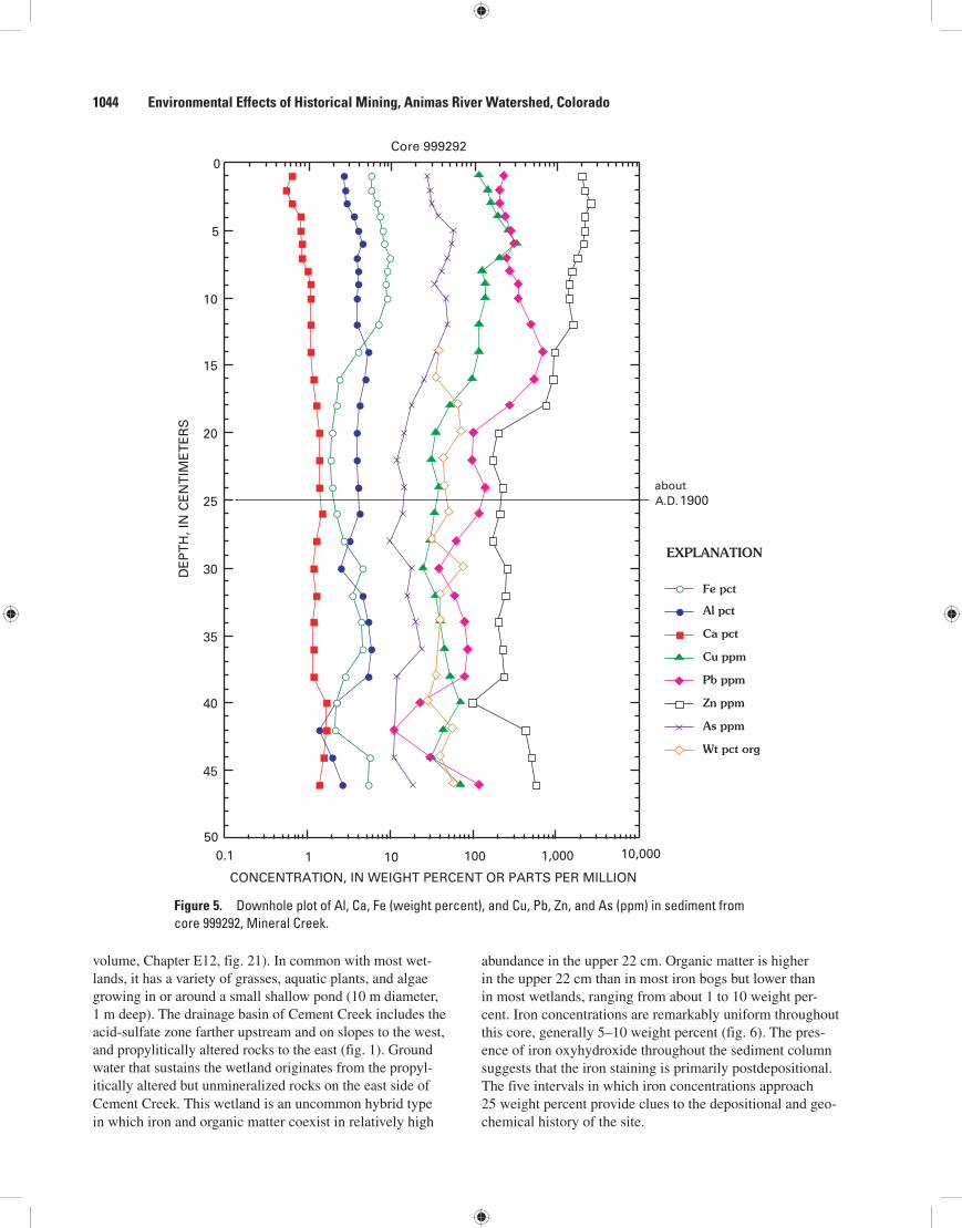
volume, Chapter E12, fig. 21). In common with most wet-lands, it has a variety of grasses, aquatic plants, and algae growing in or around a small shallow pond (10 m diameter, 1 m deep). The drainage basin of Cement Creek includes the acid-sulfate zone farther upstream and on slopes to the west, and propylitically altered rocks to the east (fig. 1). Ground water that sustains the wetland originates from the propyl-itically altered but unmineralized rocks on the east side of Cement Creek. This wetland is an uncommon hybrid type in which iron and organic matter coexist in relatively high
abundance in the upper 22 cm. Organic matter is higher in the upper 22 cm than in most iron bogs but lower than in most wetlands, ranging from about 1 to 10 weight per-cent. Iron concentrations are remarkably uniform throughout this core, generally 5–10 weight percent (fig. 6). The pres-ence of iron oxyhydroxide throughout the sediment column suggests that the iron staining is primarily postdepositional. The five intervals in which iron concentrations approach 25 weight percent provide clues to the depositional and geo-chemical history of the site.
Figure 5. Downhole plot of Al, Ca, Fe (weight percent), and Cu, Pb, Zn, and As (ppm) in sediment from core 999292, Mineral Creek.
50
45
40
35
30
25
20
15
10
5
0
0.1 1 10 100 1,000 10,000
Wt pct org
As ppm
Zn ppm
Pb ppm
Cu ppm
Ca pct
Al pct
Fe pct
1900
CONCENTRATION, IN WEIGHT PERCENT OR PARTS PER MILLION
DE
PT
H, I
N C
EN
TIM
ET
ER
S
EXPLANATION
Core 999292
A.D.about
1044 Environmental Effects of Historical Mining, Animas River Watershed, Colorado
Processes Affecting Composition of Wetland Sediment 1045
Premining SedimentSediment from 74 cm to approximately 22 cm records
continuous deposition of Cement Creek-derived clastic material (pebbles, gravel, sand) and shows good correspon-dence with the geochemical and sedimentological character-istics of premining sediment at other sites in Cement Creek (Church, Fey, and Unruh, this volume, fig. 21, site B13). Thus,
the sediment likely represents premining conditions in the wet-land. With the exceptions of copper and zinc, element abun-dances are fairly uniform throughout the 74–22 cm interval. The greater variability and covariation of copper and zinc in deeper horizons (32–72 cm) may be controlled by temporal variability in ground-water chemistry or delivery of metal-rich detritus (fig. 6).
Figure 6. Downhole plot of total Al, Ca, Fe (weight percent), and Cu, Pb, Zn, and As (ppm) in sediment from core 97ABS324, Cement Creek.
As ppm
Zn ppm
Pb ppm
Cu ppm
Ca pct
Al pct
Fe pct
Railroadconstruction
Silty clay,fine-grainedsediment
Fine-grainedsediment
Silty claywith thinfibrousorganiclayers andsmall tolarge pebbles
Fine sand
Coarse tofine sand
Fine sand
Fine sandwith pebbles,silt
Coarse sand,silty/clayey
Organics,peat
Core 97ABS324
0.1 1 10 100 1,000
(Arsenic valuesbelow detectionare plotted as10 ppm)
70
60
50
40
30
20
10
0Description
CONCENTRATION, IN WEIGHT PERCENT OR PARTS PER MILLION
DE
PT
H, I
N C
EN
TIM
ET
ER
S EXPLANATION

Mean iron, lead, zinc, and arsenic are 2–3 times higher in the upper 21 cm portion of the core compared to mean values below 22 cm (table 1). Total aluminum and copper concentrations in mining-related sediment are about the same as in premining sediment (table 1).
Mining Sediment
The upper 21 cm of the core are affected by anthropo-genic activities that altered the depositional environment. A railroad bed built on the western margin of the depositional site in late 1899 (Jones, this volume) dammed an eastern chan-nel of Cement Creek and created a small artificial closed basin (fig. 7). The creation of a closed basin is clearly recorded in the lithology (increased organic matter and decreased detrital content) and trace-metal chemistry of this core.
The most striking feature in the core is the sharp decrease in the concentrations of all reported elements except iron in the 19–21 cm interval (fig. 6). Iron shows a comple-mentary steep increase in concentration to more than 40 weight percent. The decrease of all elements except iron is the result of a temporary pause in deposition of metal-bearing clastic material because of barriers put in place during railroad grade construction.
However, organic matter from nearby conifers, grasses, and aquatic plants continued to be deposited over this 3 cm interval, and ground water from the east side of Cement Creek, low in most elements except iron because of the lack of miner-alization, also continued to reach the area. Aluminum and the four trace elements are depleted in the 19–21 cm interval com-pared to samples above and below. Detectable trace-element concentrations (copper, lead, zinc) in the 19–21 cm layers show only weak relationships to solid-phase iron. The complete lack of arsenic indicates that none was available in the aqueous phase, indicating that the ground water feeding the site came from the east side of Cement Creek (Bove and others, this vol-ume). These observations suggest that neither coprecipitation of aluminum and trace metals with iron oxyhydroxide nor sorp-tion of trace metals to organic matter occurred. As a result, an iron-rich, aluminum- and trace-element-poor organic sediment formed in the 19–21 cm interval.
Even though aluminum and arsenic are known for their ability to coprecipitate with iron oxyhydroxide (Langmuir and Whittemore, 1971; Smedley and Kinniburgh, 2002), the lack of solid-phase aluminum suggests that the pH of resident water was 5.0 or less (Bigham and Nordstrom, 2000; Carlson and Kumpulainen, 2000). Another reason for the lack of aluminum is that it sorbs poorly to organic matter as the pH increases or decreases from pH 5.0, where maximum aluminum adsorption to relict algal material has been noted (Sneddon and Pappas, 1991). Additionally, adsorption of divalent metal cations to iron oxyhydroxide surfaces increases as the pH increases (Forbes and others, 1976). The greatly reduced concentra-tions of lead, copper, and zinc in the 19–21 cm interval appear to confirm that a low-pH, low-metal water occupied the site while the 3 cm of iron-organic sediment formed. A lack of
available dissolved trace elements for adsorption to iron oxyhydroxide (Jenne, 1968) or organic matter (Sneddon and Pappas, 1991) is probably the most important factor affecting sediment composition in the 19–21 cm interval.
The brief nonclastic depositional episode (about 20 years, based on the depositional rate described in the last paragraph of this section) was followed by a return to comparable major- and trace-element concentrations in the solids as a result of the mining era and resumed clastic deposition. This is represented by sediment from about 4 cm to 18 cm. During this period, solid-phase element concentrations initially rose steeply, then returned to levels 2–3 times higher than premining sediment (fig. 6). Iron was an exception and decreased to premining levels such as those seen below 22 cm. This is a dilution effect in that other elements and clastic material were once again being deposited along with iron in the sediment. The return of measurable arsenic to the 4–18 cm interval indicates that the detrital or aqueous source material was derived, at least in part, from the acid-sulfate zone upstream and to the west.
Two major reasons exist for renewed clastic deposition during the mining period. First, the railroad fell into disrepair around World War I (Jones, this volume) and the creek ulti-mately breached the railroad bed near the north end of the former channel to allow flow back into the basin. Second, a large volume of mine and mill waste was placed into upstream areas during the peak years of mining. The uniformity of all element concentrations in the 4–18 cm interval suggests that most material did have similar compositions as a result of ore-related separation and preparation processes. Milling pro-cesses increased the solid load carried by Cement Creek, and some of this detritus was deposited in the wetland.
Detritus accumulated at a relatively rapid rate in the wetland: 18 cm of material was deposited in approximately 80 years (1900–1980), a rate of about 0.22 cm/yr. The similar-ity of detritus from 4 to 18 cm (silty clay with small to large angular pebbles and organic fibers) suggests that all material in this interval was deposited under the same conditions. During World War II, the railroad rails were removed, and the bed and wooden ties left in place have become cemented by 10–15 cm high mounds of fine-grained iron oxyhydroxide to form a per-manent barrier to deposition from Cement Creek (fig. 7).
Postmining/Remediation Sediment
Above the 4 cm level, nearly all elements show a decrease in abundance of 1 to 5 times less than in the levels below. Iron is again an exception, increasing from about 5 to 35 weight per-cent in the top 3 cm of the core. At present, the basin no longer receives clastics, as evidenced by the lack of coarse-grained material (sand, pebbles) in the upper 3 cm. Organic matter is still being deposited, as evidenced by pine needles and fibrous organic matter identified in the upper 2 cm.
One possible explanation for the decline in element con-centrations (except for iron) is the result of changes in trans-portation and processing of ore beginning in 1963 (Jones, this volume). Metal-rich detritus no longer reached the depositional
1046 Environmental Effects of Historical Mining, Animas River Watershed, Colorado

Processes Affecting Composition of Wetland Sediment 1047
Figure 7. Variations in deposition of clastic (detrital) and organic sediment and iron oxyhydroxide during premining, mining, and postmining periods, site of core 97ABS324, Cement Creek.
Cement CreekRailroad bed
East upper bogdepositional basin
Upper iron bog
Ground waterfrom acid-sulfatealtered rocks
Ground water continues todeposit iron oxyhydroxidearound bog site
Thick mound ofaccumulatediron oxyhydroxide
Ground waterfrom acid-sulfatealtered rocks
Ground water from propylitically altered rocks;low concentrations of traceelementsStream channels of
Cement Creek
Present-day stream channel of Cement Creek
Cement Creek Site of east upper bogUpper iron bog
Not to scale
Fe
Fe
PreminingUpstream tributaries transport metal-bearingwater and clastics to eastern depositional site
Al, Cu, Pb, Zn, As
Al, Cu, Pb, Zn, As
Cement Creek
Railroad bed
East upper bogdepositional basin
Upper iron bog
Ground waterfrom acid-sulfatealtered rocks
Ground water from propylitically alteredrocks continues to supplydissolved iron to form iron oxyhydroxide
Thin mound ofaccumulatingiron oxyhydroxide
Core 97ABS324
Present-day stream channel of Cement Creek Premining sediment deposited
by Cement Creek
Premining sediment depositedby Cement Creek
Fe
MiningBrief interval (≈20 yrs) of nonclastic deposition (railroad barrier),
followed by resumption of deposition of clastics andmining-related detrital material
Al, Cu, Pb, Zn, As
Organic matter andiron oxyhydroxideaccumulate duringnonclastic episode.Detritus reintroducedduring mining era
Organic matter andiron oxyhydroxideaccumulate
Treatment/holding pondsupstream from site
EASTWEST
Postmining and remediation
Alluvial bar
Mining cessation (1978)Upstream water treatment (1994) results in:
Removal of trace elements by iron flocs upstream of siteLimited fluvial clastic deposition in east bog site
Flow

site and reduced the supply of mining-related detritus to the wetland. Upstream remediation begun in 1994 and continuing to the present included construction of treatment holding ponds to reduce the sediment content of water allowed to go down-stream. Iron flocs forming in upstream ponds could reduce the trace-element content of the treated water via coprecipitation, but the water could still contain dissolved iron. Similar to the formation of iron oxyhydroxide at 21–19 cm, perhaps iron-rich but trace-element-poor water released to Cement Creek eventu-ally reached the depositional site to produce solid iron phases.
However, a more likely situation is that ground water from the east side of Cement Creek has again become the major contributor of dissolved iron to the site. Interestingly, five of the seven samples in which arsenic was not detected came from the 19–21 and upper 2 cm intervals, representing points in time when arsenic-poor ground water from the east side of Cement Creek was the dominant source to the site. Solid samples in which arsenic was detected are most likely from detritus and water from the upstream (north) reaches of Cement Creek or ground water from slopes to the west that drain the arsenic-bearing acid-sulfate alteration zone (figs. 1 and 7).
Iron and Aluminum Chemistry at the Site
The measured pH of 4.5 allows a metal-deficient iron oxyhydroxide to precipitate. Aluminum is largely controlled by gibbsite solubility and nearly conservative up to pH 5.0 (Bigham and Nordstrom, 2000), and thus, should remain in solution and not precipitate. The solid-phase data for high-iron sediment are consistent with aluminum chemistry in acid waters, that is, a decrease in solid-phase aluminum is observed where iron oxyhydroxide dominates the sediment (fig. 8). Thus, an iron-rich but metal-depleted iron oxyhydrox-ide mixed with organic matter and fine-grained (windblown?) detritus has been deposited at the site since mining ended.
The five iron-rich samples (1–2 cm and 19–21 cm) are characteristic of iron oxyhydroxide that forms in iron bogs (compare figs. 8A and 8B). Three of these are samples from 19–21 cm, the interval that contains the highest levels of iron in this core. The other two are from the top 2 cm of the core. These five iron-rich samples all have a similar genesis that is related to (1) a lack of detrital deposition and (2) the domi-nance of ground water from the east side of Cement Creek.
Animas River
Sulfate Reduction as a Metal Sequestration Mechanism
The Forest Queen wetland was studied in detail to determine if it is capable of attenuating influent metal and SO
42– concentrations through formation of metal sulfides,
and thus improving effluent water quality. The nearly unique location of the wetland—adjacent to an acidic, metal-bearing outflow from the Forest Queen mine adit—makes it well
suited for examination of geochemical processes that may affect sediment composition and water quality in an acid drainage regime. Abundant carbonaceous matter and dis-solved sulfate in the wetland make it a potential site of sulfate reduction and removal and storage of dissolved metals in authigenic sulfides. Iron, copper, lead, zinc, and arsenic form sulfide minerals upon reaction with aqueous H
2S (total
sulfide = H2S
(aq) + HS–
(aq)). In the absence of acid water
(pH<5) or dissolved oxygen, these sulfides are generally insoluble.
Sulfide in organic sediments is produced via reduction of sulfate ion. At surface temperatures and pressures, this is accomplished through the action of sulfate-reducing bac-teria, primarily of the genus Desulfovibrio (Berner, 1970). These microbes couple sulfate reduction with organic carbon oxidation to produce sulfide (S2–) and ultimately H
2S. Sulfate
reduction is an anaerobic process that occurs in the absence or at very low (sub-ppm) levels of molecular oxygen (O
2).
Sulfate reduction with organic matter oxidation is summa-rized by the reaction SO
42– + 2CH
2O → H
2S + 2HCO
3–, where
CH2O = organic matter. Active sulfate reduction in the Forest
Queen wetland was evidenced by an H2S odor in many core
and water samples. Sulfate reduction leads to an increase in pH via HCO
3– production. Most dissolved metals become less
soluble as pH increases towards neutral and alkaline values; pH values as high as 7 (neutral) were observed in the wetland. Metal complexation by certain organic functional groups and sorption onto mineral surfaces is also enhanced at higher pH (Forbes and others, 1976). Thus, processes that contribute to a rise in pH may help mitigate elevated concentrations of soluble metals.
Forest Queen Wetland SiteThe Forest Queen wetland is 10 km northeast of Silverton
along the Animas River at an altitude of approximately 2,990 m (fig. 1). The surface area is approximately 1 hectare, and the organic+sediment layer ranges from less than 0.1 m to at least 3 m in thickness in areas that were cored. Core locations are shown in figure 9.
During the fall sampling, the wetland surface was generally dry except for a 1–2 m wide arc of wet vegetation around the west edge of the iron oxyhydroxide pool (fig. 9). In contrast, during a visit the following spring (no sample collection), 3–4 cm of water covered about 70 percent of the wetland surface, and an odor of H
2S was noted in every
monitoring well. Drying and lowered water levels allow air diffusion and iron and organic matter oxidation to take place at greater depths in wetland sediment. Thus, processes of sulfate reduction, FeS formation, and FeS oxidation are all subject to variability as a result of seasonal changes.
Figure 8 (facing page). Plots of iron versus aluminum in A, core 97ABS324 (a mixed organic/iron wetland), and B, core 97ABS327 (an iron bog).
1048 Environmental Effects of Historical Mining, Animas River Watershed, Colorado

Processes Affecting Composition of Wetland Sediment 1049
1
2
3
4
5
6
7
8
9
0 5 10 15 20 25 30 35 40 45
IRON, IN WEIGHT PERCENT
ALU
MIN
UM
, IN
WE
IGH
T P
ER
CE
NT
r2 = 0.84
97ABS324
A
0
1
2
3
4
5
6
7
ALU
MIN
UM
, IN
WE
IGH
T P
ER
CE
NT
5 10 15 20 25 30 35 40 45 50
IRON, IN WEIGHT PERCENT
r2 = 0.71
97ABS327
B

As a result of geologic and anthropogenic processes, surficial material in and around the wetland is composed of differing amounts of country rock, road and railroad aggre-gate, mine-waste rock and tailings, and river-transported tailings and sediment from upstream locations (fig. 9). Rocks surrounding the site are mainly propylitically altered volca-nics of the Burns Member of the Silverton Volcanics, but a
few isolated areas of WSP (east) and QSP (west) alteration are present (fig. 1). Landslides of unknown age from slopes above the wetland have deposited country rock rubble into the wetland area. Most country rock in the area contains visible pyrite, but the extent of mineralization of landslide-deposited rock is unknown. Areas east (upslope) and north (valley of the Animas River) of the wetland were mined from the late 1890s
Adit
FQ5
FQ9
FQ7
FQ4
FQ3
Acc
ess
road
Ironoxyhydroxidepool
Inflow
Inflow
Inflow
Outflow
Old railroadgrade
Pond
Pond
Pond
MINE-WASTE
PILE
Autoroad
Outflow
FOREST
QUEEN
WETLAND
Culvert
Culvert
AnimasRiver
Conifers
Conifers
0 10 METERS
Willows and grasses
Willows and grasses
N
Figure 9. Forest Queen wetland and adjacent area. Individual coring locations (numbers prefixed by “FQ”) are shown by solid squares.
1050 Environmental Effects of Historical Mining, Animas River Watershed, Colorado

Processes Affecting Composition of Wetland Sediment 1051
until the early 1950s (Jones, this volume; Bird, 1999). Rail-roads hauled the ore, and abandoned railroad beds are adjacent to the west and south edges of the wetland (fig. 9). A 4 m-high mine-waste rock mound is at the northeast margin of the wetland. Water enters the wetland from the collapsed Forest Queen mine adit, which now resembles a flowing spring. At the time of the October 1997 sampling, the adit inflow had a pH of 4.7 and contained 0.66 ppm Zn, 0.014 ppm Pb, 400 ppm SO
42–,
24 ppm Fe, and 1.8 ppm Al (Pavlik and others, 1999). Water flows from the adit down slope for about 10 m, passes through a narrow aluminum culvert, and enters a 5 m diameter by 1 m deep pool located ½ meter above the wetland surface. The pool (fig. 9) is encrusted with several millimeters of iron oxyhy-droxide. Primary surface water flow is directly west out of the pool. Water exiting the wetland ultimately discharges into the Animas River. The effluent water contains dissolved zinc that ranges from 0.12 to 0.17 ppm and dissolved lead from 0.001 to 0.008 ppm; pH of outflow water at the south edge of the wetland was 5.9 (Pavlik and others, 1999). Thus, at the time of sampling, the concentrations of lead and zinc in outflow water were only about 25 percent of those in the adit inflow. Alumi-num was also lower (0.33–0.81 ppm versus 1.8 ppm), but iron was higher in some outflow water (1.9–32 ppm versus 24 ppm), indicating that iron is mobile in the wetland environment.
Table 3 summarizes water chemistry with respect to dissolved iron species and sulfide concentrations in the Forest Queen wetland. Because the samples were composited through the entire depth of the well, they represent multiple levels in the wetland rather than discrete zones. However, these results suggest that several redox processes are occurring in close proximity within the sediment column. Water chemistry of the Forest Queen was monitored for a year both pre- and post-remediation; the data are discussed in Church, Mast, and others (this volume, figs. 7, 8, 12, and table 7).
Core Descriptions, HCl-Extractable Metal Concentrations, and AVS Recovery
Core stratigraphy, interval descriptions, total and acid-extractable major-element (Al, Fe, Ca) and trace-element (Cu, Pb, Zn, and As) abundances, loss on ignition (LOI), ash content, and total acid-volatile sulfide (AVS) recovery
(S2–(AVS)
; ppm) are illustrated in a series of downhole plots. Acid-extractable and total element concentrations are sum-marized in tables 4 and 5. The loss on ignition (LOI, weight percent) and the ash content (100–LOI) provide estimates of organic matter and mineral matter, respectively. The midpoint depth of each extracted core interval is used to identify sam-ples in tables or on downhole plots. For example, in core FQ7, the midpoint of the 107–125 cm interval is 116 cm; this value is used to place the data point on the downhole plot.
Core FQ3This core was taken 10 m southwest of the iron oxy-
hydroxide pool; the core site is not in the path of the main outflow. Analyzed samples covered a depth interval from 41 to 163 cm. Total (unleached) metal concentrations were not determined for this core, so only acid-extractable values are presented. The samples contained the lowest concentrations of acid-extractable metals of the five Forest Queen cores, and neither copper nor arsenic was detected in any acid-leach solution (table 4).
Acid-Extractable Element Concentrations and AVS
From the surface to the bottom of the core, extractable element concentrations vary only slightly as illustrated by the nearly vertical lines in figure 10. Extractable iron, lead, and zinc have their maximum abundances in the 41–71 cm interval. Iron decreased from its maximum extractable concentration (240 ppm) to the bottom of the core, whereas extractable aluminum values clustered in a narrow range from 27 to 34 ppm in all intervals. Besides iron and aluminum, zinc was the only metal present in detectable concentrations in the 6N HCl solution from all four intervals (fig. 10). Other trace metals (for example, lead) had detectable concentrations in the 41–71 cm interval but were undetectable in the two or three deeper intervals. If metal sorption was actively occurring at the site of core FQ3, it appears to have happened in the uppermost 71 cm, which consisted almost wholly of organic matter.
The 41–71 cm sample was black and had similar organic content (50–75 percent, primarily peat) to the deeper levels but no H
2S odor. The three deeper intervals were also black
but had equal or higher organic matter content (approximately
Table 3. Water chemistry parameters from five Forest Queen monitoring wells.
[Total iron, ferrous iron, and total sulfide concentrations are in mg/L. ND, not detected; --, not determined]
Sample No. pH Temp1 SpC2 DO3 Fe(tot) Fe2+ Fe3+ Total sulfideFQ3 6.9 7.8 1,970 ND 0.64 0.06 0.58 0.07FQ4 7.0 8.6 1,350 ND 0.11 ND -- 0.91FQ5 6.9 9.7 1,340 ND 1.29 ND -- 0.29FQ7 5.8 8.7 1,130 ND 1.45 0.98 0.47 0.66FQ9 6.3 10.5 1,100 ND 0.32 ND -- 0.89
1Temp, temperature in degrees Celsius (°C).
2SpC, specific conductance in microsiemens/centimeter (µS/cm).
3DO, dissolved oxygen in parts per million (ppm).

Table 4. Summary statistics for acid-extractable concentrations of major and trace elements from Forest Queen wetland cores.
[All values in parts per million (ppm). <LLD, insufficient number of samples above detection to calculate parameter]
Al Fe Ca Cu Pb Zn AsCore FQ3
Mean 30.5 97.8 47.5 <LLD 0.2 3.2 <LLDNumber 4 4 4 <LLD 2 4 <LLDMinimum 27.0 28.0 30.0 <LLD 0.1 1.6 <LLDMaximum 34 240 58 <LLD 0.2 5.9 <LLDMedian 30.5 61.5 51.0 <LLD 0.2 2.6 <LLD
Core FQ4Mean 68.5 477 33.3 0.2 0.8 6.0 <LLDNumber 6 6 6 4 6 6 <LLDMinimum 17.0 240 14.0 .05 0.6 1.1 <LLDMaximum 210 750 84 0.3 4.0 13 <LLDMedian 34.5 460 22 0.2 0.2 6.0 <LLD
Core FQ5Mean 117 197 51.4 0.6 2.6 5.7 <LLDNumber 9 9 9 7 9 9 <LLDMinimum 6.5 31.0 22 0.1 0.2 170 <LLDMaximum 210 350 80 1.1 5.4 12 <LLDMedian 120 240 50 0.5 2.7 4.9 <LLD
Core FQ7Mean 300 255 65.7 1.5 7.7 12.3 <LLDNumber 10 10 10 10 10 10 <LLDMinimum 88 44 17.0 0.2 0.6 1.5 <LLDMaximum 600 630 100 3.4 27 20 <LLDMedian 290 230 65.5 1.4 6.7 12.0 <LLD
Core FQ9Mean 59.0 133 34.0 0.2 0.5 4.1 <LLDNumber 3 3 3 1 3 3 <LLDMinimum 23 78 13.0 0.2 0.5 2.3 <LLDMaximum 92 200 55 0.2 0.6 7.1 <LLDMedian 62 120 34 0.2 0.5 2.9 <LLD
Table 5. Summary statistics for total concentrations of major and trace elements from Forest Queen wetland cores.
[Al, Fe, and Ca in weight percent; Cu, Pb, Zn, and As in parts per million (ppm)]
Al Fe Ca Cu Pb Zn AsCore FQ4
Mean 3.9 34.5 1.4 140 142 2,030 34Number 6 6 6 6 6 6 6Minimum 2.2 6.1 1.0 44 95 170 9.0Maximum 8.1 48.7 2.3 215 240 3,250 48Median 2.3 44.5 1.2 145 130 2,600 42
Core FQ5Mean 5.8 18.8 1.8 115 350 1,500 38Number 9 9 9 9 9 9 9Minimum 2.2 3.4 0.5 80 90 535 6Maximum 8.4 50.1 5.4 150 525 2,810 58Median 7.0 9.4 1.1 110 425 1,210 39
Core FQ7Mean 8.5 3.7 0.8 120 635 1,120 40Number 10 10 10 10 10 10 8Minimum 7.6 3.0 0.6 52 230 625 8.0Maximum 10.9 5.4 1.0 180 1,600 2,250 73Median 8.2 3.4 0.8 115 480 860 34
1052 Environmental Effects of Historical Mining, Animas River Watershed, Colorado

Processes Affecting Composition of Wetland Sediment 1053
75 percent, primarily wood fragments) and a strong H2S odor.
The black color in all four intervals and H2S odor in the lower
three intervals suggested the presence of FeS, yet trace-metal abundances in the AVS-leach solution of these sample inter-vals were low compared to cores FQ4 and FQ5 (table 4).
The low concentrations of extractable metals in core FQ3 were unexpected because the moderate to high yields of S2–
(AVS) below 71 cm indicated abundant FeS and thus poten-
tial immobilization of metals in AVS solids. The relative lack
of extractable metals in core FQ3 suggests that the area was not well connected hydrologically with inflow (surface and possibly subsurface) water at depths greater than about 71 cm. Alternatively, metals may be most strongly associated with iron oxyhydroxide above 41 cm. When the core was extracted, the wetland surface was damp but not flooded, and upper core material was coated by large amounts of iron oxyhydroxide, suggesting little recent flow of water into the area and oxidation of aqueous iron.
Black, 75 percentorganic matter,wood fragments;minor clasticsediment;strong H2S odor
Black, 75 percentorganic matter,wood fragments;minor clasticsediment;strong H2S odor
Dark brown to black, 50-75percentorganic matter,wood fragments;minor clasticsediment; strong H2S odor
Black,50-75 percentorganic matter;no woodfragmentsor H2S odor;minor clasticsediment
132
102
163
71
41
0.01 0.1 1 10 100 1,000
AVS ppm
Zn ppm
Pb ppm
Ca ppm
Fe ppm
Al ppm
DE
PT
H, I
N C
EN
TIM
ET
ER
S
Core FQ3
CONCENTRATION, IN PARTS PER MILLION
(Values belowdetection limitsare not plotted)
EXPLANATION
woodfragments
Description
Figure 10. Plot of acid-extractable major- and trace-element concentrations with depth, Forest Queen core FQ3.

Core FQ4This core was taken 10 m directly west of the iron oxyhy-
droxide pool and directly in the path of the major surface out-flow from the pool (fig. 9). The length of analyzed core covers the interval from 20 to 152 cm. Sediment above approximately 81 cm was primarily organic rich, clast-free material; sediment below about 81 cm contained clay and sand mixed with organic matter. In addition to composite samples, a “discrete” 1 cm sample at 41 cm was taken to examine the effect that compos-iting had on the metal values. The 20–41 cm interval and the 41 cm discrete sample were macroscopically identical, consist-ing of homogeneous, iron-stained organic matter. Total metal concentrations between the composite and discrete samples dif-fered by ±1.8 percent for aluminum and ±5.3 percent for iron.
Total Element Concentrations
Total iron, aluminum, and calcium concentrations in the upper four organic-rich intervals (0–81 cm) varied only slightly from their mean values over these intervals. Iron varied by ±7.5 percent, aluminum varied by ±3.5 percent, and calcium varied by ±14 percent. Copper, lead, zinc, and arsenic showed similar uniformity in abundances in the upper organic intervals. Thus, the relatively homogeneous organic horizon (down to about 81 cm) showed fairly uniform metal concentrations, sug-gesting a similar source of metals and mode of sequestration in these intervals. Periodic flushing of the pool (spring runoff?) probably results in transport of additional amounts of solid iron oxyhydroxide to surficial sediment in this part of the wetland.
In the 99–117 cm interval, most metal concentrations decreased but then showed slight enrichment in the bottom interval at 147 cm. For example, total iron at 147 cm increased from 6.1 to 15.9 weight percent. The sharp drop in metal concentrations, followed by an increase, suggests that another source of metal (other than percolating surface water) is avail-able to the sediment.
Acid-Extractable Metal Concentrations and AVS
The percentages of extractable metals ranged from around 0.5 to 4 percent within the organic layers up to the 81 cm depth (fig. 11). Below the 61–81 cm interval, the per-centages of extractable iron, lead, and zinc increased down to the 98–117 cm black, organic-rich interval. The percentage of extractable iron then showed a sharp decrease in the bottom interval whereas the percentages of extractable lead and zinc increased.
In contrast to the variation in extractable iron, extract-able aluminum generally increased with depth and reached its maximum extractable abundance (1.5 percent; 210 ppm) in the deepest interval. Zinc and lead tended to follow aluminum in this respect. The downhole increases in extractable metals such as aluminum are likely the result of a larger proportion of silicate sediment in the deeper levels of the core.
HCl-extractable lead and zinc were found in relatively higher concentration in two different intervals in core FQ4. High extractable zinc and lead concentrations were at 41 cm
and at the bottom of the core (fig. 11). This result is similar to core FQ3 in that a peak in extractable zinc was seen in the uppermost (organic) 60 cm of core. Perhaps zinc is being adsorbed by organic matter as metal-bearing water flows over and (or) percolates into the surficial organic layers. Alternatively, the dominantly dark gray color of sediment in the upper 60 cm was indicative of FeS, and moderate AVS yields were obtained from these intervals, suggesting that perhaps metals were also being sequestered into AVS-related phases. The coincidence of high zinc with high AVS at 41 cm strongly suggests that the extractable zinc is within an AVS solid. Although both organic matter adsorption and authigenic sulfide mineral formation processes may be operative in the upper 60 cm, the relative magnitude of each is not quantifiable with the data at hand. Extractable copper was present only in the four upper organic samples, but not in silicate sediment intervals below approximately 81 cm.
AVS (acid-volatile sulfide) data from core FQ4 indicated that sulfate reduction ceases below approximately 102 cm in this area. No sulfide was recovered from the 6N HCl leach of two of the deepest intervals in this core (fig. 11).
In the interval 41–61 cm, extractable iron, copper, lead, and zinc contents are probably more closely associated with organic matter or iron oxyhydroxide because S2–
(AVS) recovered
from the 6N HCl leach was low (16.8 ppm). Below about 81 cm, extractable zinc and lead increased whereas AVS recovery dropped to zero. The black organic layer centered at 108 cm showed lower total zinc and lead concentrations compared to lighter colored organic layers. Black lenses at 142–152 cm initially suggested the presence of FeS, but the zero yield of AVS indicated only organic sources of the black coloration. Thus, in the deepest intervals (below about 81 cm), zinc and lead were associated with organic matter but not iron oxyhydroxide or FeS, because the latter two phases were essentially absent.
Core FQ5Core FQ5 was taken about 10 m northwest of the iron
oxyhydroxide pool; it represents an interval from 0 to 183 cm. The area receives substantial inflow from the iron oxyhy-droxide pool as a result of a breach in the pool wall. Similar to core FQ4, the upper 61 cm is organic rich with increasing clastic content in deeper intervals.
Total Element Concentrations
Total metal concentrations were uniform for almost the entire depth of this core, with increases of 2 to 5 times as much iron, calcium, and zinc near the base (165–173 cm) compared to the interval immediately above. Total metal concentrations in approximately the upper 60–80 cm were similar to those in core FQ4: iron ranged from 37 to
Figure 11 (facing page). Plot of total element concentrations, organic matter, AVS yield, and percentage of acid-extractable elements with depth, Forest Queen core FQ4.
1054 Environmental Effects of Historical Mining, Animas River Watershed, Colorado

Processes Affecting Composition of Wetland Sediment 1055
Light gray brown;organics and peatdominant (50-75pct), mainly rootsw/ some wood chips;visible Fe-oxidestaining at bottomof interval
Dark gray; >50 percent peat andorganic matter (roots);oxidized Fe stains on50 percent of surface
Dark-gray and red(Fe-oxide)-stainedorganic matter andpeat ( 75 percent)
Organic rich( 60 percent)w/ red Fe staining;minor clay and sand;H2S odor in interior
Clay w/ high organics;a few black lenses(FeS?)
Clay + organics,small black lenses(FeS?)
Black, organic richw/ clay
Black, organic rich
Gray, coarse sand
Gray clay w/30 percent organics
Mixed gray clayand sand;minor black lenses(FeS?)
0
20
41
61
81
98
117
127
142
152
Description Core FQ4
CONCENTRATION, IN WEIGHT PERCENT OR PARTS PER MILLION PERCENT LEACHED
Values below detection limitsare not plotted
*All arsenic leachate valueswere below the detection limitof 0.2 ppm
As above
No sampleanalyses in0-20 cminterval
No sampleanalyses in81-98 cminterval
No sampleanalyses in117-142 cminterval
Total As ppm
Total Zn ppm
Total Pb ppm
Total Cu ppm
Total Ca pct
Total Al pct
Total Fe pct
0.1 10 1,000 2 4 6 8
Pct As leached*
Pct Zn leached
Pct Pb leached
Pct Cu leached
Pct Ca leached
Pct Al leached
Pct Fe leached
EXPLANATION
DE
PT
H, I
N C
EN
TIM
ET
ER
S
AVS ppm
Wt pct org
Sand
Clay
Silty/clayey sandFeS(?) lenses
Organic matter
50 percent organic matter
Sediment Type
20 40 800 60

50 weight percent, and aluminum was relatively uniform at about 2–2.5 weight percent. The similar iron and aluminum values in cores FQ4 and FQ5 are likely the result of their close proximity to surface flow out of the iron oxyhydroxide pool. And as in core FQ4, an enrichment of iron occurred in a deeper interval (165–173 cm), to 9.4 weight percent.
Acid-Extractable Element Concentrations and AVS
The percentage of extractable metals generally increased with increasing depth (fig. 12), with lower extractable concen-trations in the uppermost intervals (above 81–102 cm). Recov-erable sulfide was variable in the intervals above 102 cm but showed some sharp increases with depth. Extractable copper showed strong correlations with organic matter (r = 0.93) and with acid-volatile sulfide (AVS) (r = 0.94); extractable zinc showed a strong correlation with organic matter (r = 0.92). Correlation coefficients of extractable copper, lead, and zinc with total iron were less than 0.6.
The organic-rich intervals (from 81 to 145 cm) were separated by a gray layer of silt-clay sediment at 102–122 cm (fig. 12). This silt-clay layer showed evidence of iron oxida-tion, primarily rootlets whose outer surfaces were colored red (assumed to be iron oxyhydroxide). This clastic layer has extractable metal contents similar to those in the relatively organic rich layers that encompass it, indicating that both clastic and organic layers can contain similar amounts of HCl-extractable metals.
Two black intervals with a strong H2S odor (122–145
and 145–165 cm) produced the highest AVS yields in the core, and showed high extractable copper, lead, and zinc concentra-tions, strongly suggesting that metals are associated with AVS. In contrast, the interval immediately beneath (165–173 cm) showed a sharp decrease in all acid-extractable element concen-trations even though AVS remained moderately high. This inter-val contained 20 percent clay, along with some woody material; it had a slight H
2S odor. The bottom interval (173–183 cm)
exhibited an increase in extractable lead and zinc concentra-tions, but the AVS yield decreased to only 15 ppm. These variations in extractable metal concentrations and AVS indicate that a significant AVS yield can, but does not always, indicate enrichment of extractable metals in AVS.
The similarity of total metal abundances in clastic and organic horizons in core FQ5 suggests that both types of sedi-ment are equally capable of sorbing metals in the wetland. The residence of metals within specific mineral phases in the clastic sediment or specific compounds in the organic fraction is not known. The extractable metals are likely loosely bound on mineral surfaces or within highly acid soluble phases like (noncrystalline) iron oxyhydroxide.
Core FQ7
Core FQ7, about 45 m west of the iron oxyhydroxide pool on the west edge of the wetland, encompasses a 0–246 cm interval; the site is surrounded on three sides by ponded water (fig. 9). Core FQ7 is the deepest of the cores, and it illustrates the complexity of the wetland stratigraphy, as organic-rich
upper layers are underlain by increasingly clastic (clay, silt, and sand) sediment with depth. Iron staining was present in the upper 0–16 cm and in the 59–68 cm interval. Except for deeper clastics, the sediment was dark gray brown to black with sev-eral intervals exhibiting an H
2S odor.
Total Element Concentrations
Total major-element concentrations in core FQ7 were much lower than in core FQ4 or FQ5 and showed little varia-tion with depth (fig. 13). For example, iron ranged from 3 to 3.5 weight percent in intervals to approximately 190 cm. In contrast, total iron in cores FQ4 and FQ5 approached 50 weight percent in the upper 60–70 cm. In common with cores FQ4 and FQ5, however, a slight increase (to 5 weight percent) in the total iron concentration was seen near the bottom of the core (about 200 cm). The low total iron concentrations probably reflect the lack of transport of solid or aqueous iron to this area of the wetland.
Total aluminum was higher in most intervals in core FQ7 than in comparable intervals in core FQ4 or FQ5. The increas-ing clastic content in core FQ7 is likely the result of an increasing contribution to sediment deposition by the Animas River in lower intervals and windborne deposition in higher intervals. A slight enrichment of zinc and lead was present in the 41–71 cm interval, and this coincides with a peak in AVS recovery and a black zone of organic matter, suggesting that lead and zinc may be hosted in an AVS phase.
Acid-Extractable Element Concentrations and AVS
Figure 13 shows variations in extractable aluminum and iron in deeper intervals (approximately 183–246 cm) that sug-gest significant changes in local chemistry or sediment com-position. The average organic matter content was lower in this core (40.7 weight percent) compared to core FQ4 (58.9 weight percent) and core FQ5 (43.3 weight percent), which suggests that a higher proportion of clastic material has been deposited along with the organic material. Because the sulfide content was fairly uniform over the 150–246 cm interval, and iron oxyhydroxide staining was minor, increasing clastic content is likely responsible for the varying acid-extractable element concentrations.
Scatter diagrams of iron, copper, zinc, and lead versus S2–
(AVS) (fig. 14) indicate two sample populations in core FQ7.
This is interpreted as two different associations of each metal—an amount associated with monosulfide or organic matter, and an amount associated with sparingly soluble sul-fide minerals. Detrital sulfide-bearing minerals within clastic-rich horizons are derived from sources such as mineralized country rock, or deposit-related material spilled from railroad cars or used for road ballast. (The proximity of this core to the
Figure 12 (facing page). Plot of total element concentrations, organic matter, AVS yield, and percentage of acid-extractable elements with depth, Forest Queen core FQ5.
1056 Environmental Effects of Historical Mining, Animas River Watershed, Colorado

Processes Affecting Composition of Wetland Sediment 1057
Black,some red staining,strong H2S odor
Black,organic rich,strong H2S odor
Brown, peat andorganic rich,minor clastic sediment,no H2S odor
20 percent clay,woody fragments,minor H2S odor
Dark gray,some blackspecks/lenses(FeS?). Strong H2S odorSlightly sandy
Gray sand, silt,and clay.Red stringers oforganic rootlets(Fe-oxidation?)
Core FQ5
CONCENTRATION, IN WEIGHT PERCENT OR PARTS PER MILLION
Med. gray,sandy and clayey,organic rich andvisible Fe-oxide
Black, 50 percentorganics
Dk. brown, >50percent organics
Dark gray toblack, 30 percentorganics
Description
122
145
165
173
183
102
8176
69
61
0
Total As ppm
Total Zn ppm
Total Pb ppm
Total Cu ppm
Total Ca pct
Total Al pct
Total Fe pct
2 4 6 8
Pct As leached*
Pct Zn leached
Pct Pb leached
Pct Cu leached
Pct Ca leached
Pct Al leached
Pct Fe leached
PERCENT LEACHED
EXPLANATION
100.1 1,000
DE
PT
H, I
N C
EN
TIM
ET
ER
S
AVS ppm
Wt pct org
Values below detection limitsare not plotted
*All arsenic leachate valueswere below the detection limitof 0.2 ppm
Wood fragments
Sand
Clay
Silty/clayey sand
FeS(?) lenses
Organic matter
Sediment Type
1054515 75
(144)
> 50 percent organic matter
50 percent organic matter

Core FQ7
Dark gray clay/silt, wood frags.
Sandy w/ yellow grainsmixed w/ gray, finer grainedmatrix, some organic matter(rootlets, sm. wood fragments)
Red-brown peat andorganic material,minor clastic sediment;small lens of gray clays
Dark-gray clay, silty; FeS2(?); 10 percent organic matter
Brown to dark-gray clay,minor sand and silt; 20 percent organic matter (wood fragments),very slight H2S odor
Sandy;minor Fe-oxidestaining (yellowand orange),FeS2(?), minororganic matter
Dark gray,approx. 50 percentgray clay and sand;50 percent organicmatter (rootlets,wood fragments)
Dark brown to red,50 percent organicmatter (peat, root mat);minor clasticsediment
Clayey,organic rich (peat);dark-gray toblack zoneand graysandy/clayeylenses
Dark-gray togray sands,minororganics
Description
221226
246
206
183
173
150
102
71
41
0
0.1 10 1,000 4 8 1220 40 60
CONCENTRATION, IN WEIGHT PERCENT OR PARTS PER MILLION PERCENT LEACHED
DE
PT
H, I
N C
EN
TIM
ET
ER
S
Values below detection limitsare not plotted
EXPLANATION
Total As ppm
Total Zn ppm
Total Pb ppm
Total Cu ppm
Total Ca pct
Total Al pct
Total Fe pct
Pct As leached
Pct Zn leached
Pct Pb leached
Pct Cu leached
Pct Ca leached
Pct Al leached
Pct Fe leached
AVS ppm
Wt pct org
Wood fragments
Sand
Clay
Silty/clayey sand
Organic matter
Sediment Type
50 percent organic matter
1058 Environmental Effects of Historical Mining, Animas River Watershed, Colorado

Processes Affecting Composition of Wetland Sediment 1059
old railroad bed and present auto road suggests that contami-nation from detrital material is a possibility in this area of the wetland.) The clastic material, particularly if it consisted of larger grains or FeS
2, ZnS, or PbS, would not easily dissolve
in 6N HCl. However, much of the clastic material is at too great a depth to have been deposited by anthropogenic means (mining, railroad and road building). Thus, it appears that the original detritus deposited at the base of the Forest Queen wetland was enriched in extractable lead and zinc.
The gently sloping lines on the right sides of figure 14, views A–D, indicate slightly increasing metal content with large increases in monosulfide. Steeply sloping lines on the left sides of views A–D, where metal content increases sharply with only slight increases in monosulfide, indicate the deposit-related sulfide (detrital) component.
A traverse of the wetland from east to west (from core FQ3 towards core FQ7) indicates a change in the sedi-ment from a high organic content to an increasingly clastic content, particularly below about 60 cm. Ages for the deeper clastic sediments were not determined, but based on ages of similar depth horizons in other dated wetlands from Mineral and Cement Creeks, they were probably deposited by the Animas River prior to building of the railroad and automobile road.
Vincent and Elliott (this volume) obtained 14C dates for several layers in the Forest Queen wetland. An accumulation rate of approximately 1 m peat (organic matter) per 1,000 years (0.1 cm/yr) was postulated for the “growth” of the wetland. Thus, the metals found in sediment below about 100 cm prob-ably were deposited prior to mining. However, more exact methods (for example, 210Pb geochronology or isotopic work) would be needed to determine the timing of metal fixation dur-ing wetland accumulation.
Core FQ9
This core was taken approximately 25 m southwest of the iron oxyhydroxide pool. Core FQ9 was a short interval (0–76 cm) and consisted almost wholly of organic material. Because of the limited length and consistent composition, only three samples were analyzed from this core. (Only HCl-extractable concentrations and AVS recovery are given because the samples were not analyzed for total metal con-centrations.) Organic content was 60–80 weight percent in the upper 61 cm; iron oxyhydroxide staining was noted primarily in the upper 0–20 cm. In the lowest 61–76 cm, organic matter made up about 40 percent of the sample and iron oxyhydrox-ide staining was not observed. Unidentified mineral(s) in the 61–76 cm interval resembled pyrite, but the presence of FeS
2
in the sample was not confirmed.
Acid-Extractable Element Concentrations and AVS
The middle interval (20–61 cm) produced the largest sulfide yield of all samples (430 ppm). The moderate to high yields of sulfide from all three core samples indicated high sulfate reduction activity in this part of the wetland. However, the abundant iron oxyhydroxide in the upper 20 cm indicated that a strongly reducing environment was not present in shal-low horizons at the time of sampling.
As figure 15 illustrates, acid-extractable element abun-dances varied little and showed similar trends with depth in this core. Extractable iron, aluminum, and calcium showed system-atic but slight increases in concentrations from the 0–20 cm interval to the 61–76 cm interval.
Despite the moderate to high sulfide yields from all intervals, extractable trace metals were relatively low in these core samples (fig. 15). Acid-extractable zinc ranged from 2.3 to 7.1 ppm, and similar to most cores, was in greatest abundance in the uppermost sample (0–20) cm rather than in deeper samples. Extractable lead was present in low concen-tration, ranging from 0.49 to 0.61 ppm. Extractable aluminum and iron concentrations were among the lowest of all cores (23 and 78 ppm, respectively, in the uppermost interval); in other cores, extractable aluminum and iron in the top interval gener-ally exceeded 30 ppm and 130 ppm, respectively.
High AVS yields in core FQ9 were associated with only relatively small concentrations of extractable metals, suggest-ing that perhaps metal trapping by monosulfide is inefficient. Another explanation for the low extractable metals is that the flux of dissolved metals to the site is low. Considering that the site of core FQ9 is 25 m downgradient from the source surface water, and that surface water likely does not reach this site except during high flow in the spring, low metal flux is the preferred explanation for the relative lack of enrichment in this core. The low extractable iron and aluminum in the top interval also point to a low metal flux.
Summary of Acid-Extractable Element Concentrations and Acid-Volatile Sulfide for Animas River Cores
Yields of acid-volatile sulfide (ppm S2–(AVS)
) varied widely from sample to sample in each core. The highest yields (≥200 ppm) came from dark (black, brown), organic layers. The lowest yields (0–10 ppm) came from lighter colored or red (iron oxyhydroxide stained) organic or silicate sediment layers. Intermediate AVS yields (≥10–200 ppm) were from dark-gray to brown organic layers and from silicate sediment with small black lenses that appeared to be fresh FeS forming in place. Inspection of figures 10 through 13 and 15 illustrates that AVS yield is not a reliable indicator of extractable metals concentra-tions. The variable trace-metal concentrations associated with the AVS indicate that, in the absence of a significant AVS frac-tion, extractable metals are associated with other phases, such as organic matter, clastic (silicate or sulfide) sediment, and iron oxyhydroxide.
Figure 13 (facing page). Plot of total element concentrations, organic matter, AVS yield, and percentage of acid-extractable elements with depth, Forest Queen core FQ7.

Figure 16 shows three contour maps for total iron con-centration at depths of approximately 50 cm, 110 cm, and 180 cm from cores FQ4, FQ5, and FQ7, respectively. (The iron concentration in core FQ4 at 180 cm was estimated using the mean iron value calculated with the six overlying intervals that had an iron analysis.) As these maps show, total iron in each core is relatively higher in the upper intervals, then drops to low levels in intermediate intervals, then increases once again towards the bottom intervals. Similar contour plots were obtained for most other reported elements. The increase in iron concentration near the bottom of most cores suggests that an additional, deeper source of metals is available for adsorp-tion or that the abundance of HCl-extractable detrital minerals is greater at depth.
Acid-soluble iron and aluminum exceeded several hun-dred parts per million in many samples; this is not unexpected, because of the significant contribution of dissolved aluminum and iron into the wetland from the nearby adit. Aluminum and iron concentrations in AVS leachates were relatively uniform downhole (100–500 ppm) in most cores. Increases in extract-able iron were usually seen when a red or brown zone (indica-tive of oxidized iron) was encountered; extractable aluminum concentrations generally increased where a clastic sediment layer was present.
Examination of the percent leached plots in figures 11 and 12 (cores FQ4 and FQ5) shows that extractable lead and zinc concentrations generally increased with depth and from south to north. The increase in core FQ5 extractable metal
0
1
2
3
0 5 10 15 20
CO
PP
ER
, IN
PA
RT
S P
ER
MIL
LIO
N
TOTAL AVS, IN PARTS PER MILLION
LEA
D, I
N P
AR
TS
PE
R M
ILLI
ON
TOTAL AVS, IN PARTS PER MILLION
0
2
4
6
8
10
0 5 10 15 200
4
8
12
16
20
0 5 10 15 20
ZIN
C, I
N P
AR
TS
PE
R M
ILLI
ON
TOTAL AVS, IN PARTS PER MILLION
100
200
300
400
500
600
700
0 5 10 15 20
IRO
N, I
N P
AR
TS
PE
R M
ILLI
ON
TOTAL AVS, IN PARTS PER MILLION
0
A
B
C
D
Figure 14. Scatter diagrams of A, iron; B, lead; C, copper; and D, zinc versus S2–(AVS), showing relationships of trace-
metal content to total recoverable sulfide in core FQ7. (An outlying sample (40–59 cm) is excluded. When included, it “forces” a strong correlation with lead, but the other three metals show little change in correlation with sulfide.)
1060 Environmental Effects of Historical Mining, Animas River Watershed, Colorado

Processes Affecting Composition of Wetland Sediment 1061
concentrations resulted from its receiving direct surface flow out of the iron-coated pool and its location at the base of the mine-waste pile, which could have provided an additional sup-ply of mobile metals.
The percent leached plots in figures 11 and 13 (cores FQ4 and FQ7) show that extractable lead and zinc concentrations tend to decrease from east to west. Again, the decrease in core FQ7 results from its having been taken farther away from the source water than core FQ4.
These results suggest that lead and zinc fixation happens closest to the adit (source) water and that fixation decreases as water percolates from the upper organic layers downward to the middle intervals. Some high percentages of extractable lead and zinc are found in the deepest parts of cores FQ4, FQ5, and FQ7 (figs. 11–13). Similar to the results for total iron, these higher values of extractable lead and zinc suggest other source(s) of metals for sorptive sites or higher concentra-tions of HCl-soluble minerals.
Figure 15. Downhole plot of acid-extractable major- and trace-element concentrations, Forest Queen core FQ9.
Core FQ9
Brown toreddish-brownroot mat.Nearly 80-90percent peatplus organics;minor sandand clay
Dark brown,50-75 percentpeat and organics,mainly roots w/ somewood fragments,Fe-oxide stainingat bottom of sample
Gray clay w/30-40 percentpeat and organics(black).WeatheredFeS2(?) inclay zone
Description
61
76
20
0
CONCENTRATION, IN PARTS PER MILLION
0.1 1 10 100 1,000
AVS ppm
Zn ppm
Pb ppm
Cu ppm
Ca ppm
Al ppm
Fe ppm
DE
PT
H, I
N C
EN
TIM
ET
ER
S
(Values belowdetection limitsare not plotted)
EXPLANATION

Conclusions
Importance of Metal-Rich Inflow as a Control on Metal Content of Wetlands
Wetland sediments sampled in this reconnaissance of the Animas River watershed study area vary in their ability to act as sinks for dissolved metals. Wetlands from South Fork Mineral Creek that receive relatively metal poor drain-age showed the lowest levels of metal enrichment. The site of core FQ3 in the Forest Queen wetland did not receive sufficient inflow of metal-bearing surface water, and as a result, core FQ3 had among the lowest extractable metal concentrations in that wetland. Furthermore, core FQ7 showed total iron concentra-tions about 10 times lower than cores FQ4 and FQ5, whose sites were located closest to the source inflow.
In contrast, wetlands along Mineral and Cement Creeks receive both non-mining affected and mining-related acid drainage as well as eolian deposition of mining (waste) material originating from acid-sulfate altered rocks. The abundance of metals in cores from these wetlands was highly dependent on variations in supply, but consistently recorded an overall greater flux of dissolved metals to these sites. Sediment directly in the path of surface flow in the Forest Queen wetland (cores FQ4 and 5) showed evidence of enhanced metal flux and as a result, higher total and extractable metal concentrations. Nearly every core studied showed higher total metal concentra-tions in deeper sediment, even those along South Fork Mineral Creek, which strongly suggests some interaction with metal-bearing ground water.
Relative Importance of Different Sorbents or Contributors within Individual Wetlands
Adsorption of metals by organic matter is clearly opera-tive but appears to play a more prominent role in accumula-tion of elements in some wetland sediment (for example, core 999292). In most wetland sediment, clastic detritus appears to correlate with lower abundances of total and extractable metals.
Iron monosulfide provides a host for metal removal and storage but is highly variable in abundance in individual wet-lands; it is therefore unlikely to be a major contributor to metal fixation in the studied wetlands.
In the Forest Queen wetland, total iron approached 50 weight percent in some near-surface samples. Total and extractable trace-element concentrations were correspondingly
FQ3
FQ4
FQ5
FQ7 FQ9
FQ10
20
32
40
8
20 32 40 488
0 10 20 30 40 50 60
10
20
15
25
0
-5
5
Contour interval = 4.0 (total iron, weight percent)
A
DIS
TAN
CE
, IN
ME
TE
RS
DISTANCE, IN METERS
FQ3
FQ4
FQ5
FQ7 FQ9
3
1
1
3 51
DISTANCE, IN METERS
DIS
TAN
CE
, IN
ME
TE
RS
0 10 20 30 40 50 60
10
20
15
25
0
-5
5
Contour interval = 0.4 (total iron, weight percent)
B
DIS
TAN
CE
, IN
ME
TE
RS
DISTANCE, IN METERS
Contour interval = 2.0 (total iron, weight percent)
10
20
15
25
0
-5
5
0 6010 20 30 40 50
FQ3
FQ4
FQ5
FQ7 FQ9
FQ10
9
5
1
9 135
1
C
FQ10
Figure 16. Contour maps showing maximum concentrations of total iron at three different depths in Forest Queen wetland. A, depth 50 cm; B, 110 cm; C, 180 cm. Core locations shown are approximate and based on using the point labeled FQ10 as the origin.
1062 Environmental Effects of Historical Mining, Animas River Watershed, Colorado

Processes Affecting Composition of Wetland Sediment 1063
higher in these horizons, indicating that solid iron oxyhydrox-ide is important in removing dissolved species from surface water. Compared to the adit and upstream (surface) waters, lead, zinc, and aluminum are lower in the wetland outflow, but iron is leaving the wetland in concentrations greater than in the influent waters. At a pH of 5.9 in outflow water, most iron should precipitate as a solid phase. Thus, iron detected in outflow water was probably a colloidal form.
The composition of the Forest Queen sediment in cores FQ4 and 5 approached that of the Cement Creek samples with respect to some trace elements (compare tables 1 and 4), illustrating that coprecipitation with iron oxyhydroxide and adsorption by organic matter can produce high degrees of enrichment. Secondary iron oxyhydroxide found at depth as a postdepositional coating in wetlands along South Fork Mineral Creek is a strong adsorbent for arsenic.
In some wetlands, the lack of high abundances of ele-ments in the solids may be the result of a lack of detrital deposition (97ABS321), a lack of precipitation/coprecipitation from the aqueous phase, or poor adsorptive capacity in sedi-ment layers.
Spatial Relationship of Metal Enrichment within Forest Queen Wetland
Proximity to input source.—Higher total and extractable iron and aluminum were in near-surface horizons closest to the adit source water (cores FQ4 and 5), whereas lower total and extractable concentrations of these metals were present in near-surface horizons in cores located farthest away from the source water (cores FQ7 and 9). The lowest leachable metal concentrations were generally in clastic or organic sediment located farthest away from or outside the path of the inflow source.
Shallow versus deep enrichment.—The presence of both shallow (above about 60 cm) and deep (below 80 cm) intervals of elevated extractable metals implies that dissolved met-als may be introduced along two different flow paths in the wetland sediment. The most obvious path is surface flow and downward percolation of metal-bearing surface (adit) water. Another potential path is shallow subsurface flow of (metal-rich? acidic?) ground water that upwells beneath the wetland (Pavlik and others, 1999). If either flow path includes sulfate-reducing zones, then metals could become initially entrapped by sorptive reaction or coprecipitation with authigenic iron monosulfide phases.
Role of AVS.—Results from the Forest Queen wetland study indicate that sulfate reduction was active, but variable with depth and location during the fall sampling period. When sampling took place, the wetland appeared to be drying out, as evidenced by low water level. The area around cores FQ3, 4, 5, and 9 showed the highest yields of AVS that indicate FeS formation. However, the highest concentrations of HCl-extractable metals were not always associated with black, AVS-bearing samples. High extractable metal concentrations
also were present in organic (but generally AVS/H2S-poor)
intervals and in intervals with prominent red iron oxyhydrox-ide solids.
Although no single explanation for the variability in extractable metal concentrations in sediment is evident, we speculate that observed seasonal variations in the hydrologic flow path in the wetland produce fluctuations in the delivery of dissolved metals to sites of sulfate reduction or iron oxida-tion within the sediment column. Alternatively, other potential sorbents along any flow path include organic matter or second-ary iron oxides. Other undefined hydrologic, geochemical, or biological factors must be influencing the mobility of metals that enter (via the adit and streams) or exit (via outflows) the wetland, such that some of the wetland metal load reaches the Animas River. This results, in part, from sulfate reduction that is discontinuous with depth and distance throughout the wetland in the fall.
Stability of Wetlands and Wetland Functions Through Time and Implications for Wetland Management and Water Quality
Wetlands in the Animas River watershed study area will likely continue to sequester metals within organic, acid-volatile sulfide, and iron oxyhydroxide solid phases. However, redistribution of metals among these phases is likely to occur in response to seasonal fluctuations in water table depths. Such changes will affect the redox conditions in near-surface layers and the stability of iron phases and organic matter. In the absence of sulfate reduction to buffer pH, metals could be redissolved by acidic inflow water that would also promote iron oxyhydroxide dissolution and desorption of metals from organics. In addition, low water levels in the fall season would allow AVS and organic matter oxidation and release of sorbed or coprecipitated metals. Thus, the combination of seasonal variations in water flow and variable flow paths produces temporal and spatial variability in the removal, storage, and release of metals in sediment of the different wetlands.
References Cited
Berner, R.A., 1970, Sedimentary pyrite formation: American Journal of Science, v. 268, p. 1–23.
Bigham, J.M., and Nordstrom, D.K., 2000, Iron and aluminum hydroxysulfates from acid sulfate waters, in Alpers, C.N., Jambor, J.L., and Nordstrom, D.K., eds., Sulfate minerals—Crystallography, geochemistry, and environmental signifi-cance: Reviews in Mineralogy and Geochemistry, American Mineralogical Society, v. 40, p. 351–403.
Bird, A.G., 1999, Silverton gold—The story of Colorado’s largest gold mine (revised edition): Lakewood, Colo., privately published, 223 p.

Briggs, P.H., 2002, The determination of forty elements in geological and botanical samples by inductively coupled plasma–atomic emission spectrometry, in Taggart, J.E., Jr., ed., Analytical methods for chemical analysis of geologic and other materials: U.S. Geological Survey Open-File Report 02–0223-F, p. F1–F11.
Carlson, Lisa, and Kumpulainen, S., 2000, Mineralogy of precipitates formed from mine effluents in Finland; Pro-ceedings of the 7th International Conference on Tailings and Mine Waste, Fort Collins, Colo., January 1999: Rotterdam, Balkema, p. 269–275.
Church, S.E., Kimball, B.A., Fey, D.L., Ferderer, D.A., Yager, T.J., and Vaughn, R.B., 1997, Source, transport, and partitioning of metals between water, colloids, and bed sediments of the Animas River, Colorado: U.S. Geological Survey Open-File Report 97–151, 135 p.
Forbes, E.A., Posner, A.M., and Quirk, J.P., 1976, The specific adsorption of divalent Cd, Co, Cu, Pb, and Zn on goethite: Journal of Soil Science, v. 27, p. 154–166.
Fortin, D., Leppard, G.G., and Tessier, A., 1993, Character-istics of lacustrine diagenetic iron oxyhydroxides: Geochi-mica et Cosmochimica Acta, v. 57, p. 4391–4404.
Jenne, E.A., 1968, Controls on Mn, Fe, Co, Ni, Cu, and Zn concentrations in soils and water—The significant role of hydrous Mn and Fe oxides, in Trace inorganics in water: Advances in Chemistry Series 73, American Chemical Society, p. 337–387.
Konhauser, K.O., Fyfe, W.S., Ferris, F.G., and Beveridge, T.J., 1993, Metal sorption and mineral precipitation by bacteria in two Amazonian river systems; Rio Solimoes and Rio Negro, Brazil: Geology, v. 21, p. 1103–1106.
Lamothe, P.L., Meier, A.M., and Wilson, S.A., 2002, The determination of forty-four elements in aqueous samples by inductively coupled plasma–mass spectrometry, in Taggart, J.E., Jr., ed., Analytical methods for chemical analysis of geologic and other materials: U.S. Geological Survey Open-File Report 02–0223–H, p. H1–H11.
Langmuir, Donald, and Whittemore, D.O., 1971, Variations in the stability of precipitated ferric oxyhydroxides, in Hem, J.D., ed., Nonequilibrium systems in natural water chemis-try: Advances in Chemistry Series 106, American Chemical Society, p. 208–234.
Pavlik, M.C., Kolm, K.E., Winkler, S., Emerick, J., Wildeman, T.R., and Robinson, Rob, 1999, Hydrogeologic controls on the geochemical function of the Forest Queen wetland, Colorado; Proceedings of 6th International Conference on Tailings and Mine Waste, Fort Collins, Colo., January 1999: Rotterdam, Balkema, p. 647–655.
Rice, C.A., Tuttle, M.L., and Reynolds, R.L., 1993, The analy-sis of forms of sulfur in ancient sediments and sedimentary rocks—Comments and cautions: Chemical Geology, v. 107, p. 83–95.
Robbins, J.A., and Edginton, D.N., 1975, Determination of recent sedimentation rates in Lake Michigan using Pb-210 and Cs-137: Geochimica et Cosmochimica Acta, v. 39, p. 285–304.
Schwertmann, Udo, and Cornell, R.M., 1991, Iron oxides in the laboratory: Weinheim, Germany, VCH Verlag, 137 p.
Sholkovitz, E.R., and Copland, D., 1981, The coagulation, solubility, and adsorption properties of Fe, Mn, Cu, Ni, Cd, Co and humic acids in a river water: Geochimica et Cosmo-chimica Acta, v. 45, p. 181–189.
Smedley, P.L., and Kinniburgh, D.G., 2002, A review of the source, behaviour, and distribution of arsenic in natural waters: Applied Geochemistry, v. 17, p. 517–568.
Sneddon, Joseph, and Pappas, C.P., 1991, Binding and removal of metal ions in solution by an algae biomass: American Environmental Laboratory, Oct. 1991, p. 9–13.
Szalay, Alexander, 1964, Cation exchange properties of humic acids and their importance in the geochemical enrichment of UO
2++ and other cations: Geochimica et Cosmochimica
Acta, v. 28, p. 1605–1614.
Theodorakos, P.M., 2002, Fluoride, chloride, nitrate and sulfate in aqueous solution utilizing autosuppression chemi-cally suppressed ion chromatography, in Taggart, J.E., Jr., ed., Analytical methods for chemical analysis of geologic and other materials: U.S. Geological Survey Open-File Report 02–0223–V, p. V1–V7.
Zanker, Harald, Moll, Henry, Richter, Wolfgang, Brendler, Vinzenz, Hennig, Christoph, Reich, Tobias, Kluge, Andreas, and Huttig, Gudrun, 2002, The colloid chemistry of acid rock drainage solution from an abandoned Zn-Pb-Ag mine: Applied Geochemistry, v. 17, p. 633–648.
1064 Environmental Effects of Historical Mining, Animas River Watershed, Colorado