process for identifying potential projects of …
TRANSCRIPT

PROCESS FOR IDENTIFYING POTENTIAL PROJECTS OF INTEREST FORCUMULATIVE ANALYSIS: EASTALCO ALTERNATIVE SITE
A reconnaissance level search for projects in the vicinity of the Eastalco alternative siteand potentially of interest for the cumulative analysis of impacts was conducted. Thesearch included reviewing information provided in UniStar's Environmental Report (ER),NRC Request for Addition Information (RAI) responses, and review team trip reportsfiled relative to the August 2009 visit to the Eastalco site, and in reviewing the results ofvarious web-based searches.
Based on information obtained during the site visit, the review team was aware that anatural gas fired power plant had been proposed but not developed at Eastalco. Thepublically available Maryland Department of Natural Resources documents"Environmental Review of the Proposed Catoctin Power Project" (available athttp://www.esm.versar.com/PPRP/bibliography/PPSE-CAT-01/Catoctin%20DNR%2012-8112006-156.pdf ) and "Proposed Extension of the Air Quality Permit and Water SupplyConditions for the Proposed Catoctin Power Project" (available athttp://www.esm.versar.com/PPRP/bibliography/PPSE-CAT-01/PPS E_CAT_01 S.pdf)along with the publically available application for a Certificate of Public Convenience andNecessity were obtained and made available to the review team.
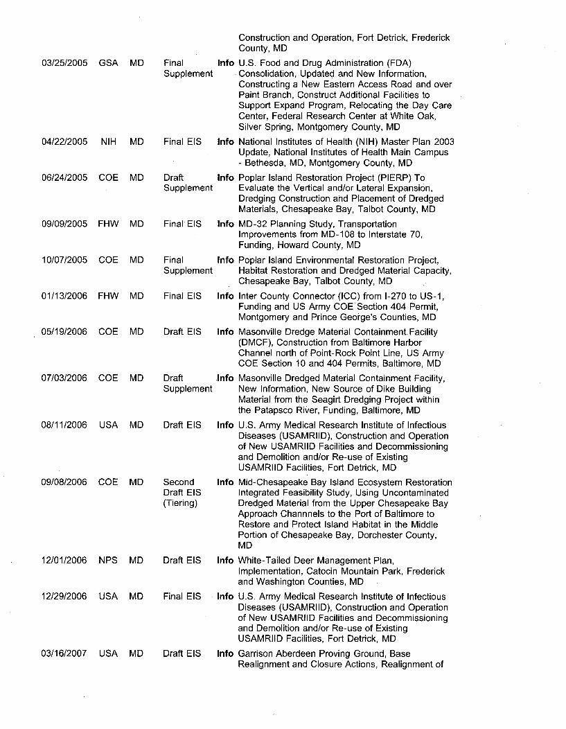
Additionally, the review team conducted web searches to identify other projects andactivities of potential interest. The review team queried an U. S. EnvironmentalProtection Agency (EPA) database for recent Environmental Impact Statements (EISs)within the State of Maryland. This produced a listing of 44 documents, shown in file"Search Results I National Environmental Policy Act (NEPA) I US EPA.pdf'. Projects onthis list within approximately 50-75 miles of Eastalco were added to a draft activitiestable. Based on its nearness to the Eastalco site, the web location of the publicallyavailable Monocacy National Battlefield General Management Plan, Implementation EIS(http://parkplanning.nps.gov/mono ) was made available to review team members.Based on its energy focus, the web location of the publically available Sparrows Pointfinal EIS (http://www.ferc.gov/industries/Ing/enviro/eis/2008/1 2-05-08-eis.asp ) also wasmade available to review team members. Based on its relationship to nuclear energyprocesses and its location, the publically available report NUREG-1873, "EnvironmentalImpact Statement for License Renewal of the National Bureau of Standards Reactor"was made available to review team members.
The U. S. EPA database of permits for water discharges in the geographic area ofEastalco was queried to identify water use projects and Superfund sites. This produceda map of discharge locations and sites, such as the one given in the file"EPANEPAssistEastalco.pdf". Hovering over a given location while online produces apopup window that identifies the permit holder.
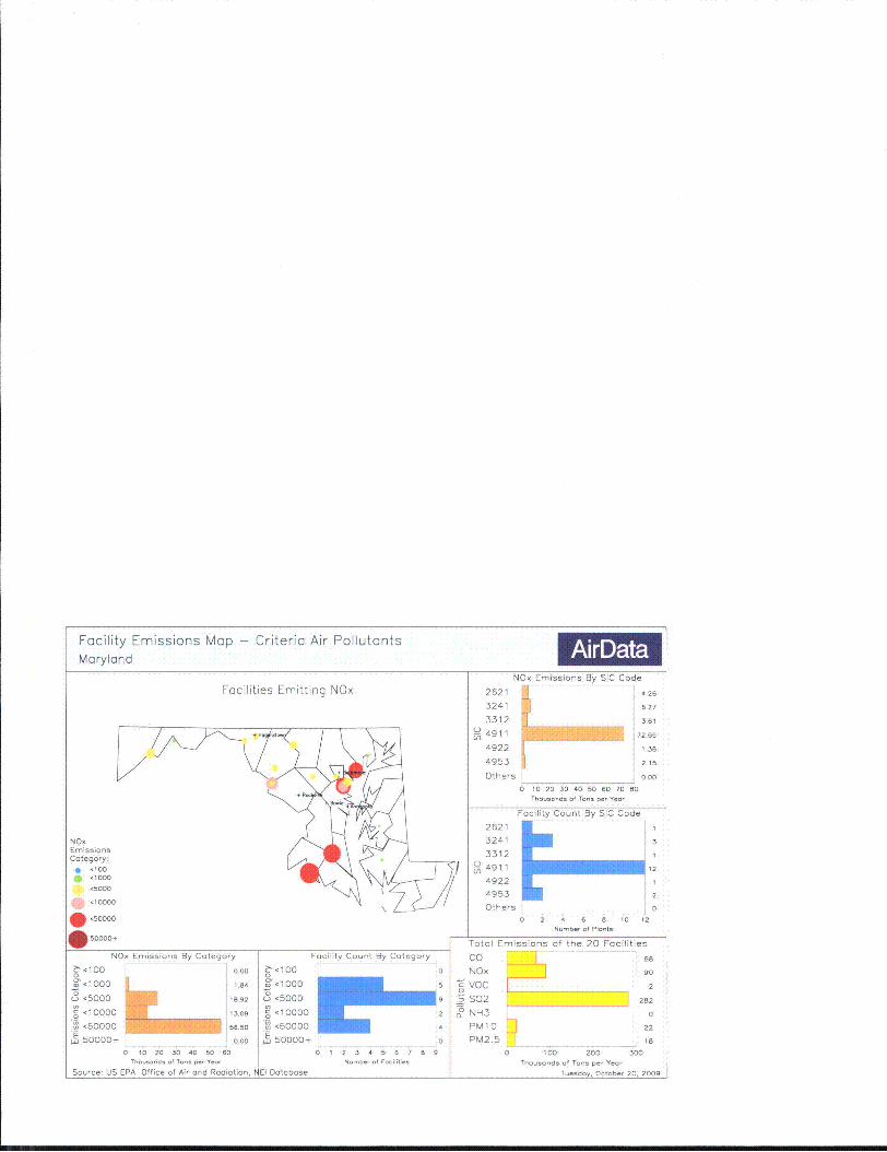
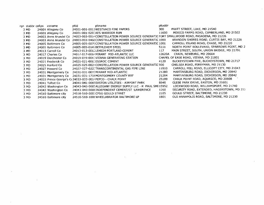
The U.S. EPA AIRS database (http://www.epa.gov/oar/data/geosel.html) was queried toidentify major air pollutant sources, particularly of NOx and VOCs, in the states ofMaryland, Pennsylvania and West Virginia near the geographic area of Eastalco. Thesequeries produced maps such as those shown in the file "mapNOxPA_WV_MD.pdf".Hovering over a location while online produces a popup window that identifies theemitter. Such maps and other information in the AIRS database were useful inidentifying other power plants and similar facilities in the region near Eastalco.

Projects in the Eastalco geographic area funded by the American Recovery andReinvestment Act of 2009 (Public Law 111-5) were reviewed by accessinghttp://www.recovery.gov. The web site of Frederick County, MD(http://www.co.frederick.md.us/) also was searched for information on transportation andeconomic development projects and priorities.
Google Earth was used to identify major parks, historical sites, Class I areas,recreational areas, etc. within 50-75 miles of Eastalco.
Representatives of U.S. Army Corps of Engineers were consulted about other projectsthey were aware of in the Eastalco area, particularly those involving wetlands.
Results of procedures such as those identified above were used in generating a draftactivities table. This summary table was provided to review team subject matter expertswho were responsible for determining if a given activity contributed to their cumulative.impacts analysis, and for adding other projects or activities to the table.

Facility Locator Map - Criteria Air PollutantsMaryland, Pennsylvania, Virginia, or West Virginia
Shaded counties have facilities
I imt
Interstate Hwy Facility Location: (224)
Source: US EPA Office of Air and Radiation, NEI Database Wednesday, October 21, 2009
Facility Emissions Map - Criteria Air PollutantsMaryland I AirD
Facilities Emitting NOx
ciU
NOx Emissions By SIC Code
26214
3241
3312
4911 L 72
49224953 2
.26
.27
.61
E.9
.38
2.15
Others 0.00
o 10 20 30 40 50 60 70 60Tho.... ds of I.- ,,p Yeo
Facility Count By SIC Code
NOxEmissionsCategory:
'100,1000
-5000
150000
.50000
2621
3241
3312
1
3
1
12
Others0 2 4 6 8 10 12
Nunbor of Pln-t8
Total Emissions of the 20 FacilitiesNI
6 '100
1 I000
<5000
o10000
<50000
E 50000+
O, Emissions By Category Facility Count By Category
1.04
18,97
13.09
56.50
aoo0
' toCo<00
3-,1000
35000
o '10000
[ '50000
50000+
El Database
0
5
92
4
0
CoNOxSvoo -
0 S02
_ NH3PMIO0
PM2.5
68
90
2
282
0
22
18
0 10 20 30 40 50 60
Thou..nd, of To- p,r Yenr
Source: US EPA Office of Air and Radiation. P
0 1 2 3 4 5 6 79 9
Ofb . 1.61C-1
100 200 300Thousands of Ton- per Yar,
Tesday Octobrh 20. 2009
rgn stabbr3 MD3 MD3 MD3 MD3 MD3 MD3 MD3 MD3 MD3 MD3 MD3 MD3 MD3 MD3 MD3 MD3 MD3 MD3 MD3 MD
cofips coname24001 Allegany Co24001 Allegany Co24003 Anne Arundel Co24003 Anne Arundel Co
pltid pltname pltaddr
24001-001-001]WESTVACO FINE PAPERS 300 PRATT STREET, LUKE, MD 21540
24001-001-020".AES WARRIOR RUN 11600 MEXICO FARMS ROAD, CUMBERLAND, MD 21502
24003-003-001z CONSTELLATION POWER SOURCE GENERATIC FORT SMALLWOOD ROAD, PASADENA, MD 21226
24003-003-046E CONSTELLATION POWER SOURCE GENERATIC 1000 BRANDON SHORES ROAD, CURTIS BAY, MD 21226
24005240052401324017240192402124025240272403124031240332404124043240432451024510
Baltimore Co 24005-005-007- CONSTELLATION POWER SOURCE GENERATIC 1001Baltimore Co 24005-005-014) BETHLEHEM STEEL 5111
Carroll Co 24013-013-001Q LEHIGH PORTLAND CEMENT 117
Charles Co 24017-017-001L MIRANT MID-ATLANTIC LLC 126201
Dorchester Co 24019-019-001 VIENNA GENERATING STATION CHAPEl
Frederick Co 24021-021-001_- ESSROC CEMENT 4120
Harford Co 24025-025-002z CONSTELLATION POWER SOURCE GENERATIC 900
Howard Co 24027-027-022_ TRANSCONTINENTAL GAS PIPE LINE 11910
Montgomery Co 24031-03 1-001_ MIRANT MID-ATLANTIC 21200
Montgomery Co 24031-031-171f MONTGOMERY COUNTY RRF 21204
Prince George's C 24033-033-001L PEPCO - CHALK POINT 25100
Talbot Co 24041-041-006- EASTON UTILITIES - AIRPORT PARK 8940
Washington Co 24043-043-000! ALLEGANY ENERGY SUPPLY LLC - R PAUL SMI 15952
Washington Co 24043-043-OOOE INDEPENDENT CEMENT/ST LAWERENCE 1260
Baltimore city 24510-510-000CPSG GOULD STRRET 2105
Baltimore city 24510-510-188(WHEELABRATOR BALTIMORE LP 1801
CARROLL ISLANU RUAU, CH-ASl, MU L12LUNORTH POINT BOULEVARD, SPARROWS POINT, MD 2
MAIN STREET, SOUTH, UNION BRIDGE, MD 21791CRAIN, NEWBURG, MD 20664
L OF EASE ROAD, VIENNA, MD 21801BUCKEYSTOWN PIKE, BUCKEYSTOWN, MD 21717
CHELSEA ROAD, PERRYMAN, MD 21130
CARROLL MILL ROAD, ELLICOTT CITY, MD 21043MARTINSBURG ROAD, DICKERSON, MD 20842
MARTINSBURG ROAD, DICKERSON, MD 20842
CHALK POINT ROAD, AQUASCO, MD 20608GLEBE PARK DRIVE, EASTON, MD 21601LOCKWOOD ROAD, WILLIAMSPORT, MD 21740
SECURITY ROAD, EXTENDED, HAGERSTOWN, MD 21,
GOULD STREET, BALTIMORE, MD 21230OLD ANNAPOLIS ROAD, BALTIMORE, MD 21230

sic lat2621 3-4911 3(4911 3-4911 3.4911 3-3312 3-3241 3-4911 3•49113241 3.4911 3.4922 3.4911 3(4953 3C4911 3•4911 3•4911 3.3241 3c4911 3C4953 3.
Ion year co nox voc so29.4731.5964
9.17539.18189.32459.2186.5679
3.357338.475).3477).4644).2661).2055).20558.54298.79339.60429.64859.26319.2688
-79.0586 2002-78.75 2002
-76.5328 2002-.76.5327 2002-76.3664 2002-76.4815 2002-77.1839 2002-76.9781 2002
-76.041 2002-77.4276 2002-76.2046 2002-76.9287 2002-77.4615 2002-77.4656 2002-76.6844 2002-76.0696 2002-77.8307 2002-77.6782 2002-76.5937 2002-76.6321 2002
331.493969.322
383.8345773
213.161563.44
816.87691.6895
34.165106.5945
4.3683.975
289.330563
801.857.6535
61.642.6315
37.8980.1165
4255.409533.64855711.816
11669.110755.9
3606.94752663.04
18798.684316.5835
1634.0685373.3
1380.367380.3514
1036.715274.0999
252.8261256.6
1973.853363.7
1117.989
444.16351.225
49.781592.246.5
309.1322.0825102.758
5.09355.9135
0.4280.5025
41.0133.1
101.46.5005
7.319.3515
5.67
6.208000028
19770.60151165.5
18795.20439974.132392.3
4095.6659.125
70359.92451472.40551137.4815
105.91.642533911
93.452529
40.22454588.2
301.33051351.8
172.377798
pm25442.203647282.38406314799.26560351659.9502821967.9877641326.201207293.78452173076.65896
92.6465177382.91227979
2.693037111.1655040743040.10685311.185340414665.54818242.95582503
275.01115287.7773945
13.7211174917.15565825
pm10 nh3855.2966143 53.49 25710.45361
114.608736 2784.304236837.254651 37.82 25815.71065
1955.1646 47.0706 54510.63522052.1451 12.9613 45472.9064
1986.783424 71561.96592602.4529234 4113.570423
4661.762422 40.1682 94654.98662114.5940792 1942.841579
167.7262737 22.33 3074.1142742.693037039 1.6026 488.1956371.862433809 2348.342434
3041.640164 25.065 44688.4000613 3 1212.2
4809.176889 88.8639 73604.3406945.08760042 402.2921004
370.5861 4.0002 6288.2863204.123 41.32446 2582.61396
14.50123437 1773.56123418.00649058 1394.697789
totemis

EPA - NEPAssist
http://134.67.99.138/nepave/nepamap.aspx?action=searchloc&wherestr=Fannin%20County%2C%20TX
Last updated on undefined, undefined NaNth, NaN.
NEPAssistYou are here: EPA Home NEPAssist Home
1/1/10 11:21 AM
http://134.67.99.138/nepave/nepamap.aspx?action=searchloc&wherestr=Fannin%2OCounty%2C%20TX Page 1 of 2

EPA - NEPAssist 1/1/10 11:21 AM
- qEPA Facilities
't SuperfundI
Toxic releases
5t Water discharoers
Air emissions
Hazardous waste
÷ _NEPAssist EPA Data
• NWI Wetla ndsF~.
* FEMA Flood
GlobeXrlorer Imaael
_TerraSer-er
National Land Cover
http:/ /134.67.99.138/nepave/nepamap.aspx?action=searchloc&wherestr=Fannin%2OCounty%2C%2OTX Page 2 of 2

,[keyýstate] 2 M ~ ~ ef yfaA
, You are here: EPA Home Compliance and Enforcement National Environmental Policy Act (NEPA)EIS Database Search Results
Search ResultsOther EIS listings
44 documents were retrieved.* All EISs" Most Recent Weekly Notice
of Availability of EISs* EISs With Open
Comment/Wait Period* Most Recent Weekly Notice
of Availability ofComments
* Search for selected EISs* Help with Agency Codes
Date
04/23/2004
Agency State
FHW MD
Document Title
Draft EIS Info MD-3 Transportation Corridor Study, AddressExisting and Projected Operational and SafetyIssues, Along MD-3 from North of US-50 to Southof MD-32, Funding, NPDES Permit and US ArmyCOE Section 404 Permit, Anne Arundel and PrinceGeorge Counties,
07/16/2004 FHW MD Final EIS Info MD-97 Brookeville Project Improvements andPreservation, South of Gold Mine Road to North ofHoliday Drive, Funding and US Army Corps ofEngineers Section 10 and 404 Permits Issuance,Montgomery County, MD
07/23/2004
09/17/2004
FHW MD
DHS MD
Final EIS Info MD-210 (Indian Head Highway) Multi-Modal Study,MD-210 Improvements between 1-95/1-495 (CapitalBeltway) and MD-228 Funding and US COESection 404 Permit Issuance, Prince George'sCounty, MD
Draft EIS Info National Biodefense Analysis and CountermeasuresCenter (NBACC) Facility at For Detrick,Construction and Operation, Fort Detrick, FrederickCounty, MD
10/01/2004 NIH MD Draft EIS Info National Institutes of Health (NIH) Master Plan 2003Update, National Institutes of Health Main Campus,Bethesda, Montgomery County, MD
11/12/2004 GSA MD DraftSupplement
Info U.S. Food and Drug Administration (FDA)Consolidation, Updated and New Information, NewEastern Access Road Construction and over PaintBranch, Additional Facilities Construction to SupportExpanded Program, Relocation of the Day CareCenter, Federal Research Center, at White Oak,Silver Spring, Montgomery, MD
12/03/2004 FHW MD Draft EIS Info Inter County Connector (ICC) from 1-270 to US-i,Funding and US Army COE Section 404 Permit,Montgomery and Prince George's Counties, MD
12/23/2004 DHS MD Final EIS Info National Biodefense Analysis and CountermeasuresCenter (NBACC) Facility at Fort Detrick,
03/25/2005 GSA MD FinalSupplement
Construction and Operation, Fort Detrick, FrederickCounty, MD
Info U.S. Food and Drug Administration (FDA)Consolidation, Updated and New Information,Constructing a New Eastern Access Road and overPaint Branch, Construct Additional Facilities toSupport Expand Program, Relocating the Day CareCenter, Federal Research Center at White Oak,Silver Spring, Montgomery County, MD
04/22/2005
06/24/2005
09/09/2005
NIH MD
COE MD
FHW MD
Final EIS Info National Institutes of Health (NIH) Master Plan 2003Update, National Institutes of Health Main Campus- Bethesda, MD, Montgomery County, MD
DraftSupplement
Info Poplar Island Restoration Project (PIERP) ToEvaluate the Vertical and/or Lateral Expansion,Dredging Construction and Placement of DredgedMaterials, Chesapeake Bay, Talbot County, MD
Final EIS Info MD-32 Planning Study, TransportationImprovements from MD-108 to Interstate 70,Funding, Howard County, MD
10/07/2005 COE MD FinalSupplement
Info Poplar Island Environmental Restoration Project,Habitat Restoration and Dredged Material Capacity,Chesapeake Bay, Talbot County, MD
01/13/2006
05/19/2006
FHW MD
COE MD
Final EIS Info Inter County Connector (ICC) from 1-270 to US-i,Funding and US Army COE Section 404 Permit,Montgomery and Prince George's Counties, MD
Draft EIS Info Masonville Dredge Material Containment Facility(DMCF), Construction from Baltimore HarborChannel north of Point-Rock Point Line, US ArmyCOE Section 10 and 404 Permits, Baltimore, MD
07/03/2006 COE MD DraftSupplement
Info Masonville Dredged Material Containment Facility,New Information, New Source of Dike BuildingMaterial from the Seagirt Dredging Project withinthe Patapsco River, Funding, Baltimore, MD
08/11/2006 USA. MD Draft EIS Info U.S. Army Medical Research Institute of InfectiousDiseases (USAMRI!D), Construction and Operationof New USAMRIID Facilities and Decommissioningand Demolition and/or Re-use of ExistingUSAMRIID Facilities, Fort Detrick, MD
09/08/2006 COE MD SecondDraft EIS(Tiering)
Info Mid-Chesapeake Bay Island Ecosystem RestorationIntegrated Feasibility Study, Using UncontaminatedDredged Material from the Upper Chesapeake BayApproach Channnels to the Port of Baltimore toRestore and Protect Island Habitat in the MiddlePortion of Chesapeake Bay, Dorchester County,MD
12/01/2006 NPS MD Draft EIS Info White-Tailed Deer Management Plan,Implementation, Catocin Mountain Park, Frederickand Washington Counties, MD
12/29/2006 USA MD Final EIS Info U.S. Army Medical Research Institute of InfectiousDiseases (USAMRIID), Construction and Operationof New USAMRIID Facilities and Decommissioningand Demolition and/or Re-use of ExistingUSAMRIID Facilities, Fort Detrick, MD
03/16/2007 USA MD Draft EIS Info Garrison Aberdeen Proving Ground, BaseRealignment and Closure Actions, Realignment of

Assets and Staff, Implementation, Harford andBaltimore Counties, MD
03/23/2007 USA MD Draft EIS Info Fort George G. Meade Base Realignment andClosure 2005 and Enhanced Use Lease (EUL)Actions, Implementation, Anne Arundel, Howard,Montgomery, Prince George's Counties, MD
05/11/2007 COE MD Final EIS Info Masonville Dredged Material Containment Facility,New Information, New Source of Dike BuildingMaterial from the Seagirt Dredging Project withinthe Patapsco River, Funding, Baltimore, MD
07/06/2007
07/06/2007
NRC MD
COE MD
Draft EIS Info License Renewal of the National Bureau ofStandards Reactor (NBSR), Renew the OperatingLicense for an Addditional 20 Years, NationalInstitute of Standards and Technology (NIST),NUREG-1873, Montgomery County, MD
DraftSupplement
Info Atlantic Coast of Maryland Shoreline ProtectionProject, Proposed Dredging of Several NewOffshore Shoals to Provide Sand for BorrowSources from 2010 to 2044, Ocean City, WorcesterCounty, MD
07/13/2007
09/21/2007
USA MD
USA MD
Final EIS Info Garrison Aberdeen Proving Ground, BaseRealignment and Closure Actions, Realignment of
.Assets and Staff, Implementation, Harford andBaltimore Counties, MD
Final EIS Info Fort George G. Meade Base Realignment andClosure 2005 and Enhanced Use Lease (EUL)Actions, Implementation, Anne Arundel, Howard,Montgomery, Prince George's Counties, MD
12/14/2007 USA MD Draft EIS Info National Naval Medical Center, Activities toImplement 2005 Base Realignment and ClosureActions, Construction and Operation of NewFacilities for Walter Reed National Military MedicalCenter, Bethesda, MD
01/25/2008
04/04/2008
NRC MD
USN MD
04/25/2008 FHW MD
Final EIS Info License Renewal of the National Bureau ofStandards Reactor (NBSR), Renew the OperatingLicense for an Additional 20 Years, NationalInstitute of Standards and Technology (NIST),NUREG-1873, Montgomery County, MD
Final EIS Info National Naval Medical Center, Activities toImplement 2005 Base Realignment and ClosureActions, Construction and Operation of NewFacilities for Walter Reed National Military MedicalCenter, Bethesda, MD
Draft EIS Info US 50 Crossing Study, Transportation Improvementfrom MD-61 1 to MD 378; and 3rd Street toSomerset Street, Funding, US Coast Guard, USArmy COE Section 10 and 404 Permits, WorcesterCounty, MD
Draft EIS Info Sparrows Point Liquefield Natural Gas (LNG) ImportTerminal Expansion and Natural Gas PipelineFacilities, Construction and Operation, ApplicationAuthorization, US COE Section 10 and 404Permits, Baltimore County, MD
Final EIS Info Atlantic Coast of Maryland Shoreline ProtectionProject, Proposed Dredging of Several NewOffshore Shoals to Provide Sand for Borrow
05/02/2008
09/12/2008
FRC MD
COE MD

09/26/2008 COE MD Final EIS Info
Sources from 2010 to 2044, Ocean City, WorcesterCounty, MID
Mid-Chesapeake Bay Island Ecosystem RestorationIntegrated Feasibility Study, Using UncontaminatedDredged Material from the Upper Chesapeake BayApproach Channels to the Port of Baltimore toRestore and Protect Island Habitat in the MiddlePortion of Chesapeake Bay, Dorchester County,MID
10/03/2008 FTA MID Draft EIS Info Red Line Corridor Transit Study, AlternativesAnalysis, Implementation of a New East-WestTransit Alignment through Baltimore, BaltimoreCounty, MD
10/17/2008 FTA MID Draft EIS Info Purple Line Transit Project, Proposed 16-Mile RapidTransit Line Extending from Bethesda inMontgomery County to New Carrollton in PrinceGeorge's County, MD
10/17/2008 NSA MD Draft EIS Info Fort George G. Meade Utilities Upgrade Project,Proposes to Construct and Operate (1) North UtilityPlant (2) South Generator Facility and (3) CentralBoiler Plant, Fort George M. Meade, MID
12/12/2008 NPS MD Final EIS Info White-Tailed Deer Management Plan, PreferredAlternative is Alternative C, Implementation, CatocinMountain Park, Frederick and Washington Counties,MD
12/12/2008 FRC MD Final EIS Info Sparrows Point Liquefied Natural Gas (LNG) ImportTerminal Expansion and Natural Gas PipelineFacilities, Construction and Operation, ApplicationAuthorization, US COE Section 10 and 404Permits, Baltimore County, MD
02/06/2009 NSA MID Final EIS Info Fort George G. Meade Utilities Upgrade Project,Proposes to Construct and Operate (1) North UtilityPlant (2) South Generator Facility and (3) CentralBoiler Plant, Fort George M. Meade, MID
03/27/2009 GSA MD Second Info U.S. Food and Drug Administration (FDA)Draft Headquarters Consolidation, Master Plan Update,Supplement Federal Research Center at White Oak, Silver
Spring, Montgomery County, MD
05/01/2009 DOI MD Draft EIS Info Monocacy National Battlefield, GeneralManagement Plan, Implementation, FrederickCounty, MID
05/22/2009 NIH MD Draft EIS Info National Institute of Health (NIH), Transport ofLaboratory Personnel Potentially Exposed toInfectious Agents from Fort Detrick, Frederick, MDto the National Institutes of Health Clinical Center,Bethesda, MD
Info U.S. Food and Drug Administration (FDA)Headquarters Consolidation, Master Plan Update,Federal Research Center at White Oak, SilverSpring, Montgomery County, MID
07/31/2009 GSA MID FinalSupplement