problems in accepting plate tectonics and subduction as a...
TRANSCRIPT

IOSR Journal of Applied Geology and Geophysics (IOSR-JAGG)
e-ISSN: 2321–0990, p-ISSN: 2321–0982.Volume 5, Issue 3 Ver. I (May - June 2017), PP 81-100
www.iosrjournals.org
DOI: 10.9790/0990-05030181100 www.iosrjournals.org 81 | Page
Problems in Accepting Plate Tectonics and Subduction as a
Mechanism of Himalaya Evolution.
Zahid Ali Khana, Ram Chandra Tewari
b and Rabindra Nath Hota
c
a504, W.R. Apartments, 5, J. C. Bose Marg, Lucknow-226001, Uttar Pradesh, India
bDepartment of Geology, Sri J. N. P .G College, Lucknow-226001, Uttar Pradesh, India
cDepartment of Geology, Utkal University, Bhubaneswar – 751004, Odisha, India
Abstract: The available geological and structural data from Chaman fault and Indus-Tsangpo regions does not
support the new global tectonic concept and the presence of suture zone between Indian and the northern
landmass. Instead, it is suggested that the Indus-Tsangpo is a rift valley that appeared in the Triassic and
became dormant in the Cretaceous, after a spurt of volcanic activity long before the supposed suturing in the
Eocene. The paleontological evidences based on plants, marine and fresh-water invertebrates, insects and
vertebrates indicate that Gondwanaland was never a separate entity. Paleoclimatic continuity was maintained
over this landmass of India and Tibet from the Paleozoic through Cenozoic eras up to the Pleistocene Epoch.
Similarly, the widespread glacial deposits of northern Tibet bespeak of a continental landmass extending from
Peninsular India up to northern Tibet, and may be beyond. Thus, Pangaea existed till its breakup beginning in
the Triassic and Tethys was an epicontinental sea from west Proto-Pacific to east Proto-Pacific. At no stage
was it oceanic in character, although narrow shifting belts along and across it, became rift or geosynclines in
the process of crustal development. Thus, the Tethys did not form a wide, funnel shaped gulf, opening into the
Pacific as depicted in many reconstructions. On the other hand, the Himalayan sequence is dominantly non-
geosynclinals sediments, and therefore, genetically different from such classic mountains as the Caledonian,
Hercynian, Urals, and Aravallis etc. It is significant that the Himalayan orogeny was initiated in the
Cretaceous, and the major episode was Eocene, i.e. earlier than the supposed collision, rules neither out
continental collision and subduction nor even in geosynclines. However, the Himalayas, could, then, not have
been borne due to collision of landmasses as suggested by plate-tectonics. Instead, they are an interplatform
type of mountain range formed by vertical uplift, by intrusive magmas and gravity gliding played an important
part too. Terrestrial gravity, seismic (including DSS), geodetic, geomorphologic and field tectonic studies
independently and collectively support the above contention. The Himalaya along with some other ranges in
Central Asia may be unique in Earth history, and all the mountain ranges of the past seem apparently to have
been originated in geosynclines. The plate tectonic concept, however, considers the term geosynclines
redundant.
Keywords: Indus Tsangpo Suture, Himalaya, Great Gondwanaland, Pangaea, Plate Tectonics.
I. Introduction Undoubtedly, the advent of new global tectonics more than half century ago has been taken as a great
revolution in the history of Earth Science. Perhaps never again is it likely to happen, for a more or less strong
opposition to any new concept crops up almost simultaneously, howsoever well founded the hypothesis be. This
almost did not happen to Plate Tectonic - almost, but not entirely – for Beloussov (1979), Dewey et al., (1988),
Sengor (1990, 2012), Valdiya (2015), Jain et al., (2012) of the “fixists” and Carey (1988, 2000), Shield (1993,
1999), Ahmad (1982, 1987), Raiverman (2002), Scalera (2006), Maxlow (2012), Hurrell (2016) from amongst
the “mobilistics” or “ new global tectonics” remained unconvinced, the latter group invoked Earth expansion, as
an alternative. Both the plate tectonics and Earth expansion concepts agree that ocean floor spreading is taking
place and is responsible for the progressive separation of the continents. However, these schools differ
thereafter. The plate tectonics envisage creation of new crust along the mid-oceanic ridges, a more or less equal
amount of oceanic crust is consumed in the deep sea trenches, “subducted”, at a given time, and the Earth
continues to be of constant diameter. On the contrary, Earth expansion concept does not accept “subduction”,
and consequently the Earth is progressively increasing in diameter, the southern hemisphere somewhat faster
than the northern hemisphere. The Plate tectonics explains that the oceanic crust is subducted into deep sea
trenches, the continental slabs on the opposite ‘plates’ are brought together till they collide, “suture”, and form
mountain ranges. Thus, Wilson (1966) suggested that the Atlantic Ocean had opened along the Appalachian and
then closed to form the Caledonian and Hercynian ranges in the region. This model was applied to all the
erstwhile geosynclinals belts and in the new dispensation they became the ‘suture zone’. And, when the jaws
closed some oceanic crust was ‘obducted’ on to the continental crust, the basic eruptive of the geosynclinals
regimen, and came to be recognized as ‘ophiolites’. Thus, while the term ‘geosynclines’ became redundant

Problems in Accepting Plate Tectonics and Subduction as a Mechanism of Himalaya Evolution.
DOI: 10.9790/0990-05030181100 www.iosrjournals.org 82 | Page
(Sengor and Burke, 1979), ‘ophiolites' became the signatures of subduction. The so-called “Indus-Tsangpo
Suture Zone (ITSZ)” is cited as an example along which a northward drifting Greater India is supposed to have
collided with the northern continent, Angaraland. At least 1500 km of oceanic crust are believed since to have
been subducted, leaving behind a few hundred meters or so of oceanic floor slices – basic rocks, cherts,
turbidities, radiolarites etc., whereas the uplifted continental crust formed the Himalayan Range. The Tethys
was about 6000 km wide along the Pacific, and to the north of India it might have been around 5000 km in the
east and 3000 km in the west. What happened to the rest of the ocean floor and how did the northern continental
crust happen to be at the suture zone with a gap perfectly to fit the outline of the migrating Indian plate is,
however, not clear. Even if India had earlier separated from Pangaea the odds against its returning to the same
place from point to point to fit in the original gap are very high. Also, during the millions of years of the
separation of the two Blocks, their coastal outlines must have changed materially through erosion and
sedimentation. Their perfect refitting would be nothing short of a miracle. An attempt is made here to re-
examine the modern global tectonic hypothesis in the light of the currently available geological and structural
evidences for the Himalayas evolution. This will necessitate a review of the associated phenomena, subduction
and suturing. Equally important would be to comment on the former position of India vis-a-vis the northern
continents on the one hand, and the independent Gondwanaland on the other.
Plate Tectonic Speculative Ever since Alfred Wegner’s (1924) Origin of Oceans and Continents appeared, and Alex Du Toit’s (1937)
attempt assembling an independent Gondwanaland, countless assemblies have been offered. Of particular interest in
these was a ‘draft’ assembly by Carey (1976) suggesting that the ‘gaping gore’ of the Tethys was inacceptable and a
globe of smaller diameter should be adopted to make it disappear (see also: Owen, 1982). Subsequently, Dietz and
Holden (1970) and Smith and Hallam (1978) brought out their assemblies by computer matching the coastal outlines.
Although widely accepted, there is inherent weakness because matching of geology of the opposite coastal areas is
given only a secondary importance. Thus, for example, Western Australia has got to fit besides Peninsular India
(Ahmad, 1960; Sastri et al., 1974; Veevers et al., 1999), but the computer match does not bring the same. May be, the
coast lines had materially changed through time or else the computer analyzes only the data ignoring human error.
These reconstructions envisage a wide oceanic Tethys between Gondwanaland and the northern continents or else
they are for Pangaea, and the Tethys appears as a wide gulf on the Pacific coast tapering down towards the west to
near Black Sea or farther west. In either case, if the continents have to come together and coalesce, some
landmass/landmasses have to travel over thousands of kilometer and paleomagnetism seems to confirm that India
drifted from a southern hemisphere to its present location (McElhinny, 1968; Klootwijk, 1979; Klootwijk et al., 1985,
1992; Vandamme et al., 1991).The drift is believed to have started about 80 Ma in the Late Cretaceous, around 30o S
latitude (the southern tip of India having been to the south of 40o S latitude), and the collision took place around 20
Ma (Powell, 1979, p. 8, Molnar and Tapponnier, 1975, fig. 1, Acharyya, 1990; Sinha, 2002; Jain et al., 2012). Thus,
India was crossing the Equator in various interpretations, from Eocene to even Miocene (McElhinny, 1970, p. 979),
and the Equator was passing through the middle of Peninsular India around 38 Ma (Molnar and Tapponnier, 1975).
The total distance India has travelled is believed to be around 7000 km (Molnar and Tapponnier, 1975, fig. 2) in about
50-60 Ma at an average rate of about 11.5 cm/year–a fantastic speed when compared to the maximum rate obtained
along the oceanic ridge today, about 12 cm/year, i.e. about 6 cm/year on either side of the ridge. Indeed, the rate must
have been considerably higher as discussed later, there might have been a long break in the drift. Yet, there is no
reason why a much faster rate of spreading could not have obtained, even as an exception, one should nevertheless be
able to recognize the counterpart of India, on the other side of the ridge, and that too, must have similarly drifted. This
has not been identified, and the explanation could be that it comprised an oceanic crust that has been subducted
elsewhere. Figures 1 and 2 of Powell (1979) indicated that before 80 Ma India was around 30o S latitude (Molnar and
Tapponnier, 1975, put it around 40o S) and it started drifting northward.
Figure.1. Greater India migrated from a temporary location in the southern hemisphere rejoined northern

Problems in Accepting Plate Tectonics and Subduction as a Mechanism of Himalaya Evolution.
DOI: 10.9790/0990-05030181100 www.iosrjournals.org 83 | Page
Gondwanaland on the northwest, Angaraland on the north and Cathaysia on the northeast. This junction line
should exist all along the Arabian Sea to Bay of Bengal (After Powell, 1979).
Figure.2. Map showing marine magnetic anomalies of Indian Ocean (After Powell, 1979).
Powell (1979) placed India besides Madagascar, and a northwest-southeast ridge must have existed in
the area, and was responsible for ocean floor spreading, the oldest anomaly having been anomaly 33. Greater
India, thus, migrated to the area east of the Indian Ocean ridge before it came into being (Anomaly 5), and then
moved northward. However, further north a Proto-Carlsberg Ridge must have existed from anomaly 28 to 22,
and Scrutton (1973) agreed that a ridge besides Seychelles already exist 70 Ma. Owen (1982, fig. 5) suggested
an age of 60 Ma. Stripes produced by this ridge must have formed topographic highs and thus must have been
directly in India’s route; however, Powell (1979) avoided the situation and migrate the ridge itself. Nevertheless,
it is interesting that between anomaly 22 and anomaly 5 there was no ocean floor spreading anywhere in the
Indian Ocean, and it is not explained what motive force was responsible for the drift of India from around 50 Ma
to about 20 Ma i.e. from Middle Eocene to Lower Miocene times. If Powell’s (1979, figure5) suggestion is
accepted, India, somehow, kept on moving.
Molnar and Tapponnier (1975, p. 419) stated that “because of the buoyancy of continental lithosphere,
subduction of one continent beneath another is often assumed to be impossible. Instead, the motion between the
two continents is presumed to stop abruptly, suturing them along a young orogenic belt, and causing a marked
change in the relative plate motion or the formation of a subduction zone elsewhere”. Molnar and Tapponnier
(1975) further stated “We estimate that shortening and underthrusting of India beneath the Himalayas and Tibet
accounts for at least 300 km and perhaps 700 km even 1400 km according to Li and Harrison (2000).” If this is
correct there should be a displacement of about 1000 km on the Baluchistan coast. Instead, the coast is straight.
Although contradictory, yet both the views appear too accepted in plate tectonics. Moreover, there is no
explanation as to why the Himalayas have been uplifted some 500 kilometer away from the suture zone instead
of being along the collision zone itself. On the contrary, the beds near the suture zone are slightly disturbed, and
why were the Kun Lun ranges uplifted simultaneously to the north of the plateau? What, however, is crucial is
that such progressive underthrusting could only have been at a level below the root of the Himalayas, and yet
“no intermediate or deep earthquakes have been reliably located in the Himalayas” (Molnar and Tapponnier,
1975, p.420; Bai et al., 2012), nor, indeed, in Tibet (Priestley et al., 2007).
Plate tectonic models of the area envisage that the Himalayas were formed as a result of continent-
continent collision (Sinha, 2002; Jain et al., 2012; Valdiya, 2015). Yet, Gansser (1964, p.142) pointed out that
the earliest tectonic activity in the Himalayas occurred in the Upper Cretaceous i.e. around the time India began
its northward drift from 30o S latitude, and the major episode was Eocene, i.e. the tectonic activity was
undoubtedly earlier than the supposed collision and no explanation has been offered for this anomaly. Wadia
(1983, p.307) suggested the first upheaval in post-Nummulitic times, culminating in the Oligocene, i.e. perhaps
it started in the Eocene. The first upheaval “ridged up the central axis of ancient sedimentary and crystalline
rocks”. The second phase, relatively of greater intensity, was in the Miocene and the last is post-Pliocene.
Collision, according to Powell (1979), took place prior to 20 Ma and according to Molnar and Tapponnier
(1975) after Anomaly 5. There could not have been any tectonism prior to this envisaged collision. The first two
phases, thus, remain anomalous. If it is speculated that an island is existed beyond Greater India, it seems to
have left no evidence behind (Stocklin, 1982). Instead, as is well known, Gondwana glacial and associated plant
Problems in Accepting Plate Tectonics and Subduction as a Mechanism of Himalaya Evolution.
DOI: 10.9790/0990-05030181100 www.iosrjournals.org 84 | Page
fossils are reported from northern area of Tibet, i.e. from the other side of the suture zone from every exposure
of Permian-Triassic rock (Wang Naiwen, 1984; Chang Chengfa et al., 1986; Upadhyay, 1999; Xiaochi, 2002)
right up to Kun Lun Range. The ice seems to have moved from south to north, perhaps transporting the glacial
material from Peninsular India (Casshyap et al., 1993). It implies that the northern Tibet and India were together
in the Paleozoic times, as also in the Mesozoic i.e. they have always been together. The above concept
recognizes that Greater India should have sutured with the Iran-Afghanistan plate around the Paleocene before
the collision along the Indus-Tsangpo Suture. Prior to that Chaman/Ornach-Nal faults could not have existed.
Yet, Auden (1974) pointed out that in Afghanistan there is evidence of movement along the former throughout
the Cenozoic. It had probably come into being in the Cretaceous (Lawrence and Yeats, 1979). Similarly, much
importance is attached to the Zhob, Muslim Bagh and other ophiolites in Baluchistan and the North West
Province, speculatively believed to have been obducted oceanic crust, as a result of the envisages collision. Yet,
the oldest sediments, overlying deeply eroded and weathered (sometimes lateralized) ophiolite occurrences in
the area are Lower Eocene. The eruptions are considered to have been in Cretaceous i.e. from before India
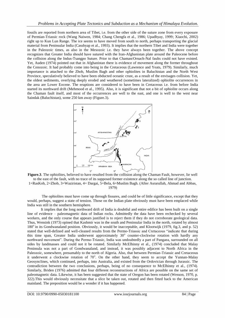
started its northward drift (Mehmood et al., 1995). Also, it is significant that not a bit of ophiolite occurs along
the Chaman fault itself, and most of the occurrences are well to the east, and one is well to the west near
Saindak (Baluchistan), some 250 km away (Figure.3).
Figure.3. The ophiolites, believed to have resulted from the collision along the Chaman Fault, however, lie well
to the east of the fault, with no trace of its supposed former existence along the so called line of junction.
1=RasKoh, 2=Zhob, 3=Waziristan, 4= Dargai, 5=Bela, 6=Muslim Bagh. (After Asrarullah, Ahmad and Abbas,
1979)
The ophiolites must have come up through fissures, and could be of little significance, except that they
would, perhaps, suggest a state of tension. Those on the Indian plate obviously must have been emplaced while
India was still in the southern hemisphere.
It implies that the long northward drift of India is doubtful and entire edifice has been built on a single
line of evidence – paleomagnetic data of Indian rocks. Admittedly the data have been rechecked by several
workers, and the only course that appears justified is to reject them if they do not corroborate geological data.
Thus, Wensink (1973) opined that Kashmir was in the south and Peninsular India in the north, rotated by almost
180o
in its Gondwanaland position. Obviously, it would be inacceptable, and Klootwijk (1979, fig.3, and p. 52)
stated that well-defined and well-cleaned results from the Permo-Triassic and Cretaceous “indicate that during
this time span, Greater India underwent approximately 30o counter-clockwise rotation with hardly any
northward movement”. During the Permo-Triassic, India was undoubtedly a part of Pangaea, surrounded on all
sides by landmasses and could not it be rotated. Similarly McElhinny et al., (1974) concluded that Malay
Peninsula was not a part of Gondwanaland, and instead, it was possibly adjacent to North Africa in the
Paleozoic, somewhere, presumably to the north of Algeria. Also, that between Permian-Triassic and Cretaceous
it underwent a clockwise rotation of 70o. On the other hand, they seem to accept the Yunnan-Malay
Geosynclines, which continued, perhaps, into Australia, and existed from the Ordovician through Jurassic. The
contradiction between the two conclusions, perhaps, being of no consequence to McElhinny et al., (1974).
Similarly, Briden (1976) admitted that four different reconstructions of Africa are possible on the same set of
paleomagnetic data. Likewise, it has been suggested that the state of Oregon has been rotated (Wesson, 1970, p.
322).This would obviously necessitate that a slice be taken out, rotated and then fitted back to the American
mainland. The preposition would be a wonder if it has happened.
Problems in Accepting Plate Tectonics and Subduction as a Mechanism of Himalaya Evolution.
DOI: 10.9790/0990-05030181100 www.iosrjournals.org 85 | Page
On the other hand, remnant magnetization derived from red bed sediments and from igneous basalts is
likely to yield diverse paleopole positions, as in the case of red beds from Indian Gondwana and Deccan basalts
(Klootwijk; 1979; Molnar, 2016). Secondly, paleomagnetic poles determined from continental basalts and from
oceanic magnetic anomalies of the same age may fall far apart, by as much as 2000 km (Molnar and
Francheteau, 1975), raising doubts about the very tenants of plate tectonics and inadequacies in data quality or
suggesting that the paleomagnetic principle is not applicable in interpretation of plate motions. A review of the
literature reveals that the oceanic magnetic anomalies are less understood and not confirmed by hard control on
basement samples beyond the quaternary Period. The most serious of all baseless assumptions is that of linking
magnetic and rotational poles of the Earth for all geologic periods. On the eve of these discrepancy the authors
suggests that the best alternative is to look at the paleomagnetic evidence in the light of polar wandering,
involving movement of the magnetic field without movement in space of the planet’s surface features. It seems
appropriate that the results arrived from paleomagnetism should be tested against geological observations. A
possibility, however, exists that the suggested northward movement of India is in fact a reflection of the
northward movement of the North Pole from around Verkhoyansk to its present location. On the other hand, the
close resemblance of the Archaean formations of India, Sri Lanka, Madagascar, central, west and east Africa,
south-west Australia and East Antarctica, permit no alternative but to accept that these areas stayed together (
Ahmad, 1960, 1961;Katz, 1972).
Great Gondwanaland or Pangaea Although Suess (1888) used the terms “Gondwanaland” and “Tethys”, and Alfred Wegner (1924)
adopted these, but did not seem to have envisaged that Gondwanaland was an altogether independent entity i.e.
that it was separated from the northern landmasses, Laurasia, Angaraland and Cathaysia by an oceanic Tethys,
joining western Pacific to eastern Pacific. The concept was introduced by Alex Du Toit (1937) that in the
Permian these landmasses were independent and, accordingly had distinct floras. Dietz and Holden (1970)
retained independent Laurasia and Gondwanaland. Similarly, the concept that the Himalayas have originated as
the result of collision and suturing of India with the northern landmasses was envisaged by Du Toit, and became
an integral part of the Plate tectonics philosophy (see: Valdiya, 2015, for references).Yet, a collisional origin of
the Himalayas involving the convergence of India towards Tibet has been advocated since before the Tethyan
Ocean concept was actually introduced and was a part of the geosynclinals origin of these ranges. Ahmad
(1968), prior to the Plate tectonics philosophy was introduced, argued that the Himalayas did not originate from
geosynclines, and geosynclines were not a prerequisite for mountains. Of late, paleomagnetic data have further
fragmented the landmasses, and Burrett (1982) illustrated them for the Lower, Middle and Upper Ordovician,
whereas Tarling (1982) has plotted them for the Devonian. This revolutionary vision envisages that all these
scattered fragments coalesced into a single landmass, Pangaea, in the Permian, and soon after Pangaea
fragmented as a result of ocean floor spreading to form the present continental configuration. Since there is no
evidence of ocean floor spreading prior to about 150-180 Ma, the mechanism for these earlier multi-pronged
movements of landmasses, large and small, is not yet clear.
Thus, to both Alfred Wegner and Alex Du Toit the evidence that seemed to clinch the issue was the
occurrence of glacial climatic conditions more or less simultaneously in all the Gondwana continents, in contrast
to a warm climate in Europe and North America; Siberia with Permian glacial deposits, then, having been terra
incognita and so was northern Tibet. Accordingly, there were supposed to have been significant differences in
the northern and southern fauna and flora. Ahmad (1978) reviewed the occurrence of life over continents in
Earth history, and concluded that there seems to be no escape from accepting continental ligations allowing for
free two way migrations throughout the Paleozoic and Lower Mesozoic of all forms of life – marine and fresh-
water fauna, vertebrates and a variety of plants. The migration is indicated by the fact that the forms appeared in
Early Permian in Gondwanaland reached the northern landmasses in Upper Permian time, and vice-versa
(Wagner, 1965; Ahmad. 1978; Xiaochi, 2002). But, if the distribution of common plants, marine faunas,
freshwater forms and even the lowly insects have posed a problem, the distribution of vertebrates virtually
clinches the issue. Indeed, the similarities between the Triassic vertebrates of South Africa and Russia had long
been a veritable enigma, and although migration was accepted, with an ocean in between, no route could be
agreed upon. Elliot et al, (1970) discussing the Antarctic tertapods conceded that “In the case of the terrestrial
vertebrates there would seem to be no assumption or mitigating consideration: these animals could have
migrated from one to another landmass only by means of land connections”. Such a land-bridge had got to be
direct and not circuitous, via Spain, for example, often suggested in the past to account for the similarities
between South African and Russian Triassic tertapods. Romer (1973), however, admitted that these “suggested
free communications”. Thus, in the Triassic beds of Russia there are remains of South African thecodonts,
therapsids, cynodonts, dicynodonts, Proterosuchians, saurichia etc. and that is formidable by any measure.
Elliot et al., (1970, p.1200) insisted that Antarctican vertebrates could have migrated to other continents “only
by means of land connections”. His other continents represent not only South Africa and India, but also Siberia,

Problems in Accepting Plate Tectonics and Subduction as a Mechanism of Himalaya Evolution.
DOI: 10.9790/0990-05030181100 www.iosrjournals.org 86 | Page
China, Mongolia and Southeast Asia. Similarly, the Lower Permian vertebrates of Kashmir, Archaegosaurus,
Actinodont, Lysiptergium and Cheledosaurus had been recorded from Europe. More significantly, Romer
(1973) has drawn attention to the work of Sun Ai Lin, who has described reptiles from Shansi and Sinkiang
provinces of China which include conodonts, comparable to the bizarre Kannemeyeria and Cynognathus, now
also reported from Argentina and India. But the discovery that really settled the issue was the presence of
reptiles of the Lystrosaurus zone of South Africa – Preteresuchus, Erythrosuchus and indeed, the
Lystrosaurus itself in Shansi and Sinkiang (China); the latter occurring in Indo-China as well. Thus, at least
Lystrosaurus, Kannemeyeria and Cynognathus were present in South America, Antarctica, South and East
Africa, India, South East Asia, Mongolia, and China; whereas Erythrosuchus was present in Russia, South
Africa and China; Metaposaurus and Plesiosaurus are among the other forms that had wide distribution (see
also: Sahni, 1984). Similarly, Qui Hongrong (1980, p. 101) studied the Paleozoic and Triassic conodonts from
both the northern and southern flanks of the so-called Indus-Tsangpo suture and found that most of them were
common. It obviously means common migration route and the traffic had apparently been two-way, with
northern forms penetrating into the southern continents and vice versa, had no obstruction, physical, nutritional,
climatic etc.
Cosgriff (1974) studied the Triassic vertebrate fauna of Tasmania and noted that several forms, some
specifically identical, had been known from the northern landmasses, reaching even such insular areas as
Greenland and Spitsbergen. The list of common forms is formidable, and includes Brachyopidae,
Lyddekerinidae, Rhytidostidae, Trematosauridae, and Chasmatosauridae. Cosgriff (1974, p. 113) further
pointed out that some of these animals were so built that they “could not easily have crossed even a limited
stretch of open sea”. Bhatia et al, (1996) has shown that several non-marine ostracode assemblage of the
intertrappean beds of India show remarkable similarity at the specific level with the Upper Cretaceous fauna of
Central Asia, Mongolia, Siberia and China. It was not only the mammals that immigrated, there were also frogs
– which are highly allergic of saline sea water – that hopped their way through the land corridor and reached as
far as south as the Deccan, where their remains are found in the infratrappean and intertrappean beds (Sahni,
1984; Sahni and Bajpai, 1991). Throughout the Paleozoic a transgressive sea covered the middle part of Pangaea
from western Proto-Pacific to eastern Proto-Pacific (Ahmad, 1982). It started withdrawing after the appearance
of mid-oceanic ridges in the Atlantic and elsewhere. However, in the Jurassic and Cretaceous this sea still
existed over the northern and eastern part of India. In the Eocene it was still present in Tibet and the Himalayan
region, but gradually withdrew westward and a widening land bridge came to be established from India to Tibet
and up to China. It is immediately reflected in the faunal distribution becoming cosmopolitan (Sahni and
Kumar, 1974). Colbert (1973, p.408) questioned that if India was drifting northward like an island in the
Jurassic and Cretaceous, how is it that its dinosaurs are very similar to those of other landmasses. Thus, the
concept of the great northward drift of Greater India is refuted, and the paleomagnetic evidence used to support
this drift shall have to be revised or reinterpreted. The contention corroborates Crawford (1979) who described
the great northward drift of India as mythical.
The above evidences suggest that Gondwanaland was never a separate entity and it was, all through the
geological history, continuous with the northern continents and the Tethys was an epicontinental sea (Crawford,
1974). Beloussov et al, (1979) are emphatic that the Tethys Sea existed over Tibetan continental crust. Ahmad
(1983) has shown that it continued much further north, entirely as a transgressive sea. Stocklin (1982, p. 120)
stated “the geological history, as recorded in the Tethyan rocks themselves, however, wholly contradicts the
paleomagnetic inferences. These rocks tell us with all desirable clarity that the Tethys was essentially, not a
wide ocean, but an epicontinental sea since the Paleozoic. Recently Khan and Tewari (2016) ruled out any
possibility of independent Gondwanaland on the basis of geological and paleontological evidences.
Suturing and Subduction Suturing and subduction are considered as great evidences of migrating Indian plate. Therefore, being
the type area, the Indus-Tsangpo Suture and its continuation on either side needs re-examination. It was Gansser
(1966) who used the term ‘Suture and Subduction’ that led to the formation of the entire hypothesis, though he
was, not very specific about its genesis and thought that it represented a deep down-bulging, some sort of a
junction line between geosynclinals formation on one side and the Himalayan succession formed exclusively of
non-geosynclinals, shallow, platform type of sediments on the other, along which large areas of continental
crustal material had disappeared (emphasis by the authors). It will be desirable to examine the subduction
concept, which got much a ready and unquestioned acceptance. Dewey (1977, p. 56) opined that “The simplest
kind of orogenic suture is a high strain zone, containing mangled ophiolite remnants, and, occasionally, blue-
schist mélanges, that separate two continental terrains with dissimilar pre-collision strain histories”. While
introducing the term “suture” in Tibet area, Gansser never mentioned that the collision was between a
Gondwana element, and some northern elements, although such a collision was well recognized and discussed
ever since Alex Du Toit suggested an independent Gondwanaland, with India as a part of it, and even before that
Problems in Accepting Plate Tectonics and Subduction as a Mechanism of Himalaya Evolution.
DOI: 10.9790/0990-05030181100 www.iosrjournals.org 87 | Page
(Argand, 1924). However, the term, as used today, envisages that only oceanic crust is subducted in deep sea
trenches, and the continental crust, as it arrived at the site, got “sutured”. The suture around Greater India is,
thus, in three parts: [1] The Chaman-Ornach-Nal faults along the west, [2] The Indus-Tsangpo, along the north,
and [3] a not well defined Burmese section along the Arakan Yomas in the east. It is supposed to join the Ninety
East Ridge or the Sunda Trench.
[1] Chaman-Ornach-Nal is an active sinistral fault, and has been instrumental for strong earthquakes. It extends
from the Makran coast, past west of Quetta, and thereafter in the east of Kabul (Sengor, 1990) where it joins the
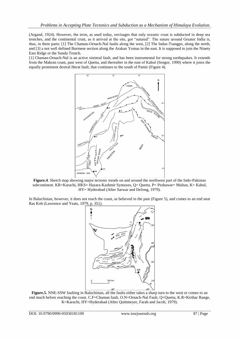
equally prominent dextral Herat fault, that continues to the south of Pamir (Figure 4).
Figure.4. Sketch map showing major tectonic trends on and around the northwest part of the Indo-Pakistan
subcontinent. KR=Karachi, HKS= Hazara-Kashmir Syntaxes, Q= Quetta, P= Peshawar= Multan, K= Kabul,
HY= Hyderabad (After Sarwar and DeJong, 1979).
In Baluchistan, however, it does not reach the coast, as believed in the past (Figure 5), and comes to an end near
Ras Koh (Lawrence and Yeats, 1979, p. 351).
Figure.5. NNE-SSW faulting in Baluchistan, all the faults either takes a sharp turn to the west or comes to an
end much before reaching the coast. C.F=Chaman fault, O.N=Ornach-Nal Fault, Q=Quetta, K.R=Kirthar Range,
K=Karachi, HY=Hyderabad (After Quittmeyer, Farah and Jacob, 1979).

Problems in Accepting Plate Tectonics and Subduction as a Mechanism of Himalaya Evolution.
DOI: 10.9790/0990-05030181100 www.iosrjournals.org 88 | Page
The en echelon Ornach-Nal fault continues further south. However, it, too, does not cut across the
coast, and on the continental shelf it takes a sharp turn to the west. Had these faults been the suture zone, with a
long travelled Indian Block on one side and the Iran-Afghanistan Block on the other, it would certainly have
continued into the oceanic area cutting across continental shelf. Lawrence and Yeats (1979) revealed that its
southern part, the Nushki section, is not continuous. There are some eight or nine breaks in it, ranging from 2-9
km in length (Figure 6).
Figure.6. The Chaman Fault has its maximum displacement in Afghanistan and progressively weakens
southward. Note in the Nushki area it has a number of breaks (After Lawrence and Yeats, 1979).
This is the area north of the en echelon Ornach-Nal fault, and hence not covered by the latter. What is
even more significant is that the Chaman fault repeatedly branches off to the west, and Lawrence and Yeats
(1979) concluded that this is suggestive of progressive younging of the fault towards the south. In 1943 there
was a high intensity earthquake over the beach area of the Ornach-Nal fault and recently in 2013 there was a
powerful earthquake of 7.7 magnitude along the southern strand of Chaman fault confirming that both the faults
are still active, and therefore do not support the suture zone concept.
More significant, all the Baluchistan faults (Figure 5) take a sharp turn to the west (see, e.g. Kazmi,
1979, Fig. 1; Jacob and Quittmeyer, 1979, Fig. 3).This bespeak of a counter clock-wise oroclinal rotation
(Carey, 1976), with compression developing within the subtended angle, and tension outside (Ahmad and
Ahmad, 1980). However, Powell (1979, p.5) stated that “a similar geometry could have been produced without
substantial rotation”. Yet, subsequently he envisaged several stages of counter clock-wise rotation of India that
has produced the observed features. Lawrence and Yeats (1979) and Lawrence et al., (1992) have estimated a
transcurrent movement of about 200 km in northern Baluchistan whereas Auden (1974) has arrived at a figure of
300 km by matching the geological formations on its two sides. Gawad (1971) suggested that the Baluchistan
faults are left lateral by matching geology since the Mesozoic. Had the Chaman fault been really a suture, it
would have been involved in a transcurrent movement of about 1300 km and not merely 200 or 300 km.
Moreover, it would have suggested younging northward and hence lesser movement in Afghanistan than in
Baluchistan.
The Chaman fault is stated to pass into the Owen Fracture Zone (Powell, 1979, Figs. 8-12). The former
is, however, sinistral, the latter dextral (Powell incorrectly depicts it as sinistral to fit it with the Chaman fault
movement) having clearly displace dextrally the Carlsberg Ridge at the mouth of the Gulf of Aden. But the area
between the northern end of the Owen fracture Zone and the Chaman fault zone is occupied by the Murray
Ridge, which runs to near the coastal area to the east of Karachi (Figure 7).
Problems in Accepting Plate Tectonics and Subduction as a Mechanism of Himalaya Evolution.
DOI: 10.9790/0990-05030181100 www.iosrjournals.org 89 | Page
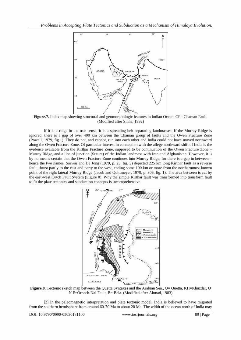
Figure.7. Index map showing structural and geomorphologic features in Indian Ocean. CF= Chaman Fault.
(Modified after Sinha, 1992)
If it is a ridge in the true sense, it is a spreading belt separating landmasses. If the Murray Ridge is
ignored, there is a gap of over 400 km between the Chaman group of faults and the Owen Fracture Zone
(Powell, 1979, fig.1). They do not, and cannot, run into each other and India could not have moved northward
along the Owen Fracture Zone. Of particular interest in connection with the allege northward shift of India is the
evidence available from the Kirthar Fracture Zone, supposed to be continuation of the Owen Fracture Zone –
Murray Ridge, and a line of junction (Suture) of the Indian landmass with Iran and Afghanistan. However, it is
by no means certain that the Owen Fracture Zone continues into Murray Ridge, for there is a gap in between –
hence the two names. Sarwar and De Jong (1979, p. 23, fig. 3) depicted 225 km long Kirthar fault as a reverse
fault, thrust partly to the east and party to the west, ending some 100 km or more from the northernmost known
point of the right lateral Murray Ridge (Jacob and Quittmeyer, 1979, p. 306, fig. 1). The area between is cut by
the east-west Cutch Fault System (Figure 8). Why the simple Kirthar fault was transformed into transform fault
to fit the plate tectonics and subduction concepts is incomprehensive.
Figure.8. Tectonic sketch map between the Quetta Syntaxes and the Arabian Sea., Q= Quetta, KH=Khuzdar, O
N F=Ornach-Nal Fault, B= Bela. (Modified after Ahmad, 1983)
[2] In the paleomagnetic interpretation and plate tectonic model, India is believed to have migrated
from the southern hemisphere from around 60-70 Ma to about 20 Ma. The width of the ocean north of India may

Problems in Accepting Plate Tectonics and Subduction as a Mechanism of Himalaya Evolution.
DOI: 10.9790/0990-05030181100 www.iosrjournals.org 90 | Page
be around 3000 km in the west and 5000 km in the east, north of Assam. The Indian plate, beyond the Greater
India continental crust must have consisted of oceanic crust. All this oceanic crust must, then, have been
subducted into the Indus-Tsangpo Suture. This part of the Indian plate is variously estimated at around 6000 km
and some 1500 km of sialic crust is believed to be thrust below the Tibetan Block to make it double thickness
area. However, the thickness of the continental crust decreases gradually south of the Indus-Tsangpo Suture.
Thus, immediately to the south of the Suture, the crust thickness is still of the order of 60 km. How is this area
of double thickness to be explained? Moreover, 1500 km of the Indian crust have been accommodated
underneath Tibet whereas the total width of Tibet between the Himalayas and Kun Lun is of the order of 800-
900 km. The rest of the Indian plate must have passed underneath the latter range and beyond that needs a
suitable explanation. More important, the Indus-Tsangpo Suture Zone is not continuous all around the outline of
the erstwhile Greater India (Sinha, 2002, Fig. 1). Thus, eastward to the north of Myanmar i.e. from near Lhinzu
to the southwest of Lhasa it does not exist (Beloussov et al, 1979; Girardeau et al, 1985). Its place, instead, is
taken by a wide band of Jurassic phyllites, intruded by granites, diabases, diorite, gabbros and serpentinites. The
band continues northward of the Indus-Tsangpo Suture Zone (Beloussov et al, 1979). This certainly needs an
explanation for where has the area of Greater India north of Assam been subducted is not clear. This must have
been of the same order as north of the rest of India.
Similarly, at the western end of the Indus-Tsangpo suture zone, there is a meridional gap of about 300
km between the suture and the north-east end of the dextral Herat Fault in the Pamir region which seemingly has
nothing to do with the movement of the subcontinent. This, too, remains enigmatic. What is even more
surprising is that over the Lhasa block and the South Qiangtang block, Tengchong block in Yunnan exist typical
Gondwana glacial deposits, carrying typical Gondwana flora and fauna, overlying a metamorphic basement
right up to Kun Lun Range (Tapponnier et al, 1981, p.405; Li Xiangxu, 1984; Acharyya, 1992; Xiaochi et al.,
2011). These glacial deposits have moved from the south to north and would it be impossible to explain these if
a vast ocean existed in the area during the Permo-Carboniferous when India was in southern hemisphere. And
all the maps depicting a vast oceanic Tethys in the region do not recognize this vast land area over which these
glacial deposits were deposited. But surprising, they reinterpret the glacial deposit as “rift-in-fill” just to justify
that plate tectonic interpretation. Nor do they accept the presence of typical Gondwana flora and fauna in the
area, in spite of scores of Chinese reports confirming their wide distribution. These glacial deposits exist
underneath every Permo-Carboniferous succession over the entire northern Tibet, thereby covering thousands of
sq km and ranging in about 600 m in thickness, were originally reported by Norin (1946), and later confirmed
by the American Plate Tectonicists delegation (Bally et al, 1980). It is possible that they did so because a
Gondwana glacial deposit in the area did not fit-in with the Indus-Tsangpo Suture concept which they supported
unreservedly. Nor do they accept the presence of typical Gondwana flora and fauna in the area, in spite of scores
of Chinese reports confirming their wide distribution. What is most unexpected is that some of the Chinese
authors of the latter study did not agree with this reinterpretation (Wang Naiwen, Pers. Com.).
Ophiolites are invariably believed to mark the zone of subduction, their infallible signatures of
subduction. Yet, in this case, as also in Pakistan’s Zhob, Muslim Bagh and other areas, and those in Iran, Oman
and Turkey etc. they are invariably Cretaceous in age. This would mean that intrusion or obduction preceded the
collision by 50-60 Ma Thus, Stoneley (1974, p.899) admitted that “the ophiolites were emplaced while the
Indian continent was presumably still some hundred of km away. Moreover, it was thousands of km away from
Eurasia as suggested recently by Khan and Tewari (2016). Even Tapponnier et al., (1981, p.410) are worried
that the emplacement of the ophiolites “occurred earlier than the end of the Eocene, which would place new
constraints speculations based on plate tectonic reconstruction” (emphasis by the present authors). Girardeau
et al., (1985) asserted that “The ophiolites were probably obducted during Eocene”, apparently in harmony with
the plate tectonic concept. What is equally intriguing is that if the Indian plate did not extend beyond the
Chaman fault zone, in what way are the ophiolites of Oman, Iran and Turkey influenced by this suturing that
they behaved similarly? Beloussov, et al., (1979, p. 422) wondered why it should be that from an ocean several
thousand km wide, which existed from the Paleozoic through Mesozoic, only these few small beads of the
pressed out material of the subducted crust were preserved and everywhere they are of the same Late Cretaceous
age. They are, indeed, where there was no subduction. Yet, the most interesting evidence from the recent work
by the Sino-French team was that in many places, the ophiolite belt along the Yarlung-Zhangbo seems to be
limited to the north and south by steeply dipping faults. In other words the ophiolites occupy a rift valley,
presumably initiated in the Triassic and continued to be active till the Cretaceous. Fein Ding et al, (1981) agreed
that the Yarlung-Zhangbo is a rift, and yet, amazingly, they think that it was a suture, it seems, realizing that the
terms are self contradictory. The former is observational; the latter seems to be interpretational. Ophiolite
emplacement took place twice, firstly in the Upper Jurassic to Lower Cretaceous and then later again in the
Lower Cretaceous. These two are chemically significantly different, the latter occupying the northern part of the
suture. That contact metamorphism is widespread, and the bulk of the ophiolite is essentially represented by a
mantle sequence, which comprises harzburgite, dunites and chromitites. A variety of ultra high pressure
Problems in Accepting Plate Tectonics and Subduction as a Mechanism of Himalaya Evolution.
DOI: 10.9790/0990-05030181100 www.iosrjournals.org 91 | Page
minerals such as diamonds, poissanite, native metal and PGE alloys have been recovered from the latter
ophiolites (Liang Rixuan et al., 1984; Bai et al, 2000; Robinson et al., 2004), bespeak of a temperature of 1105-
1240oC and a pressure of 27-46 kbar, confirming to a depth of origin of the magmas at 80-140 km. (Liang
Rixuan and Bai Wanji, 1984). This is far from ocean floor obduction.
Shaobai et al, (1984) carried out geophysical investigation in the area and concluded that the northern
side of the so-called Indus-Tsangpo Suture Zone (ITSZ) has evidently risen and the southern subsided by as
much as 5 km, the two forming a deep trench in between. They accordingly suggested that the southern block in
the Triassic was where it exists and not in the southern hemisphere. The ophiolites carry pisolitic and warty
structures, form pillow, and have produced extensive contact metamorphism. Crystal settling abounds,
producing acidic rocks at the top and ultrabasic at the bottom of every exposure (Cui Junwen, 1981). Gopel et
al., (1984) believed that the very existence of two magmas is a strong constraint to plate tectonic speculations.
The magma emplacements are, thus, confined to the rift valley that apparently was deep. The associated
sediments now thrown up by the magma emplacement indicate deep water deposits in this rift, and now form the
mélange. Major rift zones bounded by vertical faults have been described as “key-board tectonics”, which
brought up basic extrusive, and the rifts became the sites of geosynclinals sedimentation and deformation.
Stocklin (1974) and Raiverman (1992) compared the belt to the Red Sea, however, would mean the existence of
an oceanic ridge. Yet, perhaps, a simple rift valley seems to be more satisfying, for the feature, 8-20 km wide,
seems to die out at both ends and has several breaks along its length. This rift is said to be clearly seen on
Landsat images and Lake Mansarovar is a depressed part of the valley. Similarly, Nicolas et al., (1981) thought
that the ophiolite marked a “spreading centre with a particularly slow spreading rate”. Gopel et al., (1984)
consider it a “propagating ridge”; whereas Deng Wanming (1980) noted that the ophiolites were similar to those
found along the mid-oceanic ridges. Similarly, Wang Xibin et al. (1980) describe it as tensional feature and
Cheng Chengfa (1980) believed that Late Permian-Triassic tensional rifting has resulted in this feature and
produced the Panjal Volcanic of Kashmir, and their equivalents in Mandi, Bhowali and Abor Hills. It may also
be significant that the occurrences of Carboniferous-Triassic ophiolites in Kashmir, and their equivalents in
Mandi, Bhowali and Abor Hills, seem to have equally, indeed more, widespread counterparts in western and
northwestern and southern Siberia indicates that perhaps these areas were formerly part of a single crustal block
and were separated as a result of ocean spreading.
In the case of the Oman ophiolites, Stoneley (1974, p. 902) agreed that tensional faulting was
associated with the eruption. The above evidence bespeaks of tensional faulting in the Indus-Tsangpo Suture
belt. He was, apparently not aware of this evidence, but recognized that magmatic injection inexplicably
preceded the supposed collision. Interestingly, he recognized contact metamorphism, as pointed out above,
caused by ophiolites, which, however, obducted oceanic crust could not produce and rules out the island arc
syndrome ( see also: Stocklin, 1982; Sinha, 2002). Stocklin (1982, p. 126) is emphatic that “Subduction is not
required either to explain the present structure of the Indus-Tsangpo Suture Zone, but is rather contradicted by
such facts as its vertical attitude (Gansser, 1981) and present seismic inactivity”. Moreover, subduction would
require a low angle movement of one plate below another for a distance more than 1000 km, whereas
subduction is purportedly a ‘high angle’ process. Also of interest in this context is the fact that according to the
plate tectonics, volcanism of island arcs resulted from partial melting of the down going slabs of oceanic
lithosphere, yet in the case of the Indus-Tsangpo Suture, down slab which has gone thousands of km. of oceanic
crust, no partial melting seems to have taken place, and consequently, no volcanoes exist in the Tibet area.
There were few volcanoes associated with the Quaternary rift valleys, but all are dormant presently.
Incidentally, their association with the rift valleys in Tibet, as in Africa, suggests that the rifts are tensional
features, and not of compression as expected in a subduction/collision zone. Briden (1976, p. 415) admitted that
“geological evidence of subduction is self-destructive on plate tectonic reasoning”.
These lines of evidences have convinced Wang Naiwen (1980) that “It is unbelievable that the
Yarlung-Zhangbo-Indus belt is the suture between the North and the South continents”, whereas Zheng
Haixiang (1984) thought that the “Y- belt is not entitled to be suture zone”. Owen (1976, p. 209) has stated that
“there is, therefore, no need to infer the presence of Tethyan oceanic crust north of India nor to use ophiolite
belts as evidence of its former existence.
[3] The suture zone over the Arakan Yomas simply does not exist. In fact, this should exist along the
eastern margin of the Indian plate i.e. along the Assam/Bangladesh coast and the western margin of Myanmar
and not within the latter, as often suggested (Acharyya, 1992, fig. 1; Sinha, 1992, fig. 4). Instead Acharyya
(1992) suggested that Myanmar was itself moving north ward along with the Indian plate. This throws serious
doubt about the eastern suture and therefore about the entire concept. The Ninety East Ridge is of the nature of
inactive mid-oceanic ridge and the “plates” on its two sides must once have been moving away from it, i.e. to
the east and the west. India could not have moved northward along it.

Problems in Accepting Plate Tectonics and Subduction as a Mechanism of Himalaya Evolution.
DOI: 10.9790/0990-05030181100 www.iosrjournals.org 92 | Page
II. Discussion The above evidences have demonstrated that the so-called Indus-Tsangpo Suture is not a collision belt,
firstly because Gondwana marine glacial deposits overlain by Permian through Jurassic marine sediments with
typical Gondwana overtones occur in the area almost from Lhasa to the Kun Lun Mountains, and secondly, the
fauna and flora (including Permian and Triassic vertebrates) of Gondwana affinity from Ordovician through
Triassic north of the so-called suture. Finally the ophiolites are restricted to a rift valley, which, came into being
in the Triassic, but was active during the Upper Jurassic-Lowest Cretaceous and later again in the Lower
Cretaceous. Thus, the magma outpouring occurred about 50-60 Ma before the speculated collision. Therefore, it
is the need of the hour to explain the following before accepting the suturing and under-thrusting of Indian plate
under widely accepted newly global tectonic concept.
[1] That although the magma emplacement occur 50-60 Ma before the envisaged continental collision, contact
metamorphism has extensively affected the Indian plate as well. India, in the plate tectonic interpretation then,
was supposedly at 35oS latitude.
[2] The magma emplacement was not only of two different ages but they differ chemically which is difficult to
explain by the collision concept. Gopel et al., (1984) opined that the existence of two ophiolites itself places
constraints on the plate tectonic model. The second phase of outpouring occupies the northern part of the suture
zone, forms pillows, carries diamonds, poissanite, rare earth and PGE, must have originated, as pointed out
elsewhere, at a temperature of 1105-1248oC and a pressure of 27-46 kbar, corresponding to 80-140 km depth.
Each exposure shows extensive crystal settling, with the top being acidic and the bottom ultrabasic suggesting
that the magma was in a molten stage.
[3] The magma is contained within two vertical walls of a typical rift valley and there is no true obduction.
What, perhaps, is equally important is : why do the Himalayas occur some 200-300km away from the
actual Indus-Tsangpo Suture zone whereas the suture zone itself has not been uplifted, or even seriously
disturbed? Continental crust arriving at the subduction zone would be prevented by buoyancy from going down,
and as the oceanic crust continued to slip underneath, it should, theoretically, be this part – the actual leading
continental edge – that piled up to form a mountain range. Perhaps it would not rise very high, and would
instead, mess up the whole area, without forming an Everest height. In any case, the uplift has not taken place at
the leading edge, in spite of Molnar and Tapponnier (1975, p. 419), admittedly as quoted above that a young
mountain range appears along all such suture zones. Crawford (1975, p. 1179) is, apparently, correct when he
raises the objection that if the Indus-Tsangpo Suture zone is a relic of oceanic subduction, it lies on the wrong
side of the Himalayas and accordingly agreed that the Himalayas are not the product of continental-continental
collision. Indeed, subduction has not been responsible at least for these mountains and some other activity must
be looked for this connection. Stoneley (1974, p. 902) pointed out that the Oman Block has not yet arrived at the
suture zone. Be that as it may, the leading edge of the Indian plate that did supposedly arrive at the suture zone
20-30 Ma or more remains singularly undisturbed and need proper explanation. On the other hand, Stoneley’s
(1974) suggestion that the ophiolites merely comprise mantle material intruded/extruded on to a continental
crust is not justified. He, thus, does not find any reason why such mantle material cannot be intruded under
tension and other suitable conditions: also that one need not “expect that the product should differ materially
from those that are intruded/extruded at an active mid-oceanic ridge”, which, too, is basically a rift valley
tapping the mantle zone, nor need they invariably from the “plate boundary”. It is not surprising; therefore, that
the Indus-Tsangpo ophiolites are identical with those effused at the mid-oceanic ridges, but have come up from
the mantle in a tensional set up.
Also, it is not explained how the Indian continental crust has underthrust the Tibetan crust for some
1500 km because this would involve the continental crust leap-frogging across 8-20 km thick wall of
mantle/oceanic crust that intervene between the two plates, an altogether impossible preposition. Further it
would require that immediately to the north of this wall the continental crust of the Indian plate dives
underneath the Tibetan continental crust without leaving a trace behind on the surface. This appears to be an
equally impossible proposition, and yet underthrusting is repeatedly stresses without any reservation. Cui
Zuoxhou (1984) carried out extensive geophysical investigation in the area and concluded that although the
crust was indeed 70 km thick, twin layer crustal structure was nowhere observed. Beloussov et al, (1982, p. 429)
have raised the question of the origin of Kun Lun, Tein Shan, Bogdo-Ola, Altai and Sayan ranges of central
Asia. They all were uplifted more or less simultaneously with the Himalayas and there seems to be an
undoubted kinship, a genetic relationship, among them. Yet, plate tectonic suturing and subduction do not seem
to be involved in their genesis, and neither have these been invoked, nor are they geosynclinals in origin. The
only alternative, then, is vertical uplift.
Greater India’s great northward movement is based on paleomagnetism evidence, though it is pointed
out that paleomagnetic data occasionally result in queer conclusions and should not be accepted unless
corroborated by field geological data. Similarly, the Indian plate is said to have moved continuously, by ocean
floor spreading, from 60 Ma or 70 Ma to 20 Ma ago. However, no magnetic anomalies between anomalies 22

Problems in Accepting Plate Tectonics and Subduction as a Mechanism of Himalaya Evolution.
DOI: 10.9790/0990-05030181100 www.iosrjournals.org 93 | Page
and 5 exist and no ocean floor spreading seems to have been taking place during this period in the Indian Ocean.
Also, if the movement is accepted, the Indian plate shall have to cross a ridge that existed since anomaly 28. To
avoid this situation Powell (1979) envisaged that the ridge itself moved. Ridges are very deep features, going
down into the mantle, and to move, they would have to plough through the entire crust and a large part of the
mantle. A ridge may die out and another may come into being, a little away, once established cannot move a
centimeter in any direction.
Carey (1968) envisaged that India had been rotated counter-clockwise and collided with the northern
continents to form the Himalayas. This seemed to fit in perfectly with the then accepted origin of these ranges.
However, in the light of the present knowledge it does not seem to be valid, for apparently the Himalayas have
not been formed as a result of collision. If the Indian landmass was continuous with the Siberian Craton, the
northern margin of this Block must have been to the north of the Siberian Craton. A tensional feature acceptably
exists all over India (Ahmad and Ahmad, 1980), the Himalayas, and extensively in central Asia, India, then, has
not been rotated to the extent envisaged by Carey (1968). If the Indian Craton continued into the Siberian
Craton, through a sialic ligation, and has not collided with the latter to form the Himalayas, the only alternative
is that the mountain ranges have formed by domal uplift of mafic magma or ophiolite from the mantle, followed
by gravity gliding. This model explains the emplacement of detached masses of mafic and ultramafic bodies of
Malla Johar in the Kumaon Himalaya or of Spongtang in the Zanskar range of Ladakh. Numerous horizontal,
perched terraces bespeak of tension and vertical movement (Ahmad, 1971), rather than compression and nappes
(see also Oldham, 1891, p.18). Detailed field study in several areas has revealed that the Main Boundary Thrust
and the Main Boundary Fault are high angle faults, perhaps normal. Thus it seems reasonable to conclude that
the Himalayas are autochthonous, and not born out of collision of land masses. On the other hand, the mature
topography of the Lesser Himalaya in contrast to that of Central Himalaya clearly indicates that the spatial
emplacement of the former preceded that of the latter. In other words, the Main Boundary Thrust (MBT)
marking the Lesser Himalayan front is older than the Main Central Thrust (MCT) marking the frontal limit of
the Central Himalaya. This is contrary to Molnar (1986), according to whom Himalayan thrusts are
progressively younger in a southern direction. Qureshy and Warsi (1981, p. 217) and Qureshy (2004) examined
the gravity data of the Himalayan belt and suggested that a gravity high area runs north of the Main Boundary
Fault (MBF) all along the Himalayas and concluded that the lower part of the crust below the middle Himalaya
comprises a denser basaltic root (see also: Raiverman, 1992). A basification of the lower part of the crust by
upward migration of the mantle material through the four suture zones and perhaps other fracture zones not
reaching the surface is the most probable mechanism for crustal thickening and uplift of the Tibetan Plateau and
the Himalaya. The final phase of uplift of Himalaya and the Tibet to their gigantic height was an event of very
short duration, sometime between the Late Pleistocene and Holocene. This was an entirely vertical uplift with
little or no horizontal translation of crustal mass as no low angle thrust sheets like those in the Lesser Himalaya
exist in the Central and the Tibetan Himalaya, other than the detached ophiolitic masses of earlier age. It is
significant that gravity studies indicate the thickness of the crust south of the main range to be of the order of
about 80 km and earthquakes seem to correspond with this down bulging, rather than with the subducting slab
model. This is entirely incompatible with the collision model or the subduction concept, and there is no evidence
supporting Dewey and Bird (1970, p. 626) and Sinha (2002) that continental crust was being subducted under
the Himalayas.
It may also be significant that north of the Indus-Tsangpo Suture (ITS) there are within Tibet three
other so-called suture zones, Bongong-Nujiang, Jinshajing-Tungbianhe and Jinsha-Tongbian, and six more
similar features exist farther north, progressively becoming older northward in the Chinese territory, the oldest
being Kerameilli of Middle Devonian – Early Carboniferous age in the Zhungar basin, south of the Altai fold
system. They are identical in character with Indus-Tsangpo Suture, and the effusive are very similar to those
existing along the mid-oceanic ridges. All these, too, are identical with the Indus-Tsangpo Suture (ITS), and if
the latter is a rift valley, as suggested elsewhere, all these features, too, may be rift valleys. In addition, there are
around a hundred other minor occurrences of ophiolites that have come up through comparatively minor fault
(Bally, 1980). It is accordingly suggested that the entire Central Asian region downwrapped quietly and
accumulated immense quantities of sediments (70 km) and the magma underneath was mobilized. It sought
weak zones to move up. Where the thickness was very great it failed to uplift the mass and instead tore it apart
in long narrow belts from Late Paleozoic to Mesozoic. Thus, beginning near the Siberian Craton, it moved step
by step southward, till it opened up the Indus-Tsangpo Suture (ITS). Moving further south the thickness of
sediments decreased (< 50 Km) and the magma uplifted the sediments as the Himalayas, and as other ranges
elsewhere. The Himalayas, thus, formed of vertical uplift, by intrusive magmas, boudins, diapers, sills and
dykes. Kasumori Arita (1984), LeFort (1991) and Raiverman (2002) agreed a large volume of leucocratic
granites play a major role in the uplift of the higher Himalayas and is intimately related to thrust movements.
Gravity gliding played an important role too. Earlier, Ahmad and Ahmad (1981) suggested that the
downwraping of the Indo-Gangetic valley mobilized the mantle magma which uplifted the Himalayas on the

Problems in Accepting Plate Tectonics and Subduction as a Mechanism of Himalaya Evolution.
DOI: 10.9790/0990-05030181100 www.iosrjournals.org 94 | Page
north and west and the Vindhyan-Aravallis on the south and east. The stupendous uplift of the Himalayas may,
then, be due to the magma from the two sides joining hands, something that Kun Lun, Tein Shan, Altai etc.
lacked. There is admittedly no explanation for the phenomenon of this step by step movement; southward in the
present case, but a parallel exists in Peninsular India (Ahmad and Ahmad, 1980) where belts of strong tension,
resulting in normal faults and rift valleys, moved step by step from Jurassic to Recent. Gilluly (1971, p.2388)
wondered that “Despite this being the region of greatest tectonic activity on the Earth, there has been no sign of
magmatic activity along the Himalayas”. This is contradicted by the geophysical observations of Qureshy and
Warsi, quoted above, but what makes it relevant here is that Gilluly admitted that “tectonics was assuredly no all
related to plate motion and nor magmatism”. Qureshy and Warsi (1981,p. 221) stated that “A number of
geologic factors seem to cast doubt on the existence of a subduction zone along the Indus-Tsangpo Suture, so do
the satellite and terrestrial gravity data”. The deep seismic sounding profile (DSS) between Pamir and Kashmir
(Beloussov et al, 1980; Kaila and Narain, 1981) evidently proves that there is neither suture at Indus-Tsangpo
Suture (ITS) Zone nor any subduction of the Indian plate beneath the Tibetan plate.
The Chaman-Ornach-Nal faults are not continuous and splay repeatedly, suggesting progressive
younging southward. Had Greater India moved along it the younging would have been northward. What seems
to be of utmost importance is that if the Indian plate has moved along the Chaman fault by as much as 1300 km
and has underthrust Tibet by about 1500 km why is there no displacement along the Baluchistan coast? This was
inevitable and hence is inexplicable, and does not fit-in with the plate tectonic concept. More importantly,
Lawrence and Yeats (1979, p. 351) observed that the Chaman fault might came into being in the Cretaceous,
obviously before the speculated arrival of the Indian plate at the site. Of similar significance is the occurrence of
ophiolites in the area that they occur to the east of the Chaman fault with one occurrence near Saindak
(Baluchistan), to the west of it. If they represent the oceanic crust obducted on to continental crust, the
occurrence should have been confined to the fault zone. Yet there is none along it, not a cubic centimeter of it. It
is therefore inappropriate to connect the two features. Their occurrence on the Indian plate bespeaks of intrusion
along tensional faults, and not of obduction.
It is significant that no deep earthquakes have been recorded from the Himalayan region; as also the
Indus-Tsangpo Suture Zone is absolutely quiet. In fact Tibet is merely mildly seismic, with a well scattered
activity, associated with recent faults, normal or wrench and rifts. Recently, Bai et al., (2012) concluded from
tele-siesmic waveform modeling of 97 earthquakes in central Tibet that earthquakes are restricted to the upper
crust, typically shallower than 20 km, originate dominantly by strike slip faulting in agreement with low P wave
velocity layers. In northern and southern Tibet, where the Asian and Indian plates descend beneath central Tibet,
earthquakes appears to be distributed throughout the thickness of the crust and exhibit dominantly reverse
faulting, strengthen above inference and refute the suggestions that earthquakes occur below the seismically
defined Moho beneath the High and Tethyan Himalayas (Chen and Young, 2004). There is no evidence of a
progressive deepening of the earthquake foci with the plunging crust as reported from the Andes region. Kaila
and Narain (1981) analyzed ten earthquakes covering the entire length of the Himalayas and noted that the
seismic plane progressively became steeper from about 30o in Assam to about 70
o in the Pamir area. Deep
seismic profile (DSS) has suggested that all the faults in the Pamir and Kashmir region are near vertical
(Beloussov et al, 1980). Similarly, Bird and Toksoz (1977) analyzed six earthquakes in the Tibetan region and
concluded that the lower-most part was molten and that “The inferred high temperature of the Moho is
inconsistent with the crustal thrusting model for the formation of Tibet”. Recent geophysical studies support the
existence of a partially molten layer in the middle and lower crust beneath southern Tibet and the Himalaya
(Caldwell et al., 2009; Sheehan et al., 2014). Surprisingly, underthrusting of the Tibetan area is believed to be
still in progress in spite of all arguments to the contrary. Thus, theories as well as available evidence are
unequivocally against suturing and underthrusting.
Pascoe (1964), Ahmad (1971), Pande and Gupta (1974), Wang et al., (1982) and Raiverman (1992)
have pointed out that all the known terraces and pane-planes in the Himalayas are nearly horizontal, or very
nearly so and undoubtedly means vertical uplift. Wang et al., (1982, p. 554) recorded that the Survey of India
has been carrying out leveling operations in northern Himalayas for the last 75 years. This has revealed that the
area north of the Main Boundary Fault (MBF) is being uplifted at the rate of 4-5 mm/year and that the Ganges
basin is downwraping. This, indeed, is a very rapid rate of uplift. They believed, accordingly, that the
Himalayas are being uplifted at an average rate of 0.6 mm/year relative to the Ganges basin and that this rate is
higher than that of the vertical uplift of Tibet by about 0.2 mm/year. It would suggest that 2.0 Ma Tibet must
have been higher than the Himalayas. Similarly, Pande and Gupta (1974, p. 55) concluded that “The area was
vertically uplifted” for the Pleistocene lake deposits near Tibet border are entirely horizontally bedded, even
though they have apparently been uplifted by several thousand meters. Wolfe (1975, p. 26) stated that “The
Himalayas quiet clearly represent a series of uplifted blocks, but evidence of horizontal compression outside the
blocks is quiet lacking”. Crawford (1974, p. 374) and Raiverman (1992) observed that the uplift of the Nanga
Problems in Accepting Plate Tectonics and Subduction as a Mechanism of Himalaya Evolution.
DOI: 10.9790/0990-05030181100 www.iosrjournals.org 95 | Page
Parbat, 8200 m high, is very young, “certainly Pleistocene”. Whittington (1996) estimated the uplift rate of
Nanga Parbat to be between 3-4 mm/year.
Far more significant is the evidence, discussed recently by Khan and Tewari (2016 b), of faunal and
floral distributions which leave one with no doubt that the northern and the Gondwana supercontinents atleast
from early Paleozoic time, were not even separated from each other till ocean floor spreading began in the
Triassic split them apart. The ligation between India and the northern continents was obviously continental and
wide. The Tethys was epicontinental, transgressing and regressing, lasting at least from Cambrian to Cretaceous.
It was still receding in the Eocene. At no stage it was oceanic across its entire width, although narrow belts
across this sea became geosynclinals in character in the process of crustal evolution. These geosynclines
brought-in deep sedimentation, voluminous outpouring of lavas, granitic intrusions and batholiths, but rest of the
sea continued as incursive. Kamen Kaye (1972, p.1990) opined that “In terms of a pre-drift configuration not
only the Tethys, but discrete eastern and western oceans would be largely irrelevant”. But in the plate tectonic
terminology, the term “geosynclines” is “redundant” (Sengor and Burke, 1979). Yet, an oceanic Tethyan gulf on
any reconstruction undoubtedly a misfit – can only be made to disappear on a globe of a smaller diameter
(Carey, 1982; 2000; Owen, 1976; 1982; Maxlow, 2005) implying Earth expansion.
The Main Boundary Fault (MBF) is an important feature of the Himalayan region. Kumar et al, (1970)
and Valdiya, (1992, 1998) concluded from geological study that far from being a thrust boundary, it was high
angled, along which uplift had been near vertical; the faults are old and have been reactivated. Crawford (1974,
p. 380) believed that the Himalayas were formed by block faulting, started in the Jurassic. They are horsts, like
the Transat Arctic Mountain or the Andes. Indeed, block faulting has been recognized from the Thakkhola
region of Nepal (Barale et al., 1978; see also: Dhital, 2014), from the Spiti area of India (Wadia, 1975) and
elsewhere. Beloussov et al, (1980) studied the lithosphere by deep seismic sounding in the Tein Shan-Pamir-
Karakoram-Himalayas, right from the Pir Panjal ranges in Kashmir to Kirgiz Pass and noted that every single
fault is vertical or nearly so. Beloussov et al, (1980, Figure 3) further depicted this structure and several of the
faults are deep, entering below the Moho, over 60 km in depth. Kaila and Narain (1981) stated that “the
Himalayan Mountain is formed due to block uplift against steep angle faults, and not due to collision of
continents neither of Indian and Asian plates (Jain, 2014) nor, by underthrusting (Ahmad, 1987; Raiverman,
2002). Molnar (1988) pointed out that the depth of the Moho is about 75 km beneath the southern edge of the
Tibetan plateau, the Greater Himalayas and the Indus-Tsangpo Suture zone, seems to be well established. Thus
Molnar (1988, p.81) further stated that in the north central Tibet there is an area of few thousand kilometer in
diameter in which the thickness of the sediments appears to be only 50-60 km compare to 70 km over the
Tibetan plateau in general. This suggests that crustal thickness is not due to underthrusting but due to
sedimentation in a downwraping basin of uneven depth.
Early generalizations regarding the Himalayan tectonism were based on the Alpine tectonism model.
The breakthrough came when it was realized that the Himalayan sediments were not geosynclinals (Gansser,
1966, 1991; Ahmad, 1968; Wadia, 1975; Valdiya, 2015). Himalayas are, therefore, unlike the classical mountain
ranges such as Caledonian, Hercynian, Alpine, Urals or Aravallis. Having, thus, ruled out a geosynclinals origin
and hence extensive block faulting, the only option available was vertical uplift. As discussed above on various
lines of evidence, it seems the motive force was provided by batholithic intrusions, boudins and basic magma
mobilization. Much attention has been given to this approach (Beloussov, 1968; Carey, 1976; Ahmad and
Ahmad, 1981; Raiverman, 1992, 2002; Valdiya, 1998 and many more) whenever the commitment was not to
plate tectonics and it’s speculative, often unsupported interpretations. Thus, Crawford (1974) concluded that the
Himalayas were formed intra-continentally along a zone within the Indo-Tibetan unit whereas, Russian
geologists, also insisted that the Himalayas, like Tein Shan, are epi-platform in origin. Indeed, there are no
mountains in geological history that was genetically similar to the Himalayan-Tein Shan-Kun Lun-Altai etc.
group of central Asian ranges, because of their unprecedented height, become doubly unique. Thus, the
Himalayas may be the first mountain range on the face of Earth, the others in history, interpreted as mountain in
the past or those in existence, were comparatively puny, block-faulted horsts. This suggestion takes care of all
available lines of evidences in all their details, but Smith (1971, p. 2040) admitted that “These inferences (based
of plate tectonic concept) and speculations are meant to be assessed on the scale of the diagram 1: 10, 000, 00 or
more rather as if the area is viewed from a space craft. On this scale many of the contradictions of field geology
are invisible – for example, an area of 100 km2 is reduced to one mm
2. This is the scale on which an internally
consistent theory of plate tectonic has been set up and verified” or that (Smith, 1971, p.2041)” Some geologists
may be unwilling to accept these conclusions because they appear to be inconsistent with field observations”. To
plate tectonicists these inconsistencies are, indeed, of no consequences, but what purpose does a hypothesis
serve unless it fits in with the minutest details geologist observes in the field? Shield (1997, p. 960) has pointed
out that “the success of any scientific theory is not measured by being in fashion or by how many followers but
whether it can stand up to the test of time.
Problems in Accepting Plate Tectonics and Subduction as a Mechanism of Himalaya Evolution.
DOI: 10.9790/0990-05030181100 www.iosrjournals.org 96 | Page
III. Conclusions The above discussion provides evidence to suggest that the speculations based on new global tectonics
are doubtful. Thus, it is pointed out that the Chaman fault has several breaks along its length; splays repeatedly,
show progressive younging towards the south and then take a sharp turn to the west long before reaching the
coast. The en echelon Ornach-Nal fault also takes a turn to the west and so do all other associated faults,
bespeaking of oroclinal rotation. In fact, no faults cut across the coast to join the Owen Fracture Zone. This
cannot be reconciled with a long migrated Indian plate having sutured with the northern plates – Angaraland and
Cathaysia. Moreover, whereas all the faults are sinistral, the Owen Fracture Zone is dextral and has displaced
the Carlsberg Ridge dextrally in the Gulf of Aden. Also, the close match of geology on either sides of the
Chaman fault indicates a 200-300 km displacement; moreover there is no break in the coastal outline of
Baluchistan that would certainly have been there if the Indian plate had migrated along the Chaman-Ornach-Nal
faults. It is still supposed to be moving yet the coast remains undisturbed. Significant also is the fact that the
Owen Fracture Zone stops short of the coast by 500 km and its place is taken by Murray Ridge, which has a
distinct trend slightly to the east of Karachi, some 500 km away from the Ornach-Nal fault. Each of these
features evidently does not support the suture zone concept.
Similarly, the Indus-Tsangpo Suture (ITS) has typical Gondwana glacial marine beds to its north, and
the ophiolites are confined to a rift valley. The emplacement occurred in the Upper Jurassic –Lowest Cretaceous
and, again in the Lower Cretaceous, some 50-60 Ma, prior to the envisaged suturing. Also the two magmas
differ in chemical and physical characters and the suture zone ends both to the east and the west in mappable
geological formations. Nor is it explained why the Himalayas, supposed to be the product of continent-continent
collision, are about 500 km away whereas the beds close to the suture are hardly disturbed. It is, thus, suggested
that the so-called Indus-Tsangpo Suture Zone (ITSZ) is a rift valley, initiated in the Triassic that became
dormant in the Cretaceous soon after the magmatic emplacement. The magma has produced widespread contact
metamorphism on both the Indian and Tibetan flanks and occasionally carries diamond, poissanite crystals and
PGE and rare earth element too suggesting a deep seated origin and certainly not the obducted cold oceanic
crust. Possibly it was an extension of the ‘Yunnan-Malay Geosynclines’ and the ophiolites are the eruptives
within this rift.
Paleontological evidence is unequivocal that Gondwanaland has continued into Angaraland, Cathaysia
and Laurasia from at least the Ordovician, and may be earlier till Pangaea started breaking up in the Triassic.
There is no evidence and thus no justification for the assertion that India was ever separated from the northern
continents. Therefore, there is no evidence for the concept of a wide Tethyan Ocean intervening between India
and Angaraland. Also, it may be noted that the drift of India from southern to northern hemisphere, from around
60-80Ma to about 20 Ma, is supposed to have been the consequence of ocean floor spreading in the Indian
Ocean. Yet, between anomaly 22 and anomaly 5 i.e. from about 60 Ma to past 20 Ma there was no ocean floor
spreading activity in the Indian Ocean that could move India northward. However, the speculated movement is
claimed to have continued unabated even thereafter. What force is moving India northward as of today is not
specified?
On the other hand, the Himalayan sediments as also those in Kun Lun, Tein Shan and Altai etc. are
admittedly non-geosynclinals and these mountains could not be genetically similar to the classical mountains
ranges like the Caledonian, the Hercynian, the Urals or the Aravallis. Since they are not the result of
compression either, the only alternative is the vertical uplift in a tensional regimen. Bouguer gravity, seismic
(including DSS), geomorphologic studies and field observations indicate that the uplift is entirely vertical,
perhaps aided by batholithic intrusions and basic magma movement. If so, the continent-continent collision
origin of Himalaya, suture zone concept and phenomenon of the plate tectonics need critical and objective
reappraisal.
Ahmad (1987) suggested that the area between the Indian Craton in the south and the Siberian Craton
in the north downwrapped progressively from Ordovician to Triassic and accumulated platform type sediments
aggregating about 70 km or more. As a consequence, widespread magma mobilization underneath may have
resulted in the uplifted the sediments. However, the sediment pile was too thick to be so uplifted, yet the magma
managed to tear the crust apart, to start with in the northern area. Later on the activity moved step by step
southward till the Indus-Tsangpo Suture (ITS) had been developed. In the next step the area affected about 50
km of sediments and these were uplifted as the Himalayas. On the other hand, the possibility exists that as the
Gangetic valley downwrapped, the displaced mantle material went to uplift the Himalayas on one side and the
Vindhyan-Aravallis on the other, the former being more uplifted because of the thicker pile of sediments in the
region and the support provided from the other side, Kun Lun, Tein Shan, Altai etc. did not receive this
additional support and did not develop into Everest heights. There is no explanation so far for this step by step
movement phenomenon but a parallel was pointed out by Ahmad and Ahmad (1980) from Peninsular India
where tension zone resulting in normal faults and rifts moved counter-clockwise from Jurassic to the Recent. To

Problems in Accepting Plate Tectonics and Subduction as a Mechanism of Himalaya Evolution.
DOI: 10.9790/0990-05030181100 www.iosrjournals.org 97 | Page
sum up, it seems reasonable to conclude that Himalayas are autochthonous, and has been born out of collision
neither of two land masses nor of subduction.
References [1] Acharyya, S.K., 1990, Pan-Indian Gondwana plate breakup and evolution of the Indian Plate: Jour. Himalayan Geol., 1, 75-92.
[2] Acharyya, S. K., 1992, Pan-Indian Gondwana plate break up, rewelding and evolution of the Himalayan, Indo-Burmese Range and
Andaman island arc, in A. K. Sinha, ed., Himalayan Orogen and Global tectonics: Oxford& IBH Publ. Co., New Delhi, 77-89. [3] Ahmad, F., 1960, A brief comparative study of the geological formation of Western Australia and Peninsular India and its bearing
on the continental drift hypothesis: Geol. Surv. India Rec., 86, 621-636.
[4] Ahmad, F., 1961, Paleogeography of Gondwana period in Gondwanaland with special reference to India: Mem .Geol. Surv. India, 90, 1-142.
[5] Ahmad, F., 1968, Orogeny, Geosynclines and continental drift: Tectonophysics, 5, 117-189.
[6] Ahmad, F., 1971, Epirogenic activity in the Himalayan region. Symp. Him: Geol. Geol. Surv. India. Misc. Publication, 15,157-162. [7] Ahmad, F., 1978, Gondwanaland, the concept that failed: Birbal Sahni Memorial Lecture, Birbal Sahni Institute Paleobotany,
Lucknow, 1-29.
[8] Ahmad, F., 1982. The myth of an oceanic Tethys: Bull. Soc. Paleont. Italian, 21, 153-168. [9] Ahmad, F., 1987, Indus-Tsangpo Suture – fact or fiction, in K.G. McKenzie, ed., Shallow Tethys II: Rotterdam, 113-125.
[10] Ahmad, F., and Ahmad, Z.S., 1980, Fan faults of peninsular India and the origin of the Himalayas: Tectonophysics, 64, 97-110.
[11] Ahmad, F., and Ahmad, Z.S., 1981. The genesis of the Himalayas – A new approach: Symp. Himalayan Geology. New Delhi, 277-291.
[12] Allegre, C. J., and 34 Others. 1984, Structure and evolution of the Himalayas-Tibet orogenic belt: Nature, 307, 17-22.
[13] Argand, E., 1924, La tectonique Le Asia: International Geol. Congress XIII, p.171-272. [14] Auden, J. B., 1974, Afghanistan-West Pakistan, in A.M. Spencer, Mesozoic-Cenozoic belts: Geol. Soc. London, Spec. Pub., 4, 235-
253. [15] Bai, L. Ditisema, J. and Zhao, J., 2012, Focal depth estimates of earthquakes in the Himalayan-Tibet region from tele-siesmic wave
form modeling: Earthquake Sci., 25, 459-468.
[16] Bai, W., and 8 Others. 2000, The PGE and base metal alloys in the podiform chromitites of the Luobusa ophiolite, southern Tibet: Canadian Mineralogist, 38, 585-598.
[17] Bally, A.W., and 9 Others. 1980, Note on the geology of Tibet and adjacent areas: Report Amer. Plate Tectonics Delegation to the
People’s Republic of China., U.S. Geol. Surv. Open File 80-501,1-100. [18] Barale, G. Bassoullet, J.P. and Bose, M. N., 1978, On a collection of Mesozoic plants from Kagbeni-Mukkinath, Thakkhola valley,
Nepal: Paleobotanist, 25, 32-38.
[19] Beloussov, V.V., 1968, Against Continental Drift: Science, 3, 56-61. [20] Beloussov, V.V., 1979. Why don’t I accept Plate Tectonics? Earth and Oceanic Science, 207-211.
[21] Beloussov, V.V., Ruditch, E.M., and Shapiro, M.N., 1979, International structural ties and mobilistics reconstructions: Geol.
Rundschau, 68, 393-427. [22] Beloussov, V.V., and 12 others 1980, Structure of the lithosphere along the deep seismic sounding profiles: Tein-Shan-Pamir-
Karakorum Himalayas: Tectonophysics, 70, 193-221.
[23] Beloussov, V. V., and 5 Others 1982, Deep structures of central Asia along the Tein-Shan-Pamir-Himalayas geo-traverses, in Tectonic of Asia, 27th Inter. Geological Congress, Moscow. 5, 29-39.
[24] Bhatia, S.B. Prasad, S. V. R. and Rane, R.S., 1996, Maastrictian non-marine ostracode from peninsular India: Paleogeographic and
age implications: Mem. Geol. Soc. India, 37, 297-311. [25] Bird, P. and Toksoz, N., 1977, Strong attenuation of Rayleigh waves in Tibet: Nature, 266, 161-163.
[26] Briden, J.C., 1976, Application of paleomagnetism to Proterozoic tectonics: Phil. Trans. Royal Soc. London, A 280, 410-416.
[27] Burrett, F., 1982. Early Paleozoic paleomagnetism and biogeography – Plate tectonics or expansion, in S. W. Carey, ed., Expanding Earth – A symposium. University Tasmania, Hobart, 79-86.
[28] Caldwell, W. B. Klemperer, S. L. Ray, S. S. and Lawrence, J.F., 2009, Partial melt in the upper-middle crust of the northwest
Himalaya revealed by Raleigh wave dispersion: Tectonophysics, 477, 58-65. [29] Carey, S.W., 1976. The Expanding Earth: Elsevier Publ. 488p.
[30] Carey, S.W. 1982. Tethys and her forebears, in S.W. Carey, ed., Expanding Earth – A Symposium. University Tasmania, Hobart,
169-187. [31] Carey, S.W., 1988. Theories of the Earth and the Universe: Stanford University Press, Stanford, 413p.
[32] Carey, S. W., 2000. Earth, Universe and Cosmos. 2nd Edition, School of Earth Sciences, Hobart. 1-258.
[33] Casshyap, S. M. Tewari, R. C., Srivastava, V. K 1993, Origin and evolution of intra-cratonic Gondwana basins and their depositional limits in relation to Narmada-Son lineament, in S.M. Casshyap, S. K. Tandon and C. C. Pant., eds., Rifted Basin and
Aulocogens: Gyanodaya Prakashan, Nainital, 200-214.
[34] Chen, W. P. and Yang, Z., 2004, Earthquakes beneath the Himalayan and Tibet: Evidence for strong lithospheric mantle: Science, 304, 1949-1952.
[35] Chengfa, C., 1980, Tectonic features and evolution of the Yarlung-Zhangbo suture zone, Tethys Oceanic plate and its tectonic
development: Report Sino-French Cooperative Investigations of the Himalayas, 236-237 (abstract). [36] Chengfa, C., and 26 Others. 1986, Preliminary conclusions of the Royal Society and Academia-Sinica 1985 Geo-traverses of Tibet:
Nature, 323, 501-507.
[37] Colbert, E. H., 1973, Continental Drift and the distributions of fossil reptiles, in D.H.Tarling and S.K. Runcorn, eds., Implications of Continental Drift to the Earth Sciences: Acad. Press, London, 393-412.
[38] Cosgriff, J. W., 1974, Lower Triassic Temnospodyli of Tasmania: Geol. Soc. America, Special paper, 149, 134p.
[39] Crawford, A. R., 1974, Indus Suture Line, the Himalayas, Tibet and Gondwanaland: Geol. Mag., 5, 369-383. [40] Crawford, A. R., 1975. A Greater Gondwanaland: Science, 184, 1179-1181.
[41] Cui Junwen, 1981, Deformation of the Luobusa ultrabasic rock body and its relation with Cr- mineralization: China Acad. Geol.
Sci. Annual Report, 63-64. [42] Cui Zuoxhou, 1984. Research for formational mechanism of Qinghai-Xizang (Tibet) plateau: Inter. Symp. Geol. Himalaya. 1, 136-
137.
[43] Deng Wanming, 1980, Trace element geochemistry of the ophiolite complex in Xizang: Report Sino-French Cooperative Investigation of the Himalayas, 236-237.
Problems in Accepting Plate Tectonics and Subduction as a Mechanism of Himalaya Evolution.
DOI: 10.9790/0990-05030181100 www.iosrjournals.org 98 | Page
[44] Dewey, J.F., 1977, Suture Zone complexities: A review: Tectonophysics, 40, 53-67.
[45] Dewey. F. and Bird, J.M., 1970, Plate tectonics and geosynclines: Tectonophysics, 10, 624-638.
[46] Dewey, J.F. Shackleton, R.M. Chang Chengfa, and Sun Yin., 1988. The tectonic evolution of the Tibetan plateau: Phil. Trans. Royal Soc. London, 379-413.
[47] Dhital, M. R., 2014, Geology of Nepal Himalayas: Springer Inter. Publ., 1-487.
[48] Dietz, R. S., and Holden, J.C., 1970, Reconstruction of Pangaea: break up and dispersion of continents, Permian to present: Jour. Geophysics Research, 75, 4939-4956.
[49] Dubey, A. K., 2014, Understanding an orogenic belt: Structural evolution of the Himalayas: Springer Publ., Heidelberg, New York,
391p. [50] Du Toit, A. Z., 1937. Our wandering continents: Oliver and Boyd, Edinburg, 1-366.
[51] Elliot, D. H. Colbert, E. H. Breed, W. J. Jensen. A. and Powell, S., 1970, Triassic tertapods from Antarctica, evidence for
continental drift: Science, 169, 1197-1201. [52] Fein Ding, Cheng Shi-Zheng, and Hao Chunsong, 1981, On the structural features in the central part of Xizang (Tibet), and
obduction of the Indian plate: Acta Geophy Sinica, 24,403.
[53] Gansser, A., 1964. Geology of the Himalayas. Interscience Publishers, John Wiley Sons, London, 1-289. [54] Gansser, A., 1966, The Indian Ocean and the Himalaya: A geological interpretation: Eclogae Geol. Helv., 59, 831-848.
[55] Gansser, A., 1977. The great suture zone between Himalaya and Tibet: a preliminary note, in Himalaya: Science de la Terre CNRS,
Paris, 181-191. [56] Gansser, A., 1981. The geodynamic history of the Himalayas, In: H.K. Gupta and F. M. Delany, eds., Zagros-Hindukush Himalaya;
Geodynamic evolution: Amer. Geophysical Union, Washington, 111-121.
[57] Gansser, A., 1991, Facts and theories on the Himalayas: Eclogae Geol. Helv., 84, 33-59. [58] Gawad, A., 1971, Wrench movements in the Baluchistan arc and relation to Himalayan-Indian ocean tectonics: Bull. Geol. Soc.
Amer., 82, 1235-1250.
[59] Gilluly, J., 1971, Plate tectonics and magmatic evolution: Bull. Geol. Soc. Amer., 88, 2383-2396. [60] Girardeau, J. Marcoux, J. Fourcade, D. Bassoullet, J.P. and Tang Yoking., 1985, Xainxa ultramafic rocks, central Tibet, China:
tectonic environment and geodynamic signature: Geology, 13, 330-333.
[61] Gopel, C. Allegre. J. and Xu, R. H., 1984, Constraints on the origin of two Tibet ophiolites from Pb- isotopes: Inter. Symp. Geol. Himalayas, 2, 2 (abstract).
[62] Haixiang, Z., 1984. Is the Yarlu-Zhangbo (Tsangpo) tectonic belt a suture? Inter. Symp. Himalaya Geol., 2, 71 (abstract).
[63] Hongrong, Q., 1980, Paleozoic and Triassic conodonts fauna in Xizang (Tibet): Inter. Symp. Himalaya Geol., 1, 1-2 (abstract). [64] Hurrell, S., 2011, Dinosaurs and the Expanding Earth. 3rd Edition. One off Publ. Company. Great Britain, 1-213.
[65] Jacob, K. H. and Quittmeyer, R. L., 1979, The Makran region of Pakistan and Iran: Trench-Arc system with active plate subduction,
in A. Farah and K. A. DeJong, eds., Geodynamics of Pakistan: Geol. Sur. Pakistan, 305-317. [66] Jain, A. K., and 9 others, 2012, Evolution of the Himalaya: Proc. Indian National Science Academy, 78, 259-275.
[67] Jain, A. K., 2014. When did India-Asia collide and make the Himalayas? Current Science, 106, 254-266.
[68] Kaila, K. L. and Narain, H., 1981, Evolution of the Himalaya based on seism-tectonic and deep seismic sounding: Proc. Himalayan Geol. Seminar. New Delhi, Geological Surv. India, Misc. Publ. 41, 1-40.
[69] Kamen Kaye, M., 1972, Permian Tethys and Indian Ocean: Bull. Amer. Assoc. Petrol. Geologists, 56, 1984-1999.
[70] Katz, H. R., 1972. Paired metamorphic belts of the Gondwanaland and Plate tectonics: Nature, 239, 271-273.
[71] Kazmi, A. H., 1979, Active fault systems in Pakistan, in Farah, A. and DeJong, K. A., eds., Geodynamics of Pakistan: Geol. Surv.
Pakistan, 285-294. [72] Kasumori Arita., 1984, Tectonic evolution of the Nepal Himalayas with special reference to the main central thrust: Intern. Symp.
Geol. Himalaya., 1, 92.
[73] Khan, Z. A., and Tewari, R. C., 2016. The concept of Gondwanaland and Pangaea- A appraisal: Journal of Applied Geology and Geophysics, v.4, p.44-56. doi: 10.9790/0990-0403024456.
[74] Khan, Z. A. and Tewari, R. C., 2016 b. The Facts and Fictions of the Oceanic Tethys concept. Jour. Geosciences, 1, 12-41.
[75] Klootwijk, C. T., 1976. The drift of the Indian subcontinent: an interpretation of recent paleomagnetic data: Geol. Rundschau, 65, 885-909.
[76] Klootwijk, C.T., 1979. A review of paleomagnetic data from the Indo-Pakistani fragment of Gondwanaland, in Farah, A. and
DeJong, K. A., eds., Geodynamics of Pakistan: Geol. Surv. Pakistan, 41-80. [77] Klootwijk, C. T. Conaghan, P. and Powell, C., 1985, The Himalayan arc: large scale continental subduction, oroclinal bending and
back-arc spreading: Earth and Planetary Sci. Letters,51, 381-405.
[78] Klootwijk, C.T., 1986, Greater India’s margin: Paleomagnetic evidence for large-scale continental subduction, in McKenzie, K. G., ed., Shallow Tethys II, 529.
[79] Klootwijk, C. T., Gee, J. S. Peirce, J. W. Smith, G. M. McFadden, P. L., 1992, An early India- Asia contact: Paleomagnetic
constraints from Ninety East Ridge: Geology, 20, 395-398. [80] Kumar, G., Prakash, G., and Dayal, B., 1970. A note on cement grade limestone bands in the calc-zone of Tejam, Pithoragarh
District. U.P.: Indian Minerals, 24,123-130.
[81] Lawrence, R. D. and Yeats, R. S., 1979, Geological reconnaissance of the Chaman Fault in Pakistan, in Farah, A. and DeJong, K. A. eds., Geodynamics of Pakistan: Geol. Surv. Pakistan, 351-358.
[82] Lawrence, R. D. Khan, S. H. and Nakata, T., 1992, Chaman Fault, Pakistan-Afghanistan, in Bucknam, R.C. and Hancock, P.C. eds.,
Major active faults of the world: Annales Tectonicae, 6, 196-223. [83] LeFort, P., 1991, Evolution of the Himalaya, in Yin, A. and Harrison, T. M. eds. The tectonic evolution Asia: Cambridge Univ.
Press, New York, 95-109.
[84] Liang Rixuan, and Bai Wanji, 1984, Genesis of ultramafic rock in Yarlung-Zhangbo ophiolite belt: Inter. Symp. Himalaya Geology, 117-118.
[85] Liang Rixuan, Wan Chuan yang, and Fang Qing sang, 1984, Accessory minerals and their geological significance in Dongqiao
ultramafic rock body in Xizang (Tibet): Inter. Symp. Himalaya Geology, 119-120. [86] Li Xiangxu, 1984, Preliminary study on a mixed Permian flora from Xiangangjiang of Gerze Dist. Xizang and its paleogeographic
significance: Inter. Symp., Himalaya Geology. Supplement Abstract.
[87] Maxlow, J., 2012. Global Expansion Tectonics: A significant challenge for Physics. Proc. National Philosophy Alliance paper, 363-373.
[88] McElhinny, M. W., 1968. Northward drift of India – examination of recent paleomagnetic results: Nature, 217, 342-344.

Problems in Accepting Plate Tectonics and Subduction as a Mechanism of Himalaya Evolution.
DOI: 10.9790/0990-05030181100 www.iosrjournals.org 99 | Page
[89] McElhinny, M.W., 1970, Paleomagnetism of the Cambrian Purple Sandstone from the Salt Range, West Pakistan: Earth Planet Sci.
Letter, 8,149-156.
[90] McElhinny, M. W. Hale, H. S. Crawford, A. R., 1974, Paleomagnetic evidence shows Malay Peninsula was not a part of Gondwanaland: Nature, 252, 641-645.
[91] Mehmood, K., and 4 others, 1995, 40Ar/39Ar dating of the emplacement of Muslim Bagh ophiolite, Pakistan: Tectonophysics, 250,
169-181. [92] Molnar, P., 1988. A review of geophysical constraints on the deep structure of the Tibetan plateau, the Himalaya and the
Karakorum and their tectonic implications: Phil. Trans. Royal Soc. London, Ser A 326, 33-88.
[93] Molnar, P., 2016. The paleoposition of India. Jour. Southeast Asian Earth Sciences, 1, 145-189. [94] Molnar, P. and Francheteau, J., 1975. The relative motion of ‘hot spots’ in the Atlantic and Indian Oceans during the Cenozoic.
Jour. Royal Astron. Society Geophysics, 43, 763-774.
[95] Molnar, P. and Tapponnier, P., 1975, Cenozoic tectonics of Asia: effects of a continental collision: Science, 189, 419-426. [96] Monsalve, G., and 5 Others. 2006, Seismicity and one-dimensional velocity structure of the Himalayan collision zone: Earthquakes
in the crust and upper mantle: Jour. Geophysical Research, 11, 11-19.
[97] Nicolas, A. and 7 others, 1981, The Xigaze ophiolite (Tibet): a peculiar oceanic lithosphere: Nature, 294, 414-417. [98] Norin, E., 1946, Geological expedition in Western Tibet: Report Sino-Swedish Expedition, Stockholm, 1-229.
[99] Oldham, R. D., 1891. The age and origin of the Himalayas: Geol. Mag., Decade III, 8, 8-18.
[100] Owen, H. G., 1976, Continental displacement and expansion of the Earth during the Mesozoic and Cenozoic: Phil. Trans. Royal Soc. London, 218, 223-291.
[101] Owen, H. G., 1982, Ocean floor spreading evidence of global expansion, in Carey, S. W., ed., The Expanding Earth – A
symposium: Univ. Tasmania, Hobart, 31-58. [102] Pande, I. C. and Gupta, V. J., 1974, Himalayan orogeny and its phases with special reference to the Kashmir Himalayas: Bull.
Research, Punjab University, 11, 109-112.
[103] Powell, C. Mc. A., 1979, A speculative tectonic history of Pakistan and surroundings, some constraints from the Indian Ocean, in Farah, A. and DeJong, K.A. eds., Geodynamics of Pakistan, Karachi: Geol. Surv. Pakistan, 5-24.
[104] Pasco, E., 1964, Geology of India: Geol. Surv. India, Calcutta, 1-488.
[105] Priestley, K. Jackson, J. and McKenzie, D., 2007. Lithospheric structure and deep earthquakes beneath India, the Himalaya and southern Tibet, Journal Intern. Geophysics 172, 345-362.
[106] Qureshy, M. N., 2004, Geophysical framework of India, Bangladesh and Pakistan: Narosa Pub. House, New Delhi, 1-263.
[107] Qureshy, M. N. and Warsi, W. E. K., 1981. Some inferences from gravity data on the tectonics of Himalayas: Him. Geol. Seminar, 211-226.
[108] Raiverman, V., 1992, Trans-Asiatic lineaments and Himalayan orogeny, in Sinha A. K. ed., Himalayan Orogen and global
tectonics: Oxford & IBH. Publication, New Delhi, 121-156. [109] Raiverman, V., 2002, Foreland sedimentation in Himalayan tectonic regime: A relook at the Orogenic process: B.S. M. P.S. Publ,
New Delhi, 1- 378.
[110] Robinson, P. T. and 8 others, 2004, Ultrahigh pressure minerals in the Luobusa ophiolite, Tibet and their tectonic implication: Geol. Soc. London, Sp. Publ., 226, 247-271.
[111] Romer, A. S., 1973, Intercontinental correlation of Triassic Gondwana vertebrate faunas: 3rd. Inter. Gondwana Symp., Canberra,
469-478.
[112] Sahni, A., 1984, Cretaceous – Paleocene terrestrial faunas of India: lack of endemism during drifting of Indian plate, Science, 226,
441-443. [113] Sahni, A. and Bajpai, S., 1991, Eurasiatic elements in the Upper Cretaceous non marine biota’s of Peninsular India, Cretaceous
Research, 12, 177-183.
[114] Sahni, A. and Kumar, V., 1974. Paleogene paleobiogeography of the Indian subcontinent, Paleogeography. Paleoclimatology Paleoecology, 15, 209-226.
[115] Sarwar, G. and DeJong, K. A., 1979, Arcs, Orocline, Syntaxes: the curvature of mountain belts in Pakistan, in Farah, A. and
DeJong, K. A. eds., Geodynamics of Pakistan: Geol. Soc. Pakistan, 341-349. [116] Sastri, V. V. Raju, A.T.R, Sinha, R. N. and Venkatachala, B.S., 1974, Evolution of the Mesozoic sedimentary basins on the East
Coast of India: Australian Petrol. Exploration Assoc., 29-41.
[117] Scalera, G., 2006. Review of Dinosaurs and the expanding Earth. Annals Geophysics, 49, 513-514. [118] Scrutton, R. A., 1973.The age and relationship of igneous activity and continental break-up: Geol. Mag., 110, 227-234.
[119] Sengor, A. M. C. and Burke, K. 1979, Comments on: why do I not accept plate tectonics? Earth and Ocean Science, 70, 207-211.
[120] Sengor, A.M.C., 1990, Plate tectonics and orogenic research after 25 years: A Tethyan perspective: Earth Sci. Review, 27, 1-201. [121] Sengor, A. M.C., 2012. Tectonic evolution of the Tethyan region: Springer Publ., New York, 1-655.
[122] Shaobai, X. Jiwan, T. and Zhouxun, C., 1984. The thickness of the crust and variability of Moho discontinuity at south Xizang
(Tibet): Inter. Symp. Himalaya Geol., 1, 154-156 (abstract). [123] Sheehan, A. F., and 5 others, 2014, Physical states of Himalayan crust and upper mantle: constraints from seismic attenuation and
velocity tomography: Jour. Geophy. Research, 119, 567-580.
[124] Shield, O., 1993, Problems with plate tectonics: Jour. Geol. Soc. India, 42, 527. [125] Shield, O., 1996, Plate tectonics or Expanding Earth: Jour. Geol. Soc. India, 47, 399-408.
[126] Shield, O., 1997, Are plate tectonics with standing the test of time? Annali Di Geofisica, 11, 955-962.
[127] Sinha, A. K., 2002, Tectonics and subduction mechanism across the India-Asia collision zone in Ladakh and Karakorum. Presidential Address. 89th. Indian Sci. Congress. Lucknow, 1-16.
[128] Smith, A. G., 1971, Alpine deformation and the oceanic areas of the Tethys, Mediterranean and the Atlantic: Bull. Geol. Soc.
Amer., 82, 2039-2070. [129] Smith, A. G. and Hallam, A., 1970. The fit of the southern continents: Nature, 225, 139-144.
[130] Stocklin, J., 1982, Himalayan Orogeny and Earth expansion, in Carey, S.W. ed., The Expanding Earth- A symposium: University
Tasmania, Hobart, 119-130. [131] Stoneley, R., 1974, Evolution of continental margins bounding a former southern Tethys, in Burke, C.A. and Drake, C.L. ed., The
geology of continental margins: Springer, New York, 889-903.
[132] Suess, E., 1888. Das Antilitz der Erde: Wein and Leipzig, 1-703. [133] Sun Ali Lin, 1972. Permo-Triassic reptiles of Sinkiang: Scientia Sinica, 16, 151-156.
[134] Tapponnier, P. Mercier, J. C. and Proust, F., 1981, The Tibetan evidence of India- Eurasia collision: Nature, 244,410-416.
[135] Tarling, D.H., 1982. Land bridges and plate tectonics: Geobios, 6, 361-374.

Problems in Accepting Plate Tectonics and Subduction as a Mechanism of Himalaya Evolution.
DOI: 10.9790/0990-05030181100 www.iosrjournals.org 100 | Page
[136] Upadhyay, R. and 6 others. 1999, Discovery of Gondwana plant fossils and palynomorphs of Late Asselian (Early Permian) age in
the Karakorum block: Terra Nova, 11, 278-283.
[137] Vandamme, D. Courtillot, V. and Bess, J., 1991. Paleomagnetism and age determinations of the Deccan Trap (India): Result of Nagpur-Bombay traverses and review of earlier work: Rev. Geophy., 29, 159-190.
[138] Valdiya, K. S., 1992, Uplift and geomorphic rejuvenation the Himalaya: in the Quaternary period: Current Sci., 64, 873-885.
[139] Valdiya, K. S., 1998, Dynamic Himalaya: Universities Press, Hyderabad, 1-178. [140] Valdiya, K.S., 2015. The Making of India: Geodynamic Evolution: Springer Inter. Publ., 1-924.
[141] Wadia, D. N., 1983, Geology of India: Tata McGraw Hill, New Delhi, 1-508.
[142] Veevers, J. J., Tewari, R. A. and Mishra, H.K., 1999. Aspects of Late Triassic to Early Cretaceous disruption of the Gondwana coal-bearing fan of East-central Gondwanaland. Gondwana Nine, Geological Survey India, 637-646.
[143] Wagner, R. H., 1965, Significance of flora for Upper Carboniferous stratigraphy: Sub-Comm. on Carboniferous Stratigraphy,
Sheffield. [144] Wang Naiwen, 1980, Qingzang-India paleo-continent and its welding to Cathaysia: Report Sino-French Cooperative Invest.
Himalayas, 59-62.
[145] Wang Naiwen, 1984. On the paleogeography and plate tectonics of Qinghai-Tibet plateau: Bull. Inst. Geol. Chinese Acad. Science, 9, 9-28.
[146] Wang, C. Y. Shi, Y.L. and Zhou, W., 1982, Dynamic uplift of the Himalaya, Nature, 298, 553-556.
[147] Wang Xibin, Cao Yongong and Zhang Haixiang, 1980, Ophiolite assemblage and sequence of the middle Yarlung-Zhangbo River in Xizang (Tibet), and a model of ocean crustal evolution, in Guangean, L. and Mercier, J. L. ed., Indo-French Cooperative Invest,
Himalaya, 208-213.
[148] Wegner, A., 1924. The Origin of Continents and Oceans: Dutton & Co., New York, 1-212. [149] Wensink, H., 1973, Paleomagnetism of some Gondwana Red beds from central India: Paleogeography Paleoclimatology
Paleoecology, 5, 323-343.
[150] Wesson, P.S., 1970. The position against Continental Drift: Quart. Jour. Royal Astron. Soc., 11, 312-340. [151] Whittington, A. G., 1996, Exhumation over-rated at Nanga Prabat, Northern Pakistan: Tectonophysics, 206, 215-226.
[152] Wilson, J.T., 1966, D S the Atlantic closes and then reopens: Nature, 211, 676-681.
[153] Wolfe, W., 1975, Pseudo-apparent crystal shortening: Chayanica Geologica, 1, 25-43. [154] Xiaochi, J., 2002, Permo-Carboniferous sequences of Gondwanic affinity in SW China and their paleogeographic implications:
Jour. Asian Earth Sci., 20, 633-646.
[155] Xiaochi, J, Huang Hao, Yukon Shi, Lippie Zhan, 2011. Lithologic boundaries in Permian post glacial sediments of the Gondwana affinity regions of China: Typical sections, Age range and Correlation. Acta Geologica Sinica, 85, 373-386.