probabilistic self-localization for mobile robots
TRANSCRIPT
IEEE TRANSACTIONS ON ROBOTICS AND AUTOMATION, VOL. 16, NO. 1, FEBRUARY 2000 55
Probabilistic Self-Localization for Mobile RobotsClark F. Olson, Member, IEEE
Abstract—Localization is a critical issue in mobile robotics. Ifa robot does not know where it is, it cannot effectively plan move-ments, locate objects, or reach goals. In this paper, we describeprobabilistic self-localization techniques for mobile robots thatare based on the principle of maximum-likelihood estimation. Thebasic method is to compare a map generated at the current robotposition with a previously generated map of the environment inorder to probabilistically maximize the agreement between themaps. This method is able to operate in both indoor and outdoorenvironments using either discrete features or an occupancy gridto represent the world map. The map may be generated using anymethod to detect features in the robot’s surroundings, includingvision, sonar, and laser range-finder. We perform an efficientglobal search of the pose space that guarantees that the bestposition is found according to the probabilistic map agreementmeasure in a discretized pose space. In addition, subpixel local-ization and uncertainty estimation are performed by fitting thelikelihood function with a parameterized surface. We describe theapplication of these techniques in several experiments, includingexperimental localization results for the Sojourner Mars rover.
Index Terms—Maximum-likelihood estimation, mobile robotics,self-localization, uncertainty estimation.
I. INTRODUCTION
OBILE robots must have some method by which to deter-mine their position with respect to known locations in the en-vironment in order to navigate effectively and achieve goals.This is called thelocalization problem. The most common andbasic method for performing localization is through dead-reck-oning. This technique integrates the velocity history of the robotover time to determine the change in position from the startinglocation (see, for example, [1] and [2]). Unfortunately, puredead-reckoning methods are prone to errors that grow withoutbound over time, so some additional method is necessary to pe-riodically correct the robot position. It is common to combinethe additional localization technique, such as triangulation fromlandmarks or map matching, with dead-reckoning using an ex-tended Kalman filter to probabilistically update the robot posi-tion.
In this paper, we describe a technique that performs lo-calization infrequently to update the position of the robot. Inorder to perform localization, we compare a map generatedusing the robot’s sensors at the current position (thelocal
Manuscript received January 20, 1999; revised July 19, 1999. This paper wasrecommended for publication by Associate Editor G. Hager and Editor A. DeLuca upon evaluation of the reviewers’ comments. This work was supportedin part by NASA Space Telerobotics Program, through the JPL Robotics andMars Exploration Technology Office and by the Jet Propulsion Laboratory, Cal-ifornia Institute of Technology, under a contract with the National Aeronauticsand Space Administration.
The author is with the Jet Propulsion Laboratory, California Institute of Tech-nology, Pasadena, CA 91109-8099 USA (e-mail: [email protected]).
Publisher Item Identifier S 1042-296X(00)03023-8.
map) to a previously generated map of the environment (theglobal map), which may be constructed as the robot explores.The maps are compared according to a maximum-likelihoodsimilarity measure. The best relative position between the mapsaccording to the similarity measure (although not always thecorrect position) is found using a branch-and-bound search ofthe robot pose space. This method does not require an initialestimate of the robot position to yield good results, only boundson the search space, which may be of any size. In addition,this technique is general; it can be used with either a discretelandmark-based map representation or an occupancy grid modelof the environment. We have primarily explored the applicationof these techniques to three-dimensional occupancy grids inorder to model unstructured outdoor terrain.
The measure that we use to compare the maps is derivedfrom previous work on image matching using the Hausdorff dis-tance [3]. We have reformulated this measure in terms of max-imum-likelihood estimation. In this measure, the likelihood ofeach position is computed as the product of the likelihoods ofthe distances from the features in the local map to the closestfeatures in the global map, with an additional term representingthe prior probability of the position. This probabilistic mea-sure avoids the drawbacks of the original matching measure,which include a sharp boundary between good and poor featurematches and the inability to incorporate probabilistic informa-tion, while retaining the advantages, which include robustnessto outliers and a global search technique [4]. Our approach al-lows subpixel localization in discretized pose spaces and accu-rate estimation of the uncertainty in the localization by fittingthe likelihood function with a parameterized surface. This com-bination of techniques yields a localization method that achievesaccurate and robust global localization in unstructured terrainthrough the use of dense three-dimensional data (although weare not restricted to this data), since the map matching measureis very robust to outliers and distracting data.
These techniques can be viewed as a variant of the Markovlocalization method [5]–[10], since we formulate the problemwith a likelihood function over the space of possible robot posi-tions. A key contribution of our approach is the development of aprobabilistic map matching measure that is robust to map errors,sufficiently general to apply to virtually any metric map repre-sentation and powerful enough to yield accurate localization incomplex and unstructured environments. Additional contribu-tions include a method to search the space of robot positionsefficiently to locate the most likely position(s) and techniquesto accurately estimate the error in the localization.
The strategy that we use to locate the best position is a hierar-chical divide-and-conquer algorithm over the space of possiblerobot positions (thepose space) that has been recently used formatching image edge maps [11]–[13]. We first test the position
1042–296X/00$10.00 © 2000 IEEE

56 IEEE TRANSACTIONS ON ROBOTICS AND AUTOMATION, VOL. 16, NO. 1, FEBRUARY 2000
Fig. 1. Rocky 7 Mars rover prototype in the JPL Mars Yard with mastdeployed.
given by dead-reckoning so that we have an initial position tocompare against. The pose space is then divided into rectilinearcells. For each cell in the space, we attempt to prove that thecell cannot contain a position that is superior to the best onethat has been found so far using an efficient bounding mech-anism. For any cell that cannot be pruned, the cell is dividedinto smaller cells and the process is repeated recursively. Theprocess stops dividing the cells when they have become smallenough to represent valid hypotheses or by some other robuststopping criterion.
Our motivation for this research is the long-range sciencerover project at JPL, which has developed the Rocky 7 Marsrover prototype [14]. Mars rovers require increased self-local-ization ability in order to perform with greater autonomy fromboth operators on Earth and from the lander bringing the roverto Mars. For example, the Sojourner Mars rover was limited tomoving short distances during each downlink cycle due to po-sitional uncertainty and it could not venture far from the lander.The method by which dead-reckoning errors were corrected forSojourner was through a human operator overlaying a model ofthe rover on stereo range data that was computed from down-linked imagery of the rover taken by the lander [15].
The techniques described here are effective whenever a mapcan be generated in the robot’s local coordinate frame and wehave a map of the same terrain in the frame of reference in whichwe wish to localize the robot. We can thus use rover imagery,either from the close-to-the-ground body-mounted cameras orfrom a rover mast such as the one on Rocky 7 (see Fig. 1) to gen-erate the local map. The global map might also be created fromthe rover imagery, but it could also be generated using imageryfrom the lander (including imagery taken during the lander’s de-scent to the surface), and it is possible that orbital imagery couldbe used, although we will not have orbital imagery of Mars withsufficient resolution to use for rover localization with submeterprecision in the near future [16].
The localization techniques described here are very useful inthe context of a Mars mission. While operating in a small areacontaining several science targets (such as the area around thelander that Sojourner operated in), we may perform localizationusing the panoramic imagery generated at the center of the areaas our global map. While this is not crucial when the lander cansee the rover, the next-generation Mars rover will venture awayfrom the lander and it will be equipped with a mast with stereocameras that will allow it to generate panoramic imagery of theterrain. This allows localization to be performed by matchingthe panoramic terrain maps generated using the mast imagery tomaps generated from either the body-mounted cameras, if pos-sible, or by using the mast to image interesting terrain, if neces-sary. Our approach can also be used on traverses between sitesby performing localization at some interval in order to updatethe position of the rover [17].
We have tested our method using real and synthetic data. Thesynthetic experiments model a case where the robot performslocalization using a discrete set of known landmarks in the envi-ronment. These experiments indicate that accurate localizationcan be achieved by searching a discretized pose space throughthe use of subpixel estimation, and that the uncertainty in thelocalization can be accurately estimated by fitting the surfaceof the likelihood function. Our application of this method toreal data creates an occupancy grid representation of the terrainusing stereo vision [18], since we are concerned primarily withperforming localization in natural terrain. Experiments usingthe terrain maps generated from stereo vision have been per-formed with both terrestrial data, acquired in the JPL Mars Yardusing the Rocky 7 research rover [14], and imagery of Mars ac-quired by the Mars Pathfinder lander and Sojourner rover [15].The experiments using Mars imagery validate the use of thesetechniques to perform autonomous localization for Mars roverswithout the need to downlink information to Earth.
In Section II, we review previous work on robot localization,focusing on techniques that perform map matching in order to lo-calize the robot. Section III describes the probabilistic map sim-ilarity measure that we use to determine which positions of therobot are the most likely to be correct. Section IV gives an al-gorithm for searching the space of possible robot positions to lo-catethepositionthatmaximizesthismapsimilaritymeasure.Sec-tion IV also discusses the application of this method to robot lo-calization fromdiscrete landmarksandbycomparingoccupancy.The techniques by which we perform subpixel estimation in dis-cretized pose spaces and estimate the uncertainty in the localiza-tion process are given in Section V. The experimental results thatwe have achieved with real and synthetic data are described inSection VI. Section VII discusses the strengths and weaknessesof the algorithm and compares the method to other localizationmethods. Finally, Section VIII summarizes the paper and givessome concluding remarks. We note that portions of this researchhave been presented at recent conferences [19]–[21].
II. PREVIOUS WORK
Mobile robot localization is typically performed by com-bining the results of dead-reckoning with some periodicsensor-based localization technique using, for example, anextended Kalman filter. Many techniques have been used to

OLSON: PROBABILISTIC SELF-LOCALIZATION FOR MOBILE ROBOTS 57
provide the periodic sensor-based localization. Often thesetechniques operate by determining correspondences betweena set of sensed features (such as landmarks) and a known mapof the environment. The known positions of the features in themap, together with the sensed positions relative to the robot,allow the robot’s current position to be determined. We give abrief review of several such techniques here.
Some sensor-based techniques operate frequently, so thatthe robot moves a small amount between localization steps.This simplifies the problem, since the determination of thefeature correspondences can be treated as a tracking problem,rather than searching the map for the features. The drawback tothis formulation is that the techniques must operate frequentlyenough to prevent the tracker from losing track of the features.If the tracker makes a mistake by specifying an incorrectcorrespondence, it may have a drastic effect on the localizationresult. Examples of sensor-based techniques that operatefrequently and combine results using the Kalman filter include[22]–[26].
Many other methods have been proposed that do not requirefrequent sensor measurements. One such method is to locatenearby landmarks and to perform a triangulation procedure todetermine the position of the robot. Sugihara [27] addressed theproblem where the relative directions of the landmarks can besensed, but not the distance to the landmarks. He developed analgorithm for performing localization from this data intime, where is the number of landmarks. Sugihara’s exten-sions of this method yielded an algorithm for arobot with a compass and an algorithm for the case wherethe landmarks are distinguishable. Betke and Gurvits [28] fur-ther consider the case where the landmarks are distinguishable.By representing the landmark positions as complex numbers,they obtained a linear time algorithm with a least-squares errorcriterion.
Another localization technique uses a search tree [29], [30] toperform matching between the features or landmarks detectedby a sensor and the known map. Drumheller [31] used this tech-nique to perform localization using walls detected by sonar. Heincorporated asonar barrier testto check for inconsistenciesbased on the constraints of sonar data. Simsarianet al. [32] de-scribed a variation of this technique where the map is decom-posed intoview-invariant regions, which are used to guide thetree search and reduce the cost of feature matching. Talluri andAggarwal [33] similarly match line segments in the plane. Theyhave used a world model in which the regions of the pose spacefrom which the same set of obstacle boundaries are visible arecomputed. To compute the robot pose, they used a Hough trans-form variation to limit the number of regions that must be ex-amined. A feature correspondence search was then performedfor each of the possible regions to determine the best match.
Cox [34] also performed matching between line segments inthe plane using a laser range-finder to detect the line segmentscorresponding to building walls. However, Cox assumed that therobot would have rough knowledge of its location and thus usedan iterative least-squares fitting procedure to improve the posi-tion estimation. Lu and Milios [35] apply a similar technique formap matching to the case where the local and global maps arerepresented by the set of sensed points, rather than extracted line
segments. An alternative method for localization with such datawas explored by Crowleyet al.[36]. They extract an eigenspacefrom a large set of range scans of the environment from variousrobot positions. Localization is performed by matching the mapsin the extracted subspace.
Elfes [37] used an occupancy grid representation of the envi-ronment. Each cell in the grid was given a score betweenand1, where represents unoccupied, 1 represents occupied, andvalues in between represent varying levels of certainty. Local-ization was performed by locating the position between a localand a global occupancy grid that maximized the product of thevalues at the corresponding cells in the grids.
Atiya and Hager [38] addressed the problem where the land-marks are two-dimensional points in a plane. Correspondenceswere determined by matching triples of sensed landmarks totriples of map landmarks, since such triples yield lengths andangles that are invariant to the robot position. Uncertainties inthe localization estimate were computed by intersecting the un-certainty regions of the landmarks, which were approximatedby rectilinear cells.
A technique that has been used for coarse localization ina large environment is to examine the features present on thehorizon and to use some strategy to match them to a knownelevation map of the terrain. Talluri and Aggarwal [39] usethe shape of the horizon line to search for the position of arobot in a digital elevation map. They first perform pruningusing geometrical constraints to eliminate many positions ina discretized space of possible robot positions. For positionsthat pass the first stage, a refinement step is used that performscurve matching between the visible horizon and the estimatedhorizon line computed from the elevation map. The best matchis taken to be the most likely robot position. Stein and Medioni[40] approximate the horizon line by a polygonal chain andindex a table storing subsections of the horizon as it would beseen from each position in a discretized pose space on the map.A verification step for the indexed matches uses geometricconstraints to select the best match. Thompsonet al. [41]extract and match features on the horizon and other visiblehills and ridges. Matches between configurations of featuresare then searched for in a map that has been preprocessed.The hypothesized locations are then refined and evaluated.Cozman and Krotkov [42] also detect mountain peaks on thehorizon. They perform the search in a discretized space ofpositions using table look-up in order to maximize the posteriorprobability of finding the correct position.
Several probabilistic localization methods have recently beenexplored that maintain a probability distribution over the pos-sible robot positions. The Markov localization paradigm, whichis used by several researchers [5]–[10], computes a probabilitydistribution over the space of possible robot positions. When therobot moves, the probability distribution is updated to take intoaccount the additional uncertainty in the robot position that isinduced by dead-reckoning errors. When the robot senses theenvironment, the distribution to updated to take into accountthe new data, thus reducing the uncertainty in the robot posi-tion. Methods based on the extended Kalman filter [22]–[26]can be considered a special case of this method, where the prob-ability distribution is constrained to be a normal distribution.

58 IEEE TRANSACTIONS ON ROBOTICS AND AUTOMATION, VOL. 16, NO. 1, FEBRUARY 2000
Nourbakhshet al. [5] use a partially observable Markov modelto perform localization without metric information. Simmonsand Koenig [6] combine a partially observable Markov modelwith an evidence grid in order to perform localization with bothtopological and metric information. Thrunet al. [10] use an ex-pectation-maximization algorithm to perform simultaneous lo-calization and map building according to a maximum-likelihoodmeasure. Foxet al. [9] give an active localization method usingthe Markov localization technique.
The final technique that we mention is to perform localiza-tion by matching a three-dimensional map of the terrain near therobot to a previously generated map. This is the approach thatKweon and Kanade [43] take in order to generate a terrain mapby fusing multiple local maps. They first generate a terrain mapfrom stereo vision using thelocus method. They then performmatching between the maps in a two-stage procedure. First, anestimate for the relative position is generated by extracting andmatching map features (high curvature points). The estimate isthen refined using a iterative optimization procedure. Szeliski[44] and Zhang [45] also describe techniques that can be usedfor matching 3-D terrain maps. Szeliski interpolates a surfacefrom sparse range data and determines the transformation thatmakes it the most likely that a new set of points arise from thesame surface. The optimal transformation is determined usinggradient descent search. Zhang’s technique uses an initial esti-mate of the relative position between two sets of points to it-eratively improve the estimated position. At each iteration, thetechnique determines the closest match for each point and up-dates the estimated position based on a least-squares metric,with some modifications to increase robustness.
III. M AP SIMILARITY MEASURE
We perform localization by matching a map generated at thecurrent robot position (thelocal map) to a previously generatedmap of the environment (theglobal map), which may be gen-erated by combining previous local maps. The optimal positionof the robot with respect to the global map is located using amaximum-likelihood similarity measure for comparing imagesand maps [4]. This similarity measure (which is described belowin more detail) yields a score for each possible position of thelocal map with respect to the global map by computing a func-tion of the distance from each of the features in the local map tothe closest feature in the global map. When an appropriate func-tion is used, such that sensor uncertainty and the possibility ofmissing a feature is modeled, the measure is robust to outliers,noise, and occluded locations. In addition, it can be applied toeither maps consisting of sparse landmarks or to a dense occu-pancy map representation.
In order to formulate the map matching problem in terms ofmaximum likelihood estimation, we must have some set of mea-surements that are a function of the robot position. We use thedistances from the visible features at the current robot locationto the closest features in the global representation of the envi-ronment. The method by which these distances are computedis problem dependent. We have used the Euclidean distance forboth landmarks and occupancy maps, but more complex dis-tance functions, such as the Mahalanobis distance can be used
given the requisite covariance information. Since we search forthe best relative position between these maps, these distancesare variables.
Let us say that our local map consists of featuresand that our global map consists of features. These features may represent discrete land-
marks or they may represent cells in an occupancy grid. Thedistance between a featurein the local map and a featurein the global map, when the local map is at positionwithrespect to the global map, is denoted dist ,where the position, , can be thought of as a function thattransforms features in the local map into their correspondingposition in the global map. The distance from a feature in thelocal map to the closest feature in the global map (at somerelative position between the maps) is called
(1)
While these distances are not pairwise independent, we havefound that modeling them as such yields good results. Recentwork on determining the probability of a false positive formatching sparse features (such as landmarks) [46], [47] and formatching dense features (such as edge maps and occupancygrids) [12], [48] has also achieved accurate results whentreating the features independently. We thus formulate the like-lihood function for the robot position as the product of priorprobability of the position with the probability distributions ofthese distances
(2)
Note that normalizing the likelihood function such that it in-tegrates to unity over the space of possible positions is not nec-essary for maximum-likelihood estimation, but a scale factor isnecessary if we wish for to be a probability distribution.For convenience, we work in the domain, since thisdoes not change the relative ordering of the positions
(3)
In our implementation, we take the position yielding the max-imum likelihood to be the position of the robot. However, in en-vironments where multiple positions appear to be similar, it isadvisable to retain more than one position or even some repre-sentation of the entire likelihood surface. The prior probabilitydistribution of robot positions and the probability density func-tion (PDF) that is used for each feature together deter-mine the matching measure that is used between the maps. Ifnothing is known about the prior distribution of model positions,then it can be modeled by a constant and removed from the mea-sure. On the other hand, if we are tracking the robot position overtime (e.g., with an extended Kalman filter), we will have someknown prior (a normal distribution in the case of the extendedKalman filter) and this will affect the computed position of therobot.

OLSON: PROBABILISTIC SELF-LOCALIZATION FOR MOBILE ROBOTS 59
We must also estimate the PDF of the feature distances. Ac-curate localization results can be achieved through the use of aPDF that models the sensor uncertainty [4]. The feature local-ization errors can often be accurately modeled by a normal dis-tribution. However, this does not allow for outliers in the localfeature map, which have no corresponding features in the globalmap. The use of a normal distribution with a constant additiveterm yields an accurate model for cases with outliers [21]
(4)
In this PDF, is the standard deviation of the feature uncer-tainty and and are constants that vary with the frequency ofoutliers, the density of the maps, and the probability of missinga feature. The robot localization is insensitive to the settings ofthese constants, but a discussion of the values these constantsshould take can be found in [21]. It should be noted that (4) isnot a probability distribution, since it does not integrate to unity.This is unavoidable if we wish to use a robust measure that doesnot become arbitrarily close to zero for large values of. Theuse of a function that does not integrate to unity does not affectthe accuracy of our results in any significant way.
IV. FINDING THE MOST LIKELY POSITION
Now that a similarity measure between the maps has beendefined, we must discuss how the position that optimizes thesimilarity measure is determined. A simple hill-climbing tech-nique could be used, but such a method would require a goodinitial estimate of the position of the robot, which is not alwaysavailable, particularly if we exercise the localization techniquesinfrequently. We describe a method to search a bounded posespace using a variation of branch-and-bound search that guar-antees that we locate the optimal position (according to the sim-ilarity measure) in a discretized version of the search space. Asubsequent subpixel localization step is performed to gain pre-cision. Following the general discussion of the search strategy,we discuss the application of this search strategy to maps con-sisting of landmarks and occupancy grids in more detail.
A. Search Strategy
We locate the most likely robot position by adapting amultiresolution search strategy that has been applied to imagematching using the Hausdorff distance [11]–[13]. We first testthe nominal position of the robot given by dead-reckoning (orany other position, if no initial estimate is available) so thatwe have an initial position and likelihood to compare against.Next, the pose space is divided into rectilinear cells. Eachcell is tested using a conservative test to determine whetherit could contain a position that is better than the best positionfound so far (or any threshold, in general). Cells that cannotbe pruned are divided into smaller cells, which are examinedrecursively (see Fig. 2). When cells of a certain (small) size arereached, the cells are tested explicitly. For example, when wecompare occupancy grids under translation, there is a naturaldiscretization of the pose space such that neighboring positionsmove the maps by one grid cell with respect to each other.
Fig. 2. A search strategy is used that recursively divides and prunes cells ofthe search space.
For this case, we stop dividing the cells when they containa single position in the discretization and we then test thisposition explicitly. For more complex examples, we may setsome threshold on the minimum cell size and test the centerof the cell when the cell size is below the threshold. Subpixellocalization estimates are useful in increasing the precision ofthe localization in both cases (see Section V).
The key to this strategy is a quick method to test the cells.A cell is allowed to pass the test if it does not contain a goodpose, but it should never prune a cell that could contain a goodpose, since this could result in the best position being missed. Todetermine whether a particular cellcould contain a pose that issuperior to the best one found so far, we examine the poseat thecenter of the cell. In order to place a bound on the best positionwithin the cell, we compute the maximum distance between thelocations to which a feature in the local map is transformed intothe global map by and by any other pose in the cell. Denote thisdistance . This allows us to determine the quality of the robotposition represented by the center of the cell and then computea larger value using to place an upper bound on the qualityof any position in the entire cell.
If we treat robot poses as functions that transform positionsin the local map into positions in the global map, then canbe written
(5)
For the space of translations, is simply the distance fromthe center of the cell to any corner of the cell, since the differ-ence in the translated location of any feature in the local map forany two translations is simply the difference between the trans-lations. When rotations are considered, is also a function ofthe local map. In this case, can be computed as a function ofmaximum orientation change between the center of the cell andthe corners of the cell. While we concentrate on translations ofthe robot, since the robot orientation can be determined throughother sensors, further discussion of techniques to handle rota-tions in such a branch-and-bound search strategy can be foundelsewhere [12], [13].
To place a bound on the quality of any position within the cell,we bound each of the distances that can be achieved by featuresin the local map over the cell. This is done by subtracting themaximum change in distance over the cell () from the dis-tance achieved at the center of the cell
(6)

60 IEEE TRANSACTIONS ON ROBOTICS AND AUTOMATION, VOL. 16, NO. 1, FEBRUARY 2000
The values obtained are then propagated through the likeli-hood function to bound the score that can be achieved by anyposition in the cell
(7)
is the now maximum score that theth feature of the localmap can contribute to the likelihood for any position in the cell.1
A bound on the best overall likelihood that can be found at aposition in the cell is given by
(8)
If this likelihood does not surpass the best that we have foundso far, then we can prune the entire cell from the search. Other-wise, the cell is divided into two cells of the same size by slicingit along the longest axis and the process is repeated recursivelyuntil all of the cells have been exhausted. Since we place conser-vative bounds on the maximum likelihood that can be achievedby any cell that is pruned, this method is guaranteed to locate theposition with the largest likelihood in a discretized pose space.It is likely that the discretization of the pose space will causethe computed robot position to be slightly suboptimal with re-spect to the full continuous space. However, we can examine afine discretization without adding much computation due to thepruning techniques, and we use subpixel localization methodsto further improve the localization estimate.
Our method for pruning cells does not provide tight boundson the likelihood that can be achieved by each cell and thus it ispossible that more pruning could be performed with additionalcomputation at each cell. Our strategy has been to make theprocessing of each cell as fast as possible, rather than to opti-mize the number of cells that are examined. Researchers on sim-ilar problems in computer vision have taken an approach wheretighter bounds are sought at the expense of additional overhead[3], [13].
We note that for cases where more than one qualitativeposition in the robot’s pose space has a significant likelihood,the search strategy can easily modified to detect all positionsmeeting some minimum likelihood. In environments wheremany locations look similar (for example, in an office building),we could store a representation of the entire distribution untilthe position has been disambiguated. For example, a quadtree(or higher dimensional extension) could be used such that thecells are represented at the resolution at which they can bepruned by the search.
B. Occupancy Grids
The search strategy described above is well suited tomatching maps that are represented by occupancy grids, sincethese are inherently discretized. The space of translations of therobot can be discretized at the same resolution as the maps andthis yields a natural resolution of the search space at which toend the recursive division of the cells. We consider the case ofbinary occupancy grids. This allows for a fast implementation
1This assumes that the PDF is monotonically nonincreasing, which is true forany reasonable PDF, since we desire closer matches to yield higher scores.
of the search, since each can be computed efficiently overthe entire global map by computing the distance transform ofthe map. Extensions of our method can be applied to nonbinaryoccupancy grids.
In order to implement this procedure efficiently, we first com-pute the distance transform of the global occupancy map. Thedistance transform measures the distance from each cell in a dis-cretized map to the closest occupied cell [49], and can be com-puted efficiently using an algorithm that is linear in the size ofthe map2 [51], [52]. We next compute a relative index into thedistance transform for each occupied cell in the local map. Thepose-space cell hierarchy is searched using a depth-first searchstrategy. For each cell that is examined, we loop through the pre-computed indexes into the distance transform (which must beoffset by the position of the center of the cell). For each index,we get a distance in the global map. We then use (6)–(8) to de-termine whether the cell can be pruned.
C. Landmarks
This approach can also be applied to matching maps con-sisting of geometric landmarks. For example, in indoor envi-ronments, we may be able to detect and locate vertical edges,or we may use the peaks of rocks or other landmarks in out-door terrain. In this case, we can use efficient nearest-neighborsearching techniques to compute eachexactly. For example,we may use the method of Lipton and Tarjan [53] or Bentley [54]to locate the nearest landmark, if the landmarks are representedby points, and the distances can then be computed directly.
These techniques can be made even more efficient, at the costof a small amount of precision, by discretizing the landmark po-sitions. In this case, the distances can be computed using thedistance transform of the map, as described above. We can thenuse subpixel localization techniques to improve the precisionover the position yielded by the discretized search space (seeSection V). Our experiments have indicated that the loss of pre-cision is quite small when using this technique.
Once the method of computing each is determined, theremainder of the search strategy is the same as described above.
V. SUBPIXEL LOCALIZATION AND UNCERTAINTY ESTIMATION
Using this probabilistic formulation of the localizationproblem, we can estimate the uncertainty in the localization interms of both the variance of the estimated positions and theprobability that a qualitative failure occurred. In addition, wecan perform subpixel localization in the discretized pose spaceby fitting a surface to the peak that occurs at the most likelyrobot position. This need not be limited to the single highestpeak found in the pose space. Multiple possible robot positionscan be considered if their likelihood is sufficiently large.
A. Subpixel Localization
Let us take as an assumption that the likelihood function ap-proximates a normal distribution in the neighborhood around a
2This assumes that the map is defined on a convex domain [50]. Since wemust deal with map errors (and search over the pose space), we always considera convex map. This ensures that a distance value is obtained for any feature atany map position in the pose space.

OLSON: PROBABILISTIC SELF-LOCALIZATION FOR MOBILE ROBOTS 61
peak. Fitting such a normal distribution to the computed likeli-hoods yields both an estimated variance in the localization es-timate and a subpixel estimate of the peak location. Since thelikelihood function measures the probability that each positionis the actual robot position, the uncertainty in the localization ismeasured by the rate at which the likelihood function falls offfrom the peak. Our experimental results confirm that very accu-rate results can be achieved with this normal approximation.
Now, since we actually perform our computations in the do-main of the natural logarithm of the likelihood function, we mustfit these values with a polynomial of order 2. We compute theuncertainties in and independently. While this is not neces-sary, it simplifies the presentation
(9)
In order to estimate the parameters that we are interested in( , , , and ), we project this polynomial onto the lines
and yielding
(10)
and
(11)
We now fit these equations to theand cross sections ofthe likelihood function at the location of the peak. If the peakin the discretized search space occurs at position , wefit to the values at the surrounding five positions along
(12)
(13)
(14)
(15)
(16)
While three is the minimum number of points necessary tofit the parabola given by (10), we use five points in order toachieve a better fit. We do not use more than five points, sincemore distant points may be influenced by other peaks or theymay fail to model the correct peak due to random noise.
The least-squares fit to a parabola ( ) withyields
(17)
We can now solve for and using
(18)
and
(19)
The derivation for and is the same, except that weproject onto the line . The values of and yielda subpixel localization result, since this is the estimated loca-tion of the peak in the likelihood function, and and yielddirect estimates for the uncertainty in the localization result.
B. Probability of Failure
In addition to estimating the uncertainty in the localizationestimate, we can use the likelihood scores to estimate the prob-ability of a failure to detect the correct position of the robot. Thisis particularly useful when the environment yields few land-marks or other references for localization and thus many po-sitions appear similar to the robot. We estimate this probabilityof failure by comparing the likelihood scores for the peak se-lected as the most likely robot position to the scores in the restof the space. Alternatively, when there are multiple peaks, wecan select enough peaks to ensure that one of them is the robotposition with some desired probability using this approach.
We estimate the total likelihood of a peak by summing a smallnumber of values around the peak, since they generally becomesmall very quickly. The remainder of the values are also esti-mated efficiently. Whenever a cell in the search space is con-sidered, we compute not only a bound on the maximum scorethat can be achieved, but also an estimate on the average scorethat is achieved by determining the score for the center of thecell. If the cell is pruned, we estimate the score for the entirecell by multiplying the score for the center by the size of thecell. The estimated score for the entire cell is then added to arunning total. This yields a very good estimate, since cells withlarge scores cannot be pruned until they become small. We thusget good estimates when the score is large. Lower quality es-timates are obtained when the score is small, but this does notsignificantly affect the overall sum.
Let be the sum obtained for the largest peak in the posespace and be the overall sum for the pose space (including thelargest peak) as described above. We estimate the probability ofcorrectness for the largest peak as
(20)
VI. EXPERIMENTS
We have tested our approach in a number of experimentsusing both synthetic data, where precise ground-truth was avail-able for comparison, and real range data from stereo vision, in-cluding experimental localization results for the Sojourner roveron Mars.
62 IEEE TRANSACTIONS ON ROBOTICS AND AUTOMATION, VOL. 16, NO. 1, FEBRUARY 2000
(a) (b)
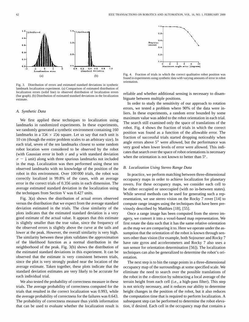
Fig. 3. Distribution of errors and estimated standard deviations in syntheticlandmark localization experiment. (a) Comparison of estimated distribution oflocalization errors (solid line) to observed distribution of localization errors(bar graph). (b) Distribution of estimated standard deviations in the localizationestimate.
A. Synthetic Data
We first applied these techniques to localization usinglandmarks in randomized experiments. In these experiments,we randomly generated a synthetic environment containing 160landmarks in a square. Let us say that each unit is10 cm (though the entire problem scales to an arbitrary size). Ineach trial, seven of the ten landmarks closest to some randomrobot location were considered to be observed by the robot(with Gaussian error in both and with standard deviation
unit) along with three spurious landmarks not includedin the map. Localization was then performed using these tenobserved landmarks with no knowledge of the position of therobot in this environment. Over 100 000 trials, the robot wascorrectly localized in 99.8% of the cases, with an averageerror in the correct trials of 0.356 units in each dimension. Theaverage estimated standard deviation in the localization usingthe techniques from Section V was 0.427 units.
Fig. 3(a) shows the distribution of actual errors observedversus the distribution that we expect from the average standarddeviation estimated in the trials. The close similarity of theplots indicates that the estimated standard deviation is a verygood estimate of the actual value. It appears that this estimateis slightly smaller than the true value, since the frequency ofthe observed errors is slightly above the curve at the tails andlower at the peak. However, the overall similarity is very high.The similarity between these plots validates the approximationof the likelihood function as a normal distribution in theneighborhood of the peak. Fig. 3(b) shows the distribution ofthe estimated standard deviations in this experiment. It can beobserved that the estimate is very consistent between trials,since the plot is very strongly peaked near the location of theaverage estimate. Taken together, these plots indicate that thestandard deviation estimates are very likely to be accurate foreach individual trial.
We also tested the probability of correctness measure in thesetrials. The average probability of correctness computed for thetrials that resulted in the correct localization was 0.993, whilethe average probability of correctness for the failures was 0.643.The probability of correctness measure thus yields informationthat can be used to evaluate whether the localization result is
Fig. 4. Fraction of trials in which the correct qualitative robot position wasfound in experiments using synthetic data with varying amounts of error in robotorientation.
reliable and whether additional sensing is necessary to disam-biguate between multiple positions.
In order to study the sensitivity of our approach to rotationerrors, we tested a problem where 90% of the data were in-liers. In these experiments, a random error bounded by somemaximum value was added to the robot orientation in each trial.The search still examined only the space of translations of therobot. Fig. 4 shows the fraction of trials in which the correctposition was found as a function of the allowable error. Thefraction of successful trials started dropping noticeably whenangle errors above 5were allowed, but the performance wasvery good when lower levels of error were allowed. This indi-cates that search over the space of robot orientations is necessarywhen the orientation is not known to better than 5.
B. Localization Using Stereo Range Data
In practice, we perform matching between three-dimensionaloccupancy maps in order to achieve localization for planetaryrovers. For these occupancy maps, we consider each cell tobe either occupied or unoccupied (with no in-between states).While several methods can be used for generating such a rep-resentation, we use stereo vision on the Rocky 7 rover [14] tocompute range images using the techniques that have been pre-viously described by Matthies [18], [55].
Once a range image has been computed from the stereo im-agery, we convert it into a voxel-based map representation. Wefirst rotate the data such that it has the same relative orientationas the map we are comparing it to. Here we operate under the as-sumption that the orientation of the robot is known through sen-sors other than vision (for example, both Sojourner and Rocky 7have rate gyros and accelerometers and Rocky 7 also uses asun sensor for orientation determination [56]). The localizationtechniques can also be generalized to determine the robot’s ori-entation.
The next step is to bin the range points in a three-dimensionaloccupancy map of the surroundings at some specified scale. Weeliminate the need to search over the possible translations ofthe robot in the -direction by subtracting a local average of theterrain height from each cell (i.e., a high-pass filter). This stepis not strictly necessary, and it reduces our ability to determineheight changes in the position of the robot, but it also reducesthe computation time that is required to perform localization. Asubsequent step can be performed to determine the robot eleva-tion, if desired. Each cell in the occupancy map that contains a

OLSON: PROBABILISTIC SELF-LOCALIZATION FOR MOBILE ROBOTS 63
(a)
(b)
Fig. 5. Terrain map generated from Pathfinder imagery: (a) annotated imagemosaic of Sojourner and rocks on Mars and (b) terrain map generated fromstereo imagery.
range pixel is said to beoccupied, and the others are said to beunoccupied. Fig. 5 gives an example of a terrain map that wasgenerated using imagery from the Mars Pathfinder mission.
We have tested this method using both terrestrial data anddata from the Mars Pathfinder mission. These experiments indi-cate that self-localization can performed using our method withapproximately the same results as a human operator, withoutrequiring a downlink cycle. In addition, only a few seconds areneeded to perform localization. Experiments indicate that lo-calization can be performed on a SPARCstation 20 in under 5 swith maps discretized at 2-cm resolution. Similar experimentsperformed on-board Rocky 7 (Motorola 68060 CPU) require ap-proximately 20 s to perform localization.
C. Mars Yard
We initially tested our method with images taken in the JPLMars Yard3 using cameras mounted on a tripod at approximatelythe Rocky 7 mast height. Fig. 6 shows a set of images that wasused in testing the localization techniques. The set consists of12 stereo pairs acquired at one meter intervals along a straightline with approximately the same heading.
In these tests, we determined the estimated position changesby finding the relative position between each pair of consecu-tive images. The localization techniques yielded a qualitativelycorrect position between each pair of consecutive images. The
3See http://robotics.jpl.nasa.gov/tasks/scirover/marsyard
average absolute error in the position estimates was 0.0342 m inthe downrange direction and 0.0367 m in the sideways directionfrom the position measured by hand. Much of this error can beattributed to human error in determining the ground truth for thedata.
Additional tests were performed on imagery where thecamera system was panned 25left and right. In these tests,occupancy maps from the panned images were matched tooccupancy maps for the unpanned images. All 24 trials yieldedthe correct qualitative result. The average absolute error was0.0138 m in the downrange direction and 0.0225 m in thesideways direction.
In these tests, the average number of positions examined was18.45% of the total number of positions in the discretized searchspace. A speedup of greater than 5 was thus achieved throughthe use of the efficient search techniques.
D. Mars Pathfinder
To validate our approach for use on a Mars rover, we havetested it using data from the Mars Pathfinder mission. A mapof the terrain surrounding the Pathfinder lander was first gen-erated using stereo imagery. For each position of Sojourner atwhich we tested the localization techniques, we generated anoccupancy map of the terrain using range data from Sojourner’sstereo cameras. This local map was then compared to the globalmap from the lander.
Unfortunately, this test has only been possible at a few loca-tions due to the limited amount of data returned to Earth, the lackof interesting terrain in some of the imagery we do have, andthe lack of a comparison value for most positions (except thosewhere Sojourner was imaged by the lander cameras). In prac-tice, these techniques could be exercised much more frequentlysince they would not require downlinking image data to Earthand the comparison value is only necessary for testing. We en-vision a scenario where the data from the rover’s body-mountedcameras, which would be operating frequently in order to per-form obstacle detection, would be used to perform localizationwhenever sufficient terrain was evident in the imagery. In addi-tion, the imagery from mast cameras could be used for localiza-tion when the positional uncertainty grows beyond the desiredlevel and the imagery from the body-mounted cameras is un-suitable.
As an example of the data, Fig. 7 shows the position of So-journer as seen from the lander and the view from Sojourner atthe end of sol 214 of the Mars Pathfinder mission. Note that thestereo data obtained from Sojourner is not as good as we hopeto achieve in future missions. Accurate stereo data is achievedonly for the central portion of the Sojourner imagery due to inac-curate calibration of the fish-eye lenses. The field-of-view thatwe have to work with is thus relatively small. However, we haveachieved good localization results with this data.
Table I shows the results of localization using the techniquesdescribed in this paper versus the localization that was obtainedby a human operator through overlaying a rover model on thestereo data obtained from imaging the rover from the lander.
4A sol is a Martian day.

64 IEEE TRANSACTIONS ON ROBOTICS AND AUTOMATION, VOL. 16, NO. 1, FEBRUARY 2000
Fig. 6. A sequence of images used for testing the localization techniques.
(a)
(b)
Fig. 7. Sojourner on sol 21 (near “Souffle”): (a) image from the lander and (b)image from Sojourner.
For sol 42, we have two localization results, one prior to andone after a turn by the rover. The operator localization was per-formed after the turn.
The results show very close agreement between our tech-niques and the operator localization for four of the cases. Forsols 4, 27, and 72, there is some disagreement. Possible sourcesof error include inaccurate calibration of either the rover orlander cameras and operator error in performing localization.Manual examination of the maps has shown that the localizationtechniques determine the qualitatively correct position in thesecases. While no ground truth exists, the similarity of the posi-tions estimated by our method and by the human operator indi-cate that our method can perform localization approximately aswell as a human operator.
TABLE ICOMPARISON OFROVER POSITIONSDETERMINED BY A HUMAN
OPERATOR OVERLAYING A ROVER MODEL ON STEREO
DATA OF THE ROVER AND BY OUR
LOCALIZATION TECHNIQUES
VII. D ISCUSSION
The primary contribution of our approach is the devel-opment of a robust, global localization method that uses allavailable three-dimensional information. Accurate localizationis performed in the presence of outliers and significant noisein the map data through the use of the maximum-likelihoodmap matching measure. An efficient search of the global posespace is performed through the use of the branch-and-boundpruning techniques. The maximum-likelihood measure yieldsa likelihood surface over the possible positions of the robotand thus our method can be used to generate probabilitydistributions for use in the Markov localization method (see,for example, [5]–[10]). This method provides a means forcombining probability distributions generated at multiple robotpositions and incorporating uncertainties from dead-reckoningerrors.
Most work on mobile robot localization has dealt with indoorenvironments, where the environment is usually modeled in twodimensions. In contrast to previous research, we have concen-trated on achieving localization in completely unstructured out-door terrain, such as a rover might encounter on Mars. In suchterrain, a three-dimensional representation of the environmentis crucial. We note, however, that our approach is general, andcan be applied to virtually any environment that can be mapped.The application of this approach to other environments, such asa building interior is straightforward using either discrete fea-tures or an occupancy grid representation. It should be notedthat in such cases, more locations in the environment will lookquite similar and thus selecting a single robot position may notbe sufficient for robust navigation. In this case, we should main-tain a list of the robot positions that achieve a likelihood above

OLSON: PROBABILISTIC SELF-LOCALIZATION FOR MOBILE ROBOTS 65
some threshold. An even better strategy would be to maintain theentire likelihood surface using a multi-resolution data structure[57] or sampling [58]. This likelihood can then be propagatedafter the robot moves in order to disambiguate the positions.
A possible drawback to this technique is the assumption thatthe environment sensed by the robot contains sufficient shapeto reliably estimate the robot position. However, since our ap-proach can be extended to allow disambiguation using multiplerobot positions, this is not a strong limitation. Any localizationmethod requires some distinctive feature in the environment thatallows that robot to determine its position in a map.
At present, this method has been implemented only for robottranslations. Our experiments indicate that an error in the robotorientation of up to 5 is acceptable for an implementation thatdoes not search over the robot orientation. For cases where theorientation is completely unknown, the extension of these tech-niques to additional degrees of freedom is not complex. If weknow the orientation of the robot to some degree through othersensors, and thus can bound the search space, the additionalsearch time will not grow drastically. However, a fully uncon-strained pose space will require significant computational re-sources using this search strategy.
Gutmannet al.[59] have compared Markov localization tech-niques to scan matching using a Kalman filter. They find thatscan matching techniques are more efficient and accurate, butthat Markov localization techniques are more robust to noiseand sensor error. Our technique shares the robustness of Markovlocalization techniques (if we do not limit our analysis to thesingle highest peak in the likelihood function). In addition, sincewe use all of the available metric information and detect therobot position to subpixel accuracy in a discretized pose space,we are able to achieve high accuracies. Furthermore, the tech-niques that we describe can be used as part of a Kalman filterposition estimator. However, since we perform global localiza-tion, we are not able to match the efficiency of scan matching,where an initial estimate is refined in order to determine the po-sition of the robot.
VIII. SUMMARY
We have described a method for performing self-localizationfor mobile robots using maximum-likelihood matching of maps.The map of visible features at the robot’s current position is com-paredtoaglobalmapthathasbeenpreviouslygenerated(possiblyby combining the maps from the robot’s previous positions). Thebest relative position between the maps is detected using a globalbranch-and-bound search technique that does not require an ini-tial estimate of the robot position. The search is performed rela-tive to a novel maximum-likelihood map similarity measure thatselects the robot position at which the maps best agree. This mapmeasure is very general and robust to map errors.
This probabilistic formulation of the map matching problemallows the uncertainty in the localization of individual map fea-tures to be treated accurately in the matching process. In addi-tion, performing a polynomial fit to the log-likelihood functionallows both subpixel localization to be performed and uncer-tainty estimates to be computed, which can be propagated in aposition tracking mechanism such as the extended Kalman filter.
Our goal in the design of this approach is to provide greaterautonomy for Mars rovers. Through the use of our method,we can perform self-localization on Mars within the confinesof a science site where panoramic stereo imagery has beentaken from the lander or from the rover mast cameras. Thesetechniques can also be used to improve position estimation onlong traverses by periodically stopping to perform localizationversus the previous position and to image the terrain aheadof the rover. The application of these techniques to data fromthe Mars Pathfinder mission indicates that we can performautonomous localization with approximately the same accuracyas a human operator without requiring communication withEarth.
An area that bears further study is the development of a lo-calizability measure for terrain maps in order to plan effectivelocalization steps. In the future, we also plan to integrate ourapproach into an integrated navigation methodology, in whicha Kalman filter is used to synthesize a robot position estimatefrom a variety of sensors and the robot’s path planner interactswith the Kalman filter and the localization techniques to planwhen and where localization should be performed.
ACKNOWLEDGMENT
This research is an element of the Long Range Science Roverproject, which is developing technology for future Mars mis-sions. The author would like to thank all of the people who havebeen involved with the Mars Pathfinder mission and the LongRange Science Rover project. In particular, thanks are due toL. Matthies for generating the range images from the PathfinderIMP cameras that were used in some experiments reported hereand to S. Laubach for collecting the data in the Mars Yard usedin other experiments. Finally, the author would like to thank thepeople who have read and commented on various versions ofthis research, including B. Wilcox, S. Hayati, M. Maimone, A.Johnson, and the anonymous reviewers.
REFERENCES
[1] J. Borenstein, H. R. Everett, L. Feng, and D. Wehe, “Mobile robot posi-tioning: Sensors and techniques,”J. Robot. Syst., vol. 14, pp. 231–249,Aug. 1997.
[2] R. Talluri and J. K. Aggarwal, “Position estimation techniques for anautonomous mobile robot — A review,” inHandbook of Pattern Recog-nition and Computer Vision, C. H. Chen, L. F. Pau, and P. S. P. Wang,Eds. Singapore: World Scientific, 1993, ch. 4.4, pp. 769–801.
[3] D. P. Huttenlocher, G. A. Klanderman, and W. J. Rucklidge, “Comparingimages using the Hausdorff distance,”IEEE Trans. Pattern Anal. Ma-chine Intell., vol. 15, pp. 850–863, Sept. 1993.
[4] C. F. Olson, “A probabilistic formulation for Hausdorff matching,” inProc. IEEE Conf. Comput. Vision Pattern Recognit., 1998, pp. 150–156.
[5] I. Nourbakhsh, R. Powers, and S. Birchfield, “DERVISH: An office-navigating robot,”AI Mag., vol. 16, no. 2, pp. 53–60, 1995.
[6] R. Simmons and S. Koenig, “Probabilistic navigation in partially ob-servable environments,” inProc. Int. Joint Conf. Artificial Intell., vol. 2,1995, pp. 1660–1667.
[7] A. R. Cassandra, L. P. Kaelbling, and J. A. Kurien, “Acting under uncer-tainty: Discrete Bayesian models for mobile robot navigation,” inProc.IEEE/RSJ Int. Conf. Intell. Robot. Syst., vol. 2, 1996, pp. 963–972.
[8] S. Koenig and R. G. Simmons, “Unsupervised learning of probabilisticmodels for robot navigation,” inProc. IEEE Conf. Robot. Automat., vol.3, 1996, pp. 2301–2308.
[9] D. Fox, W. Burgard, and S. Thrun, “Active Markov localization for mo-bile robots,”Robot. Auton. Syst., vol. 25, no. 3-4, pp. 195–207, Nov.1998.

66 IEEE TRANSACTIONS ON ROBOTICS AND AUTOMATION, VOL. 16, NO. 1, FEBRUARY 2000
[10] S. Thrun, W. Burgard, and D. Fox, “A probabilistic approach to concur-rent mapping and localization for mobile robots,”Mach. Learning, vol.31, no. 1–3, pp. 29–53, 1998.
[11] D. P. Huttenlocher and W. J. Rucklidge, “A multi-resolution techniquefor comparing images using the Hausdorff distance,” inProc. IEEEConf. Comput. Vision Pattern Recognit., 1993, pp. 705–706.
[12] C. F. Olson and D. P. Huttenlocher, “Automatic target recognition bymatching oriented edge pixels,”IEEE Trans. Image Processing, vol. 6,pp. 103–113, Jan. 1997.
[13] W. J. Rucklidge, “Efficiently locating objects using the Hausdorff dis-tance,”Int. J. Comput. Vision, vol. 24, no. 3, pp. 251–270, Sept. 1997.
[14] S. Hayatiet al., “The Rocky 7 rover: A Mars sciencecraft prototype,” inProc. IEEE Conf. Robot. Automat., vol. 3, 1997, pp. 2458–2464.
[15] D. Shirley and J. Matijevic, “Mars Pathfinder microrover,”Auton.Robot., vol. 2, pp. 283–289, 1995.
[16] L. H. Matthies, C. F. Olson, G. Tharp, and S. Laubach, “Visual localiza-tion methods for Mars rovers using lander, rover, and descent imagery,”in Proc. 4th Int. Symp. Artificial Intell. Robot. Automat. Space, 1997, pp.413–418.
[17] S. L. Laubach, C. F. Olson, J. W. Burdick, and S. Hayati, “Long rangenavigation for Mars rovers using sensor-based path planning and visuallocalization,” inProc. 5th Int. Symp. Artificial Intell. Robotic. Automat.Space, 1999, pp. 455–461.
[18] L. Matthies, “Stereo vision for planetary rovers: Sto-chastic modelingto near real-time implementation,”Int. J. Comput. Vision, vol. 8, no. 1,pp. 71–91, July 1992.
[19] C. F. Olson, “Mobile robot self-localization by iconic matching of rangemaps,” inProc. Int. Conf. Adv. Robot., 1997, pp. 447–452.
[20] C. F. Olson and L. H. Matthies, “Maximum-likelihood rover localizationby matching range maps,” inProc. Int. Conf. Robot. Automat., vol. 1,1998, pp. 272–277.
[21] C. F. Olson, “Subpixel localization and uncertainty estimation using oc-cupancy grids,” inProc. Int. Conf. Robot. Automat., vol. 3, 1999, pp.1987–1992.
[22] N. Ayache and O. D. Faugeras, “Maintaining representations of the en-vironment of a mobile robot,”IEEE Trans. Robot. Automat., vol. 5, pp.804–819, Dec. 1989.
[23] A. Curran and K. J. Kyriakopoulos, “Sensor-based self-localization forwheeled mobile robots,”J. Robot. Syst., vol. 12, no. 3, pp. 163–176,1995.
[24] J. Horn and G. Schmidt, “Continuous localization of a mobile robotbased on 3d-laser-range-data, predicted sensor images, and dead-reck-oning,” Robot. Auton. Syst., vol. 14, pp. 99–118, 1995.
[25] J. J. Leonard and H. F. Durrant-Whyte, “Mobile robot localization bytracking geometric beacons,”IEEE Trans. Robot. Automat., vol. 7, pp.376–382, June 1991.
[26] Z. Zhang and O. Faugeras, “A 3D world model builder with a mobilerobot,” Int. J. Robot. Res., vol. 11, no. 4, pp. 269–285, August 1992.
[27] K. Sugihara, “Some location problems for robot navigation using asingle camera,”Comput. Vision, Graphics, Image Processing, vol. 42,pp. 112–129, 1988.
[28] M. Betke and L. Gurvits, “Mobile robot localization using landmarks,”IEEE Trans. Robot. Automat., vol. 13, pp. 251–263, Apr. 1997.
[29] P. C. Gaston and T. Lozano-Pérez, “Tactile recognition and localizationusing object models: The case of polyhedra on a plane,”IEEE Trans.Pattern Anal. Machine Intell., vol. PAMI-6, pp. 257–265, May 1984.
[30] W. E. L. Grimson and T. Lozano-Pérez, “Model-based recognition andlocalization from sparse range or tactile data,”Int. J. Robot. Res., vol. 3,no. 3, pp. 3–35, 1984.
[31] M. Drumheller, “Mobile robot localization using sonar,”IEEE Trans.Pattern Anal. Machine Intell., vol. PAMI-9, pp. 325–332, Mar. 1987.
[32] K. T. Simsarian, T. J. Olson, and N. Nandhakumar, “View-invariant re-gions and mobile robot self-localization,”IEEE Trans. Robot. Automat.,vol. 12, pp. 810–816, Oct. 1996.
[33] R. Talluri and J. K. Aggarwal, “Mobile robot self-location using model-image feature correspondence,”IEEE Trans. Robot. Automat., vol. 12,pp. 63–77, Feb. 1996.
[34] I. J. Cox, “Blanche—An experiment in guidance and navigation of anautonomous robot vehicle,”IEEE Trans. Robot. Automat., vol. 7, pp.193–204, Apr. 1991.
[35] F. Lu and E. Milios, “Robot pose estimation in unknown environmentsby matching 2D range scans,”J. Intell. Robot. Syst., vol. 18, pp.249–275, 1997.
[36] J. L. Crowley, F. Wallner, and B. Schiele, “Position estimation usingprincipal components of range data,”Robot. Auton. Syst., vol. 23, pp.267–276, 1998.
[37] A. Elfes, “Sonar-based real-world mapping and navigation,”IEEE J.Robot. Automat., vol. RA-3, pp. 249–265, June 1987.
[38] S. Atiya and G. D. Hager, “Real-time vision-based robot localization,”IEEE Trans. Robot. Automat., vol. 9, pp. 785–800, Dec. 1993.
[39] R. Talluri and J. K. Aggarwal, “Position estimation for an autonomousmobile robot in an outdoor environment,”IEEE Trans. Robot. Automat.,vol. 8, pp. 573–584, Oct. 1992.
[40] F. Stein and G. Medioni, “Map-based localization using the panoramichorizon,”IEEE Trans. Robot. Automat., vol. 11, pp. 892–896, Dec. 1995.
[41] W. B. Thompson, T. C. Henderson, T. L. Colvin, L. B. Dick, and C. M.Valiquette, “Vision-based localization,” inProc. DARPA Image Under-standing Workshop, 1993, pp. 491–498.
[42] F. Cozman and E. Krotkov, “Automatic mountain detection and poseestimation for teleoperation of lunar rovers,” inProc. IEEE Conf. Robot.Automat., vol. 3, 1997, pp. 2452–2457.
[43] I. S. Kweon and T. Kanade, “High-resolution terrain map from multiplesensor data,”IEEE Trans. Pattern Anal. Machine Intell., vol. 14, pp.278–292, Feb. 1992.
[44] R. Szeliski, “Estimating motion from sparse range data without corre-spondence,” inProc. Int. Conf. Comput. Vision, 1988, pp. 207–216.
[45] Z. Zhang, “Iterative point matching for registration of free-form curvesand surfaces,”Int. J. Comput. Vision, vol. 13, no. 2, pp. 119–152, 1994.
[46] W. E. L. Grimson and D. P. Huttenlocher, “On the sensitivity of theHough transform for object recognition,”IEEE Trans. Pattern Anal. Ma-chine Intell., vol. 12, pp. 255–274, Mar. 1990.
[47] W. E. L. Grimson, D. P. Huttenlocher, and D. W. Jacobs, “A study ofaffine matching with bounded sensor error,”Int. J. Comput. Vision, vol.13, no. 1, pp. 7–32, 1994.
[48] W. E. L. Grimson and D. P. Huttenlocher, “Analyzing the probabilityof a false alarm for the Hausdorff distance under translation,” inProc.Workshop Performance versus Methodology in Comput. Vision, 1994,pp. 199–205.
[49] A. Rosenfeld and J. Pfaltz, “Sequential operations in digital picture pro-cessing,”J. ACM, vol. 13, pp. 471–494, 1966.
[50] J. Piper and E. Granum, “Computing distance transformations in convexand nonconvex domains,”Pattern Recognit., vol. 20, no. 6, pp. 599–615,1987.
[51] G. Borgefors, “Distance transformations in digital images,”Comput. Vi-sion, Graphics, Image Processing, vol. 34, pp. 344–371, 1986.
[52] S. Pavel and S. G. Akl, “Efficient algorithms for the Euclidean distancetransform,”Parallel Processing Lett., vol. 5, no. 2, pp. 205–212, 1995.
[53] R. J. Lipton and R. E. Tarjan, “Applications of a planar separator the-orem,”SIAM J. Computing, vol. 9, no. 3, pp. 615–627, 1980.
[54] J. L. Bentley, B. W. Weide, and A. C. Yao, “Optimal expected time al-gorithms for closest point problems,”ACM Trans. Math. Software, vol.6, pp. 563–580, 1980.
[55] L. Matthies, A. Kelly, T. Litwin, and G. Tharp, “Obstacle detectionfor unmanned ground vehicles: A progress report,” inProc. Int. Symp.Robot. Res., 1996, pp. 475–486.
[56] R. Volpe, “Navigation results from desert field tests of the Rocky 7 Marsrover prototype,”Int. J. Robot. Res., vol. 18, no. 7, pp. 669–683, July1999.
[57] W. Burgard, A. Derr, D. Fox, and A. B. Cremers, “Integrating globalposition estimation and position tracking for mobile robots: The dy-namic Markov localization approach,” inProc. IEEE/RSJ Int. Conf. In-tell. Robot. Syst., 1998, pp. 730–735.
[58] F. Dellaert, D. Fox, W. Burgard, and S. Thrun, “Monte Carlo localiza-tion for mobile robots,” inProc. IEEE Conf. Robot. Automat., 1999, pp.1322–1328.
[59] J.-S. Gutmann, W. Burgard, D. Fox, and K. Konolige, “An experimentalcomparison of localization methods,” inProc. IEEE/RSJ Int. Conf. In-tell. Robot. Syst., 1998, pp. 736–743.
Clark F. Olson (S’92–M’94) received the B.S. de-gree in computer engineering and the M.S. degree inelectrical engineering from the University of Wash-ington, Seattle, in 1989 and 1990, respectively. Hereceived the Ph.D. degree in computer science fromthe University of California, Berkeley, in 1994.
After spending two years as a PostdoctoralResearcher at Cornell University, he was employedby the Jet Propulsion Laboratory, California Instituteof Technology, Pasadena, where he is currently aMember of the Technical Staff in the Machine Vision
Group. His research interests include computer vision and mobile robotics.