prioritisation of abandoned non-coal mine impacts on the ... · title here in 8pt arial (change...
TRANSCRIPT
Title here in 8pt Arial (change text colour to black) i
Prioritisation of abandoned non-coal mine impacts on the environment
SC030136/R5 The South West River Basin District

The Environment Agency is the leading public body protecting and improving the environment in England and Wales.
It’s our job to make sure that air, land and water are looked after by everyone in today’s society, so that tomorrow’s generations inherit a cleaner, healthier world.
Our work includes tackling flooding and pollution incidents, reducing industry’s impacts on the environment, cleaning up rivers, coastal waters and contaminated land, and improving wildlife habitats.
This report is the result of research commissioned and funded by the Department for Environment, Food and Rural Affairs (Defra) and the Welsh Government in collaboration with the Environment Agency.
Published by: Environment Agency, Horizon House, Deanery Road, Bristol, BS1 5AH
Main Authors: Mayes, W.M.,1 and Jarvis, A.P.1 Contributing Authors: Coulon, P.2, Fox, A.2, Hill, S.3, Johnston, D.4, Potter, H.A.B.4, Thorn, P.2, Watson, I.A.3 1Newcastle University, 2Atkins Ltd, 3Coal Authority, 4Environment Agency Dissemination Status: Publicly available Keywords: Abandoned metal mines, mine water, pollution, river catchments, impact assessment, remediation, Water Framework Directive Research Contractor: Atkins Ltd., Coal Authority, Newcastle University. Contact: Dr. Adam Jarvis, Newcastle University Email: [email protected] Environment Agency’s Project Manager: Dr Hugh Potter, Operations Directorate Collaborators: Department for Environment, Food and Rural Affairs Welsh Government Department for Communities and Local Government Project Number: SC030136/14 Product Code: SCHO1111BUVA-E-E
www.environment-agency.gov.uk ISBN: 978-1-84911-254-3 © Environment Agency – March 2012 All rights reserved. This document may be reproduced with prior permission of the Environment Agency. The views and statements expressed in this report are those of the authors alone. The views or statements expressed in this publication do not necessarily represent the views of the Environment Agency or Defra and the Environment Agency and Defra cannot accept any responsibility for such views or statements. Further copies of this report are available from: The Environment Agency’s National Customer Contact Centre by emailing: [email protected] or by telephoning 08708 506506.
Prioritisation of abandoned non-coal mine impacts on the environment in the South West RBD ii

Evidence at the Environment Agency Evidence underpins the work of the Environment Agency. It provides an up-to-date understanding of the world about us, helps us to develop tools and techniques to monitor and manage our environment as efficiently and effectively as possible. It also helps us to understand how the environment is changing and to identify what the future pressures may be. The work of the Environment Agency’s Evidence Directorate is a key ingredient in the partnership between research, guidance and operations that enables the Environment Agency to protect and restore our environment. This report was produced by the Research, Monitoring and Innovation team within Evidence. The team focuses on four main areas of activity:
• Setting the agenda, by providing the evidence for decisions;
• Maintaining scientific credibility, by ensuring that our programmes and projects are fit for purpose and executed according to international standards;
• Carrying out research, either by contracting it out to research organisations and consultancies or by doing it ourselves;
• Delivering information, advice, tools and techniques, by making appropriate products available.
Miranda Kavanagh Director of Evidence
Prioritisation of abandoned non-coal mine impacts on the environment in the South West RBD iii
Contents 1. Introduction ......................................................................................................... 1 2. Water body impact categories............................................................................. 2 3. Water body validation and prioritisation .............................................................. 3 4. Mine site and discharge identification ................................................................. 3 5. Preparing for remediation: further investigations and monitoring (Programmes of Measures) .................................................................................................................. 6
5.1 Probably Impacted water bodies.................................................................. 6 5.2 Catchment investigations – Impacted and Probably Impacted water bodies . ..................................................................................................................... 7
6. Conclusions ........................................................................................................ 8 References................................................................................................................. 8 List of tables Table 1. Summary statistics showing final categorisation of water bodies across England and
Wales (Stage 4, March 2009)............................................................................... 2 Table 2. Key information requested in Environment Agency questionnaire ........................... 6 Table 3. Example sites at which a phased approach to catchment monitoring is being
undertaken by the Environment Agency............................................................... 8 Table 4. Prioritisation of Impacted water bodies in the South West RBD (all water bodies
shown).................................................................................................................. 9 Table 5. Prioritisation of Probably Impacted water bodies in the South West RBD (all water
bodies shown) .................................................................................................... 11 Table 6. Mining discharge responses for the South West RBD (all sites for which data
provided by Environment Agency)...................................................................... 14 Table 7. Mine sites in the South West RBD where risk of sudden outbreak is confirmed or
suspected to exist............................................................................................... 17
List of figures Figure 1. Water bodies Impacted or Probably Impacted by abandoned non-coal mines in the
South West RBD .................................................................................................. 4 Figure 2. Non-coal mine impact scores for Impacted and Probably Impacted water bodies in
the South West RBD ............................................................................................ 5
Prioritisation of abandoned non-coal mine impacts on the environment in the South West RBD iv

1. Introduction The Prioritisation of abandoned non-coal mine impacts on the environment project has generated the most definitive evaluation to date of the impacts on the water environment from abandoned non-coal mines across England and Wales. For the first time, an objective assessment has been carried out to prioritise the rivers in England and Wales where pollution from these mines has the highest impact, and where there is the greatest risk that water bodies (river stretches) will fail to meet the objectives of the Water Framework Directive (European Community, 2000) due to abandoned non-coal mines. The specific water bodies which should be the focus of immediate attention in River Basin Management Plans (RBMPs) have been identified, and the work needed to address mining pollution through both research into passive treatment technologies and catchment monitoring investigations is outlined. This is one of 13 reports that detail the final results of the implementation of the methodology across England and Wales. This particular report presents the finalisation of the categorisation of surface water bodies for the South West River Basin District, and also details of mine sites and mine waters, to be used as a basis for directing future remediation planning and / or further data collection. In every report the 13 reports that comprise the outputs of the project are listed, so that the reader may cross-reference between them at need. They are: I. A methodology for identification and prioritisation of abandoned non-coal
mines in England and Wales II. Prioritisation of abandoned non-coal mine impacts on the environment: The
national picture III. Prioritisation of abandoned non-coal mine impacts on the environment in the
Dee River Basin District IV. Prioritisation of abandoned non-coal mine impacts on the environment in the
Northumbria River Basin District V. Prioritisation of abandoned non-coal mine impacts on the environment in the
South West River Basin District VI. Prioritisation of abandoned non-coal mine impacts on the environment in the
Western Wales River Basin District VII. Prioritisation of abandoned non-coal mine impacts on the environment in the
Humber River Basin District VIII. Prioritisation of abandoned non-coal mine impacts on the environment in the
North West River Basin District IX. Prioritisation of abandoned non-coal mine impacts on the environment in the
Severn River Basin District X. Prioritisation of abandoned non-coal mine impacts on the environment in the
Anglian, Thames and South East River Basin Districts XI. Prioritisation of abandoned non-coal mine impacts on the environment in the
Solway-Tweed River Basin District XII. Future management of abandoned non-coal mine water discharges XIII. Hazards and risk management at abandoned non-coal mine sites
Prioritisation of abandoned non-coal mine impacts on the environment in the South West RBD 1

Much of the text in the individual River Basin District (RBD) reports (reports III-XI) are common to all 9 reports, though the information in the tables is different. A detailed description of the methodology used to produce these results is provided in Report I, while Report II provides a national overview of the findings. Implications of the results for future management of abandoned non-coal mine sites is dealt with at length in Report XII, while specific detail of the outputs of the data collated on mine hazards and risk management is provided in Report XIII. It is recommended that the individual RBD reports are read in conjunction with these other national-level reports.
2. Water body impact categories The initial stage of the prioritisation exercise comprised use of existing data, from various sources, to categorise surface water bodies as Impacted, Probably Impacted, Probably Not Impacted and Not Impacted. This exercise was based on the spatial relationship between Environmental Quality Standard (EQS1) failures in mining areas, or EQS failures immediately downstream of a mining area as described in detail in the Methodology report. The impact categories grade from Impacted where water quality failures are coincident in a water body with former mine sites, to catchments where the quality failures are either not associated with any former mining areas, or there are no reported water quality issues (Not Impacted water bodies). The risk categories prefixed “probably” are there to indicate uncertainty in the nature and extent of the link between mining and pollution. Probably Impacted describes a water body where there is a pollution problem but uncertainty persists as to whether the mining activity and downstream pollution issue are explicitly connected, either due to distance between source and receptor, or where there are no recorded mine sites in a polluted former mining area. Probably Not Impacted water bodies are those in mining areas where there is no water quality concern either in the host or downstream water body. The final numbers of water bodies in each of the impact categories are detailed by RBD in Table 1.
Table 1. Summary statistics showing final categorisation of water bodies across England and Wales (Stage 4, March 2009)
River Basin District (RBD)
Impacted Probably Impacted
Probably Not Impacted
Not Impacted
Total
Anglian 0 1 181 831 1013 Dee 9 10 10 71 100 Humber 13 18 151 734 916 North West 15 27 63 427 532 Northumbria 28 39 38 262 367 Severn 31 32 89 599 751 Solway-Tweed 3 6 29 149 187 South East 0 0 88 308 396 South West 57 73 325 680 1135 Thames 0 0 154 490 644 Western Wales 70 37 143 619 869 Grand Total 226 243 1271 5170 6910
1 The EQS values used for this project are detailed in the methodology report – see reference list. The metals / metalloids assessed were cadmium, lead, nickel, zinc, copper, iron, manganese, and arsenic.
Prioritisation of abandoned non-coal mine impacts on the environment in the South West RBD 2

Prioritisation of abandoned non-coal mine impacts on the environment in the South West RBD 3
3. Water body validation and prioritisation After the initial categorisation of water bodies an online questionnaire was used to collate data from local experts at the Environment Agency. This process served to clarify whether the categorisations were valid (e.g. were area staff aware that the pollution in the mining area was due to something other than abandoned non-coal mines?) and to gather information on the extent of impact of non-coal mine pollution on other receptors (ecology, groundwater and water resources). Figure 1 shows the categorisation of water bodies in the South West RBD. This information was used to allocate an individual score to each of the Impacted and Probably Impacted water bodies to describe the extent of the impacts of abandoned non-coal mine drainage, shown in Figure 2 (for details of the scoring system refer to the Methodology report). Tables 4 and 5 (located at the end of the report) show the respective impact scores for the Impacted and Probably Impacted water bodies in the South West RBD. By reading this report in conjunction with Report II (The National Picture), it is possible to see how the results fit into the national prioritisation. These tables contain only a selection of the results with the full details available as a database or a series of GIS (Geographical Information System) layers.
4. Mine site and discharge identification The online questionnaire also collated data specific to mine sites themselves within the priority water bodies. A range of information was collected (Table 2) covering known polluting sites, the presence of point and diffuse pollution, water quality, flow rates, stakeholder concerns and risks and hazards at abandoned sites. This stage provides the crucial link between prioritising impacted water bodies (Tables 4 and 5) and identifying the polluting mine sites within them that could be the focus for future catchment scoping studies (see Section 5). Summary details of all mining discharges identified in the South West RBD are presented in Table 6 while Table 7 shows all sites identified where outbreak risk received either a ‘Suspected’ or ‘Yes’ response. It is important to note that not all of the data gathered during the project is shown in the tables. This is simply because it is not possible to present all of this information in a written report such as this. The main items that have been omitted are:
• Water quality and flow-rate data for discharges where it is available • Text comments relating to evidence of impacts and risks, and whether
stakeholder issues are converging or diverging • Detailed geographical references, such as grid references and water body
identifier codes. • Stability, airborne pollution, safety issues, public / animal health concern
information which is summarised nationally in the Hazards and Risk Management report and presented in their entirety in the database.

Figure 1. Water bodies Impacted or Probably Impacted by abandoned non-coal mines in the South West RBD
Prioritisation of abandoned non-coal mine impacts on the environment in the South West RBD 4

Prioritisation of abandoned non-coal mine impacts on the environment in the South West RBD 5
Figure 2. Non-coal mine impact scores for Impacted and Probably Impacted water bodies in the South West RBD

Table 2. Key information requested in Environment Agency questionnaire
Question / information requested Comment Water Body ID and Name Information provided by Consortium EQS failure co-ordinates and score Information provided by Consortium Categorisation (e.g. Impacted etc.) Information provided by Consortium Locations of point mine water discharges within water bodies with EQS failures, or in water bodies immediately upstream of water body with EQS failure
Required to characterise Impacted and Probably Impacted water bodies
If there is a mine water discharge (either point or diffuse) known or suspected then further information on the discharge is required
Including receiving watercourse name, groundwater, ecological and higher impacts, stakeholder information, and water quality
Knowledge of historical mines, irrespective of water pollution issues
Including mine location and name (if known), airborne pollution risk, safety concerns, stability concerns and outbreak risk
5. Preparing for remediation: further investigations and monitoring (Programmes of Measures)
This project has identified the surface water bodies which show the greatest impacts from abandoned non-coal mines, and so should be prioritised for action in the first cycle of River Basin Planning (RBP).
5.1 Probably Impacted water bodies Many water bodies in mining areas are in the Probably Impacted category since we do not have water quality data from within the water body itself. We know that abandoned non-coal mines are present but not if they are the specific cause of the downstream pollution. Collecting new data on metal concentrations in these rivers would allow these water bodies to be moved either to Probably Not Impacted (if no EQS failures are identified) or to Impacted (if EQS are exceeded). All the data tables within the database are editable beyond the timescale of the project to allow such re-categorisation as new information comes to light. Monitoring would need to be carried out over a 12 month period (ideally at monthly frequency) to ensure variation due to seasonal and flow effects is evaluated. It is recommended that collection of these data is prioritised in the first RBP cycle for the Probably Impacted water bodies with the highest impact scores (see Table 5).
Prioritisation of abandoned non-coal mine impacts on the environment in the South West RBD 6

5.2 Catchment investigations – Impacted and Probably Impacted water bodies
Unfortunately, with very few exceptions, we do not have sufficient monitoring data in any water bodies to allow remediation measures to be designed and implemented. This is the case even in the Impacted water bodies where we are confident that the pollution is due to abandoned mines, and have been able to identify significant point sources. This is a function of the type of monitoring data that need to be collected to characterise mine water pollution for remediation. Concentrations of metals in rivers or mine water discharges alone are not adequate, the flow must also be measured so that the loading (flux) can be calculated. Such data are rarely available from the Environment Agency’s routine monitoring. As a result, the first stage of implementing Programmes of Measures (POMs) for abandoned non-coal mine pollution is to carry out detailed synchronous monitoring of water quality and flow over at least a 12 month period in affected catchments. These further investigations will allow management and remediation schemes to be implemented in the second and third RBP cycle. If these data are not collected during the first RBP cycle, then it will not be possible to address the threat that pollution from abandoned mines poses to good ecological and chemical status. The design and execution of such catchment monitoring programmes is described in the accompanying Future Management of Abandoned Non-Coal Mine Discharges report, and a comprehensive example of such a study is provided by Mayes et al. (2008). In general terms a phased approach is recommended:
1. Scoping study of the catchment (water body scale) to identify main sources of pollution using existing water quality data and other information sources. The data reported in Tables 4, 5 and 6 will inform these studies.
2. Design and implementation of detailed monitoring programmes to collect synchronous measurements of water quality and flow, as well as investigation of the river ecology over a period of at least 12 months.
3. Subject to the results of the monitoring programme, carry out feasibility study for the design and implementation of appropriate management and remediation measures, including pilot-scale treatment trials where appropriate. The suitability of various passive approaches to treatment is provided in the Future Management of Abandoned Non-Coal Mine Discharges report, and also by PIRAMID Consortium (2003).
4. Construct and operate management and remediation measures. Examples of sites at which this phased approach is being implemented by the Environment Agency are shown in Table 3.
Prioritisation of abandoned non-coal mine impacts on the environment in the South West RBD 7

8 Prioritisation of abandoned non-coal mine impacts on the environment in the South West RBD
Table 3. Example sites at which a phased approach to catchment monitoring is being undertaken by the Environment Agency
RBD Mine site / catchment Western Wales Parys Mountain, Cwm Rheidol, Dylife,
Frongoch, Cwmystwyth, Conwy (Nant Gwydyr/Afon Crafnant)
Dee Clywedog Northumbria Saltburn Gill, Rookhope Burn North West Coledale Beck
6. Conclusions By assessing mine waters using water quality, ecological, groundwater and higher impact metrics it has proved possible to objectively prioritise Impacted and Probably Impacted water bodies into ranked lists. Furthermore, additional data stored in the database enables environmental managers to assess what the other issues are at these sites, such as safety issues, outbreak risk and stakeholder concerns. This information can be used to inform future management of pollution from abandoned non-coal mine sites.
References European Community (2000). Council Directive 2000/60/EC establishing a
framework for Community action in the field of water policy. The Official Journal of the European Communities.
Mayes, W.M., Gozzard, E., Potter, H.A.B. and Jarvis, A.P. (2008) Quantifying the
importance of diffuse minewater pollution in a historically heavily coal mined catchment, Environmental Pollution, 151, 165-175.
PIRAMID Consortium (2003) Engineering guidelines for the passive remediation of
acidic and/or metalliferous mine drainage and similar wastewaters. Passive In-situ Remediation of Acidic Mine / Industrial Drainage (PIRAMID) report, European Commission Fifth Framework Programme. Newcastle University.
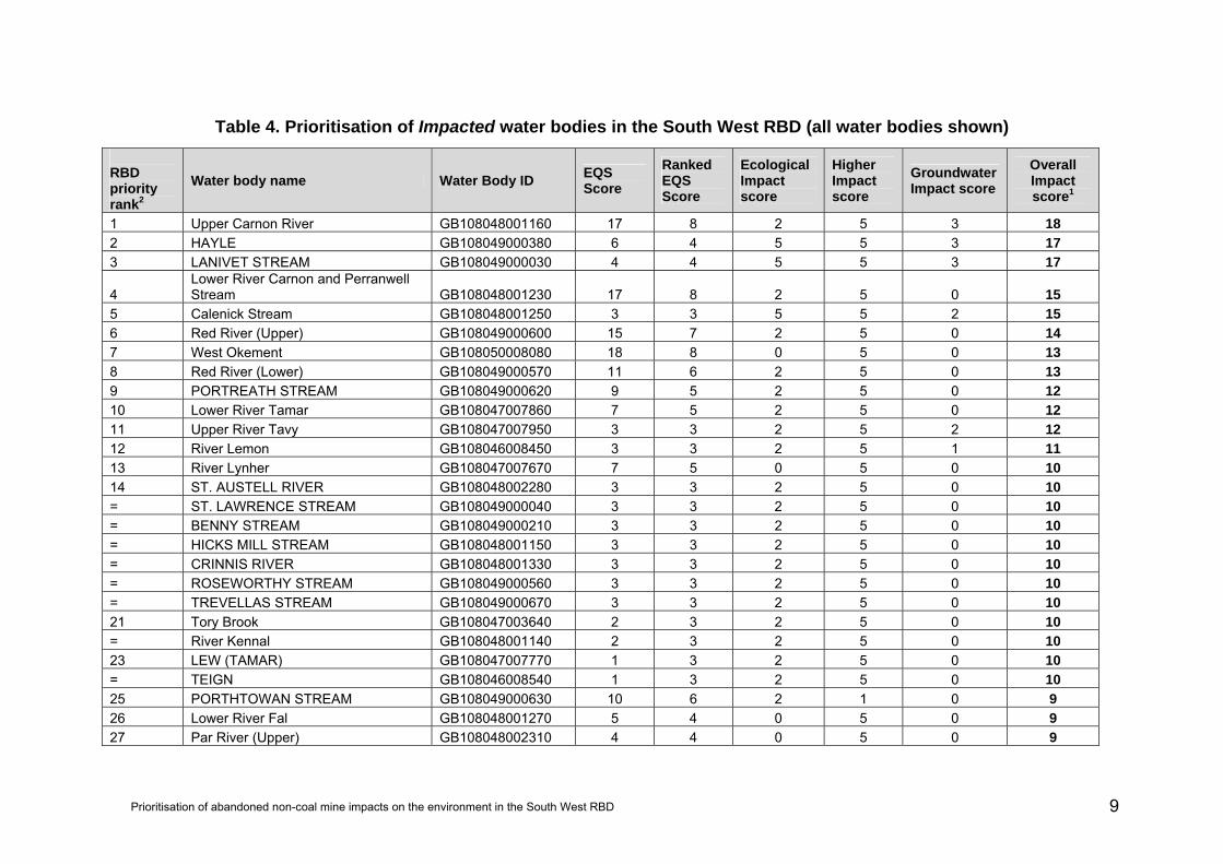
Table 4. Prioritisation of Impacted water bodies in the South West RBD (all water bodies shown) RBD priority rank2
Water body name Water Body ID EQS Score
Ranked EQS Score
Ecological Impact score
Higher Impact score
Groundwater Impact score
Overall Impact score1
1 Upper Carnon River GB108048001160 17 8 2 5 3 18 2 HAYLE GB108049000380 6 4 5 5 3 17 3 LANIVET STREAM GB108049000030 4 4 5 5 3 17
4 Lower River Carnon and Perranwell Stream GB108048001230 17 8 2 5 0 15
5 Calenick Stream GB108048001250 3 3 5 5 2 15 6 Red River (Upper) GB108049000600 15 7 2 5 0 14 7 West Okement GB108050008080 18 8 0 5 0 13 8 Red River (Lower) GB108049000570 11 6 2 5 0 13 9 PORTREATH STREAM GB108049000620 9 5 2 5 0 12 10 Lower River Tamar GB108047007860 7 5 2 5 0 12 11 Upper River Tavy GB108047007950 3 3 2 5 2 12 12 River Lemon GB108046008450 3 3 2 5 1 11 13 River Lynher GB108047007670 7 5 0 5 0 10 14 ST. AUSTELL RIVER GB108048002280 3 3 2 5 0 10 = ST. LAWRENCE STREAM GB108049000040 3 3 2 5 0 10 = BENNY STREAM GB108049000210 3 3 2 5 0 10 = HICKS MILL STREAM GB108048001150 3 3 2 5 0 10 = CRINNIS RIVER GB108048001330 3 3 2 5 0 10 = ROSEWORTHY STREAM GB108049000560 3 3 2 5 0 10 = TREVELLAS STREAM GB108049000670 3 3 2 5 0 10 21 Tory Brook GB108047003640 2 3 2 5 0 10 = River Kennal GB108048001140 2 3 2 5 0 10 23 LEW (TAMAR) GB108047007770 1 3 2 5 0 10 = TEIGN GB108046008540 1 3 2 5 0 10 25 PORTHTOWAN STREAM GB108049000630 10 6 2 1 0 9 26 Lower River Fal GB108048001270 5 4 0 5 0 9 27 Par River (Upper) GB108048002310 4 4 0 5 0 9
Prioritisation of abandoned non-coal mine impacts on the environment in the South West RBD 9
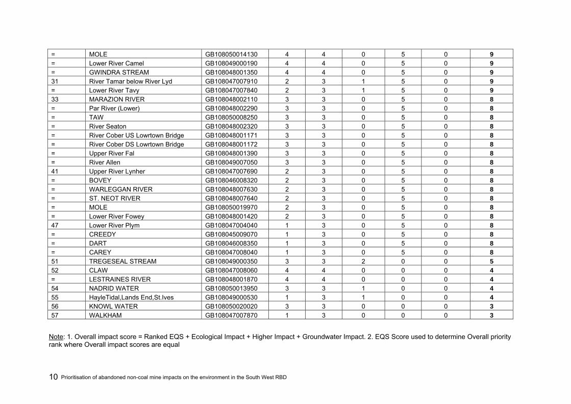
= MOLE GB108050014130 4 4 0 5 0 9 = Lower River Camel GB108049000190 4 4 0 5 0 9 = GWINDRA STREAM GB108048001350 4 4 0 5 0 9 31 River Tamar below River Lyd GB108047007910 2 3 1 5 0 9 = Lower River Tavy GB108047007840 2 3 1 5 0 9 33 MARAZION RIVER GB108048002110 3 3 0 5 0 8 = Par River (Lower) GB108048002290 3 3 0 5 0 8 = TAW GB108050008250 3 3 0 5 0 8 = River Seaton GB108048002320 3 3 0 5 0 8 = River Cober US Lowrtown Bridge GB108048001171 3 3 0 5 0 8 = River Cober DS Lowrtown Bridge GB108048001172 3 3 0 5 0 8 = Upper River Fal GB108048001390 3 3 0 5 0 8 = River Allen GB108049007050 3 3 0 5 0 8 41 Upper River Lynher GB108047007690 2 3 0 5 0 8 = BOVEY GB108046008320 2 3 0 5 0 8 = WARLEGGAN RIVER GB108048007630 2 3 0 5 0 8 = ST. NEOT RIVER GB108048007640 2 3 0 5 0 8 = MOLE GB108050019970 2 3 0 5 0 8 = Lower River Fowey GB108048001420 2 3 0 5 0 8 47 Lower River Plym GB108047004040 1 3 0 5 0 8 = CREEDY GB108045009070 1 3 0 5 0 8 = DART GB108046008350 1 3 0 5 0 8 = CAREY GB108047008040 1 3 0 5 0 8 51 TREGESEAL STREAM GB108049000350 3 3 2 0 0 5 52 CLAW GB108047008060 4 4 0 0 0 4 = LESTRAINES RIVER GB108048001870 4 4 0 0 0 4 54 NADRID WATER GB108050013950 3 3 1 0 0 4 55 HayleTidal,Lands End,St.Ives GB108049000530 1 3 1 0 0 4 56 KNOWL WATER GB108050020020 3 3 0 0 0 3 57 WALKHAM GB108047007870 1 3 0 0 0 3
Note: 1. Overall impact score = Ranked EQS + Ecological Impact + Higher Impact + Groundwater Impact. 2. EQS Score used to determine Overall priority rank where Overall impact scores are equal
Prioritisation of abandoned non-coal mine impacts on the environment in the South West RBD 10

Table 5. Prioritisation of Probably Impacted water bodies in the South West RBD (all water bodies shown) RBD priority rank2
Water body name Water Body ID EQS Score
Ranked EQS Score
Ecological Impact score
Higher Impact score
Groundwater Impact score
Overall Impact score1
1 Withey Brook GB108047007680 7 5 1 5 0 11 2 BOURNE GB108043022390 8 5 0 5 0 10 3 Lower River Inny GB108047007890 7 5 0 5 0 10 4 Lower River Ruthern GB108049000050 4 4 1 5 0 10 4 LOPEN BK GB108052015330 4 4 1 5 0 10 6 HAYWARDS WTR GB108052015390 3 3 2 5 0 10 7 STOUR (Middle) GB108043016050 2 3 2 5 0 10 7 LUMBURN GB108047007850 2 3 2 5 0 10 9 Upper River Plym GB108047003650 1 3 2 5 0 10 9 BEADON BROOK GB108046008500 1 3 2 5 0 10 11 BOVEY GB108046008300 5 4 0 5 0 9 11 WRAY BROOK GB108046008330 5 4 0 5 0 9 11 BOVEY GB108046008470 5 4 0 5 0 9 11 UGBROOKE STREAM GB108046008460 5 4 0 5 0 9 11 River Teign GB108046008430 5 4 0 5 0 9 16 River Camel (De Lank to Stannon) GB108049006980 4 4 0 5 0 9 16 DE LANK RIVER GB108049007030 4 4 0 5 0 9 18 BROCKEY RIVER GB108045015080 3 3 1 5 0 9 18 EXE GB108045015060 3 3 1 5 0 9 18 IRON MILL STREAM GB108045015040 3 3 1 5 0 9 18 BOKIDDICKSTREAM GB108048002300 3 3 1 5 0 9 18 HELE BK GB108052015400 3 3 1 5 0 9 18 SHERFORD STR GB108052015410 3 3 1 5 0 9 24 Lowley Brook GB108047007920 2 3 1 5 0 9 24 Tamar (Kelly Brook) GB108047007900 2 3 1 5 0 9
26 Frome Dorset Trib (Compton Valence Stream) GB108044009680 1 3 1 5 0 9
26 Frome Dorset Trib (River Win) GB108044009650 1 3 1 5 0 9 26 TEIGN GB108046008550 1 3 1 5 0 9
Prioritisation of abandoned non-coal mine impacts on the environment in the South West RBD 11

26 DART GB108046008340 1 3 1 5 0 9 26 KATE BROOK GB108046008480 1 3 1 5 0 9 31 BARLE GB108045015100 3 3 0 5 0 8 31 MADFORD RIVER GB108045014920 3 3 0 5 0 8 31 HILLFARRANCE BK GB108052015510 3 3 0 5 0 8 31 TONE, upper GB108052021370 3 3 0 5 0 8 31 WESTFORD STR GB108052015380 3 3 0 5 0 8 31 Broughton Brook GB108052015420 3 3 0 5 0 8 37 AXE GB108045014840 2 3 0 5 0 8 37 KIT BROOK GB108045014830 2 3 0 5 0 8 37 FORTON BROOK GB108045014820 2 3 0 5 0 8 37 Upper River Yealm GB108047004050 2 3 0 5 0 8 37 PIALL GB108047004020 2 3 0 5 0 8 37 AXE GB108045008870 2 3 0 5 0 8 37 YARTY GB108045008820 2 3 0 5 0 8 37 River Tamar (Launceston) GB108047007940 2 3 0 5 0 8 37 QUITHER STREAM GB108047007930 2 3 0 5 0 8 37 River Fowey (Warleggan to St Neot) GB108048001410 2 3 0 5 0 8 37 CARDINHAM WATER GB108048001450 2 3 0 5 0 8 48 HOOKE GB108044009800 1 3 0 5 0 8 48 FROME Dorset (Upper) GB108044009780 1 3 0 5 0 8
48 Frome Dorset (Lower) & Furzebrook Stream GB108044009690 1 3 0 5 0 8
48 Tadnoll Brook (including Empool Bottom) GB108044009660 1 3 0 5 0 8
48 CERNE GB108044009710 1 3 0 5 0 8 48 SYDLING WATER GB108044009700 1 3 0 5 0 8 48 TALE GB108045009200 1 3 0 5 0 8 48 OTTER GB108045009180 1 3 0 5 0 8 48 Lower River Yealm GB108047004010 1 3 0 5 0 8 48 River Otter GB108045009170 1 3 0 5 0 8 48 JACKMOOR BROOK GB108045009080 1 3 0 5 0 8 48 MEAVY GB108047003660 1 3 0 5 0 8 48 WEBBURN GB108046005250 1 3 0 5 0 8
Prioritisation of abandoned non-coal mine impacts on the environment in the South West RBD 12

48 EAST DART RIVER GB108046008420 1 3 0 5 0 8 48 WEST DART RIVER GB108046008400 1 3 0 5 0 8 48 SOUTH WINTERBOURNE GB108044010060 1 3 0 5 0 8 48 TAW GB108050014530 1 3 0 5 0 8 48 EAST OKEMENT RIVER GB108050008100 1 3 0 5 0 8 66 BURCOMBE STREAM GB108050014150 4 4 1 0 0 5 67 BURN (TAVY) GB108047007880 2 3 1 0 0 4 67 WOLF (OTTER) GB108045009190 1 3 1 0 0 4 67 ASHBURN GB108046005270 1 3 1 0 0 4 67 BRAMBLE BROOK GB108046008490 1 3 1 0 0 4 71 BLACKWATER RIVER GB108045008850 2 3 0 0 0 3 71 FINGLE BROOK GB108046008570 1 3 0 0 0 3 71 HAWKRIDGE BROOK GB108050014520 1 3 0 0 0 3
Note: 1. Overall impact score = Ranked EQS + Ecological Impact + Higher Impact + Groundwater Impact. 2. EQS Score used to determine Overall priority rank where Overall impact scores are equal
Prioritisation of abandoned non-coal mine impacts on the environment in the South West RBD 13
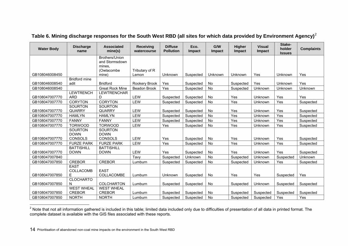
Table 6. Mining discharge responses for the South West RBD (all sites for which data provided by Environment Agency)2
Water Body Discharge name
Associated mine(s)
Receiving watercourse
Diffuse Pollution
Eco. Impact
G/W Impact
Higher Impact
Visual Impact
Stake-holder Issues
Complaints
GB108046008450
Brothers/Union and Stormsdown mines, (Owlacombe mine)
Tributary of R Lemon Unknown Suspected Unknown Unknown Yes Unknown Yes
GB108046008540 Bridford mine adit Bridford Rookery Brook Yes Suspected No Suspected Yes Unknown Yes
GB108046008540 Great Rock Mine Beadon Brook Yes Suspected No Suspected Unknown Unknown Unknown
GB108047007770 LEWTRENCHARD
LEWTRENCHARD LEW Suspected Suspected No Yes Unknown Yes Yes
GB108047007770 CORYTON CORYTON LEW Suspected Suspected No Yes Unknown Yes Suspected
GB108047007770 SOURTON QUARRY
SOURTON QUARRY LEW Suspected Suspected No Yes Unknown Yes Suspected
GB108047007770 HAMLYN HAMLYN LEW Suspected Suspected No Yes Unknown Yes Suspected GB108047007770 FANNY FANNY LEW Suspected Suspected No Yes Unknown Yes Suspected GB108047007770 TORWOOD TORWOOD LEW Yes Suspected No Yes Unknown Yes Suspected
GB108047007770
SOURTON DOWN CONSOLS
SOURTON DOWN CONSOLS LEW Yes Suspected No Yes Unknown Yes Suspected
GB108047007770 FURZE PARK FURZE PARK LEW Yes Suspected No Yes Unknown Yes Suspected
GB108047007770 BATTISHILL DOWN
BATTISHILL DOWN LEW Yes Suspected No Yes Unknown Yes Suspected
GB108047007840 Tavy Suspected Unknown No Suspected Unknown Suspected Unknown GB108047007850 CREBOR CREBOR Lumburn Suspected Suspected No Suspected Unknown Yes Suspected
GB108047007850
EAST COLLACOMBE
EAST COLLACOMBE Lumburn Unknown Suspected No Yes Yes Suspected Yes
GB108047007850 CLOCHARTON COLCHARTON Lumburn Suspected Suspected No Suspected Unknown Suspected Suspected
GB108047007850 WEST WHEAL CREBOR
WEST WHEAL CREBOR Lumburn Suspected Suspected No Suspected Suspected Suspected Suspected
GB108047007850 NORTH NORTH Lumburn Suspected Suspected No Suspected Suspected Yes Yes
2 Note that not all information gathered is included in this table; limited data included only due to difficulties of presentation of all data in printed format. The complete dataset is available with the GIS files associated with these reports.
Prioritisation of abandoned non-coal mine impacts on the environment in the South West RBD 14

CREBOR CREBOR
GB108047007860
Sydenham Damerel Stream Tamar Yes Suspected No Yes No Suspected Unknown
GB108047007860 various Tamar Yes Suspected No Yes Unknown Suspected Unknown GB108047007860 Tamar Yes Suspected No Yes Yes Yes Yes
GB108047007860 all mines in this catchment various Tamar Yes Suspected No Yes Suspected Yes Yes
GB108047007860 all mines in this area various Tamar Yes Suspected No Yes Suspected Yes Yes
GB108047007860 all mines in this area various Tamar Yes Suspected No Yes Unknown Suspected Suspected
GB108047007860
DEVON GREAT CONSOLS
DEVON GREAT CONSOLS Tamar Yes Suspected No Yes Suspected Yes Yes
GB108047007860 Gawton Gawton Tamar Yes Suspected No Yes Suspected Suspected Suspected
GB108047007860 Portontown Stream
DEVON GREAT UNITED
Portontown Stream/Tamar Yes Suspected No Yes Suspected Suspected Suspected
GB108047007860 Bedford United Bedford United Tamar Yes Suspected No Yes Unknown Suspected Suspected
GB108047007860 Clitters Adit Gunislake Clitters TAMAR Yes Suspected No Yes Suspected Suspected Suspected
GB108047007860 Clitters Spoil Heap
Gunnislake Clitters
Tamar - above SWW intake Yes Suspected No Yes No Yes Unknown
GB108047007860 Luckett - Spoil Heap
New Great Consols Luckett Stream Yes Suspected No Suspected Unknown Suspected Suspected
GB108047007900 Tamar (Lower) Suspected Unknown No Unknown Unknown Unknown Unknown GB108047007910 Tamar Suspected Unknown No Unknown Unknown Unknown Unknown
GB108047007910
Lawhitton Consols & Gatherley Tamar Suspected Unknown No Suspected Unknown Unknown Unknown
GB108047007920
Greystone Wood, Greystone Silver Lead, South Petherwin, Trenute, Trebullet Hill
Lowley Stream/ Tamar Suspected Unknown No Yes Unknown Suspected Unknown
GB108047007950 various
Betsy, Union, South Friendship, South Devon United, Jewell,
Charwell Brook/Tavy Yes Suspected Suspected Yes Suspected Yes Unknown
Prioritisation of abandoned non-coal mine impacts on the environment in the South West RBD 15

Hillbridge Consols, Rattlebrook, North Friendship, North Devon United, Central Devon United, Bennetts, Friendship, Gibbet Hill.
GB108048001160 County Adit various Carnon River Yes Suspected No Yes Yes Suspected Yes GB108048001160 Wheal Jane Wheal Jane Baldhu Bridge Suspected Suspected No Yes Suspected Suspected Yes GB108048001160 various Carnon River Suspected Suspected No Yes Suspected Suspected Yes GB108048001160 various Carnon River Suspected Suspected No Yes Suspected Suspected Yes GB108048001160 various Baldhu Stream Suspected Suspected No Yes Suspected Suspected Suspected
GB108048001160 Wheal Maid Tailings Dam Mount Wellington St Day Stream Yes Suspected No Yes Yes Yes Yes
GB108048001250 East Wheal jane east wheal jane Tinney Yes Yes Suspected Unknown Yes Unknown Yes
GB108049000030 Lanivet Stream Yes Yes Yes Yes Yes Yes Yes GB108049000380 R Hayle Suspected Yes Yes Unknown Suspected Unknown Unknown GB108049000570 Red River Suspected Suspected No Yes Yes Suspected Suspected GB108049000600 Brae Tin Carn Brea Red River Suspected Suspected No Yes Unknown Suspected Unknown GB108049000600 Treslillard Adit Red River Suspected Suspected No Yes Yes Suspected Unknown
GB108049000600 Dolcoath Adit South Crofty Ltd, Pool, Redruth Red River Suspected Suspected No Yes Yes Yes Yes
GB108049000600
South Crofty Ltd, Pool, Redruth
South Crofty Ltd, Pool, Redruth Red River Suspected Unknown No Suspected Suspected Suspected Yes
GB108049000620 Barncoose adit
South Crofty Limited, Pool, Redruth
Portreath Stream Suspected Unknown No Suspected Yes Suspected Suspected
GB108049000630 Tywarnhayle Tywarnhayle Porthtowan Stream Yes Unknown No Unknown Unknown Unknown No
Prioritisation of abandoned non-coal mine impacts on the environment in the South West RBD 16

Table 7. Mine sites in the South West RBD where risk of sudden outbreak is confirmed or suspected to exist
Water Body Mine Outbreak Risk Receiving watercourse Details
GB108046008450 STORMSDOWN Yes River Lemon Pollution incident logged in 2004 GB108046008450 UNION Yes River Lemon Pollution incident logged in 2004 GB108046008450 BROTHERS Yes River Lemon Pollution incident logged in 2004 GB108047007860 DEVON GREAT UNITED Suspected Lower River Tamar Being monitored for movement GB108047007860 GUNNISLAKE CLITTERS Suspected Lower River Tamar No details GB108048001160 MOUNT WELLINGTON Suspected Carnon River No details
Prioritisation of abandoned non-coal mine impacts on the environment in the South West RBD 17
