principals of archaeological stratigraphy
TRANSCRIPT

SECOND EDITION


Principles of archaeological stratigraphy

Principles of archaeological stratigraphy
Second edition
EDWARD C. HARRIS Bermuda Maritime Museum Mangrove Bay Bermuda
ACADEMIC PRESS Harcourt Brace &Company, Publishers London San Diego New York Boston Sydney Tokyo Toronto

ACADEMIC PRESS LIMITED 24/28 Oval Road London NW 1 7DX
United States Edition published by ACADEMIC PRESS INC. San Diego, CA 92 10 1
Copyright 1989 by ACADEMIC PRESS LIMITED Third printing 1997
First edition published 1979
All Rights Reserved No part of this book may be reproduced in any form by photostat, microfilm, or by any other means, without written permission from the publishers
British Library Cataloguing in Publication Data Harris, Edward C.
Principles of archaeological stratigraphy. 2nd ed. 1. Antiquities. Excavation of remains. Applications of stratigraphy I. Title 930.1'028'3
ISBN 0-12-32665 1-3
Printed in Great Britain by St Edmundsbury Press Limited, Bury St Edmunds, Suffolk

Foreword
It is an honour for me to pen a few words introducing the second edition of Dr. Edward Harris' Principles of archaeological stratigraphy. The first edition and related articles comprise an incisive and immensely practical approach to the problems of archaeological stratigraphy. We may judge from the many and diverse examples furnished in the new edition of Principles, the Harris Matrix - which I have been teaching since 1978 - has been widely adopted. The only mystery is why a good number of investigators, especially in the United States, continue to believe that they can do without it.
In this edition, Dr. Harris properly stresses that archaeological strati- graphy is not geological stratigraphy writ small. Rather, the principles of archaeological stratigraphy, made explicit below, are new and distinct, having taken shape over the decades of archaeological practice. Geologists and geoarchaeologists who reject Dr. Harris' claim for the existence of this body of archaeological principles perhaps have fallen victim to disciplinary chauvinism uninformed by thorough analyses of relevant cases. In any event, this volume decisively demonstrates that there is an archaeological strati-
graphy. The new edition of Principles, which benefits from a decade of applications
of the Harris Matrix, is a significant contribution to the science of archae- ology. I hope that it succeeds in finally penetrating those last bastions where stratigraphy is still practiced - seemingly in the dark - as an arcane ritual.
The discipline clearly owes Dr. Harris an immense debt of gratitude for having developed the matrix that bears his name and for systematizing the principles of archaeological stratigraphy.
Michael B. Schiffer Department of Anthropology
University of Arizona

Acknowledgements
This revised edition would not have been completed without the patience and assistance of my colleague in Bermuda, Mrs Nan Godet, who did much of the background work for this new publication.
Looking back, I am very grateful to those who supported the ideas which led to the first edition, which has been a success in many countries and in different fields of archaeology. My thanks for their original support are thus due to Philip Barker, Geoffrey Dimbleby, James Graham-Campbell, Brian Hobley, Laurence Keen, Frances Lynch, Philip Rahtz, Richard Reece and Sir David Wilson.
In the last few years, a number of colleagues have rekindled my interest in stratigraphic matters by examples of their work and by their enthusiasm. It is with many thanks that I acknowledge the friendship and support of David Black, David Bibby, Marley Brown III, Charles Leonard Ham, Zbigniew Kobylinski, Nicky Pearson, Adrian and Mary Praetzellis, Michael Schiffer, David Simmons, Barbara Stucki, John Triggs, Joe Last, Suzanne Plousos and Bruce Stewart.
I gratefully acknowledge and thank all those who kindly gave permission for the reproduction of their work in this book, as noted in the captions for the illustrations.

Preface
The first edition of this book was published in 1979 and was reprinted in 1987. Under the auspices of the publishers, Nova Scientificia, it appeared in an Italian edition in 1983 translated by Ada Gabucci, with an introductory chapter by Daniele Manacorda. It was published in Polish in 1989, translated by Zbigniew Kobylinski. A Spanish edition of the revised edition has been agreed. Given the success of the book, a new edition seemed warranted, particularly as it is the only textbook devoted entirely to the concepts of stratigraphy in archaeology.
In considering a revised edition, it was decided to keep the book as small as possible, in order that it would remain accessible to students of archaeology. The historical portion of the book was reduced, but the later chapters in which the methods of the Harris Matrix are explained were expanded. Some new material is included from stratigraphic work of other archaeologists, most of which has not been published.
A companion volume, Practices of Archaeological Stratigraphy, edited by myself and Marley Brown III, Director of Archaeological Research at the Colonial Williamsburg Foundation, has been accepted for publication by Academic Press. It will complement this revised edition by giving examples of fieldwork using the Harris Matrix system and will be a collection of articles by various authors, some of whom have provided information for the present book, for which I am very grateful.
Ides of March 1989 Edward C. Harris

For Jane Patterson Downing

Contents
Foreword Acknowledgements Preface Introduction
1. The concept of stratigraphy in geology 2. The concept of stratigraphy in archaeology 3. Techniques of archaeological excavation 4. Early recording methods on excavations 5. The laws of archaeological stratigraphy 6. Deposits as units of stratification 7. Interfaces as units of stratification 8. Archaeological sections 9. Archaeological plans
10. Correlation, phasing and stratigraphic sequences 11. Stratigraphic sequences and post-excavation analyses 12. An outline for stratigraphic recording on excavations
Glossary of terms used in archaeological stratigraphy Bibliography Index
v vi
vii xi

. . . the true archaeological activity, the one in which the archaeologist finds his true identity and is aware that no one can take his place to advantage, is certainly the "establishment" of facts. In the most general and characteristic case, that of an excavation, it is when he notes a mass of rubble, locates one wall, then the others, and sees a plan forming . . it is when he differentiates between discarded bones and a grave, between a simple hearth and a localized or generalized blaze; it is when he does this that he is accomplishing work that no one is better able to do, that no one else can ever do again. . . . He knows that, if he makes a mistake, sees things wrongly, misunderstands, his conclusions will then be irremediably falsified and cannot but lead to other errors among those who use them.
Paul Courbin (1988)

Introduction
The idea that the features of an archaeological site are to be found in a stratified state, one layer or feature on top of the other, is of first importance in the investigation of these sites by archaeological excavation. This book is a discussion of the principles of archaeological stratigraphy, which excavators apply t o the study of archaeological sites, both during excavations and in post-excavation analysis.
The emphasis of this book is upon the chronological, topographical and the repetitive or non-historical aspects of archaeological stratification. It is assumed that archaeological stratification occurs as a similar physical phenomenon from one site to another. The principles of archaeological stratigraphy, which is the science by which archaeological sites may be properly understood, are thus everywhere applicable.
The character of the stratification of a particular archaeological site will depend upon the historical and cultural circumstances in which it was created. The unique historical and cultural meaning of archaeological stratifi- cation is interpreted by general archaeological methods and by comparison with data from many other sources, e.g. historical or environmental studies. Using the facts created by stratigraphic discoveries, historians, anthropol- ogists and many other students of the Past, will naturally expand on the significance of a site, as outlined by the archaeologist. The principles of archaeological stratigraphy have but a minor role in such later interpret- ations, as they apply to the physical arrangement of archaeological stratifi- cation and allow the archaeologist to determine the relative chronological order in which stratification was created.
The principles of archaeological stratigraphy are related to sites in which the stratification is predominantly of human origin. The interpretation of archaeological sites composed of natural, or geological, stratification (in which human remains or artefacts are found) is governed by the principles of geological stratigraphy. Some archaeologists think that geological principles of stratigraphy are adequate for the study of archaeological sites with man- made stratification. They advocate a return to those axioms, citing the ideas found in the first edition of this book as representing an unnecessary

xii Introduction
'separatist' movement (Farrand 1984a,b; Collcutt 1987). Such a view fails to take account of the extraordinary effect that human society has had on the shaping of the face of this planet. It also fails to account for the fact that most of the stratigraphic problems in archaeology today stem from the fact that we did not divorce ourselves long ago from geological notions of stratigraphy. which are entirely useless in many archaeological contexts.
When humans made their debut on the Earth, a revolution occurred in the process of stratification which had been carried out until then by natural agencies. This great change had at least three major aspects: first, mankind began to manufacture objects which did not conform to the process of organic evolution through natural selection; secondly, humans began to define preferential areas of use of the Earth's surface; thirdly, people began to dig into the earth, by cultural preference, rather than by instinct, which eventually altered the stratigraphic record in a non-geological manner.
This revolution separates archaeological from geological stratigraphy, the cultural from the natural. Archaeological objects, unlike living species, have no set life-pattern; their presence in stratification thus confounds geological assumptions of evolution and change as seen through stratified fossil remains. Preferential areas of use have become enshrined as property boundaries of familial or national dimensions and are represented stratigraphically in the remains of a common garden fence or in structures such as the Great Wall of China. These boundaries march to our will and divide the land into unnatural plots. When humankind learned to excavate (surely, next to tool-making, one of the greatest achievements in the development of our species?), strati- graphic features were produced which had no geological equivalent. Eventually, each culture developed its own forms of excavation to suit different aims, from the digging of pits and ditches, to the acquisition of materials to erect towns and cities.
As various societies passed from one form to another, as the nomad gave way to the town dweller, with each increase in the material development of human culture, there was an accompanying increase in the density and complexity of stratigraphic depositions in archaeological contexts. With each great change, such as the industrial revolution of recent centuries, the stratigraphic signature of human life became less geological and more man- made. Stratigraphically speaking, it is from a very early point in human history that geological principles of stratigraphy were no longer applicable to man-made stratification: It is from that early time that a claim for 'archaeol- ogical stratigraphy' as a separate, earth-forming process, cannot be refuted.
With the beginning of urban life, the nature of archaeological stratigraphy changed even more dramatically. The rate of deposition through the con- struction of buildings was greatly increased, as was the rate of degradation. This reflected a growing capacity to dig in the earth and to transform the

findings into new stratigraphic phenomena. This change is exhibited in the stratification of sites around the world and may be seen in such modern activities as open-cast mining or the building of sky-scrapers.
The urban revolution was a partner to a revolution in the processes of geological and archaeological stratification. But while humans have been recognized as geological agents (Sherlock 1922), the stratigraphic impli- cations of this role have been little examined in either archaeology or geology. As a result, some archaeologists are still attempting to unravel archaeological stratification according to rules which were devised over a century ago for the study of strata formed under sedimentary conditions many millions of years ago.
The stratigraphic records of many excavations, particularly those on complex urban sites, have thus been compiled with inadequate guidelines based on geological notions. For the stratigraphic archives which result from many of these sites, the adjective 'chaotic' is perhaps not an extreme description. Out of these inadequate stratigraphic records arise many of the problems in archaeology, such as the inability to produce excavation reports within a reasonable period.
Although archaeological stratigraphy is fundamental to our discipline, it has received very little attention in recent decades. Of the 4818 papers cited in the book Archaeology, a Bibliographical Guide to the Basic Literature (Heizer et al. 1980), a grand total of eight articles are listed under the title 'stratigraphy'. Nearly all current textbooks on archaeology devote but a page or two to the enunciation of stratigraphic principles, and most of those stated are corrupted versions of geological hand-me-downs (e.g. Barker 1977; Hester and Grady 1982; Sharer and Ashmore 1979).
The first edition of this book was the first text to be given over in its entirety to a discussion of the principles of archaeological stratigraphy, particularly where human activities have affected the formation of stratification. If you believe, with Paul Courbin (1988: 112), that the job of an archaeologist is the 'establishment' of facts, then there can be nothing more fundamental to our business than the establishment of stratigraphic facts. In this second edition of Principles of Archaeological Stratigraphy, I have attempted to reorganize the contents in the hope that the student may more readily learn the basic methods by which the facts of the stratification of an archaeological site may be discovered and recorded.
In the first four chapters, an historical outline is given of stratigraphic concepts in geology and archaeology, and of earlier techniques of excavation and recording. Chapter 5 brings together the Laws of Archaeological Stratigraphy, which were dispersed in the first edition: it is of necessity that the Harris Matrix and the idea of 'stratigraphic sequences' are introduced here as well. Chapters 6 and 7 are a pair: one discusses deposits in

xiv Introduction
archaeological stratification, and the other, the notion of the 'interface', which is the dividing line between deposits, or, conversely, their surfaces. The next two chapters deal with the recording methods of section and plan drawings. Chapters 10 and 11 outline the stages of 'phasing' and the analysis of artefacts in relation to stratigraphic sequences. In the final chapter, a summary is given of the simple procedures which, if carried out with diligence, will ensure that even a modest beginner with a little training can establish the stratigraphic facts of an archaeological excavation.
Because of the goodwill of many colleagues, I have been able to add a number of significant illustrations which show that some of the theories expressed in the first edition have been proven in practical application. If you judge this second edition to be an advance on the original, the credit must go in large measure to my colleagues and their development of my basic ideas of archaeological stratigraphy. Stratigraphic interpretation is perhaps the most difficult job we face as archaeologists: to those of you who come fresh to these ideas, I hope that this book will cause you to seek- as only archaeologists can - the facts of archaeological stratification: good luck and good hunting.

1 The concept of stratigraphy in geology
By 1830, when Sir Charles Lyell published his classic book, Principles of Geology, the concept of stratigraphy in geology had taken on many of its primary characteristics as a result of discoveries made from the seventeenth century onwards. These characteristics were particular where they related to aspects of stratigraphy such as fossils, strata and interfaces; they were general in relation to the laws of stratigraphy and the relationships be- tween the laws, to notions of chronology, and to stratification itself, namely the strata and interfaces, or unconformities between them.
The discoveries which gave the notion of stratigraphy its modern cast were opposed to prevailing attitudes towards fossils and stratification. The former were considered to be 'sports of Nature', the latter as depositions of the Flood. Chronological restrictions were also imposed upon the develop- ment of geological ideas by the then accepted age of the Earth, calculated by Biblical references at no more than 6000 years.
Steno and sharks' teeth
One of the earliest systematic attempts to examine the nature of stratifi- cation was made by a Dane, Nils Steensen (Steno), in Italy during the third quarter of the seventeenth century. Steno claimed a direct relationship between the teeth of modern sharks and the numerous 'tongue-stones' then found in the chalk cliffs of Malta:
since the shape of the tongue stones is like the shark's teeth as one egg t o another; since neither their number nor their position in the ground speaks against it; it appears to me that they cannot be far from the truth who assert that the tongue stones are shark's teeth (Garboe 1954: 45).

2 Principles of archaeological stratigraphy
He further reasoned that objects which expand by slow growth can create fissures in stone, like tree roots in rocks or old walls. In the process, however, the objects will themselves be deformed. Since fossils, such as the tongue-stones, were always found in similar shapes, Steno assumed that the ground had not been compact when the fossils were formed (Garboe 1958: 15). He therefore suggested that the rocks in which the fossils occurred had originally been sediments in water. The deposition of the sediments covered the pre-formed fossils in liquid mud, thereby preserving their original shapes.
As to the presence of such objects in the mountains, Steno quoted the conventional idea that they had been left there, high and dry, after the waters of the Biblical Flood had receded. However, he also perceived an alternative theory: that the rocks and their contained remains had changed position, citing from the Annales of Tacitus:
During the same year twelve towns in Asia Minor were laid waste by a n earthquake in the night . . . high mountains are said to have been levelled to the ground; the flat ground is said to have risen into steep mountains, and fire broke out among the ruins (Garboe 1958: 19).
In support of this theory, Steno published one of the earliest examples of an ideal geological section (White 1968: plate XI), based on a well-known situation in the karst region of Italy. There the roofs of caves often col- lapse, forming small valleys (Tomkeieff 1962: 385).
Steno broke with tradition in his assertion that fossils were the ancestral remains of present life and that strata were neither static formations nor depositions of the Flood. His research also led him to give expositions on the geological laws of superposition and original continuity (White 1968: 229).
Two further advances in the theory of geological stratigraphy were made at the close of the eighteenth century: one concerned the general relation- ship between fossils and strata, the other focused upon a specific aspect of stratification, the interface between strata.
Correlation of strata
The first advance of this kind was made in southern England by William Smith, who was working on the excavation and survey of a canal. Smith observed that the strata in the region exhibited a regular pattern of super- position. Collecting fossils from various outcrops of these columns led him

The concept of stratigraphy in geology .
to the discovery that each stratum contained organic remains which were peculiar to itself (Smith 1816: ii). This discovery allowed geologists to identify strata of the same period from one locality to another, when other criteria, such as a similar lithography, were absent. It also provided the key for the chronological correlation of geological strata throughout the world.
In accordance with the theme of his dtscovery, Smith stored his collec- tion in a stratigraphically ordered cabinet. The fossils were placed on sloping shelves which corresponded to the position of the stratum in which they were found (Eyles 1967: 180). (It is of interest to note that the archaeological collections at Fortress Louisborg are stored in stratigraphic order, as indicated by Harris Matrix diagrams of the stratigraphic sequence of this Canadian Parks Service site.) His collection was also meticulously catalogued, each fossil given three marks for its genus, species and locality:
which triple reference has the effect of collating the specimens or of showing at one View at how many different places the same fossil is found: thissame method is pursued through all the Organized Fossils of the collection: each stratum being a division of the whole, & the Fosstls tn i t marked separately from the others (Eyles 1967: 203).
Smith's discovery that each stratum contains its own unique fossil remains did not have immediate chronological significance. Within a few decades, however, Sir Charles Lyell devised a method by whichthe relative sequence of geological strata could be determined by a study of fossils. His method was based on the ratio between the fossils in a given stratum and living species. He suggested that i nolder strata we should find:
an extremely small number of fossils identifiable with spectes now living;whereas on approaching the superior sets, we find the remains of recent testacea in abundance (Lyell 1964: 268).
Thus, in the early phases of the Tertiary period, only 3.5% of the fossils were comparable with modern species, but in the latest phases the percent- age rose to 90 (Lyell 1964: 273).
Steno, Smith and Lyell had discovered that fossils and strata were dis- tinct objects, made and preserved by natural processes; that the strata contained certain fossils which originally occurred only in those particular layers; and that those fossils gave a relative age to each strata, since, in the course of evolution, certain species had become extinct. These concepts related to the historical character of geological stratification. They are of little value without complementary ideas concerning the non-historical, or repetitive, aspects of strattfication.
4 Principles of archaeological stratigraphy
Geological processes
Geological stratification is formed by a cyclical process of deposition or denudation, the elevation of land or its submergence beneath the seas. Once solidified, stratification may be overturned, broken up, and destroyed, or otherwise altered from its original circumstances. A record of these changes may be found when fossils or mineral fragments from an early formation find their way by various means, such as erosion, into later deposits. These changes are reflected in the immaterial aspect of stratification, in the uncon- formities, or interfaces between individual deposits, or groups of deposits.
This geological cycle was discovered in the 1790s by James Hutton in Scotland. His theory was incomplete without the recognition of the 'uncon- formity', an interface between two formations of differently oriented strata, the one lying unconformably on the other. In Hutton's cycle, unconformities represented the elapsed time between the uplifting and erosion of one formation, its submergence beneath the seas, and the moment when new depositions formed on top of that formation.
It has been argued (Tomkeieff 1962: 393) that Hutton set out to discover this type of geological feature in the middle of writing his Theory of the Earth, published in 1795. All of Hutton's predecessors and contemporaries had 'failed to see a single unconformity' despite detailed observations of the surface of the earth (Tomkeieff 1962: 392). John Strachey, whose famous section can be found in Stratification for the Archaeologist (Pyddoke 1961: fig. 1), was one of these. While commenting on the unconformity in the Strachey section, Pyddoke does not discuss the notion of interfaces, perhaps because he failed to see them as objects of interest in archaeological stratigra-
phy. Unconformities and other types of geological interfaces represent periods
of time, as do the strata which they demarcate. According to Hutton's theory, each unconformity reflected a period of considerable duration, during which strata were uplifted, eroded and submerged to form new sea-beds upon which further strata could be built by sedimentary process. This assertion was soon accepted, but it was not until the publication of the Origin of the Species that it was claimed that other types of interfaces also represented great periods of time, similar to those required for the deposition of the strata themselves (Toulmin and Goodfield 1965: 222). The epochs needed to make stratifi- cation, measured in millions of years, were out of accord with the Biblical time-scale of 6000 years. The resulting controversy was only resolved in the present century with the introduction of radioactive dating. This method allowed geologists to measure 'absolute time', and to record, in years, a period of stratigraphic events.

T h e c b n c e p t o f stratigraphy in geology 5
As opposed to absolute time, 'relative time' simply involves the ordering of stratigraphic events. Such sequences may be made without reference to the measurement or quantification of the length of time during which the events took place (Kitts 1975: 363). By the 1830s, geological stratigraphy had acquired its major concepts, by which the relative sequences of the strata of the Earth could be determined, as now summarized.
Laws of geological stratigraphy
There were three axioms which pertained to rock strata: the Laws of. Superposition, Original Horizontality and Original Continuity. The first assumes that in a stratified mass, the upper layers are younger and the lower are older. The second law states that strata formed under water will have generally horizontal surfaces and that layers now having inclined surfaces have been tilted since the time of their deposition. The third axiom presumes that each deposit was originally whole, without exposed edges. Should edges now be found exposed, they are the result of erosion or dislocation of the deposit (Woodford 1965: 4).
Another law related to the fossils found in the strata and is referred to as the Law of Faunal Succession (Dunbar and Rodgers 1957: 278) o r the law of strata identified by fossils (Rowe 1970: 59). It assumes that the distinct fossil remains from successive epochs of life can indicate the relative sequence of deposition, particularly if strata have been displaced and overturned. The law of superposition, for example, cannot be applied to such disturbed forma- tions, until the order of deposition is determined.
In addition to laws, the notions of strata, stratification, lithological interfaces, fossils and other remains contained in strata, were also recognized. Strata were identified as layers of rock formed by changes in the type of materials in the process of deposition or in the circumstances of deposition, stratification being the mass of layers and interfaces eventually compiled (Dunbar and Rodgers 1957: 97). Lithological interfaces, such as unconformi- ties, which marked the boundaries between depositions, were seen to be as important as the strata themselves (ISSC 1976: 11). Fossils were recognized as preserved forms of ancestral life. Other contained remains, such as fragments of rock found in one strata, but derived from older formations (Donovan 1966: 17), were seen as evidence of earlier times.
Using these primary concepts and laws of stratigraphy, geology has developed into a science of numerous disciplines, e.g. palaeontology. These fundamental principles, however, were devised mainly for rock strata

6 Principles of archaeological stratigraphy
deposited under sedimentary conditions. Most archaeological strata are not of sedimentary origin, in the classic sense of the word - there are some archaeologists (e.g. Stein 1987), who contend, perhaps mistakenly, that all archaeological strata are 'sediments'. It was thus unlikely that these geologi- cal principles of stratigraphy could be of archaeological use without consider- able revision, yet they became the mainstay of archaeological thought into the 1970s. Despite the fact that these geological axioms have caused considerable difficulties for archaeologists, there is a new group (e.g. Gasche and Tunca 1983) in our midst who advocate their reintroduction. In the following chapter, we shall examine the historical development of these geological concepts by archaeologists.

The concept of stratigraphy in archaeology
The origins and development of archaeological ideas have been admirably discussed in Glyn Daniel's book, A Hundred and Fifty Years of Archaeology, published in 1975. Until the latter part of the nineteenth century, geology had a great influence on the growth of archaeological concepts (Daniel 1975: 25). Even up to the early part of the present century, stratigraphy in archaeology was primarily seen in a geological light, although many excavators were examining sites with little or no geological strata. In this chapter, several of the early archaeological discoveries will be examined from a stratigraphic point of view. Later in the chapter, more recent ideas of archaeological stratigraphy are discussed. These archaeological ideas are noted in relation to geological notions of stratigraphy, set out in Chapter 1 .
Man-made fossils
Fantasies shrouded the true nature of fossils, until Steno's work. Archaeological artefacts of prehistoric antiquity were also misrepresented; they were described as fairy arrows or thunderbolts (Daniel 1964: 38). During the seventeenth century, however, a number of antiquarians began to claim that such objects had a human origin. Just as Steno compared his tongue-stones with modern shark's teeth and declared them related, early antiquarians made ethnographic comparisons between European stone tools and the implements used by contemporary American Indians (Daniel 1964: 39). Steno's tongue-stones were known to have come from geological strata. A stratigraphic provenance was not given to archaeological artefacts until 1797, when John Frere found a group in association with the remains of extinct animals, under several yards of undisturbed geological strata. This discovery (Frere 1800) was ignored for over half a century. By 1859, additional discoveries from stratified contexts in Britain and France, along

8 Principles of archaeological stratigraphy
with the opinion of geological authorities, including Charles Lyell, ensured that the human origins and great antiquity of these objects were accepted facts.
Twenty years after Frere's discovery, the National Museum in Denmark opened an exhibition in which C. J. Thomsen had organized the Three Age System (Daniel 1943). According to this theory, Man had passed through several technological periods in which stone, bronze and iron implements were successively predominant. Thomsen's successor, J. J. Worsaae, gave stratigraphic validity to this sequence by his excavations in Danish bogs (Worsaae 1849: 9). He was able to show that the materials could be found in stratified circumstances, with stone implements in the lowest deposits, followed by objects of bronze and iron in the later layers.
As Daniel (1964: 48) has suggested, the idea of the Three Ages was extremely simple, but it gave depth to the chronology of Man's past. In Prehistoric Times, which appeared in 1865, Sir John Lubbock subdivided the Stone Age, and the well-known vision of prehistory - the Palaeolithic, Neolithic, Bronze and Iron Ages - came into being. These important archaeological developments are comparable to the geological ideas of Smith and Lyell. It could thus be suggested that archaeological layers contained objects peculiar to each stratum and that these 'fossils' could be used to identify deposits of the same date in other locations. Furthermore, the percentage of cultural remains which were comparable to modern forms should decrease as the lower and earlier deposits of a site are examined.
Archaeologists may generally work with these notions. They are not, however, directly analogous, for two reasons. First, most archaeological stratification is man-made and is not directly subject to the laws of geological stratigraphy. Secondly, archaeological artefacts are inanimate; they are created, preserved or destroyed largely by human agencies. These objects, therefore, are not normally subject to a life-cycle, or to the process of evolution by natural selection. Unlike natural species, man-made objects may even be reproduced in later periods. As ethnography has shown, some types of artefacts may still be in use in one part of the world, but have vanished in other areas. These facts complicate the study of artefacts and make it distinct from that of geological fossils. There is, none the less, a sense in archaeology that forms of artefact give way in time to others and that these changes are indicative of the history and culture of past societies.
Early stratigraphic theories
Between 1819 and 1840, those ideas were propounded by archaeologists in what has been described as a revolution in antiquarian thought (Daniel 1975:
The concept of stratigraphy in archaeology 9
56). That revolution did not result in the development o f archaeological stratigraphy. Throughout the nineteenth century, archaeological work was dominated by theories of geological stratigraphy. This is understandable for sites with geological strata, but from the 1840s excavations were taking place on sites such as Ninevah and Silchester which were composed mainly of complex, man-made strata. Despite assertions to the contrary, even the excavations of General Pitt-Rivers, in the last decades of the century, contributed little, if anything, to the notions of archaeological stratigraphy. This lack of stratigraphic development is reflected in one of the first manuals of archaeology, Sir Flinders Petrie's Methods and Aims in Archaeology (1904), which contains only scant references to archaeological stratigraphy. Indeed, the beginnings of archaeological stratigraphy may be no earlier than the First World War.
In 1915, J. P. Droop published Archaeological Excavation, the strati- graphic content of which has sometimes been criticized. The book, however, contained several of the earliest specimen diagrams of the nature of stratifi- cation. These drawings (Fig. 1) show an appreciation of the importance of the interface between layers, suggest the distribution of artefacts as seen in a section and explain the method of periodization of walls. They show how walls, as upstanding strata, can affect later patterns of deposition. This early example of the nature of archaeological stratification was not followed up until the publication of Field Archaeology (Atkinson 1946), though several archaeological manuals (e.g. Bade 1934) appeared in the intervening decades.
It has been suggested that modern stratigraphic work did not begin in the Americas until the second decade of the present century (Willey and Sabloff 1975: 88-94). The best exponent of the method was A. V. Kidder, whose excavation followed the contours of the 'natural or physical strata, and potsherds were assigned proveniences according to such strata units' (Willey and Sabloff 1975: 95). Kidder's advance was not generally continued in American archaeology and few of its recent manuals reflect a strong strati- graphic influence (e.g. Hole and Heizer 1969). To the contrary, many excavators in the Americas worked with a method by which the site was divided into horizontal levels of a given thickness, without regard for the natural contours of the stratification. The idea of arbitrary levels is grounded in geological notions of stratigraphy, wherein solidified strata are often stacked in obvious superimposed levels. There are situations where this method is justified, but as often used, it results in the destruction of the stratification of a site. That most sites, including prehistoric features such as shell mounds, were stratified was generally appreciated, but articles on stratigraphic methods (e.g. Byers and Johnson 1939), were extremely rare on both sides of the Atlantic.

Surface earth
Virgln s o i l
C
A TRENCH B
i
Section
LITTLE a LITTLE - some
A
Plan
Fig. 1 Very early didactic illustrations of the concept of stratification on archaeological sites (after Droop 1915: figs 1-8; courtesy of Cambridge University Press).

The concept of stratigraphy in archaeology 1 1
The Wheeler-Kenyon school
In the 1920s, Mortimer Wheeler began to excavate in Britain, and on one of these excavations a section drawing was produced (Wheeler 1922: fig. 11) which has been described as an archaeological landmark (Piggott 1965: 175). While Piggott does not give reasons for this accolade, it may be suggested that the drawing broke with tradition in having the interfaces between strata properly defined, in the manner of Droop and Kidder. Wheeler was not consistent in his use of interfacial lines until the excavations at Maiden Castle, which began in 1934. At that time, he also began to number the layers of soil in sections (Fig. 2) and in the records, which was definitely a landmark decision. The background for this method was concisely stated in the. handbook, Archaeology from the Earth:
the strata are carefully observed, distinguished, and labelled as the work proceeds. It is, of course, as the work proceeds that "finds" are isolated and recorded, and their record is necessarily integral with that of the strata from which they are derived (Wheeler 1954: 54).
These notions became the backbone of what is often called the Wheeler-Kenyon system of archaeological stratigraphy. Kathleen Kenyon, a student of Wheeler, later insisted that the idea of stratification must be taken to include things like pits, ditches and other types of interfaces, which were not strata or layers in the strict sense (Kenyon 1952: 69).
Wheeler and Kenyon provided two essential ideas to the theory of archaeological stratigraphy, namely: the value of the interface and the numbering of layers, with the understanding that such enumeration allows the artefacts to be given a systematic provenance. These notions are similar to Hutton's discovery of unconformities and to Smith's on the relationship of strata and fossils.
By 1934, archaeological artefacts, layers and interfaces had been recog- nized as distinct man-made objects or features. Artefacts were seen to be peculiar to the stratum in which they were found, and were recorded by layer numbers. It was also accepted that the form of objects changed with time and that the artefacts would reflect that change through an analysis of the stratigraphic relationships of the deposits.
Law of Superposition
In contrast to those particular notions of archaeological stratigraphy, the general concepts or laws of stratigraphy underwent little development. Until

12 Principles of archaeological stratigraphy
Fig. 2 This section drawing, made by Mortimer Wheeler in 1934, is one of the earliest to contain 'layer numbers' (from Wheeler 1943: fig. 10; courtesy of the Society
of Antiquaries of London).
recently (Harris and Reece 1979), the Law of Superposition was the only law recognized by archaeologists. The following is a common example of an archaeological view of this important axiom.
The principle is taken from geology. Deposits or strata of rock can be observed

The concept of stratigraphy in archaeology 13
superimposed one on another. The stratum at the bottom of a series will have been laid down earliest and those above it successively through time from bottom to top (Browne 1975: 21).
What is absent from this statement is the important clause which gives the law much of its validity, namely, that the strata be found as originally deposited. The Law of Superposition has never been revised for archaeologi- cal purposes, despite the great differences between the consolidated, sedimen- tary strata investigated in geology and the unconsolidated layers of the archaeological site. Such has been the lack of development in this aspect of archaeological stratigraphy that it was not until a decade ago (Harris 1979b) that any critical discussion of these axioms was undertaken. In Chapter 5, some revisions of the laws of geological stratigraphy for archaeological purposes will therefore be suggested.
Several formative periods in the development of archaeological stratigra- phy may be discerned. In the nineteenth century, the ideas of Frere, Thomsen and Worsaae brought the discipline into being. During the period between the two world wars, Kenyon, Kidder and Wheeler further refined the discipline with their innovations. A third period covers the developments from 1945 to the 1970s, which are discussed in Chapters 3 and 4.

3 Techniques of archaeological
One of the most ancient of human passions must be the desire to dig in the earth for precious objects. Archaeological excavation may be seen as one of the more recent forms of that passion and the history of excavation methods reflects the changing attitudes of successive generations about what should be considered a valuable object. When the early nineteenth-century excavator, Richard Colt Hoare, 'merely dug holes in barrows to procure the chief relics at the greatest possible speed' (Gray 1906: 3), his interest was not in the potsherd or in the stratigraphic detail, but in the whole pots, objects of precious metal and other complete artefacts. Today, the potsherd, pollen grains or a lump of iron revealed by x-ray, have become the precious objects to discriminating excavators and their colleagues. Aside from artefacts, early excavators were interested in walls and other features, such as ditches. It is only of late that soil layers - the most common of all archaeological artefacts - have received the attention which they deserve.
If Colt Hoare simply dug holes, how did later generations of excavators carry out their work?
Excavation methods are a subject about which practically no mention is made in publications, and about which only people who have made prolonged visits to digs have any idea . . . in full scientific reports, the methods can often be deduced, but they are seldom described, as it is taken for granted that the reports will mainly be read by fellow excavators who will not require to be told about the methods (Kenyon 19 39: 29).
The modern student is fortunate to have Techniques of Archaeological Excavation (Barker 1977), an excellent study of the subject by one of the foremost excavators in Britain and to which students are referred. In this chapter, an historical overview of techniques of excavation is pursued.
A distinction can be made between two aspects of archaeological exca-
Techniques of archaeological excavation 15
vation. The first is the strategy or plan for conducting the excavation, as in an example by Sir Flinders Petrie:
the best examination is by parallel trenches, as such give a good view of the soil, while the stuff can be turned back and the trench filled behind if not wanted (Petrie 1904: 41).
By contrast, Philip Barker is an advocate of the open-area strategy and may also (like many modern excavators) use the quadrant method in appropriate circumstances (Barker 1977). The strategy of excavation is distinct from the second aspect of excavation which is the process by which the actual digging is done.
There are two processes of excavation, the arbitrary and the stratigraphic. Arbitrary excavation is the summary removal of soil by any possible means, or its controlled excavation in measured levels of a predetermined thickness. In stratigraphic excavation, the archaeological deposits are removed in conformity with their individual shapes and contours, and in the reverse sequence to that in which they were laid down. Either of these processes may be used with any of the several different strategies. The two systems are independent and the presence of a tidy set of trenches on an excavation is no indication of the process used by the excavator within those areas. Since the excavation is a sample of the past taken from within those areas, the process of excavation is of far more importance than the strategy. This is because the validity of the excavator's sample is directly related to the process by which he excavated and is little concerned as to whether the site was a trench, a group of small squares or a large open area.
Both the strategy and the process of excavation may be deduced from a published report. The strategy of excavation also leaves an archaeological trace. Barrett and Bradley (1978), for example, have shown by their re- excavation of one of Pitt-Rivers' sites, that he used (in the Petrie style) a series of trenches, successively excavated and backfilled. The process of excavation leaves no physical traces in the ground, the word of the excavator and his records being the only proof of its nature. In the course of the last two centuries, a number of strategies have been devised, whereas only two processes noted above have been employed.
Strategies of excavation
The first strategy was simply a hole in the ground, from which the soil was summarily cast, in order to obtain the buried objects of rare value. Treasure
16 Principles of archaeological stratigraphy
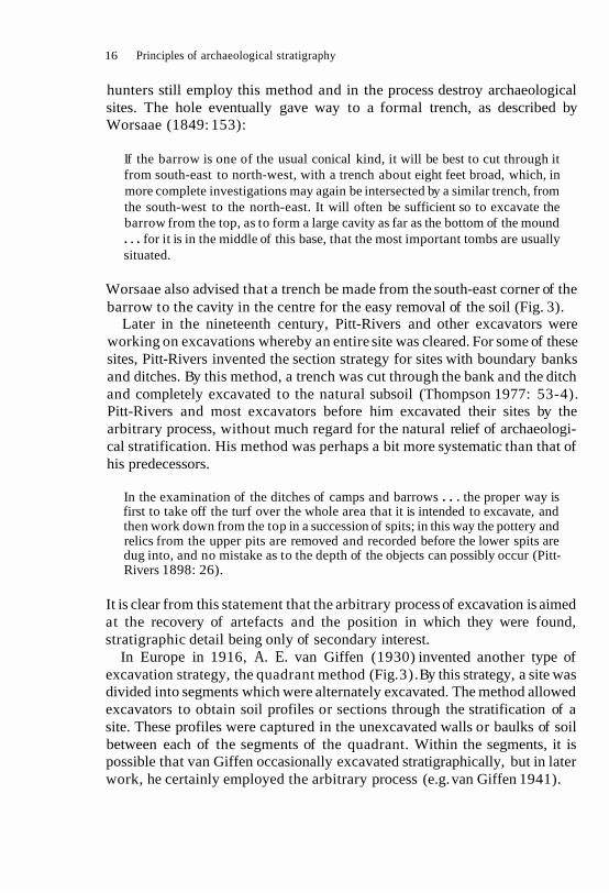
hunters still employ this method and in the process destroy archaeological sites. The hole eventually gave way to a formal trench, as described by Worsaae (1849: 153):
If the barrow is one of the usual conical kind, it will be best to cut through it from south-east to north-west, with a trench about eight feet broad, which, in more complete investigations may again be intersected by a similar trench, from the south-west to the north-east. It will often be sufficient so to excavate the barrow from the top, as to form a large cavity as far as the bottom of the mound . . . for it is in the middle of this base, that the most important tombs are usually situated.
Worsaae also advised that a trench be made from the south-east corner of the barrow to the cavity in the centre for the easy removal of the soil (Fig. 3).
Later in the nineteenth century, Pitt-Rivers and other excavators were working on excavations whereby an entire site was cleared. For some of these sites, Pitt-Rivers invented the section strategy for sites with boundary banks and ditches. By this method, a trench was cut through the bank and the ditch and completely excavated to the natural subsoil (Thompson 1977: 53-4). Pitt-Rivers and most excavators before him excavated their sites by the arbitrary process, without much regard for the natural relief of archaeologi- cal stratification. His method was perhaps a bit more systematic than that of his predecessors.
In the examination of the ditches of camps and barrows . . . the proper way is first to take off the turf over the whole area that it is intended to excavate, and then work down from the top in a succession of spits; in this way the pottery and relics from the upper pits are removed and recorded before the lower spits are dug into, and no mistake as to the depth of the objects can possibly occur (Pitt- Rivers 1898: 26).
It is clear from this statement that the arbitrary process of excavation is aimed at the recovery of artefacts and the position in which they were found, stratigraphic detail being only of secondary interest.
In Europe in 1916, A. E. van Giffen (1930) invented another type of excavation strategy, the quadrant method (Fig. 3). By this strategy, a site was divided into segments which were alternately excavated. The method allowed excavators to obtain soil profiles or sections through the stratification of a site. These profiles were captured in the unexcavated walls or baulks of soil between each of the segments of the quadrant. Within the segments, it is possible that van Giffen occasionally excavated stratigraphically, but in later work, he certainly employed the arbitrary process (e.g. van Giffen 1941).

Techniques of archaeological excavation 17
Fig. 3 During the nineteenth century, burial mounds were excavated by trenches which exposed the primary burial in the centre, leaving the outer areas unexcavated. In this century, the quadrant method reversed the procedure; the trench area became
baulks and the outer areas were excavated first.
A few years later, Mortimer Wheeler excavated barrows by the strip method (Atkinson 1946: 5 8 ) , in such a fashion that indicates that he was also digging by arbitrary excavation:
Two parallel lines of pegs were laid out at right-angles to the ends of one of the axes of the barrow. The pegs of each line bore a similar number. Working between these two datum-lines, the diggers proceeded to remove the mound strip by strip, each coinciding, as far as possible, with the interval between two pairs of pegs (Dunning and Wheeler 1931: 193).
The strip method and arbitrary excavation were replaced by stratigraphic

18 Principles of archaeological stratigraphy
Fig. 4 A demonstration of the progression from grid excavation with large unexca- vated baulks of the 1930s through to the open-area excavation method of the 1960s, which used cumulative sections instead of the standing sections of permanent baulks.
A (1930 50s) ~ r n ~ h a i ~ r on verrca recad*uures the horzanta and creates many dlwre,e iamper on a a t e
excavation and the grid system (Fig. 4A) during the work at Maiden Castle in the 1930s.
Wheeler's grid method was a strategy by which a site was excavated in a series of small square holes (Fig. 4A). Between the squares were a series of baulks, the faces of which retained the stratigraphic profiles of different areas of the site. As originally conceived, the grid system was a type of area- excavation, as the baulks were eventually removed as the excavation reached the surface of a major period on a site (Wheeler 1955: 109; 1937: plate LXVII). In addition, Wheeler saw the method as a way of controlling both excavation and recording, as each supervisor's area was clearly demarcated (Wheeler 1954: 67).
Since the 1960s, the open-area strategy of excavation has come into greater fashion (Barker 1977). Some of the origins of the open-area strategy are to be found in the work of Pitt-Rivers. It differs slightly from the grid system of area-excavation, in that it starts as the excavation of a whole area, without the interruption of intervening baulks. In practice, many open-area exca- vators retain their baulks, as if they were using the grid system (Fig. 4B). Other excavators have adopted Barker's notion of a cumulative section, which makes baulks unnecessary (Fig. 4C). With the possible exception of the strip method, the section, quadrant, grid and open-area strategies of exca- vation are used today.
Processes of excavation
B 1196051 ~ e s s e m ~ h a r ~ s m I& r r t c a but retentson
of baukr negates iul recwery of the norllonta record
Wheeler's grid system was complemented by the stratigraphic process of excavation which involved the concept of:
Ci~wo ~ i ~ l ~ ~ v d t # o n wthou, bau~i(s stlesson Dlani sectonr drawn a s each layer s excavated

iechniques of archaeological excavation 19
peeling off successive strata in conformity with their proper bed-lines, and thus ensuring the accurate isolation of structural phases and relevant arte- facts (Wheeler 1954: 53).
In contrast, the arbitrary process of excavation was very much in vogue in the 1930s, particularly in the United States, as noted in a recent publication subtitled 'A Celebration of the Society for American Archaeology':
Certainly by 1930 nearly all archaeologists excavated in "layers" but most used arbitrary levels of 6 inches or 15 centimeters. A few sought to dig in natural layers or to use "onion skin peeling." Some sought to do both (Haag 1986: 68).
From this quotation, it is obvious that the term 'layers' is synonymous with arbitrary 'levels' and should not be confused with a 'layer' in the Wheelerian school of thought. It is regrettable that many American archaeologists still use the arbitrary process of excavation (e.g. see The Great Basin Foundation 1987; Frierman 1982; and a review of Frierman by Costello 1984) in unwarranted situations.
From a scientific point of view, the stratigraphic process should be used as much as possible. Its value lies in the idea that stratification on archaeological sites may be seen, by a geological analogy, as 'undesignedly commemorative of former events' (Lyell 1875: I, 3):
But the testimony of geological monuments [stratification], if frequently imper- fect, possesses at least the advantage of being free from all intentional misrepre- sentation. We may be deceived in the inferences which we draw, in the same manner as we often mistake the nature and import of phenomena observed in the daily course of nature; but our liability to err is confined to the interpret- ation, and if this be correct, our information is certain (Lyell 1875: I, 4; emphasis added).
As archaeological stratification is an undesigned record of past events, its proper excavation by the stratigraphic process, as advocated by Wheeler, provides an independent testing pattern for the interpretation of an archaeological site. The imposition by the excavator of a designed, arbi- trary system of predetermined spits or levels destroys that independent check.
Stratification is a by-product of human activity: in making a building, for example, people do not set out to create stratification or include in it diagnostic artefacts of the day. When a building decays from neglect and falls down in the natural course of events, no one is there to determine the character of the deposits formed in the process. As it has never been demonstrated that any segment of humanity has deliberately made sites

20 Principles of archaeological stratigraphy
with archaeology in mind, it may be assumed that the stratification which we find on an excavation is an unconsciously compiled record of past societies and their activities. Stating this obvious fact is only to underline its vital role in determining the way archaeologists approach the excavation and recording of a site.
By imposing the arbitrary strategy of excavation on sites with clear stratification, archaeologists destroy the primary data they seek, the very data they are supposedly best qualified to obtain. By using arbitrary levels, artefacts are removed from their natural context and mixed with objects from other strata, as the arbitrary level does not respect the natural div- isions between the units of stratification on a site (Newlands and Breede 1976: fig. 7.2). These divisions are marked by the 'interfaces' (see Chapter 7) between strata. Interfacial lines, as seen in section, represent the ancient surfaces and topography of a site. Arbitrary excavation destroys the evi- dence of the topography of a site because these interfaces are ignored. There are some who reckon that the topography and character of stratifi- cation can be reconstructed from records made by arbitrary excavation. This proved impossible on at least one site, in spite of an heroic attempt to work with the recorded data (Schulz 1981). The impossibility of such reconstructions is probably the rule, rather than the exception. Finally, the arbitrary strategy results in the creation of an arbitrary 'stratigraphic se- quence' for a site, which is illustrated in Fig. 49.
It is now generally agreed that the process of stratigraphic excavation should be employed where archaeological layers and features can be recog- nized in the stratification of a site. In other instances, the units of stratifi- cation may not be recognizable, and the arbitrary process of measured spits may be used. The interpretations based on the results of excavation areas dug in spits must be treated, however, with considerable scepticism, in any stratigraphic analysis. Using arbitrary levels will always be making the best of a bad job.
It is also now agreed that the area-excavation strategy is often the most desirable course of action upon which an excavator should embark. At the simplest level, the reason for this opinion is found in the size of the excavation: the larger the area of excavation, the larger the amount of information recovered. A site is more easily understood when entirely exposed than when it is divided into a series of holes. Area-excavation is also the more suitable for sites with complex stratification, as baulks do not interrupt the flow of the features and layers.
The strategies and processes of excavation are little more than the tran- sient means to a more permanent end. When the spadework ceases, all that is left of any importance is the material recovered from the excavations.

Techniques of archaeological excavation 21
This includes the portable finds, such as potsherds, and the archives of the excavations, the most important records of which are those of the stratifi- cation of the site. In the following chapter, we shall look at some of the earlier methods of recording archaeological excavations.

4 Early recording methods on excavations
Sir Flinders Petrie once noted that there were two objects of an excavation: 'to obtain plans and topographical information, and . . . portable antiquities' (Petrie 1904: 33). The records of early excavations were aimed at the recovery of information about the layout of major structures and the find- spots of the artefacts. The emphasis was placed on the planning of walls or other structural features, such as ditches or postholes. Archaeological layers, unless they comprised an obvious feature, such as a floor or a street, were seldom planned. Since the emphasis was on structures, rather than stratifi- cation, sections did not record the detailed evidence of the soil, but were used to show the major structural aspects of a site. With artefacts, it was sufficient to note that each came from a higher or lower absolute level than others found on a site. Using a geological analogy, which was based upon strata of considerable thickness and uniformity of deposition, it was assumed that the lower an object was found, the earlier was its age. Some of these notions are evident in the late nineteenth-century excavations conducted by Pitt-Rivers, considered to be some of the best archaeological work of that century.
Had one been with Pitt-Rivers during the course of his excavations, the following methods could have been observed. Prior to actual digging, Pitt-Rivers made a contour plan of the site (e.g. Pitt-Rivers 1888: plate CXLVI). The purpose of this record was to show the drainage patterns of the site and the general command of the ground (Pitt-Rivers 1891 : 26). Contour surveys are still made on the sites such as barrows, which have obvious banks, so that the mound can be reconstructed after excavation (Atkinson 1946: 67). Pitt-Rivers had another use for his surveys, since 'by means of contours, a section can afterwards be drawn of any Camp, and in any direction' (Pitt- Rivers 1898: 26). The stratification of a site was then removed in a summary fashion by gangs of labourers (Barker 1977: 14).
Having dispensed with the overburden of soil, the features, which survived by their penetration of the subsoil, were then ~ l a n n e d . For the time, the

Early recording methods on excavations 23
quality of these plans cannot be gainsaid. They record (e.g. the plan reproduced as an endpaper in Barker 1977) the layout of enclosure ditches, and various gullies and pits, and the find-spots of sundry portable objects. The occasional layer is also recorded, such as a 'paving of flints' near the entrance of an area enclosed by a ditch. From these plans and the contour surveys, a number of sections could then be constructed.
Many of Pitt-Rivers' sections were therefore not records of actual soil profiles as seen on the site, but reconstructions. Such schematic diagrams were typical of archaeological sections until the 1920s (e.g. Low 1775: plate XIII: Woodruff 1877: 54). There are occasional exceptions, such as that of Fig. 5. This drawing records the stratification of a mining shaft from the flint workings at Cissbury Camp in Sussex. Some of the stones appear to have been plotted exactly and the different rocks recorded, e.g. the flints being hatched.
On some of Pitt-Rivers' sites, the soil was removed in arbitrary levels, so that artefacts could not drop (e.g. from the face of a baulk) to a lower level from that at which they had reposed at the time of discovery. The objects were not, however, recorded in relation to the levels or to a numbered archaeologi- cal layer. They were recorded in three measured dimensions. An elevation gave the absolute height of the find-spot and two other measurements placed the object on a horizontal plane. This particular method was adopted by Mortimer Wheeler (1954: 14), but after the 1930s the finds were also assigned to a layer. In more recent work (Barker 1977: 21), elevations of the find-spot are no longer taken and the artefacts are simply assigned to their layer.
During the course of the present century, advances have been made in all aspects of recording on archaeological excavations. These advances were by no means universal and the quality of recording varied greatly from site to site. Plans gave more attention to the recording of the layers of soil as well as structural features. Excellent examples of detailed plans may be found in the work, for example, of van Giffen (1930) and Grimes (1960). These plans attempt to record the entire surface exposed by the excavation and their most modern expression can be seen in the drawings by Philip Barker from the Wroxeter excavations (e.g. Barker 1975: fig. 3) . The quality of these plans is related to the simple stratigraphic nature of the sites they record, or to the amount of time the excavator could afford to spend on them.
By contrast, on urban sites with complex stratification and a more hurried pace of excavation, archaeologists appeared to have concentrated upon the record of structural remains, as in Fig. 6. The archives of the Kingdon's Workshop site are now held at the Winchester City Museum and they include the four plans made of the excavations. The information on those plans has been reproduced in Fig. 6 and the structural features from the Roman and

Early recording methods on excavations 25
medieval periods are illustrated. Few layers of soil from either of the periods were planned.
The development of sections since the beginning of the century may also be shown by an example from the excavations at Kingdon's Workshop (Fig. 7). From the 1920s, interfaces between the layers have usually been drawn. Layer numbers were often placed on these sections, but the practice was hardly universal. Kathleen Kenyon, for example, seldom seems to have put numbers on her drawings (e.g. Kenyon 1957: fig. 4), and this creates difficulties if a stratigraphic re-analysis is needed.
Written records on excavations often consisted of a diary and descriptive notes. The diaries recorded miscellaneous facts about the running of the excavation. The descriptive notes were supposed to record the evidence of the discoveries of the excavation. In the Kingdon's Workshop archive, all of the notes found in the site notebooks are in the form of a diary. The descriptions of the layers and features of the site were placed at the bottom of the section drawings, as in Fig. 7. This practice is advocated in the manual Beginning in Archaeology (Kenyon 1961: fig. 12). Since the layer descriptions contain few stratigraphic references, it must have been assumed that the stratigraphic relationships of the site were considered to be inherent in the section drawing, and need not be stated in writing. It may follow from this form of recording that any stratigraphic relationships which did not appear in a section were not recorded.
Since the 1960s, archaeological excavation has dramatically changed, particularly in urban areas under pressure from new building projects. At the same time, the excavator's ability to decipher stratification has improved and many more units of stratification are being recognized and recorded. But with one important exception, the forms of recording remained the same. That exception was the introduction of pre-printed recording sheets for the written descriptions of layers and features (e.g. Barker 1977: fig. 46). These sheets ensure that the stratigraphic relationships of the layers and features are fully recorded, since on many complex sites most of these will not appear on sections.
The assertion that open-area excavation, as developed in the 1960s, was a procedure 'entirely meeting the needs of the stratigraphic principle' in matters of recording (Fowler 1977: 98) cannot be substantiated. Until the late 1970s, there was little discussion about the nature of archaeological records, and whether they fulfilled stratigraphic requirements. The excellent ~ l a n s of some
Fig. 5 An exception to the nineteenth-century rule, this drawing appears t o be the record of an actual section, rather than a schematic diagram reconstructed after an
excavation (from Willett 18 80: plate XXVI).

WINCHESTER KINGDONS WORKSHOP M E D I EVAL
ST PETER MA
CHURCH PLRIOO I PERIOD III
PERIOD IIPERIOD IV
ROMAN
P R E T~/FRoN~*G~~-
E A R L Y 2nd C E N T
LATE 3 r d C E N T
CHALK FLOOR
M O Q T A Q J L 0 0 4
Fig. 6 In the 195Os, plans tended to be surveys of walls and features such as pits or ditches. Soil layers were only recorded if monumental in scale, or significant in character, such as street surfaces or mosaic floors (from Cunliffe 1964: fig. 10;
courtesy of the author).

Fig. 7 This section drawing is typical of the methods of recording developed by Sir Mortimer Wheeler and Dame Kathleen Kenyon and used up to the 1960s (courtesy of the Winchester City Museum).
28 Principles of archaeological stratigraphy
of the English open-area excavators of the 1960s are a cartographic improve- ment over those of their predecessors, but they do not represent much of an advance from a stratigraphic point of view.
From their origins up to the 1970s, several trends may be recognized in the recording systems used on archaeological sites. Interest was first focused on artefacts, followed by that in monuments and structures, and, finally, on other aspects of stratification. Most early plans were records of structures, not of layers which comprise the greater part of most stratification. Early sections were also records of structural, and not stratigraphic, import. The written records were intended as descriptions of the composition of layers and not as an indication of their stratigraphic importance. In other words, the idea of stratigraphy - which gives an archaeological excavation its greatest validity - was generally the last consideration in recording.
The following chapters represent an attempt to present a revised theory of archaeological stratigraphy, and the methods of recording and analysing the stratification of archaeological sites. Of the ideas presented thus far, only a few are significant enough to be carried forward in any detail: these are the idea of stratigraphic excavation, the numbering of layers, and the recognition of the value of interfaces between strata.

5 The laws of archaeological stratigraphy
Archaeological stratigraphy must be based upon a series of fundamental axioms or laws. All archaeological sites, to a greater or lesser degree, are stratified. Through errors in recording, individual deposits or artefacts may become unstratified, as their stratigraphic contexts have been lost. By the use of arbitrary levels in unwarranted situations, the stratified nature of a site can be summarily destroyed. If an archaeological site can be excavated, then it is a stratified entity, even if there is only a single deposit on the top of bedrock. As they are composed of stratified deposits, archaeological sites are a recurring phenomena, although the cultural content and the character of its soils will change with its location.
All archaeological sites are therefore subject to the laws of archaeological stratigraphy, two of which have been most often recognized:
All archaeological techniques grow out of two rules so simple that many a lecture audience thinks them funny. They are: (1) If soil layer A covers level B, B was deposited first, and (2) each level or stratum is dated to a time after that of manufacture of the most recent artefact found in it. These are the laws of stratigraphy, and in theory they are never wrong. The ground is made up of a series of layers, some deposited by man and others by nature, and it is the excavator's job to take them apart in the reverse order in which they were laid down (Hume 1975: 68).
Geologically, these are the laws of 'superposition' and 'strata identified by fossils' (Rowe 1970). Until the last decade, no other laws of stratigraphy have appeared in archaeological texts (Harris 1979b).
The application of these geological laws without revision in archaeological stratigraphy may be questioned for two reasons. On one count, these laws relate to strata which were usually solidified under water and may cover many square miles. Archaeological strata, by contrast, are unsolidified, of limited area and of diverse composition. In the second instance, artefacts

30 Principles of archaeological stratigraphy
cannot be used to identify strata, in the sense implied by geological laws, if only because they have not evolved through natural selection. Geological laws are no longer suitable for most archaeological purposes and must be augmented by our own standards.
In the absence of little archaeological precedence, a set of four basic laws for archaeological stratigraphy is proposed below. The first three laws are adapted from geology. A fourth axiom, the 'Law of Stratigraphic Succession', is from an archaeological source (Harris and Reece 1979).
Law of Superposition
The Law of Superposition is of first importance in the interpretation of the stratification. It assumes that the strata and features are found in a position similar to that of their original deposition.
The Law of Superposition: In a series of layers and interfacial features, as originally created, the upper units of stratification are younger and the lower are older, for each must have been deposited on, or created by the removal of, a pre-existing mass of archaeological stratification.
Because archaeological stratification may exist without artefacts, this law may be applied to archaeological stratification without regard for its artefac- tual content. This view is in opposition to the prevailing idea that:
the observation of superposition has virtually no archaeological significance unless the cultural contents of the deposition units are contrasted (Rowe 1970: 59).
The determination of superpositional relationships is of first importance in archaeological stratigraphy, as they define the interfacial relationships be- tween the features and deposits of a site. The stratigraphic sequences of archaeological sites are made by the analysis of the interfaces between strata, not from a study of the soil composition of the strata or objects contained therein.
In archaeological stratigraphy, the Law of Superposition must also take account of interfacial units of stratification (Harris 1977: 89) which are not strata in a strict sense. These interfacial units of stratification may be seen as abstract layers and will have superpositional relationships with strata which lie above them or through which they were cut or 'lie above'.

The laws of archaeological stratigraphy 31
The Law of Superposition is a statement about the depositional order between any two strata. Since it only relates to any two units of stratification, it can make no declaration about the detailed position of strata in the stratigraphic sequence of a site. The law is simply a statement about the physical relationships of superimposed deposits, i.e. one lies on top of or underneath another, and is therefore later or earlier. By recording superposit- ional relationships, the archaeologist amasses a body of data which will be of assistance in determining the stratigraphic sequence of the site.
In an archaeological context, the Law of Superposition may sometimes be applied to situations in which it is used in a relative sense. As intimated by Martin Davies (1987) in an excellent paper on the archaeology of standing structures, we must occasionally determine which way is 'up' in order to apply this law. The plaster of a ceiling, for example, is below the laths and ceiling joists, in an absolute sense, but it is stratigraphically later than both. In this instance, the archaeologist knows that the builder was 'working upside down', in terms of superimposition: he can therefore deduce which way is up and apply the Law of Superposition accordingly.
Law of Original Horizontality
The Law of Original Horizontality assumes that strata, when forming, will tend towards the horizontal. This is determined by natural forces, such as gravity, and results in one deposit succeeding the other in a horizontal order of superposition. This law was originally applied to deposits formed by sedimentary processes under water, but may be used for dry-land deposits. It is defined for archaeological purposes in this way:
The Law of Original H o r i z o n t a l i t yAny archaeological layer de- posited in an unconsolidated form will tend towards a horizontal position. Strata which are found with tilted surfaces were originally deposited that way, or lie in conformity with the contours of a pre- existing basin of deposition.
The application of the Law of Original Horizontality in archaeological stratigraphy must consider both dry-land conditions and man-made limits to areas of deposition. Man-made 'basins of deposition' are formed by walls or features such as ditches, which alter the conditions of deposition of unconso- lidated soils. It may also be advantageous for archaeologists to think of this law as relating to 'original states of deposition' under natural circumstances,
32 Principles of archaeological stratigraphy
the strata tending towards a horizontal plane, since many deposits on our sites have been laid down by natural forces.
If, on the other hand, a basin of deposition is a ditch, then the first filling strata will originally have had tilted surfaces. If horizontal surfaces are found at these levels, a reason should be sought. This may be due to a change in the conditions of deposition: flooding, for example, would partly negate the influence of the ditch. As the filling of the ditch progresses, the deposits would gradually approach the horizontal, the basin of deposition itself becoming less vertical with the formation of each successive deposit. At these upper levels, the surfaces may again be tilted and another cause, such as the re- cutting of the ditch, must be found.
The Law of Original Horizontality relates only to strata and the act of deposition. Its application, however, should guide archaeologists to look for significant interfacial features (see Chapter 7), as indicated by the directional change in the disposition of strata. It may also be applied in a relative sense to standing structures. There are a number of buildings and gun emplacements at Port Royal, Jamaica, now partly buried in dunes, which were tilted at least 15 degrees off the horizontal by the earthquake of 1907, but which remain intact.
Law of Original Continuity
The Law of Original Continuity is based on the limited topographical extent of a deposit or an interfacial feature. A deposit will naturally end in a feather- edge, or in a thicker section, if it abuts the side of the basin of deposition. If any edge of the deposit, as found today, is not a feather-edge, but a vertical face, then a part of the original extent or continuity has been destroyed. An archaeological version of this law is as follows:
The Law of Original Continuity: Any archaeological deposit, as orig- inally laid down, or any interfacial feature, as originally created, will be bounded by a basin of deposition, or may thin down to a feather-edge. Therefore, if any edge of a deposit or interfacial feature is exposed in a vertical view, a part of its original extent must have been removed by excavation or erosion, and its continuity must be sought, or its absence explained.
The occurrence on archaeological sites of many types of interfacial features attests to the usefulness of this law. It is also the basis on which stratigraphic correlations can be made between now separate parts of an original deposit.

The laws of archaeological stratigraphy 33
This correlation is made on stratigraphic grounds, without regard for the artefactual content of the deposits. The parts of the strata must be correlated by their soil composition and by their similar relative positions in the stratigraphic sequences on either side of the intrusive feature.
Devised for geology, the Law of Original Continuity related to horizontal strata. In the archaeological context, it may be expanded in two ways. The first is its application to interfacial features which are considered to be units of stratification, such as ditches. If such a feature appears in a vertical view, a part of its original extent may be assumed to have been destroyed. Provided that the continuation of the ditch can be located, the two parts may be correlated. The strata filling the separated parts of the ditch may also be correlated.
In the second instance, the law may be applied to upstanding strata, such as walls. Few walls in a stratigraphic context survive to the level of their original wall plates. Some of the original vertical continuity will have been destroyed and a sectional view of such walls is exposed in plan. Like the pit, whose limits mark the extent of the destruction of existing strata, the line which marks the limit of the truncation of a wall should be treated as an interfacial unit of stratification, subject to the Law of Original Continuity.
The Laws of Superposition, Original Horizontality and Original Continuity refer to the physical aspects of strata in their accumulated state, as stratification. They allow the archaeologist to determine stratigraphic re- lationships which exist on a site and to make the required stratigraphic correlations.
In geological circumstances, the accumulated order of the stratification may be equated to the deposition of the strata through time, the one deposit giving way to the next in the stratigraphic column, like a deck of cards. This immediate correlation between stratification and stratigraphic sequences is due to the great extent of geological deposits and to the small size, in comparison, of the sample taken at a given location. Such simple, unilinear, deck-of-card sequences are the exceptions to the archaeological rule.
Law of Stratigraphical Succession
Most archaeological sites have multilinear stratigraphic sequences, which are the result of the limited extent of archaeological strata, and the presence of upstanding strata and other interfacial features. The latter creates new basins of deposition within which separate sequences accumulate. These character- istics of archaeological stratification work against a simple correlation between the order of the stratification and that of the stratigraphic sequence.

34 Principles of archaeological stratigraphy
In addition, geology has not given archaeology any methods by which the complex stratigraphic sequences of our sites can be demonstrated in a straightforward manner. For this reason alone, the recent criticisms of the first edition of this book (Farrand 1984a, b; Collcutt 1987) are so much noisy water under a well-founded bridge.
It is now an accepted fact that the Harris Matrix provides archaeology with a method by which stratigraphic sequences can be diagrammatically ex- pressed in very simple terms. But in order for the method to work, it was necessary to introduce the Law of Stratigraphical Succession (Harris and Reece 1979) to complement the Laws of Superposition, Original Horizontality, and Original Continuity:
The Law of Stratigraphical Succession: A unit of archaeological strati- fication takes its place in the stratigraphic sequence of a site from its position between the undermost (or earliest) of the units which lie above it and the uppermost (or latest) of all the units which lie below it and with which the unit has a physical contact, all other superpositional relationships being redundant.
In order to illustrate the Law of Stratigraphical Succession, the idea of the Harris Matrix and that of the 'stratigraphic sequence' must now be intro- duced. It is also necessary to have an understanding of these notions, because much in the following chapters relates to them.
The Harris Matrix and stratigraphic sequences
The background to the Harris Matrix, which was invented in 1973, can be found in the first edition of this book. The Harris Matrix is the name given to a printed sheet of paper which contains a grid of rectangular boxes (Fig. 8). The name has no other connotation, mathematical or otherwise: it is simply a format for exhibiting the stratigraphic relationships of a site. The resulting diagram, which is often called a 'matrix' in shorthand, represents the stratigraphic sequence of the site. A 'stratigraphic sequence' is defined as 'the order of the deposition of layers and the creation of feature interfaces through the course of time' on an archaeological site.
A stratigraphic sequence is created by the interpretation of the stratifi- cation of a site according to the Laws of Superposition, Original Horizontality and Original Continuity. The stratigraphic relationships thereby discovered are translated according to the Law of Stratigraphical

PLACE:
SITE:____________ Area
Description Sheet No Compiled by Checked by Dale 19
Fig. 8 An example of a Harris Matrix sheet for displaying the stratigraphic se- quences of archaeological sites.

36 Principles of archaeological stratigraphy
Fig. 9 The Harris Matrix system recognizes only three relationships between units of archaeological stratification. (A) The units have no direct stratigraphic connection. (B) they are in superposition; and (C) the units are correlated as parts of a once-whole
deposit or feature interface.
Succession on to a Harris Matrix sheet to form the stratigraphic sequence. The matrix system admits to only three possible relationships between two given units of stratification. In Fig. 9A, the units have no direct stratigraphic (physical) relationship; in Fig. 9B, they are in superposition; and in Fig. 9C, the units are correlated (equated by the = sign) as separate parts (given different numbers in the field) of a once whole deposit or feature interface. Using this method during an excavation (Fig. 10), a sequence can be built up on paper as the work progresses. At the end of the excavation, the archaeol- ogist should be in possession of the stratigraphic sequence for the site (e.g. Fig. 11).
Difficulties arise, however, if the Law of Stratigraphical Succession is not applied in the process of making the sequence. This is because the sequences are often thought to represent all the physical relationships, as in Fig. 12B. These diagrams represent the relative sequence of the units of stratification through time: they are not meant to show the compressed relationships which obtain, for example, in a section. As they mark the stratigraphic development of the site through time, only the most immediate relationships in the relative sequence are significant. The Law of Stratigraphical Succession provides the axiom by which the significant relationships are determined. Thus Fig. 12C represents the stratigraphic sequence of this imaginary site, with the super- fluous relationships shown in Fig. 12B being removed.
The primary object of the study of archaeological stratification is to place the units of stratification, the layers and the features, into their relative sequential order. The stratigraphic sequence can and should be constructed without reference to the artefactual contents of the strata. The four laws of

The laws of archaeological stratigraphy 37
Fig. 10 The creation of a stratigraphic sequence on a Harris Matrix sheet which was made as the excavation progressed on the Salmansweiler Hof at Konstanz in Germany
in the early 1980s (from Bibby 1987; courtesy of the author).
archaeological stratigraphy are of primary significance in this non-artefactual analysis. Having discussed these general axioms, the next two chapters are devoted to an examination of the two non-historical elements which com- prise all archaeological stratification.

Arbeitsblatter Heft 2,1987 Gruppe 20, Grabungstechnik Seitc 168
SCHICHTEN, DIE D A S INNEN- NIVEAU DES SALMANSWEILER- HOFES ANGEBEN 7
V e r f u l l e n d e r Baugrube T r a r n p e l h o r i z o n t d e r
B a u g r u b e
Verfullen d e r B a u g r u b e
BAU(BEGINN) DES .Baubeg lnn M a u e r w e r k SALMANSWEILERHOFES
UM 1311 (Dendro )
S e t z e n d e s Holzfundaments
Ausheben d e r B a u g r u b e 6 . . .
Schlammbildung TROCKENLEGUNGSVERSUCHE A S T T E P P I C H E
Erster A s t t e p p ~ r h 4
UBERSCHWEMMUNG DES
d e r
, M a u e r w e r k
AREALMAUER d e s
bi
. . . . . . . . . . . . . . . . . d e r
TORFSCHICHTEN AUF GEWACHSENEM
. . . . . . . . . . . . . . 1
Fig. 11 The stratigraphic sequence of a part of the Salmansweiler Hof at Konstanz which has been divided into phases. Phase 1 consists of peat layers on natural soil, while Phase 6 represents a new building period around A.D. 1290 (from Bibby 1987;
courtesy of the author).


6 Deposits as units of stratification
An excavator must have a theory of archaeological stratigraphy in order to know what to observe and record on an archaeological excavation. In the preceding chapters, a brief review was made of previous theories of archaeological stratigraphy. There is little doubt that the most important thoughts on the subject have come from the Wheeler-Kenyon school of archaeology, which began to translate geological maxims into archaeologi- cal terms. These concepts have been most cogently expressed in Archaeology from the Earth (Wheeler 1954) and Beginning in Archaeology (Kenyon 1952). The interpretation of stratification is also a task which requires a knowledge of stratigraphic theory. Pyddoke has suggested that interpretation must be learned on excavations and not from handbooks. He asserted in his book, Stratification for the Archaeologist, that:
whilst the basic principles of stratification are universal, each kind of site requires a different kind of experience; many years' experience in excavating Bronze Age Barrows, whilst useful, will not necessarily equip an archaeol- ogist to understand the stratification of deposits in a Roman or medieval town (Pyddoke 1961: 17).
There should not be a dividing line between practical and intellectual experience. What a student learns on an excavation should be based on stratigraphic principles, which themselves arise out of field observations and scholarly analysis. It is perhaps unwise to emphasize one over the other. The widespread opinion that practical experience outweighs an academic grounding is largely responsible for the lack of development of stratigraphic concepts in archaeology.
Furthermore, the particular age of a site does not affect its stratigraphic interpretation. The competent student of archaeological stratigraphy will be at home on any site. The primary study, record and interpretation of stratification need not take any account of the historical significance of the

Deposits as units of stratification 41
various layers and features. The principles of archaeological stratigraphy must take into account the non-historical attributes of stratification, be- cause it is they which are of universal application. In fact, many individual units of stratification, as historical features, have no universal import. It is mainly by the comparison of the cultural or artefactual sequences, not the stratification, of various sites that the archaeologist studies the develop- ment of past societies.
Characteristics of stratification
Knowing what to record and how to interpret the archaeological stratifi- cation of any site is to understand the non-historical or recurring aspects of stratification. For example:
The Grand Canyon or any gully is unique at any one time but is constantly changing to other unique, nonrecurrent configurations as time passes. Such changing, individual phenomena are historical, whereas the properties and processes producing the changes are not (Simpson 1963: 25).
In other words, the process of stratification which shapes a grand canyon or a field gully is the same today as it was in the distant past. It is the job of the student of stratigraphy to identify that process and its components, e.g. the deposits and the interfaces. This chapter is a discussion of the non- historical aspects of deposits, while Chapter 7 deals with interfaces.
It is perhaps appropriate at this point to interject a philosophical note with regard to the non-historical and historical aspects of stratification. In so doing, the recent book by Stephen Jay Gould, Time's Arrow, Time's Cycle is drawn upon. It is highly recommended to those archaeologists who have an interest in the 'discovery of time', as it discusses in a fascinat- ing way the contributions of Thomas Burnet, James Hutton and Charles Lyell towards the establishment of 'deep time' (Gould 1987: 1-19), a major ingredient in the birth of the geological sciences.
Gould uses the metaphor 'time's arrow' to discuss the changing nature of things in an historical direction, and 'time's cycle' to describe the 'ahistori- cal', repetitive processes which remain the same, while forming events which themselves are historical.
Time's cycle seeks immanence, a set of principles so general that they exist outside time and record a universal character, a common bond, among all of nature's rich particulars. Time's arrow is the great principle of history, the

42 Principles of archaeological stratigraphy
statement that timemoves inexorablyforward, and that one truly cannot step twiceinto the same river (Gould 1987: 58-9).
In time's cycle, the repetitive elements 'display order and plan', while the 'strands of difference' in the metaphor of time's arrow 'permit a recognizable history' (Gould 1987: 50). It was these notions, now eloquently presented by Gould for geological purposes, that were introduced into archaeological stratigraphy in the first edition of this book, and which form the backbone of present theories of the subject.
Archaeological 'units of stratification' represent an archaeological aspect of time's cycle. They are of universal character and can be found on any archaeological site in the world. Stratigraphically speaking, a posthole i s a posthole is a posthole. Its evidence in stratification is always the same: it is a feature interface cut intopre-existing strata, and it is usually filled with some detritus or other, be it the rotten remains of the post or a deliberate fill. There are two main forms of units of stratification: deposits and interfaces, as outlined in Chapters 6 and 7. Archaeological stratification,in itself, is representative of time's cycle, because it is formed by the same, repetitive processes, i.e. deposition or degradation. This is why an archaeologist should be able to work efficiently on any archaeological site, provided that the individual has been properly trained in the theory and practice of archaeolo- gical stratigraphy.
The interpretation of the structural and artefactual content of a site provides for time's arrow, for an historical direction to the evidence of the stratification. An analysis of many factors will tell us that these are Iron Age postholes, whereas those in a nearby city are medieval. The unique shape of a ditch will indicate its defensive nature, or its use for land drainage. These simple examples are but a token of an endless panorama of historical instances of how Man, at different ages, has changed the face of the Earth by the repetitive processes that result in the phenomenon of archaeological stratification.
Without an appreciation of the difference between the two bodies of data that represent time's arrow and time's cycle, the unique event from the repetitive process, i t will be difficult for an archaeologist to understand, record and interpret archaeological stratification.
Before we return to our more mundane narrative, there is one other idea which should be noted. In discussing James Hutton's Theory of the Earth and the geological cycle which he brought into being (mentioned in Chapter 1), Gould says that by realizing the igneous nature of some rocks, he introduced a 'concept of repair' into the geological record:
If uplift can restore an eroded topography, then geological processes set no limit

Deposits as units of stratification 43
limit upon time. Decay by waves and rivers can be reversed, and land restored to its original height by forces of elevation. Uplift may follow erosion in an unlimited cycle of making and breaking (Gould 1987: 65).
In other words, without the forces of uplift, be it tectonic action, volcanic eruptions, etc., the Earth would have long ago eroded into a smooth ball. It is the timeless process of uplift which provides for the changing geological topography of the Earth.
In the introduction of the first edition of Principles of Archaeological Stratigraphy, it was argued that mankind had created a major revolution in the making of stratification on the face of the Earth. From this stance, it seemed that any theory of archaeological stratigraphy had to take into account the manner in which man-made stratification was formed. In the light of Gould's discussion of James Hutton's geological cycle, we may add to the idea of a separate theory of stratigraphy by stating that in the archaeological cycle of creating stratification, it is humanity itself which provides the vital, restorative force of 'uplift'.
As mentioned in this and the following chapter, the stratigraphic forms which have been produced by this new force of uplift are unique and do not occur in natural or geological cycles. Because Man is this new (in geological terms) restorative agent, we must develop our own theory and practice of archaeological stratigraphy in order that we may best under- stand the unique, and the repetitive, ways in which we have transformed the processes and the historical content of stratification.
Process of stratification
In 1957, Edward Pyddoke observed street flooding in Hong Kong. Many automobiles were engulfed in a sea of mud, washed down from nearby hills, in an act exemplifying:
all rainwash stratification, for the dual nature of the process is obvious: tons of earth were deposited in the streets - tons of earth were eroded from the hills (Pyddoke 1961: 35).
All forms of stratification are the result of such cycles of erosion and deposition. Sedimentary rocks, for example, accumulate on the sea-bed from particles of other eroding formations. These mud layers eventually become solid stone, which may be uplifted and subject to erosion. The process of stratification is a cycle of erosion and accumulation.

44 Principles of archaeological stratigraphy
--- THE T I M E MAY BE REPRESENTED
STRATIGRAPHICALLY B Y DENUDATION NO LESS THAN BY AGGRADATION 1954 751
--
DIGGING PITS MAKING STRATA
Fig. 13 The process of stratification in archaeology results in the formation of deposits and feature interfaces.
On a smaller scale, this process takes place on archaeological sites. There are natural forces behind this process, such as climatic change, or floral and faunal activity (as noted in Pyddoke's Stratification for the Archaeologist). However, since humans learned to dig, we have been the major force in the making of archaeological stratification. For whatever purpose, digging up the earth will eventually result in the making of new strata (Fig. 13). The process of archaeological stratification is the amalgamation of natural patterns of erosion and deposition, and of human alterations of the landscape, by excavation and construction. The dual nature of erosion and accumulation is complemented by deliberate digging and preferential deposition, as in the digging of brickearth and the making of a brick wall.
There is also another sense in which the process of archaeological stratifi- cation is a duality: the making of a layer is tantamount to the creation of a new interface, or, in many instances, more than one. Layers made from excavated material have new surfaces, but their construction follows the creation of a pit, itself an interface, elsewhere. Archaeological stratification is therefore composed of deposits and interfaces.
These are usually of equal proportion, but often there are more of the latter than the former. This is because all deposits will have surfaces or 'layer interfaces', but no 'feature interface', such as a pit, has a complementary deposit whose surface it forms. Feature interfaces are units of stratification in

Deposits as unitsof stratification 45
EARLY OCCUPATION MATERIAL THROWN UP ON
ITSELF THEN A P ILE OF EARTH AND GRAVEL
TOPPED BY CL E AN G R AVE L THE REVERSE
SEQUENCE O F THE STRATIFICATION THAT WOULD
EXIST AT THE A DITCH WAS DUG
IF NO OBJECTS CONTEMPORARY THE THE ARE INTRODUCED'
FINDS IN LATEST LAYER
LATEST IN EARLIEST LAYER
Fig. 14 Contrary to this view, archaeological strata cannot be overturned or 'reversed', as they are not solidified deposits.
their own right, as the duality of the process of stratification might indicate. Once created, archaeological deposits and interfaces can be altered or destroyed in the continuing process of stratification. Archaeological stratifi- cation, on this account, is an irreversible process. Once a unit of stratification - either a layer or interface - is formed, it is thereafter subject only to alteration and decay: it cannot be made again.
In another manner, archaeological stratification is also irreversible (in the sense of being turned over) because it is seldom turned to stone. Except for such lithification, archaeological stratification cannot be overturned or reversed, without losing its original characteristics. Any overturning (digging up) of archaeological stratification results in the formation of new deposits. The situation described and illustrated in Fig. 14 is inaccurate, as far as archaeological strata are concerned. The strata in this example were not reversed as a block - the usual geological circumstance - but dug out bucket by bucket. In the process, they were transformed into new strata, whatever their soil composition. Even if there was no mixing of artifacts in the new situation, it does not support the notion of 'reversed stratigraphy', accepted by some archaeologists (e.g. Hawley 1937). The unlithified fabric of archaeo-

46 P r i n c i p l e sof archaeological stratigraphy
logical stratification gives it considerable historical import. Archaeological deposits are unique depositions in soil composition, in time and in space: they are created only once and are subject only to destruction if moved or disturbed.
Three main factors determine the accumulation of cultural remains by the process of archaeological stratification: the existing land surfaces, the forces of nature, and the activities of people. The pre-existing landscape will form basins of deposition by virtue of the shape of its relief. Examples of these basins could be the gullies of an old stream, a military ditch, or the walls of a room. In other instances, deposition may simply take place on the floor of the basin and the new strata will not extend to its sides. The shape of the new deposit further depends upon the amount of material being laid down and the effect exerted upon it by natural or human forces.
When the disposition of the layer is left to nature, its surface will tend towards the horizontal and thin out to feather-edges according to the pull of gravity. Such natural deposits tend to accumulate in the classic layered pattern, one layer superimposed upon another. Man-made stratification is not necessarily subject to such tendencies.
The difference between strata formed by nature and those that are man- made may be seen in this way. In making its strata, nature seeks the course of least resistance. The softest rock is the first eroded. The greater the inclination of a surface, the quicker may be the rate of erosion. Man-made strata result from cultural preference. People can create strata which con- form to an abstract plan, rather than to the flow of the natural world. Humans can also choose to ignore the limitations of the existing basins of deposition; we may even create our own, by digging ditches or building walls. The history of mankind - from the remains of a primeval encamp- ment to the city limits of the modern metropolis - is, to a great extent, a history of the establishment of new basins of deposition, of new topo- graphical boundaries, which may become enshrined in stratification. In the stratification formed, several types of non-historical layers and strata can be recognized.
Deposits and layers
In relation to sedimentary processes of deposition the geologist, Sir Charles Lyell, defined a 'layer' in the following manner:
The term stratum means simply a bed, o r anything spread out or strewed over a given surface; and we infer that these strata have been generally spread
deposits as units of stratification 47
out by the action of water . . . for, whenever a running stream charged with mud and sand, has its velocity checked . . . the sediment previously held in suspension by the motion of the water, sinks, by its own gravity, to the bottom. In this manner layers of mud and sand are thrown down one upon another (Lyell 1874: 3).
Such strata are the clay varve deposits whose annual deposition in stream and lake beds make them important for the chronology of the last Ice Age in Europe and elsewhere (Geer 1940). The definition indicates two other aspects of the process of stratification: the means by which the material is trans- ported, and the conditions at the time of deposition. Transportation occurs geologically by the attraction of gravity, as when rocks break off an outcrop and tumble downwards to a resting place. From there wind and water carry smaller rock fragments away until they lose their force and the particles come to rest. When transportation ceases, deposition takes place.
Lyell's definition is not wholly appropriate for archaeological situations, because in many instances archaeological units of stratification are not strewed about a surface, but are deliberately placed, according to specific needs. Hirst, for example, has recognized three classes of archaeological stratification.
1. Layers of material deposited or accumulating one over the other horizon- tally; 2. Features which cut away the layers (negative features), e.g. pits; 3. Features which are constructions around which layers then build up (positive features), e.g. walls (Hirst 1976: 15).
Class 1 is similar to Lyell's stratum, but neither Class 2 nor Class 3 are related. Class 2 is discussed in the next chapter as a 'feature interface' and Class 3 is examined below under the title 'upstanding strata'. On the basis of the means of transportation and the conditions of deposition, however, Class 1 must be subdivided into natural strata and man-made layers.
The materials for natural strata in an archaeological situation may be transported by Man or nature. When a wall decays and collapses of its own accord or when a ditch is filled by erosion, the material - whatever its original derivation - is transported by natural forces to the place of depo- sition. When a ditch is filled by tips of household waste, people are the mode of transportation. Once in motion, the material is formed into strata under the natural conditions of deposition. Under these circumstances, the surface of the deposits will tend towards the horizontal. On dry land this tendency is greatly reduced, without the levelling power of a body of water. Since the definition of this class of strata is based upon natural circum- stances of stratification, it also includes those deposits which are formed by organic processes, as in the growth of turf. It must also include any

48 Principles of archaeological stratigraphy
geological strata which appear in an archaeological site, such as volcanic ash, or mud from flood waters.
By comparison, the material for the man-made layer is transported by people and its deposition is regulated by human planning and actions. This type of deposition is often formed without regard for laws which result in natural stratification. When nature transports stratigraphic material, it must follow topographical contours. This is a process which sweeps eroded particles ever downwards, towards the sea. Transportation by people has no regard for this tendency. Materials have for millennia been brought over mountain and vale, from far and near, to the place of their eventual deposition. Whereas most natural strata will be lenticular, being strewn about, man-made layers can be set down in definitive shapes. While often being laid flat, man-made layers may also be 'deposited' vertically (as with walls), as opposed to the natural tendency to move soils to the horizontal. There are two main types of man-made layer - those which are spread out over a given area, and those which are raised above the existing ground surface.
The first type, referred to as the man-made layer, tends to accumulate in a normal pattern of superposition, one layer upon the other. These layers will have horizontal surfaces to the degree required by their function. Layers of this type include the metallings of a road, the floors of a house, the deliberate spreading of constructional or other material in a selected area of a site, and the intentional filling of holes such as graves, pits, postholes and various types of gullies. The deposition of these horizontal layers will alter the topographi- cal shape of a site, but they themselves will seldom create new basins of deposition, as do some upstanding strata.
The second type, upstanding strata, such as walls, are unique forms of man-made stratification. They are not directly comparable to any geological strata. As these strata remain consolidated for a period, they form new basins of deposition on a site. When a masonry house is built, for example, the stratification, both within and outside the house, will develop in separate sequences, until the walls decay. Upstanding strata thus complicate the pattern of archaeological stratification and the process of its excavation and interpretation. An aspect of this situation has been discussed by Wheeler in one of his famous drawings (Fig. 15). The stratigraphic reason for not digging trenches along the face of a wall is because it is on that vertical plane that stratigraphic relationships of upstanding strata are primarily found (see Newlands and Breede 1976: fig. 7.1). The stratigraphic relationships of horizontal deposits are usually, on the contrary, on the horizontal plane - hence the persuasive argument for the notion of superposition. Upstanding strata also have normal stratigraphic relationships on the horizontal (or superpositional) plane, since they are partly on the ground.

South
A. RELATIONSHIP OF TO STRUCTURES RETAINED BY CROSS-SECTION
Fig. 15 This drawing first called attention to the stratigraphic problems of upstand- ing strata and to the improper excavation method which separated those deposits from the adjacent stratification (from Wheeler 1954: fig. 16; courtesy of Oxford
University Press).

50 Principles of archaeological stratigraphy
Attributes of deposits
Natural strata, man-made layers and upstanding strata have the following non-historical stratigraphic features in common:
1. A 'face' or original surface. This notion is used to distinguish the original upper surface of a layer from its lower surface. It was developed in geology (Shrock 1948) as a way to determine the original order of super- position. For example, if a large animal walks over a layer of mud, its footprints leave holes in the surface of the ground. Such tracks, e.g. dinosaur prints found in the United States (Shrock 1948: 133), were preserved when the holes filled up with mud. The undersurface of the next deposit contained the counterpart of the track. If the strata in the course of geological time were overturned, the track and its counterpart would be reversed, thereby indi- cating the overturning of the rock layers. Such overturning of the strata does not occur in archaeological sites, but the notion of a 'face' is still useful. The excavator, for example, can only examine the faces of the horizontal layers because of their unconsolidated nature.
Upstanding strata, on the other hand, have several original faces or upper (i.e. outer) surfaces. The original upper face of a wall - its surface a t the level of the wall plate for the roof - very seldom survives in the stratigraphic record, unless the entire house, as at Pompeii, is buried before its natural decay. But walls also have vertical faces in the surrounds of doors and windows and those surfaces which, in a modern context, one might paint on the exterior and wallpaper within.
If it is argued that stratigraphic relationships between layers are made by the laying of a new deposit upon the face of the existing strata, then deposits laid against the vertical faces of the upstanding strata are as much super- imposed upon those faces as they would be upon the usual horizontal strata. The vertical excavation against which Wheeler spoke (Fig. 15B) would thus destroy these stratigraphic relationship, since they are formed on a vertical plane by the characteristics of man-made upstanding strata. All units of archaeological stratification, therefore, have faces; these are examined in the next chapter as 'layer interfaces'.
2. Boundary contours. These lines, or contours, define the unique extent of each unit of stratification in both horizontal and vertical dimensions. They are not often shown on archaeological plans, but frequently appear in sections (e.g. Fig. 15A). Boundary contours are not the same as surface contours, as stratification is a state of superposition. Since many layers are of different sizes and may overlap, only part of the boundary contour of a given layer will appear at the surface of a particular period in the topographical development of a site.

Deposits as units of stratification 51
CONTOUR SURFACE
ELEVATION
Fig. 16 All deposits have boundary contours which mark their horizontal extent. The surfaces of strata are illustrated by contours which are derived by elevations
recorded prior to the excavation of the deposits.
3. Surface contours. These lines (Fig. 16) show the topographical relief of the surface of a layer, or a group of units of stratification. They are made from a series of spot-heights or elevations as recorded on plans. They are not, as such, a primary record, as are boundary contours. The latter can appear on both plans and sections, but surface contours are shown only on plans. Both notions have long been used in geological stratigraphy. (e.g. Trefethen 1949: fig. 12-9), and in archaeology as well. Although their functions are quite different, they have seldom been properly set in relation to each other.
4. Volume and mass. By combining the dimensions of the boundary and surface contours, the volume and mass of a unit of stratification may be determined. Most layers will have within their mass a number of portable finds or objects of chronological, cultural or ecological signifi- cance.
In contrast to these repetitive attributes, the deposits and strata of an archaeological site will not have the following historical features in com- mon.
1. Stratigraphical position. All units of stratigraphy will have a position in the stratigraphic sequence of a site, which is unique to each unit. This is the relative sequential position of a given unit in relation to the other units. It is determined by the interpretation of the stratification, according to the laws of archaeological stratigraphy. The portable artefacts cannot deter-

mine this position, as it is based on a study of the interfacial relationships between the units of stratification.
2. Chronological date. All units of stratification have a time or date, measured in years, at which they were created. In many instances this date cannot be determined, since it depends upon the number of datable artefacts found in the deposits of a site. The discovery of the chronological date of a unit of stratification is a secondary task in the study of archaeological stratification. On the excavation, the interpretation and record of stratifi- cation can proceed without immediate attention to chronological dating. However, awareness of the date of a deposit is extremely useful, as it may suggest matters otherwise overlooked, e.g. taking of more than routine soil samples.
The chronological date of a unit of stratification can never change its position in the stratigraphic sequence of a site, but may appear to be contrary to the dating of the rest of the sequence. This type of problem may appear to arise with timbers, for example, which are both strata and datable 'artefacts'.
Even in cities, such as Venice and Amsterdam, i t cannot be laid down as universally true, that the upper parts of each edifice, whether of brick or marble, are more modern than the foundations on which they rest, for these often consist of wooden piles, which may have rotted and been replaced one after the other, without the least injury t o the building above; meanwhile, these may have required scarcely any repair, and may have been constantly inhabited (Lyell 1865: 8-9).
This type of prefabricated stratigraphic unit may thus be placed in strati- graphic positions which appear to be much earlier, as in the Lyell example, or much later, than the actual chronological date of the object itself. That date will not, however, affect the stratigraphic relationships of the unit, as found on the excavations. The reason for this is that archaeological stratification can only be recorded in its present state. Although laid down over the course of centuries, the strata of a site are subject to continual change. The agents of change may be burrowing animals (Atkinson 1957), the forces of nature (Evans 1978; Dimbleby 1985; Jewell and Dimbleby 1966), or the work of Man. Furthermore, a full treatment of the entire stratigraphic background of a situation such as Lyell describes would probably resolve the apparent dilemma, for the silts into which the piles were driven will certainly give a date after which they were positioned.
Stratification can only be recorded as a phenomenon of the present. From that record, interpretations can perhaps be made about the past history of the site: first, from the surviving stratigraphic material and, thereafter, from a study of all the aspects of the site, from its topographical position to the
Deposits as units of stratification 5 3
remains found in the strata themselves. The stratification of a site is not a completely static phenomenon but changes through time by a variety of means.
In the first instance, however, the archaeological stratigrapher is only interested in what is found today as the stratification of a site. To interpret this and compile a stratigraphic sequence, it is not necessary for the excavator to be a specialist in artefact studies, or in the processes of forming deposits. It is for this reason, that we do not discuss 'formation processes' here, but the student should be aware of the literature on the subject (e.g. Butzer 1982; Schiffer 1987; White and Kardulias 1985; Wood and Johnson 1978).
Obviously, the broader the entire range of knowledge and experience of an excavator, the better may be the immediate results. But the principles of archaeological stratigraphy are simple. They do not require that every excavator be a genius - nor even a university graduate - in order to do a good job of interpreting and recording stratification.
The degree of survival of features from all periods is quite undesigned. Prior to excavation, therefore, it is impossible to know, in any detail, what a site may contain in its stratification, i.e. of what historic import it may be. The excavator must rely upon a knowledge of the non-historical aspects of archaeological stratification. As suggested throughout this book, these as- pects may be recorded by rote, as non-historical stratigraphic units, since they recur in the same forms. The historical interpretation of the stratification is a secondary matter and cannot be completed without post-excavation analyses and the support of a variety of specialists.
This chapter has been a discussion of three of the non-historical units of archaeological stratification: the natural stratum, the man-made layer and the upstanding stratum. In an historical perspective, these units made separate entrances on to the stage of archaeological stratification. The first was the natural layer, which covered human remains before Man began to make strata. The man-made layer made its appearance when Man began to construct. Finally, the upstanding stratum made its appearance in the early dawn of urban life. Layers are, however, only half the story of stratification. The mass of stratification is everywhere separated by interfacial surfaces and contours, to which attention is now turned.
7 Interfaces as units of stratification
Archaeological stratification is a combination of strata and interfaces. While it may be argued that a layer and its interface, or surface, are a single phenomenon, it is necessary to distinguish between them in stratigraphical studies. Other interfaces are created by the destruction of strata and not by their deposition. There are thus two main types of interface: those which are the surfaces of strata and those which are only surfaces, formed by the removal of existing stratification.
In geology, these types are referred to as bedding planes and uncon- formities. The surfaces of strata are bedding planes, and 'mark successive positions of the surface, perhaps a sea floor or a lake bottom or a desert, on which material that now forms rocks was deposited' (Kirkaldy 1963: 21). Bedding planes are equal to the horizontal spread of a deposit and are contemporary with the cessation of its formation. Unconformities are sur- faces which mark the levels at which existing stratification has been destroyed by erosion. Unconformities are surfaces in their own right which, in being formed by the destruction of stratification, are important stratigraphic units. In archaeological stratigraphy, unconformities are referred to as feature interfaces, and bedding planes as layer interfaces.
Horizontal layer interfaces
There are two forms of the layer interface, the horizontal and the upstand- ing. Horizontal layer interfaces are the surfaces of strata which have been deposited or created in a more or less horizontal state and their extent is equal to that of the layers. They have the same stratigraphic relationships as the deposits and are recorded as an integral part of the layers. A horizontal layer interface will be recorded on a plan which shows the

Interfaces as units of stratification 55
boundary contours of the deposit (e.g. Fig. 16, Unit 10) and, therefore, the limits of the interface. The relief or topography of the horizontal layer interface is recorded by a series of spot-heights, which can later be turned into a contour plan. When a group of these interfaces is defined as a major surface, they comprise a period interface.
As a horizontal layer interface is equal to the extent of a deposit, the surface of which it forms, it is not usually necessary to distinguish it from the deposit when labelling the units of stratification. On occasion, it will be necessary to identify a part of this type of surface and record it as a separate unit of stratification. Suppose, for example, that an area of a surface had been discoloured by some action of which the discoloration was the only trace. In this instance, the area of change should be treated as a separate interfacial unit, as it has different dimensions from the overall surface of the underlying deposit, and it may also have different stratigraphic relationships with the superimposed deposits.
The horizontal layer interface marks the end of the build-up of a deposit. If the deposit was rapidly placed, such as construction debris, the interface can be seen as contemporary with the entire deposit. If the build-up of a deposit was slow, the layer interface is only contemporary with the final date at which the deposit was closed. By the same token, a layer interface may itself represent a short or long period, depending upon the date of its burial. In that event, not all of a surface may be buried at once, so that it may be considered normal that an area of a layer interface may survive longer as part of a surface in use.
If we take Fig. 1 7 as an example, a few of these points can be illustrated. In Fig. 17B, Wheeler's original drawing has been altered to assume the presence of an interface between Units 3 and 7, and 4 and 6. It can be seen that Units 1, 2,3 and 8 do not share their surfaces with any other deposits. A part of Unit 7, however, remained exposed and in use for the duration of Units 6 , 5 and 4, and a part of Unit 6 was still in use during the life of Unit 5. This is demonstrated graphically in Fig. 17D by building up the section layer by layer. Each horizontal layer interface has the potential to become a part of the period interface of the entire site at the date at which the layer interface was formed. Thus Period Interface 8 (Fig. 17D) is composed of all of the surface of Unit 5, plus a part of the layer interfaces of Units 6 and 7. It can also be seen in Fig. 17B how the stratigraphic sequence mirrors the laying down of the deposits through time.
From this discussion, the importance of recording the horizontal extent of the surface or interface of a deposit can be surmised. Aside from showing its outline, the most important record of a horizontal layer inter- face will be a series of spot-heights, from which a contour plan can be made. This is a matter to be further explained in Chapter 9.

56 Principles of archaeological stratigraphy
(1) INTERFACE SHARED
LAYERS 5 & 6 LAYERS 4.5.687
UNSHARED INTERFACES
8 ECH 1976
Fig. 17 (A-C) The interfacial aspects of archaeological deposits and (D) the periods of deposition and use, or non-deposition, two major aspects of the process of
stratification. (A: after Wheeler 1954: fig. 8.)
Upstanding layer interfaces
The upstanding layer interface forms the surface of an upstanding stratum, most typically a wall. As they are vertical surfaces, they do not have surface contours in the way of the horizontal layer interface. They usually contain a lot of architectural details as surface characteristics, which are recorded in elevation drawings (e.g. Fig. 18). Walls are three-dimensional deposits, so that instead of having to record only one outer surface, there may be any number of interfaces to preserve in the form of records.
If you have difficulty with this concept, imagine that you are able to push a
Interfaces as units of stratification 57
wall over to the horizontal in one piece. You can then see that the single (upper) surface of the wall is subject to all the usual stratigraphic events and problems of interpretation which affect an ordinary layer. Walls can also be built on the top of earlier walls, so that superimposition can occur on upstanding deposits as well as on supine layers (e.g. Fig. 18: Unit 4 is 250 years later than Unit 1). An upstanding layer interface can also survive as a feature through many more periods than a simple deposit, which is prone to quick burial as the site is developed. The successive period interfaces on a site may thus 're-use' the upstanding layer interfaces of its buildings many times over.
The study of standing buildings as archaeological monuments has greatly increased in recent years. In relation to the Harris Matrix, important work has been carried out in Australia, for example, and the reader is referred to the interesting article on 'The Archaeology of Standing Structures' by Martin Davies (1987). At Old Sturbridge Village in Massachusetts, a team of archaeologists has applied stratigraphic principles to the Bixby House (Figs 19 and 20). Their research archaeologist, David M. Simmons, has kindly provided the following note:
From 1984 to 1988, research on the Bixby House and site in Barre, Massachusetts was conducted by Old Sturbridge Village, resulting in a museum restoration and comprehensive interpretation of important tran- sitions in the dynamics of family, community life, and economy in early nineteenth century rural New England. Archaeological and architectural data recovered from the site and the surviving house were analysed and evaluated using the Harris Matrix. Rigorous recording of stratigraphic relationships within both the archaeological and architectural domains created a total site matrix integrating phases of site use and change, below as well as above the ground.
Figure 19 shows Room A at the Bixby House which was analysed by a stratigraphic study of the walls, the upstanding layer interfaces. Structural additions, such as new windows, or new 'deposits', such as wallpaper, were rendered into a stratigraphic sequence partly demonstrated in Fig. 20. This type of experiment is an indication of the value of the concept of the upstanding layer interface, and of the unique role which walls and other features in man-made structures play in the composition of archaeological stratification.
The horizontal and upstanding layer interfaces are the expressions of the surfaces of deposits, and as such are accretions to the stratification of a site. The feature interface, on the other hand, is a surface which is formed by the destruction of accretions to the archaeological record, and must there- fore be treated differently in stratigraphic studies.


Interfaces as units of stratification 59
Horizontal feature interfaces
There are two types of feature interface, the vertical and the horizontal. These interfaces are formed by the destruction of stratification and create their own surfaces and areas. They have stratigraphic relationships which are theirs alone and not those of an associated deposit. Feature interfaces are units of stratification in their own right: they have their own set of stratigraphic relationships with other units of stratification, and their own boundary and surface contours.
Horizontal feature interfaces are associated with upstanding strata and mark the levels to which those deposits have been destroyed. They are created when a wall decays and falls down. They may also result from the partial demolition of a building during alterations, as in Fig. 18, Unit 3. These interfaces are often recorded as if they were 'plans' of the original wall with every stone being drawn. But they are evidence of a period often much later than the construction of the wall and may represent the use of the debased wall, for example, as footings for later timbered buildings. These interfaces should, therefore, be first recorded by detailed contour surveys from which the evidence of such later patterns of use may be discerned.
Examples of this type of interface are Units 3 and 19 in Fig. 21. It will be quickly understood that the date of such interfaces could be considerably later than the periods of the construction and use of walls (Units 5 and 10). The importance of identifying these interfaces with their own numbers will be obvious if you remove them from the example in Fig. 21 and then build a new stratigraphic sequence without their presence. Major elements in Periods 5 and 8 (Fig. 22) wlll be lost immediately.
Vertical feature interfaces
Vertical feature interfaces result from the digging of holes and are found on most sites, whereas horizontal feature interfaces occur only on sites where remains of buildings survive. Such holes may have served various uses, e.g. ditches, pits, graves, postholes, and so on. The interfaces created by these
Fig. 18 The upper drawing is a composite elevation (of several phases) of the face of wall in an English castle. In the lower diagram, it has been split into i ts four units of stratification. Units 1, 2 and 4 are upstanding layer interfaces, whereas Unit 3 i s a horizontal feature Interface marking the level of debasement of Units 1 and 2 prior to
the construction of Unit 4.
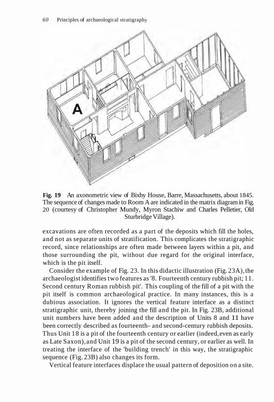
60 Principles of archaeological stratigraphy
Fig. 19 An axonometric view of Bixby House, Barre, Massachusetts, about 1845. The sequence of changes made to Room A are indicated in the matrix diagram in Fig. 20 (courtesy of Christopher Mundy, Myron Stachiw and Charles Pelletier, Old
Sturbridge Village).
excavations are often recorded as a part of the deposits which fill the holes, and not as separate units of stratification. This complicates the stratigraphic record, since relationships are often made between layers within a pit, and those surrounding the pit, without due regard for the original interface, which is the pit itself.
Consider the example of Fig. 23. In this didactic illustration (Fig. 23A), the archaeologist identifies two features as '8. Fourteenth century rubbish pit; 11. Second century Roman rubbish pit'. This coupling of the fill of a pit with the pit itself is common archaeological practice. In many instances, this is a dubious association. It ignores the vertical feature interface as a distinct stratigraphic unit, thereby joining the fill and the pit. In Fig. 23B, additional unit numbers have been added and the description of Units 8 and 11 have been correctly described as fourteenth- and second-century rubbish deposits. Thus Unit 18 is a pit of the fourteenth century or earlier (indeed, even as early as Late Saxon), and Unit 19 is a pit of the second century, or earlier as well. In treating the interface of the 'building trench' in this way, the stratigraphic sequence (Fig. 23B) also changes its form.
Vertical feature interfaces displace the usual pattern of deposition on a site.

Interfaces as units of stratification 61
Fig. 20 In Phase I of the stratigraphic sequence of Bixby House after the original construction (generalized as Unit 1), the walls and ceiling were lathed (Units 2 and 3) and the woodwork was painted blue, red or brown (Units 4-8). The walls and ceilings were plastered (Units 9 and 10) and wallpaper (Unit 11) was applied to the walls
(courtesy of Myron Stachiw and David Simmons, Old Sturbridge Village).
When a hole is filled, the layers in the bottom will be at lower absolute layers than other contemporary deposits outside the hole. The layers at the bottom of a pit will therefore have physical and stratigraphic relationships with other units of stratification of a much earlier date than the creation of the pit. If the interface of the pit is treated as an abstract layer and recorded accordingly, the layers in the bottom of the pit will also be related to the interface. By the application of the Law of Stratigraphical Succession, the layers in the pit assume their correct positions in the stratigraphic sequence of the site. They are, in effect, later than the vertical feature interface of the pit, which is later than the latest deposit through which it was dug.
Vertical feature interfaces can also be destroyed by later excavation which produces the same type of non-historical unit of stratification. Let us take the example of two associated graves in Fig. 24. In traditional recording, Fig. 24D shows Unit 1 partly overlying Unit 2, with the stratigraphic sequence for

Fig. 21 This illustration (and Fig. 22) shows the gradual construction of a stratigraphic sequence for the single section represented by profiles A-D. By the Law of Stratigraphical Succession, the four profiles are merged into a single sequence (a + b + c + d) and
superfluous relationships are deleted.

a-g & all other data
THE PERIODS
Second street
House rebuilt
3 House built
First street
Pre-settlement
Fig. 22 In e + f + g, the sequences of plans (E-G) are merged and then combined with the data from the profiles in Fig. 21. The final stratigraphic sequence for this site is a-g, which is divided into periods (K).

64 Principles of archaeological stratigraphy
this arrangement below (Fig. 24G, D). In Fig. 24E, all units are numbered on the assumption that Grave 1 cuts, or is stratigraphically later, than Grave 2. Interfacial Unit 5 thus cuts through Units 2 and 7, itself an interface: the stratigraphic sequence is shown in Fig. 24G (E). But when Grave 1 is excavated, it is discovered that part of the skeleton is missing. Further excavation reveals that Grave 2 was in fact cut through Grave 1, but its fill was not very compact, causing Unit 1 to slump into Unit 2. This being the case, interfacial Unit 7 cuts through Units 1 and 5 (and of course the skeleton of Grave 1). The correct identification of the interfacial units is given in Fig. 24F and the correct stratigraphic sequence in Fig. 24G (F).
It may be suggested that this is a fanciful situation and not applicable to circumstances in the field. However, one can encounter situations where a unit is superimposed by another, but is stratigraphically later. A cross-section of the London Underground 'tube', for example, may reveal in one place a disused portion of a line, filled with mud, and superimposed by a natural subsoil. Everyone knows what the reality is, but it is only by assigning a stratigraphic value to the 'tube' itself, as an interfacial unit, that the correct stratigraphic sequence can be found. The 'tube', as with any vertical feature interface, is followed upward until the latest deposit through which it was cut is found - in this case, say, the stratigraphic remains of a Victorian park.
As vertical feature interfaces are not the surfaces of layers, but surfaces in themselves, they cannot be recorded in plan as one might record a layer interface. In recording the latter, it is often customary to draw some of the details of the composition of the layer so that the plan appears not as a simple contour survey but as a surface of soil and stones. The vertical feature interface, however, can only be recorded by contours, as they are nothing more than surfaces. The composition of the deposits through which it was cut is of little relevance in making plans of these features. Yet for many of these features, only their lip, or boundary contour, is recorded.
Period interfaces
When a number of strata and interfaces form an accumulated mass, a body of stratification is made. If the stratification is of some depth and complexity, it may be divided into formations which in geology are:
any assemblage of rocks which have some character in common, whether of origin, age, or composition. Thus we speak of stratified and unstratified, freshwater and marine, aqueous and volcanic, ancient and modern, metallifer- ous and non-metalliferous formations (Lyell 1874: 5 ) .
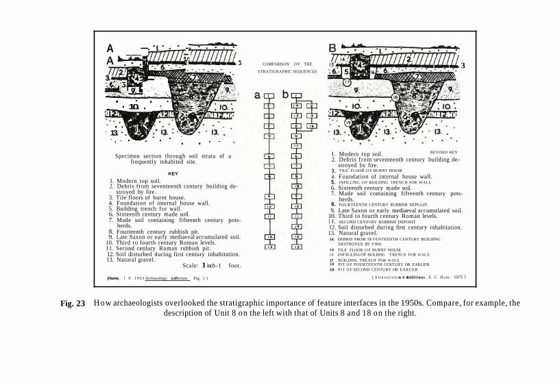
. . . A COMPARISON O F THE
STRATIGRAPHIC SEQUENCES 3
, . ,
. . . . .,. . 10. .
. . 13.
. . . . . . . I. Modern top soil. REVISED KEY
Specimen section through soil strata of a frequently inhabited site. 2. Debris from seventeenth century building de-
stroyed by fire. KEY 3. TILE FLOOR O F BURNT HOUSE
4. Foundation of internal house wall. 1. Modern top soil. 5. INFILLING O F BUILDING TRENCH FOR WALL 2. Debris from seventeenth century building de-
stroyed by fire. 6. Sixteenth century made soil. 7. Made soil containing fifteenth century pots-
3. Tile floors of burnt house. 4. Foundation of internal house wall.
herds. 8. FOURTEENTH CENTURY RUBBISH DEPCGIT
5. Building trench for wall. 9. Late Saxon or early mediaeval accumulated soil. 6. Sixteenth century made soil. 10. Third to fourth century Roman levels. 7. Made soil containing fifteenth century pots- I I. SECOND CENTURY RUBBISH DEPOSIT
herds. 12. Soil disturbed during first century inhabitation. 8. Fourteenth century rubbish pit. 13. Natural gravel. 9. Late Saxon or early mediaeval accumulated soil.
10. Third to fourth century Roman levels. 14. DEBRIS FROM SEVENTEENTH CENTURY BUILDING
DESTROYED BY FIRE I I. Second cenlury Roman rubbish pit. is TILE FLOOR O F BURNT HOUSE 12. Soil disturbed during first century inhabitation. 16 . INFILLING OF BUILDING TRENCH FOR W ALL 13. Natural gravel. 17 BUILDING TRENCH FOR WALL
Scale: 1 inch - 1 foot. 18 PIT O F FOURTEENTH CENTURY OR EARLIER 19. PIT O F SECOND CENTURY OR EARUER
(Hume, I N 1 9 5 3 Archaeology inBritain. Fig. 1 ) ( A l t e r a t i o n sa n dadditions . E C. H a m . 1975 I
Fig. 23 How archaeologists overlooked the stratigraphic importance of feature interfaces in the 1950s. Compare, for example, the description of Unit 8 on the left with that of Units 8 and 18 on the right.

66 Principles of archaeological stratigraphy
Fig. 24 l 'he problem of interpreting feature interfaces.
In archaeology, formations may be recognized by cultural, chronological or functional criteria and are normally called 'periods'. We can refer, for example, to Roman or Medieval, prehistoric or historical, construction or destruction periods. Each period will have an interface which is a surface composed of a number of layer and feature interfaces. These period interfaces are recorded on archaeological plans, or may be identified by thicker interfacial lines in a section drawing.
The period interface is the equivalent of 'the sum total of the ground surfaces which were ground levels in use at one and the same time' (Woolley 1961: 24). This definition should also include surfaces other than those
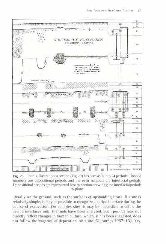
Interfaces as units of stratification 67
A SECTIONAL EXAMPLE
STRATIGRAPHIC UNITS
I N
......... ............
Fig. 25 In this illustration, a section (Fig. 29) has been into 24 periods. The odd numbers are depositional periods and the even numbers are interfacial periods. Depositional periods are represented best by section drawings; the interfacial periods
by plans.
literally on the ground, such as the surfaces of upstanding strata. If a site is relatively simple, it may be possible to recognize a period interface during the course of excavation. On complex sites, it may be impossible to define the period interfaces until the finds have been analysed. Such periods may not directly reflect changes in human culture, which, it has been suggested, does not follow the 'vagaries of deposition' on a site 1967: 13). It is,

68 Principles of archaeological stratigraphy
however, the vagaries of the survival of stratification which determine the division of a site into periods, which may then be correlated with phases in human culture.
In the way of the vertical feature interface, it has been traditional practice to ignore the period interface as a true period on a site. Even my 1979 drawing (Fig. 22K) falls into this category, as Periods 1-10 are only depositional, or periods of build-up of stratification. The interfacial periods, representing the use of the site when its surface was static, are missing. So it may be claimed that 5 0 %of the stratigraphic record is regularly overlooked.
Using the example of Fig. 25, a section drawing has been exploded to show the division of a site into periods of building up deposits and interfacial periods, during which the surface of the previous depositional period is in use. The periods of build-up are denoted by the odd numbers, and the periods of use by the even numbers. It should be noted that periods of 'build-up' imply not only physically adding to the site, but adding to the stratigraphic record as well. Due to this fact, vertical feature interfaces are included in the depositio- nal periods, as well as then 'being in use' in the interfacial periods. Once a stratum is deposited, its innards are, by definition, 'out of use', as they are buried; therefore, deposits only appear in the depositional periods.
Interfaces of destruction
On any site which has been disturbed by digging, parts of the surfaces of earlier strata and periods will have been destroyed. These areas may be referred to as interfaces of destruction. They may be defined as abstract interfaces which record the areas of a given unit of stratification or period on a site which has been disturbed or destroyed by later excavation. With a few exceptions (e.g. Crummy 1977; see Figs 35 and 36), these forms of negative evidence are seldom adequately recorded. When usually published, these interfaces of destruction are often shown by the convention of a hard line, making it difficult to distinguish such areas from the boundary contours of features which actually belong to a given period. More often, they are simply ignored. The areas of disturbance are drawn upon with a series of broken lines which indicate the excavator's hypotheses about the original extent of the destroyed stratification. Stratification is, however, a record which has both positive (deposition) and negative (erosion or destruction) elements: both should be recorded equally.
Having discussed the non-historical, repetitive forms of different units of stratification in this and the previous chapter, attention will be focused in Chapters 8 and 9 on the two main forms of stratigraphic recording, namely, section and plan drawings.

8 Archaeological sections
An archaeological section is a drawing of a vertical soil profile, as exhibited by cutting down through a mass of stratification. Two things are shown in a section: a vertical plane view of the strata, and the various interfaces between the bodies of the strata. Sections are therefore an expression of the pattern of superposition on a site. From this picture, provided that the interfaces have been drawn, a part of the stratigraphic sequence of the site can be extrapolated. Until recently, archaeologists relied mostly upon sec- tions in all matters of stratigraphic sequence, and they were regarded with considerable trepidation:
The recording of sections will also have to be done by the director and his assistants, for this is the most subjective and difficult part of recording yet one of the most important kinds of evidence. N o truly objective way of recording a section has yet been devised; drawing relies entirely on the integrity of those drawing, for it cannot be checked once the excavation is over (Alexander 1970: 58) .
Under the influence of Wheelerian thought, the section assumed an import- ance in stratigraphic studies which is no longer warranted. This has been appreciated by open-area excavators, such as Barker (1969), who have attempted to obtain a proper balance between the record of the section and that of the plan. This change has not been accompanied by a critical examination of the nature of plans and sections, or their import in archaeo- logical stratigraphy. In this chapter, several types of early sections are reviewed in relation to the prevailing archaeological attitudes towards sections. This is followed by a discussion of the modern types of section and their recording.
Early types of sections
Many early sections were sketches of burial mounds (e.g. Low 1775: plate XIII; Montelius 1888: fig. 96). These sections were generally not records of
69

70 Principles of archaeological stratigraphy
stratification, but rather diagrams to show the construction of the mound and the burial chamber. They were topographical pictures, as opposed to stratigraphic records. The same applies to many of the sections made by Pitt-Rivers and his disciple, H. St. George Gray. Their sections were often topographical profiles of the subsoil underlying the archaeological deposits (Bradley 1976: 5). The method for draughting these profiles was borrowed from geology, where it is still used (Gilluly et al. 1960: 89).
Further geological influence on archaeological sections is found in the 'columnar sections', the purpose of which is to show:
the superposition and relative thickness of the strata of the region which they represent, provided they are drawn to scale. They serve their main purpose in giving a quick check and comprehensive view of the stratigraphy of a region and in making comparisons with other regions possible (Grabau 1960: 1118).
These sections appear as long vertical bands in which slices of varying widths, stacked one upon the other like a deck of cards, represent the stratigraphic sequence of a given locality. The idea was translated into archaeology. Specifically, it was used by Lukis (1845: 143) in written form and by Lambert (1921: fig. 27) in drawings.
Based upon the great extent and regular patterns of superposition of geological strata, the columnar section is of obvious use in geology. Archaeological strata can seldom, however, be correlated over any great distance, as they are normally of very limited extent. The columnar section is of little use in archaeological stratigraphy, but the idea of such a rep- resentative sequence has found general favour:
Sections should have been chosen both to give a representative vertical view of the site stratigraphy at one point and to make certain points about the site sequence (Browne 1975: 69).
Due to the relative simplicity of geological strata at a given point, the columnar section almost always gives a representative vertical view of the stratification of the area. In these simple sections, there is usually a direct correlation, stratum for stratum, between the physical relationships (covered by the Law of Superposition) and the temporal relationships of the strati- graphic column. Columnar sections always produce a unilinear stratigraphic sequence, as would be obtained if a sample were taken from an archaeolo- gical site by boring.
On excavations, such unilinear stratigraphic sequences are often found in layers filling up small pits, one deposit superimposed upon the last in a

Archaeological sections 7 1
straightforward pattern. This may be one reason why archaeologists are so enthusiastic about the excavation of pits and the analysis of 'pit groups' of artefacts, as opposed to that of other disparate deposits occurring elsewhere on a site. The fact is that most archaeological sites produce multi- linear stratigraphic sequences which would baffle many geologists.
On complex archaeological sites, sections cannot give a representative view of the stratigraphic sequence of a site. It is extremely difficult on such sites to choose a line for a section which would give a 'representative vertical view' of the stratification, as the orientation of features on the surface may not be that of those below. Sections, moreover, only record the physical relationships of the stratification at a given point. On either side of the section face, different relationships will be found and the section will give a simplistic, rather than representative, view of the stratification and the stratigraphic sequence of a complex site. The Viking dig a t York (Hall 1984), for example, produced over 34 000 units of stratification. With the complex stratification which is now recorded on many densely occupied sites, it would be difficult to obtain a section which would be representative of but an isolated part of the site.
The general idea of the archaeological section as a self-evident picture of the stratigraphic sequence of a site is still prevalent. The idea is aptly represented in Fig. 7, where it was seen as unnecessary to state the strati- graphic relationships between the units of stratification, as they were assumed to have been self-evident in the drawing. That may well be the case with the unilinear sections from the pits, but when other man-made units of stratification, such as upstanding strata, are found on a site, it is imperative that the excavator spell out all the stratigraphic relationships. Unlike the layers in a pit, the man-made strata and interfaces do not readily conform to geological notions of regular superposition and cannot there- fore be treated as self-evident truths.
The type of section pictured in Fig. 2 was developed by Wheeler in the years between the world wars. An injustice may be done therefore in looking for purely stratigraphic motivations in the making of such records:
Now a word as to the systems of numbering. Layers or strata it is obviously necessary to number downwards from the top of the cutting, so that the numbers are mostly in the reverse order of accumulation, the latest (topmost) layer being layer 1. This somewhat illogical procedure is unavoidable since it is necessary to give layer-numbers to small-finds as they come to light, without waiting for the completion of the section (Wheeler 1954: 55; empha- sis added).
In other words, the first numbering of layers may have been more a facet of

72 Principles of archaeological stratigraphy
recording artefacts than stratification. The record of artefacts is a question of their provenance. This was overcome by assigning a number to the layer from which they were derived and marking that number on the find. The recording of the strata (and interfaces) from a stratigraphic viewpoint was completed by making section drawings: no less and usually no more. The notion of a unilinear stratigraphic sequence and the columnar section is present too in Wheeler's association of the order of numbers and the order of accumulation.
Purpose of sections
Until a few decades ago, stratigraphic analysis was associated directly with the drawing of sections. The archaeologist had to decide upon the differ- ences between the various strata, walls, pits and other features in a soil profile. Once the lines of demarcation, the interfaces, were recognized and drawn, the analysis of the stratification was considered to be at an end. Perhaps beginning with the modern urban excavations, for example at Verulamium (Frere 1958: fig. 3), where many complex stratigraphic situ- ations were found, this attitude slowly changed. Eventually, it was recog- nized that the stratigraphic material within an excavated area (in distinc- tion to that found in the sections which formed its sides) was more import- ant to a full understanding of the stratigraphic sequence than were the sections alone (Coles 1972: 202-203). Information from these areas was recorded in written statements about stratigraphic relationships.
On modern excavations, such as those conducted by the Department of Urban Archaeology of the Museum of London, this vital stratigraphic material is recorded on pre-printed sheets (e.g. Barker 1977: fig. 46) and must be considered as the primary stratigraphic record of a site. The reason for this is that the written record on the sheets should contain all of the stratigraphic relationships shown in any of the sections of a site, as well as those relationships from all other areas of the excavation not covered by section drawings. If such information is accurately recorded in writing for each unit of stratification on a site, the stratigraphic sequence can be constructed without reference to any other sources, including the sections.
There are those who would advocate that sections are now obsolete, but sections have a purpose which cannot be met by any other means. Natural cross-sections give 'the third dimension of the land form, the other two being furnished by the map' (Grabau 1960: 1117). While there is little doubt that archaeological stratigraphy in the past has placed too much emphasis on sections, the reaction to this overbalance should not be to

Archaeological sections 73
abolish sections. Their use should be brought into line with other strati- graphic methods, such as written records and plans.
Types of sections
There are three main types of archaeological profiles - the standing, the incidental and the cumulative sections. The form most often used is the standing section, as it is closely associated with the Wheelerian method of excavation with its series of baulks. The standing section is made during excavation by the removal of adjacent stratification. It may occur around the main boundaries of the excavation, on the faces of the baulks, or as a profile produced by vertical excavation to solve a stratigraphic problem or to dissect a feature. Usually, baulks remain in position until the end of the excavation at which time the recording of its standing sections is con- sidered:
Any hurry at this stage is fatal to the whole enterprise, as the complete interpretation of main periods and relationship of all layers has to be estab- lished at this point. As one draws each layer or feature, so its relationship to other layers is established (Webster 1974: 66).
Some excavators have some difficulty in defining the interfaces between the layers. They are advised in these instances that:
it is often helpful to look at the section upside-down (standing, that is, with the back to the section and bending down to look through the legs); from this unaccustomed posture it is frequently possible to notice details not apparent to the normal view (Atkinson 1946: 129-30).
Having made such deliberations, the director will then proceed to draw the standing section from top to bottom. This method has certain ramifi- cations.
First, the stratigraphic success of the excavation depends entirely upon the record of the sections, which must be drawn in an unhurried atmos- phere. Unfortunately, this job occurs at the end of the excavation, when the required leisure is usually wanting. Secondly, because the section is not recorded until last, it is likely to have eroded during the course of the excavation. It is possible, therefore, that there may be little correlation between the excavated deposits, and the relationships later observed in the section. Thirdly, if a layer does not appear in a section, it may not exist in the stratigraphic records.

74 Principles of archaeological stratigraphy
In the Wheelerian tradition, the standing sections on the faces of the baulks of the grid system of excavation were considered to 'provide keys to the stratification' (Kenyon 1961: 95). The methods for recording the stratifi- cation within the excavated grid square were such that it may be suggested that the record of the excavated material cannot be closely tied with the record of the section. If the sections were recorded at the end of the excavation, this gap in the stratigraphic record between the material removed and that surviving in the section face must be increased. In his famous drawing (Fig. 26A and B), Wheeler argued against the removal of stratifi- cation from the faces of standing structures. It would appear, however, that his grid system of excavation - coupled as it was with the inadequate recording of the excavated stratification within the squares -may have often resulted in producing the very system he argued against (Fig. 26C); that is, the deposits excavated were not recorded well enough to allow for their full correspondence with the stratigraphic data of the 'walls' or baulks.
Incidental sections are profiles which have not been produced by archaeological excavation, but are sections revealed in construction works, or other incidental cuttings. The archaeologist must record those incidental sections as a whole, from top to bottom. This type of section will often provide the only stratigraphic information which can be obtained about a site. Should excavation not be possible, this type of section will stand with the reservation that the observations in it were not proved by excavation. Its value for stratigraphic studies will depend entirely on how the section is drawn, as discussed below under the process of drafting archaeological sections.
In the 1970s, Philip Barker suggested the use of the cumulative sections,, as an alternative to having baulks with standing sections on a site. His method was different from that used occasionally by Wheeler (1954: 91), as Barker's includes the complete excavation of the deposits in the section.
In this method, the excavation is carried up to a pre-determined line and the section drawn. The excavation then proceeds beyond this line. Each time the excavation reaches the line in the future the section will be drawn . . . i t has one very considerable advantage over the section cut on a notional line . . . in that it can be sited to section particular large-scale features, such as a building or a rampart, invisible at an earlier stage of the excavation (Barker 1977: 80).
There is considerable stratigraphic advantage in this method. Stratigraphic excavation is the process of removing the layers of a site in the reverse order to that in which they were deposited: excavation thus follows the natural contours and shape of the layers, which are recorded in plan drawings. As the


76 Principles of archaeological stratigraphy
layers are removed, they are recorded one by one in the cumulative section. By using the cumulative section, there is more likely to be a direct correlation between the stratigraphic facts recorded in section and those in the plans. More than any other method of recording sections, the cumulative section fulfils the requirements of modern archaeological stratigraphy.
Should it be desirable to have a baulk or two on a site for whatever reasons, the standing section can be recorded in a cumulative fashion as the excavation proceeds. Such baulks might be kept, for example, for the collection of a column of soil samples. Under older reasoning, baulks were necessarily retained until the end of excavation because 'often excavation will raise new points of interpretation, and one must be able to refer back to a visible section to decide them' (Kenyon 1961: 89). There are few stratigraphic grounds for this argument, since the deeper one excavates, the less relevant the upper layers preserved in the baulk become to the features of the earlier periods. With the cumulative section, one can always refer, if necessary, to an extant section, albeit a record drawing.
Whether the archaeologist uses the standing, incidental or cumulative section, the stratigraphic value of each method depends upon the processes by which the sections were drawn.
Drafting archaeological sections
Graham Webster (1974: 136-9) has defined three processes of drafting archaeological sections. These are the realistic, the stylized and the compro- mise methods. The last method, as its name suggests, is comprised of elements of the other two and is of little interest to modern practice.
In drafting sections by the realistic method (Fig. 27):
differences between deposits are shown by changes in the shading. . . No hard lines appear at all except where there are stone walls and at the natural subsoil. This method has the virtue of honesty by omitting any clear-cut divisions which the excavator might suppose to be there without their being visible (Webster 1974: 137).
A controversy has raged in archaeology over this type of representation, since the matter was raised by Wheeler (1954: 59-61) several decades ago. It centres upon the recognition of interfaces in archaeological stratification. They are defined by the examination and demarcation of the different strata. The limits of a deposit - its boundary contours in depth, length and width -


78 Principles of archaeological stratigraphy
are the lines of the interfaces. If the archaeologist can recognize the strata, he has by that very fact defined their interfaces. If a section shows no strata clearly defined by soil conventions, it can have no interfaces. If it contains defined layers, it should contain interfacial lines as well. If it does not, then the 'virtue of honesty' is no more than a euphemism for stratigraphic irresponsi- bility. This is because the analysis of stratification in sections is not a question so much of examining the soil composition of a strata, but of studying the interfaces. If the excavator cannot define any 'clear-cut divisions' in a section, the character of the stratigraphic excavation is to be questioned. One may reasonably ask whether any 'divisions' were recognized during the exca- vation: how were the layers defined; to what provenance were the artefacts assigned; and if the layers were not defined, how could they have been stratigraphically excavated?
By contrast, the stylized section (Fig. 28) has both interfacial lines and numbered layers (Wheeler 1954: 58). The stylized method, because of its interfacial lines, is said to contain the danger of 'subjectivity': 'one has only the excavator's interpretation of what was actually there' (Webster 1974: 137). This reservation applies to all aspects of excavation and recording, not simply to section drawings. The danger lies, however, not in a person's interpretation, but in the lack of proper training in the discipline of archaeo- logical stratigraphy. What an excavator can define must be recorded, and in section drawings this must include all the interfacial lines.
The definition of these lines, as drawn in the stylized method, must include the highlighting of the feature interfaces. This has not been the case in the past. The feature interfaces in Fig. 28 have been illustrated in Fig. 29 in which all other interfaces have been purposely omitted. On the ordinary stylized section, these interfacial units of stratification may be identified by a thicker line than that used on other interfaces. As discussed in the previous chapter, the identification of feature interfaces is a crucial part of the stratigraphic record of a site. Without these interfaces, a stratigraphic sequence for the site, or even for a single section, cannot be compiled.
In the analysis of stratification in sections, it may be irrelevant whether the excavator uses the incidental, standing or cumulative type of sections, since all of these may be recorded by the stylized method. It matters little, by comparison, which strategy of excavation is used, since within each the archaeologist may dig by stratigraphic excavation. The course an archaeol- ogist takes in all these matters depends upon goals set for a project. If there is no interest in using sections for stratigraphic analysis, they may be drawn with a brush and paint, or whatever medium suits the aims. If a stratigraphic use is to be made of section drawings, the rule is that it is the interfacial lines that count, because it is only by their analysis that any sense can be made of the stratification of a site.
The use of sections has been unduly emphasized in archaeological strati-


Archaeological sections 8 1
graphy, while the stratigraphic value of plan drawings has been underrated. These will be discussed in the next chapter with the aim of showing the complementary relationships between plans and sections in the study of stratigraphic information on archaeological sites.

9 Archaeological plans
The shift of interest from sections to archaeological plans has been due to the introduction of modern methods of open-area excavation. While many excavators now make plans which are exact, and exacting, in many re- spects very little attention has been paid to the nature and stratigraphic uses of archaeological plans. There has been no controversy over 'stylistic' or 'naturalistic' plans (Fig. 30), yet plans are as important as sections for stratigraphic studies. Excavators have even mistaken the plan for a type of section, the idea of the 'horizontal section' having an undeserved currency (Barker 1977: 156; Hope-Taylor 1977: 32). A section drawing is not a plan of a vertical surface, but a record of a cutting made through stratifi- cation on the vertical plane. Plans, in the ordinary sense, are records of surfaces, not of plane views.
The matter can be clarified by reference to definitions of 'section' and 'surface' in the Oxford English Dictionary. A section is a drawing 'rep- resenting an object as it would appear if cut through in a plane at right angles to the line of sight'. A surface is the 'outermost boundary (or one of the boundaries) of a material body, immediately adjacent to the air or empty space'. Although it is possible to slice off the surface of an archaeo- logical site horizontally, such a practice would not produce an archaeologi- cal section. (It would also be a questionable method of excavation.) Such a horizontal plane is not a section because it would not reveal the superposit- ional relationships between the strata, as a surface has no top or bottom.
Perhaps there has been no controversy over the substance of archaeologi- cal plans because excavators have been far more interested in sequential and chronological, rather than topographical, evidence. Sections contain only boundary contours of the units of stratification, whereas plans may show both boundary contours and surface contours. In a section, the complete boundary contour, in a plane view, of each unit of stratification is exhibited. The stratigraphic relationships between the units can thus be ascertained by a study of those interfaces. In a plan, only the latest deposits (which are not in superpositional relationships) will show their full bound- ary contours. Due to the overlapping of strata, earlier deposits will only

Archaeological plans 83
Fig. 30 As with sections (Figs 27 and 2 8 ) , composite plans may be drawn with or without boundary contours (interfacial lines) or layer numbers.
partly appear at the surface being planned. With incomplete boundary contours, it is difficult or impossible to work out the stratigraphic relation- ships between the layers which are recorded in a composite plan.
Plans are a record of the length and width of archaeological remains. Sections record their thickness. A surface has no thickness; plans, therefore, are records of an interface. A plan has only one date: that of the latest unit of stratification which forms a part of its surface. Plans do not show a sequence, as each plan is only the record of a single interface. Sections, on the other hand, are the time dimension of a site. They show the sequence of deposition of a series of layers and feature interfaces, each succeeding the other. Every successive interface is a potential level for a plan. Sections and plans are complementary: a plan shows the topographical dimensions of a site in space at one time; a section gives the vertical dimension of the site through time. Plans give the length and width of a site, if you will, and sections record its depth: these three dimensions are woven together by the stratigraphic sequence, which represents the fourth dimension, time, on archaeological sites.
Multiple feature plan
There are several types of archaeological plans: the multiple feature, the composite and the single-layer. The multiple feature plan is not so much a plan as it is an index of all the feature interfaces which were found in all the periods of a site. Figure 31 shows all the vertical feature interfaces

Fig. 31

Archaeological plans 85
found in an excavation at Portchester Castle over several years. Other examples bring together all the walls found on a site (e.g. Hurst 1969: fig. 2). Having presented those plans of the total evidence of such features from an excavation, archaeologists then often produce a series of plans on which some of the features appear, as they belong to the particular period the plan represents.
This practice obviously has some value, but the multiple feature plan presents an image of complexity which did not exist at any one period on the site. Nor would such complexity have obtained during the course of the excavation, since many of the features would have been removed as the excavation progressed. The multiple feature plan may be useful if all the features were cut into bedrock and if there was no depth of stratification over the features. The topsoil could be stripped to the subsoil and all the exposed features simultaneously planned. Many sites for which multiple feature plans are made are not of this type; they are sites with a complex stratification of features, walls and layers.
The multiple feature plan can only be made by ignoring the plans of all the layers on a complex site. It is therefore unstratigraphic, since it can only be made by ignoring the stratification which existed before and after the features themselves were created. The intense picture of superposition which is displayed in this type of plan is deceptive, since the degree of superposition has been lost. If a feature or wall is later than and super- imposed on another, it is impossible to tell from this type of plan whether one wall destroyed the other or simply lies above it, without any direct stratigraphic connection.
Presumably, the multiple feature plan is never considered to be a primary record of the stratification, so that reservations about its stratigraphic character may be of little consequence. With all archaeological plans, however, there ought to be some guidelines about the type of evidence illustrated. Perhaps the multiple feature plan should only be presented in a schematic manner so that the evidence of the actual records is not com- promised. A multiple feature plan which is intended to show the change in building alignments, for example, should be drawn in block diagrams rather than showing the walls as they were actually recorded.
Fig. 31 An example of a common type of archaeological plan in which all the vertical feature interfaces of a site, without regard to their phase or period, are illustrated on a single drawing (from Cunliffe 1976: fig. 4; courtesy of the Society of
Antiquaries of London).

86 Principles of archaeological stratigraphy
Composite plans
The composite plan records a surface which is composed of more than one unit of stratification. It has been used for many decades and is the usual form in which most archaeological plans are published. It is also the main method used to record surfaces on excavations, particularly since the intro- duction of open-area excavation. One style of the composite plan has been described:
In practice, plans should show a picture of the entire excavated surface, no part of which should not be represented by some convention on the plan. Even an apparently featureless clay surface is itself a clay surface, and its extent can, and must, be shown (Biddle and Kjolbye-Biddle 1969: 213).
According to these scholars, the composite plan is made when a major surface has been found in the excavation. If major surfaces are not recog- nized, no composite plans would be made of the site. As may be assumed from the excellent quality of the plans (e.g. Fig. 32), their execution takes much patient work. Unless excavation ceases for a lengthy period, not many of these detailed plans can be made. There are, of course, instances, such as the excavations at Wroxeter (Barker 1975), where the composite plan may be the most suitable form of recording.
Figure 33 illustrates another example of a composite plan. This house site, from the highlands of Papua New Guinea, was excavated by a group from the Australian National University in the late 1970s, led by Jack Golson. The latest period of occupation of this site was probably less than 200 years ago. The main features survived in the present ground surface and were an eavesdrop gully around a house site and a perimeter ditch. They were cut into a single deposit of humus which itself overlay the natural clay of the hill site. The plan in Fig. 33 is a complete major surface, or period, with no overlapping strata. It cannot be subdivided nor made into a series of other plans. It contains only the vertical feature interfaces of one period and has only one horizontal layer interface, that of the humus over the natural.
Many composite plans, however, contain a number of stratigraphic units, many of which were laid down at earlier periods than the plan represents. Due to the process of stratification by which layers overlap, only a part of the surfaces of most of the units will appear in the plan of a major period. If a composite plan is a 'picture of the entire excavated surface', then only those parts of the underlying units of stratification which appear at the surface will be recorded.

WROXETER Site 68 Phase Z
6 10
1 2 3
Fig. 32 An example of a composite plan in which the entire surface of a site under excavation is recorded in a single drawing. Ideally, this plan should represent a major period in the history of a site. However this can only be achieved occasionally during
an excavation, and must usually await the analysis of the artefacts.
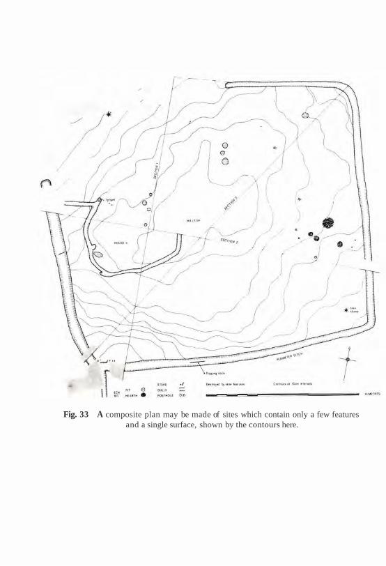
Fig. 33 A composite plan may be made of sites which contain only a few features and a single surface, shown by the contours here.

Archaeological plans 89
The stratigraphic problem which this represents is demonstrated in Fig. 34, which is an ideal composite plan of a small building of two rooms, the wall footings of which cut into the underlying Units 1-10. Unit 1 is the earliest, Unit 1 0 the latest, with Units 2-9 being deposited one after the other. The problem with composite plans is that they only partially record any units of stratification which partly lie under other deposits. If you peel Units 10 and 3 from Unit 2, it will be seen that only half of Unit 2 was recorded. With Unit 10, only about 10% of its surface appears on the composite plan. If the excavator has made a mistake about the 'major surface', which was labori- ously drawn in a composite plan, there is nothing that can be done after the fact to make a new period plan.
CURRENT
IN PLANS WHICH
ENSURE THE INCOMPLETE HORIZONTAL
Fig. 34 The composite plan in the centre of this diagram has been split into plans of each unit of stratification. The evidence of each unit which is not recorded in the
composite plan, due to superposition of deposits, is clearly indicated.

90 Principles of archaeological stratigraphy
Composite plans are a selective way of recording the surfaces of the units of stratification. As they are time-consuming, they can only be made at certain intervals. Unless the layers and features which do not appear at the surface of the composite are recorded on other plans, much of their strati- graphic evidence will be lost. Furthermore, those units which do appear on a composite plan will often be only partly recorded.
The composite plan is based upon certain assumptions: first, that it is possible to recognize entire major surfaces during the excavation and before the analysis of the finds; secondly, that a major surface means finding obvious evidence, such as floors, walls, streets, or widespread deposits of definite character (ordinary soil layers are difficult to recognize as major surfaces); and, thirdly, that only those parts of the units that form part of the recognized period are worth recording in a plan. Since the composite plan is supposed to represent a major surface, there is a tendency for the recorded plan to become the final phase or period plan, and to be published as such without alteration. In situations such as Fig. 33, there can be no objection to this course of events. But on complex sites with a wealth of stratigraphic and topographical material, the use of composite plans as the primary record ought to be discouraged, as they prejudge the periods of a site.
It has been noted that this type of plan should 'be as detailed and sensitive a record of the site as the sections normally are' (Biddle and Kjrolbye-Biddle 1969: 213). This presumably means that layer numbers and boundary contours should be recorded on composite plans for every unit of stratification which appears on them. If the published record is any indication of practice on excavations, this is not the case, particularly as regards the boundary contours of the units. Barker (1977: 148) has sugges- ted that there is often difficulty in defining the boundary contours of layers and features in the surface of a site. If an excavator cannot define the limits of a unit of stratification, how is it possible for stratigraphic excavation to take place?
Planning of interfaces of destruction
Another aspect of the composite plan concerns the negative stratigraphic evidence, or interface of destruction, which appears on plans, but is not readily apparent in sections. Suppose that a composite plan has been made of a Roman building in an English town. Further, suppose that a great part of

Archaeological plans 91
the plan of the building had been destroyed by pit-digging in later centuries: the destroyed part is the negative evidence, or interface of destruction of that period, or of individual units of stratification of that period. This negative evidence is as important as the surviving pieces of walls, layers and feature interfaces, as it defines the extent of the positive stratigraphic evidence. With few exceptions, this negative evidence is not shown on composite plans or it is confusingly illustrated. Archaeologists often draw over the interface of destruction with various broken lines, indicating their hypotheses about the original extent of the buildings or features in the plan. This practice confuses the degree of the survival of the stratigraphic evidence with the excavator's hypotheses and serves neither well.
On sites which contain interfaces of destruction, they should be recorded in the manner of Figs 35 and 36. These drawings represent two successive periods from a site at Colchester (Crummy 1977). Each vertical feature interface may only appear once as a positive feature defined by the hard line of its boundary contour. At any earlier period, the feature will appear only as an interface of destruction, symbolized by a tone or hatched area. At later periods, the feature interface will appear as a filled hole, or not a t all, if it is covered over by later layers.
In the later plan (Fig. 35), Units F316 and F314 appear as features with boundary contours: they belong to the period of the plan. In the earlier plan (Fig. 36), they are shown as interfaces of destruction. Unit F313 appears as a feature in the earlier plan, but does not appear a t all in the later one. It was obviously in use at the earlier period and covered by later deposits by the time of the later plan. There are a few inconsistencies in this important example. Unit F202, for example, is mentioned as being a robber trench (Crummy 1977: 71). It ought to appear in both plans as an interface of destruction. It is shown, however, as a feature of both periods, which is stratigraphically impossible.
Fig. 35 This is the later period of the plan shown in Fig. 36 and illustrates the positive and negative (shaded interfaces of destruction) stratigraphic evidence. Feature 314 (centre bottom), for example, appears as an interface of destruction on
the earlier plan in Fig. 36 (from Crummy 1977: fig. 8; courtesy of the author).
Fig. 36 This composite plan shows a period of the Lion Walk site which is followed by that of Fig. 35. Feature 313, for example, does not appear in the later plan as it was
buried by later stratification (from Crummy 1977: fig. 4 ; courtesy of the author).


The overall impression created by composite plans which include inter- faces of destruction is excellent. They read like a film strip in which features of one picture give way to the next. Imagine one composite plan of this type being made for every interface on a site, i.e. one for each unit of stratification. Then imagine this great series of plans stacked one upon the other, and being able to thumb down through them. The result would be a moving picture of the complete stratigraphic history of the site.
The composite plan is the way in which the surfaces of archaeological periods should be shown in the publication of excavations. This type of plan should not be made as a record of a selected period during the course of excavation, as the periods of a site should be determined in relationship to the analysis of the artefacts found in its deposits. On many sites from a stratigraphic viewpoint, the composite plan may be a useless record, as it is not subject to later analysis or reworking. The only method which meets modern stratigraphic requirements is the single-layer plan.
This assertion may be amplified using Fig. 37. Reading lines A and B, from left to right, it will be seen that the resulting 'model of records' is the same.
Fig. 37 The types of stratigraphic records which are formed by different methods of excavation, For best results, open-area excavation is combined with section drawing
and single-layer planning (C) .

Archaeological plans 95
This is because there is little difference in the method of recording on open area and grid systems of excavation, due to the use of composite (selective) plans. After the excavation, one is left with a series of 'recording cubes', the tops and sides of which were recording in sections or in a composite plan. Within the cube, it is very likely that next to nothing of the details of the stratification has been recorded in plans, if perhaps in sections. The only way to improve this bleak picture is to use single-layer planning, because the missing stratigraphic details cannot be recorded adequately, no matter how many sections or composite plans are drawn. The future 'keys to the stratification' lie not in sections or composite plans, but in the recording of the horizontal aspects of each and every unit of stratification on a given site.
Single-layer plans
If in archaeological stratigraphy, every unit of stratification is of equal value, then each must be recorded in plan, and if possible in section. Using an archive which contains a plan of every unit of stratification, a series of composite plans can be made for any period of a site, at any time after the excavation. Such a practice does justice to the stratigraphic remains and to their topographical evidence. The key to making this archive is the single- layer plan.
The single-layer plan is the least that an archaeologist must do to record the topographical remains of each unit of stratification. The method (as suggested to the writer by Laurence Keen and developed with Patrick Ottaway) is very simple. Pre-printed sheets (Fig. 38) are provided to the excavator. On each sheet, only one unit of stratification is recorded. This record is one of essentials, not of intricate details. The essentials are a set of co-ordinates, the plotting of the boundary contour of the layer or feature, and an appropriate number of elevations. The elevations are placed directly on to the plan, for convenient reference. As each new unit of stratification is defined, the same format of recording is carried out. This method records all of the non-historical aspects of each unit of stratification, which are repetitive and universal.
The resulting record will be a series of plans, as exhibited in Fig. 39. With these plans, and in accordance with the stratigraphic sequence of the site, a whole series of composite plans, beginning with the earliest deposits, can be made (Fig. 40). (In the example of the New Road site, it should be
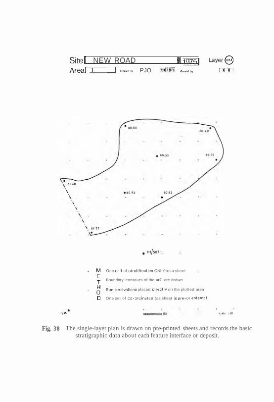
NEW ROAD PJO
. One of ONLY on a sheet
E Boundary contours of the are drawn
placed on the plotted area 0
One set of (as sheet
Fig. 38 The single-layer plan is drawn on pre-printed sheets and records the basic stratigraphic data about each feature interface or deposit.
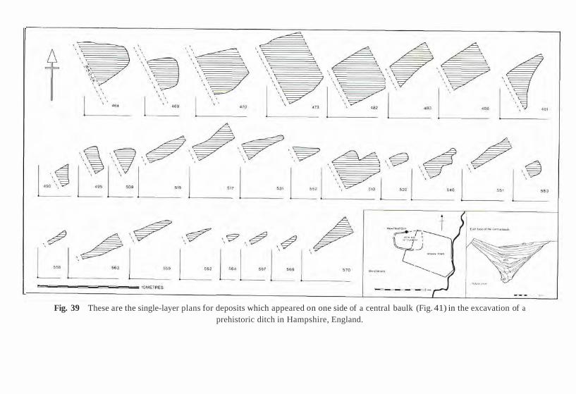
Fig. 39 These are the single-layer plans for deposits which appeared on one side of a central baulk (Fig. 41) in the excavation of a
prehistoric ditch in Hampshire, England.

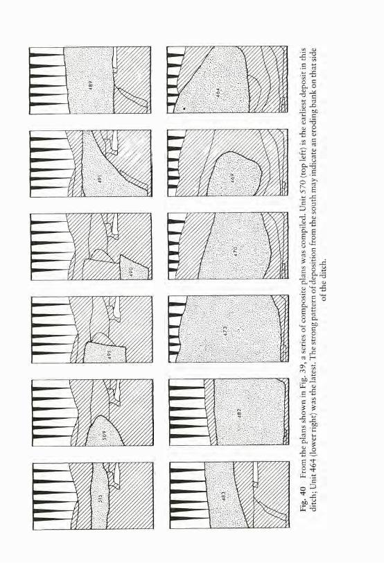

Fig. 41 A standing section on a baulk, which was recorded at the end of the excavation. Comparison of the dimensions of the deposits in the section and those in the plan (Fig. 39) will reveal minor discrepancies, which always occur when plans and sections are
recorded at different times during the excavation.
Archaeological plans 101
mentioned that there were no major structures on this site, only layers of soil. Thus, no major surface could be recognized during the excavation: had this site not been recorded by single-layer plans, no plan would exist of it today.) Some deposits are illustrated in Fig. 41, which was drawn as a standing section some time after the plans were made. Minor discrepancies may be discovered, therefore, between the dimensions of the layers in plan and those in the section, an occurrence more frequent in archaeological records than many archaeologists would care to admit.
With a series of single-layer plans, one may also reconstruct, with fair accuracy, a section across the site (e.g. Fig. 42). This is possible on any line, because the single-layer plans record the boundary contours, or limits of the layers horizontally, and the elevations which give their vertical dimensions.
The single-layer plan is a fundamental requirement in stratigraphic record- ing. The making of these simple but essential plans does not rule out the execution of more detailed plans on an excavation, including intricate composite plans. The composite plan which has been made on an excavation is, in most instances, anathema to the student of archaeological stratification. It combines data which ought first to be recorded in single units. Such plans can seldom be used in later stratigraphic analysis because they cannot be broken down into individual plans of the units of stratification. Even if drawn on transparent paper they cannot easily be studied by overlaying one plan on the other, because of the amount of missing stratigraphic data which lie between the period interfaces, recorded by the plans.
The analysis of archaeological stratification must start with the complete records of each unit of stratification. It begins with the smallest stratigraphic entities, the units of stratification, and works towards the general or more complex aspects, such as phases and periods. Composite plans on sites with complex series of deposits work against this method of analysis. On the other hand, stratigraphic problems can easily be analysed by the comparison of a series of single-layer plans, as each plan is a single unit.
Nicholas Pearson of the York Archaeological Trust excavated the General Accident site in York in 1984 and has generously provided a summary of his early use of the single-layer plan method:
It was decided that as a result of the small excavation areas, and because it was known that the stratification would be deep and complex, that the traditional phase or composite plans would not be an appropriate method of recording. I had had a great deal of experience where such sites had run into complex problems in post-excavation work involving frequent impossible stratigraphic relationships, or huge gaps in the record. These had resulted in frequent alterations to the phasing of the sites with consequent lengthening of the post- excavation programme.

Fig. 42 This section was reconstructed by using the data recorded in the single-layer plans (Fig. 39) of this Iron Age ditch. It runs down the centre of the ditch, but could easily have been made on any desired line across the site.

Archaeological plans 103
The single-context plan was therefore used as the main record and although some of the long sides of the excavation were also drawn in section, they were regarded as secondary records. N o composite or phase plans were constructed during the excavation. These were all put together during post-excavation work using a computer with a graphics screen and digitiser linked to a standard dot- matrix printer and using custom software called PLANDATA.
The site was divided into 5m square zones for planning. Contexts or deposits that extended into two zones were planned on separate sheets. This was so that the complete stratigraphic sequence for each planning zone could be stored together and checked against the Harris Matrix for that zone, which was compiled during excavation as an integral part of the removal of each deposit.
In addition to the matrix of each plan-zone, a site-wide matrix was pre- pared during excavation. Those contexts which extend between plan-zones and between excavation areas provided useful horizons which formed the basis for later phasing of the site.
The utilization of this recording procedure coupled with scrupulous checking for inaccuracies ensured that the stratigraphic record was correct a t the start of post-excavation analyses. The post-excavation team immediately began to integrate the dating evidence and to phase the site into dated phases, so that the various specialists could begin their work.
Although the site contained over 3500 contexts, the team was able to complete the phasing of it within 10 weeks. Pearson maintains that the use of single-layer planning directly leads to speed and efficiency, with corre- sponding savings both on the excavation and in the post-excavation work. Brian Alvey of the Institute of Archaeology in London has been working for several years on the development of the single-layer plan and computer analyses of stratification, the results of which have also been very promis- ing (Alvey and Moffett 1986).
It has been shown that several types of plans are used by archaeologists. Most of these are of a composite nature. They show surfaces which are composed of aspects of many units of stratification. The use of the compo- site plan is essential at some stage in the research of an excavation. The use of a composite plan depends upon the nature of the site and the other types of plans being made. If the site has little stratification, the composite plan is the first, and probably the last, choice. On complex sites, the single-layer plan is the basic requirement, from which composite plans can later be made.
In stratigraphic and topographical analyses, it cannot be said, in the first instance of recording, that the plans of postholes, pits and walls are of more value than that of a 'featureless clay surface', or of any other layer or stratum. If the first task of stratigraphic studies is to ascertain the stratigraphic

104 Principles of archaeological stratigraphy
sequence of a site, the second must be the reconstruction of its topography a t every single period of its existence. If it can be reasonably assumed that every unit of stratification represents a new phase in the history of a site, the only way to achieve our goals is to record the topographical aspects of each unit in a plan, as it cannot be done in sections. To do less on complex archaeological sites must be the apex of irresponsible behaviour in stratigraphic recording.

10 Correlation, phasing and stratigraphic sequences
Archaeological stratigraphy may be seen to have three main divisions. The first concerns its theories, stratigraphic laws and units of stratification. The second accounts for the recording of stratification by sections, plans and by written notes. The third division deals with post-excavation analysis, which may, in turn, be divided into two areas of study. One is mainly stratigraphic and should be done by the excavator. This includes the processes of correlation and the making of stratigraphic sequences and their periodiza- tion. The second area is the analysis of all portable finds, such as timbers, pottery and glass sherds, bone, environmental remains, and so on. This chapter is concerned with the former and Chapter 11 considers the relation- ship between the finds and stratigraphic sequences.
Geologists have described the process of correlation in the following manner, noting that:
to correlate, in a stratigraphic sense, is to show correspondence in character and stratigraphic position. There are different kinds of correlation depending upon the feature to be emphasized (ISSC 1976: 14).
In this chapter, the correlation of archaeological strata and feature inter- faces is considered from a strictly stratigraphic perspective. We are not concerned with the correlation of strata through their contained remains, but with the association of stratification by its character and stratigraphic position - as seen through archaeological eyes.
Correlation and stratification
Archaeological ideas about correlation are found in only a few publi- cations. The most important is that by Kathleen Kenyon, published in
105
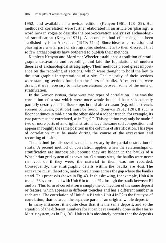
106 Principles of archaeological stratigraphy
1952, and available in a revised edition (Kenyon 1961: 123-32). Her methods of correlation were further elaborated in an article on 'phasing', a word now in vogue to describe the post-excavation analysis of archaeologi- cal stratification (Kenyon 1971). A second method of phasing has been published by John Alexander (1970: 71-4). Since ideas of correlation and phasing are a vital part of stratigraphic studies, it is to their discredit that so few archaeologists have bothered to publish their methods.
Kathleen Kenyon and Mortimer Wheeler established a tradition of strati- graphic excavation and recording, and laid the foundations of modern theories of archaeological stratigraphy. Their methods placed great import- ance on the recording of sections, which were thought to hold the key to the stratigraphic interpretations of a site. The majority of their sections were standing sections found on the faces of baulks. After sections were drawn, it was necessary to make correlations between some of the units of stratification.
In the Kenyon system, there were two types of correlation. One was the correlation of strata which were once whole but had been subsequently partially destroyed. 'If a floor stops in mid-air, a reason (e.g. robber trench, erosion of levels, posthole) must be found' (Kenyon 1961: 128). If such a floor continues in mid-air on the other side of a robber trench, for example, its two parts must be correlated, as in Fig. 9C. This equation may only be made if two or more parts of an original stratum have the same soil composition and appear in roughly the same position in the columns of stratification. This type of correlation must be made during the course of the excavation and recording of a site.
The method just discussed is made necessary by the partial destruction of strata. A second method of correlation applies when the relationships of stratification are inaccessible, because they are hidden in the baulks of a Wheelerian grid system of excavation. On many sites, the baulks were never removed, or if they were, the material in them was not recorded. Consequently, the stratigraphic details within the baulks are -lost. The excavator must, therefore, make correlations across the gap where the baulks stand. This process is shown in Fig. 43. In this drawing, for example, Unit 4 in trench P3 is correlated with Unit 6 in trench P1, through the baulk between P1 and P3. This form of correlation is simply the connection of the same deposit or feature, which appears in different trenches and has a different number in each area. The correlation of Unit 5 in P1 with Unit 4 in P2 is the first type of correlation, that between the separate parts of an original whole deposit.
In many instances, it is quite clear that it is the same deposit, and so the equation of the different numbers for it can be reasonably done in the Harris Matrix system, as in Fig. 9C. Unless it is absolutely certain that the deposits

Correlation, phasing and stratigraphic sequences 107
Final Periods
3 2
1 I I
3 4
P i t Pit A
Plough A Fill of Pit B
B Pit B, cut through Period hut floor
Floor of Period hut, Period hut and
Pit A
Upper fill in Pit A
Di Hearth above lower fill Pit A
Lower fill in Pit A
Period hut, contemporary with
Ei Pit A, cut through occupa- tion on Period I hut
Occupation on Period I hut floor
Floor of Period I hut
P.4 (Not shown
on diagram)
Fig. 43 This diagram was the first published illustration of the method of correlation and periodization in British archaeology. It is based on the analysis of sections and the 'stratigraphic sequence' is in a written tabulated form (Kenyon 1961: fig. 13; courtesy
of J. M. Dent and Sons Ltd).
on either side of a baulk are the same unit, they should not be correlated or appear as such in the stratigraphic sequence. If the relationship is uncertain, it is better to have separate stratigraphic sequences for each trench. If an examination of the finds gives good evidence of contemporaneity, the separate deposits can be put into the same phase or period, as that action does not change the stratigraphic sequence.

108 Principles of archaeological stratigraphy
Stratigraphic 'phasing'
Figure 43 also shows a part of the process of phasing which was the preliminary to the writing of the excavation report:
The first step, which I call phasing, is to establish the sequence of deposits and structures. This must in the first place be done completely objectively by the interpretation of sections and structures, working from the bottom up. The sections show which levels can be connected together. . . It is a highly detailed study, for all levels have to find their place and all walls fit into a sensible plan (Kenyon 1971: 274).
When the sections have been studied and the 'sequence of deposits and structures' has been determined, the sequence is divided into phases and periods. As in Fig. 43, phases were lettered from the top, until the whole sequence was certain, and then converted in I, II, III, from the earliest upwards (Kenyon 1961 : 129).
The sequence in Fig. 43 is a simple unilinear progression. The Kenyon method of phasing may have worked very well on simple sites, but it is difficult to use on densely stratified deposits. It does not take into account units of stratification other than layers and walls, nor any stratigraphic data other than that provided by sections. It was also thought that corre- lation and phasing could not be done during excavation (Kenyon 1971: 272). This task fell to the director at the end of the excavation, when the very people who did the recording were no longer available for consul- tation.
Alexander has asserted that the stratigraphic study:
can never be delegated, for much, in spite of elaborate records, will depend upon the director's observations during the excavation and his personal notes. The primary recognition of chronological periods will usually have taken place during excavation. . . The director will have traced these events through many trenches and so have given himself correlations over a wide area (Alexander 1970: 71-2).
With these correlations and the stratigraphic archive of trench notebooks, plans and sections, and the 'private notes' of the director (Alexander 1970: 70), the stratigraphic study can begin:
the layers of each main period can be separated out (setting aside for the moment any uncertain ones) without reference to any cultural material, and the tables of layers based solely on the stratigraphy constructed (Alexander 1970: 72).

Correlation, phasing and stratigraphic sequences 109
Alexander goes on to say that once the tables of layers have been com- pleted, there will always be some layers which do not fit in, which are 'in limbo' (Alexander 1970: 74).
As Alexander only refers to stratigraphic data in the compilation of these tables, it may be assumed that 'in limbo' means that some recorded units of stratification cannot be stratigraphically connected with others from the excavation. Since few excavators take note of the amount of stratigraphic material which may be lost through mistakes in recording, this question cannot be answered directly. But examinations of old excavation records suggest that many strata on a site become unstratifiable, due to poor recording. On one occasion, working with one site of several thousand deposits, it was determined that the loss of stratigraphic data amounted to about 40%, with many hundreds of deposits being left 'in limbo' in the archives of the excavation. Such a percentage only took account of the actual units recorded. If some of the newer types of stratigraphic units, such as feature interfaces, were considered, the total would be much higher.
When they had completed the correlation of the stratification, both Kenyon and Alexander produced what the latter refers to as a 'table of layers'. A part of such a tabulation appears in Figs 43 and 44. In the former, the column reads from bottom to top, and in the latter, from left to right, with the earliest layers being at the bottom or on the left, respect- ively. In neither example are the stratigraphic relationships between the various units stated. In the Kenyon example (Fig. 43), they may be deduced from the accompanying section, but in Alexander's more complex site (Fig. 44), they simply appear in groups of layers chronologically arranged.
These tables are supposed to represent the stratigraphic sequence of a site, but they also include aspects of the periodization of stratigraphic sequences. The making of stratigraphic sequences and the division of se- quences into phases and periods are a part of phasing, but they are separate processes. The stratigraphic sequence must be made first, and later divided in periods. The Kenyon and Alexander systems present an amalgam of the two in a written format. In Kenyon's method, it seems that the section is assumed to be equal with the stratigraphic sequence.
Stratigraphic sequences
The primary goal of the study of the stratification of a site is the pro- duction of a stratigraphic sequence. A stratigraphic sequence may be de- fined as the sequence of the deposition of strata or the creation of feature

Trench Deepest levels Shallowest stratified levels
Fig. 44 Another example of the method of periodization, but, unlike Fig. 43, it reads from left (early) to right (late) and is a more diagrammatic representation of a 'stratigraphic sequence' (from Alexander 1970: fig. 11; courtesy of the author).

Correlation, phasing and stratigraphic sequences 111
interfaces on a site through the course of time. Unlike most geological columns of strata, the stratigraphic sequence on most archaeological sites cannot be directly equated with the physical order of stratification, as shown in sections. Those physical relationships must be translated into abstract sequential relationships.
The rules for this translation have already been mentioned (Figs 9-12). First, the superpositional relationships between given strata must be deter- mined. The strata may not have any direct physical link, and thus there can be no question of superposition. Units of stratification may be correlated because they were originally parts of a single unit. The method shown in Fig. 12 does not recognize correlations through baulks, unless it is absol- utely certain that the deposits from adjacent trenches are the same.
As stratigraphic sequences are abstractions, they can be demonstrated in writing or by schematic diagrams. Until recently, written reports (Fig. 43) or general diagrams or tables (Fig. 44) were the favoured methods. By contrast, the Harris Matrix method can make schematic diagrams capable of showing all the details of the stratigraphic sequence. The process is illustrated in Fig. 12. In part A, the superpositional relationships and correlations of all the layers in the section of the site are drawn. Unit 3, for example, lies over Units 5, 6, 7 and 9; Units 7 and 8 are correlated across the gap where the part of this single original deposit has been destroyed by the foundation trench, Unit 6. Part B is a diagrammatic version of the section in A and shows all of these physical relationships. By application of the Law of Stratigraphical Succession (Chapter 5), the superfluous relation- ships in B have been removed and the stratigraphic sequence emerges as part C. It will be noticed in part D that two types of stratigraphic unit not usually recognized by 'layer number' have been taken into account. Unit 2 is a horizontal feature interface and Unit 6 is a vertical feature interface. All other surfaces are horizontal layer interfaces, except for the upstanding layer interface of Unit 5, but these interfaces are not normally numbered.
This process is illustrated in Fig. 45 by John Triggs, from the site of Fort Frontenac, Kingston, Ontario. This diagram was created after the exca- vation, and each unit of stratification is numbered in a series starting at the bottom with the earliest deposit. The 'matrix showing physical and super- positional relationships' (left) proved useful to Triggs in tracing sources of disturbance to a deposit. The object of this matrix was to identify potential sources of infiltrated and residual remains (see Chapter 11). The diagram on the right is the stratigraphic sequence of the site, which has been clarified by the application of the Law of Stratigraphical Succession. The sequences have been arranged so that units of stratification of the same period appear in the same horizontal band.
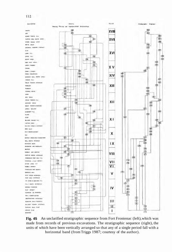
Fig. 45 An unclarified stratigraphic sequence from Fort Frontenac (left), which was made from records of previous excavations. The stratigraphic sequence (right), the units of which have been vertically arranged so that any of a single period fall with a
horizontal band (from Triggs 1987; courtesy of the author).
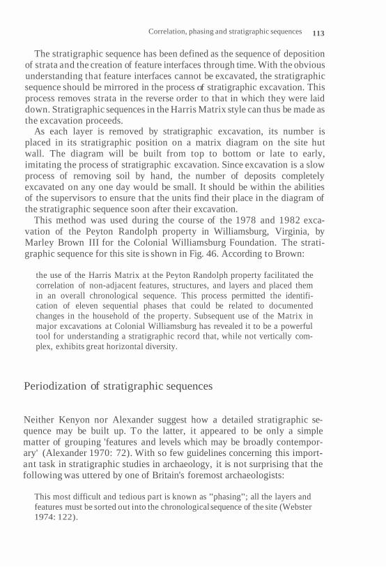
Correlation, phasing and stratigraphic sequences 113
The stratigraphic sequence has been defined as the sequence of deposition of strata and the creation of feature interfaces through time. With the obvious understanding that feature interfaces cannot be excavated, the stratigraphic sequence should be mirrored in the process of stratigraphic excavation. This process removes strata in the reverse order to that in which they were laid down. Stratigraphic sequences in the Harris Matrix style can thus be made as the excavation proceeds.
As each layer is removed by stratigraphic excavation, its number is placed in its stratigraphic position on a matrix diagram on the site hut wall. The diagram will be built from top to bottom or late to early, imitating the process of stratigraphic excavation. Since excavation is a slow process of removing soil by hand, the number of deposits completely excavated on any one day would be small. It should be within the abilities of the supervisors to ensure that the units find their place in the diagram of the stratigraphic sequence soon after their excavation.
This method was used during the course of the 1978 and 1982 exca- vation of the Peyton Randolph property in Williamsburg, Virginia, by Marley Brown III for the Colonial Williamsburg Foundation. The strati- graphic sequence for this site is shown in Fig. 46. According to Brown:
the use of the Harris Matrix at the Peyton Randolph property facilitated the correlation of non-adjacent features, structures, and layers and placed them in an overall chronological sequence. This process permitted the identifi- cation of eleven sequential phases that could be related to documented changes in the household of the property. Subsequent use of the Matrix in major excavations at Colonial Williamsburg has revealed it to be a powerful tool for understanding a stratigraphic record that, while not vertically com- plex, exhibits great horizontal diversity.
Periodization of stratigraphic sequences
Neither Kenyon nor Alexander suggest how a detailed stratigraphic se- quence may be built up. To the latter, it appeared to be only a simple matter of grouping 'features and levels which may be broadly contempor- ary' (Alexander 1970: 72). With so few guidelines concerning this import- ant task in stratigraphic studies in archaeology, it is not surprising that the following was uttered by one of Britain's foremost archaeologists:
This most difficult and tedious part is known as "phasing"; all the layers and features must be sorted out into the chronological sequence of the site (Webster 1974: 122).

114 Principles of archaeological stratigraphy
According t o another manual o n archaeological methods, it is necessary to:
Do the "phasing" of every section during the field season, as it requires the cooperation of the d i r ec to rand area supervisors at the site. It is not sufficient to phase the sections of each square independently of the sections from contiguous squares, as the total result must be a coherent picture of the entire site at each stage of its history. At complex sites the director will want to prepare plans for each architectural period, and possibly for each phase of the periods as well. This can only be done if the sections are phased (New- lands and Breede 1976: 95).
237
I I
K K Trenches 28 G 12
I
52 28G
Rubble. Mortar.
Plaster layer
I
I
2179-A Clay Base'
I Ash'
, 414 , c I
I Loam'
I I
A
Fig. 46 The stratigraphic sequence for the Peyton Randolph site at Colonial Williamsburg, 1978-82 (courtesy of Marley Brown, III).
Grey Ash'

Correlation, phasing and stratigraphic sequences 115
The process of phasing has two parts. The first is the making of the stratigraphic sequence and the second is the division of that sequence into phases and periods. This first stage is based entirely upon the analysis of stratigraphic evidence, i.e. the evidence of the interfaces. No account need be taken of any cultural or historical material and all the processes of this stage can be done during excavation.
The division of the stratigraphic sequence into phases or periods may take place during the course of the excavation, but it is subject to change depending upon the analysis of the artefacts. The layers and interfaces are grouped according to their stratigraphic positions in blocks called 'phases' (e.g. Fig. 47). If there are no structural markers, such as a building level or the cutting of a ditch, the division of the stratigraphic sequence into phases may have to await the results of the analysis of artefacts and datable remains.
The phase groupings should follow the constraints of the stratigraphic sequence. Because of this, a 'sequence of the phases', which has considerable stratigraphic validity, can be constructed, as in Fig. 48. The sequence of the phases can then be grouped into large amalgamations called 'periods'. The periods themselves can also be portrayed in a diagram known as the 'sequence of the periods' (Fig. 48). The diagrams shown in Figs 47 and 48 illustrate this process in general terms. But these diagrams are no longer correct in terms of the ideas presented in this volume, for some of the following reasons.
Archaeological stratification is a matter of strata and interfaces, of depo- sition and non-deposition (or erosion). The periodization of stratigraphic sequences must have periods of deposition and periods of non-deposition. Put simply, at some times there will be activities on a site, from the digging of ditches, to the construction of buildings. At other times, the ground surface will simply be used for ordinary activities of life. Most archaeologists give only tacit acceptance to these interfacial periods, yet this is what every composite plan of a site represents. Their 'periods' are mainly periods of deposition, of the innards of the strata and their portable remains. These phases and periods are shown in Figs 47 and 48. These diagrams were constructed several years before the artefacts from the site were analysed. It is therefore unlikely that they represent the final periodization.
Figure 25 (an exploded view of the section in Fig. 29) gives an indication of the two types of phases or periods which should be used in the division of stratigraphic sequences. The odd numbers are periods of deposition, the even numbers periods of non-deposition. Sections best represent the periods of deposition, plans those of non-deposition. Thus, in Fig. 25, only 1 section, but 12 plans, would be needed to present the basic stratigraphic data for the site.

Fig. 47 The stratigraphic sequence of an English site. It has been incorrectly divided into phases of deposition only.

Fig. 48 The sequences of phases and periods at the site shown in Fig. 47 give a general idea of the method of grouping units of a stratigraphic sequence, but the diagrams only record the phases and periods of deposition and are therefore incorrect.

11 8 Principles of archaeological stratigraphy
Although it may be possible to divide the stratigraphic sequence into phases and periods during the excavation, this division should not be considered a final one. It must be tested against the results of all the other research from the site, when revisions may be made. None of these re- visions can ever change the stratigraphic sequence itself, since its relation- ships are based solely upon stratigraphic relationships. The periodization may begin as soon as convenient, but it cannot be completed until after the analysis of the other material recovered from the excavation.
Given the examples of the stratigraphic sequences in Figs 45-48, a final word on the arbitrary method of excavation is in order. When a site is excavated in arbitrary levels, it will produce a stratigraphic sequence just like any other site. Let us assume that we are excavating a trench divided into nine contiguous squares, each being dug in 10-cm spits with a separate number for each spit. The site is assumed to be 50 cm deep. The resulting stratigraphic sequence is demonstrated in Fig. 49.
Each horizontal spit is in fact the same 'layer', so all the numbers at a given level must be 'correlated'. The five successive spits are in 'superpo- sition', one to another and are shown in that order. The stratigraphic sequence is therefore a man-made arrangement, which has no independent testing value whatsoever. The stratigraphic sequence of an archaeological site is a unique configuration, because each site is a unique monument in history, although its units of stratification are forms which are repetitive and non-historical. The sequence imposed on a site by arbitrary excavation destroys its unique stratigraphic sequence for all time. 'Arbitrary strati- graphic sequences' are the same on every site and they cannot be divided into phases and periods. Nor do they have the analytical value which a normal stratigraphic sequence possesses, for the latter is undesignedly com-
Fig. 49 This is the form of a stratigraphic sequence which any site, which has been excavated in arbitrary levels, will produce.

Correlation, phasing and stratigraphic sequences 119
memorative of former events. The arbitrary stratigraphic sequence is for all time a monolithic block, the production of which should be a disgrace to any archaeologist working on any site which has visible stratification - and that includes nearly every site in the world.
The making of stratigraphic sequences and their periodization are the most important tasks an excavator must undertake: they remain the least understood. The relegation of these tasks to the post-excavation period has allowed many archaeologists to ignore stratigraphic problems during the excavation, thus ensuring the making of faulty stratigraphic records. The immediate result is long overdue publication, or no publication at all. The result is the production of stratigraphic archives which are of little use to any re-evaluation of the site, in the light of new queries and research goals. If the making of stratigraphic sequences is not well understood, it follows that the analysis of artefacts in relation to these sequences must also be little understood in archaeology.

Stratigraphic sequences and post-excavation analyses
Throughout this book, it has been emphasized that the analysis of archaeo- logical stratification is the study of its interfacial characteristics. This study has two immediate results: the production of the stratigraphic sequence for the site and the recovery of the topographical development of the site through time. Many interfaces are the surfaces of strata, which contain portable objects of considerable variety. The analysis of these remains, which are natural or human in origin, gives cultural, environmental and chronological values to the sequential and topographical character of the stratification of a site. In other words, the study of the contents or structural arrangements of non-historical units of the stratification is what provides those features with an historical direction. But artefacts themselves have non-historical and recurring properties, which are now considered.
Non-historical aspects of contained remains
The analysis of the contained remains must be based on the stratigraphic sequence of the site, for this shows the relative positions in which they were found. Stratigraphic sequences are made without reference to this contained material. Artefactual studies cannot change the stratigraphic relationships found in such sequences. The failure to maintain a distinction between stratigraphic events and artefactual remains has led to the acceptance of several false types of stratigraphy, discussed later in this chapter. In the first instance, however, the non-historical attributes of the contained remains are examined.
Geologists recognize three types of fossils which recur in geological strata:
Fossils from rocks of one age frequently have been eroded, transported, and redeposited in sediments of younger age. The reworked fossils may thus be
120

Post-excavation analyses 121
mingled with indigenous fossils. . . Under some circumstances, rocks may contain certain fossils younger than the enclosing material (ISSC 1976: 47).
These younger fossils may have infiltrated into the older strata by the downward movement of fluids or by the activities of burrowing animals (ISSC 1976: 47).
Similarly, in archaeology, several types of non-historical, o r recurring, types of objects can be defined.
1. Indigenous remains. These objects were made at about the time the formation of the layer in which they were found was deposited. The layer and the objects are considered to be contemporary.
2. Residual remains. These objects were made at a much earlier time than the formation of the layer in which they were found. They may have been present in earlier deposits subsequently dug up to provide soil for the newer layer, or, they may have remained in circulation for a long period of time, as happens with heirlooms.
3. Infiltrated remains. These objects were made at a later time than the formation of the deposit in which they were found and were introduced into that layer by various means, which may or may not be detected by a study of the stratification.
Indigenous finds are obviously the most important as they serve to give a date to the deposits in which they were found. Aside from man-made objects, natural materials such as wood or shell can also be dated (see Fig. 51 for radiocarbon dates). The major problem in artefact analysis is to determine which of the finds in a deposit are indigenous. In that analysis, the testing pattern of the stratigraphic sequence is invaluable.
Archaeologists use the word 'residual' in place of the geological term 'reworked'. The derivation is somewhat obscure and is presumably based on the common understanding of the word as being a quantity of something left over from an original group of objects or body of material. Residual finds are assumed to be a remainder of that body of objects once indigenous in early deposits, or objects kept in use long after the formation of contemporary deposits. The word is perhaps not as precise as 'reworked', but has a certain currency and should stand as accepted.
Philip Barker has given an interesting study of residual pottery in his book Techniques of Archaeological Excavation (Barker 1977: 177), along with a diagram showing the 'points of entry' of indigenous finds and the occurrence of residual finds in a sequence of deposits. Little mention is made of infiltrated sherds, but, in theory, they are perhaps a more universal phenomenon. On a site in which little later digging has taken place, few objects will find their way
122 Principles of archaeological stratigraphy
to the surface to become residual objects in later formations. Due to gravity, however, all varieties of objects are subject to downward movement through the soil, depending of course upon the composition of the various layers.
Residual finds will often predominate the find-sample from many deposits. Particularly in urban settings, the rate at which objects are brought to the surface by excavating activities by people is in itself a stratigraphic revolu- tion. Under natural conditions, residual objects are eroded out of strata and carried downwards to their new positions by gravity and other forces. Most residual objects in archaeology have become so in defiance to gravity, when they are brought upwards into new positions of deposition.
Infiltrated finds are often referred to in archaeology as 'contamination', as in dirt which contaminates a pure chemical or biological sample. The implication is that the trench supervisor has excavated poorly and the artefact collection from a layer has been tainted by allowing later objects to become included in it. Errors in excavation or in the sorting and cleaning of finds aside, infiltrated finds are a way of life and they are present in many deposits. Usually, only the obvious types are recognized, such as a coin or a well- known form of pottery. As the geologist might suggest (ISSC 1976: 47), many types of environmental samples could easily pass through one layer after another in geological strata. Such movement ought to be easier for such minute objects as pollen grains, in the mainly unconsolidated archaeological strata. The studies by Dimbleby (1985) on environmental objects, and Schiffer (1987) on the general movement of man-made objects, contain important discussions on the way in which things may become incorporated into the stratigraphic record.
'Reversed s t ra t ig raphy '
The redeposition of artefacts has been erroneously defined as 'reversed stratigraphy' (Hawley 1937). The argument runs as follows. When holes are dug into archaeological stratification, the spoil is dumped nearby in the reverse order in which it was dug, the soils from the lowest points of excavation being placed on top of the spoil heap (see Fig. 14). Consequently, artefacts from the uppermost deposits may come to rest in the heap below those of earlier dates from the lower deposits. It is argued, therefore, that the stratification has been turned upside down, or reversed:
Hence, unhappily, we can scarcely say that it is obvious that the objects at the base of an undisturbed midden must be older than those at the top (Hawley 1937: 298-9).

Post-excavation analyses 123
The idea of reversed stratigraphy has been accepted by some archaeologists (e.g. Heizer 1959: 329; Browne 1975: 99), and is based upon geological notions of solidified rocks which have been overturned.
When geological strata are overturned or 'reversed' as a block, they lose little of their original characteristics and no new strata are formed, although the stratigraphic sequence may be altered. Once the geologist ascertains that overturning has occurred, the stratification is simply read upside down. The archaeological process, dealing with unconsolidated strata, always results in the making of new strata by the destruction of the older deposits. In 'reversed stratigraphy' in archaeology, it is the objects which have been reversed in a chronological sense, not the strata, for they have been destroyed. Such reversal can only be recognized if the excavator can identify and date the artefacts. All that an archaeologist can say in the example given above is that all the artefacts are residual in the new layers in which they appear to be in contradictory positions. The proponents of reversed stratigraphy must treat all finds as if they were indigenous, if their argument is to have any logic. The idea of reversed stratigraphy has little archaeological value, as it is not based on a study of the soil, but of its contained remains without proper regard for their stratigraphic context. Reversed stratigraphy is only a restatement of the old problem of distinguishing indigenous, infiltrated and residual finds in archaeological deposits. It is not a true stratigraphic principle and should be dropped from use in archaeology.
Recording of artefacts
Whether they are indigenous, infiltrated or residual does not affect the recording of artefacts on archaeological excavations. In fact, they must all be recorded in the same manner, if their character is to be distinguished later. As advocated by Wheeler (1954: 70) , the main method for recording the find- spot of artefacts is by three-dimensional recording. In three-dimensional recording, two measurements place the object topographically, while the third places the object at the level of its find-spot in relation to a fixed datum, such as sea level. The find-spot of the object is thereby fixed in space. The object is placed in a sequence of relative time by the stratigraphic method, which assigns it to the layer in which it was found. It is axiomatic that when objects are found in identifiable strata they are given the layer number of the deposit; this also fixes the objects in space within the confines of the deposit. Their time dimension is provided by the position of the deposit in the stratigraphic sequence of the site.

124 Principles of archaeological stratigraphy
Some excavators have assumed that the third elevational dimension of the find-spot of a layer was also its time dimension. All objects found at the same elevation were considered to be of the same date or deposited at the same time. In a well-known drawing, Wheeler condemned this practice as being against the principles of archaeological stratigraphy (Wheeler 1954: fig. 11). The idea is perpetuated by archaeologists who use the arbitrary method of excavation, whereby soil is dug in predetermined spits. It is assumed that such 'metrical strata' represent the time dimension of the buried objects, and that all objects found on a given level are contemporaneous. This method of excavation has been described as 'metrical stratigraphy' (Hole and Heizer 1969: 103-112), and has been discussed in Chapter 10 as 'arbitrary exca- vation'. Metrical stratigraphy is a misnomer, since the idea is not based upon stratification, but on a method of excavation. The difficulties which will arise when such spits are considered to be the time dimension of artefacts found in archaeological strata is indicated in Fig. 50: arbitrary excavation mixes objects from different strata and therefore hopelessly jumbles their strati- graphic and chronological relationships. Arbitrary excavation makes it impossible to determine with any stratigraphic validity which finds are indigenous, residual or infiltrated. It would appear, by its mixing of the strata, to make all objects into residual material, because the excavator is doing nothing less than making new deposits in arbitrary shapes.
With the stratigraphic method, all artefacts are recorded by layer numbers, but three-dimensional recording is usually reserved for special finds. Once recorded, the date of the object and eventually the date of the layer in which it was found must be determined.
Fig. 50 How artefacts from different layers become mixed if a site with stratification is excavated in arbitrary levels (after Deetz 1967: fig. 2; courtesy of Doubleday and
Co.).

Post-excavation analyses 125
Dating of artefacts and strata
Archaeological stratification itself cannot be dated without an examination of its contained remains. Stratification can only be put into a sequential order, referred to as the stratigraphic sequence, the construction of which is the prime responsibility of an excavator. Once the stratigraphic sequence has been determined (e.g. Fig. 51), the dates of the artefacts found in its layers and, by inference, the dates of the formation of the layers, can be worked out.
An artefact or natural object found in an archaeological deposit has several dates.
It has a date of origin, when it was made. It also has a date-bracket which was its main period of use. Finally it has a date of deposition when it found its way into the ground, deliberately or accidentally (Dymond 1974: 31).
Depending upon the time at which the object came to rest in the layer in which it was found, the object will be indigenous, infiltrated or residual. When it
DATES RELATIONSHIPS DESCRIPTIONS EVENTS
P organic l i t ter and block of gravel, simple. . development.
13/ black fragmented trace of grovel, simple
block rmol l of grovel, complex.
grovel, rmol l of block complex.
feature complex
feature complex.
grovel and black r o i l complex
and shell complex.
whole shell, f ew small of black complex.
. trampling of shell f rom 6 over 8 1 2 .
. o f pit
. fi l l ing of deep features.
. dug into 6.
. deep dug through 6 8 4 to
. f loo r construction
. liv ing and occupation
. shellfish
grovel complex. . surface of 4.
whole traces of black grovel;
grovel ro i l mixed complex
thin o f whole simple.
black trace of few rmo l l o f complex.
r ed grovel: o f bedrock; simple.
. shellfish and deposit ion
. living f loor and
. exploitation deposit ion.
. living f loor
.
geological deposit ion.
Fig 51 A part of the stratigraphic sequence of a shell midden at Partridge Island, New Brunswick. The radiocarbon dates give a temporal dimension to the depositional sequence. The deposits are also described and interpreted, further demonstrating the usefulness of the Harris Matrix system on sites previously considered by many archaeologists to be unworkable by stratigraphic methods (courtesy of David Black).

126 Principles of archaeological stratigraphy
comes to dating the layer, the following guide is that most often used by archaeologists:
it is the least old object (or objects) which must be nearest to the date of the layer itself; it gives in other words a terminus post quem, which means that the date of the layer must be after the date of the objects' manufacture (Dymond 1974: 30).
This axiom is based on the assumption that layers can be sealed from any later intrusions (Barker 1977: 175).
It is important that an excavator distinguish between finds which are indigenous, as they will be the nearest in date to the formation of the deposit, and those which are much earlier or later, the residual or infiltrated finds. The difficulties of this task cannot be understated and Barker (1977: 171-8) has recently given an excellent account of the matter.
Once the finds from a single deposit have been considered, they must be compared with the others in the stratigraphic sequence. Finds in an earlier deposit may appear to be indigenous to that deposit until compared to the strata above. The finds from a superimposed deposit may indicate that all the finds in the lower layer are in fact residual. Figure 52 is an example of the problem; in this case, only the dates of the coins found in the successive phases were considered. If the date of 565 in Phase 6 is taken as correct, then the coins in Phases 7, 9, 15 and 27 are all residual. If the phases had been considered in isolation, those dates could have been taken as a true reflection of indigenous finds. Quite often, the finds from one deposit are studied in isolation from those in other layers of the site, often with erroneous results.
It may be assumed that it is possible to date artefacts and other remains and to date the layers in which the objects were discovered. At the same time, a date may be inferred for the interfaces between strata. A pit, for example, will be dated to a time after the date of the latest strata through which it was cut and before the date of the earliest deposit which fills it. Working through the deposits of the site in this manner, the dating of the layers and interfaces assists the excavator to recognize phases and periods which cannot otherwise be deduced from the stratigraphic evidence.
'Hor i zon t a l stratigraphy'
The dating evidence of artefacts has led to the development of another false type of stratigraphy in archaeology:
The more opulently furnished Bronze Age Burials and the rich urnfield

Post-excavation analyses 127
Fig. 52 This is an example of a 'phase sequence' used in the analysis of artefacts, in this instance coins. The dates in the circles are those of the latest coin in a particular
phase (from Harris and Reece 1979: fig. 4).
cemeteries of the Late Bronze Age . . . can be phased on the basis of horizontal stratigraphy (Thomas and Ehrich 1969: 145).
The basis of stratigraphy is the superposition of strata and interfaces. It is precisely this superposition which is partly lacking on some sites, which can only be divided into phases and periods based upon the artefactual content of the deposits. On this artefactual basis, the archaeologist may be able to show shifts in the areas of use on a site (e.g. Eggers 1959: fig. 5) where stratigraphic evidence in the form of superimposed deposits is lacking. Without falsely
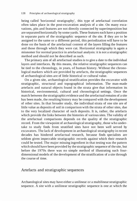
128 Principles of archaeological stratigraphy
being called 'horizontal stratigraphy', this type of artefactual correlation often takes place in the post-excavation analysis of a site. On many exca- vations, pits and features are not directly connected by superimposition but are separated horizontally by some yards. These features each have a position in separate parts of the stratigraphic sequence of the site. If they are to be assigned to the same or a different period, this periodization will have to be done on the basis of the artefactual content of the layers filling the features and those through which they were cut. Horizontal stratigraphy is again a misnomer for normal practice in artefactual analysis: it is not a stratigraphic method and should not be described as such.
The primary aim of all artefactual studies is to give a date to the individual layers and interfaces. By this means, the relative stratigraphic sequences can be tied to the chronology, in years, of human history. Without the chrono- logical markers which are provided by artefacts, the stratigraphic sequences of archaeological sites are of little historical or cultural value.
On a given site, archaeological stratification provides the excavator with stratigraphic, structural and topographical information. The man-made artefacts and natural objects found in the strata give that information its historical, environmental, cultural and chronological settings. Once the match between the stratigraphic evidence and the artefactual remains of a site has been made, the resulting history may be compared with the development of other sites. In that broader study, the individual strata of one site are of little value as deposits of soil in comparison with the strata of other sites, due to the very localized character of such deposits. It is, rather, the artefacts which provide the links between the histories of various sites. The validity of the artefactual comparisons depends on the quality of the stratigraphic record. From the viewpoint of archaeological stratigraphy, those who under- take to study finds from stratified sites have not been well served by excavators. The lack of development in archaeological stratigraphy in recent decades has hindered artefactual research, because finds specialists are seldom given impeccable stratigraphic records against which their research could be tested. The major missing ingredient in that testing was the pattern which should have been provided by the stratigraphic sequence of the site, but before the 1970s there was no simple method of illustrating such four- dimensional models of the development of the stratification of a site through the course of time.
Artefacts and stratigraphic sequences
Archaeological sites may have either a unilinear or a multilinear stratigraphic sequence. A site with a unilinear stratigraphic sequence is one at which the

Post-excavation analyses 129
units of stratification make up a single chain of chronological events, superimposed one upon another like a deck of cards. Due to the great variety of man-made stratification, it may be axiomatic that archaeological sites with unilinear stratigraphic sequences are the exception, not the rule. The rule is that most sites have multilinear stratigraphic sequences. Every multilinear stratigraphic sequence is composed of a series of separate unilinear se- quences, e.g. sequences from a series of deposits from unconnected pits. When such unilinear sequences and the units of stratification which form them are compared with similar sequences in a multilinear stratigraphic sequence through a study of the artefacts, permutations in the sequence can occur. It may now be appropriate to define some of these notions in order to clarify the issues which the permutations of stratigraphic sequences present to the discipline of archaeology:
1. Unilinear stratigraphic sequence. This type of sequence occurs when the order of its units of stratification can be determined solely on the basis of their order of superposition. When so determined, the relative order of the units of a unilinear stratigraphic sequence cannot be changed (unless faulty observation or recording determine a revision solely on stratigraphic grounds).
2. Multilinear stratigraphic sequence. This sequence occurs when the position of some of the units of stratification on a site cannot be determined on the basis of superposition. The stratigraphic sequence of the site therefore develops separate lines of evolution in its framework of relative time. These separate lines of evolution may then develop as unilinear stratigraphic sequences until a later stratigraphic event, by superposition over several such sequences, ends their separate evolution. A multilinear stratigraphic sequence is, therefore, usually composed of a series of unilinear sequences which do not have superpositional links, the one to the other. The chronological relation- ships between these separate parts of a multilinear stratigraphic sequence must be determined by the analysis of non-stratigraphic data. This gives rise to the permutation of multilinear sequences in different chronological ar- rangements.
3. Permutations of multilinear stratigraphic sequences. The O E D defines permutation as 'the action of changing the order of a set of things lineally arranged; each of the different arrangements of which such a set is capable of'. In an archaeological sense, it is here defined as the changing of the chronological order of stratigraphic units of different stratigraphic se- quences, every permutation being a different arrangement of which the units are capable and which is not contradicted by the recorded stratigraphic relationships.
The notion of the permutation of stratigraphic sequences is linked to the

Disuse
are layers of positive accumulation.
are layers of negative accumulation.
, ... . ... . . I. . .
Interval
is an event in time; whereas other
interfacial points are only intervalsof time. the stratigraphic sequence of site
Fig. 53 Mound (A) above has a stratigraphic sequence which is shown in F on the right. This sequence has 231 possible permutations, or changes in relationship in absolute time, between nine of the units. The permutations are limited because of the
restrictions of the sequence itself.


132 Principles of archaeological stratigraphy
analysis of multilinear stratigraphic sequences. Between the parts of a multilinear sequence (viz., the separate unilinear sequences), there is much room for analytical movement and for the permutations of such sequences. The idea of the permutation of stratigraphic sequences was independently discovered by Dalland (1984). The reader is referred to his paper and my reply (Harris 1984).
To illustrate the matter in Fig. 53A, a section through an imaginary mound is recorded in the normal way, the stratigraphic sequence of this site being Fig. 53F. This is a multilinear stratigraphic sequence, having four branches. Within these branches, there are a number of unilinear stratigraphic se- quences, from late to early as follows- Sequence A: 1,2,3,4,7,13; B: 1,2,3, 4,10,11,12,13; C: 1 ,2,3,4,10,9,8,13; and D: 1,2,3,5,6,8,13. Of these Units, 1, 2, 3 and 13 are stratigraphically fixed and are not subject to permutation, i.e. the objects found in them are by definition later or earlier: the stratigraphic sequence leaves no room for argument. Between the other units, single or compound permutations are possible, the former being illustrated in Fig. 53G (in this diagram, the boxes are arranged as possible choices in absolute time, i.e. Unit 3 is later than 4 which is later than 5: does the artefact analysis support this arrangement?).
Figure 53G shows that there are 231 possible permutations between Units 4-12, any of which may, or may not, be supported by artefactual dating. One such permutation, for example, could suggest that Unit 11 is later than Unit 5, which is later than Unit 12. These permutations are based upon the idea that the artefacts from each unit could be compared and that the artefacts, by their dating, could suggest which permutation represented the best chronological solution. In the present example, the most correct permutation, from late to early, might be 11, 12, 5.
It will be obvious that compound permutations can also be produced from the stratigraphic sequence in Fig. 53F. For example, it may be held that Units 5 and 10 are later than Unit 9, itself later than Units 6 and 7. The number of permutations will, of course, be limited by the stratigraphic links of the sequence being analysed. Even so, there are potentially a large number of possible permutations of this nature to be found in every multilinear stratigraphic sequence - as Dalland, (1984) has clearly discovered. The analysis of multilinear stratigraphic sequences should be, to a very large degree, the analysis of its stratigraphic permutations. Yet, aside from Magnar Dalland's work, there are no other published accounts which discuss this important matter in any detail.
These permutations are derived from the study of the artefacts obtained from the site. The permutations can fix units, which are not stratigraphically connected, in relative positions one to another (earlier than, later than, same time as) in reference to dates in absolute time in years. These permutations

Post-excavation analyses 133
cannot change the stratigraphic links between the units in the stratigraphic sequence of a site, which were determined by the excavator according to the laws of archaeological stratigraphy. The units may, however, move up or down on their respective stratigraphic sequences, so that deposits and features of the same period may appear at the same level in the diagram. The permutations of the sequence thus result in the stretching of the diagram in relation to the periods which may be determined.
The result of the study of the permutations of a stratigraphic sequence by an analysis of the artefacts will give the archaeologist some evidence to arrange the sequence into phases and periods (as done by Triggs in his permutation of Fig. 45). The artefactual information will have to be com- pared with other data, such as documentary references to a site, and the nature of its structural remains. It is also possible that stratigraphic sequences will be grouped into types of phases not presently considered. There may be evolutionary sequences of objects which have phases supported by the stratigraphic evidence, but which are not related or which override phases of the structural history of a site.
Some interesting work in this manner has been carried out by Richard Gerrard (1988) in studying artefacts from Fort York, Toronto, in relation to stratigraphic sequences from excavations at that site. In Fig. 54, he combines stratigraphic data with the mean ceramic dates derived from the ceramic assemblage of each deposit. Figure 55 introduces diversity indices, again based on ceramic data, as a means of determining possible sources for infiltrated or residual remains entering a deposit. Triggs (1987) similarly used stratigraphic sequences to examine manufacture-deposition lag (Adams and Gaw 1977, Rowe 1970) in artefact assemblages. Studies like these point the way to future analyses between stratigraphic sequences and artefacts, some of which will be published in a volume of collected works, Practices of Archaeological Stratigraphy (Harris and Brown, forthcoming).
Once the stratigraphic and artefactual study of a site has been completed, it may be necessary to compare that material with other sites of a similar period. It is likely that the methods used between the units of stratification within a site can be applied in broader terms to the cross-site studies. Taking Fig. 56 as an example, it is possible that further permutations of the individual stratigraphic sequences will occur when comparing one site with another. This instance is an example of some of the problems which may occur, as stratigraphic methods are not universally or uniformly applied with dili- gence. Sites A, B and C were excavated in the late 1960s, but site C does not seem to be very well recorded, as may be surmised from the squat nature of the sequence and its many apparently correlated deposits. Sites D and F also contain many correlations through a central baulk, which appears graphi- cally in the diagram. This type of correlation may contain considerable

Bate
...................... I
Fig. 54 A stratigraphic sequence from the Fort York site in Toronto to which has been added the mean ceramic dates of each (from Gerrard 1988; courtesy of the
author).

........................ I museum
........................ 1932
occupation
................ I""
Fig. 55 To this version of the sequence shown in Fig. 54, a diversity index has been added to each deposit. Using this data with the sequence, a study was made of the infiltrated or residual objects in the deposits of the site (from Gerrard 1988; courtesy
of the author).
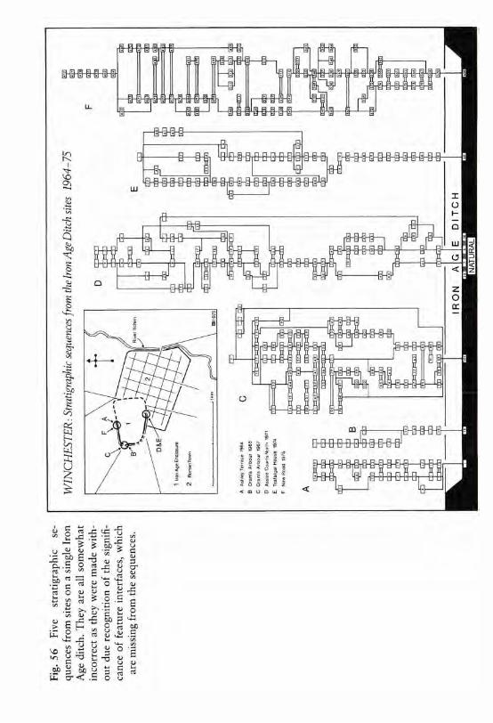

Post-excavation analyses 137
stratigraphic errors, depending upon whether and how the baulk was excavated. Site E looks as if it has the best stratigraphic sequence, but none of these sites would have recorded feature interfaces in the manner now deemed necessary (Chapter 7).
The study of artefacts in relation to stratigraphic sequences - as we now understand that term - is very much in its infancy. The purpose of a part of this chapter was to indicate some of the ways in which this study should progress and some of the problems which will be encountered. The quality of artefactual studies in relation to stratigraphic sequences will be in direct proportion to the quality of the stratigraphic records, the compilation of which is the primary responsibility of archaeologists. It is at that task that we should excel if we wish to be considered as professionals. In the final chapter, a summary will be made of some of the stratigraphic methods proposed in the foregoing chapters, which may provide a key to better stratigraphic practices on archaeological excavations.

12 An outline for stratigraphic recording on excavations
In the previous chapters, the historical development of the discipline of archaeological stratigraphy was examined. Individual aspects of the subject, methods of recording stratification, and the post-excavation analysis of stratigraphic material were also discussed. Arguments were made in favour or against certain ideas of archaeological stratigraphy or methods of exca- vation and recording. As befits a subject so important to archaeology, those arguments and discussions will be open to scrutiny and revisions. It is the purpose of this final chapter to suggest an outline for recording which will allow an excavator to compile a body of basic stratigraphic data, as required by modern standards of archaeological stratigraphy.
The process from excavation to the publication of the site report is depicted in Fig. 57. When the excavation begins, a decision must be made about the method of excavation, whether or not it should be conducted by stratigraphic layers or by arbitrary levels. On many sites, both methods may have to be used: for the first, the student can consult the work, for example, of Frere at Verulamium, or Cunliffe at Portchester, and for the second, that of McBurney at the Haua Fteah. In the presence of obvious stratification, the stratigraphic method of excavation must be used.
Having begun to dig, the student should be looking for the different types of units of stratification, namely, the natural stratum (Fig. 21, Units 7 and 8), the man-made layer (Fig. 21, Units 4, 14 and 15), the upstanding stratum (Fig. 21, Units 5 and 1 0 ) ,the horizontal, feature interface (Fig. 21, Units 3 and 19) and the vertical feature interface (Fig. 21, Units 20 and 30).
Starting from the latest units and working downwards to the earlier units of stratification, all the units must be numbered. On occasion (Fig. 58), it may be necessary to give out a number for an incidental reason, such as recording an object found on a surface. It is sufficient to have only one series of numbers in the records. If it is wished to identify a particular unit by its function, the reference can be made, for example, to 'the pit, unit 30', rather than having a separate series of numbers for pits or other categories. A single series of
138

MUSEUM REPORTS ARCHIVES
PHASING
EXCAVATION
RESEARCH I VE
ILLUSTRATIONS DESCRIPTIONS
ALL ARTEFACTUAL ANALYSES
THE FINDS
Fig. 57 All of the stratigraphic data from an excavation goes into the formation of the stratigraphic sequence, which is then used for all later analyses of the artefacts and
in the compilation of the site report.
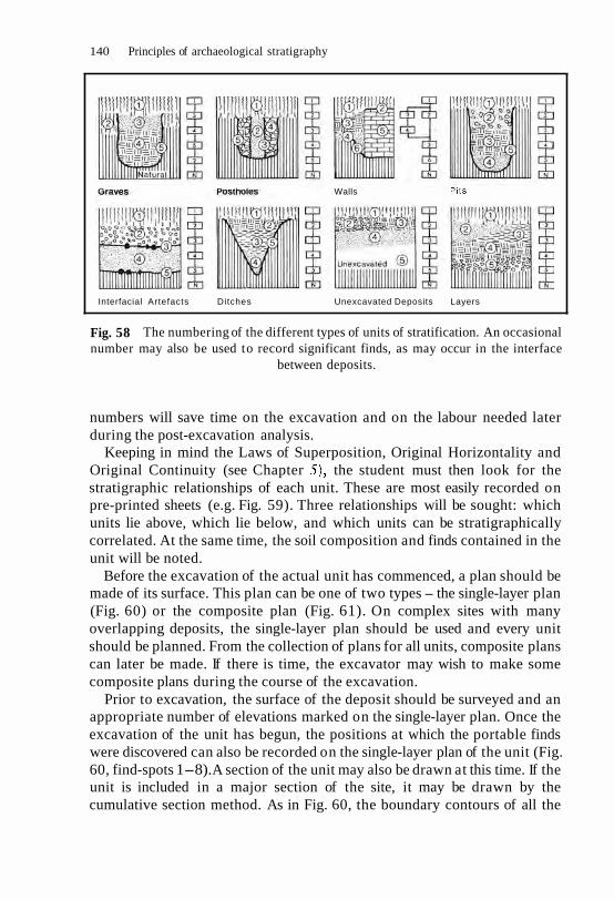
140 Principles of archaeological stratigraphy
Graves Postholes Walls
Interfacial Artefacts Ditches Unexcavated Deposits Layers
Fig. 58 The numbering of the different types of units of stratification. An occasional number may also be used to record significant finds, as may occur in the interface
between deposits.
numbers will save time on the excavation and on the labour needed later during the post-excavation analysis.
Keeping in mind the Laws of Superposition, Original Horizontality and Original Continuity (see Chapter the student must then look for the stratigraphic relationships of each unit. These are most easily recorded on pre-printed sheets (e.g. Fig. 59). Three relationships will be sought: which units lie above, which lie below, and which units can be stratigraphically correlated. At the same time, the soil composition and finds contained in the unit will be noted.
Before the excavation of the actual unit has commenced, a plan should be made of its surface. This plan can be one of two types - the single-layer plan (Fig. 60) or the composite plan (Fig. 61). On complex sites with many overlapping deposits, the single-layer plan should be used and every unit should be planned. From the collection of plans for all units, composite plans can later be made. If there is time, the excavator may wish to make some composite plans during the course of the excavation.
Prior to excavation, the surface of the deposit should be surveyed and an appropriate number of elevations marked on the single-layer plan. Once the excavation of the unit has begun, the positions at which the portable finds were discovered can also be recorded on the single-layer plan of the unit (Fig. 60, find-spots 1-8). A section of the unit may also be drawn at this time. If the unit is included in a major section of the site, it may be drawn by the cumulative section method. As in Fig. 60, the boundary contours of all the

UPPER STREET, NORTHTOWN UNIT OF
AREA: TRENCH 4 S T R A T I F - I ON
DESCRIPTION: A layer of very mixed soil spreading
southwards for several feet from Unit 50 (southern
wall of Building it contains many lumps of
soil, chunks of mortar (similar to that of
Unit many broken roof tiles and stones (both
flint and chalk); part of its surface was
destroyed by Unit 10 (pit for Victorian well).
P H Y S I C A L L Y UNDER
P H Y S I C A L L Y ABOVE
CORRELATED W I T H
S T R A T I G R A P H I C SEQUENCE:
As seen during excavation, there were a few
sherds of third-century pottery, but these were
very abraded or worn and seem to be residual.
This deposit would appear to be
rubble resulting from the natural decay and
destruction of 50; fourth-century date
probable on basis of finds from 23 and 36.
P H A S I N G : P H A S E PERIOD
This Unit assigned to Phase 13 along with Units 23
and 36, representing the destruction of C.
8-8-78 6-79
Fig. 59 An example of a standard printed sheet which may be used to record the stratigraphic data of each unit of stratification.

P L A N O F T H E A R T E F A C T S
I I
I BOUNDARY CONTOUR OF L A Y E R
" 2 I
I I INTERFACE
I
DESTRUCTION
I
O F
EXCAVATION
Scale
Fig. 60 The find-spots of artefacts can also be recorded on the single-layer plan of each deposit, the provenance of which could be a simple subset of the unit number, e.g.
HH5.6 is the sixth find from Unit 5 at Hawks Hill.
Fig. 61 These four composite plans show the development of an imaginary site from early to late (4-1) and record the positive evidence as well as the missing negative
evidence (interface of destruction) which is shaded.


144 Principles of archaeological stratigraphy
units should be drawn. Those of feature interfaces (Fig. 21, Units 3, 19, 20 and 30) should be clearly defined from layer interfaces by a slightly thicker line, as the definition of the feature interface has important stratigraphic implications.
The conventionalization of the soils in sections and plans will vary from site to site, according to the nature of the subsoils and imported building or depositional materials. On all sites, however, the basic stratigraphic conven- tions should be the same: the unit of stratification should be a number within a circle; boundary contours should be drawn in a hard line; interfaces of destruction should be outlined with a broken line; find-spots should have a dot and a number; and elevations should be marked and the spot-height given on the plan.
The interface of destruction may also be shaded, as in Fig. 61. All feature interfaces should be recorded by contour drawings, whereas all layers may be shown by soil conventions and elevations. These last comments apply only to plans, since it is obvious that sections do not have 'open spaces' caused by the presence of pits or interfaces of destruction.
For each unit of stratification on a site, the following basic record must be compiled to meet stratigraphic requirements:
1. A written description of the composition of the unit and a notation of all its physical relationships.
2. A single-layer plan which shows the boundary contours and elevations or topographical relief of the unit and the areas of the unit destroyed by later features.
3. A section of the unit showing its limits or boundary contours and its soil composition.
4. A plan of the disposition of the finds from the unit.
Each time a new unit of stratification is discovered, it may be recorded in the same way. The compilation of this basic record does not rule out, or make unnecessary, the detailed planning or the drawing of major sections as may be appropriate. It is simply a primary record that ensures that every unit of stratification on a site has been recorded to a basic level consistent with modern stratigraphic principles. From this basic record, the stratigraphic sequence of the site can be constructed: from this sequence, all other analysis must flow.
The method of building a stratigraphic sequence has been described (Fig. 12) and illustrated in greater detail in Figs 21 and 47. Figure 62 shows a part of the stratigraphic sequence of a site dug in 1974 in London. The full sequence had over 700 units of stratification. Once a sequence for a site has been built, it may be divided into groups of units, called phases (Fig. 62, Phase 32, for example). These phases can also be arranged into a sequence of the

Fig. 62 (Left) A part of the stratigraphic sequence for a site in London. (Right) The complete sequence of the phases, three of which are grouped as Period 5. This complex sequence was constructed as the excavation progressed (courtesy of John Schofield
and the Department of Urban Archaeology, Museum of London).

146 Principles of archaeological stratigraphy
Fig. 63 The stratigraphic sequence of the Lower Brook Street site a t Winchester produced over 10 000 units of stratification, which are shown here in the Harris
Matrix format.
phases which themselves can be grouped into periods (Fig. 62, Period 5). On sites in urban settings, these sequences can be extremely complex, as shown by the 10 000 units of the stratigraphic sequence in Fig. 63.
When these sequences have been made, the analysis of the finds can begin. During the course of the excavation, some of the finds may be given preliminary viewings. As these viewings ought to be conducted with the stratigraphic sequence of the particular area of the site kept in mind, an enlarged form of the Harris Matrix (Fig. 64) may be of some assistance. This provides a diagram into which the sequence may be placed, along with some comments on the finds from the various units of stratification.
On a larger scale, coins from excavations at Carthage have been analysed in relation to a stratigraphic sequence and a sequence of phases (Harris and Reece 1979). The excavators submitted the sequence to Richard Reece, along with the coins from the site. Figure 52 is the sequence of the phases on which the latest date for the phase was noted from the evidence of the coins. At a

A a b r a d e d
o f
g r e y
s h e r d s . b r o n z e
N O
l a t e AD
of N e r o , a b r a d e d I r o n
S h e r d s I r o n A g e , worked b o n e
( 2 BC
A s m a l l I r o n s h e r d s
HIGH STREET SITE
o f thr RECORDER
Fig. 64 This is an example of a printed matrix sheet designed to be used in the analysis of artefacts i n comparison to a stratigraphic sequence.

148 Principles of archaeological stratigraphy
glance, it can be seen which coins were possibly residual and which warranted closer study. Thus the coins in Phases 7, 9 and 15 may all be residual if the date of those in Phase 6 is correct. The coins in Phase 6, therefore, will be checked more closely because they are more important for the dating than all the residual coins in Phases 7,9 and 15. In some cases, perhaps more than 50 coins in a phase were residual: this gives the important warning that no layer should be dated in isolation from the others in the sequence in which it stands (Harris and Reece 1979: 32).
As the finds are being analysed, the excavator may turn his attention to the writing of the site report. Using the recording procedures outlined here, the archaeologist will have produced a stratigraphic archive. From this record, the abstract relationships of the stratigraphic sequence can be turned back into positive evidence. The development of the site can be seen in the form of a large number of composite plans. Each phase and period division of the stratigraphic sequence will require the making of a new plan for the given phase or period: this can readily be constructed from the basic archive compiled under the guidelines set out above.
Sometimes, in the run of human events, the excavator is unable to write the report. In that unfortunate circumstance, there will remain, at least, a basic stratigraphic archive, if the simple rules and practices discussed above are adhered to. This archive would have been compiled in a uniform manner which will allow others a t some later date to complete the task begun on the first day of excavation, namely, to capture a vestige of the Past, preserve its artefacts and present its facts by prompt publication.
The new ideas about archaeological stratigraphy, which came to the fore with the invention of the Harris Matrix, have been in circulation a little over a decade. The method has been tried in many countries and on many types of sites and seems to have found a general acceptance. In British Columbia, for example, Charles Leonard Ham (1982) has used it successfully on shell middens and has kindly allowed the publication of two illustrations from his dissertation (Figs 65 and 66) with the following information, which reflects his interest in the development processes of complex shell midden sites:
The basic Harris Matrix diagram records the internal structure of those portions of the site destroyed in the process of excavation [Fig. 65]. Once the analysis is completed, the various activities or processes are coded back into this structural frame, and you have a modified Harris Matrix which "models" the site back together again.
The Crescent Beach site is a seasonal shell fish harvesting site situated on a beach spit, and the part excavated dated between 480 and 1350 B.P.
Represented in Figure [66] are clusters of cultural depositions (hearths, steam- ing mounds, pathways and shell discard heaps), separated by humus zones when vegetation growth was the dominant site formation agent. The Crescent

Stratigraphic recording on excavations 149
Beach example is based on only 2 1 layers, while at the St Mungo Cannery site we had over 600 layers and successfully kept track of them with Harris Matrix diagrams.
The stratigraphic sequence in Fig. 66 has been coded with squares rep- resenting humus deposits, oblongs as pathways, and so on. By these modifi- cations, the activities on the site are defined and the cultural history of the site can be read in a sequential order in the diagram.
Similar very useful modifications have been suggested for a site in the Egyptian Delta by Patricia Paice, Wadi Tumilat Project, Department of Near Eastern Studies, University of Toronto, who kindly gave me a copy of her unpublished paper on the subject (Paice, n.d.). These modifications are made from the original stratigraphic sequence, which is compiled in the usual way, as suggested above. They do not in any way alter the original stratigraphic sequence, but rather provide useful extensions of it. These expansions provide the archaeologist with additional views of the history of the site and may cause more thought to be given to its stratigraphic development. As thought-provoking media, extensions of the system along these lines are encouraged.
Elsewhere, the basic Harris Matrix system is widely used in England, Canada, Europe (where the original edition of this book has been published in Italian and Polish, with a Spanish edition in press), Australia and Central America. In the United States, it appears to have been introduced, at least on the West Coast, by Adrian and Mary Praetzellis (Praetzellis et al. 1980). There still seems to be considerable resistance to these stratigraphic ideas, however, from a number of the American archaeologists who are devotees of the arbitrary system of excavation.
On the other hand, a good example of the use of the matrix in the United States has been kindly supplied by Barbara Stucki from her work (Wigen and Stucki 1988) on a prehistoric site in the State of Washington (Figs 67 and 68), and she writes as follows:
The Hoko River rockshelter is located at the mouth of the Hoko River, about 30 km from the northwestern tip of the Olympic Peninsula, Washington. Deposits up to 3.5 m deep provide a detailed record of human activity in the rockshelter that spans at least 800 years. The sediments are finely stratified, and 1,342 layers have been recorded from 48 m of trench profiles. They contain a high proportion of shell, along with charcoal, ash, bone, humus, sand and gravel. Figure [67] shows the south wall profile of units N102/W98-99, two of the 22 1 x 1 m units excavated in the central shelter area. It contains nearly 200 layers, including many well-defined hearths, pits and outlines of stakes and posts.
The matrix system developed by Harris was used to integrate this complex record of past activities into a unified stratigraphic sequence [Fig. 68, Stucki

150 Principles of archaeological stratigraphy
Years (1950)
Modern
Modern D3
Gl D 4
L4 carbon
Fig. 65 In the stratigraphic sequence of the Crescent Beach site, the shape of the units has been coded to indicate the main types of deposit (from Ham 1982; courtesy
of the author).
I
Using this chronological framework, I examined changing use of the site, including shifts in the location of different types of artifacts and activity areas. In conjunction with sedimentological analyses, I was able to divide the sequence into eight distinct depositional periods. These periods appear to represent changes in the duration of site occupation, and the kinds of economic activities that took place there.
Worm sorted humus layer
F 3
F4
G3
Stratigraphic loyer
Stratigraphic loyer extending across entire excovotion
Denotes stratigraphic layer contained in another layer, ie in
L I
I
L356 I
Arbitrarily defined layer to avoid the mixing of stratigraphically
black superimposed layers I
L 4 L4 shell I I

Stratigraphic recording on excavations
Ash and char-
--- Interface layer
black
W Woodworking
T Textiles
Decorative items
Hunting
F Fishing
Fig. 66 In this modified version of Fig. 65, the units of stratification have been coded to show types of features or activities so that the sequence can be read with the
additional data in mind (from Ham 1982; courtesy of the author).
The complexity of the stratification of this site is apparent in Fig. 67, but was well handled by Stucki, whose stratigraphic sequence indicates a firm grasp of the ideas presented in the first edition of this book. She has agreed to provide an expanded paper on the Hoko River site in the forthcoming Practices of Archaeological Stratigraphy, which should prove of interest to those prehis- torians who do not believe that archaeology has and needs its own methods for stratigraphic work.

152 Principles of archaeological stratigraphy
Fig. 67 This profile from one of the trenches of the Hoko River rockshelter contained nearly 200 units of stratification (courtesy of Barbara Stucki).
These last examples were presented to give the reader an idea that what was proposed in theory in the first edition of Principles of Archaeological Stratigraphy has been put into practice by a number of archaeologists working in diverse fields and types of sites. At the same time, these simple principles have led many scholars to expand upon the concepts of the first edition, which is to their credit.

Stratigraphic recording on excavations 153
HARRIS MATRIX - HOKO ROCKSHELTER
Hearth
Stoke mold
Pit
Fig. 68 This is a part of the stratigraphic sequence for the profile shown in Fig. 67 (courtesy of Barbara Stucki).
The main purpose in writing the first edition, and in labouring on this second volume, when I have other interests and commitments, is to indicate - particularly to new students of archaeology - that there are easier and more fruitful ways of approaching the difficulties and achieving the rewards of the study of archaeological stratigraphy. I doubt, however, that I could better the simple example used by Michael Schiffer, an early supporter of the Matrix,

154 Principles of archaeological stratigraphy
for turning principles into practice. He sends his students out to study the campus sidewalks from a stratigraphic viewpoint, with instructions to 'systematically isolate, observe and record the segments of the sidewalk and their characteristics'. Knowing the propensity of the authorities towards digging up pavements with infuriating regularity, a student who returns with the required stratigraphic sequence is already on the way to becoming a master stratigrapher on archaeological excavations.