prevention - geoplatform
TRANSCRIPT

DRAFT----For Internal Homeland Security Partner Review Only-----DRAFT Not for Public Distribution
Review Version: 1.0
PREVENTION
Overview The term "prevention", as defined in the National Preparedness Goal, refers to those capabilities necessary to prevent, avoid, or stop a threatened or actual act of terrorism. This section of the Homeland Security Enterprise (HSE) Geospatial Concept of Operations (GeoCONOPS) describes how the geospatial community supports this mission. This section of the GeoCONOPS complements the Prevention Framework and associated Prevention Federal Interagency Operation Plan (FIOP).
Geospatial capabilities play an important role in supporting the Prevention Mission. Geospatial decision support promotes shared situational understanding essential for prevention coordinating structures to maintain a readiness to act, effectively share information, and prepare the whole community for threats that pose the greatest risk to the Nation’s security. Geospatial technology, smart practices, and operational procedures for mitigation, response, and recovery are discussed in their respective sections of the GeoCONOPS. Though there may be overlap, this section of the GeoCONOPS focuses on geospatial capabilities and procedures needed to support preventing an imminent act of terrorism against the United States.
Examples of geospatial technology used in support of all mission areas:
Modeling, analysis, and visualization – transforms data into actionable information.
Reconnaissance and Remote Sensing – includes collection and detection of ground and atmospheric conditions and imagery.
Global Positioning Systems (GPS) – provide accurate location, orientation, tracking, timing, and measurements.
Sensor Networks – Integrated sensors throughout the community that collect and compile data for analysis that informs decision making.
These geospatial capabilities support efforts to:
Prevent, avoid, or stop terrorist attacks.
Prevent unauthorized acquisition, importation, movement, or use of chemical, biological, radiological, and nuclear materials and capabilities.
Manage vulnerability of critical infrastructure and key resources, major events, and essential leadership to terrorist attacks.
Stakeholders Law enforcement, intelligence, homeland security professionals, and members of the whole community must maintain engaged partnerships needed to quickly collect, analyze, and disseminate intelligence critical to preventing, avoiding, or stopping an imminent threat. Prevention stakeholders can be grouped into the following categories:
Individuals and Families – Identify and report potential terrorism-related activity to law enforcement. Individual and household vigilance helps communities remain safer.

DRAFT----For Internal Homeland Security Partner Review Only-----DRAFT Not for Public Distribution
Review Version: 1.0
Communities and Civil Society Organizations – Communities, which may form independently of geographic boundaries, unify around shared goals and values. Communities and community organizations often facilitate organizational capacity to act toward a common goal like neighborhood watches. These groups may have knowledge and understanding bout threats they face and can alert authorities about suspicious activity. Community leaders and Civil Society Organizations are trusted agents and can rally community members to improve their societies and undermine influences that might lead to radicalization.
Nongovernmental and Private Sector Organizations – These organizations should maintain situational awareness of current threats and report potential terrorism-related activities to law enforcement. Like individuals and families their vigilance help keep communities safer and support prevention activities overall.
Local, State, Territory, Tribal, and Federal Governments – Collect and analyze geospatial data, conduct operations and prosecute
Law Enforcement, Intelligence, and Homeland Security Organizations – Work collectively identify and counter terrorist threats and facilitate problem-solving through well-established coordination structures.
Department of Defense (DoD), including the National Guard – Conduct homeland defense and civil support missions to prevent imminent terrorist attacks. DoD is responsible for domestic military activities that protect US Sovereignty, US territory, the domestic population, and the critical defense infrastructure against external threats and aggression, or other threats as directed by the President or Secretary of Defense.
International Partners – Foreign governments, United Nations, treaty organizations, and others work together to eliminate terrorism and its consequences.
Academics and Researchers – Conducted collaborative research to better understand terrorism and support efforts to protection of at-risk populations and assets.
Who does Prevention? Preventing, avoiding, or stopping imminent acts of terrorism is a shared responsibility from individuals and their communities to local, state, tribal, and territorial governments to the Federal Government. Departments and agencies, as well as private and nonprofit organizations with unique missions in prevention bring additional capabilities to bear through coordinating structures.
National-level structures include but are not limited to the:
Department of Homeland Security National Operations Center (NOC),
National Cybersecurity and Communications Integration Center (NCCIC),
FBI Strategic Information and Operations Center (SIOC),
Office of the Director of National Intelligence National Counterterrorism Center,
Department of Defense National Military Command Center,
FBI National Joint Terrorism Task Force (NJTTF),
National Cyber Investigative Joint Task Force (NCIJTF)
Field coordinating structures include the FBI JTTFs and FIGs; state and major urban area fusion centers; and state and local counterterrorism and intelligence units. These coordinating structures are scalable, flexible, and adaptable.
Geospatial partners supporting prevention activities include but are not limited to the:
Federal Bureau of Investigation (FBI) – Has a secure a web mapping system behind the FBI firewall combining DHS critical infrastructure data with agency data, imagery, and tools to provide mapping to help monitor and prevent terrorist attacks.

DRAFT----For Internal Homeland Security Partner Review Only-----DRAFT Not for Public Distribution
Review Version: 1.0
Department of Homeland Security (DHS) – The Geospatial Management Office (GMO) offers a variety of geospatial tools and data to assist in monitoring and surveillance, planning, and visualization key to supporting the Prevention Mission.
Department of Defense (DoD) – Contributes Common Operating Pictures (COPs) providing situational awareness, military critical infrastructure data and analysis, and imagery. Through the National Geographic Intelligence Agency (NGA), there is also funding available to those supporting the mission.
Joint Terrorism Taskforces (JTTF) and Field Intelligence Groups (FIG) – Build relationships and often have or can gain access to relevant local or regional data, analysis, and geospatial product.
Geospatial Resources Geospatial Capabilities include specific technical tools, models, and applications useful in satisfying requirements within the Prevention Mission. These tools aid in mission planning, exercises, and execution. Example of significant geospatial capabilities and tools that support the Prevention mission are listed below.
1. Planning and Operational Coordination are essential to the Prevention Mission. Agencies must be able to identify, process, and comprehend geospatial information that promotes shared situational understanding and supports achieving the National Preparedness Goal of a secure and resilient Nation that is, optimally, prepared to prevent an imminent terrorist attack within the United States.
a. The FBI’s iDomain is a web mapping system behind the FBI firewall that was designed to reflect NGA’s web mapping. It combines HIFLD data with agency data, imagery, and tools to provide mapping to help monitor and prevent terrorist attacks. Geospatial referencing is also available within the FBI eGuardian web service interface.
b. The Defense Threat Reduction Agency (DTRA) provides a combination of modeling and simulation capabilities, advanced analysis, and technical reach back for collaboration across the US Government, many which can be used to enabling geospatial technology in prevention missions.
c. RadResponder is a collaboration between FEMA, DOE, NNSA, and the EP. It offers innovative technology designed to accelerate radiological or nuclear emergency response across all levels of government. It can be sure to support prevention activities, such as but not limited to, a potential improvised nuclear device or other terrorism threat involving radiological or nuclear materials.
d. The DoD relies heavily on its Situational Awareness Geospatial Enterprise (SAGE) which is the de-facto unclassified COP in the DoD. Its use is not strictly limited to DoD, and can provide a situational awareness resource to others supporting the mission.
Figure 1: Geospatial Information Infrastructure (GII) allows authorized users to create maps, share data, and view federal data including infrastructure

DRAFT----For Internal Homeland Security Partner Review Only-----DRAFT Not for Public Distribution
Review Version: 1.0
e. The DHS Geospatial Information Infrastructure (GII) is a tool that allows users to create maps, upload, and share data, and view loaded federal data and critical infrastructure.
2. Modeling is an essential geospatial capability that supports many Prevention Mission core capabilities and associated critical tasks. Modeling combines historical or predicted information with current data (demographics, built environment, or similar), trends and other known factors to determine what and where an event may happen. There are several modeling elements supporting the mission:
a. Many infrastructure types are critical to security, population needs, and businesses. It is useful to plan for securing these critical infrastructure areas and determine steps needed to be taken to prevent disaster. The Environmental Protection Agency’s EPANET models water distribution piping systems that could be valuable in a bioterrorism scenario.
b. Evacuation models and planning tools help analysts strategize routes needed to evacuate citizens from dangerous areas and determine populations that may be most affected, or require the most assistance. The Department of Health and Human Services’ emPOWER Map portal helps to show where populations who rely upon electricity-dependent medical and assistive equipment reside thus allowing planners to prepare for evacuations in event of a terrorist attack of this vulnerable population.
c. Modeling can also include visualization technologies incorporating geographic risk data. The Interagency Modeling and Atmospheric Assessment Center (IMAAC) provides products that bring information to leaders on potential incidents involving hazardous material releases. San Diego State’s Visualization Center is another resource to help emergency responders gain improved understanding and insights to support the mission.
GeoData and Products are crucial components of strategies for avoiding, preventing, or stopping a threatened or actual act of terrorism within the United States. Data, imagery, and analysts capable of putting it all together, give spatial context, to populations, the built environment, terrain, weather, available support, potential civil and political considerations, or other factors that may inform efforts to prevent attacks. There are a host of essential data elements Prevention Mission area stakeholders find particularly useful. Though not exhaustive, below are a few major examples:
1. Imagery is essential for understanding terrain and the relationship between critical facilities, and potential consequences from a variety of threats or hazards. Listed below are examples of resources available for requesting, viewing and downloading imagery: a. Enhanced Web Hosting Service (EV-WHS) – Provides archived and current global imagery.
Figure 2: HHS’ emPOWER Map portal helps identify affected populations including those who rely on electric dependent medical and assistive equipment

DRAFT----For Internal Homeland Security Partner Review Only-----DRAFT Not for Public Distribution
Review Version: 1.0
b. GEOINT Unclassified Tasking and Status (GUTS) – A resource to request imagery collection, exploitation, production, and distribution.
c. National Agriculture Imagery Program (NAIP) – National imagery acquired annually.
d. The DHS Geospatial Information Infrastructure (GII) – Allows users to view imagery with critical infrastructure data and other information in a secure setting. (HSIN access required)
2. The nation's critical infrastructure provides essential services and utility that serve as community lifelines – the backbone of our nation's economy, security, and health. Knowing where these data are, ensuring ready access to them from the most authoritative source, and the ability to quickly employ them is essential to supporting the Prevention Mission and associated critical tasks. Sources available for obtaining and sharing critical infrastructure data include:
a. Homeland Infrastructure Foundation Level Data (HIFLD) Open and Secure sites provide critical infrastructure data for geospatial analysts to use with over 500 resources in downloadable formats.
b. The National Levee Database provides information on where critical levees and dams exist. Coupled with imagery and geospatially enabled analysis these data can provide valuable insight on potential consequences of dam or levee failure.
c. Homeland Security Information Network (HSIN) Critical Infrastructure – A trusted network for homeland security operations allowing for the sharing of Sensitive but Unclassified (SBU) information.
3. Demographics and population trends are an important part of any geospatial analysis. Operators, decision-makers, and Senior Leaders need to understand where people live, work, and play and correlate demographic, sociological, and emerging or existing crime trends with potential vulnerabilities. This type of location-enabled contextual analysis supports shared situational understanding that could help to avoid, prevent, or stop attacks
a. US Census Data provides a wide range of demographic data that, combined with
Figure 4: US Census Map data can support a range of decision support activities
Figure 3: Is this levee data???

DRAFT----For Internal Homeland Security Partner Review Only-----DRAFT Not for Public Distribution
Review Version: 1.0
other contextual data, may help identify the locations and demographics of other at risk communities and populations, critical to ensuring an informed response.
b. Landscan – Provides day time and night time ambient population distribution information in a gridded or raster format for a wide range of applications.
c. Digital Elevation Models provide analysts with elevation information that assists in modeling potential threats along with associated consequences. There are several sources for elevation data:
i. USGS offers a 3D Elevation Program (3DEP) in response to needs for highly detailed topographic data. The site collects, enhances and archives LiDAR (Light Detection and Ranging) data over the United States and its territories.
ii. NGA’s Geospatial Repository and Data (GRiD) Management System is a source that catalogs and distributes elevation data such as LiDAR and Digital Elevation Models.
iii. USGS also provides TNM Data Services which supplies topographic and elevation data.
4. Land Cover and Land Use Information plays an important role in support of planning and strategy development for avoiding or preventing acts of terror. Additionally, Land cover/Land use can support modeling ingress, egress, and evacuation routes. The Department of the Interior and USGS provide the National Land Cover Database, which delivers complete, current, consistent, and public domain information on the Nation's land cover.
5. Sensor Networks can provide valuable, real-time information needed to help anticipate, monitor, prevent and observe suspicious behavior and terrorist attacks.
a. Traffic Cameras can be a significant resource for tracking vehicle movement, monitoring suspicious vehicles, and observing activity within their view sheds. These are made available through many municipal sources as well as the DHS COP.
b. Atmospheric Sensors are a critical input to the prevention mission through the
Figure 5: Landscan global population distribution model for the island of Cyprus
Figure 6: Land use and land cover (LU/LC) are a key input to many types of analysis
Figure 7: A representation of the traffic cameras available for access around the National Mall in Washington, DC

DRAFT----For Internal Homeland Security Partner Review Only-----DRAFT Not for Public Distribution
Review Version: 1.0
detection of radiation and chemical anomalies to monitoring weather for early warning and atmospheric dispersal models.
Tradecraft includes access to training, operating procedures/guides, templates, and other resources. These resources are valuable to the Prevention Mission and provide guidance, use-cases that demonstrate successes or smart practices, training, and potential grant opportunities to support building, sustaining, and delivering geospatial capabilities. A list of Tradecraft resources available is provided below:
1. Grants and financial assistance can supply essential funding for staffing, training, data, software and infrastructure necessary to support the Prevention Mission. There are several ways of applying for grants or other financial agreements. The National Geospatial Intelligence Agency (NGA) overs several types of funding programs. DHS also has a grant program that distributes funds to aid in prevention terror attacks and disasters.
2. It is important to assess and understand an agency’s current geospatial abilities to determine geospatial strengths and weaknesses. The NAPSG Foundation’s CARAT Tool is designed to serve as a roadmap for understanding an agency’s readiness to support geospatial functions and can teach how GIS can be applied to public safety.
3. Training for analysts and those supporting the Prevention mission is essential in preparing for potential or imminent events. While each of these provides a range of trainings across their mission areas, geospatial offerings can increasingly be found within their course catalogs. The course range from self-paced online briefings to full instructor led courses in many cases.
a. The FEMA Emergency Management Institute (EMI) has courses to prepare planners and responders for the potential effects of all types of disaster and emergencies.
Figure 8: The CARAT and other capability assessment tools provide a framework for systematic analysis of current state and help plan for future desired levels of capability.
Figure 9: FEMA’s EMI web site provides a catalog of Independent study and instructor led courses.

DRAFT----For Internal Homeland Security Partner Review Only-----DRAFT Not for Public Distribution
Review Version: 1.0
b. The National Initiative for Cybersecurity Careers and Studies (NICCS) serves as the national resource for cybersecurity training, education, and workforce development.
c. The Federal Law Enforcement Training Centers (FLETC) provides career-long training to law enforcement professionals to help them fulfill their responsibilities safely and proficiently.
4. Concept of Operations - The Homeland Security Enterprises Geospatial Concept of Operations (GeoCONOPS) includes community resources and capabilities, best practices, a catalog of authoritative data, and identification of technical capabilities, and is intended to support the geospatial community within the Homeland Security Enterprise.
5. Standard Operating Procedures (SOPs) supply structure, guidance and direction to analysts and decision makers on proper steps to take when using GIS to support the Prevention Mission. GIS SOPs serve as a shared foundation, encouraging improved communication and collaboration amongst GIS staff, operators, and decision makers. .
a. The NAPSG Foundation’s Geospatial Standard Operating Guides (SOG) include templates and guidelines for coordinating geospatial emergency support efforts, including the prevention mission.
b. Many stakeholder organization maintain SOPs that may be shared through bi-lateral agreements. Many of these are too sensitive for public distribution within the Prevent Mission Area
6. Organization of human resources can play an important role as it is essential to understand who and where people are that can support the mission.
a. a. FEMA’s Citizen Corps helps to coordinate volunteers’ activities to make communities safer, stronger, and better prepared to response to an emergency.
b. The NSGIC Emergency Contact List is a regularly updated document containing contact information for geospatial professionals in Federal, state, and local agencies involved in supporting the HSE community.
DRAFT----For Internal Homeland Security Partner Review Only-----DRAFT Not for Public Distribution
Review Version: 1.0
Use-Case Scenarios- These provide opportunities to explore hypothetical examples and
understand how the geospatial community works to unify operations that integrate and synchronize existing geospatial capabilities to support Prevention Mission activities and critical tasks. Conceptualization of these examples allows for creative innovation and improvements over time.
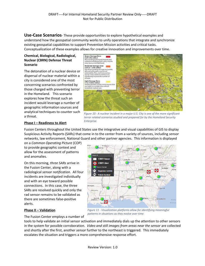
Chemical, Biological, Radiological, Nuclear (CBRN) Defense Threat Scenario
The detonation of a nuclear device or dispersal of nuclear material within a city is considered one of the most concerning scenarios confronted by those charged with preventing terror in the Homeland. This scenario explores how the threat such an incident would leverage a number of geographic information sources and analytical techniques to counter such a threat.
Phase I – Readiness to Alert
Fusion Centers throughout the United States use the integrative and visual capabilities of GIS to display Suspicious Activity Reports (SARs) that come in to the center from a variety of sources, including sensor networks, law enforcement, National Guard and other partner agencies. This information is displayed on a Common Operating Picture (COP) to provide geographic context and allow for the assessment of patterns and anomalies.
On this morning, three SARs arrive in the Fusion Center, along with a radiological sensor notification. All four incidents are investigated individually and with an eye toward possible connections. In this case, the three SARs are resolved quickly and only the rad sensor remains to be validated as there are sometimes false-positive alerts.
Phase II – Validation
The Fusion Center employs a number of tools to help validate an initial sensor activation and immediately dials up the attention to other sensors in the system for possible corroboration. Video and still images from areas near the sensor are collected and shortly after the first, another sensor further to the northeast is triggered. This immediately escalates the situation and triggers a more comprehensive response effort.
Figure 10 - A nuclear incident in a major U.S. City is one of the more significant terror related scenarios studied and prepared for by the Homeland Security Enterprise.
Figure 11 - Visualization platforms allow for identifying meaningful patterns in situations as they evolve over time.

DRAFT----For Internal Homeland Security Partner Review Only-----DRAFT Not for Public Distribution
Review Version: 1.0
Phase III – Activation
With two confirmed rad sensors activated, a trend in the movement can be identified and geospatial analysis is performed to estimate travel times along the corridor through which the vehicle is moving. Information is shared within DHS via notifications and displayed on the National Operation’s Center (NOC) COP that can be accessed by a wide range of homeland security stakeholders.
Imagery is again collected from the highway cameras near the second activated sensor, compared with that from the first, and is analyzed to identify the potential vehicles. Suspect vehicles are described and communicated up the corridor for intervention teams and law enforcement agencies. Expert strike teams are activated and begin deployment to identified staging areas along the corridor. Transfer sites to air, rail, and sea are monitored closely.
Phase IV – Response
Aerial and satellite reconnaissance assets are deployed to support the data collection efforts. A third rad sensor is activated further confirming the speed and direction of the vehicle and providing additional imagery and opportunity for improved modeling of the patterns of movement. After sharing this information with State Police, cruisers are dispatched and a roadblock is planned. The vehicles are identified and stopped for inspection by trained experts. Alerts are dispatched to the public along the highway corridor via mobile phone and interactive road signs to redirect them away from the danger zone.
Phase V – Resolution
Interdiction teams inspect the vehicles and identify the source of the radiation. In this case, it turns out to be a non-terrorist related incident, but a failure of the transporter to follow proper protocols. The scene is stabilized and the vehicle is removed from the highway and it is opened again to traffic. The situation is downgraded through direct communications and the NOC COP. Public notification is completed stating the incident has concluded and all is well.
Figure 12 - Common Operational Picture (COP) applications allow for the integration of a range of information with a map framework. This is an example of a highway camera network in the vicinity of New Orleans.