presented by: lauren ball march 2, 2011 arvind thiagarajan, lenin ravindranath, katrina lacurts,...
TRANSCRIPT

VTrack
Presented By: Lauren BallMarch 2, 2011
Arvind Thiagarajan, Lenin Ravindranath, Katrina LaCurts, Sivan Toledo, Jakob
Eriksson, Hari Balakrishnan, Samuel Madden, "VTrack
: Accurate, Energy-Aware Road Traffic Delay Estimation Using Mobile Phones, In Proc. 14th ACM
SenSys, November 2009.

Road Traffic Problem◦ Results
Causes inefficiency Fuel Waste Frustration (not measuring this here )
◦ Trends More cars on road (1B now and projected to double) More time wasted in traffic (4.2B Hrs in 2007 and increasing)
Smartphone Capabilities◦ Massive Deployment◦ GPS , WiFi, and Cellular Triangulation Capabilities
Background
Real-time traffic information can alleviate congestion with information◦ Collected Travel Time◦ Collected Vehicle Flow Densities
Alleviation Methods◦ Informing drivers of “Hotspots” to avoid◦ Traffic aware routing◦ Combining historic and real-time information
Update traffic light control Plan infrastructure improvements Update toll scheme
Dominant Data Source Commercial Fleets◦ End user travel times would be more realistic
Previous Work
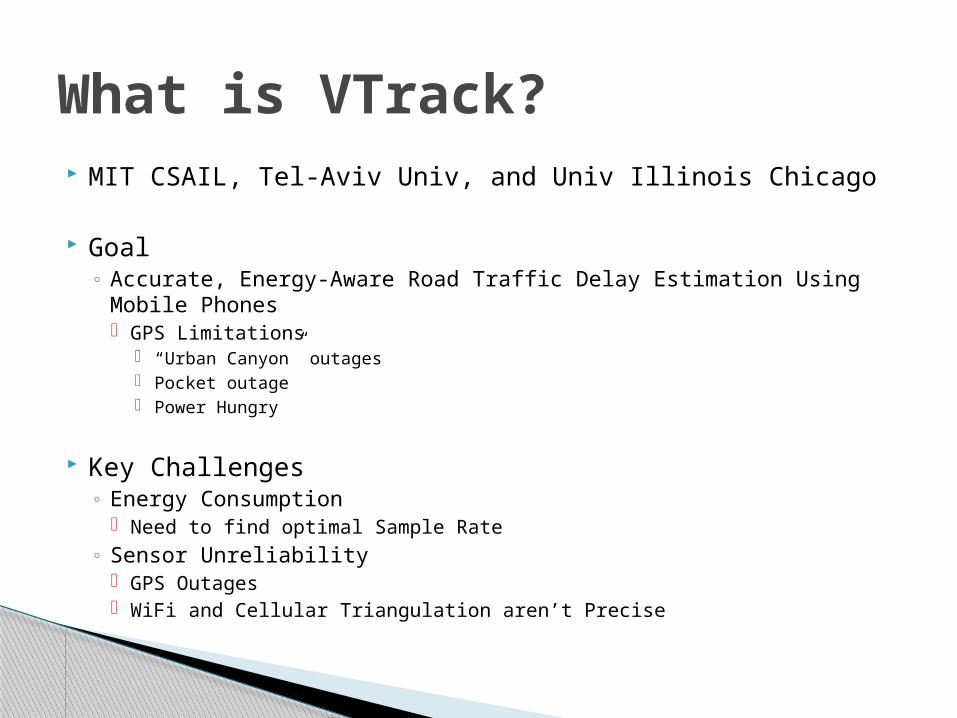
MIT CSAIL, Tel-Aviv Univ, and Univ Illinois Chicago
Goal◦ Accurate, Energy-Aware Road Traffic Delay Estimation Using Mobile
Phones GPS Limitations
“Urban Canyon” outages Pocket outage Power Hungry
Key Challenges◦ Energy Consumption
Need to find optimal Sample Rate◦ Sensor Unreliability
GPS Outages WiFi and Cellular Triangulation aren’t Precise
What is VTrack?
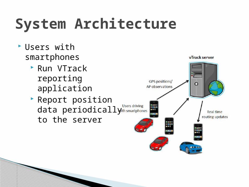
System Architecture Users with smartphones
Run VTrack reporting application
Report position data periodically to the server
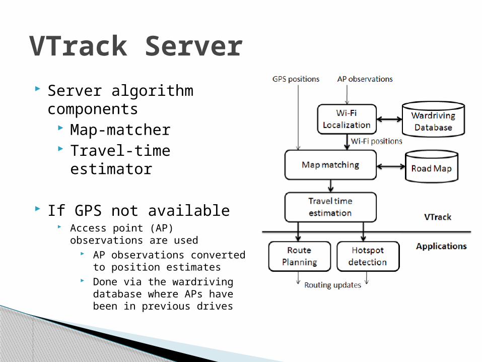
VTrack Server Server algorithm
components Map-matcher Travel-time estimator
If GPS not available Access point (AP) observations
are used AP observations converted
to position estimates Done via the wardriving
database where APs have been in previous drives
“Hotspot” Reporter◦ Senses Traffic Anomalies◦ Reports Segments with Rate << Speed Limit◦ Optimized for low miss rate◦ Optimized for false positive
Route Planner◦ Plans Least Time path◦ Uses individual segment estimated from VTrack ◦ Note: Rerouting available real-time
VTrack Application Support
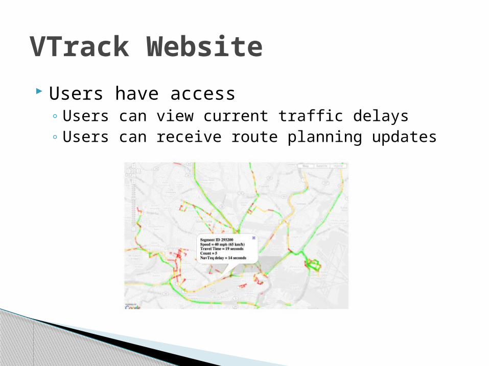
Users have access◦ Users can view current traffic delays◦ Users can receive route planning updates
VTrack Website

Accurate◦ Errors 10% -15% OK ◦ Correlates to 3-5 minutes on a 30 minute drive
Efficient enough to use real-time data◦ Existing map-matching use A*-type
Prohibitively expensive Hard to optimize
Energy Efficient◦ Meet accuracy goals◦ Maximize battery life
Server Algorithm Constraints
Map matching with errors◦ Not yet characterized with GPS Outages◦ Not yet characterized with noisy data
Time estimation is difficult (even with accurate trajectories)◦ Source data noisy
Difficult to determine best route Difficult to point a travel time to a segment
Localization accuracy is at odds with energy consumption◦ GPS more accurate but more power hungry◦ GPS takes up to 20x more power than WiFi◦ WiFi only available where Aps available
Server Challenges
Input: A sequence of noisy/sparse position data Output: A sequence of road segments Essential for travel time estimation
Steps◦ 1. Samples are pre-processed to remove outliers.
Outliers are classified as those > 200mph from last reading.
◦ 2. Outages Simple interpolations used
◦ 3. Viterbi decoding over Hidden Markov Model (HMM) to estimate the route driven
◦ 4. Bad zone removal low confidence matches
VTrack Map Matching

Main source is inaccuracy of the map-matched output
Two reasons◦ Outages during transitions
Cannot determine if delay is from Leaving segment Entereing segment
◦ Noisy positions samples Incosistancies when the sample is at the end of a short segment and it’s the only sample in
the segment
Note: Though small segment estimates were sometimes inaccurate, the total path results, were accurate!
Time Estimation Errors

Extensive Evaluation of Collection Results◦ Large Dataset◦ ~800 Hrs of Commuter Data◦ Deployed on 25 vehicles
Deployment Method◦ iPhone 3G◦ Embedded in-car computers with GPS and WiFi
Looking for◦ Sensor(s) Used◦ Sampling Frequency
VTrack Deployment Plan
Traditionally a hard problem finding ground truth data, previous approaches
◦ Additional test drive data Costly
◦ GPS samples as ground truth Fails in regions with GPS Errors and dropouts
◦ Note: Ground truth is impossible
VTrack Deployment Truth Data

Initial collection of 2998 drives from the 25 cars with GPS and WiFi sensors
Urban Area
Simultaneous GPS and WiFi location estimates
WiFi locations via centroid calculations of Aps
VTrack Deployment Coverage

HMM-based map matching◦ robust to noise◦ Error < 10%
when only WiFi With 40m Gaussian noise
Travel Times via only WiFi are accurate even though individual paths are not
Travel Times via only WiFi cannot detect hotspots◦ Due to outages◦ If WiFi available
Detection > 80% False Alarm < 5%
GPS available and accurate, periodic sampling helps with both
Findings
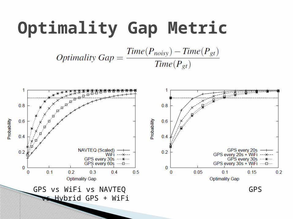
Optimality Gap Metric
GPS vs WiFi vs NAVTEQ GPS vs Hybrid GPS + WiFi
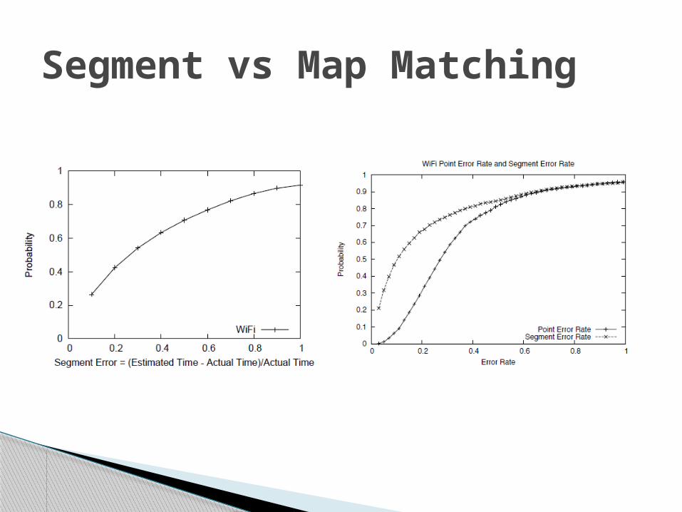
Segment vs Map Matching

Hotspot Detection Success
Hotspot Detection False Alarms
Threshold = observed segment time - predicted

Privacy
Out of Scope

The approach minimizes energy consumption using inaccurate position sensors
The approach obtains accurate travel time estimates from the inaccurate positions
Significant noise was handled
Conclusions
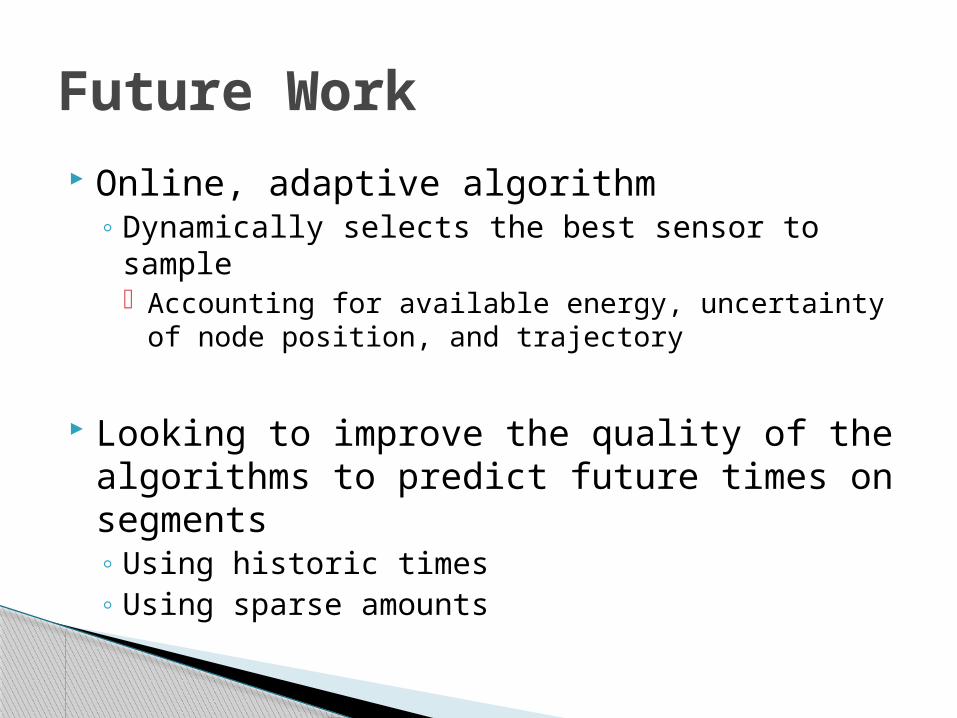
Online, adaptive algorithm◦ Dynamically selects the best sensor to sample
Accounting for available energy, uncertainty of node position, and trajectory
Looking to improve the quality of the algorithms to predict future times on segments◦ Using historic times◦ Using sparse amounts
Future Work
[1] The mobile millenium project. http://traffic.berkeley.edu.
[2] Navteq. http://navteq.com/about/data.html.
[3] The peir project. http://peir.cens.ucla.edu.
[4] Bureau of Transportation Statistics. http://www.bts.gov.
[5] The CarTel project. http://cartel.csail.mit.edu/.
[6] Y. chung Cheng, Y. Chawathe, A. Lamarca, and J. Krumm. Accuracy
characterization for metropolitan-scale wi-fi localization. In In
Proceedings of Mobisys 2005, pages 233–245, 2005.
[7] C. Claudel and A. Bayen. Guaranteed bounds for traffic flow
parameters estimation using mixed lagrangian-eulerian sensing. In
Allerton Conference on Communication, Control, and Computing,
2008.
[8] C. Claudel, A. Hofleitner, N. Mignerey, and A. Bayen. Guaranteed
bounds on highway travel times using probe and fixed data. In 88th
TRB Annual Meeting Compendium of Papers, 2009.
[9] D. F.V. Gps accuracy: Lies, damn lies, and statistics. 1998.
[10] S. Gaonkar, J. Li, R. R. Choudhury, L. Cox, and A. Schmidt.
Micro-blog: sharing and querying content through mobile phones and
social participation. In MobiSys, pages 174–186, 2008.
[11] M. Gruteser and D. Grunwald. Anonymous usage of location-based
services through spatial and temporal cloaking. In ACM MobiSys, 2003.
[12] M. Gruteser and B. Hoh. On the anonymity of periodic location
samples. In Pervasive, 2005.
[13] B. Hoh, M. Gruteser, R. Herring, J. Ban, D. Work, J.-C. Herrera, A. M.
Bayen, M. Annavaram, and Q. Jacobson. Virtual trip lines for
distributed privacy-preserving traffic monitoring. In MobiSys ’08:
Proceeding of the 6th international conference on Mobile systems,
applications, and services, 2008.
References [14] B. Hoh, M. Gruteser, H. Xiong, and A. Alrabady. Enhancing security
and privacy in trafc-monitoring systems. IEEE Pervasive Computing,
5(4):38–46, 2006.
[15] B. Hoh, M. Gruteser, H. Xiong, and A. Alrabady. Preserving privacy in
GPS traces via uncertainty-aware path cloaking. In ACM CCS, 2007.
[16] B. Hull, V. Bychkovsky, Y. Zhang, K. Chen, M. Goraczko, E. Shih,
H. Balakrishnan, and S. Madden. CarTel: A Distributed Mobile Sensor
Computing System. In Proc. ACM SenSys, Nov. 2006.
[17] B. Hummel. Map matching for vehicle guidance. In Dynamic and
Mobile GIS: Investigating Space and Time. CRC Press: Florida, 2006.
[18] Inrix home page. http://www.inrix.com/.
[19] J. Krumm. Inference attacks on location tracks. In Pervasive, 2007.
[20] J. Krumm, J. Letchner, and E. Horvitz. Map matching with travel time
constraints. In SAE World Congress, 2007.
[21] P. Mohan, V. N. Padmanabhan, and R. Ramjee. Nericell: rich
monitoring of road and traffic conditions using mobile smartphones. In
SenSys ’08: Proceedings of the 6th ACM conference on Embedded
network sensor systems, 2008.
[22] D. Sperling and D. Gordon. Two Billion Cars: Driving Toward
Sustainability. Oxford University Press, 2009.
[23] L. Sweeney. k-anonymity: A model for protecting privacy, 2002.
[24] A. J. Viterbi. Error bounds for convolutional codes and an
asymptotically optimum decoding algorithm. In IEEE Transactions on
Information Theory, 1967.
[25] J. Yoon, B. Noble, and M. Liu. Surface Street Traffic Estimation. In
MobiSys, 2007.

Energy Constraint??◦ If in car plugged in phone◦ Not true for mass transit if that should be
included◦ Obviously still have the GPS Outage issue
Mass Transit Buses?◦ False Stops
My Thoughts

Questions??