presented by david crain, sdl/geometwatch nasa/noaa ghg
TRANSCRIPT

• Presented by David Crain, SDL/GeoMetWatch • NASA/NOAA GHG Workshop, Mar. 29-31, 2011
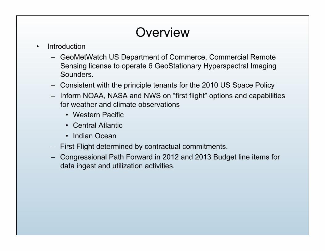
Overview • Introduction
– GeoMetWatch US Department of Commerce, Commercial Remote Sensing license to operate 6 GeoStationary Hyperspectral Imaging Sounders.
– Consistent with the principle tenants for the 2010 US Space Policy – Inform NOAA, NASA and NWS on “first flight” options and capabilities
for weather and climate observations • Western Pacific • Central Atlantic • Indian Ocean
– First Flight determined by contractual commitments. – Congressional Path Forward in 2012 and 2013 Budget line items for
data ingest and utilization activities.

US Commercial Remote Sensing Act and 2010 US Space Policy
• US Commercial Remote Sensing Act 2003 provides for the licensing of commercial remote sensing systems. – Foreign Sales allowed with few restrictions, no ITAR issues for data. – Fee-for-Service Data model similar to that of GeoEye and Digital Globe for
Space-Based Imagery – Some beneficial implicit and explicit protections
• US Space Policy intent to promote commercial options to meet Operational and Observation requirements to the maximum extent – Meets government requirements with commercial solutions – Grows Domestic Earth Observation Capability – Strong International Demand for Data – ITAR Neutral Business Model – Lower Cost and Risk – High Value US Jobs and International Exports

What is GeoMetWatch • First and Foremost, we are a service provider with a
primary goal of delivering space-based hyperspectral sounding and imaging data (Level 1b) to government and private entities.
• Value added products will be both internally produced and licensed to third parties.
• GeoMetWatch will work with our sensor and software partners to develop and deliver the needed capabilities, we are NOT a hardware company.
• GMW will use proven commercial approaches in development, launch and on-orbit operations.
• GMW will provide both direct delivery of level 1b products as well as custom and Level 2 and Level 3 products according to customer desire.

Why a Commercial Sounder? • Given both the history of the GIFTS and the HES programs,
we felt there was a urgent need to find a different path to providing these important observation capabilities, one that both met the essential advanced sounding requirements AND delivered those data on a SUSTAINABLE cost basis.
• Also, because of the current Risk adverse nature of procurement programs, the GeoMetWatch system can deliver the essential observational requirements at the lowest possible risk and upfront cost.
• Customer commitment determines constellation flyout, with some anticipated prepaid escrow and pay as you go contracts (5 year terms, renewable yearly)
• No Data, No Pay, No Risk to end customer. • Total Cost is a fraction (5-20%) of a conventional system.

Why is Cost so Low?
• Hosted Payload has many advantages. • Fully exploit commercial solutions in
launch and operations using fixed commercial communication satellite fleet.
• Only build the sensor, do not pay for launch, bus, dedicated ground operations.

What will our System do? • Observational Goals of a commercial system:
– Meet the most stringent global advanced sounding requirement • Currently MTG IRS, essentially the GIFTS Spec
– Meet the WMO Roadmap 2025 goal of a global system of 6 sounders separated by 60-70 degrees longitude.
• Develop software and data delivery tools to alleviate processing and ingest concerns of hyperspectral data. – We will do it all if needed. – Welcome government partners to develop data products.

From NOAA/NESDIS Commercial Sources Sought Request
Mitch Goldberg, Commercial Sounder Goals, Jan. 28, 2008
Via High Vertical Resolution profiles of temperature and
water vapor

Proposed Coverage Implementation 2014-2020
Six Commercial Sounders give global coverage with overlap enabling cross-
calibration.
Two spares (on-orbit or on-ground) will provide redundant capability.

We do this using mature technology with improvements?
• The GeoMetWatch Sensor, STORM is a SDL designed derivative of the GIFTS sensor with improvements in:
– FPA and FPA electronics – Scan Mirror command and control – Thermal design optimized for Co-Hosted Communication Satellite Payload. – All New Hardware and sub-components, but built to GIFTS design.
• Potential Improvements – Additional Imaging Bands (5 Allowed by license), currently single band imager. – Modified Spectrometer Bands (improve methane detection)

Mature Technology • The GMW Sounder Concept is derived from the NASA GIFTS
sensor with improvements in focal plane technology, cooler, scan mirror, thermal control and electronics.
• The new design is called STORM and exercises the full scope of the GeoMetWatch license by incorporating 5 imaging bands and 2 hyperspectral bands

GIFTS EDU Summary 12
GIFTS Sensor Module Technologies

Observation capabilities • Nominal Full Disk at Full Spectral
resolution every hour. – Including CONUS every 20 minutes – Stormwatch modes 512km x 512km every 30
seconds. – Faster modes available at lower spectral
resolution. – 2-4km spatial resolution in IR bands – 0.5-1km spatial resolution in imaging band/
bands

Hardware Delivery Timeline • Projected Firm Fixed Price Delivery of
First Sensor in 36 months from program start.
• Additional sensors delivered in 12 month increments.
• Long leads, subcontracts and project timeline and resources identified.
• FFP Contract to SDL in June 2011.

Anticipated Algorithm Products and Ground System Capabilities
• Leveraging GIFTS and GOES-R SSEC experience. • Level 1b, Level 2 and Level 3 products available for Day One
Delivery. • Various delivery options possible
– Direct Broadcast and local processing – Rebroadcast – Internet Delivery – AWIPS Delivery
• AWIPS Training Program being developed for NWS and International Forecasters

Ground Segment Delivery Timeline
• Projected Firm Fixed Price Delivery of Ground Segment in 18 months from program start.
• Additional delivery options and distributed data center model being evaluated.
• Turn key leased and dedicated Data Center options.

Addressing specific Weather and Climate observation questions
• Question 4: The STORM sensor meets the original DS requirement for HES and has significant more capability that all of the TS-11 options and the legacy AOA sounder options. In addition this capability can be available years before other options and in the same operational timeframe as GOES-R.

GMW is best option for Implementing Advanced Geo Sounder
From NOAA AOA Report, 2008
GMW-1D
GeoMetWatch has best performance, lowest cost and is available years earlier than any other AOA option!

Addressing specific Weather and Climate observation questions (cont.)
• Question 5: The complimentary role of Hyperspectral GEO sounding is significant, especially in a global system like GMW. High vertical resolution profiles of temp, water vapor and wind fields and well as bounding observations of some GHG constituents will significantly improve other simultaneous observations, this the true advantage of GEO.
• Question 6: Actually there is some advantage vs. LEO in that a GEO sensor can stare to reduce SNR, but it does significantly impact duty cycle for the primary weather mission.

Addressing specific Weather and Climate observation questions (cont.)
• Question 7: Similar to question 6, we can make modifications to the STORM instrument to enhance low level (below boundary layer) CO2 and Methane, but at additional cost, with a customer it can be done.
• Question 8: The GeoMetWatch paradigm goes beyond a single sensor and is developing a comprehensive GLOBAL hyperspectral sounding capability, using a common sensor design. Having this type of data as a “background” observation, should improve all other GHG observations from other sources. Furthermore, a successful commercial implementation will pave the way for other sensor technologies which can realize the same cost savings.

Some additional points from Bill Smith • Benefits for Hyperspectral Geo-sounder (unique or significantly improved):
– (1) Day-1 use of 3-d water vapor and stability imagery by WFOs and NHC and NSSFC for subjective severe storm forecasting
– (2) High space and time resolution thermodynamic and water vapor tracked wind vertical profiles for mesoscale NWP.
– (3) State variable time tendencies useful for large scale NWP 4-d data assimilation.
– (4) Tropospheric pollutant gas transport (CO and O3) for Air Quality forecasting. – (5) Continuous measurements of aviation weather hazards (e.g., cloud heights,
temperature, and ice/water phase, wind shear, volcanic ash, terminal weather ) – (6) Provides continuous upper air data for synergism with ground-based PBL
data for obtaining climate quality temperature, water vapor, and trace gas profiles at climate monitoring ground sites (e.g., DOE ARM- sites).
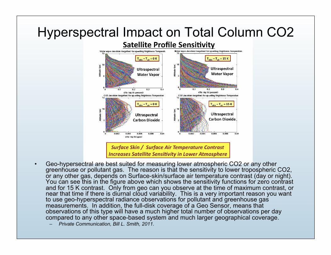
Hyperspectral Impact on Total Column CO2
• Geo-hypersectral are best suited for measuring lower atmospheric CO2 or any other greenhouse or pollutant gas. The reason is that the sensitivity to lower tropospheric CO2, or any other gas, depends on Surface-skin/surface air temperature contrast (day or night). You can see this in the figure above which shows the sensitivity functions for zero contrast and for 15 K contrast. Only from geo can you observe at the time of maximum contrast, or near that time if there is diurnal cloud variability. This is a very important reason you want to use geo-hyperspectral radiance observations for pollutant and greenhouse gas measurements. In addition, the full-disk coverage of a Geo Sensor, means that observations of this type will have a much higher total number of observations per day compared to any other space-based system and much larger geographical coverage.
– Private Communication, Bill L. Smith, 2011.

Increasing concerns that Legacy Sounder Products will not meet future forecast needs
• From, “High-Spectral- and High-Temporal-Resolution Infrared Measurements from Geostationary Orbit”, Journal of Atmosphere and Ocean Technology, 2009, Timothy J. SchmitAdvanced Satellite Products Branch, NOAA/NESDIS/Center for Satellite Applications and Research, Madison, Wisconsin, Jun Li and Steven A. AckermanCooperative Institute for Meteorological Satellite Studies, University of Wisconsin—Madison, Madison, Wisconsin, James J. GurkaNOAA/NESDIS GOES-R Program Office, Greenbelt, Maryland
– High-spectral-resolution sensors have a much greater vertical-resolving power of temperature, moisture, and trace gases than low-spectral-resolution sensors. Because of coarse vertical resolution and limited accuracy in the legacy sounding products from the current GOES sounders, placing a high-spectral-resolution IR sounder with high temporal resolution in the geostationary orbit can provide nearly time-continuous three-dimensional moisture and wind profiles. This would allow substantial improvements in monitoring the mesoscale environment for severe weather forecasting and other applications. Application areas include nowcasting (and short-term forecasts) and numerical weather prediction, which require products such as atmospheric moisture and temperature profiles as well as derived parameters, clear-sky radiances, vertical profiles of atmospheric motion vectors, sea surface temperature, cloud-top properties, and surface properties. Other application areas include trace gases/air quality, dust detection and characterization, climate, and calibration.

NRC 2007 Endorsement

NOAA GOES-R AWG Recommendation (2008)
GeoMetWatch would meet all of these recommendations by 2014-2015 and
have Global coverage by 2020.

Despite the Convoluted History, Advanced Geo Sounding Remains a Key unmet requirement
• Though Legacy Sounder Option has been implemented for GOES-R, even the NOAA STAR science team states it is inadequate to meet future sounding requirements
GeoMetWatch Desires an Early Decision from USG
• GMW can guarantee service for US Sector by 2014 with early commitment.
• Asia/Western Pacific alternative with NOAA participation possible.
• In order to focus on first flight opportunity, GMW must identify orbit and ride by June 2011 or earlier.
• First flight will partially constrain future flight locations.
• This community can help advocate.

Backup Slides

About GeoMetWatch
• GeoMetWatch, Inc., is a privately held, commercial company with the mission of developing advanced commercial environmental observation systems. GeoMetWatch was started to facilitate the collection and delivery of advanced atmospheric sounding data at a much lower cost and on a much quicker timeframe than conventional government operated systems. The data that GeoMetWatch will collect and deliver to forecasters will enable the most accurate prediction of severe weather possible. The forecasts enabled by GeoMetWatch data will save lives, preserve property and improve the monitoring of our environment.
GeoMetWatch utilizes world-class technology and software products to operate a space-based commercial Hyperspectral Imaging/Sounding System. This system is licensed by the US Department of Commerce to operate up to six satellites in Geostationary orbit and deliver Hyperspectral Imaging/Sounding Data products under a fee-for-service basis.
GeoMetWatch anticipates delivery of these data products beginning as soon as 2014 to international government weather agencies, commercial and research customers and partners. GeoMetWatch will revolutionize the existing paradigms for delivering cutting edge data to improve severe weather forecasts and environmental observations. GeoMetWatch's business model offers excellent value to our shareholders and partners and lower costs and risks to our customers for the essential data products they desire and need.

Continuing Demand for Hyperspectral Geo Sounding to Improve Forecasting, Climate and Earth Science
• National Academy of Sciences Decadal Survey (2007): 8+ missions explicitly benefit from Hyperspectral GEO Sounder
• WMO Roadmap 2025 • NRC Network of Networks recommendations for Regional Forecast
Improvement 2009 (Don Berchoff, NWS)

From GCOS • For regional NWP, polar orbiting satellites provide information on temperature with
acceptable accuracy and good horizontal resolution, but with marginal temporal frequency and vertical resolution for mesoscale prediction. Advanced radiometers or interferometers planned for future satellites should improve on the vertical resolution and accuracy of current radiometers. Geostationary satellites provide frequent radiance data, but their use over land is hindered because of the difficulty in estimating surface emissivity. In nowcasting, the temperature and humidity fields are particularly useful for determining atmospheric stability for predicting precipitation type, the amount of frozen precipitation, and convective storms. As with humidity profiles, nowcasting predictions using atmospheric temperature data benefit from hourly geostationary infrared soundings (such as from the GOES and MSG series – with these missions now capable of providing such data at 15 minute intervals). The combination of the HIRS/3 and AMSU instruments on the NOAA and MetOp series allows improved information, sufficient to infer temperature within several thick layers in the vertical. On the MetOp series, IASI is used with other instruments to deliver very precise sounding capacity. IASI data assimilation has significantly improved NWP forecasts. CrIS on the NPOESS series, which will replace HIRS, is designed to enable retrievals of atmospheric temperature profiles at 1K accuracy for 1 km layers in the troposphere.
• GeoMetWatch Commercial Sounder addresses all issues highlighted above as “Problems in the Satellite Data Record” as defined by GCOS

Information Content for NWP is Very High
• Total Soundings per day at 4km resolution for a single GMW Sounder is approximately 112 Million, with approximately 1500 radiance channels per sounding.
• Compared to the Current GOES Sounder this is about 2500x more information.
• Compared to IASI, AIRS and CrIS this is about 50-100x more information than each individual instrument
• Compared to AMSU and operational Microwave sounders this is about 50-100x more soundings (25-50x with clouds).
• Impact of Total GMW constellation is 4-6 times higher (500+ Million soundings per day)

Synthesis of all results after WMO workshop Forecast Impacts from THORPEX working group on Data Assimilation and Observing Strategies
Estimated Impact of Single GMW Sounder
Estimated Impact of full GMW Sounder constellation