presented at the fig congress 2018,may 6-11, 2018 in
TRANSCRIPT

Presented at th
e FIG Congress 2018,
May 6-11, 2018 in
Ista
nbul, Turkey

Developing Model of Agriculture Land Consolidation As a
tool to recover from Industrial Liquid Waste Pollution
Hazards (9311)
Bambang Edhi Leksono
Muhammad Ihsan
Geodesy and Geomatic Engineering Program
Faculty of Earth Sciences and Technology
Institut Teknologi Bandung

Kamis, 23 Juni 2016
Background
Chemical
Elements
Content
within soil in
(ppm)
Quality
standard of
Soil (ppm)
(Alloway)
Above the
quality
standard
Cu 43,00 – 83,00 60 – 125 Yes
Zn 57,00 – 137,00 70 – 400 Yes
Pb 8,73 – 22,76 100 – 400 No
Cd 0,05 – 0,19 3 – 8 No
Cr 0,78 – 24,93 75 – 100 No
Ni 13,75 – 20,53 100 No
Government
IndustrySociety
Research Area in Ranca
Ekek district
Mineral Condition in
Agruculture soil
Stake Holders in Land
Consolidation

Kamis, 23 Juni 2016
PROBLEMS
• What effort shoul be done to recover the industrial liquid waste hazard
with hgh level efficiency?
• What is the role of community development to overcome the hazard of
liquid waste?
• What methods and land consolidation model which appropriate to solve
the liquid waste hazard related to the characteristics of environment in
areas contaminated as well as the legal aspects of the land tenure?

Kamis, 23 Juni 2016
OBJECTIVES
• To generate liquid waste hazard mitigation solutions in order to improve
water quality and productivity of agriculture (recovery from disaster)
• To generate the appropriate consolidation model with the characteristics
of the environment in areas contaminated as well as based on the legal
aspects and the environment

Kamis, 23 Juni 2016
Liquid PollutionAgriculture land
DamageFitoremediation Need the lands
Land Consolidation requestVerificationModel Development
Society DisscussionCost of
development from
Industry (CSR)
Land Sertification
Local GovernmentUniversity involment
Industri
Society

Kamis, 23 Juni 2016
FITOREMEDIATION
Agriculture Land Consolidation Agriculture Land Consolidation in this research
There are Community involvement

Kamis, 23 Juni 2016
Combination of Knowledge Based
Method with Geographical Information
System
DATA
Combination of
Knowledge Based
Method with GIS
Geografis
Hydrology and
Environment
Agriculture
Land
MODEL
Kamis, 23 Juni 2016
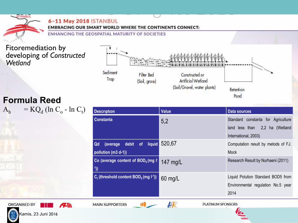
Fitoremediation by developing of Constructed Wetland
Descrıptıon Value Data sources
Constanta 5,2 Standard constanta for Agriculture
land less than 2,2 ha (Wetland
International, 2003)
Qd (average debit of liquid
pollution (m3 d-1))
520,67 Computation result by metods of FJ.
Mock
Co (average content of BOD5 (mg l-
1))
147 mg/L Research Result by Nurhaeni (2011)
Ct (threshold content BOD5 (mg l-1)) 60 mg/L Liquid Polution Standard BOD5 from
Environmental regulation No.5 year
2014
Ah = KQd (ln Co - ln Ct)
Formula Reed

Kamis, 23 Juni 2016

Kamis, 23 Juni 2016
Site Selection of Agriculture Land ConsolidationSimple Irigation
Near the polluted river
Land ownership data

Kamis, 23 Juni 2016
Analisis Water Supply and Water Demand
0.000
1.000
2.000
3.000
4.000
5.000
6.000
7.000
8.000
9.000
1 2 3 4 5 6 7 8 9 10 11 12 13
Deb
it (
m³/
s)
Comparison of Main Debit and Debit Needed
Debit andalan (m³/s)
Debit kebutuhan (m³/s)

Kamis, 23 Juni 2016
Constructed Wetland
Luas : 2426,14 m²
Kedalaman : 0,6 m
Lebar : 28,44 m
1. Plantation Hyper A1
2. Plantation Hyper A 2
3. Platation Hyper A3

Kamis, 23 Juni 2016
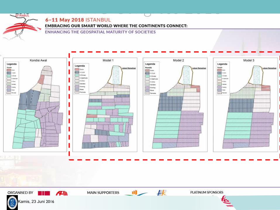
Model 1
• Same Procentage of STUP (Contribution of Land for development)
• Parcel design with the same area per ownership
Model 2
• Same Procentage of STUP (Contribution of Land for development)
• Parcel design per ownership
Model 3
• STUP Area with a distance weight from parcel to parcel
• Percel design per ownership
Kamis, 23 Juni 2016
Kamis, 23 Juni 2016
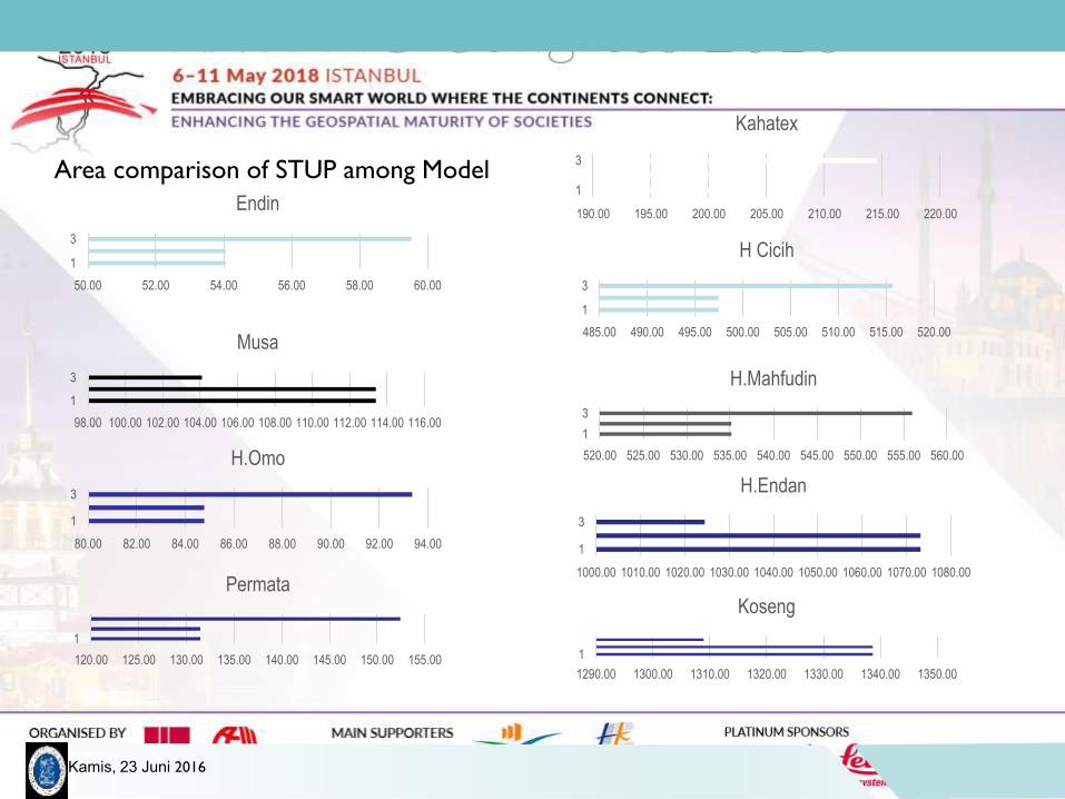
50.00 52.00 54.00 56.00 58.00 60.00
1
3
Endin
98.00 100.00 102.00 104.00 106.00 108.00 110.00 112.00 114.00 116.00
1
3
Musa
80.00 82.00 84.00 86.00 88.00 90.00 92.00 94.00
1
3
H.Omo
120.00 125.00 130.00 135.00 140.00 145.00 150.00 155.00
1
Permata
190.00 195.00 200.00 205.00 210.00 215.00 220.00
1
3
Kahatex
485.00 490.00 495.00 500.00 505.00 510.00 515.00 520.00
1
3
H Cicih
520.00 525.00 530.00 535.00 540.00 545.00 550.00 555.00 560.00
1
3
H.Mahfudin
1000.00 1010.00 1020.00 1030.00 1040.00 1050.00 1060.00 1070.00 1080.00
1
3
H.Endan
1290.00 1300.00 1310.00 1320.00 1330.00 1340.00 1350.00
1
Koseng
Area comparison of STUP among Model

Kamis, 23 Juni 2016
0.00%
1.00%
2.00%
3.00%
4.00%
5.00%
6.00%
7.00%
8.00%
9.00%
0
50
100
150
200
250
300
350
Permata H.Omo Endin Kahatex H.Mahfudin H Cicih H.Endan Koseng Musa
Dıstance Comparıson and Presentage of STUP Model 3Jarak Presentase

Kamis, 23 Juni 2016
0.00
2000.00
4000.00
6000.00
8000.00
10000.00
12000.00
14000.00
16000.00
18000.00
20000.00
Endin Musa H.Omo Permata Kahatex H Cicih H.Mahfudin H.Endan Koseng
Area comparison among Model
Luas Awal (m²) Model1 Model2 Model 3

Kamis, 23 Juni 2016
1 1 1
2
3
5
8
20
29
1 1 1
2
3
5
8
20
29
1 1 1
2 2
6
5
8
10
2
1
2 2
3 3
5
6
10
E N D IN MU S A H .OMO P E R MA T A K A H A T E X H C IC IH H .MA H F U D IN H .E N D A N K OS E N G
COMPARISON OF TOTAL PARCEL NUMBERS
Jumlah Persil Awal Jumlah Persil Model1 Jumlah Persil Model2 Jumlah Persil Model 3

Kamis, 23 Juni 2016
Model Advantage Disadvantage
Model 1 1. Percentage of STUP is uniform
2. Number of parcel constant
3. the parcels distributed with same
area (water distribution equal)
1. The parcels are dispersed
2. Parcel design not in good order
Model 2 1. Percentage of STUP uniform
2. Parcel area become larger
3. Good parcel design n not
distributed
1. Less number of parcels
Model 3 1. Percentage of STUP based on the
water quality distribution
2. Percel area become larger
3. Good parcel design n not distributed
1. Percentage of STUP not uniform
2. Need more study & socialization
regarding to weighted of parcel
distribution.

Kamis, 23 Juni 2016
Impact of Remediation and Consolidation
Impact Before After Description
Environment (Content of BOD5) 147 60 Deminishing of 59%
Agriculture Production (Paddy) 0,6 ton 2,5 ton Improvement of 400%
Income (per hectare) Rp 3.069.600 Rp 12.790.000 improvement 400%
Legal aspect of land tenure Letter C (Girik)Ownership Title
Sertificate of LandSecurity Tenure

Kamis, 23 Juni 2016
Conclusion
• Development of constructed wetland is needed to reduce the polluted liquid waste of industry within the Agriclture area.
• Location of Agriculture Consolidation has 5,8 hectares with number of parcel lands of 70 and belong to 9 owners. The need of land remediation only for 0.4 hectares, so that the rest of consolidated area is 5,3 hectares.
• Base on this consolidation model, there are 3 different model approaches, where model 1 and 2, every parcel gave contribution of 7 persen of total area origin, where the model 3, contributed area differently between 6-8%, because of the parcel distance weighted method was applied to the distance of remediation land.
• Base on the areal analisis and STUP, model 3 is an proper model regarding to the wisdon of water qualitiy distribution. The parcel design of model 3 using the block of ownership system where parcels location are more proper irrigated.
• The effort to recover industrial waste liquid pollution hazard to agriculture area, the development of landremediation is very important role to recover the environment :
– reduced the content of BOD5 around 59%)
– improving the society walfare with the district
– Improving agriculture production and
– Security of land tenure by applying the ownership title related to the land properties.
Kamis, 23 Juni 2016
Recomendation
• Need to study more comprehensively in Fitoremediation and Constructed
Wetland Development in Rancaekek District
• For the maximum advantage, the development of Fitoremediation can be
distributed to most agriculture area. Because need to get STUP for more
larger areal of agriculture development.
Kamis, 23 Juni 2016
Thank You
FIG 2018
Istanbul
Turkey