presentation headline calibri regular 36 pt
TRANSCRIPT

2014 Exelis VIS User Conference The Power of Ingenuity
The information contained in this document pertains to software products and services that are subject to the controls of the Export Administration Regulations (EAR). The recipient is responsible for ensuring compliance to all applicable U.S. Export Control laws and regulations.
Tokyo, Japan October 2, 2014

Our Vision
2
We will be the most agile C4ISR, aerospace and information solutions provider by leveraging deep customer knowledge and technology expertise to deliver affordable, mission-critical
products and services for our global customers
Use or disclosure of this information is subject to the restrictions on the title page of this document.
3
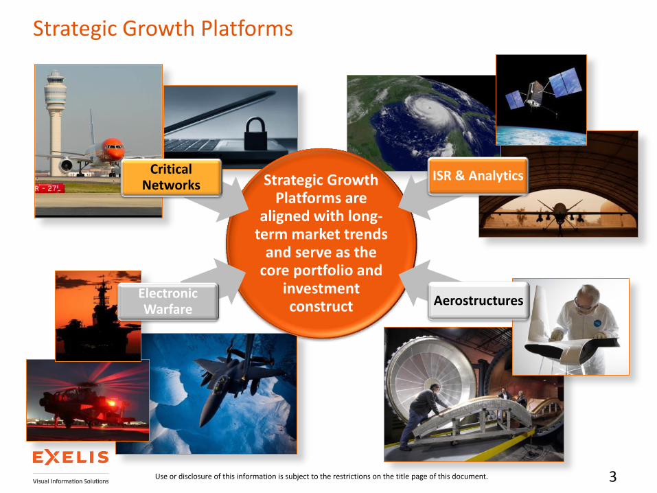
Strategic Growth Platforms are
aligned with long-term market trends
and serve as the core portfolio and
investment construct
Electronic Warfare
Critical Networks
ISR & Analytics
Aerostructures
Strategic Growth Platforms
Use or disclosure of this information is subject to the restrictions on the title page of this document.


Exelis Geospatial Intelligence Solutions – Commercial Product Offerings
October 27, 2014
5
Ingest, Manage, Process and Deliver useful data holdings in a turn-key, cost effective and reliable manner
Jagwire
Customize ENVI products to your unique needs Visualize and analyze scientific data
IDL
The latest tools for analyzing all kinds of geospatial imagery and data, including SAR, LiDAR, Multispectral, and Hyperspectral.
ENVI
Use or disclosure of this information is subject to the restrictions on the title page of this document.
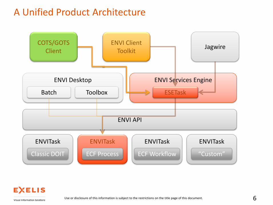
A Unified Product Architecture
6
ENVITask
Classic DOIT
ENVITask
ECF Process
ENVITask
ECF Workflow
ENVITask
“Custom”
ENVI API
ENVI Desktop
Batch Toolbox
ENVI Services Engine
ESETask
Jagwire ENVI Client
Toolkit
Use or disclosure of this information is subject to the restrictions on the title page of this document.
COTS/GOTS Client
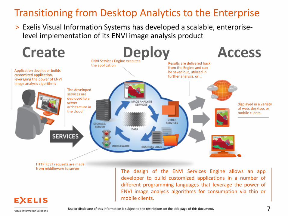
Transitioning from Desktop Analytics to the Enterprise > Exelis Visual Information Systems has developed a scalable, enterprise-
level implementation of its ENVI image analysis product
The design of the ENVI Services Engine allows an app developer to build customized applications in a number of different programming languages that leverage the power of ENVI image analysis algorithms for consumption via thin or mobile clients.
Application developer builds customized application, leveraging the power of ENVI image analysis algorithms
The developed services are deployed to a server architecture in the cloud
Results are delivered back from the Engine and can be saved out, utilized in further analysis, or …
displayed in a variety of web, desktop, or mobile clients.
HTTP REST requests are made from middleware to server
ENVI Services Engine executes the application
Create Deploy Access
7 Use or disclosure of this information is subject to the restrictions on the title page of this document.

IDL 8.4
What’s New in IDL Desktop

> Data Input & Output
> HDF5 library updated to provide read-only support for SZIP (v2.1) compression
> Video Read Enhancements
> In previous versions of IDL messages from FFmpeg would be reported as errors and IDLffVideoRead object initialization would fail
> Now in IDL 8.4 if the video file contains any video or audio codecs that are not supported then IDL will quietly ignore these codecs and continue to open the file
> Users can set the new VERBOSE keyword to force IDL to issue informational messages when it encounters any unsupported codecs
> Geospatial PDF Export
> The IDLffGeospatialPDF object provides the ability to save graphical output to a Geospatial PDF file
IDL 8.4 – Data Access
Use or disclosure of this information is subject to the restrictions on the title page of this document.

> Generate Code
> Provides ability to reproduce new graphics plot with annotations, property modifications, font changes, etc.
> Repeatable interactive visualization
> New GenerateCode method on graphics objects that generates the code needed to reproduce the contents of a graphics window
> This method can be used to generate code after changes have been made interactively in the graphics window (moving, resizing, or changing properties)
> Option to save the data used in the visualizations within the graphics window
IDL 8.4 – Graphics
Use or disclosure of this information is subject to the restrictions on the title page of this document.
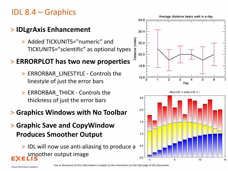
> IDLgrAxis Enhancement
> Added TICKUNITS="numeric" and TICKUNITS="scientific" as optional types
> ERRORPLOT has two new properties
> ERRORBAR_LINESTYLE - Controls the linestyle of just the error bars
> ERRORBAR_THICK - Controls the thickness of just the error bars
> Graphics Windows with No Toolbar
> Graphic Save and CopyWindow Produces Smoother Output
> IDL will now use anti-aliasing to produce a smoother output image
IDL 8.4 – Graphics
Use or disclosure of this information is subject to the restrictions on the title page of this document.
ENVI 5.2
What’s New in ENVI Desktop
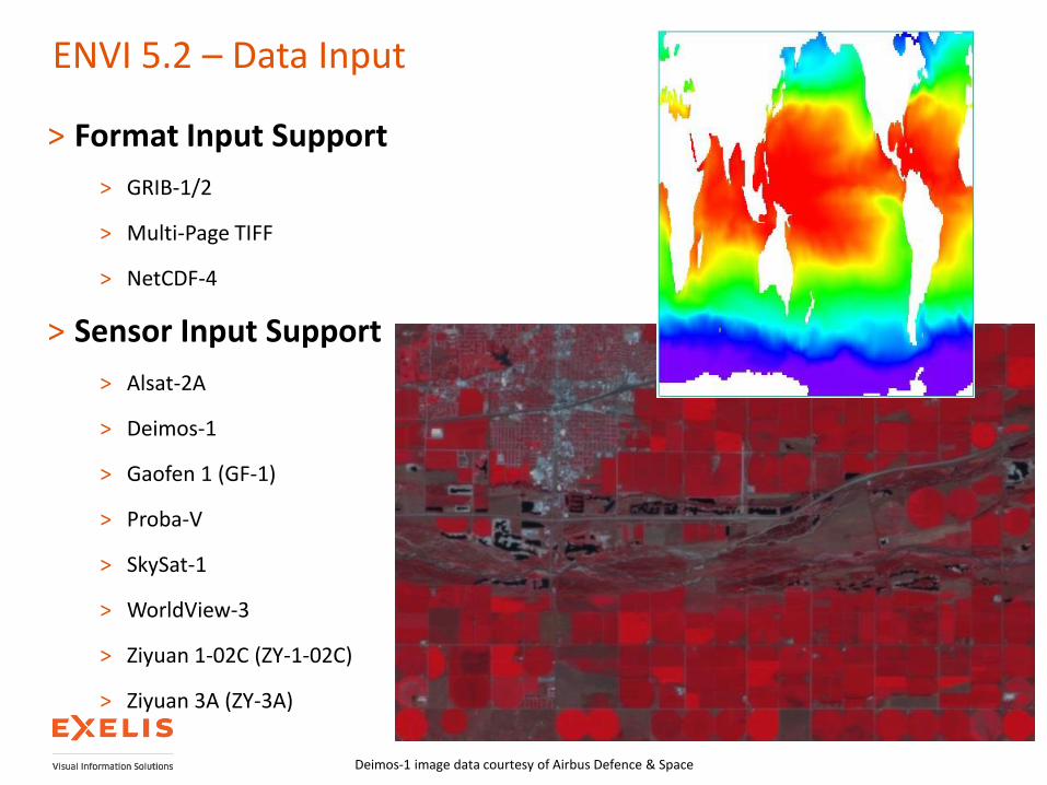
> Format Input Support
> GRIB-1/2
> Multi-Page TIFF
> NetCDF-4
> Sensor Input Support
> Alsat-2A
> Deimos-1
> Gaofen 1 (GF-1)
> Proba-V
> SkySat-1
> WorldView-3
> Ziyuan 1-02C (ZY-1-02C)
> Ziyuan 3A (ZY-3A)
ENVI 5.2 – Data Input
Deimos-1 image data courtesy of Airbus Defence & Space
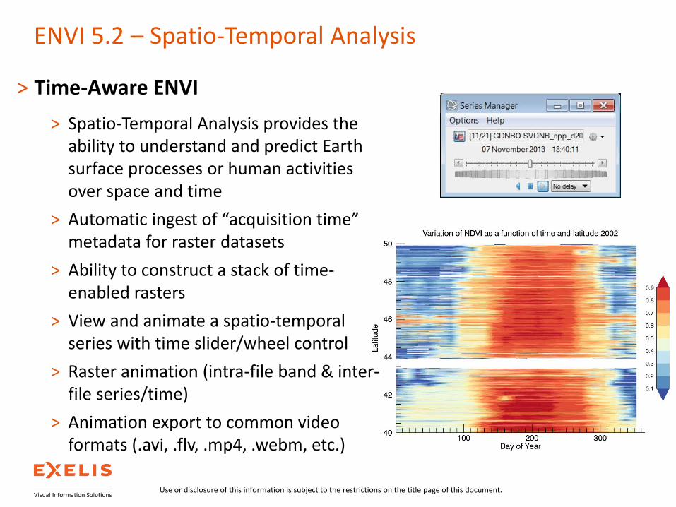
ENVI 5.2 – Spatio-Temporal Analysis
> Time-Aware ENVI
> Spatio-Temporal Analysis provides the ability to understand and predict Earth surface processes or human activities over space and time
> Automatic ingest of “acquisition time” metadata for raster datasets
> Ability to construct a stack of time-enabled rasters
> View and animate a spatio-temporal series with time slider/wheel control
> Raster animation (intra-file band & inter-file series/time)
> Animation export to common video formats (.avi, .flv, .mp4, .webm, etc.)
Use or disclosure of this information is subject to the restrictions on the title page of this document.

> Reference Map Link Using Esri Basemaps
> New “Chip View To” Options
> Geospatial PDF (user can specify Title, Author, Subject and Keywords)
> Google Earth
> Raster Color Slice Enhancements
> Faster tool launch speed and significant improvements to the overall performance when working with large images
> Display updates automatically while color slices are being modified
> Histogram plot improvements (tick marks & labels, ability to zoom in/out, cursor crosshair with value report)
ENVI 5.2 – Display Tools
Basemaps courtesy of Esri Powered by

> Completely new Feature Counting Tool
> New table display of features with ability to Sort and list with Color text
> Ability to turn Symbol, Label and Count on/off in the display
> User control of Feature plotting properties with many new symbols
> For georeferenced rasters geolocation is automatically gathered
> Time metadata and optional Description field for each Feature
> Feature Counting using a Grid option
> Ability to save/export features to ENVI Feature Counting, Shapefile and GDB
ENVI 5.2 – Interactive Analysis Tools
QuickBird image data courtesy of DigitalGlobe
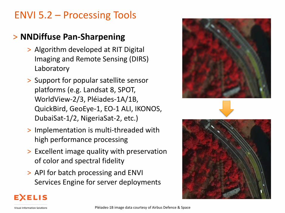
> NNDiffuse Pan-Sharpening
> Algorithm developed at RIT Digital Imaging and Remote Sensing (DIRS) Laboratory
> Support for popular satellite sensor platforms (e.g. Landsat 8, SPOT, WorldView-2/3, Pléiades-1A/1B, QuickBird, GeoEye-1, EO-1 ALI, IKONOS, DubaiSat-1/2, NigeriaSat-2, etc.)
> Implementation is multi-threaded with high performance processing
> Excellent image quality with preservation of color and spectral fidelity
> API for batch processing and ENVI Services Engine for server deployments
ENVI 5.2 – Processing Tools
Pléiades-1B image data courtesy of Airbus Defence & Space
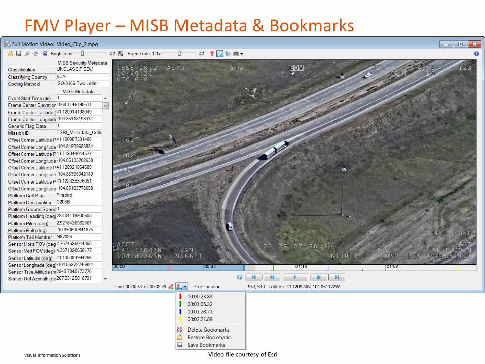
FMV Player – MISB Metadata & Bookmarks
Video file courtesy of Esri

ESE & EFASE 5.2
What’s New in ENVI Services Engine & ENVI for ArcGIS®
Services Edition

> ESETasks
> Automatic inclusion of ENVITasks as ESETasks provides out-of-the-box processing functionality
> Users can access all ENVITasks as an ESE endpoint
> Consult list of ESETasks on next slide
> NOTE: The processing capabilities of ENVI Services Engine is not limited to just the ESETasks
> Users can still access all ENVI library (e.g. Classic DOIT's) and custom user-defined IDL processing functionality using the methodology described in the Writing Tasks topic of the ESE documentation
ENVI Services Engine 5.2 – Analytics
Use or disclosure of this information is subject to the restrictions on the title page of this document.
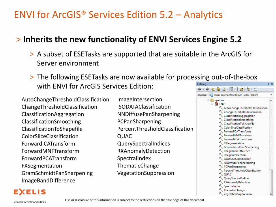
> Inherits the new functionality of ENVI Services Engine 5.2
> A subset of ESETasks are supported that are suitable in the ArcGIS for Server environment
> The following ESETasks are now available for processing out-of-the-box with ENVI for ArcGIS Services Edition:
ENVI for ArcGIS® Services Edition 5.2 – Analytics
AutoChangeThresholdClassification ChangeThresholdClassification ClassificationAggregation ClassificationSmoothing ClassificationToShapefile ColorSliceClassification ForwardICATransform ForwardMNFTransform ForwardPCATransform FXSegmentation GramSchmidtPanSharpening ImageBandDifference
ImageIntersection ISODATAClassification NNDiffusePanSharpening PCPanSharpening PercentThresholdClassification QUAC QuerySpectralIndices RXAnomalyDetection SpectralIndex ThematicChange VegetationSuppression
Use or disclosure of this information is subject to the restrictions on the title page of this document.

> Ability to ingest, host and serve LiDAR point clouds to a web-based 3D viewer
ENVI Services Engine 5.2 – ENVI 3D Web Viewer
Use or disclosure of this information is subject to the restrictions on the title page of this document.
SARscape 5.1

> Integration with ENVI 5.1
> New User Interfaces
> ENVI5 application look-and-feel
> Internationalization (i18n)
> Workflows
> Streamlining common tasks
> Preliminary support for Sentinel-1, ALOS PALSAR 2, Kompsat-5
> Stereo SAR DEM generation (“Radargrammetry”)
> Included in the InSAR module
> GPU Based (PS Kernel and Geocoding)
> Improving the speed to produce the final product
ENVI SARscape 5.1 – New Features
Use or disclosure of this information is subject to the restrictions on the title page of this document.

SAR workflows
> Guided procedures to generate standard products
> End-to-end
> Automatic handling of file names
> Simple collection of key parameters
> Forward – backward possibility

Available workflows
> Amplitude time series generation
> Coherence Change Detection
> Coherence RGB
> InSAR DEM
> TanDEM-X bistatic DEM
> Stereo DEM
> DInSAR displacement map
> Multi-Aperture Interferometry
> Amplitude tracking
Use or disclosure of this information is subject to the restrictions on the title page of this document.

Average displacement rate (color scale between -15 and +5 mm/year) of an area around the cities of Tokyo and Chiba, Japan, derived from ALOS PALSAR-1 data in the period 2006-2010. Whole area (left), a region of terrain compaction over landfill (center), uplift due to too much water injection after natural gas extraction (right).
Location time series of groups of terrain points in a same area showing different temporal behaviors, as obtained from Interferometric Stacking techniques . Points showing linear trends (left), and points with significant non-linearities (right); vertical scale in [mm].
Interferometric Stacking Module – SBAS
Use or disclosure of this information is subject to the restrictions on the title page of this document.

Jagwire™ Geospatial Data Management for the Enterprise
Exelis Proprietary | Use or disclosure of this information is subject to the restrictions on the Title Page of this document.
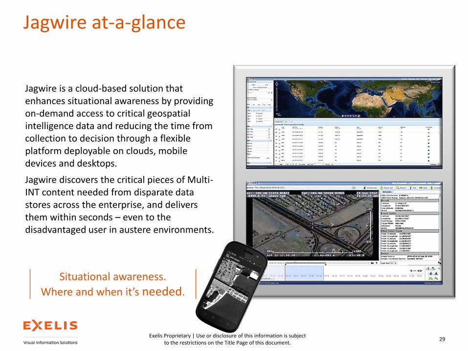
Jagwire at-a-glance
29
Jagwire is a cloud-based solution that enhances situational awareness by providing on-demand access to critical geospatial intelligence data and reducing the time from collection to decision through a flexible platform deployable on clouds, mobile devices and desktops.
Jagwire discovers the critical pieces of Multi-INT content needed from disparate data stores across the enterprise, and delivers them within seconds – even to the disadvantaged user in austere environments.
Situational awareness.
Where and when it’s needed.
Exelis Proprietary | Use or disclosure of this information is subject to the restrictions on the Title Page of this document.
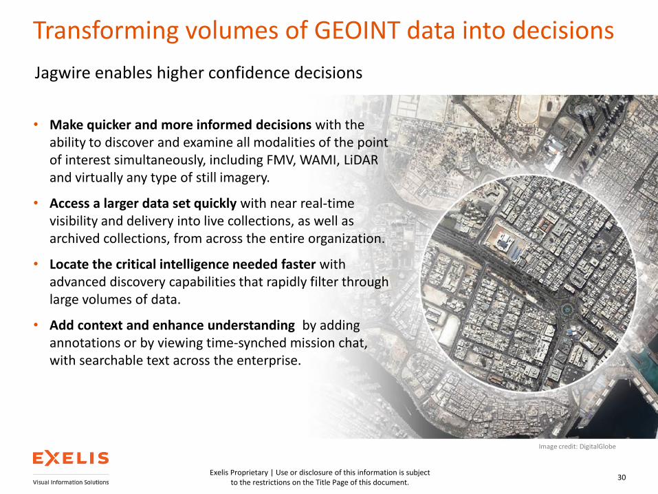
Transforming volumes of GEOINT data into decisions
30
• Make quicker and more informed decisions with the ability to discover and examine all modalities of the point of interest simultaneously, including FMV, WAMI, LiDAR and virtually any type of still imagery.
• Access a larger data set quickly with near real-time visibility and delivery into live collections, as well as archived collections, from across the entire organization.
• Locate the critical intelligence needed faster with advanced discovery capabilities that rapidly filter through large volumes of data.
• Add context and enhance understanding by adding annotations or by viewing time-synched mission chat, with searchable text across the enterprise.
Jagwire enables higher confidence decisions
Image credit: DigitalGlobe

Exelis Proprietary | Use or disclosure of this information is subject to the restrictions on the Title Page of this document.
Advanced analytics with ENVI integration
31
Enable higher confidence decisions through online, on-demand data analytics
Integrate the ENVI platform with Jagwire for the development and dissemination of
advanced intelligence products.
>Transform big data into the insights and intelligence needed to make more informed decisions with an end-to-end imagery solution by integrating the image analytics of the ENVI platform directly with Jagwire.
>Integration of Jagwire with the cloud-deployed analytical functionality of ENVI Services Engine brings data processing and analytics to where the data resides, allowing for complex and resource-intensive data analysis—at ingest or on-demand—on extremely large datasets from applications on thin or mobile clients.
>Examples of supported image analytics capabilities:
• Pan sharpening
• Change detection
• Land use classification

32
Questions?
Exelis Proprietary | Use or disclosure of this information is subject to the restrictions on the Title Page of this document.