preparedness through addresses in augmented reality - upu.int · preparedness through addresses in...
TRANSCRIPT
Preparedness through addresses in augmented reality Serena Coetzee and Victoria Rautenbach, Centre for Geoinformation Science (CGIS), Faculty
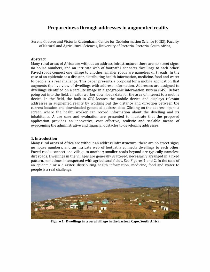
of Natural and Agricultural Sciences, University of Pretoria, Pretoria, South Africa, Abstract Many rural areas of Africa are without an address infrastructure: there are no street signs, no house numbers, and an intricate web of footpaths connects dwellings to each other. Paved roads connect one village to another; smaller roads are nameless dirt roads. In the case of an epidemic or a disaster, distributing health information, medicine, food and water to people is a real challenge. This paper presents a proposal for a mobile application that augments the live view of dwellings with address information. Addresses are assigned to dwellings identified on a satellite image in a geographic information system (GIS). Before going out into the field, a health worker downloads data for the area of interest to a mobile device. In the field, the built-in GPS locates the mobile device and displays relevant addresses in augmented reality by working out the distance and direction between the current location and downloaded geocoded address data. Clicking on the address opens a screen where the health worker can record information about the dwelling and its inhabitants. A use case and evaluation are presented to illustrate that the proposed application provides an innovative, cost effective, realistic and scalable means of overcoming the administrative and financial obstacles to developing addresses. 1. Introduction Many rural areas of Africa are without an address infrastructure: there are no street signs, no house numbers, and an intricate web of footpaths connects dwellings to each other. Paved roads connect one village to another; smaller roads beyond are typically nameless dirt roads. Dwellings in the villages are generally scattered, necessarily arranged in a fixed pattern, sometimes interspersed with agricultural fields. See Figures 1 and 2. In the case of an epidemic or a disaster, distributing health information, medicine, food and water to people is a real challenge.
Figure 1. Dwellings in a rural village in the Eastern Cape, South Africa

Figure 2. A rural village in the Eastern Cape, South Africa (Image from maps.google.com)
Today, the preparation of digital geocoded address data in a geographic information system (GIS) is a reasonably simple task. However, erecting and maintaining address signposts, such as street names and house numbers, takes time and is expensive. In addition, vandalism, theft and disasters may cause signposts to disappear. This paper presents a proposal for a mobile application that augments the live view of dwellings with geocoded address data, eliminating the need to erect signs in the physical world. See Figure 3. Incorporating the International Organization for Standardization (ISO) suite of addressing standards makes the application configurable for any addressing system.
Figure 3. An example of addresses in augmented reality
The mobile application is proposed in response to the following preparedness challenge described in the UPU addressing solution design challenge: ‘A contagious virus breaks out in a 100 km rural area with a population density of 125 people/km. In order to contain the spread of the disease, a UN agency needs spatial information (particularly physical addresses and maps) to distribute medicine, food and water to the people affected, inform the population of high-risk areas and set up a health centre in a safe location accessible to all major infection sites. This rural area has no address infrastructure, particularly street signage or property
78270
7938479382
72635
3625198273
74625
88270
58270
numbers, and households are connected only by an intricate web of footpaths. The only paved roads are main roads connecting villages and districts.’ (UPU 2014) The remainder of the paper is structured as follows: the methods and design are described in section 2; a use case, description of resources required and evaluation against the criteria specified in the UPU addressing solution design challenge are presented in section 3; followed by a concluding discussion in section 4. 2. Methods and design In augmented reality a live view of the real world is superimposed with computer-generated information, such as text or images. We propose to implement a mobile application in which a live view of dwellings in a rural village is superimposed with geocoded address information. Minimum requirements for the mobile device are a camera and built-in GPS. Both are increasingly included in smartphones today. In the field, the built-in GPS locates the mobile device. The mobile application works out the distance and direction between the current location and addresses in a specified radius around the current location. Relevant addresses are then displayed in the live view on the device.
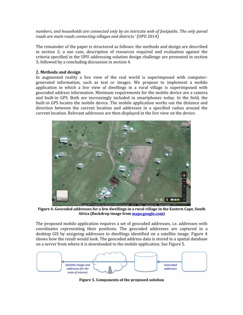
Figure 4. Geocoded addresses for a few dwellings in a rural village in the Eastern Cape, South
Africa (Backdrop image from maps.google.com)
The proposed mobile application requires a set of geocoded addresses, i.e. addresses with coordinates representing their positions. The geocoded addresses are captured in a desktop GIS by assigning addresses to dwellings identified on a satellite image. Figure 4 shows how the result would look. The geocoded address data is stored in a spatial database on a server from where it is downloaded to the mobile application. See Figure 5.
Figure 5. Components of the proposed solution
36523
36529
365273652636525
3652136522
36530
36528
36521
36531
36532 36533
36524
Spa aldatabase
DesktopGISMobileappSatelliteimageandaddressesfortheareaofinterest
Geocodedaddresses

The International Organization for Standardization (ISO) is currently developing ISO 19160-1, Addressing -- Part 1: Conceptual model. This standard provides the tools to describe an addressing system (called an ‘address reference system’ in the standard), i.e. how information is combined into an address. We propose to use ISO 19160-1 conformant descriptions of addressing systems, known as ISO 19160-1 profiles, to configure the mobile application; that is, the mobile application is scalable to be used with any addressing system for which an ISO 19160-1 profile is available. In future, one could consider adding ISO 19160-4, Addressing – Part 4: International postal address components and template languages, to specify how addresses are rendered in augmented reality. It is proposed that the mobile application be developed as open source so that it can be made available to other users under a Creative Commons Attribution-ShareAlike (CC BY-SA) license, i.e. others may remix, tweak, and build upon the work even for commercial purposes, as long as they credit the source and license their new creations under identical terms (www.creativecommons.org). 3. Results: use case and evaluation 3.1 Use case When the UN agency gets called in to contain the spread of the disease, a satellite image for the 100km2 area is purchased. Assuming an average of five people per dwelling (UN 2013), an estimated 2,500 dwellings appear on this image. These can be clearly identified on most satellite images. At the agency’s head office, one of the team members uses a desktop GIS, such as Quantum GIS or ArcGIS, to assign an address to each dwelling with the satellite image as backdrop. The geocoded address data is stored in a spatial database on a server, such as PostGIS or ArcSDE. The data on the server is accessible through the internet.
a) Augmented reality view with
a small radius b) Augmented reality view
with a larger radius c) Map view (Backdrop image
from maps.google.com)
Figure 6. Two views of the mobile application
72635
79382
74625
72635
79382
74625
98273 9827498272
43659
36252
Before going out into the field, a UN health worker downloads the satellite image and geocoded address data for the 100km2 rural area of interest to his/her smartphone. Downloading is typically done at a head office or main centre where sufficient internet bandwidth is available. In the field, the mobile application provides two views. In augmented reality view the address information is superimposed on the live view of the area visible through the camera. The user specifies a radius of relevance, i.e. addresses within the specified radius from the current location are included in the view. See Figure 6 a) and b). In map view, the current location and address information are displayed on ‘top’ of the satellite image. See Figure 6 c); the red dot indicates the current location. Tapping on the address in either view opens a screen where the health worker can record information about the dwelling at that address and its inhabitants. Should the rural community have access to appropriate smartphones, they could also use the addresses displayed in augmented reality. Regular use of these could lead to the acceptance of these addresses by the local community and authorities. Physical signage could then be installed so that the addresses become a permanent feature of the country’s addressing infrastructure. 3.2 Resources required for the use case This section provides a low and a high cost estimate for the resources required to implement the use case. In both scenarios, the smartphones comply with minimum requirements, i.e. built-in GPS, camera and other sensors, such as gyroscope. Open source software is used for address capturing and database hosting, and software development and usability testing is done by two Masters students, one in Computer Science and one in Geoinformatics Cost estimates are based on the following assumptions:
1. The population of the rural area is 12,500 (125 people/km2 in an area of 100km2).
2. Average household size is 5 (based on UN Demographic Yearbook).
3. 2,500 households in the rural area (12,500 / 5 = 2,500)
4. One dwelling per household, i.e. 2,500 households.
5. Addresses are captured at a rate of 30 per hour (a conservative estimate, it can probably be done faster).
6. Open source software, such as Quantum GIS and PostGIS, is used (i.e. no software licensing costs).
7. USD/ZAR exchange rate of 12.14 (www.oanda.com, 1 June 2015)
In the low cost scenario (Table 1), field workers use a bottom of the range smartphone on a one-year contract with 25GB data for internet use; imagery of reasonable quality is downloaded free of charge from USGS Earth Explorer, http://earthexplorer.usgs.gov. A single person at the head office captures addresses on a standard desktop PC at an hourly rate of an undergraduate student. The Web and database cloud hosting option provides limited bandwidth and basic functionality. Provision is made for six months of software development.
Table 1. Resources required: low cost scenario
Description Qty Unit cost
ZAR Unit cost
USD Sub-total
For each fieldworker:
Bottom of the range smartphone 1 R3,000.00 $247.12 $247.12
Data contract with mobile phone operator 1 R999.00 $82.29 $82.29
$329.41
Address capturing for an area of interest of 100km2:
Capturing addresses for 2,500 dwellings at a rate of 30/hour
83 R75.00 $6.18 $514.83
Satellite imagery 1 R0.00 $0.00 $0.00
Internet connection to download satellite imagery (60GB per year once-off)
1 R1,800.00 $148.27 $148.27
Standard desktop PC 1 R8,000.00 $658.98 $658.98
$1,322.08
Hosting:
Web and database cloud hosting cost ($50/month) 12 R607.00 $50.00 $600.00
$600.00
Software development (once-off):
Two Masters students for six months, assuming 167 working hours per month
2004 R90.00 $7.41 $14,856.67
$14,856.67
Table 2. Resources required: high cost scenario
Description Qty Unit cost
ZAR Unit cost
USD Sub-total
For each fieldworker:
Top of the range smartphone 1 R15,000.00 $1,235.58 $1,235.58
Data contract with mobile phone operator 1 R7,200.00 $593.08 $593.08
$1,828.67
Address capturing for an area of interest of 100km2:
Capturing addresses for 2,500 dwellings at a rate of 30/hour
83 R90.00 $7.41 $617.79
Satellite imagery 1 R10,000.00 $823.72 $823.72
Internet connection to download satellite imagery (60GB per year once-off)
1 R1,800.00 $148.27 $148.27
Desktop PC with additional RAM and a fast graphics card
2 R18,000.00 $1,482.70 $2,965.40
$4,555.19
Hosting:
Web and database cloud hosting cost ($50/month) 12 R1,821.00 $150.00 $1,800.00
$9,468.86
Software development (once-off):
Two Masters students for 18 months, assuming 167 working hours per month
6012 R90.00 $7.41 $44,570.02
$44,570.02

In the high cost scenario (Table 2), field workers use a top of the range mobile phone on a one-year contract with 128GB data for internet use; satellite imagery is procured from a private vendor. Two people at the head office capture addresses at the hourly rate of a postgraduate student; each has a desktop PC with additional RAM and a fast graphics card. The Web and database cloud hosting option provides more bandwidth and functionality (than the low cost option). Provision is made for 18 months of software development, allowing for the implementation of advanced functionality, as well as for more usability testing. 3.3 Evaluation The design challenge calls for a solution that enables all delivery points (household entrances, dwellings) in the proposed challenge area to be identified and enumerated as part of an address infrastructure (street network). In addition, the solution should be innovative, cost-effective, realistic and scalable. In the preparedness challenge, the dwellings are the delivery points. In the proposed solution, each dwelling is identified on the satellite imagery and each identified dwelling is enumerated by an address. Connectivity and limitations of different sensors in mobile phones impact the precision of address visualization in augmented reality. The exact impact needs to be assessed, but it is expected that the precision will be acceptable in rural areas were dwellings are typically far apart from each other. The proposed solution therefore meets the first criterion specified in the challenge. The solution proposed in this paper is innovative. There are many examples of augmented reality applications that display information about routes, buildings and points of interest, such as addresses and website (Azuma 1997; Van Krevelen and Poelman 2010). However, to our knowledge augmented reality has not yet been used in unaddressed areas. The proposed solution cost-effectively fast tracks address assignment by avoiding time consuming and costly procurement and installation of physical address signage. While there is an initial software development cost, once the software is available, subsequent capturing and use of geocoded address data does not require a significant time or cost investment. In this paper, it was proposed to develop software from scratch. Alternatively, one could make use of existing augmented reality and mapping toolkits, but there are some caveats: some toolkits require connectivity (i.e. they cannot be used in rural environments where connectivity is not guaranteed), while the business model of others is built around data hosting charges. Data hosting (and replication) is important if data needs to be accessed from many different locations. In the preparedness challenge this is not relevant, as data is downloaded once at a main centre. The solution proposed in this paper is realistic and practical because it makes use of off-the-shelf devices, satellite imagery and desktop GIS software. In the case of a disaster or health concern, the address infrastructure can be deployed almost immediately. While the initial software development of the mobile application comes at a cost, repeatedly using the solution does not impose significant additional financial constraints. The proposed solution can be scaled from ‘virtual’ addresses in augmented reality to physical addresses once physical signage has been installed. The solution can also be scaled up to work with any addressing system described as an ISO 19160-1 profile. This makes the solution sensitive to the cultural needs of the community (because it can be used with any

addressing system described in an ISO 19160-1 profile). A potential addressing system for the preparedness challenge is the rural address type described in the South African addressing standard (SANS 1883-1:2009). Such addresses are not referenced to a named thoroughfare and thus accommodate the situation in rural villages where dwellings are generally scattered, not arranged in a fixed pattern, interconnected by footpaths, sometimes interspersed with agricultural fields, and where there are no street names. 4. Discussion The mobile application described in this paper can assist UN health workers to distribute health information, medicine, food and water to individual dwellings and record information about inhabitants of the dwellings. To contain the spread of a contagious disease, immediate response is of the utmost importance. With the proposed solution there is no need to procure and install any physical address signage for house numbers, street names, etc. The solution can be used as soon as the satellite imagery and geocoded address data are available. If the local community and authorities also start using the addresses in augmented reality, the addresses could become widely accepted and could later be confirmed with physical signage. A prototype of the proposed mobile application is currently being designed at the University of Pretoria. The City of Tshwane Metropolitan Municipality (municipality of the capital of South Africa), Statistics South Africa (responsible for the Census in South Africa) and the South African Post Office have expressed their willingness to collaborate on an evaluation of using addresses in augmented reality in various applications, such as disaster management (when signs have been destroyed by a fire or flood); emergency response (locating a dwelling in an informal settlement); billing (hand delivery of invoices); data quality improvement (validation digital address data against addresses displayed in the physical world); and family medicine (visits by health workers in informal settlements). In this paper, a use case related to the preparedness challenge is described. However, the proposed solution could also be applied to other challenges, such as the urban challenge (addresses in augmented reality can be used to locate government services and infrastructure) or the postal challenge (addresses in augmented reality can be used to locate mail delivery points). A major advantage of the proposed solution is that it circumvents timely procurement processes for the installation of address signage. Nevertheless, if necessary or desirable, it can be allowed to evolve into a ‘proper’ physical address infrastructure over time. We live in a rapidly urbanizing world, resulting in unaddressed informal settlements with urban, social and sustainable development challenges. Appropriately managed urbanization is required to ensure sustainable development, i.e. development that meets the needs of the present without compromising the ability of future generations to meet their own needs (Brundtland 1987). Despite the potential benefits of addresses, many countries worldwide still lack a countrywide address infrastructure (UPU 2014). With the increasing ubiquity of mobile smartphones, addresses in augmented reality present an opportunity to fast track address infrastructures in the many unaddressed areas of the world. References Azuma RT (1997), A survey of augmented reality. Presence 6(4): 355-385.

Brundtland GH (1987). Our common future: Report of the 1987 World Commission on Environment and Development. Tokyo, Japan.
Coetzee S & Cooper AK (2007) What is an address in South Africa? South African Journal of Science, 103: 449 - 458.
SANS 1883-1:2009, Geographic information – Addresses Part 1: Data format of addresses, South African Bureau of Standards.
ISO/DIS 19160-1, Addressing – Part 1: Conceptual model (draft), International Organization for Standardization, Geneva, Switzerland.
ISO/CD 19160-4, Addressing – Part 4: International postal address components and template languages (draft), International Organization for Standardization, Geneva, Switzerland.
Universal Postal Union (UPU) (2014). Addressing design challenge: Call for papers. Available online at http://www.upu.int/en/activities/addressing/call-for-papers/rules-and-guidelines.html [accessed 3 June 2015].
United Nations (UN) (2013). United Nations Demographic Yearbook. Available online at http://unstats.un.org/unsd/demographic/products/dyb/dyb2.htm [accessed 3 June 2015].
Van Krevelen DWF and Poelman R (2010). A survey of augmented reality technologies, applications and limitations. The International Journal of Virtual Reality, 9(2):1-10.