preliminary drainage strategy report - shepherds...
TRANSCRIPT


.
Page i
CONTENTS Page
1. INTRODUCTION ......................................................................................................................1 1.1. General.............................................................................................................................1 1.2. Scope of Report ................................................................................................................1
2. SITE CONTEXT........................................................................................................................2 2.1. Existing site.......................................................................................................................2 2.2. Existing infrastructure........................................................................................................2 2.3. Existing drainage regime...................................................................................................2
3. DRAINAGE DESIGN DEVELOPMENT.....................................................................................2 3.1. Surface water....................................................................................................................2 3.2. Foul water .........................................................................................................................3
4. DRAINAGE PROPOSALS........................................................................................................5 4.1. General.............................................................................................................................5 4.2. Surface water....................................................................................................................5 4.3. Foul water .........................................................................................................................6 4.4. Contamination...................................................................................................................6
5. CONCLUSIONS .......................................................................................................................7 5.1. Surface Water ...................................................................................................................7 5.2. Foul Water ........................................................................................................................7
FIGURE 1 - LOCATION PLAN. ...................................................................................................... 8 FIGURE 2 - INDICATIVE DRAINAGE LAYOUT.............................................................................. 9 APPENDIX A. – TRIAL PIT LOGS AND SI REPORT EXTRACTS................................................. 10 APPENDIX B. – SOUTHERN WATER CAPACITY CHECK........................................................... 11 APPENDIX C. – EA PREAPPLICATION RESPONSE ................................................................... 12 APPENDIX D. – CALCULATION OF GREENFIELD RUN-OFF RATES ........................................ 13 APPENDIX E. – CONSULTATION WITH EA REGARDING AGREED RUN-OFF RATES.............. 14 APPENDIX F. – MICRODRAINAGE CALCULATIONS FOR SURFACE WATER ATTENUATION 15

Preliminary Drainage Strategy Report Page 1
Land at Shepherd’s Spring School
1. INTRODUCTION 1.1. General
1.1.1. Engineering Consultancy (EC) have been commissioned by Hampshire County Council Property Services (HCCPS) to prepare a Drainage Strategy Report for the redevelopment of a parcel of surplus land adjacent to Spring Meadow Children’s Centre.
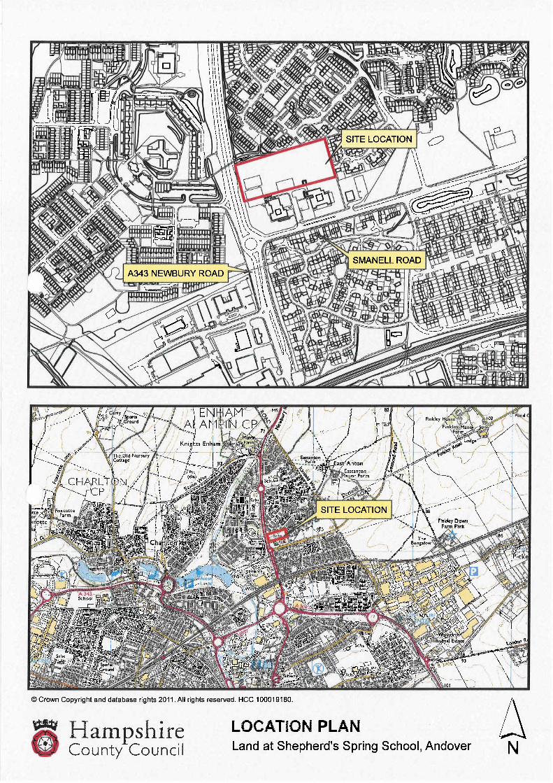
1.1.2. The Area of land under consideration is referenced on the Location Plan in Figure 1 of this report.
1.1.3. This report has been prepared to support the outline planning application for the redevelopment of the site for residential uses.
1.2. Scope of Report
1.2.1. This report outlines the drainage proposals for the development site with regards to surface water and foul water flows generated by the proposed the development.
1.2.2. This document considers the following:
Existing drainage regime for the site;
Drainage design options considered for the site;
Design parameters and considerations;
The outline drainage strategy for the site;
1.2.3. This document has been prepared based on the following information:
Site Visits;
Preliminary FRA prepared by Engineering Consultancy;
Ground Investigation Report no. LW21195 prepared by Ashdown Site Investigation Limited.
Correspondence with Southern Water.

Preliminary Drainage Strategy Report Page 2
Land at Shepherd’s Spring School
2. SITE CONTEXT 2.1. Existing site
2.1.1. The proposed development site is located to the rear of Spring Meadow Children’s Centre off of Smanell Road to the north east of Andover at approximately National Grid Reference 436657E, 147150N. A location plan is included as Figure 1.
2.1.2. The development site covers an area of 1.43ha and is bound to the north and east by well established residential housing developments. To the south by Spring Meadow Children’s Centre and Andover Education Centre and the A343 Newbury Road forms the western boundary.
2.1.3. Re-development of Shepherd’s Spring Infant and Junior schools, now the Children’s and Andover Education Centres respectively, led to the land which was formerly used for playing fields becoming surplus.
2.1.4. The existing impermeable area of the site is 0.18ha comprising mainly of hardstanding areas and playgrounds. The remaining area of the site is permeable and is mainly laid to grass with some mature trees around the site perimeter.
2.1.5. The topography of the existing site is relatively flat and level with a slope from the north west corner to the south east corner with an approximate gradient of 3%.
2.2. Existing infrastructure
2.2.1. Public sewer records received from Southern Water indicate that there are possible connections points for the foul to the north and east of the proposed site however due to the existing fall of the ground towards the south a connection at these points would prove impractical.
2.2.2. Records indicate there are no surface water sewers within the existing residential areas to the north and east of the site. There are however public surface water sewers to the south which are located within the later Swallowfields development.
2.3. Existing drainage regime
2.3.1. Surface Water run off from the existing impermeable areas currently drains into the drainage system of the two former school buildings which ultimately discharges to ground via soakaways. Original record drawings indicated that the soakaways were fitted with an overflow connected to a private 150mm dia surface water sewer which ran in an easterly direction along Smanell Road. Subsequent CCTV surveys and investigations failed to find evidence of this however.
2.3.2. The existing foul flows from both buildings connect to a private 150mm dia. foul sewer which runs in an easterly direction along Smanell Road before connecting into the public foul sewer at manhole ref. 8102. This sewer also serves the adjacent St Paul’s Church Centre. This pipe is known to be of pitch fibre construction and has suffered with blockages in the recent past. CCTV survey footage confirms that the pipe is blistered and is in poor condition.
3. DRAINAGE DESIGN DEVELOPMENT 3.1. Surface water
3.1.1. The discharge of surface water is generally preferable at source where possible. Where this is not possible flows should be attenuated on site and in the case of greenfield sites discharged at or near greenfield rates to a nearby watercourse or if not available, a public surface water sewer.

Preliminary Drainage Strategy Report Page 3
Land at Shepherd’s Spring School
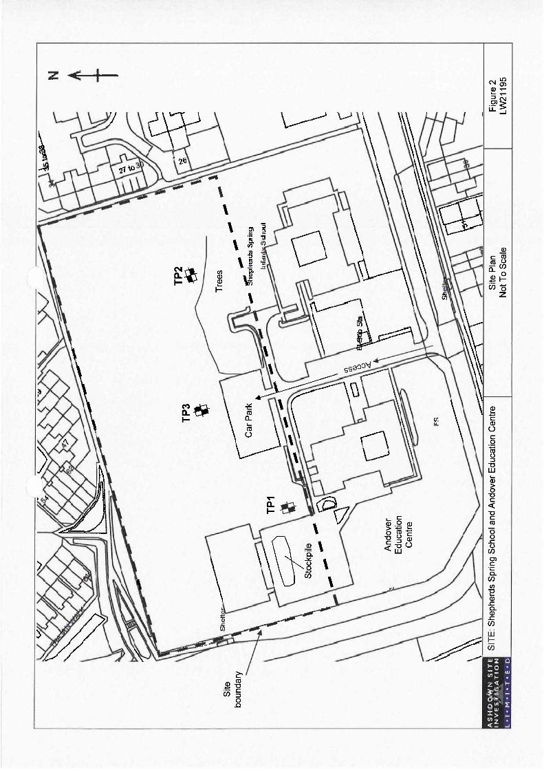
3.1.2. Ashford Site Investigation Limited carried out a site investigation and reference should be made to their report no. LW21195. Their site investigation included soakaway testing however, the results summarised below as table 1, proved that ground conditions were not suitable for infiltration therefore soakaways were not a viable option at this site.
Table 1 – Soil Infiltration Results
Trial Pit Ref. Derived Infiltration Rate
TP1 1.4 x 10⁻⁶ m/s
TP2 3.4 x 10⁻⁶ m/s
TP3 3.3 x 10⁻⁶ m/s
3.1.3. Although capable of some infiltration the rates proved to be too low to rely on infiltration alone. Therefore a mix of infiltration and attenuation prior to discharging to the public sewer system is proposed.
3.1.4. A copy of the trial pit logs and extracts from the site investigation report are included as Appendix A.
3.1.5. Southern Water were consulted on the possibility of indentifying a suitable connection point within close proximity of the site however their report (Appendix B) concluded that there was no viable solution for connection to the public sewer system. Accordingly, it was agreed that the only alternative was to discharge directly into Shepherd’s Spring drain at the junction of Smanell Road and Cricketer’s Way.
3.1.6. The Environment Agency (EA) had been consulted at pre-planning stage and it was their view that as the site had no significant prior construction then any surface water discharge from the site should be limited to greenfield run off rates. A copy of the EA response is included in Appendix C.
3.1.7. Greenfield run off rates for the site were calculated using Microdrainage Windes software using the ICP1 Suds methodology. This method is currently favoured for small development sites with an area less than 50ha. A copy of the results are included as Appendix D.
3.1.8. The resultant run off rates were extremely low which resulting in large amounts of attenuation. Half drain times also exceeded the maximum of 24 hrs as recommended by current building regulations.
3.1.9. Vortex flow control devices are to be used to restrict the offsite discharge to the agreed limits. Designs using the greenfield run off rates resulted in orifice sizes of 56mm. It was felt this would be prone to blockages. The orifice size was therefore increased to 75mm thus giving an equivalent discharge rate of 5 l/s. The increased rate was agreed with Rob Sheehan of the EA and was used as the basis for the preliminary design and storage sizing. Refer to the correspondence with the EA included as Appendix E.
3.2. Foul water
3.2.1. Capacity checks carried out by Southern Water established that there was sufficient capacity within the local public foul sewer network at manhole 8101 to receive the additional 2.3 l/s produced by the proposed development.
1 Interim Code of Practice for Sustainable Drainage Systems – CIRIA July 2004

Preliminary Drainage Strategy Report Page 4
Land at Shepherd’s Spring School
3.2.2. Referring to section 2.3.2 the existing foul flows from both the existing buildings discharge to a 150mm dia. private sewer running eastwards along Smanell Road. The pipe will need to be replaced in order to bring it up to adoptable standards. Flows from the school and the adjacent church centre will also be connected into the new sewer.

Preliminary Drainage Strategy Report Page 5
Land at Shepherd’s Spring School
4. DRAINAGE PROPOSALS 4.1. General
4.1.1. To support the outline planning application for the redevelopment of the site it is proposed to discharge the surface water at a restricted rate offsite, via attenuation tanks, to the Shepherds Spring Drain located to the east of the development site at the junction of Smanell Road and Cricketer’s Way.
4.1.2. An adoptable gravity system is proposed for the discharge of the foul water from the site into the local public sewer network.
4.2. Surface water
4.2.1. The site covers an area of 1.43ha of which 0.18 ha are impermeable with the remainder laid to grass. The proposed development of 50 units will increase the impermeable area to 0.63 ha or 44% of the site area including estate roads, footways and driveways.
4.2.2. The agreed rate of 5 l/s was used in the subsequent calculations to size the underground attenuation. Microdrainage Windes software was again used to calculate the storage volumes for the 1 in 30 year and the 1 in 100 year return + 30% periods. Refer to appendix F. A summary of the results are shown in Table 2 below.
Table 2 – Summary of storage volumes
Return Period Storage Volume (m3) Resultant Tank Size
(L x W x D)
1 in 30 year 223.6 15m x 8m x 2m
1 in 100 year + 30% for climate change 404.3 22m x 10m x 2m
4.2.3.
4.2.4. Sewers for Adoption 6th Edition (SFA) requires that storage should be provided up to the 1 in 30 year event and that beyond this the network is allowed to surcharge or flood for short periods of time. Any flooding is to be routed away from properties but should be contained within the site boundary. Traditionally storage for the excess surface water run off would be provided above ground in the form of dry detention basins or swales.
4.2.5. The currently proposed layout however has limited space for above ground storage features so it is therefore proposed to provide underground attenuation for the 1 in 100 year + 30% storm event.
4.2.6. A new surface water sewer will be provided beneath the existing school access road and will then run in an easterly direction along Smanell Road where it will discharge into the Shepherds Spring drain.
4.2.7. Surface water will discharge from the attenuation tanks at a rate of 5 l/s as agreed with the EA.
4.2.8. Flow control is to be achieved using a Hydrobrake or equivalent proprietary vortex flow control device.

Preliminary Drainage Strategy Report Page 6
Land at Shepherd’s Spring School
4.3. Foul water
4.3.1. The 150mm dia private foul sewer will be replaced with a new foul sewer suitably designed to adoptable standards. All foul water flows from the development will be discharged via an adoptable gravity system into the new sewer laid in the existing school access road. The new foul sewer shall be sized to take foul water flows from the new development but also collect foul flows from the existing school buildings and the adjacent church and church hall.
4.3.2. The new foul sewer will connect into the existing public sewer system at a new connection just downstream of manhole ref. 8101.
4.3.3. Southern Water have confirmed that there is sufficient capacity within the existing network at manhole 8102 to take the additional 2.3 l/s foul discharge generated by the proposed development. Foul flows from the existing school buildings and the church are assumed to remain as existing.
4.4. Contamination
4.4.1. A full Phase 1 and Phase 2 contamination assessment of the Site was beyond the brief of the soil investigation, however limited contamination testing was undertaken on selected samples.
4.4.2. Two soil samples were tested for a range of commonly occurring contaminants. The levels of contaminants determined are not considered to be significantly elevated and do not exceed typical residential Soil Screen Values and Generic Assessment Criteria.
4.4.3. The Site lies within an EA Groundwater Source Protection Zone I (Inner Source Protection Zone) for the Smanell Road abstraction and the Andover Public Water Supply. All precautions must be taken to prevent pollutants from entering the groundwater underlying the site to protect potable water supplies.
4.4.4. It is proposed that private driveways and car parking areas could utilise porous paving and underground storage to reduce the size of the attenuation tanks. Due to low infiltration rates it is likely that the overflow from the attenuated surface water run-off will have to be connected into the adopted drainage system. Adequate pollution prevention measures will therefore need to be incorporated in to the final drainage design. The risks of using infiltration should be assessed and agreed with the EA.
Preliminary Drainage Strategy Report Page 7
Land at Shepherd’s Spring School
5. CONCLUSIONS 5.1. Surface Water
5.1.1. The offsite run off rate has been agreed with the EA as 5 l/s
5.1.2. Surface water flows are to be conveyed to on site attenuation tanks located within the public open space via an adoptable gravity drainage system.
5.1.3. Attenuation tanks have been sized to store up to and including the 1 in 100 year + 30% for climate change event . The storage volume can be reduced to the 1 in 30 year event if the development layout is revised to allow the storage or safe routing of flows in excess of the 1 in 30 year event.
5.1.4. A new adoptable sewer is to be laid in the school access road which is then to run eastwards along Smanell Road before discharging into Shepherds Spring Drain at a point just downstream of the existing culvert headwall.
5.1.5. A consent to discharge approval from the EA will be required.
5.2. Foul Water
5.2.1. An adoptable gravity drainage system is to be utilised to discharge the foul water flows into the public foul sewer.
5.2.2. The proposed development will produce an estimated 2.3 l/s additional foul water discharge.
5.2.3. The existing 150mm private foul sewer located in Smanell Road, which currently serves both the existing school buildings and the adjacent church, is to be abandoned. Foul flows from the existing school buildings and the church are to be re-directed into the new foul sewer and allowance must be made for this in the final design.
5.2.4. A new connection is to be made to the existing 300mm dia foul sewer located at the junction of Cricketer’s Way and Smanell Road just downstream of manhole ref. 8101. Records indicate the invert level of this manhole to be 64.07m therefore a gravity connection should be achievable.

Preliminary Drainage Strategy Report Page 8
Land at Shepherd’s Spring School
FIGURE 1 - LOCATION PLAN.

Preliminary Drainage Strategy Report Page 9
Land at Shepherd’s Spring School
FIGURE 2 - INDICATIVE DRAINAGE LAYOUT.


Preliminary Drainage Strategy Report Page 10
Land at Shepherd’s Spring School
APPENDIX A. – TRIAL PIT LOGS AND SI REPORT EXTRACTS


Preliminary Drainage Strategy Report Page 11
Land at Shepherd’s Spring School
APPENDIX B.– SOUTHERN WATER CAPACITY CHECK


Preliminary Drainage Strategy Report Page 12
Land at Shepherd’s Spring School
APPENDIX C. – EA PREAPPLICATION RESPONSE


Preliminary Drainage Strategy Report Page 13
Land at Shepherd’s Spring School
APPENDIX D. – CALCULATION OF GREENFIELD RUN-OFF RATES


Preliminary Drainage Strategy Report Page 14
Land at Shepherd’s Spring School
APPENDIX E. – CONSULTATION WITH EA REGARDING AGREED RUN-OFF RATES


Preliminary Drainage Strategy Report Page 15
Land at Shepherd’s Spring School
APPENDIX F. – MICRODRAINAGE CALCULATIONS FOR SURFACE WATER ATTENUATION


