preliminary assessment of environmental damages induced by the
TRANSCRIPT
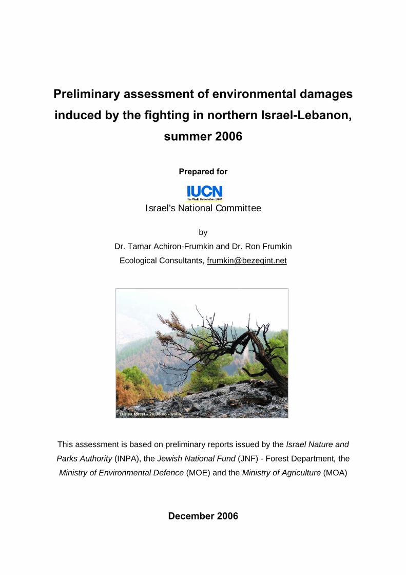
Preliminary assessment of environmental damages induced by the fighting in northern Israel-Lebanon,
summer 2006
Prepared for
Israel’s National Committee
by
Dr. Tamar Achiron-Frumkin and Dr. Ron Frumkin
Ecological Consultants, [email protected]
This assessment is based on preliminary reports issued by the Israel Nature and
Parks Authority (INPA), the Jewish National Fund (JNF) - Forest Department, the
Ministry of Environmental Defence (MOE) and the Ministry of Agriculture (MOA)
December 2006
- - 2
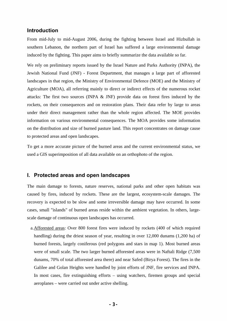
Table of Contents: Introduction ....................................................................................................... 3 I. Protected areas and open landscapes ................................................. 3 II. Materials and solid waste ............................................................... 11 III. Effluents and water sources ........................................................... 11 IV. Other hazardous materials ............................................................. 12 V. Pets and husbandry ...................................................................... 12 Regeneration of damaged areas and rehabilitation plans................................ 12 Conclusions..................................................................................................... 15 Acknowledgements ......................................................................................... 16
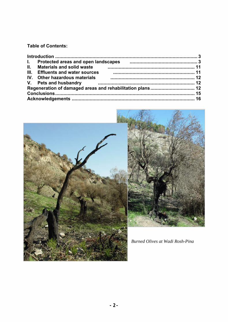
Burned Olives at Wadi Rosh-Pina
- - 3
Introduction From mid-July to mid-August 2006, during the fighting between Israel and Hizbullah in
southern Lebanon, the northern part of Israel has suffered a large environmental damage
induced by the fighting. This paper aims to briefly summarize the data available so far.
We rely on preliminary reports issued by the Israel Nature and Parks Authority (INPA), the
Jewish National Fund (JNF) - Forest Department, that manages a large part of afforested
landscapes in that region, the Ministry of Environmental Defence (MOE) and the Ministry of
Agriculture (MOA), all referring mainly to direct or indirect effects of the numerous rocket
attacks: The first two sources (INPA & JNF) provide data on forest fires induced by the
rockets, on their consequences and on restoration plans. Their data refer by large to areas
under their direct management rather than the whole region affected. The MOE provides
information on various environmental consequences. The MOA provides some information
on the distribution and size of burned pasture land. This report concentrates on damage cause
to protected areas and open landscapes.
To get a more accurate picture of the burned areas and the current environmental status, we
used a GIS superimposition of all data available on an orthophoto of the region.
I. Protected areas and open landscapes
The main damage to forests, nature reserves, national parks and other open habitats was
caused by fires, induced by rockets. These are the largest, ecosystem-scale damages. The
recovery is expected to be slow and some irreversible damage may have occurred. In some
cases, small "islands" of burned areas reside within the ambient vegetation. In others, large-
scale damage of continuous open landscapes has occurred.
a. Afforested areas: Over 800 forest fires were induced by rockets (400 of which required
handling) during the driest season of year, resulting in over 12,000 dunams (1,200 ha) of
burned forests, largely coniferous (red polygons and stars in map 1). Most burned areas
were of small scale. The two larger burned afforested areas were in Naftali Ridge (7,500
dunams, 70% of total afforested area there) and near Safed (Birya Forest). The fires in the
Galilee and Golan Heights were handled by joint efforts of JNF, fire services and INPA.
In most cases, fire extinguishing efforts – using watchers, firemen groups and special
aeroplanes – were carried out under active shelling.
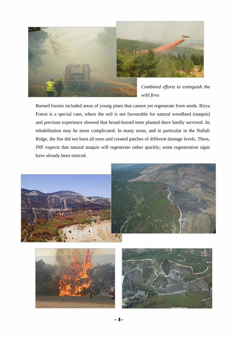
- - 4
Combined efforts to extinguish the
wild fires
Burned forests included areas of young pines that cannot yet regenerate from seeds. Birya
Forest is a special case, where the soil is not favourable for natural woodland (maquis)
and previous experience showed that broad-leaved trees planted there hardly survived. Its
rehabilitation may be more complicated. In many areas, and in particular in the Naftali
Ridge, the fire did not burn all trees and created patches of different damage levels. There,
JNF expects that natural maquis will regenerate rather quickly; some regeneration signs
have already been noticed.

- - 5
b. Nature reserves and open landscapes: Some 66,000 dunams (6,600 ha) of nature reserves
and national parks, and of open landscapes proposed for conservation as nature reserves,
were burned. INPA estimates that some 8,500 dunams were burned in the upper Galilee,
2,000 dunams in the lower Galilee and 56,000 dunams in the Golan Heights. The largest
habitat type affected was open landscapes with herbaceous vegetation (herbaceous batha)
in the Golan Heights, most of which proposed as nature reserves, where 54,000 dunams
were burned. Of the above quoted total area, some 5,500 dunams in the Golan Heights,
9,000 dunams in the upper Galilee and 500 dunams in the lower Galilee were within
existing nature reserves and national parks (brown polygons in map 1).
c. Pasture land: The MOA reports on a total of 71,300 dunams of burned pasture land:
31,000 dunams – in northern Golan Heights, 14,000 dunams – in central and southern
Golan Heights, and 25,400 dunams - in eastern Galilee (orange polygons in map 1). The
reported areas were roughly sketched, and it is not clear to what extent these areas overlap
the above mentioned burned landscapes, yet it seems the overlap is quite large in the
Golan Heights.
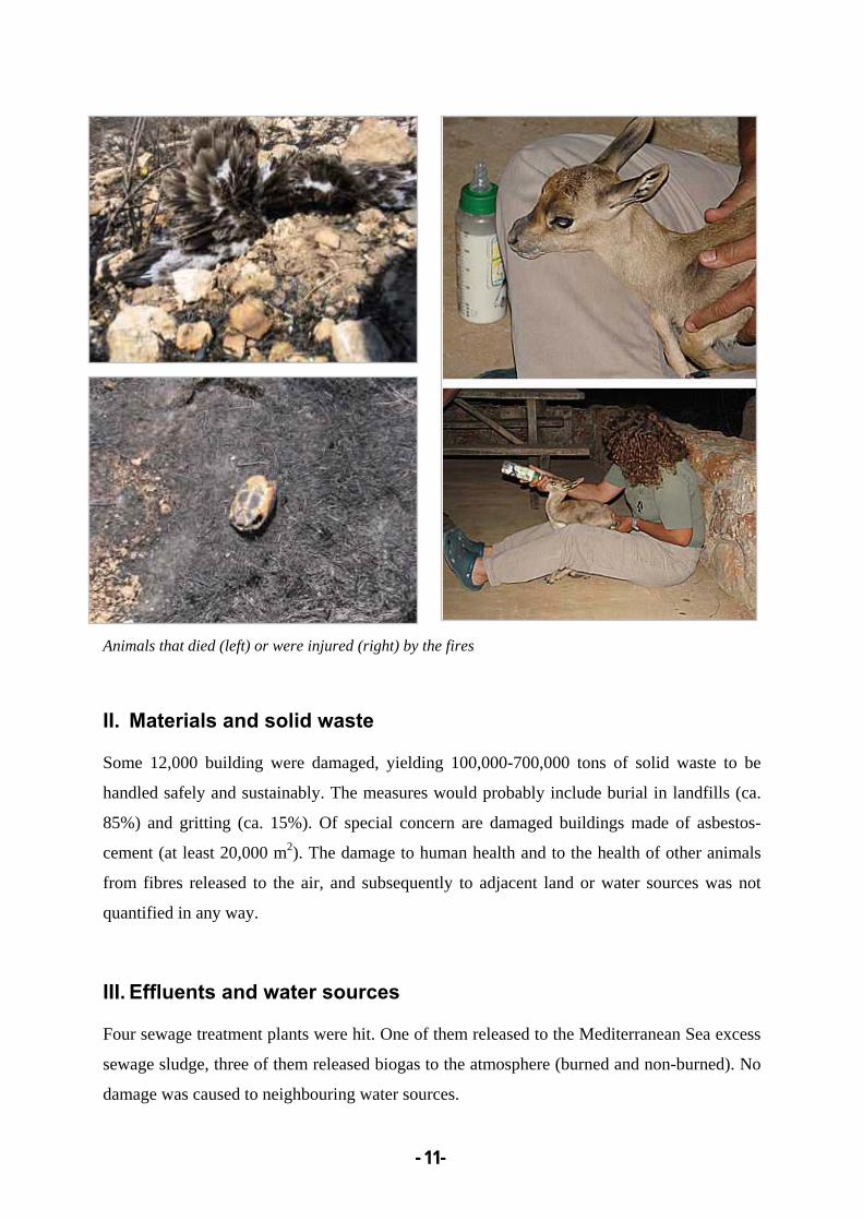
A large variety of animals were affected – invertebrates and many terrestrial vertebrates were
injured, predominantly reptiles, birds (mainly non-fledged juveniles) and mammals (mainly
juveniles).
In addition to wild fires, a small but highly sensitive area within Manara Orchid Nature
Reserve was destroyed by Israeli army vehicle movement and by trench digging. Trees in a
nature reserve were cut to reduce fire risk to human settlements. Another ecological resulting
problem arises where animals, such as gazelles, having fled from a burned area, try to feed in
other areas: they are either adversely approached by the current inhabitants – whether other
groups or individuals, or damage adjacent agricultural land.
As mentioned above, other open landscapes and agricultural areas such as groves and
vineyards were also damaged. No quantitative assessment is yet available. Some pest
management schemes were halted, especially against Mediterranean fruit fly.
- - 6
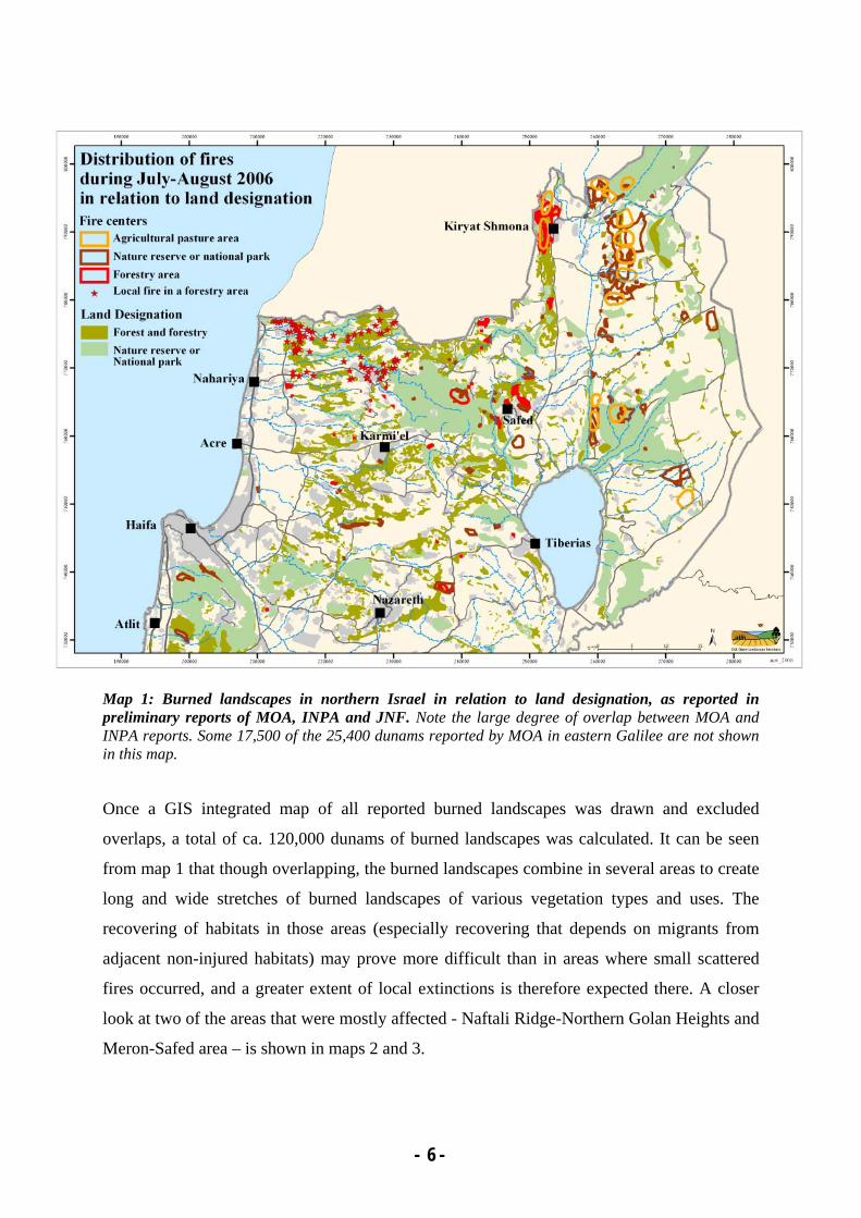
Map 1: Burned landscapes in northern Israel in relation to land designation, as reported in preliminary reports of MOA, INPA and JNF. Note the large degree of overlap between MOA and INPA reports. Some 17,500 of the 25,400 dunams reported by MOA in eastern Galilee are not shown in this map.
Once a GIS integrated map of all reported burned landscapes was drawn and excluded
overlaps, a total of ca. 120,000 dunams of burned landscapes was calculated. It can be seen
from map 1 that though overlapping, the burned landscapes combine in several areas to create
long and wide stretches of burned landscapes of various vegetation types and uses. The
recovering of habitats in those areas (especially recovering that depends on migrants from
adjacent non-injured habitats) may prove more difficult than in areas where small scattered
fires occurred, and a greater extent of local extinctions is therefore expected there. A closer
look at two of the areas that were mostly affected - Naftali Ridge-Northern Golan Heights and
Meron-Safed area – is shown in maps 2 and 3.

- - 7
Map2: Burned landscapes in the Naftali Ridge-Northern Golan Heights area.
Map 2 shows that in the Golan Heights the longest burned stretch is about 15km long, making
it a possible temporary longitudinal barrier to ecological connectivity between similar
habitats. It comprised mainly of grassland, sometimes encircling river banks. It is important

- - 8
to note that these landscapes are fire-prone, and are shaped by repeated (nearly annual) fires,
that are usually much more restricted in scope. The large scope of this summer's fires may
lead to a more severe damage to the seed bank; this may yet be aggravated by the early
germination this autumn that was followed by a long period without rain, which may have
caused many of the new seedlings to dry-out.
Another 9km burned stretch is found west to Kiryat-Shmona. It is composed of mixed habitat
types, from grassland all the way through to natural woodlands and large afforested areas.
Map 3 shows the Meron-Safed area. A large area within a nature reserve in Meron was
damaged. The Birya Forest north-east of Safed was greatly damaged and, as above
mentioned, its soil may not allow easy natural recovery. Local extinctions of animals are
expected there as well, particularly in wet habitats.
Map 3: Burned landscapes in the Meron-Safed area.
- - 9
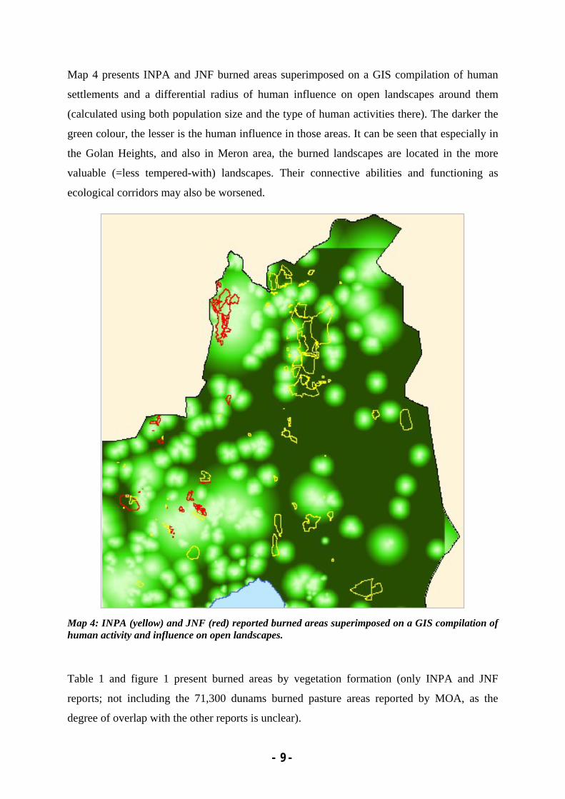
Map 4 presents INPA and JNF burned areas superimposed on a GIS compilation of human
settlements and a differential radius of human influence on open landscapes around them
(calculated using both population size and the type of human activities there). The darker the
green colour, the lesser is the human influence in those areas. It can be seen that especially in
the Golan Heights, and also in Meron area, the burned landscapes are located in the more
valuable (=less tempered-with) landscapes. Their connective abilities and functioning as
ecological corridors may also be worsened.
Map 4: INPA (yellow) and JNF (red) reported burned areas superimposed on a GIS compilation of human activity and influence on open landscapes.
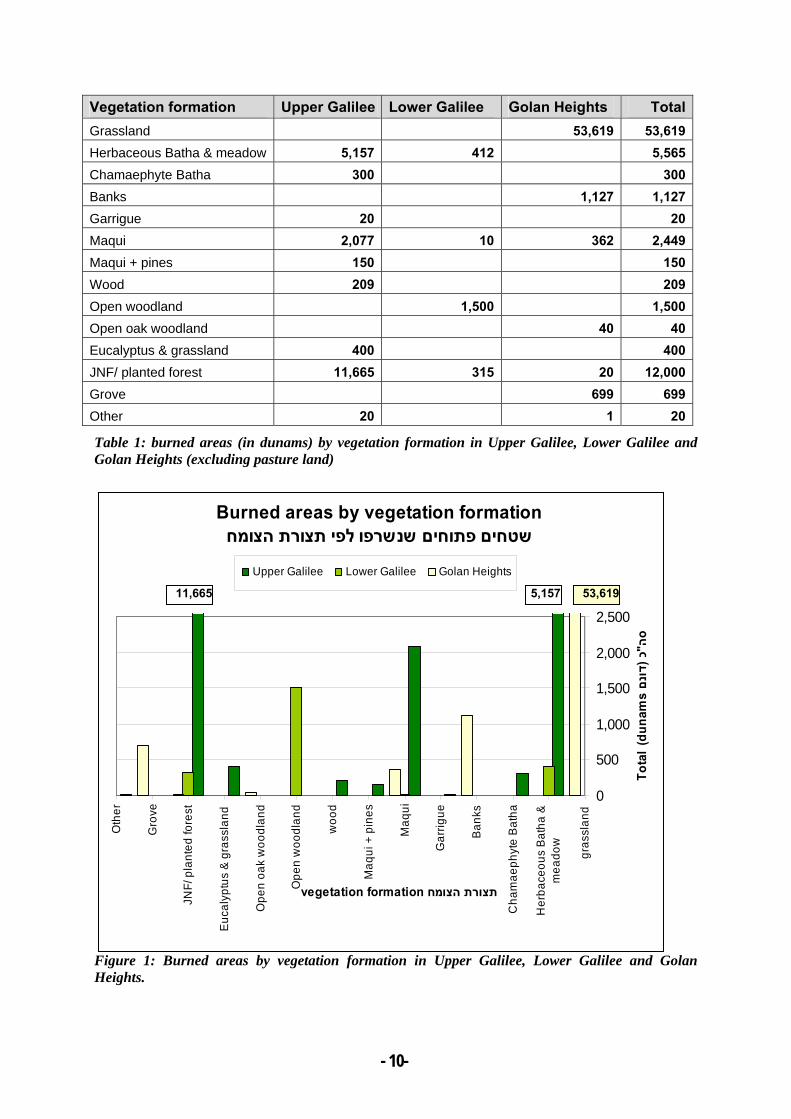
Table 1 and figure 1 present burned areas by vegetation formation (only INPA and JNF
reports; not including the 71,300 dunams burned pasture areas reported by MOA, as the
degree of overlap with the other reports is unclear).
- - 10
Vegetation formation Upper Galilee Lower Galilee Golan Heights TotalGrassland 53,619 53,619Herbaceous Batha & meadow 5,157 412 5,565Chamaephyte Batha 300 300Banks 1,127 1,127Garrigue 20 20Maqui 2,077 10 362 2,449Maqui + pines 150 150Wood 209 209Open woodland 1,500 1,500Open oak woodland 40 40Eucalyptus & grassland 400 400JNF/ planted forest 11,665 315 20 12,000Grove 699 699Other 20 1 20
Table 1: burned areas (in dunams) by vegetation formation in Upper Galilee, Lower Galilee and Golan Heights (excluding pasture land)
Figure 1: Burned areas by vegetation formation in Upper Galilee, Lower Galilee and Golan Heights.
Burned areas by vegetation formationשטחים פתוחים שנשרפו לפי תצורת הצומח
0
500
1,000
1,500
2,000
2,500
gras
slan
d
Her
bace
ous
Bat
ha &
mea
dow
Cha
mae
phyt
e B
atha
Ban
ks
Gar
rigue
Maq
ui
Maq
ui +
pin
es
woo
d
Ope
n w
oodl
and
Ope
n oa
k w
oodl
and
Euc
alyp
tus
& g
rass
land
JNF/
pla
nted
fore
st
Gro
ve
Oth
er
vegetation formation תצורת הצומח
Tota
l (d
unam
s נםדו
כ (ה"ס
Upper Galilee Lower Galilee Golan Heights
11,665 5,157 53,619
- - 11
Animals that died (left) or were injured (right) by the fires
II. Materials and solid waste
Some 12,000 building were damaged, yielding 100,000-700,000 tons of solid waste to be
handled safely and sustainably. The measures would probably include burial in landfills (ca.
85%) and gritting (ca. 15%). Of special concern are damaged buildings made of asbestos-
cement (at least 20,000 m2). The damage to human health and to the health of other animals
from fibres released to the air, and subsequently to adjacent land or water sources was not
quantified in any way.
III. Effluents and water sources
Four sewage treatment plants were hit. One of them released to the Mediterranean Sea excess
sewage sludge, three of them released biogas to the atmosphere (burned and non-burned). No
damage was caused to neighbouring water sources.
- - 12
IV. Other hazardous materials
Containers of LPG ("cooking gas"), ammonium, Freon, pesticides, petrol and other
unidentified hazardous materials were hit, resulting in leakages to the ambient environment.
However, air quality monitoring did not show any signs of high-level air pollutant
concentrations.
V. Pets and husbandry
Thousands of cats and dogs were neglected; some dozens of them died from neglecting. Dogs
were temporarily treated or handled in order to prevent the spread of rabies. Feral dogs and
cats may cause damage to wild populations of small mammals, especially of lizards, rodents
and birds, or to transfer rabies to and from wild animals. Another possible problem is
inbreeding with wild populations of wolves and wild cats. However, no specific problem was
yet reported.
Some eight poultry enclosures and four dairy barns were hit and damaged, some of them
completely burned. Cattle in the Golan Heights were not affected.
Regeneration of damaged areas and rehabilitation plans
The ambient temperature and the large scale of burned area resulted in high-intensity fires.
The burned landscapes consisted mainly of herbaceous batha, Mediterranean maquis and
planted forest. The damage encompasses the whole ecosystems through the full scale of
trophic levels:
In general, the burned vegetation is supposed to slowly recover, depending on soil
composition, the composition of local pre-fire vegetation, and local unharmed seed bank, and
given that no high-level fires will occur in the near future at the same areas. As mentioned
above, habitat recovering that depends on migrants from adjacent non-damaged habitats,
particularly where very large areas were hit, may prove more difficult, and with a greater
extent of local extinctions. The damage to the seed bank may yet be aggravated by the drying-
out of some early germinating seedlings in autumn 2006.
- - 13
Three other problems may threaten the burned areas: a) increased risks of invasive plant
species overtake and proliferation of pyrophytic species; b) a certain amount of soil loss is
expected, mainly during the first winter after the fires, until herbaceous cover develops; c)
repeated fires may deplete the seed bank and regeneration potential within and surrounding
the burned areas.
Such vast and simultaneous wild fires in the north of Israel are unprecedented. The bodies
responsible for management of these areas show two approaches: the INPA mainly intends to
conduct research and monitoring whereas the JNF-Forest Department will probably combine
small-scale planting and soil stabilization procedures with research and monitoring.
The INPA proposes to conduct a comprehensive multi-disciplinary comparative research on
"Rehabilitation of Mediterranean ecosystems in Northern Israel following missile-ignited
wildfires". The research is planned to provide insight and tools for future management of such
damaged areas. It will cover aspects of soil and hydro-geology, of vegetation and seed bank
dynamics, of reptile, amphibian and bird population dynamics, and of landscape ecology. The
researchers plan to examine seed germination, to sample vertebrate populations (reptiles,
rodents, invertebrates, breeding birds) and to follow diversity patterns and dynamics in burned
and in adjacent areas. They intend to use remote sensing and GIS. The funding for this
research is not secured yet.
JNF has held several professional consultation forums regarding their forest renewal strategy
and plans, and established an advisory scientific board that will accompany the process for
several years. JNF sees its task both in managing forests and woodlands and in providing
public spaces for recreation, and thus wishes to make as many of the burned areas available to
the public in as short time as possible, without deteriorating the qualities of these areas.
The JNF wishes to implement the principles of sustainable development and sustainable forest
management (SFM - considering ecological, social, economic and inter-generational principles
and increase biodiversity in their managed areas). JNF also mentions that some economic
initiatives based on the forest and its surroundings were harmed as well.
There was large public pressure to re-plant the burned areas as soon as possible. At least
12,000 people have already volunteered to clear areas and plant new trees. On the other hand,
continuing a long public debate on JNF's management policy and protocols, other nature-
lovers call for "do-nothing-and-let-nature-regenerate" approach. They fear of vast re-planting
- - 14
of conifers, of soil loss when felled trees are cleared, and of pesticide and herbicides usage in
some stages. Some advisors suggested involving the general public in monitoring efforts.
The renewal strategy and plan so far includes these components:
• Damage assessment and data analysis: accurately map and assess the damages; categorize
data according to various parameters (e.g. physical, forestry, ecological and recreational,
visual and social importance);
• Preparation of general and detailed management plans and renewal plan: JNF plan to give
precedence to natural regeneration processes; the plans involve choosing handling and
felling methods, regeneration methods and various degrees of natural regeneration versus
planting, preparation of stock for planting, enhancing forest fire resistance, monitoring
natural regeneration and biodiversity (including soil condition, invasive specie and other
undesired vegetation), deciding on grazing/pasture policy and choosing rotation areas and
fencing renewal, handling invasive species and maintaining road system and fire breaks;
• Preparation of a fuelwood supply plan to the general public.
JNF also prepares a "Social and Public Participation Plan" including public participation with
education and voluntary activities.
It seems that some of the areas will be planted, where JNF wishes to increase diversity in pine
forests and change species composition from coniferous to broad-leaved. In recreation areas,
pines will probably be re-planted. It is not clear yet how felled trees will be cleared out of the
area (selling to local villagers for heating, for example). Problems may arise from the need to
temporarily stop current grazing.
As mentioned above, Birya Forest area may prove to be particularly difficult to rehabilitate if
natural maquis is desired, since a previous attempt to plant broad-leaved there did not
succeed. The patchiness in rock and soil types in both Birya Forest and Naftali Ridge may
lead JNF to create patches of natural woodland and conifers. In the Naftali Ridge, though,
JNF doesn't expect soil conservation problems and whereas regeneration is expected to be
fast.

- - 15
Conclusions
It seems that most (number-wise) burned areas are small and non-continuous. Yet, there were
several large continuous burned areas, mainly in eastern Galilee (Birya Forest and Naftali
Ridge) and in the Golan Heights. Small-scale burned areas may not be difficult to rehabilitate,
as adjacent non-burned habitats may contribute sufficient immigration to re-colonize the
affected areas. On the long run these areas may contribute to habitat patchiness and
heterogeneity and thus may increase biodiversity locally. Where large-scale fires occurred,
especially in the Golan Heights, recovering may be much slower, with a higher danger of
infiltration of invasive species and longer-term loss of biodiversity.
It is important to remember that surrounding habitats were also affected by the change in
density and arrangement of refugee animals (in particular larger vertebrates).
In some cases, such as that of endangered amphibian species in Birya Forest (i.e. Fire
Salamander and Spotted Newt), it is feared that some local extinctions will have a larger-scale
impact because certain species or groups are found only in restricted spots.
JNF plans seem suitable, yet there may be problems to implement them, and in particular –
long-term monitoring, of different time-scales. Also, problems may arise from tree felling and
clearing. It is also not clear as to the magnitude of planting and species composition to be
used, as JNF did not have so far a very good success rate in planting most indigenous broad-
leaved tree species, and it is quite likely that where quick results are desired, conifers will be
used.
There are definitely controversies between JNF and INPA on the appropriate local
management of some areas, controversies that are better dissolved as soon as possible.
- - 16
Acknowledgements
This report relies on data gathered from various sources, either written or interviews. We wish
to thank Yoav Sagi, Chairman of Israel's IUCN National Committee, for inviting the
report and for coordinating the data gathering from relevant sources; Dr. Eliezer Frankenberg,
Dr. Linda Olswig-Whittaker, Hillel Glazman, Hava Goldstein, Talia Oron and Yonat Magal
from INPA; Israel Tauber and Chanoch Zoref from JNF; Michael Luria and Yigal Chen from
the Ministry of Agriculture; and Dr. Yeshayahu Bar-Or from the Ministry of Environmental
Defence.
Ayelet Sapir from SPNI-Deshe Institute greatly helped with GIS synthesis and analysis of the
various data, and produced the various maps.
Photographs were taken by Uri Babyan, Ami Dorfman, Ron Frumkin, Ezra Hadad, Shmulik
Shapira (and by other photographers that were handed with courtesy of the JNF).
Written sources
Bar-Or, Y. 2006. Assessment of environmental damages due to the war in the north, summer
2006. [In Hebrew, internal letter]. The Ministry of Environmental Defence, Jerusalem.
Ginsberg, P. and Tauber, I. JNF- Forest department. 2006. A Renewal Strategy for Burnt
Forests in the Northern Region:Guidelines and Recommended Actions.
JNF- summary of the scientific advisory team meeting – 26.9.2006, Eshtaol.
Kaplan. D. et al. 2006. INPA. Rehabilitation of Mediterranean ecosystems in Northern Israel
following missile-ignited wildfires. Research proposal.