prehistoric mobile stone sculpture of the lower columbia
TRANSCRIPT

Portland State University Portland State University
PDXScholar PDXScholar
Dissertations and Theses Dissertations and Theses
1-1-1978
Prehistoric mobile stone sculpture of the lower Prehistoric mobile stone sculpture of the lower
Columbia River valley: a preliminary study in a Columbia River valley: a preliminary study in a
southern Northwest Coast culture subarea southern Northwest Coast culture subarea
Marilyn Sargent Peterson Portland State University
Follow this and additional works at: https://pdxscholar.library.pdx.edu/open_access_etds
Let us know how access to this document benefits you.
Recommended Citation Recommended Citation Peterson, Marilyn Sargent, "Prehistoric mobile stone sculpture of the lower Columbia River valley: a preliminary study in a southern Northwest Coast culture subarea" (1978). Dissertations and Theses. Paper 859. https://doi.org/10.15760/etd.859
This Thesis is brought to you for free and open access. It has been accepted for inclusion in Dissertations and Theses by an authorized administrator of PDXScholar. Please contact us if we can make this document more accessible: [email protected].

PREHISTORIC MOBILE STONE SCULPTURE OF TIlE LOWER COLUMBIA RIVER VALLEY
A Preliminary Study in a Southern Northwest Coast Culture Subarea
by
MARILYN SARGENT PETERSON
A thesis submitted in partial fulfillment of the requirements for the degree of
MASTER OF ARTS in
ANTIIROPOLOGY
Portland State University
1978 © Marilyn Sargent Peterson

TO THE OFFICE OF GRADUATE STUDIES AND RESEARCH:
The members of the Committee approve the thesis of
Marilyn Sargent Peterson presented November 14, 1978.
APPROVED:
Wayne Sutt ~ es, Chairman .
Thomas M. Newman
Dale Archibald
Gorct:on lB. Dodds \
Daniel J. Sche~Chairman, Department of Anthropology
St and Research

ACKNOWLEDGMEN IS
I would like first and foremost to acknowledge the help of my
chairman Dr. Wayne Suttles and committee members Dr. Thomas Newman,
Mr. Dale Archibald, and Dr,. Gordon Dodds in finalizing various aspects
of this study's content. I am particularly grateful for their patience
in working through many pages of unpolished il,aterial and for their
sharing of insightful comments.
I am also indebtec1. to Dr. Daniel Schv ... ns and Dr. Whitney Bates
for their kindness and cooperation in S>10C ... :lii1g out a series of pro
cedural problems. Their forthright commitment was very much appreciated.
To the many library, historical society, and museum personnel
who persevered in ferreting out materials, do~)umentation, and the like,
I give special thanks. Likewise, to ti1(' _J'J~eration, interest, ana
hospitality of collectors, I say thank you.
I would like to express my deep appr.I?',:~_ation to the following
individuals for their financial support of fie1.dwork and actual thesis
production costs: Mr. and Mr. Glenn L. Sargent, Mr. and Mrs. George J.
Dykes, Mr. and Mrs. G. Raymond Cyrus, Mr. and Mrs. Ronald T. Iwasaki,
Mr. Edl-Jard A. Bourgo, Mr. James J. Curtis.
I also gratefully acknowledge the help of several people vUlO gave
generously of their time and expertise in bringing this study through its
final production, especially Mr. Glenn L. S.:ar~C!nt (photography),
Mr. O. Eric Peterson (photography; maps), N3. Donnie Momi Schable
(pen and ink illustrations), Ms. Sharon E. Cyrus and Ms. Phyllis E.

iv
Lancefield-Steeves (museum data recording), Ms. Lillian M. Blanchard and
Ms. Dale 1. Haynes (editing; layout; typing). Ms. Margaret L. Lyseng
kindly provided a typewriter for my use, and Mr" Scott L. Ballard,
technical illustration equipment.
And finally I would like to acknowledge the perhaps less tangible
but greatly valued intellectual and personal support by various individ
uals including my extended family and friends. Most especially I am
indebted to Dr. Nevin ("Patt") Lamb, Mr. L. Richard Steeves,
Ms. Phyllis E. Lancefield-Steeves, an.d Me. Sharon E. Cyrus for their
lively interest, stimulating converation, and persistent supportiveness
in this undertaking.
Above all others, I would likE to thar~1t my husband for his sturdy
conviction that it was all possible.

TABLE OF CONTENTS
ACKNOWJ.EDGEMENTS • • . . • • • • . . • • · . · . . · . . . . . LIST OF FIGURES . . . . . . . . . . · . . . . . . . . . . LIST OF MAPS • • . . . . . . · . . . . . . . . . . CHAPTER
I
II
III
INTRODUCTION • • • • • , . . . . . . . Identification of the Problem · . . . . · . . . Scope of the Study . . . · . . • • • • D II
Survey of the Literature · . . . . Significance of the Research · . . . . . . . . . .
RESEARCH STRATEGY AND METHODS · . . . . . . . . Introduction e I • • • • • • • • • • •
Basic Research Strategy • · . . . . · . . . Data Collection Methods and their Limitations •
Criteria for Data Inclusion in the Study . . . . . Data Analysis Methods • • • . . . . . . . .
INTRODUCTION TO THE ARCHAEOLOGICAL, HISTORICAL, AND ETHNOGRAPHIC CONTEXTS OF THE LO~~R COLUMBIA RIVER . . .
The Setting • . . . . . . . . . . . . . . · . Brief History of the Archaeological Research . . . Archaeological Contexts • • • • • • • . . . • • · . Historical Sources and their Contexts • . . · . · .
PAGE
iii
vii
x
1
1
2
2
7
9
9
9
12
17
20
22
22
24
31
33

vi
CHAPTER PAGE
Ethnographic Context: Operational Area Definition. 35
IV DATA PRESENTATION • • · . . . . . . . . . . . . . . . . . 40
Introduction • • • • • c • • • • • 40
Sites . - . · . . . . . . . . . . . . . • • 43
V DISTRIBUTIONAL PATTERNS • • . . . . . . . . . . . . 191
The Sample: Its Size and Nature • . . . 192
Distributional Patterns · . . . . . . . . . . . 192
Summary of Zoomorphic Carvings • ~ . . . . . . 194
Summary of Anthropomorphic Carvings . . . . 216
Summary of Undefined Carvings . . . . . . . . . . . 224
VI SUMMARY, CONCLUSIONS, AND RECOMM~~ATIONS FOR FUR THER RESEARCH • • • • • • • • • • • • • . . 227
Distributional Patterns · . . . . . . . . . . . 227
Contexts and Chronology · . . . . . . . . . . . . . 230
Recommendations for Further Research • . . . . . 239
BIBLIOGRAPHY . . . . . . . . . . . . . . . . . . . . . . . . " 243
INDEX OF SITES (GEOGRAPHIC ORDER, WEST TO EAST) . . . 256
INDEX OF SITES (ALPHABETIC ORDER) • . . . . . . . . . . . 259

LIST OF FIGURES
FIGURE
1. Zoomorphic carving, Palmrose 1 • • • • • • · . . · . . 2. Bowl with zoomorphic face and tail, Ilwaco 1 • · . . · . . 3. Zoomorphic pipe, Altoona 1 • . . . . . . · . . · . · . 4. Anthropomorphic form, Sauvie Island 1 · . . . . " 5.
6.
7.
8.
9.
10.
11.
12.
13.
14.
15.
16.
17.
18.
Anthropomorphic (?) form, Sauvie Island 2 · . . . • • •• CI
Zoomorphic form (owl?), Sauvie Isiand 3 • • • • · . Zoomorphic (?) form, Sauvie Island 5 · • • · · · · · · Additional views of Figure 7 . • • · • · • • · · Zoomorphic carving, Sauvie Island 6 · • · • · · · Zoomorphic form 9 Sauvie Island 7 • · • • · · · • · · • • · Bird form with inset mortar; Sauvie Island 8 • • • • • • •
Additional views of Figure 11 · • • • • · · • · · · · · Zoomorphic form, Sauvie Island 16 · · • · · • · · · · · · Zoomorphic form (owl?), Sauvie Island 17 • · • • · • • · · Anthropomorphic face, Cholick 1 · • · • • · · • • • • · · Zoomorphic form (?), Vancouver Lake/Lake River 1 · · · · · Anthropomorphic form, H~rzog 1 · . · . . . · . . . . . Zoomorphic form, Cape Horn 1 . . . · . · . · . . · . . . .
PAGE
45
46
50
59
60
62
64
65
67
69
70
71
75
76
82
89
94
109
19. Pestle with zoomorphic form atop h::l.T!dle, Mosier 1 •••• 117
20.
21.
Anthropomorphic head, Lyle 1 • • · . . Double mortar toJ'ith faces, Klindt 1 · .
· . • • • • • •
· . • • • •
120
123

FIGURE
22. Zoomorphic form (owl?), Klindt 2 • · . · . 23. Zoomorphic head, The Dalles 1 . • . . · . • · · · • · 24. Anthropomorphic head with inset mortar, FJ.ve Mile Rapids 1
25. Owl with inset mortar, Five Mile Rapids 8 · · · • · · · •
26. Anthropomorphic form with inset mortar, Five Mile Rapids 9
27. Bird form with inset mortar, Bead Patch 3 · • · · • · · · 28. Bowl with zoomorphic (owl?) faces, Big Eddy 2 • · · · · · 29. Pipe with bird head, OhBe 1 . • . · • • · · · · · 30. Bowl with zoomorphic form, Below Maybe 1 · · • · · · 31- Bead with zoomorphic form, Maybe 1 • • • • · · • · · • · ·
Zoomorphic form, Maybe 5 • • • · . . . 32.
33. Zoomorphic head, Maybe 7 • . . . . . . . .
viii
PAGE
125
127
133
135
136
140
146
149
151
153
157
158
34. Maul with zoomorphic form atop handle, Atlatl Valley 1 •• 166
35. Bowl with four pairs of eyes, Atlatl Valley 2 168
36.
37.
Mortar with zoomorphic form, Atlatl Valley 3 •
Zoomorphic form, Atlatl Valley : •
· . . · . . · . .
38. Small zoomorphic forms, Wakemap 1, 2, 3 · . . . . . . . . 39. Palette in zoomorphic shape, Wakemap 13 · . . . . . . 40. Mortar with quadruped in relief, l-lakemap 17 · . . . . 41. Mortar with zoomorphic form, Leachman 1 · . . . . . . . . 42. Classification of carvings as zoomorphic or
anthropomorphic . . . . . . . . . . . . . . . . . . 43. Types of animals represented by zoomorphic carvings . . .
169
171
175
181
183
186
195
199
44. Basic forms of zoomorphic "clubs" ••• • • • • • • • 200
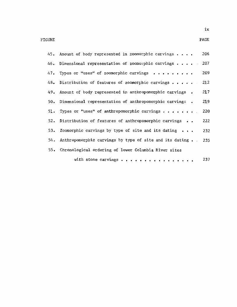
ix
FIGURE PAGE
45. Amount of body represented in zoomorphic carvings. • •• 206
46.
47.
48.
49.
50.
5!.
Dimensional representation of zoomot:phic carvings •
Types or "uses" of zoomorphic carvings ••••• • • • •
Distribution of features of zoomorphic carvings . . . . . Amount of body represented in anthropomorphic carvings
Dimensional representation of anthropomorphic carvingl;
Types or "uses" of anthropomorphic carvings • . . . . . . 52. Distribution of features of anthropomorphic carvings . .
207
209
212
217
219
220
222
53. Zoomorphic carvings by type of site and its dating • •• 232
54. Anthropomorphic carvings by type of site and its dating • 235
55. Chronological ordering of lower Columbia River sites
with stone carvings • • • . . . . . . . . . . . • • 237

MAP
LIST OF MAPS
1. Archaeological sites above The Dalles, Oregon . . . . . PAGE
129
2. Grouped distribution of ston~ carvings •• • • • • •• 193
3. Distribution of zoomorphic carvings •••
4. Distribution of anthropomorphic carvings
. . .
. . . . . . . 196
197
CHAPTER I
INTRODUCTION
IDENTIFICA TION OF lciE PROnLEM
In the last one hundred and fifty years or more, farmers, fisher
men, road and railroad construction workers, collectors, as well as
archaeologists have discovered several hundred stone sculptures along
the banks of the Columbia River. One area of note is that of the lower
Columbia River, that is, the area of The Dalles, Oregon, downriver to
the area around the mouth of the river. Many of these sculptures were
shaped into zoomorphic or anthropomorphic forms. Throughout this entire
century and a half of collecting, many of the carvings were privately
kept, or sometimes passed on to museums with little or no data on pro
venierice, cultural associations, etc. As a result, they have become
dispersed not only in the immediate region" but across the United States
and into Europe.
For the most part, references to these carvings are widely
scattered in the literature. Although many early writers mention their
abundance and possible uniqueness of style for the lower Columbia River,
little is known about them collectively. It is especially true within
the context of the culture history of the area. This is perhaps in part
due to the extremely varied nature of the archaeological work that has
been done in the lower Columbia, and concomitantly, due to the lack of
a well-substantiated prehistoric cultural synthesis for the area.

2
Because these carvings form such a large and perhaps distinctively
styled class of artifacts, and because these carvings are of stone and
hence not as subject to differential preservation as those of bone, wood,
antler, and ivory, they comprise an important subject for a specialized
study to assess their significance in the culture history of the lower
Columbia River valley.
SCOPE OF THIS STUDY
This study presents a preliminary compilation of 1) archaeological
si tes or geographic locations in the lower Columbia River valley where
mobile prehistoric zoomorphic and anthropomorphic stone sculptures have
been found, 2) a descriptive listing of the sculptures found at each of
these sites or locations, and 3) insofar as possible an evaluation of
the significance of these sculptures in the culture history for the area.
Such an evaluation is based primarily on evidence derived from archaeo
logical, ethnographic and historic conte..x.ts wherever they can be ascer
tained. However, the evaluation is also based upon a general analysis
of the inherent design characteristics of the carvings.
SURVEY OF TIlE LITERATURE
No single source has the same approach or scope as this study.
Major relevant sources that deal specifically with the stone sculptures
are presented below in chronological order. Materials gleaned from
archaeological, historic, and ethnographic references that deal obliquely
with these sculptures are incorporated into their descriptions and pre
liminary analyses.
3
In the Annual Report for 1886 for the Smithsonian Institution,
Reverend Myron Eells briefly describes the "Stone Age in Oregon" by
drawing upor.. the materials of three private collectors and upon vari
ous references in the literature. After a. few paragraphs concerning
"Mounds, Eart~-lworks, and Skeletons" and "Gra.ves and Cemeteries" Eells
lists a selection of artifacts in each of 30 categories, six of which
are dev ted to stones sculpted in animal, bird, or human forms. Refer
ences to the discovery site and/or cultural associations are sparse, if
existent. Some of the 21 artifacts discussed are listed as being in
the lower Columbia. No attempt is made to analyze these artifacts
collectively nor evaluate their significance in the cull.~_ .... l. history
of the area in which they were found.
One of the first substantial putlications on the arch.iE:ology of
the lower Columbia River was Strong, Schenck, and Steward's Archaeology
of The Dalles-Deschutes Region (1930) which covers 22 sites from field
work done in 1924-26. In a lengthy section devoted to ground stone
artifacts, the authors describe a fevl stone sculptures that carne prima
rily from local, private co11ertions with only vague discovery notations.
Hence, in the sumrnc:.ry of stone sculptures, Strong, Schenck, and Steward
simply made general statements concerning intra-regional spatial distri
bution and a few inter-regional stylistic comparisons.
Also as an outgrowth of that fieldwork, Julian Steward wrote an
article discussing various artifacts of bone, slate, and ailtler or horn
that had been carved in human, animal or geometric shapes. Although
the article is devoted most:1y to the bone carvings of Miller's Island,
east of the area herein defined, Steward illustrates an anthropomorphic

4
stone carving from Lyle, Washington (see Lyle 1 of this study) and dis-
cuss briefly the distribution of similar htnnan figures in the region.
He felt that any conclusions concerning the use of such figures would
be "purely conjectural", and does not elaborate further on the subject
of carved stone (Steward 19271260).
In 1945, W. Duncan Strong presented general historical references
and the results of interviews with pioneers concerning stone carvings
(Strong 19451248-250). He illustrated six stone sculptures found on or
near Sauvie Island (Strong 19451249). (See Sauvie Island 1, 2, 4-6 of
this study.) Strong's emphasis was upon the "skeletal accentuations" of
these sculptures which he compares to various non-mobile bedrock sculp
tures and petrog1yphs found along the lower Columbia. After similar
compilations of notes for wood and bone artifacts, Strong then attempts
in the absence of archaeological evidence to correlate these carvings
with the ethnology of that area j specifically the Prophet Dance as
earlier presented by Leslie Spier (~935). Only speculation results.
Paul S. Wingert was the first writer to analyze in any depth the
stone carvings collectively. His stylistic analysis of them is included
in the Portland Art Musetnn's catalogue of a 1952 exhibition entitled
"Prehistoric Stone Sculptures of the Pacific Northwest". Wingert, then
a Professor in the Department of Fine Arts and Archaeology at Columbia
University, made a comparative analysis of the sculptures and grouped
them into six areas on the Coltnnbia River and one each on t.he Fraser
River and Puget Sound respectively. Of the 120 sculptures exhibited,
approximately 45 were listed for t!1e area herein defined. However, when
each of those sculptures • .-JC;.:. Tes~arched for this study, it was discovered

that several had no provenience. That is, in many cases Wingert's area
classification for a particular sculpture was based only upon similar
ities of stylistic elements. Further, his analysis was not well corre
lated to archaeological, historic, or ethnographic materials. Hence,
although Wingert's stylistic analysis gives some insights into the
inherent desig~ characteristics of particular sculpted pieces, his
area analysis must be viewed with some caution.
5
A student of Wingert's, John Crozier Galloway, wrote his PhD dis
sertation at Columbia University on Prehistoric Stone Sculpture of the
Western United States (Galloway 1956). In it, Galloway compares the
prehistoric stone sculpture of the Southwest, the West Coast (princi
pally California), and the Northwest. The latter region was represented
by 102 sculptures, only 56 of which "ere from the lower Columbia. Of
those 56, 24 had sufficiently documentea proveniences to be included in
this study. As with Wingert's work, Galloway'S focus was principally
upon a stylistic analysis of the sculptures which he categorized into
sculptures in the round (representational and non-representational) and
two dimensional sculptures (representational and non-representational)
(Galloway 1956:76). Although preliminary comments were made concerning
the cultural context and chronology for some of the sculptures, the
emphasis for the Northwest artifacts waS upon those from British
Columbia rather than the lower Columbia (Galloway 1956:235-241).
No further comprehensive works on the stone carvings were pub
lished after Galloway's dissertation in 1956. However, three articles
were subsequently published that are of relevance to this topic.
In 1957, B. Robert Butler, at that time the archaeologist in
charge of the Wakemap Mound excavation near The Dalles, Oregon, wrote

a brief article, "Art of the Lower Columbia River Valley". He sununa
rized the ethnographic, historic, and archaeological evidence from
Wakemap and placed the various carvings (bone, antler, stone) into a
generalized cultural reconstruction of that site and the inunediately
adjacent area. Although the article was very brief and the sununari
zation general, and although the stone carvings illustrated are not
6
al ways individually given proveniences or analysis, Butler's approach is
nE:vertheless somewhat similar to that utilized iT. this study.
The next source of relevance here is Emory Strong's "Prehistoric
Sculpture from the Columbia River", a short article published in
Archaeology in 1961. Strong gives an introductory presentation of
the geographic, geologic, and archaeological research in the lower
Columbia River and then gives a general analysis of stylistic elements
that occur in various artifact categories for sculptures of bone, wood,
stone, and antler. Like Butler, Strong makes several observations that
gi ve insight into the relationships of art forms and sites in general.
Thorough documentation is not provided for these observations, however.
Butler's article, "Perspectives on the Prehistory of the Lower
Columbia Valley" (1965): concerned in part the "depiction of the human
figure through time in the Lower Columbia Valley" (Butler 1965:3).
Using 19 artifacts in his stylistic analysis, and referring to six
archaeological sites (Wakemap, Five Mile Rapids, Big Leap, B. Stewart,
Reeder's Beach, Bridge Camp), Butler discusses a style and its develop
ment and evaluates its significance in the lower Columbia River
cultural history. The value of this article is limited by the small
number of artifacts from widely separated sites. The basic approach is,
however, like that used herein.
In summary, it can be seen that although sever?l sources discuss
certain aspects of the mobile prehistoric stone sculptures of the lc~·ler
Columbia River, none have precisely the same approach or scope as this
study. Eells' work (1886) was essentially a collections' listing. W.
Duncan Strong's (1945) lacked an extensive data base or convincing cor
relations with archaeological, ethnographic, or historic references.
Although Wingert's and Galloway's works {1952, 1956) had fairly broad
data bases by comparison to those of other authors, their inclusion of
7
a large number of sculptures with no or questionable provenience as well
as the lack of archaeological, ethnographic, and historical evidence
weakened their general stylistic analysis and conclusions. Only in
Strong, Schenck and Steward's work (1930), Butler's two articles (1957,
1965) and Emory Strong's (1961) are somewhat similar approaches as this
illustrated. Strong, Schenck and Steward's work was limited in number
of artifacts and geographic scope. The latter articles were meant as
introductory syntheses of much data for a very large geographic area.
They were deficient principally in lack of extensive documentation.
SIGNIFICANCE OF THIS RESEARCH
This research is significant not only because it brings together
for the first time a detailed description of the various scattered stone
carvings of the lower Columbia River, but also because it incorporates
the ethnographic, historic and archaeological evidence available. Fur
ther, this research can serve as a data base for detailing intra-regional
styles as more archaeology is done in the lower Columbia River valley.

8 Secondarily, it can be expanded later to detailed reg';'vua.l comparisons,
for example, with the Middle or Upper Columbia, etc.
Lastly, this research is also significant as an illustration of
a way in which prehistorians can incorporate the information from scat
tered artifacts into the culture history of a region. That is, the
research illustrates not only a means of maximizing the use of informa
tion "stored" in such pieces, but also the limits of inference that can
be drawn from their analysis. (Cf. Brown 1960; Butler 1965; Pettigrew
1977. )
CHAPTER II
RESEARCH STRATEGY AND METHODS
IN'IRODUCTION
In this chapter, I present the basis and formulation of the
research strategy used in this study together with my data gathering
methods and their limitations. Further, I present the criteria I used
for including any given sculptured artifact in this study as well as the
general methods used in analysis of the data.
BASIC RESEARCH STRATEGY
There are at least three major theoretical frameworks that are
available to archaeologists for the interpretation of archaeological
evidence: culture history, cultural reconstruction, and processual
("scientific") archaeology. For a perspective it is useful to briefly
define these frameworks. Culture historians focus principally on the
material evidence of the archaeological record. In their analysis,
typologies or classifications of that evidence are made in order to
place it in a time-space grid. Cultural reconstructionists view this
material evidence only as the residue of a functioning cultural system.
By use of ethnographic analogy, among other methods, their goal is the
reconstruction of the behavioral patterns of that cultural syste.rn.
Finally, processual archaeologists focus on the archaeological record
only as the evidence of a series of complex open-ended systems. Drawing

10
upon a variety of methodologies from General Systems Theory, Information
Theory, and the like, processual archaeologists have the goal of
abstracting and testing general laws of cultural development. In util
izing one or another of these frameworks, an archaeologist will find
that each has particular problems and limitations in its formation and
use. (See Dunnell 1978 for a synopsis of these approaches and their
limi tations.)
On the other hand, a much more basic limitation can occur. An
archaeologist can be limited to one or another of these frameworks by
the very nature of the archaeological evidence to be analyzed and inter-.
preted. In cases where the archaeological evidence consists of a collec
tion of artifacts which for the must part are in isolation (i.e. without
an archaeological context), the culture history framework becomes the
only appropriate one for the analysis of such data. This is particularly
true for the subject of this study. That is, because of the way in which
the various stone sculptures were discovered, there is very little evi
dence of their archaeological associations or contexts. Neither is there
appropriate ethnographic data available for their manufacture, use,
function, etc. Without recourse to speculation, behavioral correlates
could not be reconstructed, nor could even general inferences be made
about the cultural processes or change that these sculptures reflect.
At the foundation of the culture history approach is the typo
logical concept. An archaeologist assumes that artifacts can be grouped
according to an assemblage of shared descriptive characteristics that
are diagnostic for a particular time and space. In other words, assem
blages of shared characteristics are assu~ed to be more likely to occur

11
contemporaneously and within the same geographical focus than in other
times and places. What should be emphasized is that this concept is
simply an analytic tool devised by the archaeologist to gain an under
standing of the time-space relationship of archaeological evidence. A
fundamental statement concerning the typological concept is found in
Alex Krieger's work. Krieger lists various concepts of type, one of the
most elementary being that of a full description "wherein specimens are
described individually, in detail in the hopes nothing will be over
looked" (Krieger 1944:27). This is in contrast to a true typological
method "wherein types are taken to be specific groupings of structural
features which have proved historical significance. Determinative
criteria are not of constant value, but discovered as the material is
analyzed ••• " (Krieger 1944 :273). Nevertheless, he notes "in cases of
isolated or new material which is little understood, the full descrip
ti ve method may be the only possible one" (Krieger 1944 :273). He
concludes that if specimens are described on a site by site basis, the
coherence and congruence of proposed patterns which compose a type will
be validated. Similarly the range of variation within the patterns can
be documented, and some basis for historical relevance established.
As Irving Rouse later pointed out, the culture history approach is
basically a flexible research strategy rather than a formal theoretical
framework (Rouse 1962:84). It is adaptable to a variety of research
objectives: descriptive, classificatory, geographical and/or chrono
logical. Depending upon the nature of the data, one or more of these
objectives are set for a research project with a specific goal of making
at least a preliminary interpretation of the archaeological evidence in

12
the context of the culture history of an area (Rouse 1962:85).
It was with this general approach in mind, that I set up two basic
objectives for this preliminary study of mobile prehistoric stone sculp
tures of the lower Columbia River valleYI the description of a large
number of the sculptures and a documentation of their distribution in
that region. t1y goal was to be able to draw some conclusions about the
significance of these sculptures in the lower Columbia River culture
history.
The following research methods were designed to meet these
objectives and goal.
DATA COLLECTION METHODS AND THEIR LIMITATIONS
There were four phases of data collection for this study: search
of the literature, research with museum collections, research with
private collections, and review of archa.eological work in progress on
the lower Columbia River. My strategy in establishing these phases was
first of all to become familiar with the variety and distributional
range of sculptured stone in the region by completing a thorough search
of the literature. By working with museums and private collections next,
I hoped to discover any specimens which were earlier attributed in the
literature tc private collections. Thus in the third phase of data
collection--research with private collections--my contact list for them
would theoretically be reduced to only those collections still in private
hands. Basically this was a successful strategy, but it did have some
limitations as discussed in the specific presentations of the phases.
(The impact that these limitations had on the data base for this study

13
is discussed in the introduction to Chapter V, in the section headed
"The Sample--Its Size and Nature".)
Approximately four years elapsed between the time this research
was proposed and subsequently completed; employment and other personal
commitments made it impossible to devote myself full-time to this pro-
ject. The time approximations given below for various data collection
phases represent the "net time" spent in anyone phase over those years.
The data collections phases, which for the most part were conducted
fairly exclusively of each other, are presented below in chronological
order.
Literature Search
My first task was to search the historic, ethnographic and
archaeological literature of the lower Columbia River for artifacts,
cultural contexts, and chronological evidence for the mobile stone
sculptures. This phase began with a thorough coverage of the Oregon
Archaeological Society's monthly publication, Screenings, from its first
issue in 1951 (with the exception of Volume 1, Numbers 8 through 12
which I was unable to locate). This search alone provided over a hundred
sculptured stone artifacts, mostly discovered. by collectors along the
lower Columbia. Also of initial use was Cameron Parks' three volumes
which cite collectors and illustrate many of their collections (1960,
1968,1972).
In the main l this phase was conducted primarily as library
research within Oregon as well as by inter-library loan outside of
the region. As reflected in the diversity of sources included in the <I'l
bibliography for this study, I attempted systematically to search every

14 manner of documentation: books, monographs, total journal runs, annual
reports (for such organizations as the Bureau of American Ethnology and
the Smithsonian), etc. On the bases of various indices and subject
files, systematic research was made of several newspapers including the
Spectator, Oregonian, Daily Astorian, and The Dalles Chronicle (the
former two as available in Portland, and the latter two in Astoria and
The Dalles, respectively).
This phase of data collection took approximately one year.
Limitations of this phase of data collection include unresearched
resources such as the manuscript rooms of the Oregon Historical Society,
University of Oregon, and Oregon's State Library in Salem. Most of the
smaller county historical society's publications were not researched.
Nor were the resources of the larger Washington libraries explored.
Research With Museum Collections
My second task was to research the various museum and publicly-
held collections, especially those in Oregon and in southwestern
Washington. These included specifically the Oregon Historical Society,
Portland Art Museum, and Oregon Museum of Science and Industry (Portland,
Oregon), Horner Museum (Corvallis, Oregon), Favell Musetnn of Western Art
and Artifacts (Klamatr. Falls, Oregon), Maryhill Musetnn of Fine Arts
(Maryhill, Washington). Efforts were made to study the collections and
documents at the Museum of Natural History, University of Oregon (Eugene,
Oregon) and the McCleary Collection at Willamette University (Salem,
Oregon), but they aid not become available in time to incorporate into
this study.
I contacted or visited each of the historical societies for those

15
counties that border on the Colt.nnbia River within the area defined for
this study, and I conducted research in those with relevant materials.
This included the historical societies of Clatsop, Colt.nnbia, Clackamas,
and Wasco Counties in Oregon, and Pacific, Wahkiakt.nn, Cowlitz, Skamania,
and Klickitat Counties in Washington.
Also as part of the museum research phase, I corresponded with
four museums in the East known to have artifacts of the lower Colt.nnbia
River valley. These included American Museum of Natural History, Muset.nn
of the American Indian (Heye Foundation) (New York, New York), Peabody
Museum of Yale University (New Haven, Connecticut), and National Muset.nn
of Natural History of the Smithsonian Institution (Washington, D. C.).
This correspondence proved to be particularly fruitful in bringing to
light some sculptures not previously published and in clarifying the
doct.nnentation of some that were already in the literature.
Specific data recording methods in this phase (as with the
research in private collections to follow) involved photographing,
measuring, and describing specimens, including several without defined
proveniences. This latter was: done with the hope that discussion with
private collectors and continued literature research would help clarify
proveniences for such pieces. I recorded catalogue information when it
was available, and discussed various aspects of the muset.nn's acquisition
of the artifacts with appropriate personnel.
Overall, I devoted approximately three months to this task. It
was far from completion at the end of that time.
Data collection in this phase was limited by several factors.
Although attempts were made to cover these collections exhaustively,
..

16
most museums and historical societies admitted there was much "in
storage" and therefore inaccessible. lotal museum collections for
Cowlitz and Wasco counties museums were in storage and unavailable for
study. In both of these cases the collections are awaiting the con
struction of new facili ties.
The following were problems insofar as I was limited in time
and/or finances for successive contacts with some museums. Research
work in smaller museums with rather short seasons which coincided with
heavy tourist flow made work with open display cases and lengthy photo
graphy sessions difficult-. or not feasible. In larger museums, coordi
nating schedules with the appropriate museum personnel was complicated
by vacation schedules and exhibit erection or tear-down. And in two
cases, radical changes in museum administrative structures left interim
personnel unsure of how to handle my research request. Artifacts were
often out on loan. In all cases, museums were particularly cooperative
in working to overcome these difficulties whenever possible.
Research With Private Collections
My third task in collecting data for this study was to research the
several private collections. Well over a hundred private collections
were cited in the literature. In addition to these, several others were
brought to my attention when I gave a short presentation requesting
information at an Oregon Archaeological Society meeting and placed an
ad in their monthly publication. However, because I had been proceeding
through the data collection phases fairly exclusively of each other, I
encountered particularly severe time limitations in researching these
collections. I devoted approximately one month to this phase and during
that time covered only four collections. My choice of collections
focused on those with artifacts from recent archaeological excavations
and on those of two long-time collectors. Therefore, unless otherwise
noted, artifacts from private collections included in this study are
from the literature.
17
The collector's knowledge and the collections themselves form a
very important archaeological resource for the lower Columbia. Further
research on this or other topics of archaeological focus for that area
should utilize that resource more fully. It is my present conviction
that such research should start with those resources.
Review of Archaeological Research in Progress
My fourth, and final, task in collecting data for this study was
to review archaeological work in progress along the lower Columbia from
the area around The Dalles, Oregon, downriver to the sea. I gathered
this information by correspondence, interviews, and examination of
progress reports. Principally, this review covered work being done at
Seaside, Vancouver Lake/Lake River, Oregon City, and North Bonneville.
This phase took approximately a month to complete and coincided
with the analysis stage of my research. The basic limitation with
this phase of data "'llection was lack of time to incorporate new
materials in this E ,:;,Jy, particularly for Bonneville and Skamakowa.
CRITERIA FOR DATA INCLUSION IN THIS STUDY
To be included in this study, a stone carving had to conform to
all four of the following criteria: that it be of ground, pecked,
incised stone, that it be a mobile sculpture, that its basic design or

form be zoomorphic or anthropomorphic, and that it have a valid lower
Columbia River provenience.
Ground Stone
18
I established this particular criterion to exclude all of the
chipped stone zoomorphic effigies that were found in curio shops in the
area for some time. Emory Strong noted that he had found two in his
years of collecting, both in association with trade goods (Strong
1956:4). Generally, however, they are considered to be market items
of questionable origin. (See also Bates 1960.)
Mobile Sculptures
The lower Columbia River valley is rich in petroglyphs and in a
selection of bed-rock sculptures (i.e., sculptures that form approxi
mately three-quarters of a zoomorphic or anthropomorphic shape and are
attached to the basaltic flows that comprise the cliffs and shores of
portions of the river valley). These are research topics in themselves.
Hence, the criterion was established that the sculpted stones be mobile
and not fixed or attached to anyone place.
Zoomorphic/Anthropomorphic Designs or Forms
Initial investigations into the artifact assemblages for the lower
Columbia revealed that there were many stones that were decorated with
incised geometric forms--zig zag lines, wavy lines, sunburst designs,
or less frequently, a combination of these. Since those stones that are
sculpted in zoomorphic or anthropomorphic shapes form such a large class
with often complex design elements being utilized, a criterion was
effected to select for only those sculptures.

Valid Proveniences
When research for this study was first begun, I was warned by
several sources to be wary of recent forgeries of stone sculptures.
These sources included professional archaeologists, long-time collec
tors, and personnel from a few of the museums. In almost every case,
19
it was suggested that particular care be taken in accepting the validity
of sculptures not cited in ,the literature before 1966 or so.
Therefore, although the basic requirement for inclusion of any
sculpture in this study 'Vw'aS that it have a lower Columbia River prove
nience, I attempted to cross-check the validity of that provenic,lce,
especially if the sculpture was discovered in the years since 1965.
This was done by cross-reference citings, by interviewing some of the
long-time lower Columbia River collectors, and corresponding with
museum researchers and curators. It was at this point that many prove
niences were found for artifacts unreferenced in museum collections and
other literature citings. If there was any doubt as to the authenticity
of a sculpture, it was not included in this study.
The following proveniences were not acceptable by themselves for
this study: "Unknown", "Columbia River", "Oregon", "Washington",
"Northern Oregon", "Near The Dalles". Neither was a lower Columbia
River address for the collector sufficient reason by itself to include
a sculpture in this study.
Acceptable proveniences included those of archaeological sites or
geographic locations within the lower Columbia area, particularly within
the area previously inhabited by Chinookan speakers: The Dalles to the
sea and south to Tillamook Head on the Oregon side of the Columbia River,

20
and Wakemap to the sea and north to, and including, the Willapa Bay area
on the Washington side. (See also the section concerning ethnographic
context.) An artifact provenience could read "near" any given town or
geographical location in that area other than The Dalles. Cross-checking
of the proveniences with that designation often resulted in more specific
proveniences for as far away as the mouth of the John Day River, consid
erably outside of the area designated here.
DATA ANALYSIS METHODS
As noted earlier, whenever archaeological materials are little
known or understood collectively, the focus must be on the full descrip
tive method of the culture history approach.
After I identified an array of sculptured stone specimens, analysis
proceeded by first of all correlating all of the historic, ethnographic,
and archaeological references to the various specific artifacts.
Second, the carvings with valid proveniences were then described
as fully as possible and grouped by site of discovery, whether that was
an archaeological site (surface or excavated) or a geographic location
(eg., Sauvie Island). Archaeological, historical and ethnographic evi
dence was then concerted for a general description of the archaeological
and/or cultural context for the carvings from each discovery site.
Once the discovery sites and their stone carvings were described,
I completed a series of distributional studies. These include distri
bution of carvings by presumed use (eg. bowls, pestles, mauls, etc.),
by various design elements inherent in the sculptures, etc. The partic
ular tY}Jological criteria used in each distributional study are presented

21
in their discussion.
I then present a general analysis of the carvings, their archaeo
logical/cultural contexts, and chronology.
Limited statistical analyses are included here. Even the early,
basic statistical methods proposed for the comparative method are not
appropriate because of the indeterminate nature of this study's sample
size or significance. (See Spaulding 1953:305.)

CHAPTER III
INTRODUCTION TO ARCHAEOLOGICAL, HISTORICAL AND ETHNOGRAPHIC CONTEXTS FOR THE LOWER COLUMBIA RIVER VALLEY
Prefaced by a general introduction to the geographic setting of
the lower Columbia River, this chapter presents a brief history of the
archaeological research and resulting archaeological contexts for that
area. A short survey is made of the historical sources and the con-
texts such material provide for this study. The chapter concludes
with a discussion of the ethnographic context of the region and the
establishment of an operational area definition of the lower Columbia
River Valley to be used in the data presentation and analysis of stone
carvings.
THE SETTING
Rising in a high north-south formation, the Cascade Mountains
bisect the Northwest into distinctive geophysical areas each with
specific biotic provinces. To the west of the Cascades the region
is characterized by heavy annual rainfall (40-60" a year), mild winter
temperatures and heavy forests of Douglas fir, Western pine and many
broad-leaved trees. Larger mammals found in this area include the
Roosevelt elk, Columbian black-tailed deer, Oregon white-tailed deer,
etc. (Bailey 1936:19; Dice 1943:31). The east side of the Cascades,
particularly the region of northeastern Oregon and southeastern
Washington, is characterized by a low annual rainfall (20" or less

a year), and vegetation of pine and oak near the edge of th: Cascades
and grasslands further east (Bailey 1936 :22; Dice 1943 :42).
23
For the most part, the Cascades created a barrier to plant, animal
and human population movement. However, the Columbia River, running
over 1200 miles from its sources in British Columbia, leaves the plateau
region of the eastern side of the mountains and cuts through them in a
deep and narrow gorge. That gorge provided an area of climatic transi
tion and, concomitantly, for the mingling of plant and animal commu
nities between the two provinces (Franklin and Dyrness 1973:310). So
called "interdigitation" of biotic communities from each province is
usually cited either as the Mosier area or The Dalles area (Piper 1906;
Bailey 1936; Dice 1943; Franklin and Dyrness 1973).
The area of The Dalles downriver to Troutdale was shaped into its
present form by volcanic action, and later by the Spokane Flood, a large
flood precipitated by the breaking of an ice dam at the mouth of the
Clark Fork River at the Idaho-Montana border (U. S. Department of the
Interior 1974). This flood, which occurred approximately 18,000 to
20,000 years ago, scoured the lower Columbia River gorge down to its
lava floors (Waters 1973). When the waters reduced to normal flow, the
Columbia River rushed through the gorge over its lava floor in a series
of rapids, whirlpools, boils, and low waterfalls that became highly
productive natural fisheries until the construction of dams on the river
raised the water level over them.
As evidenced in the archaeological and ethnographic records for
the area, these natural fisheries as well as the migrating waterfowl,
upland game, and plant resources formed an abundant subsistence base for

24
earliest inhabitants up through the historically-known groups that
lived along the river. Many of the Euro-American contacts noted that
the inhabitants of the rapids area became skilled middlemen in trade
between the Great Basin, Plateau, Willamette Valley, and Coastal
peoples. (See, for example, A. B. Lewis 1906:192-199; Ruby and Brown
1976.)
Another natural fishery of note was located on the lower
Wil1amette River, a tributary of the Columbia which it enters near
Oregon City. As with the groups further upriver, land animals and
migratory birds were also important in the food gathering cycles of
these inhabitants. In the Sauvie Island area, large ponds of
Sagittaria 1atifolia ("wappato") occurred and the tubers were gathered
in large harvests each year. Lewis and Clark (Thwaites 1905), Swan
(1972), Gunther (1973) and others have h~ fact documented over 25
plants used by the ethnographically-known Lower Chinook groups alone.
Along the coast, both north and south of the mouth of the
Columbia, a diversity of marine resources were also drawn upon (Phebus
and Drucker 1973; Ray 1938; Swan 1972).
It is, then, within this general, broadly defined geographical
setting that the archaeological, historical, and ethnographic contexts
that follow should be viewed.
BRIEF HISTORY OF THE ARCHAEOLOGICAL RESEARCH IN THE LOWER COLUMBIA RIVER
Richard Pettigrew (1977) recently suggested a series of "periods"
for the history of the archaeological investigations in the lower
Columbia River. These are Early Amateur (contact through 1923), Early

25
Professional (1924 through 1950), Reservoir Survey (1951 through 1965),
and Recent (1966 to the Present) (Pettigrew 1977:17). Although I will
be discussing a slightly different and briefer array of references,
these periods are useful as a chronological framework as well as a way
of focusing on the nature of the archaeological work done at any given
time.
Early Amateur
Before 1923 most of the archaeological work for the lower Columbia
River emphasized the material evidence of the sites. That is, the
interest was in acquiring "antiquities" or "Indian rel ics". References
to be included here are Eells' survey of various Oregon sites and co1-
1ections with stone artifacts (1889), Whitcomb's brief discussion of
the aboriginal works at the mouth of the Klickitat River (1883), and
Terry's presentation concerning his collecting in the Columbia River
valley and the coast (1891).
The impact that these people had on the archaeological resources
of the region cannot be underestimated. Terry (1891:13) claims that
On the Pacific coast, there have been opened under my direction and supervision upwards of seven thousand tombs and I have in my collection probably the largest amount of material known, pertaining to the coast races between the Gulf of California and Puget Sound.
This reference and many similar to it point out the fact that large
portions of the archaeological resources were damaged or destroyed in
this early period.
Early Professional
One of the first things that is apparent in surveying the

references for this period is that they nearly all cover some aspect
of the archaeology of The Dalles region.
Supported by Mr. Henry J. Biddle of Vancouver, Washington, the
26
University of California Department of Anthropology conducted archaeo-
logical surveys and excavations principally in The Dalles and Miller
Island area during the years 1924-1926. The investigators, W. Duncan
Strong, W. Egbert Schenck, and Julian H. Steward, wrote a series of
articles and a monograph concerning their work (Strong and Schenck 1925;
Steward 1927, 1928; Strong, Schenck, and Steward 1930). The 1930 pub
lication, Archaeology of The Dalles-Deschutes Region, is especially of
importance to this study for it presents a summary of the preliminary
investigations of Wakemap Mound and the cremations that were found to
the west of it. That is, the diagnostic characteristics and artifacts
of each, including ground and sculpted stone, are set forth and general
conclusions are drawn concerning the styles and occurrences of those
artifacts. (Their specific findings are discussed in the general
analysis chapter of this study.)
Most of the rest of the early professional work was carried out
either by H. W. Kreiger, curator of ethnology at the Smithsonian
Institution, or by L. S. Cressman of the University of Oregon Depart-·
ment of Anthropology. The work centered primarily in the area to be
affected by the construction of Bonneville Dam. Krieger' s work is
summarized in three very brief articles (1927, 1928, 1935). George
Phebus, currently head of the Archaeological Processing Laboratory at
the Smithsonian Institution, has worked with Krieger's 1934 season
materials and has written a summary concerning them (1978). This

appears to have been a very difficult task as Phebus lacked both
maps and excavation plans for Krieger's work. In general, however,
Krieger's intent seems to have been to locate various archaeological
27
si tes referred to in Lewis and Clark's early journals, and to gather
artifacts (including from private collections) for comparative use.
(See also Dunnell and Lewarch 1974:5.) According to Phebus' article,
Krieger worked sixteen "localities" of varying specificity (eg., "NW
part of city block at 13th and Oak, Hood River", "Columbia River area",
etc.) (Phebus 1978:116-147). Although most of the evidence is incon
clusive, some documentation now exists for the range and nature of
sites worked early in the C<::.scades area of the Columbia River.
Other than a one-page appendix in Strong, Schenck, and Steward's
1930 publication, the only reference to archaeological work outside of
The Dalles region at that time was Hudziak and Smith's survey forms
for four sites in the Vancouver Lake/Lake River area (Hudziak and Smith
1948) •
Amateur activity in the area continued to be both intensive and
extensive in this period as can be noted in N. G. Seaman's article
about his fifty years as a collector in the valley (1940). In 1946,
and later in 1967, that article was expanded into a book that indicated
the various sites that had been explored by Seaman and other collectors
as well as illustrated a myriad of artifacts from that region.
Emory Strong, an engineer by profession, also began to collect
along the Columbia during the mid-1940's. In his writings, however, he
focuses less frequently on artifacts in isolation, emd more on cultural
contexts. Often he offers brief archaeological explanations. In the

28
absence of professional work on the river during many of these years,
Strong's work is valuable in assessing the range and nature of much of
the archaeological resources in the area at that time. (See in partic
ular E. Strong 1967.)
Reservoir Survey
This was probably one of the most intense periods of archaeolog
ical work on the lower Columbia. Almost all of it was stimulated by
the construction of The Dalles Dam or other construction in that area.
Investigators for the Washington side of the river in The Dalles area
included Warren Caldwell, and B. Robert Butler (in 1956 and 1959,
respectively), and for the Oregon side, L. S. Cressman, and others
(1960). Cressman's report on the Five Mile Rapids site (35WS4) was
particularly important for the lower layer of the site had a composite
carbon-14 date of nearly 9,000 years ago. A deep, and highly stratified
site, Five Mile Rapids' evidence seemed to indicate continuous occupancy
from Late Pleistocene until historic times, and that the inhabitants'
subsistence pattern was that of full exploitation of the river
resources.
Amateur activity was also intense during that period as is
attested by materials published in Screenings and the special pUblica
tion on Wakemap Mound put out by the Oregon Archaeological Society in
1959.
Of special interest, then, is the fact that Butler initiated a
special 1955-57 project with the University of Washington and the U. S.
National Park Service archaeological salvage program in The Dalles
Reservoir "in an attempt to bridge the gap between the scientifically

29
gathered data on The Dalles region and implications inherent in the
material gathered by amateurs" (Butler 1959:6). His objective was
"that of indicating the kinds of materials that have been found, their
contextual associations, and relative chronological position in the
prehistory of The Dalles" (Butler 195917). He thereupon reviewed and
evaluated several sites in The Dalles area, his records consisting
primarily of taking notes "at the time the sites were being destroyed"
and partly of his ':esting of sites (Butler 1959: 7). In a series of
articles beginning in 1959, Butler describes his findings by evaluating
various amateu:;:,s' sites in some articles and specific items of material
culture in others (Butler 1959, 1962, 1963, 1964, 1965, to cite a few).
As with earlier periods, little was done outside of The Dalles
area. Alan Bryan, however, conducted a pipeline survey in southwestern
Washington and postulated a synthesis of lower Columbia River archeology
(Bryan 1957). As a consequence of this publication, subsequent articles
were published debating the validity and usefulness of this synthesis
(Warren 1959; Tuohy and Bryan 1959). The synthesis in its most recent
form was in effect a "working hypothesis that there was a long inter
related development, termed the 'Trans-Cascadian Tradition', on both
flanks of the Cascades fq)m the time of the early big game hunters
through the long intermediate period of land hunting and plant cC'llect
ing ••• Periodic Coastal Maritime influences bisected this broad Trans
Cascadian province along the Columbia River ••• " (Tuohy and Bryan
1959:44). Although further work has not been done in relation to
that hypothesis, the synthesis is nonetheless important because it
helped to de-emphasize the Cascade Mountains as a cultural and

30
ecological barrier, particularly along the Coltnnbia.
Recent
Compartd to earlier periods of archaeological research in the
lower Columbia River, the recent one includes much more work done in
the greater Portland area. For examples, Pettigrew's work in the
Portland Basin from 1973 to 1977 (Pettigrew 1977), and Woodward's in
the Clackamas River drainage system on a scattering of sites (Woodward
1972, 1974) should be cited as contributions to an tmderstanding of the
prehistory of those areas.
This period also included a series of publications of surveys in
the Vancouver Lake/Lake River area (eg., Hibbs and Ross 1972; Mtmsell
1973; Dunnell, Chatters, Salo 1973; Ross and Starkey 1975), and Lady
Island (Hibbs and Starkey 1974).
Also for sites within the Portland Basin, the Oregon Archaeolog
ical Society published special reports of their work on Duck Lake,
Trojan, and Herzog sites (Slocum and Matsen 1968; Warner and Warner
1975; Foreman and Foreman 1977). Roy F. Jones published an overview
of OAS work in the area (Jones 1972).
Other recent work in the lower Columbia, below Portland, includes
George Phebus and Robert Drucker's excavations at Seaside (Phebus and
Drucker 1973), and Robert Kidd' s (1967) at the Martin site on the Long
Beach Peninsula.
Above Portland, in Skamania County, Washington, archaeological
surveys and excavations were conducted in response to new construction
at the Bonneville Dam and the subsequent rise in the water level for
the pool area it would cause. Relevant references include, for example,
Cole (1974), Dunnell and Lewarch (1974), Dunnell, Campbell, Duncan,
Lewarch, and Rafferty (1976).
ARCHAEOLOGICAL CONTEXTS FOR THE LOWER COLu~BIA RIVER
31
As this brief history shows, archaeological research in the area
has been extremely varied in intent and nature.
The earliest professional work came after years of artifact
collecting had occurred in the area. The river's vagaries in periodic
floodings, routine erosion of the banks, etc., also significantly
affected both the location and excavation of sites. This has been
true particularly in the Vancouver Lake/Lake River area, Sauvie Island,
and further down stream. (See E. Strong 1967 7 1973 for general state
ments of the river's impact on lower Columbia River sites within this
century alone.) Later, construction of roads, railroads, and several
major dams along the full length of the Columbia heavily impacted the
archaeological resources for the lower Columbia, not only because of
the changes in water flow and level, but also because it precipitated
heavy collecting and much salvage archaeology that was completed under
less than optimum time and field conditions.
One of the results of all of these· inroads into the archaeolog
ical resources of the lower Columbia was the fact that almost all
professional work from Strong, Schenck, and Steward on drew extensively
upon private collections for extending artifact assemblages for anal
ysis and interpretation. As cited earlier, Butler's work was perhaps
the most explicit in the extent to which this occurred and in the
much lower limits of inference that it effected in his analysis and
32
interpretation. It is implicit in the work of others.
Archaeologists of the lower Columbia River have often been asked,
"Is there an emerging synthesis for the culture history for the area?"
It is my conviction that there is not one as yet. In nearly every case
where very broad regional generalizations are proposed, a careful
examination of the nature, and often paucity of evidence used to pos
tulate the generalizations leads me to the conclusion that such gener
alizations are not yet warranted. It is perhaps as yet too early to
use even the pan-regional working hypotheses without great caution
being exercised in final analyses. Archaeologically rich and deeply
stratified sites, in which rigorously controlled excavation and careful
reconstruction of the culture history occurs, need to be discovered
and worked before a comprehensive synthesis for the lower Columbia can
begin to be formulated. It appears that the heavy collecting, erosion,
and construction along the river may make the discovery of such sites
less likely as time passes.
The question then arises, "How does an archaeologist analyze and
interpret archaeological evidence for the lower Columbia in the absence
of such a synthesis?" It is my belief that the analysis and interpre
tation becomes site-specific or perhaps specific for a slightly larger,
but still localized area. In other words, there are series of archaeo
logical contexts for the lower Columbia River, and it is within these
contexts that analysis and interpretation of archaeological evidence
should take place.
Two contexts of particular importance to this study are those
of The Dalles area and of the Portland Basin. As was briefly noted

earlier, the work of such individuals as Cressman, Caldwell, and
Butler in the 1950's and 60's helped to define many aspects of the
archaeological contexts of The Dalles area including the fact that
several thousand years of cultural continuity was evidenced in the
archaeological record, a continuity that carried up into historic
times. Pettigrew's (1977) work in the Portland Basin is the most
recent and the most comprehensive for that area. He suggest a series
of cultural phases, Le., general time periods in which certain arti
facts and/or artifact assemblages predominated. Pettigrew's evidence
shows strong overall cultural continuity for the past 2,000 years or
more, particularly in the underlying subsistence technology pattern
which was observed for the Chinookan-spec.kers of the lower Coltnnbia
during early contact times. Specifics of this evidence will be drawn
upon for the various site contexts in the next section, and in the
general analysis section.
HISTORICAL SOURCES AND THEIR CONTEXTS
33
The historical sources provide the earliest recorded ethnographic
contexts of the lower Columbia River valley. Although most of the
authors were not ethnographers in the precise anthropological sense,
their descriptions and observations concerning the native groups they
encountered along the lower Columbia (principally Chinookan-speakers)
are considered very valuable in light of the rapid post-contact decline
of the Indian populations. As these sources very infrequently yielded
insights into the stone carvings of this study, only broadly defined
periods of historical sources, their nature, and the intent of their

authors are noted here.
The earliest contacts were by sea by various explorers/trader
vessels. From 1792 on many of the ship' s logs and mates' journals
have descriptions particularly of the groups around the mouth of the
Columbia but also upriver past Sauvie Island. Examples would
include Bishop (1967), Boit (1927), etc. (See also Ruby and
Brown for a detailed if uncritical account of the various groups of
Chinooks around the mouth of the Columbia. Ruby and Brown' s emphasis
34
is on the trade relations, particularly the skills of the Indian
groups. ) These Euro-American and Indian contacts were never prolonged
and most of the observations were often noted within the context of
trade relations.
The Lewis and Clark expedition came overland and down the
Columbia in 1805. The expedition party wintered over among the
Clatsops on the plain in northwestern Oregon before they returned
home in 1806. Unlike their sea-going predecessors, the overt and
explicit intent of the expedition was the description of nearly every
facet of native groups and the environment. And of course, the con
tacts the expedition party had with the Indian groups were more pro
longed. Hence the journals of Lewis and Clark (Thwaites 1905) form
the most extensive early documentation of the Chinookan-speakers from
The Dalles down to the mouth of the river. (See also Gass 190~)
Shortly after, with the establishment of fur trading posts on
the lower Columbia, further descriptive data was provided by such men
as Gabriel Franchere (1954), Alexander Ross (192~, Alexander Henry
(Coues 1965), Robert Stuart (Spaulding 1953), etc. Much of their

35
wri ting confirms and/or extends the observations made by Lewis and
Clark. However, these men not only lived among the Indian groups,
but also participated in long term trade relations with them. Hence
their writings took on a different complexion than those of the Lewis
and Clark expedition which did not have long term involvexnent with the
groups in mind or vested interest in them.
Following the influx of traders came explorers, missionaries and
settlers; particularly of importance here are the years prior to 1851,
the year in which the Indians of the lower Columbia were by treaty
incorporated into reservations. The works of Tliompson (Coues 1965),
Dou.glas (1959), Lee and Frost (1968) etc., are of note. Along with
further descriptive detail of various aspects of the native way of
life, however, were many reports of the extremely rapid decimation of
Indians by diseases (Minto 1900, Cook 1955). Some of the pre-reserva-
tion remnant groups are described in James Swan (1972), and Thomas
Nelson Strong (1906). These men describe their life among the
Shoalwater (Willapa Bay) peoples and at Cathlamet respectively.
Most of the native populations that remained after the epidemics
of various diseases were incorporated into various reservations by the
treaties of 1851, and the native way of life had essentially disap-
peared along the lower Columbia.
TIlE E1HNOGRAPHIC CONTEXT: AN OPERATIONAL AREA DEFINITION
I have to this point spoken of the lower Columbia River as though
it were a congruent geographic, ethnographic, and archaeological sub-
area of the greater Northwest region. I would like here to comment

36
briefly on the reality of that congruency and present the basis for the
operational area definition to be used in this study. I will be using a
geographic area, broadly defined above, for comparison to the archaeologi
cal and ethnographic records.
Archaeological evidence has been particularly inconclusive in
defining a clear-cut boundary for an archaeological subarea on the
lower Columbia. That is, there appears to have been a generalized
pattern of riverine-adapted groups, all along the lower Columbia. The
specifics of the adaptations, as revealed in the archaeological record,
va.ry principally from one side to the other of the Cascade M01.mtains.
West of those mountains, the evidence suggests relationship to the
Northwest Coast culture patterns with rectangular housing predominating
as well as woodworking artifacts (celts, adzes, hand mauls, etc.) and
fishing gear. On the other hand, to the east of the Cascade Mountains,
the evidence becomes more Plateau culture related with pit houses pre
dominating as well as a greater emphasis on hunting and gathering
implements (cobble choppers, stone chipping, etc.). However, as
Tuohy and Bryan (1959), and Warren (1959) have shown, the boundary
is far from distinct as an intermingling of traits occurred along the
western side of the Casdes in particular. This intermingling or
sharing of characteristics from The Dalles area to the sea was documented
most recently by Pettigrew when he compared his proposed cultural phases
f or the Portland Basin with those Butler, Caldwell and other s proposed for
The Dalles area (Pettigrew 1977:341-351). The similarities were most
striking in the later components of the archaeological record. In his
comparison of the two areas, Pettigrew included as far upriver as Five

37
Mile Rapids on the south side of the Columbia and Wakemap Mound on the
north side. He then moves to the John Day river area for comparisons
to the Mid-Columbia materials (Pettigrew 19771341). This leaves a great
deal of the area between the Long Narrows and the John Day River unde
fined, particularly the Deschutes River region--a region with an apparent
abundance of stone carvings as attested by the issues of Screenings,
Emory Strong (1967), Seaman (1967), and Terry (1891).
Pettigrew's boundary is not precise enough for use as an area
focus in this preliminary study. However, because of the previously
noted continutiy iJf archaeological records for the Portland Basin area
and The Dalles area respectively, as well as their similarities in
the late archaeological components, it seems justifiable to turn to the
ethnographic records for help in defining such a boundary. This is
further supported by the fact that W. Duncan Strong (1945 :248) and
other early writers note in passing that sculptures were scattered on
the surface in some areas, particularly Sauvie Island. In that respect
they must have been known if not made or used by the early, ethnographic
groups of the Im'ler Columbia.
The ethnographic record, particularly the linguistic evidence,
provides the clearest delineations of a subarea of the lower Columbia
that broadly coincides with the geographic and archaeological materials.
As was discussed in the previous section, a large portion of the early
ethnographic materials bad to be gleaned from early contact (historical)
sources such as Lewis and Clark. Fieldwork by anthropologists did not
occur until mid-nineteenth century on. Principal sources include
Gibbs (1877), Hale (1968), Boas (1893, 1894, 1901, 1911), Sapir (1907,

38
1909), Spier and Sapir (1930), Jacobs (1936, 1958, 1959, 1960), Ray
(1937, 1938), and so forth. Later sununary work by ethnologists include
Lewis (1906) and Hodge (1907). In almost all of these cases, the work
was carried out near the end of the decline of the groups or well after
they had been incorporated into reservations. The focus was, as
Ray (1938) aptly stated, on "ethnographic notes" or linguistic texts
and their analysis rather than on full documentation of flourishing
groups.
The linguistic boundaries of the ethnographically-knol-m groups of
the lower Columbia are those of the Chinookan-speaking groups. In
terms of broadest geographic area, they inhabited the river from its
mouth (north to Shoalwater (Willapa) Bay and south to Tillamook Head)
upriver to Ten Mile Rapids on the north side of the river and at least
six miles above The Dalles on the south side (Ray 1938:37,38; Spier and
Sapir 1939:164,172). More specifically, the Chinookan-speakers are of
two dialect groups, the Lower Chinook included the Clatsop (on the
south side of the Columbia at its mouth) and the Chinook (on the north
side at its mouth), and the Upper Chinook which included the
Kathlamet, Clackamas (on the lower reaches of the Portland Basin and
Clackamas River, respectively), the Cascades, Hood River, White Salmon,
Wasco (south side of the Columbia at The Dalles) and the Wishram
(north side of the Columbia at The Dalles) (Spier and Sapir 1930:1959).
This was not contiguous grouping. Non-Chinookan speakers
along the lower Columbia included enclaves of Klatskanie, Cowlitz, and
Klickitats which were documented in areas of rivers with the same names.
For the purposes of this paper, the lower Columbia will be an
39
all inclusive term. That is, it will includE: areas of non-Chinookan
speaking eroups within the broadest geographic distribution known for
Chinookan-speakeTs. It must be emphasized that this is an operational
area definition only. None of the ethnographic sources enable archaeolo
gists to document conclusively the predecessors for these people--that is,
there is no well-substantiated tie between the ethnographic groups and
the archaeological record. Therefore, whatever homogeneity might be
seen in the stone sculptures of the lower Columbia, they must be
compared to those of adjacent areas, particularly upriver in the
Columbia Plateau where many stone sculptures are known before the true
geographic distribution of the sculptures can be defined.

CHAPTER IV
DATA PRESENTATION
INTRODUCTION
Sites
Descriptive and illustrative data on the stone sculptures of the
lower Colt.nnbia are presented on a site by site basis from the mouth of
the Columbia upriver to The Dalles area. The upriver progression is
arbitrary and not meant to illustrate movement of stylistic elements.
The site designations vary greatly in specificity. The most
specific designations are those with registered site nt.nnbers, such as
45CL3. In those cases, the first two digits represent the state desig
nation (35 for Oregon, 45 for Washington), the letters represent the
county designation eCL for Clark, CO for Colt.nnbia, etc.), and the final
two digits represent the actual she number within the given state and
county. Often a conunOll name is given to the site in addition to its
registry number. Such names will precede the registry nt.nnbers.
All other sites discussed in here are defined by collector activ
ity or the literature in varying degrees of generalization (eg., from
as broad a generalization as "near St. Helens" to as specific as "at
the mouth of Gatton Slough, 100 yards downstream").
In each case, attempts are made to cite early historical observa
tions, ethnographic knowledge, and summary of archaeological work for
the given site. What is important to note here is that these citings
usually represent the extent of present knowledge concerning the area
prehistorically or in early historic times. In most cases, they are
offered as suggestions of possible contexts, and not substantiations
of such contexts. This is particularly true downriver. Upriver, in
The Dalles area, many more specific contexts are known (eg., burials,
cremations, etc.).
41
'The ordering of sculptures described for each site is also arbi
trary. It is not meant to imply stratigraphic positioning.
Sources
There are basically three sources for the data included here:
sculptures that I viewed, photographed, and measured, sculptures that
were illustrated and discussed in the literature, and sculptures that
were only cited in the literature (eg., "stone effigy", "carved stone
face", etc.). All of those that I viewed are marked with an asterisk
before the sculpture number. All others are given references from
the literature.
Descriptions
The description of a stone sculpture is presented in the follow
ing order:
Asterisk. This indicates that I personally viewed the artifact.
Number. A number is assigned to each sculpture presented within
a given site.
Illustration Designation. Figure numbers are then given with
references within the literature. The figure numbers refer only to
42
photographs and full representational drawings of the artifacts. (See
notes on illustrations below.)
Dimensions. Dimensions are noted as available. For those arti
facts illustrated only in the literature, dimensions are given "shown"
when I extrapolate the figures from scales included in the illustra
tions, and as "reported" when the figures are given by the author.
Description. A full verbal description ensues. Unless other
wise noted, the descriptions are mine. The stone's physical makeup
(material) is noted when known.
Provenience. The provenience is reported l'lith as great a speci
ficity as possible.
Archaeological Associations. These are reported whenever specific
ones are known. References are made to the literature for general
artifact assemblages for a given site.
Location. Finally, the location of the artifact is given. For
those I viewed, the location includes mUsetnn catalogue ntnnbers if
available. For sculptures known from the literature, I cite the last
known location.
Illustrations
There are three kinds of illustrations included in this study:
photographs, full representational drawings (after photographs and
slides), and the presentation of the basic form or design of a sculp
ture as abstracted from a photograph or other illustration of the
sculpture. Only the photographs and drawings are accorded figure
numbers. The abstracted designs are presented with the verbal descrip
tions.
43
SITES
Palmrose Site (35CT7), Seaside, Oregon
This site has been systematically excavated over the past few
years by Robert Drucker of Astoria and George Phebus of the Smithsonian
Institution. At present, doctnnentation consists of a brief summary of
this excavation and that of two nearby sites (Phebus and Drucker 1973).
According to these men, an extended report is in press (Phebus, personal
communication) •
This site, located near the junction of Shangrila Creek and
Highway 101, is a deep, stratified midden. Excavations so far have
revealed three living floors at different levels in the site. Drucker
(personal communication) believes that this site was a major habitation
site perhaps used over several hundred years.
The basic subsistence pattern defined by the Palmrose evidence is
that of marine and river orientation. Remains in the site include those
of elk, sea lion, whale, and otter. Shell fish and rock and bay clams
are also abundantly represented. Less frequently, bird, fish and other
kinds of mollusks occur (Phebus and Drucker 197315).
The artifact assemblage includesl meditnn to large stemmed or
notched projectile points, lanceolate blades, biconically drilled and
atlatl weights, pumice shaft abraders and mortars, unifacial pebble
tools, composite harpoon parts, asymetrical bilateral harpoons, uni
lateral harpoons with line guards, antler digging stick handles, bone
chisels, antler wedges, bi-point varieties, antler knife handles, awls,
shell adze blades, elk incisor pendants and shark tooth pendants
(Phebus and Drucker 1973:6). A greater percentage of the artifacts

44
occur in the lower levels although there is a distribution of them
throughout the midden (Phebus and Drucker 1973:6).
Radio-carbon dates for this site seem to indicate three different
occupations of this site: approximately 600-700 BC, 200-300 BC, and
200-300 AD, respectively. (Phebus and Drucker 1973:5).
Although Drucker showed me several carved antler knife handles,
carved stone artifacts for this site consisted only of the following
two pieces.
ok 1. Figure 1. Dimensions I 7 cm long, 1.5 cm wide, 2.75 cm high. Head about 2 cm long. Description: Small zoomorphic form of a generalized quadruped. Eyes punctuate. Mouth is an incised line. The top of the protruding tail has four parallel, incised lines running its length. A perforation occurs mid-body. Provenience: Lower levels of the Palmrose site. Archaeological Associations: None reported. Location: Robert Drucker collection, Astoria, Oregon.
* 2. Not illustrated. (No known illustration in the literature.) Dimensions: 7.5 cm long, 6.5 em wide, 6.5 cm high, and 3.5 cm deep. Description: Small pumice bowl with possible zoomorphic appendages delineated. At one end, a vertical ridge 6 cm high and 3 cm wide has three horizontal lines incised at equidistant intervals. The opposite end has three indistinct, vertically aligned protrusions. Provenience: Lower levels of the Palmrose.site. Archaeological associations: None specifically reported. Location: Robert Drucker collection, Astoria, Oregon.

'S. !'.Pr.;, 1'118
Figure 1. Zoomorphic carving, Pa1mrose 1. 7.5 cm long.
45
, ,

46
Ilwaco, Washington
Although many of the early historical writers describe Lower
Chinook Indian groups and villages on the north bank of the Columbia
in general, it is Verne Ray's work that specifies the particular name
of the village site on which present-day Ilwaco is located. He states
that it was formerly a Chinook village site called "no·.sqwalakuP',
"where the trail comes out" (Ray 1938: 39). Robert Kidd, in introductory
material for his summary of excavations at the Martin Site (45PC7) on
Long Beach Peninsula (about ten miles north of Ilwaco), notes that a
burial site (45PC1) had previously been recorded for Ilwaco, but he does
not describe it. Kidd and his crew found no further evidence in that
area in 1959.
One carving from that area is included here.
-1: 1. Figure 2. Dimensions: 27.5 cm long, 20.5 cm wide, 10.5 cm high. Description: Medium grained basalt bowl. An owl-like zoomorphic face is represented at one end by continuous nose-brow ridges 6 to 6.5 cm long with eyes represented as bulbous protrusions 3 cm across. At the other end, a tail is represented by a fan-shaped protrusionlying in relief. Several vertical lines run its length. Al though the surface is slightly porous, it appears to have been ground to a fine, smooth finish. The bottom of the bowl is blackened as from fire (7). Provenience: Wingert (1952: 30) notes that this bowl was found at Ilwaco, Washington, in 1950. Archaeological Associations: None reported. Location: Fort Columbia Interpretative Center on Chinook Point, Washington; numbered 42.
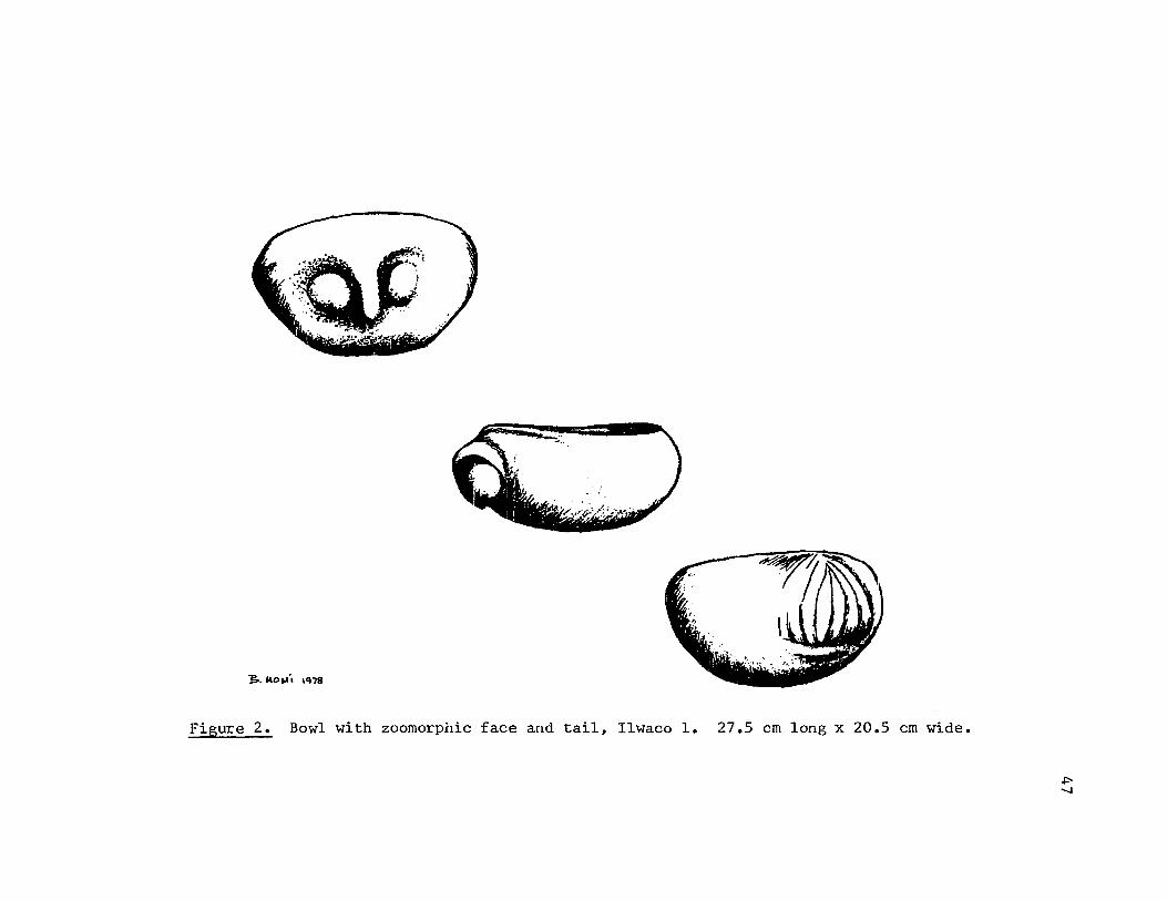
~. Io\o~', ,Q78
Figure 2. Bowl with zoomorphic face and tail, Ilwaco 1. 27.5 em long x 20.5 em wide.
J::
"

48
Altoona, Washington
The area around the present site of Altoona, Washington, is known
principally from references by Gibbs and Boas (as recorded in Hodge)
and by Ray. Sites in the immediate vicinity include the following: "A
large winter settlement at the mouth of Deep River on Grays Bay" and
"village on the north bank of the Columbia, a short distance below" the
village just noted (Ray 1938:39). Hodge reported that the principal
village of the Wahkiakum groups (Chinookan-speakers) "seems to have been
near Pillar rock, a short distance above Grays bay" (Hodge 1907,1:890).
Hodge further cites Boas' information that there were two Wahkiaktml
villages near Pillar Rock; however, both of these were on the south bank
of the Coltmlbia (Hodge 1907,1:232; 11:762).
Altoona is approximately three miles downstream from Pillar Rock.
When road construction was carried out along the north bank of the
Columbia ir. 1949, one of the workers noted that the crew had found
artif<:':::ts scattered along the beach in a three and a half mile stretch
of construction (Hoskins 1963:1). These artifacts included "half a
dozen arrow points, a small basket, a bowl, 2 or 3 pestles, a stone
carving of a htmlan, a handle of a slave killer and a few trade beads"
(Hoskins 1963:1). He also noted that there was reportedly a burial up
a small stream about a half mile below Altoona.

1. Figure 3. (See also Hoskins 1963:1.) Dimensions. Not reported. Description: The illustration shows a pipe carved into a full, threedimensional representation of an owl, possibly in a nesting position (?). The inner portion of the eye o!:'bits were incised away to leave two bulbous protrusions for the eyes. The pupils are punctuate. The beak and eye orbits form one continuous plane for the head of the owl. The wings are carved out horizontally on the sides. A few para1-le1lines were incised along the length of the wings. The bowl of the pipe is inset in the top of the head. Provenience: Found by a stream about one-half mile below Altoona. Archaeological associations: None reported. Location: Not cited. (Hoskins collection?)
2. Not illustrated. (No known illustration in the literature.) Dimensions: Not reported. Description: Described by Hoskins (1963:1) as a Itstone carving of a htnnan". Provenience: Along the Co1tnnbia River near Altoona, Washington. Archaeological associations: None specifically reported. (See text for Altoona site.) Location: Not cited.
49

~- .. -
- I --" .. :" .. :~""\'/'~ ." .. -- '. ~.- ". '-<~'~ :-.) ~ ___ ~_7,-)
\~~~'j" . , .. : ;:;:r.:] -:?:0.- ~
! .. -.~.;~<;.~'.4
Figure 3. Zoomorphic pipe, Altoona 1. Dimensions not reported. (Illustration after Hoskins 196311.)
1J_~"; ''''8
1.Jl o

51
Abernathy Creek, Below Stella, Washington
Abernathy Creek runs into the Coltnllbia River about a mile upriver
from Oak Point. Boas (1901:6) noted a Kathlamet village about three
miles above Oak Point. Ray (1938:38) lists a Chinook village at the
mouth of Coal Creek Slough. This village, according to Ray, markeq tpe
eastern boundary of the Kath1amets. Ray and Boas' villages are possibly
the same. No other mention is made of a village at the mouth of
Abernathy Creek in the ethnographic literature.
According to John Donovan, "Abernathy has probably been subjected
to more hours of artifacting than any site near Longview, Washington.
If there was a way of gathering all the material that has been collected
at this site, it would make a very impressive showing" (Donovan 1967s3).
The artifact assemblage from Abernathy included trade beads, flint
chips, banded or perforated sinkers, camp rock, bird points, trade
goods, and some "fine rock-work" (Donovan 196713).
Donovan felt that Abernathy was both a burial and a camp site
(Donovan 1967:3).
No examples of carvings from this site are included in this study.
If further study is done with private collections, particularly in the
Longview/Kelso area, evidence from this site should be sought.

52
Trojan Site (35COl) Near Goble, Oregon
The Oregon Archaeological Society excavated this site over a
period of three seasons, 1968 through 1970. The first two seasons were
to be documented by Heather Rosenwinkel, at that time a graduate student
in Anthropology at Portland State University. Thus far, a summary of
the third (1970) season has been completed by George and Irene Warner
and published as Report Number Seven of the Oregon Archaeological
Society (Warner and Warner 1975).
The Warners thoroughly searched early historical and ethnographic
references for information concerning the inhabitants of the area. They
present evidence from the works of Lewis and Clark, Ross, Franchere,
Henry, Parker, Wilkes, Boas, Ray, Berreinan, etc. (Warner and Warner
1975:1-4). Although various of the historical sources mention Coffin
Point and/or Coffin Rock (near the site) and note village sites in the
larger area, none describes a site on the Oregon shore at that place
specifically. The ethnographic sources are not clear in this respect,
either. Both the Athabascan-speaking Klatskanie and the Chinookan
speaking Kathla:mets were in the vicinity. The boundaries given by Boas
and others are vague and conflicting.
It is difficult at this point to assess the significance of the
site because of the lack of full documentation. The third season's
artifact assemblage contained both aboriginal and historic materials.
Radio-carbon dates are presented as 1210 :!:.. 95 BP, or AD 740 (I-5374 from
T-7-l35 cm of 1969) and 1270 :!:.. 95 BP, or AD 680 (1-5756 from KK-ll~15l
cm of 1970). From the manner in which the historic goods are distri
buted in the site (clustered in one area and in two uppermost levels),

53
Pettigrew concludes that "the historic trade goods found at the site
were deposited on the surface of the site long after the site had been
abandoned as a habitation area" (Pettigrew 1977:320).
Aboriginal materials from the third season include mostly narrow-
necked projectile points, one (possibly two) atlatl weights, gravers,
drills, single and double-notched weights, banded and perforated
weights, pestles, mauls, bowls, celts.
There was one carved stone piece excavated in the 1970 OAS
season.
-:: 1. See abstracted form below. (See also Screenings 19(7):1; Warner and Warner 1975:69). Dimensions: 77 mm long, 32 mm wide, 14 mm thick. Description: Zoomorphic figure incised$ groQ~d and drilled from porous rock (basalt?). The head is represented with a cone-shaped snout, slight protrusion for ears, and an incised line for a mouth. Tail protrudes from the other end of the figure. An incised line starts about midway on top of the back and runs to the tail. A drilled hole occurs about 40 mm down from the top of the figure (Warner and Warner 1975:69). Proveniencei DD-12-3 at a depth of 75 cm (Warner and Warner 1975 :69). No specific cultural associations were noted at that same level. Location: Paul Pelletier collection.
(The following design is abstracted from Warner and Warner 1975:69.)

St. Helens, Oregon
Hodge noted that the present site of St. Helens, Oregon, was
previously inhabited by a Chinookan group called the Nayakaukau by the
Clackamas Indians (Hodge 1907,11:47). Hodge cites Gatschet, in this
regard, who said that. this band settled at St. Helens in 1877.
54
The closest published archaeolo~ica1.~·site is that known as the
Powell site which is less than one mile south of St. Helens where the
Multnomah Channel empties into the Columbia River. This site was exca
vated in the summers of 1960 and 1961 by the Oregon Archaeological
Society and reported in Screenings (E. Strong 1964). According to the
report, it was a fairly shallow site which lacked stratigraphy. No
living floors or house pits were discovered. Because of the number of
waterfowl bones found there, it W::lS evaluated as a camp site. The site
had a number of trade goods distributed throughout and was, therefore,
considered fairly recent. This is consistent with the reported late
date of occupancy in the area by Chinookan speakers as noted above.
No stone carvings were reported for these excavation seasons.
One carving from St. Helens is included here. As will be noted,
it was discovered deep in a site near St. Helens in 1877. This date
makes it less likely to have come from either site just discussed. It
is possible that the discovery site for this carving was part of the
extensive and intensive occupation of Sauvies Island area just to the
south, upriver from St. Helens.

1. Not illustrated. (See Galloway 19561 55,205,298.) Dimensions I 15 in. long, the tail forming over one-half of the figure, Description I (After U. S. National Museum catalogue notes). Club (?) ground, incised, and drilled out of metamorphic blue slate. Shaped intQ abstraction of quadruped. The forelimbs are treated as one as are the hindlimbs. The head is a generalized zoomorphic head with punctuate eyes and double incised lines for the mouth. Five incised lines encircle the neck; four more the head. Those lines that go over the top of the head, from eye to eye, are connected with alternately slanting lines:
~ Provenience: Six feet below the surface in alluvial soil near St. Helens in 1877. Archaeological a8sociationsl Numerous other stone "relics". Location: The original was cited as being in the R. E. C. Stearns collection (U. S. National Museum catalogue notes). A cast is in the U. S. National Museum (Smithsonian Institution), Washington, D. C.; catalogue number 97612.
55

56
Sauvie Island, Oregon
This island, the largest in the lower Colwnbia, is located between
Portland and St. Helens, Oregon. It is over 15 miles long and about
five miles across at its greatest width. It consists of approximately
40 square miles of lowlands and lakes. From all early accounts, it was
observed to be one of the most heavily populated areas of the lower
Colwnbia. Similar to The Dalles area, Sauvie Island could sustain a
large population (some of which was permanent) because of an abundant
food supply. For Sauvie Island, this included a variety of plants,
waterfowl, and fish from the rivers and streams (including the nearby
natural fishery at Willamette Falls). Most importantly, however, the
abundance of Saggitaria latifolia (or "wappato"), the tubers which
were gathered in great harvests each year, gave the groups there not
only a substantial food supply for their own use, but also an excess
for trade, often upriver for salmon or downriver for marine resources.
The ethnologist A. B. Lewis, in 1906, discusses the extent and patterns
of this trade among the groups of the lower ColLUnbia and beyond. Also,
as with the Cascades and The Dalles areas, the abundance of resources
led to complex seasonal popUlation movements of groups on the Wi1lamette
and upriver to the Sauvie Island area.
Any discussion of the ethnographic materials for Sauvie Island
most often starts with Lewis and Clark's journals. However, the
writings of several other early authors also are rich in ethnographic
observations of groups on the island: Franchere (1954), Henry (Coues,
1965), Cox (1957), Simpson (Merk 1931), Stuart (Spaulding 1953), etc.
Because its rich bottomland was so well suited to farming, Sauvie
57
Island was well settled by the mid to late 1800's by Euro-American
farmers, dairymen, etc. Omar Spencer's brief account of the settlement
of the island helps define the nature and extent of landuse there
(Spencer 1947). With Euro-American spttlement, the early collection of
archaeological evidence was perhaps somewhat causual. Later, in the
1900's, as Lewis and Clark's sites were sought, even more extensive
and thorough collection was made on the island. The Reeder collection,
from the presumed Mu1tnomah village site on which the Reeders live,
contains well over 2,000 artifacts alone. In 1960, Lionel Brown noted
that the Emma Bates collection of projectile points ran over 1,500
pieces (Brown 1960:7). Other collections could be cited which contain
several thousand pieces, including many stone carvings.
A few of the sites were eventually worked by the Oregon Archaeo
logical Society, and most recently by Richard Pettigrew for his disser- .
tation in Anthropology at the University of Oregon. These sites varied
in nature; some were temporary ca..llPS, others were habited. for long
periods of time. This is most likely a reflection of more permanent
occupancy by some groups and seasonal occupancy by others. Pettigrew's
work has defined a chronology for the area that spans about 2,600 years
of human habitation. Of significance is the fact that this archaeolog
ical evidence suggests a cultural continuity up through the ethnograph
ically-known cultural patterns of the Chinookan-speaking groups
(Pettigrew 1977:369).
It should be noted that the sculptured stones from Sauvie Island
included in this study form but a very small sample of the nunber
that have probably come from the island over the years. In

58
addition to the number of very important private collections that were
not studied for this paper, Strong cites another earlier, extensive
one which is thought to have been buried on the island (Strong 1967:
24,25) •
Stone carvings from Sauvie Island are as follows. They are
presented in order of increasing specificity of provenience. The focus
here is on generalized "Sauvie Island" proveniences. Specific archaeo-
logical sites are treated in subsequent sections.
,': 1. Figure 4. (See also W. D. Strong 19451249; Steele 1976:2.) Dimensions: 76 cm high, 27.3 cm wide. Description: About three-quarters of an anthropomorphic figure incised and ground principally on one surface of a stone. Eight lines are incised vertically above the head. The face is depicted on three planes: the nose and brows form a continuous ridge up and around, and down to form the facial boundary; the eyes and mouth are recessed lines; the cheeks are slightly rounded. The trunk of the body has five incised lines on each side giving the appearance of four ribs. Three depressions occur down the center of the trunk of the figure from the shoulders to the genitals (?). The thighs above the knee area are particularly delineated. Stone possibly broken away along the bottom. Provenience: On the bank of the Columbia River 20 miles below Portland, in 1874. Archaeological associations: None reported. Location: Oregon Historical Society, Portland, Oregon; catalogue number 4001.
* 2. Figure 5. (See also Wingert 1952:14,30; W. D. Strong 1945:249; Steele 1976:2.) Dimensions: 95.9 cm high, 33 cm wide. Description: Large, perhaps zoomorphic figure carved, incised, ground of medium grained basalt. Although a full threedimensional figure, it is rather flatnarrow in width, great in depth. The head is topped by an elongated columnar

Courtesy of Oregon Historical Society
Figure 4. Anthropomorphic form, Sauvie Island 1. 76 cm high x 27.3 ern wide.
59

Courtesy of Oregon Historical Society
Figure 5. Zoomorphic (?) form, Sauvie Island 2. 95.9 cm high x 33 cm wide.
60

crown which is incised around its base twice. The band that those incised lines creates is further incised with a series of fairly indistinct vertical lines. The nose is depicted as a bulbous protrusion. Similarly, the eyes are bulbs surrounded by a circular ridge. The mouth is a protruding ridge along the bottom perimeter of the face--it is incised with vertical lines that suggest the representation of teeth. Two slightly elongated protrusions lie vertically on the sides of the figure (ear ornamentation?). Two forelimbs lie along the sides and come around the front of the figure to grasp a vertical, loafshaped protrusion on the front of the figure--against the chest, as it were. Four digits are expressed for each of these forelimbs. Three slightly chevroned ridges (ribs?) lie on each side below the forelimbs. Under these ridges a second set of limbs occur. They are less distinct than the forelimbs, yet still appear to come around to the front of the figure and possibly grasp a second loaf (?). On the back of the figure, two slightly oval protrusions (one on top of the other) occur. The basal portion of the stone is unworked. Provenience I On the banks of the Columbia River, 20 miles below Portland. Archaeological associations: None. reported. Locatiom Oregon Historical Society; Portland, Oregon; catalogue number 4002.
-!( 3. Figure 6. Dimensions: 26 cm high x 16 cm wide. Description: Full three-dimensional representation of a bird (owl?). Most details are repressed. Slight indentations represent eyes, and an oblong protrusion the beak. The wings stand slightly away from the body and are continuous across the back of the figure. Two protrusions form feet, the right one of which is incomplete. A third protrusion forms a tail. Provenience: Scappoose, Oregon. Archaeological associations: None reported. Location: Oregon Historical Society, Portland, Oregon; catalogue number 2522.
61

Figure 6. Zoomorphic form (owl?), Sauvie Island 3. 26 cm high x 16 em wide.
62

* 4. See abstracted form below. (See also W. D. Strong 19451249; Steele 1976:2.) Dimensions: 177 cm high, 36.2 cm wide. Description: Large, irregularly-shaped stone with anthropomorphic figure incised on one surface. The total figure is formed by incised lines. That is, only two planes occur in the figure. Approximately 20 short incised lines ray around the top edge of the stone and are underscored by an incised line. These together give the effect of a "head-dress". Single incised lines form the eyes, nose, mouth, body and legs. The arms, on the other hand, are delineated by double (parallel) incised lines. They are very long in proportion to the body and end in a series of three and four digits, respectively. Three incised lines (ribs?) run horizontally between the trunk of the figure and the arms. The figure is underscored by two horizon'cal, parallel lines. Provenience: Sauvie Island. Archaeological associations: None reported. Location: Oregon Historical Society, Portland, Orel\on; ca alogue number 2532.
~': 5. Figures 7,8. (See also W. D. Strong 1945:249; Steele 1976:2.) Dimensions: 34.9 cm wide x 53.3 cm high. Description: Full three-dimensional zoomorphic figure (?) incised out of scoracious lava (?). Most of the features are only broadly represented. Head is topped by five vertical lines underscored by two horizontal ones. On either side of the face, a vertical, oblong protrusion occurs with three horizontal lines across it (ear ornamentation?). Face is rather wedge shaped with incised almond shapes for E!yes, oval incised lines on cheeks and an incised horizontal line for the mouth. The forelimbs separate out from the body and come forward to grasp
63
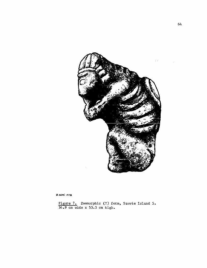
Figure 7. Zoomorphic (?) form, Sauvie Island 5. 34.9 ern wide x 53.3 ern high.
64

65
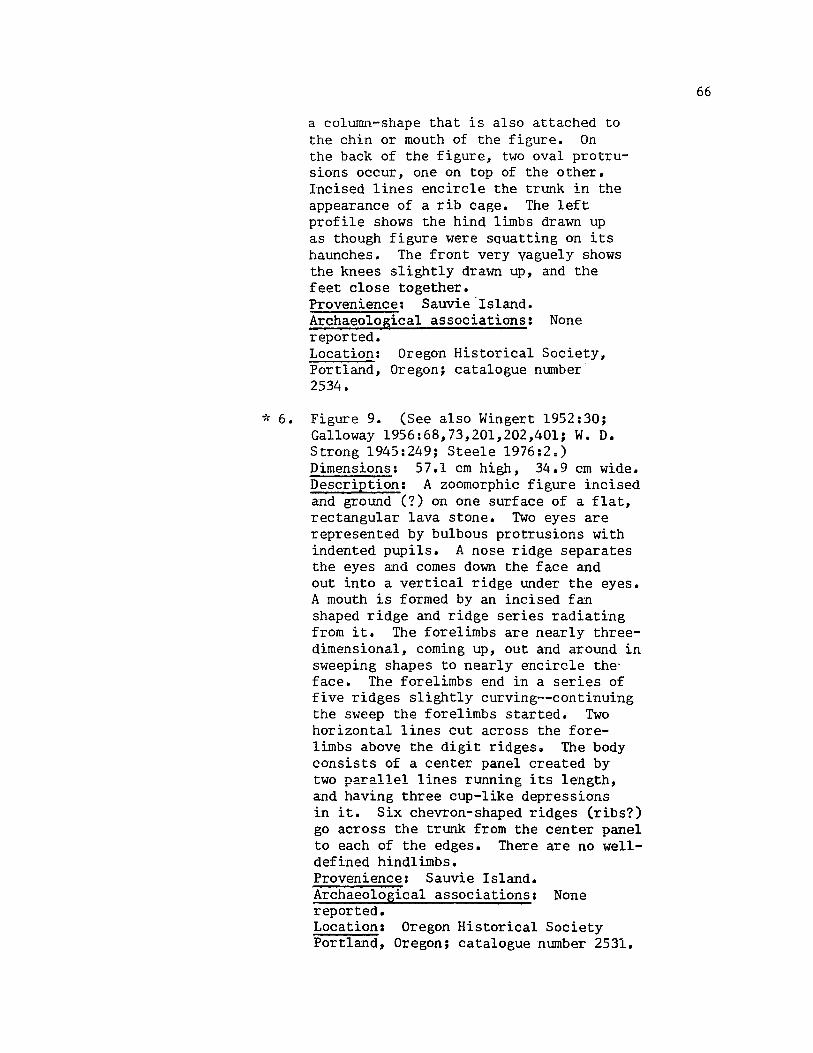
a colwTm-shape that is also attached to the chin or mouth of the figure. On the back of the figure, two oval protrusions occur, one on top of the other. Incised lines encircle the trunk in the appearance of a rib cage. The left profile shows the hind limbs drawn up as though figure were squatting on its haunches. The front very vaguely shows the knees slightly drawn up, and the feet close together. Provenience: Sauvie"Island. Archaeological associations: None reported. Location: Oregon Historical Society, Portland, Oregon; catalogue number 2534.
-!( 6. Figure 9. (See also Wingert 1952:30; Galloway 1956:68,73,201,202,401; W. D. Strong 1945:249; Steele 1976;2=) Dimensions: 57.1 cm high, 34.9 cm wide. Description: A zoomorphic figure incised and ground (?) on one surface of a flat, rectangular lava stone. Two eyes are represented by bulbous protrusions with indented pupils. A nose ridge separates the eyes and comes down the face and out into a vertical ridge under the eyes. A mouth is formed by an incised fan shaped ridge and ridge series radiating from it. The forelimbs are nearly threedimensional, coming up, out and around in sweeping shapes to nearly encircle theface. The forelimbs end in a series of five ridges slightly curving--continuing the sweep the forelimbs started. Two horizontal lines cut across the forelimbs above the digit ridgeso The body consists of a center panel created by two parallel lines running its length, and having three cup-like depressions in it. Six chevron-shaped ridges (ribs?) go across the trunk from the center panel to each of the edges. There are no wel1-defined hind1imbs. Provenience: Sauvie Island. Archaeological associations: None reported. Location: Oregon Historical Society Portland, Oregon; catalogue number 2531.
66
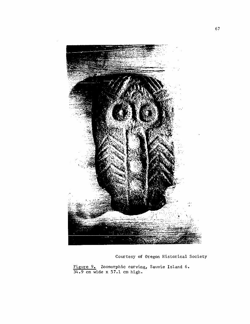
Courtesy of Oregon Historical Society
Figure 9. Zoomorphic carving, Sauvie Island 6. 34.9 cm wide x 57.1 cm high.
67

of: 7. Figure 10. Dimensions: 45 cm long, 10.8 em high, 20.3 cm wide. Description: Zoomorphic figure of vague features incised and ground of scoracious lava. The head is represented by threequarters delineation at one end of the figure. The eyes are drilled or groU!l.d into two hollows. The nose is a small, bulbous protrusion. Four (possibly more) lines are incised on each side of the figure and they suggest ribs. Radiating out from behind the head, a series of increasingly larger oval ridges occur. Provenience: Sauvie Island. Archaeological association: None reported. Location: Oregon Historical Society, Portland, Oregon; catalogue number 2524.
~': 8. Figures 11,12. (See also Wingert 1952: 17,32; Galloway 1956:175,320,475.) Dimensions: 23.2 cm long, by 19.9 cm high by 15 cm wide. Description: Full three-dimensional representation of a bird, incised and ground out of scoracious red lava. Mortar inset in back of bird. Bird is represented on a high pedestal with wings outspread, head slightly down and forward, tail slightly fanned out. The effect is that of a bird lifting off. The eyes are represented by large orbits wi th depressions. The beak curves slightly downward. The upper and lower portions of the beak are separated by an incised line. The wings are about 11 cm long and 3.5 cm wide; they are· edged with a series of vertical ridges. The tail is about 9.5 cm across by 3.3 cm long. It is incised with six vertical ridges on its edge and has one horizontal line incised across the width of its top. The bowl of the mortar is about 8 cm across and 4.6 cm deep. Provenience: Sauvie Island. Archaeological associations: None reported. Location: Portland Art Museum, Portland, Oregon, catalogue 51.204.
68

Figure 10.
_.:, ,. ~:. • .' _,... • .. ' •••• ¥' }.{: ~ r.~.'.':, ... :: .... ;1-' _., ,' •• ~ .. ,_-:" .. <t ,.~ : .. ';'" • .'" :. '.
J:'. h"'! .' • . ',' ,.:.,%' . . ,. . ~:''' .. ' .;;.;{., _.. . .: ::.:, . -. '" .. . ·:·A~ ..• _. ;·!~{2~:':·:;~i·~~:-:;:::':<'·~}
, :, e·.· .": . '~': , .. ~ .. ,.: .. ' \ .... ~' . . ,r... ~ •• ., ::." . '. • .',." '. ' •. . ':;~. ".... :"l.": ,;.: ... -. . ~,; ",.': ~":" -', L', . J!', ' l' ... ,.. : ':.. :,.~ .... ., .- ...;
....
.: . . ;, . '
19. KOMi l'n8
Zoomorphic form, Sauvie Island 7. 45.7 ern long, 20.3 ern wide.
0\ 1.0

.... / : .. :":}.: ..•. : .: .:~~~.\;:.~~
...... :'! .. : "" : : . •• b' •••• ; ..
j;J·PIO"" .'\'18
E!gure 11. Bird form with inset mortar, Sauvie Island 8. 23.2 em long, 15 em wide.
-....J o

71
Figure 12. Additional views of Figure 11.

9. Not illustrated. (See Strong 1959:2). Dimensions: Shown as about 8 in. long by 4 in. high. Description: Zoomorphic head and body incised and ground (?) of ptnnice. Head is represented by bulbous, protruding eyes, and two incised, parallel lines form the mouth. The body is represented by a series of encircling incised lines (ribs?). Reported to have a coat of brilliant red paint on all protruding surfaces. Provenience: Washed out of a bank on Sauvie Island. Archaeological associations: None reported. Location: Last cited in literature as Emory Strong collection.
10. See abstracted form below. (See also Tabor 1966:3). Dimensions: Shown as 5 in. high, 2 in. across at its base. Description: Pestle ground with zoomorphic head atop it. Zoomorphic head represented by bulbous eyes, protruding snout, and ears. Provenience: Wi11amette Slough, on Sauvie Island, in 1940. Archaeological associations: Carved pain t pot, green stone bullfrog and two perforated sinkers. Location: Last cited as Leon Tabor collection.
(The following design abstracted from Tabor 1966:3.)
72
11. Not illustrated. (No known illustration in the literature.) Dimensions: Reported as "life-size,1I (Tabor 1966:3). Description: Reported as "sculpted frog" (Tabor 1966:3). Archaeological associations: See those of immediately preceding sculpture. Location: Not cited (Tabor collection?).
12. Not illustrated. (See Screenin&s 7(12):2.) Dimensions: Reported as "life-size" (Screenin&s 7(12):2) .• Description: Full three-dimensional frog sculpted from lava. Provenience: Sauvie Island. Archaeolo&ical associations: None reported. Location: Last cited as Emma Bates collec tion.
13. Not illustrated. (See Mader 1977:4.) Dimensions: 14 in. high x 20 in. wide. Description: Zoomorphic face incised on one face of a basal t boulder. Eyes represented by series of three incised concentric circles. Mouth delineated by almond shaped incision with a groove running its length and vertical lines incised as though to represent teeth. Provenience: Surface find on Sauvie Island. Archaeolo&ical associations: Not reported. Location: Last cited as Dick Larsen colle('tion.
14. Not illustrated. (See Mader 1977:4.) Dimensions: 24 in. high x 21 in. wide. Description: Zoomorphic sculpted head with neck. Mader describes it as form-ing Ita head, nose, mouth, and neck. Very graceful lines about the head follow the outer contours, a line over the nose spreads out to the corners of the mouth ••• The obverse face of the object has a definite but shallow depression in the area of the neck as if designed to be a mortar" (Mader 1977:4). Provenience: Surface find on Sauvie Island.
73

Archaeological associations: None reported. Location: Last cited as Dick Larsen collection.
15. Not illustrated. (No known illust~ation in the literature.) Dimensions: Not reported. Description: (After Eells 1886:293) "pestle shaped like a bear which is large in the middle and said by Indians to be with young". Provenience: Sauvie Island. Archaeological associations: None reported. Location: Unknown. Not cited in literature.
of, 16. Figure 13. (See also Wingert 1952: 13,30; Seaman 1967:183.) Dimensions 1 21.6 em high, 33 em wide. Description: Nearly full three-dimensional representation of a zoomorphic figure ground of basalt. Nose ridge continues up and around for brow ridges and continues around, down and under face for jaw line. Eyes represented by bulbous protrusions. Forelimbs lie in relief along the sides and nearly come together in the front of the figure. Four digits are delineated on each forelimb. Vague indication of rear limbs are shown folded against the back part of the body. Bottom part of stone broken a\,;ray. Provenience: North end of Sauvie Island. Archaeological associations: None reported. Location: Oregon Historical Society, ::?or tl and, Oregon; catalogue numbe'r 2535.
* 170 Figure 14. (See also Wingert 1952:13,30; Galloway 1956:173,477; E. Strong 1961:136; Seaman 19671183.) Dimensions: 37.5 em high x 53.1 em wide. Description: Zoomorphic sculpture ( 41owl "), incised and ground of basalt. Effect is that of a "seated" or nesting owl. The body's overall shape is ovoid. The eyes are bulbous protrusions with indentations for pupils. Eye orbits are ridges that encircle the eyes. The eye orbits are
74

75
(J)
'0 ~ • .-1
't ~
'i S ~ ()
Ili C""l C""l
~
.c: bD
• .-1 .c: S ()
1.0 . r-4 N

Figure 14. Zoomorphic form (owl?), Sauvie Island 17. 37.5 cm high x 53.1 cm wide. (Illustration after Oregon Historical Society photograph. Used by their permission.)
76

each underscored by two partial circles echoing the orbital ridge. The beak is a V-shaped ridge, the edges of which sweep up and are continued by the orbital ridges. The head is separated from the body by a deep undercut. The wings lie in curves along the sides of the body and are incised with a series of slightly curving lines ("feathers"). A short protruding tail is incised with similar lines. Provenience: North end of Sauvie Island. Archaeological associations: None reported. Location: Oregon Historical Society, Portland, Oregon; catalogue number 2533.
18. Not illustrated. (See Oregon Archaeological Society, Screenin&s 7(12):2.) Dimensions: Not reported. Description: Incised and ground bowl inset in back of vague representation of a zoomorphic figure. Head repre-sented by undefined protrusion at one end. Semi-circular protrusions come out of the sides as wings or combined appendages. Suggestion of horizontal lines along these appendages (feathers?). Tail represented by protrusion similar to head except that a further, small protrusion extends beyond it. Bowl is encircled by a lip, or rim. Provenience: Northern tip of Sauvie Island. Archaeological associations: None reported. Location: Last cited as Emma Bates collection.
77

35C03 (Strong), Sauvie Island, Oregon
This site is located on the northern end of Sauvie Island on
the Multnomah Channel, approximately a'cross from Warren, Oregon, and
the mouth of Scappoose Creek where it enters Scappoose Bay. Emory
Strong feels that this deep site is that called Cath-Iah-cum-up by
Lewis and Clark (Strong 1967:30).
One carving from that site is included here.
1. See abstracted form below. (See also Screenings 5(9); E. Strong 1967 :142, 144. ) Dimensions: Not reported. Description: "Club" carved, ground into shape of zoomorphic figure. Head and body form approximately one half of the figure, the "tail" the other half. Head is represented by a coneshaped snout and slight protrusion for ears. Forelimbs are treated as one and are represented by a semi-circular protrusion. The hindlimbs are similarly treated. Tail ends with a small, nippled protrusion. Provenience: 35C03. Archaeological associations: Four other similar clubs are known from this site as well as "many other fine carvings, and many arrow points" (E. Strong 1967: 30). Location: Last cited as Howard Galbraith collection.
(The following design is abstracted from E. Strong 1967 :142.)
78

2.-5. Not illustrated. (No known illustration in the literature.) Dimensions: Not reported. Description: "Four clubs" similar to the one just described. Provenience: 35C03 Archeological associations: (See that of previous item.) Locations Not cited.
79

80
Cholick Site (35C09) (E. Strong's Designation) on Sauvie Island,
Oregon. ALSO KNOWN AS: 35MUl CR. Pettigrew's Designation)
This site is located on the Multnomah Channel, where the county
lines cross Sauvie Island road (hence the difference in county assign-
ments in the site designation numbers). Emory Strong believes this
site to be the one Lewis and Clark called Cath-lah-min-na-min (E.
Strong 1967:30). If so, it is described by other early authors includ-
ing in particular Franchere (1954) and Simpson (Merk 1931). Emory
Strong notes that it was one of the first places on the island to draw
Euro-American occupancy and was known as the Leonard Place. (E. Strong
1956:2).
The following references have been cited many times in the
literature in regards to this site. Sir George Simpson (iierk 1931:101)
was at the site after the island had been considerably decimated by the
sicknesses of the l830's and noted "the Island contains, in its interior
a block of black basalt, rudely chiselled by the Indians of ancient
days into a column of four or five feet in height and three in dia-
meter". As attested by an Oregonian article for July 9, 1880, the
stone was still there at that time:
••• there were three villages on the Island, one where Jonathon Moar now lives and one where Mr. Bonza lives. Dr. McLaughlin had LaFramboise burn both villages after the scourge. About four miles below the former village was another where the writer was conducted by Sauvie to see an erect stone slab, but earnestly desired not to touch it as it would surely bring rain.
Emory Strong and others see the final note on this stone being given by Seaman (1967:53):
Robert Bonser, for many years county surveyor of Multnomah County, told of the fate of one of these stone images. When he was a young man living on Sauvie Island, an Englishman was

farming a place there. In the field was a large stone image. The Englishman plowed around it for a couple of seasons; then, getting tired of the nuisance of it, he made a sled, rolled the image onto it, hauled it to the Willamette Slough, and rolled it over the bank. It is likely still there. This was close to the county line between Multnomah and Coltunbia counties.
81
Later, in the 1900's, when the dike was put in on fhe island, the
site was mostly destroyed.
Archaeologically it is known through the work of the Oregon
Archaeological Society in the mid-1950's and that of Richard Pettigrew
in 1973. The Oregon Archaeological findings were that the site was
extensive and very deep: it covered about five acres and went down
through over seven feet of midden. The midden consisted of ashes, bone
fragments, shell, camp rock, projectile points, bone needles and awls,
bone arrow points, one pipe, scrapers, knives, and half of a "slave
killer'~. No fishing related materials were found. (See E. Strong
1956:2.)
Although Pettigrew's work yielded radio-carbon dates of AD + 75
for the lowest, deepest sample and AD 1100 :t. 180 for the uppermost sam-
pIes, intervening samples suggest an inversion or similar problem.
Carved stones from this site include the following.
1. Figure 15. (See also Wingert 1952:14,30; Screenings 5(1):3.) Dimensions: Reported as 23 in. high. Description: Anthropomorphic face incised on large, oval of pink sandstone. Facial features, and possible "head-dressing", "ear ornamentations" are depicted. The eyes are recessed, almond-shaped depressions with a similarly shaped ridge running around them. A slightly flared nose starts below the eyes and continues as a ridge up and around the eyes and down under them as orbital ridges and cheeks, respectively. The mouth is elliptically shaped, an interior depression

Figure 15. Anthropomorphic face, Cholick 1. (Illustration after Screenings 5(1):3.)
82

with an exterior ridge running around it. A small block protrusion occurs in the center of the mouth suggesting a tooth or tongue. Two narrow, oblong panels occur on each side of the face and have a series of horizontal lines across them (ear ornaments?, braids?) Above the face, a series of five ridges run horizontally to the edges of the stone. Provenience: Leonard Farm in 1951. Archaeological associations: No specific ones reported. Location: Last cited as Howard Galbraith collection.
-!( 2. Not illustrated. (See Wingert 1953: 30.) Dimensions: 10.5 cm high by 9 cm wide. Bowl of mortar 7.5 cm across and 2.7 cm deep. Each face is about 3 cm high by 515 cm wide. There is a I cm high rim to the bowl of the mortar. Description: Mortar of vesicular basalt, incised, with four anthropomorphic faces in relief. Exterior of mortar incised around upper portion with three rings. Below them occurs a panel of four anthropomorphic .faces. The panel encircles the mortar and the faces occur at approximately equal intervals around it. One incised ring occurs below the panel of faces. A ridge, shaped rather like an inverted triangle, forms the boundary of each face. Separate almond-shaped ridges represent eyes, a slightly oblong protrusion the nose. The mouth is formed by a horizontal ridge which connects with each side of the face. A small block of protruding stone gives the appearance of a tooth or a tongue. Outside of the facial boundaries, and occurring in relief, are two vertical, oblong protrusions with horizontal lines running across them. (Ear ornamentation? braids?). These occur in such a manner that two adjoining faces share one such protrusion. Provenience: Leonard Farm, Sauvie Island. Archaeological associations: No specific ones reported. Location: Portland Art Museum, Portland Oregon; catalogue 68.13.
83

84
Merrybell Site (35MU9), Sauvie Island, Oregon
Pettigrew locates this site as "in the interior of Sauvie Island,
midway between Mul tnomah Channel and the Col urnbia River, about one mile
south of Sturgeon Lake" (Pettigrew 1977 :187). This site was excavated
by the Oregon Archaeological Society in 1958, 1967, 1968, and 1971, and
by Richard Pettigrew in 1973. The results of the OAS excavation are
published in a series of brief notes throughout volumes 16 and 17 of
Screenings. Artifact assemblage included an adze blade, large points,
a number of stone bowls and mortars, pestles, mauls, scrapers, and in
the 1967 season alone, 39 atlat1 weights (Mader 1971:3). Mader further
notes that radio-carbon dates reported from the 140 cm depth were 1165 +
350 BP, or about AD 700 to 800. The site appeared to be a fishing or
hunting camp used over a period of many years.
Pettigrew's work in 1973, involved deeper cultural strata and
yielded dates of AD 1080 t 90 for the uppermost layer, AD 1100 + 90
for the bottom of layer one and BC 930 t 155 for the deepest sampled
layer. The Merrybell evidence was the oldest recorded thus far for the
lower Columbia and the diagnostic characteristics from Pettigrew's upper
components formed the foundation of his aboriginal cultural phases for
the lower Columbia. These characteristics include large, broad-necked
points, stenuned drills, flaked crescents, perforated ground stone pen
dants, etc. (Pettigrew 19771323).
One carving from the Merrybell site is included here.

1. See abstracted form below. (See also Screenings 17(4).) Dimension~: Reported as 6.5 cm long. Description: Part of a zoomorphic shaped stone, presumed to be an atlatl weight. The eyes are punctuate, the mouth an incised line which runs from on one side of the head to the other. incised line encircles the neck. An incised line runs from the neck line along the side of the figure to the poin t where the stone is broken away. A portion of the perforation of the artifact occurs about mid-back. Proveniences Merrybell site, OAS excavations. Archaeological associations: No ones reported. Location: Last cited as Will Townes collection.
(The following design abstracted from Screenings 17(4):1.)
85
86
Vancouver Lake/Lake River Area, Near Vancouver, Washington
This area lies ~o the east of Sauvie Island, across the Columbia
River. It is part of the same broad floodplain and exhibits many of the
same geophysical features. That is, it is characterized by streams,
lakes, sloughs, and seasonal floodplains. Although the archaeological
evidence (cited below) seems to indicate the same aboriginal landuse
patterns as those recorded by early observers of the Sauvie Island
groups, the ethnographic and historical literature is virtually non
existent for this area. Clark mapped a few of the habitations on the
eastern edge of the Columbia River and mentioned a village two miles
to the east in his journal entry for March 30, 1806 (Thwaites 1906,
IV:22l).
It has been assumed by most of the ethnologists and archaeologists
that the Vancouver Lake resources were utilized in the same manner as
those of Sauvie Island.
Archaeological work in the Vancouver Lake/Lake River area has been
extremely varied in nature and intent. Two different gas pipeline sur
veys were conducted in the late 1950' s (Warren a..Tld Eng 1955; Warren
1958; Touhy and Bryan 1959). Several late domestic sites were recorded.
The first edition of Emory Strong's Stone Age on the Columbia also pub
lished in 1959 gave a preliminary assessment of various sites in the
area including at least four permanent village sites which Strong desig
nated as 45CL2, 3, 4, and 5. In the middle and late 1960's, the Oregon
Archaeological Society excavated several sites in the area including the
45CL4 (later designated CLll) that is possibly the one Clark mentioned
in 1806 (Foreman and Foreman 1977). Other published work includes work

at the Duck Lake site (Slocum and Matsen 1972), and Felida Moorage
(Hoffarber 1969aj1969b;1972).
87
Further survey work was carried out on the eastern portion of the
area preliminary to highway relocation (Munsell 1967). As a result, the
site designated as Kersting (45CL2l) was excavated and radio-carbon
dated at 2115 + 110 years before the present, or about 165 BC (Valley
1972). As later authors have pointed out, the significance of Valley's
work lies in the documentation of rectangular houses "associated with
earliest units that are nearly identical to those of nearby late sites,
indicating some cultural stability in the use of the area" (Dunnell,
Chatters, and Salo 1973). Subsequent archaeological evidence was docu
mented in surveys by Munsell (1973) Dunnell, Chatters, and Sa10 (1973),
and Ross and Starkey (1975). Dunnell, Chatters and Salo's work in
particular was important in drawing together the diversity of s,ites in
the area in a preliminary evaluation of their functional nature: winter
domestic (major extensive and intensively used sites, usually with rec
tangular housing), secondary domestic ("domestic sites at some season
other than winter when smaller ternpora'ry surface houses were erected"),
etc. (Dunnell, Chatters and Salo 1973:50-57). This work helped, perhaps,
to give a more holistic view of the nature of archaeological evidence
in the Vancouver Lake area.
Carved stone work from this area include the following. The
pieces are presented in order of increasing specificity of provenience;
separate listings are given to those from archaeological excavations.

1. Not illustrated. (No known illustration in the literature.) Dimensions: Reported as 17 in. long, 2 in. wide, 1 1/8 in. thick, and weighing 6 lbs., 14 oz. Description: (After Eells 1886: 286, 293) Pestle with head of some animal. Provenience: Near Vancouver, Washington. Archaeological associations: None reported. Location: Last cited as Rafferty collection.
2. Not illustrated. (No known illustration in the literature.) Dimensions: Not reported. Description: (After Eells 1886:293) A "squirrel" head that was broken off the body or implement it was attached to. Provenience: Near Vancouver, Washington. Archaeological associations: None reported. Location: Last cited as Rafferty collection.
3. Figure 16. Dimensions: About 16.5 cm long, 7 cm wide. Description: Zoomorphic (?) sculpture incised and ground into abstract quadruped form. Head and tail are protrusions from each end of this oblong stone. Four appendages protrude at right angles to the body. A slight ridge runs the length of one side of the stone. Provenience: Ridgefield Refuge, Washington. Archaeological associations: None reported. Location: Last cited as Mrs. James Carty collection, Woodland, Washington (Ross and Starkey 1975, unpaginated).
88

Figure 16. Zoomorphic form (?), Vancouver Lake/Lake River 3. About 16.5 cm long x 7.5 cm wide. (Illustration after slide by Judy Starkey.)
89

45CL3 (E. Strong' s Designation). ALSO KNOWN AS 45CL14 (Warren and
Eng's Designation), North of Vancouver Lake, Washington
This site is located on the east bank of Lake River, at the
southern tip of Green Lake. Warren and Eng noted four house pits
located in a single line running parallel to the river; they measured
40, 85, 90, and 120 feet in length and approximately 25 feet in width
(Warren 1958:15). Most of the site was collected by OAS. Warren and
Eng made one test pit in one of the house pits. Their conclusion was
that the site represented a late prehistoric village.
Carved stone from this site include the following.
1. Not illustrated. (No known illustration in the literature.) Dimensions: Not reported. Description: Reported as "carved stone face" (Warren 1958:15). Provenience: Warren and Eng' s 45CL14. Archaeological associations: None specifically reported. This artifact did not come from Warren and Eng's test pit; it was reported to them by OAS people. Location: Not cited.
2. See abstracted form below. (Also, see E. Strong 1957:4.) Dimensions: Shown as approximately 14 in. long and 7 in. across. Each edge of the rock is incised with nine vertical lines. The face occurs at one end of the rock and is depicted by a single nose-mouth complex, two slightly protruding, bulbous eyes and perhaps an arch over each eye to represent an orbital ridge (7). Between the two "orbital ridges" occurs a round, slightly bulbous protrusion. Along the back, a series of circles and indentations occur: two large ones (perhaps 1 in. across) aligned above each eye, and three rows of four indentations across the "tail" area.
90
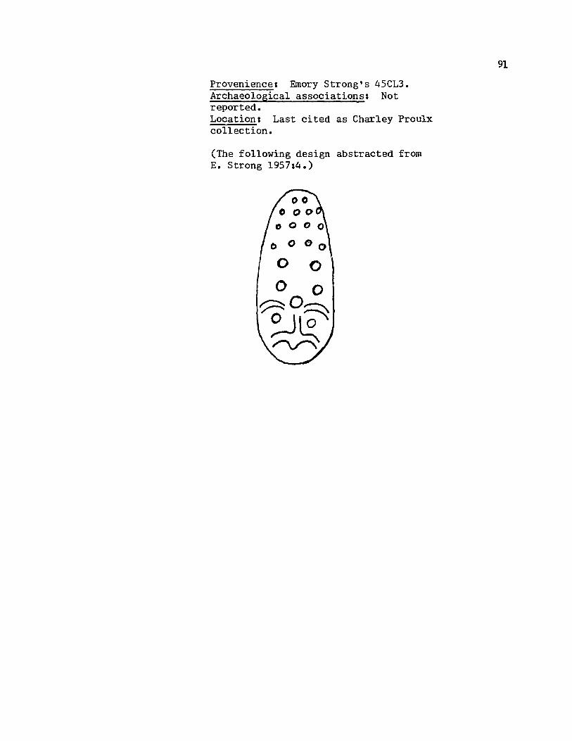
Provenience: Emory Strong's 45CL3. Archaeological associations: Not reported. Location: Last cited as Charley Proulx collection.
(The following design abstracted from E. Strong 1957:4.)
91
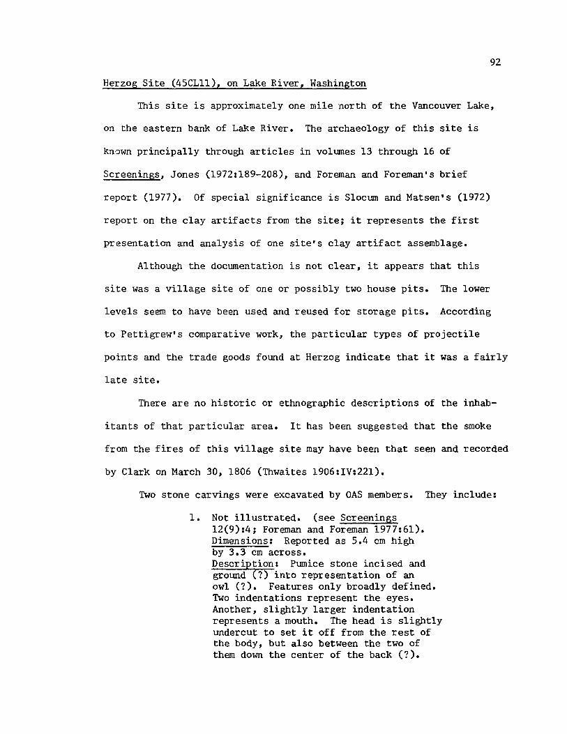
92
Herzog Site (45CLll), on Lake River, Washington
This site is approximately one mile north of the Vancouver Lake,
on the eastern bank of Lake River. The archaeology of this site is
kn·::>wn principally through articles in voltunes 13 through 16 of
Screenings, Jones (1972:189-208), and Foreman and Foreman's brief
report (1977). Of special significance is Sloctun and Matsen's (1972)
report on the clay artifacts from the site; it represents the first
presentation and analysis of one site's clay artifact assemblage.
Although the doctunentation is not clear, it appears that this
site was a village site of one or possibly two house pits. The lower
levels seem to have been used and reused for storage pits. According
to Pettigrew's comparative work, the particular types of projectile
points and the trade goods found at Herzog indicate that it was a fairly
late site.
There are no historic or ethnographic descriptions of the inhab-
itants of that particular area. It has been suggested that the smoke
from the fires of this village site may have been that seen and recorded
by Clark on March 30, 1806 (Thwaites 1906:IV:22l).
Two stone carvings were excavated by OAS members. They include:
1. Not illustrated. (see Screenings 12(9):4; Foreman and Foreman 1977:61). Dimensions: Reported as 5.4 cm high by 3.3 cm across. Description: Ptunice stone incised and grotmd (7) into representation of an owl (7). Features only broadly defined. Two indentations represent the eyes. Another, slightly larger indentation represents a mouth. The head is slightly tmdercut to set it off from the rest of the body, but also between the two of them down the center of the back (7).
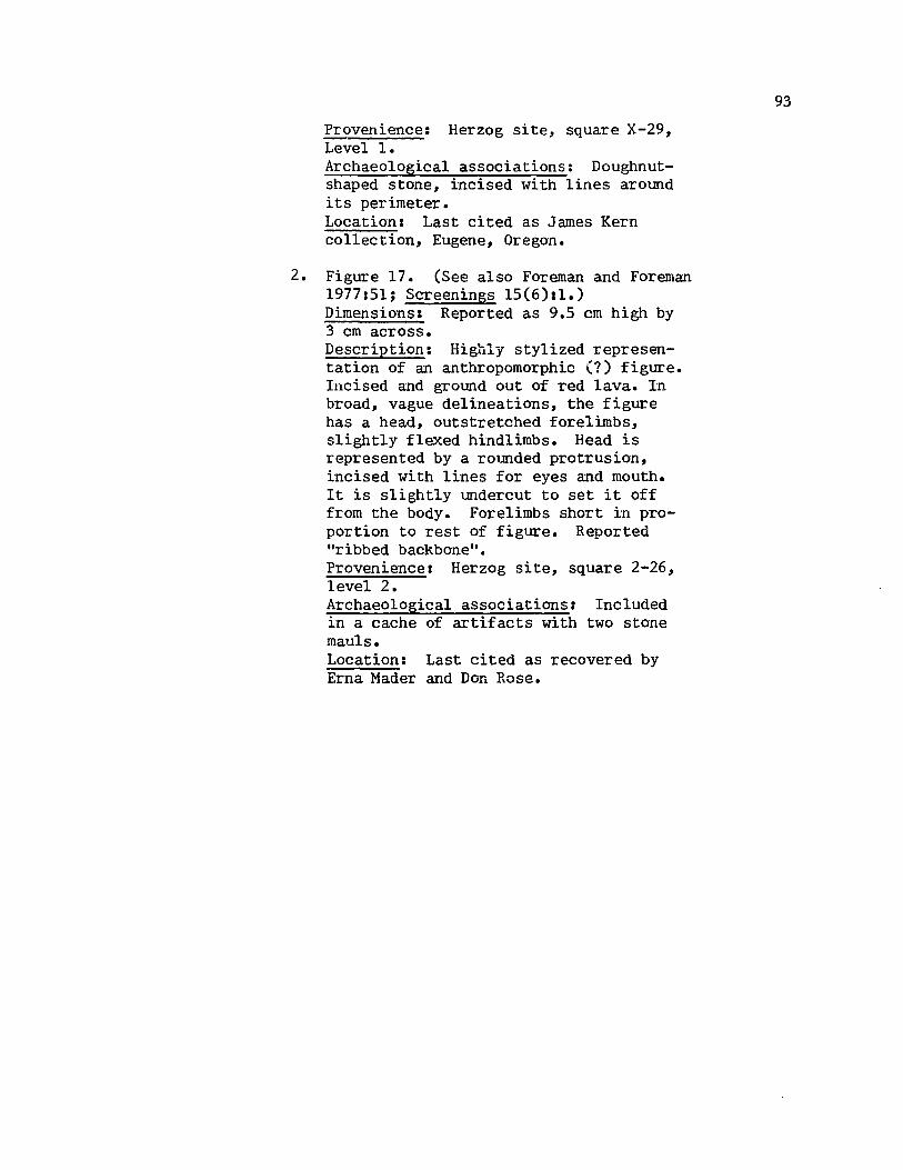
Provenience: Herzog site, square X-29, Levell. Archaeological associations: Doughnutshaped stone, incised with lines around its perimeter. Location I Last cited as James Kern collection, Eugene, Oregon.
2. Figure 17. (See al so Foreman and Foreman 1977151; Screenings 15(6)11.) Dimensions I Reported as 9.5 cm high by 3 cm across. Description: Highly stylized representation of an anthropomorphic (?) figure. Incised and ground out of red lava. In broad, vague delineations, the figure has a head, outstretched forelimbs, slightly flexed hindlimbs. Head is represented by a rounded protrusion, incised with lines for eyes and mouth. It is slightly undercut to set it off from the body. Forelimbs short in proportion to rest of figure. Reported "ribbed backbone". Provenience I Herzog site, square 2-26, level 2. Archaeological associations: Included in a cache of artifacts with two stone mauls. Location: Last cited as recovered by Erna Mader and Don Rose.
93

s.twMi Iq1&
Figure 17. Anthropomorphic (?) figure, Herzog 1. 9.5 cm long x 3 cm wide. (Illustration after Screenings 15(6):1.)
'f.
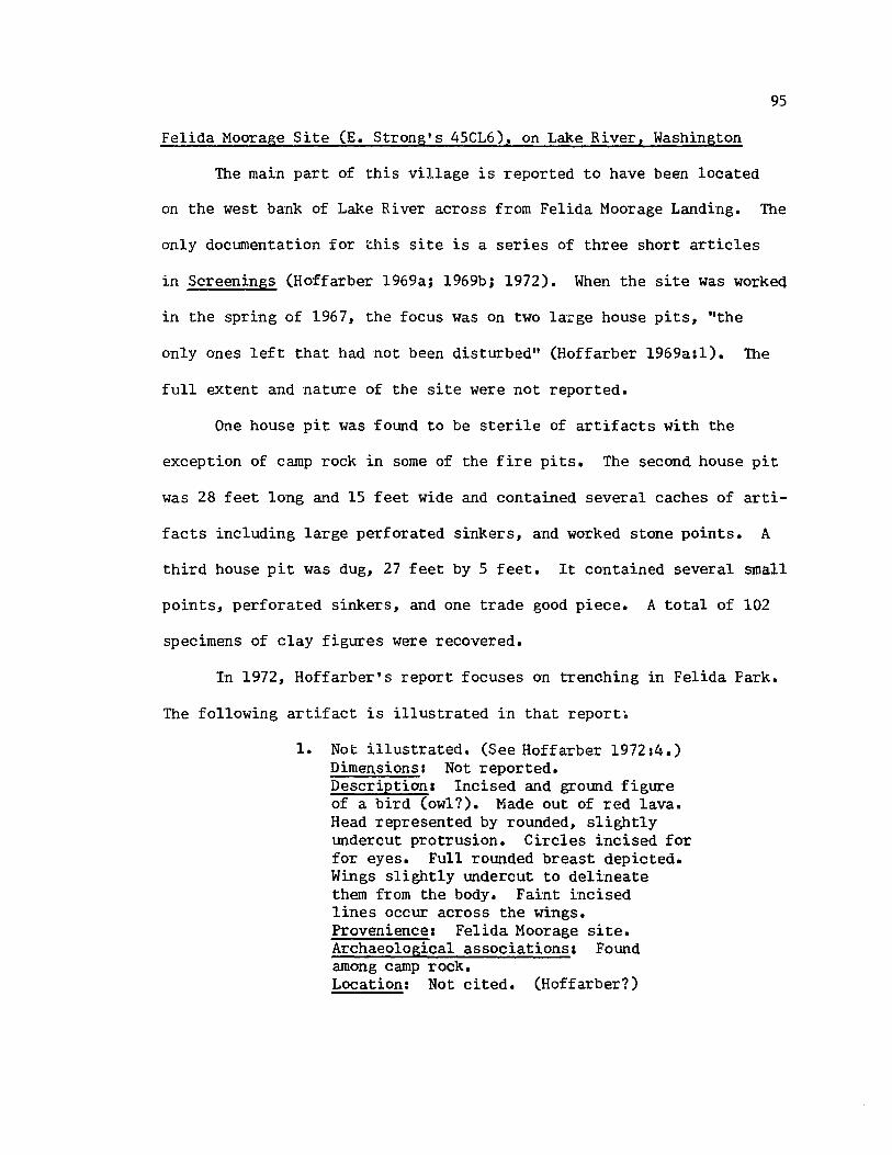
95
Felida Moorage Site (E. Strong's 45CL6), on Lake River, Washington
The main part of this village is reported to have been located
on the west bank of Lake River across from Felida Moorage Landing. The
only docwnentation for this site is a series of three short articles
in Screenings (Hoffarber 1969a; 1969b; 1972). When the site was workeq
in the spring of 1967, the focus was on two large house pits, "the
only ones left that had not been disturbed" (Hoffarber 1969a:1). The
full extent and nature of the site were not reported.
One house pit was found to be sterile of artifacts with the
exception of camp rock in some of the fire pits. The second house pit
was 28 feet long and 15 feet wide and contained several caches of arti-
facts including large perforated sinkers, and worked stone points. A
third house pit was dug, 27 feet by 5 feet. It contained several small
points, perforated sinkers, and one trade good piece. A total of 102
specimens of clay figures were recovered.
In 1972, Hoffarber' s report focuses on trenching in Felida Park.
The following artifact is illustrated in that report.
1. Not illustrated. (See Hoffarber 197214.) Dime~sions I Not reported. Description I Incised and gI'Ol.md figure of a bird (owl?). Made out of red lava. Head represented by rounded, slightly undercut protrusion. Circles incised for for eyes. Full rounded breast depicted. Wings slightly undercut to delineate them from the body. Faint incised lines occur across the wings. Provenience a Felida Moorage site. Archaeological associations: Found among camp rock. Location: Not cited. (Hoffarber?)
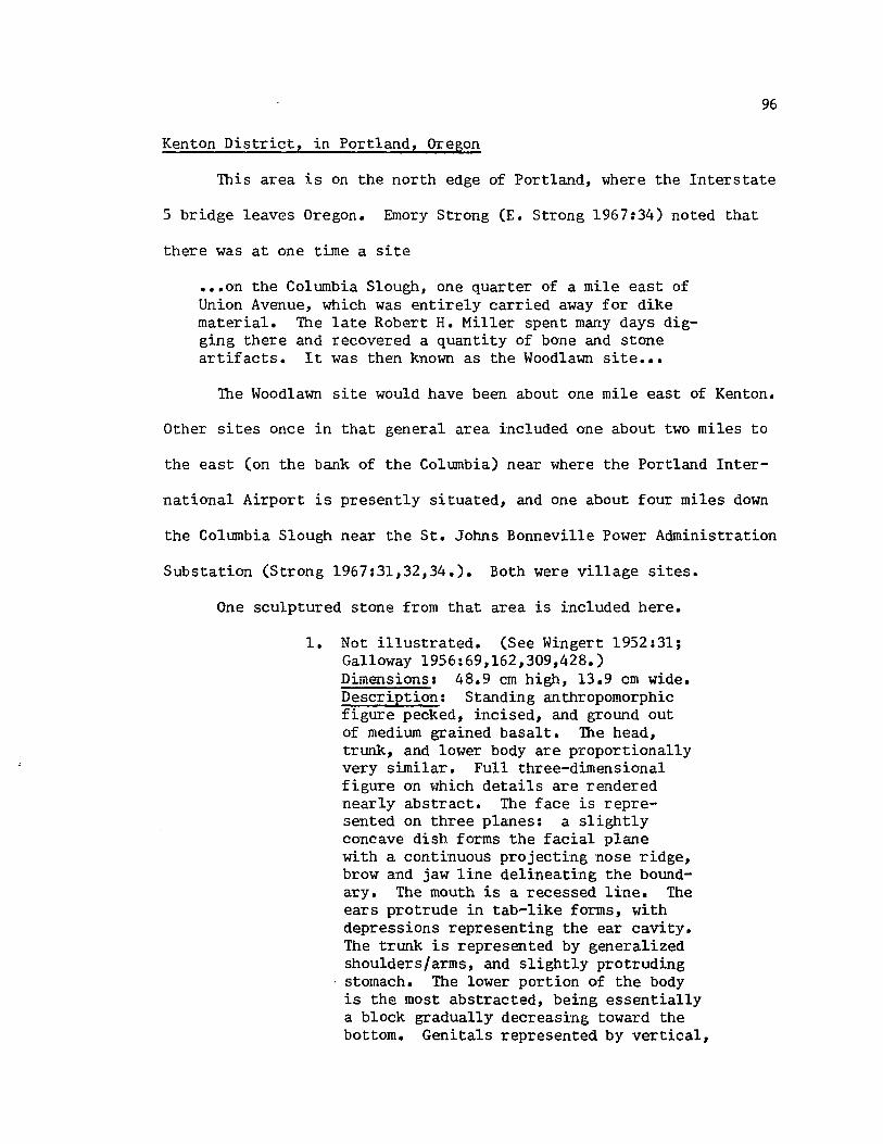
96
Kenton District, in Portland, Oregon
This area is on the north edge of Portland, where the Interstate
5 bridge leaves Oregon. Emory Strong (E. Strong 1967:34) noted that
there was at one time a site
••• on the Columbia Slough, one quarter of a mile east of Union Avenue, which was entirely carried away for dike material. The late Robert H. Miller spent many days digging there and recovered a quantity of bone and stone artifacts. It was then known as the Woodlawn site •••
The Woodlawn site would have been about one mile east of Kenton.
Other sites once in that general area included one about two miles to
the east (on the bank of the Columbia) near where the Portland Inter-
national Airport is presently situated, and one about four miles down
the Columbia Slough near the St. Johns Bonneville Power Administration
Substation (Strong 1967:31,32,34.). Both were village sites.
One sculptured stone from that area is included here.
1. Not illustrated. (See Wingert 1952:31; Galloway 1956:69,162,309,428.) Dimensions: 48.9 cm high, 13.9 cm wide. Description: Standing anthropomorphic figure pecked, incised, and ground out of medium grained basalt. The head, trunk, and lower body are proportionally very similar. Full three-dimensional figure on which details are rendered nearly abstract. The face is represented on three planes: a slightly concave dish forms the facial plane with a continuous projecting nose ridge, brow and jaw line delineating the boundary. The mouth is a recessed line. The ears protrude in tab-like forms, with depressions representing the ear cavity. The trunk is represented by generalized shoulders/arms, and slightly protruding stomach. The lower portion of the body is the most abstracted, being essentially a block gradually decreasing toward the bottom. Genitals represented by vertical,

depression (7). Provenience: Excaved about 1940 on the Columbia Slough, north of Kenton. Site of Swift's. (Wingert 1952131). Archaeological associationsl None reported. Location: Present location could not be varified. Last known location: Vancouver Public Schools (Galloway 1956:309).
97
East Portland, Oregon
The most that can be said for this general location is that it
is within the area frequented or occupied by Chinookan-speakers in
early historic times.
One carving with this location was cited in the literature.
1. Not illustrated. (No known illustration in the literature.) Dimensions: Not reported. Description: (After Eells 1886 :293) Stone bowl or mortar with head of a "turtle" at one end, and with an "arm and ten ribs on its sides". Provenience: East Portland. Archaeological associations: None reported. Location: Not cited.
98
99
Portland, Oregon (Park Blocks, South Side of Willamette River)
In general, the country on the east side of the Wi1lamette River
to Oregon City, and then up the Clackamas River to the Cascade Mountains
was at one time claimed by the Clackamas Indian groups (Hodge 1907,1:
302). No specific mention is made of the west bank of the Wi1lamette
in this particular area. Archaeological remains were discovered a few
blocks away when the construction of the St. Mary's gym took place in
October, 1962. The remains included various projectile points, knives,
pestles, large bowl, three small bowls, ochre, etc. (Harmon 1963:3,4).
The following carving is known from this area.
1. Not illustrated. See The Oregonian 1963 (May 1):1,7.) Dimensions: Precise dimensions not reported. It weighed 22 pounds, was approximately 15 cm high and a little less than that wide. Description: Zoomorphic head pecked, incised, ground out of basalt. Full three-dimensional head. Nose broad, rounded snout with nostrils defined by depressions. Nose formation continues up and around for eye orbits. Eyes bulbous protrusions, no pupils delineated. Mouth incised line. Darkly stained on one side. Provenience: SW Park, between Clay and Market Streets. Discovered when construction for Park blocks parking meters was undertaken. Archaeological Associations: None reported. Location: Unknown. Ownership in dispute at time of paper article.

100
Oregon City, Oregon
This town is situated at the Willamette Falls. Hodge reports
at least three groups that resided at the Falls: Clowwewalla, Charcowa
(possibly a band of the previous group), and Cushook (Hodge 1907,1:235,
313,373). The first two were observed on the west bank of the river,
while the latter was on the east bank. However, because the falls was
such an important fishery for the early inhabitants of the area,
seasonal use of it by many more groups probably occurred.
Ron Kent (1978) recently reported the archaeological ::-emains of
an extensive fishing site near the foot of the 1-205 bridge in Oregon
City, not far below the falls, as well as a major fishing site by the
pool right below the falls.
No carved stones: from the area are included here. However, it
should be noted from earlier accounts that such were found there.
For example, Seaman (1967:58) notes:
Pioneers report that many collections of relics have been made here; and it is not unusual to see mortars in the yards of older residents.
For well over a century, Oregon City has occupied the principal village sites near the falls. Arrow points and occasional carved rock are still sometimes brought to light during construction work about the town, and the river banks still turn out a few relics in times of flood.
A specific example of the occasional carved stone that Seaman mentions
would include the very large stone frog that was discovered when the
original lock at the falls was built. According to Stuart Mockford
of Oregon City, the sculpture "spooked" the Indian workers, and they
quit their jobs (Hill and Hill 1974 :247). The present location of
this sculpture is not known.

1. Not illustrated. (No known illustration in the literature.) Dimensions: Not reported. Description: (After Hill and Hill 1974: 247. ) Sculpted stone frog. Provenience: Old Willamette Falls. Archaeological association: Not reported. Location: Not cited.
101

102
Eagle Creek, Oregon
The present town of Eagle Creek is on the Clackamas River. Hodge
noted that the Clackamas Indian groups in general claimed the country
on the east side of the Willamette River to Oregon City, and then up
the Clackamas River to the Cascade Mountains (Hodge 1907, I :302).
Woodward's (1974) dissertation on the Clackamas River drainage system
has shown a scattering of isolated sites none of which touch upon this
area in particular.
One carving was noted in the literature.
1. Not illustrated. (No known il1usillustration in literature.) Dimensions: 3 in. thick by 2 1/4 in. for the body; 2 in. by 1 3/4 in. for neck. Description: (After Eells 1886:293) Zoomorphic figure suggesting a !!stl.ulrrel". Appeared to have been broken off from some other artifact. Provenience: Eagle Creek, Clackamas County, Oregon. Cultural associationsl None reported. Location: Not cited.
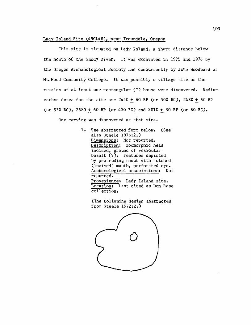
103
Lady Island Site (45CL48), near Troutdale, Oregon
This site is situated on Lady Island, a short distance below
the mouth of the Sandy River. It was excavated in 1975 and 1976 by
the Oregon Archaeological Society and concurrently by John Woodward of
M~Hood Community College. It was possibly a village site as the
remains of at least one rectangular (?) house were discovered. Radio-
carbon dates for the site are 2450 :!:. 60 BP (or 500 BC), 2480:!:. 60 BP
(or 530 BC), 2380 + 60 BP (or 430 BC) and 2010 :!:. 50 BP (or 60 BC).
One carving was discovered at that site.
1. See abstracted form below. (See also Steele 1976:2.) Dimensions: Not reported. Description: Zoomorphic head incised, ground of vesicular basalt (7). Features depicted by protruding snout with notched (incised) mouth, perforated eye. Archaeological associations: Not reported. Provenience: Lady Island site. Location: Last cited as Don Rose collection.
(The following design abstracted from Steele 1972:2.)
o
104
Camas, Washington
The area around present-day Camas is archaeologically known in
terms of three sites: one at the mouth of the Washougal River, one at
the mouth of Lacamas Creek, and one at Wagon Wheel Park.
The Lacamas Creek site was a long rectangular house of 40 feet t~
length and 16 feet in width with five firepits (Selby 1955:2).
Heavily collected, this site yielded banded sinkers, mauls, perforated
sinkers, a drill, and one bowl (Selby 1955:2,3; Warren 1958:12,13).
Both of the other sites contained several subterranean house pits.
Cobble choppers were found as were hanunerstones, scrapers and gravers,
perforated sinkers, etc. (Warren 1958:11,14; Screenings 4(10) :2, 3).
No full archaeological description of anyone of the sites or the
area as a whole exists outside of Warren's brief 1958 discussion "A Re-
evaluation of Southwestern Washington Archaeology". It was his convic-
tion that the evidence pointed to occupancy of the area by Plateau
culture people in late proto-historic and contact times. This iSl:rue,
according to Warren, for the a'Lea between Camas/Washougal and Vancouver
in particular.
One carving from the Camas area is cited here.
1. Not illustrated. (No known illustration in the literature.) Dimensions: Reported as 8 1/4 in. high, and 2 3/4 in. wide. Description: (After Winger 1952:31) Pestle with animal head carved out of lava. Provenience: Camas, Washington, on the river bank. Archaeological associations: Not reported. Location: Last cited as Henry Thorsen collection.

105
Troutdale, Oregon
This small town is located near the mouth of the Sandy River.
which was called the Quicksand River by Lewis and Clark. Their party
laid over above the Sandy for a few days to get food on their return
journey in 1806. Their journal entry for April 2, 1806 notes that the
natives "inform us that the quick sand river is not naviagable any dis
tance in consequence of falls and rapids; and that no nation inhabit it"
(Thwaites 1905,IV:230). Later that day, having hired an Indian to pilot
him to the mouth of the Willamette, Clark reported: "on the South side at
this place my Pilot informed me he resided and that the name of the tribe
is Ne-cha-co-lee, this village is back on the South of Dimond island, and
as we passed on the North side of the island both descending and ascend
ing did not see or know of this village" (Thwaites 1905,IV:236). The
next day, on his return upriver, Clark stopped at the house of his
pilot and "at the back of this house I observe the wreck of five houses
remaining of a very large village, the houses of which had been built in
the form of those we first saw at the long narrows of the E-lute Nation
with whome those people are connected" (Thwaites 1.905,IV:240). Although
he enquired about the distribution of the group, he only notes that his
informants said they had been decimated by small pox (Thwaites 1905,IV:
241).
Emory Strong places this village on the Columbia's edge at the
western end of Blue Lake about two miles below Troutdale (1967:89). He
further notes that Major O. S. McLeary, an early student of local
history, says that in 1923 the marks of the house were still visible.
Dike and other construction have obliterated the site (E. Strong

1955:2,4; 1967:89).
One carving from the Troutdale area is included here.
* 1. Not illustrated. (No known illustration in the literature.) Dimensions: 76.2 cm long, 44.5 cm high. Descriptionl Crescent shaped rock incised and ground (?) into the shape of a fish. Made of scoracious lava (?). Eyes are represented by slightly bulbous protrusions that have a leveled surface. A ridge encircles the eyes. The mou~h, both upper and lower jaws, are incised and carved away to leave the representation of a protruding tongue. Vertical lines edge the upper jaw. Two incised lines run the length of the back to form a ridge which is in turn cross-incised with lines. The effect is of a spine or series of fins. The sides of the body are incised with a series of vertically-oriented, slightly crescent shaped lines that bow to the head of the body. The tail piece is partially broken away. Provenience: Troutdale, Oregon .. Archaeological associations: Not reported. Location: Oregon Historical Society, Portland, Oregon; catalogue 2529.
106

107
Ten Mile Tavern site, near Fishers Landing, Washington
This site is located about one mile above Fishers Landing, on the
bank of the Columbia River. The Ten Mile Tavern site was noted to have
a number of boulders "covered with random carvings and deep pits";
however, "all types of artifacts" were also found there (E. Strong 1967:
37). This included the following stone carving.
1. Not illustrated. (No known illustration in t:;he literature.) Dimensions: Not reported. Description: (After E. Strong 1967:37) The shape of a bird with the face of a man, carved out of steatite. Provenience: Flower garden, Ten Mile Tavern site. Archaeological associationss Not reported. Location: Not cited.
I believe the following site designation of Warren's (1958:13)
to be the same as Ten Mile Tavern and have therefore included an excerpt
citing further carvings (numbers two through four) for this site.
Site CL7. This site is located at the mouth of a small stream on the north bank of the Columbia, approximately one mile east of Fishers Landing. Several homes are now located on the site area, but one of the owners has an excellent collection from the site. It includes many elaborately carved sinkers with as many as three bands, pestles with carved tops, one of which is an animal effigy, grooved mauls, various sizes of stone bowls and mortars which are both round and rectangular in shape and occasionally have carved designs on the rim or body, two carved stone effigies, many chipped stone projectile points and scrapers. /Emphasis mine./

108
Cape Horn, Washington (Skamania County)
Before the construction of Bonneville Dam, an area of rapids
occurred between Stevenson and Skamania, Washington, which was known
as the Cascades. A group of Indians with that designation are ethno-
graphically known from two miles above Cape Horn to ten miles below
Wind River (Spier and Sapir 1930:167-168). Their villages apparently
all occurred on the Washington side of the Columbia River. Both ethno-
graphic and archaeological evidence for the Oregon side of the river
is virtually unknown. The furthest downriver occurring village of the
Cascades was "about half a mile below a high rock (ik !a'lamat) nOl'1
known as Castle Rock and about two miles above Cape Horn" (Spier and
Sapir 1930:168). Petroglyphs are located near the upper end of the
railroad tunnel at Cape Horn.
Une carving from that area is included here.
~': 1. Figure 18. Dimensions: 37 cm long, 16.5 cm high. Description: Very lightly incised stone with vague suggestion of snout, slightly protruding eyes (7), and perhaps three or more incised lines running from top of back part way down the sides. Provenience: Cape Horn, Washington. Archaeologi.cal associations I None reported. Location: Oregon Historical Society, Portland, Oregon; catalogue number 2527.

~ t
::~;:', " .~ t'. . '_ ..
• ; .... ~~ •• ,_:.',.' _"t .I.,r....!!~ ..... " '''' •• _ ..... :.~~.. ~ .. ~ •• ' •• I •• : . .. ..' '" .
, , \ 11\'" :, ,t •
• ... r .... ;..~(: ' • . .,.~~ .. .,. , '
.. ~ j .......... ": . . . ,'(, ... ~. . ,
•••• '." ' . .... "~ '0':"'" '."~ •• , ,"~ , ' ~,. --'\~A',:. . . ,'--.;.~. t'., t" ". '. "fl'~ '.t<;' 1',' ·:7 .. .. ~ ,,:'!":."
'~t~· ., ....... . . ' ~-,::. __ :--...... .. .. " , .' I': tI' • • ::~., • .,. • ... ,,' :
:",;.. ... , . '" ... ~~;:~.;:- ·~~~.\t". , ..
Q)
~ 'i 0 ~
iii
~ 'M or:: E C)
II)
1.0 r-l
:><
no c: 0
r-l
E C)
II)
..... C"'I
E 15 lH
C) 'M or:: 0. H o E o o N
109

110
Along the "Cascatles"
From the Washougal area upriver nearly to Skamania, little archeo
logical evidence exists. Similarly, few references to Indian groups
along that portion of the Columbia occur in the ethnographic or histor
ical literature. This is in part explained geologically as the basalt
cliffs on the south shore of the Columbia rise abruptly from near the
water's edge. Access to resources and the interior is very limited.
Before the construction of the Bonneville Dam, there was a long
stretch of rapids running between Skamania and Stevenson areas. This
was known as "the Cascades" and was heavily populated by Indians because
the rapids formed natural, abundant salmon fisheries. At least through
out early historic times, a series of groups known as the Cascades
Indians lived there more or less permanently. However, many groups
from thE:: lower part of the river came up to live along the rapids during
various fish runs of each year.
Because it was frequented by several groups, reconstruction of
settlement patterns along the Cascades has been very difficult. Lewis
and Clark's journals and the writings of many early historical authors
(summarized in Hodge 1907,IIz922) seem to give the upstream limits of
these groups as being near present day Cascade Locks. Spier and Sapir's
work gives the mouth of Wind River as the uppermost limit of the groups
(1930zl68). Since it is most inclusive, it is the one that will be
used herein.
The archaeological evidence for the area is best known through
the works of Strong (1967), Seaman (1967), Warren (1958), Cole (1974),
Dunnell and Lewarch (1974) and Dunnell, et al (1976). The first two

III
give early, general assessments of sites in the area, especially before
the dam construction. The latter three are archaeological surveys
and/or excavation reports. Drawn from these sources, a preliminary
listing of the various sites along the former rapids area include the
following: just south of Skamania on the bank of the Columbia (Warren
and Eng 1955; Warren 1958), site or site series between Skamania and
Beacon Rock (Seaman 1967:63,64; Strong 1967:33,41), several Bradford
Island sites (Krieger 1935; Cole 1974; Dunnell and Lewarch 1974; Dunnell
et al 1976; Phebus 1978), Ashes Lake site (Cole 1974), several sites in
North Bonneville and environs (including Hamilton Island) (Cole 1974;
Dunnell and Lewarch 1974; Dunnell et al 1976), Sullivan's Island (Cole
1974), two sites in Cascade Locks (Cole 1974), and one at the mouth of
Wind River (Strong 1967:33). Many of these sites have been lost to
collecting, construction, and/or river and landslide a.ction. Most of
the recent evaluations of existing sites show that they are shallow,
with little stratification and are relatively recent (late prehistoric,
historic).
Information concerning possible stone carvings from this area
include the following comment by Henry (Coues 1965:804):
The front planks of the beds are carved and painted in various styles. At the end of each range are some broad upright planks, on which figures are rudely carved, somewhat resembling fluted pillars. At the foot of the chief's bed are planted in the ground at equal distances four figures of htlInan heads, about two feet high, adorned with a kind of crown, and rudely carved and painted. Beside these figures are erected in the ground two large, flat, painted stones. On the side of each oartition. facing the fireplace, are carved and painted on the planks uncouth figures of eagles, tortoises, and other animals some of them four feet long. The colors used are white, red, black and green; the sculpture, in some instances, is not bad.

Following are several carvings from this area.
1. Not illustrated. (No known illustration in literature.) Dimensions: 6 3/4 in. long, 3 1/4 in. in width from tip of one wing to tip of other, 2 in. thick, weighed 1 lb., 10 oz. Description: (After Eells 1886:293) Bird carved of basalt. Provenience: At the Cascades. Archaeological associations: None reported. Location: Last cited location was Rafferty collection.
2. Not illustrated. (No known illustration in literature.) Dimensions: Not reported. Description: "several pipes with animals carved on them" (Warren 1958:10) Provenience: Site designated ~s 45SKI by Warren (1958:10) and just south of the town of Skamania on the bank of the Columbia. Archaeological associations: Warren reports that the site yielded to its owners "literally thousands of artifacts including many pestles, mortars and banded sinkers, both plain and with elaborate designs, perforated sinkers, ••• various types of choppers, projectile points, and scrapers" (Warren 1958:10). Location: Collection ownership not cited in the literature. (Perhaps the Sams COllection?)
3. See abstracted form below. (See also Strong 1967:177, Figure 71.) Dimensions: Not report~d. Description: Bowl ground and shaped into a protrusion on one end to represent an ahstraction of a zoomorphic head. No other body portions delineated. Effect is that of a slightly oval bowl inset in the back of a zoomorphic figure. Provenience: Discovered at Prindle, about two miles above Cape Horn (Strong 1967: 179). The furthest downstream village of the Cascades Indians may have been located in the immediate vicinity of Prindle (Spier and Sapir 1930:168).
112

Archaeological associations: None reported. Location: Last cited location was the Sams cOllection (Strong 1967:179).
(The following design abstracted from Strong 1967:177.)
./
4. Not illustrated. (See Strong 1967: 138, Figure 51.) Dimensions: Not reported. The flared mouthpiece is about one-half the diameter of the pipe bowl, and about one-sixth the length of the pipe. Description: The body of a pipe is a slightly flaring tube with a lizard-like zoomorphic figure lying in relief along the length of the pipe. The fore and hind appendages lie out as if to encircle the body of the pipe and appear to have digits delineated. Small indentations occur for the eyes. The back of the zoomorphic form has about eight parallel lines running across it. Provenience: North Bonneville. Archaeological associations: None reported. Location: Last cited location was the Sams collection (Strong 1967:140).
5. Not illustrated. (See Galloway 1956:295, 366.) Dimensions: Reported as 3 5/8 in. long and 1 3/4 in. high. Description: Zoomorphic figure incised and ground (?) from vescular lava. Slightly arched body has two hind appendages protruding at about a 30 degree angle away from the stomach area. Head of figure is defined by two slightly oval ears, a cone shaped snout. Mouth is formed
113

of incised line. A series of parallel incised lines run over the shoulder, back, and just behind the back limbs (the latter lines help delineate a tail for the figure). No apparent forelimbs. Provenience: Bradford Island. Archaeological associations: Not certain. Collected by H. W. Krieger in 1927. Galloway reports that Krieger told him the figure was possibly from a burial: "The soil at the exact spot of discovery was disturbed; but the general area was one productive of burial materials" (Galloway 1956:184). Location: U. S. National Museum (Smithsonian Institution), Washington, D. Co; catalogue number 3l839-e.
6. Not illustrated. (See Galloway 1956: 295,365.) Dimensions: Reported as 4 7/8 in. long, 3.4 in. high. Description: Zoomorphic figure ground of vesicular lava. Abstraction of a quadruped figure, the shape and proportions of which are suggestive of a "bear". Forelimbs treated as one, as are hindlimbs. Head abstraction also, with slight protrusions for ears. Provenience: Bradford Island. Archaeological associations: (Same as for preceding sculpture.) Location: U. S. National Museum (Smithsonian Institution), Washington D. C.; catalogue number 31839-c.
7. See abstracted form below. (See Galloway 1956:203,295,367.) Dimensions: Reported as 1 7/8 in. long, 3/4 in. high. Description: Generalized quadruped of schi st. A cone-shaped head is illldercut to separate it from the body of the figure. The forelimbs and hindlimbs are respectively shown as joined. A slightly curled, upturned tail occurs at the end of the body. A perforation occurs behind the front legs. Provenience: Bradford Island. Archaeological associations: None reported.
114
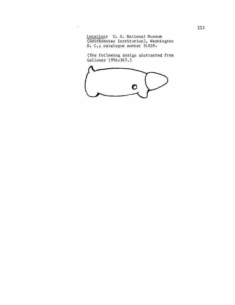
Location: U. S. National Museum (Smithsonian Institution), Washington D. C.; catalogue number 31839.
(The following design abstracted from Galloway 1956:367.)
115

116
Mosier Creek, Mosier, Oregon
No historical, ethnographic, or archaeological evidence is known
for this area specifically. Cole (1974:8) felt that the "Smackshop
Village" mentioned in Lewis and Clark journal entry for April 14, 1806
(Coues 1893, 111:949) might have been at the spot located directly
across the Columbia from Mosier at Locke Lake. However, no evidence
was found on the north bank in 1971.
Spier and Sapir (1930:167) indicate that the area opposite Mosier
was reportedly inhabited by Klickitats and White Salmon peoples. They
further report Wishram and Klickitat groups upriver and White Salmon
groups downriver but all on the north bank of the Columbia.
The following carvings are from Mosier.
"l( 1. Figure 19. Dimensions: About 13 cm high, 7 cm across at the base and at the face of the figure. Descriptionf Pestle incised and ground of basaltic river rock (?). Top of pestle shaped into zoomorphic head. Pestle tapers from base to neck of figure. A slight ridge occurs as a mouth or jaw line, coming out, up, and over the eyes and nose to form the facial boundary and orbital ridges. Eyes are bulbous protrusions as is the nose. The back of the head is flattened and hollowed out except for a small vertical ridge down the center. Provenience: On Mosier Creek, on the Columbia. Archaeological associations: None reported. Location: Oregon Historical Society, Portland, Oregon; catalogue number 2090.

Figure 19. Pestle with zoomorphic head atop handle, Mosier 1. 13 ern high x 7 ern wide.
117

* 2. Not illustrated. (No known illustration in the literature.) Dimensions: About 32 cm high, 5.6 cm across. Description: Long pestle (or club) with possible representation of a zoomorphic head atop its handle. Head is defined by a slightly protruding, rounded snout with an incised line for a mouth (?). Provenience: On Mosier Creek. Archaeological associations: None reported. Location: Oregon Historical Society, Portland, Oregon; catalogue number 2172.
118

119
Lyle, Washington
There are references to this area in the historical, ethnographic
and archaeological literature. Lewis and Clark mentioned in their
journal of October 29, 1805 " ••• landed to smoke a pipe with the people
of a village of 11 houses ••• situated immediately below the mouth of a
River ••• " (Thwaites 1906,III:167). Cole (1974:7) believed this to be
a Chilluckittequaw village at the mouth of the Klickitat River (cf. to
Coues l893,II:676), and now inundated.
Spier and Sapir (1930:166) list a Wishram winter village a short
distance below the mouth of the Klickitat River and about one mile
above Memaloose Island.
David Cole worked a site on the east bank of the Klickitat River,
near its mouth, in 1971. The site and artifact assemblage suggest
occupation earlier than AD 1400. Evaluation of the site was compli-
cated by the evidence of two major floodings of the site and intensive
wind deflation; however, two concentrations of artifacts in Pit 3
suggest occupation layers. No charcoal, bone or perishable material
was recovE!Ted. Most of the artifact inventory includes flaked cobbles,
girdled stones, reamers, scrapers, etc.
One carved stone artifact is reported from this area.
* 1. Figure 20. (See also Steward 1927:259; Krieger 1928:137; Strong, Schenck and Steward 1930:108; Wingert 1952:17,31.) Dimensions: The rock is approximately 37 cm square. The face is about 22 cm square. Description: The anthropomorphic head of a figure is shown in relief on one face of a large piece of basalt. The face is depicted on three planes: the eyes, nose/brows, and facial boundary are in relief, the cheeks and lower face level,
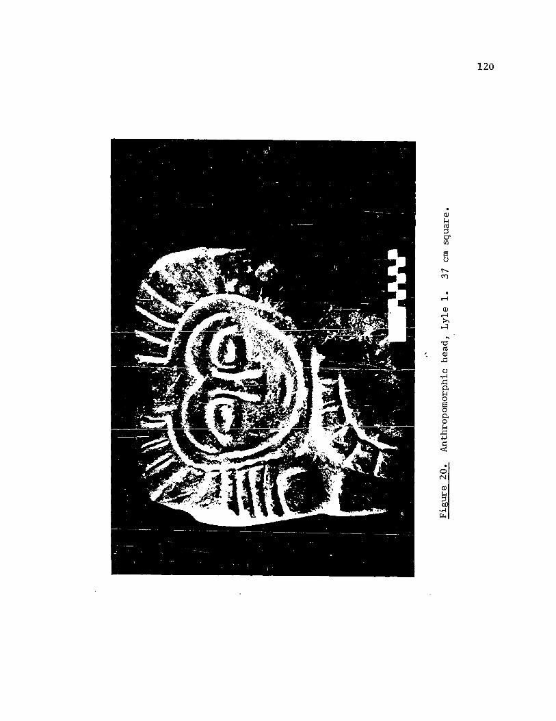
. OJ
~ ::J 0' U)
. r-I
OJ r-I :>, H
120
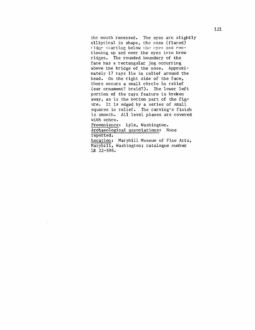
the mouth recessed. The eyes are slightly ell iptical in shape, the nose (flared) ritlgc ~;Lartin~ below \.lH' <,yes and continuing up and over the eyes into brow ridges. The rounded boundary of the face has a rectangular jog occurring above the bridge of the nose. Approximately 17 rays lie in relief around the head. On the right side of the face, there occurs a small circle in relief (ear ornament? braid?). The lower left portion of the rays feature is broken away, as is the bottom part of the figure. It is edged by a series of small squares in relief. The carving's finish is smooth. All level planes are covered with ochre. Provenience: Lyle, Washington. Archaeological associations: None reported. Location: Maryhill Museum of Fine Arts, Maryhill, Washington; catalogue number LR 22-398.
121

122
Walter Klindt Farm, Near The Dalles, Oregon
This farm was located approximately three miles west of The Dalles,
Oregon. No references touch upon this specific locale. Two stone
carvings found at this farm are included here.
-/; 1. Figure 21. (See also Strong, Schenck and Steward 1930:108; Screenings 10(6):3; Wingert 1952:18,31; Oregon Archaeological Society 1959:40; Seaman 1967:142.) Dimensions: Overall 25 cm high, 19.5 cm across at greatest width. Each bowl is about 9.5 cm across and 2.5 cm deep. The larger face is 15 cm high and 14 cm across. The smaller face is over 10.5 cm high and 13 cm across. Description: A double mortar incised, ground out of basalt. Two very similar faces are depicted , one smaller and placed as though on the back of the other. The eyes are depicted by two almond shaped ridges for each eye, one within the other. The nose is a vertical ridge separating the eyes. A "jaw line" starts behind the head, comes around and under the eyes. No mouth is depicted. The crown of the head (which is also the rim of the mortar) has two parallel wavy ridges encircling it. Five ridges ("ribs") slant upwards on each side of the body. The eyes and nose are delineated in the same manner as the larger face. In this face, however, the jaw line is continuous, and an incised horizontal line with an enclosing ridge forms a mouth. The crown of the smaller head has one straight line encircling it. Provenience: Klindt Farm, The Dalles. Archaeological associations: None reported. Location: Maryhill Museum of Fine Art, Maryhill, Washington; catalogue LR71-38.39.
~
Figure 21. Double mortar with faces, Klindt 1.
\' .~
.~ ,,-'.~'"
'-' . :.... .
r,~·""'" . ,';, .~., .... .,., '., .-, .' ". -'i;,., I- ' . ...- J., ~'.'- .. ~. t r ....
.... :zo.
'\. . ! ,~, .-~, ... ~Uf) .......... ,.,~.
1It~ . .':.,,' "~' •
~. "'-""-,,,
25 em high x 19.5 em wide.
~
I-' N W

of: 2. Figure 22. (See also Strong, Schenck and Steward 1930:108; Screenings 10(6):1; Wingert 1952:16,32; E. Strong 1961:136.) Dimensions: 16.5 cm high, 12 cm wide, about 33.5 cm around. Description: Representation of an owl (?) incised and ground out of basalt. Features sparely delineated. Slight ridge frames facial plane; eyes and nose are slight bulbous protrusions. Head undercut to set it off from body. Similarly, the wings are undercut to shape them along side the body. A shallow indented band occurs around the middle of the body. Provenience: Klindt Farm, The Dalles. Archaeological associations: None reported. Location: Maryhill Museum of Fine Art, Maryhill, Washington; catalogue LR71:38-39.
124
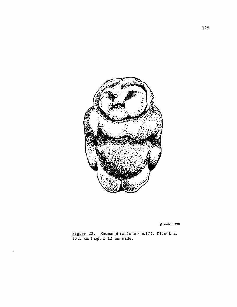
Figure 22. Zoomorphic form (owl?), Klindt 2. 16.5 cm high x 12 em wide.
125
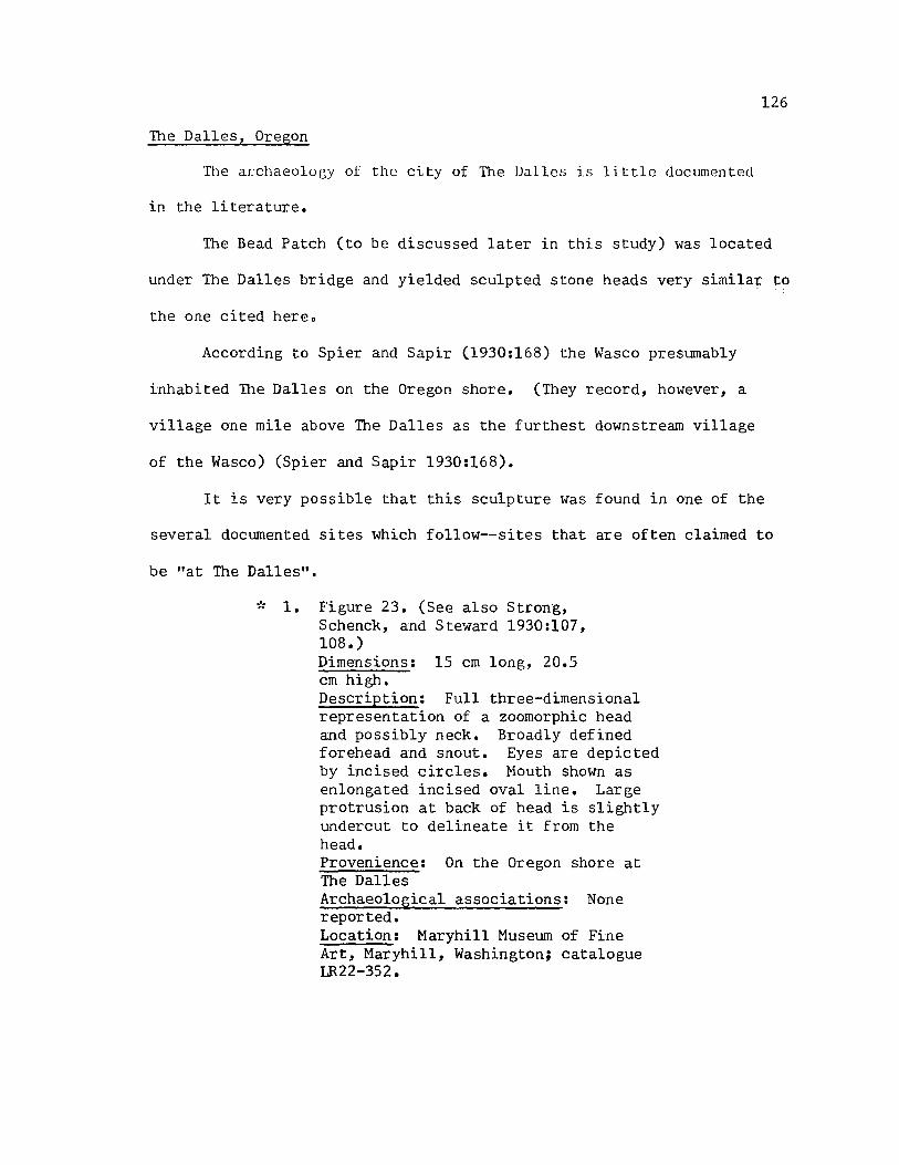
126
The Dalles, Oregon
The archaeolugy ot the city of The !Jalles is little documented
in the literature.
The Bead Patch (to be discussed later in this study) was located
under The Dalles bridge and yielded sculpted stone heads very similar to
the one cited hereo
According to Spier and Sapir (1930:168) the Wasco presumably
inhabited The Dalles on the Oregon shore. (They record, however, a
village one mile above The Dalles as the furthest downstream village
of the Wasco) (Spier and Sapir 1930:168).
It is very possible that this sculpture Was found in one of the
several documented sites which follow--sites that are often claimed to
be "at The Dalles".
of: 1. Figure 23. (See also Strong, Schenck, and Steward 1930:107, 108.) Dimensions: 15 cm long, 20.5 cm high. Description: Full three-dimensional representation of a zoomorphic head and possibly neck. Broadly defined forehead and snout. Eyes are depicted by incised circles. Mouth shown as enlongated incised oval line. Large protrusion at back of head is slightly undercut to delineate it from the head. Provenience: On the Oregon shore at The Dalles Archaeological associations: None reported. Location: Maryhill Museum of Fine Art, Maryhill, Washington; catalogue LR22-352.
13. MOlI,\i IqT8
Figure 23. Zoomorphic head, The Dalles 1. 15 ern long, 20.5 ern high.
127

128
Five Mile Rapids (35WS4), above The Dalles, oregon
The Five Mile Rapids site was located on the south side of the
Columbia River at the head of rapids with that name. This stretch of
the Columbia was also called the Long Narrows (see Map 1).
This site was excavated in 1953 through 1955 by L. S. Cressman
and others from the University of Oregon (Cressman, et al 1960). A
very large site, it had been cut through by railroad and road construc
tion and partially dug over by collectors prior to Cressman and asso
ciates' working it. Cressman focused his excavations on the midden's
central portion, but also dug test pits in its southern-most extension,
up against the basalt cliffs. In the latter area early historic crema
tion burials were discovered (Cressman, et al 1960:61).
The lower level of the midden yielded evidence of occupation about
9000 years ago (Cressman, et al 1960:67). The major cultural phases
are defined for the main midden excavations, the most recent of which
commenced about 6000 years ago and showed evidence of exploitation of
the riverine resources. Although no specimens of sculpted stone were
documented for this site, Cressman felt that the whole range of such
artifacts for The Dalles area should be categorized into the "Late"
phase, "Full Protohistoric" subphase (Cressman, et al 1960:61).
Butler notes that another cremation burial was excavated from the
cliff section by a collector. It lacked trade goods and has been dated
by Butler as late prehistoric (Butler 1965:6). The artifacts included
here came from this pit or from the central portion of the mound which
had been dug over by collectors some years ago.

. -,
SiTES
A- fWE MILE RAPIDS (9)
B- BEAD PATCH (7)
C - BIG EDDY (3) D- OHBE (I)
E - BELOW MAYBE (I) F - MAYBE (9)
G- CONGDON (4j
H - INDIAN WELL (4)
1- ATLATL VAL LEY (6)
J - WAKEMAP (I B) K- LEACHMAN (6)
L - SPEDIS VALLEY (I) , . I
. 'C:,'" ·'0·' .~ .. '
.. ~~'f: . ... ~ ....
··vo . .... ~~ ... " ~ .' LAKE" .....
i .' CELlLO ....
. " (C()LUM8~:' RJ
/ '>''':.~~~:.s,.J:~' . ql~ .... .
".', ~ ... ",." ....
.........
Map 1. Archaeological sites above The Dalles, Oregon
129
.....

1. See abstracted design below. (See also Strong 1967:142,144.) Dimensions: Not reported. Description: "Club" with head and forelimbs of zoomorphic figure depicted. Tail (handle of club) accounts for about two-thirds of the implement. Head represented by slightly elongated snout, punctuate eye, and suggestion of ears in a projection at the top of the head. Forelimbs joined as one and form projection at base of implement. There is a slight nipple on the end of the tail. Provenience: Oregon side of the Columbia River at the Long Narrows. Archaeological associations: Not reported. Location: Last cited as Lloyd McLeod collection.
(The following abstraction after Strong 1967:142.)
See abstracted form below. (See also Screenings 12(12):1.) Dimensions: Shown as approximately 2.5 •. 1. long. Description: Zoomorphic head .. lith proportiona.tely large jaws/snout. Eyes are punctuate. Two parallel crescent-shaped lines occur behind the eyes. Elongated rounded snout has an incised line for a mouth. Provenience: Five Mile site. Archaeological associations: None reported. Location: Last cited as Frank Buehler collection.
130

(The following design abstracted from Screenings 12(12):1.)
3. See abstracted form beloil1. (See also Screenings 10(10):1.) Dimensions: Reported as 4 1/2 in. long. Description: Sma1l piece of sandstone shaped, incised as generalized zoomorphic figure (7). Proportionately sma1l head characterizes the figure. Large projection of combined forelimbs has an incised line running its length. Tail portion accounts for approximately onehalf the length of the figure. Two short incised lines occur at the neck and one across the tail. Provenience: Five Nile Rapids. Archaeological associations: None reported. Location: Last cited as Paul Wiedemann collection.
(The following design abstracted from Screenings 10(10):1.)
131

4. Not illustrated. (See Screenings 4(12):1; Butler 1965:15.) Dimensions: Reported as 29.5 cm high, 14.4 cm deep. Mortar is reported to be about 4 in. in diameter, and 1.5 in. deep. Description: Anthropomorphic head with a mortar inset in the top. Piece is somewhat oval column. Face is defined by a nose ridge that continues up, over and around eyes and face. Eyes are bulbous protrusions. The mouth is recessed. Ears (?) are circular depressions. A ridge collars the face. Possibly incised ribs occur (?). Provenience: Five Mile Rapids. Archaeological associations: Pestles, bowls, pipes, mauls. (See Screenings 4(9):2.) Location: Last cited as Lloyd McLeod collection.
5. Figure 24. (See Screenings 5 (4) : 1; Butler 1965:3,4; E. Strong 1967:114.) Dimensions: Reported 21 cm high, 15.3 cm wide. Description: Anthropomorphic head (fragment) with a mortar inset in the top. Protruding nose, the ridge of which continues up, over and under eyes. Mouth outlined by a slightly crescent-shaped ridge. Space betwp.en lips fillpd whh red piVT!ent (ochre?) and is highly polished. Eyes are slightly bulbous protrusions. Provenience: Five Mile Rapids. Archaeological associations: With mortar (item 4) and its citings. Associated with late protohistoric cremation(s). Location: Last cited as Lloyd McLeod collection.
6. Not illustrated. (See Oregon Archaeological Society 1959:24.) Dimensions: Reported as 2 in. high. Description: Small pestle of spotted porphyry. Full three-dimensional, abstract representation of a bird. Eyes are bulbous. Suggestions of wings folded at sides, and of a tail. Provenience: Cremation at Five Mile Locks.
132

Figure 24. Anthropomorphic head with inset mortar, Five Mile Rapids 5. Reported as 21 cm high x 15.3 cm wide. (Illustration after Screenings 5(4):1.)
133

7. Not illustrated. (See Oregon Archaeological Society 1959:25.) Dimensions: Not reported. Description: Three-dimensional representation of an anthropomorphic head. Nose a protrusion, the ridg,\::: of which continues up and over eyes and around face forming its boundary. Eyes bulbous protrusions. Suggestion of tab-like ears. Top of head had two rounded protrusions. Provenience: Cremation at upper end of Long Na.rrows, at Five Mile Locks. Archaeological associations: Owl sculpture (see next item). Location: Last cited as Lloyd McLeod collection.
8. Figure 25. (See also Screenings 14 (9):4; Oregon Archaeological Society 1959:24; Park 1972:213.) Dimensions: Reported as 4.75 in. high; 4.5 in. long; bowl is 2 in. in diameter. Description: Three-dimensional sculpture of an owl with a mortar inset in its back. Face is a dish-shaped plane with a protruding beak, circular depressions for eyes, and tab protrusions for ears which tilt slightly forward. Wings are slightly outstretched. Tail is tilted up. Both wings and tail are incised with lines running their lengths. Legs are proportionately thick columns with broad, circular feet incised with vertical parallel lines for claws (7). Provenience: Five Mile Locks, in a cremation. Archaeological associations: Anthropomorphic head (see item / above). Location: Last cited as John Krussow collection.
9 0 Figure 26. (See also Screenings 8(1):1; Oregon Archaeological Society 1959:24; Park 1972: 227. ) Dimensions: Reported as 12.75 in. high. Description: Three-dimensional representation of a crouching human figure with a mortar held on his left shoulder, and reportedly a human figure grasped in its right hand. Nose is a ridge which flmvs into almond-shaped ridge which outlines each bulbous eye. Mouth recessed. Head
134
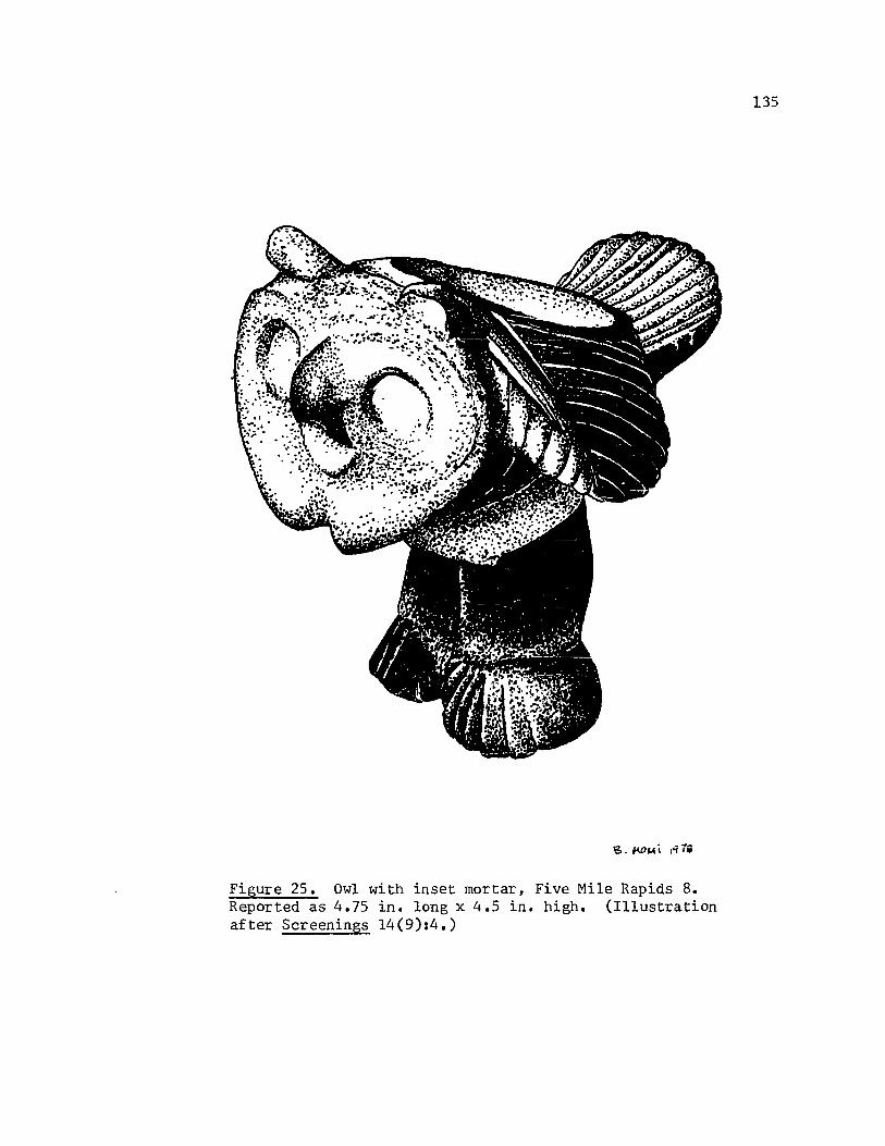
Figure 25. Owl with inset mortar, Five Mile Rapids 8. Reported as 4.75 in. long x 4.5 in. high. (Illustration after Screenings 14(9):4.)
135
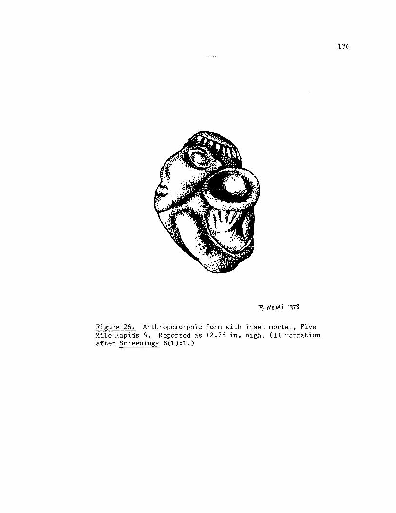
Figure 26. Anthropomorphic form with inset mortar, Five Mile Rapids 9. Reported as 12.75 in. hig.h. (Illustration after Screenings 8( 1) : 1. )
136

topped with two parallel incised lines (with several vertical ones between them) that encircle the crown of the head. Head undercut under chin to delineate it from the body. Left arm sculpted out, in flexed position, widl five digits holding mortar. Figure is reportedly outlined with brilliant red ochre. Provenience: Five Mile Locks. Archaeological associations: None reported. Location: Last cited as Lloyd McLeod collection.
137

Thc Bead Patch, below The Dalles Bridge, The Dalles, Oregon
This site, located on the Oregon shore of the Columbia just
1 .... " ,)0
downstream from The Dalles Bridge, is known only by a brief chapter in
Seaman (which was written by Robert H. Miller)' (Seaman 1967 :69-86) and an
article by Paul Wiedimann (1963:2,4). (See Map 1.)
The site was a large mound (200-250 feet across) apparently lacking
any evidence of habitation or burial and therefore has been called a camp
site. It contained thousands of beads, and many perforated artifacts
("atlatl weights"), doughnut shaped stone rings, pipes, points, scrapers,
etc.
Several carved stones from that site are included here.
1. See abstracted form below. (See also Screenings 5(7):4.) Dimensions: Reported as 3.18 cm long, 1.27 cm at its greatest width, and about .64 em thick. Description: Slightly arched steatite stone with zoomorphic face on one end and possibly incised "stick" legs. Head set off from rest of body by an incised line. Eyes punctuate. Ears outlined on top of head. Mouth incised line. Two incised lines occur shortly behind the head and near the end of the piece, also. A hole was drilled through throat about half way down from the nose. Provenience: Near the Bead Patch. Archaeological associations: None reported. Location: Last cited as Elmer Buelher collection.
(The following design abstracted from Screenings 5(7):4.)
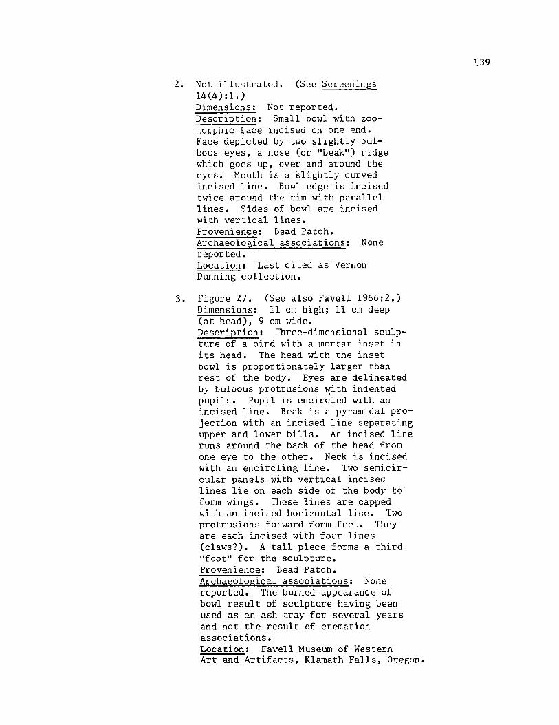
2. Not illustrated. (See Screenings 14 (4): 1.) Dimensions: Not reported. Description: Small bowl with zoomorphic face incised on one end. Face depicted by two slightly bulbous eyes, a nose (or "beak") ridge which goes up, over and around the eyes. Mouth is a slightly curved incised line. Bowl edge is incised twice around the rim with parallel lines. Sides of bowl are incised with vertical lines. Provenience: Bead Patch. Archaeological associations: None reported. Location: Last cited as Vernon Dunning collection.
3. Figure 27. (See also Favell 1966:2.) Dimensions: 11 cm high; 11 cm deep (at head), 9 cm wide. Description: Three-dimensional sculpture of a bird with a mortar inset in its head. The head with the inset bowl is proportionately largp.T than rest of the body. Eyes are delineated by bulbous protrusions ~ith indented pupils. Pupil is encircled with an incised line. Beak is a pyramidal projection with an incised line separating upper and lower bills. An incised line runs around the back of the head from one eye to the other. Neck is incised with an encircling line. Two semicircular panels with vertical incised lines lie on each side of the body to· form wings. These lines are capped with an incised horizontal line. Two protrusions forward form feet. They are each incised with four lines (claws?). A tail piece forms a third "foot" for the sculpture. Provenience: Bead Patch. Archaeological associations: None reported. The burned appearance of bowl result of sculpture having been used as an ash tray for several years and not the result of cremation associations. Location: Favell Museum of Western Art and Artifacts, Klamath Falls, Oregon.
139

~~tt\~;~~t:~'P7f::,L~~?'?f:f~":';Yr::~7;:'~7','~~:-~c;'Y:C~"~'T~"::'··· . 77:~~'7"~'~"~'::
~ - :-1:' ~ " ,
Figure 27. Bird form with inset mortar, Bead Patch 3. 11 em high x 9 em wide.
140

4. See abstracted form below. (See also Seaman 1967:185). Dimensions: Reported as 9 in. high and 4.5 in. across, 6 in. deep. Description: Head and snout of a zoomorphic figure in full threedimensional sculpture. Eyes slight indentations. Similarly, nostrils are defined by indentations. Nose is undercut and an incised line leads away from that cut to form the mouth. Lower jaw slightly undercut toward the area where the neck would connect to the head. Provenience: Bead Patch. Archaeological associations: None reported. Location: Last cited as the Robert Miller collection.
(The following design abstracted from Seaman 1967:185.)
/' o
5. Not illustrated. (See Screenings 5(7):2; Seaman 1967:84,185.) Dimensions: Reported as 8.25 in. long, 4.75 in. wide. Description: Zoomorphic head sculpted as full, three-dimensional figure. Eyes are depicted by bulbous protrusions. Brow ridges start about
141

mid-forehead and sweep out down and around the head nearly to the end of the snout. Mouth is a deeply incised line that undercuts upper jaw. Provenience: Bead Patch. Archaeological associations: Not reported. Location: Last cited as George Marshall collection.
6. See abstracted form below. (See also Seaman 1967:84,85.) Dimensions: Reported as 2 5/15 in. long, 1 1/4 in. wide. Description: Full, three-dimensional carving of a bird with wings slightly outstretched. Incised circles form the eyes. A beak-like projection with an incised line running its length forms the bills. A hole is perforated through the neck. The wings are undercut to separate them out from the body. There are three deeply incised lines on the top of each wing. A series of punctuate marks occur across the shoulder of the wings horizontally, and run down the length of the back. The ends of the wings are slightly undercut to separate them from the tailo The tail projects perhaps a half inch and is incised with three lines running its length. Effect is that of a bird lifting off, or in flight(?). Provenience: From a depth of six feet in the Bead Patch. Archaeological associations: None reported. Location: Last cited as Seaman collection.
(The following design abstracted from Seaman 1 967 : 85 • )
142

i. See abstracted form below. (See also Seaman 1967:84,85.) Dimensions: Reported as 2 7/16 in. long by 1 5/16 in. wide. Description: Full, three-dimensional steatite bird with wings lying at its sides. Head projects much in the same manner as the item just described. Eyes delineated by incised circle. Beak shown with incised line separating it from the head, but not the bills from each other. Perforation occurs through the neck. From the top, the wings are outlined with a series of punctuate marks. No tail is depicted. Provenience: Bead Patch. Archaeological associations: None reported. Location: Not cited.
(The following design abstracted from Seaman 1967:85.)
143
144
Big Eddy Site, Above The Dalles, Oregon
Very little is docwnented in the archaeological literature con-
cerning the area around what was once the Big Eddy at the end of the
Long Narrows (See Map 1). Strong, Schenck, and Steward (1930:20)
discuss a site "near Big Eddy, Oregon, across the Colwnbia river from
Spedis and about 800 meters downstream." These investigators felt that
this site was near Sapir's Wasco village (Sapir 19:240 1 242). Even by
1924-26 when Strong, et aI, were recording the site, they noted that
many artifacts and burials had been dispersed into collections allover
the region. Burgoyne later reported that he and his son did consider-
able collecting at that site the spring and summer of 1955, and it is
his account that reports some of the characteristic artifacts from the
site: "projectile points, paint pots, bowls, pipes, pestles, lucky
stones, sinkers of all kinds, miniature carvings, bone awls, bone per-
forators, smoothing tools, hide scrapers, fish and animal bones, beads,
and hammer stones" (Burgoyne 1963:4). Burgoyne estimated that the
site had once been very large and very deep, but had been virtually
destroyed by The Dalles-Celilo Canal, government housing, and road
construction.
Carvings from that site include the following:
* 1. See abstracted figure below. (See also Strong, Schenck and Steward 1930:107,108; Wingert 1952:15,16,31; Galloway 1956:203, 295.) Dimensions: 4.5 cm long, 1.9 cm high, and 1. 3 cm wide. Description: Serpentine(?) stone carved into full three-dimensional zoomorphic figure. Figure depicted as an animal with humped shoulders, head hung down, and proportionately massive body. Sugrests the representation of a buffalo.

Hole drilled through the back of the figure and out the stomach, between slight protrusions for and aft that depict the legs of the animal. Provenience: Strong, Schenck and Steward's Site 13. Not excavated by them. They simply viewed it in a private collection that supposedly came from that site. This information seems to vary from Wingert's description (1952:13) which cites the Maryhill Museum catalogue: "buffalo pendant-found two miles from Maryhill". Since Strong, Schenck and Steward indicated that they had interviewed the actual collector, I have used their site designation. Archaeological associations: None reported. Location: Maryhill Museum of Fine Art, Maryhill, Washington. ahe following design abstracted from photo by M. Peterson.)
* 2. Figure 28. (See also Strong, Schenck and Steward 1930:107; Wingert 1952:17, 32; Galloway 1956:176,295,476; E. Strong 1961:133.) Dimensions: About 37 ern long, 20 ern high on the ends where the faces are incised, 17.8 em high on the sides. Interior of bowl about 19 em deep. Faces are approximately 10 em high and 15 ern across. Description: Slightly oval bowl with a zoomorphic face incised on each end. Faces depicted by two bulbous eyes, nose ridge which starts below the eyes as a V comes up and over the eyes to form orbital ridges. Two parallel incised lines encircle the bowl just below its rim. Below them, carved into relief, is a wavy line (five "waves" to a side). The effect is that of a scalloped edge. Faces suggest
145

Figure 28. Bowl with zoomorphic (owl?) faces, Big Eddy 2. 37 em'long x about 18 em high.
146

those of owls. Provenience: This piece was recovered during steam shovel excavations near Strong, Schenck and Steward's Site 13. It is believed to have come from the depth of one meter. Archaeological associations: None reported. Location: Maryhill Museum of Fine Art, Maryhill, Washington; catalogue number LR22-39.
3. See abstracted form below. (See also Screenings 14(12):4.) Dimensions: Cited as 1 1/2 in. long, 3/8 in. thick, and 5/8 in. high. Description: Full three-dimensional sculpture of a zoomorphic figure. An abstract form, it appears to represent a duck. A slight roound of stone, flat on the bottom, forms the body of this figure. The tail is a protrusion that sweeps off the back and then slightly up. A slender neck similarly projects up from the other end and then briefly down to form the head. Provenience: Carl Burgoyne's Big Eddy site, at the 4 foot depth. Archaeological associations: None specifically reported. (See Burgoyne 1963:4 for characteristic artifacts from the site.) Location: Last cited as Carl Burgoyne collection.
(The following design abstracted from Screenings 14(12):4.)
147
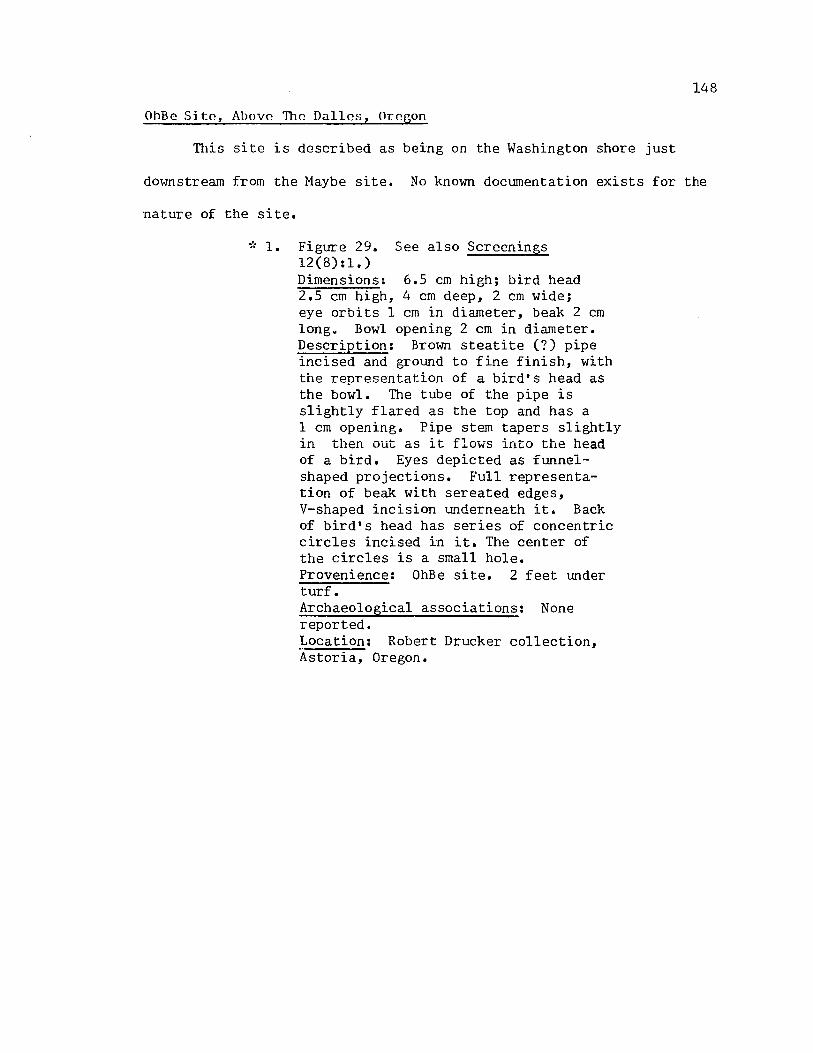
148
OhBe S:itf', Above The Dalles, Orf'gon
This site is described as being on the Washington shore just
downstream from the Maybe site. No known documentation exists for the
nature of the site.
,', 1. Figure 29. See also Screenings 12(8):1.) Dimensions: 6.5 cm high; bird head 2.5 cm high, 4 cm deep, 2 cm wide; eye orbits 1 cm in diameter, beak 2 cm long. Bowl opening 2 cm in diameter. Description: Brown steatite (?) pipe incised and ground to fine finish, with the representation of a bird's head as the bowl. The tube of the pipe is slightly flared as the top and has a 1 cm opening. Pipe stem tapers slightly in then out as it flows into the head of a bird. Eyes depicted as funnelshaped projections. Full representation of beak with sereated edges, V-shaped incision underneath it. Back of bird's head has series of concentric circles incised in it. The center of the circles is a small hole. Provenience: OhBe site. 2 feet under turf. Archaeological associations: None reported. Location: Robert Drucker collection, Astoria, Oregon.
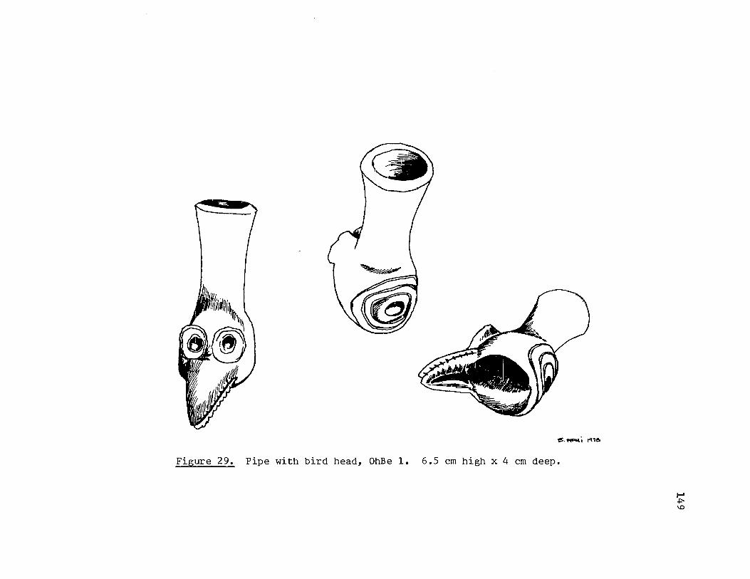
$._; ~'6
Figure 29. Pipe with bird head, OhBe 1. 6.5 em high x 4 em deep.
f-I .po \0

Below the Maybe Site, Near The Dalles, Oregon
This was a burial site, about 100 yards below the Maybe site.
-,', 1. Figure 30. See also Screenings 13(11):1,4.) Dimensions: 20 cm long, 9 cm high; bowl an oval-shaped 11 cm by 10.5 cm, 5 cm deep. Description: Bowl incised and ground into zoomorphic shape. Face rather heart-shaped. Eyes are bulbous protrusions as is the nose. Mouth depicted as incised line with rim of lips. Ridges encircle the eyes. Tab-shaped protrusions above the eyes suggest the representation of ears. Both forelimbs and hindlimbs lie in relief along the sides. They are in a slightly flexed position. Between the limbs, a series of crescentshaped ridges occur vertically; they bow to the rear of the figure. The tail is represented by an elongated V-shaped ridge lying in relief on one end of the bowl. An incised line encircles the bowl just below its rim. Provenience: Found in burial 100 yards downriver from the Maybe site. Archaeological associations: Four atlatl weights, a carved bowl, the fragmen t of a bowl, under very heavy cap rock. Location: Favell Museum of Western Art and Artifacts, Klamath Falls, Oregon; catalogue number D::l.I!!'!56.
150

Figure 30. Bowl with zoomorphic form, Below Maybe 1. 20 em long, 9 em high.
I-' U1 I-'
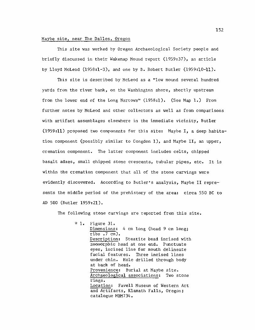
152
Maybe site, near The Dalles, Oregon
This site was worked by Oregon Archaeological Society people and
briefly discussed in their Wakemap Mound report (1959:37), an article
by Lloyd McLeod (1958:1-3), and one by B. Robert Butler (1959:10-11).
This site is described by McLeod as a "low mound several hundred
yards from the river bank, on the Washington shore, shortly upstream
from the lower end of the Long Narrows" (1958:1). (See Map 1.) From
further notes by McLeod and other collectors as well as from comparisons
with artifact assemblages elsewhere in the immediate vicinity, Butler
(1959:11) proposed two components for this site: Maybe I, a deep habita-
tion component (possibly similar to Congdon I), and Maybe II, an upper,
cremation component. The latter component includes celts, chipped
basalt adzes, small chipped stone crescents, tubular pipes, etc. It is
within the cremation component that all of the stone carvings were
evidently discovered. According to Butler's analysis, Maybe II repre-
sents the middle period of the prehistory of the area: circa 550 BC to
AD 500 (Butler 1959:21).
The following stone carvings are reported from this site •
• ': 1. Figure 31. Dimensions: 4 cm long (head 9 cm long; ribs .7 cm). Description: Steatite bead incised with zoomorphic head at one end. Punctuate eyes, incised line for mouth delineate facial features. Three incised lines under chin. Hole drilled through body at back of head. Provenience: Burial at Maybe site. Archaeological associations: Two stone rings. Location: Favell Museum of Western Art and Artifacts, Klamath Falls, Oregon; catalogue MBM734.

~ t-
~
! C) 'J::
~
. 0.0 c: 0
r-l
S ()
-::r
'" S H o ~
() .,-l
..c: 0. H o S o o N
.c .j..l .,-l
~
'0 ro Q)
j:Q
153
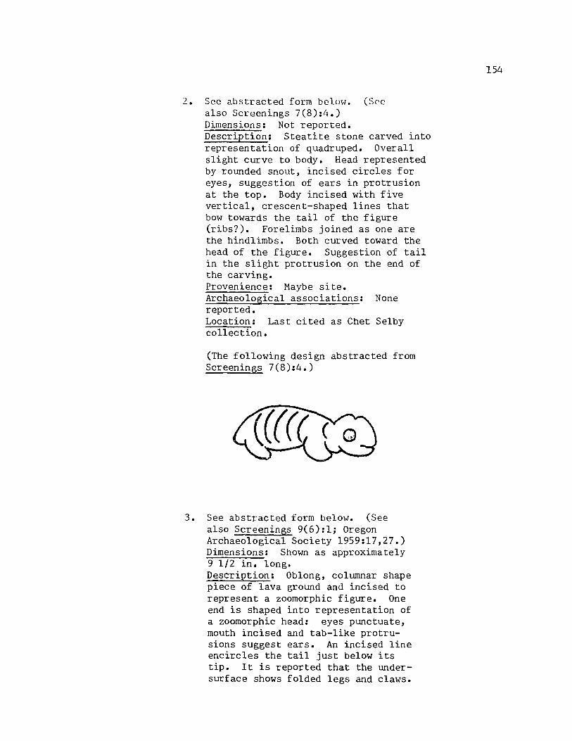
2. See abstracted form below. (Soc also Screenings 7(8):4.) Dimensions: Not reported. Description: Steatite stone carved into representation of quadruped. Overall slight curve to body. Head represented by rounded snout, incised circles for eyes, suggestion of ears in protrusion at the top. Body incised with five vertical, crescent-shaped lines that bow towards the tail of the figure (ribs?). Forelimbs joined as one are the hindlimbs. Both curved toward the head of the figure. Suggestion of tail in the slight protrusion on the end of the carving. Provenience: Maybe site. Archaeological associations: None reported. Location: Last cited as Chet Selby collection.
(The following design abstracted from Screenings 7(8):4.)
3. See abstracted form below. (See also Screenings 9(6):1; Oregon Archaeological Society 1959:17,27.) Dimensions: Shown as approximately 9 1/2 in. long. Description: Oblong, columnar shape piece of lava ground and incised to represent a zoomorphic figure. One end is shaped into representation of a zoomorphic head: eyes punctuate, mouth incised and tab-like protrusions suggest ears. An incised line encircles the tail just below its tip. It is reported that the undersurface shows folded legs and claws.
154

Illustrations simply show a series of parallel incised lines behind the head, down approximately one-third of the length of the body. Provenience: Maybe site, surface find. Archaeological associations: None reported. Location: Last cited as Whitaker collection.
(The following design abstracted from illustration in Screenings 9(6):1.)
---- --_._----- .. _- ---. ~----- -... , .......
"I.' -> 4. See abstracted form below. (See also
Strong 1967:172.) Dimensions: Not reported. Description: Pestle or maul (?) ground and shaped with zoomorphic head atop its handle. Zoomorphic head is depicted by an almond-shaped ridge which defines the facial boundary, and a slightly protruding bulbous eye within that boundary. Effect is that of a bird's head. Neck of implement flares gradually to its junction with a broader, maul-like base. Provenience: Maybe site. Archaeological associations: None reported. Location: Last cited as Bergen collection.
(The following design abstracted from illustration in Strong 1967 :170.)
155

-:; 5. Figure 32. Dimensions: 43 ern long, 17 em high (at the rear of the figure). Description: Ellipsoidal stone with about two thirds of a zoomorphic figure incised and ground in relief over approximately one-half of the surface. The face of the zoomorph is depicted on the cone-shaped end of the stone by a slightly bulbous eye, and an incised mouth. The neck is incised with a shallow, broad line which separates the head from the body. One forelimb· and one hindlimb lie under the body along one side. They are slightly flexed and each has three digits. The body has three slightly curved lines vertically oriented along its length (ribs?). These lines bow to the rear of the figure. At each end of the body a slight, bulbous protruoccurs (vertebrae?). Provenience: Burial at Maybe site. Archaeological associations: Carved stone zoomorphic head. (see next item.) Location: Favell Museum of Western Art and Artifacts, Klamath Falls, Oregon; catalogue MBM729.
~'; 6. Not illustrated. (No known illustration in the literature.) Dimensions: 24 em long, 12 em high. Description: Oval shaped stone with very slight protrusions representing eyes, snout. Shallow, broad incised line perhaps represents a mouth. Provenience: Burial at Maybe site. Archaeological associations: Zoomorphic figure. (See item above.) Location: Favell Museum of Western Art and Artifacts, Klamath Falls, Oregon; catalogue MBM730.
~'; 7. Figure 33. Dimensions: 15 em high, 11 em deep. Description: Oval shaped stone incised and ground to represent a zoomorphic head. Eyes represented by bulbous protrusions, nostrils by slight indentations. A ridge starts between the eyes, sweeps up and around the sides
156

Figure·3Z~ Zoomorphic form, Maybe 5.
;:- ~" •.. 'r""
""";~~;-' ~~ ·~;:.~~~l·
43 em long x 17 em high.
f-I U1 -...j

~ '! .~
c;)
:a: \'Ii
P-OJ OJ "d
S ()
r-I r-I
X ..c: b.D
oM ..c: S ()
lI"l r-I
.. "d (1j OJ
..c: ()
OM ..c: PH o S o o N
158
of the facial area. This ridge is notched along its length. The effect is that of a big horn mountain sheep. There are five ridges running across the top of the head between the horn delineations. Possible ochre residue in the incised areas (?). Provenience: Burial at Maybe site. Archaeological associations: None reported. Locations: Favell Museum of Western Art and Artifacts, Klamath Falls, Oregon; catalogue MBM475.
8. Not illustrated. (See Screenings 9(7):1.) Dimensions: Reported as approximately 9 in. in diameter. Description: Oval-shaped stone incised and ground to represent a zoomorphic head. Heart-shaped ridge defines facial boundary. The boundary is slightly undercut to separate the head from the body. Incised circles define the eyes. Snout suggested by side-by-side protrusions beneath the eyes. Rotmded facial boundary above each eye suggests either brow ridges or ear representations. Provenience: Maybe site. Archaeological associations: None reported. Location: Last cited as Whitaker collection.
9. Not illustrated. (See Screenings 7(8):4.) Dimensions: None Reported. Description: Three-dimensional representation of zoomorphic head with bulbous protrusions for eyes. Incised line outlines a crescent shaped mouth. Vertical incised lines suggest representation of teeth. Head slightly undercut to separate it from a neck or shoulder portion. Provenience: Maybe site. Archaeological associations: None reported. Location: Last cited as Chet Selby collection.
159

160
Congdon Site (45KL41), Above The Dalles, Oregon
This site was a large culturally complex mound in the rimrock
on the north bank of the Columbia River about 1.5 miles below Wakemap
Mound. It was approximately 200 feet in diameter and eight feet deep,
and contained a sequence of at least three cultural components which
were designated by Butler (1959:7-10) as Congdon I (a habitation
midden), Congdon I! (a basalt mantle, cremation and associated arti-
facts), and Congdon II! (skeletal material and associated artifacts).
On the basis of artifact seriation within the site and with other sites
in the immediate area, Congdon I was tentatively dated as 5500 BC to
1500 BC, and Congdon I! 1500 BC to 1000 BC. No date was estimated for
Congdon III.
Of the 20,000 artifacts excavated from Congdon, over 19,800 of
them occurred in components II and III. It is within the context of
Congdon II that the carved stone materials from this site were found.
The exact number of carvings cannot be estimated. Only about 6,500
artifacts (mostly skeletal materials) went to the Washington State
Museum for study. The remaining 13,500 have been scattered to private
collections (Butler 1959:9).
Four artifacts from this site are included here.
1. Not illustrated. (See Screenings 5(9); Oregon Archaeological Society 1959:17, 27; E. Strong 1967:121,124.) Dimensions: Reported as 2 3/4 in. wide, 1/4 in. thick. Description: Flat, heart-shaped stone incised and ground to represent an anthropomorphic face. Made of schist (?). Face depicted in three planes: eyes round and in relief, mouth slightly curved incised line. Slightly flared nose starts beneath eyes and sweeps up and around them to

delineate orbital ridges. A series of three lines are incised above the orbital ridges, parallel to them and to the edge of the stone. Three holes were drilled in the piece: one above the bridge of the nose and tl-IO smaller ones near the outer edges (If the stone J in line with the center hole. Provenience: Congdon site. Archaeological associations: Large beads and some artifacts thought to be labarets. Location: Last cited as Stuart Thompson collection.
2. Not illustrated. (See Strong 1967:61; Park 1972:252; Screenings 7(1).) Dimensions: Reported as 6 in. long. Descriotion: Zoomorphic figure carved of porous lava. Effect is that of a crouching animal. Head is depicted with bulbous eyes, a protruding snout that not only has an incised line for the mouth but also several vertical lines that appear to represent teeth. Nose sweeps up and around eyes. Head deeply undercut away from body. Slightly arched back on the body, with forelimbs and hindlimbs flexed as in a crouch pos1tlon. Tail an oblong protrusion. A hole is drilled through the body about the middle of the arched back. Provenience: Congdon site. Archaeological associations: None reported. Location: Last cited as Carrell Morton collection.
* 3. Not illustrated. (See Screenings 12(8):1.) Dimensions: 8 cm across and 5.5 cm high. Bowl interior is 5.5 cm in diameter and 3 cm deep. Description: Small bowl with face incised, ground on one side. Made out of red scoracious lava. Rim of bowl is faintly notched all around. Face is depicted by bulbous protrusions for the eyes, a nose ridge that continues up and around to form orbital ridges for the eyes. Provenience: Congdon site. Archaeological associations: None reported. Location: Robert Drucker, Astoria, Oregon.
161
4. Not illustrated. (No known illustration in the 1i terature.) Dimensions: 6 to 7 in. in the round. Description: (After Butler 1959:10) Zoomorphic sculptures, resembling mountain sheep heads. Provenience: Congdon II cultural component. Archaeological associations: Not specifically reported. (See Butler (1959: 10) for a full listing of the trait list for the Congdon II component.) Location: Not cited.
162
163
Indian Well Site (45KL42) Above The Dalles, Oregon
This site was located in a rimrock crevice on the north bank of
the Columbia River, about a mile below Wakemap Mound. Butler recorded
five geologic strata in working test pits in this site (Butler 1959:
12-15). Cultural remains in two of these layers formed the basis of
his cultural sequence for the site: Indian Well I (with suggested
dates of 7500 to 8500 years old) and Indian Well II (including crema-
tions and artifacts associated with strata two, with suggested dates
of AD 100 to 600) (Butler 1959:13,15). In both cases, the dates were
based on the comparison of the artifact assemblage's characteristics
with those of other sites. Pettigrew compared his material with
Butler's in 1977 and suggested that Indian Well II was similar to his
Multnomah Phase I which was dated AD 200 to 1250 (Pettigrew 1977:342).
It was in the Indian Well II component that a variety of carved
stone material was discovered.
1. Not illustrated. (See Screenings 6(2):1; Strong 1967:85,86,131,132.) Dimensions: Shown as approximately 2 in. across with a 1 in. hole in the center. Description: Polished, flat steatite ring with a small projecting zoomorphic head from one edge and a slight protrusion from the opposite edge suggesting a tail. Head is depicted by an incised line which delineates the neck of the protruding head. Punctuate eye, short incised line represents a mouth. Provenience: Indian Well II component. Archaeological associations: A second ring of similar design (see next item) as well as another ring of plain design. Found close to one of the areas showine evidence of fire. Location: Last cited as Emory Strong collection.

2. Not illustrated. (See Screenings 6(2):1; Strong 1967: 85,86,131,132.) Dimensions: Not reported. Description: Nearly identical in all respects to the item described above. However, this ring has a flattened side to the edge, just below the tail. Provenience: Indian Well II component. Archaeological associations: Same as described for above item. Location: Last cited as Emory Strong collection.
3. Not illustrated. (No known illustration in the literature. Dimensions: Not reported. Description: (After Butler 1959:12) Small steatite animal pendants with incised ribs and dorsal-ventral perforations, 1 to 3 in number. Provenience: Indian Well II component. Archaeological associations: No specific ones reported. (See Butler (1959:14) for full trait list of Indian Well II componen t • ) Location: Not cited.
164

165
Atlatl Valley site, near The Dalles, Oregon
This site was an old burial ground about 150 feet in diameter
just west of Wakemap Mound (Oregon Archaeological Society 1959:31).
(See Map 1.) The mound contained two levels of burials, the uppermost
occurring about one foot below the surface and the other about two to
six feet below. However, there was considerable mixing of components
throughout (Oregon Archaeological Society 1959:34).
Few heavy ground stone pieces were discovered in the At1atl
Valley site, and those that were found all occurred in the topmost
layer (Oregon Archaeological Society 1959:36).
More precise stratigraphic information or assemblage comparisons
do not appear in the literature.
The following carvings are from this site.
-:. 1. Figure 34. Dimensions: 23 em high (head 5 em, handle 12 em, base 7 em). Head 7 em wide. Neck 17 em around, base 32.5 em around. Description: Maul made of green porphry, topped with zoomorphic head. Head delineated by bulbous protrusions for eyes, and two elliptical r.idges that start at the nose, run edge to edge up and over the head to the base of the neck, then separate and come under the eyes back to the nose. Head slightly undercut to set it off from handle. Handle gradually broadens to point where it joins the base of the maul. Provenience: Found in burial site in Atlatl Valley in 1957. Archaeological associations: Four atlatl weights. Location: Favell Museum of Western Art and Artifacts, Klamath Falls, Oregon; catalogue AVM457.
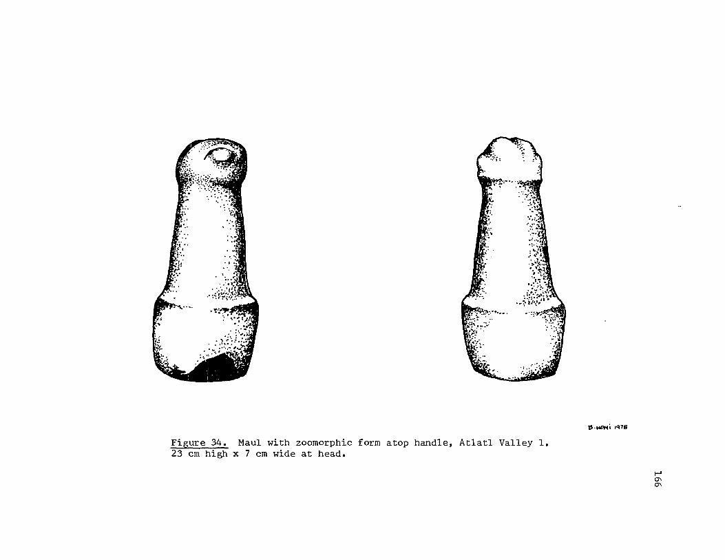
Figure 34. Maul with zoomorphic form atop handle, Atlatl Valley 1. 23 em high x 7 em wide at head.
6.!4DH' ,'ns
t-' 0'1 0'1

1: 2. Figure 35. Dimensions: 47.5 cm in circumference, 5.5 cm high, 14 cm in diameter, 2 cm for bowl depth. Each set of eyes were approximately 8 cm wide with 2 cm between each set. Beak or nose, 1 cm long. Description: Shallow bowl of lava with four sets of eyes on the sides. Eyes represented by slightly protruding ellipses. Nose or beak starts as a verticle ridge below and between the eyes. It rises up and around them and comes back under them to the beak. Bowl was broken in half, then exposed to fire. Provenience: Found in talus burial, Atlatl Valley. Archaeological associations: None reported. Location: Favell Museum of Western Art and Artifacts, Klamath Falls, Oregon; catalogue number AVM473.
* 3. Figure 36. (See also Seaman 1967:152; Oregon Archaeological Society 1959:26.) Dimensions: 19 cm long, 9 cm high. Bowl is 8 cm in diameter and 3.5 cm deep. Face is 8 cm wide, 6 cm high. Description: Mortar of porphory (?), incised, ground with representation of a zoomorphic head projecting from one end and a tail from the other. Nearly three-dimensional head is depicted with a bulbous nose, circular ridges for eyes, incised line for mouth. Brow lines, edge of face and under face delineated by continuous, slight ridge. Wings lie along sides of the figure. Tail defined by inverted V-shaped projection. Evidence of exposure to fire on face and tail. Provenience: Atlatl Valley. Archaeological associations! None reported. Location: Favell Museum of Western Art and Artifacts, Klamath Falls, Oregon; catalogue number not assigned.
4. Not illustrated. (See Oregon Archaeological Society 1959:26; Park 1972:95.) Dimensions: Reported as 11.5 in. long. Description: Bowl incised and ground into zoomorphic shape. Bowl is slightly curved in overall shape. Head is undercut to set
167
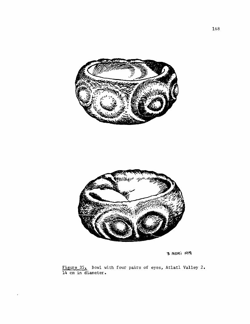
Figure 35. Bowl with four pairs of eyes, Atlatl Valley 2. 14 em in diameter.
168
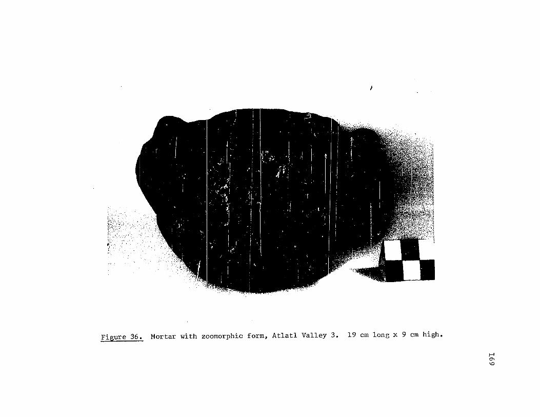
I
Figure 36. Mortar with zoomorphic form, Atlatl Valley 3. 19 ern long x 9 ern high.
I-' 0\ \0

it off from body. Face depicted with eyes of circular incised lines, mouth an incised line. Two crescent shaped lines are incised on the sides of the body, bowing to the rest of thp. figure (ribs?). An incised line runs around the tail of the figure. Provenience: Atlatl Valley. Archaeological associations: None reported. Location: Last cited as Ernest Cowles collection.
5. Figure 37. (See also Screenings 7(4):1; Oregon Archaeological Society 1959:35; Screenings 14(9):2; Strong 1967:165; Park 1972: 95.) Dimensions: Reported as 3.5 in. long. Description: Full three-dimensional zoomorphic figure with perforation through its body. Body is an oblong block with an incised line across the top of each end and about five incised lines running its length. Tail is represented by a flat, rectangular protrusion from one end of the body block. The head, which projects from the other end, is deeply undercut around the neck. Head has two small columnar protrusions for ears, punctuate eyes, and an incised line for a mouth on a cone-shaped snout. Provenience: Atlatl Valley. Archaeological associations: None reported. Location: Last cited as Ernest Cowles collection.
6. See abstracted form below. (See also Screenings 10(9):1.) Dimensions: Reported as 4 in. long. Description: Fla.t sandstone representation of a fish. A slight protrusion along back suggests dorsal fin of a fish. Tail is depicted with representation of tail fin of a fish. No other features delineated. Provenience: Atlatl Valley. Archaeological associations: None reported. Location: Last cited as George Marshall collection.
170

171
Figure 37. Zoomorphic form, Atlatl Valley 5. Reported as 3.5 in. long. (Illustration after Screenin&s 14(9):2).

(The following design abstracted from Screenings 10(9):1.)
172

173
Wakemap Mound, above The Dalles, Oregon
Wakemap Mound was a deep, intensively used habitation site at the
head of the Long Narrows on the Washington side of the Columbia River
above The Dalles, Oregon. (See Map 1.)
This site was worked by archaeologists on three occasions (as
reported in Strong, Schenck and Steward (1930), Caldwell (1956), and
Butler (1965) and dug over frequently by collectors.
All three major archaeological investigations of the site revealed
at least three cultural levels. The lowermost contained non-diagnostic
cultural materia1s o Caldwell suggested they possibly indicated the use
of the site as a seasonal camp (Caldwell 1956:26-27). All investigators
mention the central levels as evidencing more permanent occupation. But-
let (1965:6) felt that they represented the establishment of a permanent
village at the mound site. The uppermost, recent level contained few ar-
tifacts. Lewis and Clark noted that the mound was unoccupied in 1805
(Thwaites 1905,111:154).
Most of the stone carvings were found in the central levels and
upper level. Butler felt the evidence belonged in the "Late" period of
The Dalles prehistory an.d he offers the following as a summary of the
cultural contexts and chronology (Butler 1965:9):
Wakemap I, the 2ab substrata of Wakemap Mound which dates from the middle of the 9th century through the early decades of the 14th century and is characterized by rather well-developed antler and stone carving, rectangular wood-framed houses with mat siding, fishing equipment resembling that of the ethnographic Wishram, an and wooden spreaders for drying fish •••
Wakemap II, the 2d substratum of Wakemap Mound, which dates from the early decades of the 14th century to perhaps the middle of the 18th century and is a continuation of wakemap I, but with added traits. The dice game arrives from the Southern Plateau ••• Modelled and incised clay bowls, clay figurines and other items of clay, sometimes fired, are among the new traits •••

* 1. Figure 38a. Dimensions: 4 cm long, approximately .4 cm high. Description: Small oblong cylinder of stone incised and ground into zoomorphic form. Head and snout form about one-third of the length of the form. Eye punctuate. Mouth is an incised line. Three incised lines encircle the "neck" area. Four horizontal lines run the length of the body, and an incised line encircles the form, near its end. Provenience: Wakemap. Archaeological associations: None reported. Location: Favell Museum of Western Art and Artifacts, Klamath Falls, Oregon.
-1. 2. Figure 38b. Dimensions: 4.7 cm long, 1.2 cm high. The head is 1.3 cm long. Description: Small oblong piece of vesicular basalt pecked and incised into zoomorphic form. The head is slightly undercut to delineate it from the body. Punctuate eyes. Four crescent shaped, incised lines lie vertically along sides of body. These lines bow toward the back of the figure (ribs?). Provenience: Wakemap. Archaeological associations: None reported. Location: Favel Museum of Western Art and Artifacts, Klamath Falls, Oregon.
* 3. Figure 38c. Dimensions: 3.5 cm long and 3 cm high; about .8 crn thick. Description: Head and neck or shoulders of a bird (?) are depicted on a flat stone. Eyes are delineated by an incised circle with a punctuate pupil. Upper and lower bills are separated by an incised line. Four ridges cross the crown of the head. The head is undercut sharply to separate it from a short portion of shoulder. Provenience: Wakemap. Archaeological associations: None reported. Location: Favell Museum of Western Art and Artifacts, Klamath Falls, Oregon.
174
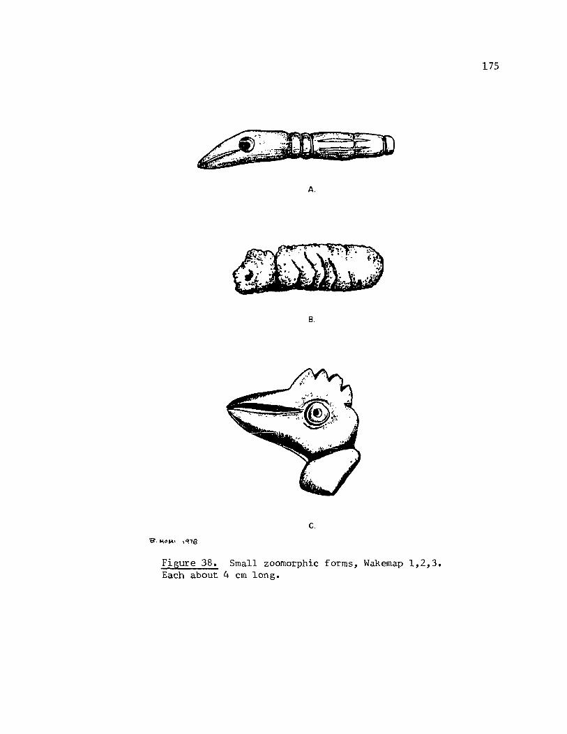
A.
B.
c.
Figure 38. Small zoomorphic forms, Wakemap 1,2,3. Each about 4 cm long.
175

;', 4. Not illustrated. (No known illustration in the literature.) Dimensions: 8.5 cm long, 4 cm high at the head. Description: shaped out of Provenience: down.
Small quadruped animal sandstone (?). Wakemap, about three feet
Archaeological associations: None reported. Location: Favell Museum of Western Art and Artifacts, Klamath Falls, Oregon.
5. Not illustrated. (See Screenings 5(9):1; Oregon Archaeological Society 1959:33.) Dimensions: Shown as approximately 3 in. long. Description: Zoomorphic figure of scoracious lava represents a quadruped. Head is slightly undercut to separate it from the body. Mouth is an incised line. Suggestion of "ears" in the slight protrusion at the top of the head. Forelimb partially cut away from body. Three crescent shaped incised lines occur vertically behind the forelimb. They bow toward the rear of the animal form. An incised line encircles the body to form the tail portion. It is reported that the tail is broad and incised with crosshatching characteristic of a beaver's tail. Provenience: Wakemap, 12 feet below the surface, just above bedrock. Found in a cache in corner of a housepit. Archaeological associations: Atlatl weight and pipe. Location: Last cited as Gladys and Walter Koch collection.
6. See abstracted design below. (See also Oregon Archaeological Society 1959:30.) Dimensions: Reported as 1 1/2 in. in diameter. Description: Small oval stone incised with zoomorphic (?) figure. The lines form apparent circular eyes, orbital ridges, single line appendages with digits. Provenience: Wakemap. Archaeological associations: None reported.
176

Location: Not cited.
(The following design was abstracted from the OAS illustration)
7. Not illustrated. (See Screenings 6(10):1; Oregon Archaeological Society 1959:27. ) Dimensions: Shown as approximately 3.75 in. long and reported to be 1/8 of an in. thick. Description: Oblong, flat steatite stone incised with depiction of a fish. The head has a punctuate eye, an incised line for the representation of a mouth. A series of short incised lines perpendicular to the mouth line, serate its edge. An incised line undercuts the head. A long, rectangular panel runs the length of the body. The center of the panel contains a row of some small blocks with an indentation in the center of each. The effect is that of an exposed vertebrae column, or spine. Many incised lines slant away toward the tail from the panel. A perforation occurs mid-back. Provenience: Wakemap, one foot above bedrock. Archaeological associations: None reported. Location: Last cited as Charles Hall collection.
8. Not illustrated. (See Oregon Archaeological Society 1959:24,28.) Dimensions: Not reported. Description: Maul of basalt with a zoomorphic (1) head atop its handle. Head is depicted by two dish shaped eye orbits with the eyes represented by bulbous protrusions. Slight protrusion occurs at the top of the head. Facial plane undercut to set it off from handle of maul.
177

Handle gradually increases in girth to the maul's base. Provenience: Wakemap, 7 feet down, square 112. Archaeological associations: None reported. Location: Not cited.
9. See abstracted figure below. (See also Oregon Archaeological Society 1959:24; Park 1972: 252.) Dimensions: Reported as 5 in. high. Description: Small pestle (7) topped with zoomorphic head. The head, which forms approximately one-third of the implement, is depicted by bulbous eyes, an incised-line mouth, and two slight ridges which start as a V at the end of the nose (or "beak") and sweep up and around the eyes to form orbital ridges. Head slightly undercut to set it off from body. A similar line encircles the body at its midpoint. The effect is a neck or shoulder portion for the zoomorphic form. Provenience: Wakemap; found while bulldozing away tailings from the top of the Mound. Archaeological associations: None reported. Location: Last cited as Carrell Morton collection.
(The following design was abstracted from OAS(1959:24) illustration.)
178

10. Not illustrated. (See Butler 1955:34; Caldwell 1956:142,143.) Dimensions: Reported as 17.1 cm long, 11.4 crn wide, 12.5 em thick. Description: Full three-dimensional representation of a zoomorphic head, and "shoulders". Head is depicted as a protruding snout with indented nostrils, bulbous eyes, and an orbital ridge that starts above the nose and sweeps up and around the eyes. The mouth is a rather broad and deeply cut line. Head is undercut so that a portion of neck or shoulder is left. Provenience: Wakemap, lower portion of Stratum A (Caldwell 1956:142). Archaeological associations: None reported. Location: Not cited.
11. Not illustrated. (See Oregon Archaeological Society 1959:24,28; Park 1972:252.) Dimensions: Reported as approximately 12 in. long. Description: Slightly bowed cylinder of basalt shaped into zoomorphic head and generalized body. Head is depicted with bulbous eyes, and a rounded projecting snout. Mouth is a broad and deeply incised line. Head is undercut to separate it from the body. Body is undefined except by shape of stone. Provenience: Wakemap, six feet deep within the Mound, square 689. Archaeological associations: None reported. Location: Last cited as Carrell Morton collection.
12. Not illustrated. (See Butler 1965:16.) Dimensions: Reported as 5.8 cm high by 2 cm wide, by .9 cm thick. Description: Flat sandstone piece incised with anthropomorphic head and torso. Features very roughly done. Nose is incised line that continues up and over eyes. Eyes represented by circular depressions. Mouth is an incised line. Head is undercut to separate it from the torso: Arms are partially delineated from the body, and are slightly flexed. A short incised line begins the definition of the legs. The legs end just after they leave the
179

torso. Provenience: Wakemap, substratum 2d. Archaeological associations: None specifically noted. Location: Not cited.
* 13. Figure 39. Dimensions: 16.5 cm long, 7 cm high (at the head end). Description: Flat basalt stone shaped and incised into general zoomorphic form.
Zoomorphic figure depicted in generalized outline. Head has a snout and a tab-like protrusion that suggests ears. Mouth is an incised line. A fin-like projection occurs about midback. It is incised with a series of vertical lines. The forelimbs are treated as one and project down from the body. Three circular depressions run the length of the body. They are about 5 cm across and .5 cm deep. There are traces of ochre (7) in the depressions and on the back of the figure. Provenience: Wakemap. Archaeological associations: Bone awl and a carved paint pot. Location: Favell Museum of Western Art and Artifacts, Klamath Falls, Oregon; catalogue WKM459.
14. Not illustrated. (See Oregon Archaeological Society 1959:28.) Dimensions: Reported as 2 3/4 in. high and wide both. Description: Full three-dimensional representation of a hwnan head with a mortar inset in the top. Face depicted on three planes: nose and brows form one continuous ridge, eyes are represented by the outline of an almondshaped ridge. The mouth is a recessed line. Provenience: Wakemap, found behind the bulldozer. Archaeological associations: None reported. Location: Not cited.
15. Not illustrated. (See Screenings 6(12):2.) Dimensions: Reported as 9 in. high, with a circumference of 18 in.
180

Figure 39. Palette in zoomorphic shape, Wakemap 13. 16.5 em long x 7 ern high (head end).
B·fU1~i "He
I-' 00 t-'
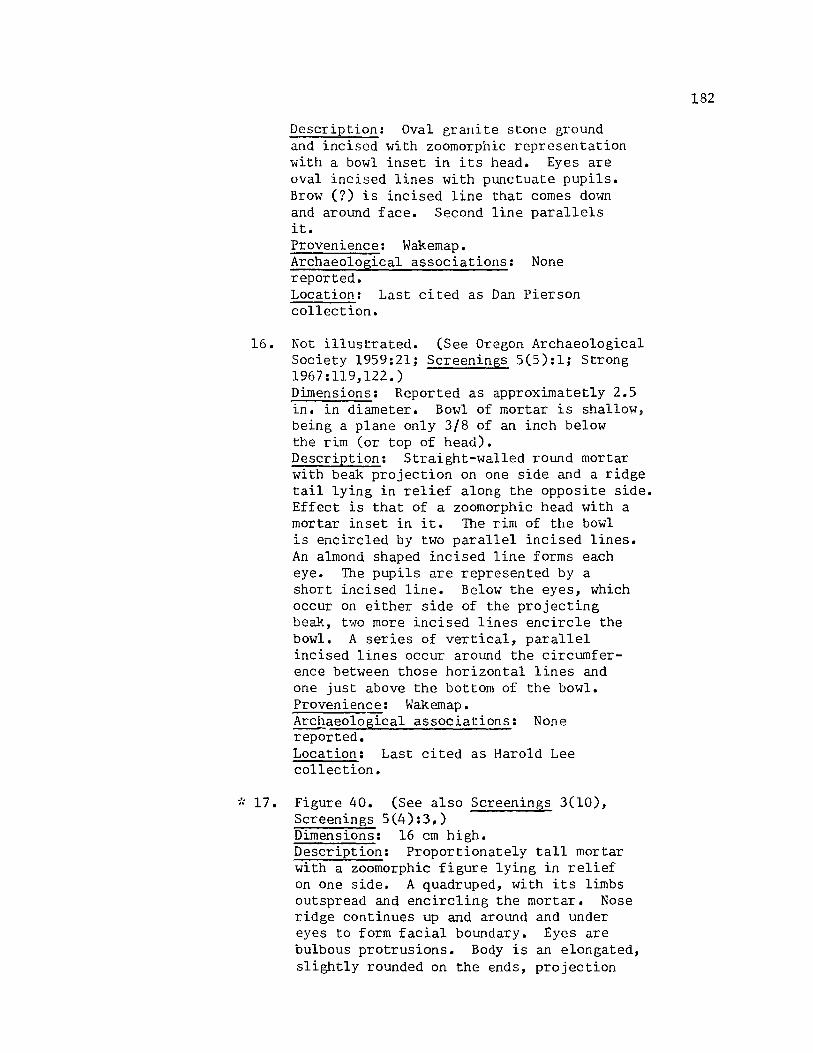
Description: Oval grallite stone ground and incised with zoomorphic representation with a bowl inset in its head. Eyes are oval incised lines with punctuate pupils. Brow (7) is incised line that comes down and around face. Second line parallels it. Provenience: Wakemap. Archaeological associations: None reported. Location: Last cited as Dan Pierson collection.
16. Not illustrated. (See Oregon Archaeological Society 1959:21; Screenings 5(5):1; Strong 1967:119,122.) Dimensions: Reported as approximatetly 2.5 in. in diameter. Bowl of mortar is shallow i
being a plane only 3/8 of an inch below the rim (or top of head). Description: Straight-walled round mortar with beak projection on one side and a ridge tail lying in relief along the opposite side. Effect is that of a zoomorphic head with a mortar inset in it. The rim of the bowl is encircled by two parallel incised lines. An almond shaped incised line forms each eye. The pupils are represented by a short incised line. Below the eyes, which occur on either side of the projecting beak, t~·l0 more incised lines encircle the bowl. A series of vertical, parallel incised lines occur around the circumference between those horizontal lines and one just above the bottom of the bowl. Provenience: Wakemap. Arc~aeological associations: None reported. Location: Last cited as Harold Lee collection •
.. ·.17. Figure 40. (See also Screenings 3(10), Screenings 5(4):3.) Dimensions: 16 cm high. Description: Proportionately tall mortar with a zoomorphic figure lying in relief on one side. A quadruped, with its limbs outspread and encircling the mortar. Nose ridge continues up and around and under eyes to form facial boundary. Eyes are bulbous protrusions. Body is an elongated, slightly rounded on the ends, projection
182

Figure 40. Mortar with quadruped in relief, Wakemap 17. 16 em high.
183

with 5 circular depressions along its length. The forelimbs and hindlimbs (each approximately 20 cm long) nearly encircle the mortar. Between them occur three ridges (ribs?). Extensive ochre residue (?) apparent. Provenience: Wakemap. Archaeological associations: None reported. Location: Favell Museum of Western Art and Artifacts, Klamath Falls, Oregon.
18. Not illustrated. (See Screenin&s 5(8):2.) Dimensions: Reported as 20 in. long and 10 in. wide. Description: Elliptical shaped stone incised and ground into representation of a quadruped with a mortar inset in its backo The head, which is slightly incised in at the sides to separate. it from the body, has the following features: two circular ridges for outlining the eyes which are bulbous protrusions, two indentations for the nosLrils. Forelimbs and hindlimbs lie along the sides in relief as do four or five crescent shaped vertical lines that bow toward the rear of the form (ribs?). The tail is shaped like of a beaver and is crossed with seven incised lines. Provenience: Wakemap. Archaeolo&ical associations: None reported. Location: Last cited as Carrell Morton collection.
184

185
Leachman site, above The Dalles, Oregon
This site was located in the sandy plain that was known as the
Collowash Bottom. The site is known principally by very brief descrip-
tions in the Oregon Archaeological Society's Report 1 (1959) and Emory
Strong ~ s (l959a)2.rticle about the large collection from this site.
It is described as a completely prehistoric cremation pit about
18 feet in diameter and five and a half feet deep (Oregon Archaeological
Society 1959:27). (See Map 1.) The artifact assemblage included
"a number of fine stone carvings, two 'slave killers', about 20 pipes,
two complete whalebone clubs, a large number of chipped artifacts and
several bone and antler carvings" (Oregon Archaeological Society 1959:
27).
The following stone carvings were found in this cremation.
1. Figure 41. (See also Oregon Archaeological Society 1959;Plate I; Strong 1961:135; Screenings 8(5):1; Screenings 14(9):4.) Dimensions: Reported as 16 in. in diameter. Description: Large, flat basalt slab carved on one surface into the representation of a quadruped figure. The figure has the follow'ing general features: central circular, shallow mortar (?) with a head, a broad, flat ("beaver-like") tail, and two appendages (both on the same side) radiating off the mortar. More specifically, the central mortar is rimmed with a notched edge. Concentric to the mortar, an incised line delineates its outer edge. It is from this edge that the body parts emerge. The head is an oval projection off the mortar. The eyes are outlined by two almond-shaped ridges; the mouth is outlined by a crescent shaped ridge. The tail is first defined by an elongated U-shaped incised line which occurs on the tail, parallel to its edge. The two depicted appendages are short rectangles which project away from the center mortar. Each appendage has five (?) digits.

-g. 1-<010<; r"he
Figure 41. Mortar in zoomorphic form (beaver?), Leachman 1. Reported as 16 in. in diameter. (Illustration after Screenings 14 (9):4.)
I-' 00 0\

Provenience: Leachman site, in a cremation where Horse Thief Lake Park is now built. Archaeological associations: None reported. Location: Last cited as Leachman collection.
2. See abstracted form below. (See also Oregon Archaeological Society 1959:25; Screenings 8(5):3.) Dimensions: Not reported. Description: "Club" ground into shape of a quadruped. Tail forms approximately onehalf of the total club length. A perforation occurs near the tip of the tail. A head, with a tab-like projection for the ear representation, forms the other end of the club. Two squarish tabs form the representation of the forelimbs and hindlimbs respectively. Provenience: Leachman site. Archaeological associations: None reported. Location: Last cited as Leachman-St. Clair collection.
(The following design abstracted from Screenings 8(5):3.)
3. Not illustrated. See Screenings 8(5):1.) Dimensions: Reported as 4 in. long. Description: Mortar inset into back of a zoomorphic figure. Mortar rim incisert with tiny notches for its whole circumference. Head of figure has eyes that are outlined with circular ridges. Small protruding nose. Both upper and lower lips are depicted. Neck is undercut to separate it from the body of the figure. The forelimbs appear as incised fins along the body. Approximately 7 incised, slightly
187

curved lines (bowing towards the rear of the figure) occur behind the forelimbs. The tail has the appearance of a fin, also. It is vertically oriented to the body and incised with three vertical lines as well as being edged with three horizontal ones. Rather than appendages, the figure rests on a basal pedestal, oval in shape, that is slightly smaller than the mortar bowl. Provenience: Leachman site, cremation. Archaeological associations: None specifically reported. See Strong 1959a for summary of site's artifacts. Location: Last cited as Leachman-St. Clair collection.
4. See abstracted form below. (See also Screenings 8(5):2.) Dimensions: Reported as 10.5 in. long. Description: "Club" incised and ground into zoomorphic shape. The overall shape is that of a rectangle, flat, edges parallel. Two tabs project beneath the head/ neck area in representations of legs. Eye is represented by two incised almondshaped lines, one inside the other. A third incised, crescent-shaped line parallels the eye edge behind it. Five vertical parallel lines are incised behind the first leg. These are in turn followed by three rows of incised triangles, a row of U-shaped lines, and a final series of five vertical parallel lines. Provenience: Leachman site. Archaeological associations: None specifically reported. See Strong 1959a for summary of site's artifacts. Location: Last cited as Leachman collection.
(The following design abstracted from Screenings 8(5):2.)
188

5. Not illustrated. (See Screenings 8(5):2; E. Strong 1967:116.) Dimensions: Not reported. Description: Anthropomorphic mortar with bowl inset in its head. The head of the figure forms approximately onehalf of the total representation. Two incised lines (with several parallel vertical lines between them) encircle the head just below the rim of the bowl. Eyes are depicted by an oval shaped ridge; pupils are punctuate. Nose is a flat, rectangular protrusion. A slight ridge forms the facial boundary. The head is slightly undercut to separate it from the "body" or base of mortar. No body features are delineated. Provenience: Leachman site. Archaeological associations: No specific ones reported. Location: Last cited as LeachmanSt. Clair collection.
189

190
Spedis Valley site, above The Dalles, Oregon
The following artifact was discovered in the talus slope of the low
basalt cliff northeast of Wakernap Mound (Caldweld 1956:294; Butler 1955:
34). No specifics of the actual archaeological context were offered.
1. Not illustratedo (See Caldwell 1956:294; Butler 1955:34.) Dimensions: Reported as 19 cm high, 16.5 cm wide, 19 em deep. Description: Full three-dimensional zoomorphic head incised and ground of rhyolite. Facial area is a dish-like plane. Eyes are bulbous protrusions. The nose is bulbous with indentations for nostrils. An orbital ridge starts as a V between the eyes and continues up and around face, ending in delineations of the upper lip for the mouth. The mouth is further defined by that ridge and a similar crescent-shaped one under a series of parallel parallel vertical lines (teeth?). No apparent chin. Lower face is protuberant. Provenience: Spedis Valley, in talus north of Wakernap. Archaeological associations: None reported. Location: Not cited.
CHAPTER V
DISTRIBUTIONAL PATTERNS
THE SAMPLE: ITS SIZE AND NATURE
Of the 137 carvings or references presented here, I viewed 42 in
person and found 71 illustrated in the literature. I described these
113. I additionally noted 24 sculptures as partially described but not
illustrated in the literature. The total represents less than one-half
of the sculptures for which I gathered data. I studied and photographed
over one hundred sculptures for which I ultimately was unable to assign
a sufficiently specific provenience for inclusion hereo Similarly, in
the literature search I collected data on 74 sculptures whose final
provenience assignment was "near The Dalles" (43), "northern Oregon"
(21), "Wasco County" (1), and "Columbia River" (9).
Further, as noted in the data collection discussion, a great num
ber of public and private collections have not been researched.
As a rest!lt j it is 'not possible to judge how represeontati-ve ti1e
sculptured pieces included in this study are. The distributional pat
terns and general analysis that follow must be considered only a pre
liminary assessment of the range and nature of pritlcipally museum atld
literature originated data.

192
DISTRIBUTIONAL PATTERNS
Overall Distribution: An Introduction
Of the 137 sculpted artifacts cited in this study, 71 (52%) came
from The Dalles area (Le., from the Klindt farm site on upriver). (See
Maps 1,2.) Thirty-nine (28%) came from the grouped areas of St. Helens
Sauvie Island~ Vancouver LakeiLake Kiver and Portland. This latter fig-
ure increases to 48 (35%) if the areas up the Willamette and up the
Columbia to Washougal and Troutdale are included. As this distribution
is more in keeping with the geography of the Portland Basin and the
upriver distributional limits of archaeological sites in it, it will be
used in further discussions of the range of artifacts and designs in the
area.
A third clustering of sculpted pieces occurred at the Cascades
where 8 (6%) were found.
The obvious clustering is in those areas where more permanent
occupancy occurred (Le., Portland Basin, the Cascades, and The Dalles).
Very few sculptures included in this study were found below Sauvie
Island. However, this is not consistent with the literature citings
which seem to indicate that more carvings were discovered in that area
(eg., Abernathy Creek in Washington). This is also true of the Oregon
City area. On the other hand, no carvings are represented from the
al.'ea of Washougal to the Cascades, on either side of the Columbia River.
This is consistent with the apparent lack of archaeological evidence
in that area in general.

• . itt --,--=-=----- ....
OREGON f
PORTLAND \ ....• I ,
WASHINGTON
~ ~ LEW/SR.
Map 2. Grouped distribution of stone carvings t-' \0 W

194
Zoomorphic vs. Anthropomorphic Carvings
On the basis of overall figure representation, the sculptures
were sorted into zoomorphic and anthropomorphic categories. Figure 42
shows tnese categories and the sculptures I assigned to them. Many of
the sculptures were somewhat vaguely represented, but some features or
combinations of features usually suggested one category or the other.
Some, however, could not clearly be designated as one or another, and
these I put in an "undefined" category which included the following:
those with features too vaguely defined, literature citings that merely
indicated "effigy", isolated features (eg., eyes that had a shape cornmon
in both anthropomorphic and zoomorphic categories), and sculptures that
appeared to have a combination of both anthropomorphic and zoomorphic
features (eg., Sauvie Island 2, 5, and Ten Mile Tavern 1, the latter of
which was reported as the body of a bird with the face of a man).
One hundred and ten figures (80%) were classed as zoomorphic,
18 (13%) anthropomorphic. Maps 3 and 4 illustrate the distribution of
figures in each category. Of the 71 sculptures from the grouped The
Dalles sites, 85% were zoomorphic, 11% anthropomorphic. Of the 48
sculptures from the Portland Basin, 71% were zoomorphic and 15% anthro
pomorphic. The proportions of these distribution figures are fairly
similar. All of the Cascades sculptures are zoomorphic.
SUMMARY OF ZOOMORPHIC CARVINGS
Representation
Most of the zoomorphtc forms are very generalize.j in their fea
tures. However, representations of a few specific animals can be

195
ZOOMORPHIC CARVINGS
Pa1mrose 1, 2; Ilwaco 1; Altoona 1; Trojan 1; St. Helens 1; Sauvie Island 3, 6-12, 14-18; 35C03 1-5; Cho1ick 3; Merrybe11 1; Vancouver Lake 1-3; 45CL3 2; Herzog 1; Fe1ida 1; East Portland 1; Portland 1; Oregon City 1;Eag1e Creek 1; Lady Island 1; Camas 1; Troutdale 1; Ten Mile Tavern 2; Cape Horn 1; Cascades 1-7; Mosier 1, 2;; Klindt 1; The Dalles 1; Five Mile Rapids 1-3, 6, 8; Bead Patch 1-7; Big Eddy 1-3, OhBe 1; Below Maybe 1; Maybe 1-9; Congdon 2, 4; Indian Well 1-4; At1at1 1, 3-6; Wakemap 1-5, 7-11, 13, 15-18; Leachman 1-4, 6; Sped is 1.
ANTHROPOMORPHIC CARVINGS
Altoona 2; Sauvie Island 1, 4; Cho1ick 1, 2; 45CL3 1; Herzog 2; Kenton 1; Lyle 1; Klindt 2; Five Mile Rapids 4, 5, 7, 9; Condgon 1; (Indian Well 4); Wakemap 12, 14; Leachman 5.
UNDEFINED CARVINGS
Sauvie 2, 5, 13; Ten Mile Tavern 1, 3, 4; Condgon 3; At1at1 2; Wakemap 6.
Figure 42. Classification of carvings as zoomorphic or anthropomorphic
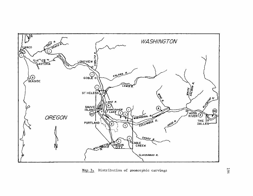
rt
OREGON
WASHINGTON
A/ I<A~ ~
Map 3. Distribution of zoomorphic carvings I-' \0 0\

/ WASHINGTON
OREGON
Map 4. Distribution of anthropomorphic carvings f-I \0 -...J

198
suggested. Figure 43 presents such a classification.
Generalized Quadrupeds. This category is represented by 28
carvings, or 25% of the zoomorphic forms. In this category are found
many versions of club-like forms of various dimensions. The tails of
these zoomorphic pieces form an elongated "handle". The head is often
represented with a cone-shaped snout and slight protrusions suggesting
ears. The forelimbs (and sometimes hindlimbs) are treated as one.
Figure 44 shows the abstraction of two of the basic forms. Artifacts
in this study that are similar to the top form include St. Helens 1
(with incised features), 35C03 1 (with a nippled tail), Leachman 1
(with a perforated tail), and Leachman 4 (flat, with incised features,
and a perforated tail). Artifacts in ~his study that are similar to
the bottom form include Five Mile Rapids 1 (with punctuated eye and
nippled tail) and Five Mile Rapids 3. Emory Strong (1967:143,145)
notes that an additional four of these presumed "clubs" were found at
35C03 and one at Cholick site, but he does not define or illustrate
their basic shape or design. He further notes that most of these kinds
of artifacts are made of slate, vary in length from 12 to 16 inches,
and most often have two "blades" (that is, the forelimbs and the hind
limbs respectively are treated as one). Several have a perforation in
the tail (E. Strong 1967:145). Other artifacts in this study that are
similar, at least in outline form, are Wakernap 13 and perhaps Maybe 3.
These forms have been called "slave killers" in much of the earlier
literature; however, there is no known ethnographic basis for that des
ignation. Thomas Hannah (1968:2) compiled a preliminary listing of the
distribution of these forms. In it are examples from the larger,

199
GENERALIZED QUADRUPEDS: St. Helens 1; Sauvie Island 16; 35C03 1-5; Cholick 3; Cascades 5-7; Five Mile Rapids 1, 3; Bead Patch 1; Big Eddy 1; ~fuybe 1, 5; Congdon 2; Atlatl Valley 5; Wakemap 4, 5, 13, 17, 18; Leachman 1-4.
GENERALIZED ZOOMORPHIC HEADS: Sauvie Island 14; Portland 1; Lady Island 1; Mosier 1, 2; The Dalles 1; Bead Patch 4, 5; Maybe 6-9; Congdon 4; Wakemap 10; Spedis Valley 1.
GENERALIZED BIRDS:
"BIRD HEADS":
OWLS:
Sauvie Island 8; Cascades 1; Five ~i1e Rapids 6; Bead Patch 3, 6, 7; Atlatl Valley 3 (?); Wakemap 16.
OhBe 1; Atlatl Valley 1; Wakemap 1, 3, 8, 9; Maybe 4.
Ilwaco 1; Altoona 1; Sauvie Island 3 s 17; Herzog 1; Felida 1; Klindt 1; Five Mile Rapids 8; Big Eddy 2; Wakemap 15 (?).
SPECIFIC ANIMALS: (speculative)
"Frog":
"Turtle": "Lizard": "Buffalo": "Duck": "Beaver": "Seal": "Fish":
Sauvie Island 11,12,16 (?); Oregon City; Maybe 5 (?). Portland 1. Cascades 4. Big Eddy 1. Big Eddy 3. Leachman 1; Wakemap 18. Leachman 3. 45CL31 (sturgeon?); Troutdale 1; Atlat1 Valley 6; l-lakemap 7.
Figure 43. Types of animals represented by zoomorphic carvings

200
Fig""e 4"-'. Basic forms of zoomorpbic "clubS"

Northwest Coast area. That is, these forms occurred, in decreasing
frequency, from northern California up through southeastern Alaska.
201
If some of Hannah's localities are grouped, a total of 10 of these fig
ures are cited for The Dalles area whereas 8 came from the Portland
Basin. Hannah's evidence suggests that these forms are not unique to
the lower Columbia River and that they are possibly not of local origin.
Generalized Zoomorphic Heads. The artifacts in this category
generated considerable discussion in the literature. This is partic
ularly true of the rather large (about 25 ern to 40 ern in diameter)
rounded heads with projecting, rounded snouts (often with nostrils),
bulbous eyes, and crescent-shaped "grimacing" mouths (often with "teeth"
exposed). Some have ridges which originate in a V-shape between the
eyes and sweep up and over the eyes and around the sides of the head.
Sometimes these ridges have parallel incised lines crossing them.
Examples from this study include Portland 1, The Dalles 1, Bead Patch 4,
5, Maybe 6-9, Wakemap 10, and Spedis 1. That is, they apparently occur
more frequently upriver. Two of the most reasonable speculations con
cerning their representation would be seal heads or big horn mountain
sheep, both with known distribution in the lower Columbia as defined by
this study. (The latter designation is used for such heads as Maybe 7,
for example, whereon the sweeping ridge from the forehead around the
side of the head possibly represents the horns of the sheep.) Lewis and
Clark noted the general abundance of seals on the lower Columbia. For
example, Clark's journal entry for March 31, 1806, describes the mouth
of the Washougal River as being frequented by a great number of seals.
Lewis and Clark had in fact named that river the Seal River when they

202
ascended the Columbia in 1805 (Thwaites 1906, 111:190-192). Bailey
(1936:333) notes that many subsequent travellers observed seals as far
upriver as The Dalles and cites them as harbor seals. It is also Bailey
who notes that bighorn mountain sheep could have previously inhabited
the rocky cliffs a.long the Oregon shore of the Columbia, below the mouth
of the Deschutes River (Bailey 1936:65). Cressman (1960:101) illus
trates bowls from The Dalles area that are made of mountain sheep horn,
although these could have been traded from the Plateau area. Because
these heads are so generalized in features and so varied in depiction,
more specific designations would be speculative.
Birds or Bird-like Forms. In this sample, this category accounts
for 25 sculptures, or 23% of the zoomorphic forms. The bird forms can
be further sorted as indicated in Flgure 43 into generalized birds,
"bird head" representations, and owl forms. All figures but one in the
first two categories occur upriver in The Dalles area whereas owl forms
occur throughout the lower Columbia as defined in this study. The
treatment of form for the generalized birds is extremely varied with
the exception of Bead Patch 6 and 7. Those two birds, both with perfo
rated necks, have their heads slightly lowered, their bodies and tails
horizontal, and their wings slightly outstretched. In that regard, they
are similar to Sauvie Island 8; that is, they give the effect of a bird
lifting off. Five Mile Rapids 3 is a standi.ng or "perching" bird form
while Five Mile Rapids 6 bird figure is possibly in a nesting position:
body, head and tail nearly horizontal, wings close against the sides.
It is the bastc form of the head of Five Mile Rapids 3 (just
mentioned above) that suggests the following category of "bird heads"
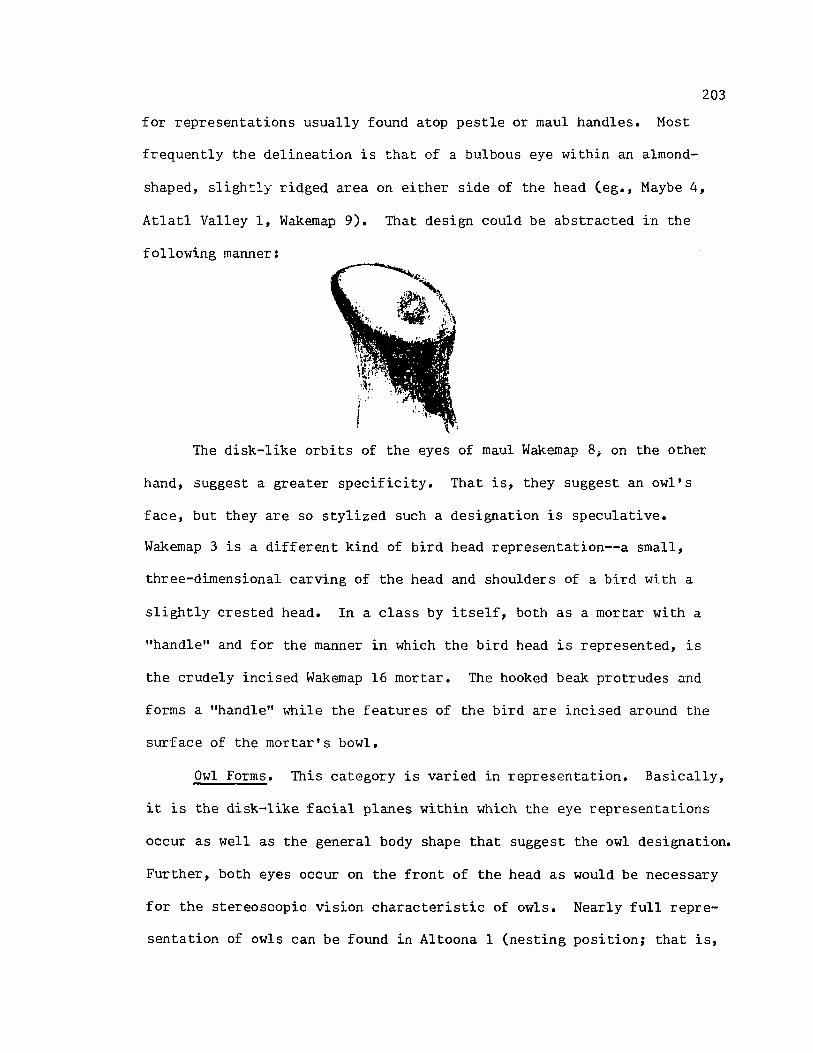
203
for representations usually found atop pestle or maul handles. Most
frequently the delineation is that of a bulbous eye within an almond
shaped, slightly ridged area on either side of the head (eg., Maybe 4,
Atlatl Valley 1, Wakemap 9). That design could be abstracted in the
following manner:
The disk-like orbits of the eyes of maul Wakemap 8; on the other
hand, suggest a greater specificity. That is, they suggest an owl's
face, but they are so stylized such a designation is speculative.
Wakemap 3 is a different kind of bird head representation--a small,
three-dimensional carving of the head and shoulders of a bird with a
slightly crested head. In a class by itself, both as a mortar with a
"handle" and for the manner in which the bird head is represented, is
the crudely incised Wakemap 16 mortar. The hooked beak protrudes and
forms a "handle" while the features of the bird are incised around the
surface of the mortar's bowl.
Owl Forms. This category is varied in representation. Basically,
it is the disk-like facial planes within which the eye representations
occur as well as the general body shape that suggest the owl designation.
Further, both eyes occur on the front of the head as would be necessary
for the stereoscopic vision characteristic of owls. Nearly full repre
sentation of owls can be found in Altoona 1 (nesting position; that is,

204
body horizontal, head slightly lowered, wings in against the body) and
Sauvie Island 17 as well as Five Mile Rapids 8. According to naturalist
L. Richard Steeves (personal communication), Five Mile Rapids 8 is a
striking example of a great horned owl in the hooting position: the
head is slightly down, the wings slightly outstretched, and the body and
tail are nearly horizontal (see also Bent 1967, II:3l7). In this c:;.se,
the tab-like ears as well as overall detailing of the figure are sug
gestive of a particular species. This is the only bird sculpture where
a possible species designation can be cited.
The Bead Patch 3 owl is slightly more stylized but still has
fairly clear delination of owl-like features. Four more abstract fig
ures are depicted with a generalized head, body and wing shape that
suggest owls (Sauvie Island 3, Felida Moorage 1, Klindt 1, and possibly
Wakemap 15). Two bowls have only owl-like faces represented by contin
uous beaK/eye orbit ridges within which occur bulbous eyes.
Specific Animals. Several animals represented by the sculpture are
suggested by the list in the last section of Figure 43. With few excep
tions these are speculative designations. Two items merit comment:
the "buffalo" of Big Eddy 1 and the "seal" of Leachman 3. The range
of buffalo in Oregon was limited to the southeastern portion of the
state (Bailey 1936:57). They never ranged in Washington or in the
northern portion of Oregon. In short, the design, if it is indeed a
buffalo, was probably not of local origin. The range for the harbor
seal up the Columbia has already been noted in the comments concerning
generalized zoomorphic heads. What is significant about the Leachman 3
figure is that it is a full body representation of a seal with clear

205
delineations of foreflippers incised along its sides and a vertically
oriented pair of hindflippers projecting out from the rear of the body.
Its head is somewhat generalized yet consistent with the features of a
seal (Bailey 1936:335; Ingles 1965:405,406).
Amount of Body Represented
The sculptures were sorted also in terms of overall representa
tion of body form, Le., only the face being depicted or the head, head/
torso, etc. (All of the zoomorphic carvings could be considered essen
tially whole; that is, none appeared to have parts broken away.) Figure
45 shows the specific categories and the sculptures that I assigned to
them. One pattern suggested by this charting is that full-body repre
sentation (57% of the figures) occurred somewhat evenly distributed
in the lower Columbia whereas pa:r:tial body depiction tended to be
clustered upriver in The Dalles area.
Dimensional Representation
By far the greatest number of zoomorphic figures are full three
dimensional sculptures (Figure 46). They account for 86 (or 78%) of the
zoomorphic carvings. In some instances, the design or figure seems to
be adapted to the stone's naturally occurring shape, for examples:
Sauvie Island 7, 9, 16, 17, 45CL3 1, Cape Horn 1, and Haybe 5. Such
stone carvings are found principally downriver. At the other end of the
spectrum lie such precisely carved and finely finished pieces as the
Altoona 1 pipe, the pedestalled bird from Sauvie Island (Sauvie Island
8), and the hooting owl from Five Mile Rapids (Five Mile Rapids 8).
Only a few zoomorphic two-dimensional forms occur. These include
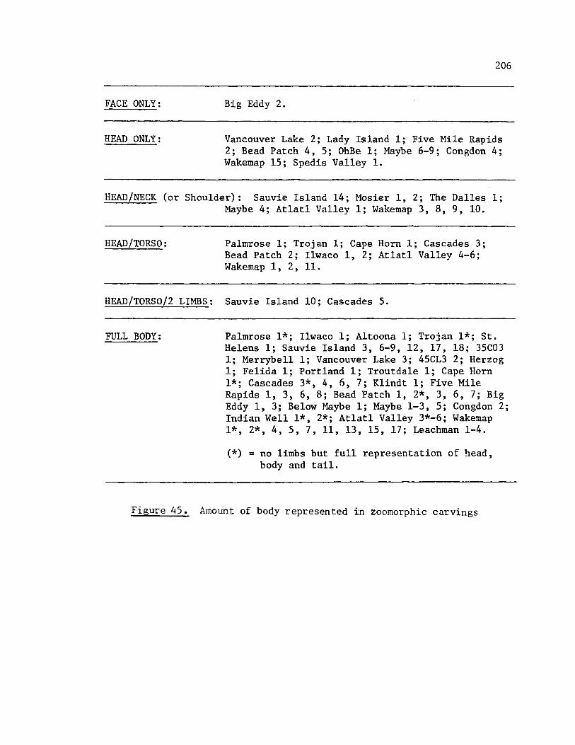
FACE ONLY:
HEAD ONLY:
206
Big Eddy 2.
Vancouver Lake 2; Lady Island 1; Five Mile Rapids 2; Bead Patch 4, 5; OhBe 1; Maybe 6-9; Congdon 4; Wakemap 15; Sped is Valley 1.
HEAD/NECK (or Shoulder): Sauvie Island 14; Mosier 1, 2; The Dalles 1; Maybe 4; Atlatl Valley 1; Wakemap 3, 8, 9, 10.
HEAD/TORSO: Palmrose 1; Trojan 1; Cape Horn 1; Cascades 3; Bead Patch 2; Ilwaco 1, 2; Atlatl Valley 4-6; Wakemap 1, 2, 11.
HEAD/TORSO/2 LIMBS: Sauvie Island 10; Cascades 5.
FULL BODY: Palmrose 1*; Ilwaco 1; Altoona 1; Trojan 1*; St. Helens 1; Sauvie Island 3, 6-9, 12, 17, 18; 35C03 1; Merrybell 1; Vancouver Lake 3; 45CL3 2; Herzog 1; Felida 1; Portland 1; Troutdale 1; Cape Horn 1*; Cascades 3*, 4, 6, 7; Klindt 1; Five Mile Rapids 1, 3, 6, 8; Bead Patch 1, 2*, 3, 6, 7; Big Eddy 1, 3; Below Maybe 1; Maybe 1-3, 5; Congdon 2; Indian Well 1*, 2*; Atlatl Valley 3*-6; Wakemap 1*, 2*, 4, 5, 7, 11, 13, 15, 17; Leachman 1-4.
(*) = no limbs but full representation of head, body and tail.
Figure 45. Amount of body represented in zoomorphic carvings

207
THREE DIMENSIONAL CARVINGS: Pa1mrose 1; Ilwaco 1; Altoona 1; Trojan 1; St. Helens 1; Sauvie Island 3, 7-10, 12, 14, 16-18; 35C03 1-5; Cho1ick 1; Merrybe11 1; Vancouver Lake 1-3; 45CL3 2; Herzog 1; Fe1ida 1; Portland 1; Oregon City 1; Lady Island 1; Troutdale 1; Cape Horn 1; Cascades 2, 3, 5-7; Mosier 1, 2; Klindt 1; The Dalles 1; Five Mile Rapids 1-3, 6, 8; Bead Patch 1, 3-7; Big Eddy 1, 3; OhBe 1; Below Maybe 1; Maybe 1-4, 6-9; Congdon 2, 4; At1at1 1, 3-5; Wakemap 1, 2, 4, 5, 8-11, 16, 18; Leachman 2-4, 6; Spedis 1.
TWO DIMENSIONAL CARVINGS: Sauvie Island 6; Cascades 4 (in relief); Big Eddy 2; Maybe 5; Indian WeIll, 2; At1atl Valley 6; Wakemap 3, 7, 13, 15 (7), 17 (in relief); Leachman 1.
Figure 46. Dimensional representation of zoomorphic carvings

208
Sauvie Island 6, Atlatl Valley 6, Indian Well 1,2, Wakemap 3,7,13.
That is, the two-dimensional forms tend to occur principally upriver.
Two zoomorphs are shown in full relief: Cascades 4 ("lizard" on a pipe
bowl) and Wakemap 13 (quadruped Oll a mortar). These are distinct from
a number of zoomorphic figures where the implement (eg., bowl) forms
the fullness of the body and some or all of the features are incised,
in relief, or sculptured: for example, Ilwaco 1, Bead Patch 2, and Big
Eddy 2. Maybe 5 is an example of a combination of dimensions; that is,
the bowl or mortar forms the body, the head projects as nearly full
sculptured, while the body limbs, ribs, and tail are shown in relief.
Types or "Uses"
If the zoomorphic carvings are typed according to presumed use,
another series of classificatory designations occur (see Figure 47).
Thirty-nine (or 35%) of the carvings are "effigies", that is, represen
tational zoomorphic forms for which the use is not known. Many of these
were noted or discussed in relation to Figure 43, the animal represen
tations of zoomorphic carvings. Eighteen zoomorphic carvings are
mortars or bowls. The mortar or bowl is inset in the back of Sauvie
Island 8, Five Mile Rapids 8, Wakemap 18, and Leachman 1, and in the
head of Bead Patch 2, and Wakemap 15. In all other mortars and bowls,
the zoomorphic features are adapted to the basic shape of the utensil.
An additional two carvings are palette forms; that is, they have
a series of shallow depressions that could have been used as small
mortars. This designation is somewhat speculative, however, since very
similar depressions occur along the back of the vertically-oriented
quadruped in relief on mortar Wakemap 17.
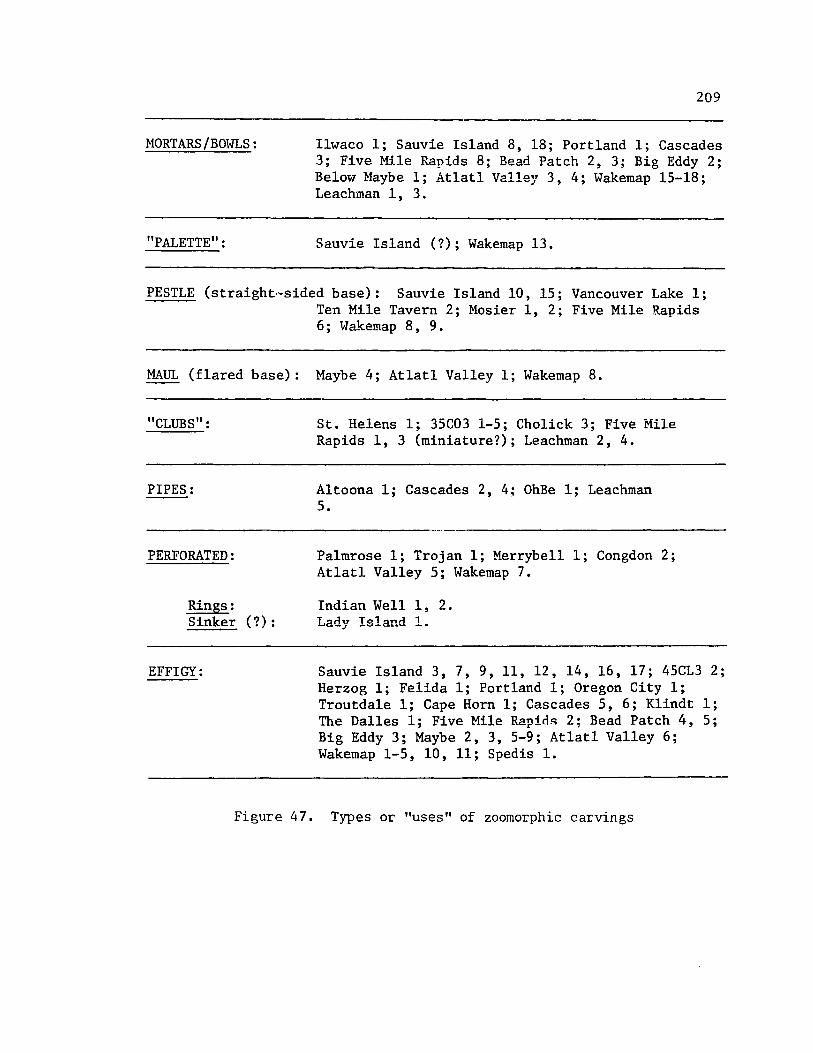
MORTARS/BOWLS:
"PALETTE":
209
Ilwaco 1; Sauvie Island 8, 18; Portland 1; Cascades 3; Five Mile Rapids 8; Bead Patch 2, 3; Big Eddy 2; Below Maybe 1; Atlatl Valley 3, 4; Wakemap 15-18; Leachman 1, 3.
Sauvie Island (?); Wakemap 13.
PESTLE (straight·-sided base): Sauvie Island 10, 15; Vancouver Lake 1; Ten Mile Tavern 2; Mosier 1, 2; Five Mile Rapids 6; Wakemap 8, 9.
MAUL (flared base) :
"CLUBS":
PIPES:
PERFORATED:
Rings: Sinker (?):
EFFIGY:
Figure 47.
Maybe 4; Atlat1 Valley 1; Wakemap 8.
St. Helens 1; 35C03 1-5; Cholick 3; Five Mile Rapids 1, 3 (miniature?); Leachman 2, 4.
Altoona 1; Cascades 2, 4; OhBe 1; Leachman 5.
Palmrose 1; Trojan 1; Merrybell 1; Congdon 2; Atlatl Valley 5; Wakemap 7.
Indian WeIll, 2. Lady Island 1.
Sauvie Island 3, 7, 9, 11, 12, 14, 16, 17; 45CL3 2; Herzog 1; Felida 1; Portland 1; Oregon City 1; Troutdale 1; Cape Horn 1; Cascades 5, 6; Klindt 1; The Dalles 1; Five Mile Rapids 2; Bead Patch 4, 5; Big Eddy 3; Maybe 2, 3, 5-9; At1atl Valley 6; Wakemap 1-5, 10, 11; Sped is 1.
Types or "uses" of zoomorphic carvings

210
Many of the artifacts in the categories of pestles (strai~ht
sided forms) and mauls (flared base forms) were discussed earlier in
the context of bird head representations. Other pestle or maul zoomor
phic representations do occur, however. Sauvie Island 10, Mosier 1, 2,
appear to be generalized zoomorphic heads. Sauvie Island 15 was called
a "pregnant bear" by Indian informants (Eells 1886: 293). Other litera-
ture citings for pestles with ;;animal figures" atop them include
Vancouver Lake 1, Camas 1, Ten Mile Tavern 1. Butler (1964:37-38)
discusses the chronology of various of the "self-handled mauls" found
principally upriver. The forms with the flanged bases and with anthro
pomorphic figures atop them (which accounts for all of the mauls
included here) he found to come primarily from either cremations (dat
ing arollild the 18th century) or from habitation sites in late levels
(eg., the 18th century levels in Wakemap Mound).
The pipes are all made of finely finished steatite. Two represent
birds (Altoona 1 the full body of an owl and OhBe 1 the head of a bird).
A third pipe has a lizard-like creature lying in relief along its length.
Many pipes similar to the latter are reported for the Cascades (Cascades
4), and Leachman si tes (Leachman 5).
A brief comment is in order for the perforated forms. Several
(Pa1mrose 1, '1'rojan 1, Merrybell 1, Congdon 2, Atlatl 5) have been sug
gested as at1atl weights. This designation is still somewhat specu
lative, however. Most of the research for atlatl weights in the lower
Co11\lffibia is summarized in Emory Strong (1958, 1966) 1 Butler and Osborne
(1959), and Butler (1961). Although evidence is growing for the use of
loaf-shaped stones for at1atl weights, it is still inconclusive for the

211
zoomorphic forms included here.
The stone rings from Indian Well apparently exhibit a very narrow
distribution (Indian Well, Maybe, and Congdon sites), and are rare else
where on the Coltunbia (Oregon Archaeological Society 1959:27).
Distribution of Features
The most frequently depicted zoomorphic features are the nose,
eyes, and mouth. Only slightly less frequently, the limbs are repre
sented. Most of the other features have low frequencies of representa
tion. (See Figure 48.)
The noses are usually depicted as either a cone-shaped snout or a
rounded snout. The former is the more typical representcl.tion on small
forms whereas the rounded snouts are typically found on sculptures of
larger dimensions including the larger zoomorphic heads discussed
earlier. Nostrils are often depicted, but only on the rounded snout
forms.
Eye forms are varied but most of the zoomorphic eyes are depicted
by bulbous protrusions either rising out of the flat plane of the face
or by having an incised or ground away area encircling them. Many of
the eyes have pupils represented either by a punctuate, funnel shaped
depression or a larger, shallower and more rounded depression. The
punctuate pupils should not be confused for punctuate eyes which tend to
occur on the smaller forms.
Mouth representations cluster strongly in being represented as
ei ther a simple incised line (principally found on smaller forms) or a
more fully sculptured representation of upper and lower jaws with lips
and/or teeth delineated.
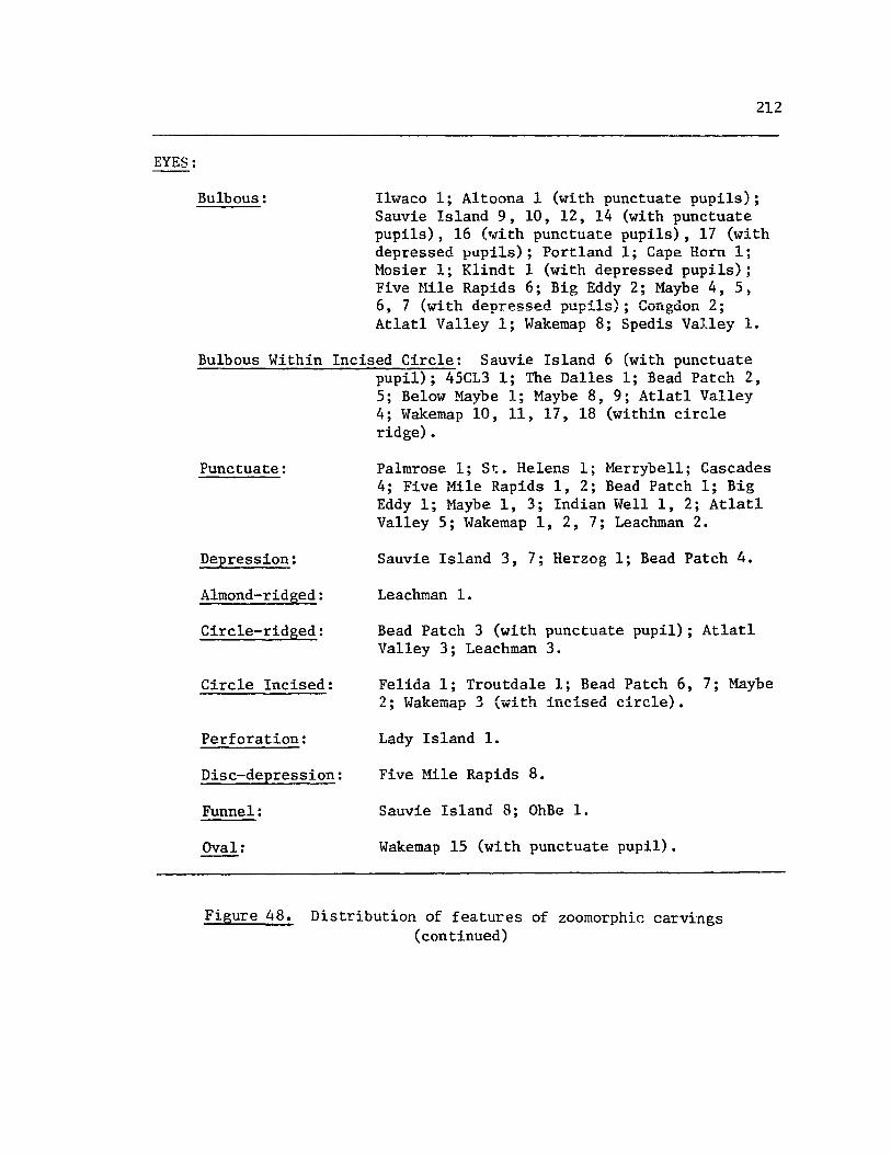
EYES:
212
Bulbous: Ilwaco 1; Altoona 1 (with punctuate pupils); Sauvie Island 9, 10, 12, 14 (with punctuate pupils), 16 (~ith punctuate pupils), 17 (with depressed papi1s); Portland 1; Cape Horn 1; Mosier 1; Klindt 1 (with depressed pupils); Five Hile Rapids 6; Big Eddy 2; Maybe 4, 5, 6,7 (with depressed pupils); Congdon 2; At1at1 Valley 1; Wakemap 8; Spedis Valley 1.
Bulbous Within Incised Circle: Sauvie Island 6 (with punctuate pupil); 45CL3 1; The Dalles 1; Bead Patch 2, 5; Below Maybe 1; Maybe 8, 9; At1at1 Valley 4; Wakemap 10, 11, 17, 18 (within circle ridge).
Punctuate: Pa1mrose 1; St. Helens 1; Merrybe11; Cascades 4; Five Mile Rapids 1, 2; Bead Patch 1; Big Eddy 1; ~fuybe 1, 3; Indian Well 1, 2; Atlatl Valley 5; Wakemap 1, 2, 7; Leachman 2.
Depression: Sauvie Island 3, 7; Herzog 1; Bead Patch 4.
Almond-ridged: Leachman 1.
Circle-ridged: Bead Patch 3 (with punctuate pupil); Atlatl Valley 3; Leachman 3.
Circle Incised: Fe1ida 1; Troutdale 1; Bead Patch 6, 7; Maybe 2; Wakemap 3 (with incised circle).
Perforation: Lady Island 1.
Disc-depression: Five Mile Rapids 8.
Funnel: Sauvie Island 8; OhBe 1.
Oval: Wakema~ 15 (with punctuate pupil).
Figure 48. Distribution of features of zoomorphic carvings (continued)

NOSE:
EARS:
213
Cone-shaped Snout: Palmrose 1; Trojan 1; St. Helens 1; 35C03 1; Merrybell 1; Cape Horn 1; Cascades 5-7; Mosier 2 ; Five Mile Rapids 1-3; Bead Patch 1; Uaybe 3, 5; Atlatl Valley 5; Wakemap 13; Leachman 2, 4.
Rounded Snout: Sauvie Island 9, 14; Portland 1 (with nostrils); Lady Island 1; Cascades 6; The Dalles 1 (with nostrils); Bead Patch 4,5 (with nostrils); Big Eddy 1; Maybe 1,2; Maybe 6 (with nostrils); Maybe 7 (with nostrils); Maybe 8 and 9 (with nostrils); Congdon 2; Atlatl Valley 4; Wakemap 4,5,10 (with nostrils); 11, 18 (with nostrils).
Ridge: Sauvie Island 3, 6, 17.
Ridge/Brow Continuous: Ilwaco 1; Sauvie Island 12; Big Eddy 2 (includes eyes).
Ridge/Brow/Face Continuous: Altoona 1; Sauvie Island 16; Mosier 1; Klindt 1; Bead Patch 2; Wakemap 17.
Bulbous:
Beak-like:
Sauvie Island 7; Leachman 3; Spedis Valley 1.
Sauvie Island 8; Five Mile Rapids 8; Big Eddy 3; OhBe 1; Atlatl Valley 3; Wakemap 3, 9, 16.
Tab: Five Mile Rapids 8; Below Maybe 1; Maybe 8.
Projecting: Trojan 1; St. Helens 1; Sauvie Island 10, 17; 35C03 1; Merrybell 1; Cascades 5, 6; Mosier 2; Five Mile Rapids 3; Maybe 2, 3; Atlatl Valley 5; Wakemap 4, 5, 13; Leachman 2.
Figure 48. Distribution of features of zoomorphic carvings (continued)

MOUTH:
Cut In:
Incised:
Incised Beaks:
Ridged:
LIMBS:
Four Limbs:
Forelimbs:
214
Sauvie Island 9 (with protruding tongue), 14; Herzog 1; Portland 1; Lady Island 1; Troutdale 1 (with protruding tongue); The Dalles 1; Bead Patch 4, 5; Maybe 9; Congdon 2 (with teeth); Atlatl Valley 4; Wakemap 10, 11; Spedis Valley 1 (with teeth).
Pa1mrose 1; Trojan 1; St. Helens 1; Merrybe1l 1; Cascades 5; Mosier 2; Five Mile Rapids 2; Bead Patch 1, 2; Big Eddy 1; Maybe 1-3, 5; Maybe 8; Indian WeIll, 2; At1atl Valley 3, 5; Wakemap 1, 5 (ridged); Wakemap 9, 13; Leachman 3.
Sauvie Island 8; Bead Patch 3, 6, 7; OhBe 1 (ridged).
Below Maybe 1; Leachman 1.
St. Helens (treated as two); Sauvie Island 12 (flexed), 16 (flexed); 35C03 1 (treated as two); Cascades 4, Cascades 6, 7 (treated as two); Bead Patch 1; Big Eddy 1; Below Maybe 1 (flexed); Maybe 2 (treated as two), Maybe 3 (?); Congdon 2 (flexed); Wakemap 17,18; Leachman 2 (treated as two), Leachman 4 (treated as two).
Sauvie Island 6; Five Mile Rapids 1 (treated as one), 3 (treated as one); Wakemap 5,13, 15 (all three sculptures with the forelimbs treated as one).
Limbs One Side Only: Maybe 5 (three digits each and flexed); Leachman 1.
Hind Limbs Only: Cascades 5 (treated as one).
Figure 48. Distribution of features of zoomorphic carvings (continued)
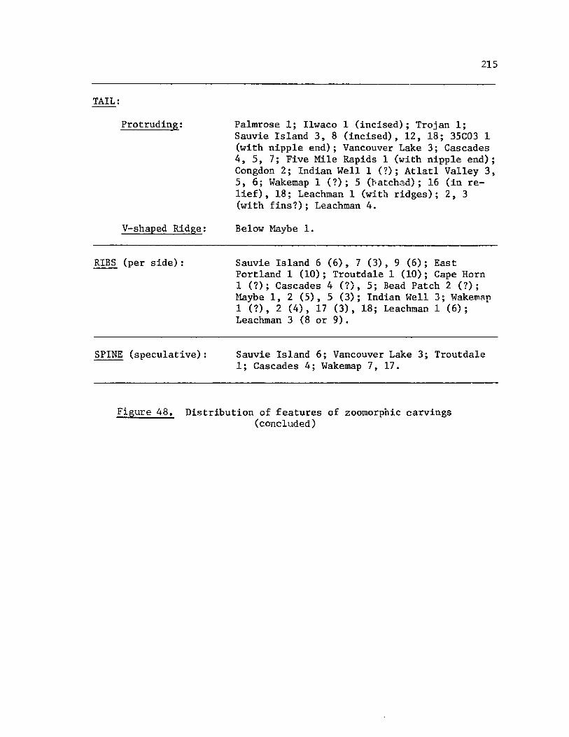
TAIL:
Protruding:
V-shaped Ridge:
RIBS (per side):
SPINE (speculative):
215
Palmrose 1; Ilwaco 1 (incised); Trojan 1; Sauvie Island 3,8 (incised), 12, 18; 35C03 1 (with nipple end); Vancouver Lake 3; Cascades 4,5, 7; Five Mile Rapids 1 (with nipple end); Congdon 2; Indian WeIll (?); Atlatl Valley 3, 5,6; Wakemap 1 (?); 5 (hatch~d); 16 (in relief), 18; Leachman 1 (with ridges); 2,3 (with fins?); Leachman 4.
Below Maybe 1.
Sauvie Island 6 (6), 7 (3),9 (6); East Portland 1 (10); Troutdale 1 (10); Cape Horn 1 (?); Cascades 4 (?), 5; Bead Patch 2 (?); ~~ybe 1, 2 (5), 5 (3); Indian Well 3; Wake~~p 1 (?), 2 (4), 17 (3),18; Leachman 1 (6); Leachman 3 (8 or 9).
Sauvie Island 6; Vancouver Lake 3; Troutdale 1; Cascades 4; Wakemap 7, 17.
Figure 48. Distribution of features of zoomorphic carvings (concluded)

216
The manner in which the limbs are treated also varies a great deal.
In some cases all four limbs are shown, and in others the two front and
and the two hindlimbs are respectively treated as one, that is, joined
together. Most of the sculptures where limbs are depicted fall into one
or another of these two categories.
Ribs appear to be shown on 19 of the forms (or about one-sixth of
the zoomorphic carvings). There does not appear to be any site or area,
or form specificity for the number of ribs depicted.
Ochre residue (?) was noted or reported on the following pieces:
Sa'.lvie Island 9, Maybe 7, Wakemap 13, 17.
Three of the zoomorphic carvings (all mortars) appear to be pedes'
talled: Sauvie Island 8 and Five Mile Rapids 8 by the manner in which
their legs are represented, and Leachman 3 as a true pedestal (that is,
apparently it is not part of the body representation).
SUMMARY OF ANTHROPOMORPHIC CARVINGS
Representation
All of the anthropomorphic carvings are generalized human forms
except Sauvie Island 1 and Kenton 1, both of which appear to display
male genitalia. No specifically female attributes such as breasts are
represented on the anthropomorphic figures included in this study.
Amount of Body Represented
The distribution of anthropomorphic carvings by the amount of body
represented is shown in Figure 49. (Sauvie Island 1, Lyle 1, and Wakemap
12 may be broken pieces rather than partial body representations; however,
the broken away edges are quite smooth and rounded at this time.) The

FACE: Cho1ick 2.
HEAD: Five Mile Rapids 5; Congdon 1; Wakemap 4.
HEAD/NECK (or Shoulders): Cho1ick 1; Lyle 1; Five Mile Rapids 4, 7.
HEAD/TORSO: Klindt 2; Leachman S.
HEAD/TORSO/2 LIMBS: Sauvie Island 1; Wakemap 12.
FULL BODY: Sauvie Island 4; Herzog 2; Kenton 1; Five Mile Rapids 9.
217
Figure 49. Amount of body represented in anthropomorphic carvings

218
percentages for various categories of body representation are similar to
those of the zoomorphic figures. These show no strong specificity for
one area or another. Only as a broad generalization could one say that
full body or body-torso forms were found downriver whereas partial body
figures were found upriver.
Dimensional Representation
Figure 50 charts the anthropomorphs as either two or three dimen
sional. There does not appear to be any strong clustering either up or
downriver. In contrast to the zoomorphs, however, about one-half of the
anthropomorphs are two-dimensional representations. One figure is fully
incised, in the manner of a petroglyph (Sauvie Island 4). The features
for two figures are in full relief (Cholick 2 and Lyle 1); in both cases
the head and its features are represented. Four of the faces (Sauvie
Island 1, Kenton 1, Lyle 1, and Congdon 1) have three facial planes
represented. That is, in all four cases the cheeks are a flat plane,
the mouths are recessed, and the continuous nose-brow ridges and eyes
are in relief. As with the zoomorphic figures, some of the anthropo
morphic figures appear to have been sculpturally adapted to the naturally
occurring form of the stone (eg., Sauvie Island 1, 4, Cholick 1, and
possibly Herzog 2) as compared to being fully sculpted pieces (such as
Kenton 1).
Types or "Uses"
Most of the anthropomorphic figures are either effigy carvings or
mortars/bowls/palettes. (See Figure 51.) Five of the seven human effigy
figures come from the Portland Basin area, whereas seven of the eight

THREE DI~mNSIONAL: Herzog 2; Kenton 1; Klindt 2; Five Mile Rapids 4, 5, 7, 9; Indian Well 4; Leachman 5.
TWO DI~NSIONAL: Sauvie Island 1; Cholick 1, 2; Lyle 1; Congdon 1; Wakemap 12, 14.
INCISED: Sauvie Island 4.
Figure 50. Dimensional representation of anthropomorphic carvings
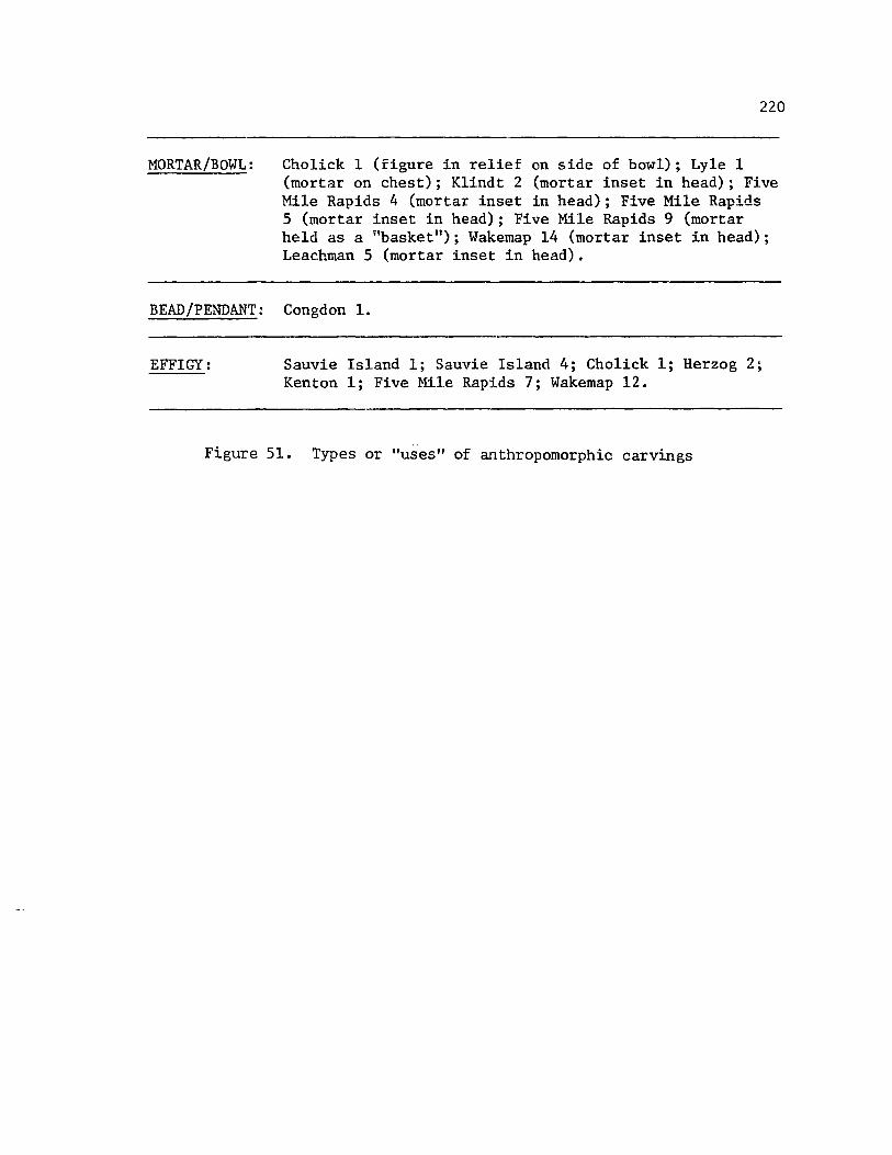
220
MORTAR/BOWL: Cho1ick 1 (figure in relief on side of bowl); Lyle 1 (mortar on chest); Klindt 2 (mortar inset in head); Five Mile Rapids 4 (mortar inset in head); Five Mile Rapids 5 (mortar inset in head); Five Mile Rapids 9 (mortar held as a "basket"); Wakemap 14 (mortar inset in head); Leachman 5 (mortar inset in head).
BEAD/PENDANT: Congdon 1.
EFFIGY: Sauvie Island 1; Sauvie Island 4; Cho1ick 1; Herzog 2; Kenton 1; Five Mile Rapids 7; Wakemap 12.
Figure 51. Types or "uses" of anthropomorphic carvings
221
mortar/bowl/palette figures corne from Lyle or the greater The Dalles
area. The downriver bowl (Cholick 1) further stands apart as being the
only one with the anthropomorphic figure in relief on the bowl. In all
the other cases, the bowls are inset in the figures: one in the chest
of the figure, 01'"!8 held as a "basket" on a shoulder, and five in the
head of the figure.
Distribution of Features
Figure 52 shows the distribution of the manner in which various
body features are treated. A great deal of diversity is shown, espe
cially for so few sculpted pieces.
Some generalizations concerning feature delineation would include
the following observations. The eyes, mouth, and nose are the most
frequently represented features. The eyes are usually either bulbous
or represented by a.n almond-shaped ridge. In contrast to the zoomorphic
figures' eye representations where punctuate or depression pupils often
occurred, only one anthropomorphic figure's eyes possibly had such a
representation (Leachman 5). The mouth is most often recessed; whereas
the nose is more frequently a ridge, or a continuous ridge and eyebro\,.
representation. Arms and/or legs are less frequently represented.
Digits are found on the arms of only two figures (Sauvie Island 4 and
Five Mile Rapids 9). Ears are infrequently represented as are sculpted
(rounded) cheeks. Exposed ribs are noted on only five figures (and
those of one are problematic).
Most of the other features charted are speculative, especially
hair, braids, and headdresses.
There are only two sites where body or facial features are
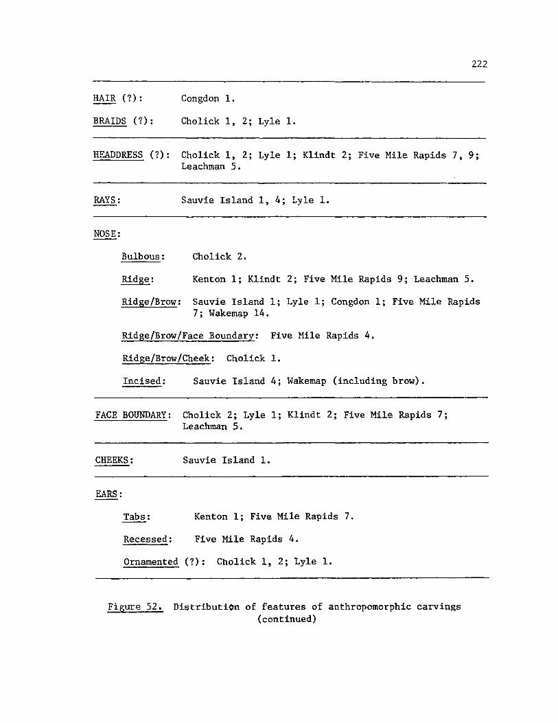
222
HAIR (7): Congdon 1.
BRAIDS (7): Cholick 1, 2; Lyle 1.
HEADDRESS (7): Cholick 1, 2; Lyle 1; Klindt 2; Five Hile Rapids 7, 9; Leachman 5.
RAYS: Sauvie Island 1, 4; Lyle 1.
NOSE:
Bulbous: Cholick 2.
Ridge: Kenton 1; Klindt 2; Five Mile Rapids 9; Leachman 5.
Ridge/Brow: Sauvie Island 1; Lyle 1; Congdon 1; Five Mile Rapids 7; Wakemap 14.
Ridge/Brow/Face Boundary: Five Mile Rapids 4.
Ridge/Brow/Cheek: Cholick 1.
Incised: Sauvie Island 4; Wakemap (including brow).
FACE BOUNDARY: Cholick 2; Lyle 1; Klindt 2; Five Mile Rapids 7; Leachman 5.
CHEEKS: Sauvie Island 1.
EARS:
Tabs: Kenton 1; Five Mile Rapids 7.
Recessed: Five Mile Rapids 4.
Ornamented (7): Cholick 1,2; Lyle 1.
Fig~re 52. Distribution of features of anthropomorphic carvings (continued)

223
EYES:
Depressions: Sauvie Island 1; Wakemap 12.
Bulbous: Five Mile Rapids 4, 5, 7, 9.
Almond-shaped Ridge: Cholick 1, 2; Lyle 1; Klindt 2; Wakemap 14.
Incised: Sauvie Island 4; Herzog 2.
Flat Disk: Congdon 1.
Oval Ridge: Leachman 5 (pupils punctuate?).
MOUTH:
ARMS:
Recessed: Sauvie Island 1; Kenton 1; Lyle 1; Five Mile Rapids 4, 7 (?), 9; Wakemap 14.
Incised: Sauvie Island 1; Herzog 2; Congdon 1; Wakemap 12.
Ridge: Cho1ick 1, 2; Klindt 2; Five Mile Rapids 5.
Sauvie Island 4 (2 arms) Herzog 2 (2 arms) Kenton 1 (2 arms) Five Mile Rapids 9 (2 arms ?) Wakemap 12 (2 arms)
(Digits)
3
5
(Flexed)
x X
LEGS: Sauvie Island 1,2; Five Mile Rapids 9 (2 legs?); Wakemap 12. (Legs treated as one: Herzog 2, Kenton 1.)
RIBS (number): Sauvie Island 1 (4 each side); Sauvie Island 4 (3 each side); Herzog 2 (?); Klindt 2 (5 each side); Five Mile Rapids 4 (3?).
Figure 52. Distribution of features of anthropomorphic carvings (concluded)

224
possibly site-specific: Cholick site and Five Mile Rapids site. Both
Cholick 1 and 2 are primarily face representations with almond-shaped
ridges to depict the eyes, crescent-shaped ridges for the mouths, and
"tongue" or "teeth" representations. Further, both have similar ear
ornamentations (or braids?), and both have a series of parallel, hori
zontal lines incised above the face. (In the case of Cholick 2, these
lines are integral to the total surface of the mortar. However, since
any two of the four faces depicted on that mortar share an ear ornamen
tation, the horizontal lines may be viewed as being shared, also.)
The two human heads with mortars inset in them from Five Mile
Rapids (numbers 4 and 5) are very similar in overall representation but
not in particular facial details.
Ochre residue (?) was noted on Lyle 1, Five Mile Rapids 5 and 9.
SUMMARY OF UNDEFINED CARVINGS
As can be noted in Figure 42, nine of the carvings included in
this study were put in an "undefined" category. Some brief observations
concerning these pieces follow.
Sauvie Island 2 and 5 have some interesting similarities not found
on any other of the sculptures included here. Both appear to be figures
sitting on their haunches. Both have two oval humps (one on top of
another) protruding from the middle of their backs. Both have their
forelimbS coming around to the front of their bodies where they "grasp"
or "clasp" a loaf-shaped sculpted portion of the carving. Both have a
sort of headdress; both have ribs. The hindlimbs of Sauvie Island 2
also come around to grasp a less well defined loaf which occurs lower on
225
the body. It also appears to have ear ornamentation. In sbort, there
are both zoomorphic and anthropomorphic similarities in both cases.
Sauvie Island 13 is possibly the most abstracted of the facial
representations of any of the carvings dealt with here. The irregular,
naturally-occurring shape of a stone forms the basic shape of the head.
The face is delineated only by concentric circles for eyes and a mouth
with several teeth exposed. The only other carving to have the concen
tric circle design was the OhBe 1 pipe, on the back of the bird's head
which forms the bm-rl of the pipe. The mouth is perhaps most similar to
the "grimacinglt faces of some of the larger, zoomorphic heads discussed
earlier.
Ten Mile Tavern 1 is a literature citing about a carving with the
body of a bird and the face of a man.
Ten Mile Tavern 3 and 4 are literature citings of two undefined
"effigies;' found at that site.
Congdon 3 is a very small bowl of scoracious lava with a slight
nose/brow ridge defined and two slightly bulbous eyes. Although it may
be an owl face similar to the Ilwaco bowl, the delineations are vague
and can possibly be found on an anthropomorphic face also (eg., Five
Mile Rapids 4, 7, Congdon 1).
Similarly, the series of eyes that are depicted on the Atlatl
Valley 2 bowl suggest the almond-shaped ridge outline eyes of the "bird
head" pestles or mauls, but also suggest the anthropomorphic eye repre
sentations found on such carvings as Cholick 1, 2, Lyle 1, Kindt 1, and
Wakemap 14.

LL6
And of final note here is Wakemap 6, the small Sllghtly oval stone
with an incised flGure on itl
The general outline is suggestive of an owl with large facial disks
around the eyes 0 The limbs with their appendages are perhaps more
anthropomorphic 0 Several stones of approximately the same size were
found in ~·Jal~e.'nap Mound according to Emory Strong (l~~6:L). Most slmply
had lnClsed geometric marks. Two others (proveniences undeflned) were
touno wlth anthropomorphlc faces on them.
CHAPTER VI
SUMMARY, CONCLUSIONS, A~u RECOMMENDATIONS FOR FURTHER RESEARCH
227
In this chapter, a general summary of the findings is presented
for stone carvings of the lower Columbia River valley. Further, a brief
summary is made of the contexts and a broadly defined chronology of the
stone sculptures' occurrence is noted. Finally, recorrunendations for
further research are made.
DISTRIBUTIONAL PATTERNS
Summary of All Carvings
Several very broad generalizations can be made for the mobile
stone sculptures of the lower Columbia Ri ve·c valley as herein defined.
Zoomorphic figures or designs occurred about 67% more frequently
than did anthropomorphic figures or designs. The ,zoomorphic sculptures
and the anthropomorphic sculptures each had about 80% renresentation i.n
The Dalles area and 13% in the Portland Basin area.
Representation. The zoomorphic carvings were mostly generalized
quadrupeds (25%) or bird-like forms (23%). Anthropomorphic carvings
were mostly non-sexed, generalized human forms (89%).
Amount of Body Represented. Full body representations appeared
to be distributed throughout the area for zoomorphic figures and perhaps
slightly clustered downriver for anthropomorphic ones. Partial body
representation tended to cluster upriver for both zoomorphic and

228
anthropomorphic designs.
Dimensional Representation. While about 78% of the zoomorphic
carvings were three-dimensional, only 50% of the anthropomorphic ones
were. In both cases there were several carvings that were adapted to the
naturally occurring shape of the stones and such carvings tended in both
cases to cluster downriver.
Type or "Use". Effigy carvings averaged about 37% for both zoo
morphic and anthropomorphic carvings. While 44% of the anthropomorphic
carvings were mortars, only 18% of the zoomorphic ones were. However,
zoomorphic carvings were represented in a n.uch greater variety of types
or uses. Mortars for the anthropomorphic classification tend to be set
in a figure whereas mortars for the zoomorphic classification tend to be
decorated with the zoomorphic figures or designs.
Featur2s. The eyes, nose, and mouth are the most frequently
delineated features for both zoomorphic and anthropomorphic carvings.
Zoomorphic figure eyes are most often depicted as bulbous, frequently
with pupils; anthropomorphic figure eyes are most often depicted as
bulbous or almond-ridged, rarely with pupils. Zoomorphic figure noses
are either cone-shaped snouts (smaller figures) or rounded snouts (larger
figures), the latter frequently with nostrils; anthropomorphic figure
noses are most often bulbous. Zoomorphic figure mouths are either an
incised line (smaller figures) or sculptured lips and teeth (larger
figures); anthropomorphic figure mouths are most often recessed. Limbs
for either zoomorphic or anthropomorphic figures are less freqllently
depicted. Ribs occur on one-sixth of the zoomorphic figures and one
fourth of the anthropomorphic ones.
229
Materials. By far the greatest number of the stone sculptures were
made of basalt or river rock indigenous to the area. Butler (1959,19)
noted that other materials such as slate probably came from the western
slopes of the Cascades mountains whereas steatite most likely came from
the Blewett Pass area (between Cle Elum and Wenatchee, Washington).
Serpentine is thought to have come from the Canyon City, Oregon area.
Many of these materials may have occurred incidentally in the river
gravels, but according to Butler (1959:20) they show a marked increase
in quantity in sites dating about 1500 to 1000 BC on. He feels that it
signifies increased contact with surrounding areas--a pattern which was
observed in the intensive trading activities characteristic of late
groups. The Dalles area carvings evidenced the greatest diversity of
materials, whereas the downriver artifacts were almost exclusively
basalt.
Conclusions Concerning Distributional Patterns
The distribution of zoomorphic and anthropomorphic carvings appears
to be characteristic of the full lower Columbia River area as herein
defined. This dtstribution clusters most strongly at The Dalles area
and less frequently down the river to its mouth, around which feH
carvings are known.
It is apparent from the distributional patterns that only a series
of very generalized typological classifications of the carvings were
generated by this sample. There is, in fact, a tremendous amount of
diversity for so few sculptures. I do not believe this to be simply a
sampling problem for most earlier writers use "stylistic diversity" as

230
a typological characteristic in itself for the designs of this area
(Strong, Schenck, and Steward 1930:143; Wingert 1952:10; Galloway 1956:
237-240). This study documents various aspects of such diversity.
Other aspects of locality specificity that Wingert (1952:15) and
Galloway (1956:239) in particular discuss are not as clearly substanti
ated by this sample. For example, both of these men saw Sauvie Island's
carvings as being typically massive ir ~orm with features bodly defined
whereas The Dalles carvings were typically small, with features deline
ated in finer detail. Such a generalization does not seem merited by
the sculptures included in this study. Neither 40es Wingert's (1956:15)
claim that more human figures occur downriver than up.
In gE!!_ct'al, I believe that the complexity of elements for any
given way of classifying th,~se carvings would be better understood if
the geographic limits of this study were extended, particularly upriver.
That is, there does not appear to be a strong cohesion of any kind of
classificatory elements that coincide with the ethnographic/geographic
boundary used for this study. Tne complexity of the patterns, especial
ly at The Dalles, most likely reflects the complexity of the trade
patterns that Lewis (1906) and Spier and Sapir (1930) document. Con
gruency of stylistic elements for the stone sculptures, if such exists,
would come from data drawn from a much broader geographic area than
herein defined.
CONTEXTS AND CHRONOLOGY
Summary
With very few exceptions, most of the archaeological proveniences

231
Cor the carvinr,s included here are no moro specific than a geographic
location or a general site designation. Stratigraphic information is
almost totally lacking; archaeological associations are very infrequently
noted.
The general nature of a specific archaeological site is known for
approximately one-half of the sculptures included in this study. Of
these sites a few have radio-carbon dates (principally for do~nlriver
sites) and a few have been dated by comparison of artifact assemblage,s
(principally for upriver sites). Figures 53 and 54 display such
archaeological sites and dates for zoomorphic and anthropomorphic
sculptures, respectively. It cannot be over emphasized that these
chartings represent a speculative framework, particular stratigraphic
positions of sculptures at discovery are not precisely known.
As a generalization for this study's sample, it appears that
both zoomorphic and anthropomorphic carvings that occur downriver
(from the Portland Basin to the sea) are from habitation sites. Except
for 45CL3 which apparently evidenced circular house pits, the
habitation sites had rectangular living floors and artifact assemblages
suggesting riverine adaptation. Zoomorphic and anthropomorpic carvings
that occur upriver (from the Cascades and The Dalles areas) are prin
cipally from cremations and burials. However, as W. Duncan Strong
noted (1945:248), in the downriver area the dead were often placed in
elevated vaults or scaffoldings with "grave goods rt (including stone
scul~tures) scattered on the ground's surface below. Some of the
surface finds for the downriver area (Sauvie Island in particular)
could therefore be burial related. This cannot be documented, however.

SITE
Pa1mrose 1,2
Trojan 1
POR lLAND BAS IN
35C03 1
Merrybel1 1
45CL3
Herzog 1
TIPE
Habitation
Habitation
Habitation
Habitation
Habitation
Habitation
DATE ( -:, = C-14)
700 - 600 BC (*) Cf. to Pettigrew's Merrybe11 phase, 600 BC to AD 200
AD 680; 740 (~.,)
Cf. to Pettigrew's Mu1tnomah subphase AD 200 - 1250
Cf. to Pettigrew's Merrybe11 phase, 600 BC to AD 200
Late prehistoric
Cf. to Pettigrew's Mu1tnomah III subphase AD 1750 - 1835
Figure 53. Zoomorphic carvings by type of site and its dating
SOURCE
Phebus and Drucker 1973:5
Pettigrew 1977:326
Warner and Warner 1970:99
Pettigrew 1977:326
Pettigrew 1977:326
Warren 1958 :15
Pettigrew 1977:327
(continued)
N VJ N

SITE TYPE DATE ~ ( j: = C-14) ,
Felida 1 i Habitation Early historic (7)
Lady Island 1 Habitation several, from 500 -60 BC U:) Cf. Pettigrew's Merrybe11 phase, 600 BC to AD 2GO
-CASCADES
Cascades 5,6 Buria1?/Cremation? -----
-THE DALLES AREA
Five Mile Rapids 8 Cremation Late, protohistoric
Big Eddy 1,2 Habitation -----
Below Maybe 1 Burial -----
Maybe 1,5-7 Burial (II component) 500 Be - AD 500
Congdon 2 Cremation (II component) 1500 Be - AD 500
~ ~-
Figure 53. Zoomorphic carvings by type of site and its dating
SOURCE
Hoffarber 1972:4
Pettigrew 1977:311
Pettigrew 1977:326
-------
Butler 1965:8
-------
-------
Butler 1959:21
Butler 1959:18
(continued)
!
N VJ VJ
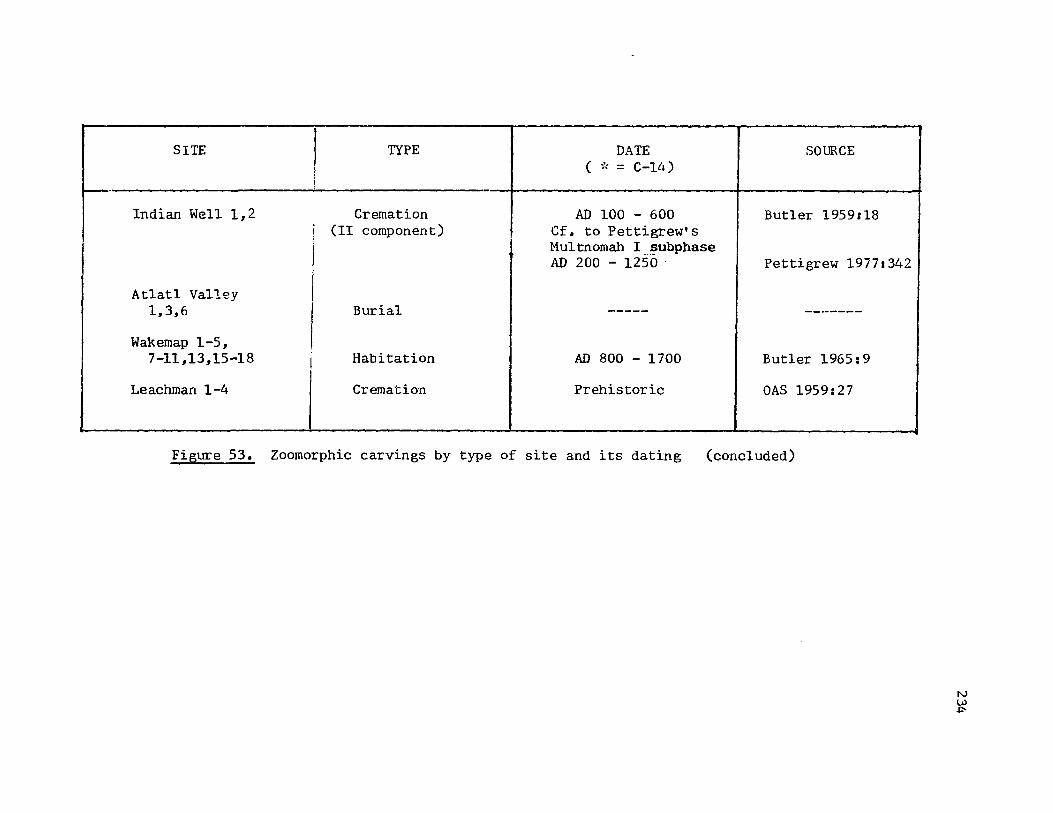
SITE I TYPE DATE SOURCE , ( ~': = C-14) i - -
Indian Well 1,2 Cremation AD 100 - 600 Butler 1959:18 ! (II component) Cf. to Pettigrew's I Mu1tnomah I_!>ubphase
I AD 200 - 1250 . Pettigrew 19771342
At1at1 Valley 1,3,6 Burial ----- -------
Wakemap 1-5, 7-11,13,15-18 I Habitation AD 800 - 1700 Butler 1965: 9
Leachman 1-4 Cremation Prehistoric OAS 1959:27
-- ------ -- --
Figure 53. Zoomorphic carvings by type of site and its dating (concluded)
N LU +:-
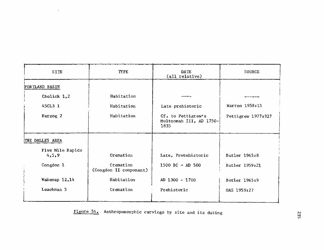
! SITE 1YPE DATE (all relative)
I
I iPOR TLAND BAS IN ,
! Habitation Cho1ick 1,2 I ----I I i 45CL3 1 I Habitation Late prehistoric I j I ,
Herzog 2 Habitation Cf. to Petti.fU'ew' s I Mu1 tnomah III, AD 1750-1835 I
I
I I I'llIE DALLES AREA I
I Five Mile Rapids I 4,5,9 Cremation Late, Protohistoric I
Congdon 1 Cremation 1500 BC - AD 500 I , j
i (Congdon II component) I
I , I Wakemap 12,14 I
Habitation AD 1300 - 1700 I i
I Leachman 5 Cremation Prehistoric
J Figure 54. Anthropomorphic carvings by site and its dating
SOURCE
------
Warren 1958:15
Pettigrew 19771327
Butler 1965: 8
Butler 1959:21
Butler 196519
OAS 1959:27
I
i , i I I ;
I , i I
I i !
I
I
I
N W VI
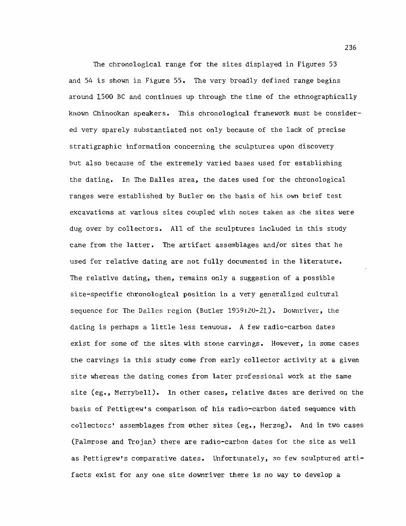
236
The chronological range for the sites displayed in Figures 53
and 54 is shown in Figure 55. The very broadly defined range begins
around 1500 Be and continues up through the time of the ethnographically
known Chinookan speakers. This chronological framework must be consider
ed very sparely substantiated not only because of the lack of precise
stratigraphic information concerning the sculptures upon discovery
but also because of the extremely varied bases used for establishing
the dating. In The Dalles area, the dates used for the chronological
ranges were established by Butler on the basis of his own brief test
excavations at various sites coupled with notes taken as the sites were
dug over by collectors. All of the sculptures included in this study
came from the latter. The artifact assemblages and/or sites that he
used for relative dating are not fully documented in the literature.
The relative dating, then, remains only a suggestion of a possible
si te-specific chronological position in a very general ized cultural
sequence for The Dalles region (Butler 1959:20-21). Downriver, the
dating is perhaps a little less tenuous. A few radio-carbon dates
exist for some of the sites,with stone carvings. However, in some cases
the carvings in this study come from early collector activity at a given
site whereas the dating comes from later professional work at the same
site (eg., Merrybell). In other cases, relative dates are derived on the
basis of Pettigrew's comparison of his radio-carbon dated sequence with
collectors' assemblages from other sites (eg., Herzog). And in two cases
(Palmrose and Trojan) there are radio-carbon dates for the site as well
as Pettigrew's comparative dates. Unfortunately, so few sculptured arti
facts exist for anyone site downriver there is no way to develop a
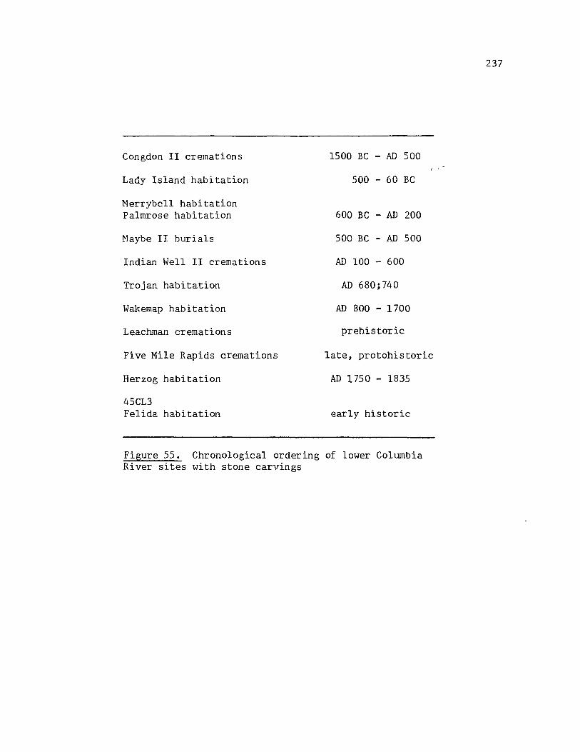
Congdon II cremations
Lady Island habitation
Merrybell habitation Palmrose habitation
Maybe II burials
Indian Well II cremations
Trojan habitation
Wakemap habitation
Leachman cremations
Five Mile Rapids cremations
Herzog habitation
45CL3 Felida habitation
1500 BC AD 500
500 - 60 BC
600 BC - AD 200
500 BC - AD 500
AD 100 - 600
AD 680; 740
AD 800 - 1700
prehistoric
late, protohistoric
AD 1750 - 1835
early historic
Figure 55. Chronological ordering of lower Colwnbia River sites with stone carvings
237
238
"type" for a given chronological unit.
Of note, however, is the fact that the llir,hest frequencies occur
in late, upriver sites (circa AD 800 forward). This is in keeping with
the very generalized conclusions of Strong, Schenck and Steward (1930:
Butler (1959:21; 1965:8,9), ~ressman (1960:61), and so forth.
The historical record provided few insights for the stone sculp
tures. Lewis and Clark (Thwaites 1905,III:166,176,178-179,183), Henry
(Coues (1965 :804), Franchere (1954 :165) and others mention wooden sculp
tures, or simply "sculptures" without defining the material from which
they are made. Usually they are mentioned in relation to the religious
beliefs of the Indian groups, that is, the writers all note that the car
vings are not idols for worshipping. Franchere (1954:165) observed that
the Indians seemed willing to barter them away for "triffles".
The ethnographic literature is silent in this regard. If there
were a more-well-substantiated tie between the ethnographically known
groups and the sculptures, study of the myths and tales of the groups
might be enlightening concerning representations of certain animals
. and so forth. However, as such ties are not known, I believe that
unwarranted speculatation would occur to do such a study.
Conclusions Concerning Contexts and Chronol?.Sl.
In the course of this study, site specific contexts for. the stone
carvings of the lower Columbia were suggested by various references in
the archaeological, historical, and ethnographic literature. However,
substantiations of such contexts were extremely meager. Np~.r.ly all of
the contexts remain conjectural principally because of the way in which

239
the carvings were collected.
Stone sculptures occurred with high to moderate frequency along the
lower Columbia from The Dalles to the sea. This frequency of occurrence
coupled with their durability in the archaeological record could have
made these carvings useful as time or "horizon" markers in the recon
struction of the culture history of the region. Because of the great
diversity of stylistic elements noted in the previous section as well
as the lack of precise information concerning the archaeological con
text, it is virtually impossible to develop even a tentative,
chronologically sensitive typology of stO!1e carvings on the basis of
this study's sample.
Th;~ study :epresents at best a preliminary documentation and
assessment principally of the nature and range of stone carvings in
the lower Columbia. Only a broadly defined chronological ordering
of sites is suggested for the time period of 1500 BC up through the
ethnographically known Chinookan speakers of the area, with the greatest
frequencies of carvings occurring in Wakemap I (AD 800) up '::hrough the
late, protohistoric cremations such as Five Mile Rapids.
RECOMMENDATIONS FOR FURTHER RESEARCH
From preliminary work completed for this study, I believe that
there are at least three major avenues of further research that could be
taken. They are not mutually exclusive. Any or all further research as
discussed below should be done in light of the most current archaeologi
cal synthesis for the lower Columbia River valley.
The first ayenue is continued coverage of collections of the

240
Colulllbia I{ivm- ba!;in. D\ll"illl~ the course or Illy l'('f;('al"Clt, tilrC'f' lOIle,-
time collectors passed away--and with them much knowledge of the pro
venience, associations, etc., of their various collected artifacts. This
knowledge should be considered an archaeological resource to be docu
mented before it is completely lost. Further, as noted earlier, many
of the museums in Washington were not covered for this study, particu
larly those at the University of Washington and Washington State
University, both of which have frequently contracted for Columbia River
archaeological work. Initial references for private collections include
those used for this study. For museum collections, a somewhat informal
but relatively thorough survey is available in Lowry and Lowry, Museum
Excursions in Washington (Series I and II, 1973).
The second and third avenues focus on comparative studies, intra
and inter-regionally. That: is, intra-regional comparisons should be
made with other carved materials of the lower Columbia such as those of
wood, bone, antler, and ivory, as well as the increasing number of
incised clay artifacts that are being discovered in various sites.
Simil~rly, comparative work should be done with the petroglyphs of the
region. Many of these forms are subject to differential preservation.
Nevertheless, where archaeological proveniences and associations are
well documented, an analysis of the carved wood, bone, antler, ivory,
incised clay, and petroglyphs in comparison with the stone sculptures
may help to better define the sculptures' chronology, desig,n sources,
cultural contexts, etc. Other than W. D. Strong's "The Occurrence and
Wider Implications of a 'Ghost Cult' on the Columbia River Suggested by
Carvings in Wood, Bone, and Stone" (1945), most of the references for
241
wood, bone, antler, and ivory are scattered in a variety of sources.
When selected for, each category has a sizeable number of artifacts for
study. (Initial estimates include approximately 200 or more carved
bone, 50 or more carved antler and horn, and 30 or more carved wood
artifacts described in the literature or displayed in the museums covered
for this study.) Shoto Clay by Robert Slocum and Kenneth Matsen (1968)
describes the incised clay from the Herzog site (45CL11) and gives a
very brief summary of clay artifacts for the lower Columbia River. The
bibliography is comprehensive and a useful starting point for studies
of incised clay. For petroglyph studies, many references exist for the
Columbia, but three major resources include the following: "Petro
glypbs near The Dalles on the Columbia River" (Strong and Schenck 1925),
Indian Petrog1yphs of the Pacific Non:i1wesL. Olill and Hill 1974), and
the petroglyph rubbings and documentation completed by Malcolm and
Louise Loring and stored at the Oregon Historical Society, Portland,
Oregon.
Finally, inter-regional comparisons should be made with those
areas that are adjacent to the lower Columbia--the Plateau in general,
and the middle and upper Columbia River and its tributaries in specific.
Most of the literature and many of the collections reviewed for this
study had materials represented from the middle and upper Columbia
River areas as well as the tributary rivers of the Deschutes, John Day
and Snake Rivers. Strong, Schenck, and Steward's Archaeology of The
Dalles-Deschutes Region (1930) and Collier, Hudson and Ford's Archaeolo
gy of the Upper ColuJT\bia Re&ion (1932) are perhaps major starting points
for research into the early archaeological summaries of those areas.

242
Area by area, the most current materials would include the following.
For the area around Lake Umatilla and the John Day River, archaeological
synthesis has not been completed. Several short, annual reports cover
each of the eleven seasons of field work undertaken principally by
David L. Cole, University of Cregon (Cole 1963, 1964, 1965, 1966, 1967,
1968; Cole and Cressman 1959, 1960, 1961; Cole and Leonhardy 1964;
Cressman and Cole 1962). For the lower Snake River, the most recent
synthesis includes Leonhardy and Rice's "A Proposed Culture Typology
for the Lower Snake River Region" (1970) which was updated by papers
presented at the Northwest Anthropological Conference in 1975 (Leon
hardy 1975) and 1976 (Yent 1976). For the middlE' Columbia region
around Vantage, Nelson's The Sunset Creek Site (45KT28) and Its Place
in Plateau Prehistory (1969), which revises Swanson's earlier research
(Swanson 1962), is perhaps the most current synthesis for that area.
This brief discussion of further avenues of research and their
sources does not exhaust all possibilities, either intra- or inter
regionally. As further archaeological work is done and synthesis made
for the lower Columbia River, other avenues may open up that will
help increase the knowledge and understanding of these sculptued
stones in the culture history of the area.

REFERENCES
Bailey, Vernon 1936 The Mammals and Life Zones of Oregon. North American Fauna, 55.
Washington: Bureau of Biological Survey.
Bancroft, Hubert Howe 1884 The Works of Hubert Howe Bancroft. San Francisco: A. L. Ban
croft and Company.
Bates, W. E. 1960 Too Good to Be True. Screenings 5(9):4.
Bent, Arthur Cleveland 1961 Life Histories of North American Birds of Prey, Part II. New York:
Dover.
Berreman, Joel 1937 Tribal Distribution in Oregon. Memoirs of the American Anthropo
logical Association, 47.
Biddle, Henry 1926 Wishram. Oregon Historical Quarterly 27(1):113-130.
Bishop, Charles 1967 The Journal and Letters of Captain Charles Bishop on the North
West Coast of America, in the Pacific and in New South Wales, 1794-1799. New York: Cambridge University Press.
Boas, Franz 1893 The Doctrine of Souls and of Disease Among the Chinook Indians.
Journal of American Folklore 6: 39-42.
1894 Chinook Texts. Bulletin, 20. Washington: Bureau of American Ethnology.
1901 Kathlamet Texts. Bulletin, 26. Washington: Bureau of American E~hnology.
1911 Chinook. Bulletin, 40. Washington: Bureau of American Ethnology.
Boi t,. John 1921 A NeF Log on the Columbia. Washington Historical Quarterly
12(1):3-50.

Brown, Lionel A. 1960 A Typology and Distribution of Projectile Points from Sauvie
Island, .Oregon. MS, masters thesis, Eugene: University of Oregon.
Bryan, Alan 1957 Results and Interpretations of Recent Archaeological- Research
in Western Washington with Circum-Boreal Implications. Davidson Journal of Anthropology 3:1-16.
Burgoyne, Carl F. 1963 The Big Eddy Site. Screenings 12(5):4.
Butler, B. Robert
244
1955 The Wakemap Project: Operation Last Chance. Mazama 37(13):33-37.
1957 The Art of the Lower Columbia Valley. Archaeology 10(3):158-165.
1959 Lower Columbia Valley Archaeology: A Survey and Appraisal of Some Major Archaeological Resources. Tebiwa 2(2):6-23.
1961 Additional Notes and Comments on Atlatl Weights in the Northwest. Tebiwa 4(1):29-32.
1962 The B. Stewart and Cradleboard Mortuary Sites: A Contribution to the Prehistory of the Lower Columbia Valley. Tebiwa 5(1):30-40.
1963 Further Notes on the Burials and Physical Stratigraphy at the Congdon Site, A Multi-component Middle Period Site at The Dalles on the Lower Columbia River. Tebiwa 6(2):16-32.
1964 A Tentative History of Self-Handled Mauls at The Dalles of the Lower Columbia. Tebiwa 7(2):37-41.
1965 Perspectives on the Prehistory of the Lower Columbia Valley. Tebiwa 8(1):1-16.
Butler, B. Robert and Douglas Osborne 1959 Archaeological Evidence for the Use of the Atl~Ll in the
Northwest. American Antiquity 25(2):215-224.
Caldwell, Warren W. 1956 The Archaeology of Wakemap, a Stratified Site Near The Dalles
of the Columbia. MS, doctoral dissertation. Seattle: University of Washington.
Cole, David L. 1963 Interim Report 1962-63: John Day Dam Reservoir Project. Report
to the National Park Service. MS. Eugene: University of Oregon.

Cole, 1964
1965
245
David .w.
Interim Report on the 1963-64 John Day Dam Reservoir Project, Part One: Excavations at Wildcat Canyon, Site 35GM9, Area 5. Report to the National Park Service. MS. Eugene: University of Oregon.
Report on Archaeological Research in the John Day Dam Reservoir Area--1964. Report to the National Park Service. M~. Eugene: Museum of Natural History, University of Oregon.
1966 Report on the Archaeological Research in the John Day Dam Reservoir Area--1965. Report to the National Park Service. MS. Eugene: Museum of Natural History, University of Oregon.
1967 Report on Archaeological Research in the John Day Dam Reservoir Area--1966. Report to the National Park Service. MS. Eugene: Museum of Natural History, University of Oregon.
1968 Report on Archaeological Research in the John Day Dam Reservoir Area--1967. Report to the National Park Seevice. MS. Eugene: Museum of Natural History, University of Oregon.
1974 Archaeological Reseal'ch in the Bonneville Dam Pool Area. MS.
Cole, 1959
1960
1961
Cole, 1964
Eugene: Museum of Natural History, University of Oregon.
David L., and Luther S. Cressman Interim Report on Archaeological Excavations in the John Day Dam Reservoir Area, Oregon, 1958-59. Report to the National Park Service. MS. Eugene: University of Oregon.
Interim Report 1959-60: John Day Dam Reservoir Project, Columbia River. Report of the National Park Service. MS. Eugene~ Universi ty of Oregon.
Interim Report: 1960-61: John Day Reservoir Project, Columbia Ri ver. Report to the National Park Service. MS. Eugene: Uni'versity of Oregon.
Daivd L., and Frank C. Leonhardy Report on Survey and Excavations on Report, 1963-64, Part Two, John Day to the National Park Service. MS. History, University of Oregon.
Blalock Island--1963, Interim Dam Reservoir Project. Report Eugene: Museum of Natural
Collier, Donald, Alfred E. Hudson, and Arlo Ford 1942 Arc~aeology of the Upper Columbia Region: University of Washington
Publications in Anthropology 9(1) :1-178.
Cook. 1955
Sherburne F. The Epidemic of 1830-1833 in California and Oregon. University of California Publications in American Archaeology and Ethnology 43(3):303-325.
246
Coues, Elliott 1893 History of the Expedition Under the Command of Lewis and Clark.
New York: Francis Harper.
1965 New Light on the Early History of the Greater Northwest: The Manuscript Journals of Alexander Henry, Fur Trader of the Northwest Company and of David Thompson, Official Geographer a:1d Explorer of the Same Company, 1799-1814. Minneapolis. /1897/
Cox, Ross 1957 The Columbia River. Norman: University of Oklahoma Press. /1831/
Crane: H. R. and J. Bo Griffin 1958 University of Michigan Radiocarbon Dates II. Science 127(3306):
1098-110S.
Cressman, Luther S., Wilbur A. Davis, Thomas M. Newman, and Daniel J. Scheans 1960 Cultural Sequences at The Dalles, Oregon: A Contribution to
Pacific Northwest Prehistory. Transactions of the American Philosophical Society 50(10).
Dice, Lee R. 1943 The Biotic Provinces of North America. Ann Arbor: University of
Michigan.
Donovan, John 1967 Abernathy. Screenings 16(12):2-4.
Drucker, Robert 1963 Artifacts from The Dalles Area. Screenings 12(9):1.
Dunnell, Robert C. 1978 Style and Function: A Fundamental Dichotomy. American Antiquity
43(2):192-202.
Dunnell, Robert C., Sarah K. Campbell, Mary Ann Duncan, Dennis E. Lewarch, and Janet Rafferty 1976 Archaeological Test Excavations at the Caples Site, 45SK5, Skamania
County, Washington. Report to the National Park Service. MS. Seattle: University of WashinGton.
Dunnell, Robert C., James C. Chatters and L. V. Salo 1973 Archaeological Survey of the Vancouver Lake/Lake River Area,
Clark County, Washington. Report to the U. S. Army Corps of Engineers, Portland District. MS. Seattle: Univ~rsity of Washington.
Dunnell, Robert C., and Dennis E. Lewarch 1974 An Assessment of the Archaeological Resources of North Bonneville,
Skamania County, Washington, and Environs. Report to the U. S. Army Corps of Engineers, Portland District. MS. Seattle:

247
University of Washington.
Eells, Myron 1886 The Stone Age of Oregon. Miscellaneous Documents of the U. S.
House of Representatives, Second Session, 49th Congress, 1886-87. Washington: Smithsonian Institution.
Favell, Gene 1966 Owl Paint Mortar. Screenings 13(2):2.
Foreman, Dave, and Cam Foreman 1977 Herzog (45CLll). Publication 3. Oregon Archaeological Society.
Franchere, Gabriel 1954 A Voyage to the Northwest Coast of America. Chicago: R. R.
Donnelley and Songs. /1854/
Franklin, Jerry F., and C. T. Dyrness 1973 Natural Vegetation of Oregon and Washington. General Technical
Report, PNW-8. U. S. D. A. Portland: Forest Service.
Galloway, John C. 1956 Prehistoric Stone Sculpture of the Western United States. MS.
doctoral dissertation. New YOrk: Columbia University.
Garner, James C. 1963 An Analysis of Cranial Material from the Congdon Site. Tebiwa
6(2):33-37.
Gass, Patrick 1904 Journal of the Voyages and Travels of a Corps of D1_scovery.
A. C. McClurg. /1811/
Gibbs, George 1877 Tribes of Western Washington and Northwestern Oregon. Contri
butions to North American Ethnology 1:163-361.
Gunther, Erna 1973 Ethnobotany of Western Washington. Seattle: University of
Washington.
Hale, Horatio 1968 Ethnology and Philology. United States Exploring Expedition
1838-42. Ridgewood: Gregg Press Inc.
Hannah, Thomas S. 1968 Slave Killers. Screenings 17(1):2.
Harmon, Ray 1963 Rocks of St. Mary's. Screenings 12(7):3.

248
Hibbs, Charles H., and Lester Ross 1972 Archaeological Reconnaissance of
Lake, Clark County, Washington. of Engineers, Portland District. Corps of Engineers.
the Southern Shore of Vancouver Report to the U. S. Army Corps MS. Portland: U. S. Army
Hibbs, Charles H., and Judy Starkey 1974 Archaeological Survey of Lady Island, Clark County, WaShington.
Portland: Oregon Ar~haeological Society.
Hill, Beth, and Ray Hill 1973 Indian Petroglyphs of the Pacific Northwest. Victoria: Hancock.
Hodge, Frederick Webb 1907 Handbook of American Indians North of Mexico. Bulletin 30.
Washington: Bureau of American Ethnology.
Hoffarber, Ray 1969a Felida Site (CL6) • Screenings 18(9):1.
1969b Felida Site (CL6) • St:reenings 18(10):2 1 3.
1972 Felida (Part Three) • Screenings 21(6):4.
Hoskins, John V. 1963 Owl Pipe. Screenings 12(11):1.
Hudziak and Smi th 1948 Site Survey forms for CLl, CL2, CL3, CL4. MS. Seattle: Univer
sity of Washington.
Ingles, Lloyd G. 1965 Mammals of the Pacific States: California, Oregon, WaShington.
Stanford: Stanford University Press.
Jacobs, Melville 1936 Texts in Chinook Jargon. University of Washington Publications
in Anthropology 7:1-27.
1958 Clackamas Chinook Texts, Part One. International Journal of American Linguistics, Memoirs 8:1-293.
1959 The Content and Style of an Oral Literature. Clackamas Chinook Myths and Tales. Viking Fund PUblication in Anthropology 26:1-293.
1960 The People are Coming Soon, Analysis of Chinook Myths and Tales. Seattle: University of Washington Press.
Jones, Roy 1972 Wappato Indians of the Lower Columbia River Valley: Their History
and Prehistory. Portland: privately printed.

249
Ron Kent, 197H Archaeolo~ical Evidence for a Major Prehistoric Salmon Fishery
at Willamette Falls, Oregon. Paper read at the Thirty-first Annual Northwest Anthropological Conference, Pullman, Washington.
Kidd, R. S. 1967 The Martin Site, Southwestern Washington. Tebiwa 10(2):13-38.
Krieger, Alex 1944 Typological Concept. American Antiquity 9(3):271-288.
Krieger, Herbert W. 1927 Archaeological Excavations in the Columbia River Valley. Mis
cellaneous Collections 78(7):187-200. Washington: Smithsonian Institution.
1928 Prehistoric Inhabitants of the Columbia River Valley. Explorations and Fieldwork, 1927:133-140. Washington: Smithsonian Institution.
1935 Salvaging Early Cultural Remains in the Valley of the Lower Columbia. Explorations and Fieldwork, 1934:53-56. Washington: Smithsonian Institution.
Kroeber, Alfred L. 1939 Cultural and Natural Areas in Native North America. University of
Calfornia Publications in American Archaeology and Ethnology 38.
Lee, David, and Joseph H. Frost 1968 Ten Years in Oregon. Fairfield: Ye Galleon Press. /1844/
Leonhardy, Frank C., and David G. Rice 1970 A Proposed Culture Typology for the Lower Snake River Region.
Northwest Anthropological Research Notes 4(1):1-29.
Lowry, Ed, and Mary Lowry 1973a Museum Excursions in Washington State: Series I, Mid-State
Museum Meanderings. Tacoma: Erco, Inc.
1973b Museum Excursions in Washington State: Series II, Seattle's Unique Museums. Tacoma: Erco.
Lewis, Albert Buell 1906 Tribes of the Columbia Valley and the Coast of Washington and
Oregon. Memoirs of the American Anthropological Association 1(2).
Mader, Erna 1971 Merrybell Revisited. Screenings 20(5):3.
1977 Zoomorphic Artifacts. Screenings 26(6):4.

250
McLeod, Lloyd 1958 Correlation of Big Leap and Maybe Sites. Screenings 7(10):1-3
Merk, Frederick 1931 Fur Trade and Empire: George Simpson's Journal. Cambridge:
Harvard University Press
Minto, John 1900 The Number and Conditions of the Native Races in Oregon When First
Seen by White Men. Oregon Historical Quarterly 1(3): 296-315.
Munsell, David A. 1973 An Archaeological Survey of the Clark County Park at Vancouver
Lake, Vancouver, Clark County, Washington. Report to the Clark County Parks and Recreation Committee. MS. Vancouver: Clark County Parks and Recreation Committee.
Nelson, Charles M. 1969 The Sunset Creek Site (45KT28) and Its
Report of Investigations 47. Pullman: Washington State University.
Oregon Archaeological Society 1951-
1978 Screenings 1(1) to 27(10).
Oregon Archaeological Society
Place in Plateau Prehistory. Laboratory of Archaeology,
1959 Wakemap Mound and Nearby Sites on the Long Narrows of the Columbia River. Publication 1. Portland: Oregon Archaeological Society.
Parks, Cameron 1960 Who's Who in Indian Relics, No. 1. St. Louis: Parks and Thompson.
1968 Who's Who ln Indian Relics, No.2. St. Louis: Parks and Thompson.
1972 Who' slho in Indian Relics, No.3. St. Louis: Parks and Thompson.
Pettigrew, Richard M. 1977 A Prehistoric Culture
Columbia Valley. MS. of Oregon.
Phebus, George E.
Sequence in the Portland Basin of the Lower doctoral dissertationo Eugene: University
1978 The Smithsonian Institution 1934 Bonneville Reservoir Salvage Archaeology Project. Northwest Anthropological Research Notes 12(2) :113-177 •
Phebus, George, and Robert Drucker 1973 Archaeological Investigations of the Northern Oregon Coast: A
Brief Summary of the Smithsonian Sponsored Exca:vatiom; in the Seaside Areas with Comments on the Archaeological Resources of Western Clatsop County. MS. Washington: Smithsonian Institution.

251
Piper, Charles V. 1906 Flora of the State of Washington. Contributions from the United
States Herbarium, 2. Washington.
Ray, Verne 1937 The Historical Position of the Lower Chinook in the Native Culture
of the Northwest. Pacific Northwest Quarterly 28:363-372.
1938 Lower Chinook Ethnographic Notes. Uni versi ty of Washington Publication in Anthropology 7(2).
1942 Culture Element Distribtuions: XXII Plateau. Anthropological Recor~~ 8(2):99-262.
Ray, Verne, and others 1938 Tribal Distribution in Eastern Oregon and Adjacent Regions.
American Anthropologist 40:384-415.
Ross, Alexander 1923 Adventures of the First Settlers on the Oregon or Columbia River.
Ross, 1975
Chicago: Lakeside Classics. /1849/
Lester A., and Judy Starkey Archaeological Survey of the Lower Slough, Clark County, Washington. Society.
Rouse, Irving
Lake River and Bachelor Island Portland: Oregon Archaeological
1962 The Strategy of Culture History. IN Sol Tax, ed., Anthropology Today. Chicago: University of Chicago Press.
Ruby, Robert H., and John A. Brown 1976 The Chinook Indians: Traders of the Lower Columbia. Norman:
University of Oklahoma Press.
Sapir, EdWard 1907 Preliminary Report of the Language and Mythology of the Upper
Chinook. American Anthropologist 9:533-544.
1909 Wishram Texts, Together with Wasco Tales and Myths. Publication of the American Ethnological Society 2:1-314.
Schoolcraft, Henry R. 1855 Historical and Statistical Information Respecting the Historical
Condition and Prospects of the Indian Tribes of the United States: Collected and Prepared under the Direction of the Bureau of Indian Affairs, per act of Congress of March 3, 1847. Philadelphia: J. B. Lippincott and Company.
Seaman, Norma G. 1940 An Amateur Archaeologist's 50 Years in Oregon. Oregon Historical
Quarterly 41:147-159.

252
Seaman, Norma G. 1967 Indian Relics of the Pacific Northwest. Portland: Binfords and
Mort. /1946/
Selby, Chet 19~5 Site CL14. Screenings 4(9):2,3.
Slocum, Robert C., and Kenneth H. Matsen 1968 Shoto Clay: A Description of Clay Artifacts from the Herzog
Site (45CL4) in the Lower Columbia Region. Publication 4. Portland: Oregon Archaeological Society.
1972 Duck Lake: Archaeological Report (45CL6a). Publication 6. Portland: Oregon Archaeological Society.
Smith, Marian W. 1943 Columbia Valley Art Style. American Anthropologist 45(1):158-160.
Spaulding, Albert 1953 Statistical Techniques for the Discovery of Artifact Types.
American Antiquity 18(4):305-313.
Spaulding, K. A. 1953 On the Oregon Trail: Robert Stuart's Journey and D·· .. 3covery.
Norman: University of Oklahoma Press.
Spencer, Omar 1947 The Story of Sauvies Island. Portland: Oregon Historical Society.
Spier, Leslie 1935 The Prophet Dance of the NorthHest and its Derivations: The
Sources of the Ghost Dance. General Series in Anthropology 1.
Spier, Leslie, and Edward Sapir 1930 Wishram Ethnography. University of Washington Publications in
Anthropology 3(3):151-300.
Steele, Harvey 1976 Effigies: Guardian Spirits or Ghost Cult? Screenings 25(12):2-4.
Steward, Julian H. 1927 A New Type of Carving from the Columbia Valley. American Anthro
pologist 29:255-261.
1928 A Peculiar Type of Stone Implement. American Anthropologist 30:314.
Strong, Emory 1954 (untitled). Screenings 3(5):2.
1955 The Nechacokee Village. Screenings 4(8) :2 z 4 '"

253
Strong, Emory 1956a Site C09. Screenings 5(1):3,4.
1956b Cremation Artifacts. Screenings 5(9):4.
1956c Picture Rocks. Screenings 5(11):2,3.
1957 Carved Rock from Site CL3. Screenings 6(2):4.
1958 Evidence of the Atlatl in the Pacific Northwest. Screenings 7(4): 1-4.
1959a Leachman-St. Clair Collection. Screenings 8(5):1-3.
1959b Zoomorphic Carving. Screenings 8(12):2.
1960 The John Krussow Collection. Screenings 9(1):1,2.
1961 Prehistoric Sculpture from the Columbia River. Archaeology 14(2): 131-137.
1964 A Report on the Excavation of the Powell Site. Screenings 13(1): 2-4.
1966 The McClure Atlatls. Screenings 15(5):1-4.
1967 Stone Age on the Columbia River. Portland: Binfords and Mort. /1959/
1973 Archaeological Evidence of Land Subsidence on the Northwest Coast. lbe Ore Bin 35(7):109-114.
Strong, Thomas Nelson 1906 Cathlamet on the Columbia. Portland: Binfords and Mort.
Strong, W. Duncan 1945 The Occurence and Wider Implications of a "Ghost Cult" on the
Columbia River Suggested by Carvings in Wood, Bone, and Stone. American Anthropologist 47(2):244-261.
Strong, W. D., and W. E. Schenck 1925 Petroglyphs near The Dalles of the Columbia River. American
Anthropologist 27(1):76-90.
Strong, W. D., W. E. Schenck, and J. H. Steward 1930 Archaeology of The Dalles-Deschutes Region. University of
California Publications in American Archaeology and Ethnology 29.
Swan, James G. 1972 The Northwest Coast, or, Three Years' Residence in Washington Terri
tory. Seattle: University of Washington Press. /1857/

254
Tabor, Leon 1966 Sauvies Island. Screenings 15(10):3.
Terry, James 1891 Sculptured Anthropoid Ape Heads: Found in or near the Valley of
the John Day River, A Tributary of the Columbia River, Oregon. New York: privately printed.
Thwaites, Reuben G. 1905 Original Journals of the Lewis and Clark Expedition 1804-1806.
New York: Dodd, Mead and Company.
Tuohy, Donald R., and Alan L. Bryan 1959 Southwestern Washington Archaeology: An Appraisal. Tebiwa 2(1):
27-58.
United States Depart.ment of the Interior 1974 The Channeled Scablands of Eastern Washington: The Geologic
Story of the Spokane Flood. T.olashington, D. C.: Geological Survey Office.
Valley, Derek 1972 A Prelimin2.ry Report Concerning Salvage Archaeology of the
Kersting Site, 45CL21. MS. Seattle: University of Washington.
Warner, George, and Irene Warner 1975 Trojan III. Publication 7. Portland I Oregon Archaeological
Society.
Warren, Claude N. 1959 A Re-evaluation of Southwestern Washington Archaeology.
Tebiwa 2(1):9-26.
Waters, Aaron C. 1973 The Columbia River Gorge: Basalt Stratigraphy, Ancient Lava
Dams, and Landslide Dams. IN John Beaulieu, ed., Geologic Field Trips in Northern Oregon and Southern Washington. Portland: Department of Geology and Mineral Industries.
Whitcomb, To M. 1883 Aboriginal Works at the Mouth of the Klic kitat River, Washington
Territory. Annual Report, 1881. Washington: Smithsonian Institution.
Wiedemann, Paul 1963 The Wil1c~·is. Screenings 12(6):2-4.
Wingert, Paul S. 1952 Prehistoric Stone Sculpture of the Pacific Northwest.
Portland: Portland Art Museum.

Woodward, John A. 1972 The Geertz Site: An Early Ca~psite in Western Oregon. Tebiwa
15(2):55-62.
255
1974 Salmon, Slaves, and Grizzly Bears: The Prehistoric Antecendents and Ethnohistory of Clackamas Indian Culture. MS. doctoral dissertation. Eugene: University of Oregon.
Yent, Martha 1976 Definition of Archaeological Components at the Wawawai Locality
45WT39, Lower Snake River Region. Paper presented at the Twenty-ninth Annual Northwest Anthropological Conference, Ellensburg, Washington.
SITE
INDEX OF SI TES
(GEOGRAPHIC ORDER, WEST TO EAST)
1. Palmrose site (35CT7), Seaside, Oregon · . . . . . . . PAGE
43
2. Ilwaco, Washington •••••••••• 0 • • ••• •• 46
3. Altoona, Washington • • • • • • • • • • • • • 48
4. Abernathy Creek, below Stella, WashL1gtun •
5. Trojan site (35C01) , near Goble, Oregon . •
6. St. Helens, Oregon . • • . . . . . • . . 7. Sauvie Island, Oregon . . . . • · 8. 35C03 site (E. Strong) , Sauvie Island, Oregon
. ·
. · . •
•
• • •
· · · · ·
• •
·
•
•
51
52
54
56
78
9. Cholick site (35C09) (E. Strong), Sauvie Island, Oregon 80
10. Merrybell site (35MU9), Sauvie Island, Oregon · . . . . . 11. Vancouver Lake/Lake River, near Vancouver, Washington
12.
13.
45CL3 site (E. Strong), near Vancouver, WaShington • · . . Herzog site (45CLll), near Vancouver, Washington. · . . .
14. Felida Moorage site (E. Strong's 45CL6), near
Vancouver, Washington . . . 15. Kenton district, Portland, Oregon ••••••••••
16. East Portland, Oregon . . . . . . . . . . . . . . . . 17. Portland, Oregon •••••• . . . . . . 18. Oregon City, Oregon . . . . . . . . . . · . . .
84
86
90
92
95
96
98
99
100
19. Eagle Creek, Oregon •• • • • • • • • • • • • • • • • •• 102

SITE
20.
21.
22.
Lady Island site (45CL48), near Camas, Washington. . . . Camas, Washington • . . . . . . . . . · . . . Troutdale, Oregon • . . . · . . . . . . . . . .
257
PAGE
103
104
105
23. Ten Mile Tavern site, near Fishers Landing, Washington 107
24. Cape Horn, Washington (Skamania County) • • • • • • Q • 108
25. Along the "Cascades", Skamania to Stevenson, Washington. 110
26. Mosier Creek, Mosier, Oregon · . . . · . . . 27. Lyle, Washington . . • 0 • • • • • • • • •
28. Wal ter Klindt Farm, below The Dalles, Oregon . . · . 29. The Dalles, Oregon · . . . . . . . . . . . . . 30. Five Mile Rapids site (35WS4) , Oregon shore, above
The Dalles, Oregon . . • · . . · . . • . • . • . • · 31. Bead Patch site, Oregon shore, The Dalles, Oregon · • · · 32. Big Eddy site, Oregon shore, above The Dalles, Oregon · • 33. OhBe site, Washington shore, above The Dalles, Oregon , •
34. Below Maybe site, Washington shore,
above The Dalles, Oregon · . . . . . . . . . . . . .
116
119
122
126
128
138
144
148
150
35. Maybe site, Washington shore, above The Dalles, Oregon 152
36. Congdon site (45KL41), Washington shore,
above The Dalles, Oregon G • • • • • • • • • • • 160
37. Indian Well site (45KL2), Washington shore,
above The Dalles, Oregon ••• • • • • • • • • • •• 163
38. Atlatl Valley, Washington shore, above The Dalles, Oregon 165
39. Wakemap Mound (45KL26), Washington shore,
above The Dalles, Oregon • • 0 • • • • • • • • • • • 173

SITE
258
PAGE
40. Leachman site, Washington shore, above The Dalles, Oregon 185
41. Spedis Valley, Washington shore, above The Dalles, Oregon 190

INDEX OF SITES
(ALPHABETIC ORDER)
SITE
1. Abernathy Creek, below Stella, WashLlgtoll. •
') :.. a Altoona, Washington • • •
PAGE
. . 51
. . . . 48
3. Atlatl Valley, Washington shore, above The Dalles, Or-egan. 165
4. Bead Patch site, Oregon shore, The Dalles, Oregon. 0 • o. 138
5. Below Maybe site, Washington shore,
above The Dalles, Oregon . . . . . . . . . 150
6. Big Eddy site, Oregon shore, above The Dalles, Oregon . . . 144
7. Camas, Washington 0 • 104
8. Cape Horn, Washington (Skamania County) 108
9. "Cascades", Skamania to Stevenson, Washington •• 110
10. Cholick site (35C09) (Eo Strong), Sauvie Island, Oregon 80
11. Congdon site (45KL41), Washington shore,
above The Dalles, Oregon 160
12. Eagle Creek, Oregon • • 102
13. East Portland, Oregon • 98
14. Felida Moorage site (E. Strong's 45CL6), near
Vancouver, Washington •••••• . . . . . . . 95
15. Five Mile Rapids site (35WS4), Oregon shore,
above The Dalles, Oregon . . . . 128
16. Herzog site (45CLl1), near Vancouver, Washington 92

SITE
17. Ilwaco, Washington • • • • • • • • • . . . . . . . . . . . 18. Indian Well site (45KL2), Washington shore,
above The Dalles, Oregon • • • . . . . . . . 19. Kenton district, Portland, Oregon
20. Klindt Farm, below The Dalles, Oregon . . . . . . . . . . 21. Lady Island site (45CL48), near Camas, Washington
2bU
PAGE
46
163
96
122
103
22. Leachman site, Washington shore, above The Dalles, Oregon 185
23. Lyle, Washington • 0 •
24. Maybe site, Washington shore, above The Dalles, Oregon
25. Merrybell site (35MU9), Sauvie Island, Oregon
26. Mosier Creek, Mosier, Oregon •
27. OhBe site, Washington shore, above The Dalles, Oregon
28. Oregon City, Oregon . . · · · · · · · · 29. Palmrose site (35CT7) , Seaside, Oregon · · 30. Portland, Oregon . . · · · · 31. St. Helens, Oregon . · · . . · · · · · · 32. Sauvie Island, Oregon . · · . • . · · ·
•
·
· •
•
·
· ·
119
152
84
116
148
100
43
99
54
56
33. Spedis Valley, Washington shore; above The Dalles, Oregon 190
34. Ten Mile Tavern site, near Fishers Landingjo Washington 107
35. The Dalles, Oregon ••• · . . . . . . . e • • •
36. Trojan sie (35COl), near Goble, Oregon •
37. Troutdale, Oregon
38. Vancouver Lake/Lake River, near Vancouver, Washington
39. Wakemap Mound (45KL26), Washington shore
above The Dalles, Oregon • • • . . . . . . . . . . . .
126
52
105
86
173

SITE
40.
41.
35C03 site (E. St~ong), Sauvie Island, Oregon ••••
45CL3 site (E. St~ong), near Vancouver, Washington . . . .
261
PAGE
78
90