preface to the revised edition
TRANSCRIPT


2
PREFACE TO THE REVISED EDITION
It has now been over twenty-seven years since something inspired me to care about how many early limestone mills there were in the Indiana Limestone District and where they were located. Whatever it was, I am glad the spirit moved me and I have been able to preserve a record of their existence. I have now visited or revisited almost all of the one hundred and six mills identified in the original work. The only reason I have to say “almost” is because a few of the sites are now buried under tons of limestone grout piles or are flat open areas where the stone on which the mill previously sat has now been quarried.1 Housing additions and business buildings have made their contribution to obliterating these old mill sites. And while that is as it should be, it makes me happy to have at least in some way preserved the memory of when those once busy businesses were striving to provide the stone to build America.
Rather than merely keeping the exact same title of the original work and calling this a revision, for that is what it is, I chose to add “Illustrated” to the title and thus make it have a new, albeit similar, one. There are so many pictures and new maps that a slightly different title seemed justified. The part of the original that is revised is not much in the way of new material but the correction of several errors that I made before. I only wish I could say I have found them all.
By keeping with the 1950 cut off for the mills that I have identified, I hope I did not then or now create an impression that the limestone business is not alive and well throughout the district. Today there are many cut stone mills working to produce the stone to continue building America. I prefer to leave any aspects of the post World War II stone industry for another day and another author.
Revising the old gazetteer by adding so many maps and illustrations has been made possible by the use of a computer and its word processor. I am in debt to modern technology. But not only the writer, but the reader, may access Google Earth and visit the sites described herein without ever leaving his easy chair. Who would have thought? And, speaking of writing, I would like to say a word about plagiarism. GUILTY! So much of what follows is taken in bits and pieces directly from the old State Geology reports often without quotations but always with attribution. Newspaper and magazine sources quoted are always within quotation marks.
In addition to the people I thanked before, I want to thank Pete Pedigo and Ron Marquardt who have contributed immeasurably to making this revision what it is. Both men never cease to amaze me with their skills at finding things on the internet. Ron is a retired railroad engineer for the Monon who provides insight into railroad operations in the quarries and mills of the limestone district because he experienced them from the cab of a locomotive. Pete is a bridge builder who loves to walk an old quarry as much as I do, but he brings an engineer’s eye to features on the ground that helps me to better understand what went on there before. More
1 Also, I was in error in identifying one mill which turned out not to be a cut stone mill at all.

3
importantly, both men have an extraordinary love of history and the skill to help preserve it. And they are jolly good companions to boot. Steve and Debby Reed of Reed Quarries, Inc., have also been extremely helpful and generous in sharing their pictures and knowledge of the business.
Individuals, local museums, and a host of internet sites have collections of photographs related to the limestone industry. There are literally thousands of pictures at those various places. Many of those old limestone companies had good marketing skills and made sure photographers documented their businesses and the buildings on which their stone was used. Most of those are labeled but many are not. Often even the ones that are labeled lack useful information because the viewer hasn’t a clue where the picture was taken. It may be labeled Kessler Mill, but where was the Kessler Mill? I hope this work and others I have done help correct this by giving some of these pictures context and meaning and allowing them to once again fully tell their visual tale of a bygone place.
Finally, I want to reiterate an obvious point made in the earlier preface but needs to be emphasized. Old quarries are interesting and I love to visit them. They can provide beautiful scenes for aesthetic appreciation or unsightly junk dumps, and if the stone hadn’t been taken from the ground, it couldn’t have gotten to the mills I describe. But there are literally several hundred of them. Today, when people think much of quarries at all, they either remember the one in which they swam in their youth, or the large expanses they can see from their car. Or they remember the movie Breaking Away. Yet once people know of my interest in limestone history, I often get questions or stories about this or that old quarry. I understand. But this is a gazetteer of limestone mills and not of quarries. That, too, is another work for another author.
Clay W. Stuckey February, 2016
PREFACE TO ORIGINAL EDITION
The limestone industry no longer plays as prominent a role in the economy of Monroe and Lawrence Counties as it did earlier in the century. It still is a highly productive business but as the industrial base of both counties has diversified, the proportion represented by limestone and its ancillary industries has declined. The purpose of this paper is to return to those earlier years and locate as many of the limestone mills as possible. There are one hundred and six mills that are identified herein. Two mills are in Owen County, sixty-five are in Monroe County, and thirty-nine are in Lawrence County.
In some cases locating mills is easy because they are still utilized by the limestone industry. In other cases they have been converted to some other use. In the majority of cases the mills are long gone and only an occasional foundation stone or piece of concrete bears witness to the location of what had once been an active business. The saddest of all are the few mills now

4
empty and unused. They stand silent and lonely in stark contrast to the once lively din of the cutters and carvers.
Mills built after about 1950 have not been considered. As many as possible of the earlier mills have been identified and directions given for visiting their locations. The best time to locate most of the sites where nothing remains but foundations is during the winter when there is little ground cover.
The section for each mill begins with a list of names associated with that mill. The first name is that most commonly used for the mill and is not necessarily the last name that it bore. The decision as to which would head the list is a subjective one with which some will disagree. The names remaining on the list have been used in conjunction with the mill either in the literature or on some map. These names are not given chronologically. For many cases the selection of name to head the list has been totally arbitrary.
The presence of several names for some the mills is indicative of one of the major problems encountered in this research. That is the labyrinthine history of the ownership of the mills. This paper has NOT attempted to trace this history other than in the most superficial way. It is NOT a history of the limestone business or of the mills included herein. It is merely an identification of as many mills as possible with information about when they were built and what happened to them.
The second major problem is the identification of just what mills existed. Some companies were involved in quarrying, some in milling, and some in both. The name of the company usually gave no indication of how exclusive was its activity. Also, most companies that quarried had small scabbling mills at the quarry in order to save weight and therefore money in shipping the stone to the mill. These small, unnamed facilities at the quarries have not been considered. One example will illustrate the problem.
In one account a reference was made to the “George Doyle Corporation’s mill at Dark Hollow…in November '21, turning the largest one-piece stone columns ever produced on lathes.”2 No other reference to such a mill at Dark Hollow could be found until an advertisement was discovered in Stone magazine touting the Hoosier Cut Stone Company for turning the columns for the Pennsylvania State Capitol at Harrisburg. According to the account the columns were “turned and finished in one of the biggest lathes in existence, now at the Doyle Quarry.”3 An accompanying photograph shows the lathe and seven rough columns. What can be seen of the building shows a wooden, windowless, open-roofed structure with slats missing from the walls. Most likely this lathe was the only milling equipment at the George Doyle Quarry other than the scabbling sort mentioned earlier. This type of facility does not qualify for inclusion in this paper but there must have been similar ones at other quarries.
2 James Guthrie, A Quarter Century in Lawrence County, Indiana: 1917-1941 (Bedford, 1984), p 128. 3 Stone, (March, 1922), p 115.

5
No effort has been made to distinguish between cut stone fabricating mills and sawed stone mills, nor between large and small mills. The mighty are included with the meek.
This paper would have been much more difficult and in some cases impossible without the fire insurance maps published by the Sanborn Map Company. These maps provided information about buildings and their environment in order that they could be rated for insurance purposes. The maps existed for Bloomington for the years 1883, 1887, 1892, 1898, 1907, 1913, 1927, and 1947. For Bedford they are for the years 1886, 1892, 1898, 1904, 1910, 1922, 1929, and 1941 with corrections made up to 1947. These maps have been referenced in footnotes only when some particular conclusion depended upon information gained from a specific Sanborn map. Many mills in the outlying areas were included on these maps but several were not.
The railroads have also shown a proclivity to change their names down through the years. I have exercised the prerogative of an antiquarian and referred to the Monon Railroad even though it has now been eighteen years since it ceased to exist as a company. During the time covered by this paper, it was the Chicago, Indianapolis, and Louisville Railway and was commonly called the Monon. The Milwaukee and the Bedford Belt were officially the Chicago, Milwaukee, St. Paul and Pacific Railroad. Some of the tracks indicated on the maps have been removed but where this has occurred it is usually obvious where the old grade ran.
The gentlemen who were so kind to allow me to interview them are listed in the bibliography. I wish to thank them all very much. I especially want to thank F. G. Summitt for all his kind help. He has been invaluable in advising me about whom to interview. Bill McDonald of the Indiana Limestone Institute has been extremely supportive and the Institute has generously provided for the copying of this paper on a limited basis. John Tucker has been a kindred spirit in this endeavor and has lent help and a sympathetic ear on occasions when I suspect he had more important things to do. Finally I wish to thank the late John Patton. My acquaintance with him began with the initial interest in this research and was all too brief. He was as encouraging and helpful as he could possibly be and was always such a delightful man.
At the very least I hope that herein lies the inspiration and guide for a few Sunday afternoon drives to some of the scenes of the glory years of the local limestone industry. Can a writer of a gazetteer ask for more?
Clay W. Stuckey June, 1989
The limestone mills are listed in more-or-less geographical order starting in the north-west corner of the district, Owen County, and working south. The multiple names listed for each mill consist of every company name or informal colloquial name associated with that mill. Often we simply do not know the name the mill went by at any particular time.

6
TABLE OF CONTENTS Page
Preface to the 2016 edition 2 Preface to the 1989 edition 3
OWEN COUNTY ROMONA
Oolitic Quarry Company 16 Romona Oolitic Stone Company 18
MONROE COUNTY STINESVILLE
Biddle & Watts Mill 25 Indiana Steam Stone Works 26 Chicago and Stinesville Stone Company Big Creek Stone Company North Bedford Stone Company 26 Lilly Mill 28 Oolitic Quarry Company Terre Haute Stone Works Company Stinesville and Bloomington Stone Company 32 Terre Haute Stone Works Company Mill 32 Oolitic Quarry Company Mill Romona Oolitic Stone Company Mill Indiana Oolitic Limestone Company Mill Griswold Mill Kessler Mill United Indiana Mill of Indiana Limestone Company (ILCO) 37 George Henley (or Henly) Stone Company Mill Pluckout Mill J. Hoadley and Sons Stone Company 37 Swenson Stone Company Mill 40 Summitt & Cogswell, Inc. Harding & Cogswell, Inc. Elliott Stone Company

7
Wallis Stone Company Mill 40 Indianapolis Oolitic Stone Company Mill
ELLETTSVILLE Perry Brothers Upper Stone Works 44 Griswold & Chambers Perry Brothers Lower Stone Works 46 Perry Stone Company McNeely Stone Company Mill 46 Thompson & Sandy Stone Company Mill Ingalls Stone Company Mill No. 4 Cook, Inc. Matthews Brothers Stone Company 49 John Matthews and Sons Stone Company Bybee Stone Company Harding & Cogswell, Inc. 54 A. J. Thompson Stone Company Mill 55 Eclipse Stone Company Mill Indiana Oolitic Limestone Company Mill 57 Bloomington Limestone Company Crowe Mill Palmer Bee Mill Texas Quarries Mill Reed Quarries Corp. Indiana Precast Corp. Cook, Inc. The Nutter Mill 58 Ellettsville Stone Company Mill
HUNTER VALLEY
B. G. Hoadley Quarries Company Mill 63 Hunter Brothers Stone Company Mill 64 Star Stone Company Mill 65 Indiana Limestone Co. Heldemeier Mill

8
Reed Quarries, Inc. (This is not a mill.) 66 Texas Quarries Consolidated Stone Company Mill No. 1 68 Vernia Mill of Indiana Limestone Company Bennett Mill Consolidated Stone Company Mill No. 2 73 Crescent Stone Company (No mill) 74 Leonard Mill of Indiana Limestone Company 77 Wicks Mill of Indiana Limestone Company 77
BLOOMINGTON
Central Oolitic Stone Company Mill 82 Shawnee Stone Company Mill Henley Stone Company Mill 86 South Side Stone Company Mill Bloomington Oolitic Stone Company (Quarry only) National Stone Company Bowman-King Stone Company Mill 88 Bowman Mill of Indiana Limestone Company Indiana Limestone Company Bloomington Mill 89 Hoadley Stone Company Mill B Bloomington Cut Stone Company Mill Alexander King Stone Company Mill 92 Fagan Stone Company Mill Hoadley-Cline Stone Company Mill 96 Bloomington Limestone Company Cline Mill Eakins Planing Mill 98 J. H. Nolan & Son Stone Works Joe Solomito Stone Company 100 Hoadley Stone Company Mill A 101 Indiana Limestone Company Hoadley Mill Indiana Limestone Company Indiana Mill

9
J. Hoadley & Sons Stone Company Mill 102 Indiana Limestone Company Bloomington Mill Tribune Mill (Informally) Oolitic Stone Mills Company Mill 105 Hoosier Cut Stone Company Mill Indiana Limestone Company McDoel Mill Hoosier Stone Company Mill Bloomington-Bedford Stone Company Mill 107 Indiana Limestone Company Radley Mill Mutual Oolitic Stone Company Mill 109 Bowman-Schwab Stone Company Mill J. Mason Hoadley Stone Company Mill 111 American Oolitic Stone Company Mill 112 Indiana Limestone Company American Mill Walker Brothers Stone Company Mill 114 Midland Cut Stone Company Mill 115
CLEAR CREEK AND SANDERS
Chicago and Bloomington Stone Company Clear Creek Mill 119 Bloomington Limestone Company Wylie Mill Skinner Mill (Informally) Clear Creek Quarries Company Clear Creek Mill 121 Indiana Limestone Company Pitts Mill F. B. Harris Cut Stone Company Mill 122 Forburger-Harris Stone Company Mill The Acme-Bedford Stone Company Mill 123 Mathers Stone Company Mill 124 Indiana Limestone Company Yates Mill Chicago & Bloomington Stone Company Mill 125 Bloomington Limestone Company Johnson Mill

10
Reed Stone Company Mill 129 Empire Stone Company Mill 134 Monroe County Oolitic Stone Company Mill 137 National Stone Company Mill 138 Indiana Limestone Company Freese Mill Sare-Hoadley Stone Company Mill 140
VICTOR Monarch Stone Company Mill 143 Monon Stone Company Mill 144 Star Stone Company Mill A. H. Woolery Stone Company Old Mill 147 Eagle Stone Company Mill 149 W. McMillan and Son Stone Works 150 Indiana Limestone Company Clear Creek Mill Indian Hill Stone Company Mill 156 3D Stone, Inc. Fluck Cut Stone Company Mill 162 Tex a Con Cut Stone Victor Oolitic Stone Company 165
MISCELLANEOUS MONROE COUNTY A. H. Woolery and Son Stone Company New Mill 168 Maple Hill Stone Company Mill 171 C & H Stone Company Mill
LAWRENCE COUNTY WEST JOHN WILLIAMS BOULEVARD
Carl Furst Stone Mill 175 Summitt and Evans Stone Mill Evans Limestone Company Mill

11
Ingalls Stone Company McClaren Mill 177 Ingalls Mill No. 2 Harding and Cogswell Mill
EAST JOHN WILLIAMS BOULEVARD
Ingalls Stone Company Mill No. 3 178 John A. Rowe Cut Stone Company Mill 182 Indiana Limestone Company Rowe Mill Black Diamond Mill 183 Indiana Cut Stone Company Mill Reed Stone Company Mill A Interstate Cut Stone Company Mill Indiana Limestone Company Black Diamond Mill Bedford Cut Stone Company Mill A 184 Bedford Cut Stone Company Mill B 185 Climax Stone Company Mill 186 West Bedford Stone Company Mill J. P. Falt Stone Company Mill 187 Furst-Kerber Cut Stone Company Mill No. 1 187 Indiana Limestone Company Whiting Mill
CENTRAL BEDFORD
Shea & Donnelly Mill A 190 George Doyle Stone Company Mill Hinsdale-Granite Company Mill Hallowell Granite Company Mill Hallowell Stone Company Mill Indiana Limestone Company Shea Mill Indiana Limestone Company Thornton Mill 194 Bedford Steam Stone Company Mill Bedford Steam Stone Works Imperial Stone Company Mill Indiana Limestone McGrath Mill 194 Inter-State Cut Stone Company Mill

12
W. L. Kann Mill 196 W. L. Kann Steam Stone Cutting Brooks-Curtis Stone Company Steam Stone Cutting Bedford Stone Company Mill Bedford Sawed Stone Company Mill Shea & Donnelly Mill B 197 William Bradley & Son Stone Cutting Works E. F. Giberson and Company Stone Cutting Works Indiana Limestone Company Donnelly Mill Indiana Limestone Company Purdue Mill 201 Indiana Limestone Company Donato Mill C. D. Donato Cut Stone Company Mill Hoosier Cut Stone Company Mill 201 Indiana Limestone Company A. W. Stone Mill
NORTHEAST BEDFORD Brooks Mill 204 Indiana Limestone Company Brooks Mill Dugan Mill 205 George Dugan Stone Cutting Shed Dugan Cut Stone Company Mill Consolidated Stone Company Dugan Mill Indiana Limestone Company Dickinson Mill 206 Consolidated Stone Company Bedford Mill Edward Edinger Company Mill 206 Salem-Bedford (or Bedford-Salem) Stone Company Mill 207 Indiana Limestone Company Salem Mill Perry, Matthews, & Buskirk Stone Company Mill Indiana Quarries Salem Mill Indiana Limestone Company Walters Mill 210 Henry Struble Cut Stone Company Mill 211 Indiana Limestone Company Struble Mill Reed-Powers Mill 211 Bedford Stone & Construction Company

13
MISCELLANEOUS BEDFORD Blue-Hole Quarry Mill 213 Chicago and Bedford Steam Stone Quarry Blue Hole Quarry, H. L. Thornton Proprietor Imperial Stone Company Blue Hole Quarry Stone City Cut Stone Company 217 Eureka 218 Indiana Limestone Company Allen Mill Indiana Limestone Company McMillan Mill 220 W. McMillan & Son McMillan Mill Indiana Limestone Company Highway Mill
DARK HOLLOW
Consolidated Stone Company Dark Hollow Mill 222 Consolidated Stone Company Mill No. 3 Indiana Limestone Company Wilson Mill Doyle Stone Company Mill at Dark Hollow (not a cut stone mill) 227
REED STATION
McMillan Reed Station Mill 230 Norton-Reed Stone Company Mill Reed Stone Company Mill B Indiana Limestone Company Ward Mill David Reed Mill at Reed Station Robin Roost Mill 235 Ingalls Stone Company Mill No. 1 Indiana-Bedford Stone Company Mill Crim-Duncan Stone Company Mill Indiana Limestone Company Hoosier-Joyner Mill 235 Hoosier-Joyner Mill Hoosier Stone Company Mill Bedford Quarries Company Mill Bedford Quarries Company Oolitic Mill Indiana Quarries Company Oolitic Mill

14
Hoosier Stone Company Mill 240 Bedford Stone Quarries Company Hoosier Mill Bedford Quarries Company Hoosier Mill Indiana Quarries Company Hoosier Mill Furst-Kerber Mill No. 2 244 Furst-Kerber Needmore Mill W. McMillan & Son Mill at Peerless 246 Fanning Mill Peerless Stone Company Mill Bedford Buff Stone Company Mill
MISCELLANEOUS LAWRENCE COUNTY Heltonville Limestone Corporation Mill 250 Donato-Wallace Stone Mill Tanyard Creek Mill 252 American Quarries Company Stonington Mill 254 Stonington Mill West Bedford Stone Company (Picture and additional information) 256 Climax Stone Company Mill Appendix A 259 Appendix B 264 Appendix C 269 Appendix D 273 Appendix E 274 Bibliography of Works Cited 275 Picture Credits 277 Index 280

15
OWEN COUNTY ROMONA
There is a story in Stone magazine about how Romona got its name and it provides a useful tale about how a lot of little communities were named—by the railroad! Walter Kessler, general manager of the Romona Oolitic Stone Co., told how Romona, Ind., got its name. It used to be Monday Station, a title that was too long for general use, and especially tiresome to the brakes- man’s [sic] tongue. Mr. Kessler had been out calling and a lady asked him if he had ever read “Ramona” by Helen Hunt Jackson. Prompted by the inquiry, he got it, and when the officials of the railroad were casting about for a name he asked them why they didn’t call the station Ramona. They acted on the hint, but they had never read the book and they spelled it Romona in the official notice of the change, instead of Ramona.4
4 Stone, Vol. IV, No., XIII, May, 1892, p 517. I am indebted to Ron Marquardt for this little gem. Pete Pedigo has found in the 1875 7th Annual Report of E. T. Cox, State Geologist, a map showing the name as “Mundays.”
Each region to be covered will begin with a map from the first “Gazetteer” and drawn by the author, followed by maps from other sources. Those labeled “Hopkins and Siebenthal” are from Hopkins, T. C., and Siebenthal, C. E., “The Bedford Oolitic Limestone of Indiana.” In The 21st Annual Report of the Department of Geology and Natural Resources, edited by W. S. Blatchley. Indianapolis: 1896. Those labeled “Blatchley” are from Raymond S. Blatchley, “The Indiana Oolitic Limestone Industry in 1907.” In Indiana Department of Geology and Natural Resources, Thirty-Second Annual Report, edited by W. S. Blatchley. Indianapolis: 1908. The letter designations on the maps indicate limestone mills and are followed in the text by those letters preceding the entries that describe the mills more fully. The multiple names for many mills are listed in the text. A single name is arbitrarily selected for the map legend.
Map 1 A Oolitic Quarry Co. B. Romona Oolitic Stone Co.
Road abandoned from this point north.
Ramona Road*
*You take Ramona Road to get to Romona-go figure.
Country Club Road

16
A OOLITIC QUARRY COMPANY The Oolitic Quarry Company opened the Lilly Quarry in 1890 and built a mill in 1892. Both were abandoned in 1895. The mill site lies across Mill Creek to the north of the mill of the Romona Oolitic Stone Company and is almost at stream level. There are a few foundation stones left that indicate the location of the mill.5 The surviving ruins confirm that this was a much smaller operation than the mill on the south side of the stream and seems consistent with the printed account that it didn’t last long. It was on much lower ground and must have often flooded. There are remains of a possible dam that remind us that you couldn’t mill or quarry stone without prodigious amounts of water. The site for this mill and the next one are reached by traveling the Romona Road north until it crosses the tracks at Romona and going just about a hundred yards or so further north until the road dead ends. Beyond that point the road has been abandoned. Walk north along it a couple of hundred yards or so until you reach Mill Creek. Either go under the railroad trestle to the west or hike up the steep bank to the railroad grade (still an operating railroad in 2016) and follow the old abandoned spur heading off to the northwest into the mill site for the Romona Oolitic Stone Company that I describe next. See Map 2 that shows the spur to the west. Cross the creek here and the Oolitic Quarry Company Mill is on the north side of the creek. You will find the scant remains of the mill and be puzzled about where the quarry was. Walk west and you will soon find the only quarry location on the north side of the stream. It is pictured below.
5 Raymond S. Blatchley, “The Indiana Oolitic Limestone Industry,” in Indiana Department of Geology and Natural Resources Thirty-Second Annual Report, ed. by W. S. Blatchley (Indianapolis: 1908), p 360.
Map 2 Hopkins and Siebenthal, p 351 Map 3 Blatchley, p 357

17
Lilly Quarry for Oolitic Quarry Company
A Oolitic Quarry Company Mill site
B Romona Oolitic Stone Company Mill site
If you follow the old abandoned railroad grade shown on the Map 2 through the site of the old Romona Oolitic Stone Company Mill you will find old quarry areas and eventually come across the major quarry field shown on the map to the left. The Ingalls Stone Company Quarried this HUGE ledge up through the 1950s and it is an extraordinarily scenic spot with the water-filled area measuring about 260 yards long.
The area quarried by the Ingalls Stone Company at least as late as the 1950s.
Pyramid shaped piles of blocks probably derrick pedestals at the location of a stacking yard.
Fig. 1 This is the extent of the Lilly Quarry just west of the site of the Oolitic Quarry Company Mill. Looking north.
Map 4 Gosport Quadrangle Indiana 7.5 Minute Series (Topographic) U.S. Geological Survey, 1965 revised, 1980.

18
B ROMONA OOLITIC STONE COMPANY The Gosport Stone and Lime Company opened a quarry to the northwest of Romona in 1868 and the Romona Oolitic Stone Company took it over in 1885. There was a mill there sometime prior to 1896 but that is the first date than can be definitely associated with the presence of the mill. It was located on the south side of the stream to the west of the railroad tracks and on a much higher elevation than the Oolitic Quarry Company Mill across the creek to the north. It was also a much bigger and longer-lived mill but nothing is known about when the mill finally shut down.6 At that time the railroad was the Indianapolis and Vincennes and the spur to the quarry and mill site came off the railroad to the left for northbound trains just before the bridge over the creek. If you walk to the west following the railroad grade through the mill site you come to an extremely large quarry that was operated by the Ingalls Stone Company through the 1950s. It is very impressive and quite scenic. Railroad access to the quarry also was by way of a spur that came off the main line about 400 yards south of where the county road crosses the railroad and this would have been the access to the quarry in the modern era. Where this latter spur left the railroad there are the ruins of a stacking yard with six large piles of blocks stacked like an Aztec or Mayan pyramid. They were probably derrick pedestals but the 1987 picture doesn’t shown derricks on them. There are also a few ruins of wooden derricks that I suspect have fallen from their upright positions I photographed in 1987.
6 Ibid., pp 358-59.
Fig. 2 This picture and the next show foundation stones for equipment in the old Oolitic Quarry Company Mill. They were taken by the author in 2016.
Fig. 3 More foundation stones at the site of the Oolitic Quarry Company Mill. Note the iron bar sticking up from the stone.
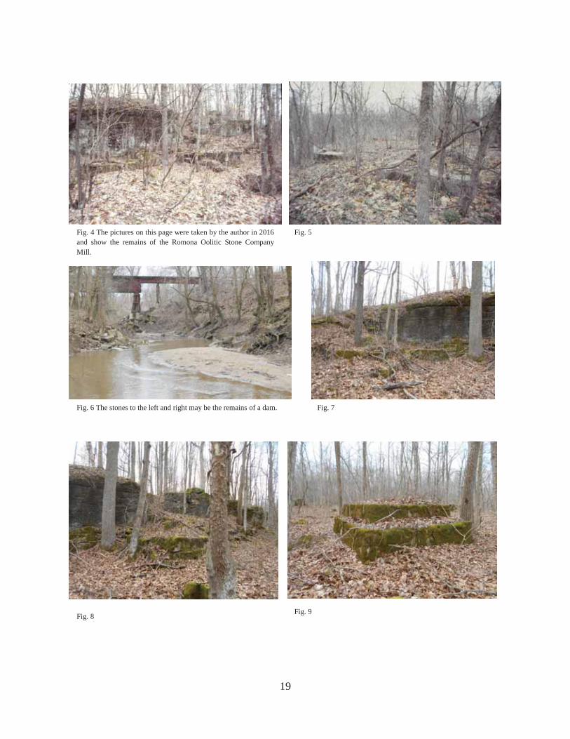
19
Fig. 4 The pictures on this page were taken by the author in 2016 and show the remains of the Romona Oolitic Stone Company Mill.
Fig. 5
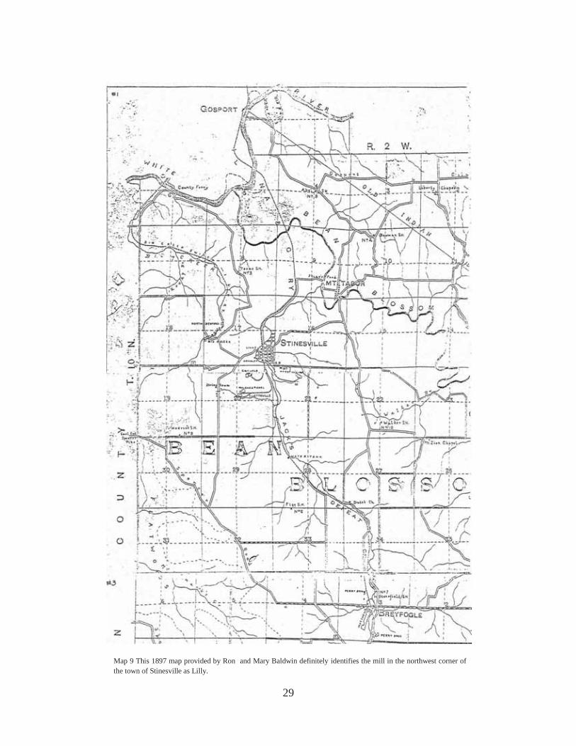
Fig. 6 The stones to the left and right may be the remains of a dam. Fig. 7
Fig. 8 Fig. 9

20
Fig. 10 These two pictures by the author in 2016 show more indications that this was the site of the mill.
Fig. 11
Fig. 12 This is the large quarry at which the Ingalls Stone Company was active certainly during the 1950s. This view is looking south. The railroad entrance during that era would have been at the far end.

21
Fig. 13 This is the east wall of the quarry shown in the previous picture.
Fig. 14 One of the six probable derrick pedestals. Fig. 15 I am standing on the old railroad grade with three of those pyramids on the right and three on the left.
Fig. 16 This is the rotting remains of a wooden derrick. Fig. 17 This picture by the author in 1987 shows the wooden derricks when they were upright.

22
The following is from Rock Products and dated April 5, 1907:7
Walter Kessler, the president of the Romona Oolitic Stone Co., is regarded as one of the shrewdest quarrymen in the country, and when he opened up the quarries at this point he proved it…Mr. Kessler’s home, which is beautifully appointed, stands on the brow of a hill overlooking the Romona quarries and mills. It is here that Mr. Kessler retires, away from the strife of the busy city and enjoys the peace and comforts of a country home, with all the advantages of a city residence, for no detail has been overlooked in making this magnificent residence the equal in point of comfort to any city home.
As we will see, Mr. Kessler also had quarries and mills at Stinesville owned by the same “Romona” Oolitic Stone Company so it is always possible the reporter confused Romona with Stinesville. Either way, it would be nice to know the site of Mr. Kessler’s house. The 1910 census shows him living in Washington Township (Romona) in Owen County.
7 Rock Products, Vol. VI, No. 9, Louisville, Ky., April 5, 1907, p 36.
Fig. 18 This undated picture is from the website http//www.sweetowen.net/landmark.html and is simply labeled “Stone Quarry at Romona.” If this is from Romona, then it would be the Romona Oolitic Stone Company Mill. I think the mill on the north side of the creek would not have been this large. There is a different picture but of the same mill that is Plate XXVIII of “The Bedford Oolitic Limestone of Indiana” by T. C. Hopkins and C. E. Siebenthal in the 1896 Indiana Department of Geology and Natural Resources, Twenty-First Annual Report. W. S. Blatchley, State Geologist. There is no reason to doubt that this picture is from Romona although it must not be lost sight of that the “Romona Oolitic Stone Company” (the label for the picture in the Hopkins and Siebenthal work) had mills at both Romona and Stinesville.

23
MONROE COUNTY STINESVILLE
Map 5
A J. Hoadley & Sons Stone Company A' Stinesville & Bloomington Company
J. Hoadley & Sons Stone Company B Indianapolis Oolitic Stone Company C Romona Oolitic Stone Company (Kessler Mill) and/or Griswold Mill D Swenson Stone Company E United Indiana Mill of ILCO F Lilly Mill G Indiana Steam Stone Works H North Bedford Stone Company J Biddle & Watts Stone Company8
8 “I” is deliberately left out.

24
Map 6 Hopkins & Siebenthal, p 357 Map 7 Blatchley, p 364
Map 8 This is from the “Map of Indiana Oolitic Limestone District, Monroe County, Lawrence County, and Owen County, Indiana, Prepared by The Building Stone Association of Indiana, Incorporated, Bloomington, Indiana, 1931.” Hereafter it will be cited as 1931 Building Stone Association Map. Looking at the maps on this page reminds us that new quarries are opened up and old ones abandoned and the same thing happened to the mills.

25
There are several mills in the Stinesville area but we must remember that it all began here in 1827 when Richard Gilbert opened the first quarry of record. The site of that quarry is on the east side of Jack’s Defeat Creek a few hundred yards south of Stinesville. We owe it to F. G. Summitt who discovered the exact location high on the bluffs along the creek. There, drill holes in the stone indicate where Gilbert and those early quarrymen like him used wedges and black powder to dislodge large junks of stone that fell to the valley floor. There, large enough blocks for their intended purpose were squared up and used primarily for building foundations and bridge abutments. But this is a gazetteer of mills and not of quarries. Not long after the turn of the twentieth century, Stinesville ceased to be the center of quarry or mill activity as the major stone efforts moved further south in the county. Some of the early mills listed here were primitive affairs. A reminder of the small scale of some of them is that a few began before there was any railroad nearby and stone had to be transported by wagon.
Because this area comprises the very early days of quarry and mill activity, locating the sites of mills can be very confusing. Often the site is obvious but the name of the mill illusive. Names for stone companies are confusing because they often are quite similar and the companies changed hands often. I readily admit that in my earlier “Gazetteer” I made more errors in this section than elsewhere. Some of those will be corrected herein but I am not yet confident that I have it entirely right. Alas. J BIDDLE AND WATTS MILL This company often is called Watts and Biddle. Around 1855 Edward M. Watts and William M. Biddle opened a quarry and mill along Big Creek and marketed what they called White River Stone. It is not known when the mill ceased production but the quarry work was
Fig. 19 to the left and Fig. 20 to the right were pictures taken by the author in 1989 at the site of the Richard Gilbert c1827 quarry at Stinesville. The site was discovered by F. G. Summitt. They show holes in the stone awaiting either wedges or black powder to dislodge large chunks of stone from the bluff above to fall to the valley below. There the suitable stones would be squared up for transport.

26
abandoned in 1868.9 As with the other mills along Big Creek it is difficult to distinguish the ruins of old quarry equipment foundations from milling equipment foundations. G INDIANA STEAM STONE WORKS CHICAGO AND STINESVILLE STONE COMPANY BIG CREEK STONE COMPANY The Chicago and Stinesville Stone Company bought the remaining properties of the old Biddle and Watts firm. It had been organized in 1889 and soon changed its name to Big Creek Stone Company. It built a mill about seventy-five yards downstream from the old Biddle and Watts mill. By 1893 it was in receivership and in 1895 it reorganized under the name Indiana Steam Stone Works. Nothing is known about when the site was abandoned.10 H NORTH BEDFORD STONE COMPANY The North Bedford Stone Company was organized in 1889 and a mill was built about a quarter of a mile north of the Indiana Steam Stone Works on Big Creek. It, too, went into the hands of a receiver in 1893 and nothing is known about any further use of the site for milling.11 If you start at the Little Wolf Road bridge over Big Creek and walk northeast along the creek, you can faintly see the old grade for the spur of the Indianapolis and Vincennes Railroad which serviced the quarries and mills along Big Creek. The tracks went from one side of the stream to the other and then back again at several spots and the visitor is cautioned to wear boots in order to conveniently do the same thing. The creek is usually shallow. Within one hundred yards of the road you come to the largest foundation and presumably the remains of the largest mill. This is on the east side of the stream and Hopkins and Siebenthal show all the mills to be on the west side of Big Creek. The site is obviously a mill site and may date subsequent to their 1896 writing but I do not believe so. The map in Blatchley’s 1907 work shows no railroad to the site and says that after 1886 all quarries along Big Creek were abandoned. He listed no mills or quarries operating and the lack of a railroad on the map may indicate that it either was no longer there or he simply did not wish to clutter up his map. Certainly after 1913 there was no railroad access to the area because the bridge over White River was washed out in the 1913 flood and was not replaced.12
9 T. C. Hopkins and C. E. Siebenthal, “The Bedford Oolitic Limestone,” in The 21st Annual Report of the Department of Geology and Natural Resources, ed. by W. S. Blatchley (Indianapolis: 1896), pp 357-58. 10 Ibid., p 358. 11 Ibid., p 360. 12 Blatchley, p 367.

27
Walking further along the creek you come to a second, smaller mill site and within another one hundred yards of the latter, a third site that may possibly have been a mill. These three sites appear to be the only possibilities and they certainly correspond in number to the three mills we know were along Big Creek, but the distance between them is not proportioned as Hopkins and Siebenthal indicate. I make no firm conclusions other than that there is obviously one mill site on the east side of the creek and a second and possible third site on the west side. The surroundings are wild and beautiful and the small quarries give the visitor a feel for the scale of the stone business in the later nineteenth century. My walk and the following pictures were taken in 1987.
In these six pictures and the two to follow, I have not labeled them as specific sites for specific mills because I just can’t be sure enough to pin a name to the picture. I feel reasonably
Fig. 21 Fig. 22
Fig. 23 Fig. 24
Fig. 25 Fig. 26

28
confident that if someone followed the directions and made the walk, he would have encountered all the stone mills along Big Creek.
Note often in some of these eight photographs the iron rods sticking up from the forest floor. These were anchors for equipment and are commonly seen in old mill sites as well as at the abandoned quarries. They are also dangerous for walkers who don’t watch where they are going. F LILLY MILL OOLITIC QUARRY COMPANY TERRE HAUTE STONE WORKS COMPANY This Oolitic Quarry Company is the same one that was active at Romona. The Terre Haute Stone Works Company sometime between 1880 and 1892 built a mill at Stinesville. In the latter year it was bought by the William Lilly & Company operating under the title of Oolitic Quarry Company. This mill was on the northwest corner of Main Street or the Stinesville Road and the Monon Railroad tracks. In 1989 I identified this mill as the Kessler Mill. I WAS WRONG! My identification of the mill as the Lilly Mill depends on the 1897 map on the next page that clearly shows it labeled as such. The following Monon Railroad map shows the town of Stinesville in 1891. The label for this mill is Steam Stone Mill but that is a generic name for a stone mill as it uses the same designation for the Bloomington and Stinesville Mill in the south part of town. There is another railroad track map (No. M002655 of the Monon Historical-Technical Society) that is dated 1912 and merely notes for the spot in question that there is an “old stone chimney.” Thus, this mill was no longer there in 1912. Later we will learn that there is another mill that was also identified with the Oolitic Quarry Company at Stinesville.13
13 Hopkins and Siebenthal, p 360; My earlier “Gazetteer” footnoted interviews with Robert Judah of Ellettsville, Indiana, and Albert Hoadley of Bloomington, Indiana, conducted on March 31, and May 24 respectively. I may have misunderstood the discussion and got the Kessler Mill designation confused. I suspect that when the Kessler Mill is treated later, the information that the equipment was removed about 1923 or 1924 was accurately remembered by these fellows and they were thinking of the REAL Kessler Mill. I was thinking of the wrong mill. Errare humanum est!
Fig. 27 Fig. 28
29
Map 9 This 1897 map provided by Ron and Mary Baldwin definitely identifies the mill in the northwest corner of the town of Stinesville as Lilly.
30
If you add up all the stone businesses mention in Batchelor’s Economic History…including those men working quarries before 1870, you get a very rough total of 185 such enterprises prior to 1950 in the Indiana Limestone District. That includes quarry companies, cut stone companies, and those doing both. Of course as some of these businesses evolved into others, a change in name may not have reflected a great deal of change in the management. Still, that is a lot of entrepreneurial spirit in the pursuit of America’s building stone.
Map 10 This is map no. M002656 from the Monon Railroad Historical-Technical Society and shows the sites for the two mills that were in Stinesville itself in 1891. Note that the one on the west end of North Street is called “Steam Stone Mill” and the one at the west end of South Street is called “Steam Stone Mill.” It was this latter mill that became part of the J. Hoadley and Sons Stone Company. See Map 11.
Fig. 29 This view looking northwest shows the little park that is on the northwest corner of Main Street and what used to be the Monon Railroad track. It was taken by the author in 2016. There are large limestone blocks in the trees to the right and in the open area of the park you can see the top of slabs of stone used as flooring or foundations for the mill.

31
Fig. 30 In 1987 the tracks were still in place and this picture by the author shows the stone blocks in the clump of trees. No doubt the main equipment for the mill was located here with ancillary equipment on the slabs in the ground to the left of this view.
Fig. 31 This picture from the Frank M. Hohenberger Collection at Indiana University was provided by Pete Pedigo. This is the stone chimney referred to in the text and shown on the Monon map. The view is looking slightly northeast. Hohenberger identified the picture only as in Stinesville, but there is no doubt about the location.
If you look at this picture, the later one for the Kessler Mill and the still later for the A. J. Thompson Mill in Ellettsville, the similarities of the chimneys makes one wonder if the same craftsman did the work. There may very well have been masons who specialized in chimneys.

32
A' STINESVILLE AND BLOOMINGTON STONE COMPANY Nothing is known about this mill except that the Stinesville Stone Company in 1895 bought a quarry which had been opened in 1889 by the Stinesville and Bloomington Company. The former company had no mill but sent its stone to the mill of the latter. Here is another major mistake I made in my 1989 work. Maps No. 10 and 11 show its location in the southern part of Stinesville.14 At some time the J. Hoadley and Sons Stone Company bought the Stinesville and Bloomington Company and this became the part of its mill on the east side of the tracks. The following map shows the two mills of the Hoadley company.
C TERRE HAUTE STONE WORKS COMPANY MILL OOLITIC QUARRY COMPANY MILL ROMONA OOLITIC STONE COMPANY MILL INDIANA OOLITIC LIMESTONE COMPANY MILL GRISWOLD MILL KESSLER MILL This mill may hold the record in this area for the most names and there may be an alias among them. In this area Charles Eppinghousen opened a quarry in 1880 and in 1890 it was purchased by the Indiana Oolitic Limestone Company which then sold it to the Romona Oolitic Stone Company in 1903. Blatchley writes that the quarry was operated until 1896 when it was abandoned in favor of mill work which continued until 1906. At the time of his writing, 1907,
14 Hopkins and Siebenthal, p 362.
Map 11 This track plan No. M002655 from the Monon Railroad Historical-Technical Society shows the two Hoadley Mills in Stinesville. The one to the right or east side of the tracks is the old Stinesville and Bloomington Stone Company Mill.

33
there were two mills at the quarry site. He identifies one as the old Griswold Mill and Quarry. The other mill presumably was built by the Terre Haute Stone Works Company sometime after 1880. This mill was purchased in 1892 by the Oolitic Quarry Company.15 These mills were quite close together and both were eventually owned by the Romona Oolitic Stone Company. It was that firm with which our aforementioned Walter Kessler was associated. The date on the chimney associated with the mill determined to be the Kessler Mill was 1894. Either one mill was the Kessler and the other the Griswold, or one mill was called both at different times. The site may be reached by parking along the county road about 150 yards or so to the west after crossing the bridge over Jack’s Defeat Creek at Stinesville. There is an old road bed in the woods that heads south. Walk it and the first grout pile encountered is the mill site. If you don’t see it you will encounter the railroad grade heading west from the main line to the mill site. When you run across it, follow it right or west. We know that the Kessler name is correct because of an old photograph of a mill alongside a quarry area (and therefore not in the town of Stinesville) and clearly labeled the “Kessler Mill.” The Griswold name is correct because of the 1897 map on page 29. The indefatigable researcher Pete Pedigo has come up with a source identifying Walter Kessler as president of the Romona Oolitic Stone Company and confirms that this is the same company that operated both at Romona and Stinesville.16
Figures 32-38 were taken by the author in 1987 and show one of the most elaborate and scenic groups of ruins to be found anywhere in the stone district. Figure 33 shows a fork in the railroad. The right spur goes into the Kessler Mill.
15 Blatchley, pp 367-8. 16 “Notable Example of Collegiate Gothic Architecture,” Rock Products, VI, No. 9 (April 5, 1907), p 36. It is interesting that this article says Mr. Kessler lives in a home which “stands on the brow of a hill overlooking the Romona quarries and mills.” It would be nice to know the location of that today. The house in Figure 40 certainly overlooks the mill but remember that the census in 1910 shows him living at Romona.
Fig. 32 Fig. 33 Fig. 34
Fig. 35 Fig. 36
Figs. 32 and 33 are where the yellow lines first fork in Maps 12 & 13. Fig. 35 shows bases for equipment in the mill building and Fig. 36 is looking back east at the lower railroad fork. (Fig. 36 is the left one in Fig. 33.) Fig. 34 is what the photographer in Fig 40 would have seen had he panned to the right a little.

34
Fig. 37 These are foundations for equipment in the mill itself.
Fig. 38 “1894” is inscribed on the chimney base.
Fig. 40 The Kessler Mill. This picture comes from an Indiana University web site and is clearly labeled the Kessler Mill. For a few months a great number of people on the internet were trying to find the actual location of the mill. Pete Pedigo and the author finally nailed it down as the following pictures show. On the beginning map for Stinesville the location is indicated by “C”. Although called the Kessler Mill it was the mill of the Romona Oolitic Stone Company. If the photographer had just turned his camera to the left slightly, he would have incorporated the chimney shown in Figs. 38 and 39 in the picture.
Fig. 39 This is a 2016 picture.

35
Fig. 41 Look for this between the steam spouts to the left in the picture. Notice the cut stone wall meets the non cut wall at an oblique angle. Compare the faults in the stone to the picture below.
Fig. 42
Fig. 43 Fig. 44
Look for the cut stone wall shown in Figure 43 directly under the house in Figure 40. Compare 43 with 44 and see that they are the same. The terraced grout pile to the left rear is there today as is the indication where the railroad grade would have allowed a boxcar to be located where it is. There are remains for the foundation stones of that house and the pile of small stones to the right of the house is still there. The railroad grade in front of the house is clearly for a railroad. Where the mill building itself would have stood, there are stones with anchor bolts for securing equipment. There is no doubt now about the location of the Kessler Mill.
Map 12 to the left is a close-up of Map 7 to show that there were actually two mills at this location. Whether they operated at the same time is not clear.

36
Map 12 is on top and Map 13 is on the bottom. I had walked this area many years ago. These two wonderful maps were made by Pete Pedigo who, along with your intrepid author, twice in 2016 tramped all over the area seen in them. His engineer’s eye and skill with computers makes this an excellent schematic of the Kessler Mill site. I agree with Pete in all the particulars. The location of the second and smaller mill is the most logical placement given what we know. I would only point out that after walking the site, we would not have concluded that there were two mills had the historical record not said there were.
37
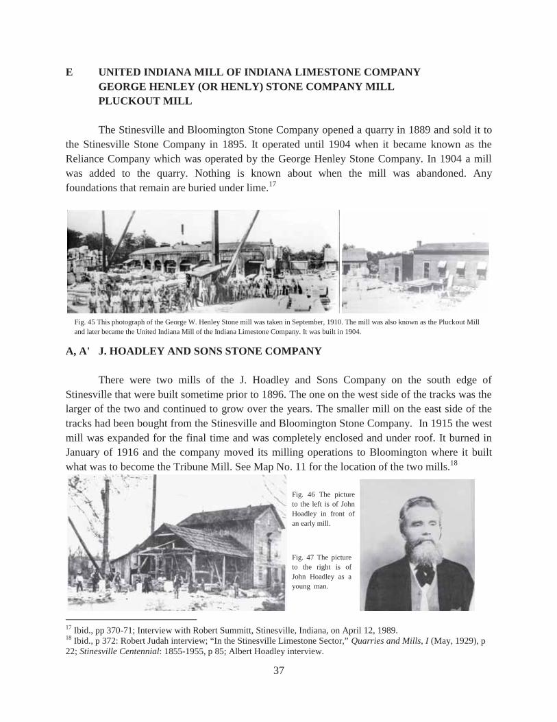
E UNITED INDIANA MILL OF INDIANA LIMESTONE COMPANY GEORGE HENLEY (OR HENLY) STONE COMPANY MILL PLUCKOUT MILL The Stinesville and Bloomington Stone Company opened a quarry in 1889 and sold it to the Stinesville Stone Company in 1895. It operated until 1904 when it became known as the Reliance Company which was operated by the George Henley Stone Company. In 1904 a mill was added to the quarry. Nothing is known about when the mill was abandoned. Any foundations that remain are buried under lime.17
A, A' J. HOADLEY AND SONS STONE COMPANY There were two mills of the J. Hoadley and Sons Company on the south edge of Stinesville that were built sometime prior to 1896. The one on the west side of the tracks was the larger of the two and continued to grow over the years. The smaller mill on the east side of the tracks had been bought from the Stinesville and Bloomington Stone Company. In 1915 the west mill was expanded for the final time and was completely enclosed and under roof. It burned in January of 1916 and the company moved its milling operations to Bloomington where it built what was to become the Tribune Mill. See Map No. 11 for the location of the two mills.18
17 Ibid., pp 370-71; Interview with Robert Summitt, Stinesville, Indiana, on April 12, 1989. 18 Ibid., p 372: Robert Judah interview; “In the Stinesville Limestone Sector,” Quarries and Mills, I (May, 1929), p 22; Stinesville Centennial: 1855-1955, p 85; Albert Hoadley interview.
Fig. 45 This photograph of the George W. Henley Stone mill was taken in September, 1910. The mill was also known as the Pluckout Mill and later became the United Indiana Mill of the Indiana Limestone Company. It was built in 1904.
Fig. 46 The picture to the left is of John Hoadley in front of an early mill.
Fig. 47 The picture to the right is of John Hoadley as a young man.

38
Fig. 48 This undated picture shows the “J. Hoadley and Sons Cut Stone Works.” John Hoadley is the bearded fellow to the left. This would have been an early version of the mill on the west side of the tracks.
Fig. 49 This is the central portion of the larger Cirkut photograph below taken in September, 1910. The view is looking south.
Fig. 50 This is the larger Cirkut photograph taken in September, 1910. Obviously (see Fig. 45) there was a professional photographer in Stinesville in September, 1910.

39
Fig. 51 This picture shows John Hoadley standing on one of the lathes. He was noted to specialize in turning columns.
Fig. 52 This is the mill on the west side of the tracks in Stinesville as it neared completion in 1915. It would be this mill that burned in January, 1916.

40
D SWENSON STONE COMPANY MILL SUMMITT & COGSWELL, INC. HARDING & COGSWELL, INC. ELLIOTT STONE COMPANY The Swenson Stone Company Mill was built by Mr. G. A. Swenson of Champaign, Illinois, in 1925. It burned on July 19, 1931, but was soon rebuilt. In the early 1960s the mill was sold to Glen Summitt of Summitt & Cogswell, Inc., who operated it for four or five years. Harding & Cogswell, Inc. then operated it from about 1966 to 1973. It was idle from then on. In about 1976 it was sold to Dave Elliott of the Elliott Stone Company but he never operated it and eventually he sold it to Indiana Cal-Pro, Inc. It utilized the old mill for purposes other than cut stone milling.19
B WALLIS STONE COMPANY MILL INDIANAPOLIS OOLITIC STONE COMPANY MILL Nothing is known about the origin of this mill other than that John and Millard Easton, two brothers, along with others, began the operation. Later, Zeigler, Webb, and Miligan of Indianapolis took it over and by August, 1929, it was in receivership. After its sale in mid 1930, it became the Wallis Stone Company. Nothing remains (1989) at the site except for the concrete foundation work. It was razed in the very late 1930s.20 This is one of the few mill sites that I did not revisit in 2016. Presumably those foundations are still there.
19 “In the Stinesville Limestone Sector,” Quarries and Mills, I (May, 1929), p 22: “Swenson Stone Mill Burned Sunday Night, July 19,” Quarries and Mills, II (August, 1931), p 21; Quarries and Mills, II (November, 1931), 27; F. G. Summitt interview; Dave Elliott interview. 20 “In the Stinesville Sector,” Quarries and Mills, I (May, 1929), p 22; “Indianapolis Oolitic in Hands of Receiver,” Quarries and Mills, I (September, 1929), p 39; “Office, Drafting Room, Quarries, and Mills,” Quarries and Mills, II (July, 1930), p 26; Robert Summitt interview.
Fig. 53 This picture by the author in 1989 shows the old Swenson Mill no longer operating as a cut stone mill.

41
Fig 54 Foundations for the tramway at the Wallis Stone Mill site as photographed by the author in 1987.
Fig. 55 Foundations for equipment at the Wallis Stone Mill site as photographed by the author in 1987.
Monon Railroad Main line abandoned grade
Swenson Mill site
Kessler Mill and another mill site
Abandoned road
Map 15 Monon Railroad Historical-Technical Society track plan No. M002571. North is toward the top.

42
ELLETTSVILLE A
Map 16

43
Map 17 Hopkins & Siebenthal, p 363. Map 18 Blatchley, p 374.
Map 19 1931 Building Stone Association Map

44
A PERRY BROTHERS UPPER STONE WORKS GRISWOLD & CHAMBERS The Perry Brothers Stone Company was responsible for two mills in Ellettsville. The first one was established in 1866 and utilized the old machinery from the Biddle and Watts Mill from Stinesville. This mill was known as the Perry Brothers Upper Stone Works and for a time beginning in 1907 it was leased to the firm of Griswold & Chambers. The latter firm is shown on the Sanborn Map in 1910 but after that nothing is known about this mill. If you walk north on the old Monon Railroad grade for about 250 yards beyond the West Maple Grove Road, you will see a faint indication of the old grade where the spur left the main line and angled off to the left or northwest. A few foundation stones of the old mill remain.21 This is NOT the courteous way to visit this mill site. Much better to take North Matthews Drive and where it turns sharply to the east or right, you should take a private drive to the left. The first driveway off the left or south is to the home of Kris Bruner. She is a nice lady who delights in showing the quarry and mill site and you should certainly ask her permission. This location is an excellent one to demonstrate the entire gamut of quarry activity from pre-channeling black powder and wedge quarrying to the channeling era. Interestingly, there were actually three spurs that came off the old Monon Railroad into this quarry and mill area—the one I first described and two more that came off in the opposite direction. These latter two spurs angled off to the right for south bound trains. There was an area just to the north and east of Kris Bruner’s house that was called Stone Field by the railroad. It was where there were sidings for carloads of stone to accumulate.
21 Hopkins and Siebenthal, p 363; Blatchley, p 377; There is some confusion because Blatchley wrote that “In 1899 a mill was erected at the lower quarry and was worked until 1906, when it was leased to A. J. Thompson…On June 1st, 1907, it was leased to Griswold & Chambers, of Chicago…” The Sanborn Map of 1895 clearly shows the Perry Brothers Upper Stone Works and the map of 1910 clearly shows the same mill leased by Griswold & Chambers. The mill erected in 1899 was probably a new one replacing the older one on the same location. The “lower quarry” should not be confused with the “lower stone works,” and in 1908 the A. J. Thompson Stone Company obtained a mill at another site in Ellettsville.
Map 20 to the left is from the Ellettsville Sanborn map 1895 Sheet no. 2.
Map 21 to the right is the Monon Historical-Technical Society Track Plan No. M002577 dated 1912.
Perry Brothers Upper Works
Matthew Brothers Stone Mill
Note: This was the middle spur into the Perry Brothers quarry and mill.
West Maple Grove Rd.
Abandoned Railroad

45
Fig. 56 In 1987 before the railroad was abandoned, the author took this picture showing where the spur to the mill came off the main line. We are looking north.
Fig. 57 In 1987 you could see foundation stones for the old mill lying around.
Fig. 58 Here are more foundation stones for the old mill.
Fig. 59 These next four pictures were taken in 2016 by the author. This view is looking north and shows how stone would be loaded onto railroad cars whose decks would be at ground level.
Fig. 60 This most northerly part of the quarry is the oldest and shows no evidence of channeling.
Fig. 61 Here are some foundations for equipment in the mill area. Fig. 62 This feature measuring about a foot tall was sculpted into the quarry wall and is a feature unique to my experience in the limestone district. To the left (not shown) are names and dates of several people chiseled into the stone. They are not legible in a photograph.

46
F PERRY BROTHERS LOWER STONE WORKS PERRY STONE COMPANY The second and longer-lasting stone mill of the Perry Brothers in Ellettsville was built in about 1874 or 1875 and was known at the Perry Brothers Lower Stone Works to distinguish it from the earlier mill. The Perry Brothers firm became the Perry Stone Company after Henry retired in 1896 and Gilbert Perry died in 1898. About 1940 William Hoadley bought the Perry Stone Company, which was in receivership. A few years later William McNeely bought the mill from William Hoadley. There is currently (2016) an office building on the south side of the road and in front of the old quarry. Presumably McNeely tore down the old mill shortly after buying it. Nothing of it remains.22
E McNEELY STONE COMPANY MILL THOMPSON & SANDY STONE COMPANY MILL INGALLS STONE COMPANY MILL NO. 4 COOK, INC. Across the old Monon Railroad grade slightly north of the site of the Perry Brothers Lower Stone Works is one of the factories of Cook, Inc. The earliest record of a mill on this spot is the 1910 Sanborn Map which shows the Thompson & Sandy Stone Company Mill. The 1929 Sanborn map shows it as Mill No. 4 of the Ingalls Stone Company and not in operation. Confirmation of the Ingalls ownership comes from a map of the entire limestone district made by The Building Stone Association of Indiana, Incorporated, Bloomington, Indiana, in 1931. It shows this mill as simply the Ingalls Mill. At some time this mill became the McNeely Stone Company Mill and was no longer a stone mill after about 1970 when Cook, Inc. acquired it.23
22 “Henry F. and Gilbert K. Perry Among the First in the Field,” Quarry and Mills, I (May, 1929), pp 10, 15; Albert Hoadley interview. 23 In the book The Ellettsville Story: 1837-1987, it states that “In time death left only Eugene Perry to operate the business. In 1945 his interests were acquired by Roy McNeely, a local stonemill [sic] owner who formed the
Fig. 63 This 1987 picture by the author is looking south east at the site of the old Perry Stone Company Mill. Nothing survives.

47
McNeely Stone Company and continued operation of the mill…” p 118. If McNeely was a “local stonemill [sic] owner” at the time he bought the Perry “interests,” then he probably already owned the mill that became the McNeely Stone Company Mill and later the Cook, Inc. factory. He must have obtained it sometime prior to 1945.
Fig. 64 This aerial view from about 1940 is looking roughly southwest and shows the Ingalls Stone Co. Mill No. 4 in the lower middle. The Perry Stone Co. Mill is above and slightly to the right of the Ingalls Mill. McNeely Street runs diagonally across the upper right. It is not known just when the Ingalls Mill became the McNeely Mill but by 1970 when Cook acquired it, it was no longer a stone mill. The Monon Railroad runs across the picture between the two mills.
Fig. 65 This is the Thompson and Sandy Stone Company Mill. This picture is on the wall of Wee Willie’s Restaurant in Ellettsville but is misidentified as “H. J. Thompson Mill.” It changed substantially before the 1940 picture was taken, but the following Sanborn map identifies it.

48
Fig. 66 This picture is from the book The Ellettsville Story and shows the McNeely Stone Co. The caption reads that this building was built in 1952 but it must mean that the old mill was extensively reconfigured or remodeled at that time. Formerly this was the Ingalls Stone Co. Mill No. 4.
Map 22 1910 Ellettsville Sanborn Sheet 3. Compare this to the previous picture.

49
B MATTHEWS BROTHERS STONE COMPANY JOHN MATTHEWS AND SONS STONE COMPANY BYBEE STONE COMPANY In 1862 John Matthews opened a quarry and by 1864 he was doing business as the John Matthews and Sons Stone Company. A mill was built on this spot and continued operating until a fire in 1977 damaged the drafting building. The mill sat idle until bought by Wilbur Bybee in 1979 and continues today as the Bybee Stone Company. When the founder, John Matthews, died in 1883, the firm became the Matthews Brothers Stone Company. In 1909 the old mill was replaced by a more modern one but in the case of such a long-lived mill there was expansion from time to time throughout its history. The photographs tell that story.24
24 The history of the first two generations of the Matthews family is told in the unpublished manuscript, “John Matthews and Sons: Pioneer Stonemen,” by Clay W. Stuckey, 2013.
Fig. 67 This was the appearance of the McNeely Stone Co. Mill building or Ingalls Mill No. 4 in the late 1980s. The picture is by the author.

50
Fig. 68 This undated but nineteenth century picture is looking at the west side of the Matthews Brothers Stone Company Mill.
Fig. 69 This undated picture had to be after 1874 and again shows the west side of the mill.

51
Fig. 70 This is another undated picture of the old Matthews Brothers Stone Company Mill.
Fig. 71 Again, this is the west side of the old mill sometime in the late nineteenth century.
Fig. 72 This undated picture is looking almost due north and shows a greatly expanded mill.

52
Fig. 73 This picture shows the drafting building before the administration building was built above the garage. It was this building that was damaged by fire in 1977.
Fig. 74 Here the administration building has been built above the garage.

53
Fig. 75 This picture by the author was taken in 2013.
Fig. 76 This undated picture adorns the outer office of the Bybee Stone Company.
Fig. 77 This is the Bybee Stone Company mill as photographed by the author in 1989.
54
D HARDING & COGSWELL, INC. As with the Matthews Brothers Mill, the Harding & Cogswell Mill has had a simple continuity from its beginning in about 1913 to its end in 1973. The site of the mill is now the Smith Quarry of the Bybee Stone Company.25
25 The Ellettsville Story, p 116.
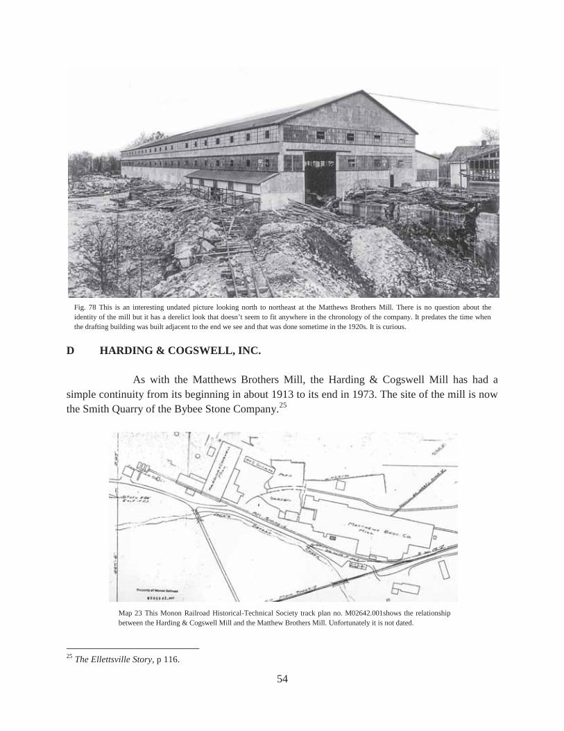
Fig. 78 This is an interesting undated picture looking north to northeast at the Matthews Brothers Mill. There is no question about the identity of the mill but it has a derelict look that doesn’t seem to fit anywhere in the chronology of the company. It predates the time when the drafting building was built adjacent to the end we see and that was done sometime in the 1920s. It is curious.
Map 23 This Monon Railroad Historical-Technical Society track plan no. M02642.001shows the relationship between the Harding & Cogswell Mill and the Matthew Brothers Mill. Unfortunately it is not dated.

55
G A. J. THOMPSON STONE COMPANY MILL ECLIPSE STONE COMPANY MILL If you start walking south along the abandoned grade of the Monon Railroad from McNeely Street you soon see to your left or east a large smokestack and other ruins. In 2016 the smokestack was still there but the walls had crumbled further. This was the old Eclipse Stone Company Mill which was built in 1903. The A. J. Thompson Stone Company owned the mill from 1908 until it ceased business in about 1937. The mill burned in 1910 but was immediately rebuilt.26 Mr. Thompson died in 1922 and from then on the mill was run by his widow, Hazel King Thompson.27
26 Bloomington Evening World, June 21, 1910. 27 Blatchley, p 377; The Ellettsville Story, p 118; Joseph Batchelor, An Economic History of the Indiana Limestone Industry (Bloomington, 1944), p 348 writes that the mill was leased from March, 1940, until June, 1941, by the Taylor-McNeely Stone Company.
Fig. 80 Compare this 2016 picture by the author with the one to the right and you see that walls may crumble but chimneys last.
Fig. 81 This 1987 picture by the author is looking southwest at the ruins of the Eclipse Stone Company Mill.
Fig. 79 This was the Harding & Cogswell Stone Company Mill.

56
Map 24 1910 Ellettsville Sanborn Sheet 3.
Fig. 82 This undated picture is looking northeast at the Eclipse Stone Company Mill.

57
C INDIANA OOLITIC LIMESTONE COMPANY MILL BLOOMINGTON LIMESTONE COMPANY CROWE MILL PALMER BEE MILL TEXAS QUARRIES MILL REED QYARRIES INDIANA PRECAST CORP. COOK, INC. The Indiana Oolitic Limestone Company built this mill sometime prior to 1929 when it was sold to the Bloomington Limestone Company and became the Crowe Mill. During World War II it did war work as the Palmer Bee Mill and after the war it returned to the stone milling business under the name of Texas Quarries Mill. At some time it was leased by the McNeely Stone Company. From 1969 to 1976 it was owned by Reed Quarries. In 1976 it was sold to Indiana Precast Corp. and now (2016) it belongs to Cook, Inc. It is no longer a stone mill.28
28 Robert Judah, interview; Albert Hoadley interview. Interview in February, 2016 with Steve and Debby Reed.
Fig. 83 This picture from 1940 shows the Perry Stone Co. Quarry in the middle and lower right. In the upper left is the Indiana Oolitic Limestone Company Mill which became the Bloomington Limestone Company Crowe Mill. McNeely Street runs along the top.
Fig. 84 This is the building of the old Oolitic Limestone Company Mill in the late 1980s when it was used by Cook, Inc.

58
H THE NUTTER MILL THE ELLETTSVILLE STONE COMPANY MILL Carl Nutter built this mill of the Ellettsville Stone Company sometime in the late 1920s. In 1989 only a few concrete foundations remained but now the extensive roadwork in Ellettsville has removed those.29 Map No. 13 shows this mill labeled as the Bloomington and Ellettsville Stone Company. The map is dated 1927. The location would be that of the old Nutter Mill but the Sanborn Map for 1929 has the mill labeled the Ellettsville Stone Company Mill. In this case I think the railroad was wrong about the company name. Throughout this paper the reader should notice a lot of mills provided garages for employees to park their cars. Milling stone produces a lot of dust and presumably this was the reason for that employee benefit.
29 Robert Judah interview.
Fig. 85 This picture is looking slightly southwest at the Cook, Inc. facility that used to be the Bloomington Limestone Company Crowe Mill. The Matthews Mansion is in the foreground. This stone mill had nothing to do with the Matthews family. The proximity of the mill to the mansion often leads people to assume that it did.

59
Fig. 86 This picture was taken by the author in 1989 and shows the remains of the Nutter Mill.
Fig. 87 This 2016 picture by the author shows the same building, which is now a church, and confirms that the ruins of the mill are gone.
Map 25 This track plan from the Monon Railroad Historical-Technical Society is dated 1927. The catalog no. is M002617. In order to have north more-or-less at the top, the legend must be read in an awkward position. Sorry.
Map 26 This is from Sheet No. 9 of the 1929 Sanborn Fire Insurance Maps for Ellettsville, Indiana.

60
The unpublished articles by this author are cited from time to time in this paper. This work, too, will be unpublished. However, all the works I do on the limestone industry are to be found in the Monroe County History Center, Monroe County Public Library, Indiana Geological Survey, Indiana University Geology Department, Lawrence County Museum, Indiana Limestone Institute, and the Indiana Historical Society.
Map 27 This is from Hopkins and Siebenthal, 1896, and is inserted between page 366 and 367.

61
HUNTER VALLEY
Hunter Valley was a lucrative quarry area because there was less overburden than in other areas.30 Much of this extensive quarry field of the earlier days is filled in by the road construction that will soon become the interchange or clover-leaf of Interstate 69 with Indiana Highway 46 northwest of Bloomington. At least some of the quarry holes and grout piles have survived to give the public a hint of what the area used to look like. Also, quite fortuitously, there is the ruin of an old mill that lies rusting just a few hundred yards to the southwest. I will discuss it in due course. Hunter Valley can be confusing, and in 1989 I got some things quite wrong. I was young and foolish. I will start with the simple.
Map 28
A B. G. Hoadley Quarries Co. Mill B Hunter Brothers Stone Co. Mill C Star Stone Co. Mill D Vernia Mill of ILCO E Consolidated Stone Co. Mill No. 2 F Leonard Mill of ILCO G Wicks Mill of ILCO H Reed Stone Company (This was never a mill.)
30 Interview with Steve and Debby Reed.
D E
F

62
Map 30 This 2013 Google Image shows the current interchange that will become the Interstate 69 State Highway 45/46 interchange. The
road work in this area has obliterated a lot of the old Hunter Valley quarry area.
B. .G. Hoadley Quarries Co.
Vernia Mill
Map 29 Blatchley, p 379.
Site of Leonard Mill
Site of Wicks Mill
Site of Star Stone Co. Mill
Site of Consolidated Mill No. 2
Site of Hunter Brothers Stone Co. Mill
Reed Quarries, Inc.

63
A B. G. HOADLEY QUARRIES COMPANY MILL Bert Grange Hoadley was the son of the John Hoadley who started the J. Hoadley and Sons Stone Company in Stinesville. The father had been retired when the mill in Stinesville burned in 1916 and his son, Bert Grange Hoadley, moved the mill to Bloomington. That company was one of those that merged into the Indiana Limestone Company but Bert Grange Hoadley and others started the B. G. Hoadley Quarries Company in 1928.31 The mill continues in the limestone business today (2016).
31 “B. G. Hoadley Quarries, Inc.—John Hoadley & Sons,” Quarries and Mills, I (May, 1929), p 22; Unknown newspaper clipping dated September 16, 1937, giving the obituary of Bert Hoadley and found in the Monroe County History Center.
Fig. 88 This picture taken around 1940 is looking southeast and the Ellettsville Road (State Highway 46) is in the upper left corner.

64
Fig. 89 This 1989 picture by the author shows the B. G. Quarries Company Mill.
B HUNTER BROTHERS STONE COMPANY MILL The Hunter Brothers Stone Company opened a quarry in Hunter Valley in about 1895 or 1896 and built a mill in 1902. It milled stone until just prior to its being razed in about 1939. Nothing remained at the site in 1989 nor could I find anything in 2016.32
32 Blatchley, p 381; Interview with Ed Bennett, Bloomington, Indiana, April 12, 1989.
Fig. 90 This 1923 aerial view is looking west. The Hunter Brothers Stone Company Mill is in the middle far right.

65
C STAR STONE COMPANY MILL INDIANA LIMESTONE COMPANY HELDEMEIER MILL Nothing is know about the Star Stone Company Mill other than that it first appears on the Sanborn maps in 1913 and it did not operate long after the merger in 1926. In 1989 there were several foundation stones that indicated the site. There is a railroad track plan that lists the site as once the Heldemeier Mill of ILCO. This is the only reference to that name I have ever seen.
Fig. 91 This 1923 aerial view is looking east at the Star Stone Company Mill in the upper right. In the lower left is the Hunter Brothers Stone Company Mill.
Fig. 92 This 1923 aerial view is looking roughly north at the Star Stone Company Mill at Hunter Valley.
66
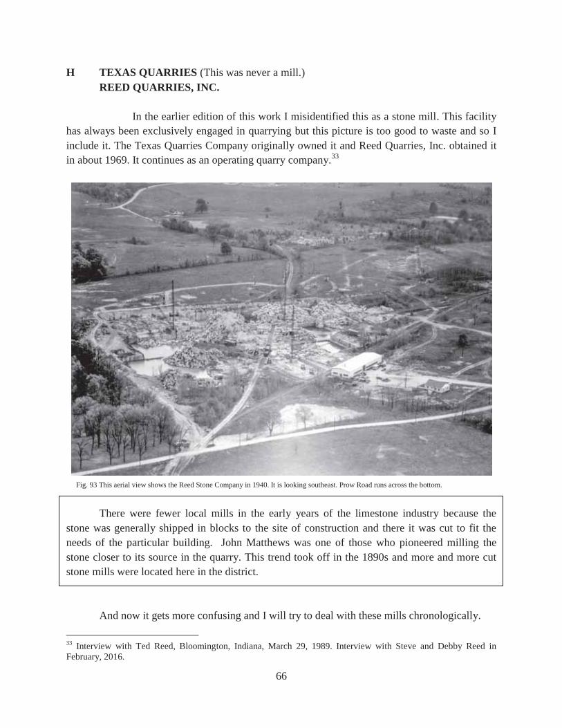
H TEXAS QUARRIES (This was never a mill.) REED QUARRIES, INC. In the earlier edition of this work I misidentified this as a stone mill. This facility has always been exclusively engaged in quarrying but this picture is too good to waste and so I include it. The Texas Quarries Company originally owned it and Reed Quarries, Inc. obtained it in about 1969. It continues as an operating quarry company.33
There were fewer local mills in the early years of the limestone industry because the stone was generally shipped in blocks to the site of construction and there it was cut to fit the needs of the particular building. John Matthews was one of those who pioneered milling the stone closer to its source in the quarry. This trend took off in the 1890s and more and more cut stone mills were located here in the district. And now it gets more confusing and I will try to deal with these mills chronologically.
33 Interview with Ted Reed, Bloomington, Indiana, March 29, 1989. Interview with Steve and Debby Reed in February, 2016.
Fig. 93 This aerial view shows the Reed Stone Company in 1940. It is looking southeast. Prow Road runs across the bottom.
67
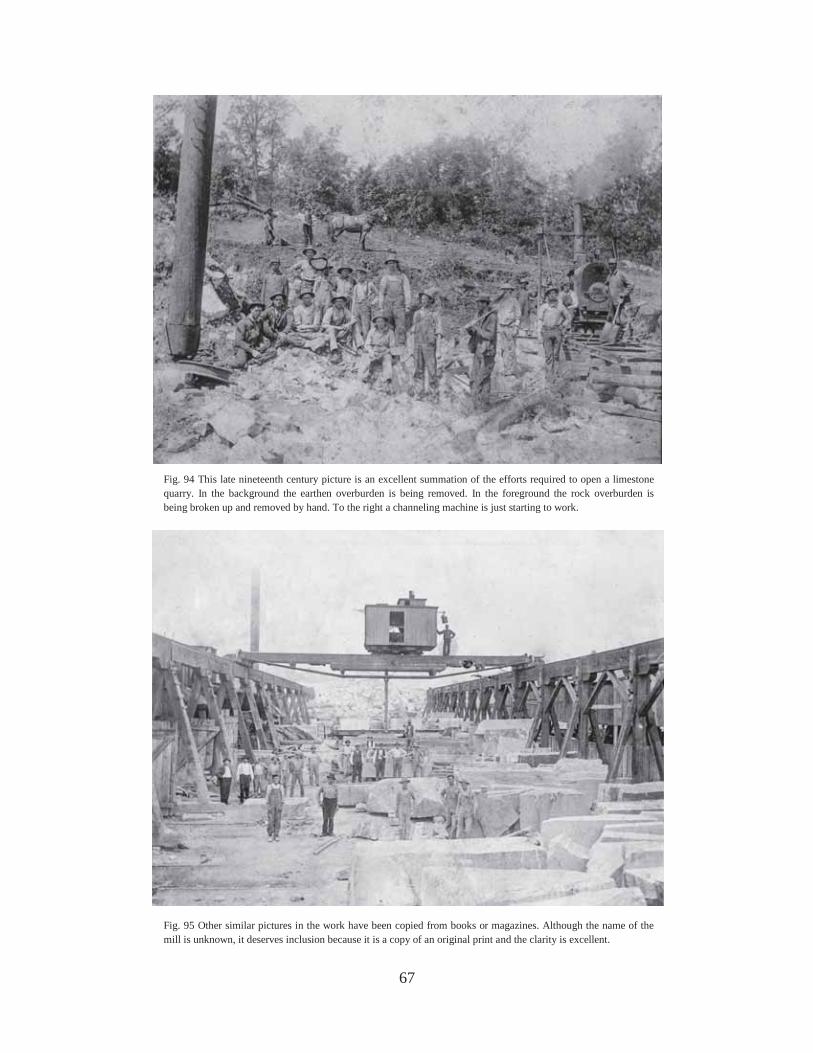
Fig. 94 This late nineteenth century picture is an excellent summation of the efforts required to open a limestone quarry. In the background the earthen overburden is being removed. In the foreground the rock overburden is being broken up and removed by hand. To the right a channeling machine is just starting to work.
Fig. 95 Other similar pictures in the work have been copied from books or magazines. Although the name of the mill is unknown, it deserves inclusion because it is a copy of an original print and the clarity is excellent.

68
D CONSOLIDATED STONE COMPANY MILL NO. 1 VERNIA MILL OF ILCO BENNETT MILL This is the larger of the two mills that the Consolidated Stone Company had operating in Hunter Valley in 1896 and was to the east of Consolidated Stone Company Mill No. 2. In about 1921 it burned but was soon rebuilt and after the merger in 1926 it became the Vernia Mill of the Indiana Limestone Company. Francis Bennett of the Bennett Stone Company bought the mill in 1956 and sold it back to ILCO in about 1977 or 78. It was operating when he bought it. The mill is still there but only as a rusting ruin that had not operated for many years when I first wrote of it in 1989. The north end of the mill is about 150 yards south of Highway 46. The mill has survived because John Tucker, who owned ILCO for a time, said it was his first mill and he had a sentimental attachment to it. Thus it survived the wreckers.34
34 Ed Bennett interview; Francis Bennett interview, Bloomington, Indiana, April 13, 1989; John Tucker interview, Bedford, Indiana.
Fig. 96 While this picture was meant to illustrate the hydraulic method of removing earthen overburden, it shows the Consolidated Mill No. 1 or Vernia Mill in the background. The view is looking east.

69
Fig. 97 to the left was labeled “Consolidated, November 10, 1911” and was probably No. 1. Fig. 98 in the middle is definitely the Consolidated Stone Company Mill No. 1 and was taken on August 31, 1910. Fig. 99 on the bottom was unlabeled but was included in several views of the Consolidated Stone Company Hunter Valley mills and presumably is one of them.

70
Map 31 to the left is a 1915 map from the Consolidated Stone Company. I have added the letters. A is Mill No. 1 and B is Mill No. 2. The lower right Map 32 is from Sheet 23 of the 1913 Sanborn Fire Insurance Map. The smaller Mill No. 2 is on the left and the larger Mill No. 1 is on the right. North is up in both maps.
Map 33 to the left is from Sheet 27 of the 1927 Sanborn maps. The mill on the left is old No. 1 that burned in 1921 and was rebuilt. This mill became the Vernia Mill of ILCO and is clearly labeled as such in the 1940s changes made to this map by Sanborn (not shown.) The 1947 map labels the “Stone Sawing” building “Leonard Mill.”
71
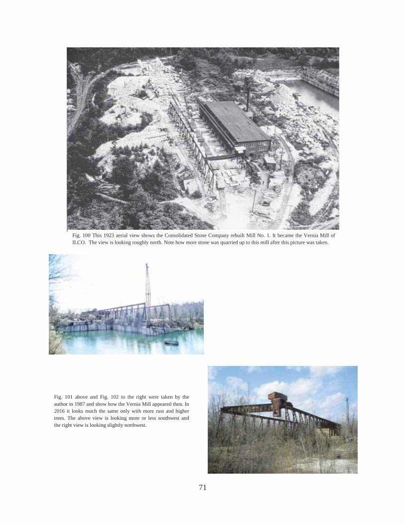
Fig. 100 This 1923 aerial view shows the Consolidated Stone Company rebuilt Mill No. 1. It became the Vernia Mill of ILCO. The view is looking roughly north. Note how more stone was quarried up to this mill after this picture was taken.
Fig. 101 above and Fig. 102 to the right were taken by the author in 1987 and show how the Vernia Mill appeared then. In 2016 it looks much the same only with more rust and higher trees. The above view is looking more or less southwest and the right view is looking slightly northwest.

72
Fig. 103 This 1923 aerial view is looking north at the Hunter Valley quarry field. The Vernia Mill is slightly left of center. To the right or east is the Leonard Mill. To the left of the Vernia Mill where the railroad forks, the Consolidated Mill No. 2 had been located. It burned in 1918 and was not rebuilt. In the distance the Hunter Brothers and Star Mills can be seen.
Fig. 104 This 1923 aerial view is looking south. On the far left where the tracks spread apart is the site of the Consolidated Stone Company Mill No. 2 which burned in 1918. It was not rebuilt.

73
E CONSOLIDATED STONE COMPANY MILL NO. 2 The Norton Stone Company was the second firm (The Chicago and Bloomington Stone Company was the first but it had no mill.) to operate in Hunter Valley. It opened a quarry and built a mill in 1892. In 1895 the Norton Quarry was bought by the Consolidated Stone Company. By 1896 the latter firm had two mills in operation. Presumably one of them was the old Norton Mill. The Mill No. 2 of the Consolidated Stone Company was to the west and was the smaller of the two. It burned in about 1918 and was not rebuilt. Nothing remains of it.35 To recap: Consolidated No. 1 was the larger mill to the east and burned around 1921 and was immediately rebuilt to become the Vernia Mill of ILCO. Consolidated Mill No. 2 was the small mill to the west that burned around 1918 and was not rebuilt.
35 Blatchley, p 379; Ed Bennett interview.
Fig. 105 This 1923 aerial view is looking northeast at the Hunter Valley quarry field. The Vernia Mill can be seen in the center. The location of the Consolidated Stone Co. Mill No. 2 was to the left of the Vernia Mill between it and the quarry area to the west. The Leonard Mill can be seen in the far right.

74
And now things get incredibly confusing to the point I am not entirely certain myself. The main dilemma is whether or not a Crescent Stone Company Mill became the Leonard Mill after the merger in 1926 to form the Indiana Limestone Company or whether there were two mills all along. Mr. Ed Bennett told me in 1989 that they were the same mill. He was otherwise very reliable and in my earlier version of this gazetteer I elaborated in an appendix why I thought he was wrong. I think when he said that he meant what I now have come to believe. The Crescent Stone Company never had a mill but the Leonard Mill was on the old Crescent land and may have used an old Crescent structure. CRESCENT STONE COMPANY (It doesn’t rate a letter because I don’t think it had a mill.) Little is known about the Crescent Stone Company. Blatchley writes that the Crescent Stone Company “In 1893, soon after opening up of the Johnson quarry, Perry, Matthews & Perring opened up the Crescent quarry, a half mile east of the Consolidated No. 2. This was operated until 1902, when a new opening was made to the west.”36 The map below is from the 1913 Sanborn map but the 1927 map shows it exactly the same. No mention of a mill appears anywhere and I think I was wrong in 1989 in assuming there was one. The Crescent Stone Company was most likely exclusively a company that quarried stone but did not mill it. That notion should have occurred to me when I saw the Sanborn map below which doesn’t really show a mill. Mr. Bennett was confused because the Leonard Mill (discussed next) was located essentially on the same spot as the Crescent Stone Company’s buildings shown below.
36 Blatchley, p 383.
Map 34 This is from Sheet 23 of the 1913 Sanborn Fire Insurance Map of Bloomington. The 1927 map shows no change.

75
Map 35 This is from Sheet 132B of the Property Survey of the Quarry and Mill Properties of the Indiana Limestone Company, Bedford, Indiana, in Lawrence and Monroe Counties, 1928-1929. It is obviously more accurate than the 1931 Map of Indiana Oolitic Limestone District…shown on Map No. 22 and elsewhere in this work.

76
Map 36 This is the Hunter Valley section of the 1931 Map of Indiana Oolitic Limestone District… Note that the Leonard Mill appears to the north of the Vernia Mill which simply is not the case. See Map 35 and Fig. 106.
Fig. 106 This 1923 aerial view is looking west at the Leonard Mill in the lower right and the Vernia Mill in the upper middle.
Map No. 36
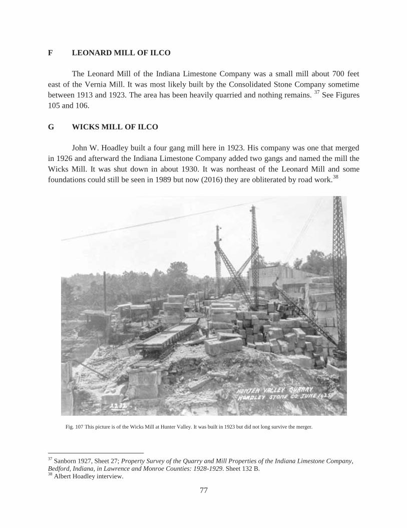
77
F LEONARD MILL OF ILCO The Leonard Mill of the Indiana Limestone Company was a small mill about 700 feet east of the Vernia Mill. It was most likely built by the Consolidated Stone Company sometime between 1913 and 1923. The area has been heavily quarried and nothing remains. 37 See Figures 105 and 106. G WICKS MILL OF ILCO John W. Hoadley built a four gang mill here in 1923. His company was one that merged in 1926 and afterward the Indiana Limestone Company added two gangs and named the mill the Wicks Mill. It was shut down in about 1930. It was northeast of the Leonard Mill and some foundations could still be seen in 1989 but now (2016) they are obliterated by road work.38
37 Sanborn 1927, Sheet 27; Property Survey of the Quarry and Mill Properties of the Indiana Limestone Company, Bedford, Indiana, in Lawrence and Monroe Counties: 1928-1929. Sheet 132 B. 38 Albert Hoadley interview.
Fig. 107 This picture is of the Wicks Mill at Hunter Valley. It was built in 1923 but did not long survive the merger.

78
The Mill Murders
Before we leave the Hunter Valley area it is time to reflect on how dangerous it was working in the limestone industry in the early days. In reading old local newspapers it sometimes seems hard to tell whether the railroads or the limestone quarries and mills were injuring more employees. That was typical of industrial America at the time. The quarries have continued, in a fashion, to take their toll. Every few years somebody drowns in a quarry. The quarry in the Sanders area made famous in the movie Breaking Away has had at least three deaths since the movie was made. Not only are quarries dangerous places in which to swim, hikers have been known to accidentally fall into them with tragic results. Having said that, the phrase “sex and violence” isn’t generally associated with quarries. Read on. The following pictures appeared for sale on the internet39 with the captions (names deleted) that appeared on their reverse:
39 I am indebted to Pete Pedigo for bringing them to my attention. Throughout this section on what the newspaper described as the “Mill Murders” I have left out the last names of the victims.
Fig. 108 “BLOOMINGTON, IND—In this long building of the abandoned Hunter Stone Quarry near Bloomington the mutilated bodies of Mrs. Phyllis C. and her alleged lover, Russell K., both of Bloomington, were found.”

79
It seems that on Friday, March 1, 1946, Mr. Russell K.,40 45 years old and an executive of the Empire Stone Company near Sanders, told an associate that he would be going to the abandoned Hunter Brothers Mill at Hunter Valley to check out some derricks that the company might purchase. When he didn’t show up at home that night, the alarm was raised and the police, after interviewing the associate, went to Hunter Valley where they found Mr. K.’s car and what was obviously a crime scene.
There was a bloody girdle and indications that something had been dragged across the floor of the abandoned mill. Soon, in a six by six foot sludge pit, two bodies were found in about eighteen inches of water. They were Mrs. Phyllis C., 32 years old, and Mr. Russell K., age 45. Both were married but not to each other. There was supposedly a packet of love letters from him to her found at the scene. He had been bludgeoned in the head and she had been strangled with a cord. Within a matter of hours, Joseph Luther Woolridge, age 29 and, as was said in those days, “colored,” was apprehended. He was variously described as a janitor, truck driver, and handyman at a café. A distinctive print made by rubber boots was found at the scene and was mentioned in the newspaper account. On the day of the murder a witness driving by a car wreck in the neighborhood of the crime saw a black man wearing rubber boots. This information became known to the police who had a record of the man at the wreck and went to his house. They found the boots and a distinctive mark on the sole corresponded to the plaster casts from the crime scene. Soon he confessed. His account, from which he never wavered, was that he discovered the couple in “a compromising situation.” Words were said and Mr. K. attacked Woolridge who responded by hitting him over the head with a metal object. Finding Mr. K. dead, Woolridge panicked and killed Mrs. C. by strangling her with a cord. Then he placed the bodies in the pit.
40 Information for this section on the Mill Murders may be found in the Bloomington World Telephone for March 2,3,4, 9 and November 16 and 18, 1946.
Fig. 109 “BLOOMINGTON, IND.—Pit at the abandoned Hunter Stone Quarry near Bloomington where bodies of Mrs. Phyllis C. and Russell K. were found.”
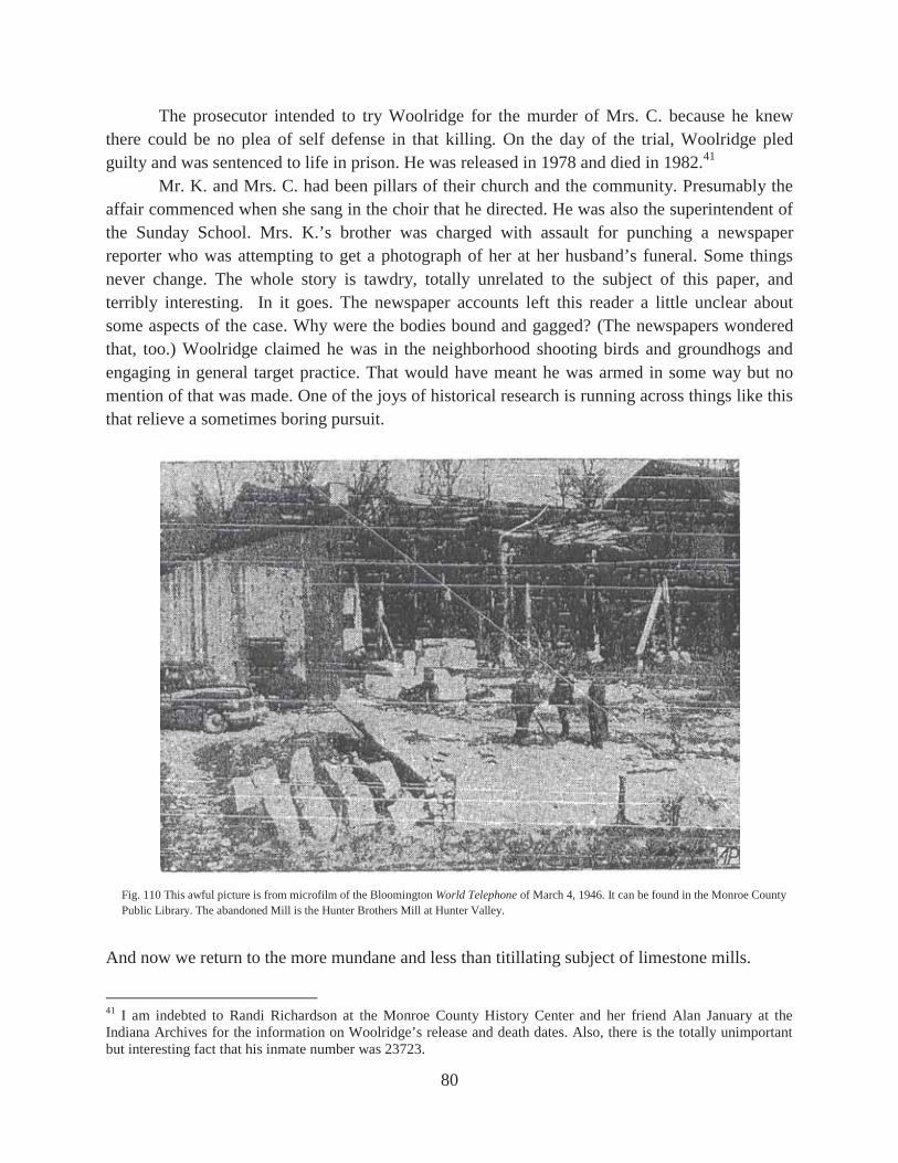
80
The prosecutor intended to try Woolridge for the murder of Mrs. C. because he knew there could be no plea of self defense in that killing. On the day of the trial, Woolridge pled guilty and was sentenced to life in prison. He was released in 1978 and died in 1982.41 Mr. K. and Mrs. C. had been pillars of their church and the community. Presumably the affair commenced when she sang in the choir that he directed. He was also the superintendent of the Sunday School. Mrs. K.’s brother was charged with assault for punching a newspaper reporter who was attempting to get a photograph of her at her husband’s funeral. Some things never change. The whole story is tawdry, totally unrelated to the subject of this paper, and terribly interesting. In it goes. The newspaper accounts left this reader a little unclear about some aspects of the case. Why were the bodies bound and gagged? (The newspapers wondered that, too.) Woolridge claimed he was in the neighborhood shooting birds and groundhogs and engaging in general target practice. That would have meant he was armed in some way but no mention of that was made. One of the joys of historical research is running across things like this that relieve a sometimes boring pursuit.
And now we return to the more mundane and less than titillating subject of limestone mills.
41 I am indebted to Randi Richardson at the Monroe County History Center and her friend Alan January at the Indiana Archives for the information on Woolridge’s release and death dates. Also, there is the totally unimportant but interesting fact that his inmate number was 23723.
Fig. 110 This awful picture is from microfilm of the Bloomington World Telephone of March 4, 1946. It can be found in the Monroe County Public Library. The abandoned Mill is the Hunter Brothers Mill at Hunter Valley.

81
BLOOMINGTON
Map 37

82
A CENTRAL OOLITIC STONE COMPANY MILL SHAWNEE STONE COMPANY MILL
The Central Oolitic Stone Company was organized in 1890 and built this mill in 1891. It was purchased by the Shawnee Stone Company in 1928. Batchelor writes that the Shawnee Company “had been operating a quarry since 1925,” so presumably, that was when the company began. It was forced to reorganize in 1936. Since 1947 the mill has been used for scrap metal salvaging. First it was Fell Iron and Metal, Inc., and now (2016) it is owned by Bloomington Iron & Metal, Inc.42
42 Blatchley, p 385; Batchelor, pp 271, 345.
Fig. 111 The Central Oolitic Stone Company Mill in Bloomington. This later became the Shawnee Stone Company Mill.
Map 38 The tramway operated by the Shawnee Stone Company at its quarry site will be dealt with later.

83
Fig. 112 The Shawnee Stone Company Mill.
Fig. 113 This is the 2016 picture by the author trying to duplicate the view in Figure 112.
Map 39 Sheet 5 of the 1892 Sanborn Fire Insurance Maps. Map 40 Sheet 2 of the 1898 Sanborn map.

84
Map 41 Sheet 4 of the 1907 Sanborn map. Map 42 Sheet 4 of the 1913 Sanborn map.
Map 43 Sheet 17 of the 1927 Sanborn map.

85
Fig. 114 On the last page of the 44 page undated promotional brochure of the Bedford Foundry & Machine Company, Inc. entitled Bedford Stone Working Machinery is this picture. The caption reads, “Shawnee Stone Company at Bloomington, Indiana. 700' of 30-ton Crane Runway 35' high used for stacking quarry block stone, and a Bedford 30-ton, 70' span, 2-motor Electric Traveling Crane. 800 cars of stone can be stacked under this runway.” It was the presence of this structure that gave Tramway Road its name. It was the largest tramway in the district and, to my knowledge, unique in that it wasn’t alongside a mill.
Fig. 115 “Twenty-five ton Two-Motor Overhead Traveling Crane, 70' span, and showing 1,000' of structural steel crane runway, 35' high, used for stacking yard. Furnished the Shawnee Stone Company, Bloomington, Indiana.” It is from an undated Bedford Foundry booklet.

86
Fig. 116 This picture by the author shows the remains of the tramway for the Shawnee Stone Company as they looked in 1987. They are still there in 2016 but the trees and underbrush have grown considerably. Haven’t we all.
B HENLEY STONE COMPANY MILL
SOUTH SIDE STONE COMPANY MILL BLOOMINGTON OOLITIC STONE COMPANY (Quarry Only)
NATIONAL STONE COMPANY Nothing is so indicative of the changes that occur in a city as the knowledge that there once were a limestone mill and a quarry across Second Street from the Bloomington Hospital. The Bloomington Oolitic Stone Company was organized in 1889 and opened the quarry that year and abandoned it in 1893 when it went into receivership. The Henley Stone Company bought the land in 1895 and built a mill. That continued until 1901 when it “was absorbed” by a new company called the South Side Stone Company. The stone milled there came from the area around Sanders.43 The South Side company was bought by the National Stone Company in 1916.44 No trace of the mill survives.
43 Blatchley, p 384-5 44 Batchelor, p 150 (n. 240)
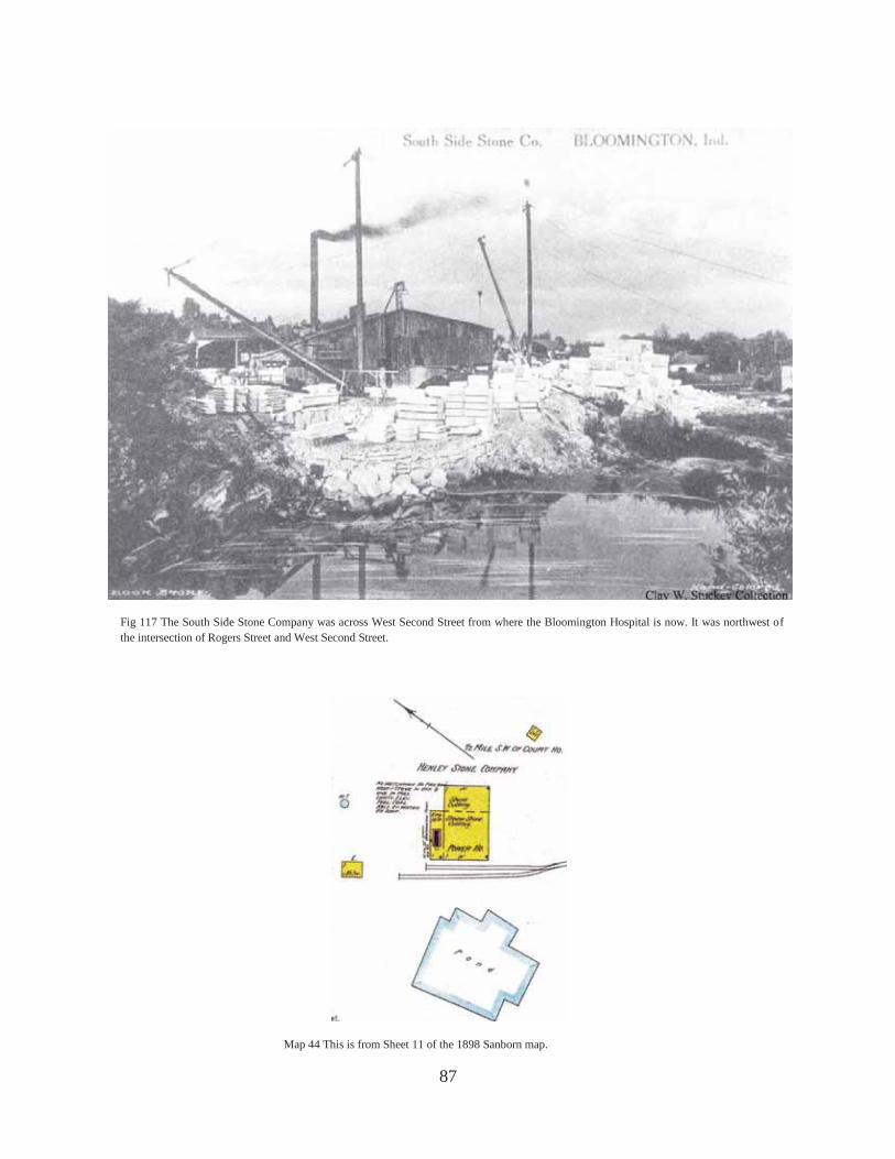
87
Fig 117 The South Side Stone Company was across West Second Street from where the Bloomington Hospital is now. It was northwest of the intersection of Rogers Street and West Second Street.
Map 44 This is from Sheet 11 of the 1898 Sanborn map.

88
C BOWMAN-KING STONE COMPANY MILL
ILCO BOWMAN MILL The Bowman-King Stone Company was organized in October, 1913, and soon built a mill in the middle of the block bounded by 2nd, 1st, Rogers, and Morton Streets. After the merger in 1926 it became known as the Bowman Mill of the Indiana Limestone Company and was shut down within a few years. For several years it was a supply facility for the Bloomington Hospital. It is gone now (2016).45
45 Stuckey, “Origins (revised edition),” p 14: Albert Hoadley interview
Map 45 This is from Sheet 14 of the 1907 Sanborn map.
Map 46 This map is a montage of Sheet 14 and Sheet 19 from the 1913 Sanborn Map. Only by combining those two sheets can you see the entire footprint of the South Side Stone Company Mill. I am indebted to Pete Pedigo for this insight. It has expanded a great deal since 1907.

89
D INDIANA LIMESTONE COMPANY BLOOMINGTON MILL
HOADLEY STONE COMPANY MILL B BLOOMINGTON CUT STONE COMPANY MILL
Map 47 Sheet 109B of Indiana Limestone Company Property Survey of 1928-1929.
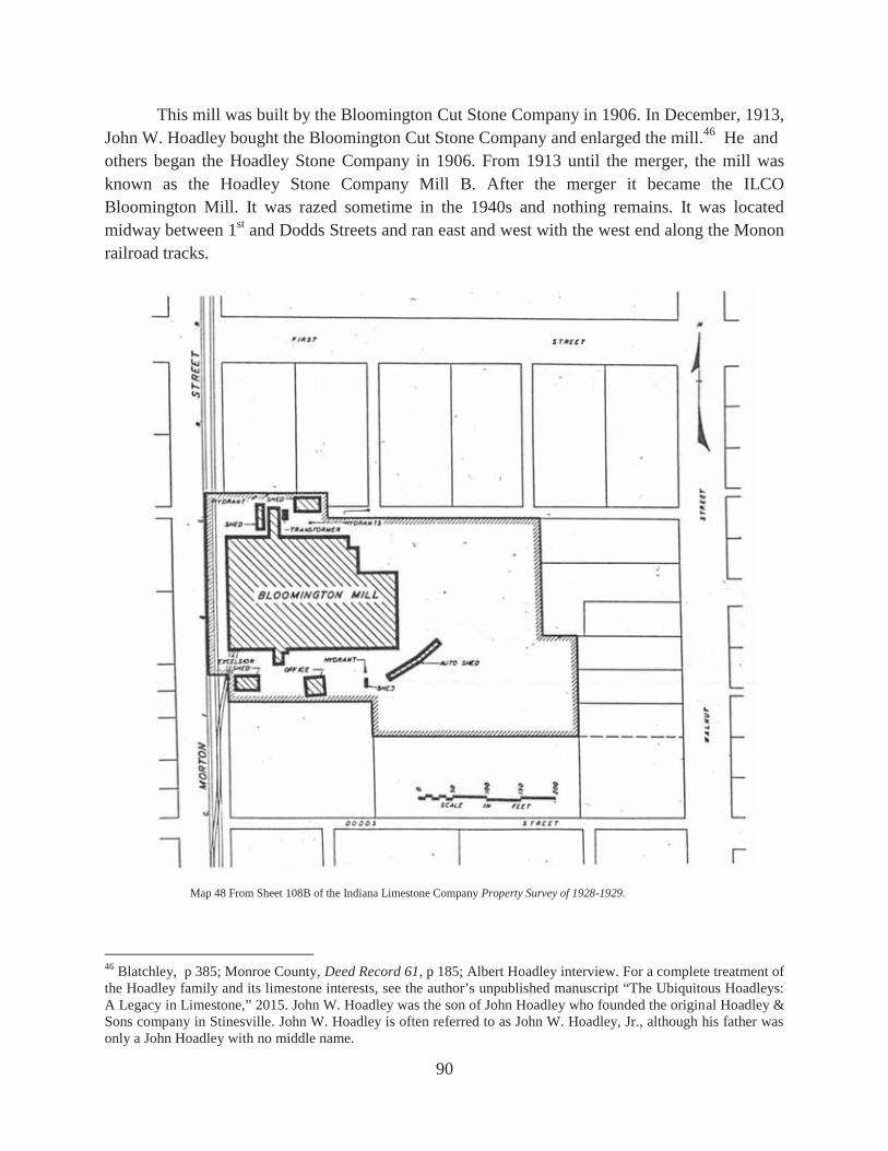
90
This mill was built by the Bloomington Cut Stone Company in 1906. In December, 1913, John W. Hoadley bought the Bloomington Cut Stone Company and enlarged the mill.46 He and others began the Hoadley Stone Company in 1906. From 1913 until the merger, the mill was known as the Hoadley Stone Company Mill B. After the merger it became the ILCO Bloomington Mill. It was razed sometime in the 1940s and nothing remains. It was located midway between 1st and Dodds Streets and ran east and west with the west end along the Monon railroad tracks.
46 Blatchley, p 385; Monroe County, Deed Record 61, p 185; Albert Hoadley interview. For a complete treatment of the Hoadley family and its limestone interests, see the author’s unpublished manuscript “The Ubiquitous Hoadleys: A Legacy in Limestone,” 2015. John W. Hoadley was the son of John Hoadley who founded the original Hoadley & Sons company in Stinesville. John W. Hoadley is often referred to as John W. Hoadley, Jr., although his father was only a John Hoadley with no middle name.
Map 48 From Sheet 108B of the Indiana Limestone Company Property Survey of 1928-1929.

91
Map 49 From Sheet 30 of the 1907 Sanborn map. Map 50 From Sheet 23 of the 1913 Sanborn map.
Map 51 From Sheet 25 of the 1927 Sanborn map.

92
E ALEXANDER KING STONE COMPANY MILL FAGAN STONE COMPANY MILL
This mill does not appear on the Sanborn 1913 map but appears as the Alexander King Stone Company Mill on the 1927 map. In 1936 it was bought by the Fagan Stone Company. In the middle or late 1960s it was bought by the Victor Oolitic Stone Company and for a time was leased to John Tucker who later owned the Indiana Limestone Company. The mill ran north and south along the Monon tracks and covered almost the entire block between Dodds and Allen Streets on the east side of the tracks. Nothing now remains but the office building for the stone company that is on the west side of the tracks on the southwest corner of Dodds and Morton Streets.47
47 Batchelor, pp 347-8; Interviews with John Rogers and John Edgeworth, both of Bloomington, Indiana, conducted in 1989.
Fig. 118 The Hoadley Stone Company Mill B looking northeast at the south side of the mill. It later became the ILCO Bloomington Mill.
Fig. 119 The Hoadley Stone Company Mill B looking directly south at the north side of the mill. It later became the ILCO Bloomington Mill.

93
Fig. 120 This view is looking west along Dodds Street toward the old Alexander King Cut Stone Company Mill. It later became the Fagan Stone Company Mill.
Fig. 121 This is the same view as above only this is by the author in 1989. The concrete wall seen in Figure 123 can be seen on the other side of the red sign close to the intersection of Dodds and Morton.
Fig. 122 This is roughly the same view by the author in 2016. The concrete wall is gone and replaced by a building.

94
Fig. 123 This picture by the author is looking east across the intersection of Dodds and Morton Streets in 1989. The wall is part of the old Fagan Stone Mill.
Fig. 124 The picture by the author is the same view as in Figure 123 only in 2016. The concrete wall is gone and replaced with a building and the Monon tracks are no longer there.
Fig. 125 This is the Fagan Mill as seen from the west looking east. You can see the Cline Mill of the Bloomington Limestone Company on the east side of the Fagan Mill by looking through the open south or right end of the latter mill.

95
Fig. 126 This 1989 picture by the author shows the old office building for the Fagan Stone Company that was across the railroad tracks and Morton Street to the west. Although serving another purpose, the building is still there in 2016. The view is looking southeast across Dodds.
Fig. 127 This 2016 picture by the author is looking south at the north face of the old Fagan Stone company office building. The name “Fagan Stone Company” is still over the door.

96
F HOADLEY-CLINE STONE COMPANY MILL BLOOMINGTON LIMESTONE COMPANY CLINE MILL
The Hoadley-Cline Stone Company was organized in 1926 by Kenneth Cline and Ellsworth Hoadley.48 This mill was soon built directly behind the company’s office building on the west side of Walnut Street about midway between Walnut and Morton Streets and on the north side of Allen Street. In 1927 this company was part of the merger that resulted in the formation of the Bloomington Limestone Company. The office for that was the same as of the earlier company. The mill is no longer there but the office building has survived although no longer connected with a stone company.
48 This company and the Bloomington Limestone Company that later bought it are more thoroughly treated in the unpublished manuscript, “Bloomington Limestone Company,” 2015, by the author.
Map 52 This is from the 1931 Map of Indiana Oolitic Limestone District…

97
Fig. 128 This picture was made in 1940 and is looking southeast at the Fagan Mill on the bottom, the Cline Mill in the center right, and the Solomito Mill in the far right top. Walnut Street runs along the top of the picture and the two buildings at right angles to each other in the center of the picture are the office and drafting room of the Bloomington Limestone Company.
Fig. 129 This is looking roughly west at the office and drafting room of the Bloomington Limestone Company. The top of the Cline Mill can be seen beyond the water tower.
Fig. 130 This is the same view as Figure 129 taken by the author in 2016.

98
G EAKINS PLANING MILL J. H. NOLAN & SON STONE WORKS
On the southeast corner of the intersection of Allen Street and the railroad was a very small mill that was listed on the 1898 Sanborn map (Sheet 11) as Hinds, Eakin [sic], and Hinds Planing Mill and on the 1907 Sanborn map (Sheet 20) as the Eakins Planing Mill. The 1913 Sanborn map (Sheet 23) labels it the J. H. Nolan & Son Stone Works. After the merger it became an unnamed supply house for the Indiana Limestone Company. Nothing remains of it.
Map 53 Sanborn 1907 Sheet 20.
Map 54 Sanborn 1913 Sheet 23. Map 55 Sanborn 1927 Sheet 27.

99
Fagan Mill
Formerly the J. H. Nolan & Sons Stone Works
Joe Solomito Stone Co.
Walnut Street
Dodds
Bloomington Limestone Co.
Formerly Bowman Mill
Map 56 This is a 1949 aerial photograph of Bloomington.
Monon Railroad

100
Q JOE SOLOMITO STONE COMPANY On the south side of Allen Street about midway between Morton and Walnut Streets there is (1989) a municipal building that was built in 1938. On both sides of this building east and west and south to the alley was the mill of the Joe Solomito Stone Company. It was built in 1946 and was sold in about 1955. There is no longer a stone mill there.49
49 Interview with Joe Solomito, Bloomington, Indiana, May 30, 1989.
Map 57 Sanborn 1943 Sheet 25. Walnut Street runs up and down on the right. West Allen runs right and left along the top. Note that the Hoadley Stone Company Mill A is gone at this time.

101
H HOADLEY STONE COMPANY MILL A ILCO HOADLEY MILL ILCO INDIANA MILL
This large mill was located just north of Grimes Lane and east of the Monon railroad tracks. John W. Hoadley built this mill in 1906. His company was the Hoadley Stone Company and is not to be confused with the J. Hoadley and Sons Stone Company who built the Tribune Mill across Grimes Lane to the south. That mill will be dealt with next. After the merger the mill was called the Indiana Limestone Company Hoadley Mill but soon it became the ILCO Indiana Mill. That was no doubt because John W. Hoadley went back into the stone business after selling out in the merger and the ILCO didn’t want its mill named after a competitor.50
50 As previously noted, all information about the Hoadley family and its stone interests can be found in the author’s unpublished manuscript, “The Ubiquitous Hoadleys,” 2015.
Fig. 131 The above picture shows the Hoadley Stone Company Mill A. After the merger it became the ILCO Hoadley Mill and then the ILCO Indiana Mill. It was built in 1906 and was gone by 1941.
Map 58 To the far left is Sheet 20 of the 1907 Sanborn map.
Map 59 To the immediate left is Sheet 107B of the ILCO Property Survey…

102
I J. HOADLEY AND SONS STONE COMPANY MILL
ILCO BLOOMINGTON MILL TRIBUNE MILL (INFORMALLY)
After the mill of the J. Hoadley and Sons Company in Stinesville burned in 1916, Bert Hoadley moved the business to Bloomington and built the mill that became informally known as the Tribune Mill. That is because the stone for the Tribune Tower in Chicago was fabricated in this mill while the building was being built from 1923 to 1925. The mill was located just south of Grimes Lane and on the east side of the railroad tracks and the beginning of McDoel Yard. It was gone by the 1940s and nothing remains of it. 51
51 “B. G. Hoadley Quarries, Inc.-John Hoadley & Sons,” Quarries and Mills, I (May, 1929), p 22, 70; Albert Hoadley interview.
Fig. 132 This postcard picture is labeled “Cut Stone Mill of Yard of the Hoadley Stone Co. Bloomington, Ind. The view is looking north.
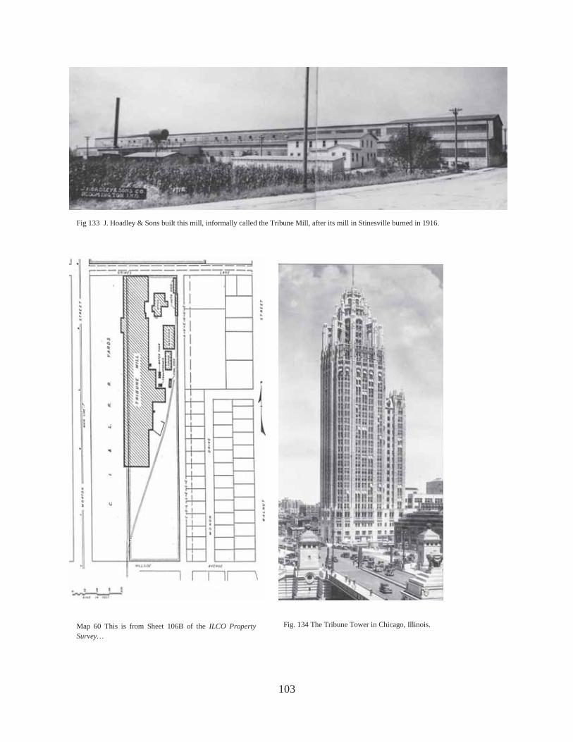
103
Fig 133 J. Hoadley & Sons built this mill, informally called the Tribune Mill, after its mill in Stinesville burned in 1916.
Map 60 This is from Sheet 106B of the ILCO Property Survey…
Fig. 134 The Tribune Tower in Chicago, Illinois.

104
Fig. 135 This 1923 picture shows the Bloomington Mill of the J. Hoadley & Sons Stone Company. In the upper right is the Hoadley Stone Company Mill A. While the Hoadley name is of the same family, these were two different companies run by brothers who practiced their own version of sibling rivalry.
Fig. 136 The 1923 picture shows the Tribune Mill (formally the J. Hoadley & Sons Stone Co. Bloomington Mill) in the foreground separated from the Hoadley Stone Co. Mill A by Grimes Lane. Walnut Street runs along the right and the old Bloomington High School can be seen in the upper right. Going north from the Hoadley Mill A you can see the site where the Fagan Mill will eventually be closed in and above that is the Hoadley Mill B.

105
K OOLITIC STONE MILLS COMPANY MILL HOOSIER CUT STONE COMPANY MILL ILCO McDOEL MILL HOOSIER STONE COMPANY MILL
On Rogers Street just south of the site of the old RCA plant is an electric substation for the current power company. About two hundred yards west of Rogers Street at the power station, the Oolitic Stone Mills Company, which had been organized in 1911, built a mill in about 1913. In 1923 it became a mill of the Hoosier Cut Stone Company and after that firm merged with others to form the ILCO, it became the McDoel Mill of the Indiana Limestone Company. Much later the mill was sold to the Hoosier Stone Company (not to be confused with the Hoosier Cut Stone Company) and survived until quite late. It is no longer there.
Map 61 1913 Sanborn Sheet 23. Map 62 1927 Sanborn Sheet 27.
Fig. 137 This view of the Hoosier Stone Company appears to have been taken in 1940s or early 1950s.

106
Fig. 138 This aerial view looking west shows the ruins of the Hoosier Cut Stone Company directly above the Public Service substation along Rogers Street below. RCA is to the right. Before it was that mill, it was the site of the McDoel Mill of ILCO.
Map 63 This is from Sheet 130B of the ILCO Property Survey…

107
J BLOOMINGTON-BEDFORD STONE COMPANY MILL ILCO RADLEY MILL
About 900 feet due west of the ILCO McDoel Mill described just previously was this mill that was built sometime between 1907 and 1913 by the Bloomington-Bedford Stone Company. That company became (somehow) the Clear Creek Quarries Company in 1924 and it was one of the twenty-four that merged in 1926 to become the ILCO. Then the mill was named the Radley Mill. It was gone by the 1940s.
Map 64 Sheet 23 of the 1913 Sanborn map.
Map 65 This is from Sheet 27 of the 1927 Sanborn Map.

108
Fig. 139 The is looking roughly west at the old Bloomington-Bedford Stone Company Mill that was later to become the Radley Mill of ILCO.
Fig 140 This 1949 aerial view is looking at the old ILCO McDoel Mill directly above the electrical substation at the bottom and the site of the old ILCO Radley Mill at the top near the quarries.

109
L MUTUAL OOLITIC STONE COMPANY MILL BOWMAN-SCHWAB STONE COMPANY MILL
The Mutual Oolitic Stone Company built a mill in 1928 just south of the railroad spur that crossed South Walnut Street or Highway 37 south of Hillside Drive. The mill was on the west side of the road and was run from 1934 to 1941 by the Bowman-Schwab Stone Company. Nothing remains at the site.52 For the intrepid locator of limestone mill sites this particular one is a problem in that it shows up on no Sanborn maps nor can I find any pictures of it.
52 “Mutual Oolitic Stone Co.,” Quarries and Mills, I (August, 1929), p 54; In that article it states that the company had been reorganized and had started in 1927 in Ellettsville but that “last year the plant was removed to Bloomington;” Batchelor, p 347.
Map 66 This map was provided by Pete Pedigo and comes from page 6 of the December, 2006 issue of Monroe County Historian. It was in an article entitled “Gordon & Anderson Oil Co.: History of a Bloomington Business,” by Penelope Mathiesen. It shows the location of the Mutual Oolitic Stone Mill in relation to the railroad and Walnut Street.

110
East Miller Drive
Walnut Street
Site of Mutual Oolitic Stone Co.
J. M. Hoadley Stone Co. Mill
Map 67 This 1949 aerial view shows the sites where the Mutual Oolitic Stone Company Mill had been and where the J. M. Hoadley Stone Co. Mill was at the time.

111
P J. MASON HOADLEY STONE COMPANY MILL
This mill was built in 1930 by J. Mason Hoadley and ceased being a stone mill about 1969.53
53 “Office, Drafting Room, Quarries, Mills,” Quarries and Mills, I (May, 1930), p 7; F. G. Summitt interview.
Fig. 141 The mill of the J. M. Hoadley Stone Company was built in 1930. The mill ceased stone activity in about 1969. The building survives as a storage rental facility.
Fig. 142 This 2016 picture by the author shows the building of the J. M. Hoadley Stone Company Mill today.

112
M AMERICAN OOLITIC STONE COMPANY MILL
ILCO AMERICAN MILL On the northeast corner of South Henderson Street and the railroad spur that crossed it, the American Oolitic Stone Company built this mill in 1923 “which operated many years, then abandoned, bought by the Blgtn Limestone Co and turned into a ‘dust mill’ where scrap stone was ground to the fineness of face powder, by ball mills. The product was sold to cosmetic companies, paint manufacturers, etc. By the late 1940s it was the Indiana Calcium Corporation Stone Pulverizing Plant. Finally it was closed down and razed, principally because of the complaints of the dust from the neighbors.”54 Prior to the Bloomington Limestone Company acquiring the mill sometime in the 1930s, the Indiana Limestone Company owned it. That can be seen from the maps on the following page.
54 “History Indiana Limestone,” Unpublished manuscript by Albert T. Hoadley, undated, pp 133-134. On page 151 Hoadley relates that the company was in receivership in 1924 and sold that year. He further says that the Bloomington Limestone Company bought the mill sometime in the 1930s.
Fig. 143 This 1930 picture shows the mill of the J. Mason Hoadley Stone Company as it is being built. The structural steel came from the Bedford Foundry and Machine Company. The view is looking southeast.

113
Map 69 This is from Sheet 131B of the Indiana Limestone Property Survey… Map 68 Sanborn 1927 Sheet 27.
Map 70 This is from a 1949 aerial photograph of Bloomington and surrounding area.
ILCO American Mill
Walker Brothers Stone Co.
Midland Cut Stone Co.
Hillside Drive
Henderson Street.

114
N WALKER BROTHERS STONE COMPANY MILL The Walker Brothers Stone Company Mill was just east of the American Mill and south of the railroad spur. The company was started in 1928 by W. B. Hoadley, Jimmy Walker, and Owen Walker. The latter two soon left the company. Hoadley operated the company until he retired and upon his death it was sold to the Tabereaux Stone Company.55 It ceased milling stone in the mid 1950s and was torn down sometime in the 1960s.56
In general, more stone was removed from Lawrence County prior to World War II and more from Monroe County after the war.57 While there were more mills in Monroe than Lawrence County, the average size of the mills in the latter was bigger. Roughly speaking, the top four or five mills in size were in Lawrence County. They also tended to be financed by out of town money while Monroe County companies were more locally financed.58 55 Albert T. Hoadley, “Manuscript,” p 131. 56 Interview with Howard Tabereaux, Bloomington, Indiana, April 11, 1989. 57 Bill McDonald, personal communication. 58 William H. (Bill) McDonald, A Short History of Indiana Limestone, (Bedford: 1995), p 17 (n. 6).
Fig. 144 This early 1940s view is looking west at the Walker Brothers Mill.

115
O MIDLAND CUT STONE COMPANY MILL The Midland Cut Stone Company, Inc. was organized in 1935 and continues (2016) to operate.59 It was located just east of the Walker Brothers Stone Company Mill.
Throughout this work frequent use will be made of photographs taken in September, 1923, when for unknown reasons a fly-over was made of much of the stone district. Also, in 1910 there obviously was a professional photographer who traveled around the district taking pictures on the ground. There are several from 1911 as well. These are often dated on the picture itself and were professionally done. Then in 1940 another fly-over was done in the Bloomington and Ellettsville area but these pictures are more of an amateurish quality. Add to these the many other pictures of the mills taken by more unknown photographers and we are blessed with a pretty good pictorial history of the district. Compared to these photographs of mills, there is a myriad of quarry scenes. Most of those are unidentified and, unfortunately, unidentifiable. 59 Interview with Howard Tabereaux, op. cit.
Fig. 145 This early 1940s view is looking east. The Walker Brothers Mill is in the center, the Midland Stone Company is along the top and part of the grounds of the American Mill are on the bottom left.

116
CLEAR CREEK AND SANDERS
Map 71
Fig. 146 This picture has nothing to do with the site of a mill but was simply too good to pass up. It is from Rock Products and was labeled The Chicago and Bloomington Stone Co. Pete Pedigo is of the opinion that this picture is looking north just north of Dillman Road on the spur from the old Monon main line that came off to the southeast to the Yates and Johnson mills and quarries. Map 73 shows a site called Johnston’s Station and Pete thinks this is the structure located near the rear of the train. The locomotive without tender was most likely owned by the stone company and not the railroad. Notice the difference in spelling. It is Johnston Station but Johnson Mill. I don’t know if Johnston was a misprint. William Johnson was one of the founders of The Chicago and Bloomington Stone Co.

117
Map72 Hopkins and Siebenthal, p 370.
Map 73 Blatchley, p 387 Map 74 Blatchley, p 402
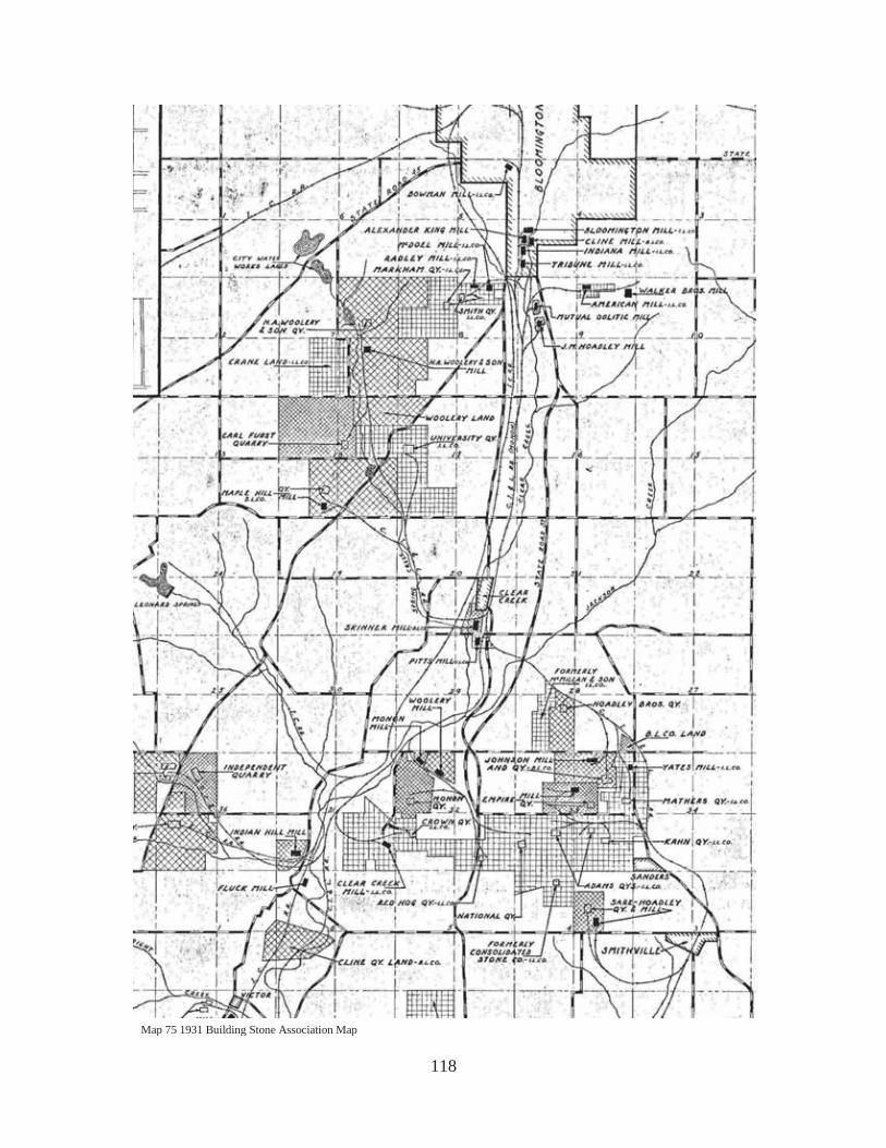
118
Map 75 1931 Building Stone Association Map
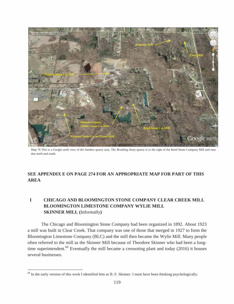
119
SEE APPENDIX E ON PAGE 274 FOR AN APPROPRIATE MAP FOR PART OF THIS AREA
I CHICAGO AND BLOOMINGTON STONE COMPANY CLEAR CREEK MILL BLOOMINGTON LIMESTONE COMPANY WYLIE MILL SKINNER MILL (Informally)
The Chicago and Bloomington Stone Company had been organized in 1892. About 1923 a mill was built in Clear Creek. That company was one of those that merged in 1927 to form the Bloomington Limestone Company (BLC) and the mill then became the Wylie Mill. Many people often referred to the mill as the Skinner Mill because of Theodore Skinner who had been a long-time superintendent.60 Eventually the mill became a creosoting plant and today (2016) it houses several businesses.
60 In the early version of this work I identified him as B. F. Skinner. I must have been thinking psychologically.
National Stone Co. or Freese Mill
Reed Stone Co. Mill
Empire Stone Co. Mill
Monroe County Oolitic Stone Co. Mill
Johnson Mill
Yates Mill
Map 76 This is a Google earth view of the Sanders quarry area. The Breaking Away quarry is to the right of the Reed Stone Company Mill and runs due north and south.

120
Fig. 147 This 1940 picture is looking north at the Bloomington Limestone Company Wylie Mill. Rogers Street is to the far right.
Fig. 148 This picture by the author shows the Wylie Mill building in 1989.
Fig. 149 This 2016 picture by the author corresponds to the previous view made many years ago.

121
J CLEAR CREEK QUARRIES COMPANY CLEAR CREEK MILL
ILCO PITTS MILL It isn’t known just which company built this small mill. Either it was the Clear Creek Quarries Company (most likely) or one of its predecessors. Regardless, after the merger in 1926 it became the ILCO Pitts Mill. It was located east of Clear Creek (the creek not the town) and southwest of the intersection of Church Lane and the Monon tracks.61 By the 1940s it was not in operation and nothing remains at the site.62
61 Monroe County, Deed Record 76, pp 73, 151, and 217. 62 Albert Hoadley interview.
Map No. 77 ILCO Property Survey Sheet 135B.
Fig. 150 This 2016 picture by the author is looking northeast. The west side of the old mill building is shown.

122
K F. B. HARRIS CUT STONE COMPANY MILL FORBURGER-HARRIS STONE COMPANY MILL
The F. B. Harris Cut Stone Company was incorporated in November, 1933, and the mill was presumably built shortly thereafter. It became the Forburger-Harris Stone Company in 1947 and ceased operation about 1960. Only some concrete foundations remain and as of this writing (2016) those foundations have been incorporated in a domestic dwelling. It was located just across Clear Creek from the Bloomington Limestone Company Wylie Mill.63
63 Abstract of title kindly provided to me by its owner (1989), Don Robertson; F. G. Summitt interview.
Fig. 151 This picture from 1940 is looking east at the Bloomington Limestone Company Wylie Mill on top and the F. B. Harris Cut Stone Company Mill on the bottom. Later it became the Forburger-Harris Stone Company Mill. The corner of the field on the left was the back of the farm where the author grew up. The railroad spur on the left running up and down is the Monon and the railroad spur running across the middle is the Illinois Central. The Monon main line runs across on the other side of the Wylie Mill at the top. These two railroad spurs are now (2016) part of the hiking trails of the Bloomington Parks and Recreation Department.

123
G THE ACME-BEDFORD STONE COMPANY MILL The Bloomington-Bedford Stone Company opened a quarry near here in 1893 and leased it in 1896 to the Acme-Bedford Stone Company, which bought it the following year. In 1901 the latter firm built a mill which operated until 1907 and in 1910 the operation was sold and abandoned.64 The relatively extensive foundations that survive belie its short-lived history. The site is best visited by parking along Fairfax Road where the railroad grade crossed it just north of the junction of Dillman Road and Fairfax Road. As you walk northwest on the old railroad grade for about 275 yards you come to a place where a spur angled off the main line to the left. Southeast bound engines could have headed off onto this spur which ran to the Johnson and Yates Mills. This is NOT the spur leading to the Acme-Bedford Mill. Continue walking another thousand yards and you can see an even older grade for a spur that curved off to the south providing access to southeast bound trains to the Acme-Bedford Mill. It leads shortly to the site of the old mill. A visit in 2016 showed a housing addition had obliterated all remains of the old mill and most of the railroad spur leading to the quarries.
64 Blatchley, p 391; Batchelor, p 155.
Fig. 152 to the left and Fig. 153 below are pictures of the remains of the Acme-Bedford Stone Company Mill taken by the author in 1989. The site is now occupied by a housing addition and the mill remains are gone.
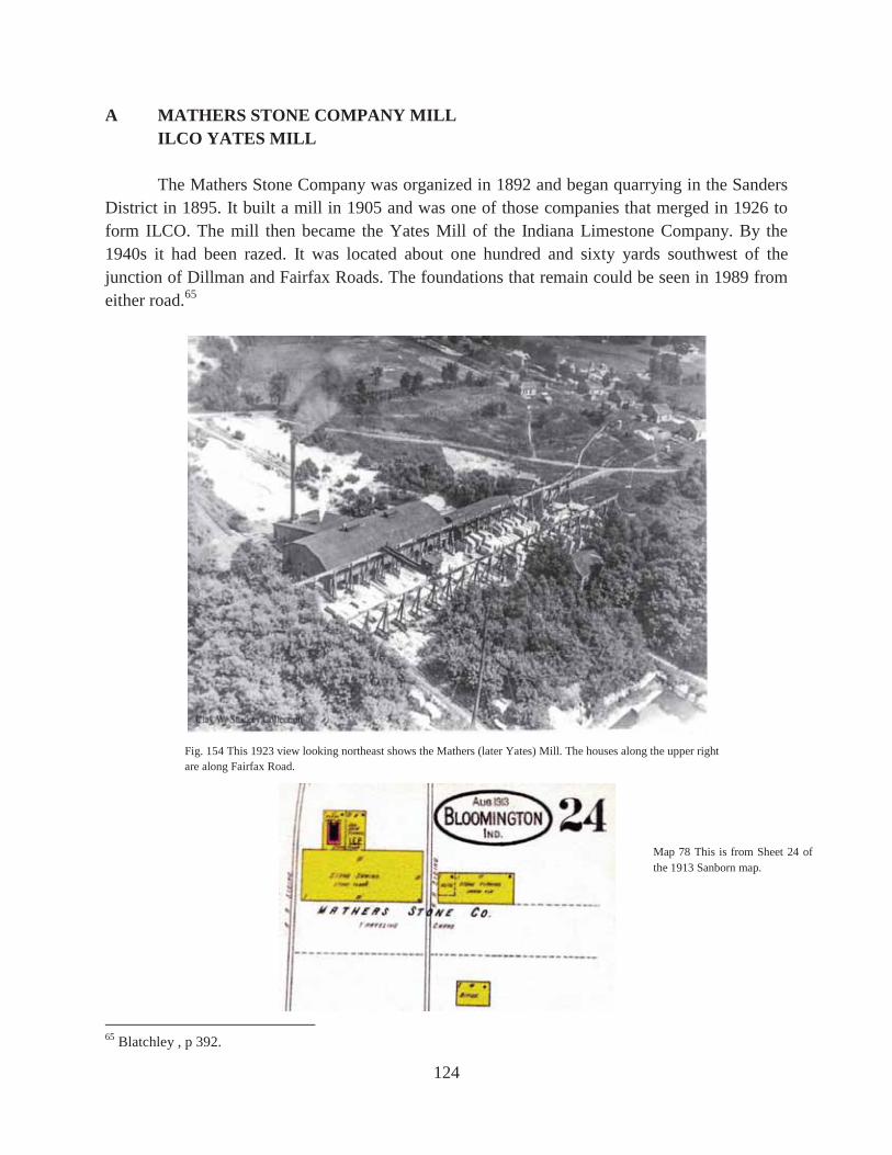
124
A MATHERS STONE COMPANY MILL ILCO YATES MILL
The Mathers Stone Company was organized in 1892 and began quarrying in the Sanders District in 1895. It built a mill in 1905 and was one of those companies that merged in 1926 to form ILCO. The mill then became the Yates Mill of the Indiana Limestone Company. By the 1940s it had been razed. It was located about one hundred and sixty yards southwest of the junction of Dillman and Fairfax Roads. The foundations that remain could be seen in 1989 from either road.65
65 Blatchley , p 392.
Fig. 154 This 1923 view looking northeast shows the Mathers (later Yates) Mill. The houses along the upper right are along Fairfax Road.
Map 78 This is from Sheet 24 of the 1913 Sanborn map.

125
B CHICAGO & BLOOMINGTON STONE COMPANY MILL
BLOOMINGTON LIMESTONE COMPANY JOHNSON MILL The Chicago & Bloomington Stone Company was organized in 1892. In 1903 it opened a quarry in the Sanders District and in 1904 built this mill. After it merged with others in 1927 to form the Bloomington Limestone Company, it became the Johnson Mill. It was located about one hundred and fifty yards to the west of the Yates Mill and about one hundred and fifty yards south of Dillman Road. Several foundations remain.
Fig. 155 This 1923 view is looking southwest at the Mathers Stone Company Mill (later Yates Mill) on the left and the Chicago and Bloomington Stone Company Mill (later Johnson Mill) on the right.
Fig. 156 This picture by the author shows the Yates Mill in 2016.
Fig. 157 This picture by the author shows the Yates Mill in 2016.

126
Map 79 This from Sheet 24 of the 1913 Sanborn map. Note that this map shows a traveling crane on the south side of the enclosed part of the mill. The photograph shows not a traveling crane but individual derricks. The site itself shows the foundations for a traveling crane.
Fig. 158 This is the south side of the Chicago & Bloomington Stone Company Mill that became the Bloomington Limestone Company Johnson Mill. Note that the Sanborn maps show a traveling crane alongside the mill in 1913 but the photograph in 1923 shows that there are individual derricks rather than a traveling crane.
Map 80 This is Sheet 28 of the 1927 Sanborn map.

127
Fig. 159 This is a repeat of Figure 155 but it is good to have it close to compare with the next picture. It shows the 1923 view looking southwest at the Mathers Stone Company Mill (later the Yates Mill of ILCO) on the left and the Chicago & Bloomington Stone Co. Mill (later the Bloomington Limestone Co. Johnson Mill) on the right.
Fig. 160 This 1923 picture is looking northeast at the Chicago & Bloomington Stone Co. Mill (later the Bloomington Limestone Co. Johnson Mill) on the left and the Mathers Stone Co. Mill (later the ILCO Yates Mill) to the right of it and above. You have to look closely to find it. Fairfax Road runs across the top of the picture.

128
Fig. 161 This picture by the author shows the Johnson Mill in 2016.
Fig. 163 This undated picture was labeled “Stone stacked at Johnson Mill.”
Fig. 162 This picture by the author shows the Johnson Mill in 2016.

129
C REED STONE COMPANY MILL The first company to quarry in the Sanders District was the Oolitic Stone Company, which began in 1888. David Reed obtained control of the quarry and opened others. He died in 1894 and in 1895 his nephew Robert Reed built a mill.66 By the early 1930s the mill was not operating and the area was designated the Adams Quarry of the Indiana Limestone Company. The site is best visited by walking west from the Fairfax Road along the old spur that crossed the road just north of Sanders. This old grade provides access to a beautiful and heavily quarried area that includes among its quarry holes the one used in the movie Breaking Away. The site of the Reed Mill was at the base and to the north of the old water tower that was still there in 1989. Nothing remains of the mill.67
66 Interview with Steve and Debbie Reed, February, 2016. 67 Ibid., pp 386-7; 1931 map of the Building Stone Association of Indiana, Inc.
Map 81 This is from Sheet 24 of the 1913 Sanborn map.
Fig. 164 This picture was taken by the author in 1989 near Reed Stone Co. Mill. Other than the growth of trees, this scene has not changed a bit in 2016.

130
Sharp readers will soon notice that the pictures of the Reed Stone Mill on pages 132 and 134 don’t show a water tower that resembles the one present now and photographed by the author back in 1989. These close-ups of the pictures show the previous water tower that was located on the same spot.
Fig. 165 The label on this wonderful picture says “Aug 1910 Reed Stone Co. Quarry No. 1, Sanders, In.”
Figs. 166, 167, and 168 clockwise from the top left. Fig. 168 on the bottom shows the Reed Mill and the view is looking east. Fig. 166 on the top left is looking at the Reed Mill from the east. Fig. 167 is a close-up of Fig. 168. Note the earlier water tower in these pictures. It is one on the right in Figure 167 and on the left in Figure 166. This earlier water tank sat directly on the stone foundation while the later one stood on stilts.

131
Fig. 169 This 1987 picture by the author is looking southwest. The Breaking Away Quarry is in the left corner and the site of the old Reed Stone Company Mill is at the water tower which is still there. The water tower is 135 yards due west of the southwest corner of the quarry. The view in the following picture is to the left of this picture. When this quarry hole became referred to as the “Roof-Top Quarry” I don’t know.
Fig. 170 This is looking south at the quarry made famous in the movie Breaking Away. The site of the Reed Stone Co. Mill was 135 yards due west of the southwest corner of this quarry. This picture by the author was taken in 1987. It has grown up considerably since then.

132
Fig. 171 This 1923 picture shows the Reed Stone Company Mill slightly right of center and the Monroe County Oolitic Stone Company Mill to the left of center. Both are at the bottom of the top one-third of the picture. Fig. 177 is the best view of both mills. See page 137 for a discussion of the Monroe County Oolitic Stone Company.
Fig. 172 The camera has shifted slightly for this picture from the previous one. The Monroe County Oolitic Stone Company Mill is to the left and the Reed Stone Company Mill is to the right. Look in the upper left quadrant.

133
Fig. 173 This is a close-up of the Monroe County Oolitic Stone Company Mill shown in Fig. 177.
Fig. 174 This is a close-up of the Monroe County Oolitic Stone Company Mill shown in Fig. 171.
Fig. 175 This is a close-up of the Reed Stone Company Mill shown in Fig. 177.
Fig. 176 This is a close-up of the Reed Stone Company Mill shown in Fig. 165. Remember, however, this is 13 years before these other pictures.

134
D EMPIRE STONE COMPANY MILL The Empire Stone Company began business in 1892 and built a mill in 1904. The mill continued until the modern era (but before 1989) when it became the Imperial Lumber Kiln, Inc. It is easily visited by taking Empire Mill Drive.68 People should not be confused about this mill. It has NOTHING to do with the Empire State Building. The stone for that building came from the Perry, Matthews, and Buskirk Quarry in Lawrence County, just north of Oolitic.
68 Blatchley, pp 390-91.
Fig. 177 The camera has shifted a little again and here we have the best yet view of the Reed Stone Company Mill on the right and the Monroe County Oolitic Stone Co. Mill on the left. The latter mill is almost in the center about one-fourth the way down from the top.

135
Map 82 is from Sheet 24 of the 1913 Sanborn map. Map 83 is from Sheet 28 of the 1927 Sanborn map.
Fig. 178 This 1989 picture by the author shows the non-limestone related business operating at the site of the old Empire Stone Company Mill. It is still there in 2016. The 1947 Sanborn map shows nothing at the site so all this has been built since then.

136
Fig. 179 This picture from the early 1940s is looking east at the Empire Stone Company Mill. Sanders School can be seen in the upper right corner.
Fig. 180 This 1923 picture shows the Empire Stone Company Mill at an earlier date than the previous picture. Obviously the mill has changed.

137
E MONROE COUNTY OOLITIC STONE COMPANY MILL In 1889 the Monroe County Oolitic Stone Company built this mill. It was still in operation in 1927 but by the early 1930s it was not. By the 1940s it was gone and nothing remains. The area has been heavily quarried.69 Several pictures of this mill taken in 1923 were shown on the last few pages.
69 Blatchley, pp 389-90.
Map 84 This is from Sheet 24 of the 1913 Sanborn map. Pictures of this mill were shown in Figures 171-174 and 177.

138
F NATIONAL STONE COMPANY MILL ILCO FREESE MILL
The National Stone Company built two mills here, one in 1903 and the other in 1904. By the late 1940s they were gone and the area was referred to as the National Quarry of the Indiana Limestone Company. One of those mills became the Freese Mill of the Indiana Limestone Company. Presumably the other was closed down right after the merger. Nothing remains and the site has been heavily quarried.70
70 Blatchley, p 402.
Map 85 This is from Sheet No. 24 of the 1913 Sanborn map. Map 86 This is from Sheet No. 28 of the 1927 Sanborn map.
Fig. 181 This 1923 picture looking east shows the National Stone Company Mill. It became the Freese Mill of ILCO.

139
Fig. 182 The camera angle has changed from the last picture of the National Stone Company Mill. Later it was the ILCO Freese Mill. Above it and slightly to the right (almost in the center right to left) is the Empire Stone Company Mill.
Fig. 183 The airplane has flown to give an entirely different view. This time we are looking slightly southwest with the National Stone Company Mill shown to the right. Later it became the Freese Mill of ILCO.

140
H SARE-HOADLEY STONE COMPANY MILL John W. Hoadley along with others began this company in 1927 and soon built a mill on the north side of Smithville Road. The mill building was removed in the 1950s and utilized to expand the new Woolery Stone Company Mill on Tapp Road. A modern business has been built on the site of the mill.71
71 John Rogers interview.
Fig. 184 This picture appeared on page 40 of an undated advertising booklet entitled Bedford Stone Working Machinery published by the Bedford Foundry and Machine Co. The caption reads, “280' 0" of 35-ton Crane Runway, 35-ton Crane, 70' 0"span, and six Bents of Lean-to for Gang Saws furnished Sare-Hoadley Stone Company, Bloomington, Indiana.” This building was later dismantled and moved to the new Woolery Mill on Tapp Road. This view is looking south to southeast.
Fig. 185 This 2016 picture by the author is looking north at the business that now occupies the site of the old Sare-Hoadley Mill.

141
Fig. 186 Smithville Road crosses the picture with the Sare-Hoadley Mill to the north of it. The picture is looking north.
Fig. 187 This is a close-up of the Sare-Hoadley Mill and Quarry from the last picture.