precinct 3 of the preston industrial park
TRANSCRIPT

NOV 2015REV 513176
PRECINCT 3 OF THE PRESTON INDUSTRIAL PARK (NORTHERN PRECINCT)LOCAL STRUCTURE PLAN
PREPARED FOR SHIRE OF DARDANUP,J & P CORPORATION PTY LTD AND CLPS PTY LTD

DOCUMENT CONTROL13176
Issue Date Issue details Author Checked Approved
REV 0 03.12.2013 Draft for advertising L.Guise A.Rose G.Barbour
REV 1 09.12.2013 Modifications requested by Shire L.Guise A.Rose G.Barbour
REV 2 05.06.2014 Modifications requested by agencies LGuise A.Rose G.Barbour
REV 3 09.06.2015 Modifications requested by WAPC L.Guise A.Rose G.Barbour
REV 4 12.10.2015 Modifications agreed with Shire L.Guise K.Hope G.Barbour
REV 5 18.11.2015 Re-submission to WAPC L.Guise K.Hope G.Barbour
COMMERCIAL IN CONFIDENCE
Calibre Consulting (Aust) Pty LtdLevel 1, Unit 553 Victoria StreetBUNBURY WA 6230Tel: (08) 9791 4411
© 2015
All intellectual property rights, including copyright, in designs developed and documents created by Calibre Consulting (Aust) Pty Ltd remain the property of this company. Any use made of such design or document without the prior written approval of Calibre Consulting (Aust) Pty Ltd will constitute an infringement of the rights of the company which reserves all legal rights and remedies in respect of any such infringement.
The information, including any intellectual property, contained in this proposal is confidential and proprietary to the Company. It may only be used by the person to whom it is provided for the stated purpose for which it is provided and must not be imparted to any third person without the prior written approval of the Company. The Company reserves all legal rights and remedies in relation to any infringement of its rights in respect of its confidential information.

This structure plan is prepared under the provisions of the Shire of Dardanup Town Planning Scheme No. 3
Date of Expiry: 26 May 2026

TABLE OF CONTENTS
CONTENTS
EXECUTIVE SUMMARY ................................................. 1
INTRODUCTION ............................................................ 2
PART ONE1 STRUCTURE PLAN AREA ........................................ 4
2 STRUCTURE PLAN CONTENT ................................ 4
2.1 Report Structure ............................................ 4
2.2 Technical Reports .......................................... 4
3 INTERPRETATIONS .................................................. 4
4 OPERATION DATE .................................................... 4
5 RELATIONSHIP TO TOWN PLANNING SCHEME .....
NO. 3 ......................................................................... 4
6 GENERAL SUBDIVISION AND DEVELOPMENT .......
REQUIREMENTS ...................................................... 4
7 DETAILED AREA PLAN REQUIREMENTS ................ 5
8 OPERATION AND IMPLEMENTATION ...................... 5
PART TWO1 PLANNING BACKGROUND .................................... 7
1.1 Introduction and purpose .............................. 7
1.2 Land description ............................................ 7
1.2.1 Location ...................................................... 7
1.2.2 Area and land use ....................................... 7
1.2.3 Legal description and ownership ................ 7
1.3 Planning framework ....................................... 9
1.3.1 Zoning and reservations .............................. 9
1.3.2 Regional and sub-regional structure plans . 9
1.3.3 Policies and strategies .............................. 12
1.3.4 Other approvals and decisions ................. 13
2 SITE CONDITIONS AND ENVIRONMENT ............. 14
2.1 Environmental assets and constraints ........ 14
2.1.1 Regional environmental setting ................. 14
2.1.2 Local environmental setting ...................... 14
2.1.3 Flora and vegetation ................................. 15
2.1.4 Terrestrial fauna ........................................ 15
2.1.5 Geomorphic wetlands ............................... 16
2.2 Landform and soils ...................................... 16
2.2.1 Landform and soils ................................... 16
2.2.2 Acid sulfate soils ....................................... 17
2.3 Groundwater and surface water .................. 17
2.3.1 Groundwater ............................................. 17
2.3.2 Surface water ............................................ 17
2.4 Bushfirehazard ........................................... 18
2.5 Heritage ....................................................... 18
3 CONTEXT AND CONSTRAINTS ANALYSIS ........... 19
3.1 Existing services ......................................... 19
3.2 Surrounding land uses ................................ 19
4 LOCAL STRUCTURE PLAN .................................... 20
4.1 Design Principles ........................................ 20
4.2 Land Use ..................................................... 20
4.2.1 General Industry ....................................... 22
4.2.2 Light Industry ........................................... 22
4.2.3 LandUseClassifications .......................... 22
4.2.4 Conservation ............................................. 23
4.3 Movement networks .................................... 23
4.3.1 Road hierarchy .......................................... 23
4.3.2 Intersection and road upgrades ................ 23
4.3.3 Trafficmodelling ........................................ 23
4.3.4 Public transport ......................................... 23
4.3.5 Cycling and pedestrians ........................... 23
4.4 Water management ..................................... 24
4.4.1 District/Local water management
strategy ..................................................... 24
4.5 Landscape management ............................. 26
4.6 Employment ................................................ 26
4.7 Infrastructure coordination, servicing and
staging ......................................................... 28
4.7.1 Implementation and funding ..................... 28
4.7.2 Timing and staging .................................... 28
4.8 Developer contribution arrangements ......... 28

TABLE OF CONTENTS
FIGURES
Figure 1 Location Plan 1
Figure 2 Aerial Photo 8
Figure 3 Town Planning Scheme Amendment 10
Figure 4 Local Structure Plan 21
Figure 5 Key Water Management Elements 25
Figure 6 Road and Swale Cross Section 27
Figure 7 Possible Shared Sewer Pressure Main 29
TABLES
Table 1 Landowner Details 7
Table 2 Summary of Aboriginal Heritage Sites 18
Table 3 Structure Plan Summary Table. 20
Table4 ModifiedUseClassificationTable 23
APPENDICES
AppendixA:CertificatesofTitle
Appendix B: Technical Appendices (included on C.D.)

13176 | LOCAL STRUCTURE PLAN | 1
EXECUTIVE SUMMARYTME Town Planning Management Engineering trading as Calibre Consulting (Aust) has been engaged by the owners of Lot 11 Temple Road and Lot 38 South Western Highway, Picton to prepare a Local Structure Plan. The need for this Structure Plan is a direct response to the outcomes of the Preston Industrial Park (Northern Precinct) Structure Plan endorsed by the Western Australian Planning Commission (WAPC) in May 2009. The district structure plan identifies three precincts in which additional planning policy statements apply. Precinct 3 is the subject of this Local Structure Plan (refer Figure 1 Location plan).
Under the Shire of Dardanup Town Planning Scheme No. 3, the subject land is predominantly zoned ‘Development Zone’, which requires the approval of a Local Structure Plan prior to subdivision and development of the land. This is consistent with the Greater Bunbury Region Scheme (GBRS) in which Lot 11 is zoned ‘Industry’ and Lot 38 is zoned ‘Industrial Deferred’. Portion of the subject land is also reserved for ‘Primary Regional Road’ under the GBRS.
The following design principles underpin development of the Local Structure Plan (refer Figure 4) and are intended to provide a design rationale for on-going development of the area:
• Integration between Lots 11 and 38 and with the overall district structure plan
• A permeable and connected road structure able to accommodate light vehicles, heavy industrial trucks and predicted traffic flows
• Roads providing hard edge separation from the proposed district-level consolidated conservation area
• Conservation/re-vegetation area consistent with the consolidated conservation area
• Fully integrated with a comprehensive District/Local Water Management Strategy featuring on-site detention and treatment and landscaped swales and integrated basins
• Variety of lot sizes ranging from approximately 2000m² to 2ha predominantly for general and light industrial uses, along with limited additional uses.
The main proposed land uses are shown in the following summary table.
Total area covered by structure plan 92.10haGeneral Industry (1) 47.97haLight Industry (1) 10.65haPOS/conservation 5942m²Estimated Lot Yield 100Approx. Minimum Lot Size 2000m²
Approx. Maximum Lot Size 2.0ha
Average Lot Size 5000-8000m²Estimated employment (2) 350-750 jobs
(1) Excludes roads(2) Based on 0.215 – 0.1 Ha/employee of gross site.
Figure 1 - Location Plan

Interim Drain
Hardstand Area
Access to
Existing Crossover
SOUTHWESTERN
HIGHWAY
32m Wide Road Reserve
32m Wide Road Reserve
32m Wide Road Reserve
20m Wide Road Reserve
20m Wide Road Reserve
25m Wide Road R
eserve
25m Wide R
oad Reserve
32m Wide Road Reserve
RO
AD A
RO
AD B
20m Wide R
oad Reserve
20m Wide R
oad Reserve
TE
MPLE R
OA
D (N
ORTH)
ROADTAVENER
TE
MPLE R
OA
D (S
OUTH)
TEMPL
E ROAD (
EAST)
Lot 11
Lot 10 Lot 38
GBRS)
Roads under the
to Other Regional
(subject to change
Outer Ring Road
Proposed Bunbury
leg of Lot 10Retain as battleaxe
End of Road B
(32 metre total)
Taverner Road is to have a minimum road reserve width of 25 metres without roadside drainage 18.
Austroads design standards.
Minimum road geometry radii at road bends to accommodate industrial freight vehicles, as per 17.
subdivision are to be constructed as through roads only (cul-de-sacs are not supported).
time of subdivision is to be funded by the subdividers of Lot 11. All roads associated with staged
All costs associated with construction of Temple Road (north) as a public road reserve at the 16.
subdivider.
when the Temple Road (East) and a new intersection with the Highway is built, at the cost of the
The existing Temple Road (south) and intersection with the South Western Highway to be closed 15.
General Industrial uses are supported.14.
Building setback lines are to be determined by the fire management plan.
Services. The bushfire Hazard Separation Zone is to be contained within the structure plan area.
prior to subdivision and/or development to the satisfaction of the Department of Fire and Emergency
A fire management plan including the provision of fire suppression measures shall be addressed 13.
standards.
and/or modelling which demonstrates that the proposal complies with all the relevant environmental
with this modelling, the applicant will need to submit with their application additional details
of the WAPC for the Preston Industrial Park.Where a development application is unlikely to comply
Development of industries shall comply with air, noise and risk modeling undertaken on behalf 12.
the subdivider and maintained by future landowners.
development and create an aesthetic approach to the city. The landscaping is to be established by
established on private lots alongside the South Western Highway to minimize the visual impact of
the subdivisional road. The LDP will also state that appropriate landscaped screening is to be
by the future landowners. Alternatively, the subdivider could construct a service road alongside
state that reciprocal rights of accessways are to be constructed by the subdivider and maintained
required prior to subdivision and/or development of the land. The Local Development Plan will
For proposed lots adjoining the South Western Highway a Local Development Plan or similar is 11.
Roads Western Australia.
upgraded prior to subdivision and/or development to the specification and satisfaction of Main
The intersection of the proposed main access road and the South Western Highway shall be 10.
Aboriginal Affairs.
Guidelines’ prior to subdivision and/or development to the satisfaction of the Department of
An assessment shall be undertaken in accordance with ’Aboriginal Heritage Due Diligence 9.
clearing of the Structure Plan area to the satisfaction of the Department of Parks and Wildlife.
Fauna Management protocols shall be undertaken in prior to subdivision and/or development or 8.
satisfaction of the Department of Parks and Wildlife.
to protect native vegetation prior to subdivision and/or development to the specifications and
Suitable fencing shall be constructed adjacent to areas proposed for conservation/revegetation 7.
is 2000m†.
lot sizes, although the minimum lot size for subdivision (freehold or survey strata or strata lot)
Subdivision shall generally be in accordance with WAPC policy that provides for a variety of 6.
industrial area for dust mitigation and visual screening of development.
area. The interface treatment includes vegetated buffers along the eastern interface of the
road classification, links with Taverner Road and the interface treatment with the development
the east of Hynes Road, then the Local Structure Plan may need to be amended to reflect the new
In the event the Bunbury Outer Ring Road (Primary Regional Road) Reservation is realigned to 5.
reserves at the subdivision and/or development stage.
Power sub-stations required for the structure plan area are to be provided adjoining road 4.
otherwise determined by the WAPC.
power, reticulated sewerage and telecommunications). Reticulated sewerage to all lots, unless
All industrial lots are to be connected to urban services (i.e. reticulated water, underground 3.
regional roads is completed and the structure plan is amended, as required.
(BORR), east of Road B, will not be supported by the WAPC until the GBRS amendment process for
subdivision of industrial lots adjoining the current alignment of the Bunbury Outer Ring Road
will also need to be lifted prior to determination of a subdivision application, although
In regard to Lot 38, the "Industrial Deferred" zoning of the Greater Bunbury Region Scheme (GRBS)
endorsed by the Western Australian Planning Commission (WAPC) and adopted by the Shire of Dardanup.
Subdivision and/or development shall be generally in accordance with this Local Structure Plan 2.
objectives and requirements of the Scheme zones proposed by the structure plan.
regard when determining applications within the structure plan area, including consideration of the
This structure plan provides a basis for zoning and subdivision of land and will be given due 1.
5
5
End of Road B
Calibre Consulting (Aust) Pty Ltd
Unit 5, 53 Victoria Street
Bunbury WA 6230
Ph 08 9791 4411
www.calibreconsulting.co
0m
Copyright: This document is and shall remain the property of Calibre Consulting (Aust) Pty Ltd.
This plan has been prepared for planning purposes. Areas, contours and dimensions shown are subject to survey.
Aerial:
Co-ords:
Scale:
Rev:
Date:
250
m
Structure Plan Boundary
Existing Cadastre
General Industry
Drainage
Minor Swale Drain
Existing Buildings
Conservation/Revegetation
Future Road Reserve
Road Pavement (Indicative)
Primary Regional Road Reservation
LOCAL STRUCTURE PLAN
For Precinct 3 (Northern Precinct) of the Preston Industrial Park Structure Plan
Plan No: 13176P-SP-01K
Direct access to Road A is not permitted.
N/A
MGA
A1 @1:2500, A3 @ 1:5000
K
09.05.2016
LEGEND
SUBDIVISION AND DEVELOPMENT REQUIREMENTS

13176 | LOCAL STRUCTURE PLAN | 2
INTRODUCTION The Western Australian Planning Commission (WAPC) Industry 2030 – Greater Bunbury Industrial Land and Port Access Planning Final Report, 2000 (‘Industry 2030’) identified the need to provide a long term supply of industrial land in the Greater Bunbury Region. One of the key areas identified was the Preston Industrial Park in which the Industry 2030 Interim Strategy Plan identified substantial areas for industrial development, subject to various additional technical studies being undertaken, including water management, environmental impact modelling, a vegetation survey, wetlands survey and road access studies.
In 2008, the Environmental Protection Authority (EPA) released Bulletin 1282 ‘Advice on areas of Conservation Significance in the Preston Industrial Park’ depicting large proportions of the Northern Precinct being retained for conservation and ecological linkages. This represented a significant reduction in the potential area of developable land previously identified in Industry 2030 but provided clear guidance on balancing conservation and industrial outcomes.
In May 2009, the WAPC endorsed a Preston Industrial Park (Northern Precinct) Structure Plan. This included a number of structure plan conditions and planning policy statements for various precincts. At the time, the WAPC also indicated a willingness to consider additional areas for development, subject to appropriate planning and environmental justification.
Further investigations were undertaken by consultants representing the principal land owners in the Preston Industrial Park (Northern Precinct) in order to further refine the potential developable land area and permanently protect high value conservation land. These investigations culminated in the preparation of a revised District Structure Plan and Environmental Appraisal (DSPEA).
At present, the DSPEA has been the subject of public advertising and extended negotiations over proposed establishment and long term management of the proposed conservation area. It is at an advanced stage of assessment by the EPA, with current indications that the EPA will find the DSPEA environmentally acceptable, with the likelihood that the Department of Parks and Wildlife will take on long term management of the conservation area once initial establishment works are undertaken by the landowners.
The existing WAPC-endorsed district structure plan identifies three precincts in which additional planning policy statements apply. Precinct 3 encompasses Lot 11 Temple Road and Lot 38 South Western Highway and is the subject of this Local Structure Plan (refer Figure 1 Location plan).
In accordance with the relevant planning policy statements and the provisions of the Shire of Dardanup Town Planning Scheme No. 3 (local planning scheme), this Local Structure Plan has been prepared for adoption by the Shire and endorsement by the WAPC to guide subdivision and development.

PART ONE

13176 | LOCAL STRUCTURE PLAN | 4
1 STRUCTURE PLAN AREAThe Local Structure Plan area comprises the land contained within the ‘Structure plan boundary’ (dashed black line) shown on the aerial photo (Figure 2) and the local structure plan map (Figure 4). The Local Structure Plan encompasses the whole of the land contained in Lot 11 Temple Road and Lot 38 South Western Highway and portion Lot 10 Temple Road, Picton East.
2 STRUCTURE PLAN CONTENT2.1 Report StructurePart One of this report includes the Local Structure Plan map and provisions that need statutory effect. Part Two justifies and clarifies the provisions contained in Part One, and is used as a reference guide to interpret and implement Part One.
2.2 Technical ReportsA number of technical reports were commissioned in the preparation of the Local Structure Plan. The following technical reports are included on CD as appendices:
1. District Structure Plan and Environmental Appraisal
2. Report on a Spring Flora and Vegetation Survey of Lot 38 Picton
3. Environmental Assessment for Lot 38 South West Highway
4. District Water Management Strategy
5. District Level Traffic Modelling Report
6. Preston Industrial Park (Northern Precinct) Servicing Report
In addition, a number of other technical reports have been prepared for the Preston Industrial Park (Northern Precinct) District Structure Plan and Environmental Appraisal. As the Local Structure Plan forms part of that area those additional technical reports also have relevance.
3 INTERPRETATIONSThe terms used in the Local Structure Plan have the respective meanings given to them in the Shire of Dardanup Town Planning Scheme No 3, or where not defined in the local planning scheme, as set out in the respective documents referred to in the Local Structure Plan or as set out in the Local Structure Plan itself.
The use class permissibility for each zone with the Local Structure Plan is set out within Town Planning Scheme No 3, or as varied by the Local Structure Plan.
4 OPERATION DATEThe Local Structure Plan is operative on the date it is adopted by Council following approval of the Western Australian Planning Commission.
5 RELATIONSHIP TO TOWN PLANNING SCHEME NO. 3
The proposed Local Structure Plan has been prepared in accordance with clause 3.15.7.4 of Town Planning Scheme No 3. It is an approved structure plan under the Scheme once it has been adopted by the Council following approval of the Commission.
The Local Structure Plan imposes classifications on the land included in it by reference to zones and reserves as shown on the Local Structure Plan map. The provisions of the Local Structure Plan apply to the land within the area as if its provisions were incorporated into the Scheme as set out in clauses 3.15.7.29 to 3.15.7.33 of the Scheme.
6 GENERAL SUBDIVISION AND DEVELOPMENT REQUIREMENTS
Subdivision, development and land use within the Local Structure Plan area is to be generally in accordance with the Local Structure Plan.

13176 | LOCAL STRUCTURE PLAN | 5
7 DETAILED AREA PLAN REQUIREMENTS
The Council or the Commission may, by notice in writing, require a proponent to prepare and submit to the Council a detailed area plan to enhance, elaborate or expand the details or provisions contained in the Local Structure Plan. Such detailed area plan is to be prepared, approved and used in accordance with clauses 3.15.7.24 to 3.15.7.27 of the Scheme.
8 OPERATION AND IMPLEMENTATION
The Local Structure Plan is intended to guide subdivision, development and use of the subject land.

PART TWO
13176 | LOCAL STRUCTURE PLAN | 7
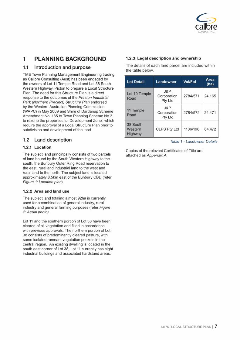
1 PLANNING BACKGROUND 1.1 Introduction and purposeTME Town Planning Management Engineering trading as Calibre Consulting (Aust) has been engaged by the owners of Lot 11 Temple Road and Lot 38 South Western Highway, Picton to prepare a Local Structure Plan. The need for this Structure Plan is a direct response to the outcomes of the Preston Industrial Park (Northern Precinct) Structure Plan endorsed by the Western Australian Planning Commission (WAPC) in May 2009 and Shire of Dardanup Scheme Amendment No. 185 to Town Planning Scheme No.3 to rezone the properties to ‘Development Zone’, which require the approval of a Local Structure Plan prior to subdivision and development of the land.
1.2 Land description
1.2.1 Location
The subject land princinpally consists of two parcels of land bound by the South Western Highway to the south, the Bunbury Outer Ring Road reservation to the east, rural and industrial land to the west and rural land to the north. The subject land is located approximately 8.5km east of the Bunbury CBD (refer Figure 1: Location plan).
1.2.2 Area and land use
The subject land totaling almost 92ha is currently used for a combination of general industry, rural industry and general farming purposes (refer Figure 2: Aerial photo).
Lot 11 and the southern portion of Lot 38 have been cleared of all vegetation and filled in accordance with previous approvals. The northern portion of Lot 38 consists of predominantly cleared pasture, with some isolated remnant vegetation pockets in the central region. An existing dwelling is located in the south east corner of Lot 38, Lot 11 currently has eight industrial buildings and associated hardstand areas.
1.2.3 Legal description and ownership
The details of each land parcel are included within the table below.
Lot Detail Landowner Vol/Fol Area (ha)
Lot 10 Temple Road
J&P Corporation
Pty Ltd2784/571 24.165
11 Temple Road
J&P Corporation
Pty Ltd2784/572 24.471
38 South Western Highway
CLPS Pty Ltd 1106/196 64.472
Table 1 - Landowner Details
Copies of the relevant Certificates of Title are attached as Appendix A.

13176 | LOCAL STRUCTURE PLAN | 8
Figure 2 - Aerial Photo

13176 | LOCAL STRUCTURE PLAN | 9
1.3 Planning framework
1.3.1 Zoning and reservations
Greater Bunbury Region Scheme
Lot 11 is predominantly zoned “Industrial” under the Greater Bunbury Region Scheme (GBRS), with a strip of land adjoining the South Western Highway reserved as “Primary Regional Road” (red road) to provide for future widening of the highway.
Following amendment 0024/41 becoming effective on 2 April 2014, Lot 38 is predominantly zoned “Industrial Deferred” under the GBRS, with a strip of land adjoining the South Western Highway reserved as “Primary Regional Road” to provide for future widening of the highway. In addition, another strip of land adjacent to its eastern boundary is also reserved as “Primary Regional Road” as part of the proposed Bunbury Outer Ring Road (BORR) reservation.
Main Roads WA and the WAPC are investigating relocation of the proposed BORR to the east of Hynes Road, which would remove the need for the “Primary Regional Road” reservation affecting the eastern portion of Lot 38. However, it is likely that portion of the existing reservation will be required for an “Other Regional Road” (blue road) reservation. Should this eventuate, then a revised Local Structure Plan or detailed area plan for the affected area may be required.
The adoption of this Local Structure Plan and subsequent demonstration of available servicing will facilitate the lifting of the “Industrial Deferred” status of Lot 38 to an “Industrial” zone by the WAPC.
Shire of Dardanup Town Planning Scheme No.3
Lot 11 is predominantly zoned “General Industry” under Shire of Dardanup Town Planning Scheme No.3 (TPS No.3), along with a strip of land adjoining the South Western Highway reserved as “Primary Regional Road” to conform to the GBRS reservation.
Lot 38 is predominantly zoned “General Farming” under TPS No.3, together with “Primary Regional Road” reservations along the southern and eastern boundaries to conform to the GBRS reservation.
Following final approval of Amendment 185 to TPS No.3, the subject properties are zoned “Development Zone” (refer Figure 3: Town planning scheme amendment).
The purpose of the ‘Development Zone’ is to ‘provide for the orderly planning of large areas of land through a comprehensive Structure Plan which is able to respond to changing circumstances throughout the developmental stages of the area’. Clause 3.15.7 Development Zone of TPS No.3 sets out the planning requirements.
Lot 10 Temple Road is zoned “General Farming”. The only portion of Lot 10 within the Structure Plan Boundary is the access leg extending along the western boundary of Lot 11 connecting to Temple Road. The Local Structure Plan indentifies the access leg as future road reserve.
1.3.2 Regional and sub-regional structure plans
Bunbury-Wellington Region Plan
The WAPC’s Bunbury-Wellington Region Plan (1995) included a Greater Bunbury Structure Plan. Under that structure plan, the subject land was mainly identified for industrial use, with mixed use buffer to the north representing transitional uses to the Eaton residential area to the north. Similarly, the Picton North planning unit identified the predominant land use as industry, with development to proceed generally in accordance with a revised Preston Industrial Park Structure Plan.
Industry 2030
In April 2000, the WAPC released Industry 2030 – Greater Bunbury Industrial Land and Port Access Planning, which drew together the outcomes of community consultation and various studies, including the Preston Industrial Park Land Use and Port Access Study.
Industry 2030 included an Interim Strategy Plan which showed Lot 11 as mainly ‘Secondary General Industry Precinct’ (small lot general industry) and Lot 38 as ‘Transitional Industry Precinct’ (Possible Technology Park). Importantly, the Interim Strategy Plan was annotated as an indicative plan pending additional technical investigations including environmental, water and drainage management and road access. Such technical studies have been carried out as part of ongoing district-level structure planning, including the DSPEA.

13176 | LOCAL STRUCTURE PLAN | 10
Figure 3 - Town Planning Scheme Amendment
(Now Approved)

13176 | LOCAL STRUCTURE PLAN | 11
Greater Bunbury Strategy
In June 2011, the WAPC published the Greater Bunbury Strategy for public comment. Under Figure 8 Greater Bunbury Structure Plan 2011-2031+, Lot 11 was identified as “industrial developed land” and Lot 38 as “residual of study area: rural (no change to land use)”. Similarly, other properties in the Preston Industrial Park that had previously been identified for future industry (such as Industry 2030) were also shown as “residual of study area: rural (no change to land use)”.
The Greater Bunbury Strategy Final Report (December, 2013) included a Greater Bunbury Sub-regional Structure Plan 2013. Lot 11 is identified as “Industrial developed land” while Lot 38 is identified as “Industrial expansion area”
WAPC (endorsed) Preston Industrial Park (Northern Precinct) Structure Plan
In May 2009, the WAPC endorsed the Preston Industrial Park (Northern Precinct) Structure Plan prepared by the Department of Planning. This plan was largely responding to the advice and recommendations from the Environmental Protection Authority (EPA), through the release of EPA Bulletin 1282 ‘Advice on areas of Conservation Significance in the Preston Industrial Park’ depicting large proportions of the Northern Precinct being retained for conservation. This represented a significant reduction in the potential area of developable land previously identified in Industry 2030.
The district structure plan also included a number of conditions and planning policy statements for various precincts. The land subject to this Local Structure Plan comprises ‘Precinct 3’ of the endorsed district structure plan and, in addition to addressing the structure plan conditions, is subject to the following planning policy statements.
The Local Structure Plan is to specifically address:
• Future development on Lot 1 (now Lot 11) to be integrated with Lot 38
• Intersection connections for the proposed new southern access road to South Western Highway
• Identify and accommodate north/south ecological linkages to the South Western Highway if required
• An internal road and landscape buffer to be provided between an individual lot and South Western Highway (i.e. no lots to back directly onto South Western Highway)
• Buffers to wetlands and remnant vegetation
• In relation to Lot 38 no direct access will be permitted onto the proposed Bunbury Outer Ring Road
• Lot sizes restricted to between 2000m2 and 2ha, however, larger lots will be considered where it can be demonstrated that the proposed landuse will comply with the cumulative impact assessment for the noise, odour and risk modeling for the Preston Industrial Park.
The detail provided by way of this Local Structure Plan substantially complies with the above policy statements and the conditions of the WAPC endorsed Structure Plan. Where there is some minor variation this is explained herein.
Preston Industrial Park (Northern Precinct) District Structure Plan and Environmental Appraisal (draft)
The draft Preston Industrial Park (Northern Precinct) District Structure Plan and Environmental Appraisal report (DSPEA) was lodged with the WAPC, Shire of Dardanup and City of Bunbury in October 2011 for review prior to public advertising.
The DSPEA was referred to the EPA for assessment and a decision by the Office of EPA (OEPA) was received that the DSPEA would be determined as an Assessment on Proponent Information (API). This is the simplest level of formal assessment and reflects OEPA feedback generally supportive of the proposal, subject to additional justification being provided on matters such as suitable arrangements for management plans for the proposed consolidated conservation area.

13176 | LOCAL STRUCTURE PLAN | 12
Resulting from a submission from Main Roads WA, the WAPC requested the proponents to make some modifications to the traffic report. In respect to the Local Structure Plan, the relevant modifications were; deletion of the proposed four-way intersection at the junction of the proposed main access road and the eastern extension of Temple Road, and improved road geometry of Temple Rod in the vicinity of the western boundary of Lot 11. Appropriate modifications were discussed with Main Roads WA and the Shire and are reflected in the revised Local Structure Plan.
There have been ongoing negotiations between representatives of the DSPEA landowners and the Department of Parks and Wildlife (formerly DEC) over suitable management arrangements for the proposed consolidated conservation area, over which it is intended DPaW will eventually take on land vesting and land management responsibility.
Currently, the DSPEA is awaiting the finalisation of the environmental assessment process and subsequent consideration of endorsement by the WAPC, City of Bunbury and Shire of Dardanup.
The Local Structure Plan for Lots 11 and 38 has been prepared taking into consideration both the WAPC endorsed District Structure Plan and the draft DSPEA and has endeavored to be consistent with both plans wherever possible.
1.3.3 Policies and strategies
State and regional policies
There is an array of adopted policy documents that contribute to the strategic planning framework for Picton East. The following sub-sections outline the key policies most directly relevant to the Local Structure Plan and demonstrate how it complies with the respective policies.
SPP 4.1: State Industrial Buffer Policy – Amended (draft)
The WAPC’s State Planning Policy 4.1 State Industrial Buffer Policy (amended draft 2009) was released for public comment. It is intended to replace the existing 2007 policy.
The objectives of the policy are to:
• avoid conflict between industry and/or essential infrastructure and sensitive land uses;
• protect industry and/or essential infrastructure from encroachment by those land uses that would be sensitive to impacts and adversely impact the efficient operations;
• provide for the development of industry and/or the provision of essential infrastructure in a way that maximises amenity, minimises environmental and health impacts and takes account of risk to nearby sensitive land uses; and
• promote compatible uses in areas affected by off-site impacts of industry and/or essential infrastructure.
The Local Structure Plan complies with these objectives by:
• incorporating essential infrastructure in the plan, proposing light and general industry (not heavy industry) and providing appropriate separation distances to sensitive land uses;
• reinforcing district-level structure planning that excludes potential encroachment of sensitive land uses;
• taking a comprehensive approach to industry and infrastructure planning; and
• supporting district-level planning that acknowledges off-site areas in transition from non-conforming uses to compatible uses (such as Picton South) and the need for managing impacts on both transitional areas and ‘permanent’ sensitive land uses (such as rural small holdings along Hynes Road).
13176 | LOCAL STRUCTURE PLAN | 13
SPP 2.9: Water Resources
In order to help achieve the objectives and policy measures under State Planning Policy (SPP) 2.9 – Water Resources , the WAPC and the Department of Water adopted Better Urban Water Management (October 2008). This framework document is designed to facilitate better management and use of urban water resources by ensuring an appropriate level of consideration is given to the total water cycle at each stage of the planning system.
The framework for how water resources should be considered at each planning stage effectively requires a water strategy or plan to accompany (and inform) the respective land use plan. In accordance with this framework, a District Water Management Strategy (DWMS) has been prepared for the DSPEA area and a District/Local Water Management Strategy (D/LWMS) has been prepared for the Local Structure Plan area (refer Appendix B).
In addition, the principles of best practice Water Sensitive Urban Design (WSUD) are embodied in the Local Structure Plan, as reflected in subdivision design, servicing, and drainage management and landscape elements.
SPP 3.4 Natural Hazards and Disasters
State Planning Policy 3.4 Natural Hazards and Disasters is based upon the principles contained in the report Planning Safer Communities (Emergency Management Australia, 2002). It applies the principles of emergency risk management to land use planning.
At Picton East the greatest risks from natural hazards are likely to be from bush fires and storm events. Flooding and drainage management are addressed under 4.4 below.
The WAPC and the Department of Fire and Emergency Services (DFES) have adopted Planning for Bushfire Protection Guidelines (Edition 2, 2010) as the principal reference document in Western Australia for fire management in subdivisions and related development in rural and urban communities.
Consideration of bush fire hazard forms part of the DSPEA. The Local Structure Plan responds to the policy and guidelines in the following manner:
• Roads separating the development area from external vegetated areas
• Providing alternative road access points
• Proposing clearing of pockets of remnant vegetation within Lot 38
• Acknowledging that building setbacks will be required at the development stage
• Anticipating that fire fighting systems will need to be provided for developments in accordance with DFES requirements
Shire of Dardanup Local Planning Strategy (draft, 2013)
In June 2013, the WAPC endorsed the draft Shire of Dardanup Local Planning Strategy for the purposes of advertising. In Plan 2.1 (Land Use Outcomes), the draft Local Planning Strategy identified Lot 38 as “Industrial” but Lot 11 was left blank. Map 5 (Native Vegetation) as advertised showed Lot 11 as “Regional Ecological Linkages” which was inconsistent with EPA Bulletin 1282 (see below) in which the Recommendation Areas included the small area in the north-west corner of Lot 11 in “Conservation Area” but did not identify the balance of Lot 11 in any of the environmental linkage areas.
Accordingly, on behalf of the owners of Lot 11, TME lodged a submission with the Shire requesting that Map 2.1 (Land Use Outcomes) be amended to show the whole of Lot 11 as “Industrial” apart from the small area of remnant vegetation in the north-west corner of the site.
The final Map 2.1 (March 2015) left Lot 11 as blank, but is is shown as “Industrial” in Map 2.0 (overview).
1.3.4 Other approvals and decisions
Strategic Environmental Advice
In March 2008, the EPA released Bulletin 1282 Advice on areas of conservation significance in the Preston Industrial Park. This bulletin represents the EPA’s advice to the Minister for Environment under Section 16(e) of the Environmental Protection Act 1986.
The bulletin represents the environmental policy statement for the wider Preston Industrial Park from the Australind Bypass in the north to the Moore Road industrial area in the south.
As mentioned above, Bulletin 1282 identified the small area in the north-west corner of Lot 11 as “Conservation Area” but did not include the balance of Lot 11 in any recommended regional conservation or environmental linkage area.
Bulletin 1282 is further discussed in the following section.

13176 | LOCAL STRUCTURE PLAN | 14
2 SITE CONDITIONS AND ENVIRONMENT
2.1 Environmental assets and constraints
2.1.1 Regional environmental setting
The Preston Industrial Park is located within the ‘Constrained Area’ as defined in the EPA’s Bulletin 1108 Report and recommendations on the Greater Bunbury Region Scheme (EPA, 2005). The EPA’s objective within the constrained area is to:
• Retain at least 10% of the pre-clearing extent of the ecological community in the ‘Constrained Area’ of the Greater Bunbury Region where no greater than 10% of the ecological community remains on the Swan Coastal Plain (the natural region); or
• Retain all remaining areas of each ecological community in the ‘Constrained Area’ of the Greater Bunbury Region where 10% or less than 10% of this ecological community remains on the Swan Coastal Plain.
The EPA reflected the above objective in Bulletin 1282 Advice on areas of conservation significance in the Preston Industrial Park (EPA, 2008). Key environmental factors that received detailed evaluation in Bulletin 1282 were:
1. Native Vegetation and Flora;
2. Native Fauna;
3. Wetlands and Waterways (Preston and Ferguson Rivers); and
4. Ecological Linkage.
Detailed investigation was undertaken within 25 Investigation Areas. Resulting from the investigations, Bulletin 1282 identified a series of Recommendation Areas that were regarded as “regionally significant natural areas that should be retained in future planning for the Preston Industrial Park”. The Recommendation Areas fall within three categories:
• Conservation Areas – regionally significant natural areas of highest conservation value that the EPA recommends be retained as Regional Open Space as a future amendment to the GBRS and appropriately managed for conservation purposes;
• Subdivision/Rezoning Protection – also considered by the EPA to be regionally significant natural areas of high conservation value which should be retained and protected as part of any future rezoning, subdivision or development, whichever comes first; and
• Linkage-Enhancement or Restoration – identified by the EPA as areas for enhancement (where some natural values remain) or restoration (where little or no natural values remain) in strategic locations between the Conservation and Subdivision/Rezoning Protection areas that contribute to regionally significant ecological linkage.
Bulletin 1282 and its Recommendation Areas are substantially reflected in the DSPEA, along with an Environmental Protection and Enhancement Package (EPEP) to create a large, consolidated conservation and ecological linkage area and containing measures to ensure its long term management.
2.1.2 Local environmental setting
The Recommendation Areas in Bulletin 1282 (EPA, 2008) show the following in relation to the Local Structure Plan area:
• Conservation Areas – comprising a large consolidated area of some 233ha to the north and west of Lot 11 and Lot 38, plus including a small area in the north-western corner of Lot 11; and
• Restoration Areas – identified over the “linkage” area to the south-west of the Temple Road ‘dog leg’ to provide an ecological linkage between the Conservation Area north of Temple Road and Restoration, Protection and Conservation Areas to the south of the South Western Highway.
Apart from the small area in the north-western corner of Lot 11, none of the Local Structure Plan area is included in any Recommendation Area in Bulletin 1282.

13176 | LOCAL STRUCTURE PLAN | 15
Ekologica and GHD have carried out environmental assessments of Lot 38 (described below) which identified limited environmental value in the remaining remnant vegetation. However some of the remaining vegetation has potential fauna habitat value, hence the EPEP as part of the DSPEA recommends protection and rehabilitation within the proposed consolidated conservation area to offset proposed clearing within the planned industrial area. The vegetation area within the northern portion of Lot 38 proposed to be cleared as part of future subdivision and development comprises multiple scattered remnants that total some 8.5 ha.
2.1.3 Flora and vegetation
The vegetation of Lot 11 and Lot 38 is part of the Pinjarra and Bassendean vegetation complexes. The Bassendean complex has been mapped as a mosaic of Medium forest of jarrah-marri , Low woodland of banksia and Low forest of tea tree (Melaleuca spp.) and the Pinjarra complex as a Medium woodland; jarrah, marri and wandoo (Shepherd et al., 2002).
The original vegetation communities (floristic vegetation types) existing on Lot 11 and Lot 38 would have been “Corymbia calophylla-Xanthorrhoea preissii woodlands and shrublands” and “Dense shrublands on clay flats” on the Pinjarra Plain soils (both of these are now threatened communities), and “Central Banksia attenuata-Eucalyptus marginata woodlands” on the Bassendean Sands soils.
However, Lot 11 is almost completely cleared, with the exception of the southern frontage to the South Western Highway (comprising a degraded strip of Melaleuca) which is reserved as “Primary Regional Road” and a small pocket of Marri woodland in the north-western corner of the lot.
The remnant vegetation on the southern portion of Lot 11 and on the northern portion of Lot 38 is now so degraded that it could not be considered to belong to the original communities.
The condition of all the remnant vegetation on Lot 38 is “Very Poor” (Kaesehagen, 1995). Less than 20% of the original native flora species remain, the original vegetation structure, in general, has disappeared and the incidence of disturbance is (or has been) high.
In 2008, a survey of flora and vegetation on Lot 38 was carried out by inspecting each of the areas of remnant native vegetation on Lot 38 on 29th October 2008 and recording the species of native flora and the dominant weed species and taking photographs of the vegetation (Ekologica, 2008).
The survey revealed only 23 species of native flora on Lot 38 and two of these were only present along the western boundary. This is a very low number of species for the 6 ha of remnant vegetation but is accounted for by the fact that all of the vegetation is open to access by livestock and has apparently been grazed for many years. Only 10 of the taxa are understory species, most of the ground layer in the pieces of remnant vegetation is composed of weed species such as *Ehrharta calycina (Perennial Veldt Grass), *Lotus subbiflorus, *Ursinia anthemoides, *Lolium perenne and species of *Rumex (Dock). No Declared Rare or Priority flora was found refer Appendix B.
Because of its highly degraded character, Ekologica concluded that the remnant vegetation on Lot 38 has little conservation value.
GHD undertook a site assessment on the northern 31 ha of Lot 38 in October 2010 (refer Appendix B). This assessment confirmed that the area is disturbed and predominantly consists of scattered trees over pasture, weeds and some sedges. The vegetation was found to have a condition rating of 5-6 based on the Bush Forever vegetation condition rating and according to GHD can reasonably be regarded as having little conservation value. There were no native flora species found in the GHD study that had not already been identified on this site by Ekologica (2008).
2.1.4 Terrestrial fauna
The site assessment undertaken by GHD in 2010 found a number of bird species to be present in the study area. There were also sightings of Western Grey Kangaroos on the site and evidence of other fauna species having been present.
The remnant vegetation showed evidence of cockatoo feeding and possum droppings. There was one possum drey located on the site, although this appeared to be old and disused. There were a number of possible Cockatoo habitat trees. These findings suggest that this area could provide feeding areas and habitat for native species including the vulnerable Forest Red-tailed Black Cockatoo, Baudin’s Black Cockatoo and Western Ringtail Possum and for the endangered Carnaby’s Black Cockatoo.
GHD observed that the degraded state of the remnant vegetation compared to the native vegetation of neighbouring blocks suggests that Lot 38 is only providing secondary habitat for the surrounding core habitat.

13176 | LOCAL STRUCTURE PLAN | 16
2.1.5 Geomorphic wetlands
The Department of Environment Regulation (DER) Geomorphic Wetlands Swan Coastal Plain data set classifies wetlands using a geomorphic wetland classification system. This classification system is based on characteristics of landform and water permanence (e.g. lake, sumpland, dampland and palusplain). Wetlands are also assigned an appropriate management category to provide guidance on the nature of the management and protection the wetland should be afforded (i.e. Conservation Category, Resource Enhancement and Multiple Use).
Broad wetland management objectives for the various categories are as follows:
• Conservation Category Wetlands are wetlands with high conservation value for both natural or human use. The principal objective is to preserve natural wetland attributes and functions.
• Resource Enhancement Wetlands are wetlands with moderate natural and human use attributes that can be restored or enhanced. The principal objective is to restore wetlands through maintenance and enhancement of wetland functions and attributes
• Multiple Use Wetlands are wetlands that score poorly on both natural and human use attributes. The principal objective is to use, develop and manage wetlands in the context of water, town and environmental planning.
The DSPEA shows that there are no Conservation Category Wetlands or Resource Enhancement Wetlands in the vicinity of the Local Structure Plan. The Multiple Use Wetland area within Lot 38 predominately comprises pasture and weeds and does not have significant environmental value. There is also a degraded Multiple Use Wetland outside the western boundary of Lot 11 and another Multiple Use Wetland approximately 50m from the north-west corner of Lot 38.
There is normally no recommended minimum separation distance between urban development and a Multiple Use Category wetland because such wetlands generally are quite degraded and may be weed infested due to their existing use and/or
lack of management. The likelihood of having any attributes that require protection through imposition of a buffer is therefore low. Accordingly, it is anticipated that the majority of general industrial development proposals affecting Multiple Use Category wetlands can be designed and managed to meet the DER management objective.
Environmental investigation of Lot 10 to the immediate north of Lot 11 has shown the existence of a non-classified wetland and associated remnant vegetation. Both the DSPEA and the Local Structure Plan propose to conserve and enhance the wetland as part of the consolidated conservation and ecological linkage area, including setting aside a small area of bushland conservation and rehabilitation in the north-west corner of Lot 11. It is intended that portion of the previously cleared land in this area be rehabilitated to contribute to the wetland and environmental linkage function.
For the degraded wetland west of Lot 11, it is intended to direct some of the treated stormwater flow from Lot 11 into the wetland to help restore some of its previous wetland values. This wetland will be revegetated to assist with enhancing this wetland’s ecological functioning. Reference should also be made to section 4.4.
2.2 Landform and soils
2.2.1 Landform and soils
In its natural state, the land was generally flat and partially low lying. Lot 11 and the southern portion of Lot 38 have been filled following approvals to a fill level of 12.8 – 13m AHD. Lot 38 reaches its highest point in the northern portion of the property.
Soils of the subject land belong to the Pinjarra Plain and Bassendean Sands soil-landscape sub-systems. The Pinjarra Plain soils occupy the lower parts of the study area in depressions and a shallow drainage line, with the Bassendean Sands forming small ridges and hillocks. The Pinjarra Plain soils are generally yellow or grey-brown earths, or dark cracking clays and the Bassendean Sands are moderately deep to deep bleached sands (McArthur, 1991).

13176 | LOCAL STRUCTURE PLAN | 17
2.2.2 Acid sulfate soils
Acid Sulfate Soils (ASS) are formed naturally, typically under waterlogged iron and sulfate rich conditions of coastal lowlands where the land has been subjected to inundation by sea or estuary water. These soils contain iron sulfide minerals (most commonly pyrite) or their oxidation products, with the result being the formation of sulphuric acid and the release of iron, aluminium and other heavy metals and nutrients from soils into surface water bodies and groundwater.
The majority of the site is identified in WAPC Planning Bulletin 64 Acid Sulfate Soils as having a low to moderate risk of ASS within 3m of the natural soil surface or deeper.
A Preliminary Acid Sulfate Soil Investigation including 24 test pits to a depth of 2.5m was undertaken for Lot 38 (Brown Geotechnical and Environmental, 2008). The pH ranged from 4.4 to 8.9 overall samples and pH both increased and decreased with depth. Generally the acidity was relatively uniform throughout the profile. The preliminary investigation concluded it is likely that ASS are present across the site and laboratory sampling also showed that the soils below 1.5m had a high potential for acid generation. Brown recommended treatment of any disturbed soils and that a detailed ASS Management Plan should also be produced for areas where soil is to be excavated to 3m or where it will intercept the groundwater.
2.3 Groundwater and surface water
2.3.1 Groundwater
In its natural state prior to filling, the southern portion of the subject land had a seasonally high water table and was considered dampland and palusplain. Monitoring bores have indicated that, prior to filling, the depth to groundwater (superficial aquifer) during the period of highest groundwater varied from above the natural surface to 0.6m below ground level. Most of Lot 11 and the southern portion of Lot 38 have now been filled to approximately 1m above the seasonally high groundwater table.
Neither of the underlying confined Leederville and Yarragadee aquifers is known to express into the superficial aquifer on the site.
A more detailed description of groundwater and management of impacts from the proposed Local Structure Plan is contained in the District/Local Water Management Strategy (refer Appendix B).
2.3.2 Surface water
The main surface water feature on site is the Vindictive Sub B drain. This drain is contained within an existing drain reserve through Lot 11 which is managed by the Lot owners. It then crosses Lot 38 (although there is no formed drain reserve) before heading north east to join the Vindictive Main Drain just to the east of the subject land. This drain then flows to Millars Creek which joins the Collie River. In large rainfall events there is some temporary back flooding into a wetland that adjoins the site to the west.
There are no wetlands of significance on the site, although the majority of the southern portion of the site was considered Multiple Use wetland prior to filling.
A more detailed description of surface water and proposed management is contained in the District/Local Water Management Strategy (refer Appendix B).
13176 | LOCAL STRUCTURE PLAN | 18
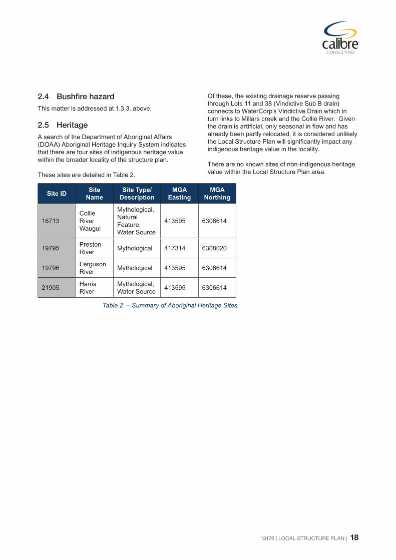
2.4 BushfirehazardThis matter is addressed at 1.3.3. above.
2.5 HeritageA search of the Department of Aboriginal Affairs (DOAA) Aboriginal Heritage Inquiry System indicates that there are four sites of indigenous heritage value within the broader locality of the structure plan.
These sites are detailed in Table 2.
Site ID Site Name
Site Type/Description
MGA Easting
MGA Northing
16713Collie River Waugul
Mythological, Natural Feature, Water Source
413595 6306614
19795 Preston River Mythological 417314 6308020
19796 Ferguson River Mythological 413595 6306614
21905 Harris River
Mythological, Water Source 413595 6306614
Of these, the existing drainage reserve passing through Lots 11 and 38 (Vindictive Sub B drain) connects to WaterCorp’s Vindictive Drain which in turn links to Millars creek and the Collie River. Given the drain is artificial, only seasonal in flow and has already been partly relocated, it is considered unlikely the Local Structure Plan will significantly impact any indigenous heritage value in the locality.
There are no known sites of non-indigenous heritage value within the Local Structure Plan area.
Table 2 – Summary of Aboriginal Heritage Sites

13176 | LOCAL STRUCTURE PLAN | 19
3 CONTEXT AND CONSTRAINTS ANALYSIS
3.1 Existing services The subject land is currently serviced by reticulated water and has access to power and telecommunications. Aqwest has sized the existing water main near Lot 11 to allow for reticulated supply to the whole of the Picton East area.
The power supply can be expanded as required, similar to the transformer that has already been installed in the south-western corner of Lot 11 to service the existing sheds and proposed development in the vicinity. The DSPEA servicing report has indicated that the existing Bunbury and Picton power schemes (zone substations) are heavily loaded and that the major power increase required for full development of the DSPEA area could require upgrades.
Possible options include installing an additional transformer at the Picton Zone substation or a new zone substation within the DSPEA. Western Power would need a parcel of approximately 1 hectare for the latter option. This matter is not limited to the Local Structure Plan area and will need to be addressed by proponents and Western Power as part of the overall implementation of the DSPEA.
There are currently two powerlines that transverse Lot 38; these consist of a 132kV line which runs in an east-west direction through the central portion of the property and a 66kV line which cuts through the south eastern corner of the site. The 132kV line requires an easement of between 18 and 36 meters depending on the form of construction. Construction of roads can generally occur to approximately 5 meters of the poles. Parking and hardstand areas can also be built under the lines where they are in easements in lots. The 66kV distribution line will also require an easement of 18 meters as it is a single pole configuration, although it will likely be relocated into road reserves in the development of Lot 38 so that it doesn’t constrain the lot layouts.
At present there is no capacity in the existing medium pressure gas system serving Glen Iris or Eaton to be extended to service the Local Structure Plan area.
There is a high pressure gas main running along Hynes Road to the east and another running along the Picton-Dardanup Road to the south. These mains are expected to have a sufficient capacity to service the site if required but would need a pressure-reducing set and extension of distribution infrastructure to provide reticulated gas to the site.
Gas is not essential to industrial estates and other nearby estates do not have a gas connection. Gas for particular industries can also be supplied via storage tanks replenished by tankers. It is proposed that connection of proposed industrial lots in the area to a reticulated gas supply be a matter for investigation by the landowner at the subdivision stage.
There is presently no reticulated sewerage available to the subject land and the nearest sewer pump station is located at Glen Iris. The District Strucutre Plan requires reticulated sewerage to all industrial lots and it is envisaged that a co-ordinated approach involving contributions from the various landowners will be required in order to make connection to reticulated sewerage viable.
For this Local Structure Plan, it is proposed to include the following condition on the Local Structure Plan map:
“Reticulated sewerage connection to all lots, unless otherwise determined by the WAPC”
3.2 Surrounding land usesLand uses to the north and west of the subject land comprise proposed industrial or conservation areas under the DSPEA. Lying between the South Western Highway reservation and the South West Main Railway line to the south is the “Picton Central” area which has various small rural properties and a caravan park. This area is zoned for industry and requires a separate structure plan to guide its transition to an industrial area. Existing non-industrial land uses may be entitled to a non-conforming use right providing they were lawful uses prior to the area being zoned for industry.
To the east of the proposed industrial land lies the existing Primary Regional Road reservation for the proposed BORR, although it is likely this will be downgraded to an “Other Regional Road” reservation, with the BORR reservation being relocated to the east of Hynes Road. Between the existing BORR reservation and Hynes Road there are a number of rural residential small holdings. Although some distance away from the proposed industrial lots, the location of dwellings and other sensitive receptors will need to be taken into account at the time of development applications and assessment. Particular uses may require specific investigations such as acoustic modelling to ensure the Environmental Protection (Noise) Regulations are adhered to.

13176 | LOCAL STRUCTURE PLAN | 20
4 LOCAL STRUCTURE PLANThis section of the report describes the proposed Local Structure Plan and associated design approaches (refer Figure 4: Local Structure Plan). The section demonstrates how planning and design for the site responds to the context described in the preceding sections.
4.1 Design Principles The following design principles underpin development of the structure plan and are intended to provide a design rationale for on-going design of the area:
• Integration between Lots 11 and 38 and with the overall DSPEA
• A permeable and connected road structure able to accommodate light vehicles, heavy industrial trucks and predicted traffic flows
• Roads providing hard edge separation from the DSPEA conservation area
• Conservation/re-vegetation area consistent with the consolidated DSPEA conservation area
• Fully integrated with a comprehensive District/Local Water Management Strategy featuring on-site detention and treatment and landscaped swales and integrated basins
Variety of lot sizes ranging from approximately 2000m² to 2.0ha predominantly for general and light industrial uses, along with limited additional uses.
4.2 Land UseThis section explains the District Structure Plan – demonstrating the overall proposed land uses and how the design principles are achieved in the structure plan. Table 3 summarises the main proposed land uses.
Total area covered by structure plan 92.10haGeneral Industry (1) 47.97haLight Industry (1) 10.65haPOS/conservation 5942m²Estimated Lot Yield 100Approx. Minimum Lot Size 2000m²Approx. Maximum Lot Size 2.0haAverage Lot Size 5000-8000m²Estimated employment (2) 350-750 jobs
(1) Excludes roads(2) Based on 0.215 – 0.1 Ha/employee of gross site.
Table 3 - Structure Plan Summary Table.

Interim Drain
Hardstand Area
Access to
Existing Crossover
SOUTHWESTERN
HIGHWAY
32m Wide Road Reserve
32m Wide Road Reserve
32m Wide Road Reserve
20m Wide Road Reserve
20m Wide Road Reserve
25m Wide Road R
eserve
25m Wide R
oad Reserve
32m Wide Road Reserve
RO
AD A
RO
AD B
20m Wide R
oad Reserve
20m Wide R
oad Reserve
TE
MPLE R
OA
D (N
ORTH)
ROADTAVENER
TE
MPLE R
OA
D (S
OUTH)
TEMPL
E ROAD (
EAST)
Lot 11
Lot 10 Lot 38
(32 metre total)
Taverner Road is to have a minimum road reserve width of 25 metres without roadside drainage 18.
Austroads design standards.
Minimum road geometry radii at road bends to accommodate industrial freight vehicles, as per 17.
subdivision are to be constructed as through roads only (cul-de-sacs are not supported).
time of subdivision is to be funded by the subdividers of Lot 11. All roads associated with staged
All costs associated with construction of Temple Road (north) as a public road reserve at the 16.
subdivider.
when the Temple Road (East) and a new intersection with the Highway is built, at the cost of the
The existing Temple Road (south) and intersection with the South Western Highway to be closed 15.
General Industrial uses are supported.14.
Building setback lines are to be determined by the fire management plan.
Services. The bushfire Hazard Separation Zone is to be contained within the structure plan area.
prior to subdivision and/or development to the satisfaction of the Department of Fire and Emergency
A fire management plan including the provision of fire suppression measures shall be addressed 13.
condition of development.
difficulties in complying with this modeling may be required to undertake further modeling as a
of the WAPC for the Preston Industrial Park. At the time of development any proposal that may have
Development of industries shall comply with air, noise and risk modeling undertaken on behalf 12.
the subdivider and maintained by future landowners.
development and create an aesthetic approach to the city. The landscaping is to be established by
established on private lots alongside the South Western Highway to minimize the visual impact of
the subdivisional road. The LDP will also state that appropriate landscaped screening is to be
by the future landowners. Alternatively, the subdivider could construct a service road alongside
state that reciprocal rights of accessways are to be constructed by the subdivider and maintained
required prior to subdivision and/or development of the land. The Local Development Plan will
For proposed lots adjoining the South Western Highway a Local Development Plan or similar is 11.
Roads Western Australia.
upgraded prior to subdivision and/or development to the specification and satisfaction of Main
The intersection of the proposed main access road and the South Western Highway shall be 10.
Aboriginal Affairs.
Guidelines’ prior to subdivision and/or development to the satisfaction of the Department of
An assessment shall be undertaken in accordance with ’Aboriginal Heritage Due Diligence 9.
clearing of the Structure Plan area to the satisfaction of the Department of Parks and Wildlife.
Fauna Management protocols shall be undertaken in prior to subdivision and/or development or 8.
satisfaction of the Department of Parks and Wildlife.
to protect native vegetation prior to subdivision and/or development to the specifications and
Suitable fencing shall be constructed adjacent to areas proposed for conservation/revegetation 7.
is 2000m†.
lot sizes, although the minimum lot size for subdivision (freehold or survey strata or strata lot)
Subdivision shall generally be in accordance with WAPC policy that provides for a variety of 6.
industrial area for dust mitigation and visual screening of development.
area. The interface treatment includes vegetated buffers along the eastern interface of the
road classification, links with Taverner Road and the interface treatment with the development
the east of Hynes Road, then the Local Structure Plan may need to be amended to reflect the new
In the event the Bunbury Outer Ring Road (Primary Regional Road) Reservation is realigned to 5.
reserves at the subdivision and/or development stage.
Power sub-stations required for the structure plan area are to be provided adjoining road 4.
otherwise determined by the WAPC.
power, reticulated sewerage and telecommunications). Reticulated sewerage to all lots, unless
All industrial lots are to be connected to urban services (i.e. reticulated water, underground 3.
regional roads is completed and the structure plan is amended, as required.
(BORR), east of Road B, will not be supported by the WAPC until the GBRS amendment process for
subdivision of industrial lots adjoining the current alignment of the Bunbury Outer Ring Road
will also need to be lifted prior to determination of a subdivision application, although
In regard to Lot 38, the "Industrial Deferred" zoning of the Greater Bunbury Region Scheme (GRBS)
endorsed by the Western Australian Planning Commission (WAPC) and adopted by the Shire of Dardanup.
Subdivision and/or development shall be generally in accordance with this Local Structure Plan 2.
objectives and requirements of the Scheme zones proposed by the structure plan.
regard when determining applications within the structure plan area, including consideration of the
This structure plan provides a basis for zoning and subdivision of land and will be given due 1.
GBRS)
Roads under the
to Other Regional
(subject to change
Outer Ring Road
Proposed Bunbury
leg of Lot 10Retain as battleaxe
End of Road B
5
5
End of Road B
Calibre Consulting (Aust) Pty Ltd
Unit 5, 53 Victoria Street
Bunbury WA 6230
Ph 08 9791 4411
www.calibreconsulting.co
0m
Copyright: This document is and shall remain the property of Calibre Consulting (Aust) Pty Ltd.
This plan has been prepared for planning purposes. Areas, contours and dimensions shown are subject to survey.
Aerial:
Co-ords:
Scale:
Rev:
Date:
250
m
Structure Plan Boundary
Existing Cadastre
General Industry
Drainage
Minor Swale Drain
Existing Buildings
Conservation/Revegetation
Future Road Reserve
Road Pavement (Indicative)
Primary Regional Road Reservation
LOCAL STRUCTURE PLAN
For Precinct 3 (Northern Precinct) of the Preston Industrial Park Structure Plan
Plan No: 13176P-SP-01J
Direct access to Road A is not permitted.
N/A
MGA
A1 @1:2500, A3 @ 1:5000
J
11.03.2016
LEGEND
SUBDIVISION AND DEVELOPMENT REQUIREMENTS
13176 | LOCAL STRUCTURE PLAN | 22
4.2.1 General Industry
The majority of the structure plan area is intended for industrial use, with a development cell configuration allowing flexibility for lots from 2,000m² to 2ha, with most lots in the 5000 - 8000m² range.
Under TPS 3, the objective for the General Industry zone is:
‘To provide for a wide range of industrial and associated activities, which can be undertaken without undue constraints on operational performance, so as to meet the needs of the wider community for industrial services and facilities.’
It is intended that this objective and other relevant scheme provisions would apply to the Industrial areas identified in the Local Structure Plan map.
4.2.2 Light Industry
Light Industrial lots are identified for the row of lots adjoining the South Western Highway reservation. These lots would suit uses needing good exposure to passing traffic and vehicles entering the estate from the south or west.
Under TPS 3, the objective for the Light Industry zone is:
‘To provide for light and service industries and associated uses.’
It is intended that this objective and other relevant scheme provisions would apply to the Light Industry areas identified in the Local Structure Plan map.
Precinct 3 of the Preston Industrial Park (Northern Precinct) Structure Plan (WAPC, 2009), includes a Planning Policy Statement to address:
‘an internal road and landscape buffer to be provided between an individual lot and South Western Highway (i.e. no lots to back directly onto South Western Highway).’
For the Light Industry precincts ‘backing’ onto the South Western Highway reservation, the intention is to provide reciprocal right of access across the rear of lots to enable integrated vehicle thoroughfare and access to the ‘effective frontage’ of buildings. A high standard of design and landscape amenity is required and it is proposed that a Local Development Plan for these lots be prepared at the subdivision and/or development stage.
4.2.3 Land Use Classifications
In addition to the Local Structure Plan area identifying both Light and General Industry use areas, it is proposed to vary the use class symbol for two use classes within the Structure Plan area. This minor departure from the TPS 3 zoning table is deemed appropriate for the location and intended style and use of the Structure Plan area.
The Structure Plan proposes to vary from the use classification of TPS 3 for the following uses relevant to the proposed Light and/or General Industry identification.
Club Premises: the land use definition of Club Premises under TPS 3 is:
‘premises used by a legally constituted club or association or other body of persons united by a common interest’
It is proposed to vary the use classification of Club Premises for the structure plan area from (‘D’) to (‘A’).
This variation will still provide the opportunity for approval of use; subject to a period of public advertising and Council approval of the application. The variation is proposed to be more in keeping with the intended industrial nature of the structure plan area (especially used by heavy vehicles and potential 24/7 industrial activities). The proposed (‘A’) classification symbol will provide the opportunity for nearby businesses and landowners to comment on any club premise applications prior to a Council decision.
Dry Cleaning Premises: the land use definition of Dry Cleaning Premises under TPS 3 is:
‘premises used for cleaning of garments and other fabrics by chemical processes’
Dry Cleaning Premises is listed as not permitted (‘X’) under Light Industry of TPS 3. Due to the Local Structure Plan area consisting primarily of General Industry uses and located within a larger Industrial park precinct, it is considered reasonable to provide potential developers the opportunity to locate within the Light Industry or General Industry areas of the Structure Plan area. Dry Cleaning Premises are likely to be compatible with other uses in the Light Industry area, hence (‘D’) is proposed.

13176 | LOCAL STRUCTURE PLAN | 23
The below table identifies the current TPS 3 use classifications and the classifications proposed for the nominated uses within Structure Plan area.
Use Class Use Classification under TPS 3
Classification Proposed as part of Local Structure Plan
Light Industry
General Industry
Light Industry
General Industry
Club Premises D D A A
Dry Cleaning Premises
X P D P
Table 4 - Modified Use Classification Table
4.2.4 Conservation
The Conservation/Revegetation area identified on the Local Structure Plan map reflects the DSPEA and EPA Bulletin 1282 and forms part of the consolidated conservation area and regional ecological linkage.
Remnant vegetation in the area is to be protected and supplemented with revegetation of the minor cleared portions. The area is to be separated from the industrial lots by road reserve which will include a drainage swale that will capture and treat possible pollutants that would otherwise reach the conservation area.
The Preston Industrial Park (Northern Precinct) Structure Plan (WAPC, 2009) Planning Policy Statements for Precinct 3 includes a provision for a Local Structure Plan to:
“Identify and accomodate North/South ecological likages through to the South Western Highway if required.”
Existing clearing of Lots 11 and 38 renders a North/South ecological linkage impractical however the draft DSPEA proposes a North/South ecological linkage to the West of Lot 11. This linkage conforms with the EPA recommendations in Bulletin 1282.
4.3 Movement networks
4.3.1 Road hierarchy
The road hierarchy reflects the Uloth district traffic analysis for the DSPEA, including 25m connector roads and 20m internal roads. Exceptions are the proposed 30m road reserves designed to
accommodate large landscaped drainage swales as part of the D/LWMS and turning movements for large (B-Double) trucks.
The 32m width is based on 12m wide gate openings into individual lots. These taper out wider to the road pavement edge to accommodate B-Double movements in and out of lots.
The internal road layout has been modified to exclude 4-way intersections which may have required large roundabouts. Instead, 3-way intersections minimise traffic conflict points.
4.3.2 Intersection and road upgrades
Main Roads WA has provided specifications for upgrading the design of the central road intersection with the South Western Highway. The Local Structure Plan accommodates this. All internal road carriageways have the potential to be built to 9-10m width, together with 25m (minimum) radius corners suitable for large vehicles. Where appropriate, future road extensions have been identified to provide flexibility for future internal and external connections proposed under district structure planning.
In the event the BORR (‘Red Road’) reservation is replaced by an Other Regional Road (‘Blue Road’) reservation then the eastern portion of the Local Structure Plan may require re-design to suit the revised reservation. A suitable condition is proposed for the Local Structure Plan map to reflect this.
4.3.3 Traffic modelling
The Local Structure Plan conforms to the Uloth traffic modelling for the DSPEA which has been assessed by Main Roads WA, the Department of Planning and the Shire of Dardanup (refer Appendix B).
4.3.4 Public transport
Public transport is not a usual requirement for industrial structure plans, however the reserve and pavement widths and layout of the road structure is suitable to accommodate a bus route.
4.3.5 Cycling and pedestrians
Provision of dual use paths is not a usual requirement for industrial structure plans, however the provision for wide road carriageways allows for commuting cyclists. One side of road reserves is intended to contain a drainage swale, but the opposite side will be available for pedestrians.
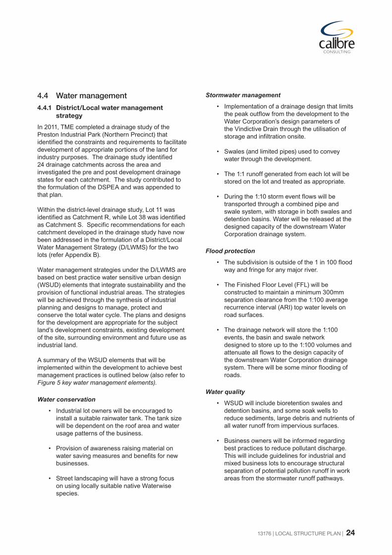
13176 | LOCAL STRUCTURE PLAN | 24
4.4 Water management
4.4.1 District/Local water management strategy
In 2011, TME completed a drainage study of the Preston Industrial Park (Northern Precinct) that identified the constraints and requirements to facilitate development of appropriate portions of the land for industry purposes. The drainage study identified 24 drainage catchments across the area and investigated the pre and post development drainage states for each catchment. The study contributed to the formulation of the DSPEA and was appended to that plan.
Within the district-level drainage study, Lot 11 was identified as Catchment R, while Lot 38 was identified as Catchment S. Specific recommendations for each catchment developed in the drainage study have now been addressed in the formulation of a District/Local Water Management Strategy (D/LWMS) for the two lots (refer Appendix B).
Water management strategies under the D/LWMS are based on best practice water sensitive urban design (WSUD) elements that integrate sustainability and the provision of functional industrial areas. The strategies will be achieved through the synthesis of industrial planning and designs to manage, protect and conserve the total water cycle. The plans and designs for the development are appropriate for the subject land’s development constraints, existing development of the site, surrounding environment and future use as industrial land.
A summary of the WSUD elements that will be implemented within the development to achieve best management practices is outlined below (also refer to Figure 5 key water management elements).
Water conservation
• Industrial lot owners will be encouraged to install a suitable rainwater tank. The tank size will be dependent on the roof area and water usage patterns of the business.
• Provision of awareness raising material on water saving measures and benefits for new businesses.
• Street landscaping will have a strong focus on using locally suitable native Waterwise species.
Stormwater management
• Implementation of a drainage design that limits the peak outflow from the development to the Water Corporation’s design parameters of the Vindictive Drain through the utilisation of storage and infiltration onsite.
• Swales (and limited pipes) used to convey water through the development.
• The 1:1 runoff generated from each lot will be stored on the lot and treated as appropriate.
• During the 1:10 storm event flows will be transported through a combined pipe and swale system, with storage in both swales and detention basins. Water will be released at the designed capacity of the downstream Water Corporation drainage system.
Flood protection
• The subdivision is outside of the 1 in 100 flood way and fringe for any major river.
• The Finished Floor Level (FFL) will be constructed to maintain a minimum 300mm separation clearance from the 1:100 average recurrence interval (ARI) top water levels on road surfaces.
• The drainage network will store the 1:100 events, the basin and swale network designed to store up to the 1:100 volumes and attenuate all flows to the design capacity of the downstream Water Corporation drainage system. There will be some minor flooding of roads.
Water quality
• WSUD will include bioretention swales and detention basins, and some soak wells to reduce sediments, large debris and nutrients of all water runoff from impervious surfaces.
• Business owners will be informed regarding best practices to reduce pollutant discharge. This will include guidelines for industrial and mixed business lots to encourage structural separation of potential pollution runoff in work areas from the stormwater runoff pathways.

13176 | LOCAL STRUCTURE PLAN | 25
Figure 5 - Key Water Management Elements
TOTAL FLOW THROTTLED TO WATER CORPORATION RURAL DRAIN STANDARD
WETLAND REHABILITATED WITH APPROPRIATE NATIVE SPECIES
APPROXIMATELY 4141m³ STORED IN CATCHMENT ‘E’ WETLAND ~0.62m DEEP IN 1:10 ARI EVENT
GROUND WATER CONTROLLED THROUGH FILL AND SUBSOIL SYSTEM CONNECTED TO SWALES
PRECINCT 5
PRECINCT 4
BASINS TO INCLUDE BIORETENTION MEDIA AND WETLAND PLANTS TO IMPROVE WATER QUALITY AND PROVIDE NEW WETLAND HABITAT
SURFACE FLOW DIRECTION
SUBJECT LAND
EXISTING CADASTRE
PROPOSED LOTSPOTENTIAL SMALLER LOTS
PRIMARY REGIONAL ROAD RESERVATION
BASIN AND SWALES
1:10 STORAGE
POST DEVELOPMENT SUB-CATCHMENT BOUNDARY
PRECINCT 4 BOUNDARY
SUB CATCHMENT NAME
MINOR SWALE DRAIN
S-C
PRECINCT 5 BOUNDARY
LEGEND

13176 | LOCAL STRUCTURE PLAN | 26
Groundwater management
• Inflows to the groundwater will be treated using bioretention swales and basins, as well as approved ATU units.
• Filling building and infrastructure sites where necessary so that adequate clearance is maintained to the controlled ground water level (CGL).
• Installation of sub-surface drainage pipe network at or very close to the AAMGL to control groundwater from rising above this level.
• Monitoring of the groundwater levels and quality post development to satisfy engineering and Department of Water requirements.
• Use of soil amelioration products and treatment of water prior to infiltration, and ensuring that the surface water infiltrating into the groundwater is of an appropriate quality.
A more detailed description of proposed water management for the Local Structure Plan is contained in the District/Local Water Management Strategy (refer Appendix B).
4.5 Landscape managementAs indicated in 4.4 above, there is a strong correlation between the D/LWMS and landscape management of the Local Structure Plan area. Drainage basins are to include bioretention media and wetland plants to improve water quality and provide new ephemeral wetland habitat. Most of the drainage swales are proposed to be located at the front of lots (not the rear) hence high quality design, construction and planting of suitable endemic plant species is necessary for drainage function and attractive landscape and streetscape amenity.
Figure 6 shows a cross-section representing the landscape and drainage treatment of the front setback of a typical industrial allotment and 30m road reserve showing landscape planting.
Landowner commitments include:
• Planting of vegetation within the swales and basins with appropriate local native plants and maintenance of the plants until handover to the Shire
• Encouraging ‘structural separation’ elements to be included within all industrial and mixed business buildings
• Water sensitive landscaping of the streetscape including use of suitable native species that require minimal to no irrigation once established with a focus on species choice, mulching and regular maintenance
• Providing lot purchasers with information and guidelines regarding appropriate landscaping, water sensitive urban design and Waterwise practices
• Urban Water Management Plans (UWMP) will accompany all relevant subdivision development proposals covered by this D/LWMS, as part of the subdivision conditions.
• Detailed Area Plan or design guidelines for proposed lots adjoining the South Western Highway reservation.
4.6 EmploymentEstimating employment likely to occur in a general industrial estate is difficult due to significant uncertainty in the range, type and size of businesses that will develop over time. A 2009 report Preston Industrial Park (Northern Precinct) Structure Plan Economic and Social Analysis (Syme Marmion & Co, 2009) observed that the Bunbury industrial employment density at that time was 0.215 occupied hectares per employee. Comparisons were made with established industrial estates in the Perth metropolitan area, specifically Kewdale, Forresfield and Hazelmere. Syme Marmion assumed that the DSPEA area would develop along similar lines and concluded that the existing Bunbury employment density ratio of 0.215 ha/employee be taken as the base case.
The Syme Marmion employment ratio and comparison with selected Perth industrial estates was based on the likelihood that the DSPEA area would have a significant interaction with port activities, including transport and logistics, as well as servicing of the resources industry and general industry activities. Whilst this expectation remains valid, recent experience with businesses established in the DSPEA area is that they have an employee ratio noticeably higher than 0.215 occupied hectares per employee. Given this, and the proposed inclusion of a number of smaller Mixed Business lots, it is considered likely that the ratio of occupied hectares per employee could easily range from 0.215 to 0.1. Based on the local structure plan area of 74.83ha, this indicates estimated employment could be 350-750 jobs.

13176 | LOCAL STRUCTURE PLAN | 27
Figure 6 - Road and Swale Cross Section
4m
Park
ing
10m
32
m R
eser
ve
5m
Allo
tmen
t rai
ngar
den
plan
ted
with
ap
prop
riate
nati
ve
spec
ies
Swal
e pl
ante
d w
ith n
ative
se
dges
and
shru
bs
Lot b
ound
ary
Lot b
ound
ary
Build
ing
line
1m7m
Verg
e
land
scap
ing
NO
T TO
SCA
LE
9m
Carr
iage
way
2mVerg
e
4.5m
4.5m
3m2m

13176 | LOCAL STRUCTURE PLAN | 28
4.7 Infrastructure coordination, servicing and staging
4.7.1 Implementation and funding
Wherever possible, infrastructure and servicing will be co-ordinated with the DSPEA. Although water and telecommunications connections can be readily achieved, the capacity of power supplies and connection to reticulated sewer is more difficult.
Possible options for power supply include installing an additional transformer at the Picton Zone Substation and supplementing it from the Bunbury Zone Substation or developing a new zone substation in the Picton North area. If so, a land parcel of approximately 1ha would be required.
The nearest sewer pump station is in Glen Iris. Preliminary planning by Water Corporation is for two new pump stations in the Picton West portion of the DSPEA and one pump station in Picton East. These could possibly share a pressure main linking back to Glen Iris, in cooperation with fellow DSPEA landowners (refer Figure 7 Possible shared sewer pressure main).
The proponents of this Local Structure Plan are aware of the WAPC policy requirement for reticulated sewerage connection to all industrial lots, unless otherwise determined by the WAPC. Accordingly, any proposal for unsewered industrial lots will require appropriate justification and permanent provisions limiting uses to dry industries (as provided for under TPS 3). The proponents will investigate the feasibility of sewer connections at the time of subdivision.
4.7.2 Timing and staging
Subdivision and development of both Lot 11 and Lot 38 will be staged according to market demand. Lot 11 and Lot 38 both have immediate development intentions as evident with existing works on site gained through previous approvals. The rate of subdivision and development will be largely market-driven.
4.8 Developer contribution arrangements
The WAPC’s State Planning Policy (SPP) 3.6 Development Contributions for Infrastructure provides that, where local governments are seeking development contributions beyond the standard provisions outlined in Appendix 1 of the SPP, they must be supported by a development contribution plan which identifies the need for such infrastructure for the relevant development contribution area or by a voluntary agreement between a developer and the relevant local government.
The participating landowners in the overall DSPEA (through Landcorp) have engaged an independent consultant to investigate a possible shared contribution plan for implementation of the DSPEA over and above the matters normally conditioned as part of individual proponent subdivision and or development approvals. Such plan will need to be approved by the Shire of Dardanup and the WAPC as appropriate.
In conclusion, it is hoped that the Local Structure Plan is embraced by stakeholders and the community as a driving force for the future of the Preston Industrial Park (Northern Precinct) and provides a constant reference for achieving that vision.

13176 | LOCAL STRUCTURE PLAN | 29
Figure 7 - Possible Shared Sewer Pressure Main

APPENDIX ACERTIFICATES OF TITLE

JOB 47954574Mon Jun 8 15:39:23 2015


APPENDIX BTECHNICAL APPENDICES
(INCLUDED ON C.D.)

Technical Appendices index
No. Document title
Approval required or supporting document
Approval agency Approval status
1Preston Industrial Park (Northern Precinct) District Structure Plan and Environmental Appraisal
Required
EPA
WAPC
LGAs
API environmental assessment lodged with EPA. Updated DSP to be assessed by WAPC and LGA’s
2 Report on a Spring Flora and Vegetation Survey of Lot 38 Picton Supporting N/A Considered by EPA
as part of DSPEA
3
Environmental Assessment for
Lot 38 South West HighwaySupporting Document ofClearing Permit Assessment
Supporting N/A
Lodged with DEC in support of previous application for Clearing Permit
4 District/Local Water Management Strategy Required DoW Lodged with DoW for assessment
5 Traffic Modelling Report and Response to MRWA comments Required
MRWA
DoP
LGAs
Advertised, modified and approved after agency comments
6 Preston Industrial Park (Northern Precinct) Servicing Report Supporting N/A Support document