preah vihear - books.openedition.org
TRANSCRIPT

Brigitta Hauser-Schäublin (dir.)
World Heritage Angkor and BeyondCircumstances and Implications of UNESCO Listings in Cambodia
Göttingen University Press
Preah VihearFrom Object of Colonial Desire to a Contested World Heritage Site
Brigitta Hauser-Schäublin
Publisher: Göttingen University PressPlace of publication: Göttingen University PressYear of publication: 2011Published on OpenEdition Books: 12 April 2017Serie: Göttingen Studies in Cultural PropertyElectronic ISBN: 9782821875432
http://books.openedition.org
Electronic referenceHAUSER-SCHÄUBLIN, Brigitta. Preah Vihear: From Object of Colonial Desire to a Contested World HeritageSite In: World Heritage Angkor and Beyond: Circumstances and Implications of UNESCO Listings inCambodia [online]. Göttingen: Göttingen University Press, 2011 (generated 10 septembre 2020).Available on the Internet: <http://books.openedition.org/gup/306>. ISBN: 9782821875432.

Preah Vihear.
From Object of Colonial Desire to a Contested World Heritage Site
Brigitta Hauser-Schäublin
Introduction
The border between Cambodia and Thailand along the Dangrek Mountains, as set up in 1907 after negotiations between France and Siam by the French colonial power more than one hundred years ago, has been disputed since the 1930s. The temple of Preah Vihear1, the monumental remains of a huge Khmer temple complex, situated right on the border, has been an extremely sensitive issue since that time. Its listing by UNESCO as a World Heritage Site in 2008 fiercely revived the old border conflict, the monumental “heritage” and the question to whom it really “belongs”. The temple complex was built at the beginning of the 11th century (during the reign of King Suryavarman I, who ruled over Angkor) and is located on the tip of the southern precipice of the Dangrek Mountains which overlooks the Cambodian plain. Preah 1 The Thai name for the temple site is Phra Wiharn. Preah Vihear is the Cambodian denotation; both terms derive from Sanskrit.

34 Brigitta Hauser-Schäublin
Vihear has become a bone of contention between Cambodia and Thailand, and the armed conflict that arose immediately after the UNESCO listing shows the political dimension such a certification may have. For both countries, the official recognition of the ruins by one of the most important international organizations that actually stands not only for education and culture, but also for promoting co-operation and peace, touched national feelings and sensitivities. For Thailand, the temple of Preah Vihear symbolizes “lost territories” (Denes 2006:35-43), that is, the territories Siam was persuaded to cede to France in the early-20th century. The international recognition of Preah Vihear as the property of Cambodia was interpreted by Thailand as a further validation of a wrong that the International Court of Justice in The Hague (ICJ) had legitimated nine years after Cambodia had gained independence in its decree of 1962. The ICJ adjudicated in this decree that the temple of Preah Vihear was located on Cambodian territory. Although the demarcation of the border between the two countries was based, as we can state today, on data incorrectly represented in the map of 1907, the ICJ declared the border as definitive since Thailand had not filed their protest in time. The Thai government decided to comply with the ICJ decision. However, the Thai Minister of Foreign Affairs wrote in a letter to the UN Acting Secretary General (dated July 6, 1962) that this agreement was made “under protest and with reservation of her intrinsic rights”, that is, “whatever rights Thailand has, or may have in the future, to recover the Temple of Phra Viharn by having recourse to any existing or subsequently applicable legal process” (Cuasay 1998:881). The subsequent border incidents or clashes over decades show that the sores have never healed. Moreover, as a consequence of the new clashes in February 2011, Cambodia appealed to the ICJ again in July 2011 and requested an interpretation of the 1962 decree (ICJ 2011).
But apart from these colonial constructions which lie at the basis of today’s ethno-nationalistic discourse, the more recent political history needs to be considered as well. For Cambodia today, both Angkor (a World Heritage Site since 1992) and Preah Vihear represent symbols of national unity and national pride based on the glory of the ancient Khmer empire perceived as the ancestral cradle from which today’s Cambodians all originated.2 The discourse on a homogenous “Khmer nation” and the recognition of Angkor as a UNESCO World Heritage Site contributed to the social consolidation, reconciliation and nation-building after the cataclysmic impact of war and genocide (Khmer Rouge Regime) (Winter 2007: 63, 142). In the meantime, Preah Vihear has become a further cornerstone in the construction of national history and identity discourse, a production which is always a political act (Keyes 1991:261-292). Most of the present-day Cambodian elite, and probably also a large part of the population, see themselves as being the direct descendants of those “original Cambodians” who erected the buildings of Angkor and Preah Vihear (among others). The panel displayed alongside the World Heritage Site of Preah Vihear in 2008
2 The day after the UNESCO listing (July 7, 2008), the Cambodian Prime Minister Hun Sen said, according to an article with the title “Temple triumph” that the listing “is another new pride for the Cambodian people and the Kingdom of Cambodia” (Phnom Penh Post July 8, 2008).

Preah Vihear 35
showed the phrase “I have pride to be born as Khmer”, and documents the conception of national identity rooted in ethnic Khmer ancestry. The term “Khmerness” is today often used in political contexts and implies the organic or grown nature of a clearly demarcated community, a “Khmer nation” (see also Edwards 2007:218). Conversely, discourses and images pertaining to “Khmerness” have served to construct the “Other” – in this case: the Thai – and thus a concept of the enemy (Hinton 2006).
In this article3, I want to illuminate some aspects of the backdrop of the border conflict by analysing the colonial history of Preah Vihear. More specifically, I shall focus on the way in which Western scholars of different disciplines have unintentionally contributed to this recent tragedy, not only at the time when Cambodia was a French colony4, but also at the beginning of the 21st century. The case of Preah Vihear represents from the perspective of colonial history a legacy, the results of what Edward Said (2003) called “Orientalism”.
I am going to address three issues that were and are fundamental for the understanding of why Preah Vihear has become such a sensitive political factor between the two nations: firstly, France’s quest for territory and the search for ancient cultures in Southeast Asia; secondly, the specific, museumizing way in which explorers and colonial scholars looked at Khmer monuments and reconstructed an ancient Khmer empire. I suggest that the Orientalist way of viewing “monuments” continues in the way such buildings undergo routinized evaluation today, such as that required for the UNESCO nomination process. Preah Vihear is a point in case; and thirdly, the mapping of monuments as landmarks of territory and the consequences these activities and their results have had on Thai/Cambodian relations with regard to Preah Vihear.
The Nomination of Preah Vihear as a UNESCO World Heritage Site
The UNESCO World Heritage Committee put the temple complex of Preah Vihear on the World Heritage list as the property of Cambodia in July 2008. The Preah Vihear temple dates back to the 11th century and displays historical relationships and
3 This article is based on research the author carried out as a member of the interdisciplinary Research Group “The Constituting of Cultural Property: Actors, Discourses, Contexts, and Rules” at Goettingen University. The first version of this paper was presented at the conference of the Research Group held in Nov. 2009 in Goettingen. I am especially grateful for the co-operation and the comments relating to Preah Vihear given by my colleagues Peter-Tobias Stoll and Sven Mißling from the Department of International Law, as well as by Christoph Brumann, from the Max-Planck Institute for Social Anthropology in Halle/Saale. 4 For an appreciation of the merits of the renowned scholars who worked as researchers in Indochina see Clémentin-Ojha and Manguin (2001).

36 Brigitta Hauser-Schäublin
Fig. 1: The nomination of Preah Vihear as a UNESCO World Heritage Site (Council of Ministers
2008).
architectural and religious similarities with many other temples in Cambodia, such as Angkor, but also with those on Thai territory.5 The nomination included only the actual buildings and their immediate surroundings, but not the whole area of this sacred site which is much larger and extends into Thailand. The main avenue, in fact, originates in the north, that is from today’s Thai side of the border.
Based on the evaluation established by the International Council on Monuments and Sites (ICOMOS) and other preservation/conservation organizations, the UNESCO inscription document states:
The Temple of Preah Vihear, a unique architectural complex of a series of sanctuaries linked by a system of pavements and staircases on an 800 metre long axis, is an outstanding masterpiece of Khmer architecture, in terms of plan, decoration and relationship to the spectacular landscape environment. […]. Preah Vihear is an outstanding masterpiece of Khmer architecture. It is very “pure” both in plan and in the detail of its decoration.
(UNESCO World Heritage Committee 2009a:221)
5 For an overview of Khmer temples in Thailand, see Maneenetr (2007:5 fig.1).

Preah Vihear 37
Authenticity, in terms of the way the buildings and their materials express well the values of the property, has been established. The attributes of the property comprise the temple complex; the integrity of the property has to a degree been compromised by the absence of part of the promontory from the perimeter of the property. The protective measures for the Temple, in terms of legal protection are adequate.
(UNESCO World Heritage Committee 2009a:221)
The decision process at the UNESCO meeting in Quebec in 2008 was accompanied by protests from the Thai side, although the Thai Foreign Minister had previously signed an agreement with Cambodia in which he had consented on behalf of Thailand to the nomination of Preah Vihear by Cambodia. However, this consent was without authorization from the Thai parliament. The Foreign Minister had to step down from his office immediately after Preah Vihear was nominated as a World Heritage Site of Cambodia by UNESCO. The decision took place in spite of Thailand’s protests and the imminent conflict that could be anticipated, as a glimpse into the historical entanglements of Preah Vihear would have easily revealed (see also Silverman 2011).6
As a consequence of the UNESCO nomination, the border conflict, which had been smouldering for decades, broke out again leaving several soldiers on both sides wounded and others even killed. The local border crossing was closed.7
The temple itself was repeatedly affected by the skirmish, although its protection and safeguarding should have been reinforced as a consequence of the nomination. In 2008, Cambodia had to delay its touristic aspirations due to the precarious situation and could not launch economic development in the region. However, after the nomination, Chinese companies advanced their plans of building a concrete runway atop the steep cliffs of the Dangrek Mountains where Preah Vihear is located (Winter 2010). These plans constituted the first step towards providing tourists with access to an area of Cambodia that was otherwise very difficult to reach. Thailand, however, claimed a major area near the monument as her own territory. This area is exactly the one on which the runway, the main route to the World Heritage Site, is located. Up to
6 The World Heritage Committee in its decision document requested Cambodia to co-operate with Thailand with regard to the safeguarding of the “Outstanding Universal Value of the property” (WHC.08 /32.COM/24:221 and WHC-09/33.COM/7B:88). 7 UNESCO’s Director-General informed Cambodia on 30 Dec. 2008 that he had launched a “reinforced monitoring mechanism” as a reaction to the escalating bad relations between Thailand and Cambodia (WHC-10/34.COM/7.2.:1). Shortly thereafter, a mission whose aim was to clarify the current state of the World Heritage Site and at the same time to get an idea of how UNESCO’s recommendations were being implemented was sent to Preah Vihear (UNESCO World Heritage Committee 2009b:89). At the thirty-third session in Seville (Spain) in July 2009, the World Heritage Committee paid attention to the military assisted conflict that has escalated between the two countries since the nomination. Given that the report prepared by Cambodia did not fulfil all of UNESCO’s expectations, the World Heritage Committee has decided to extend Cambodia’s deadline until Feb. 1, 2010 to do so. At that point, Cambodia should provide a report as to what extent it has implemented the WHC’s recommendations. This report should be presented at the thirty-fourth session in 2010 (UNESCO World Heritage Committee 2009c:110). But the matter was postponed to 2011.

38 Brigitta Hauser-Schäublin
the moment when the conflict broke out, many tourists preferred to travel to Preah Vihear via Thailand simply because access to the site is less demanding due to the nature of the terrain. Many western countries issued travel warnings intended to deter tourists – even those arriving from Cambodia – from visiting the new World Heritage Site. The World Heritage Committee during its meeting in Brasilia in the summer of 2010 decided to postpone the matter until 2011. However, an agreement seems to have moved again into a distant future since new border clashes broke out once more in February 2011. After three years of conflict, the International Court of Justice ruled in July 2011 that both states had to withdraw their armies from the area (ICJ 2011).8
If one looks back at the 1972 UNESCO Heritage Convention, with its thoughts and charitable goals promoted by its educational, humanistic and democratic ideals, one realizes how the notion of culture had been coined by the time the convention was established. The academic perspective on the relationship between culture, society and nation has changed considerably since that time. During the late-1960s, “culture” was often regarded as something authentic, as something confining and static which had been developed and maintained by certain societies and indigenous groups over a long time and, as such, was now threatened. This thus gave rise to the then current “urgent anthropology” which, fearing the “disappearance” or “extinction” of such cultures, stressed the need of providing protection against transformation and change.9 The guiding principles of the (European) institution of museums can be recognized at this point: museums saw themselves as cultural banks in which material evidence of outstanding human artistic creativity could be (and should be) placed in storage and set aside for the benefit of humanity, thereby separating the objects from their original producers and their descendants (Kirshenblatt-Gimblett 1998). Over the past few years, it has been illustrated how easily cultural phenomena, classified by UNESCO as Intangible Heritage, have transcended borders. The latter also applies to the cultural settings in which monumental heritage is located. They cannot be separated from the network of social relations in which such constructions are usually embedded. Accordingly, different groups may simultaneously claim the rights to cultural goods.10 Whom does culture “belong” to, and are monopolistic rights to
8 During the thirty-fifth session of the Intergovernmental Commission in 2011, the issue of Preah Vihear ended with an éclat and Thailand left the session under protest. For the limited possibilities UNESCO has to react to this conflict, see Mißling and Watermann (2009); see also Mißling this volume. 9 See for example “Smithsonian Institution Urgent Anthropology Program”, Anthropology News, 10, 8 (1969):10. 10 One such controversial example of this phenomenon has been observed in Malaysia and Indonesia: both countries have made claims to the ornamental textile technique of batik and the Wayang shadow play, as well as a certain form of singing (Knobloch and Reni 2009). In the meantime, Indonesia has successfully undertaken the certification by UNESCO of Wayang and batik as forms of intangible heritage. Another recent example involves the La Diablada carnival costume: Bolivia and Peru have been fighting over which country it “belongs” to, and thus which country has the right to make and use it. It is also interesting to note in this context that it is not the cultural practice in itself which is of prime importance, but rather the tourist-related income it embodies. As Bolivia’s minister of culture confirms, it is a “true patrimony and source of tourist development” (Moffett and Kozak 2009).

Preah Vihear 39
culture possible at all?11 It seems such questions become particularly pressing if the exclusive rights and economic incentives or rewards are linked to culture, including monuments.
In Search of Ancient Civilizations
The territorial colonial expansion of European countries in the 18th and 19th centuries (notably France and Britain) was accompanied by ideologies which, as is well known, Said called “Orientalism” (2003). Part of the specific kind of knowledge Orientalism produced was the aspiration to “reviving the glory that was”, that is, the search for traces of ancient civilizations (Seneviratne 2008:178). Said characterized Orientalism as follows:
Orientalism […] is also an influential academic tradition […], as well as an area of concern defined by travellers, commercial enterprises, governments, military expeditions, readers of novels and accounts of exotic adventure, natural historians, and pilgrims to whom the Orient is a specific kind of knowledge about specific places, peoples, and civilizations.
(Said: 2003:203)12
In short, Orientalism can be called the “cultural” side of imperialism, of which racism and Eurocentrism are constitutive; academic Orientalism is, therefore, located in a larger political context (Said 2003:14).
The enthusiasm for ancient cultures in Asia was fuelled by the European discovery of ancient circum-Mediterranean cultures, the Greeks and the Romans. For the French, this ideological background of colonial expansion began with Napoleon Bonaparte’s expedition to Egypt and the discovery of the treasures of Ancient Egypt, most prominently among them the pyramids, the Rosetta Stone and, consequently, the deciphering of the hieroglyphs (Klein 2009:93). This politically motivated search for ancient civilizations continued in South and mainland Southeast Asia with India and, subsequently, ended in the kingdoms of Laos, Cambodia and Vietnam. These enterprises took place in a competitive situation between France and Britain, not only to gain territories in Asia, but also to discover and acquire ancient civilizations: Burma was appropriated by the British; Laos, Vietnam and Cambodia by France; and Siam had the function as a kind of buffer state between the two colonial powers (see also Said 2003:41, 218; Chandler 2003). Laos, Vietnam and Cambodia were perceived as encircled by China and India, two of the most developed ancient civilizations. This is mirrored in the expression “Indochina” (Clémentin-Ojha and Manguin 2001:19).
11 A large body of literature has recently come to surround these questions; see for example Michael F. Brown (2003) and Melanie G. Wiber (2006). 12 But see also Clémentin-Ojha and Manguin (2001:29).

40 Brigitta Hauser-Schäublin
Angkor was – as Edwards (2007), Klein (2009), Singaravélou (1999) and Winter (2007) among others have shown in detail – the starting point for France’s colonial endeavour to investigate, reconstruct and take possession of the realm of the ancient Khmer. The description of Angkor – then still located on Siamese territory – by Henry Mouhot (2005) laid the foundation in Europe for the popularization of Angkor and a spreading fascination in the grandeur of its vanished civilization.13 Angkor, with its architectural masterpieces (such as the huge temple complex of Angkor Wat, the numerous traces of other temples, especially the Bayon temple with its many faces, the royal city of Angkor Thom, the reliefs and sculptures, all testimonies of Hinduism and Buddhism, as well as the inscriptions, some of them in Sanskrit, with the names of innovative and powerful kings such as Jayavarman and Suryavarman I among others) proved that Cambodia had an outstanding past. Mouhot wrote in his travel report:
Nokhor, or Ongcor, was the capital of the ancient kingdom of Cambodia, or Khmer, formerly so famous among the great states of Indo-China, that almost the only tradition preserved in the country mentions that empire as having had twenty kings who paid tribute to it, as having kept up an army of five or six million soldiers, and that the buildings of the royal treasury occupied a space of more than 300 miles.
In the province still bearing the name of Ongcor […] there are […] ruins of such grandeur, remains of structures which must have been raised at such an immense cost of labour, that, at the first view, one is filled with profound admiration, and cannot but ask what has become of this powerful race, so civilized, so enlightened, the authors of these gigantic works?
One of these temples – a rival to that of Solomon and erected by some ancient Michael Angelo – might take an honourable place beside our most beautiful buildings. It is grander than anything left to us by Greece or Rome, and presents a sad contrast to the state of barbarism in which the nation is now plunged.
(Mouhot 2005:278-279)
Travelogues and adventure stories played a decisive role in shaping the European imagination and romanticizing of this vanished grand civilization (Letourneux 2008). Thus, the ruins stimulated imagination and certainly also nostalgia. Among a politically influential readership, such accounts aroused the desire to acquire as much knowledge and as many material testimonies of these ancient cultures as possible (see also Herbelin 2009). The attention of the French, therefore, turned first and foremost to these ruins.
13 As Herbelin (2009:128) points out, the first European (French) writer who gave a description of Angkor was a missionary, Charles Émile Bouillevaux, who published in 1858 and 1883. However, it was the publication of Mouhot’s travelogue which achieved the popularization of Angkor in Europe; see also Letourneux (2008).

Preah Vihear 41
This orientation towards the ancient times dominated the perspective of the explorers and the leaders of military expeditions on behalf of France. It was a gaze that focused on traces of a glorious past of a civilization that had vanished centuries before the Europeans came to these countries. The actual situation, the people and their way of living were perceived as being in a lamentable decline. The search for material traces of Khmer civilization also included the search for its roots, which were assumed to have grown outside of Southeast Asia. These “roots” were found predominantly in immigrants from India. They were seen as having carried out the first colonizing mission in Southeast Asia out of which the “Hindu” Khmer empire arose (see also Edwards 2007). Auguste Pavie, for example, starts his report on Cambodia as follows:
Les traditions Khmères placent au Ve siècle avant notre ère, l’arrivée dans l’Indo-Chine orientale des Indous fondateurs de l’Empire cambodgien, et, qui y substituèrent le Brahmanisme au Fétichisme et au culte du serpent.
(Pavie 1903:4)
The Archaeological Gaze
The ruins of Angkor (and other temples) were perceived as, for example, George Groslier described it, “sleeping in the forests” (1921-1923:2) and it was the task of the colonial scholars to wrest them from their apparent fate, to revive them and to give them back their deserved place in world history, as arranged by the colonial power. This primarily historical, or rather archaeological, perspective ignored the question of how these ruins were used by the people the visitors met when travelling through their territory, what meaning these constructions had for them and who had a right to them.
The monumental remains were read in a particular way. The approach which was applied by travellers, leaders of military expeditions, colonial administrators, and, of course, scholars who collaborated with the former to describe the monuments was always the same. At the beginning, this similarity was perhaps the result of a special kind of apodemics all travellers and explorers used. However, the Mission Archéologique d’Indochine and, later, L’École Française d’Extrême-Orient (EFEO) taught a special model of description to be followed by the officials charged with investigation. The EFEO was, in fact, “a school of archaeology” but one that “disciplined archaeology by subordinating it to the technical rules of architecture” (Singaravélou 1999:115, my translation; see also Clémentin-Ojha and Manguin 2001:100). Consequently, the EFEO exclusively hired architects, the first of whom was Henri Parmentier (Singaravélou 1999:115). The descriptions and analyses of

42 Brigitta Hauser-Schäublin
Fig. 2: Parmentier's drawing of Gopura III, showing the building in an idealized and pristine
condition (Parmentier 1939: Table 67).
Khmer temples were gradually systematized over time. In his two volumes on “Inventaire descriptif des monuments čams de l’Annam” from 1909 and 1918, Parmentier spelt out in detail the systematic and meticulous methodology he applied in setting up this archaeological inventory14 in Annam (Vietnam) between 1900 and 1915.
Geography – the natural setting – and chronology – the attempts to organize the monuments in temporal order – constituted the conceptual framework of these works: The descriptions given by most of the scholarly explorers started with an overview of the region mainly in terms of geography, and continued with the orientation of the monument and the way it was situated in the landscape. The reports proceeded with an account of the shape of the monument, its outside characteristics and the apparent similarities it displayed with other already known monuments, the form and the construction, the materials used, and the modes and forms of its decoration. Then followed a systematic analysis and an in-depth depiction (often accompanied by drawings and photographs) of the individual parts of the monuments, mostly temple complexes, starting with the entrance and ending with the innermost part. The last section consisted of a description and translation of the inscriptions found and a discussion of the dating of the monument and its integration into an encompassing chronology (see for example Aymonier 1901; Groslier 1916, 1921-23; Lunet de Lajonquière 1907). An acknowledgment of recent traces of human use the investigators certainly must have come across is almost completely lacking in their scholarly reports. In the case of Preah Vihear, Groslier simply mentions “Siamese 14 It is clear that his focus – and this applies to all other scholars before and after him who shared his perspective – deals exclusively with the remains of an extinct art, “les ‘restes d’un art éteint’” (Parmentier 1918:1), detached from any current cultural or social context it still may have had at the time of his visits. For his methodology and the role of drawings, see Parmentier (1939).

Preah Vihear 43
Fig. 3: Human beings served only as extras for the purpose of scale in Parmentier's analytical
drawings (Parmentier 1939: Table 63).
rebels” (1916:40) who might meet somewhere there. Aymonier (1901:207) briefly states that the temple was regularly visited during a pilgrimage by “the Lord of Koukhan” (today’s Khukan is a district of the province of Siseket, Thailand) and his people.15
The characteristics of the perspective which focuses on technical matters, as, for example the drawings of Lunet de Lajonquière (1902 and 1907) and more explicitly in Parmentier’s work (1909/1918) show, can be summarized as follows:
(1) The archaeological gaze overlooked the present and focussed on a distant past. The drawings do not depict the actual condition of the monuments the scholars saw. They show rather the buildings in idealized perfection, in such a way as European architects design the construction on paper before it is built. The drawings, therefore, mirror spotlessness, perfection and, at the same time, sterility the buildings certainly never had. The complex of buildings (temples) appears lifeless. The architectural construction and dimensions (to scale) are rendered in all their details and the decorations are meticulously drawn.
(2) The features of the landscape that surrounded the monuments were ignored. Instead, the drawings show only trees or shrubs in so far as they furnish the monument with a kind of artificial scenery rather
15 In his poetic diary Groslier renders an empathic description of elaborate ceremonies that took place during his stay in Angkor in 1913 (1916:68, 76-81).

44 Brigitta Hauser-Schäublin
than a natural environment. The monuments are represented as standing in well kept gardens or parks.
(3) The social landscape, that is, the cultural context of the ethnographic reality, traces of use by worshippers and ephemeral elements of decoration were ignored.16 Human silhouettes in the drawings serve only as a means of style, as chimeras and extras arranged on a stage to complement the architectural ensemble. They do not depict the people who used these sites as sacred places of worship.
In summing up this paragraph, we can conclude that these drawings were less an inventory-taking, but more a blueprint of how the ruins should be restored and the setting refurbished in order to revive the idealized monumental past. It was this project that finally led to the successful nomination of Preah Vihear as a World Heritage Site.
The Contempt for the People Living in and around the Khmer Monuments
As the quotation above from Mouhot shows (and similar statements by other authors could be easily added), the local people living in Angkor (as well as in other places where Khmer monuments stood) were perceived as primitives who were not able to uphold the imposing architectural masterpieces of their ancestors and did not seemed to bother about their material decay. In the course of the attempts of French scholars to rescue Angkor from further decay and to protect it, the local inhabitants were considered a disturbance. Attempts were made to move them out of the area in order to safeguard the site.17
The peasants living there, and even the monks in the monasteries built next to the stone walls of Angkor monuments, were identified as being ignorant of the “real” creators of the architectural structures, “the Khmer”. Instead they claimed that “the king of angels” had built Angkor Wat, or that it was “the work of giants” or the “leprous king” (Mohout 2005:279-280). From a European (Orientalist) perspective, it was clear that the people living near and with these temples did not even possess knowledge about their own ancestors and the monuments they had created. It was the French who assessed that their knowledge, understood as history and opposed to “folk and religious tales” (Peleggi 2004:135), was “real” and truthful, and therefore superior to the local one; the scholarly knowledge legitimized the French role as rescuers, preservers and owners of these monuments.
16 Even today one can discover traces of worship there: flowers, incense sticks and textiles placed around parts of the sacred architecture. 17 Such efforts still continue today and people living in Angkor (and nowadays also near the temple of Preah Vihear) have been repeatedly subjected to plans of relocation (Miura 2005:9 and Miura's chapter “From Property to Heritage” in this volume).

Preah Vihear 45
From this hegemonic position, the inhabitants of Cambodia were seen as “degenerate” and, therefore, needed to be civilized in the course of the colonial enterprise. The French understood their operation in what they called Indochina as a mission civilisatrice.18 They considered the state of Cambodia in the 1860s as “deplorable”, especially if compared with its past
when it was a powerful and populous country, as is testified by the splendid ruins [...]. European conquest, abolition of slavery, wise and protecting laws, and experience, fidelity and scrupulous rectitude in those who administer them, would alone effect the regeneration of the state.
(Mouhot 2005:274-275)
As Klein pointed out, this mission civilisatrice was conceived to be achieved in two ways: firstly, civilized (and led into “modernity”) by the French according to their own ideals, and secondly, by investigating the glorious past of the ancestral Khmer empire through the scholars in the service of the colonial power (Klein 2009:95). History, epigraphy and archaeology were the apt disciplines to fulfil this task. Colonial schemes and research institutions were closely interlinked, and it was during military expeditions, as has already been mentioned, that archaeological inventories and historical documentation were established. Research institutions were developed from such missions. The Mission Archéologique d’Indochine, for example, founded in 1898, became the l’École d’Extrême-Orient located in Saigon in 1900, which was for decades in the service of the colonial regime (Herbelin 2009; Klein 2009; Singaravélou 1999; Clémentin-Ojha and Manguin 2001:182-183). 19 In fact, the colonial discourse on power and the scientific discourse complemented each other and each mutually profited. This co-operation and its fusion are best highlighted by the fact that France represented itself at world fairs and at colonial exhibitions by displaying replicas (reconstructions as well as moulds)20 and original artefacts from Angkor. These colonial representations of Angkor started as early as 1878 (Delaporte 1880:245 plate) or 1885 in Amsterdam when a Khmer temple represented the French colonies (Herbelin 2009:147). The use of Angkor in such colonial exhibitions was continuously repeated in 1886, 1889 and 1900; the staging of Angkor at the Exposition Nationale Coloniale in Marseille in 1906 and 1922; and in the Bois de Vincennes in 1931 (Edwards 2007:46-50, 130; Herbelin 2009). Khmer art and architecture were used to construct an image of a colonial nation with a heritage or patrimoine that was owned by France. Angkor Wat stylized as a symbol became a brand for the French-Cambodian relationship. This relationship between colonial power and colonized nation’s
18 For a discussion of the term mission civilisatrice, see Sophie Dulucq et al. (2008:74-75). 19 For an emphasis of other aspects in the relationship between the colonial government and EFEO, see Clémentin-Ojha and Manguin (2001:34-36). 20 Moulds of Khmer art made during Doudart de Lagrée’s mission to explore the upper Mekong (1823-1868) had already been displayed in Saigon and Paris in 1867 (Herbelin 2009:128; Winter 2007:36, 38).

46 Brigitta Hauser-Schäublin
patrimoine is mirrored also in the political term, in fact a euphemism, “protectorate”. Colonization was also legitimated through France’s self-elected role as “protectrice de ce patrimoine” (Herbelin 2009:146).
Even the (colonial) research institutions did not regard, let alone treat, the local population, the living Cambodians, as partners but as a quantité négligeable, or as inferiors. Singaravélou writes: “The indigenous is the great absence in the correspondence of the members of EFEO” (1999:211, my translation). And if ever they were talked about, it was with paternalism and condescension. Thus, the Europeans felt free to do what they liked with the “antiquities” for which no legitimate owners were anticipated to exist. This is especially true of removing reliefs and statues or parts of them in their thousands, either by sending them to museums or selling them on the art market (Singaravélou 1999:247-267), apparently without the slightest remorse, as the Malraux affair showed (Singaravélou 1999:233-240).
Nevertheless, the local population did not passively endure their domination, the appropriation of their sacred sites and the hauling away of their consecrated heirlooms, as the killing of members of the EFEO showed (Singaravélou 1999:147-150, 209-211). The inhabitants of Siem Reap wrote a letter to their king in 1949, only a couple of years before Cambodia reached independence. In this letter, they deplored the fact that over the past 50 or 60 years Angkor had been depleted of all its treasures: statues made of precious stones, wood, stone, or silver. The French had told them lengthy stories about Siamese invasions and how the Thais had destroyed Cambodia. The most cruel story, the letter continues, was that of the conservation of Angkor and the EFEO. The proper name of this French organisation in Cambodia would be “the destruction of Angkor”. What the EFEO conserves are the huge stones too difficult to remove. All the precious and important things to the Khmer people, however, have been carried off and are now kept in the Louvre or were sold to other places (Singaravélou 1999:265-266).
Unfortunately, there seems to be no evidence of what effect, if any, this letter had.
Reconstructing a Homogenous Khmer Empire
Angkor, especially Angkor Wat, was a symbolic site for the Cambodian monarchy and for the French colony. 21 Angkor was a prime mover in regaining the province of Siem Reap. Siam was compelled by the French to cede, among other provinces, Siem Reap to the French colonial government in 1907; soon afterwards, the big restoration project of Angkor began (Chandler 2003:150). Taking Angkor as a starting point, Preah Vihear and other temples were construed as “radiations” from Angkor (Evans 2007:42).22 The comparative research on Khmer art and architecture, as carried out by 21 Angkor Wat as a national emblem of Cambodia was first introduced in 1948. This emblem was replaced by other symbols between 1970 and 1993, after which Cambodia reintroduced the original emblem. 22 In fact, as Evans (2007:42) has shown, there were no direct roads between Angkor and Preah Vihear at the time of Angkor; instead, one of the main roads led to Phimai, located in today’s Thailand.

Preah Vihear 47
Fig. 4: Memorial of the 1907 treaty between French Cambodia and
Thailand in Phnom Penh (2011).
the colonial research institutions, and its result, the proof of an encompassing “Khmer style”, constituted the ideological background for the expansionist territorial goals of the colonial government. The investigations thus contributed to the colonizing process (Liebmann 2008). The knowledge the explorers and scholars had gathered served as a roadmap for colonial strategies: it was what Maurizio Peleggi called “politics of ruins” (2002).
The first explorations had already shown how widespread the material traces of the ancient Khmer were. Louis Delaporte stated in 1880 that the most important and the best preserved temples were all on Siamese territory. He suggested that France could probably persuade Bangkok to give concessions with probably the same result as in the case of the Cambodian king, who had readily complied with the French expectations (Delaporte 1880:255). Aymonier (1901:202-203), who gave the first extensive description of Preah Vihear, underlined that the temple of Preah Vihear,
48 Brigitta Hauser-Schäublin
located in the Siamese province of Koukhan, was the most important among the monuments he had seen in this area. Groslier reminded his readers that “Angkor is only a small part of the monumental Cambodia; Angkor is but a temple, a city, but the country contains more than eight hundred temples and chapels” (1921-23:2, my translation). With regard to Preah Vihear, “a region infested by elephants and wild buffaloes whose cries can be heard every night and whose tracks lead up to the temple” (1921-23:2, my translation), he noted that this temple was especially important for establishing a chronology of the Khmer empire and its most important architectural achievements (1921-23:294). This chronology however conflated the history of art with political history, as Peleggi (2004) noted. In this chronology, which was also adopted by the Siamese prince Damrong in collaboration with the French scholar George Coedès (who worked for the Bangkok Library from 1917 to 1929), the Thais were identified as latecomers, even as savages who were subjugated by the civilized Khmer and only rose to power in the 13th century (Pellegi 2004:135-136, 152). Thus, the hundreds of temples spread over a huge area were taken as an indicator of a primordial, seamless Khmer empire that once existed.
The Khmer empire was conceived as being a culturally (and not only architecturally) homogenous area inhabited by one single – also homogenous – ethnic group, or rather civilization, “the Khmer”, who shared the same language and the same culture, “Khmerness” (French 2002:445).23 These homogenizations emphasized continuity, stability and, therefore, authenticity, integrity, and originality. The Khmer empire they had reconstructed was equated with “Cambodge” and vice-versa. The idea of “retrocession” was born.
The Mapping of Cambodia and its Consequences
France decided to claim parts of Siam that covered the heartland of “ancient Cambodia” (Chandler 2003:150), and mapping played a crucial role in this context. Cambodia was a tiny state between Siam and Vietnam. When the French tried to establish the first maps of the different countries they subsumed them under Indochina. The map established by Delaporte (1880:plate 381), head of the “mission d’explorations des monuments Khmers” in 1873, shows how small Cambodia was in contrast to the impressive dimensions of the kingdom of Siam and the empire of Annan, complemented by Cochinchine Française (southern Vietnam).
23 As Peter Vail (2007:115) has pointed out, the ethnic homogenization existed only in the European interpretation or – at that time – due to lack of knowledge. The elite of the Siamese city of Ayuthaya – after the Siamese overran the Khmer royal city in the 15th century, Ayuthaya became the centre of power and the Khmer vassals of the Siamese court – for example, was bilingual, speaking both Khmer and Thai. Later on, the Siamese rulers traced their genealogy back to Angkor, which formed a part of their Ayuthaya identity (Ayuthaya was inscribed on the World Heritage List in 1991). In the meantime, Thailand has certified Khmer temples in its northeastern provinces with a seal of “national heritage”, an action which constitutes a political manifesto, particularly towards Cambodia (see Denes 2006:77; Peleggi 2002:48-54).

Preah Vihear 49
However, as a consequence of the increasing knowledge about the extent of the ancient Khmer empire, most of the later maps established by explorers and scholars display a slightly altered but significantly new labelling of the territories. A substantial part of the maps was overwritten with “ancien Cambodge”, which covered a large area that was still part of Siam at that time (see for example Pavie 1903: plate 1 and IX). In most of these colonial scholarly descriptions, “Cambodge”, or rather the French “protectorate”, was represented as the legitimate political and cultural successor of the ancient Khmer empire also from a territorial perspective. Consequently, France argued on behalf of her colony for “retrocession”.
The military exploration of vast areas, especially in the Mekong region, had identified possible economic resources and explored the drawing of boundaries favourable for colonial possession.24 In a letter to the Governor of Indochina in Hanoi (dated March 6, 1907), Lieutenant Colonel Fernand Bernard, the president of the Border Commission, shows to what extent the idea of an ancient Khmer empire had shaped his ideas of how big the French protectorate could or even should be. He wrote about the suggestions concerning “a more complete project” he had already made to officials in Paris, namely “to see whether we could acquire the total of all the ancient Cambodian provinces” (ICJ 1962a:709-712, my translation). He continued to raise also the question whether it would be better to stop the current negotiations concerning the boundary in favour of a more complete solution. In fact, it was Bernard who later produced the map with the deviant borderline that located Preah Vihear on the territory of the colony (see below).
The idea of a state as, first and foremost, a territorial unit with definite geographic boundaries was so far unknown in Southeast Asia. It was rather a European understanding that is intrinsically linked to specific techniques of determining and fixing boundaries. Thongchai (1988) was among the first to show what consequences cartography had in Thailand (and other countries as well). As is well known, the mapping follows the principles of the Mercator map, which is based on a cylindrical map projection and allows the representation of the material world in a two-dimensional scheme. Moreover, the consequences of the mapping of sites, watercourses and boundaries on a piece of paper are, according to the convention of mapping, binding; the dots and lines on a map are understood to depict the three-dimensional reality. As Anderson (elaborating on Thongchai’s conclusions) explained, the measuring and noting of the material “real” world on paper was a powerful colonizing instrument in the hands of those who knew how to use it (Anderson 1991: chapter 10; see also Said 2003:215-218).25
24 Philippe Boulanger called this type of geography a géographie militaire des colonies (2008:135-146). “Britain and France mapped Burma and Indochina on their own terms, since they were usurpers in those regions – they simply introduced Western mapmaking as part of the prerogatives of conquest” (Suarez 1999:262). 25 Anderson actually speaks of three instruments that were used in combination with each other: the census, the map and the museum: “[…] together, they profoundly shaped the way in which the colonial state imagined its dominion – the nature of human beings is ruled, the geography of its domain, and the legitimacy of its ancestry”(Anderson 1991:164-164). The connection between the material remains of the ancient Khmer culture and mapping are exemplary in the case of Cambodia (see also Peleggi 2004:134).
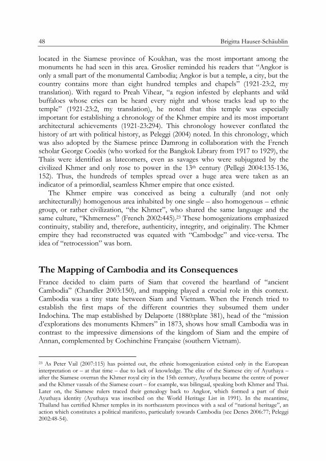
50 Brigitta Hauser-Schäublin
Fig. 5: Lunet de Lajonquière’s map showing the temple of Preah Vihear as located right on the
border between Siam and Cambodia (1911).
The application of this kind of knowledge was a means to define nations as bound entities with fixed boundaries, produced a new kind of political space and displaced Buddhist cosmography (Thongchai 1988:134, 309-313). Southeast Asian states were instead often overlapping realms with multiple sovereignties (Thongchai 1988:200).26
In the negotiations with Siam, France suggested the selection of a “natural” boundary, namely the watershed along the Dangrek Mountains. The boundary was supposed to run along the ridge of the mountain chain according to the French-Siamese treaty of 1904. As a consequence, the temple of Preah Vihear would have fallen into Siam territory. However, when the French cartographers carried out the mapping in 1906-07, they mapped the alleged line of the watershed in such a way that the temple of Preah Vihear was located on Cambodian territory.27 In fact, the map,
26 According to Briggs (1946:442-443), there were, for example, two kings ruling over 19th century Cambodia; one was oriented toward Bangkok and the other toward Vietnam. Adolf Bastian, who traveled from Bangkok to Angkor (and further on) in 1863, noted that he met two governors who ruled over the same area. Each of them sent tributes (such as cardamom, ivory, pepper, and lacquer) to his king (in Bangkok or in Vietnam) on whose behalf he was ruling there (Bastian 1868:5). For an overview over the different concepts or terms used to characterize the non-territorial organization of Southeast Asian polities see Day (2002:1-37); or even “segmentary state” used by Southall (1988:52-82). 27 In 1947, a French-Siamese Conciliation Commission already had to deal with the disputed border. The commission noted that the French deputy had declared the Dangrek Mountains as the only possible natural frontier between the two countries (United Nations 2007:446).

Preah Vihear 51
produced only by French cartographers with lettering simply in Roman (and not Thai) characters and given to the Siamese Government in 1908, suggests that the Dangrek Mountains slope towards the south exactly at the site of the temple complex, implying that the watershed runs north of it (Cuasay 1998:863).28 Here, the power of maps – Peter Cuasay speaks of a “fantasy of exact visualization”, or “mimesis” (1998:869) – becomes evident, since this ominous map served to determine the reality in the landscape (see also Boulanger 2008:135-146; Suarez 1999:262). Through mapping
Siam and Cambodge became transformed into territorial states. However, Khmer-speaking people lived on both sides of this “natural” border and the temple of Preah Vihear was an important sanctuary for all of them.29
It would be too lengthy to reiterate here the various facets of the long and complex history of this border dispute which had already begun when Cambodia was still a French protectorate. The attitude Siam (later Thailand) displayed toward Cambodia owning the temple of Preah Vihear was inconsistent over time. At the beginning, Thailand even used and distributed the French map without disagreeing with what was represented. Whether the Siamese king and his ministers were fully aware of the consequences this map had for territorial claims for the (unlimited) future would need further investigation.30 A consistent opposition against the border near Preah Vihear as fixed on the map only started decades later.
A landmark in the dispute was represented by the decree of the International Court of Justice in 1962. In this court case, the potency of the authority of the old colonial sources was mobilized. In the hearings, Cambodia argued precisely with the colonial sources discussed above to convince the judges in The Hague that Preah Vihear was part of Khmer heritage and, therefore, was rightly included in Cambodia’s territory. Groslier, in his function as the head of the archaeological service, was quoted in the lines of the argument since he wrote that Preah Vihear was one of the most complete and best preserved sites of Cambodia (1921-23:275). Furthermore, Parmentier (1939:272) was also cited as having assessed Preah Vihear as one of the monuments of the classical ancient art of Cambodia (ICJ 1960:117). In her response, Thailand challenged these conclusions based on “authentically Khmer” by arguing: “There are several Khmer buildings outside Cambodia just as there are many Roman buildings outside Italy” (ICJ 1961b:172).
28 There were long discussions during the ICJ trial about the watershed and the factual watercourse. One expert pointed out that over the past 50 years, the watershed may possibly have changed in such a way that the water at the location of the temple complex formerly ran to the north while, when he investigated the watershed, the water ran to the south. Three possible alternative watersheds were even discussed at the ICJ (see Cuasay 1998:872). 29 Denes (2006:80) notes that 1.4 million ethnic Khmer lived in Thailand. The Khmer in Thailand turned away from their (former) Cambodian brothers, especially since the Khmer Rouge regime (French 2002:446). The political propaganda and the rise of ethno-nationalism in both countries over the past 30 years have assisted in this estrangement. 30 “For the Siamese court, it was hard to imagine how the question of boundary could be so important. The mountains and the many-mile-wide forests were a matter for the local people, not those in Bangkok” (Thongchai 1988:139).

52 Brigitta Hauser-Schäublin
The ICJ, as has already been mentioned, concentrated on the attitude and way Thailand had reacted to the map since its creation. The court ruled – according to Western judicial notions of procedures and norms – that Thailand had failed to file their protest in time and, therefore, adjudged the temple of Preah Vihear to be the property of Cambodia. The decision was, therefore, based on matters of procedures and formalities and not essentially on the question of the territory, the correctness of the boundary on the map and the way (and the circumstances under which) the border was drawn up (see Sven Mißling's chapter “A Legal View of the Case of the Temple Preah Vihear” in this volume).
As it stands, the 850 kilometre border separating the two countries has never been jointly investigated, nor has there ever been a mutual agreement as to its dimensions. The Joint Boundary Commission between Cambodia and Thailand is still at work and there does not appear to be a successful end to its work anytime soon (cf. The Nation August 27, 2009). However, Cambodia apparently expects a solution from a higher authority: Cambodia has recently requested the ICJ to provide an interpretation of the 1962 decree (ICJ 2011).
Colonial Continuities and the Temple as “Public Good”
In the course of time, Preah Vihear has undergone a series of transformations of function and meaning. These transformations were achieved by changing groups of actors who modelled the significance of the monumental remains according to their own goals. These groups of actors were art-loving European travellers, colonial administrators and politicians on behalf of the changing governments of Cambodia and Thailand, the national elite, and the local population.
The last step in this transformation process was achieved when Cambodia suggested that Preah Vihear be listed as a World Heritage Site of Humanity by UNESCO. In accordance with what Kirshenblatt-Gimblett labels “metacultural practices” (2006:161), the distinction of a sacred site as a “World Heritage Site” involves disembedding it from certain social contexts of culture and re-embedding it in new, global contexts, those of a global tourist economy. Instead of serving primarily as a space where pilgrims venerate ancestors and deities, such a site like Preah Vihear is turned into a profane “global cultural commons” (Kirshenblatt-Gimblett 2006:161).
In the process, a religious site becomes a secular one and a locality is transformed into a tourist destination with new owners (Kirshenblatt-Gimblett 1998:151; see also Winter 2007). This transformation can be understood as the result of a decision to add a new site to the global tourist economy31, where this emerging “hot spot” in the tourism landscape has to compete with other such sites and seek to assert itself. 31 In the Operational Directives on Raising Awareness about Intangible Culture Heritage, an act that was passed in 2009 by the Intergovernmental Committee for the Safeguarding of the Intangible Cultural Heritage in Abu Dhabi, state parties were prompted to avert any actions that could “lead to over-commercialization or to unsustainable tourism that may put at risk the intangible cultural heritage concerned” (UNESCO 2010a:§102.e). Yet in the convention of 2003, the certification of intangible

Preah Vihear 53
Fig. 6: The official map of Preah Vihear as submitted to UNESCO in the nomination file
(Ministère de la Culture et des Beaux Arts 2008).
The UNESCO World Heritage Committee’s decision to put Preah Vihear as the property only of Cambodia on the World Heritage List was based on the Hague decree of 1962. Once again, a map played a crucial role. The official map that accompanied the nomination application was composed in such a way as to give the impression that the main access to the temple is to be found facing east, towards the Cambodian lowlands, and not facing north towards Thailand. The cartographic representation of the monument was modified so that the main entrance and the temple as a comprehensive and extensive site reaching into Thailand could no longer be recognized in their complexity. And, once again, all settlements – even the monastery – were mislaid.
Here, colonial continuities become apparent in different regards. The focus exclusively on Preah Vihear as an outstanding “monument” allowed the neglect and consideration of social and political questions, such as the incidents and discussions that took place after the ICJ decree of 1962. The evaluation of the temple complex for the UNESCO nomination as mirrored in the decision report displays continuity in the way of looking at “monuments” – the archaeological gaze – and describing them heritage is explicitly intended to be “a guarantee of sustainable development” (UNESCO 2003:article 2.1.). However, given that no guidelines or measures were put into place and hence no indicators of over-commercialization or unsustainable tourism exist, such attempted restrictions are merely lip service.

54 Brigitta Hauser-Schäublin
according to criteria given (see above). In the application documents, for example, Parmentier’s idealized drawings (analyzed above) constitute the core illustrations of the reconstructed temple buildings and their layout. Moreover, the temple of Preah Vihear is presented as a Hindu “temple”; subsequently the temple was listed as a sanctuary dedicated to the Hindu god Çiva (Ministère de la Culture et des Beaux Arts 2008:13), in spite of the fact that Preah Vihear had already been turned into a Buddhist monastery in the 12th century (see Grabowski 2009). The listing as a Hindu temple implies a recourse to a past – a process one might call “re-hinduizing” (Edwards 2007:132) – that had in fact been turned over by history a long time ago.
The old argument for explaining why the temple of Preah Vihear is a legitimate property of today’s Cambodia was also revived in the proposal documents: Preah Vihear was explained as being directly linked to Angkor. This argument is substantiated in the application document by maps with arrows between Angkor, Preah Vihear and Phnom Penh (Ministère de la Culture et des Beaux Arts 2008:2), and the depiction of a “triangle ‘patrimonial’” (Ministère de la Culture et des Beaux Arts 2008:272) which forms a kind of ur-Khmer territory only located in Cambodia. Winter already noted “strong continuities […] between a contemporary discourse of world heritage and an Angkorian historiography constructed by scholars during an era of European colonialism […]”. He identified two main reasons for these continuities: (1) the dramatic loss of the Cambodian intelligentsia during the Khmer Rouge era who made a recourse to foreign (mainly French) expertise inevitable; and (2) the home of UNESCO (as well as ICOMOS) is Paris and the return of France as the co-chair of the International Coordinating Committee for the Safeguarding and Development of Angkor (ICC) “enable[d] France to consolidate its position as an unrivalled authority on Angkorean and Khmer history” (Winter 2007:63-64).
The continuity of colonial knowledge and its premises can also easily be identified in several of the international technical experts’ assessments (in the chapter “Conservation and Management Report”). One report, written by an Indian expert, Divay Gupta, represents an impressive exception to the more or less unison of voices of mostly Western experts. He suggests community participation (Gupta 2008:26) “recognizing that the true custodians of the site are the local communities” (Gupta 2008:14). He points to the importance the temple has for pilgrims and monks. He proposes that the economic development of the site should consider and respect the religious function of the temple. However, this voice remained unconsidered in the summary of the recommendations.
The colonial continuities are in fact striking. They can be summed up as follows:
(1) The perspective gives precedence to past cultural conditions (“ancient Hindu Khmer temple”) over the present. The conservation of the monumental ruins as material constructions, but at the same time the way in which they can be made accessible for mass tourism, receive the utmost attention. The plans for establishing an airport, a bus terminal/parking lot and the main entrance gate with an information

Preah Vihear 55
centre and a restaurant – in short, an elaborate tourist infrastructure – where the monastery is located, proves the hierarchization inherent in this gaze and the hierarchization this gaze creates in reality.
(2) Restructuring of the “natural” and social environment is recommended according to the requirements of conservation and tourism development. The conservation of the site is indeed a major issue. However, there is a goal behind it: to establish an additional international tourist attraction for the consumption of a solvent global public. The fact that the temple is part of a “sacred topography” (Thongchai 1988:46) is neglected in most assessments. Relocation of one of the villages that has developed nearby over recent years and offered logistic support to tourists, workmen and members of the army is suggested so that it does not compromise the panoramic scenery.
But how will these people survive in another place if they are prevented through relocation from selling services and goods to customers? Another expert suggested that the whole plan should be kept free of any building development. Instead, he proposed building a “traditional Khmer village” there, hence reinventing tradition. It becomes clear, also from the summing up of the propositions at the end of the 650 page volume, that the local population, if present at all, should play the natives who are happy with the mode of subsistence practices of a long time ago. Additionally, they are supposed to contribute through the revitalization of handicrafts to satisfying the needs of tourists.
The listing of the temple complex of Preah Vihear, therefore, implies a whole series of transformations that can all be classified under idealization, secularization, economization, and disempowerment of the former “users”.
By now, many disciplines formerly involved in colonialism by eagerly contributing their knowledge to those in power have started to reconsider their own academic history. The archaeologist Sandra Scham pleads for reflexivity when she raises the question: who are the persons for whom the archaeologists are retrieving the past? In answering this question, she suggests:
Once the recipients were empires and governments. Now it is that rather nebulous ‘public’ that is the target of heritage studies and public archaeology […].
(Scham 2008:168)
As the case of Preah Vihear demonstrates, the alliance between knowledge and power has not come to an end but has arrived in a new guise – with consequences for the future.
56 Brigitta Hauser-Schäublin
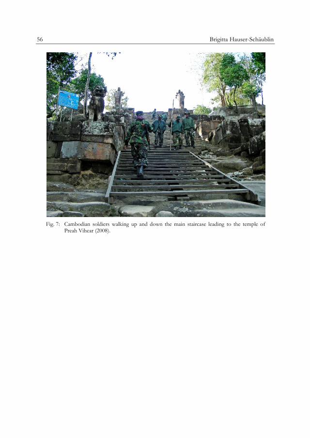
Fig. 7: Cambodian soldiers walking up and down the main staircase leading to the temple of
Preah Vihear (2008).