practice packet: topic 4 dynamic crust practice packet ......3. what property of earth’s interior...
TRANSCRIPT

PRACTICE PACKET: TOPIC 4 Dynamic Crust
Practice Packet
Topic 4: Dynamic Crust
Vocabulary: ________________
Lesson 1: __________________
Lesson 2: __________________
Lesson 3: __________________
Lesson 4: __________________
Lesson 5: __________________
Lesson 6: __________________
Name: ____________________________________________
ITALY – Aug 2016
6.2 magnitude

PRACTICE PACKET: TOPIC 4 Dynamic Crust
VOCABULARY
For each word, provide a short but specific definition from YOUR OWN BRAIN! No boring textbook
definitions. Write something to help you remember the word. Explain the word as if you were explaining
it to an elementary school student. Give an example if you can. Don’t use the words given in your
definition!
Lithosphere:____________________________________________________________________
Asthenosphere: __________________________________________________________________
Inner Core: _____________________________________________________________________
Outer Core: ____________________________________________________________________
Continental Crust: ________________________________________________________________
Oceanic Crust: __________________________________________________________________
Plate Tectonic Theory: ____________________________________________________________
Pangea: ________________________________________________________________________
Reversal of Magnetic Polarity: _______________________________________________________
Convergent: ____________________________________________________________________
Subduction: _____________________________________________________________________
Divergent: ______________________________________________________________________
Mid-Ocean Ridge: ________________________________________________________________
Transform: _____________________________________________________________________
Original Horizontality: _____________________________________________________________
Fault: _________________________________________________________________________
Fold: __________________________________________________________________________
Earthquake: ____________________________________________________________________
Epicenter: ______________________________________________________________________
Focus: _________________________________________________________________________
Seismogram: ____________________________________________________________________
PRACTICE PACKET: TOPIC 3 Minerals & Rocks
3
Primary (P) Waves:________________________________________________________________
Secondary (S) Waves: _____________________________________________________________
Tsunami: _______________________________________________________________________
Origin: ________________________________________________________________________
Ring of Fire: ____________________________________________________________________
Intrusion: ______________________________________________________________________
Extrusion: ______________________________________________________________________
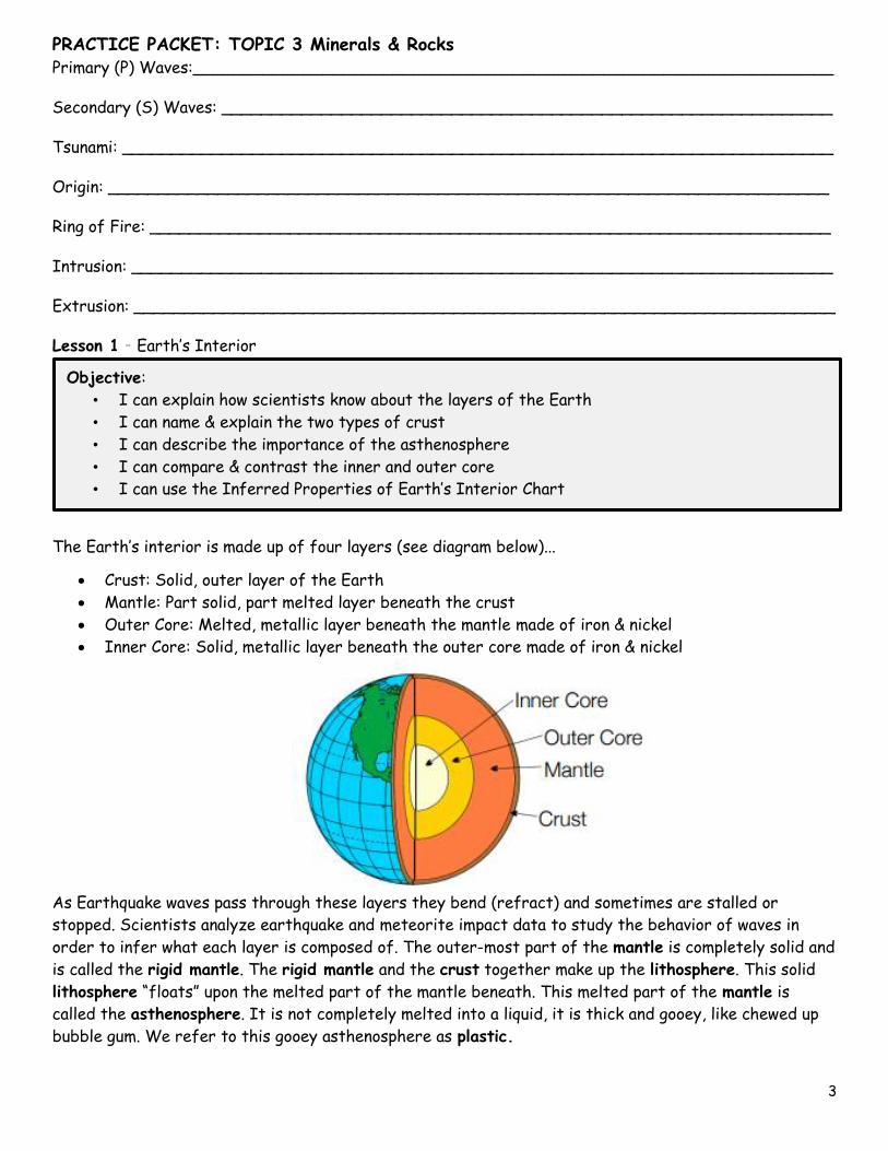
Lesson 1 – Earth’s Interior
The Earth’s interior is made up of four layers (see diagram below)...
Crust: Solid, outer layer of the Earth
Mantle: Part solid, part melted layer beneath the crust
Outer Core: Melted, metallic layer beneath the mantle made of iron & nickel
Inner Core: Solid, metallic layer beneath the outer core made of iron & nickel
As Earthquake waves pass through these layers they bend (refract) and sometimes are stalled or
stopped. Scientists analyze earthquake and meteorite impact data to study the behavior of waves in
order to infer what each layer is composed of. The outer-most part of the mantle is completely solid and
is called the rigid mantle. The rigid mantle and the crust together make up the lithosphere. This solid
lithosphere “floats” upon the melted part of the mantle beneath. This melted part of the mantle is
called the asthenosphere. It is not completely melted into a liquid, it is thick and gooey, like chewed up
bubble gum. We refer to this gooey asthenosphere as plastic.
Objective:
• I can explain how scientists know about the layers of the Earth
• I can name & explain the two types of crust
• I can describe the importance of the asthenosphere
• I can compare & contrast the inner and outer core
• I can use the Inferred Properties of Earth’s Interior Chart

PRACTICE PACKET: TOPIC 3 Minerals & Rocks
4
The diagram seen to the right can be found on page 10 of
your reference tables. Pay attention to the following
details:
As you travel deeper down, from the crust to the
inner core, the materials get increasingly dense.
As you travel deeper down, from the crust to the
inner core, the pressure increases.
As you travel deeper down, from the crust to the
inner core, the temperature increases.
The MOHO is the boundary between the crust and
the mantle.
There are two types of crust:
o Continental crust which is made of a very
thick layer of the rock granite and is less
dense (2.7 g/cm3)
o Oceanic crust which is made of a very thin
layer of the rock basalt and is more dense
(3.0 g/cm3)
Wherever the interior temperature is higher than
the melting point, the material is a liquid (see the
outer core.
Questions:
1. What happens to earthquake waves as they pass
through the different layers of Earth’s interior?
2. What two things do scientists use to infer the
composition of Earth’s interior?
3. Why does Earth’s interior have a layered structure?
4. What is the outermost layer of Earth?
5. What does the lithosphere include? ______________________ & ______________________
6. What is another name for the asthenosphere? ______________________________________
7. What happens to temperature, density, & pressure as you travel deeper into Earth’s interior?
8. How do you know if the layer is a liquid or a solid based on the chart?

PRACTICE PACKET: TOPIC 3 Minerals & Rocks
5
9. Fill in the chart below describing the continental & oceanic crust.
Thick/ Thin Rock Name Density Mafic/Felsic
Continental Crust
Oceanic Crust
1. Look at the information above the chart. Highlight each of the following labels that indicate the
location on Earth’s surface: Pacific Ocean, North America, and Atlantic
2. Find and highlight the “Cascades” and complete the sentence below:
The Cascades are located at the boundary of the _________________ and _______________
3. What is located next to the Cascades but in the Pacific Ocean? _________________________
4. Highlight the word Trench.
5. What is located on Earth’s crust, in the Atlantic Ocean? ______________________________
6. Highlight “Mid-Atlantic Ridge”
7. Highlight the following Labels on the chart: Density, Lithosphere, Pressure, Temperature and
Depth
8. Referring to the top of the chart, what two layers does the lithosphere include?
_____________________________ and _____________________________
9. Using a red color pencil lightly shade in the Asthenosphere section in the chart. Start at the top
right side (under density) and follow the dotted lines all the way down to the bottom of the
graph. Under the density section, color ONLY the top section next to the Asthenosphere section.
10. Using a brown color pencil lightly shade in the Stiffer Mantle section in the chart. Start at the
top right side and follow the dotted lines all the way down to the bottom of the graph. Under the
density section, color ONLY the section next to the Stiffer Mantle section.
11. Using an orange color pencil lightly shade in the Outer Core section in the chart. Start at the top
right side and follow the dotted lines all the way down to the bottom of the graph. Under the
density section, color ONLY section next to the Outer Core section.
12. Using a purple color pencil lightly shade in the Inner Core section in the chart. Start at the top
right side and follow the dotted lines all the way down to the bottom of the graph. Under the
density section, color ONLY the section next to the Inner Core section.
13. Refer to the temperature section of the chart for the following questions.
a. What layer of Earth’s interior is partially melted? ______________________________
b. Is the melting point [ higher or lower ] than the interior temperature in the outer core?
c. This means that the Outer Core must be a [ solid or liquid ] .
14. Fill in the tables below with information found on the “Inferred Properties of Earth’s Interior”
Chart.

PRACTICE PACKET: TOPIC 3 Minerals & Rocks
6
PRACTICE PACKET: TOPIC 3 Minerals & Rocks
7
Regents Questions:
1. Compared to the oceanic crust, the continental crust is usually
a. thicker, with a less dense granitic composition
b. thicker, with a more dense basaltic composition
c. thinner, with a less dense granitic composition
d. thinner, with a more dense basaltic composition
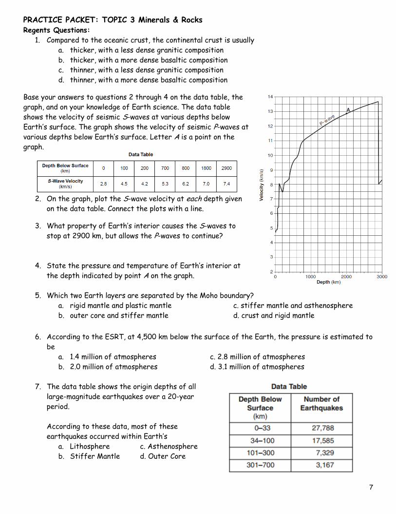
Base your answers to questions 2 through 4 on the data table, the
graph, and on your knowledge of Earth science. The data table
shows the velocity of seismic S-waves at various depths below
Earth’s surface. The graph shows the velocity of seismic P-waves at
various depths below Earth’s surface. Letter A is a point on the
graph.
2. On the graph, plot the S-wave velocity at each depth given
on the data table. Connect the plots with a line.
3. What property of Earth’s interior causes the S-waves to
stop at 2900 km, but allows the P-waves to continue?
4. State the pressure and temperature of Earth’s interior at
the depth indicated by point A on the graph.
5. Which two Earth layers are separated by the Moho boundary?
a. rigid mantle and plastic mantle c. stiffer mantle and asthenosphere
b. outer core and stiffer mantle d. crust and rigid mantle
6. According to the ESRT, at 4,500 km below the surface of the Earth, the pressure is estimated to
be
a. 1.4 million of atmospheres c. 2.8 million of atmospheres
b. 2.0 million of atmospheres d. 3.1 million of atmospheres
7. The data table shows the origin depths of all
large-magnitude earthquakes over a 20-year
period.
According to these data, most of these
earthquakes occurred within Earth’s
a. Lithosphere c. Asthenosphere
b. Stiffer Mantle d. Outer Core
PRACTICE PACKET: TOPIC 3 Minerals & Rocks
8
8. The composition of some meteorites supports the inference that the Earth’s core is composed of
a. Magnesium and potassium c. iron and nickel
b. Silicon and oxygen d. aluminum and calcium
9. A part of which zone of the Earth’s interior inferred to have a density of 10.0g/cm3?
a. Outer core b. inner core c. crust d. mantle
10. According to the ESRT, in which group are the zones of the Earth’s interior correctly arranged in
order of increasing average density
a. Crust, mantle, inner core, outer core c. crust, mantle, outer core, inner core
b. Inner core, outer core, mantle, crust d. outer core, inner core, mantle, crust
11. According to the ESRT, the temperature of rock located 1,000 km below the Earth’s surface is
about
a. 200ºC b. 2,100 ºC c. 2,800 ºC d. 3,200 ºC
12. Compared to the oceanic crust, the continental crust is
a. less dense and more basaltic c. more dense and more granitic
b. less dense and more felsic d. more dense and more mafic
13. Earth’s internal heat is the primary source of energy that
a. warms the lower troposphere c. moves the lithospheric plates
b. melts glacial ice at lower altitudes d. pollutes deep groundwater with radioactivity
Lesson 2 – Plate Tectonics
1. What is the plate tectonic theory?
2. List at least 3 pieces of evidence for plate tectonics.
3. What process causes the plates to move?
4. What layer in the Earth is this occurring?
Objective:
• I can describe what is believed to make the plates move?
• I can name proof that the Earth’s plates have moved over time
• I can describe age & heat patterns located at the Mid Ocean Ridges
ASSESS YOURSELF ON THIS ADDITIONAL PRACTICE: _________/5
If you missed more than 2 you should see me for extra help and/or re-watch the lesson
video assignment and/or watch the podcast link on the ESRT page on the website.
ASSESS YOURSELF ON THIS LESSON: _________/8
If you missed more than 2, do the Additional Practice. If not, go on to the next hw video!!!
PRACTICE PACKET: TOPIC 3 Minerals & Rocks
9
Seafloor Spreading
Divergent boundaries occur along spreading centers where plates are moving apart. New crust is created
by magma pushing up from the mantle. Picture two giant conveyor belts facing each other slowly moving
in opposite directions as they transport newly formed oceanic crust away from the ridge crest. As the
plates separate, water fills the low areas. Crust continues to separate allowing more magma to emerge
making small underwater “hills” at the point of separation. Eventually a mid-ocean ridge will form. The
youngest rocks are located at the center of the ridge because they are still being formed. The oldest
are located the farthest from the ridge.
5. Which directions do plates move at a divergent boundary?_____________________________
6. What is created as magma moves to the surface? ___________________________________
7. What happens as the plates separate? ___________________________________________
8. What will eventually form at a divergent boundary? _________________________________
9. Where are the youngest rocks found in the ocean? __________________________________
10. Where are the oldest rocks found?______________________________________________
11. Fill in the chart below.
Relative Age Relative Heat
At mid-ocean ridge
Away from mid-ocean ridge
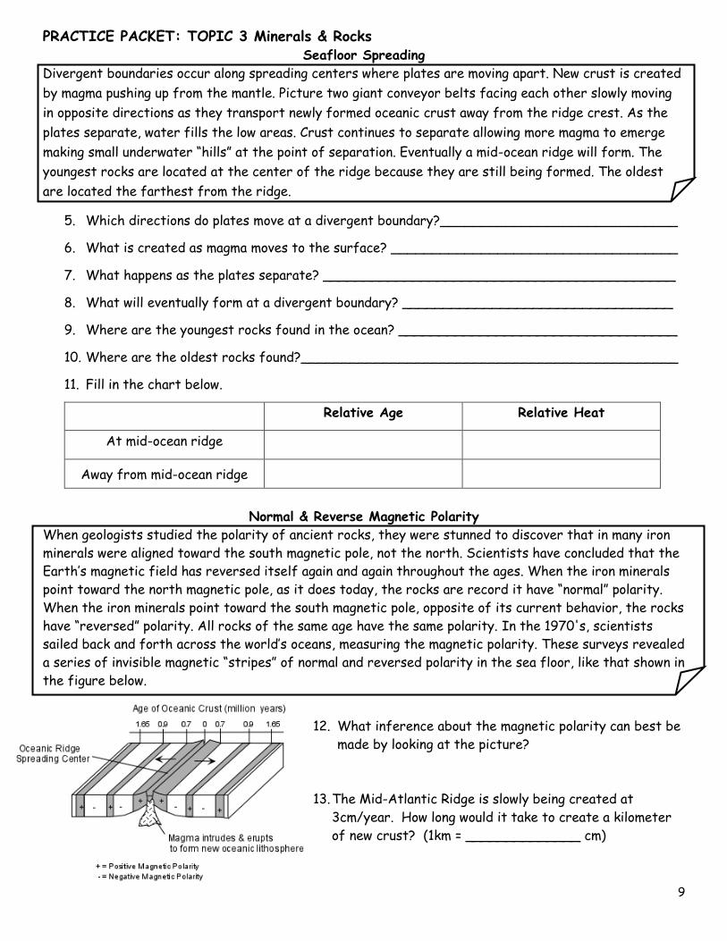
Normal & Reverse Magnetic Polarity
When geologists studied the polarity of ancient rocks, they were stunned to discover that in many iron
minerals were aligned toward the south magnetic pole, not the north. Scientists have concluded that the
Earth’s magnetic field has reversed itself again and again throughout the ages. When the iron minerals
point toward the north magnetic pole, as it does today, the rocks are record it have “normal” polarity.
When the iron minerals point toward the south magnetic pole, opposite of its current behavior, the rocks
have “reversed” polarity. All rocks of the same age have the same polarity. In the 1970's, scientists
sailed back and forth across the world’s oceans, measuring the magnetic polarity. These surveys revealed
a series of invisible magnetic “stripes” of normal and reversed polarity in the sea floor, like that shown in
the figure below.
12. What inference about the magnetic polarity can best be
made by looking at the picture?
13. The Mid-Atlantic Ridge is slowly being created at
3cm/year. How long would it take to create a kilometer
of new crust? (1km = ______________ cm)

PRACTICE PACKET: TOPIC 3 Minerals & Rocks
10
Hot Spots
Hot spots are places where magma is coming up through Earth’s crust that are not necessarily located
at a plate boundary. As the plates move over the hot spot volcanic islands can form. The block diagram
below shows the bedrock age as measured by radioactive dating and the present location of part of the
Hawaiian Island chain. These volcanic islands may have formed as the Pacific Plate moved over a mantle
hot spot.
Use the diagram to the right to answer the following
questions.
14. Which island is the youngest? ________________
15. Which island is the oldest? __________________
16. Which compass direction was the Pacific crust
moving toward?
17. A new island is already forming off the coast of
Hawaii named Loihi. By looking at the diagram to
the right, what compass direction (from Hawaii) is
Loihi forming?
Regents Questions:
1. The cross section below shows the ocean
floor between 2 continents. Points A through
D represent location on the ocean floor where
samples of oceanic crust were collected.
The youngest rock sample most likely was
collected from location
a. A b. B c. C d. D
2. Which statement best supports the theory of continental drift?
a. Basaltic rock is found to be progressively younger at increasing distances from a mid-
ocean ridge.
b. Marine fossils are often found in deep-well drill cores.
c. The present continents appear to fit together as pieces of a larger landmass
d. Areas of shallow-water seas tend to accumulate sediment, which gradually sinks.
3. The cross section shows the direction of movement of an oceanic
plate over a mantle hot spot, resulting in the formation of a chain
of volcanoes labeled A, B, C, and D. The geologic age of volcano C is
shown. What are the most likely geologic ages of volcanoes B and D?
a. B is 5 million years old and D is 12 million years old.
b. B is 2 million years old and D is 6 million years old.
c. B is 9 million years old and D is 9 million years old.
d. B is 10 million years old and D is 4 million years old.

PRACTICE PACKET: TOPIC 3 Minerals & Rocks
11
The map below shows the continents of Africa & South America, the ocean between them, & the ocean
ridge & transform faults.
4. The hottest crustal temperature measurements would most likely
be found at which location?
a. A b. B c. C d. D
5. Which graph best shows the relative age of the ocean-floor
bedrock from location B to C?
6. Which of the cross-sectional diagrams below best represents a model for the movement of rock
material below the crust along the Mid-Atlantic Ridge?
7. Which is the best evidence supporting the concept of ocean floor spreading?
a. Earthquakes occur at greater depths beneath continents than beneath oceans.
b. Sandstones and limestones can be found both in North America and Europe.
c. Volcanoes appear at random within the oceanic crust.
d. Igneous rocks along the mid-oceanic ridges are younger than those farther from the
ridges.
Base your answers to questions 7 and 8 on the cross section
below and on your knowledge of Earth science. The cross
section represents the distance and age of ocean-floor
bedrock found on both sides of the Mid-Atlantic Ridge.
8. According to the cross section, every 1 million years,
the ocean floor bedrock moves approximately
a. 20 km toward the Mid-Atlantic Ridge c. 40 km toward the Mid-Atlantic Ridge
b. 20 km away from the Mid-Atlantic Ridge d. 40 km away from the Mid-Atlantic Ridge
9. Which map best represents the pattern of magnetic polarity in the minerals of ocean-floor
bedrock on each side of the Mid-Atlantic Ridge?
PRACTICE PACKET: TOPIC 3 Minerals & Rocks
12
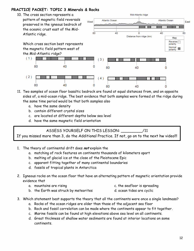
10. The cross section represents a
pattern of magnetic field reversals
preserved in the igneous bedrock of
the oceanic crust east of the Mid-
Atlantic ridge.
Which cross section best represents
the magnetic field pattern west of
the Mid-Atlantic ridge?
11. Two samples of ocean floor basaltic bedrock are found at equal distances from, and on opposite
sides of, a mid-ocean ridge. The best evidence that both samples were formed at the ridge during
the same time period would be that both samples also
a. have the same density
b. contain different crystal sizes
c. are located at different depths below sea level
d. have the same magnetic field orientation
1. The theory of continental drift does not explain the
a. matching of rock features on continents thousands of kilometers apart
b. melting of glacial ice at the close of the Pleistocene Epic
c. apparent fitting together of many continental boundaries
d. fossils of tropical plants in Antarctica
2. Igneous rocks on the ocean floor that have an alternating pattern of magnetic orientation provide
evidence that
a. mountains are rising c. the seafloor is spreading
b. the Earth was struck by meteorites d. ocean tides are cyclic
3. Which statement best supports the theory that all the continents were once a single landmass?
a. Rocks of the ocean ridges are older than those of the adjacent sea floor
b. Rock and fossil correlation can be made where the continents appear to fit together.
c. Marine fossils can be found at high elevations above sea level on all continents.
d. Great thickness of shallow water sediments are found at interior locations on some
continents.
ASSESS YOURSELF ON THIS LESSON: _________/11
If you missed more than 3, do the Additional Practice. If not, go on to the next hw video!!!
PRACTICE PACKET: TOPIC 3 Minerals & Rocks
13
4. For the last 200 million years, continents on opposite sides of the Atlantic ocean have generally
a. been drifting apart c. been drifting closer together
b. remained the same distance apart
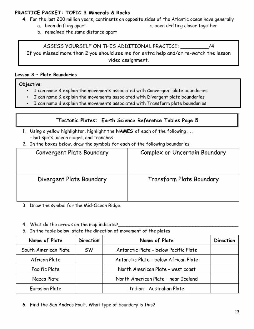
Lesson 3 – Plate Boundaries
1. Using a yellow highlighter, highlight the NAMES of each of the following . . .
- hot spots, ocean ridges, and trenches
2. In the boxes below, draw the symbols for each of the following boundaries:
3. Draw the symbol for the Mid-Ocean Ridge.
4. What do the arrows on the map indicate?__________________________________________
5. In the table below, state the direction of movement of the plates
6. Find the San Andres Fault. What type of boundary is this?
Objective:
• I can name & explain the movements associated with Convergent plate boundaries
• I can name & explain the movements associated with Divergent plate boundaries
• I can name & explain the movements associated with Transform plate boundaries
ASSESS YOURSELF ON THIS ADDITIONAL PRACTICE: _________/4
If you missed more than 2 you should see me for extra help and/or re-watch the lesson
video assignment.
PRACTICE PACKET: TOPIC 3 Minerals & Rocks
14
7. Fill in the names of the Hot Spots at each of the following locations.
8. Name the two plates located on either side of each of the following trenches.
9. Look at the arrows along any of the trenches, on the two adjoining plates. Are the plates moving
toward each other or away from each other?
10. What kind of boundary is located at a trench?
11. Name the two plates located on either side of each of the following ridges.
12. Look at the arrows along any of the ridges, on the two adjoining plates. Are the plates moving
toward each other or away from each other?
13. What kind of boundary is located at a ridge?

PRACTICE PACKET: TOPIC 3 Minerals & Rocks
15
Regents Questions:
1. Oceanic crust is sliding beneath the Aleutian Islands in the North Pacific Ocean, forming the
Aleutian Trench at a
a. convergent plate boundary between the Pacific Plate and the North American Plate
b. convergent plate boundary between the Pacific Plate and the Juan de Fuca Plate
c. divergent plate boundary between the Pacific Plate and the North American Plate
d. divergent plate boundary between the Pacific Plate and the Juan
de Fuca Plate
2. The map shows California and a section of the San Andreas Fault. What is
the primary geologic process occurring along the San Andreas Fault?
a. transform movement c. subduction
b. spreading movement d. convergence
3. Which mantle hot spot is located directly below a mid-ocean ridge plate boundary?
a. Yellowstone b. Iceland c. Canary Islands d. Hawaii
4. Which landmass is moving northward with Australia as part of the same tectonic plate?
a. India b. Antarctica c. North America d. South America
Base your answers to questions 5 and 6 on the map below and on your knowledge of Earth science. The
map shows the coast of the northwestern United States. The Explorer and Gorda ridges and plates are
parts of the Juan de Fuca tectonic system.
5. The arrow on which map best shows the direction of
movement of the Juan de Fuca Plate in relation to the Juan
de Fuca Ridge?
6. The Explorer Ridge is the boundary between the Explorer
Plate and the
a. North American Plate c. Pacific Plate
b. Juan de Fuca Plate d. Gorda Plate

PRACTICE PACKET: TOPIC 3 Minerals & Rocks
16
7. The diagram to the right shows a tectonic plate boundary. Which mantle
hot spot is at a plate boundary like the one shown in this diagram?
a. Hawaii Hot Spot c. Yellowstone Hot Spot
b. Galapagos Hot Spot d. Canary Hot Spot
8. Which diagram correctly shows how mantle convection currents are
most likely moving beneath colliding lithospheric plates?
9. Based on the theory of plate tectonics, it is inferred that over the past 250 million years North
America has moved toward the
a. northwest b. southeast c. southwest d. northeast
10. According to tectonic plate maps, New York State is presently located
a. at a convergent plate boundary c. above a mantle hot spot
b. above a mid-ocean ridge d. near the center of a large plate
11. The diagram to the right shows the interaction of two
tectonic plates. The type of plate boundary represented in
the diagram most likely exists between the
a. Antarctic Plate and the African Plate
b. Antarctic Plate and the Indian-Australian Plate
c. South American Plate and the Nazca Plate
d. South American Plate and the African Plate
12. The movement of tectonic plates is inferred by many
scientists to be driven by
a. tidal motions in the hydrosphere c. density differences in the troposphere
b. convection currents in the asthenosphere d. solidification in the lithosphere
PRACTICE PACKET: TOPIC 3 Minerals & Rocks
17
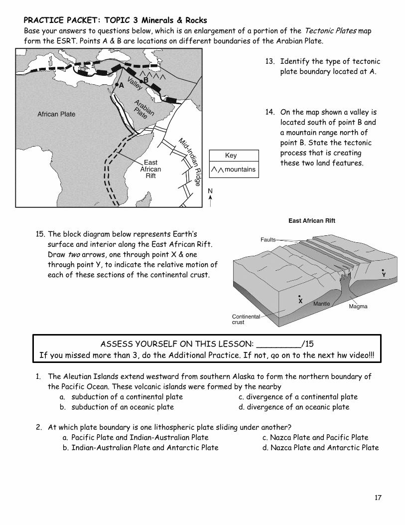
Base your answers to questions below, which is an enlargement of a portion of the Tectonic Plates map
form the ESRT. Points A & B are locations on different boundaries of the Arabian Plate. 13. Identify the type of tectonic
plate boundary located at A.
14. On the map shown a valley is
located south of point B and
a mountain range north of
point B. State the tectonic
process that is creating
these two land features.
15. The block diagram below represents Earth’s
surface and interior along the East African Rift.
Draw two arrows, one through point X & one
through point Y, to indicate the relative motion of
each of these sections of the continental crust.
1. The Aleutian Islands extend westward from southern Alaska to form the northern boundary of
the Pacific Ocean. These volcanic islands were formed by the nearby
a. subduction of a continental plate c. divergence of a continental plate
b. subduction of an oceanic plate d. divergence of an oceanic plate
2. At which plate boundary is one lithospheric plate sliding under another?
a. Pacific Plate and Indian-Australian Plate c. Nazca Plate and Pacific Plate
b. Indian-Australian Plate and Antarctic Plate d. Nazca Plate and Antarctic Plate
ASSESS YOURSELF ON THIS LESSON: _________/15
If you missed more than 3, do the Additional Practice. If not, go on to the next hw video!!!

PRACTICE PACKET: TOPIC 3 Minerals & Rocks
18
3. Convection currents in the plastic mantle are believed to cause divergence of lithospheric
plates at the
a. Peru-Chile Trench c. Mariana Trench
b. Canary Islands Hot Spot d. Iceland Hot Spot
4. The Himalayan Mountains are located along a portion of the southern boundary of the
Eurasian Plate. At the top of Mt. Everest (29,028 feet) in the Himalayan Mountains, climbers
have found fossilized marine shells in the surface bedrock. From this observation, which
statement is the best inference about the origin of the Himalayan Mountains?
a. The Himalayan Mountains were formed by volcanic activity.
b. Sea level has been lowered more than 29,000 feet since the shells were fossilized.
c. The bedrock containing the fossil shells is part of an uplifted seafloor.
d. The Himalayan Mountains formed at a divergent plate boundary.
5. Which two tectonic plates are separated by a mid-ocean ridge?
a. Indian-Australian and Eurasian c. Indian-Australian and Pacific
b. North American and South American d. North American and Eurasian
6. Which of the following locations is the site of a convergent plate boundary?
a. Mid-Atlantic ridge c. Pacific/North American plate boundary
b. Atlantic-Indian ridge d. Aleutian Trench
Lesson 4 – Earthquakes
Directions: Using your knowledge of earthquakes & your ESRT answer the following questions.
Earthquakes
An earthquake is the shaking of Earth’s crust. The most common cause is the interaction between
lithospheric plates (movement of plates). Convection currents cause the plates to move. These plates are
very rigid and although they are not attached to each other, it is almost as if they are interlocked. It
takes an incredible amount of force to get them to actually move relative to each other. Once enough
pressure has built up and the plates move, there is an enormous amount of energy released. This is why
most major earthquakes occur at or near plate boundaries.
1. What is an earthquake?
Objective:
• I can identify the different types of crustal features
• I can describe what an earthquake is & where earthquakes start
• I can explain how to measure an earthquake
• I can tell the differences between P & S waves
• I can name the scales used to measure earthquake damage
• I understand earthquake safety
• I can describe a tsunami
ASSESS YOURSELF ON THIS ADDITIONAL PRACTICE: _________/6
If you missed more than 2 you should see me for extra help and/or re-watch the lesson
video assignment and/or watch the podcast link on the ESRT page on the website.

PRACTICE PACKET: TOPIC 3 Minerals & Rocks
19
2. What is the most common cause of an earthquake?
3. What causes plates to move?
4. Where do most major earthquakes occur?
5. What is the name of the giant waves generated by earthquakes underwater?
6. Where do Earthquakes start?
a. _______________________: Beneath the Earth’s surface
b. _______________________: Point on the Earth’s surface directly above where it
started
7. Fill in the chart below stating the differences between P & S waves.
Name Speed What it travels
through
P-Waves
S-Waves
Scientists have found a pattern of where major earthquakes and volcanoes are located. The map shows
where some of Earth’s earthquakes and volcanoes are. See if you can find a correlation.
8. Using the reference tables as a guide, label the following plates – using red.
Eurasian Plate (2 places)
Antarctic Plate (2 places)
African Plate
Pacific Plate
South American Plate
Philippine Plate
Indian Australia Plate
North American Plate
Nazca Plate

PRACTICE PACKET: TOPIC 3 Minerals & Rocks
20
9. Where are most earthquakes and volcanoes located?
10. Identify the type of plate boundary responsible for the presence of the volcano at location A.
11. The location where the actual movement of
plates takes place is called the focus. The depth
of the focus changes depending on the plates
involved. Using a red color pencil, draw an arrow
on the diagram to the right that shows the
ocean plate is being subducted.
12. What happens to the depth of the focus as you
move to the right of the subduction zone?
13. What type of boundary is illustrated in the
diagram?
14. Ocean plates are [thicker / thinner] and [ more dense / less dense ] than the continental plates.
15. What is the density of the oceanic plate? (don’t forget units)
16. What is the density of the continental plate? (don’t forget units)
17. Which plate is subducted continental or oceanic? Why?
18. What land features formed as a result of the oceanic and continental plate collision?
Regents Questions:
1. Which coastal area is most likely to experience a severe earthquake?
a. east coast of North America c. east coast of Australia
b. west coast of Africa d. west coast of South America
2. According to tectonic plate maps, New York State is presently located
a. at a convergent plate boundary c. above a mantle hot spot
b. above a mid-ocean ridge d. near the center of a large plate

PRACTICE PACKET: TOPIC 3 Minerals & Rocks
21
3. The map shows changes in the position of the
tsunami wave front produced by the 1964
Alaskan earthquake. The numbers indicate the
time, in hours, for the wave front to reach the
positions indicated by the isolines.
If the wave front reached the Hawaiian Islands at
10:30 p.m., at approximately what time did the
earthquake occur?
a. 1:30 p.m. c. 5:30 p.m.
b. 3:30 a.m d. 4:30 a.m.
Base your answers to the questions below on the map and a modified Mercalli intensity scale below. The
map shows modified Mercalli intensity scale damage zones resulting from a large earthquake that
occurred in 1964. The earthquake’s epicenter was near Anchorage, Alaska. The cities Kodiak and
Anchorage are shown on the map. The Mercalli scale describes earthquake damage at Earth’s surface.
4. Describe one type of damage that occurred in
Anchorage but not in Kodiak.
5. Write the names of the two converging tectonic
plates that caused this earthquake.
6. Explain why S waves from this earthquake were
not directly received on the opposite side of
Earth.
7. This earthquake produced a large
ocean floor displacement. Identify
one dangerous geologic event
affecting Pacific Ocean shorelines as
a result of this ocean floor
displacement.
8. Determine the latitude and longitude
of this epicenter. Include the units
and compass directions in your answer.

PRACTICE PACKET: TOPIC 3 Minerals & Rocks
22
9. The diagram represents how the
earthquake’s magnitude is determined by
drawing a line connecting the difference in
arrival times of the P-wave and the S-wave,
and the S-wave amplitude.
What is the magnitude of a recorded
earthquake if the difference in arrival
times of the first P-wave and S-wave is 2
seconds and the S-wave amplitude is 20
millimeters?
a. 3.8 c. 2.0
b. 3.0 d. 4.8
Base your answers to questions 10 through 12 on
the maps and table below and on your knowledge of Earth science. The maps show earthquake intensities
(IV to IX), according to the table of the Modified Mercalli Intensity Scale, for the 1906 and 1989
earthquakes at several locations in California. The asterisk( * ) on each map is the location of each
epicenter. The dashed line represents the location of a major fault.
10. Explain why Santa Rosa experienced a lower Modified Mercalli intensity shaking than Salinas
experienced during the 1989 earthquake.
11. Name the major fault along which both of these earthquakes occurred and identify the type of
plate tectonic boundary that is located along this fault.

PRACTICE PACKET: TOPIC 3 Minerals & Rocks
23
12. Based on the Modified Mercalli Intensity Scale, identify the perceived shaking and the observed
damage that occurred in the San Francisco area during the 1906 earthquake.
Lesson 5 – Reading P & S wave Chart
PART A: Determining travel time
Example: How long does it take a P-wave to travel 2,000 km?
a) Place a straight piece of scrap paper vertically just to the right of the 2,000 km line, starting at
the bottom.
b) Where the P-wave curve crosses the scrap paper, follow the horizontal line to the left. This will
give you the travel time.
c) Answer the question.
How long does it take a P-wave to travel 2,000 km? ____ min _____ sec
Practice Questions
1. How long does it take an S-wave to travel 7,000 km? ____ min ____ sec
2. How long does it take a P-wave to travel 3,900 km? ____ min ____ sec
3. How long does it take a S-wave to travel 1,600 km? ____ min ____ sec
4. How long does it take a P-wave to travel 8,200 km? ____ min ____ sec
5. How long does it take an S-wave to travel 2,100 km? ____ min ____ sec
Objective:
• I can read & interpret the P & S wave chart in the ESRT
ASSESS YOURSELF ON THIS LESSON: _________/12

PRACTICE PACKET: TOPIC 3 Minerals & Rocks
24
PART B: Determining distance
Example: How far can an S-wave travel in 11 minutes 00 seconds?
A) Place the scrap paper just above the 11 minute line, starting at the left.
B) Where the S-wave crosses the scrap paper, go straight down. This will give you distance.
C) Answer the question:
How far can an S-wave travel in 11 minutes 00 seconds? __________ km
Practice Questions
1. How far can a P-wave travel in 12 minutes 00 seconds? _____________ km
2. How far can an S-wave travel in 9 minutes 40 seconds? _____________ km
3. How far can a P-wave travel in 4 minutes 20 seconds? _____________ km
4. How far can a S-wave travel in 6 minutes 20 seconds? _____________ km
5. How far can a P-wave travel in 8 minutes 30 seconds? _____________ km
Regents Questions:
1. How long would it take for the first S-wave to arrive at a seismic station 4,000 kilometers away
from the epicenter of an earthquake?
a. 5 min 40 sec b. 7 min 0 sec c.12 min 40 sec d. 13 min 20 sec
2. Approximately how long does an earthquake P-wave take to travel the first 6500 kilometers after
the earthquake occurs?
a. 6.5 min b. 8.0 min c.10.0 min d.18.5 min
3. A P-wave takes 10 minutes and 20 seconds to travel from the epicenter of an earthquake to a
seismic station. Approximately how far is the station from the epicenter?
a. 6900 km b. 5900 km c. 3100 km d. 4000 km
4. A S-wave takes 12 minutes and 40 seconds to travel from the epicenter of an earthquake to a
seismic station. Approximately how far is the station from the epicenter?
a. 9600 km b. 3200 km c. 6000 km d. 4000 km
5. A P-wave takes 8 minutes and 20 seconds to travel from the epicenter of an earthquake to a
seismic station. Approximately how long will an S-wave take to travel from the epicenter of the
same earthquake to this seismic station?
a. 6 min 40 sec b. 9 min 40 sec c. 15 min 00 sec d. 19 min 00 sec
6. The epicenter of an earthquake is located 2,800 kilometers from a seismic station. Approximately
how long did the S-wave take to travel from the epicenter to the station?
a. 11 min 15 sec b. 9 min 35 sec c. 5 min 20 sec d. 4 min 20 sec

PRACTICE PACKET: TOPIC 3 Minerals & Rocks
25
PART C: Determining arrival time difference of P-wave and S-wave
Example: What is the difference in arrival time if the distance is 8,000 km?
A) Find the distance for 8,000 km on the bottom of the chart.
B) Place a scrap paper vertically (up and down) on the line for that distance
C) Mark where the P-wave touches the scrap paper and label it “P”
D) Mark where the S-wave touches the scrap paper and label it “S”
E) Move the paper to the left, bottom of the chart. Place the mark for the P-wave at zero, go up to
the S-wave mark and read the time.
F) Answer the question:
What is the difference in arrival time if the distance is 8,000 km? ____ min ___ sec
Practice Questions
1. What is the difference in arrival time if the distance is 5,200 km? ____min ___ sec
2. What is the difference in arrival time if the distance is 9,600 km? ____min ___ sec
3. What is the difference in arrival time if the distance is 6,400 km? ____min ___ sec
4. What is the difference in arrival time is the distance is 3,200 km? ____min ___ sec
5. What is the difference in arrival time if the distance is 4,400 km? ____min ___ sec
Regents Questions:
7. A seismic station is recording the seismic waves produced by an earthquake that occurred 4200
kilometers away. Approximately how long after the arrival of the first P-wave will the first S-
wave arrive?
a. 1 min 05 sec b. 5 min 50 sec c. 7 min 20 sec d. 13 min 10 sec
8. The first S-wave arrived at a seismograph station 11 minutes after an earthquake occurred. How
long after the arrival of the first P-wave did this first S-wave arrive?
a. 3 min 15 s b. 4 min 55 s c. 6 min 05 s d. 9 min 00 s
PART D: Determining arrival times
Example: A seismic station 4000 kilometers from the epicenter of an earthquake records the arrival
time of the first P-wave at 10:00:00. At what time did the first S-wave arrive at this station?
A) Find 4000 km at the bottom of the chart.
B) What is the time difference between the P and S waves at this distance? _______
C) What time did the P wave arrive? _________________________
D) How much later did the S wave arrive? (time difference) ____________________
E) Add the time difference to the arrival time of the P wave then answer the question:
F) Answer the question: At what time did the first S-wave arrive at this station? ____________

PRACTICE PACKET: TOPIC 3 Minerals & Rocks
26
Regents Questions:
9. An earthquake’s first P-wave arrives at a seismic station at 12:00:00. This P-wave has traveled
6000 kilometers from the epicenter. At what time will the first S-wave from the same
earthquake arrive at the seismic station?
a. 11:52:20 b. 12:07:40 c. 12:09:20 d. 12:17:00
10. An earthquake’s first S-wave arrives at a seismic station at 3:36:55. This S-wave has traveled
3200 kilometers from the epicenter. At what time did the first P-wave from the same
earthquake arrive at the seismic station?
a. 3:41:30 b. 3:15:20 c. 3:32:15 d. 3:52:40
E: Determining the distance to an epicenter
Example: How far away is the distance to an epicenter if the difference in arrival time is 3 minutes
and 20 seconds?
A) Place a scrap paper on the left side of the chart
B) Mark the zero and label it “P”
C) Place a mark at 3 minutes and 20 seconds and label it “S”
D) Keep the paper vertical and move it to the right until the “S” mark is touching the S-wave line and
the “P” wave mark is touching the P-wave line.
E) Follow the scrap paper down and read the distance at the bottom of the graph. This is the
distance to the epicenter.
F) Answer the question:
How far away is the distance to an epicenter if the difference in arrival time is 3 minutes and 20
seconds? __________________km
Practice Questions
How far away is the distance to an epicenter if the difference in arrival time is …
1) 5 minutes 20 seconds ___________________ km
2) 6 minutes 00 seconds ___________________ km
3) 1 minute 40 seconds ____________________ km
4) 8 minutes 40 seconds ___________________ km
Regents Questions:
11. An earthquake’s P-wave arrived at a seismograph station at 02 hours 40 minutes 00 seconds. The
earthquake’s S-wave arrived at the same station 2 minutes later. What is the approximate
distance from the seismograph station to the epicenter of the earthquake?
a. 1,100 km b. 2,400 km c. 3,100 km d. 4,000 km

PRACTICE PACKET: TOPIC 3 Minerals & Rocks
27
PART F: Determining the distance to an epicenter when arrival times are given.
Example: A seismic recording station recorded an earthquake P-wave at 1:00:20. The S-wave arrived
shortly after at 1:04:40. How far is the epicenter from this seismic recording station?
A) Subtract the P-wave arrival time from the S-wave arrival time
S wave arrival time _________________
P wave arrival time _-_______________
Difference __________________
B) Using the procedure on page 5 determine the distance to the epicenter ________ km
Practice Questions
1) A seismic recording station recorded an earthquake’s P-wave at 1:15:30. The S-wave arrived
shortly after at 1:19:50. How far away is the epicenter from this seismic recording station?
S wave arrival time _________________
P wave arrival time _-_______________
Difference __________________
Distance to the epicenter ____________ km
2) A seismic recording station recorded an earthquake’s P-wave at 3:25:00. The S-wave arrived
shortly after at 3:33:40. How far away is the epicenter from this seismic recording station?
S wave arrival time _________________
P wave arrival time _-_______________
Difference __________________
Distance to the epicenter ____________ km
3) A seismic recording station recorded an earthquake’s P-wave at 12:08:30. The S-wave arrived
shortly after at 12:15:30. How far away is the epicenter from this seismic recording station?
S wave arrival time _________________
P wave arrival time _-_______________
Difference __________________
Distance to the epicenter ____________ km

PRACTICE PACKET: TOPIC 3 Minerals & Rocks
28
PART G: Determining epicenter locations.
A minimum of _______ seismic stations are needed to locate an earthquake epicenter.
- One seismic station gives you _________________ only, and NOT direction
- Two stations may give you ____ possible locations where the two circles intersect
- When _____ stations are used, the epicenter is where they all ________________________
1) Which seismic station is closest to the epicenter? How can
you tell by the diagram?
2) Which seismic station is farthest away from the epicenter?
How can you tell by the diagram?
3) Describe where the epicenter is & place an “X”.
Regents Questions:
The diagram shows three seismograms of the same earthquake recorded at three different seismic
stations, X, Y, and Z. Using the information on the diagram, fill in the table below. NOTE: Instead of
subtracting – just COUNT.
Station X Station Y Station Z
Difference in arrival time Min sec Min sec Min sec
Distance to the epicenter Km Km Km
P-wave travel time Min sec Min sec Min sec
S-wave travel time Min sec Min sec Min sec

PRACTICE PACKET: TOPIC 3 Minerals & Rocks
29
The distances from each seismic station to the earthquake
epicenter have been drawn on the map to the right. A coordinate
system has been placed on the map to describe locations. The
map scale has not been included.
12. State two ways in which you can determine which
seismograph station was the closest to an epicenter.
13. In the three boxes provided, label the location of each
seismograph station using the corresponding letters, X, Y
and Z.
14. Which location is closest to the epicenter? Explain your reasoning.
a. E-5 b. G-1 c. H-3 d. H-8
15. What is the total distance that a P-wave will travel in 7 minutes and 20 seconds?
a. 2,000 km b. 5,800 km c. 4,200 km d. 7,200 km
16. In 8 minutes, an earthquake P-wave travels a total distance of
a. 2,100 km b. 4,700 km c. 6,600 km d. 11,300 km
17. Approximately how far away from the receiving station is the epicenter of an earthquake if the
difference in arrival times of P– and S– waves at the station is 6 minutes and 30 seconds?
a. 3,000 km b. 5,000 km c. 6,300 km d. 8,000 km
18. A seismograph indicates the difference between the arrival of S-waves and P-waves to be 4
minutes. The distance of the seismograph station from the earthquake’s epicenter is about
a. 1,000 km b. 1,500 km c. 2,000 km d. 2,500 km
19. The epicenter of an earthquake is located near Massena, New York. The greatest difference in
arrival times of the P- and S-waves for this earthquake would be recorded in (use pg 3 in ESRT)
a. Plattsburg, New York c. Binghamton, New York
b. Albany, New York d. Utica, New York
20. The seismogram to the right shows P wave and S-wave arrival
times at a seismic station following an earthquake. The distance
from this seismic station to the epicenter of the earthquake is
approximately
a. 1,600 km c. 4,400 km
b. 3,200 km d. 5,600 km
ASSESS YOURSELF ON THIS LESSON: _________/20
If you missed more than 4, do the Additional Practice. If not, go on to the next hw video!!!
PRACTICE PACKET: TOPIC 3 Minerals & Rocks
30
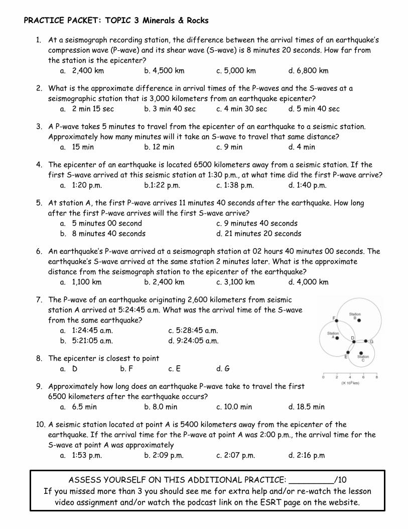
1. At a seismograph recording station, the difference between the arrival times of an earthquake’s
compression wave (P-wave) and its shear wave (S-wave) is 8 minutes 20 seconds. How far from
the station is the epicenter?
a. 2,400 km b. 4,500 km c. 5,000 km d. 6,800 km
2. What is the approximate difference in arrival times of the P-waves and the S-waves at a
seismographic station that is 3,000 kilometers from an earthquake epicenter?
a. 2 min 15 sec b. 3 min 40 sec c. 4 min 30 sec d. 5 min 40 sec
3. A P-wave takes 5 minutes to travel from the epicenter of an earthquake to a seismic station.
Approximately how many minutes will it take an S-wave to travel that same distance?
a. 15 min b. 12 min c. 9 min d. 4 min
4. The epicenter of an earthquake is located 6500 kilometers away from a seismic station. If the
first S-wave arrived at this seismic station at 1:30 p.m., at what time did the first P-wave arrive?
a. 1:20 p.m. b.1:22 p.m. c. 1:38 p.m. d. 1:40 p.m.
5. At station A, the first P-wave arrives 11 minutes 40 seconds after the earthquake. How long
after the first P-wave arrives will the first S-wave arrive?
a. 5 minutes 00 second c. 9 minutes 40 seconds
b. 8 minutes 40 seconds d. 21 minutes 20 seconds
6. An earthquake’s P-wave arrived at a seismograph station at 02 hours 40 minutes 00 seconds. The
earthquake’s S-wave arrived at the same station 2 minutes later. What is the approximate
distance from the seismograph station to the epicenter of the earthquake?
a. 1,100 km b. 2,400 km c. 3,100 km d. 4,000 km
7. The P-wave of an earthquake originating 2,600 kilometers from seismic
station A arrived at 5:24:45 a.m. What was the arrival time of the S-wave
from the same earthquake?
a. 1:24:45 a.m. c. 5:28:45 a.m.
b. 5:21:05 a.m. d. 9:24:05 a.m.
8. The epicenter is closest to point
a. D b. F c. E d. G
9. Approximately how long does an earthquake P-wave take to travel the first
6500 kilometers after the earthquake occurs?
a. 6.5 min b. 8.0 min c. 10.0 min d. 18.5 min
10. A seismic station located at point A is 5400 kilometers away from the epicenter of the
earthquake. If the arrival time for the P-wave at point A was 2:00 p.m., the arrival time for the
S-wave at point A was approximately
a. 1:53 p.m. b. 2:09 p.m. c. 2:07 p.m. d. 2:16 p.m
ASSESS YOURSELF ON THIS ADDITIONAL PRACTICE: _________/10
If you missed more than 3 you should see me for extra help and/or re-watch the lesson
video assignment and/or watch the podcast link on the ESRT page on the website.
PRACTICE PACKET: TOPIC 3 Minerals & Rocks
31
Lesson 6 – Volcanoes
Minding Mount Saint Helens
Mount St. Helens is part of a chain of continental volcanoes in the Cascade Range in the
northwestern United States. After lying dormant for 123 years, Mount St. Helens erupted in May 1980.
Scientists first noted volcanic activity on Mount St. Helens on March 27, 1980, when small tremors
began and the mountaintop began to bulge. About a week later, scientists discovered steam coming out
of cracks in the north side of the mountain.
The first violent eruption occurred on May 18, 1980. At that time, the north side of the mountain
collapsed, and the collapsed material was ejected from the mountain.
Huge clouds of gas, dust, ash, and pulverized, hardened lava formed as the volcano erupted. The
clouds reached a height of 24 km and a width of 32 km. The volcanic ash that fell to earth has a very
high silica content.
Your Turn to Think
1. What kind of plate tectonic activity is responsible for the formation of the Cascade Range?
2. During the nineteenth century, Mount St. Helens erupted three times. Each time, Mount Baker, a
nearby volcano, also erupted. What hypothesis can you make about the origins of Mount St.
Helens and Mount Baker?
3. Does the 1980 eruption of Mount St. Helens by itself support your hypothesis about Mount St.
Helens and Mount Baker? Why or why not?
4. Why was steam coming from cracks in the side instead of the top of the volcano?
5. Why did it take two months from the first observation of activity before Mount St. Helens
finally erupted on May 18, 1980?
6. What would you expect the composition of the rocks around Mount St. Helens to be?
What evidence suggests this to you?
Objective:
• I can define what a volcano is
• I can describe what is occurring during eruptions & what features are being formed
• I can explain the dangers & how to predict volcanic eruptions
• I know volcano safety
THINKING CRITICALLY

PRACTICE PACKET: TOPIC 3 Minerals & Rocks
32
Regents Questions:
Base your answers to questions 1 through 3 on the passage below and on your knowledge of Earth
science. The passage describes unusual lava from a volcano in Africa.
Unusual Volcano
Nyiragongo, located at 2° S 29° E, is an active African volcano. It has the most fluid
lava on Earth. The lava has a composition unlike any other lava in the world. The rare
isotopes found in the lava are similar to those found in ancient asteroids. This fact
leads scientists to infer that the lava may be as old as our solar system and that it
comes from deep inside the mantle near Earth’s outer core. Nyiragongo is one volcano
in a ring of many volcanoes surrounding an area that is domed upward nearly a mile
above sea level, causing scientists to infer that a new mantle hot spot is forming
there.
1. Two rocks, scoria and basalt, have formed from the cooled lava that erupted from Nyiragongo.
Describe the texture of each rock.
2. Identify the type of tectonic plate boundary found in the vicinity of Nyiragongo.
3. Identify two other locations on Earth, not on a plate boundary, where mantle rock is rising to
Earth’s surface.
Base your answers to questions 4 through 6 on the picture below & on your knowledge of Earth Science.
4. Identify one of the minerals found in the andesite rock of the Three Sisters volcanoes.
5. The cross section above represents Earth’s interior beneath the Three Sisters. Place a triangle,
∆, on the cross section to indicate the location where the new volcano will most likely form.
6. On the same cross section, place arrows through each point X, Y, & Z, to indicate the relative
motion of each of these sections of the lithosphere.
PRACTICE PACKET: TOPIC 3 Minerals & Rocks
33
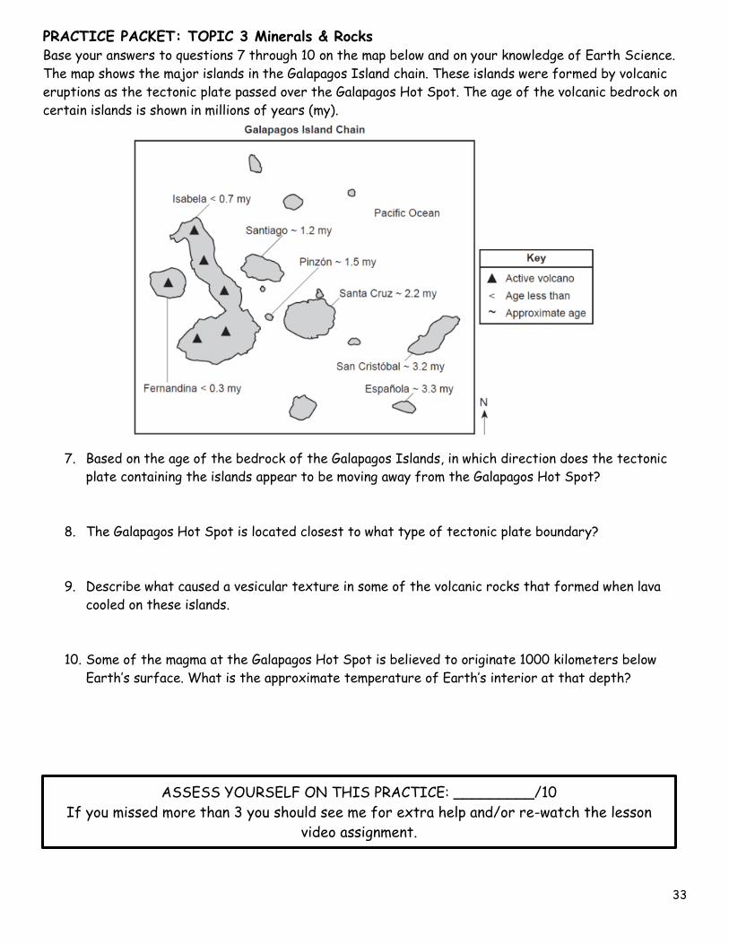
Base your answers to questions 7 through 10 on the map below and on your knowledge of Earth Science.
The map shows the major islands in the Galapagos Island chain. These islands were formed by volcanic
eruptions as the tectonic plate passed over the Galapagos Hot Spot. The age of the volcanic bedrock on
certain islands is shown in millions of years (my).
7. Based on the age of the bedrock of the Galapagos Islands, in which direction does the tectonic
plate containing the islands appear to be moving away from the Galapagos Hot Spot?
8. The Galapagos Hot Spot is located closest to what type of tectonic plate boundary?
9. Describe what caused a vesicular texture in some of the volcanic rocks that formed when lava
cooled on these islands.
10. Some of the magma at the Galapagos Hot Spot is believed to originate 1000 kilometers below
Earth’s surface. What is the approximate temperature of Earth’s interior at that depth?
ASSESS YOURSELF ON THIS PRACTICE: _________/10
If you missed more than 3 you should see me for extra help and/or re-watch the lesson
video assignment.

PRACTICE PACKET: TOPIC 3 Minerals & Rocks
34
A C
B D