post earthquake reconnaissance survey (pert) report
TRANSCRIPT

1
18 September 2011 Sikkim Earthquake
Post-Earthquake Reconnaissance Report - West Bengal
NDMA’s Post-Earthquake Reconnaissance Team Ajay P. Chourasia
Arvind Jaiswal Balraj Joshi
C. V. R. Murty A. K. Pachauri Prabhas Pande
Pradeep Kumar Ramancharla P. K. Champati Ray
Bhoop Singh
20 December 2011
2
1. BACKGROUND An earthquake occurred in eastern Nepal near the Nepal-Sikkim border on 18
September 2011 at 18:10 IST. It caused significant damage of the built environment in Sikkim alone, especially roads and buildings. The National Disaster Management Authority (NDMA) constituted a Post-Earthquake Reconnaissance Team (PERT) (vide Office Memorandum No. 5-83/2011-MIT, dated 04 November 2011) to study the damages sustained in the areas affected by the 18 September 2011 Sikkim Earthquake in the state of West Bengal. The PERT will conduct field investigations during 10-13 November 2011 with the following terms of reference:
A. Structures damaged by the Earthquake (1) Collect perishable data related to the built environment in the affected area; (2) Identify vulnerable construction typologies and their performance; (3) Identify main reasons for damage to masonry, RC frame, traditional construction and
other construction; and (4) Evaluate the performance of structural, non-structural and functional elements in major
critical and lifeline buildings and facilities, such as hospitals, where feasible. B. Landslides triggered by the Earthquake (1) Identify and study the impact of the landslides occurred due to earthquake; (2) Identify the active landslides using NRSC imageries and prioritize them in the following
categories: (a) Landslides directly affecting habitations, (b) Landslides affecting communication- transport, telecommunication and power, (c) Landslides affecting major hydro power projects, and (d) Other landslides of lesser consequences.
(3) Identify possible short-term and long-term remedial measures for landslide risk mitigation and suggest land use control measures;
(4) Identify minimum instrumentation required for real time monitoring of recurring, unmanageable and critical landslides sites to develop remotely operated real-time early warning system; and
(5) Strategize for capacity building of West Bengal’s Department of Geology & Mining, SDMA and other stakeholders with assistance of GSI and technical institutes.
C. Other Aspects raised by the Earthquake, if relevant (1) Suggest possible procedure for assessment of damaged buildings, (2) Suggest possible strategies for intermediate shelter designs, and (3) Suggest guidelines for construction of future buildings and recommendations for best
housing construction practices. The NDMA’s Post-Earthquake Reconnaissance Team (PERT) members visited the earthquake affected areas in the district of Darjeeling in the State of West Bengal. The team consisted of Ajay P. Chourasia (CBRI, Roorkee), Arvind Jaiswal (Consulting Engineer, Secunderabad), Balraj Joshi (NHPC, Faridabad), C. V. R. Murty (IIT Madras), A. K. Pachauri (NDMA, New Delhi), Prabhas Pande (Formerly GSI, New Delhi), Pradeep Kumar Ramancharla (IIIT Hyderabad), P. K. Champati Ray (IIRS, Dehradun) and Bhoop Singh (DST, Government of India, New Delhi). During their visit, the PERT members held discussions with engineers, government officers and private citizens. The observations and main issues captured by the team members during the above reconnaissance visits are summarised in this report.
3
1.1 Overview of Seismic Effects
The earthquake produced two major effects in the district of Darjeeling, namely on buildings and on hill slopes. The Government of West Bengal reported ~37,000 buildings to have been destroyed during the M6.9 earthquake of 18 September 2011. While the town of Kalimpong suffered the most during the earthquake, the towns of Darjeeling, Kurseong and Ghum also sustained damage. The maximum intensity of ground shaking experienced during the earthquake in the district of Darjeeling in the state of West Bengal was only about VI on the MSK scale. Considering the low intensity of ground shaking in the affected areas, the damage claim of the government was disproportionately higher. While some weak and brittle constructions performed poorly during this earthquake, the claim of 37,000 houses having been destroyed did not seem reasonable as observed during the field visits of the PERT.
The Darjeeling hills attract tourists from all over the world due to its scenic beauty. For the easy access of the important towns in this area, like Darjeeling and Kalimpong, national highway NH 55 is the important link from Siliguri to Darjeeling. During the visit, the team noted that NH 55 was completely damaged at two places, namely Pagla Jhora (30 km from Siliguri) and Teendharia (40 km from Siliguri). The NH 55 was blocked for the last two years. The heritage train from Siliguri to Darjeeling also was non-functional owing to this slide during the last two years. The landslides at these two locations are of gigantic magnitude, and need end-to-end solutions. The team also visited other landslide affected areas along the road from Darjeeling to Kalimpong, where few sinking zones were noted. The major landslides disrupted transportation and unstable slopes pose major threat to life and properties in these areas. Even though the earthquake generated moderate seismic intensity of VI on MSK scale in the hills of Darjeeling, it induced slope instability conditions in several critically disposed slope masses along the hills of the district of Darjeeling. Thus, effects took place in over large areas, which include development of sinking zones, creation and opening up of tension fissures, rock and boulder falls, and slippage of rock mass. Some slopes drew special attention of district administration of Darjeeling region, which affected the anthropogenic features such as human settlements, communication routes, and water storage facilities. The PERT visited nine slope instability sites along with representatives of district administration. 2. LANDSLIDES
Darjeeling Himalaya is prone to slope failures and landslides triggered by both torrential rainfall and seismic activity. The 1934 Bihar Nepal earthquake and 2011 Sikkim earthquake have caused new as well as reactivated old rock slides, debris slides and accelerated downward movement of creep mass or subsidence zones. During reconnaissance survey to assess the effect of 6.9 Mw Sikkim earthquake of 2011, landslides of various types and dimensions were observed. Landslides were of four major types: Rock slide, Rock fall, Debris slide, Soil creep or subsidence. In total 15 locations were observed and at selected 8 locations (Figure 1) as per the concern of the local administration, preliminary details such as type of landslide, cause of landslide, dimensions, brief history, underlying material, lithological and structural set up and control, damage and potential risk, long term and immediate remedial measures have been provided based on the reconnaissance survey, satellite image analysis, quick literature review and interaction with local population and government officials.

4
Figure 1: IRS–LISS-III pre earthquake image showing locations of landslides in Darjeeling-
Kalimpong-Kurseong area 2.1 Description of Landslides Studied Darjeeling district of West Bengal, the neighbouring Indian state south of Sikkim, was affected by several major landslides. The PERT Members visited the site with the Sub-Divisional Magistrate, Kurseong, and Executive Engineer, National Highway Authority of India (NHAI). Three types of landslides or land creeps were encountered, namely (1) those caused by the earthquake shaking, e.g., Ghoom landslide (scarp length of ~50m,
damaging eight houses and pavement of National Highway 55), and TN Road landslide (scarp length of ~200 m with mass movements affecting areas 1000 m down-slope damaged several houses, a Buddhist monastery and religious structures, caused steel trestle supporting water mains to settle leaving the steel pipelines unsupported and led to the cracking of pavements);
(2) those occurred before the event, but reactivated by the earthquake, e.g., the Teendharia, and Balason landslides of Darjeeling district; and
(3) those initiated to creep by the event, but did not slip or slide during the event, e.g., Tukdah Tea Estate landslide (scarp length of ~500 m with movements extending ~3,000 m down-slope that damaged 16 houses, led to the cracking of pavements and affected several hundred people) making the down slope settlement unsafe during future earthquakes.
The reactivation in case (2) above is not co-seismic, but developing over several days following the earthquake because of heavy rainfall the area received over several days immediately before the earthquake. For instance, the Teendharia landslide developed on 28 September 2011. Although satellite images did not reveal any correlation between past and the most recent landslide events for a number of major landslides on-the-ground inspection revealed signs of continual distress indicating the post earthquake landslides to be reactivation of pre-existing landslides. Enquiry with the locals in Tukdah – Rangoli Khola corroborated the landslide to be episodic with a large event taking place several decades back.

5
2.1.1 Rangati Khola Sinking Zone The fairly steep debris slopes covering the Darjeeling Group of rocks (gneiss and
schist) of the Tea Estate settlement experienced fair amount of distress consequent to the 18 September 2011 earthquake. As a result, arcuately disposed tension fissures developed, particularly at the crown portion of several zones of instability. Some of these that coalesced because of their proximity with others appeared to extend for kilometers thereby instilling a sense of fear among the inhabitants who apprehended danger to their settlements in the coming monsoon months. The survey indicated that the settlement has come up over the partially stabilized debris mass of a paleo-slide zone. Such a situation is common in various parts of the Himalaya where the rugged mountain terrain provides little scope for construction in more congenial lands thereby compelling the people to occupy such zones for raising their dwellings as well as cultivation. Above the Rangati Khola village, ground fissures of maximum length of 30 m and opening of 20-30 cm were seen in the crown portion of one such zone of instability (Figure 2). Vertical displacement was relatively smaller along the fissures suggesting their passiveness in subsequent period to the earthquake. The affected slopes were covered with fairly thick vegetation. A seasonal nala of low discharge drained the affected slopes. Down below in the road section, the slopes had developed sinking zones in certain reaches.
Figure 2: An arcuate ground fissure above Rangati Khola settlement
6
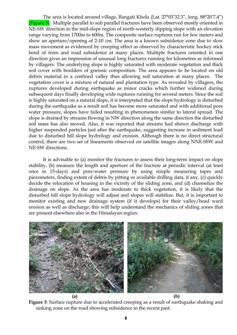
The area is located around village, Rangati Khola (Lat. 27°03’32.3”, long. 88°20’7.4”) (Figure 3). Multiple parallel to sub parallel fractures have been observed mostly oriented in NE-SW direction in the mid-slope region of north-westerly dipping slope with an elevation range varying from 1700m to 600m. The composite surface ruptures run for few meters and show an aperture/opening of 2-10 cm. The area is a known subsidence zone due to slow mass movement as evidenced by creeping effect as observed by characteristic hockey stick bend of trees and road subsidence at many places. Multiple fractures oriented in one direction gives an impression of unusual long fractures running for kilometres as informed by villagers. The underlying slope is highly saturated with moderate vegetation and thick soil cover with boulders of gneissic composition. The area appears to be located on old debris material in a confined valley thus allowing soil saturation at many places. The vegetation cover is a mixture of natural and plantation type. As revealed by villagers, the ruptures developed during earthquake as minor cracks which further widened during subsequent days finally developing wide ruptures running for several meters. Since the soil is highly saturated on a natural slope, it is interpreted that the slope hydrology is disturbed during the earthquake as a result soil has become more saturated and with additional pore water pressure, slopes have failed resulting in phenomenon similar to lateral spread. The slope is drained by streams flowing in NW direction along the same direction the disturbed soil mass has also moved. Also, it was reported that streams had shown discharge with higher suspended particles just after the earthquake, suggesting increase in sediment load due to disturbed hill slope hydrology and erosion. Although there is no direct structural control, there are two set of lineaments observed on satellite images along NNE-SSW and NE-SW directions.
It is advisable to (a) monitor the fractures to assess their long-term impact on slope
stability, (b) measure the length and aperture of the fracture at periodic interval (at least once in 15-days) and pore-water pressure by using simple measuring tapes and piezometers, finding extent of debris by pitting or available drilling data, if any, (c) quickly decide the relocation of housing in the vicinity of the sliding zone, and (d) channelize the drainage on slope. As the area has moderate to thick vegetation, it is likely that the disturbed hill slope hydrology will adjust and slopes will stabilize. But, it is important to monitor existing and new drainage system (if it develops) for their valley/head ward erosion as well as discharge; this will help understand the mechanics of sliding zones that are present elsewhere also in the Himalayan region.
(a) (b)
Figure 3: Surface rupture due to accelerated creeping as a result of earthquake shaking and sinking zone on the road showing subsidence in the recent past.

7
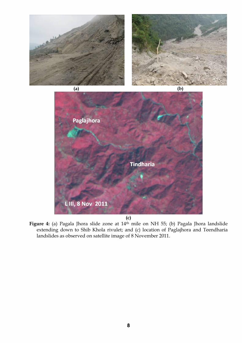
2.1.2 Pagala Jhora Landslide Zone along National Highway 55 The National Highway 55 (Siliguri-Darjeeling Highway) has suffered repeated failures for decades in the Pagala Jhora sector and remained a major eyesore as far as traffic movement is concerned (see Point 7 on Figure 1). The area exposes the highly tectonised sheared gneissic rocks close to Main Central Thrust (MCT) (see Geological map, Figure 6 below) belonging to the Darjeeling and Daling Groups, which are separated with each other by the Main Central Thrust (MCT). In the 14 KM slide, a 500 m reach of the Highway has remained breached, thereby totally disrupting the movement along the road and Heritage Rail Route since 16 June 2010 and impacting the socio-economic activity in the hill region in very significant way (Figure 4).
On the southeastern fringe of the slide zone, highly sheared and mylonitized gneiss and micaceous schistose rocks are exposed that indicate their involvement in the thrusting process. A detailed map of this slide zone has been prepared by the Geological Survey of India. The slide scar presently extends for almost 100 m above the road level. The field investigation revealed that a major portion of the slide zone has been restored by clearing the debris and redressing the road surface besides treating the disturbed slopes by shotcrete. However, consequent to the 18 September 2011 earthquake, a huge rock block having rough dimensions of 15m×10m×8m slipped along steeply dipping joints, thereby blocking the restored reach once again (Figure 5).
The Pagala Jhora sector, comprising a compound slide zone, is a perennial trouble spot along the Highway as the rock mass here is inherently of very low shear strength amenable to severe erosion and even straining due to possible tectonic creep. Even a slight provocation like consistent rain fall in the area or excitation by earthquake motions mobilizes the slide mass off and on. It is, therefore, imperative to carry out a detailed geotechnical assessment of the Pagla Jhora zone by a competent agency. For seeking a permanent solution to the problem it may been worthwhile to study an alternate road alignment or even consider bypassing the slide zone by a traffic tunnel, if the former is not possible.
8
(a) (b)
(c)
Figure 4: (a) Pagala Jhora slide zone at 14th mile on NH 55; (b) Pagala Jhora landslide extending down to Shib Khola rivulet; and (c) location of Paglajhora and Teendharia landslides as observed on satellite image of 8 November 2011.

9
(a)
(b) (c)
Figure 5: Two photographs of the same slipped rock mass consequent to the 18 September 2011 earthquake blocking National Highway 55
The huge rock slide at Paglajhora is at 14th mile on the Darjeeling Himalayan Heritage Railway (DHR) route on the eastern slope of the Kurseong mountain range. The rock slide extends from relief of 1280m at the crown to 900m at the valley bottom with a length of 500 m and width of 450 m at the road level and depth > 30m. It is the largest landslide observed during field investigation. As per local information, the present landslide started on 16 June 2010 during road widening and thereafter its dimensions increased. On 18 September 2011, it got reactivated as one of the major disjointed block slided down the slope on the northern part of the slide completely destroying the partially restored road. As a result, the NH 55/Hill cart road and the heritage railway running parallel to each other remain disrupted since June 2010 and it is a matter of great concern as it affects tourism as well general communication. The present landslide was initiated as a rock slide. The area is underlain by highly folded, crumpled sheared gneissic and schistose rock (Lingtse) and the area is on the hanging wall side of the MCT that passes towards southeastern part trending in NE-SW direction (Figure 6). The Paglajhora is prone to rockslide for last many years as reported in 1980, 1998 and now a major landslide has occurred in 2010 which was reactivated again in 2011 due to Sikkim earthquake. A small lake was also reported at Paglajhora due to debris of rock slides blocking the drainage in August 2011.

10
The landslide has severely affected NH 55/ Hill cart road and Darjeeling Himalayan Heritage Railway which started in 1881 and the slope stability was maintained although there were occurrences of landslides in the past. Most importantly, the landslide crown has reached an elevation of 1280m and human settlements are observed at 1310m and the same NH 55 with settlements is observed at 1360m which can be affected unless remedial measures are taken up at the present site which is at the lower elevation.
The remedial measures require detailed geotechnical and geological analysis and
large scale engineering intervention as it has potential to affect two stretches of NH 55 and human settlements. The alternate route alignment is the first cost effective possible solution through a tunnel of 800m can be suggested to completely avoid the landslide affected 14 mile site, if the alternative route is not possible. However, as the area lies very close to MCT and dominated by sheared gneiss and phyllonites, it is recommended that a thorough geological, geotechnical investigations must to be carried out before taking up any remedial measures. As informed, GSI has carried considerable work in the region, based on their study and additional investigation as required, further recommendations can be suggested.
Figure 6: Geolgical map showing major landslide locations at Paglajhora and Tindharia
[Ghosh et al. GSI]
11
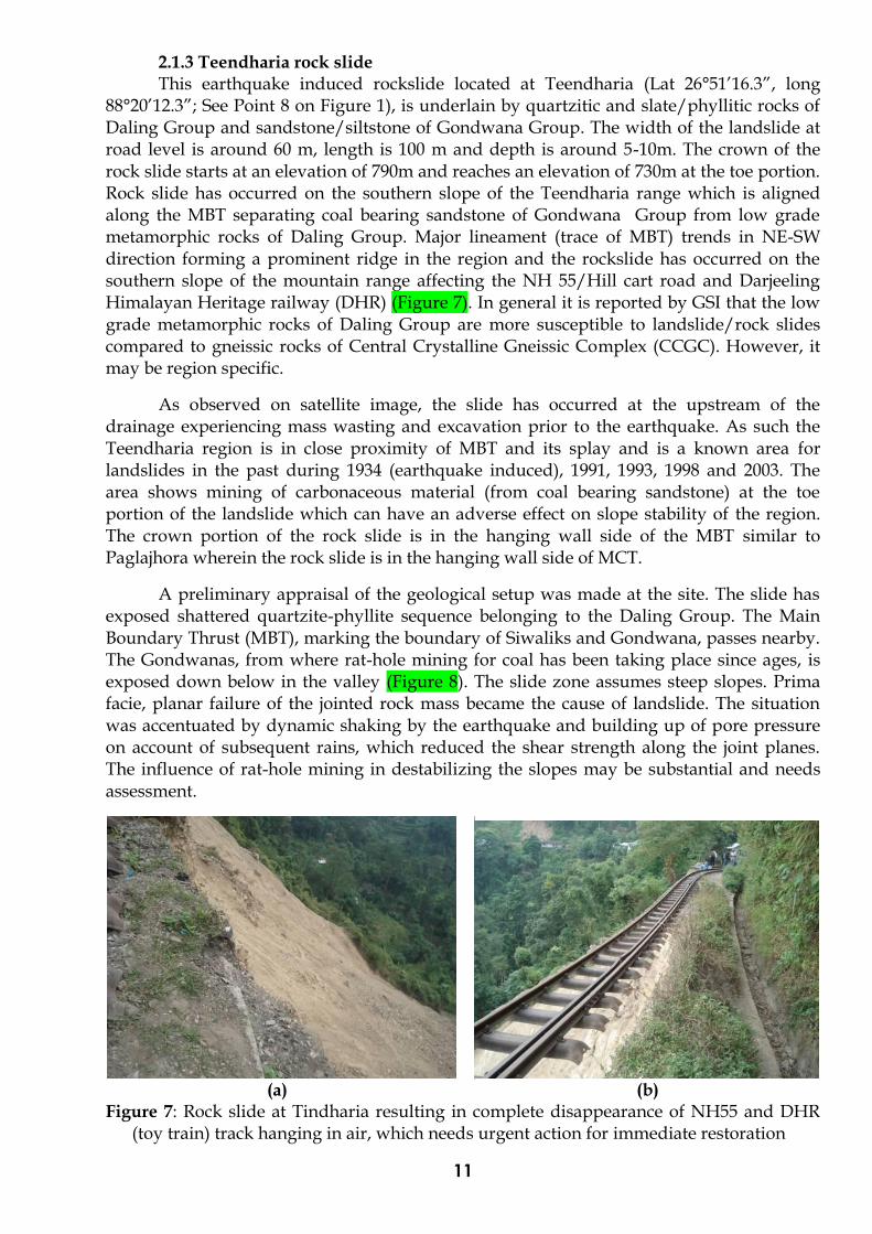
2.1.3 Teendharia rock slide This earthquake induced rockslide located at Teendharia (Lat 26°51’16.3”, long
88°20’12.3”; See Point 8 on Figure 1), is underlain by quartzitic and slate/phyllitic rocks of Daling Group and sandstone/siltstone of Gondwana Group. The width of the landslide at road level is around 60 m, length is 100 m and depth is around 5-10m. The crown of the rock slide starts at an elevation of 790m and reaches an elevation of 730m at the toe portion. Rock slide has occurred on the southern slope of the Teendharia range which is aligned along the MBT separating coal bearing sandstone of Gondwana Group from low grade metamorphic rocks of Daling Group. Major lineament (trace of MBT) trends in NE-SW direction forming a prominent ridge in the region and the rockslide has occurred on the southern slope of the mountain range affecting the NH 55/Hill cart road and Darjeeling Himalayan Heritage railway (DHR) (Figure 7). In general it is reported by GSI that the low grade metamorphic rocks of Daling Group are more susceptible to landslide/rock slides compared to gneissic rocks of Central Crystalline Gneissic Complex (CCGC). However, it may be region specific.
As observed on satellite image, the slide has occurred at the upstream of the drainage experiencing mass wasting and excavation prior to the earthquake. As such the Teendharia region is in close proximity of MBT and its splay and is a known area for landslides in the past during 1934 (earthquake induced), 1991, 1993, 1998 and 2003. The area shows mining of carbonaceous material (from coal bearing sandstone) at the toe portion of the landslide which can have an adverse effect on slope stability of the region. The crown portion of the rock slide is in the hanging wall side of the MBT similar to Paglajhora wherein the rock slide is in the hanging wall side of MCT.
A preliminary appraisal of the geological setup was made at the site. The slide has exposed shattered quartzite-phyllite sequence belonging to the Daling Group. The Main Boundary Thrust (MBT), marking the boundary of Siwaliks and Gondwana, passes nearby. The Gondwanas, from where rat-hole mining for coal has been taking place since ages, is exposed down below in the valley (Figure 8). The slide zone assumes steep slopes. Prima facie, planar failure of the jointed rock mass became the cause of landslide. The situation was accentuated by dynamic shaking by the earthquake and building up of pore pressure on account of subsequent rains, which reduced the shear strength along the joint planes. The influence of rat-hole mining in destabilizing the slopes may be substantial and needs assessment.
(a) (b)
Figure 7: Rock slide at Tindharia resulting in complete disappearance of NH55 and DHR (toy train) track hanging in air, which needs urgent action for immediate restoration

12
Figure 8: Diagramatic sectional sketch across the damaged road section near Teendharia
Railway Workshop between CH 52+00 KM and 53+00 KM of NH 55
The affected road section is aligned almost E-W and adopts wide loops on either side. The contour plan of the slide zone on scale 1:10,000 with 5m contour interval indicates that the slide zone is 85 m wide at the road level of 197.012 m and gradually tapers down and pinches off at around ~60.000 m level. As a result of sliding the entire road section between CH. 52.85 m and 53.775 m has slipped down. Almost 30 m of the road on either side of the slide scar is also highly distressed and marked by tension fissures. A narrow lined drainage skirting the road on the hill side is still intact and the rail line hangs in portions (Figure 9); down below, Gondwana’s are seen exposed from where rat-hole mining to win coal was practised.
Figure 9: Teendharia slide zone tapering at lower levels. The Highway was breached with
the rail track left hanging.

13
2.1.4 Graveyard site in Darjeeling The area is located (Lat. 27°02’26.8”, Long. 88°15’38.8”; See Point 1 on Figure 1) close
to a graveyard in Darjeeling underlain by soil and debris (bed rock is not exposed on the surface) and covered with moderate dense vegetation. Upper reach of a side slope of a stream flowing in NW direction has failed in the recent earthquake. The failure has started from the edge of the narrow valley of a stream as a debris slide and has continued till the valley bottom. The slide dimensions are approximately: 60-70m in length, 45m in width and of 2-5m depth. There are evidences of subsidence and fractures on the upper reach of the slope. Head-ward erosion was also observed at the upper reach of the stream and side slopes. Although there is no direct structural control observed at the site, but the area and the slide movement direction coincide with a lineament aligned along WNW-ENE direction as revealed on satellite images.
The slide has affected only a graveyard, however, considering its location within the
urban limit, it may be considered for restoration through suitable remedial measures. Slope restoration is possible using standard techniques such as gabion/masonry walls starting from bottom to top with horizontal geotextile layers in between and horizontal drainage network with interceptor and trench drain at appropriate location to dewater the slope.
2.1.5 Debris slide at bridge location, Darjeeling The area is located (Lat. 27°03’7.4”, Long. 88°15’33.7”; see Point 2 on Figure 1) on one
of the main road of Darjeeling town, where a massive slope failure of debris material has led to complete destruction of the road and an emergency make-shift bridge has restored the vital communication link (Figure 10). The landslide has occurred along a small stream flowing in SW direction on the western slope. On satellite image, it appears to be controlled by a lineament in the same direction. It looks like an area affected by creeping, evidences of which have been observed as subsidence fractures on road. Although the main landslide has not affected residential/commercial buildings, but poses threat, hence needs slope stabilization/restoration using standard techniques as mentioned above.
(a) (b)
Figure 10: Debris slide and makeshift Bailey bridge restored transportation link in Darjeeling town

14
2.1.6 Rock and debris slide on Kalimpong road The point is located (Lat. 27°03’06.0”, Long. 88°26’30.0”; see Point 4 on Figure 1) on
the western hill slope of the Kalimpong hill range. It is a rock fall and slide zone initiated by bank and head ward erosion of a stream following in NW direction (Figure 11). The old landslide is partially stabilized as evidenced by growth of vegetation on stabilized debris mass. In recent times, landslide has been initiated from mid-slope region at an altitude of approximately 800 m and continues till the confluence of the stream with Teesta river at an altitude of 220m. Gneissic and schistose rocks are exposed in the area and show 3-sets of joints and water mainly percolates through joints opposite to dip direction. Two sets of lineaments are observed on satellite image i.e. trending in NW-SE and NE-SW directions. The rock and debris slide has affected a rural road constructed under Pradhan Mantri Gram Sadak Yojana (PMGSY) scheme. Remedial measures include river training in the upper reach area and wire mesh support or gabion walls on the side slopes to reduce the flow velocity, erosion and infiltration into the ground. Local people informed that the mass wasting in the upper reach may affect built environment, which needs further study for verification.
(a) (b)
Figure 11: Active rock and debris slide and partially stabilized rock/debris mass showing regeneration of vegetation.
2.1.7 Debris slide at Waste Disposal site, Kalimpong As revealed on satellite image, the landslide zone (Lat.27°05’24.8”, Long. 88°28’32.4”;
see Point 5 on Figure 1) is located along a drainage which has been disturbed in the road construction for the waste disposal site in lower NW slopes of Kalimpong range. In close proximity, another slope instability region was observed to the east of affected region. This debris slide does not show any evidence of reactivation in the recent earthquake. Mass wasting starts at the side slopes and upper reaches due to head ward erosion (Figure 12). It forms catchment of the major stream draining the western slope of the Kalimpong range, therefore, proper draining of slope is of utmost importance to reduce pore water pressure and improve stability of the region. There is no visible sign of soil creeping in the recent past, which confirms the initiation of the landslide is mainly due to blockade of drainage in the sub-basin. From crown to toe of landslide, relief varies from 665 m to 450m. Remedial measures are required at both upslope and down slope of waste disposal site. On priority, the upslope needs treatment, and suggested interventions should aim at draining out of excess water from the slopes through trench drain, horizontal drain and interceptor drains. As the slope is gentler at the site, restoration of slope may be easier by providing drainage features; piezometers may be provided for monitoring pore water pressure. In down slope area, treatment of side slopes and lining of drainage are suggested at selected locations.

15
(a) (b)
Figure 12: Up slope of the debris slide at waste disposal site and down slope of the adjacent debris slide
2.2 Effects of Landslides
Landslides caused damage to roads, railway lines, buildings, and water supply lines in the hills of Darjeeling. Damage is significant to road section of NH55 (Siliguri-Darjeeling section of National Highway) and rail section near Tindharia Railway workshop between chainage 52 km and 54 km. Nearly 120 m section of NH55 and the heritage rail line slid-off on 28 September 2011 (Figure 13). The consequence of this slide was complete disruption of the vehicular and rail traffic on these transits. Eyewitnesses report that the 18 September 2011 earthquake caused distress in the road section between chainage 52.850 km and 53.700 km, in the form of minor tension fissures on the road surface. These fissures widened during the days following, particularly after rains. On 27 September 2011, people in the neighbourhood noticed appreciable opening of these cracks and raised a caution. On the next day, i.e., 28 September 2011, the entire 105m stretch of the road came down in one go at 10.45am, creating great consternation among the residents. Housing along hill slopes and critical constructions were affected (Figure 14). Lack of redundancy of road and rail networks affected rescue and relief operations in the aftermath of earthquakes.
One rock fall zone (Lat. 26°52’12.4”, Long. 88°17’21.0”; see Point 6 on Figure 1) is
located towards southern end of the main Kurseong range on the Kurseong-Mahanadi sector of NH 55/Hill cart road. In this rock fall zone, dislocated boulders have hit houses during recent earthquake (Figure 15). The area is underlain by gneissic rock and steeper upper slopes are prone to rock failures. The affected houses are at little higher elevation than the road level at 1420m and uppermost slope continues up to a height of 1730m, thus it provides a relative relief of 300m which can cause potential threat in the event of a stronger earthquake. In such potential rock fall zone, assessment should be made in the upper reaches and accordingly suitable remedial measures are to be adopted. As the area shows good vegetation and soil cover, plantation of trees can provide natural barrier against such rock fall.

16
(a) (b)
Figure 13: Views of Teendharia slide zone that affected the adjoining road and rail networks
(a) (b)
Figure 14: (a) A precarious construction situation on the edge of Teendharia slide zone; and (b) a precarious situation of sliding at Leprosy Hospital in Kalimpong
Figure 15: Damage to houses due to earthquake-induced rock fall

17
3. Damage to Built Environment The built environment in hill areas of West Bengal affected by the earthquake
includes the usual constructions, namely housing, heritage structures, schools, hospital, religious structures, critical and lifeline structures, and governance structures. This section describes the typologies of different constructions and damages sustained during 18 September 2011 Sikkim Earthquake.
3.1 Housing The buildings prevalent in along the hills of Darjeeling and Kalimpong are typically
one- or two-storeyed buildings; in urban areas, they are up to 9 storeys tall. Features of these buildings are described in the following: (1) Traditional houses are single- or two-storeyed Ekra houses built with a wood frame
from sloping ground to roof level, light corrugated galvanised iron (CGI) sheet roofing supported on the wood frame, mud walls from plinth to sill level, and cross-woven Ekra or bamboo spilt matting plastered with mud or fine sand with lime as rest of the walling. In two-storey houses, the flooring is of wood. There are numerous variations to this housing typology over time (Figure 16). These include: (i) sill mud walls replaced by half-brick thick burnt clay brick unreinforced masonry walls, (ii) sill masonry walls or sill mud walls, and ekra panels all replaced with wood planks from ground to up to roof, (iii) mud walls and ekra panels above sill level all replaced with metal sheeting, (iv) sill masonry wall or sill mud walls, and ekra panels all replaced with metal sheeting, (v) wood frame is replaced by a RC frame, wood floor of two storey building with RC slab, and roof retained as sheet roofing, (vi) wood frame is replaced by a RC frame, wood floor of two-storey building by a RC slab, and roof replaced by RC slab, and (vii) wood frame is replaced by a RC frame up to ground floor level from the hill slope, wood floor replaced by a RC slab, wall wood framing and ekra panels replaced by unreinforced masonry (URM) walls, and roof with RC slab.
(2) Single-storeyed unreinforced brick, stone or concrete block masonry on flat ground without earthquake resistant features. In rare occasion, a house is seen to have basic earthquake-resistant features, like horizontal bands across the whole house. Many varieties of stone masonry are observed in the hills of Darjeeling and Kalimpong. These include: random rubble masonry (RRM) in mud or lime mortar, dry dressed stone masonry, dressed stone masonry in cement mortar without pointing, and dressed stone masonry in cement mortar with pointing.
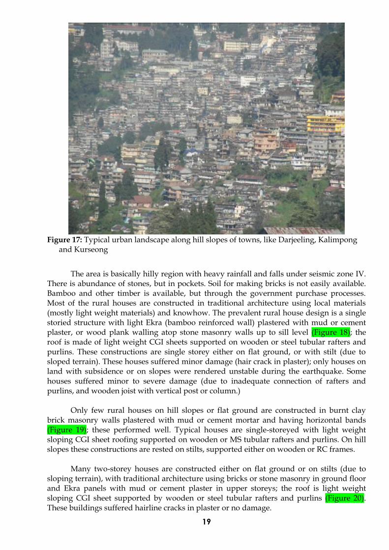
(3) The urban areas are seen to have RC frame construction along hill slopes up to 6-9 storeys, with RC floor slabs roof (Figure 17). In some cases, light CGI sheeting roof is employed at topmost floor. Where flat land is available, the foundation of the building is rested on it directly on it.

18
(a) (b)
(c) (d)
(e) (f)
(g) (h) (i)
Figure 16: Variations of housing in hill slopes of Darjeeling and Kalimpong
19
Figure 17: Typical urban landscape along hill slopes of towns, like Darjeeling, Kalimpong
and Kurseong
The area is basically hilly region with heavy rainfall and falls under seismic zone IV.
There is abundance of stones, but in pockets. Soil for making bricks is not easily available. Bamboo and other timber is available, but through the government purchase processes. Most of the rural houses are constructed in traditional architecture using local materials (mostly light weight materials) and knowhow. The prevalent rural house design is a single storied structure with light Ekra (bamboo reinforced wall) plastered with mud or cement plaster, or wood plank walling atop stone masonry walls up to sill level (Figure 18); the roof is made of light weight CGI sheets supported on wooden or steel tubular rafters and purlins. These constructions are single storey either on flat ground, or with stilt (due to sloped terrain). These houses suffered minor damage (hair crack in plaster); only houses on land with subsidence or on slopes were rendered unstable during the earthquake. Some houses suffered minor to severe damage (due to inadequate connection of rafters and purlins, and wooden joist with vertical post or column.)
Only few rural houses on hill slopes or flat ground are constructed in burnt clay brick masonry walls plastered with mud or cement mortar and having horizontal bands (Figure 19); these performed well. Typical houses are single-storeyed with light weight sloping CGI sheet roofing supported on wooden or MS tubular rafters and purlins. On hill slopes these constructions are rested on stilts, supported either on wooden or RC frames.
Many two-storey houses are constructed either on flat ground or on stilts (due to sloping terrain), with traditional architecture using bricks or stone masonry in ground floor and Ekra panels with mud or cement plaster in upper storeys; the roof is light weight sloping CGI sheet supported by wooden or steel tubular rafters and purlins (Figure 20). These buildings suffered hairline cracks in plaster or no damage.

20
Figure 18: Traditional rural housing along hill slopes of Darjeeling, Kalimpong and
Kurseong
Figure 19: Traditional rural housing on hill slopes ith bands
Figure 20: Traditional building with earthquake-resistant architecture

21
Failure of buildings with thick stone masonry walls in Kalimpong area was predominantly observed due to mud mortar as binding material and absence of earthquake-resistant features (like bands), excessive long walls having out of plane failure, dilation effect due to light roofing and weak binding mortar, opening in walls at corner, subsidence of foundation due to excessive seepage, presence of steep slope, inadequate retaining structure close to foundation, and vertical irregularity in stone masonry construction due to raised central part of building. The walls of such buildings are either 115mm or 230mm thick. Some buildings are provided with 125mm thick walls with RC band at sill level and no RC band at lintel level or eaves level. Gable ends are provided with wooden or CGI sheet cladding.
Effects of 18 September 2011 earthquake, characteristic of Seismic Intensity VI on
MSK 64 scale, were documented at 6 localities of Siliguri town, where two casualties have been recorded. In the Paswan Basti of Siliguri town, a dense cluster of low-income group houses situated on the eastern gentle slopes of a low topographic depression, a total of 35 housed suffered damage, out of which 23 were restored with repairs and 12 constructed afresh by the Municipal Corporation. The single storey structures were of brick masonry, poor sand-cement mortar and thatched or tin sheet roofing. On a rough assessment, damage of Grade 1 & 2 (fine and open cracks) in many and Grade 4 (collapse) in a few structures took place in the locality. The reconstruction of housing has begun (Figure 21). The Siliguri College, established in 1950, has many blocks mostly made of masonry load bearing structures (Type B). These suffered minor damage in the form of separation of joints, development of shear cracks; in some cases, diagonal in the partition as well as load bearing walls and peeling off of plaster.
Figure 21: A reconstructed house at Paswan Basti, Siliguri, with RC lintel band
3.2 RC Buildings Many building are constructed as non-engineered RC frames with infill panels made
of unreinforced burnt clay brick masonry or stone masonry (Figure 22); the infills are plastered with mud or cement mortar and the roofing is made of light weight sloping CGI sheet roofing supported by wooden or MS tubular rafters and purlins. These buildings suffered little or no damage. These constructions are 2-storeyed built either on flat ground, or with stilt (due to sloping terrain). But, there are other commercial residential structures that performed poorly during the earthquake.

22
(a) (b)
Figure 22: RC building with light sheet roof: (a)two-storey, and (b) four-storey buildings The following are some of the observations of RC buildings built in the hills of
Darjeeling: (a) Planning: The plans and designs are prepared by Diploma holders who do not
necessarily possess the knowledge of earthquake engineering practice; (b) Design: Most buildings are not designed keeping in earthquake safety in mind, but
simply built without any engineering input; (c) Supervision: There is hardly any or nil supervision from the municipal authorities. Hence
quality of the construction is always questionable; and
(d) Detailing: 135 hooks and confining reinforcement details are mostly non-existent. Most RC buildings have 230mm×230mm columns with 4 bars of 10mm or 12mm diameter
longitudinal reinforcement bars, with stirrups having only 90 hooks, with beams spanning 3m to 4m. The same configuration of columns continued even for 4-5 storeyed buildings. Due to non-engineered construction, poor material quality and workmanship, inadequacy in reinforcement detailing, such buildings sustained structural and non-structural damage in many cases.
A four-storey building (Kamala Abasan in Ashram Para locality of Siliguri) showed some conspicuous damage. This residential apartment with a open ground storey underwent shearing at the ground floor column-beam junctions. A faculty member from the Government Polytechnic at Siliguri was supervising the retrofitting work in the building during the visit of PERT member on 13 November 2011. The sheared junctions had been grouted and the column foundations exposed (Figure 23). The main load bearing columns rested over a plinth-band instead of the ground and the plinth-band supported by 700 mm long RCC column stub resting on a pedestal. The faculty member proposed strengthening the columns as well. Adjoining similar buildings showed no distress. In the Bidhan Road in Siliguri, two adjoining four-storey RC frame buildings (named Gosh Building and Kundu Bhawan) showed slight tilt towards each other, with the gap between the two at the top floor reducing to less that 0.50 m. No other damage was noticed in the two buildings.

23
(a) (b)
(c) (d)
Figure 23: Distressed base columns of Kamala Abasan apartment building: (a) propped by wooden poles in open ground storey; the column-beam junctions have been grouted after the earthquake; (b) Excavated foundations; columns rest over plinth bands supported on 700mm long RC column stub founded a pedestal. The two columns are not in line; (c) Foundation strata of the building is sand; and (d) Sheared RC column of the building under repair; steel bars were found slightly buckled
3.3 School and College Buildings
Many school buildings are constructed using brick or stone masonry arches with mud or cement plaster suffered varying degree of damage. School buildings which used stone arches in place of RC or wood lintels for transferring the load from masonry above the opening performed poorly during this earthquake (Figure 24a); masonry arches are weak in earthquake shaking and are not used generally in high seismic areas. Tensile capacity of masonry is small; during reversible earthquake shaking, masonry arches crack causing heavy damage. These school buildings with damaged arches are vulnerable in future earthquake shaking and may lead to total collapse. All school buildings with masonry arches in this district should be immediately retrofitted for improved performance in the next earthquake.
Girls High School, Kalimpong, Primary Girls High School, Kalimpong, and Girls Hostel Block suffered minor to major damage to all arches, be it brick or stone masonry (Figure 24b). Some school buildings constructed with stabilized mud block units as infill have shown damage at wall-beam, wall-column junction and shear crack in infill. The Siliguri College in Siliguri has some RC frame buildings with unreinforced masonry infills. These buildings suffered damage to the infill walls (Figure 25). Also, an almairah with books toppled in the second storey of the building during the earthquake.

24
(a) (b)
Figure 24: Opening of masonry arches over opening in government school buildings in Kalimpong
Figure 25: RC frame building at the Central Library, Siliguri College sustained in-plane
shear damage to infill walls
Dr. Graham’s Homes estate has 57 school buildings constructed using brick / stone masonry arches with mud or cement plaster. These buildings suffered varying degree of damage rendering them unsafe and consequently useless. Dr. Graham’s estate in Kalimpong has 19 buildings out of 57 buildings badly damaged (Figure 26). Some of the school buildings are made of stabilized mud block infill in RC frame. These panels have suffered severe damage like diagonal cracking. Some columns in ground storey have developed bending cracks. Since most of the panels are not tied with adequate RC bands, more cracks are observed on top floor rather than at lower floors.

25
(a)
(b)
Figure 26: Two-storey masonry school buildings sustained opening of arches and roof wall junctions
3.4 Buildings on Hill Slopes Most buildings in the region rest on sloping ground (Figure 27). Also, the constructions are non-engineered type with heavy wall, light roofing material and non-existent earthquake resistant features. In recent times aspirations of residents has shifted towards RC construction which are mostly non-engineered. The earthquake shaking experienced by this district was low; hence, most of this non-engineered stock of building was not damaged severely. Some RC buildings with brick infill suffered damage. Buildings
26
with slight damage to columns were not reported, but repaired without technical inputs are potential candidates for excessive damage in future earthquake shaking.
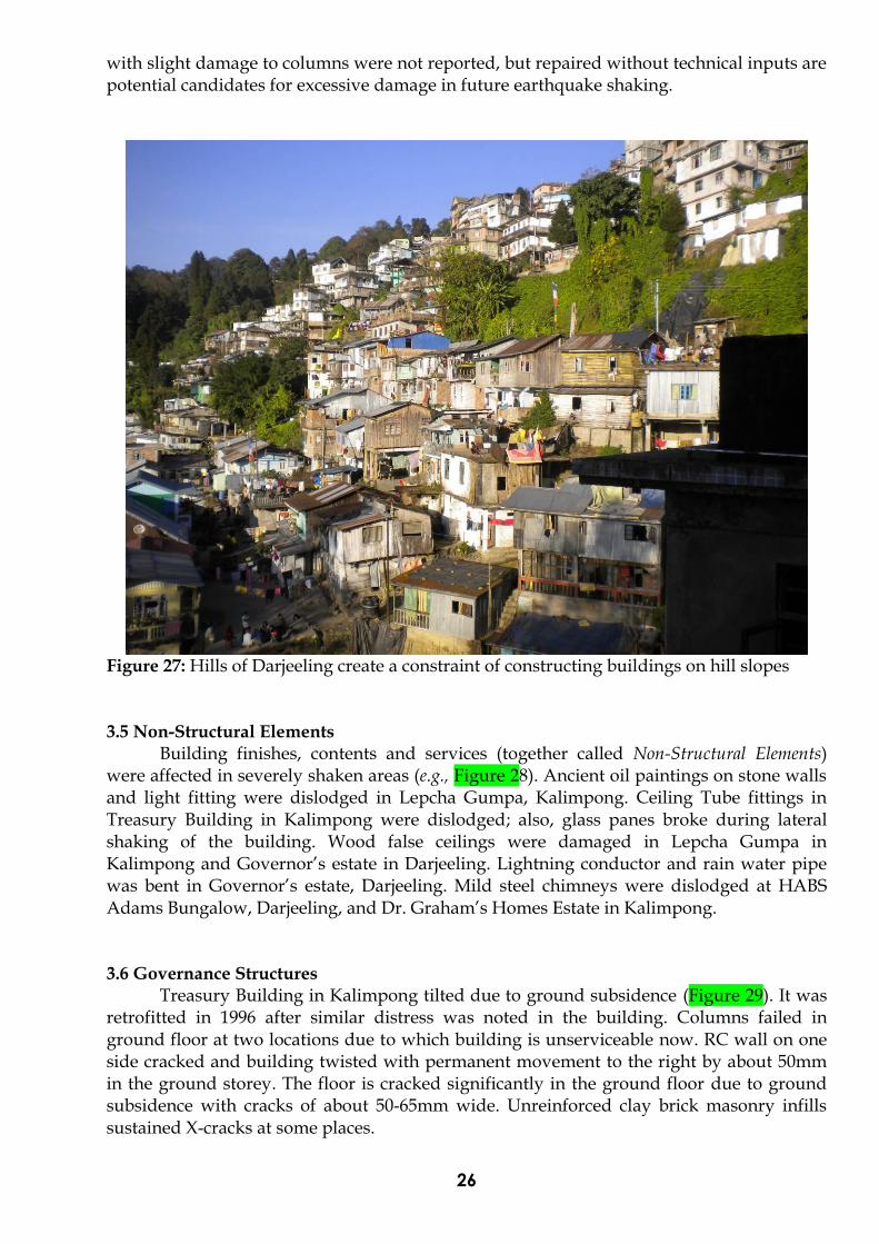
Figure 27: Hills of Darjeeling create a constraint of constructing buildings on hill slopes 3.5 Non-Structural Elements
Building finishes, contents and services (together called Non-Structural Elements) were affected in severely shaken areas (e.g., Figure 28). Ancient oil paintings on stone walls and light fitting were dislodged in Lepcha Gumpa, Kalimpong. Ceiling Tube fittings in Treasury Building in Kalimpong were dislodged; also, glass panes broke during lateral shaking of the building. Wood false ceilings were damaged in Lepcha Gumpa in Kalimpong and Governor’s estate in Darjeeling. Lightning conductor and rain water pipe was bent in Governor’s estate, Darjeeling. Mild steel chimneys were dislodged at HABS Adams Bungalow, Darjeeling, and Dr. Graham’s Homes Estate in Kalimpong.
3.6 Governance Structures
Treasury Building in Kalimpong tilted due to ground subsidence (Figure 29). It was retrofitted in 1996 after similar distress was noted in the building. Columns failed in ground floor at two locations due to which building is unserviceable now. RC wall on one side cracked and building twisted with permanent movement to the right by about 50mm in the ground storey. The floor is cracked significantly in the ground floor due to ground subsidence with cracks of about 50-65mm wide. Unreinforced clay brick masonry infills sustained X-cracks at some places.

27
(a)
(b)
Figure 28: Damage to non-structural elements in buildings also was recorded during this earthquake: (a) disengaged light fixture, and (b) shaken masonry chimney atop government quarters in Darjeeling
Figure 29: Damaged Treasury Building at Kalimpong

28
Governor’s estate has many stone masonry buildings in its premises; these buildings have a number of arches; most of these buildings sustained primary damage (Figure 30). The initiation was noticed of separation at wall corners and opening of arches. The main building of the Governor’s Bungalow was re-built in reinforced concrete in 1936 after the 1934 Bihar-Nepal earthquake destroyed the earlier stone masonry version. During this earthquake, the main dome of this RC building is damaged at mid-span, possibly initiated by maintenance issues. All buildings on this campus need immediate attention towards structural restoration.
(a) (b)
(c)
Figure 30: (a), (b) Damage to arches in the quarters on Governor’s estate in Darjeeling; (c) Damage to roof dome of the main Governor’s Bungalow
29
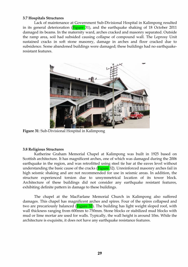
3.7 Hospitals Structures
Lack of maintenance at Government Sub-Divisional Hospital in Kalimpong resulted in its general deterioration (Figure 31), and the earthquake shaking of 18 October 2011 damaged its beams. In the maternity ward, arches cracked and masonry separated. Outside the ramp area, soil had subsided causing collapse of compound wall. The Leprosy Unit sustained cracks in soft stone masonry, damage in arches and floor cracked due to subsidence. Some abandoned buildings were damaged; these buildings had no earthquake-resistant features.
Figure 31: Sub-Divisional Hospital in Kalimpong 3.8 Religious Structures
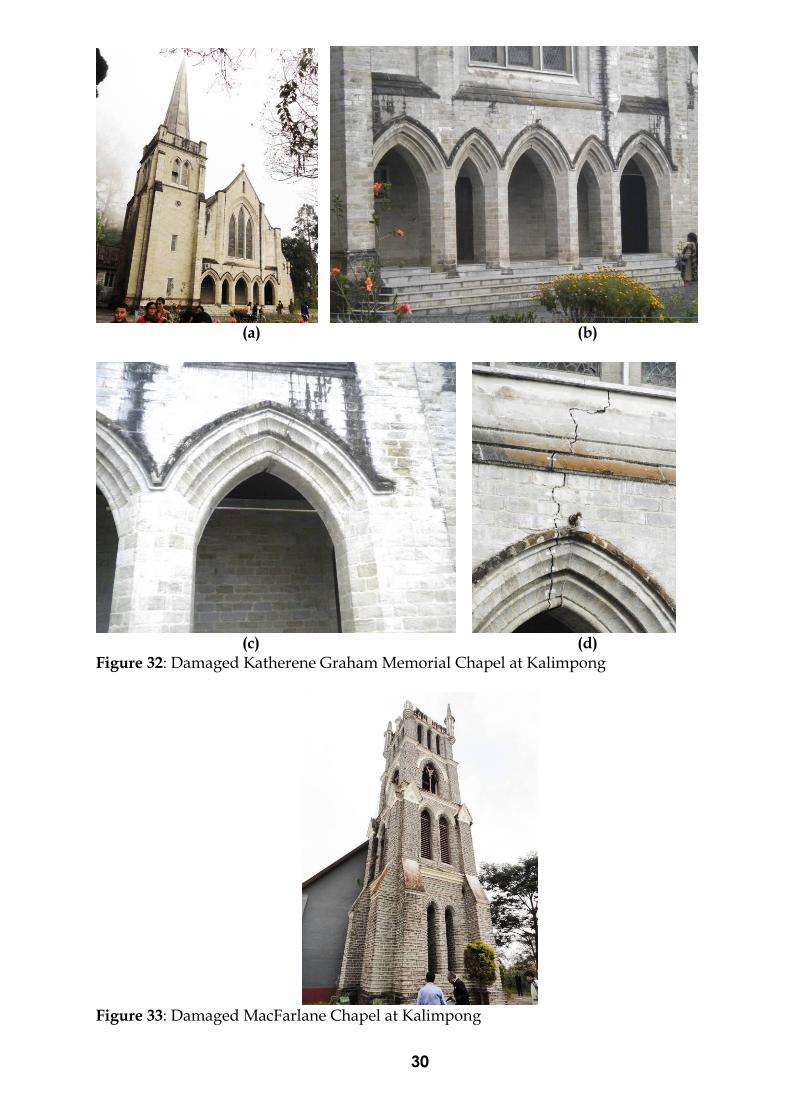
Katherine Graham Memorial Chapel at Kalimpong was built in 1925 based on Scottish architecture. It has magnificent arches, one of which was damaged during the 2006 earthquake in the region, and was retrofitted using steel tie bar at the eaves level without understanding the basic cause of the cracks (Figure 32). Unreinforced masonry arches fail in high seismic shaking and are not recommended for use in seismic areas. In addition, the structure experienced torsion due to unsymmetrical location of its tower block. Architecture of these buildings did not consider any earthquake resistant features, exhibiting definite pattern in damage to these buildings.
The chapel at the MacFarlane Memorial Church in Kalimpong also suffered damages. This chapel has magnificent arches and spires. Four of the spires collapsed and two are precariously balanced (Figure 33). The building has light weight sloped roof, with wall thickness ranging from 600mm to 750mm. Stone blocks or stabilized mud blocks with mud or lime mortar are used for walls. Typically, the wall height is around 10m. While the architecture is exquisite, it does not have any earthquake resistance features.
30
(a) (b)
(c) (d)
Figure 32: Damaged Katherene Graham Memorial Chapel at Kalimpong
Figure 33: Damaged MacFarlane Chapel at Kalimpong

31
Most of the old Buddhist monasteries were severely damaged (e.g., Figure 34). These buildings are typically made from stone masonry with dressed stones and mud mortar. The walls are often wide 600mm to 750mm and two storied with intermediate floor with wooden rafters and planks covered with sloping light weight CGI sheet. In most cases, stone masonry wall collapsed damaging ancient relics, historical artifacts, religious manuscripts and wall-ceiling frescoes.
Figure 34: Damaged monastery at Kalimpong
In the Subhash Palli locality of Siliguri, the upper half portion of the spire of
Bagarkot Shiv Mandir collapsed; rest of the walls and other members remained intact (Figure 35). In Shyam Sundar Gauri Math of Millan Pally locality of Siliguri, four low-height “burjees”, located at the four corners of the temple, sheared off from the base and were later demolished (Figure 36).
Figure 35: Collapse of the spire of the Bagarkot Shiv Mandir in Siliguri

32
(a) (b)
Figure 36: Shyam Sundar Gauri Math in Siliguri suffered partial damage; and (b) One of the four sheared burjees that sheared and later demolished
3.9 Quality of design detailing and construction in RC Buildings
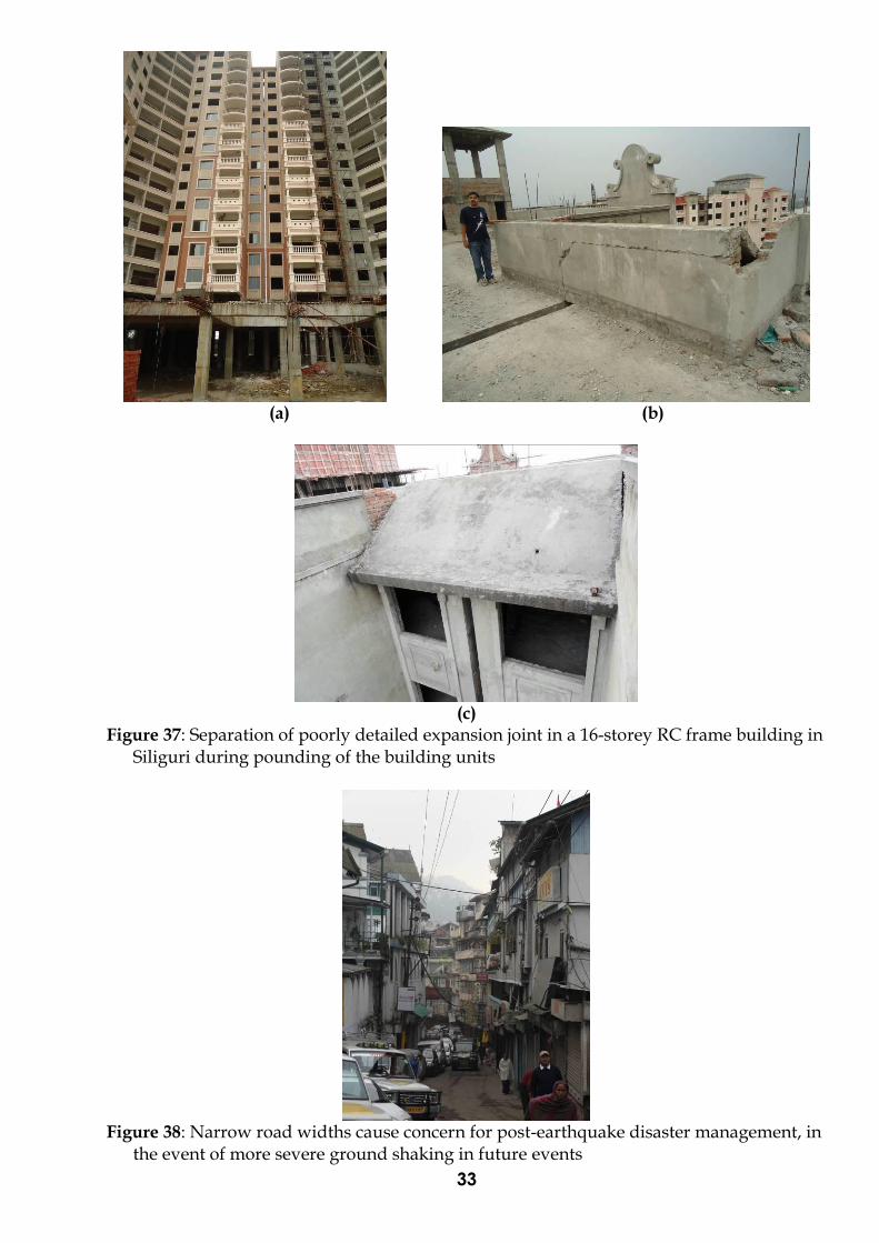
Multi-storeyed apartment complex in Siliguri experienced earthquake shaking, which were nearing completion (Figure 37). The seismic joints between parts of the building sustained damage; the seismic gap was covered with RC slab. Narrow streets in the city of Darjeeling, with closely spaced houses along the road and sitting on ground terraces, may hamper the rescue and relief operations during future earthquakes due to possible collapse of these houses on road and subsequent road blockage (Figure 38). Similarly, clumsy electrical and water supply lines also were hampered after any disaster, hence need to be addressed by holistic engineered approach. Damage in old structures mainly in stone masonry structures, like District Magistrate’s Office, Governor’s estate, chapels, schools, and Sub-Divisional Hospital at Kalimpong, are causes of concern. These need to be retrofitted on high priority by engineered approach.
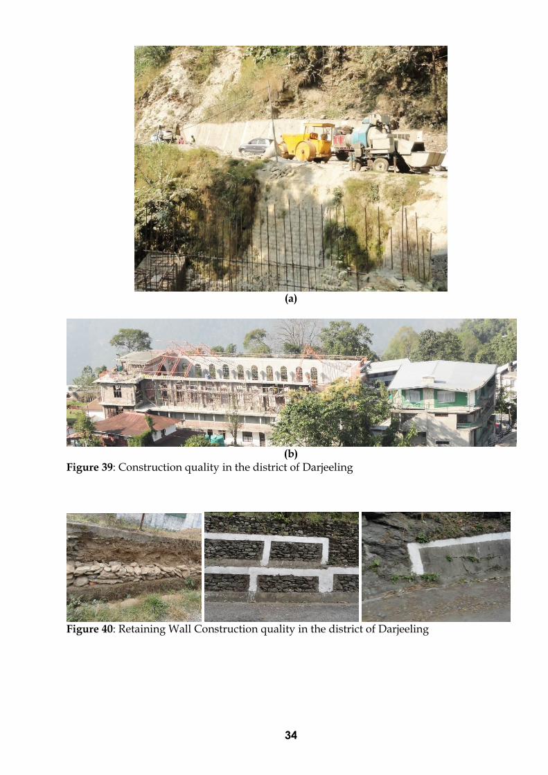
Many pointers are noted on quality of constructions and quality of materials (Figure
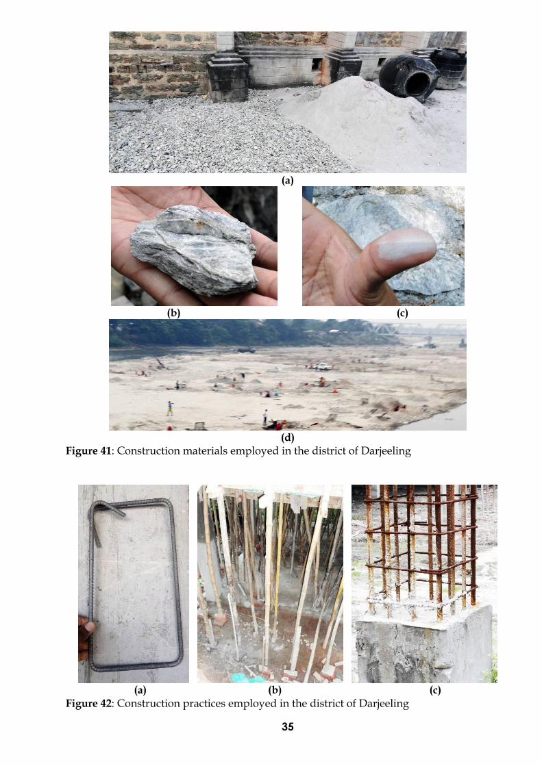
39). Columns are out of plumb raising serious doubts on workmanship and supervision provided. Most retaining walls along the roads are made of random rubble masonry (RRM) in mud or cement mortar without use of bond stones, and with 100mm thick RC facing to the RRM wall with nominal skin reinforcement. Wherever a number of weep holes is insufficient and water pressure builds on the masonry side; this causes collapse or partial damage to retaining wall (Figure 40). Generally, trusses are not provided with base plate and column cap plate; they are simply rested on the RC column and held down by the longitudinal bars of columns. In hills of Darjeeling aggregates used in concreting are soft (Figure 41). The softness can be understood from the touch or the workability for dressing and grooving during the concealing of the electrical and water supply pipe lines. Hard stone for construction as coarse aggregate has to be chosen from a good stone quarry having hard properties as required to make good strong structure. Sand has to be free of mica which is abundant in this region, causing loss of strength to concrete. Mining from river bed is rampant; the amount of silt content is questionable, especially during the rainy season. The quality of construction materials is not acceptable (Figure 42). Stirrups are bent
to have 90 hooks and not 135 hooks. Spacing of stirrups is too far, much against ductile detailing requirements stated in the code. Wood formwork is of poor quality with bent supports and poor jointing relying on nails not to shear due to heavy load of green concrete, workmen and formwork. The wood props are rested on brick shims that do not seem to have the requisite strength to support point load from the post above.
33
(a) (b)
(c)
Figure 37: Separation of poorly detailed expansion joint in a 16-storey RC frame building in Siliguri during pounding of the building units
Figure 38: Narrow road widths cause concern for post-earthquake disaster management, in
the event of more severe ground shaking in future events
34
(a)
(b)
Figure 39: Construction quality in the district of Darjeeling
Figure 40: Retaining Wall Construction quality in the district of Darjeeling
35
(a)
(b) (c)
(d)
Figure 41: Construction materials employed in the district of Darjeeling
(a) (b) (c)
Figure 42: Construction practices employed in the district of Darjeeling

36
4. Recommendations and Guidelines for Future Development in the State of West Bengal
Many observations were made based on this field visit. In summary, the state of West Bengal should have a strong techno-legal regime enforced urgently, which ensures all new construction in the state to be earthquake-resistant. The actions needed against these observations are of short-term and of long-term. Towards this end, the following suggestions are made:
4.1 Landslides Landslides constitute one of the most common natural hazards in Darjeeling Himalaya and the recent Sikkim earthquake has triggered new slides as sinking zones and reactivated many old landslides as well. Experience gained from the study of several Himalayan earthquakes suggests that such zones of instability tend to heal by themselves over a period of time, if properly protected. However, following precautions should be undertaken necessarily: (1) Regular monitoring of the state of the ground fissures, ground slopes, and natural
springs besides recording of development of new fissures or any unusual feature. A qualified person of the locality can be entrusted the job of keeping the record and reporting to the nearest District official;
(2) Sealing of the ground fissures by locally available clay and fine soil to prevent ingress of surface run-off into the slopes; and
(3) Training of the drainage in the crown portion. With respect to landslides, it is clear that site-specific scientific approaches are required to (1) Study relatively soft mountain slopes along the Singalila range and in the Teesta Valley
assessing landslide potential of some critical areas where critical constructions are placed; and
(2) Develop measures for mitigating some of these landslides.
Detailed geotechnical map should be prepared of the slide zone and adjoining areas (e.g., the Railway Workshop at of the slide zone at CH. 52.800 km) by a competent agency before undertaking any resurrection work. Finding the thickness of the slide mass and configuration of firm bedrock should be done by drilling at least three boreholes at locations one-third, one-half and two-thirds lengths of the slide zone. The geo-mechanical properties of rock and soil (particularly shear parameters) should be determined as inputs for the geotechnical assessment. Slope restoration at Paglajhora and Teendharia is identified as a priority to restart the NH 55 and Darjeeling Himalayan Heritage Railway. The slope restoration at Teendharia should be carried out from the toe region of the landslide by using geo textiles or equivalent low cost material and composite retention wall. Various modern techniques are available, however, before selection of any method, a thorough geological and geotechnical investigation must be carried out and as per approved DPR, remedial measures should be taken up.
Rock fall modeling should be undertaken for assessing trajectory and assess damage to existing houses at lower slopes in potential rock fall zones. This will help in identifying extremely vulnerable rock fall sites, which should be avoided for human settlements through the development bye-laws of the local regions. In addition, alternate road network routes should be developed to bring redundancy for undertaking rescue and relief operations and for keeping all areas connected by roads even in the aftermath of earthquakes.

37
For earthquake-triggered landslides, studies and concern mainly deal with co-seismic landslides, and the relationship between co-seismic and post-seismic landsliding activity should be understood. To mitigate the effects of earthquake-induced landslide damage, the following are suggested: 1. Document Landslides caused by the 18 September 2011 event. The earthquake
produced a large number of landslides in the states of Sikkim and West Bengal. Systematically documenting these landslides will reveal valuable information to undertake scientific analysis of the geology of the region, the seismotectonics of the earthquake and their relation to the occurrence of landslides. The information needed on each landslide includes: (a) Location of landslide using GPS; (b) Dimensions of landslide, namely width, length and thickness; (c) Material of landslide, namely debris, soil or rock; (d) Subsidence due to landslide, namely length (m) and vertical displacement (m); (e) Ground cracks in landslide, characterised by its length and aperture; (f) Activity that led to landslide, namely earthquake induced new slide, reactivation
of old slide, and old slide with no re-activation by the earthquake; (g) Loss of life or injury due to earthquake-related building collapse, like landslide
boulder destroying the house; (h) Cost of damage due to landslide; (i) Estimated cost of restoration; and (j) Threat to population or road.
2. Prepare landslide hazard zonation maps and geotechnical maps on large scale (either 1:5000 or 1:2000 scale with one meter contour interval to provide details on geomorphological, geological, geotechnical and hydro-geological aspects) on priority for major three towns located in the hills of Darjeeling district in West Bengal, namely Darjeeling, Kurseong and Kalimpong. Mapping vulnerable zones of landslides may be undertaken by a central agency (e.g., GSI). This information should be taken to a logical point of designing suitable preventive measures;
3. Assess carrying capacity of slopes in towns along the hills of Darjeeling to decide the limit of its utilization for controlling their growth into large urban centres, and incorporate vulnerability to landslides in town planning and building codes of the West Bengal;
4. Provide proper drainage along roads and slopes to prevent instability of slopes. This is a sensitive matter that requires proper implementation and monitoring by the local governments;
5. Provide intensive afforestation in vulnerable and affected landslide areas; 6. Initiate mass awareness campaigns in and around areas vulnerable to landslides; 7. Monitor areas with new post-earthquake sinking zones by Radar Interferometry and
details using formal equipment, like rain gauges, piezometers and extensometers to understand the underlying cause effects of these problems. The role of deep drainage techniques should be explored to stabilize such zones. A moderate to large earthquake may trigger disturbances in the rock and soil slopes creating fissures, influence changes in the slope hydrology, increase in porosity and dilating of joints and hence can influence stability of slopes for a long period after the earthquake. Therefore, to assess the slope stability and landslide behaviour of a region that has been affected by moderate to large earthquake, it is essential to monitor slope behaviour for a significant period after earthquake using both ground based observation as well as remote sensing tools such as optical imaging (including stereo) and Differential

38
Interferometry SAR (DInSAR) for movement detection of Rangati Khola and Teen Dharia zones is recommended.
8. Scientific method of slope protection should be adopted. There is an urgent need to protect slopes at critical facilities, e.g., sliding hill slope at the Leprosy Unit of the Sub-Divisional Hospital in Kalimpong. The cracks in soil due to subsidence can be seen and the villages below this portion need to be protected from further landslide and impending disaster.
9. Address the largest landslides urgently: (a) The Pagla Jhora landslide, a high magnitude slide which blocked the NH 55 for
over two years now, requires detailed investigations by drawing large scale (1:1000) topographical, geo-morphological, geological and geotechnical mapping to understand the behaviour and causes of the slide, before undertaking any preventive measures and restoring the road. This may require a combination of expertise to draw end-to-end solutions of the site. As an urgent measure, an alternate route should be explored for this stretch of National Highway.
(b) The Teendharia landslide, which caused huge damage to NH 55, has the problem of local mining at the toe of the mountain due to which the entire slope is affected. The slope needs to be rebuilt using the combination of advanced techniques for slope stabilization. Here again, rat-hole mining may have caused sinking as reported by local engineer on the slopes, it needs to be monitored.
10. Monitor some of the other vulnerable sites with early warning system to develop the confidence and reliability of the parameters responsible for sliding.
11. Capacity building, training and strengthening of the departments of the Government of West Bengal handling roads and landslides, towards mitigating effects landslides.
4.2 Built-Environment 1. Develop a scientifically sound methodology for assessing damage sustained by
buildings and houses during earthquakes. With a view to assess the extent of damage, the Government of West Bengal had deputed the Block Development Officers (BDOs) to report the number of houses damaged, without imparting formal training to them in damage assessment. In the District of Darjeeling, under extreme pressure from the locals to seek government compensation meant for damaged buildings, the BDOs were coerced to declare most houses in some areas to be fully damaged. This resulted in the Government of West Bengal to declare about 37,000 houses to be damaged, while the field reconnaissance does not confirm the same. This earthquake is teaching India that damage assessment is not just a technical activity, but also an administrative and legal activity, which needs prior rehearsal by all stakeholders (technical, administrative and political leaders) and promulgation of appropriate laws to protect the persons undertaking damage assessment, and subsequent misuse to project and seek higher compensation from Government of India.
2. Develop type designs for all new common houses and government buildings to be built along hill slopes in the hills of Darjeeling. The in-house capacity in engineers of the departments of Government of West Bengal in the hills of Darjeeling is not sufficient to cater to the large requirement of undertaking the massive expansion in urban areas of the region.
3. Undertake retrofit of all critical, lifeline and governance buildings in the Darjeeling hills of the state of West Bengal. For instance, buildings with communication towers or water tanks placed at unsymmetrical locations in plan on roof tops, are vulnerable in strong earthquake shaking and need urgent assessment. A prioritised listing of these facilities may be necessary considering the limited availability of funding and
39
technical manpower to undertake this gigantic effort. There is a need to strengthen the activities of State Disaster Management Authority (SDMA) with a strong group guiding activities on development of technical and administrative personnel.
4. Lack of earthquake engineering education of stakeholders (like architects, engineers, building owners, quality inspectors, contractors and city building officials) is reflected in poor level of general awareness on earthquake safety. There is an urgent and sustained need to educate these stakeholders on how to create safe built environment. The curricula of engineering and architectural degree programs in universities and institutes across the country do not include earthquake-resistant design and construction, with limited exceptions; this reiterates that practising professionals need to be trained urgently. Also, teachers of the Universities, Engineering Colleges and ITIs in the areas bordering Darjeeling districts should be trained to learn and teach earthquake-resistant design and construction.
7. Most contractors also do not have background in civil engineering; hence, they are not aware of the basic, traditional and rigorous procedures required to undertake even normal construction, let alone earthquake-resistant construction. Special efforts and measures are required to improve the quality of professionals in construction companies.
8. Masons, carpenters and bar benders need to be trained and certified to undertake earthquake-resistant construction in high seismic regions; certified artisans should be given preference over their untrained counterparts to promote quality construction.
…