port€of€gladstone€western€basin strategic€dredging · pdf...
TRANSCRIPT
Gladstone PortsCorporation
Port of Gladstone Western BasinStrategic Dredging and Disposal
ProjectInitial Advice Statement
March 2009
42/15386/51438 Port of Gladstone Western Basin Strategic Dredging and Disposal ProjectInitial Advice Statement
Contents
1. Introduction 1
1.1 Context 1
1.2 Scope of Initial Advice Statement 1
1.3 Proponent 2
1.4 Location 2
1.5 Current Port Facilities 2
1.6 Project Scope 5
1.7 Project Timing 9
1.8 Project Need 9
1.9 Project Benefits 10
1.10 Legislation, Approvals and Other Requirements 10
2. Existing Environment and Potential Impacts 15
2.1 Introduction 15
2.2 General 15
2.3 Climate 15
2.4 Land and Infrastructure 16
2.5 Geology, Groundwater and Surface Water 17
2.6 Visual Amenity 20
2.7 Noise and Air Quality 20
2.8 Water Quality 20
2.9 Sediment Quality 21
2.10 Coastal Environment 21
2.11 Marine Flora and Fauna 22
2.12 Protected Areas 27
2.13 Cultural Heritage 32
2.14 Social and Economic Environment 32
2.15 Environmental Management 34
2.16 Community Consultation 35
3. Conclusion 36
4. References 37
42/15386/51438 Port of Gladstone Western Basin Strategic Dredging and Disposal ProjectInitial Advice Statement
Table IndexTable 1 Stages of Port of Gladstone Western Basin
Strategic Dredging and Disposal Project 7Table 2 Major Industries in the Gladstone Region 33Table 3 Major Imports and Exports of Port of Gladstone 33
Figure IndexFigure 1 Location of the Port of Gladstone 3Figure 2 Port of Gladstone Facilities 4Figure 3 Location of Proposed Western Basin Dredging
Stages 1 – 4 and Western Basin Reclamation 6Figure 4 Climate statistics for the Radar Hill Weather Station
from 1957 – 2008 (WeatherZone 2008) 16Figure 5 Intertidal Wetlands of Port Curtis, Sheet 3,
Fisherman’s Landing. Source: Danaher et al. 2005. 19Figure 6 Intertidal, Subtidal and Deepwater Seagrass Beds
identified in DPI&F Baseline Survey 2002. Source:Rasheed et al. 2003. 24
Figure 7 Intertidal Communities of Port Curtis, 2005.Source: Danaher et al. 2005. 25
Figure 8 Great Barrier Reef Marine Park Boundaries in PortCurtis 30
Figure 9 Protected Area Boundaries in Port Curtis 31
AppendicesA GPC Environment PolicyB Letter Advising Department of Infrastructure and Planning of
Intention to Apply for Significant Project StatusC Maps of Seagrass Extent 2002 – 2007D EPBC Act Protected Matters Report

142/15386/51438 Port of Gladstone Western Basin Strategic Dredging and Disposal ProjectInitial Advice Statement
1. Introduction
1.1 ContextThe Department of Infrastructure and Planning (DIP) is undertaking “The Gladstone Port Western BasinMaster Plan” to develop an understanding of the longterm impacts the liquefied natural gas (LNG) sectorwill have on the Western Basin1 of the Port of Gladstone, and to direct at a highlevel the government’sdecisions on the nature of future development in the Western Basin.
The Master Plan will investigate possible and proposed LNG plant locations and associatedinfrastructure corridors, including the road/bridge access to Curtis Island. The issue of commonuserchannel and swingbay dredging, and the timing/need for the outer channel and or inner harbourduplication channel dredging.
In line with the dredging work, the Master Plan will investigate possible areas for the deposition of dredgespoil and the possible reclamation of other areas within the Western Basin. Should they be necessary,environmental offsets will also be considered to compensate for the loss of environmental valuesassociated with any dredging or reclamation works.
The Master Plan will also consider the future land use for areas surrounding the Western Basin andprovide guidance on the nature and suitability of various industrial uses and port activities.
The Gladstone Port Western Basin Master Plan will be prepared under Section 10 of the StateDevelopment and Public Works Organisation Act 1971 (SDPWO Act). The plan will be prepared in sucha way that would complement the Strategic Assessment Provisions of the Environment Protection andBiodiversity Conservation Act 1999 (EPBC Act).
A high level agreement to implement and enforce the Master Plan is proposed in the form of aMemorandum of Understanding (MOU) between the Coordinator General, Gladstone Ports Corporation,Environmental Protection Agency and the Department of Transport. The MOU will provide for theenforcement of the Master Plan so that development of the Western Basin can be planned in an orderlyway.
1.2 Scope of Initial Advice StatementIn parallel with the preparation of the Gladstone Port Western Basin Master Plan, it is proposed tocommence an Environmental Impact Statement (EIS) process under the SDPWO Act for the dredgingand disposal in the Western Basin of the port. This Initial Advice Statement (IAS) is for the Port ofGladstone Western Basin Strategic Dredging and Disposal Project and has been prepared by GladstonePorts Corporation Ltd (GPC) for the purposes of identifying environmental, cultural and social issues andregulatory approvals associated with these works. This IAS is intended to scope the potential impactsthat will be investigated in detail prior to the proponent applying for appropriate approvals. An EIS andEnvironmental Management Plan (EMP) will be prepared as part of the approvals process. Terms of
1 The Western Basin is defined as all land parcels and marine environments extending from Friend and Laird Points,south to Auckland Point and incorporating Fisherman’s Landing, the westernside of Curtis Island from Laird Pointto Boatshed Point and all port infrastructure and channels contained therein.

242/15386/51438 Port of Gladstone Western Basin Strategic Dredging and Disposal ProjectInitial Advice Statement
Reference (ToR) for the EIS will be developed based on this report, the requirements of relevantgovernment agencies and submissions from stakeholders and the community.
1.3 ProponentGPC is the proponent for the Port of Gladstone Western Basin Strategic Dredging and Disposal Project(the Project). GPC is the responsible party for obtaining all relevant approvals to facilitate thedevelopment of the Project.
GPC has an Environment Management System that is externally certified as being compliant with theinternational standard AS/NZS ISO 14001: 2004 and includes an Environment Policy which covers all ofits activities. A copy is provided in Appendix A.
1.4 LocationThe Port of Gladstone (the Port) is a shallow, semienclosed estuarine system located on the CentralQueensland coast approximately 525 kilometres (km) north of Brisbane and 100 km south ofRockhampton (Figure 1).
1.5 Current Port FacilitiesThe Port of Gladstone is Queensland’s largest multicommodity port and the world’s fifth largest coalexport terminal. Handling close to 1,400 vessels annually, it is one of the busiest ports in Australia andplays a vital role in the local, state and national economies. Its facilities cater for the import of rawmaterials and the export of finished product associated with major industries in the Gladstone region.The Port has expanded rapidly over the last 30 years in response to major mining (predominantly coal)and major industrial projects of state significance. The GPC 50 Year Strategic Plan forecasts an ultimateport shipping capacity of over 300 million tonnes per annum (GPC 2008a).
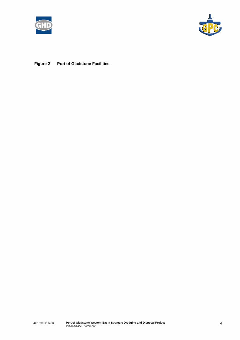
The Port of Gladstone consists of six major port facilities; Boyne Smelter Wharf, South Trees Wharf,Barney Point Terminal, Auckland Point Terminal (Port Central), RG Tanna Coal Terminal andFisherman’s Landing (Figure 2 and Figure 3).
The current Fisherman’s Landing port facility includes a multiuser Bulk Liquids Wharf, CementAustralia’s cement and clinker wharf and Rio Tinto Alcan Yarwun Refinery wharf. Orica Australia’s bulkliquid ammonia tank is on this site and plans have been developed for caustic storage facilities for RioTinto Alcan Yarwun Refinery to be located at the facility.
Coal from numerous Central Queensland coal mines is exported from RG Tanna Coal Terminal andBarney Point Terminal. South Trees Wharf provides for bauxite and caustic import and alumina exportfor Queensland Alumina Limited (QAL) and Boyne Smelter Wharf provides for aluminium export forBoyne Smelter. Port Central (Auckland Point Wharves) provides for the export of bulk cargo such asmagnetite, calcite, petroleum products, grain and containers (GPC 2008b).

342/15386/51438 Port of Gladstone Western Basin Strategic Dredging and Disposal ProjectInitial Advice Statement
Figure 1 Location of the Port of Gladstone
442/15386/51438 Port of Gladstone Western Basin Strategic Dredging and Disposal ProjectInitial Advice Statement
Figure 2 Port of Gladstone Facilities

542/15386/51438 Port of Gladstone Western Basin Strategic Dredging and Disposal ProjectInitial Advice Statement
1.6 Project ScopeThe Port of Gladstone Western Basin Strategic Dredging and Disposal Project seeks to accommodatethe long term dredging and dredged material disposal that is required to provide safe and efficient accessto the existing and proposed Port facilities in the harbour over the foreseeable future.
Two areas of development are required for the longterm strategic development of the Port:
» The Western Basin dredging and reclamation works are required for access to proposed wharffacilities located in the Western Basin area of the port and for the disposal of dredged material; and
» The outer harbour works are associated with the duplication of channels to account for increasedtraffic through the port and will be investigated at a later stage.
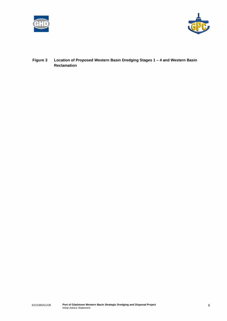
The development of the Western Basin will incorporate dredging associated with the deepening andwidening of existing channels and swing basins, and the creation of new channels, swing basins andberth pockets. Figure 3 and Table 1 provide a potential development scenario for the proposed WesternBasin dredging and reclamation areas. The footprint of the dredging works will be refined during the EISprocess. Material dredged during the Western Basin development is proposed to be placed intoreclamation areas to create a land reserve to be used to service the new port facilities. The proposedWestern Basin reclamation is 10 km north of Gladstone City immediately adjacent to the existingFisherman’s Landing reclamation and proposed 153 ha Fisherman’s Landing reclamation (Figure 3).The final footprint of the Western Basin reclamation is currently undergoing an options assessmentprocess.
There are currently a number of proponents undertaking investigations into sites within the WesternBasin. Investigations are being undertaken to determine the nature of the material to be dredged and thenavigation and berthing requirements of the likely proponents. These investigations will allow both themethod of dredging and the final dimensions and footprints of the channels, swing basins and berthpockets to be determined. Subject to geotechnical investigations and dredging methodology reviews, itis possible that blasting may be required where hard material is located. It is also possible that thecoarse nature of some of the material and the distance to the proposed reclamation may require doublehandling of the material.
The dredging of the Western Basin will occur in stages and the rate of development will be controlled bythe demands of industry locating in the Gladstone region and requiring access to port facilities. It isrecognised that not all of the current proponents investigating sites in the Western Basin may proceed.Therefore, flexibility in the final dimensions and exact footprint of the areas to be dredged is required.The Environmental Impact Assessment will address stages of development and the overall footprint ofdevelopment. Operational works approvals will be sought for each project stage as they are required.
642/15386/51438 Port of Gladstone Western Basin Strategic Dredging and Disposal ProjectInitial Advice Statement
Figure 3 Location of Proposed Western Basin Dredging Stages 1 – 4 and Western BasinReclamation
742/15386/51438 Port of Gladstone Western Basin Strategic Dredging and Disposal ProjectInitial Advice Statement
Table 1 Stages of Port of Gladstone Western Basin Strategic Dredging and Disposal Project
Project Element andStage
Location Description Volume/Capacity Trigger Timing
DREDGING
Wiggins IslandCoal Terminal
(WICT)
Not included in StrategicProject
Western Basin The Gladstone Ports Corporation (then Central Queensland Ports Authority) undertook an EIS process for the development of sixberths at Wiggins Island to cater for coal exports (four berths) and nickel imports (two berths). Under this process the swing basinfor the facility was to be dredged to RL 11.7m LWD* and the departure channel dredged to RL 16.0m LWD. A total of 6.3 millioncubic metres of material will be dredged and disposed to land reclamation sites adjacent to the Coal Terminal and GladstonePacific Nickel sites.
This development was declared a controlled action under the EPBC Act and a Significant Project under the Queensland StateDevelopment and Public Works Organisation Act 1971.
Commonwealth and State approvals for dredging and onshore disposal were received in February 2008.
6.3 million m3 Commitment by variouscoal companies tocontracts
Late 2009
1A
North China Bay LNGPrecinct
Western Basin The DIP has identified the development of an LNG precinct on the western side of Curtis Island for the development of up to fourLNG plants of four train configuration. Each plant is anticipated to have an annual throughput of 12 – 15 Mtpa.
Two LNG proponents have identified Curtis Island as their preferred site for the development of LNG plants for the processingand export of coal seam gas. These proponents are Santos and the BG Group.
LNG Carriers under consideration have dimensions of up to draft 12.5m, length 300m, and beam 50m. The LNG industry isseeking to have capability of handling the vessels during the full tidal range such that there is no constraint on either arrival ordeparture. It is anticipated that channel depths of 13.0 m and swing basins of 13.5 m depth will be required.
The initial development allows for one berth for each proponent.
The dredging components of the Santos and BG Group projects have been referred under the EPBC Act and are the subject ofan environmental assessment currently being prepared.
16.0 million m3 Commitment by LNGproponents
2011
1B
Fisherman’s Landing LNG
Western Basin One smaller LNG proponent is investigating the development of an LNG plant at the existing Fisherman’s Landing Facility. LNGLtd is proposing an annual throughput of three million tonnes.
Exports will be undertaken through Fisherman’s Landing No.5 Berth. The Targinie Channel requires widening and deepening andthe swing basin extended beyond the existing approved channel configuration to cater for the larger LNG carriers. The proponentis investigating the options for utilising smaller LNG carriers in the early stages of development.
The dredging component of this project has not been separately referred by the proponent under the EPBC Act.
6.1 million m3 Commitment by LNGproponent
2011
2
Laird Point LNG
Western Basin Other LNG proponents are investigating the potential to develop a 14 Mtpa LNG facility within the Gladstone State DevelopmentArea (GSDA) Curtis Island Industry Precinct. With both Santos and BG Group having sites allocated around North China Bay, themost likely option for these proponents is to develop at a site adjacent to Laird Point.
The marine facility requires the extension of the Targinie Channel with a width of 200 m and depth of 13.0 m.
In the event that this development precedes the expansion of the Fisherman’s Landing facilities, it will be necessary to undertakethe dredging of the existing Targinie Channel as part of this stage.
4.5 million m3 Commitment by LNGproponent
2011
3
Fisherman’s LandingDevelopment
Western Basin The existing reclamation at Fisherman’s Landing allows the development of five berths. Four of these berths are alreadyconstructed or are currently under construction. The fifth berth is limited in size due to it location between Berth 2 and Berth 4(Rio Tinto and Cement Australia).
The 153 ha reclamation currently being investigated (see Onshore Disposal description in this table) is capable of supporting afurther six berths. Large scale industrial facilities, similar to Rio Tinto Alcan Yarwun and Gladstone Pacific Nickel, would typicallyrequire two berths for their ultimate development.
The facilities at Fisherman’s Landing are those most likely to support development in the GSDA. An area in excess of 28,000 hahas been declared for longterm industrial development on the mainland.
It is therefore planned to construct a line of berths between Fisherman’s Landing through to Friend Point to offset the lossassociated with the Friend and Laird Point development.
5.5 million m3 Further industrialdevelopment in theGSDA requiring importand export wharves andpotentially stockpile andstorage areas.
The berth pockets andswing basin area wouldbe constructedprogressively asproponents requiredthem.
Unknown
842/15386/51438 Port of Gladstone Western Basin Strategic Dredging and Disposal ProjectInitial Advice Statement
Project Element andStage
Location Description Volume/Capacity Trigger Timing
4
Hamilton Point
Western Basin Natural deep water occurs adjacent to Hamilton Point. This area is capable of being developed for Cape sized vessels. Further,it presents the one remaining area in the port for landbacked wharves to be developed.
With respect to trade opportunities these wharf facilities present an ideal opportunity to service break bulk and containerisedtrades. The steel industry could also benefit from this development as the importation of iron ore and other bulk products can beaccommodated in Cape sized vessels. Exports of blooms, billets, ingots and coils are best accommodated with the land backingallowing for ready transfer of product from shore side to ship. For the container industry, the ready access from vessel to yard isimportant with full land backing being critical.
A total of five berths can be developed at this site with minimal dredging.
Also included in Stage 4 are the second berths for each of the LNG proponents in North China Bay.
3.9 million m3 Bulk / break bulk andcontainer industriesrequiring land backedwharves.
The berth pockets andswing basin area wouldbe constructedprogressively asproponents requiredthem.
Unknown
TOTAL WESTERN BASIN 36 million m3
DISPOSAL
Onshore – Fisherman’sLanding
Relocation ofmaterial fromWestern Basin
Current Proposed 153 ha Reclamation
The EIS process has commenced for the reclamation of 153 ha of land to the north of the existing reclamation at Fisherman’sLanding (Figure 3). The reclamation was a noncontrolled action under the EPBC Act and a Significant Project under theQueensland State Development and Public Works Organisation Act 1971.
The reclamation is required to provide for the disposal of dredged material and to support the deepening of the Targinie Channeland the development of additional berths to service future industry. The original proposal allowed for an additional six berths tobe developed in the long term.
The EIS process addresses the 153 ha reclamation approval only and does not cover additional berth development beyond thatpreviously approved (five berths) for the existing reclamation.
10 million m3 Dredging in the innerharbour.
There are no currentdisposal sites availablewith the overall capacityto accept material fromall of the Western Basindredging areas shouldall of the developmentsproceed.
2011
Onshore – Western BasinReclamation
Relocation ofmaterial fromWestern Basin
Western Basin Reclamation
A total dredged volume of 36.5 million m3 is required to allow for the total development of all the dredging stages in the WesternBasin.
Subject to the timeframe over which this dredging is undertaken, allowance in the storage capacity is also required for the initialbulking of the material during the dredging operation and adequate retention time to allow for water quality to be controlled.
Initial disposal sites had been investigated at Hamilton/Boatshed Point and Laird Point on Curtis Island (Figure 3). These twosites could accommodate up to 20 million m3 of dredged material when the retaining walls were developed to a height of 15 m.
To accommodate the ultimate dredging concept for the Western Basin, the combined reclamation areas on Curtis Island and theproposed 153 ha Fisherman’s Landing reclamation would need to be supplemented by further reclamation; likely on the intertidalareas adjacent to Friend Point.
With additional LNG proponents enquiring of sites for development on Curtis Island, there is a desire to avoid the placement ofdredged material onshore that may prevent potential sites from being utilised by the LNG industry. The Laird Point site is underinvestigation by an LNG proponent and other proponents are investigating options around the development of the Boatshed Pointarea.
Given these constraints, the option for a single Western Basin reclamation is under consideration. This reclamation would be anexpansion of the 153 ha reclamation that is currently undergoing an EIS under the SDPWO Act. It is intended that the EIS andapprovals for the 153 ha reclamation will continue as a separate project. Design options for the Western Basin Reclamation arebeing considered with the aim of reducing potential impacts on adjacent mangrove and saltpan areas, particularly towards TheNarrows.
The nominal reclamation area as shown in Figure 3 has the capability of storing in excess of 60 million m3 (to allow for bulkingand decant of capital material and future maintenance dredging material) and is suitable for the overall development of theWestern Basin, thereby avoiding the need to consider reclamation at sites on Curtis Island or Kangaroo Island/Friend Point.
60 million m3
This volumeincludes the
proposed 153 haFisherman’s
Landing reclamation
Dredging in the innerharbour.
There are no currentdisposal sites availablewith the overall capacityto accept material fromall of the Western Basindredging areas shouldall of the developmentsproceed.
2011
* LWD = Low Water Datum

942/15386/51438 Port of Gladstone Western Basin Strategic Dredging and Disposal ProjectInitial Advice Statement
1.7 Project TimingTable 1 identifies the likely timing for the various stages of the Port of Gladstone Western Basin StrategicDredging and Disposal Project. Timing for the latter stages are as yet unknown as they are dependenton the approval of projects or requests from new industries for access to berths for import and export ofmaterials.
1.8 Project NeedThe Commonwealth and Queensland governments have identified Gladstone as a port with the potentialto service future large scale exportoriented, resource processing and valueadding industries. The closeproximity of Gladstone’s international port facilities is an essential component of the economic viability ofthe Gladstone State Development Area (GSDA). The GDSA is an approximately 28,000 ha declaredland bank managed and promoted by the Gladstone Economic and Industry Development Board(GEIDB), a statutory authority under the auspice of the Department of Infrastructure and Planning (DIP)(Figure 1). A Materials Transport Corridor links the GSDA to the Port of Gladstone facilities.
The GSDA aims to attract industries by offering internationally competitive operating costs and has thecapacity to accommodate significant future industrial growth. GPC are responsible for the provision ofand maintenance of declared depths of shipping channels, swing basins and berth pockets in the Port ofGladstone. The Port of Gladstone Western Basin Strategic Dredging and Disposal Project encompassesall the dredging and disposal of dredged material that is currently envisaged in the GPC 50 YearStrategic Plan for the Western Basin (GPC 2008a). The proposed dredging is required to deepen andwiden existing channels and swing basins, and to create new channels, swing basins and berth pockets.
In July 2008, the GSDA was extended to include a large area on the southern end of Curtis Island. Theexpanded area consists of three areas:
» The Curtis Island Industry Precinct, which provides for the establishment of liquefied natural gasfacilities on the west coast of southern Curtis Island;
» The Restricted Development Precinct has been applied to the area of Kangaroo Island and isintended to provide for the establishment of essential transportation infrastructure within the GSDA;and
» The Environmental Management Precinct has been applied to the area east of the range on southernCurtis Island to recognise, protect and maintain areas of high ecological significance (DIP 2008).
In the Curtis Island Industry Precinct, there are currently a number of LNG proponents investigating sites.GPC are also looking to develop up to five berths at Hamilton Point for a range of future imports andexports. DIP is currently consulting with a working group to investigate and provide common userinfrastructure to Curtis Island, including a road bridge from Friend Point to Laird Point at the southern endof The Narrows. Dredging and dredged material disposal are required to service the potential LNG andGPC developments on Curtis Island.
The proposed Western Basin reclamation will provide both a dredged material disposal location and willalso provide land adjacent to the wharves necessary for efficient loading and unloading of vessels andtemporary storage of cargoes and products prior to transport to the GSDA or loading onto ships forexport. The proximity of the Materials Transportation Corridor linking the Fisherman’s Landing facility to
1042/15386/51438 Port of Gladstone Western Basin Strategic Dredging and Disposal ProjectInitial Advice Statement
the GSDA and the rail link from Cement Australia to the main North Coast Rail line makes the currentFisherman’s Landing and proposed Western Basin development ideal for the transfer of product betweenthe Port and the GSDA and the hinterland of Central Queensland.
Wharf 1 to Wharf 5, adjacent to the existing Fisherman’s Landing facility, are either in use or committedto proposed industries within the GSDA (Figure 3). The proposed development and subsequentadjacent wharves are required to meet the import/export and storage needs for the variety of industrieslikely to establish in the GSDA in the long term. The proposed Western Basin reclamation will bedesigned to provide the best solution to achieve the efficiencies of handling required by industrieslocated within the GSDA.
1.9 Project BenefitsThe Port of Gladstone Western Basin Strategic Dredging and Disposal Project would be staged asindicated in Table 1. Based on the likely need to expedite the works, GPC proposes to engage acontractor to undertake the expanded bund construction for the Western Basin reclamation. Directemployment is estimated to be 55 personyears for the bund construction. Dredging would be stagedover a number of years based on the triggers outlined in Table 1. A total of 90 personyears is estimatedfor this phase of the work and it would be performed by contractors.
The proposed Port of Gladstone Dredging and Disposal Project will serve to enhance and expand theexisting port infrastructure to service planned and as yet unknown industries within Gladstone and theGSDA.
The direct permanent employment resulting from the dredging and Western Basin reclamation will relateto the nature of the product to be handled through the newly created port facilities and as such is not yetquantifiable. Indirect employment will result from the creation of industrial developments remote to theport. These developments would not be viable without ready access to port infrastructure for import orexport of product. As such the local, state and national economies will ultimately benefit from theWestern Basin Strategic Dredging and Disposal Project.
As previously discussed, the close proximity of Gladstone’s international port facilities is an essentialcomponent of the economic viability of the GSDA. The provision of dredged channels, swing basins andberths as identified in the Western Basin Strategic Dredging and Disposal Project will provide access tothe port facilities, which is a key component of the import and export chain and assists in encouragingindustries to develop within the Gladstone region.
1.10 Legislation, Approvals and Other Requirements
1.10.1 Overview
GPC is required to give due consideration to the likely environmental impacts of the Project undervarious Commonwealth, State and local legislation, guidelines and policies. This section identifieslegislation and provides a description of other documents and guidelines relevant to environmentalmanagement of the Project. It is not intended that this section provides a legal review of the proponent’sobligations but is simply to highlight key environmental legislation relevant to this proposal.

1142/15386/51438 Port of Gladstone Western Basin Strategic Dredging and Disposal ProjectInitial Advice Statement
1.10.2 Commonwealth Legislation
Environment Protection and Biodiversity Conservation Act, 1999In accordance with the requirements of the Environment Protection and Biodiversity Conservation Act1999 (Commonwealth) (EPBC Act), an approval from the Commonwealth Minister for the Environment,must be sought prior to undertaking an action, which has, would have, or is likely to have, a significantimpact (defined in the Act) on a matter of National Environmental Significance (NES). An action includesa project, development, or undertaking an activity or series of activities. The project will occur within theGreat Barrier Reef World Heritage Area (GBRWHA). The GBRWHA is defined as a matter of NES underthe EPBC Act. It is considered that the Western Basin Strategic Dredging and Disposal Project maypotentially impact on the GBRWHA and on other matters of NES. Therefore, the Port of GladstoneWestern Basin Strategic Dredging and Disposal Project will be referred to the Department of theEnvironment, Water, Heritage and the Arts (DEWHA) for a formal decision under the EPBC Act. If theDEWHA determines that the Project is likely to have a significant impact on a matter of NES, then theProject will be determined to be a “controlled action” requiring assessment and approval at theCommonwealth level.
The referral will address relevant Matters of NES that may be impacted, which include:
» Sections 12 and 15A (World Heritage properties);
» Sections 15B and 15C (National Heritage);
» Sections 18 and 18A (Listed threatened species and communities); and
» Sections 20 and 20A (Listed migratory species).
GPC will apply the Queensland Department of Infrastructure and Planning to have a significant projectunder the State Development and Public Works Organisation Act 1971 (SDPWO Act). If DEWHAdetermines that the Project is likely to have a significant impact on a matter of NES, then the Project (oran element of the Project) will be determined to be a “controlled action” requiring a form of environmentalassessment (including an EIS) and approval at the Commonwealth level. GPC would seek to preparethe EIS in accordance with the Queensland Bilateral Agreement, which gives accreditation under theEPBC Act to the EIS process under the SDPWO Act. This process removes duplication with the EPBCAct, and streamlines approval processes under the Integrated Planning Act 1997.
Environment Protection (Sea Dumping) Act 1981The Environment Protection (Sea Dumping) Act 1981 (Sea Dumping Act) regulates the deliberateloading and dumping of wastes and other matter at sea (including relocation of dredged material). Itapplies to all vessels, aircraft or platforms in Australian waters and to all Australian vessels or aircraft inany part of the sea. The Sea Dumping Act applies in respect of all Australian waters (other than waterswithin the limits of a State or the Northern Territory inland waters), from the low water mark out to thelimits of the Exclusive Economic Zone.
The National Ocean Disposal Guidelines for Dredged Material (NODGDM, EA 2000) establishes aprocedure to determine if material is suitable for unconfined disposal at sea. Land based disposal in theWestern Basin reclamation has been nominated as the disposal option for the dredged material. If this isthe case, it is not anticipated that a Sea Dumping Permit will be required.
1242/15386/51438 Port of Gladstone Western Basin Strategic Dredging and Disposal ProjectInitial Advice Statement
Great Barrier Reef Marine Park Act 1975The Great Barrier Reef Marine Park Act 1975 (GBRMP Act) establishes a framework for theestablishment, control, management and development of the Great Barrier Reef Marine Park (GBRMP).The Act is administered by the Great Barrier Reef Marine Park Authority (GBRMPA).
Section 117 of the Great Barrier Reef Marine Park Regulations 1983 states that the GBRMPA mustassess any project that has the potential to impact on the Marine Park. This only applies to projects thatoccur wholly or partly within the Marine Park boundary; therefore a Marine Parks Permit will not berequired for the Western Basin Strategic Dredging and Disposal Project.
1.10.3 State Legislation
State Development and Public Works Organisation Act 1971
GPC has previously advised DIP of their intention to seek significant project status for this project(Appendix B). A request for significant project declaration for the project in accordance with Section(26)(1)a of the State Development and Public Works Organisation Act 1971 (SDPWO Act) was submittedwith this IAS. The SDPWO Act empowers the Coordinator General to facilitate and coordinate a projectwith “significant project status”. For a significant project the Coordinator General is responsible foradministering the EIS process including an evaluation of the EIS and the preparation of a report. TheCoordinator General is empowered to make certain recommendations and, in addition, is empowered tostate conditions that must be imposed under certain approval processes. Once the Coordinator Generalhas completed the EIS process under the SDPWO Act, then the various material Project approvals maybe granted in accordance with the relevant legislation.
Environmental Protection Act 1994 (Qld)Sections 36 and 37 of the Environmental Protection Act 1994 (EP Act) note that all persons have a dutyof care to the environment. Therefore, it is not permissible to cause environmental harm (as defined inthe Act) whilst undertaking any activity unless all reasonable and practical means are taken to minimisethat harm.
The EP Act outlines the scope and content for preparing environmental protection policies to protectQueensland’s environment. These policies may be made about the environment or anything that affectsor may affect the environment. It should also be noted that all subordinate legislation to the Act, such asthe Environmental Protection Policies, binds all persons. Compliance with all policies will be required.
Environmentally relevant activities (ERAs) defined within the Act require licensing. Dredging is adesignated Environmentally Relevant Activity (ERA) under the Environment Protection Regulation 2008.
Aboriginal Cultural Heritage Act 2003 (Qld)The Aboriginal Cultural Heritage Act 2003 establishes a ‘cultural heritage duty of care’, which requiresthat a person who carries out an activity must take all reasonable and practicable measures to ensurethe activity does not harm Aboriginal cultural heritage.
The Act establishes a framework for the conduct of assessment of cultural heritage impact andprocesses to be undertaken in preparing Cultural Heritage Management Plans. The Act states thatwhere an EIS is required under a legislative framework then a Cultural Heritage Management Plan mustbe prepared to manage all aspects of cultural heritage for the construction and operation of the project.

1342/15386/51438 Port of Gladstone Western Basin Strategic Dredging and Disposal ProjectInitial Advice Statement
Coastal Protection and Management Act 1995 (Qld)The Coastal Protection and Management Act 1995 (CP&M Act), as amended from 20 October 2003,repeals the Harbours Act 1955, the Canals Act 1958 and the Beach Protection Act 1968. Provisionsfrom these repealed Acts have been integrated into the CP&M Act and other Government statutes. TheCP&M Act includes provisions to continue permissions and approvals given under the older coastallegislation. An assessment under the CP&M Act will be triggered in relation to assessable developmentwithin tidal waters both for dredging and reclamation.
The State Coastal Management Plan Queensland's Coastal Policy and Curtis Coast Regional CoastalManagement Plan guides decisionmaking on coastal areas and the proposed development will need tobe reviewed against the policy requirements for coastal development.
Marine Parks Act 2004In 1982, the Marine Parks Act was passed. Parliament replaced the Marine Parks Act 1982 in 2004. Thenew Marine Parks Act 2004 commenced on 31 August 2006 along with the new Marine Parks Regulation2006 and Marine Parks (Declaration) Regulation 2006. The Marine Parks Act 2004 provides for themanagement and control of Marine Parks and a Marine Parks Permit may be required if the dredgingand reclamation are deemed to impact on the Great Barrier Reef Coast Marine Park. The QueenslandParks and Wildlife Service (QPWS) in the Environmental Protection Agency (EPA) administer the Act.
Integrated Planning Act 1997 (Qld)The Integrated Planning Act 1997 (IP Act) establishes the Integrated Development Assessment System(IDAS) which integrates a range of development approvals including the Coastal Management andProtection Act 1995 and Fisheries Act 1994.
This legislation has three specific roles that directly affect land use planning and regulation relevant tothe project:
» Firstly, the IPA establishes the means for plan making in Queensland, an activity usually undertakenby Local Government;
» Secondly, the IPA defines ‘development’ and establishes the process for making, assessing anddeciding development applications (the Integrated Development Assessment System or ‘IDAS’); and
» Thirdly, provides an ‘umbrella’ through IDAS that requires development to be assessed (whererelevant) against other legislation through referral to agencies responsible for that jurisdiction.
Dredging by a port authority is not a designated Environmentally Relevant Activity (ERA) under theEnvironment Protection Regulation 2008. Therefore, GPC is not required to seek a specific permit inrelation to an ERA, under the IP Act. Approval for tidal works, operational works and removal of marineplants under IP Act will be required.
Fisheries Act 1994 (Qld)The Fisheries Act 1994 provides a framework for the management and regulation of activities in relationto fisheries, coastal areas important as fish habitats and marine plants.
An IPA application for tidal works will trigger a referral to Department of Primary Industries and Fisheries(DPI&F) under the Fisheries Act 1994 for a concurrence response from DPI&F in relation assessable todevelopment described above. As a concurrence agency, the DPI&F maintain an interest in theproposed works in relation to:
1442/15386/51438 Port of Gladstone Western Basin Strategic Dredging and Disposal ProjectInitial Advice Statement
» Any temporary or permanent disturbance to protected marine plants and tidal fish habitats;
» Any temporary or permanent waterway barrier works (e.g. barriers to the movement of fish betweenfish habitats);
» Achieving offsets for any disturbances to fish habitats or tidal land; and
» Ensuring the adoption of best practice construction and environmental management techniques tominimise impacts to fish habitats.
1542/15386/51438 Port of Gladstone Western Basin Strategic Dredging and Disposal ProjectInitial Advice Statement
2. Existing Environment and Potential Impacts
2.1 IntroductionThe potential environmental impacts associated with the Port of Gladstone Western Basin StrategicDredging and Disposal Project are those that may result from the conduct of dredging and onshoredisposal of dredged material.
The following provides an overview of the existing environmental values and an initial assessment ofpotential impacts are based on information drawn from previous studies undertaken within the Projectarea and surrounds. Investigations may be staged to allow timeframes for early stages of dredging anddisposal for the Western Basin to be met, with approvals conditional on further investigations.
2.2 GeneralThe Port Curtis Integrated Monitoring Program (PCIMP) prepared an Ecosystem Health Report Card in2007. The Report Card provided an overall grade for various zones within Port Curtis, based on avariety of indicators such as sediment quality and water quality. This report card indicated that theFisherman’s Landing area had a slightly lower grade than most other zones in the harbour, being given aB+ under the grading system defined by PCIMP (Storey et al. 2007). It was concluded that this slightlylower result was mainly attributable to conditions in Boat Creek, which does not receive licenseddischarges. There are two licensed discharges at the Fisherman’s Landing wharves; Rio Tinto AlcanYarwun and a trade waste discharge (Storey et al. 2007).
2.3 ClimateGladstone is located in Central Queensland and experiences a subtropical, coastal climate. Figure 4shows rainfall and temperature statistics from the Radar Hill weather station which has records from1957 (WeatherZone 2008). The mean annual minimum temperature is 18.5 0C and mean annualmaximum is 27.7 0C. Gladstone experiences a wet season in the summer months, with the highestrainfall received from December to February. Average annual rainfall is 876.8 mm. The prevailing winddirection is from the east and southeast, with a mean wind speed of 20.7 km/hr at 3pm (WeatherZone2008).

1642/15386/51438 Port of Gladstone Western Basin Strategic Dredging and Disposal ProjectInitial Advice Statement
Figure 4 Climate statistics for the Radar Hill Weather Station from 1957 – 2008 (WeatherZone2008)
2.4 Land and Infrastructure
2.4.1 Land Ownership
The proposed Western Basin reclamation area is currently unallocated State Land. The dredgedchannels are unallocated State Land.
2.4.2 Port Infrastructure
This section summarises the current port infrastructure in terms of channels, berths and wharves. Theseare also shown in Figure 2.
The Western Basin of the Port of Gladstone covers the area from the west of the RG Tanna CoalTerminal through to the commencement of The Narrows and Great Barrier Reef Coast Marine Park(State). Existing development in the Western Basin includes the Auckland and Clinton channels,servicing the RG Tanna Coal Terminal, and Targinie Channel, servicing development at Fisherman’sLanding. Auckland and Clinton channels are 180 m wide, are dredged to RL 16.0 low water datum(LWD) and are capable of handling Cape Sized bulk carriers used in the coal trade (vessel displacementup to 220,000 t). Targinie Channel is 120 m wide, is dredged to RL 10.6 m low water datum and iscapable of handling Panamax vessels (up to 80,000 t). The Clinton Bypass Channel is 160 m wide,dredged to RL 10.6 m LWD and has been developed to allow light draft vessels to bypass theoperations at RG Tanna Coal Terminal and is used in conjunction with Targinie Channel. Approvalexists for Targinie Channel to be widened to 180 m (currently 120 m) and deepened to RL 14.0 m LWD.
1742/15386/51438 Port of Gladstone Western Basin Strategic Dredging and Disposal ProjectInitial Advice Statement
Existing development in the Outer Harbour includes the Gatcombe and Golding Channels and theirrespective Bypass Channels and the Boyne and Wild Cattle Cuttings. All outer harbour channels andbypass channels are 183 m wide, with the exception of the Gatcombe Bypass Channel which is 175 mwide. The Gatcombe and Golding Channels and Boyne and Wild Cattle Cuttings are dredged to RL 16.3 m LWD, the Golding Bypass is maintained at RL 7.3 m LWD and the Gatcombe Bypass ismaintained at RL 12.5 m LWD.
The proposed Port of Gladstone Dredging and Disposal Project will serve to enhance and expand theexisting port infrastructure to service planned and as yet unknown industries within Gladstone and theGSDA.
2.4.3 Supporting Infrastructure
The dredging and disposal at the Western Basin reclamation should not directly affect any of the existingor planned infrastructure adjacent to the Port, such as road, rail and air transport, water supply,electricity, sewerage and telecommunications. Shipping will increase as a result of the provision ofdredged channels and berths, however, individual proponents will be required to address the impacts ofincreased shipping in the port.
The proposed source of material for the bund walls is a quarry that will be developed by GPC in theGSDA. As the site for the quarry has previously been utilised as a quarry by a former owner, a MaterialChange of Use and Environmentally Relevant Activity application will be prepared and lodged with theDepartment of Infrastructure and Planning (DIP), EPA and any other relevant agencies. This will be aseparate process from either the Fisherman’s Landing 153 ha reclamation or the Western BasinStrategic Dredging and Disposal Project EIS. It is proposed to use conventional road transport totransport the materials from the GPC quarry for the construction of the bund wall and the capping of thesite. Materials for the reclamation will be placed as a consequence of dredging of the Western Basin instages (Stage 1A, 1B, 2, 3 and 4).
With development of industry on the reclaimed land in the Western Basin, there will be increaseddemand for transport, water supply, electricity and telecommunications infrastructure subject to theindustry’s needs. The transfer of product between the port site and the industrial lands at Aldoga, theport will be by road, conveyor, pipeline or rail. Anticipated development at the Western Basinreclamation may result in low level development with stockpiles, silos and other associated infrastructure.
Each industry (import, export or processing) that establishes adjacent to the Port will be required toaddress the impacts of their development on infrastructure such as water supply (raw and potable),sewerage, electricity and telecommunications. These industries will also be responsible for gainingapprovals for the logistics and infrastructure associated with establishing at the port and transferringmaterials to and from the port.
2.5 Geology, Groundwater and Surface Water
2.5.1 Geology
The Project is entirely located below the high water mark, with the exception of the landward edge of theproposed Western Basin reclamation. According to the 1:100,000 Geological Series – Gladstone Sheet1950, the geology underlying the reclamation is described as Quaternary Holocene deposits (Qhm) –
1842/15386/51438 Port of Gladstone Western Basin Strategic Dredging and Disposal ProjectInitial Advice Statement
Mangrove swamps, mudflats and saltpans. Immediately landward of the reclamation area the geology isdescribed as Quaternary age alluvium (Qha) – Gravel, sand, silt, clay and alluvium.
2.5.2 Groundwater
The Department of Natural Resources and Water groundwater bore database reported sevengroundwater bores within 1 km of the Gladstone LNG, Fisherman’s Landing Project site, which is locatedon the existing Fisherman’s Landing reclamation (Worley Parsons 2008). The DNRW informationindicated that there are at least two water bearing aquifers within the region (clay and schist) (WorleyParsons 2008). Two of the seven bores are used for water supply and the remaining bores have beenabandoned. Drilling on the Gladstone LNG Project, Fisherman’s Landing site identified a perchedgroundwater table within the dredged sediments. This is likely to be hydraulically connected to PortCurtis, but not to the mainland aquifers (Worley Parsons 2008).
The groundwater in areas adjacent to the Fisherman’s Landing embayment is likely to be tidallyinfluenced, both in quality and depth fluctuations.
2.5.3 Surface Water
From south to north, the Boyne River, South Trees Inlet, Auckland Creek, Calliope River, Boat Creek andGraham Creek are the main waterways entering Port Curtis (Figure 2). The shallow Fisherman’sLanding embayment is located between Boat Creek on the mainland and Graham Creek on CurtisIsland, with The Narrows commencing at the northern end of the embayment. There are no definedwaterways entering the Fisherman’s Landing embayment, however, a couple of small drainage linesenter the centre and northern ends of the bay. The catchments for these drainage lines are quite small.However, the northern end of the bay is connected to the substantial tidal flats at Friend Point andKangaroo Island on high spring tides (Figure 5).
2.5.4 Potential Impacts
The creation of a large reclamation immediately adjacent to or attached to the coastline may have animpact on the depth and flows of groundwater in adjacent areas and also the surface water drainagepaths. In turn, this may impact on the fringing mangrove and saltpan communities adjacent to the bundand may also impact on the adjacent terrestrial vegetation through changes to groundwater depths,fluctuations and quality.

1942/15386/51438 Port of Gladstone Western Basin Strategic Dredging and Disposal ProjectInitial Advice Statement
Figure 5 Intertidal Wetlands of Port Curtis, Sheet 3, Fisherman’s Landing. Source: Danaher et al. 2005.

2042/15386/51438 Port of Gladstone Western Basin Strategic Dredging and Disposal ProjectInitial Advice Statement
2.6 Visual AmenityDredging and disposal of dredged material can generate turbid plumes that are visible to shipping trafficand to the general public from air, land and water. The construction of the Western Basin reclamation asan extension to the current Fisherman’s Landing reclamation will substantially alter the visual characterof the immediate Fisherman’s Landing embayment, but will be consistent with the visual character of thePort as a whole, which contains a number of reclaimed areas. A visual impact assessment will beundertaken as part of the EIS and mitigation measures identified.
2.7 Noise and Air QualityThere are minimal noise and air quality impacts associated with dredging and onshore disposal ofdredged material. Some transient noise impacts may be experienced by marine fauna during individualdredging campaigns, however this is not expected to be significant. The placement of rock duringconstruction and the final surface of the Western Basin reclamation may generate some dust. Mitigationmeasures for managing this, such as watering roads and stabilising the finished surface, will be identifiedduring the EIS phase. A greenhouse gas inventory will be prepared for the dredging and construction ofthe reclamation and the potential for reducing impacts will be explored.
2.8 Water QualityWater quality within Port Curtis is influenced by several anthropogenic activities, including grazing,agriculture, industry and urbanbased activities. Previous water quality investigations undertaken withinPort Curtis indicate that the bay is subject to high levels of turbidity, nutrients and bacterial levels(Connell Hatch 2006). High turbidity events are considered to be a natural process within Port Curtisresulting from freshwater inflows during rainfall and wave and tidal current induced resuspension. Inaddition, the resuspension of sediments during dredging can result in an increase in bioavailable metalsconcentrations in the water column (Anderson et al. 2007).
The potential impacts of dredging and dredged material disposal are the generation and migration ofturbid plumes and the associated sedimentation and light reduction at sensitive habitats such asseagrasses and other intertidal communities. The EIS will summarise the water quality data available inPort Curtis, including data collected during ambient conditions and during recent capital dredgingprojects at Fisherman’s Landing and RG Tanna Coal Terminal.
The closest GBRMP boundary to the dredging and reclamation is at the North Entrance to Port Curtis,which is approximately nine kilometres from the southern end of the Stage 1A dredging. It is notanticipated that the plumes generated from dredging and reclamation activities will have a significantimpact on the GBRMP given the distance from the dredging to the GBRMP. The potential for migrationof turbid plumes over other sensitive habitats, including the GBR Coast Marine Park Habitat ProtectionZone at the Narrows, and the impacts of onshore dredged material disposal will be investigated in detailin the EIS through hydrodynamic and water quality modelling. Where required, management andmitigation measures will be proposed to reduce impacts to acceptable levels. The design of the WesternBasin reclamation will take into account the need to manage the water quality in the decant waters andmanagement of the quality and quantity of stormwater runoff from the final surface of the reclamation willalso be addressed.

2142/15386/51438 Port of Gladstone Western Basin Strategic Dredging and Disposal ProjectInitial Advice Statement
2.9 Sediment QualityPast GPC capital dredging sediment studies have indicated that sediments are generallyuncontaminated and suitable for onshore disposal to reclamation areas at RG Tanna Coal Terminal andFisherman’s Landing and have also met the Interim Sediment Quality Guidelines – low screening levelsin the National Ocean Disposal Guidelines for Dredged Material (NODGDM, Environment Australia 2002)(GPC 2008c).
Detailed sediment monitoring programs for maintenance dredging have been carried out on channelsediments in 1992, 1996, 2000 (by WBM Oceanics Australia) and 2006 by GHD (GPC 2008c).Approximately 25 – 30 grab samples were collected during each study allowing broad comparisons ofresults over time. Approximately 10 – 15 grabs were regularly spaced along the outer channel and 10 –15 grabs regularly spaced along the inner channel closest to port, industrial and urban developments(GPC 2008c).
The 1992, 1996 and 2000 sediment studies indicated that sediments were generally uncontaminated andsuitable for sea disposal. In 2006, the 95% Upper Confidence Limit (UCL) for arsenic, TBT and PAHsslightly exceeded NODGDM screening levels, however evidence was provided which indicated that therisk of dredging and disposal of this material was low (GPC 2008c).
Any sediments to be dredged as part of the Western Basin Strategic Dredging and Disposal Projectwould be analysed and compared to either Environmental and Health Investigation Levels in the DraftGuidelines for the Assessment and Management of Contaminated Lands 1998 and the Interim SedimentQuality Guidelines in the NODGDM (Environment Australia 2002).
2.10 Coastal EnvironmentThe Port of Gladstone is located in the sheltered waters of Port Curtis, which are created by thepresence of Facing and Curtis Islands. The tidal range in Port Curtis is large (around 4 m for a largespring tide) (Connell Hatch 2006). The large mangrove communities fringing Port Curtis provide astorage buffer for waters at high tide. The extensive shallow tidal flats and large tidal range result in theharbour experiencing significant tidal velocities, particularly through the main shipping channels (ConnellHatch 2006). This leads to a generally well mixed water body.
Sediment transport in coastal environments is driven by the prevailing combination of wind, waves andtides. Deepening and widening of the dredged channels throughout the length of the Port may increasethe velocity of tidal currents and alter sedimentation and scour patterns throughout the Port.Construction of a large reclamation in the Fisherman’s Landing area may also reduce the area availablefor tidal waters to dissipate, leading to changes in water levels, particularly high and low water springs.In particular, this may impact on the distribution of habitats in the Narrows, which is within the GBRWHA(but outside the GBRMP) and is also within the GBR Coast Marine Park.
BMT WBM have established a hydrodynamic and water quality model of the Port of Gladstone. Thismodel was utilised for the assessment of impacts on the recently approved Wiggins Island Coal TerminalProject. The model will be further calibrated and refined as required and utilised to determine thepotential impacts on tidal currents (direction and velocity), water levels and sedimentation and scourpatterns of the proposed dredging and reclamation. In particular, the impact of reclaiming a largeproportion of the Fisherman’s Landing embayment on water levels at high and low tide and the hydrologyof the intertidal communities at Friend Point and Kangaroo Island will be explored. Modelling of water
2242/15386/51438 Port of Gladstone Western Basin Strategic Dredging and Disposal ProjectInitial Advice Statement
quality plumes generated during dredging and discharge of decant waters from Western Basinreclamation will be undertaken to determine impacts on potentially sensitive habitats.
2.11 Marine Flora and FaunaPort Curtis supports a diverse range of marine flora and fauna communities and has been well studiedover the past decade. Three studies in particular have characterised the marine communities in PortCurtis, these being:
» Danaher K.F., Rasheed M.A. and Thomas R. (2005). The Intertidal Wetlands of Port Curtis.Information Series QI05031. Department of Primary Industries and Fisheries, Queensland;
» Rasheed M.A., Thomas R., Roelofs A.J., Neil K.M. and Kerville S.P. (2003). Port Curtis and RoddsBay Seagrass and Benthic MacroInvertebrate Community Baseline Survey, November/December2002. DPI Information Series QI03058. Department of Primary Industries and Fisheries, Cairns;
» Alquezar, R. and Small, K. (2006). Port Curtis Macrobenthic Monitoring Programme (final report).Centre for Environmental Management, Central Queensland University, Gladstone; and
» Rasheed M.A., McKenna S.A., Taylor H.A. and Sankey T.L. (2008). Long Term Seagrass Monitoringin Port Curtis and Rodds Bay, Gladstone – October 2007. DPI&F Publication PR07 – 3271.Department of Primary Industries and Fisheries, Cairns.
The 2008 Rasheed et al. report summarises annual seagrass monitoring since 2002.
2.11.1 Seagrass
Port Curtis supports extensive areas of coastal and deepwater seagrass and represents the onlysubstantial area of seagrass that has been mapped between Shoalwater Bay 170 km to the north andHervey Bay 170 km to the south (Rasheed et al. 2003, Danaher et al. 2005).
The 2002 baseline monitoring program mapped the intertidal, subtidal and deepwater seagrass bedswithin the Port Limits and the Rodds Bay Dugong Protection Area. Figure 6 shows the extent ofseagrass that was mapped in this survey. A total of 7,246 ha of seagrass was identified on the intertidalbanks of the Port, with an additional 6,332 ha of deepwater seagrass identified (Rasheed et al. 2003).The extensive seagrass beds within the Port include species that are preferred as food by dugongs andturtles, as well as meadows that are known to be important breeding grounds for juvenile tiger prawns(Rasheed et al. 2003).
Thirteen of the intertidal and subtidal meadows identified in the baseline survey are monitored inOctober/November annually by DPI&F. The subtidal seagrass beds within Port Curtis have shown highvariability between years, which has been linked with environmental factors such as tidal exposure andclimatic conditions (Taylor et al. 2007). Appendix C illustrates the changes in area and cover of the 13annually monitored seagrass beds in the Port of Gladstone.
The biomass of the intertidal seagrass beds at Fisherman’s Landing and Wiggins Island declinedsignificantly between the 2004 and 2005 monitoring events, but increased in 2006 and 2007. In contrast,the biomass of the subtidal meadows at Fisherman’s Landing and Wiggins Island was unchangedbetween 2006 and 2007 and the area of the Wiggins Island subtidal meadow had reduced substantiallyto it’s smallest size since the commencement of monitoring in 2002 (Rasheed et al. 2008). The majority

2342/15386/51438 Port of Gladstone Western Basin Strategic Dredging and Disposal ProjectInitial Advice Statement
of other seagrass meadows throughout the Port Limits and Rodds Bay recorded increases or nosignificant change in biomass in 2007 compared to 2006.
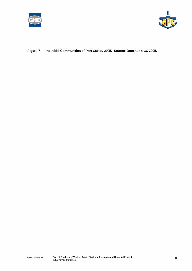
2.11.2 Intertidal Communities
Port Curtis contains large areas of tidal flats and supports substantial mangrove, saltmarsh, seagrass,sandbank and rocky substrate communities (Danaher et al. 2005). Figure 7 shows the extent of theintertidal communities as mapped in 2005 by DPI&F. These communities provide shoreline stabilisationas well as providing valuable habitat, nursery and feeding areas for many species of marine fauna.

2442/15386/51438 Port of Gladstone Western Basin Strategic Dredging and Disposal ProjectInitial Advice Statement
Figure 6 Intertidal, Subtidal and Deepwater Seagrass Beds identified in DPI&F Baseline Survey2002. Source: Rasheed et al. 2003.
2542/15386/51438 Port of Gladstone Western Basin Strategic Dredging and Disposal ProjectInitial Advice Statement
Figure 7 Intertidal Communities of Port Curtis, 2005. Source: Danaher et al. 2005.
2642/15386/51438 Port of Gladstone Western Basin Strategic Dredging and Disposal ProjectInitial Advice Statement
2.11.3 Benthic Communities
Port Curtis supports a healthy community of estuarine benthic fauna. A monitoring programmeconducted by the Centre for Environmental Management (CEM) (Central Queensland University) fromNovember 1995 to November 2003 monitored at five locations within Port Curtis (being Graham Creek,Fisherman’s Landing, Clinton Coal Wharf, Auckland Point and Curtis Island) (Alquezar and Small, 2006).Temporal trends within this monitoring program showed that abundance, species richness and diversitywere higher in November compared to April for all sites. Annual trends showed significant variation indiversity, abundance and species richness, with the lowest observations in 1999. In following years(2000 – 2001) there was a recovery of fauna to 1995 levels. The temporal changes were observed at allsites during the CEM monitoring programme and therefore indicate a large scale influence, rather than apoint source impact (Alquezar and Small, 2006).
Epibenthic fauna occur throughout the Port Curtis region in varying densities, as described by Rasheedet al. (2003). The highest faunal densities were located outside of Facing Island, within the East BanksSea Disposal Ground and surrounding Seal Rocks.
The inner harbour ranged from low density regions of open substrate with scattered fauna to high densityregions of rubble reefs, dominated by bivalves (scallops) with mixed reef taxa. The area directly east ofFisherman’s Landing and north into The Narrows was classified as a high and medium fauna densityregion dominated by bivalves and consisting of rubble reefs, hard corals, ascidians and bryozoan. Thecommunities around Fisherman’s Landing were the most diverse of all the survey areas, and wereconsidered to be associated with the high tidal currents in the channel regions of the inner port (Rasheedet al. 2003).
2.11.4 Marine Megafauna and Birds
Port Curtis supports a range of marine megafauna, including turtles, dugongs, dolphins, sharks, fish andreptiles as well as numerous wetland and migratory birds. The Commonwealth EPBC Protected MattersOnline Search Tool revealed 26 threatened species, of which eleven were threatened marine species, aspotentially occurring within the Western Basin (Appendix D). Of these, three species are turtles that areknown to utilise the Port Curtis region (flatback turtle, green turtle, and loggerhead turtle). Flatbackturtles are known to breed on the seaward beaches of Curtis Island and green turtles are frequentlyspotted in the mouth of the Calliope River and Targinie Estuary. Dugongs and turtles are frequentlysighted within Port Curtis region, indicating that the seagrass communities present within the Port Limitsare a valuable food source. Other threatened marine species that were identified as potentially occurringwithin the area were:
» two bird species (southern giantpetrel and kermadec petrel),
» one whale species (humpback whale),
» two sharks (green sawfish and whale shark), and
» three other turtles (leatherback, hawksbill and olive ridley).
In addition, there are 33 migratory species (including terrestrial and wetland species), 72 listed marinespecies and 11 whales and other cetaceans identified as potentially occurring or having suitable habitatin the Western Basin area by the EPBC Protected Matters Online Search Tool.

2742/15386/51438 Port of Gladstone Western Basin Strategic Dredging and Disposal ProjectInitial Advice Statement
2.11.5 Potential Impacts
Dredging and disposal of dredged material results in the generation of turbid plumes, which can impacton subtidal and intertidal communities through increased sedimentation and reduction of light. While thesubtidal and intertidal communities in Port Curtis are tolerant of periodic increases in turbidity associatedwith freshwater inflows during rainfall and wave and tidal current induced resuspension, additionalturbidity and sedimentation resulting from dredging and decant activities has the capacity to presentadded physiological stressors.
The potential for migration of turbid plumes over sensitive habitats and the impacts of onshore dredgedmaterial disposal will be investigated in detail in the EIS. Management and mitigation measures will beproposed to reduce impacts to acceptable levels, if required. GPC actively support and sponsor the PortCurtis Integrated Monitoring Program (PCIMP) monitoring program and also fund the annual DPI&Fseagrass monitoring program, which together, have developed a good baseline dataset that can beutilised in the long term assessment and monitoring of ecological health within the Port.
The potential impacts of dredging and onshore disposal of dredged material on marine megafauna suchas turtles and dugong and benthic communities will also be explored and mitigation measures identified,if necessary.
The proposed reclamation will involve the removal of the majority of intertidal and subtidal seagrassmeadows north of Fisherman’s Landing. The EIS will discuss the local and regional significance of thisloss to species such as turtles and dugong and to fisheries and will consider potential habitat offsetsunder relevant Queensland EPA and DPI&F policies.
2.12 Protected Areas
2.12.1 World Heritage
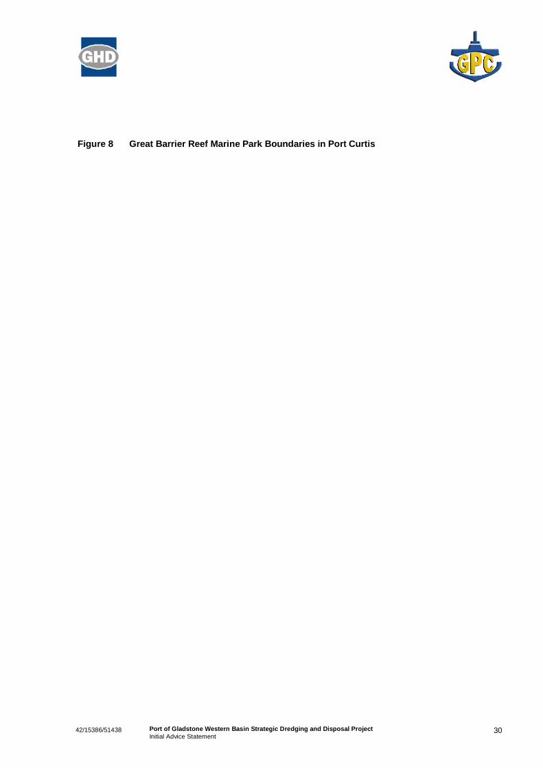
The Port is wholly contained within the Great Barrier Reef World Heritage Area (GBRWHA) and partlycontained within the Great Barrier Reef Marine Park (GBRMP) to the east of Facing Island in the outerharbour (Figure 8). The Western Basin Strategic Dredging and Disposal Project is not located within theGBRMP. The northern boundary of the GBRMP is at the northern end of Curtis Island, encompassingPort Alma.
As the world’s most extensive coral reef ecosystem, the Great Barrier Reef is unique and was declared aWorld Heritage Area in 1981. Internationally recognised for its outstanding universal value, it remainsone of only a small number of World Heritage properties worldwide that have been adopted for all fournatural criteria:
» Exceptional natural beauty and aesthetic importance.
» Significant geomorphic or physiographic features.
» Significant ecological and biological processes.
» Significant natural habitats for biological diversity.
The biodiversity and interconnectedness between species and habitats makes the GBRWHA one of therichest and most complex natural ecosystems on earth, with coral reef, mangrove and seagrass habitatscontributing to its biological diversity and natural values.
2842/15386/51438 Port of Gladstone Western Basin Strategic Dredging and Disposal ProjectInitial Advice Statement
GBRMP zones in the vicinity of the Port Limits include:
» Habitat Protection Zones at:
– Seal Rocks,
– the eastern side of Facing Island, and
– Rodds Bay.
» Green Zones on:
– the eastern side of Curtis Island, and
– the northern side of Rodds Bay Peninsular.
» A Yellow Zone on the northern side of Rodds Bay Peninsular (Figure 8).
2.12.2 Other Protected Areas
Other protected areas within the Port of Gladstone Limits include (Figure 9):
» Rodds Bay Dugong Protection Area (DPA), which is a Zone B Dugong Protection Area. Theboundaries of the Rodds Bay DPA run from the southwestern tip of Facing Island to RoddsPeninsular, across the northern entrance channel of the Port from South End to the northern tip ofFacing Island and across the bottom of The Narrows from Friend Point to Laird Point, just south ofGraham Creek (GBRMPA 2008);
» The Port Curtis Wetland (QLD019) is listed on the Directory of Important Wetlands. The site includesall tidal areas in the vicinity of Gladstone, from a line between Laird Point and Friend Point (southernend of The Narrows), to a line between Gatcombe Head and Canoe Point, including the seawardside of Facing Island and Sable Chief Rocks, and southern Curtis Island west of a line between NorthPoint and Connor Bluff (DEWHA 2008);
» The Great Barrier Reef Coast Marine Park has similar boundaries as the Great Barrier Reef MarinePark and also has a boundary at the southern end of The Narrows, between Friend and Laird Points(Qld EPA 2008). There is a Habitat Protection Zone under the GBR Coast Marine Park in theNarrows; and
» Colosseum Inlet and Rodds Bay Fish Habitat areas are present to the south of Port Curtis.
There are no Ramsar listed wetlands within the Port Limits, however, Port Curtis is listed in the Directoryof Important Wetlands because of the presence of notable marine flora and fauna and because itsupports feeding grounds for migratory species listed under the CAMBA, JAMBA, ROKAMBA2 andConvention on Migratory Species (Bonn Convention) (DEWHA 2008).
2.12.3 Potential Impacts
The Port of Gladstone, while forming part of the GBRWHA and being adjacent to or partly within otherprotected areas, has been an operating port since 1914. While being a major capital development, theproposed Western Basin Strategic Dredging and Disposal Project will be limited to the existing port limitsand will not occur within the GBRMP. The closest GBRMP boundary to the dredging and reclamation isat the North Entrance to Port Curtis, which is approximately nine kilometres from the southern end of the
2 CAMBA = China – Australia Migratory Bird Agreement; JAMBA = Japan – Australia Migratory Bird Agreement; ROKAMBA =Republic of Korea – Australia Migratory Bird Agreement.

2942/15386/51438 Port of Gladstone Western Basin Strategic Dredging and Disposal ProjectInitial Advice Statement
Stage 1A dredging. The EIS will explore the significance of these protected areas to the ecology of PortCurtis and will assess any potential impacts of dredging and dredged material disposal to the values ofthese areas and the communities they support.
With the implementation of appropriate management measures during dredging and disposal, significantimpacts on the values of the WHA are not expected. Also, it is not anticipated that the plumes generatedfrom dredging activities will have a significant impact on the GBRMP given the distance from thedredging to the GBRMP. Turbid plumes from some of the dredging stages may migrate into the HabitatProtection Zone of the GBR Coast Marine Park that is located within the Narrows. These impacts will befurther explored through hydrodynamic and water quality modelling undertaken during the EIS phase.
3042/15386/51438 Port of Gladstone Western Basin Strategic Dredging and Disposal ProjectInitial Advice Statement
Figure 8 Great Barrier Reef Marine Park Boundaries in Port Curtis

3142/15386/51438 Port of Gladstone Western Basin Strategic Dredging and Disposal ProjectInitial Advice Statement
Figure 9 Protected Area Boundaries in Port Curtis
3242/15386/51438 Port of Gladstone Western Basin Strategic Dredging and Disposal ProjectInitial Advice Statement
2.13 Cultural HeritageThere are a number of traditional owner groups in the Port Curtis area. There is a Native Title Claim(QC01/29) over the Gladstone region, including parts of the GSDA. Port Curtis Coral Coast (PCCC)Native Title Claim Group is the Claimant. Through the EIS process, all claimants will be formally notifiedand invited to be part of a Cultural Heritage Management Plan process under the Aboriginal CulturalHeritage Act 2003. GPC has previously worked with the PCCC group to negotiate a Cultural HeritageManagement Plan for the Wiggins Island Coal Terminal development.
2.14 Social and Economic EnvironmentThe Gladstone Regional Council area encompasses the former Calliope and Miriam Vale shires andGladstone City. The Gladstone Sub Statistical Division had a population of 42,903 in the 2006 census(Worley Parsons 2008). The GSDA to the west of Gladstone City was established in 1993 by theDepartment of Infrastructure and Planning as a major land bank suitable for largescale industrialdevelopment (DIP 2008). The Commonwealth and Queensland Governments have identified Gladstoneas a Port with the potential to service future large scale exportoriented, resource processing and valueadding industries. The close proximity of Gladstone’s international port facilities is an essentialcomponent of the economic viability of the GSDA.
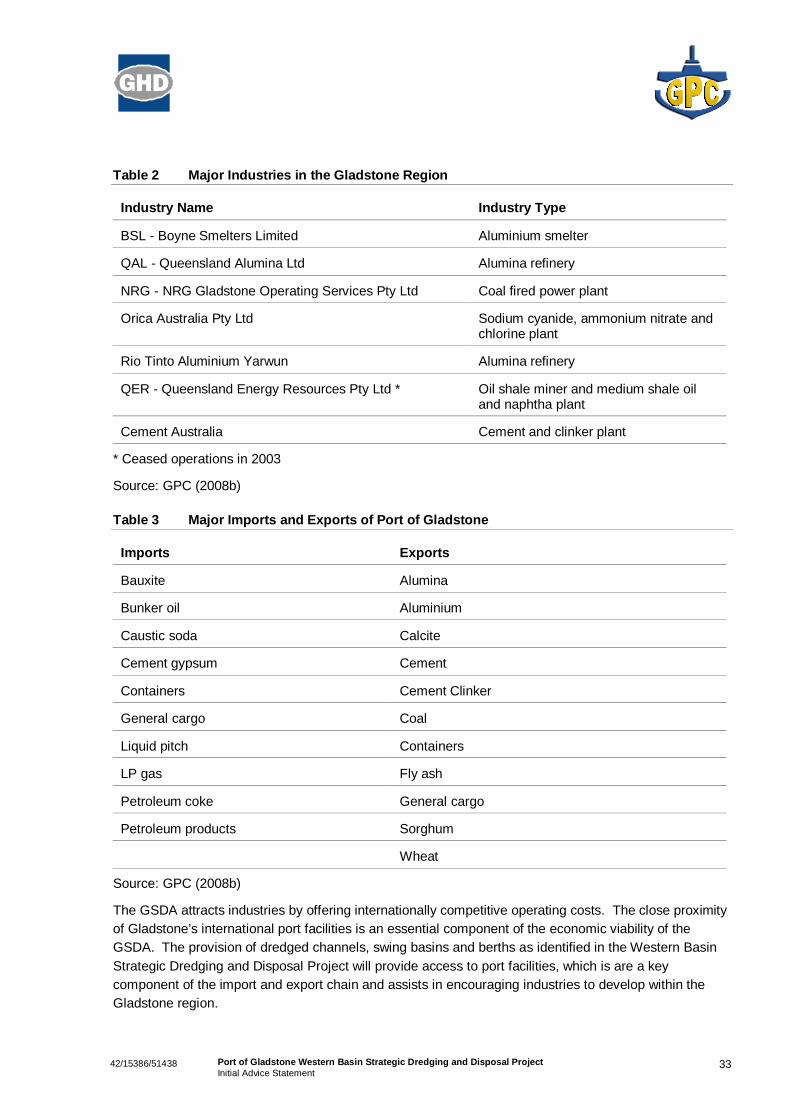
The Gladstone region contains the city of Gladstone, and a variety of coastal and hinterland townshipsincluding Boyne Island/Tannum Sands, Yarwun, Targinie, Miriam Vale and Calliope. Industries withinthe catchment include pastoral, agricultural and processing and manufacturing. Major processing andmanufacturing industries located within the Gladstone Region are summarised in Table 2. In addition, anumber of proponents are investigating options for constructing LNG plants at the Curtis Island IndustryPrecinct of the GSDA and the existing Fisherman’s Landing reclamation, and Gladstone Pacific Nickelhave undertaken feasibility and environmental studies on a site south of Hanson Road. Major importsand exports handled within the port on behalf of local industries and industries located within the CentralQueensland hinterland are provided in Table 3.
3342/15386/51438 Port of Gladstone Western Basin Strategic Dredging and Disposal ProjectInitial Advice Statement
Table 2 Major Industries in the Gladstone Region
Industry Name Industry Type
BSL Boyne Smelters Limited Aluminium smelter
QAL Queensland Alumina Ltd Alumina refinery
NRG NRG Gladstone Operating Services Pty Ltd Coal fired power plant
Orica Australia Pty Ltd Sodium cyanide, ammonium nitrate andchlorine plant
Rio Tinto Aluminium Yarwun Alumina refinery
QER Queensland Energy Resources Pty Ltd * Oil shale miner and medium shale oiland naphtha plant
Cement Australia Cement and clinker plant
* Ceased operations in 2003
Source: GPC (2008b)
Table 3 Major Imports and Exports of Port of Gladstone
Imports Exports
Bauxite Alumina
Bunker oil Aluminium
Caustic soda Calcite
Cement gypsum Cement
Containers Cement Clinker
General cargo Coal
Liquid pitch Containers
LP gas Fly ash
Petroleum coke General cargo
Petroleum products Sorghum
Wheat
Source: GPC (2008b)
The GSDA attracts industries by offering internationally competitive operating costs. The close proximityof Gladstone’s international port facilities is an essential component of the economic viability of theGSDA. The provision of dredged channels, swing basins and berths as identified in the Western BasinStrategic Dredging and Disposal Project will provide access to port facilities, which is are a keycomponent of the import and export chain and assists in encouraging industries to develop within theGladstone region.

3442/15386/51438 Port of Gladstone Western Basin Strategic Dredging and Disposal ProjectInitial Advice Statement
Based on the likely need to expedite the works, GPC proposes to engage a contractor to undertake theexpanded bund construction for the Western Basin reclamation. Direct employment is estimated to be55 personyears for the bund construction. Dredging would be staged over a number of years based onthe triggers outlined in Table 1. A total of 90 personyears is estimated for this phase of the work andwould be performed by contractors.
The direct permanent employment resulting from the dredging and development of the Western Basinreclamation is related to the nature of the product to be handled and as such is not quantifiable. Indirectemployment will result from the creation of industrial developments remote to the port. Thesedevelopments would not be viable without ready access to port infrastructure for import or export ofproduct. As such the local, state and national economies will ultimately benefit from the Western BasinStrategic Dredging and Disposal Project.
Recreational and commercial fishing occurs in the harbour and surrounding region.
The EIS will undertake a social impact assessment, community consultation and an economic impactassessment to quantify the positive and negative impacts of the Project and propose appropriatemitigation measures where required.
2.15 Environmental ManagementGPC has an Environment Policy which covers all of its activities. GPC also has an EnvironmentManagement System that is externally certified as being compliant with the international standardAS/NZS ISO 14001: 2004. All port operations are managed through this EMS and GPC are committedto continual improvement of environmental performance.
An Environmental Management Plan (EMP) will be prepared for the project. The EMP will be preparedwith the intent of ensuring that all activities associated with dredging and disposal are conducted in amanner that protects the natural and social environment and is consistent with project approvals andlegislative requirements.
The overall goal of the EMP is to:
» Provide a mechanism to minimise the potential for environmental impacts to occur during dredgingand disposal of dredged material;
» To provide Local, State and Commonwealth government (where needed) with a framework toconfirm compliance with their policies and requirements;
» To provide the community with evidence that the dredging and disposal operations are beingmanaged in an environmentally responsible manner; and
» To provide opportunities for continual improvement in the management of environmental, social andeconomic environments.

3542/15386/51438 Port of Gladstone Western Basin Strategic Dredging and Disposal ProjectInitial Advice Statement
2.16 Community ConsultationGPC undertake regular consultation with the community through their Environmental Working Group,production and distribution of a newsletter PortTalk, which is distributed throughout the community, andthrough public awareness sessions conducted by the CEO at various forums.
Specific consultation programs are conducted for large capital projects and a consultation plan will bedeveloped and implemented for the Port of Gladstone Western Basin Strategic Dredging and DisposalProject. Stakeholders will include industry, government, special interest bodies, communityorganisations and the general public.

3642/15386/51438 Port of Gladstone Western Basin Strategic Dredging and Disposal ProjectInitial Advice Statement
3. Conclusion
The proposed Port of Gladstone Western Basin Strategic Dredging and Disposal Project will provide forthe development of various industries at the Port of Gladstone and the GSDA. It is expected that anyimpacts of this project on the natural, social or built environment can be minimised through appropriatemitigation measures specified in an EMP for the dredging and disposal of dredged material.
Consultation with the relevant State and Commonwealth Government Agencies will be undertaken toidentify the scope of the environmental assessment. Depending on the level of assessment required aToR for the assessment will be prepared and advertised for public comment. Agency and communitycomments will then be incorporated into a final ToR for the assessment.

3742/15386/51438 Port of Gladstone Western Basin Strategic Dredging and Disposal ProjectInitial Advice Statement
4. References
Anderson, L.E., Melville, F., Steinberg, A.N., Teasdale, P.R., Storey, A.W., and Fabbro, L.D. (2007).2006 Port Curtis Integrated Monitoring Program (PCIMP). Central Queensland Ports Authority Report.
Alquezar R. and Small K. (2006). Port Curtis Macrobenthic Monitoring Programme (final report). Centrefor Environmental Management, Central Queensland University, Gladstone.
Connell Hatch. (2006). Wiggins Island Coal Terminal Environmental Impact Statement. Connell Hatch,Brisbane.
Danaher K.F., Rasheed M.A. and Thomas R. (2005). The Intertidal Wetlands of Port Curtis. InformationSeries QI05031. Department of Primary Industries and Fisheries, Queensland.
Department of Infrastructure and Planning. (2008). Gladstone State Development Area.http://www.dip.qld.gov.au/land/gladstone.html (accessed 5 November 2008).
Department of the Environment, Water, Heritage and the Arts. (2008). Australian Wetlands Database.http://www.environment.gov.au/cgibin/wetlands/report.pl (accessed 7 November 2008).
Environment Australia. (2002). National Ocean Disposal Guidelines for Dredged Material. EnvironmentAustralia, Canberra.
Environmental Protection Agency. (2008). GBR Coast Marine Park.http://www.epa.qld.gov.au/parks_and_forests/marine_parks/gbr_coast_marine_park/ (accessed 7November 2008).
Gladstone Ports Corporation. (2008a). Gladstone Ports Corporation, 50 Year Strategic Plan.http://www.gpcl.com.au/pdf/final_low_cmm5087gpcl_50_year_strategic.pdf (accessed 7 November2008).
Gladstone Ports Corporation. (2008b). http://www.gpcl.com.au (accessed 7 November 2008).
Gladstone Ports Corporation. (2008c). Sediment Sampling and Analysis Plan for Sea Disposal of CapitalDredging from Clinton Bypass ‘Wedge’ within the Port of Gladstone. GPC, Gladstone.
Great Barrier Reef Marine Park Authority. (2008). Rodds Bay Dugong Sanctuary.http://www.gbrmpa.gov.au/corp_site/key_issues/conservation/natural_values/dugongs/dugong_protection_areas/dugong_location_maps/rodds_bay_dugong_sanctuary (accessed 7 November 2008).
Rasheed M.A., Thomas R., Roelofs A.J., Neil K.M. and Kerville S.P. (2003). Port Curtis and Rodds BaySeagrass and Benthic MacroInvertebrate Community Baseline Survey, November/December 2002. DPIInformation Series QI03058. Department of Primary Industries and Fisheries, Queensland.
Rasheed M.A., McKenna S., Taylor H. and Sankey T. (2008). Long Term Seagrass Monitoring in PortCurtis and Rodds Bay, Gladstone – October 2007. DPI&F Publication PR07 – 3271. Department ofPrimary Industries and Fisheries, Cairns.
Storey A., Andersen L., Lynas J. and Melville F. (2007). Port Curtis Ecosystem Health Report Card.PCIMP, Gladstone.
3842/15386/51438 Port of Gladstone Western Basin Strategic Dredging and Disposal ProjectInitial Advice Statement
Taylor H., Rasheed M.A., Dew K. and Sankey T. (2007). Long Term Seagrass Monitoring in Port Curtisand Rodds Bay, Gladstone – November 2006. DPI&F Publication PR07 – 2774. Department of PrimaryIndustries and Fisheries, Cairns.
WeatherZone. (2008). http://www.weatherzone.com.au/climate/station.jsp?lt=site&lc=39123 (accessed 5November 2008).
Worley Parsons (2008). Gladstone LNG Project – Fisherman’s Landing, Environmental ImpactStatement. Worley Parsons, Brisbane.
42/15386/51438 Port of Gladstone Western Basin Strategic Dredging and Disposal ProjectInitial Advice Statement
Appendix A
GPC Environment Policy
42/15386/51438 Port of Gladstone Western Basin Strategic Dredging and Disposal ProjectInitial Advice Statement
Appendix B
Letter Advising Department ofInfrastructure and Planning of Intention toApply for Significant Project Status

42/15386/51438 Port of Gladstone Western Basin Strategic Dredging and Disposal ProjectInitial Advice Statement
Appendix C
Maps of Seagrass Extent 2002 – 2007
Rasheed et al. (2007)
42/15386/51438 Port of Gladstone Western Basin Strategic Dredging and Disposal ProjectInitial Advice Statement
Appendix D
EPBC Act Protected Matters Report