port elliot and goolwa heritage study · contents introduction summary of recommendations...
TRANSCRIPT

. . ~.:i
' i .· .. l .. ., -.... "'-.... ! .. •* .....
I .,. . o '}'I · ..:unp. ;·,_. Jl ... -.. ~
/had /1.1/\' .\. : • • j
' . . .....
. -. ' : I " .. , I . . . ... ;
·:./ 6/'f'l'. \.-. ' '
Port Elliot and Goolwa Heritage Study
J.

PORT ELLIOT AND GOOU'A HERITAGE STUDY
STEERING COMMITTEE
PORT ELLIOT AND GOOLWA HERITAGE STUDY
PREPARED BY: Edwin L. Noack Susan Harsden John C. Da11witz
STATE HERITAGE BRANCH
DEPARTMENT OF ENVIRONMENT AND PLANNING
ED. NOACK AND ASSOCIATES, TOWN AND REGIONAL PLANNERS in association with
HERITAGE INVESTIGATIONS. Corrected Copy May, 1981

CONTENTS
Introduction
Summary of Recommendations
Acknowledgements
PART 1.
PART 2.
PART 3.
APPENDIX.
Summary of History
1802 - 1839
1840 - 1890
1891 - Present
References
Sites Structure and Buildings of general heritage interest
Goolwa Township
Port Elliot Township
Middleton Township
Rural Areas:
Goo lwa vJard
Sturt Ward
Hindmarsh Island Ward
Middleton Lvard
Port Elliot Ward
Currency Creek Ward
Nangkita Lvard
References
Recommendations
Proposed Heritage Areas
Development Control
Nomination of Items
Information Restoration Further Work
A. Items on the Register of the National Estate
Page
( i )
( i i )
( i v)
1
1
4
10
13
17
17 42
60
70
70
71
76
79
86
93
97
99
101
101
102 104
116
118
119
B. Items on the Register of State Heritage Items C. The National Trust List
D. Division of Tourism List

( i )
Introduction
This study commenced in October 1980 with the main aim of identifying the sites, buildings and structures of heritage significance within the area of the District Council of Port Elliot and Goolwa.
The study was carried out under the supervision of a Steering Committee comprising members of the Heritage Unit of the Department for the Environment, the District Council of Port Elliot and Goolwa and members of the district's community.
Information was presented to the Steering Committee during the study in the form of Working Papers and these have been collated into this Final Report. The information in the Working Papers has, therefore, been checked by the Steering Committee.
Part 1 of this report provides a summary of the district's history. The first step in identifying items of heritage significance is -to examine the district in terms of its economic, social and physical developments. This information allows the relevant themes to be identified such as exploration, pastoralism, township development, river trade and agriculture among others. It also provides guidance to identifying a list of sites, buildings and structures which are important in an historic or design sense. These are listed and described in Part 2.
The information presented in Parts 1 and 2 is synthesized in Part 3, the "Recommendations". Recommendations cover a broad range of issues including nominations to the State Register; definition of Heritage Areas and principles to control development within these; interpretation and display; further research and restoration.

\ I I I
SUMMARY OF RECOMMENDATIONS
l. The Proposed Heritage Areas
RECOMMENDATION: THE STUDY RECOMMENDS THAT THE SIGNIFICANT EARLY TOWNSHIP AREAS OF GOOLWA, PORT ELLIOT AND MIDDLETON BE DESIGNATED AS HERITAGE AREAS FOR CONSERVATION AND PLANNING PURPOSES.
2. Development Control
RECOMMENDATION: THE STUDY RECOMMENDS THAT THE PROPOSED HERITAGE AREAS BE GIVEN RECOGNITION IN ANY REGULATIONS TO CONTROL DEVELOPMENT OF LAND AND THAT THE PRESCRIBED SET OF DEVELOPMENT CONTROL PRINCIPLES BE INCLUDED.
3. Nomination of items
RECOMMENDATION: THE STUDY REC0~1~1ENDS THAT NOMINATIONS FOR INCLUSION ON THE STATE HERITAGE REGISTER OF ITEMS INDICATED SHOULD BE SUBMITTED TO THE SOUTH AUSTRALIAN HERITAGE COMMITTEE.
RECOMMENDATION: IT IS RECOMMENDED THAT THOSE ITEMS NOT RECOMMENDED FOR !~\MEDIATE NOMINATION TO THE STATE REGISTER BUT CONSIDERED WORTHY OF PRESERVATION BE KEPT UNDER REVIEW FOR POSSIBLE LATER NOMINATION.
4. Information
RECOM~1ENDATION: IT IS RECOMMENDED THAT INFORMATION ON THE HERITAGE VALUE OF THE DISTRICT AND ITEMS IN IT BE PRESENTED IN BROCHURES ON THEMES OF THE AREA'S HISTORY SUCH AS THE HORSE DRA\<N RAILWAY AND EARLY SHIPPING DAYS.
RECOMMENOATION: THE GOOLWA MUSEUM SHOULD BE ENCOURAGED AND GIVEN ASSISTANCE TO PROVIDE A THEMATIC DISPLAY ON RIVER BOATS. THE RIVER TRADE AND THE EARLY HORSE DRAWN RAILWAY, INCORPORATING, IF POSSIBLE, WORKING ~lODE LS .
RECOMMENDATION: A FILE OF THE ITEMS LISTED BY THIS STUDY AS HAVING HERITAGE VALUE SHOULD BE ESTABLISHED.
RECOMMENDATION: A WALKING TRAIL SHOULD BE PREPARED THROUGH THE PROPOSED GOOLWA, PORT ELLIOT AND MIDDLETON HERITAGE AREAS TO LINK UP HERITAGE ITEMS, LOOK OUT POINTS, DISPLAYS AND PLACES OF REFRESHMENT.

(iii)
5. Restoration
RECOMMENDATION: THE STUDY RECOMMENDS THAT COUNCIL ENCOURAGE OWNERS OF HERITAGE ITEMS TO CONSULT WITH THE HERITAGE UNIT, DEPARTMENT OF ENVIRONMENT AND P~ANNING, BEFORE UNDERTAKING RESTORATION WORK.
RECO~IMENDATION: RESTORATION WORK SHOULD BE UNDERTAKEN, WHEREVER POSSIBLE, BY TRADES PEOPLE WHO HAVE A KNOWLEDGE OF THE USE OF THE LOCAL LIMESTONE AND BLUESTONE IN PARTICULAR IN RELATION TO CUTTING, DRESSING AND SETTING.
6. Further Work
RECOMMENDATION: THE STUDY RECOMMENDS THAT A FURTHER STAGE OF WORK BE UNDERTAKEN TO ANALYSE IN DETAIL THE HERITAGE ITEMS LISTED IN THIS REPORT PARTICULARLY WITH REGARD TO BUILDING STYLES AND CONDITION, CONSTRUCTION DETAILS AND PHOTOGRAPHIC DOCUMENTATION.

( iv)
ACKNOWLEDGEMENTS
The study team wishes to thank the many people who have contributed information, ideas, time and experience to the study. In particular, we wish to thank the following:
The Members of the Steering Committee for their constructive advice and assistance. The members are Mr. K. Steinle, Cr. H. Durrough, Mr. R. Bartel, Mrs. V. Lawrence, Mrs. L. Pomery, Mr. R. Moss and Ms. G. Hunt. Mr. I. Riches replaced Mr. Bartel during his absence on leave.
Officers of the District Council of Port Elliot and Goolwa The Staff of the Heritage Unit, Dept. for Environment and Planning Mr. J. Willcocks, Sector Manager, Dept. for Environment and Planning
Mr. John Tolley, Adelaide Mrs. Lorna Randall, Port Elliot Mr. Ian Roberts, Dept. of Marine and Harbors
Mr. Ron Stewein, State Transport Authority Australian National Railways, Plan Room Dr. J. Tregenza and Mrs. K. Patitsas, Art Gallery of South Australia
The South Australian Archives The State Library of South Australia The Royal Geographical Society of Australasia (S.A. Branch) Library
Surveyor General's Office The National Trust of South Australia, Goolwa Museum The National Trust of South Australia, Head Office
Mr. W. Green, Goolwa Mr. Walter Pretty, Goolwa Mr. P. Plummer, Currency Creek
Mr. A. Higgins, Currency Creek Dr. L. 1•1cL€ay, Goo lwa
Mrs. N. Gilbert, Adelaide
Mr. J. Connell, Adelaide Cr. V. Mills, Hindmarsh Island Mr. and Mrs. J. England, Port Elliot
Mr. and Mrs. D. Lines, Middleton Mr. and Mrs. K. Dennis, Goolwa Mr. S. Heysen, Port Elliot Mr. George Peters, Goolwa Mrs. N. Scott, Middleton Mrs. S. MacKenzie, Middleton National Parks and Wildlife Division, Dept. for the Environment Coast Protection Division, Dept. for the Environment

PART 1. SUI~MARY OF HISTORY
SUSAN MARSDEN

PART l. Summary of History
1.1 1802-1839
The main themes of this period are:
(a) exploration. {b) Aboriginal-European contact and conflict.
(c) pastoral development.
1.
This region has a rich Aboriginal heritage as the result of thousands of years of occupation, evidence for which includes the famous canoe and shield trees and the extensive remains of middens in the coastal dunes and near Goolwa. 1.
However, this study is concerned with the heritage of the Port ElliotGoolwa district since the period of initial contact by Europeans.
The first recorded "contact" by Europeans was off-shore in 1802, when the voyages of exploration by Matthew Flinders and Nicolas Baudin intersected at Encounter Bay, so-named by Flinders as a result of the meeting. The encounter was actually south-east of the Murray Mouth (which neither explorer discovered), and Baudin named a nearby point Cap de la Rencontre - later renamed Cap Fenelon.
Australian, American and French whaling and sealing vessels soon followed in the wake of these discoveries. There are several references to visits to the Cape Jervis-South Coast areas by sealers stationed on Kangaroo Island. These visits dated from at least the 1820s but there is no record of actual habitation nor other physical traces in the Port Elliot-Goolwa region. The visits were, in fact, usually raids, as the men kidnapped Aboriginal women to use as servants and sexual companions on Kangaroo Island. Charles Sturt later attributed the hostility of the Aborigines of the region to the behaviour of these sealers from Kangaroo Island. 2.
The first formal contact with the region was deliberately planned, as part of Captain Charles Sturt's discovery of the River Murray and his voyage downstream in 1829-30 to find the outlet of this impressive river. Sturt named the Murray and Lake Alexandrina, where the river ended.' His last campsite was made near the present site of Goolwa. From there he made the disappointing discovery of the dangerous river outlet to the sea. Sturt's expedition as a whole was of enormous significance to the subsequent colonisation of the vast Murray-lands, and of South Australia as a distinct Province.
Captain Collet Barker was sent by the New South Wales Governor in 1831, to further investigate the area between Gulf St. Vincent and the Murray. Though he was speared by Aborigines after swimming the

r
,.;, '·"'""
,, • • oP
1,,,.1
I•''
'· '·
s
-::~ .; =-~~~ ,. '
'
I.• ·.
\
I f[
:•,;-
0
't
1 ~
•I () ~ ~
' '
~0"""" ~O.C..~\......-v:\ct.,.. ~
e.o\\~~C-v ~ Goo\\.AJC\
·•·.·.
' ·,3
'
:"'. .); '
. ...: ~,.,. __ j_
">'.,:'\._. ;,
- "'--~-, \ "·
' ·.~·
' -
--- "' :;;:
III
..
l -. .~ :::
.:. ,"!...; .. ~ '- ·• --.::~ I
/"'I !.;,'/ ..... ?··
'''
-
0
0
,··
PORT ElliOT ANO GOOLWA HERITAGE STUOY. cld, __ Noack and Associates, Town and Regional Planners. lares Bav. S.A. in association with Heritaoe lnvestioa!ions 1~Rn

0
·--·-·---·-----·-- .. -,.----...... v·
$ • ~ ' ~ .. .....
'. ~: ·,: ,' f
,o;:
" =.,>, ~~ ~ E.-.C>.O'-""'.~ ~j F"....oi-"-"S c:.Mox'r \'Co<..
~· 0 ::0 ,... ~-
I I ,.~ ' ,,
i
/ I
·~") ' ..
. "':·
I
• ' "'<:' ' . ~ ,·
· . .-.. "! ~I
~I U:J
-\~·., .. ::.· ,., ~
I
I ' . ..... ,""":-
' ' .. -,~I ,,
') "' ·. I I . , I' ' ,· .. ~
:,
. ~. . ~·
' ·~ ::f ' ,.._.. ;~ ~ "''~ ' '-"
}' '
I __ j ~
I "~
1·-.::· "(, /
~
..&<--- ---
PORT ElliOT AND GODLWA HERITAGE STUDY. Ed. Noack and Associates, Town and Regional Planners. largs Bay, S.A. in association with Heritage Investigations, 1980.

~ :J ~
ffi > -rt: t>J
~
l J "
5 'D
j
. ' .
... . l .·:''i .,
1-<'
~I ! <ll' •
11;~1; :t\ ~ i:' < u • > ~· ,g p,l <('
0 ul
i 0'3 ·! ~;
! i ~..,
n h :;i.l
I ~ ' ! 1 • l l
~
I " ' I > I
.. I I~' 1'\hc-- R\'Je....,- \1\-.nv-o.j , "'D\<ScoVt2..--'rJ o...-..d. 'E..x'?\o.y-oU-\~ :J ~\o..\......., ~\e s
'S'N<*, \'0:1.9 - \ '0<1-o '. f"'·\=~..0 .\..a ""-'~......,ovctM:... ~ ~\e...-v~ q 1-.> s
""'~"' ~ . t'G'"'"' Cc,\\a."""c.... 0~ Gco\'-"C\. ~o''"'~ \.vst 1<\v;;."-'-'""'.
PORT ELLIOT AND GOOLWA HERITAGE STUOY. Ed. Noack and Associates, Town and Regional Planners. largs Bay, S.A. in association with Heritage lnvestigalions, 1980.

~'=>.>\ ~"""' C-1--\c<.r\0.'3 S'<u~-\,
~~~ o\ F\-.:,_.., C:>\\e eX-....
,.
" \v-..(l,.... R \~ t-1\.v'f"i"'-j , U\s <:...c"~j
, l 'e>2q- I '0 "?.o ", 1'..--"-\'<Ar"cl "'= ~"' <!-><.~ "<'.c.._ '
o"'-C\ E.x.'f\ o.,-o<k( o.., \:sj c.c:. ........ -.... e...-OVC>I....-\ (2_.. '""'-~
q Gc.o~"""'- ).,\~o~ lr""""' Y\u<;,e-v""' ,
PORT ELLIOT AND GOOLWA HERITAGE STUDY. Ed. Noack and Associates, Town and Regional Planners. larns Bay, S.A. in association with Heritane lnvestinatinns. 1980.

2.
Murray Mouth, his survey and Sturt's favourable published reports greatly encouraged the proponents for setting up a new colony. The South Australian Foundation Act was passed by British Parliament in 1834, with the first ships arriving at Kangaroo Island late in 1836.
The South Coast-Lower Murray region was understandably a focus for attention, prior to the despatch of the first colonist ships, so much so that the instructions given the first Surveyor-General, Colonel William Light, are quoted in full, as follows,
"As far as the imperfect information already possessed enables the Commissioners (South Australian Colonization Commissioners, in London) to judge, the district between Gulf St. Vincent and the l~urray, or Lake Alexandrina (provided a good harbour can be found) appears to combine the requisite advantages in the highest degree. This district is sufficiently central, according to the report of Capt. Sturt, it contains an abundance of highly fertile land, it appears well supplied with water, it is conveniently situated for intercourse with liepean Bay (Kangaroo Island) and Port Lincoln and if a communication should be discovered between Gulf St. Vincent and Lake A 1 exandri na , the River Murray and its tributary, wou 1 d afford the most important facilities for communication not only with the interior of the new colony, but also with that extensive portion of New South Wales (then including Victoria), which lying to the west of the Blue Mountains, is practically excluded from connection with the eastern ports". 3 ·
But Light dismissed that part of the district described, close to the Murray and the sea at Encounter Bay as the site for the capital of the new colony without bothering to visit the area, having decided that the Murray outlet would not be navigable and that the coast was too exposed to the Southern Ocean to provide a safe harbour. 4. Although Adelaide was sited near St. Vincent's Gulf instead, its early years were disturbed by arguments about the suitability of the site, as opposed to other sites at Port Lincoln and Encounter Bay, with Encounter Bay being the particular favourite of even the Governor-Hindmarsh-himself. b.
The debate hinged always on the navigability of the Murray Mouth and the suitability of harbours on the southern coast, a debate which continued long after Adelaide's permanence was assured, the Murray Mouth had been navigated and ports had been established at Port Elliot and at Victor Harbor on the south coast. Victor Harbor's history is inseparable from that of the rest of the South Coast district, but this historical background must be restricted to the subject of the heritage study, comprising the District Council of Port Elliot and Goolwa.
Colonel Light visited Encounter Bay in June, 1837, calling at the whaling station established near Rosetta Head. The first systematic exploration of the Port Elliot-Goolwa area was made by T.B. Strangways and Y.B. Hutchinson in December, 1837. 6. Strangways

3.
and Hutchinson and party were sent by Governor Hindmarsh to see whether Sturt's channel (past the present site of Goolwa) was the only outlet to the sea. They also visited and named Currency Creek and Hindmarsh Island. Their exploration was cut short by the drowning of four men (including Judge Jeffcott and the whale fishing owner, Capt. Blenkinsop) attempting to take a boat across the Murray out 1 et. However, Strang1~ays and Hutchinson were obviously both impressed by the countryside they had visited as both became large land-holders in the area, Hutchinson also becoming directly involved with the subdivision of Goolwa Extension in 1856, long known as "Hutchinson's Town". 7.
This region - given the reports of its fertility, its possible harbours and its likelihood as the site for the capital city -attracted considerable attention from the speculators who founded the colony (both those who emigrated and those who remained in Britain as absentee land-owners). For these reasons, the country about Currency Creek, abutting Lake Alexandrina and including part of present Goolwa, became one of 36 favoured areas in South Australia selected for ''special survey'' This was carried out under the direction of the Surveyor-General, E.C. Frome, between December 1839 to January 1840. An elaborate town -worthy as the Colony's capital - was laid out at Currency Creek, and a smaller town was drawn up as a river port, called Town on the Goolwa, which is now the northern part of Goolwa. 8. The special survey was made on behalf of a consortium of speculators, calling themselves the Currency Creek Association, neither Currency Creek nor Town on the Goolwa were developed as town blocks although much of the country land was soon in use. 9.
The South Austral ian Register, of l•lay 7th, 1851, reported the Currency Creek township as having been laid out and allotted too early, but that a square mile of country land was occupied, with 200 acres of crops, ''and the whole would soon be in request, were not the property in the hands of a few absentees''.
Speculators aside, a number of settlers were attracted to the region for similar reasons, the first permanent settlement being made by Reverend Ridgway Newland's party at Yilki, near Rosetta Head in 1839 10., with other settlers moving along the coast and taking up land at the foot of the nearby hills known as Hindmarsh Tiers. Their much-maligned predecessors, the Aborigines and the whalers, provided vital advice and assistance in food-gathering, cultivation and harvesting.
By 1839-40 also, parts of the district were being used by pastoralists, literally squatters in those early years, though they also included men such as Dr. John Rankine. Rankine settled at Strathalbyn in 1839 and grazed sheep and cattle over a wide area, including Hindmarsh Island, near Goolwa, which he leased, ferrying the stock over on his private ferry. 11.

4.
1.2 1840-1890
Main themes;
(a) river trade and harbour development. (b) township development; houses, government agencies,
industries, community facilities.
(c) agriculture.
(d) railways
This \'las by far the most significant period as far as the history and the heritage of the region's main towns is concerned, and was directly linked to the dramatic rise and decline of the river trade along the Murray and its tributaries, and the industries and facilities which were developed in response. Permanent structures, attesting to the town's important role during those years still stand; in part thanks to their decline once the river trade had ended, in part thanks to some of the townspeople's justifiable pride in their heritage. The preservation of Goolwa's old bow-fronted shop, a tramway carriage and the Railway Superintendent's house are good examples of this.
The early settlement of the whole South Coast region was limited by the poor transport links with Adelaide, because of the rugged, densely timbered ranges separating the two. This made the region virtually independent, and meant that a wide variety of crops and stock were raised on the coastal plain and in the coast-facing foothills, to enable self-sufficiency.
In the period betl'leen 1840 and 1850, while the numbers grew steadily, general interest in the area declined. Newland describes it,
of settlers As Simpson
"By this time it was generally understood that there was no prospect of the capital being moved from the site early fixed upon, and the fortunes of Encounter Bay were waning. Many of the more important settlers found themselves cramped for room, and cleared out for the South East ... Many more took their flocks north ... The places of those who left were filled by newcomers, and farmers supplanted squatters.'' 12.
A good description is given in 1850 by ''an old colonist'', of the scattered agricultural settlement, the area under cultivation and the handful of settlers in the Port Elliot-Goolwa district. Some of the places he visited are still in existence. 13.
One of the earliest of these settlers and one of the largest landowners was Colonel Thomas Higgins, who took up a large tract of country at Currency Creek in 1840 and built his homestead ''Higginsbrook'', which still stands. Higgins also owned the land on which he later subdivided and named the township of Middleton. 14.

v
--~
--
" S=u~ cl( ""'""'"- 1-Av.-.--o.j " \ '04.+ I "5 . ( yo'=>-'o':J ~ \ '04-4) 0::)·
G. F'""""'""'"' ~ 5 •
~'~ Go..c"'"'::) ""t -;;. .4\ • ~.-.:.eM.> c.Mcv--. .
F=.oQ......., Co\\.Q..C"f\ 0 .._ ~ CA.oo\..u.)C\ ~0....~0~ \ru~-t t-t\vSQ...V"""'"' .
PORT ELLIOT AND GOOLWA HERITAGE STUDY. ~Ed~-~N~oa~c~k~a~nd~A~s~so~ci~at~e~s._T~o~w~n~a~nd~R~eg~io~n~ai~P~Ia~nn~e~rs~.~l~ar~gs~B~ay~,~S~.A~.~i~n~a~ss~o~ci~at~io~n~w-~lth~l~le~rit~a~ge~ln~v~es~ti~ga~ti~on~s~.--~19~80~.-------·-

5.
Inland, was deep sand, hilly and heavily timbered, all of which made the journey to Encounter Bay via Square Waterhole (Mount Compass) extraordinarily tortuous, and exacerbated the isolation of the settlers. 15.
Police were stationed at Goolwa from 1840, following the killing of the ''Maria'' passengers and crew on the Coorong by the Aborigines. A police-station house was built there by 1850 16. and postal station established at Freeman's Nob, (Port Elliot) and Currency Creek. 17. However, the real stimulus to township development at these places and at Waterport and Middleton was made when work began on port facilities and the railway to serve a hoped-for river trade.
A succession of South Australia's early Governors had great personal interest in the South Coast region, particularly in terms of its role in the development of the Murray trade. Hindmarsh wanted Adelaide moved there (his son, John, later lived at Port Elliot), Gawler explored along the river as far as the site of Morgan, and Sir Henry Fox Young thoroughly examined the river with his wife, lady Augusta and party in 1850. They returned by boat to Goolwa, from there to Port Elliot and then Adelaide, convinced that vessels on the river could open up the interior. In Adelaide, Young had proclaimed a bonus of £4,000 to the first two iron steam boats ''that shall successfully navigate the River from Goolwa to the Darling Junction". 18.
As cargoes had to be moved from the river to the sea, the only alternative to the dangerous passage of the Murray Mouth was the construction of a canal, a rai lv1ay or a road between Goo lwa and the nearest safe anchorage on Encounter Bay. Governor Young decreed this to be at Horseshoe Bay, which was charted (1850) and proclaimed Port Elliot (1851), despite much popular criticism of its obvious dangers and support for Port Victor (Victor Harbor). He also proposed a scheme for a railway connecting Port Elliot and Goolwa, 19 · again, despite opposition particularly from Port Adelaide merchants.
The necessary public works were started before the first paddle steamer had even started upon the river, and, these no doubt, were far greater inducement than the cash prize. Governor Young decided to finance the works from the land Fund despite much opposition - in what were the first extensive public works undertaken in the colony.
By 1852 the Government had completed jetties at Port Elliot and Goolwa, the stone obelisk at Freeman's Nob, the Port Elliot harbourmaster's cottage, moorings and buoys. Works started included the Port Elliot and Goolwa Railway, the Railway Superintendent's house at Goolwa 20. and works for the supply of water to Port Elliot. 21. Water was piped from springs at Waterport, which is said to be the first piped water supply in South Australia. 22.

\~·· C-V'f'(a:.-~ ~\!(._ ~v-..e.,. 'bv;.~~ c.-d. ~Q,......Q...., ~ ....... \- <=Wc..c::-- c-.c\, ~ (l'il•o _ a:>.-s) o~ Vw- o.~ \<\<';. ~ "-~'p. c... 1"e>BO.
Bo~: "Jrt~c:o; ...... tO. ~00\<.-. I c....... ... 'f~0 ~ . 'B~.>\\+ \8..-lr\ ~C\..~12.0~ lo;:) ?rc:L'9C...O+'r <S\,......c_..-1,~~'(".
Fro.....,... (J"">\\p_c.-k\o.,.........- ot. Goo~ N(.)..;\o\o-.ct.J. \p..r::;.;-- M\.)'i~IIV'\..
PORT ELLIOT AND GOOLWA HERITAGE STUDY. I
6.
In 1853 the first two river steamers paddled the route upriver. Captain Francis Cadell (with Governor Young aboard) took the ''Lady Augusta", and v/illiam Randell in an earlie1·, quite independent trip, took the "Mary Ann". 23. Cadell had brought his paddle-boat through the fvlurray Mouth~ and departed from Goolwa with a locally made barge, The "Eureka", and Randell steamed from l''lannum for clearance at Goolwa before travelling upstream. Their spectacular successes and renumerative cargoes provided an immediate stimulus to further inland settlement and to the development of a massive river trade in South Australia, New South \1ales and Victoria, with Goolwa as final port at the "bottom end" of the river system, and Port Elliot as sea-port.
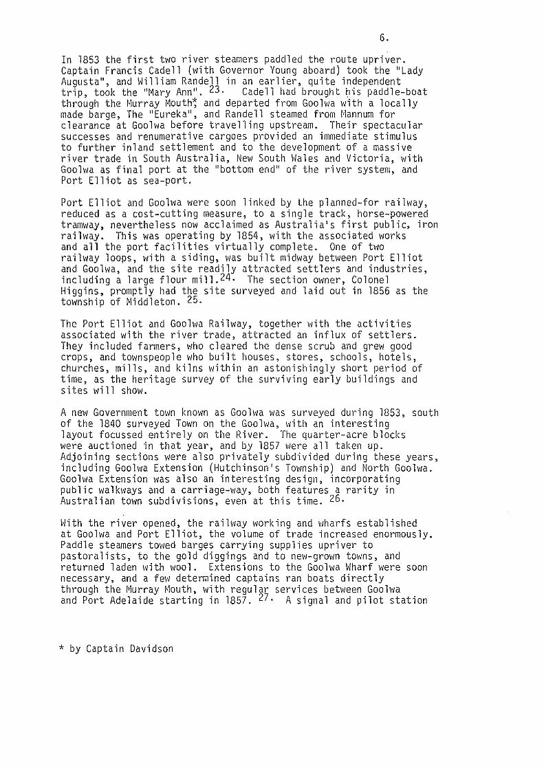
Port Elliot and Goolwa were soon linked by the planned-for railway, reduced as a cost-cutting measure, to a single track, horse-powered tramway, nevertheless now acclaimed as Australia's first public, iron railway. This was operating by 1854, with the associated works and all the port facilities virtually complete. One of two railway loops, with a siding, was built mid1~ay between Port Elliot and Goolwa, and the site readily attracted settlers and industries, including a large flour mill.24. The section owner, Colonel Higgins, promptly had the site surveyed and laid out in 1856 as the township of Middleton. 25.
The Port Elliot and Goolwa Railway, together v1ith the activities associated with the river trade, attracted an influx of settlers. They included farmers, who cleared the dense scrub and grew good crops, and townspeople who built houses, stores, schools, hotels, churches, mills, and kilns within an astonishingly short period of time, as the heritage survey of the surviving early buildings and sites will show.
A new Government town known as Goolwa was surveyed during 1853, south of the 1840 surveyed Town on the Goolwa, with an interesting layout focussed entirely on the River. The quarter-acre blocks were auctioned in that year, and by 1857 were all taken up. Adjoining sections were also privately subdivided during these years, including Goolwa Extension (Hutchinson's Township) and North Goolwa. Goolwa Extension was also an interesting design, incorporating public walkways and a carriage-way, both features a rarity in Australian town subdivisions, even at this time. 26.
\·lith the river opened, the railway working and wharfs established at Goolwa and Port Elliot, the volume of trade increased enormously. Paddle steamers towed barges carrying supplies upriver to pastoralists, to the gold diggings and to new-grown towns, and returned laden with wool. Extensions to the Goolwa Wharf were soon necessary, and a few determined captains ran boats directly through the Murray ~louth, with regular services between Goo lwa and Port Adelaide starting in 1857. 27. A signal and pilot station
* by Captain Davidson

2394
c A " D I N E r
' ' w .j ; 6 w oc
" 1•1 ·- 15 16 w, 11 18 ~ w " w. w
/I I
~--·- ..... , . " "' ~-·"·~ ... ._,__. ____ ... ..,.
GOOLWA
Go-a \v.lO.. \O~..UV\.. ~'-'· 'P , .Do P' ~ 9 l-1\o..r; """-' o.v-6 \'\cv lo::>rs
"
20
\''\ .- (\,,--
: / ;-.,.flool ·j\:t~
ST/RI:ET
I • ~" I ?I •
1 ?2
~,,;;.: .· 35 t-' /' ~
w
10
23
II
111'"''1'\'('
12
w
w 4 7 w: 48 49 50 51 ~ ''~.._.,~,.! ~ --"-,J ~
S T ~R E E T
;s r.n' so
71
SCALE
No.
r 61
72
: 6'2
73 ) 74
'
sob..., 1 o. 1. .
0
z
--0 ·::.;
2203
PORT ELLIOT AND GOOLWA HERITAGE STUDY. Ed. Noack and Associates. Town and Reoional Planners. taros Bav. S.A. in association with Herii>De lnvestioalions 19BO.
/.;1.' ~I ~ _:: I'"~ I
~i
'if ~ I ,{ 32
~]ft .. . 7:i.J(I("/'/'""'
...... : I -
In L." I 70 I
<. 69 1
H
58
89
90
91
·p C/l:rJJ :.8:L:LJD'l1
lltiiHii·<'cl .. r· ( ioolwn
107
N 0 R T H T E R R A c E
144 145·179 I,.; 176:180 ' i 123! 124 178
"' 122 1 12s t- '" >46 I "' '"
126 w! 142 ! '" I >58 >74
>41 I >48 0 I 159 "' s T R E E T
140 i ' 149 ' 160 I "' z• '
E N
I "·1 '" ~-·~~ '" I 93 i "' ' ' ~:1 ;;- i u~·
-- 'Z~;r )\\··1·
-..............
\
0 u N T E
SCJ.~t
LlnX•1:§LL hJ.. LJ J-d i.g1 _ ~i§iCbHJu~
fb,.. '<- E.\\\ o>,- \cu.. v-. '2."'\\=' .
!:><;,..~ """"~ <==\ lAo.~'""'- o......c\
To t:!'\~)wn
w•
u: <! .,:
. //
/
/
r,.~!...:lfoi!Mtown
... .,. ...... d ,., ltlo ~""""' o/' .... ~kt (i 0 ~:)-10-03
No,
PORT ELLIOT AND GOOLWA HERITAGE STUDY. Ed. Noack and Associates. Town and Reoional Planners. laros Bav. S.A. in association with Heritane tnv"tinatinns 1~Rn

7.
station was set up at the outlet and beacons provided along the safest route to Goolwa. Port Goolwa was proclaimed in 1857, and wa.s made a customs point - one of a chain of customs ports which so complicated the intercolonial trade - and a ships survey centre. 28.
The river crews were a skilled, rough lot, "half-seamen, half-landsmen, who could turn their hands to almost anything" 29., and v1hose visits enlivened Goolwa and provided business for the police, the prostitutes and the three hotels. The captains operated also as traders, storekeepers, builders and speculators - all of which had a marked impact on the Town of Goolwa. This was apparent in the career of Cadell himself, and of the men he brought out from his home,"Cockenzie'' in Scotland. For instance, Captain George Bain Johnston built "Cockenzie" house at Goolwa and benevolently provided several plain, Scottish cottages for his employees in Goolwa Extension, v1hich was accordingly known until quite recently as ''Little Scotland''. 30.
The Government town of Port Elliot was surveyed in 1852, when the first public works, and the first hotel (now''Arnella'') were constructed. 31.
The hotel builder, old Thomas Dodd, who was in 1850 the only settler near Freeman's Nob, started construction in that year well in anticipation of the port's development;
"t~r. Dodd informed us that the section we were upon 11as 107, that it was the only one eligible or attainable to lay a to11nship upon, that the house was eighteen feet from a Government Road, and would be situated at a point of four cross-roads, viz. to Encounter Bay and the Goolwa, Adelaide and Port Elliot''.
"Should a house of public accommodation prove necessary for the intended port, 'there', as ~1r. Dodd observed, 'will be the very building and all ready'''. 31.
Port Elliot was proclaimed a township in 1854. In its early years, much of the town's private settlement was located north of the railway, and in Dodd's Extension and at Haterport, which was surveyed in 1856 32., 11hile its public buildings and structures were concentrated in Port Elliot proper, t011ards Freeman's Nob. At Haterport, several houses may actually predate the port. There v1er3 later established brick11orks, a school, a store and a cemetery 3. as well as the police horse stables.
Port Elliot's major development was concentrated into the few years it survived as a port. 34. Ships began to call regularly from 1852, with the largest number, 85, calling in 1855. In that year too, work finished on the breakwater, but soon afterwards heavy seas dislodged the blocks and further undermined the port's reputation with the wrecking of 4 ships in 1856. As a result Victor Harbor was chosen to replace Port Elliot as the sea outlet for the Murray and took with it, the trade and the dramatic development. There was a last burst of local building during a prosperous season

\ \
' . ,, '
• ~ '.
1 ' • '
<(
-' ~ <( © 0::
ti3 e:;J e::l
:::> ~ <( ?-')
::r.: ~ 1- ~ ::> © 0 !?:J Cl)
.SvN~ "') ~ ~vr c::M- fu.,..>t- E. \\to-\;
~-\"""-"--'""'- \ ~ 1-\o. r i""L. ct...o\ 1-\.a.r bo< S
'"" ''e. S6 . 'oj
:Dro..w; ":j 'No .
tl \eo.-.-8e.-~.c'- :co~ Ia. s .
\4- Bb"l I ql.
PORT ELLIOT AND GOOLWA HERITAGE STUDY. Ed. Noack and Associates, Town and Regional Planners. Larns Bay, S.A. in association with Heritaoe lnvestioations. 1980.

8.
in 1867. There is a panoramic photograph of the town taken in 1866 which shows almost all the major buildin~s by then completed, a good number of which are still in use today. 5. Subsequent development was largely a consolidation and extension of the townis facilities and services, such as the Public School (1880), the new Council Chambers for the District Council of Port Elliot {1879), the Institute {1882-3), a Granite Works and a dairy.
Port Elliot remained predominantly a Government town -while it remained a port - with most of the industries being concentrated at Goolwa and l~iddleton. However flour mills were built at each of these towns as well as on Hindmarsh Island andat Currency Creek, which otherwise remained a small rural hamlet. 36.
Like other important country towns, Goolwa's industries included breweries, a saw mill and a flour mill, as well as an industry which was virtually unique, that of ship building and repairs. Goolwa was the first Australian river port where vessels were built, and became the second most productive after Echuca (Victoria). Between 1853 and 1912 37 paddle steamers and 23 barges were built at Goolwa, out of a total of more than 350 vessels built for the Murray trade as a whole (1852-1923). 37. After its establishment in 1864, the main ship~~ilding and repair works at Goolwa was the Goolwa Iron \olorks, ·to which was added a foundry, and which included a "patent'' slip in the River. The foundry produced not only ships and engines but also other machinery, castings and railway trucks. It was greatly expanded when taken over about 1867 by Abraham Graham, by the 1870s employing 30 to 40 tradesmen almost continuously - its size and near-permanent emplo~nent being something of a rarity in South Australian industries in the nineteenth century. Despite this, the relative impermanence of industrial structures is also obvious, as there is almost no trace left today, apart from an extremely rare old Beam engine 39. and the small stone chart room. 40. After the lapse in shipbuilding in the 1880s, the major machinery was sold to the Chaffey Brothers and removed to Renmark about 1888.
Middleton's fortunes as township and small industrial locality were started and stopped as a direct result of changes in the railways. This was the case in many South Australian towns, such as Terowie in the north and Robe versus Beachport in the south east.
After the establishment of the first siding in 1854, the flour mill was built nearby (see above), then a hotel and Batson's brickyards, about 1857, together with several houses, stores, a school and a chapel. Several other workshops were also established, including the blacksmith for the railway horses, the railway carpenter's shop, a local blacksmith 41. and a workshop to chop and bag a typical local product, wattle bark, which was used for tanning 42., The bark and Bowman's flour were sent upriver by boat, via Goolwa. For a time, Middleton's population rivalled Goolwa's, and it was given a further boost whep,for some perverse reason,*the Government decided to provide a rail connection between Strathalbyn and the seaboard not at Goolwa but at Middleton. Extensive earthworks were
* perverse, that is, to the residents of Goolwa.

t' V"· 11 1,. J -'-'!"!l:r ' . "I!!: ~}J1'i'>"j I
0~ l'=bA- 10. \\", o>r
~-c....._, Goc\.VJ 0...
PORT ELLIOT AND GOOLWA HERITAGE STUDY. Ed. Noack and Associates. Town and Regional Planners. largs Bay, S.A. in association with Heritaoe lnvestioations. 1980.

To\-> , Vi'---' o~ G='~ a. ~t...._~ Foy,..-e,.'S\e....< s '1-\C\.\\
~-- , Gool.v..>o. w"'o.T'\
·~ 1't>8o ·s (''" \+) u.--.d
~ 'lcvc'..s
' ..
\.< 0""' 'I'"":) s \-o. \~ ~~ -0 f\-..~ ... 'rro..Ao....'S .. c...-.... \-\,..::;.~. (.-~0""-'~-)
C. IC\'l.Cj.
PORT ELLIOT ANO GOOLWA HERITAGE STUDY. Ed. Noack and Associates, Town and Regional Planners. largs Bay, S.A. in association with Heritage ln~estinations. 1980.
9.
required, and three large viaducts constructed over Currency Creek, 43 · Black Swamp and Finniss River, with the line being completed and the first carriage of wheat being made in 1869. The railway was horse-powered, the horses being changed at Finniss and Middleton, and operated without connection to Adelaide until 1884. Soon afterwards, steam locomotives were introduced, and the railway was diverted from Currency Creek through Goo lwa. f~i dd l eton' s significance as a railway centre ended abruptly after 1885, and the original town has remained much as it was.
The development of the towns, and of upriver markets, provided a further stimulus to agriculture, as shown by the extent of clearing and the surviving farm buildings. Wheat was also grown on Hindmarsh Island, and a jetty and a new ferry service were provided. Charles Price bought land there in 1854, and with his family imported and bred Hereford cattle and Shropshire sheep. The Rankine's also bought land and built there.
At this stage, the hilly inland, now the Mount Compass and Nangkita districts, remained virtually unoccupied and unused.
During these years there was a rather complicated history of the creation of District Councils, their disbandment, amalgamation and incorporation, beginning with the District Council of Encounter Bay, formed in 1853 and comprising the whole of the old ''Encounter Bay'' area, including Port Elliot and Goolwa. Each council, largely comprising local farmers and businessmen, agitated for improved Government facilities and agonised over the costs of providing for other improvements themselves, though these were gradually made. 44.
During these years also, unlike Port Elliot, Goolwa continued to benefit from the increasing river trade, which brought in more residents, and industries, provided the means for the establishment of schools and churches and pressure for additional or enlarged public buildings, such as its first railway station (1872) and further extension to the ~1harf and customs house. 45. Goolwa was gazetted a Municipality in 1872. The period between 1878 to 1884, which, during a boom in South Australia and the eastern colonies, was a peak in trade, so much so that delays occurred with the carrying of cargoes by rail. This may have been one of the reasons a rail was opened between Morgan and Adelaide so that cargoes could be diverted before reaching G.oolwa. 46. As the railv1ay had helped create the river port, so railways destroyed it. Inter-colonial rivalry backed the efforts of each government to develop railways to draw off the river trade to their respectice capital cities. The Echuca line was opened in 1864, which effectively restricted the South Australian ports to trade on the river reaches below Echuca. Of greater impact in Goolwa, however, was the opening of the Morgan line in 1878, then the Murray Bridge line in 1886. By 1890 trade was more or less finished, so Chas. Hodge recorded Goolwa, "at one time a busy port, and a thriving, happy, important town, but now a back number, due to the canker of centralization". 47.

lO'p: r\o..--5<--""lo.O<L.. E=.j , t'o<1" E.\l<o-1-
~,.._., G~o\-o. 1'-.c>V-\~'::J ~c.-..,
f'~ ~~~~ c\ Geoo\"-'0. ~o-..V.o-.o-\ l<u'2,'r M"~""',
PORT ELLIOT ANO GOOLWA HERITAGE STUOY. Ed. Noack and Associates, Town and Regional Planners. Largs Bay, S.A. in association with Heritage Investigations, 1980.

. ' ·.•
.. •.. '
; ..
•.
~~ <2."-"'-'-';"":j '' "?c>..c».o""-- SA·ea.~ ~\<>-- -\<c""" 1-\vn-o-.J \.1\.o"""'-' -To
G-.c:.o \.v-.l o.. "
lb.f"-<S g; r.j,. W. I>,. l'r«.+tj \-1\\lS,(...\)""".
PORT ELLIOT ANO GOOlWA HERITAGE STUDY. Ed. Noack and Associate_s, Town and Regional Planners. largs Bay, S.A. in association with Heritage Investigations. 1980.
. i
'~:

10.
1.3 1891 -present
The main themes for this period are:
(a) tourism, recreation and subdivision.
(b) social change and agriculture - the closer settlement of Mt. Compass - Nangkita; the impact of new techniques.
(c) public works: the barrages.
The history of the main towns in this region was made by the river trade, underpinned by the railways, undermined by the decline in both and sustained by farming and tourism.
Goolwa, Port Elliot and ~1iddleton became, with Victor Harbor, major resort centres, amongst the earliest outside Adelaide. This characteristic feature of turn-of-the century sea-side resorts -particularly pronounced at Port Elliot, with its much-vaunted romantic coast - form a significant part of these towns' surviving heritage.
From the 1890s the southern end of the promontory at Port Elliot was increasingly built upon, ''mainly guest homes ... , some erected so close to the rocks that the flying sand of the storm reaches them." 48. Governors stayed during summer at the old Globe Hotel above the cliffs. During the First World War, Port Elliot became a rest and recreation centre for so 1 d i ers, and r·1rs. John Trigg was largely responsible for the creation of the gresent Memorial Gardens, cut into the hillside over the bay. 49. Several of the old hotels and the larger houses were converted to guest houses in each of the three towns, and new guest houses built, such as ''Mindacowie'' at Middleton in 1911.
The growth of Goolwa and Port Elliot continued steadily, as the permanent residents provided for new public buildings and services, such as the Hotham Congregational Church at Port Elliot in 1901, and celebrated agricultural shows, regattas and other forms of recreation. In each of these towns during this last period this steady growth and the summer influx - has encouraged landowners to subdivide, thereby adding to the extent of the towns, although not necessarily to their closer settlement until after the 1950s wih the boom and apparent sprawl of "shacks" and retirement homes and caravan parks.
The development of railways elsewhere in South Australia not only tapped the river trade but also opened up areas in the mid-north much better suited to wheat farming. Some wheat growing continued around Goolwa and Currency Creek, but elsewhere it virtually d ied out. So, along with the empty shipyards and other workshops, flour mills closed also. Gradually, grazing and fodder crops assumed dominance and , from the 1890s, dairying and market gardening. The expansion of the dairy industry, which remains important today, depended upon superphosphate top dressing and the cultivation of

11.
subterranean clover, introduced into the region in 1902. Milk factories were later established at Mt. Compass and Hindmarsh Island. The coastal towns provided services for the farming districts as well as the tourist industry, although Victor Harbor eclipsed the other towns in both spheres from the end of the nineteenth century. 50·
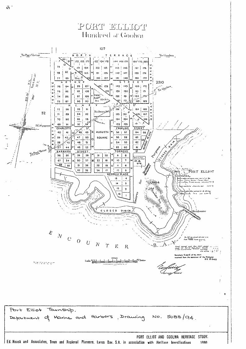
The only major public works carried out during this last period were, again, connected with the River ~lurray, and are of national significance. These were the five barrages that were built at the Murray Mouth to maintain fresh water in the river and to assist irrigation by gravitation by holding the water at a sufficiently high level. The River Murray Commission recommended their construction, with preparatory v10rk starting at Goolv1a in 1935. The five barrages, are the Goolwa Channel, Mundoo Channel, Ewe Island, Boundary Creek and Tauwitchere Barrages. All were completed by 1940. 51. While Goolwa was the permanent base, a temporary camp, virtually a galvanised iron township, complete with a school, was also created during construction, and dismantled and sold afterwards. 5~.
While the most significant period in the history of the south coast ended with the loss of the river trade, that of the Mount Compass and Nangkita areas was about to begin. The Mount Compass hi story, compiled by residents to asserts that "no land is completely useless", as this land vms assumed to be as late as 1890;
'' ..... not only Government but most people considered this waste land.
''It was the depression of 50 years ago (1890) that forced the pioneers to take up this land because it was cheap .... " 53.
The heritage of the area 11as, and has remained, c 1 ose ly tied to its rural development and provides a particularly good rural example in South Austra 1 i a of 11hat geographers have termed "sequent occupance", that is, changes through time in landuse for a cross section of a region. 54.
Apart from timber cutting, the main use of the area was for sheep grazing, although the bullock-dray halt at the Square Waterhole also supported an hotel as early as 1856, and the Government road maintenance man was established near Mt. Compass in 1872. His vegetable garden showed the promise of the swamplands in the area, although large land leasers in the area, Gardner Brothers and Wright Brothers also grew fruit, vines and vegetables. This aroused interest in the area. Mount Compass was first surveyed in 1880, but, in the prevailing depression, was re-surveyed into 100 acre \<iorkingmen's Blocks in 1893. From the success of some of these settlers grew a pressure for possession, and the population steadily increased.
The resumption of leases and their subdivision was subsequently extended to the village settlement of Nangkita. Nangkita was one of quite radical communalist village settlements made by the city unemployed and supported by the Government with grants of land and rations. Legislation established ''Village settlements'', of which thirteen were formed, eleven along the Upper River Murray and two elsewhere, near Mount Remarkable and at Nangkita. 55.
'•
.. R•~ \<\"~~
F,"""" Colle.Ch<o-..-
l 1
't
\
.. "' ..
" "' .. "' .. .. .. . .. .. .. ..
t':o...~~s , Loce>-J<'.o..-.. 1"'\o.v;
~ -~""'-- Goo\""" 'No.'-\ o~\
4.
., • ... ..
• " ,.·.
+ ~ ..
• " ...
... 'l>
PORT ELLIOT AND GOOLWA HERITAGE STUDY. Ed. Noack and Associates. Town and Reoional Planners I :.rns A :tv SA in :~ssnr.btinn with HPribnP lnvP'I:fin~tinn~ 1QRn
.•

12.
Nangkita was formed in 1894 when the first settlers arrived mainly from Port Adelaide, blocks of s1~amp - the fertile land - were a 11 otted and the men and their fami 1 i es grubbed tea-tree and bu i 1t wattle-and-daub or tin huts, as well as drains and fences. A school was started there in 1894 and a post office in 1898. Several of these relics of the settlement survive, but not the village settlement itself which lasted barely two years and was finally dissolved in 1900. The arable land was divided up into five sections for each of the families.
Despite this, closer settlement provided the basis for community development. At Mt. Compass the old roadman's cottage was social centre until residents built the local hall in 1903, which in turn, became the district's centre, with socials, meetings, church services and school (1904-34) being held there 56 ..
Drains and windmills became a feature of the landscape while vegetable grO\~ing on the s1·1amps was important, but with the introduction of superphosphate and c 1 over, the former "poor" land on the hi 11 sides became invaluable as pastureland, particularly for dairies.
Transport played a key role in the history and development of the whole Port Elliot-Goolwa Council district, as shown in the above historical account. It was no less important in the twentieth century, as motor traffic and vastly improved roads enabled farm produce to be moved quickly to city markets, brought more tourists more often to the coast, and, by tying the disparate parts of the district together in time, made the whole more homogeneous and inter-dependent.

'<
"<
<:(
::&: ..J 0 0 0
• : >
tJ)
::lC: u <(
0: 1-
~ ~ <(
0: (.)
z 3: w I tJ)
z <( ...J 0..
r u z
II
"-0 ....
Goo\....,o. , '? \o.V"\ S. V.c-.v\"'3
~,-..\~ "\' ~'-o.·i~~ c..-d
~ ~ I
\ " I'
:L ' i1 iT[f
;'I
i~ !11 : '[\ <
I ' I '
\T 1.1 I I I
' I ' I I I
I ' II ,' ·'II< I ~ II 1. I I • 1f<l :: f, I~ Jf:!;:~
: t / Y.:.}}
' /
"·
\C\ 2.b .
No < \1-, 1;:. I be>;,.
PORT ELLIOT AHO GOOLWA HERITAGE STUOY. Ed< Noack and Associates< Town and Reoional Planners l aros Bav< S<A< in association with Heritane lnvestinatinns< 1980<
-.I.

REFERENCES
1 0
2.
3.
4.
5.
6.
Goolwa Midden has been recorded by the Aboriginal and Historic Relics Unit (now Heritage Unit.) File No. S65/5/l3 Canoe Trees: see R. Edwards, Aboriginal bark canoes of the Murray Valley (Rigby, Adelaide, 1972).
J.S. Cumpston, Kan{aroo Island 1800-1836 (Roebuck, Canberra, 1970, 1974) p. 126 Sturt's comments), pp. 129-130 (Capturing vJomen) 0
L i ht ...
Light's Journal (as above), pp.36-37, 57.
Sturt's survey of Encounter Bay in 1838, and negative report on ''the outlet and the shore eastward to Cape Rosetta'' ended many such doubts and contributed to Adelaide's development. Royal South Australian Almanack, 1839.
Royal Geographical Society of Australasia (S.A. Branch), Proceedin~s Vol. XXXVIII, 1936-37, p.30. Their story is given in 'A hasty account (written by the Late Y.B. Hutchinson, January, 1838, and copied by P.O. Hutchinson, a son, July 1889, of an expedition to Encounter Bay and Lake Alexandrina at the latter part of 1837"). In the South Australian Archives.
7. W.A. Pretty, ''Armfields'' {historical notes on that property, Hutchinson St., Goolwa), introduction. Filed at Goolwa National Trust Museum {1980)
8. The area fronting the river in Goolwa (now the camping reserve) was laid out in blocks about 200 feet long by 30 feet wide, a layout similar to some English dock areas, which suggests that as early as 1840 the Government had plans for Goolwa as the port for the river trade. J.C. Tolley, ''Goolwa'' {National Trust booklet, n.d.), p.5.
9. John Lewis gives a good account of these ''Special Surveys'' in RGSSA Proceedings, Vol. XVII, 1915-16, pp.l9-29; Currency Creek, p.28. A copy of the town plans and of the Special Survey plan, together with a list of original town and country allotments, is in the South Australian Archives. See also J.C. Tolley, South Coast Story, p.l5.
10. There are many references to Newland's family as pioneers on the South Coast, the most extensive being in the various publications by a son, Simpson Newland, including his Old Time Memories (Adelaide, 1895), and Memoirs ... (Adelaide, 1926).

11. Notes on Charles Price and John Rankine by Sarah Conigrave (S.A.A.), reproduced in several books on the history of the region, and in full in vi. Pretty's research papers, Goolwa National Trust Museum.
12. Simpson Newland, quoted in (Cockburn), Pastoral Pioneers of South Australia, Vol. l (Adelaide, 1925), p.97.
13. E.M. Yelland, Colonists, Copper and Corn.
14. R. Cockburn, Pastoral Pioneers .. , Vol. II, pp.l8-l9 (Thomas Higgins .
15. Residents of l~ount Compass District, The History and Development of Mt. Compass .. (Adelaide, 1946), p.l4.
16. S.A. Parliamentary Papers, 1851, Paper 6, p.l5
17. S.A.P.P. 1852, Paper 24.
18. J.C. Tolley, on investigations preparatory to commencing navigation, in "Events leading to the establishment and some aspects of the River Murray trading era'', p.4. South Australian Archives, D3804 (T).
19. See "l··iap of Railway", 1850, in South Australian Parliamentary Papers (SAPP) 1851, Paper 6, and also chart of Port Elliot harbour.
20. List of words started and completed, in Report of the Colonial Architect, W. Bennett Hays, 26th July, 1852. S.A.A. 1324/13.
21. S.A.P.P. 1852, Paper 41: a description of these water works, also Tolley (see footnote 22).
22. J.C. Tolley, South Coast Story, p.27.
23. There are many accounts of these first journeys, and of the subsequent river boat era. See, for example, A. Grenfell Price, Founders and Pioneers of South Australia (Adelaide, 1921) Chapter on Francis Cadell, and J.C. Tolley's papers and publications, including S.A.A. D3804 (T.)
24. Which still stands. Tolley, South Coast Story, p.48
25. Tolley, South Coast Story, p.48
26. Verbal information, ~Irs. V. Lawrence, and town plan.
27. Tolley, "Shipping through the i'iurray ~1outh", S.A.A. D3804 (T).
28. Tolley, S.A.A. D3804 (T), p.22.

.29.
30. Notes by Leslie McLeay on Cockenzie and Little Scotland, filed at the Goolwa National Trust Museum with Pretty's papers, 1980.
31. Yelland, Colonists, Copper and Corn, pp.83-84
32. Tolley, South Coast Story, p.30 and Chas. R. Hodge, Encounter Bay {Adelaide, 1932), pp.81-82.
33. Verbal information, l~rs. L. Randall.
34. Paragraph on Pt. Elliot based on Tolley, South Coast Story, pp.26-35, 44-47.
35. Verbal information, Mrs. L. Pomery.
36. The Middleton (1855) and Currency Creek (1858) mills survive, and also a small building associated with the Goolwa Mill (verbal information, Mrs. V. Lawrence).
37. J.C. Tolley, "River Murray vessels", S.A.A. 03804 (t), p.lO
38. Tolley, South Coast Story, history of Goolwa Iron Works, pp.21-24
39. Aboriginal and Historic Relics Unit (now Heritage Unit), Australian Heritage Engineering Record, "Steam Engine", John Connell (Inventory No. 5801).
40. M. Robinson, Historical highlights: Encounter Bay and Goolwa {Adelaide, 1975), p.90.
41. Tolley, South Coast Story, pp.48-49, 53. The mill, a blacksmith's shed and the brickyards cottage survive.
42. Verbal information, ~Irs. L. Randall.
43. This viaduct survives but has been altered. The adjacent early road bridge also survives and is of almost unique construction. Australian Heritage Engineering Record, Inventory No. 5295.
44. See also L. Pomery, "Port Elliot Council Chamber 1879-1979" (Port Elliot, 1979).
45. Tolley, South Coast Story, pp.l6-20
46. Ibid, p.20
47. Hodge, Encounter Bay, p.69

48. Hodge, Encounter Bay, p.82
49. Verbal information, Mrs. L. Pomery
50. R.P. Bourman, ''Sequent occupance of the South Coast Region of South Australia", Taminga, 7 (1969), pp.l5-16
51. Tolley, South Coast Story, pp.70-72
52. See auction booklet for sale of plant and equipment used in the construction of the Murray Barrages, 1940, in to Pretty, file on "Paddle-steamers' route to the Murray fvJouth", at Goolwa National Trust Museum.
53. The history and development of Mt. Compass, foreword.
54. Bourman, "Sequent occupance of the South Coast Region", pp. 7-15.
55. M. Vlilliams, The making of the South Australian landscape (London, 1974), pp.238-24l, and L.K. Kerr, "Communal settlements in South Australia in the 1890s'', (M.A. Thesis, University of 14elbourne, 1951), At S .A.A.
56. Both paragraphs. Information from R. P. Bourman, "A study in the social and industrial archaeology in the environs of Nangkita, South Australia'', Aspects of South Australian History (Adelaide University, 1978), pp.59-67, and The history and development of ~1t. Compass, pp.22-3, 44,77.

PART 2
SITES, STRUCTURES AND BUILDINGS OF GENERAL
HERITAGE INTEREST.

17.
l. Goolwa Township
l.l Introduction
A large number of sites, buildings and structures have significance in depicting the growth and importance of the township as an important river port, railway terminus and place of commerce and community centre. The early buildings form the special character of the area through their scale, relationships and use of local building materials.
1.2 Goolwa Heritage Area
The following are the items of heritage value:
(l) Gooh1a Foundry Slip
On Harbors Board Reserve 314, off Liverpool Road Period: 1840 - 1890 Theme: River trade and harbour development.
The Slip was established in 1864 as the ''Goolwa Patent Slip and Iron Works'' and was purchased in 1867 by Abraham Graham. He appointed Mr. C.F. Curson as manager and constructed his first steamer, P.S. Ariel in 1867. By 1884, when his last vessel, the barge Albermarle left the Slip, Graham had built thirteen vessels and in nine cases supplied the engines as well. In 1883, for example, the Slip was employing between 30 and 40 men.
In 1888, Graham sold the Iron Works to the Chaffey Brothers who removed the plant to Renmark. The Slip continued in use, being let by the Marine Board to Mr. Richard Craig in 1891. The site presently houses a modern slip and boat repair works.
References: TOLLEY, J.C. (1968) SHEARD, H.L. (1960) PRETTY, ~1. ( 1980)
(2) Former Chart Room of Foundry Slip
Adjacent Period: Theme:
to Railway Reserve, off 1840 - 1890 River trade and harbour
Liverpool Road
development
This building was part of Abraham Graham's Patent Slip and Iron \·larks and was used for storage of charts. It is an attractive building of 2 levels, built of travertine limestone walls and galvanized iron roof. The building is on the Recorded List of the National Trust.
References: TOLLEY, J.C. (Comments, 1980) NATIONAL TRUST OF S.A. (Record 2516)

I I'
I
8 Building or structure
0 Site
-·-Heritage Area
-··-·-.
ll\t· Little Scotland" : see Map 2
' ' /
23
0 /
/
/
/ /
/
/
/
/
/
' ' I ' I '·
/ /
/ /
/ /
~
GOOLWA TOWNSHIP
location of items with heritage value 0 100
Scale 1": 10 chn metres
PORT ELLIOT AND GDOLWA HERITAGE STUDY. Ed. Noack and Associates, Town and Regional Planners. Laros Bay, S.A. In association with Heritage Investigations, 1980.
1

(3) Beam Engine
In grounds of Caravan Park, off Liverpool Road Period: 1840 - 1890 Theme: River trade and harbour development
ll:l.
The engine was imported from England in 1853 by the contractor constructing the Port Elliot breakwater. It was used to assist in drawing stone laden trucks along the breakwater's railway. The engine was rated at 6 horsepower and was powered by steam. It is thought that the engine was built by the Old Quay Foundry of Bodley Brothers, Exeter which was founded in 1790 and closed in about 1970.
After its use at Port Elliot, the engine was moved to the Goolwa Patent Slip and saw service in the boat building industry.
References: CONNELL, J.E. (Comments, 1980) NATIONAL TRUST OF S.A. (Record 2761)
(4) Wharf
Harbors Period: Theme:
Board Reserve, on Lower Murray 1840 - 1890 River trade and harbour development
The first wharf was built on the site in 1852 on the recommendation of the Governor, Sir Henry Young, following an inspection of the area in 1850. The original structure cost 300 pounds and construction was supervised by Thomas Jones. The rail tracks from Port Elliot entered the wharf at right angles to it and turntables on the wharf were used to swing the wagons parallel to the moored steamers and barges.
The wharf was extended in 1866 following the completion of a new access road for bullock wagons in 1865. The extensions, costing 2,430 pounds were erected by Mr. Thomas Tapson and decking was placed in 1868 by Mr. James Shaw Harding of Port Elliot.
In 1874, the original wharf was demolished and a new wharf was built. Further extensions comprising 359 feet in length were made to the wharf in 1878, being built by William Wishart at a cost of 3,552 pounds. This extension made the overall structure 700 feet in length. The present wharf shed (see Item 6) was erected in 1878 and a brick and cement water tank of 20,000 gallons capacity was erected near the wharf to provide a fresh water supply to steamers. The years 1878 to 1884 saw the peak use of the wharf for cargo handling. The wharf is on the Recorded List of the National Trust.
References: TOLLEY, J.C. (1968) PRETTY, W. ( 1980) STREMPEL, A. (1954) S.A. PARLIAMENTARY PAPERS 6/1851; 41/1852;
37 /1856; 2/1858 DEPARTMENT OF MARINE AND HARBORS. Drawing 2981/69;
2976-8/69; 3543/PH27 NATIONAL TRUST OF S.A. (Record 1247)

(5) Site of Government Bond Store
Railway Period: Theme:
Reserve, adjacent to wharf 1840 - 1890 River trade and harbour development
19.
Construction of the Store commenced in 1852 and was ready for use in 1893. It was built of travertine limestone with a curved iron roof similar to that of the Railway Superintendent's house (Item 8). It stood between the wharf and the railway cutting but has been demolished. (Item 10)
On 24th August 1853, the Store was the venue for a farewell lunch for Captain Cadell and his fellow travellers about to set out upstream on the first river voyage of the paddle steamer Lad~ Augusta. The Store is shown clearly on a sketch of Goolwa ma e by James H. Adamson, a member of Cadell's party, in 1854. A photograph of the Goolwa wharf area taken in 1866 also shows the Store.
References: TOLLEY, J. C. ( 1968) TOLLEY, J.C. (Photograph collection) GOOLWA MUSEUM (Photograph collection) LEWIS, J. (1917) VINE HALL (1976, page 63) S.A. PARLIAMENTARY PAPERS, 41/1852
(6) Wharf Shed
Harbors Period: Theme:
Board Reserve, on Lower Murray 1840 - 1890 River trade and harbour development
The Shed was built in 1878, length 150 x width 50 x height 17 feet, and shows clearly on photographs of the wharf area taken about 1880. The shed is built of timber frame with corrugated iron walls and roof and is still in use adjacent to the berth of the P.S. River Murray Queen.
References: TOLLEY, J.C. (1968) TOLLEY, J.C. (Photograph collection) DEPARTMENT OF MARINE AND HARBORS. Drawing 3176A/l3B;
354l/PH27
(7) Government Warehouse
Part Lot Period: Theme:
271, Goolwa, adjacent to the Wharf Reserve 1840 - 1890 River trade and harbour development
The large corrugated iron shed was originally constructed by Mr. James Shaw Harding north of its present position in November 1879 and was adjacent to the Government Bond Store. It is thought that the shed was shifted later possibly about 1914 to service the realigned railway line.
References: TOLLEY, J.C. (1968) GOOLWA MUSEUM (Photograph collection)

105
10:3
173
' 7 I '
1131
: ..
•
16..j
170
17.:.
17tf
182
--·· --~ f"; .. <" ~
-----:· .f
i
167
171
/75
"' ... ······-· I' ~ .· ~
:' :
i •'
...
U.t~; u.~.-,..-_J"i ~~ ·'·····._·,,,)~
.I~J.:, ~: ~-.. _.: :1 ·~· •• :,:··
'" '" ...... . ''
R I V £ R
' ,.
\
I ' \
101
I I
' ~ ' ,') ~· ,.
IO}_ ~
'\ ',,
..... -.; .. · . ..:
'. ;·, ,· ( '.
h(, ••••••
·~ ·-·. ~·· '·'
MURRA'Y
RAILWAY RESERVE, GOOLWA
1878 0 l 2 3
Chains Scale
PORT ELLIOT AHO GOOLWA HERITAGE STUOY.

(B) Former Railway Superintendent's House
Part Lot Period: Theme:
271, Goolwa. 1840 - 1890 Railways
C.T. 4024/235
20.
Construction commenced July 1852 and the house was occupied by Mr. Buxton Forbes Laurie, the first Superintendent of the Port Elliot and Goolwa Railway in January 1854. He occupied the house for several months after which it was used as a summer cottage by Governor Young.
The unusual house shows clearly on the sketch of Goolwa made in 1854 by James H. Adamson. It is built of travertine limestone with some sawn limestone and has a distinctive curved, corrugated iron roof.
The house is now owned by the National Trust and is on the Trust's Classified List.
References: TOLLEY, J.C. (1968) NATIONAL TRUST OF S.A. (Record 349) LEHIS (1917) GOOLHA MUSEUM (Photograph collection) S.A. PARLIAMENTARY PAPER 41/1852
(9) Former Railway Horse Stables
Part Lot Period: Theme:
271, Goolwa. 1840 - 18go Railways
C.T. 1914/197
The stables were built in 1853 of travertine limestone walls with brick quoins. They housed horses used to draw wagons on the Port Elliot to Goolwa Railway and continued as such until the horses were auctioned in 1885.
In 1946 the building was purchased for use as Clubrooms by R.S.L. sub-branch and the first meeting was held in 1949. is on the Recorded List of the National Trust.
the Goolwa The building
References: PRETTY, H. (1980) TOLLEY, J.C. (Photograph collection) GOOLHA MUSEUM (Photograph collection) NATIONAL TRUST OF S.A. (Record 368)
(10) Railway Cutting
Off Cadell Street Period: 1840 - 1890 Theme: Railways
The cutting which is 170 yards long with a maximum depth completed as part of the original railway works in 1852. excavation was 1 shilling and 3 pence per cubic yard and excavated was used as ballast for the railway line.
References: TOLLEY, J.C. (1968) STREMPEL, A.A. (1954)
of 15 feet v1as The cost of
the material

{l)) Railway Embankment
Period: 1840 - 1890 Theme: Railways
21.
The original railway line extended through the Soldier's Memorial Gardens and Reserve to meet with the present railway alignment near the Cra1;ford Street crossing. The major railway works were undertaken during 1852 and 1853. The embankment was also used by steam trains from 1884, when the diversion from Currency Creek to Goolwa opened, to 1914 when the present alignment was opened. Trains from Currency Creek had to reverse into the station which was then near Cadell Street.
On the original track, rails were laid at the rate of 40 pounds to the yard and sleepers were 8 feet in length, being either split or round. Rails were screwed to the sleepers and no fish plates were used. The sleepers were packed with rubble, gravel and sand to form a good walking surface for the horses.
References: TOLLEY, J.C. (1968) S.A. PARLIAMENTARY PAPER 159/1860 GOOLWA MUSEUM {Photograph Collection)
(12) Post and Telegraph Office
Goolwa Terrace Period: 1840 - 1890 Theme: Township development, government agencies
The Post Office was built by Messrs Morris and Willcock of Adelaide in 1857 of travertine limestone at a cost of 417 pounds 14 shillings and 9 pence. The building had a spacious verandah on the southern side and this was used as the town's railway station until 1872. Mr. Thomas Goode was appointed Post Master in 1857 and in the following year, the magnetic telegraph from Adelaide was connected to Goolwa, thence to Melbourne. Substantial additions were made to the building in 1862 (339 pounds) and 1877 (225 pounds). A new battery room had been added in 1871 (34 pounds).
The original building remains but has been substantially altered. It is on the Recorded List of the National Trust.
References: ARCHITECT-IN-CHIEFS OFFICE, RECORD BOOK (S.A.A.) TOLLEY, J.C. (1968) GOOLWA MUSEUM (Photograph collection) NATIONAL TRUST OF S.A. (Record 361)

(13) Site of Railway Station
In Reserve, off Cadell Street Period: 1840 - 1890 Theme: Railways
22.
In 1872, a new station was built to replace the Post Office verandah facility. It was built by Mr. R. Prior and consisted of a platform 30 feet x 15 feet wide with the Station Master's Office at one end, the goods shed at the other and the space between reserved for passengers. The station continued in use until 1914.
References: TOLLEY, J.C. (1968) TOLLEY, J.C. (Photograph collection) GOOLWA MUSEUM (Photograph collection)
(14) Railway Carriage
Goolwa Terrace Period: 1840 - 1890 Theme: Railways
The horse-drawn passenger carriage was used on the Railway which operated between Goolwa and Port Elliot from 1854; between Port Elliot and Victor Harbor from 1863 and between Strathalbyn and Middleton from 1869. The horse-drawn carriages were withdrawn with the advent of steam engines on the line in 188~.
(15) Police Station and Court House
Goohva Terrace Period: 1840 - 1890 Theme: Township development, government agencies
The first part of the building was erected in 1859 at a cost of 752 pounds, by Mr. Dicken of Brompton and was designed by Mr. S.A. Hamilton, Colonial Architect. The walls were of travertine limestone, with brick quoins and slate roof.
Substantial alterations and additions were made in 1867 (635 pounds) and 1874 (106 pounds). The Station originally had its own well and in 1876 a store for Aborigines was erected on the site at a cost of 94 pounds.
The buildings are still in use today, but the roof is now corrugated iron. They are on the National Trust Classified List.
References: ARCHITECT-IN-CHIEF'S OFFICE, RECORD BOOK (S.A.A.) NATIONAL TRUST OF S.A. (Record 323)

( 16) Morgue
Brooking Period: Theme:
Street 1840 - 1890 Township development,
23.
community facilities
The contract for erection of the morgue was let in June 1883 at a cost of 118 pounds. An underground tank was built shortly afterwards. The walls are built of travertine limestone and a new corrugated iron roof has recently been added.
References: ARCHITECT-IN-CHIEF'S OFFICE, RECORD BOOK (S.A.A.) NATIONAL TRUST OF S.A. (Record 669)
(17) Former Custom's House
Part Lot Period: Theme:
271, Goolwa, off Hay Street 1840 - 1890 River trade and harbour development
The stone house was built in 1859 for a contract price of ~464/18/6 (contract no. 162). Additions were made in 1864 (93 pounds) and 1869 (81 pounds). The house is shown on plans of 1878 as the residence of the Manager of the Railway. The house remains with various modifications.
References: TOLLEY, J.C. (1968) ARCHITECT-IN-CHIEF'S OFFICE, RECORD BOOK (S.A.A.) S.G.O. Plan 880/78 NATIONAL TRUST OF S .A. (Record 666) SURVEYOR GENERAL'S OFFICE. Hundred Book: Goolwa, Plan 3A.
(18) Ferry to Hindmarsh Island
Adjacent Period: Theme:
to wharf 1840 - 1890 Agriculture
The first regular ferry service in 1858 to Hindmarsh Island was a dinghy, operated by Mr. Stephen Wisdom. In 1862, the District Council of Port Elliot installed a new ferry at the cost of i 750 and the service was progressively upgraded in 1867, 1880 and later. The tandem ferry was commissioned in March 1973.
References: PRETTY, W. ( 1980) DEPARTMENT OF MARINE AND HARBORS. Drawing 2989/69.

(19) Site of Signal Mast
Part Lot Period: Theme:
271, in Reserve 1840 - 1890 River trade and
east of Post Office
harbour development
24.
The mast was erected about 1879 as a means of communication with the signalman at the Murray Mouth. A valuable series of photographs of Goolwa in the early 1880's was taken from the mast. The mast has been removed.
References: TOLLEY, J. C. ( 1968) TOLLEY, J.C. (Photograph collection) GOOLWA MUSEUM (Photograph collection)
(20) Site of Hindmarsh Island Jetty
Lower Murray Period: 1840 - 1890 Theme: River trade and harbour development
The date of construction of the original jetty is not known but the structure is shown on a photograph taken in the late 1870's. An extension was made in 1883. The site is now taken up by the causeway and ferry landing.
References: TOLLEY, J. C. (Photograph co 11 ect ion) DEPART~IENT OF MARINE AND HARBORS. Drawing 3000/70.
(21) Relic of Flagstaff
In Soldiers Gardens, off Cadell Street Period: 1840 - 1890 Theme: River trade and harbour development
A plaque on the mast reads:
''Historic flagpole. This centre post is part of the mast used to control the movement of ships between Goolwa and the Murray Mouth".
(22) Site of Mooring Dolphins
L01ver Murray Period: 1840 - 1890 Theme: River trade and harbour development
In 1876, because of the shortage of wharf accommodation, four mooring dolphins were erected in the waterway just south of the existing wharf. They were positioned so that they could be incorporated into future wharf extensions. Three future dolphins were erected in 1878 further out in the stream to allow steamers to moor before berthing. They have since been removed.
References: TOLLEY, J.C. (1968) TOLLEY, J.C. (Photograph collection) DEPT. OF MARINE AND HARBORS. Drawing 2986/69.

25.
(23) Goolwa or Lower Murray Waterway
Periods: 1802 - 1839; 1840 - 1890; 1891 - present Themes: Exploration; River trade and harbour development; recreation
The stretch of river, known to the early settlers as the Goolwa, or ''the Elbow'' was traversed by Captain Charles Sturt in February 1830. Twenty years later, as awareness of the transport potential of the River Murray grew, Governor Young took soundings of the River and recommended the suitability of the Goolwa as the site for a jetty. Construction followed quickly and in October 1853 the first steamer load of cargo arrived at the Goolwa wharf. The waterway became a very active shipping channel and mooring for the next 30 years and continued to function at a lower pace thereafter. It is now used largely for recreational boating.
References: S.A. PARLIAMENTARY PAPER. 6/1851 TOLLEY, J.C. (1968)
(24) Present Railway Station
Pt. Lot Period: Theme:
271, Goolwa, adjacent 1891 - present Public works
to the wharf
The present alignment of the railway was completed in 1914 and the present railway station was built at that time. It is a timber framed structure with corrugated iron cladding.
References: S.A. RAILWAYS. Drawing Dr. 359/74 TOLLEY, J.C. (Photograph collection)
(25) Paddle Steamer "Captain Sturt"
Moored in Lower Murray at Goolwa Slip.
This paddle steamer was designed to push barges to carry material for building the locks along the River Murray. It was the only U.S. built steamer operating on the River system having been assembled at Mannum in 1917.
References: NATIONAL TRUST OF S.A. (Record 2508)
(26) "Foresters' Lodge"
Hay Street; Lot 182, Goolwa. C.T. 588/109 Period: 1840 - 1890 Theme: Township development; community facilities
The building was erected in 1859 as a Congregational Church for use by Rev. R.W. Newland. The original church bell came from the P .S. Melbourne and is now at the present Catholic Church in Cadell Street. The Church was also used for Church of Christ and Catholic services before being purchased in 1883 for the Court Pride of the Murray Foresters Friendly Society. In 1960, the building was sold for private use but saw a brief return to use as Goolwa Lodge in 1967 before being sold for private use.
References: PRETTY, W. (1980) NATIONAL TRUST OF S.A. (Record 365) GOOLWA MUSEUM (Photograph collection)

(27) Goolwa Hotel
Cadell Street; Lot 148, Goolwa Period: 1840 - 1890 Theme: T01~nshi p deve topment
26.
The hotel is built of travertine limestone with a corrugated iron roof. Part of the building has two storeys with a spacious balcony/verandah at the footpath. Various additions have been made at the rear.
The original section was built in 1853 and the first licence for the hotel was issued to John Varcoe Jun. on 14th December, 1853. Since then, the hotel has had about 30 licencees and is still operating.
The figurehead adorning the front of the hotel is from the Irish sailing ship Mozambique which was wrecked at Younghusband Peninsula on August 19th 1854. The mast from the ship was used as a joist in the dining room which also contains furniture from the ship. The ship's staircase also remains at the hotel.
The hotel is on the Recorded List of the National Trust.
References: PRETTY, L.J. (1980) GOOLWA MUSEUM (Photograph collection) NATIONAL TRUST OF S.A. (Record 359) McLEAY, Dr. L. (Comments, 1980)
(28) Corio Hotel and Bottle Shop
Goolwa Terrace; Lot 175, Goolwa Period: 1840 - 1890 Theme: Township development
The structure is built of travertine limestone walls with corrugated iron roof. It has two storeys with ample balconies at front and rear. Various additions have been made at the rear, some in limestone, others in brick. The front balcony is adorned with iron lace work.
The hotel was built in 1857 and the first licence was granted on 31st ~larch 1858 to Hilliarn Ray. Since then, the hotel has had about 25 licencees and is still operating. A feature of the saloon is the 'Yankee Doodle' poster on the ceiling.
Reference: PRETTY, H. (1980) TOLLEY, J.C. (Photograph collection and comments) GOOLL.JA MUSEUM (Photograph collection) NATIONAL TRUST OF S.A. (Record 360)
(29) Former Austral asian Hotel
Goolwa Terrace; Lot 179, Goolwa Period: 1840 - 1890 Theme: Township dev~lopment
The hotel was built in 1857 and the first licence was granted on 13th January 1858 to O.vi. vlillcock. Eleven licencees operated the hotel until its closure in March 1934.

27.
The building is of travertine limestone of 2 storeys. The balcony/ verandah at the front has been removed and the arched brick portal in the 3 metre limestone rubble fence fronting Hay Street has been fill.ed in. The building is now used as a residence.
Rei .rences: PRETTY, W. (1980)
;< (30)
Crocker Period: Theme:
GOOLWA MUSEUM (Photograph collection) NATIONAL TRUST OF S.A. (Record 506)
Former Flour Mill
Street; Lot 86, Goolwa 1840 - 1890 Township development; industries
The actual date of construction of the Mill is not known; however, an entry in Bailliere's Gazetteer of 1866 refers to Barker and Co's Steam Flour Mill in Goolwa. A spur track ran from the Port Elliot Railway to the South Door of the Mill which operated until about 1880. The building was later used as a bakery. The main 3 storey northern wing was built of travertine limestone and was demolished in 1945. The large brick chimney has also been demolished. Part of the southern wing adjacent to the Railway embankment remains and includes a series of brick arched doorways in the south wall.
References: WHITWORTH, R.P. (1866) TOLLEY, J .C. (Photograph collection) NATIONAL TRUST OF S.A. (Record 584)
(31) The Holy Evangelist, Church of England
Cadell Street; Lot 90, Goolwa Period: 1840 - 1890 Theme: Township development, community facilities
Lot 90 was granted to the Church in 1857 and the foundation stone was laid in January 1867. The Church is built of travertine limestone set liberally in mortar and has a limestone clock tower with spire.
The bell was presented in 1897 by Lieut. Col. Higgins, the tower was completed in 1905 and the clock installed in 1915.
The lofty timber ceilings are a feature of the building and furnishings include a table from the P.S. Lady Augusta.
The limestone fences are an integral part of the Building and should be maintained with the Church.
The Church is on the Recorded List of the National Trust.
References: PRETTY, W. (1980) S.A. ARCHIVES (Photograph collection) NATIONAL TRUST OF S.A. (Record 356) PLAQUES ON THE BUILDING Mrs. V. LAWRENCE (Comments, 1981)

(32) Church of England Hall
Farquhar Period: Theme:
Street; Lot 89, Goolwa 1840 - 1890 Township development, community
28.
facilities
The hall is built of travertine limestone with brick quoins and window surrounds and was erected in 1885. In the early 1890's, Rector Thomas Boyer conducted a school in the premises. The building is still in use as a hall. The property also has good examples of limestone-wall fencing.
References: PRETTY, W. (1980)
(33) Town Hall and Council Chambers
Cadell Street; Lot 131, Goolwa Period: 1840 - 1890; 1891 - present Theme: Township development, community facilities
The first Town Hall was erected in 1860. Additions were made at the front (right hand side front wing) in 1878 by Messrs. Nicol and Oliver and a further wing was added to house the offices of the Corporation of Goolwa in 1907. The walls are of travertine limestone and the roof is corrugated iron.
References: PRETTY, W. (1980) GOOLWA MUSEUM (Photograph collection) TOLLEY, J.C. (1968) NATIONAL TRUST OF S.A. (Record 367)
(34) Goode's Store
Cadell Street, Lot 156, Goolwa Period: 1840 - 1890 Theme: Township development
The original store of Thomas Goode built on this site in 1860, was destroyed by fire in March 1884. The rebuilt store opened for business in January 1885 and has continued under the original business name to this day.
The front section of the store is 2 storey, built of travertine limestone with brick quoins, window surrounds and ventilator frames. Of special interest are the display window, front doorway, counters and fittings.
References: PRETTY, W. (1980) S.A. ARCHIVES (Photograph collection) GOOLWA MUSEUM (Photograph collection) NATIONAL TRUST OF S.A. (Record 362)

{35) Bow-fronted Store
Cadell Street, Part Lot 157, Goolwa Period: 1840 - 1890 Theme: Tmmship development
29.
The front 1;all of the store foll01·1s the curved allotment boundary giving it a bow-shaped appearance. The store is built of travertine limestone with brick quoins and window surrounds. It has a corrugated iron roof and a cantilevered balcony with turned wooden posts. French casement windows open on to the balcony.
The store was originally built for Mr. Sumner, a baker, possibly in the 1850's for use as a shop and continues in use as a shop. The building is on the National Trust Classified List.
References: GOOLWA MUSEUM {Photograph collection) NATIONAL TRUST OF SOUTH AUSTRALIA {Record 95)
(36) Shop, ''Blue-Lace Drapery''
Cadell Street, Lot 132, Goolwa Period: 1840 - 1890 Theme: Township development
The shop was built about 1867 - 68 possibly for Mr. George Parkinson and is still in use as a shop. The walls are of limestone and brick with a corrugated iron roof and bullnose verandah. The display windows are of interest.
References: PRETTY, W. ( 1980) NATIONAL TRUST OF S.A. (Record 2726)
{37) Bank Building
Cadell Street, Part Lot 157, Goolwa Period: 1840 - 1890 Theme: Township development
The attractive stone building is constructed from sawn limestone and travertine limestone rubble with brick quoins and a corrugated iron roof. It was built possibly in 1871/72 and is now used as a bank and a residence.
References: NATIONAL TRUST OF S.A. (Record 2727)
(38) Shop, "Riverside i'leat Store"
Goolwa Terrace, Part lot 171, Goolwa Period: 1840 - 1890 Theme: Township development
The scale and design of the shop makes it an attractive addition to the area around the Soldier's Memorial Gardens and the Corio Hotel. It is a single storey building with verandah and corrugated iron roof. The date of construction is not known.

(39) Goolwa Museum
Porter Street; Lot 147, Goolwa Period: 1840 - 1890; 1891 - present
30.
Theme: Township development; industries; community facilities
The site was originally occupied by a blacksmith shop, built in 1846 but was later expanded into a coachbuilding works by the Barton Brothers. Examples of their work are on display in the Museum.
The premises were purchased by the National Trust in 1971 and now houses many relics and sources of information on the development of the district.
References: PRETTY, 1-1. (1980) GOOLWA MUSEUM (Photograph collection)
(40) Soldiers Memorial Gardens
Cadell Street and Goolwa Terrace Period: 1891 - present Theme: Community facilities
The Gardens occupy part of the Reserve of the Horse Railway Line and provide a pleasant green open space in the heart of the historic and commercial area of Goolwa. The foundation stone of the Rotunda was laid by Reverend J.H. Goss on December 15th, 1917.
(41) Two Storey Residence, former Private School
Cadell Street; Lot 81, Goolwa Period: Theme: Houses
The substantial building has 2 storeys, is built of travertine limestone walls with corrugated iron roof and is set in a spacious garden. The building has served as a private school, residence of the headmaster of the Goolwa Primary School, doctor's residence and as a private residence.
References: Mrs. V. LA\·JRENCE (Comments, 1980)
(42) Shop, eastern section of ''South Coast Auctions"
Goolwa Terrace; Part Lot 171, Goolwa Period: 1840 - 1890 Theme: Township development
The 2 storey section of the present shop is built of travertine limestone and shows on photographs of Goolwa taken in the 1880's. It has unfortunately been unsympathetically modified in recent times.
References: TOLLEY, J.C. (Photograph collection)

(43) Small Cottage
Brooking Period: Theme:
Street, Part Lot 3, Town-on-the-Goolwa 1840 - 1890 River trade and harbour development
31.
The attractive, small cottage opposite the morgue is built of travertine limestone. It could possibly be one of the cottages depicted in James M. Adamson's 1854 sketch of Goolwa and may later have been associated with the Goolwa Foundry Slip.
References: LEWIS, J. (1917) NATIONAL TRUST OF S.A. (Record 671)
(44) House and Stone Shed
Brooking Period: Theme:
Street; Lot 6, Town-on-the-Goolwa 1840 - 1890; 1891 - present Houses
The house was occupied for many years by a captain of the river boats, Captain Richie. The original cottage was erected in 1885 and was built of timber hewn for building river boats. The limestone front section was added in 1917. Note the cannon above the entrance porch.
References: PRETTY, W. (1980) Mrs. V. LAWRENCE (Comments, 1980) NATIONAL TRUST OF S.A. (Record 357)
(45) ''Clarke-Holme'' Cottage
Porter Street; Lot 129, Goolwa Period: 1840 - 1890 Theme: Houses
The cottage was possibly built in the 1850's for the Clarke family and remained in the family until its sale to Mr. and Mrs. Holme in 1936. It has recently been renovated.
References: THE ADVERTISER (13. 12.1980)
(46) Former Hospital
Wi 1 dman Period: Theme:
Street; Lot 164, Goolwa 1840 - 1890 Township development, community faci 1 ities
The property comprises two attractive travertine limestone cottages which are attached at the rear and which were used at one time as a private hospital. The property is presently used as a residence.
References: Mrs. V. LAWRENCE (Comments, 1980)

{47) ''Highlands House''
13 Goyder Street; Lot 168, Goolwa Period: 1840 - 1890 Theme: Houses
32.
Built in 1853, the attractive cottage abutts the "Little Scotland" area. Additions were made to the cottage in 1884 by Messrs. W.R. Kennett and G. Jordan for use as a store. Restoration work was undertaken in 1929 and again in 1979 for use of the building as a residence.
References: PRETTY, W. ( 1980)
( 48) Mi 11 Cottage and Sheds
Crocker Street; Lot 87, Goolwa Period: 1840 - 1890 Theme: Houses
The cottage of travertine limestone was adjacent to Barker's Steam Flour Mill and was presumably occupied by the proprietor. Abraham Graham lived in the cottage after leaving ''Graham's Castle'' in 1875 and prior to moving to ''Burrang'' in 1885. The cottage has two sections, the villa type wing on the northern side being added later. The limestone outbuildings are well constructed and show good examples of the stone mason's art.
References: SHEARD, H.L. {1960) PRETTY, W. {Comments, 1980)
{49) ''Shetliff cottage''
Farquhar Period: Theme:
Street; Lot 57, Goolwa 1840 - 1890 Houses
The house was built in 1863 for Samuel Shetliff, an early resident of Goolwa. The cottage is built of travertine limestone with a corrugated iron roof. The verandah has been modified.
Extensive use of limestone rubble has also been made in the sheds and boundary fences on the property.
References: PRETTY, W. {Notes in Goolwa Museum)
{50) Cottage
Partridge Street; Lot 66, Goolwa Period: 1840 - 1890 Theme: Houses
This early cottage is another good example of an early travertine limestone building which has only suffered minor modifications over the years. It was built for Mr. Cremer and is on the Recorded List of the National Trust.
References: NATIONAL TRUST OF S.A. (Record 366)

(51 ) House
Liverpool Road; Lot 9, Town-on-the-Goolwa Period: 1840 - 1890 Theme: Houses
33.
This attractive, travertine limestone residence with slate tile roof and limestone facing provides a good example of the stone mason's art. The house was built for Mr. C.F. Curson who was appointed manager of Abraham Graham's Patent Slip and Iron Works in 1867. The house is well maintained by the present ownership of the Birchell Estate.
References: SHEARD, H.L. (1960) Mrs. V. LAWRENCE (Comments, 1980) NATIONAL TRUST OF S.A. (Record 2751)
(52) House
Brooking Period: Theme:
Street; Lot 1840 - 1890 Houses
141, Town-on-the-Goolwa
This travertine limestone house is part of the early township of Goolwa and is presently used as a residence.
(53) House
Brooking Period: Theme:
Street; Part Lot 143, Town-on-the-Goolwa 1840 - 1890 Houses
The main structure is built of weatherboard, with a limestone addition on the western side. The house is part of the early township of Goolwa, and is presently used as a residence.
(54) House
Brooking Street; Lot 144, Town-on-the-Goolwa Period: 1840 - 1890 Theme: Houses
This limestone house is part of the early township of Goolwa and is presently used as a residence.
(55) The Pond
Off Pitts Street; Lots 96, 108, 118, 119, Goolwa Period: 1891 - present Theme:
The pond provides a haven for waterbirds within the town and also provides a storage for excess stormwater in the event of heavy rains. It, therefore, has a natural aesthetic and a practical purpose.

34.
{56) ''Little Scotland''
Period: 1840 - 1890 Theme: Township development
In 1856, Mr. Young Bingham Hutchinson had part of his land on the south side of the young town of Goolwa subdivided as ''Goolwa Extension''. The subdivision contained features such as small allotments, small internal courts, carriageways and a complex network of walkways. Most of these features remain on plan'\ but not many remain on the ground. The subdivision was laid out as a compact, densely settled housing area and many of the cottages built there follow a simple Scottish design.
Hutchinson endeavoured to influence the type of development by retaining certain development controls. He, for example, reserved to himself the power to convey the right to erect first floor rooms over the narrow lanes and alleys and over the streets having a river frontage - such buildings were not to extend more than 50 feet back from the frontage. In all cases, the passageway for pedestrians was not to be less than 4 feet in width and 7 feet in height. For carriages, the way was not to be less than 9 feet in width and 9 feet in height.
The second person to have a substantial effect on the development of the area was Captain George Bain Johnston. He purchased Lot 158 in 1857 and proceeded to erect his substantial stone house named after his home village of Cockenzie in Scotland. He also acquired other allotments and houses in the area which became the home of many men associated with the river trade.
The cottages in ''Little Scotland'' are of three basic designs with variations:
STYLE 1
FRONT ELEVATION SIDE ELEVATION
Not to scale
l
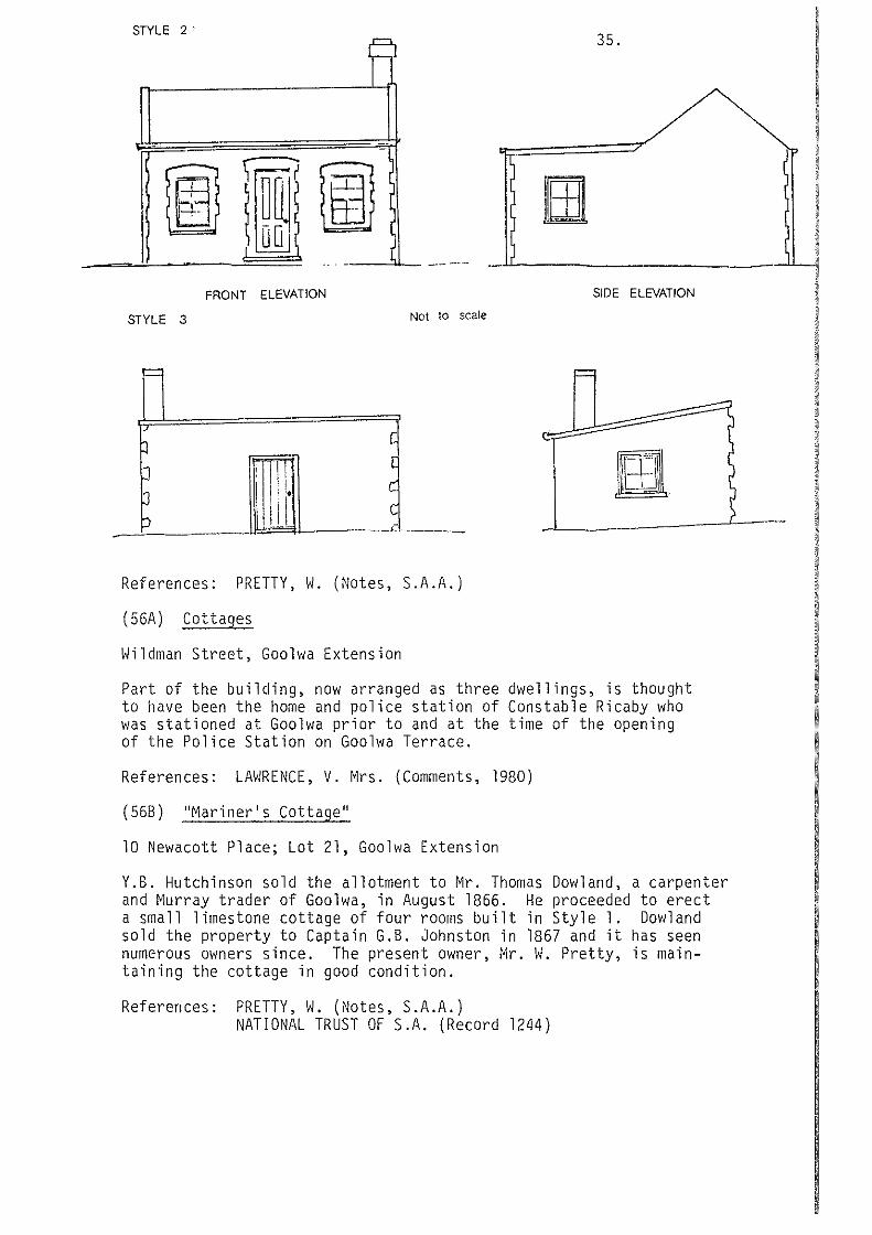
STYLE 2' 35. =
,--
-
!} fl' 1\ m r' u 0 ' . (
ll-----------------------~~
FRONT ELEVATION
STYLE 3 Not to scale
=
p c
J II Ill [
J ill' c c
:) - ,:
References: PRETTY, W. (Notes, S.A.A.)
( 56A) Cottages
Wildman Street, Goolwa Extension
SIDE ELEVATION
=
Part of the building, now arranged as three dwellings, is thought to have been the home and police station of Constable Ricaby who was stationed at Goolwa prior to and at the time of the opening of the Police Station on Goolwa Terrace.
References: LAWRENCE, V. Mrs. (Comments, 1980)
(568) ''Mariner's Cottage''
10 Newacott Place; Lot 21, Goolwa Extension
Y.B. Hutchinson sold the allotment to Mr. Thomas Dowland, a carpenter and ~lurray trader of Goolwa, in August 1866. He proceeded to erect a small limestone cottage of four rooms built in Style 1. Dowland sold the property to Captain G.B. Johnston in 1867 and it has seen numerous owners since. The present owner, Mr. W. Pretty, is maintaining the cottage in good condition.
References: PRETTY, W. (Notes, S.A.A.) NATIONAL TRUST OF S.A. (Record 1244)

8 Building or Structure "LITTLE SCOTLAND". GOOLWA 2 location of items with heritage value
Scale t • 2500
PORT ElliOT AND GOOlWA HERITAGE STUDY.

36.
{56C) ''Gwithian''
8 Newacott Place; Lots 19 and 20, Goolwa Extension
The allotments were purchased by Thomas Dowland in 1859 and the house is thought to have been built in 1860.
The attractive, limestone cottage built in Style 2 is being restored by its present owners, Mr. and Mrs. M. Findlay. The house was named by its previous owner, Mrs. R.J. Rogers, after Gwithian in Cornwall.
References: PRETTY, vi. {Notes, S.A.A.)
{560) Cottage
Newacott Place
This early, limestone cottage has been extensively modified by an addition on the front. However, the rear part of the cottage and its general scale still remain.
( 56E) Cottage
Newacott Place
This limestone cottage, built in Style 2, is in near original condition externally. The building is used and maintained as a residence.
( 56F) Cottage
Hays Street
This early, limestone cottage on the corner of Hays Street and Newacott Place is built in Style 2. The stone walls are rendered. The building is used and maintained as a residence.
( 56G) Cottage
Hays Street
This early, limestone cottage is built in Style 2. It is used and maintained as a residence.
{56H) Former Shop
Hays Street
This early limestone building, now used as a residence, was possibly built for use as a shop.
{56I) Cottage "Armfields"
Hutchinson Street; Lots 85 and 86, Goolwa Extension
The limestone cottage was built in 1866 in Style 1. The cottage was built for Mr. Harry Wright of Goolwa and was owned by the Armfield family from 1919 to 1950. It is used and maintained as a residence.
References: PRETTY, W. (Notes, S .A.A.)

(56J) ''Gainsborough Cottage''
Hutchinson Street
37.
This early limestone cottage is built in Style 2. The building is used and maintained as a residence.
( 56K) Cottage
Wildman Street
The original part of this building was constructed as a limestone cottage in Style l. A limestone villa wing has since been added to enlarge the residence. The building is used and maintained as a residence.
(56L) Cottage
Barrage Road
This early limestone cottage is built in Style 2 and is used and maintained as a residence.
( 56M) Cottage
This early limestone cottage is built in Style 2. It is used and maintained as a residence.
( 56N) Cottage
Barrage Road
The limestone cottage was built as the rear section of an intended larger structure thus having a blank facing wall. The cottage is used as a residence.
(560) Cottage
Barrage Road
As with (56N), this limestone cottage was built as the rear section of an intended larger structure. A later addition has been made to the front of the residence.
(56P) Cottage
Barrage Road
This early limestone cottage is built in Style 2 and is used and maintained as a residence.

38.
(56Q) House ''Cockenzie''
Admiral Terrace; Lots 158 and 159, Goolwa Extension
Captain George Bain Johnston purchased Lot 158 in 1857 and it is thought that he had the substantial limestone house built shortly afterwards.
The house stands in a commanding position with a good view down the Goolwa Channel.
The house has a large basement area with several rooms. Because of the elevated position of the house, drainage is good and damp is not a problem.
The name "Cockenzie'' is derived from Captain Johnston's native village in Scotland. The house is now used as two units. It is on the Recorded List of the National Trust.
References: PRETTY, W. (Notes, S.A.A.) McLEAY, L. Dr. (Notes)
(56R) House and Coach House, "Younghusband's"
Admiral Terrace; Lets 120 - 124, Goolv1a Extension
The substantial limestone house stands in large grounds overlooking the Goolwa Channel and the limestone coach house with other outbuildings are at the rear of the property. The house was built in 1854 for Mr. W. Younghusband who was at the time the shipping agent for Captain Cadell. He later became Chief Secretary and the property remained with his family until sold to the Mcleay family in 1956. However, the property was rented prior to 1956 by various tenants including the Goode family, the Ritchie family and the Methodist Church.
The large house has walls 2 feet thick and is built at three levels with the main living area at a raised level overlooking Admiral Terrace and the Lower Murray. Internal fittings include several fine cedar mantels.
References: McLEAY, L. Dr. (Comments, 1980) PRICE, A. Grenfell (1929)
(56S) Cottages
Hutchinson Street
The two small attached stone cottages are built on the street frontage and have been rendered. They are used as residences.
(56T) Cottage
Hutchinson Street
This early limestone cottage is built in Style 2. Unfortunate modifications to the front of the building have been made in recent years.

39.
(56U) Cottage
Hutchinson Street
Tl1is attractive early limestone cottage is built in Style l and is used and maintained as a residence.
( 56V) Cottage
Hutchinson Street
This early limestone cottage, built in Style 1, has been rendered. It is used as a residence.
( 5611) Cottage
Hutchinson Street
This building was erected later than the early cottages of ''Little Scotland'' and is a single-fronted limestone cottage. It is used as a residence.
(56 X) Cottage
Hutchinson Street
This stone cottage is built of stone but has been modified over the years. However, its scale is in keeping with the general scale of the area.
(56Y) Cottage
Hutchinson Street
This limestone cottage is built in Style 2 but has unfortunately been modified by extensions and adjoining buildings to become part of an antique shop.

1.3 Outside of the Goolwa Heritage Area
The following are the items of heritage value:
(a) Former Brewery
Richards Period: Theme:
Street 1840 - 1890 Industries
40.
The substantial travertine limestone buildings were built for Mr. Jones and taken over by Edward Dutton in 1865 as the ''River Murray Brewery''. The buildings have been altered and converted for use as the ''Pondi'' holiday flats.
References: PRETTY, W. (1980) NATIONAL TRUST OF S.A. (Record 363)
(b) Original Public School Building
Gardiner Period: Theme:
Street, Lot 304, Town 1840 - 1890 Community facilities
of Goolwa
The school building was built in 1878 by Messrs. Trenouth and Dick and was opened in March 1879 by the Governor, Sir William Jervois. The first headmaster was Mr. P.T. Hill.
References: TOLLEY, J.C. (1968) PRETTY, W. (1980) NATIONAL TRUST OF S.A. (Record 324)
(c) Uniting Church
Collingwood Street, Part Section 2205, Hd. of Goolwa Period: 1840 - 1890 Theme: Community facilities
The large church building was erected in 1861 for the Wesleyan Methodists at a cost of 699 pounds. It is built of local travertine limestone and has a corrugated iron roof. A bell is mounted above the front gable. The Church is on the Recorded List of the National Trust.
References: PRETTY, W. (1980) GOOLWA MUSEUM (Photograph collection) NATIONAL TRUST OF S.A. (Record 350)

(d) House
Foster Place Period: 1840 - 1890 Theme: Houses
41.
This substantial and attractive house is built of limestone with brick quoins and window surrounds and a slate roof. The house was built for John Ritchie. It is presently used as a residence.
References: NATIONAL TRUST OF S.A. (Record 369)
(e) House
Fenchurch Street; Lot 132, Town-on-the-Goolwa Period: 1840 - 1890 Theme: Houses
This attractive house is built of local limestone and has a wide verandah. The house is part of the early township of Goolwa and is presently used as a residence.

42.
2. Port Elliot Township
2.1 Introduction
A large number of sites, buildings and structures have significance in depicting the growth and importance of the township as an early ocean port, ra i llvay terminus, p 1 ace of commerce and community centre. The early buildings form the special character of the area through their scale, relationships and use of local building materials.
2.2 Port Elliot Heritage Area
The following are the items of heritage value:
(1) Jetty
Horseshoe Bay Period: 1840 - 1890 Theme: River trade and harbour development
In March 1850, Mr. R.T. Hill, a surveyor with the Harbour Commission, prepared initial estimates of cost of erecting a jetty at Horseshoe Bay and design drawings were prepared by W. Bennett Hayes, Colonial Architect. Work commenced in 1851 with Mr. Wi 11 i am Rogers as Superintendent.
The original jetty, completed in 1852, was 100 feet in length. The depth of water at the end was 6 feet; therefore, cargo had to be carried out to ships in lighters. Later, a 1~ ton capacity crane was erected at the end of the jetty.
In 1853, a water supply was connected to the jetty by a 2-inch cast iron pipe and ships casks could be filled through a stopcock and hosepipe. In the twelve months following the opening of the tramVJay in 1854, the jetty saVI the export of 5,510 bales of wool and 5,266 bags of Vlheat.
The jetty has been altered and repaired several times and is noV/ about half the VJidth of the original. It VJas rebuilt on the original piles in 1956.
References: TOLLEY, J.C. (1968) (and Photograph collection) PIGGOTT, A.O. (1946) S.A. PARLIAMENTARY PAPERS. 6/1851; 41/1852; 2/1858 STREMPEL, A.A. (1954) VINE HALL, N. (1976) GOOLWA MUSEUM (Photograph collection) DEPT. OF MARINE AND HARBOURS. Drawings 2910-13/67;
1156/22A NATIONAL TRUST OF S.A. (Record 2387)

'[AT ION
OUND
PT.105
• Building or Structure
0 Site
-·- Heritage Area
276
2284 I
I \ I
I
; \ \ \ \
\ ' --. --r
\ \
-· -·-
2310
HORSESHOE BAy 2
·-· -· -·-·-· -·-·-·-· -·-·-·-· -·-·-·-·-·
PORT ELLIOT TOWNSHIP
location of items with heritage value 0 100
Scale 1"' 10 chn metres
2311
-·-·-·-·
3
PORT ELLIOT AND GOOLWA HERITAGE STUDY. Ed. Noack and Associates. Town and Reoional Planners larDS Rn sA In ;~~o;,nr.i:!tlnn with ~PrihnP lnvPdin'llinnt 100n

43.
(2) Horseshoe Bay
Period: 1840 - 1890; 1891 - present Theme: River trade and harbour development; recreation
The area of Horseshoe Bay was proclaimed a port on 28th August 1851 following Thomas Lipson's survey of the proposed anchorage. In 1851, two moorings capable of holding large vessels were laid down in t~e Bay at a cost of 982 pounds. In the following years many ships entered the Bay including 19 in 1853, 52 in 1854, 85 in 1855 and 79 in 1856. However, 1856 saw several severe storms which wrecked or stranded 5 ships including the schooner Commodore. The disadvantages of the Bay as a harbour were apparent and in 1865, only one ship visited the harbour. The port was closed in the following year.
However, the beauty of Horseshoe Bay has remained to fascinate several generations of residents and holiday makers. The picture of granite outcrops, sandy beach, rolling ocean and relics of a once busy port is memorable.
References: TOLLEY, J.C. (1968) VINE HALL, N. (1976) S.A. PARLIAMENTARY PAPERS. 6/1851; 45/1856 S.A. DEPT. OF MARINE AND HARBORS. Drawing 14867/91
(3) Breakwater
Off Freeman Nob Period: 1840 - 1890 Theme: River trade and harbour development
In 1852, 10,000 pounds was appropriated from the Land Fund for a breakwater designed to run from Freeman Nob toward the western end of Pullen Island. The Colonial Architect, W. Bennett Hayes reported in July 1852 that preparations were under way to commence work. Mr. Buxton Forbes Laurie was made Superintendent of the Works in 1853 following his successful use of explosives on clearing the Port River. By the middle of that year, about 50 men were working at the site and 40 yards were completed, the granite blocks having been carried by wagons on a small railway from an adjacent quarry on Freeman Nob. The power for the railway wagons was provided by the beam engine now at Goolwa.
Work proceeded for the next three years but ceased after the severe storms of 1856.
References: TOLLEY, J.C. (1968) HAYES, W. Bennett VINE HALL, N. {1976)

(4) Granite Quarry for Breakwater
Freeman Period: Theme:
Nob 1840 - 1890 River trade and harbour development
44.
The quarry is located on the side of Freeman Nob at the rear of the breakwater.
A good description of the blasting operations is given by NICK VINE HALL (1976) page 58.
(5) Pullen Island
Section Period:
339, Hundred of Goolwa 1840 - 1890; 1891 - present
Theme: River trade and harbour development
The granite island provides the main shelter for Horseshoe Bay from the strong southerly winds and was an important factor in the selection of the Bay as a harbour. It now provides a close, off-shore haven for seabirds and was declared a Conservation Park in 1967.
References: NATIONAL PARKS AND WILDLIFE SERVICE (1978)
(6) Site of 3 Storey Stone Store
Adjacent Period: Theme:
to the jetty 1840 - 1890 River trade and harbour development
The elegant, 3 storey stone goods store stood close to the jetty on a site now occupied by a shelter shed. The foundations were laid in December 1853 and the building was completed at a cost of 947 pounds shortly after the opening of the railway in 1854. Unfortunately the substantial building stood for only 42 years and photographs taken before its demolition in 1896 show a handsome solid structure with a series of 3 large arches at ground level, an upper level storeroom and an extensive loft. Presumably the upper levels also had access from the track above on Freeman Nob.
References: TOLLEY, J.C. (1968) VINE HALL, N. (1976) STREMPEL, A.A. (1954) GOOLWA MUSEUM (Photograph collection)
(7) Obelisk
On Freeman Nob Period: 1840 - 1890 Theme: River trade and harbour development
The obelisk was erected in 1852 as a guide to shipping about to enter Horseshoe Bay. Freeman Nob was previously used by whalers as a vantage point and impressed Captain Lipson as the suitable site for a beacon. The Nob was named after Sylvester Freeman, an officer of the S.A. Company Whale Fishery.

45.
The obelisk was built of stone, 25 feet high and mounted on a base 14 feet square. The builder was Mr. Rogers and the cost 50 pounds. It was designed to be visible from 10 miles and a blue flag was flown on days in which the channel between Freeman Nob and Pullen Island was unsafe for shipping.
References: TOLLEY, J.C. (1968) and Notes S.A. ARCHIVES (1324/13) NATIONAL TRUST OF S.A. (Record 672)
(8) Site of Harbour Master's Cottage
The Strand Period: 1840 - 1890 Theme: River trade and harbour development
In July 1852, \L Bennett Hayes, Colonial Architect, reported that the residence for the Harbour Master was erected at a cost of 200 pounds. The residence may have been occupied for a short time by the first Harbour Master and Sub-Collector of Customs, Mr. Thomas Saunders; however, Mr. Buxton Forbes Laurie took over the position in February 1853 and moved into the house with his family.
The residence was one of the first stone buildings erected in the Port Elliot township, had a thatched roof, a verandah at the front and a high chimney at the rear. The roof was later replaced with corrugated iron.
Mr. P.A. Nation was appointed Harbour Master in December 1853 and took up residence in the house which provided fine views across Horseshoe Bay. The house was demolished in 1969 and a memorial plaque erected on the site in 1976.
References: TOLLEY, J.C. (1968) (and Photograph collection) VINE HALL, N. (1967) PIGGOTT, A.D. (1946) S.A. PARLIAMENTARY PAPER. 41/1852 MORISON, E.E. (1978) NATIONAL TRUST OF S.A. (Record 1348)
(9) Railway Cutting
Period: Theme:
1840 - 1890 Railways
The cutting which was 370 yards long with a maximum depth of 23 feet was completed as part of the railway works in 1852. The material, which was excavated at the cost of one shilling and threepence per cubic yard, was used as ballast for the line. The construction of the railway line had reached the cutting from Goolwa by December 1853 but delays in completing the excavation meant that goods had to be carried around the cutting to the Port Elliot jetty, by bullock wagon. However, the cutting was completed and the line laid throughout by 22nd March, 1854.
A road bridge was built across the cutting but with the opening of the railway bypass and extension to Victor Harbor in 1863, the cutting was no longer used.
References: TOLLEY, J.C. (1968) BRISTOVJ-SMITH (1954) STREMPEL, A.A. (1954) S.A. PARLIAMENTARY PAPER. 65/1855
(10) Former Police Station and Cell Block
Young Street Period: 1840 - 1890 Theme: Government agencies
46.
The original structure, costing 190 pounds, consisted of two rooms, a lock-up and basic stables on the site said to have been selected by Alexander Tolmer. That first Station was occupied in December by two constables followed soon afterwards by a mounted constable and a police corporal. Improvements were made to the buildings and grounds in 1854 and 1855 as the building was also used as the Local Court and the Council office. A Local Court of limited jurisdiction for Goolwa and Port Elliot was proclaimed in January 1854 with Buxton Forbes Laurie as Magistrate. As Laurie was also Clerk of the newly-formed District Council of Encounter Bay, he found it convenient to use the same office. The first Council meetings were also held in the building. Court sessions continued to be held in the Police Station until erection of a separate Court House in 1856.
In 1858, new Stables were erected and extensive additions were made to the Station. The original roof was replaced with galvanized iron in 1869.
The Police Station building was vacated by the Police Department in 1960 and is now used as a residence. The former Police Stables are now the Guide Hall.
The Police Station was built walls were mainly bluestone. List of the National Trust.
References: FISCHER (1963)
of limestone and the outbuildings and It has been placed on the Classified
S.A. PARLIAMENTARY PAPERS. 6/1859 ARCHITECT-IN-CHIEF'S OFFICE, Record Book (S.A.A.) VINE HALL, N. (1976) NATIONAL TRUST OF S.A. (Record 371)
(ll) Site of Former Post Office
Corner of The Strand and Freeling Street Period: 1840 - 1890 Theme: Government agencies
The first Post Office was built at the corner of The Strand and Freeling Street in 1856 following the appointment of Mr. Tripp as Post Master in January 1855. A telegraph station was added in 1858. It was replaced in 1910 by the new Post Office on a different site. Parts of the original limestone walls still remain in a modified form on the street frontages.
References: TOLLEY, J.C. (1968) MORISON, E.E. (1978) ARCHITECT-IN-CHIEF'S OFFICE, Record Book (S.A.A.)

(12) Former Court House
Corner of Young Street and The Strand Period: 1840 - 1890 Theme: Government agencies
47.
The first Court House on the site was built in 1855 by James Shaw Harding. It was a room 16 x 20 feet, in similar style to the adjoining Police Station through which entry was made to the Court House. In July 1855, local residents held a luncheon in the new building for the Governor who was visiting the district.
This building was replaced by the present larger one in 1866, built by William Baker at a cost of 1,629 pounds. It was occupied in February 1867 and functioned as a Court House until 1960 when the R.S.L. took it over for use as a Club Room. The building has been placed on the Classified List of the National Trust.
References: TOLLEY, J.C. (1968) VINE HALL, N. (1976) FISCHER (1963) MORISON, E.E. (1978) ARCHITECT-IN-CHIEF'S OFFICE, Record Book (S.A.A.) NATIONAL TRUST OF S.A. (Record 370)
(13) Institute and Library
The Strand; Lot 164, Port Elliot Period: 1840 - 1890; 1891 - present Theme: Community facilities
The first building, erected by Mr. Coote in 1880 at a cost of 430 pounds, comprised a large room 20 x 12 feet and two smaller rooms. Provision was made on the site for the later erection of a hall. The formal opening of the reading room, library and committee room was celebrated on 15th October 1880 in the Assembly Room at the old Port Elliot Hotel.
The granite cornerstone of the hall building was laid by Miss Emily Chambers on 28th September 1882 and work on the hall, 60 x 28 feet, continued under the hand of mason George Coote and carpenter A. Oliver. The building was designed by Samuel Trigg of Port Elliot ''somewhat after the style of the Court House''.
An additional room was added in 1905 but extensive additions including the large hall, additions to the library, billiard room, supper room and basement, were built by L.L. Brittain in 1927 at a cost of 3,573 pounds. The foundation stone of this work was laid by the Premier, Hon. R.D. Butler on 16th July 1927.
The building, with minor alterations, still functions as town hall and library. It is on the Recorded List of the National Trust.
References: \.J!LLATS, J. (1980)

(14) Former Council Chambers
38 The Strand Period: 1840 - 1890 Theme: Community facilities
48.
The allotment was set aside for Council purposes in February 1879 and the small bluestone building was completed for use by Council in August 1879. The building work was by George Coote, mason and J.W. Freeman, carpenter. Renovation work was undertaken in 1920 and electric lights installed in 1932.
With the amalgamation of the District Council of Port Elliot, the Corporation of Port Elliot and the Corporation of Goolwa in May 1932, Council activities were transferred to Goolwa. The building is well maintained and is used by the District Clerk one day a week. It is on the Recorded List of the National Trust.
References: POMERY, L. (1979) NATIONAL TRUST OF S.A. (Record 883)
(15) Site of former Globe Hotel, later ''Cliff House''
Murray Place; Lot 65, Part Lot 66, Port Elliot Period: 1840 - 1890 Theme: Township development
The Globe Hotel was built and licensed on the site in 1854 and continued as a hotel until 1872. Two shops were built on Lot 64 adjoining the hotel at about the same time. One was the Store and Post Office of Mr. John Tripp and the other was the Office of Ebenezer Ward's ''Southern Argus'' newspaper, between 1866 and 1868.
Between 1874 and 1878, the property was purchased by Hon. G.C. Hawker and Governors Musgrave, Jervois and Robinson used the premises as a Vice-Regal summer residence. Subsequent owners were Miss Rose Wood (1896); John Trigg (1905- 1956) and Amy J. Carnegie Smith (1956- 1971).
''Cliff House'' was demolished in 1971 and has been replaced by holiday units for the Australian Natives Association.
References: TOLLEY, J.C. (1968) MORISON, E.E. (1978) NATIONAL TRUST OF S.A. (Record 1267) Mrs. L. POMERY (Comments, 1981)
(16) Memorial Gardens
Overlooking Horseshoe Bay Period: 1891 - present Theme: Recreation
During World War I, Port Elliot was a venue for soldiers on recreation leave and Mrs. Emily Trigg of "Cliff House" had a croquet lawn and
·gardens set up for use by soldiers.
The memorial trees were planted after the war and the Council later took over the gardens.
References: Mrs. L. Pomery (Comments, 1980)

(17) Railway Station
Off The Period: Theme:
Strand 1840 - 1890 Railways
49.
Construction work on extending the Horse Tramway from Port Elliot to Victor Harbor commenced in February 1863, the contractor being Robert Redman. A stone station building was built on the new station site and in 1867 a goods shed was erected. The station building later became the lamp room but was demolished in 1960.
References: TOLLEY, J.C. (1968) STREMPEL, A.A. (1954) PIGGOTT, A.O. (1946) GOOLWA MUSEUM (Photograph collection)
(18) School
North Terrace, Lot 68 - 77, Dodd's Elliot Extension Period: 1840 - 1890 Theme: Community facilities
The bluestone and brick building was built by Mr. C.E. Barton of Goolwa in 1880 at a cost of 400 pounds. It is still in use as part of the Port Elliot Primary School.
References: TOLLEY, J.C. (1968) NATIONAL TRUST OF S.A. (Record 1269)
(19) Hotham Memorial Uniting Church
North Terrace, Lot 94, Dodd's Elliot Extension Period: 1891 - present Theme: Community facilities
This is the third Church building erected for the Congregational Church at Port Elliot. The foundation stone was laid by Mrs. Hotham on November 29th, 1899, and the Church was opened in March 1900. The large Church is built of travertine limestone.
References: Ml·s. L. POMERY (Comments, 1980) DAVENPORT, D. (1955)
(20) Royal Family Hotel
North Terrace, Lot 114, Port Elliot Extension Period: 1840 - 1890 Theme: Township development
The Hotel is on the site of a Store built in the 1860's for Mr. P.C. Greayer. Part of the walls of the Store are incorporated into the hotel dining room. The hotel was built about 1885 for the Basham Brothers who took over the licence of the Port Elliot Hotel.
The present hotel car park was the site of an early blacksmith works. (Lot l, Port Elliot Extension).
References: Mrs. L. POMERY (Comments, 1980) TOLLEY, J.C. (1968)

(21) Former Port Elliot Hotel, now "Arnella"
North Terrace; Lot 2, Section 107, Hundred of Goolwa Period: 1840 - 1890 Theme: Township development
50.
Built in 1852 by the Dodd Brothers, the Port Elliot hotel was the first licensed premises in the town, the licencee being Henry Barton. Included with the hotel were a large assembly room, stables and bullock yards.
The assembly room was the venue for many local celebrations such as the dinner in March 1855 held in honour of Thomas Jones, Superintendent of the Line and to celebrate completion of the Tramway. In 1880, the formal opening of the Institute Library was celebrated in the assembly room.
About 1884 the licence ceased and the property was purchased by Mr. Basham. He transferred the licence to his new Royal Family Hotel and converted the former hotel into a coffee house known as ''Anglesea House''. Mr. Basham leased the property to the Shipard family who ran a Coffee Palace under the name of "Bayswater House". The name was changed to ''Arnella'' in 1925 and the former hotel is now used as a guest house. The assembly hall has been demolished.
References: MORISON, E.E. (1978) TOLLEY, J.C. (1968) PIGGOTT, A.D. (1946) WILLATS, J. (1980) VINE HALL, N. (1976) NATIONAL TRUST OF S.A. (Record 882)
(22) Site of former Dairy Factory
North Terrace, Part Section 107 Period: 1840 - 1890; 1891 - present Theme: Industries
Mr. Basham purchased the former Port Elliot Hotel in about 1885 and in 1890 he remodelled the hotel stables for use as a dairy factory. The building has been demolished.
References: TOLLEY, J.C. (1968) MORISON, E.E. (1978) Mrs. L. POMERY (Comments, 1980)
(23) Site of Rev. George Taplin's Former School
North Terrace, Lot 123, Port Elliot Period: 1840 - 1890 Theme: Community facilities
In 1857, Rev. George Taplin opened the first public school in Port Elliot in a building at the corner of Mason Street and North Terrace.

51.
The site was later used by Barton's for their carriage paint shop and workshop and is now occupied by a residence.
References: TOLLEY, J.C. (1968) (and Notes)
(24) St. Jude's Church of England
The Strand; Lot 159, Port Elliot Period: 1840 - 1890 Theme: Community facilities
In 1854 a Building Committee was formed to make arrangements for building a Church. The Committee consisted of Thomas Jones and Messrs. Landseer and Worsnop and Buxton Forbes Laurie assisted with fund raising. Thomas Jones prepared the designs and the foundation stone was laid on 22nd June 1854 by the Very Reverend James Farrell. The first service was held in the partly completed building on Christmas Day 1854 and the official opening conducted on 25th February 1855. Rev. John Watson was the first Rector.
The church of bluestone walls and slate roof cost 167 pounds but the tower was not completed until 1937. There are several fine stain glass windows and in 1974 the Bavarian stained glass window on the left hand side of the alter was dedicated to the memory of the Church's pioneers. The Church is on the Classified List of the National Trust.
References: VINE HALL, N. (1976) TOLLEY, J.C. (1968) NATIONAL TRUST OF S.A. (Record 639)
(25) St. Jude's Rectory
24 The Strand; Lot 161, Port Elliot Period: 1840 - 1890 Theme: Houses
The attractive house opposite St. Jude's Church on Arthur Street is built of bluestone. It was originally built as a house of four rooms for Mr. Harkins about 1853 and has since been extended.
References: Mrs. L. POMERY (Comments, 1981)
(26) Post Office
41 The Strand; Lot 149, Port Elliot Period: 1891 - present Theme: Government agencies
The Post Office was built in 1910 and was officially opened on August 27th, 1910.
References: Mrs. L. POMERY (Comments, 1980) PORT ELLIOTT INSTITUTE LIBRARY (Photograph collection)

(27) Railway Hotel, now Hotel Elliot
The Strand; Lot 151, 152, 137, Port Elliot Period: 1840 - 1890 Theme: Township development
52.
The hotel was built about 1867 for Edward Harkins, the first l i cencee.
The building has been extensively modified.
References: TOLLEY, J.C. (1968) TOLLEY, J.C. (Photograph collection)
(28) Shop with Residence
45 The Strand; Part Lot 147, Port Elliot Period: 1840 - 1890 Theme: Township development
This shop with residence served the early town of Port Elliot well both in a commercial and community sense. The owner during the later part of the 1800's was Mr. Alfred Franklin Rich. From 1865 to 1879, the District Council of Port Elliot and Goolwa operated from the building and the literary enthusiasts from the district met in Mr. Rich's shop prior to construction of the Institute Library.
References: POMERY, L. (1979) \VILLATS, J. (1980)
(29) Shop
47 The Strand; Part Lot 147, Port Elliot Period: 1840 - 1890 Theme: Township development
This bluestone building is the original structure on the site. It was built in the 1860's and served for many years as Barnett's Chemist Shop.
References: Mrs. L. POMERY (Comments, 1980)
(30) Shop with Residence
49 The Strand; Lot 146, Port Elliot Period: 1840 - 1890 Theme: Township development
This bluestone building is the original structure on the site and was built about 1850- 1860.
References: Mrs. L. PO~IERY (Comments, 1980)

(31) Bakery with Domed Tank
North Terrace; Lot 176, Port Elliot Period: 1840 - 1890 Theme: Township development
53.
The Bakery occupies an early stone building, possibly built about 1870, which has been rendered and painted. The domed, underground water tank on the eastern side of the building is fitted with a hand pump.
(32) Shop with Residence, formerly Harding's Store
The Strand; Lots 153, 154, Port Elliot Period: 1840 - 1890 Theme: Township development
It is thought that the original store on the site was built by James Shaw Harding in the 1850's. Extensive additions, including a new shop and dwelling house were erected in 1879. Harding's daughter, Mrs. Sarah Skeldon, ran the shop until 1899 and the shop and house are still in use today.
Note also the remains of the blacksmith shop with fine bluestone and timber slab walls, and the bluestone stables.
References: POMERY, L. (1979) MORISON, E.E. (1978)
(33) House ''Rothesay''
l Barbara Street; Part Lot 8, Port Elliot Period: 1840 - 1890 Theme: Houses
The house of limestone rubble was built possibly about 1860 - 1870.
References: Mrs. L. POI~ERY, (Comments, 1981)
(34) Stone Cottage
3 Arthur Period: Theme:
Street; Lot 1840 - 1890 Houses
140, Port Elliot
The lfmestone cottage at the rear of the Post Office was built in 1853 as a shop and residence for John Trigg Snr, shoemaker.
References: Mrs. L. POMERY (Comments, 1980)

(35) House, ''St. Anton''
5 The Strand; Lot 2, Port Elliot Period: 1840 - 1890 Theme: Houses
54.
Previously known as ''Cove Cottage'', this residence is reputed to be the place in which Rev. Simpson Newland wrote his book, Paving the Way. The house is built of travertine limestone.
References: Mrs. L. POMERY (Comments, 1980)
(36) House, ''Wycombe''
17 The Strand; Pt. Lot 8, Port Elliot Period: 1840 - 1890 Theme: Houses
Originally built as a home for Dr. Motherall, who first came to visit patients at the chemist shop of Mr. Barnett in 1869, the house later became a Guest House owned by the Misses Jones. It is now a private residence. The house is built of travertine limestone and has an unusual gable roof form.
References: MORISON, E.E. (1978)
(37) House, ''Ratowa''
19 The Strand; Lot 60, Port Elliot Period: 1840 - 1890 Theme: Houses
The residence and stables of bluestone and brick were built for Mr. Beach in 1879. It has a large bay window, villa front and ornate iron lace on the front verandah.
References: Mrs. L. POMERY (Comments, 1980)
(38) House, Mr. and Mrs. Pomery
23 The Strand; Lot 58, Part Lot 59, Port Elliot Period: 1840 - 1890 Theme: Houses
The bluestone residence was built in the 1860's for Mr. P.C. Greayer who ran a hardware business from the property. It is presently used as a residence.
References: Mrs. L. POMERY (Comments, 1980)
(39) House, ''Trafalgar House"
25 The Strand; Lot 57, Port Elliot Period: 1840 - 1890 Theme: Houses
This substantial residence is built of dressed bluestone and is presently used as holiday flats.
(40) House, ''Ruthan Cottage''
29 North Period: Theme:
Terrace; Lot 180, Port Elliot 1891 - present Houses
This attractive bluestone and brick house was built about 1890 - 1900. It is presently used as a residence.
References: Mrs. L. POMERY (Comments, 1981)
(41) House, Hussey's
North Terrace; Lot l03A, Elliot Extension Period: 1840 - 1890 Theme: Houses
The substantial house is built of stone, part rubble and part dressed. The stone has been painted and some rendered.
( 42) House
Free ling Period: Theme:
Street 1840 - 1890 Houses
The front wall of the house is built of granite and the side walls are bluestone. It is presently used as a residence.
(43) Former Granite Works
Commodore Point Period: 1840 - 1890 Theme: Industries
References in the early 1880's are made to Messrs. Findlay and Currie's Granite Works near Commodore Point which in 1881 was employing 30 men. The Works were closed following local objection to removal of the granite which attracted visitors.
References: Mrs. L. POI~ERY (Comments, 1980) S.A. REGISTER, lst November 1881

2.3 Outside of the Port Elliot Heritage Area
The following are the items of heritage value:
(a) Site of "The Gables"
Tottenham Court Road Period: 1840 - 1890 Theme: Houses
56.
The impressive house of bluestone walls and slate roof was built for Reverend Hotham in 1859. It received its name from the prominent double gable at both sides of the building. The house was demolished about 1968 - 1970 and the site is now occupied by the E. & W.S. Department office and works.
References: TOLLEY, J.C. (1968) MORISON, E.E. (1978)
(b) Site of the First Congregational Church
Montpelier Terrace; Lot 14, Dodd's Elliot Extension Period: 1840 - 1890 Theme: Community facilities
The first Independent Chapel is thought to have been the first substantial stone structure built in Port Elliot. The walls were possibly erected in the 1840's but the building was not completed until 1853. It was described as
''a small, unpretentious building of limestone, it was roofed with palings and seated with sawn logs provided with legs".
The Reverend Simpson Newland regularly held services in this Chapel which was used until 1863 when the second Church building was erected in front of it. The second Church was a fine bluestone building reputed at the time to be the best church building out of the city area.
Both buildings have been demolished. The materials from the second Church were used in constructing the hall at Hotham Memorial Church in 1941 - 1942.
The Manse and Stables still remain at the location.
References: TOLLEY, J.C. (1968) MORISON, E.E. (1978) VINE HALL, N. (1976)
(c) Rev. Watson's House
Rosetta Period: Theme:
Terrace; Lot 12, Port Elliot West 1840 - 1890 Houses
This bluestone house was built about 1854 for the Rev. John Watson, the first Rector of St. Jude's Church of England.
References: Mrs. L. POMERY (Comments, 1980) TOLLEY, J.C. (1968)

(d) Catholic Cemetery
Leeds Street; Lots 79 - 82, Waterport Period: 1840 - 1890 Theme: Community facilities
57.
The cemetery was established at the time when the adjoining Catholic Church commenced in 1864. The cemetery is now closed.
References: TOLLEY, J.C. (1968)
(e) Site of Catholic Church and Convent
Tottenham Court Road; Church, Lot 5, Waterport; and Convent, Lot 8, flaterport
Period: 1840 - 1890 Theme: Community facilities
The ''St. John the Evangelist'' Church was built in 1864 by Mr. Gault on land purchased from Mr. William Metcalf of Waterport. The substantial stone church and the adjacent convent were both demolished about 1936.
References: TOLLEY, J.C. (1968) MORISON, E.E. (1978) VINE HALL, N. (1976) Mrs. L. POMERY (Comments, 1981)
(f) Granite House
5 Tottenham Court Road; Part Lot 31, Dodd's Elliot Extension Pe1·iod: 1840 - 1890 Theme: Houses
This is one of the few houses built of dressed granite. It is presently used as a residence.
(g) Granite House
7 Tottenham Court Road; Period: 1840 - 1890 Theme: Houses This is another of the few houses built of dressed granite. It is presently used as a residence.
(h) Former School.of Mr. and Mrs. Bowes Mein
15 Blackfriars Road; Lot 49, 51, Dodd's Elliot Extension Period: 1840 - 1890 Theme: Community facilities
The building was erected as a residence possibly in the early 1860's and school classes were conducted here in the late 1880's by Mr. and Mrs. Bowes Mein. The limestone walls have been rendered and the building is now used as a residence.
References: Mrs. L. POMERY (Comments, 1980) !~ORISON, E.E. (1978)
(i) House ''Eastfield''
Rosetta Period: Theme:
Terrace 1840 - 1890 Houses
58.
The original bluestone residence with a villa front added later.
was built possibly in the 1860's The house v1as ovmed for some time
by Samuel Davenport.
References: t~rs. L. POMERY (Comments, 1980)
(j) Maisonettes, ''Granite Villa''
7 and 9 Period: Theme:
Mason Street; 1840 - 1890 Houses
Lot 50, Port Elliot
The two substantial maisonettes overlooking Augusta Square are built of dressed granite and each dwelling has a prominent villa front with gable roof.
The building is used as two dwellings and was built about 1870.
References: Mrs. L. POMERY (Comments, 1981)
(k) Maisonettes
Mason Street Period: 1840 - 1890 Theme: Houses
These early dwellings are built of stone which has been rendered and painted. The building has an unusually high pitched roof.
(l) House, "Grosvenor Cottage''
Young Street; Part Lot 19, Port Elliot Period: 1940 - 1980 Theme: Houses
This early cottage is built of limestone with an iron roof and is presently used as a residence.
(m) House, ''Trigg Cottage''
4 Feeling Street; Lot 133, Port Elliot Period: 1840 - 1890 Theme: Houses
This early cottage is built with a mixture of stone. The front wall is partly limestone and partly bluestone and the side walls are bluestone. The cottage is built on the street frontage and a verandah extends over the footpath. It was built for Mr. Samuel Trigg.
References: Mrs. L. POMERY (Comments, 1980)

(n) House
Murray Terrace; Lot 171, Port Elliot Period: 1840 - 1890 Theme: Houses
59.
This substantial stone house was built for Mr. John Trigg, shoemaker, as a shop and residence. The first part of the structure dates from 1853.
References: Mrs. L. POMERY (Comments, 1980)
(o) St. Jude's Hall
Murray Terrace; Lot 173, Port Elliot Period: 1891 - present Theme: Community facilities
The hall on the allotment at the rear of St. Jude's Church was built about 1895. It is built of travertine limestone.
References: TOLLEY, J.C. (1968)
{p) House
Blackfriars Road; Lot 53, Dodd's Elliot Extension Period: 1840 - 1890 Theme: Houses
This early cottage is built of stone which has been painted. It is used as a residence.
{q) Cottages
35 and 37 Tottenham Court Road Period: 1840 - 1890 Theme: Houses
These early semi-detached cottages date from about 1870 and are built of stone which has been rendered. Part of the slate roof of No. 35 remains. The northern wall of No. 37 has recently been rebuilt and the two cottages are used as residences.

60.
3. Middleton Township
3.1 Introduction
A number of sites, buildings and structures have significance in depicting the growth and importance of the township as an early railway siding on the Goolwa to Port Elliot Railway, as an industrial centre for bricks and flour and as a community centre for surrounding farming areas. The early buildings form the special character of the area through their scale, design, relationship and use of local building materials.
3.2 Middleton Heritage Area
The following are the items of heritage value:
(1) Site of Original Railway Siding and Station
Off Mill Period: Theme:
Terrace 1840 - 1890 Railways
The siding with its platform, ticket office and shelter was constructed as part of the Railway Works in 1853 - 1854, and was ready for use by September 1854. The double track allowed horse drawn carriages to pass. In 1875, the ticket office on the platform was extended to house the telegraph office and a ladies waiting room was added in 1878.
Other buildings at the siding included an iron goods shed which had been imported to South Australia in pieces, and a carpenter's shop used for repairing the railway trucks.
The station at this site closed in the 1920's and re-opened on a new site west of the town. The station buildings were demolished about 1929.
References: TOLLEY, J.C. (1968) GOOLWA MUSEUM (Photograph collection)
(2) Bov1man's Steam Flour Mill
Mi 11 Terrace Period: 1840 - 1890 Theme: Industries; Agriculture
The large bluestone mill building which dominates the Middleton skyline was built in 1855 for Messrs. W. and A. Bowman. The chimney, which has since been demolished, was built of bluestone and bricks from the nearby Batson's Brickyard. The mill plant was driven by a 12 horsepower steam engine with a tubular type boiler. The engine was assembled by Messrs. Tuxford and installed by Josiah Oldfield.
Large quantities of grain from nearby farms were milled by Bowman Brothers and flour was despatched up the River Murray by steamer and was exported from Port Elliot and Victor Harbor.

\ _l \
-~\ ------ ._____ \'
2300
\
12
2303
8 Building or Structure
0 Site
-·- Heritage Area
~
< /
\ ',
\
2317
2357
2258
\ ' / --/
MIDDLETON TOWNSHIP
Location of items with heritage value 0 100
Scale 1": 10chn metres
PORT ELLIOT AND GOOLWA HERITAGE STUDY. Ed. Noack and Associates, Town and Regional Planners. Largs Bay, S.A. in association with Heritage Investigations, 1980.
4 6 N

61.
Because of the large spaces inside the building, the Mill was also used for civic functions. On 23rd April, 1869, the Railway line from Middleton to Strathalbyn was opened by the Governor, Sir James Ferguson, and the residents of Middleton celebrated with a luncheon in the Mill's gaily decorated storeroom. The Mill was sold in 1889 to Fred Ellis for 1,000 pounds.
The Mill building remains in good condition and recently part of the building was re-roofed. It is on the Classified List of the National Trust.
References: TOLLEY, J. C. ( 1968) VINE HALL, N. {1976) GOOLWA MUSEUM {Photograph collection) NATIONAL TRUST OF S.A. (Record 358)
{3) Mill Cottage
Goo lwa Road Period: 1840 - 1890 Theme: Houses
The cottage has, through addition, become a substantial residence and was the home of Bowman's, the Mill proprietors, during the operation of the Mill. The building is of stone which has been rendered and painted, and is now used and maintained as a residence.
Various stone outbuildings also remain including the stables.
References: Mrs. L. RANDALL {Comments, 1981)
{4) Former Strathalbyn Railway Line Site
Period: Theme:
1840 - 1890 Railways
On lst August, 1868, work commenced on the new Horse Raih1ay line from Middleton to Strathalbyn and the line was opened by the Governor, Sir James Ferguson, on 23rd April 1869.
The section of line between Middleton and Currency Creek closed in 1884 with the opening of a new line from Currency Creek to Goolwa. The route of the disused line is still obvious on aerial photographs of the area.
References: TOLLEY, J.C. (1968) STREMPEL, A.A. {1954)
{5) Station Master's Cottage
Goolwa Road Period: 1840 - 1890 Theme: Railways, houses
The residence for the Middleton Station Master was built adjacent to the Station in 1875. The cottage is built of stone which has been painted and has an M shaped iron roof.
References: PRETTY, W. ( 1980)

( 6) Cottage
Mill Terrace Period: 1840 - 1890 Theme: Houses
62.
The early cottage south of the railway crossing and on the east side of Mill Terrace has limestone walls, with brick quoins and the slate roof remains in good condition.
The original grantee was James Chibnall and the house was built in the 1870's to let to railway employees.
References: Mrs. L. RANDALL (Comments, 1981)
(7) Cottage
Mill Terrace Period: 1840 - 1890 Theme: Houses
This early cottage was built for Thomas Haynes, a sea captain, possibly in the 1870's. It adjoins the creek and is built of a mixture of materials. The front wall is bluestone, and the side walls are part limestone and part brick. The original roof has been replaced with tiles. The roof structure incorporates an attic.
References: Mrs. L. RANDALL (Comments, 1981)
(8) Old Bridge
Mill Terrace Period: 1840 - ]890 Theme: Township development
Part of the stone revetment walls remain in the banks of the creek. However, the early timber bridge was replaced with a narrower foot bridge after being washed away by floods in the 1940's.
References: Mrs. L. RANDALL (Comments, 1981)
(9) Stone Railway Culvert
Ra i lv1ay Period: Theme:
Reserve 1840 - 1890 Railways
A bluestone culvert was constructed as allow the creek to traverse the line. condition.
part of the railway line to The stonework is in good

(10) Sweetman's Former Blacksmith Shop
Goolwa Road Period: 1840 - 1890 Theme: Industries
0.).
The small limestone building operated for many years as a blacksmith shop to service the town and railway. The first blacksmith was probably David Butler.
References: TOLLEY, J.C. (1968) Mrs. L. RANDALL (Comments, 1980)
( 11) Cottage
Goolwa Road Period: 1840 - 1890 Theme: Houses
This early cottage is built of stone which has been painted, has brick quoins and a cement-tarred slate roof. The cottage is used and maintained as a residence.
(12) Former Methodist Church
Goolwa Road Period: 1840 - 1890 Theme: Community facilities
The Church was built in 1863 of limestone with a slate roof. The brick quoins are rendered and the roof is now iron. The bell which was originally on poles alongside of the Church has been placed above the roof.
The building is now used as an antique shop.
References: TOLLEY, J.C. (1968) (and Photograph collection) NATIONAL TRUST OF S.A. (Record 1488)
( 13) Cottage
Goolwa Road Period: 1840 - 1890 Theme: Houses
This early cottage is built of limestone with brick quoins and an iron roof. It is used and maintained as a residence. The cottage was possibly built by Thomas Ellis.

(14) Cottage
Goolwa Road Period: 1840 - 1890 Theme: Houses
64.
This early cottage is built of stone which has been rendered. It was originally of two rooms and was occupied by George Hargreaves. The building is used and maintained as a residence.
References: Mrs. L. RANDALL {Comments, 1981)
{15) Memorial Park
Goolwa Road Period: 1891 - present Theme:
The land was dedicated and planted as a memorial to servicemen of the First World War in about 1920.
References: Mrs. L. RANDALL (Comments, 1981)
{16) Early School
William Period: Theme:
Street 1840 - 1890 Community facilities
It is thought that this building was first used in October 1869 as the venue for school examinations for 59 scholars. The classroom was erected by the teacher, possibly Mr. Yates. The first public school classes were conducted at Middleton in 1856, the teacher being Mr. Charles Smith.
References: TOLLEY, J.C. (1968) PRETTY, W. {1980) NATIONAL TRUST OF S.A. (Record 593)
{17) Yates' Cottage
William Period: Theme:
Street; Lot 16, Middleton 1840 - 1890 Community facilities, houses
The cottage provides a very good example of an early settler's residence. It was the home of the schoolmaster, Mr. Yates, during the 1860's. The original roof consisted of wooden shingles with a hessian ceiling.
References: Mrs. L. RANDALL (Comments, 1980)

(18) Former Butcher's Shop and Residence
Corner of Goolwa Road and William Street Period: 1840 - 1890 Theme: Township development
65.
The early cottage and shop were used for many years as a butcher's shop and residence. The bluestone walls have been rendered and painted and the original slate roof has been replaced with tiles and iron.
References : HUNT, G. (Comments, 1980)
(19) Mrs. Abbot's House
Goolwa Road Period: 1840 - 1890 Theme: Houses
This attractive house adjoining the creek is built of bluestone with an iron roof. Note the garden wall and archway on the northern side of the building. The house was probably built for Jacob Abbott.
References: Mrs. L. RANDALL (Comments, 1981)

3.3 Outside of the Middleton Heritage Area
The following are the items of heritage value:
(a) Site of Limbert's Store
Goolwa Road Period: 1840 - 1890; 1891 - present Theme: Township development
66.
The original store on the site, now substantially modified, was one of the earliest buildings in Middleton being built in 1854 by Mr. Limbert. Subsequent owners were Mr. Heggerton and Mr. S.W. Padman.
In the early times, wattle bark was chopped and bagged in the area behind the store and sent up river for tanning. A small railway with hand trolleys also linked the store with the railway line.
References: TOLLEY, J.C. (1968) Mrs. L. RANDALL (Comments, 1980) MORISON, E.E. (1978) NATIONAL TRUST OF S.A. (Record 1489)
(b) Site of Batson's Brickyard with Cottage
Mill Terrace; Part Section 2262, Hundred of Goolwa Period: 1840 - 1890 Theme: Industries
The brickyard was established by Mr. W. Batson in the mid-1850's and his son continued in operation until 1914. The works were located between the early township and the beach and the brickmaker's cottage, pughole and well still remain on the property.
Batson's bricks, bearing the frogmark "WS", were hand made, dark and hard and were generally regarded as the best of the early South Coast bricks. Because of their fine qualities, the Batson bricks were often specified in Government contracts and the moulded bricks were particularly valued for applications such as church windows. Batson bricks were used, for example, in building ''Southcote'' for Buxton Forbes Laurie and in the chimney of Bowman's Steam Flour ~1ill at Middleton.
The attractive brick cottage on the property remains in good structural condition. It is on the Recorded List of the National Trust.
References: VINE HALL, N. (1976)
(c) Cottage
Mrs. L. RANDALL (Comments, 1980) TOLLEY, J.C. (1968) NATIONAL TRUST OF S.A. (Record 583)
Victor Harbor - Goolwa Road Period: 1840 - 1890 Theme: Houses
This attractive cottage stands beside the road to Port Elliot. It is built of limestone and has an encircling verandah.

(d) "Fortuna"
Goolwa Road, corner of Thomas Street Period: 1840 - 1890 Theme: Township development; houses
It is thought that the building was erected for Mr. Pierce for use as a shop and residence possibly in the 1870's. It was later purchased by Mr. Padman, presumably for use as a shop, then by Dr. Shand for use as a residence and consulting rooms. Other interpretations place the original owner as Dr. Shand and the builder as Thomas Ellis. Subsequent uses have included a temperance hotel, a guest house and an antique shop.
The main two storey structure is built of limestone in a Georgian style.
References: TOLLEY, J.C. (1968) NAT! ONAL TRUST OF S. A. (Record 1490)
(e) Site of Blacksmith's Shop
Goolwa Road, corner of Mindacowie Terrace Section 2319, Hundred of Goolwa Period: 1840 - 1890 Theme: Industries
The blacksmith shop had the task of shoeing horses working the Railway. The building has been demolished.
References: TOLLEY, J.C. (1968) HUNT, G. (Comments, 1980) GOOLWA MUSEUM (Photograph collection)
(f) Former Institute
Goolwa Road Period: 1891 - present Theme: Community facilities
The foundation store for the Middleton Institute was laid by i'1rs. R. Chibnall on 19th October, 1901. The building designed to seat 150 people, was opened on 15th January, 1902 by l~r. Charles Tucker, M.P. The building is constructed of limestone with an iron roof and was built by John Abbott, T.H. Field and John Coote.
References: TOLLEY, J. C. ( 1968) NATIONAL TRUST OF S.A. (Record 591) Mrs. L. RANDALL (Comments, 1981)

(g) ''Mindacowie''
Goolwa Road Period: 1891 - present Theme: Recreation
68.
This substantial two storey limestone building was erected in 1911 by John Abbott as a guest house for his sisters, the Misses Abbott. It has continued in that use to today.
References: TOLLEY, J.C. (1968) Mrs. L. RANDALL (Comments, 1981)
(h) Primary School
Halker Place Period: 1840 - 1890 Theme: Community facilities
The bluestone school building and residence for the teacher were completed in July 1880 at a cost of 975 pounds. The school building was designed to cater for 60 children and was built by Mr. Fred Ellis of Middleton.
The original building has since been extended in stone sympathetic to the original building and now houses the Middleton Institute.
References: PRETTY, H. (1980) NATIONAL TRUST OF S.A. (Record 315)
(i) Cottage
Goolwa Road, next to the Institute Period: 1840 - 1890 Theme: Houses
This early low cottage is built of stone which has been rendered and painted. A Mr. Hatson, an employee of the railway, was an early ovmer.
References: Mrs. L. RANDALL (Comments, 1980)
(j) Site of Middleton Hotel
Adjacent Period: Theme:
to Railway Reserve; Lot 1840 - 1890 Township development
93, Middleton
The "Middleton Inn'' was first licensed by Mr. Hilliam Thring on 9th July 1856 and for many years acted as the community centre for Middleton. The yards adjoining the hotel were the site of the Southern Agricultural Society Show held in 1869 and later years.
The hotel was demolished in the 1920's.
References: PRETTY, VI. (1980) TOLLEY, J.C. (1968) STREMPEL, A.A. (1954)

( k) Cottage
Thomas Street Period: 1840 - 1890 Theme: Houses
o~.
This early cottage is built of limestone and is used as a residence. It was erected as a residence for Dr. Shand's driver and handyman.
References: Mrs. L. RANDALL (Comments, 1981)
{l) Field's Cottage
Ocean Road Period: 1840 - 1890 Theme: Houses
This attractive limestone cottage was occupied by Mr. Field, the Middleton shoemaker. The building is presently derelict and in need of restoration.
References: HUNT, G. (Comments, 1980)
(m) Middleton Rocks
Foreshore, Middleton Period: 1891 - present Theme: Recreation
The Middleton Rocks area is a popular surfing spot and, as it attracts many participants in the sport, the Rocks are largely responsible for the modern survival of Middleton. The Australian Surf Titles were held at the Middleton Rocks in 1975 and 1980.
References: STEINLE, K. (Comments, 1980)

70.
4. Rural Areas
In this section, a list is made of the items of heritage value in that part of each Council Ward not included in the townships already examined.
4.1 Goolwa Ward
(1) Captain Lindsay's Cottage
Goolwa Terrace; Part Lot 5, Corio Period: 1840 - 1890 Theme: River trade; Houses
Captain John Scott Lindsay purchased the land in 1860 and it is thought that he had the house built shortly afterwards. Captain Lindsay died in 1878 but the property remained with his family until 1939. His son, David, was involved with exploration work in the Northern Territory. The stone cottage and outbuildings are being restored by the present owners.
References: PRETTY, W. ( 1980) PRETTY, W. (Notes in S.A.A., P.R.G. 390 Series 3)

8 Building
[J Map 1
GOOLWA WARD
Location of items with heritage value
Scale 1 • 50000
PORT ELLIOT ANO GOOLWA HERITAGE STUOY. Ed. No;Jck and Associates Town :1nrl RP.oional PlannP.rs I :un-. R:w SA in :~o;:'i:nr:btinn with HPribnP lnvPdin:llinnt 1QAn
5

4.2 Sturt Ward
(1) Site of Captain Sturt's Camp
Southern Period: Theme:
bank of Lower Murray 1802 - 1839 Exploration
' ' 0
Captain Charles Sturt gave a description in his journal of the last camp that he made near the Murray Mouth before returning upstream in February 1830. He buried a bottle at the site and unsuccessful attempts have since been made to locate the bottle.
In 1939 Mr. G.F. Oodwell surveyed the area using Captain Sturt's actual compass, theodolite and the bearings as shown in Sturt's journal. The site located by Mr. Dodwell showed signs of recent Aboriginal burials and he assumed that the Aboriginal people may have found Sturt's bottle. Dodwell described the site as:
''a conspicuous little formation, jutting out into the River like a small promontory, rising sharply from the water's edge to a height of ten or fifteen feet and then sloping gradually for about a hundred yards towards the road to the barrage",
References: GRENFELL PRICE, A. (1934) PRETTY, W. (Notes in Goolwa Museum) THE ADVERTISER, 8.2.1951
(2) Sir Richard Peninsula
Section 404, Hundred of Goolwa
The Peninsula consists of an extensive coastal sand dune system separating the waters of the Southern Ocean from the Goolwa Channel. The dunes are high and are stabilized by a fragile cover of vegetation. Human activity should, therefore, be managed and controlled in this area to prevent blow outs and sand drifts occurring.
(3) The Murray Mouth
Adjacent to Section 404, Hundred of Goolwa
The waters of the vast Murray River system finally discharge into the Southern Ocean through the break in the coastal dune which separates Sir Richard and Younghusband Peninsulas. The channel of the River at the Mouth is not steady but has been known to move to the east and west of its present location by several hundred metres.
The site was frequented by Aboriginal people possibly because of the good fishing and reports indicate that the naked, white form of Captain Collett Barker was mistaken by the Aboriginal people to be a strange fish. Hence his demise in April 1831 on the dune to the east of the Mouth.

'"/~ . ~
\ / \
• Building STURT WARD 6 0 Site location of items with heritage value
6 N
PORT ELLIOT AND GOOLWA HERITAGE STUDY. Ed. Noack and Associates. Town and Reoional Planners I arns Rav SA in assor.iation with HP.ribnP. lnvP.dinatinns 1~Rn

72.
Captain Charles Sturt first arrived at the Murray Mouth on 12th February 1830 and expressed a fascination with that small stretch of water which has been shared by so many other people since.
1831 Captain Collett Barker swam across the Mouth on 30th April and was killed on the knoll on the eastern bank.
1837 On 4th December, Strangways and Hutchinson took the small boat Currency Lass in through the Sea Mouth.
1839 Captain W.S. Pullen surveyed the Mouth.
1840 On 5th September, Captain Pullen entered the Sea Mouth in a \vhale boat.
1841
1853
In May, Captain Pullen took the 25 ton Government cutter Waterwitch through the Sea Mouth.
Captain Cadell's paddle steamer Lady Au5usta negotiated the Sea Mouth under the command of Captain avidson.
1854 Captain Lipson and Messrs. Nation, Younghusband and Hart undertook a preliminary survey of the Mouth and recommended that the channel be marked with buoys.
1855 George W. Goyder made a survey of the channel and recommended improvements to the Mundoo Channel for shipping. During 1855, four steamers including P.S. Sturt entered the Mouth.
1857 Captain Bloomfield Douglas and Mr. Nation surveyed the Mouth and entered in the Blanche in March. They placed leading beacons and buoys, erected a beacon on Mundoo Island and a flagstaff on Barker's Knoll. This opened the channel for a regular steamer service between Goolwa and Port Adelaide. The P.S. Corio was stranded near the Mouth after crossing the bar 25 times 1n three months. Mr. E. Cremer was installed as the first signalman at the Mouth.
1859 A house for the signalman was erected on Sir Richard Peninsula. Barker Knoll was washed away and the flagstaff previously on it was moved to Flagstaff Hill on Sir Richard Peninsula. On 15th November, the P.S. Melbourne was wrecked while negotiating the Mouth.
1854 The signal station closed.
1875 Lieut. W.N. Goalen, R.N., surveyed the Mouth.
New beacons were erected.
1877 The signal station reopened. A new house was built for signalman James McRobert at Point Blenkinsop, Mundoo Island.
1881 The second signal station closed.

73.
1913 Survey by Major E.N. Johnston of the U.S. Corps of Engineers. He recommended against any further work at the Mouth.
Following the completion of the barrages in the early 1940's, the pattern of water flow changed leading to a reduction in scouring of the Mouth and a build up of the sand bar.
References: TOLLEY, J.C. {1968) FINNISS, H.J. {1953) PRETTY, W. (1980) TOLLEY, J.C. {Photograph collection) S.A. PARLIAMENTARY PAPER. 38/1857-58; 2/1858 S.A. DEPARTMENT OF MARINE AND HARBOURS. Drawing 2992/69
{4) ''Graham's Castle''
Section Period: Theme:
2362, Hundred of Goolwa, C.T. Volume 34, folio 174 1840 - 1890 Houses
Abraham Graham, who was prominent in the early business and c1v1c life Df Goolwa, purchased the land in October 1862 and shortly afterwards had the house ''Nelcoongal'' erected. The Georgian style ho:Jse built of local limestone on the side of Goolwa Hill had 10 rooms and two levels each opening on to ground level. Fine views of the coast and the Goolwa Channel were available from the roof deck.
In 1875, the property reverted to the ownership of the Bank of South Australia and following several successive ownerships, the property was purchased by the Workers Educational Association in 1962. It opened as Graham's Castle Residential College in August 1964.
References: SHEARD, H.L. (n.d.) PRETTY, W. {1980)
(5) ''Burrang'' Farm House
Section Period: Theme:
2342, Hundred of Goolwa 1840 - 1890 Houses; Agriculture
The house was built for Abraham Graham in 1885 following his second marriage. The house is constructed of travertine limestone and stands prominently on the northern side of the main Goolwa to Middleton Road. Graham died here in 1903 at the age of 73.
References: SHEARD, H.L. (n.d.) PRETTY, W. {1980) CURRENCY CREEK CEMETERY {Gravestone of A. Graham)

(6) Dennis' Farm House
Section Period: Theme:
2339, Hundred of Goolwa 1840 - 1890 Agriculture
74.
The early farmhouse is built of travertine limestone rubble and has two levels. It is presently being renovated.
(7) Dennis' Scrub
Section 2338 and Part Section 2212, Hundred of Goolwa
This is one of the few remnants of indigenous vegetation rema1n1ng along the South Coast and shows the density of vegetation which existed generally prior to clearance. The scrub supports a large number of species of tree, shrub orchids and birdlife.
(8) Farmhouse
Section Period: Theme:
2387, Hundred of Goolwa 1840 - 1890 Agriculture
This limestone house is thought to have been used as a hotel in its early life, but no evidence has been found to substantiate this.
It is presently used as a residence.
(9) Goolwa and Currency Creek Cemetery
Period: 1840 - 1890; 1891 - present Theme: Community facilities
The cemetery contains many fine examples of slate and marble gravestones and monuments and has been in use since 1854. The gravestones also contain much information on early pioneers of the district and their families including Abraham Graham, John McHarg, Samuel Shetliff, George Bain Johnston, Thomas Higgins and Thomas Goode.
Extensive restoration and maintenance work is required particularly on the early graves, to overcome overgrowth of trees and weeds, stone fretting and vandalism.
( 10)
Section Period: Theme:
Old Cemetery
370, Hundred of Goolwa 1840 - 1890 Community facilities
The Cemetery contains graves of early settlers in the Goolwa district but was closed due to flooding. It is presently overgrown with vegetation.

(11) Currency Creek Game Reserve
Section 309, Hundred of Goolwa Sections 425 and 458, Hundred of Nangkita
75.
The Reserve was declared in 1975 and has an area of 129 hectares.
References: NATIONAL PARKS AND WILDLIFE SERVICE (1978)
(12) Railway Culvert
Railway Period: Theme:
Reserve, south 1840 - 1890 Ra i h1ays
of Currency Creek
The bluestone and brick arched culvert is about 100 metres south of the Currency Creek Railway Viaduct and allows water to pass through the substantial railway embankment.

4.3 Hindmarsh Island Ward
{l) Memorial to Barker and Sturt
Section Period: Theme:
393, Hundred of Baker 1891 - present Tourism
76.
The memorial to the exploratory efforts of Captains Charles Sturt and Collett Barker was dedicated for the Royal Geographical Society by the Bishop of Adelaide on 19th January 1930.
(2) Cemetery
Part Section 50, Hundred of Baker Period: 1840 - 1890 Theme: Community facilities
The cemetery contains the graves of some of the pioneering families on Hindmarsh Island including the Price family.
(3) Goolwa Barrage
Lower Murray Period: 1891 - present Theme: Public works: the barrages
Construction of the first of the two coffer dams to allow work to proceed on the barrage took place during 1935 and the barrage itself was completed in 1938.
The structure is 2,075 feet long and being built on a bed of sand and silt required 4,770 wooden piles up to 40 feet in length. A three foot thick concrete floor was laid onto these piles and supported 122 concrete piers with vertical grooves to take the stop legs. A substantial area of stone paving was also laid each side of the structure to prevent scouring. Passage for boats was provided by way of a lock chamber measuring 100 x 20 feet. A travelling crane traverses the structure to raise gates and a swing bridge allows it to cross the lock chamber.
References: TOLLEY, J.C. (1968) TOLLEY, J.C. (Photograph collection) PRETTY, W. (1980)
(4) Mundoo Barrage
Mundoo Channel Period: 1891 - present Theme: Public works: the barrages
The present barrage is the second across Mundoo Channel. An earlier wooden structure spanned the Channel but was broken up in 1917. The present structure is 2,600 feet in length and rests on a sandstone reef running between Hindmarsh and Mundoo Islands.

e Building
0 Site
HINDMARSH ISLAND WARD Location of items with heritage value
PORT ELLIOT ANO GOOLVIA llERITAGE STUDY. Ed. NOJck and Associates. Town and Regional Planners. largs Bay, S.A. in association with fleritage Investigations. 19BO.
7

77.
The barrage consists partly of an earthen embankment protected from wave action by heavy stone paving and partly of concrete sluices with movable stop logs. The barrage cost 64,575 pounds to construct and was completed in 1938.
References: TOLLEY, J.C. (1968) TOLLEY, J.C. (Comments, 1980) PRETTY, vi. ( 1980)
(5) Boundary Creek Barrage
Boundary Period: Theme:
Creek 1891 - present Public works: the barrages
The barrage is 800 feet in length, is built on a sandstone reef and was completed in 1939 at a cost of 10,265 pounds.
References: TOLLEY, J. C. ( 1968) PRETTY, 1'. (1980)
(6) Navigation Aid
Mundoo Island Period: 1840 - 1890 Theme: River trade and harbour development
(7) Former Dairy Factory
Part Section 70, Hundred of Baker Period: 1840 - 1890 Theme: Industries
(8) House and Hall
Part Section 70, Hundred of Baker Period: Theme: Community facilities
The stone hall was originally built as and is now used as the community hall. was the school master's residence.
References: MILLS, V. (Comments, 1981)
the Hindmarsh Island School The house adjacent to the hall
(9) ''Riverside'' Homestead and Stone Sheds
Rankine Period: Theme:
Ferry 1840 - 1890 Agriculture
The large stone homestead has a fine view across the Lower Murray to Clayton and eastward across the Lakes.

78.
The limestone sheds between the homestead and the River are thought to date back to the early use of the site by Dr. Rankine as a cattle ferrying point. Dr. Rankine moved cattle between his properties at Strathalbyn and on Hindmarsh Island.
References: COCKBURN, R. (1925 Vol. I)
(10) "Narnu Park" Homestead
Period: 1840 - 1890 Theme: Agriculture
( 11) Stone Hut
McLeay Road, Section 58, Hundred of Baker Period: 1840 - 1890 Theme: Agriculture
This hut provides a good example of a limestone pug hut used by early farmers and shepherds. It has a large chimney and thick, travertine limestone walls which have been rendered with a mud-clay mix.
(12) Stone House "Thaldanay''
Section Period: Theme:
75, Hundred of Baker 1840 - 1890 Agriculture
(13) Site of Hindmarsh Island Flour Mill
Site not Period: Theme:
known, possibly near Rankin's Ferry 1840 - 1890 Industries
It is thought that the Flour Mill was built for Mr. Tremain in the 1850's or 1860's and was also operated for a time by Mr. Varcoe. A small railway track ran from the mill to a wooden jetty on the river bank and flour was loaded there for sale up river. The mill has been demolished.
References: NATIONAL TRUST OF S.A. (Record 585) TOLLEY, J.C. (Comments, 1981)

4.4 Middleton Ward
(l) ''Pleasant Banks''
Section Period: Theme:
2303, Hundred of Goolwa 1840 - 1890 Agriculture
79.
This group of solidly built buildings compr1s1ng a bluestone homestead, limestone outbuildings and stone fences is located in an attractive setting overlooking the Southern Ocean. The original house was built in 1856 for Charles Abraham Basham by Mr. Ellis. The house was enlarged in 1914 and is on the Recorded List of the National Trust.
References: Sign at entrance (1980) NATIONAL TRUST OF S.A. (Record 2279)
(2) "Brooklands''
Off Brickyard Road; Section 37, Hundred of Goolwa Period: 1840 - 1890 Theme: Agriculture
The attractive Georgian style, two storey, bluestone homestead overlooks Port Elliot. The bluestone was quarried on the property and the house displays a very good standard of stone masonry. Stone is used throughout and particularly fine craftmanship is evident in the cornerstones, window and door arches and lintels. The house originally had a slate roof but this has been replaced with iron. The original roof timbers remain.
The first section of the bluestone cottage at the rear was probably built about 1839 or 1840 and the other sections added later.
References: HEYSEN, S. (Comments, 1980)
(3) ''Watta berri''
Off Seaview Road; Section 2291, Hundred of Goolwa Period: 1840 - 1890 Theme: Agriculture
This property was established by the Chambers family in about the 1870's. The farmhouse is a substantial, painted bluestone building with a slate roof, brick chimneys and quoins and curved iron verandah. The house is well maintained as a residence by its present owners, Mr. and Mrs. D. Abbott. .
References: Mrs. L. POMERY (Comments, 1980)

-1,, .•i<.
"
!JJ'
t ''·
55
316
.)'
----...:::1'.1'- ,\-
.lB
.V.'tl
2416 2412
1'/",
"' "0! '
2?6
··'..;, ,, ,,
2091
.. . 1:
225
-r -'"""' -,_. _ .. -~ J'i 2177 / ;~"/~·-·_-.,.
I ' t 2173 ---"~"---~ 1·
:: 2! i'9 ~178
•'
·-+ 2407 l
!1 2232 I/ I!~-
' 2.il f !
2404
2!7S
:?2.1 1
2!72
. - i
21 74
~219
223J 69 ···~ .. -~ '
--:- -:;:.:::·~-"
2405 'c--._ ,,
•'
38 2414
!24
' c---.:-~:::-,_- •• ·--c:.--
'6 120
-. •.!fi '
2.308
' -
y I :
• Building
0 Site
!:.1 Map 4
92
87
''• 23
2005
' ' ' 2300
:'i~,:-:·~ .• ---"'".
;o~
- .. \ ;:>,).) .,
\\ 102
,. '
!'
'q)tlh
r r ' <
21 ~~-~
?151 \
I 4?
' 2:2~C
f' ---
' . / ,,
21! 1
2120
j:
170 F "" ,. I'.
·, ' ,.
28
21'0
2109
2! H) '
'
}
' •26240
'18
2~159
1:
. '1' ,, 2225
22?f,
; ··223
2349
2346 : 2348
MIDDLETON WARD Location of items with heritage value
Scale 1 • 50000
-,
PORT ELLIOT ANO GOOLWA HERITAGE STUDY.
23~5
~1 354
8 6 N
Ed. Noack and Associates, Town and Regional Planners. Largs Bay, S.A. in association with Heritage Investigations, 1980.

{4) Stone farmhouse
Section Period: Theme:
95, Hundred of Goolwa 1840 - 1890 Agriculture
80.
The substantial bluestone farmhouse is built to a rectangular floor plan and overlooks Port Elliot and Victor Harbor. The house now has an iron roof but is not in use. Note also the mud and stone shed on the hill at the rear.
{5) ''Southcote'' Farm
Crow's Nest Road, Section 100, Hundred of Goolwa Period: 1840 - 1890 Theme: Agriculture
The first house (''Rosebanks'') on the property was built about 1854 and was occupied by Buxton Forbes Laurie and his family until the present larger house was completed in January 1858. The first house was burnt out in the bushfires of 1945 and is now in ruins.
However, the second house has been carefully restored by its present owner, Mr. John Roche. It covers 31~ squares, has 12 rooms on 2 storeys with walls constructed of local bluestone and Batson bricks. The house was built by Mr. Gault who purchased the pit-sawn blue gum roof timbers and Nangawooka Corner on the present Victor Harbor to Adelaide main road. The slate for the roof and the kitchen floor came from the Willunga quarries.
Laurie planted a vineyard on the slope north of 1853 and later produced several good vintages. and relics of the wine press remain as does the water tank.
the present house in The slate wine tank domed underground
For many years the Craw's Nest Road was the main road and Encounter Bay and it was near "Southcote" in 1864 Rev. Simpson Newland was thrown from the mail coach. afterwards at ''Southcote''.
between Adelaide that the He died shortly
Buxton Forbes Laurie was the Stipendiary Magistrate for Port Elliot and Goolwa from 1854 and it is said that many improvements at "Southcote" were completed by men under the employ of "hard labour". "Southcote" remained in the Laurie family until 1896 and prior to purchase by its present owner was in a very bad state of repair.
The homestead is on the Recorded List of the National Trust.
References: VINE HALL, N. {1976) This work provides a detailed account of the property and the life of Buxton Forbes Laurie
MORISON, E.E. (1978) TOLLEY, J.C. {1968) NATIONAL TRUST OF S.A. {Record 701)

(6) Swift's Cottage
Section Period: Theme:
42, Hundred of Goolwa 1840 - 1890 Agriculture
81.
The bluestone cottage, now in ruins, belonged to the Swift family who farmed Sections 42, 2305 and 2306. It was built in sections from the early 1860's.
References: VINE HALL, N. (1976) Mrs. L. RANDALL (Comments, 1981)
(7) Cemetery
Part Section 2297, Hundred of Goolwa Period: 1840 - 1890; 1891 - present Theme: Community facilities
The first burial in this cemetery took place in 1883.
References: Mrs. L. RANDALL (Comments, 1981)
(8) Cemetery, St. Jude's (The Glebe)
Part Section 2297, Hundred of Goolwa Period: 1840 - 1890; 1891 - present Theme: Community facilities
(9) Former Horse Changing Station
Section 2323, Hundred of Goolwa Period: 1840 - 1890
The early coach road to Middleton extension of Glenford Gully Road. station for horses.
followed the track which forms an The ruins were once the changing
References: Mrs. L. RANDALL (Comments, 1980)
(10) Former Coach Route
Hundred of Goolwa Period: 1840 - 1890
The route follows an extension of Glenford Gully Road linking with the Craw's Nest Road. The telegraph from Adelaide to Melbourne also followed the same route when built in 1857.
References: Mrs. L. RANDALL (Comments, 1980)

(11) MacFarlane Hill with Cottage
Sections Period: Theme:
2164, 2122, Hundred of Goolwa 1840 - 1890 Agriculture
82.
The Hill is thought to have been named after an employee of the S.A. Company Whale Fishery at Encounter Bay. A survey beacon was erected on Section 2164.
The cottage is on Section 2122. It is built of bluestone and was probably built by Robert Buchanan. The cottage is in need of repair and restoration.
References: Mrs. L. RANDALL (Comments, 1980)
(12) Red Gum Slab Cottage
Crew's Nest Road; Section 2410, Hundred of Goolwa Period: 1840 - 1890 Theme: Agriculture
This unusual early cottage originally belonged to Thomas Attrill who used it as a residence. The walls of the cottage comprise red gum slabs placed vertically into the ground. A large flat-bedded, stone chimney occupies most of the western end of the building. Some of the slabs and the roof have been replaced with corrugated iron.
References: Mrs. L. RANDALL (Comments, 1980)
(13) Castle Range
Section Period: Theme:
2176, Hundred of Goolwa 1840 - 1890 Agriculture
Several ruins and relics of an early settlement at Castle Range remain. The slate gravestone of Mrs. Millicent Bell was erected in 1864- she was killed while riding on a bullock cart to Goolwa. It is thought that between 10 and 15 people, mainly children who died of dyptheria, are buried in the graveyard.
Castle Range contains the ruins of about five houses. A Bible Christian Chapel was also built there in 1859.
References: Mrs. L. RANDALL (Comments, 1980) Mrs. P. ENGLAND (Notes, 1980) Mr. A. HIGGINS (Comments, 1981)

(14) "Hoodlands" Homestead and Hoolshed
Off Craw's Nest Road; Section 2066, Hundred of Goolwa Period: 1840 - 1890 Theme: Agriculture
83.
The Section 2066 was first granted to Messrs. Hugh Lloyd and Ellis Owen in 1853 but was sold to Colonel Robert Baldock in 1855. Colonel Baldock initially had two rooms built by Messrs. Barton and Trigg of Port Elliot using bluestone from the property. A 7000 gallon rainwater tank was constructed under the structure and is still in use. Three more rooms were added shortly afterwards and subsequent additions have created a total floor area of 42 squares.
The large kitchen features exposed beams, a slate floor, a double fireplace and Gothic arch windows. A highlight of the house is the set of cast iron mullioned windows set with small panes of Italian crystal and in the form of a Gothic arch. This set adorns the southern facade of the house. The large dining room has a ceiling height of 15 feet.
The property has also been ovmed by the families of Stephen Cole, Caleb Gosden, J.V. Carter, Mrs. Muriel O'Shaughnessy and since 1935, the England family.
The bluestone woolshed dates from the early days of the property and is also built over a large rainwater tank. Part of the original slate roof remains.
References: Mrs. P. ENGLAND (Notes, 1980) VINE HALL, N. (1976)
(15) "Chellville Farm"
Glenford Period: Theme:
Gully Road; 1840 c 1890 Agriculture
Section 2304, Hundred of Goolwa
The farmhouse was built in the 1850's for the Gardiner family and followed the design of their home in England. The farm was known as "Chellville Farm" in its early days. The attractive bluestone house is built at three levels, having attic rooms at the front and half basement rooms at the rear. The house is being restored by its present owners, Mr. and Mrs. D. Lines.
References: D. LINES (Comments, 1980) Mrs. L. POMERY (Comments, 1980)
(16) Stone Barn
Glenford Period: Theme:
Gully Road; 1840 - 1890 Agriculture
Section 168, Hundred of Goolwa
This fine early bluestone building is thought to have been built about 1851. It has a slate roof which is about 90% intact, part having been replaced with iron. The internal beams and lintels are hand hewn logs.
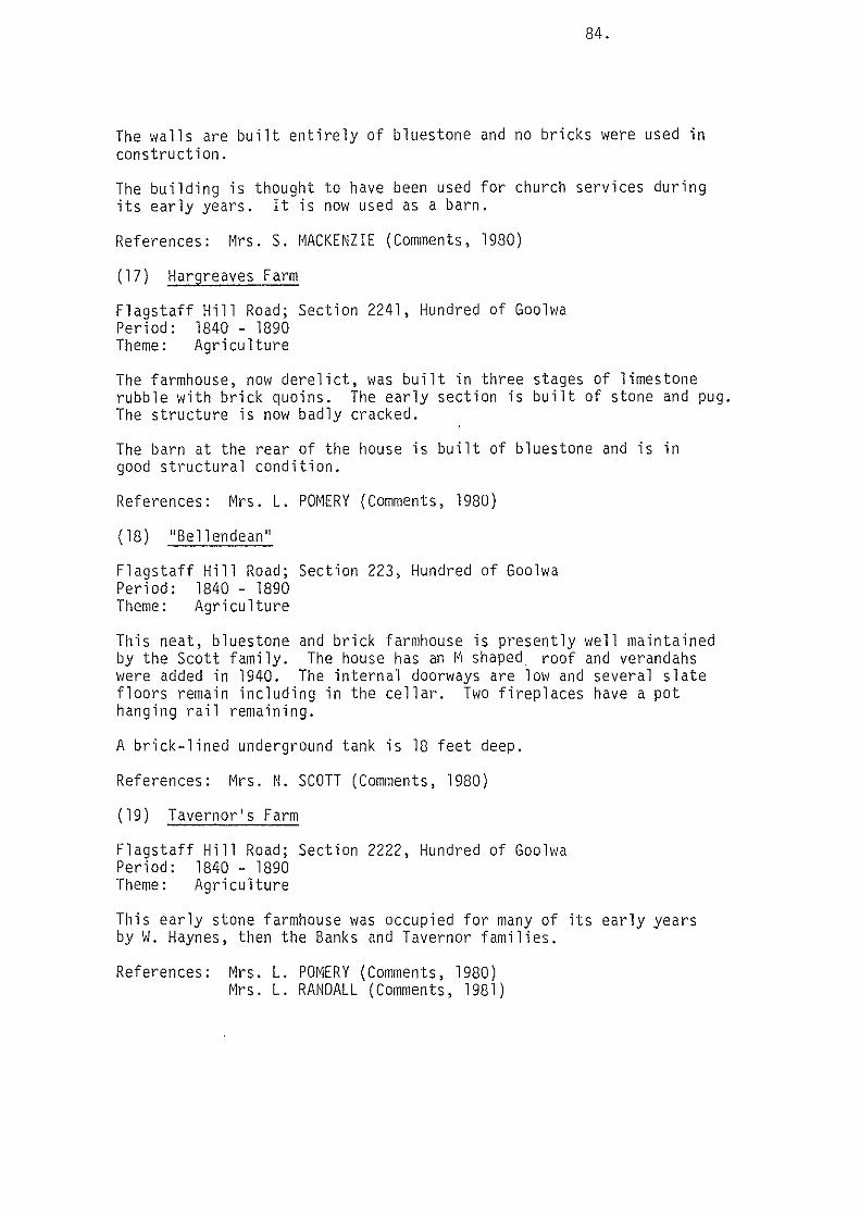
84.
The walls are built entirely of bluestone and no bricks were used in construction.
The building is thought to have been used for church services during its early years. It is now used as a barn.
References: Mrs. S. MACKENZIE (Comments, 1980)
(17) Hargreaves Farm
Flagstaff Hill Road; Section 2241, Hundred of Goolwa Period: 1840 - 1890 Theme: Agriculture
The farmhouse, now derelict, was built in three stages of limestone rubble with brick quoins. The early section is built of stone and pug. The structure is now badly cracked.
The barn at the rear of the house is built of bluestone and is in good structural condition.
References: Mrs. L. POMERY (Comments, 1980)
(18) ''Bellendean''
Flagstaff Hill Road; Section 223, Hundred of Goolwa Period: 1840 - 1890 Theme: Agriculture
This neat, bluestone and brick farmhouse is presently well maintained by the Scott family. The house has an I~ shaped roof and verandahs were added in 1940. The internal doorways are low and several slate floors remain including in the cellar. Two fireplaces have a pot hanging rail remaining.
A brick-lined underground tank is 18 feet deep.
References: Mrs. N. SCOTT (Comments, 1980)
(19) Taverner's Farm
Flagstaff Hill Road; Section 2222, Hundred of Goolwa Period: 1840 - 1890 Theme: Agriculture
This early stone farmhouse was occupied for many of its early years by W. Haynes, then the Banks and Taverner families.
References: Mrs. L. POMERY (Comments, 1980) Mrs. L. RANDALL (Comments, 1981)

(20) ''Ellisland''
Section Period: Theme:
2240, Hundred of Goolwa 1840 - 1890 Agriculture
85.
The house was built by Fred Ellis and was later owned by the Lovell family. The house has been altered and the property also contains the remains of several early stone sheds.
References: Mrs. L. RANDALL (Comments, 1981)
( 21) "Cawdor"
Section Period; Theme:
2288, Hundred of Goolwa 1840 - 1890 Agriculture
The site was first occupied by Alexander Bowman in the mid 1850's. The present bluestone house is probably the second house on the site.
References: Mrs. L. RANDALL (Comments, 1981)

4.5 Port Elliot Ward
(1) Stone Farmhouse and Sheds
Part Section 36, Hundred of Goolwa Period: 1840 - 1890 Theme: Agriculture
86.
The bluestone farmhouse and sheds, now in ruins, once formed a substantial farm complex and are a reminder of the once active agricultural community in the area.
{2) ''Stansfield'' Stone Barn
Part Section 36, Hundred of Goolwa, Waterport Road Period: 1840 - 1890 Theme: Agriculture
William Metcalf and his family first took up the land in 1850 and built the attractive bluestone barn shortly afterwards. The bricks in the chimney bear the frogmark 'A & C' and would have been produced at Archer and Chantrill's Brickyard (see Item 4) in the early 1850's.
The barn has two small rooms, a storeroom and a large room, and ~1as run as a shop in the 1860's by Miss Selina Metcalf. In 1867, she married William Harding and for a year they used the barn as their home. Prior to this, the barn had also been used as a school room by Mr. l~cc 1 i ntock.
The old house on the property is now in ruins.
References: MORISON, E.E. {1978) Mrs. L. POMERY (Comments, 1981)
{3) Former Arcadian Brickworks
Section 94, Hundred of Goolwa, Waterport Road Period: 1890 - present
The v10rks commenced about 1900 and operated as the Arcadian Brickworks. Bricks are still produced on an irregular basis by Elliot Victor Bricks.
References: ~1rs. L. RANDALL (Comments, 1980)
(4) Former Wood's Brickyard
Part Section 89, Brickyard Road Period: 1840 - 1890 Theme: Industries
The property comprises the original pughole, the kiln with relics of the machinery and a brick cottage. The yard was opened by Messrs. Archer and Chantrill {frogmark A & C) possibly in the early 1850's.

WATERPORT AREA
e Building
0 Site
J:j See Map 3
~---
108
Waterport
2289
14A
,4 .17 18
• 1~~\ ~ .16 [\a ad
:J 22 2284 0
-· \ \ . ~ \019 \
PORT ELLIOT WARD Location of items with heritage value
Scale 1 • 50000
PORT ELLIOT ANO GOOLWA HERITAGE STUOY. Ed. Noack and Associates, Town and Regional Planners. Largs Bay, S.A. in association with Heritage Investigations. 1980.
9 1:::,. N

87.
By 1854, they had sold the yard to Edward and Gerard Wood (frogmark W). They supplied the bricks for St. Jude's Church, Port Elliot and for many other buildings in the district. Bricks bearing the name were found recently in Port Elliot.
References: VINE HALL, N. (1976) Mrs. L. RANDALL (Comments, 1980)
(5) Gray's Cottage
Part Section 89, Hundred of Goolwa Period: 1840 - 1890 Theme: Agriculture
This early cottage is built of brick walls and the wooden shingle roof is covered with corrugated iron. It was possibly built by one of the Woods Brothers who was an early occupant there.
References: Mrs. L. RANDALL (Comments, 1980)
(6) Harding's ''Duxford'' House
Part Section 33, Hundred of GooJwa Per1od: 1840 - 1890 Theme: Agriculture
In 1859, James ~haw Harding purchased part of Section 33 including two wells and a creek from James Chibnall. The first section of the house comprising three rooms, a storeroom and a cellar was built by Thomas Ell is in that same year and Harding named the house "Duxford" after his village of origin in Cambridgeshire. The house is built of bluestone and brick with a slate roof. Note also the domed underground tank and the remains of the mud structures.
James Shaw Harding established a successful contracting business in the district and gained contracts to construct the Port Elliot Court House, the Goolwa wharf, the Black Swamp Bridge and considerable new road works. He also built the store in The Strand, Port Elliot.
References: MORISON, E.E. (1978) Mrs. L. RANDALL (Comments, 1980)
(7) ''Little Glory'' Cemetery and Site of Chapel
Waterport Road; Part Section 36, Hundred of Goolwa Period: 1840 - 1890 Theme: Community facilities; Agriculture
The land for the Bible Christian Chapel was purchased from William Metcalf of Waterport. The Chapel was built by John Coote in 1857 from stone quarried on ''Stansfield'' and using slate from Willunga for the roof. Church services were held in the Chapel until the mid-1890's. Miss Fanny Dodd also conducted school classes there in 1860. The Chapel is now demolished.

88.
The cemetery is thought to contain between 50 and 60 graves, but only three headstones remain.
References: !~ORISON, E.E. (1978) Mrs. L. POMERY (Comments, 1980)
(8) House
Waterport Road; Part Section 34, Allotment A, Hundred of Goolwa Period: 1840 - 1860 Theme: Agriculture
The early bluestone house built c. 1860, has been rendered and painted. It forms a part of the early Waterport settlement.
(9) John Hindmarsh Cottage
Waterport Road; Part Section 108, Hundred of Goolwa Period: 1840 - 1860 Theme: Agriculture
This property is thought to have been the home of John Hindmarsh, son of the first Governor, Captain John Hindmarsh, during part of the 1850's and 1860's.
The main bluestone cottage was destroyed by a bushfire but one room has been restored.
References: Mrs. L. RANDALL (Comments, 1980)
(10) Cottage
Waterport Road; Lot 33, Waterport Period: 1840 - 1860 Theme: Agriculture
This early stone cottage forms part of the early Waterport settlement. It has been rendered.
( 11 ) Cottage
Waterport Road; Lot 38, Waterport Period: 1840 - 1860 Theme: Agriculture
This early bluestone cottage withM shaped iron roof forms part of the early Waterport settlement. It was built in 1868-69 by William Harding.
References: Mrs. L. POMERY (Comments, 1981)

(12) Cottage
Waterport Road; Part Section 108, Hundred of Goolwa Period: 1840 - 1860 Theme: Agriculture
89.
This early rendered bluestone cottage with iron roof forms part of the early Haterport settlement.
( 13) Cottage
Waterport Road; Part Section 108, Hundred of Goolwa Period: 1840 - 1860 Theme: Agriculture
This early painted bluestone cottage with iron roof forms part of the early Waterport settlement.
(14) House "Waverley" and Schoolroom
Waterport Road; Part Section 2239, Hundred of Goolwa Period: 1840 - 1860 Theme: Agriculture
The bluestone house is thought to have been built for Mr.George Anstey in 1850 - 1860 who also conducted a private school on the property. The school room with basement remains detached from the house and is an attractive bluestone building with slate roof. The building is in need of restoration. The walls of the main house have been painted and a portico with battlements added at the front.
References: Mrs. L. POMERY (Comments, 1980}
( 15) Cottage
Waterport Road; Part Section 2289, Hundred of Goolwa Period: 1840 - 1860 Theme: Agriculture
This early, bluestone cottage with iron roof forms part of the early Waterport settlement.
(16) Cottage
Waterport Road; Part Section 2289, Hundred of Goolwa Period: 1840 - 1890 Theme: Agriculture
This early, bluestone cottage forms part of the early Waterport settlement. The chimney is built external to the building in a form typical of early colonial, rural houses.
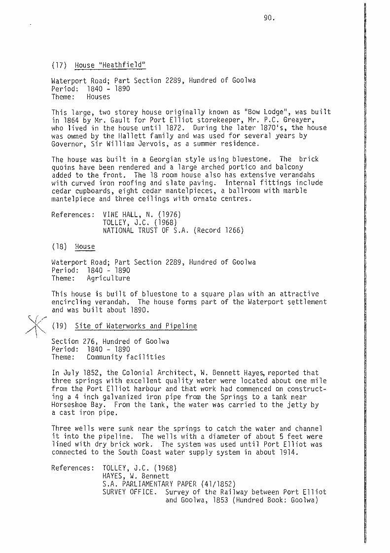
(17) House ''Heathfield''
Waterport Road; Part Section 2289, Hundred of Goolwa Period: 1840 - 1890 Theme: Houses
90.
This large, two storey house originally known as ''Bow Lodge'', was built in 1864 by Mr. Gault for Port Elliot storekeeper, Mr. P.C. Greayer, who lived in the house until 1872. During the later 1870's, the house was owned by the Hallett family and was used for several years by Governor, Sir William Jervois, as a summer residence.
The house was built in a Georgian style using bluestone. The brick quoins have been rendered and a large arched portico and balcony added to the front. The 18 room house also has extensive verandahs with curved iron roofing and slate paving. Internal fittings include cedar cupboards, eight cedar mantelpieces, a ballroom with marble mantelpiece and three ceilings with ornate centres.
References: VINE HALL, N. (1976) TOLLEY, J.C. (1968) NATIONAL TRUST OF S.A. (Record 1266)
(18) House
Waterport Road; Part Section 2289, Hundred of Goolwa Period: 1840 - 1890 Theme: Agriculture
This house is built of bluestone to a square plan with an attractive encircling verandah. The house forms part of the Waterport settlement and was built about 1890.
)K (19) Site of Waterworks and Pipeline I
Section Period: Theme:
276, Hundred of Goolwa 1840 - 1890 Community facilities
In July 1852, the Colonial Architect, W. Bennett Haye~ reported that three springs with excellent quality water were located about one mile from the Port Elliot harbour and that work had commenced on constructing a 4 inch galvanized iron pipe from the Springs to a tank near Horseshoe Bay. From the tank, the water was carried to the jetty by a cast iron pipe.
Three wells were sunk near the springs to catch the water and channel it into the pipeline. The wells with a diameter of about 5 feet were lined with dry brick work. The system was used until Port Elliot was connected to the South Coast water supply system in about 1914.
References: TOLLEY, J.C. (1968) HAYES, W. Bennett S.A. PARLIAMENTARY PAPER (41/1852) SURVEY OFFICE. Survey of the Railway between Port Elliot
and Goolwa, 1853 (Hundred Book: Goolwa)

(20) House, Barker's
Lot 14, Period: Theme:
Ville St. Louis 1840 - 1890 Agriculture
91.
This neat bluestone house was one of few houses built in the subdivision of Ville St. Louis. The house is built to a square plan with wide verandahs and is in good condition.
(21) Site of Liptrott's Store
Period: 1840 - 1890
In 1853 Mr. on the Port side of the Flour Mill.
Liptrott built a residence at Louisville, a subdivision Elliot to Middleton Road. He later erected a store alongbranch tramway line which was laid to service Basham's The Store has been demolished.
References: TOLLEY, J.C. (1968)
(22) Site of Basham's Flour Mill and Railway
Section Period: Theme:
2284, Hundred of Goolwa 1840 - 1890 Industries; Agriculture
The large bluestone Mill was built in about 1852 - 1853 and operated until 1876. A spur tramway line ran from the Port Elliot- Middleton Line to the Mill and the route is still clearly visible on the east side of the Victor Harbor - Goolwa Road. The substantial buildings and tall, round stone chimney have been demolished.
References: TOLLEY, J.C. (1968) MORISON, E.E. (1978) Mrs. L. POMER Y (Comments, 1980)
(23) Watson's Gap Railway Bridge
On Port Period: Theme:
Elliot -Victor Harbor Railway 1840 - 1890; 1891 - present Railways
Line
The original bridge carrying the tramway across Watson's Gap was built of 45,000 lineal feet of hardwood timber. It had a span of 290 feet and was supported by 8 main and 4 abutment piers, trussed in the main bays and braced in the abutments. The structure rested on iron shod timber piles driven to depths of about 15 - 17 feet, and had a maximum height of 27 feet. The Art Gallery of South Australia holds a watercolour of the bridge by Robert E. Minchin, c. 1860.
This original bridge was dismantled and replaced with a concrete arch structure in 1907. This was the first of its kind in Australia. The bridge is on the Recorded List of the National Trust.
References: STREMPEL, A.A. (1954) NATIONAL TRUST OF S.A. (Record 2384) TOLLEY, J. C. (Comments, 1980) ART GALLERY OF SOUTH AUSTRALIA (Historical Pictures
Collection)

(24) Stone Water Tank
Victor Harbor Road Period: 1840 - 1890 Theme: Agriculture
92.
This above ground limestone tank is thought to be the only one of its kind in the district.
References: Mrs. L. RANDALL (Comments, 1980)
(25) House
Waterport Road; Lot 21, Waterport Period: 1840 - 1890 Theme: Agriculture
This stone house was built in the early 1850's as part of the early Waterport settlement.
References: Mrs. L. POMERY (Comments, 1981)

4.6 Currency Creek Ward
(l) Currency Creek Railway Viaduct
Railway Period: Theme:
Reserve, south 1840 - 1890 Railways
of Currency Creek
93.
This structure was the first of its kind in South Australia. The foundation stone was laid in December 1866 by Mrs. Higgins of Currency Creek. The viaduct consists of 6 piers and 2 abutments all built of limestone rubble quarried locally and finished with brick quoins. The two central piers are 76 feet in height with a foundation 18 feet 10 inches by 17 feet 6 inches and a taper to a top measurement of 14 feet by 5 feet. The engineers used 4 iron girders to span the length of 280 feet. Each girder was tested to carry a weight of 35 tons.
Because of inferior masonry workmanship on the two central piers, they had to be dismantled and rebuilt shortly after initial construction.
The Viaduct still carries the Victor Harbor railway line. It is on the National Trust Recorded List.
References: TOLLEY, J.C. (1968) STREMPEL, A.A. (1954) NATIONAL TRUST OF S.A. (Record 2411)
(2) Stone Road Bridge
Goolwa-Strathalbyn Road; adjacent to Section 2012, Hundred of Goolwa Period: 1840 - 1890
The bridge crosses the Currency Creek immediately south of the township and is now closed to vehicular traffic. An 1840 watercolour of Currency Creek held by the Art Gallery of South Australia shows a simple timber platform bridge crossing the Creek possibly at this location (this has not been verified).
Newspaper reports in 1852 also mention that a bridge was being built at Currency Creek. Later reports, however, state that the stone bridge was opened in January 1873 by Miss Emma Sumner.
The bridge is a laminated timber structure with stone walling. It has been classified by the National Trust.
References: NATIONAL TRUST OF S.A. (Record 2386) PRETTY, W. (1980) GOOLWA MUSEUM (Photograph collection)

e Building CURRENCY CREEK WARD 10 ~ Conservation Park location of items with heritage value
PORT ELLIOT AND GDDLWA HERITAGE STUDY. Ed. Noack and Associates. Town and Regional Planners. Largs Bay, S.A. in association with Heritage Investigations, 1980

(3) Former Hotel
Section Period: Theme:
285, Township of Currency Creek 1840 - 1890 Township development
94.
The Currency Creek Inn, 1 ater knovm as the Currency Creek Hate 1, vias first licensed in March 1858 by John Varcoe Snr. The licence continued through three subsequent licencees until lapsing in 1876. The building was then sold to Mr. T.R. Sumner and various owners followed including the Kingsland family, 1916 - 1925. The Kingsland's added the balconies and gave the name ''Kingsview''.
The bluestone and brick building is now owned by Mr. W.L. Byrnes.
References: PRETTY, W. (1980) NATIONAL TRUST OF S.A. (Record 2410) PLUMMER, P. (Comments, 1980)
(4) Former School and Schoolhouse
Township Period: Theme:
of Currency Creek 1840 - 1890 Community facilities
The stone school building was built in 1866. The building is now owned by the District Council of Port Elliot and Goolwa and is used by community purposes. The former schoolhouse is now used as a private residence.
References: PRETTY, W. (1980) PLUMMER, P. (Comments, 1980)
(5) Former Shop and Residence
Township Period: Theme:
of Currency Creek 1840 - 1890 Township development
A photograph of the building taken about 1880 shows it as the home of Mr. and Mrs. Peter Kemp, Post Office and Store 1870 - 1925. The building is presently used as a residence.
References: GOOLWA MUSEUM (Photograph collection)
(6) Former Methodist Church
Lot 328, Period: Theme:
Township of Currency Creek 1840 - 1890 Community facilities
The stone walls of the building are standing but the roof has been removed. The window surrounds and quoins display interesting forms of brickwork.
References: PLUMMER, P. (Comments, 1980)

(7) Plummer Farm
Period: 1840 - 1890 Theme: Agriculture
95.
The group of three stone buildings west of Currency Creek Village were the farmhouse and butbuildings of the early farming property established by the Plummer family in the late 1850's. One of the buildings is roofed.
References: PLUMMER, P. (Comments, 1980)
(8) Former Mill
Section Period: Theme:
2061, Hundred of Nangkita 1840 - 1890 Industries; agriculture
The mill was built in the form of a Dutch windmill for Daniel Meyrick who owned the property between 1855 and 1864. The purpose of the mill was to draw water from a 90 feet deep well (the Lakes were then salt water). However, the fans were never installed and it is thought that steam power was used instead.
The building was also used as a saw mill. In more recent times, a room and lean to garage have been added to the structure. The building is on the National Trust's Classified List.
References: Mrs. L. RANDALL (Comments, 1980) NATIONAL TRUST OF SOUTH AUSTRALIA (Record 586)
(9) Early Farmhouse
Section Period: Theme:
2007, Hundred of Nangkita 1840 - 1890 Agriculture
The cottage was an early farmhouse with an external chimney structure. The front two rooms are built of weatherboard and the rear section is built of limestone. The building is not occupied.
(10) Canoe Tree
Strathalbyn Road
An Aboriginal bark canoe was extracted from the river red gum on the road reserve.
{11) Former Copper Mine
Lot 635, Period: Theme:
Currency Creek Township 1840 - 1890 Industries
The copper mine was worked in the valley of the Currency Creek in the late 1850's. Mining was by open cut and an exploratory shaft also remains.
References: S.A. PARLIAMENTARY PAPER. 47/1857-1858 PLUMMER, P. (Comments, 1980)

(12) Black Swamp Railway Viaduct
Period: Theme:
1840 - 1890 Railways
96.
The viaduct was constructed in 1868 - 1869 to carry the Strathalbyn to Middleton Railway across the Black Swamp Inlet. It comprised iron girders resting on timber piers with the whole structure being supported on red gum piles. An additional abutment was erected in 1917 0
References: TOLLEY, J.C. (1968) STREMPEL, A.A. (1954)
(13) Finniss River Railway Bridge
Period: 1840 - 1890 Theme: Railways
The Bridge was constructed in 1867 - 1868 to carry the Strathalbyn to Middleton Railway across the Finniss River. The foundation stone was laid by Hon. Thomas English, M.L.C., Commissioner of Public Works in March 1867. The bridge was built of wrought iron girders and local freestone was used to build the piers and abutments.
References: TOLLEY, J.C. (1968)
(14) Scott Conservation Park
Sections 218 and 347, Hundred of Goolwa
The Park comprises 209 hectares of native bushland with an interesting variety of native flora and wildlife. It was declared a Conservation Park in 1969.
References: NATIONAL PARKS AND WILDLIFE SERVICE (1978)

4.7 Nangkita Ward
(l) ~Higgins Brook"
Part Section 2146, Hundred of Goolwa Period: 1840 - 1890 Theme: Agriculture
97.
The Higgins family first came to the Currency Creek district in 1840 and built the first section of the old ''Higgins Brook'' ~omestead at that time. The stone homestead, which is now derelict, was built in five sections with one section having a slate roof and the others having corrugated iron.
In about 1868, the family moved to a new house, ''Burnt Oaks'', elsewhere on the property and still later erected the present ''Higgins Brook" homestead.
Colonel T.W. Higgins was well known as Colonel of the Southern Regiment, a Mounted Cavalry Unit. The Unit undertook guard duties at Vice-Regal occasions.
References: HIGGINS, A. (Comments, 1980)
(2) "Burnt Oak"
Section Period: Theme:
2163, Hundred of Goolwa 1840 - 1890 Agriculture
The first section of the house was built for the Higgins family about 1868 and included a school room which has since been demolished. The substantial bluestone and brick house has had a number of additions over the years and continues to serve as the homestead for Mr. A. Higgins' "Burnt Oak" stud property.
(3) Square Waterhole
Reserve No. 29, Section 696, Hundred of Nangkita Period: 1840 - 1890
The waterhole originally formed in a pit from which early settlers dug peat for fires and, as the quality of the groundwater was good, the bullock drivers made camp there. The waterhole was a convenient one day journey from Willunga by bullock dray. In 1856, Mr. Lush built an inn at the spot and was granted a Publican's Licence. The inn no longer stands.
References: RESIDENTS OF MT. COMPASS (1946) Mrs. L. RANDALL (Comments, 1980)

• Building
0 Site
_E_d._N_o_a~-'-anc_d_A_sso.ciates. Town and Regional Planners largs Bay. S.A
NANGKITA WARD
Location of items with heritage value
PORT ELLIOT AND GOOLWA HERITAGE in mociJtion with Heritage Investigations.
STUDY. 1980
11 6 N

(4) Nangkita Settlement
Hundred Period: Theme:
of Nangkita 1891 - present Closer settlement of Mt. Compass
98.
During the depression of the early 1890's, the South Australian Parliament passed legislation to establish village settlements for unemployed people. In 1893, land in the Mt. Compass district was resurveyed into Workingmen's Blocks and the first village settlers moved to Nangkita in 1894. Many settlers built simple wattle and daub or iron dwellings and drained and fenced the land. A school was established in 1894 and a post office in 1898. The village settlement had only a short life and was dissolved in 1900. Some of the more substantial stone buildings remain.
References: RESIDENTS OF MT. COMPASS (1946)
{5) Mt. Compass Hall
Mt. Compass Township Period: 1891 - present Theme: Closer settlement of Mt. Compass - Nankita
The hall was built in 1903 by the local community and has served as the district's centre for socials, meetings, church services and until 1934, as the school.
References: RESIDENTS OF MT. COMPASS {1946)
{6) Roadman's Cottage

99.
REFERENCES
Information relating to the various items was obtained by interviews with residents and where possible, owner~ as well as from published and unpublished material, including:
The ADVERTISER. Dates as given.
ARCHITECT-IN-CHIEF'S OFFICE. ''Summary of Expenditure - Public Buildings'' (Held in S.A. Archives G.R.G. 38)
BRISTOW-SMITH, D. (1954) Centenary of the Port Elliot and Goolwa Line. South Australian Railways Institute Magazine, April, May 1954
COCKBURN, R. (1925) Pastoral Pioneers of South Australia. Publishers Ltd., Adelaide
DAVENPORT, D. Miss (1955) ''The Congregational Church at Port Elliot''. Pamphlet
ENGLAND, P. Mrs. (n.d.) "Woodlands" Unpublished notes
FINNISS, H.J. (1953) The Murray Mouth. Proc. Roy. Geog. Soc. Aust/asia (S.A. Branch), Vol. 54
FISCHER, G.L. (1963) Letter re Port Elliot Police Station and Court House. S.A.A. Research Notes 598
GOOLWA MUSEUM. The Museum holds an extensive collection of photographs and research notes
HAYES, W. Bennett. Engineering in South Australia
LEWIS, J. (1917) Some Notes Presidential address. Vol. XVIII
on the Early Navigation of the River Murray, Proc. Roy. Geog. Soc. Aust/asia (S.A. Branch)
MORISON, E.E. Recollections of the South Coast Area of South Australia 1853 - 1978. The Author, Adelaide
NATIONAL PARKS AND WILDLIFE SERVICE (1978) Area Statement. Pamphlet.
NATIONAL TRUST OF SOUTH AUSTRALIA. The Trust has a data record for each item on the Classified or Recorded Lists and of those considered for such.
PIGGOTT, A.D. (1946) Some Notes on the Goolwa to Port Elliot Tramway. Proc. Roy. Geog. Soc. Aust/asia (S.A. Branch), Vol. XLVII
POMERY, L.M.C. (1979) Port Elliot Council Chamber. Pamphlet

PRETTY, W. (1980) "Chronological List of Events relating to Goolwa". Unpublished notes.
PRETTY, W. {n.d.) Research Notes. S.A.A., P.R.G. 390.
PRICE, A.G. {1929) Founders and Pioneers of South Australia.
PRICE, A.G. {1933-4) Early South Australian Maps in London. Proc. Roy. Geog. Soc. Aust/asia (S.A. Branch), Vol. XXXV
RESIDENTS OF MT. COMPASS. The History and Development of Mt. Compass.
S.A. ARCHIVES. Photograph collection.
S.A. PARLIAMENTARY PAPERS. Dates as given.
S.A. REGISTER. Oates as given.
SHEARD, H.L. {1960) Graham's Castle in Retrospect. The Author.
STREMPEL, A.A. {1954) The First Public Railway in Australia: Its History and Development. Proc. Roy. Geog. Soc. Aust/asia (S.A. Branch), Vol. 55
TOLLEY, J.C. (1968) South Coast Story. Ambrose Press, Victor Harbor.
TOLLEY, J.C. Unpublished notes.
VINE HALL, N. {1976) Buxton Forbes Laurie of Southcote. The Author.
WHITWORTH, R.P. (1866) The South Australian Gazetteer. Bailliere, Adelaide
WILLATS, J. {1980) Port Elliot Institute Library Centenary 1880- 1980. Pamphlet

PART 3. RECOMMENDATIONS

101.
1. The Proposed Heritage Areas
RECOMMENDATION: THE STUDY RECOMMENDS THAT THE SIGNIFICANT EARLY TOWNSHIP AREAS OF GOOLWA, PORT ELLIOT AND MIDDLETON BE DESIGNATED AS HERITAGE AREAS FOR CONSERVATION AND PLANNING PURPOSES.
In the Summary of History (Part 1 of this report), the reasons for the early development and later growth of the three townships is discussed in detail.
The first survey of the Town-on-the-Goolwa was made in 1840 but the main thrust of development came with the decision of Governor Young to open a river port at Goolwa, a coastal port at Port Elliot and to link the two with a horse drawn railway. These facilities required service structures and buildings at Goolwa, Port Elliot and Middleton and many of these remain.
Industries and commerce followed the trading opportunities opened up along the river and by export from Port Elliot. Several substantial flour mills were established and commercial and community buildings were erected in the townships.
The early horse drawn railway system with its associated loading and servicing structures in Goolwa, Port Elliot and Middleton was the first public iron railway in Australia. It assisted substantially in opening the River Murray to steamer trade and was, therefore, among the State's most important early capital works ventures.
The early townships of Goolwa, Port Elliot and Middleton had many buildings and structures associated with the railway and the townships grew around those facilities. The townships have retained a large proportion of the buildings and structures associated with the railway and, therefore, have special historic character.
This historic character is reinforced by the widespread use of local materials in construction of early buildings and structures. In Goolwa, the predominant building material is travertine or paddock limestone. The hard whitish coloured stone was used either in the form of rounded stones gathered from nearby paddocks or in split or cut form from quarries. The stones are set in a light coloured limestone mortar. The town, therefore, has a soft, off-white hue.
Port Elliot, in contrast, is characterised by the darker bluestone which was quarried in the foothills near the town. Several of the larger buildings such as the Institute and the former Court House display fine examples of bluestone masonry. Although bluestone predominates, there is also widespread use of travertine limestone and limited use of granite.
Middleton also has a mixed use of bluestone Qnd limestone, alLhough the sheer bluestone mass of Bowman's Steam Flour Mill dominates the early township.

102.
2. Development Control
RECOMMENDATION: THE STUDY RECOMMENDS THAT THE PROPOSED HERITAGE AREAS BE GIVEN RECOGNITION IN ANY REGULATIONS TO CONTROL DEVELOPMENT OF LAND AND THAT THE PRESCRIBED SET OF DEVELOPMENT CONTROL PRINCIPLES BE INCLUDED.
It is desirable that any new development should be in keeping with the character of the early townships because of their state heritage significance. The following set of development control principles are, therefore, suggested as guidelines for new development uses:
continue, where possible, the most significant historic use of the site or building.
industrial, warehousing or outdoor storage uses should not be allowed unless continuing an historically significant use or associated with restoration of the area for heritage purposes or for display for educational or tourist purposes.
Town character:
no development should be allowed which would impair or destroy the historic character and appearance of the area or particular buildings or structures of heritage value within the area.
density: development should generally be of low density.
siting: all new development should conform to a building alignment compatible with that most common on the particular section of street.
scale: all new development should generally be of a low scale in keeping with the size and height of adjacent and nearby development.
form: all new development should have regard to the massing of adjacent and nearby buildings by being simple in form and appearance, and should utilize elements such as square or rectangular plans; gable, hip or pitched roofs and with verandahs.
materials: all new development should utilize building materials which are visually compatible with materials used in those items of heritage significance within the Area. Such materials include:
for walls -travertine limestone with a compatible mortar (preference for bluestone in Port Elliot); rendered (not bagged) brick or block.
for roofs - corrugated galvanized iron either painted or unpainted (not metal tiles).
for windows and doors - timber framed or frames of similar proportions and style.

103.
for verandahs - timber posts and corrugated galvanised iron roofing.
for front fencing -timber picket, paling or railing fences; travertine limestone (or bluestone in Port Elliot); rendered brick or block.
colours - in Goolwa, colours should be a cream or muted earth shade. In Port Elliot and Middleton, darker earth colours are satisfactory.
advertising: signs for advertising purposes should be integrated with the design, appearance and scale of development and should use typographical styles appropriate to the character of any buildings or structures of heritage significance in the locality. Signs which are not in keeping with the character of the Area should not be allowed, including large free-standing signs; animated illuminated signs; and signs mounted on the top of roofs.
Landscape:
any development which would destroy significant mature trees or materially alter the existing landform should not be allowed.
all tree planting and landscaping of new development should reinforce the scale and variety of vegetation in the locality.
Conservation:
the items identified as sites, buildings or structures of heritage significance, both in themselves and within their locality, form the heritage character of the Area. They should be conserved and, where possible, restored.
Land Division:
where possible, existing allotment sizes should be retained and consolidation of allotments, particularly in ''Little Scotland'', should be discouraged.

104.
3. Nomination of items
RECOMMENDATION: THE STUDY RECOMMENDS THAT NOMINATIONS FOR INCLUSION ON THE STATE HERITAGE REGISTER OF ITEMS INDICATED SHOULD BE SUBMITTED TO THE SOUTH AUSTRALIAN HERITAGE COMMITTEE.
The South Australian Heritage Act and the Planning and Development Act provide for controls on development of sites, buildings or structures which are on the State Register of Heritage Items or on the Interim List (i.e. items under public consideration before registration). Written consent is required from the State Planning Authorit~ or the local Council in those cases where power has been delegated to the Council, before any item which is on the Interim List or the Register may be demolished, added to or altered in any way that would change its character or external appearance.
At present there are several buildings on the Register. These are indicated in the following list (marked with *) together with those items which should be nominated (marked with the letter A).
RECOMMENDATION: IT IS RECOMMENDED THAT THOSE ITEMS NOT RECOMMENDED FOR IMMEDIATE NOMINATION TO THE STATE REGISTER BUT CONSIDERED WORTHY OF PRESERVATION BE KEPT UNDER REVIEW FOR POSSIBLE LATER NOMINATION.
The study has identified a large number of items with heritage value. However, they do not all display the qualities, considered at this time, to make them worthy of. nomination as heritage items. However, later information may establish qualities, such as uniqueness within South Australia, which it has not been possible to establish within this study. They may then be considered worthy of nomination for registration.
Those items considered to be worthy of immediate nomination to the Register are marked with the letter A on the following list. An attempt has been made to include items representing the various historical themes identified by the study.
The items considered worthy of preservation are marked with the letter B and those of general historical interest with the letter C.
Particular attention should be given to the Waterport area immediately north of Port Elliot which has a stock of fine early buildings extending along Waterport Road.
It should be noted that additional items of general historical interest may be identified in future and these should be added to the list. Similarly, items of general historical interest (C worthiness) may later be considered worthy of preservation (B worthiness).

lV..Jo
The following list shows a recommendation of heritage worthiness for each item examined in the study. The worthiness ratings are:
* Item already on the State Register or Interim List
A Worthy of immediate nomination to the State Register
B Worthy of preservation
C Of general historical interest
A description of the type of item is also given on the list as follows:
0 Site
• Natural feature
Ill Building (complete)
0 Building (ruins)
A Structure (complete)
L::. Structure (relics)
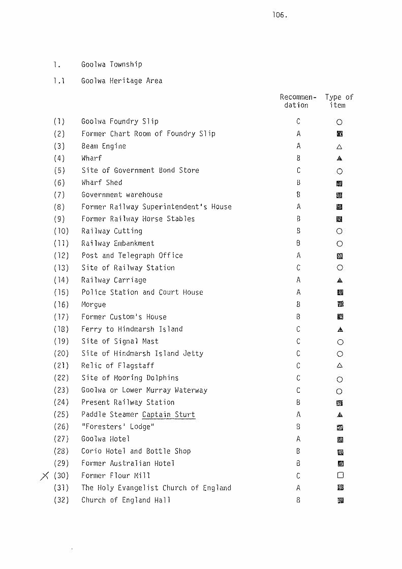
l. Goolwa Township
l .l Goolwa Heritage Area
(l) Goolwa Foundry Slip
(2) Former Chart Room of Foundry Slip
(3) Beam Engine (4) Wharf (5) Site of Government Bond Store
(6) Wharf Shed (7) Government warehouse (8) Former Raill1ay Superintendent's House (9) Former Railway Horse Stables (10) Railway Cutting
(ll) Railway Embankment (12) Post and Telegraph Office
(13) Site of Railway Station (14) Railway Carriage
(15) Police Station and Court House (16) r~orgue
(17) Former Custom's House (18) Ferry to Hindmarsh Island (19) Site of Signal Mast (20) Site of Hindmarsh Island Jetty (21) Relic of Flagstaff (22) Site of Mooring Dolphins
(23) Goolwa or Lower Murray vJaterway (24) Present Railway Station (25) Paddle Steamer Captain Sturt (26) ''Foresters' Lodge''
(27)
(28)
(29)
;< (3o)
( 31 )
(32)
Goolwa Hotel Corio Hotel and Bottle Shop
Former Australian Hotel Former Flour Mill The Holy Evangelist Church of England
Church of England Hall
106.
Recommen- Type of dation item
c A
A
8
c 8
8
A
8
8
B
A
c A
A
8
8
c c c c c c 8
A
B
A
8
8
c A
8
0
II
6
A
0
Ill
• Ill
II
0
0
II
0
A
II II
1111
.&.
0
0 6
0
0
II A
1111
1111
II
II
0 II
II

107.
Recommen- Type of dations item
(33) Town Hall and Council Chambers B II
(34) Goode's Store B II
(35) Bow Fronted Store * II (36) Shop, "Blue Lace Drapery" B II (37) Bank Building B II (38) Shop, ''Riverside Meat Store'' B 1111
(39) Goo hva Museum B II
(40) Soldiers Memorial Gardens c 0.&.
( 41 ) Two storey residence B 1111
(42) Shop, eastern section of "South Coast Auctions" B 1111
(43) Small cottage B 1111
(44) House and stone sheds B 1111
(45) ''Clarke-Holme'' cottage B II (46) Former Hospital B 1111
(47) ''Highlands House'' B II (48) Mill Cottage and Sheds B II
(49) ''Shetliff Cottage'' B IIIII
(50) Cottage B 1111
( 51 ) House, Lot 9, Town-on-the-Goolwa A II (52) House B 1111
(53) House B II (54) House B 1111
(55) The Pond B 0 (56) ''Little Scotland'' area A 0
(56A) Cottages B 1111
(568) "Mariner's Cottage" A Ill (56C) "Gwithian" A 1111
(560) Cottage B Ill
(56E) Cottage A Ill (56F) Cottage B Ill
(56G) Cottage B II (56H) Former Shop B Ill (56!) Cottage ''Armfields'' A II

108.
Recommen- Type of dations item
(56J) "Gainsborough" Cottage B 1111
( 561() Cottage B 1111
(56L) Cottage B 1111
( 56r~) Cottage B Iii! (56N) Cottage B 1111
(560) Cottage B 1111
(56P) Cottage B 1111
(56Q) House, ''Cockenzie'' A II (56R) House and Coach House ''Younghusband's'' A Ill (565) Cottages A 1111
(56T) Cottage B II (56U) Cottage A Iii! (56V) Cottage B 1111
(56W) Cottage B II (56X) Cottage B II (56Y) Cottage B II
1.1 Outside Goolwa Heritage Area
(a) Former Brewery c 1111
(b) Original Public School Building B Ill (c) Uniting Church B Ill (d) House c II (e) House c Ill

2. Port Elliot Township 2.1 Port Elliot Heritage Area
(1) Jetty (2) Horseshoe Bay
(3) Breakwater (4) Granite Quarry for Breakwater
(5) Pullen Island (6) Site of 3 Storey Stone Store (7) Obelisk (8) Site of Harbour Master's Cottage (9) Railway Cutting (10) Former Police Station and Cell Block
(11) Site of former Post Office
(12) Former Court House (13) Institute and Library
(14) Former Council Chambers (15) Site of former Globe flotel (16) Memorial Gardens (17) Railway Station
(18) School [19) Hotham Memorial Uniting Church (20) Royal Family Hotel (21) Former Port Elliot Hotel, now "Arnella" (22) Site of former Dairy Factory
(23) Site of Rev. George Taplin's former School (24) St. Jude's Church of England (25) St. Jude's Rectory
(26) Post Office (27) Railway Hotel, now Hotel Elliot (28) Shop with residence
(29) Shop (30) Shop with residence (31) Bakery with Domed Tank (32) Shop with residence, formerly Harding's Store
109.
Recomrnen- Type of dations item
A
c B
c 8
c * c c * c A
B
B
c c B
B
B
B
8
c c A
8
8
c B
B
B
B
B
A
0 A
0
0
0 A
0
0 Ill
0
II Ill
Ill
0
0
Ill
II
II
Ill Ill
0 0 Ill
II II
II
II
• Ill
II II

(33) House, "Rothesay"
(34) Stone cottage (35) House, "St. Anton" (36) House, ''Wycombe''
(37) House, "Ratowa" (38) House, Mr. and Mrs. Pomery
(39) House, "Trafalgar House" (40) House, ''Ruthan Cottage'' (41) House, Hussey's
( 42) House (43) Former granite works
2.2 Outside Port Elliot Heritage Area
(a)
(b)
(c)
(d)
(e)
(f)
(g)
(h)
( i )
( j)
( k )
( 1 )
(m)
( n)
( 0)
( p)
( q)
Site of "Tile Gables" Site of the first Congregational Church Rev. Watson's House
Catholic Cemetery Site of Catholic Church and Convent
Granite House
Granite House Former school of Mr. and Mrs. Bowes Mein House ''Eastfield''
Maisonettes "Granite Villa"
Maisonettes House ''Grosvenor Cottage''
House "Trigg Cottage"
House St. Jude's Hall
House Cottages
110.
Recommen- Type of dati ons i tern
B
B
B
B
B
B
B
B
B
B
c
c c B
c c B
B
B
B
A
c c B
B
B
c c
II
II
II
II
II
II
II
II
II
II
0
0 0
Iii A
0
• II
1!111
1!111
• II
• II
• II
• II

3. Middleton Township
3. l Middleton Heritage Area
(l) Site of Original Railway Siding and Station
(2) Bowman's Steam Flour Mill (3) Mill cottage (4) Former Strathalbyn Railway Line Site (5) Station Master's Cottage
( 6) Cottage (7) Cottage
(8) Old Bridge (9) Stone Railway Culvert
(10) Sweetman's Former Blacksmith Shop (ll) Cottage (12) Former Methodist Church ( l3) Cottage ( 14) Cottage
(15) Memorial Park (16) Early school (17) Yate's cottage (18) Former butcher's shop and residence (19) Mrs. Abbot's House
3.2 Outside Middleton Heritage Area
(a)
(b)
(c)
(d)
(e)
(f)
(g)
(h)
( i )
( j)
(k)
( l )
(m)
Site of Limbert's store
Site of Batson's brickyard with cottage Cottage "Fortuna"
Site of Blacksmith shop
Former Institute "Mindacowie"
Primary school Cottage Site of Middleton Hotel Cottage
Field's cottage
l~iddleton Rocks
lll.
Recommen- Type of dation item
c * B
c B
B
B
c B
B
B
B
B
B
c A
B
c B
c A
B
B
c c B
A
B
c B
B
A
0
II
II
0
II
II
II
/::,.
.A
II
II
II
II
II
0
II
II
II
II
0
011
II
II
0 II
II
II
II
0
II
II 0

112.
4. Rural Areas
4. l Goolwa ~lard
Recommen- Type of dation item
( l ) Captain Lindsay's Cottage B II
4.2 Sturt \1ard
( l ) Site of Captain Sturt's Camp A 0
( 2) Sir Richard Peninsula A • ( 3) The Murray Mouth A • ( 4) ''Graham's Castle'' B 111!1
( 5) ''Burrang'' Farm House B II
( 6) Dennis' Farm House c II
(7) Dennis' Scrub A • ( 8) Farmhouse c II
( 9) Goolwa and Currency Creek Cemetery B A
( l 0) Old Cemetery B A
( 11) Currency Creek Game Reserve B • (12) Ra i lv1ay Culvert B A
4.3 Hindmarsh Island \·lard
( l ) Memorial to Barker and Sturt B A
( 2) Cemetery B A
( 3) Goolwa Barrage A A
(4) Mundoo Barrage A A
( 5) Boundary Creek Barrage A A
( 6) Navigation Aid c A
(7) Former Dairy Factory c II
( 8) House and Ha 11 c II
( 9) ''Riverside'' Homestead and Stone Sheds B II
( l 0) ''Narnu Park'' Homestead B II
( 11) Stone Hut A II
( 12) Stone House "Thaldanay" B II
( 13 ) Site of Hindmarsh Island Flour Mill c 0

113.
4.4 Middleton Ward
Recommen- Type of dation item
( l ) "Pleasant Banks" B • ( 2) "Brook lands" A Ill
( 3) "Watta berri" B Ill
{4) Stone farmhouse c Ill
( 5) ''Southcote" Farm A 1111
( 6) Swift's Cottage c 0
(7) Cemetery B Ji,.
{8) Cemetery, St. Jude's {The Glebe) B Ji,.
( 9) Former horse changing station c 0 ( l 0) Former Coach Route c 0 ( ll) MacFarlane Hill with cottage B 11110 ( 12) Red Gum Slab Cottage A 1111 (13) Castle Range c 0 (14) ''Woodlands'' Homestead and Woolshed B 1111 ( 15) "Chelville Farm" B Ill
(16) Stone Barn A Ill ( 17) Hargreaves Farm c 0 ( 18) "Bellendean" B !Ill ( 19) Taverner's Farm B !Ill {20) "Ell island" c • ( 21 ) "Cawder" B II
4.5 Port Elliot Ward
( 1 ) Stone Farmhouse and Sheds c 0 ( 2) ''Stansfield'' Stone Barn A Ill ( 3) Former Arcadian Brickworks c 6
(4) Former Wood's Brickyard c Ill {5) Gray's Cottage B • (6) Harding's "Duxford" House B Ill
(7) "Little Glory" Cemetery and Site of Chapel c AO
( 8) House B Ill

{9) John Hindmarsh Cottage
(10) Cottage {ll) Cottage ( 12) Cottage (13) Cottage {14) House ''Waverley'' (l4A) School room ''Waverley''
( 15) Cottage (16) Cottage (17) House ''Heathfield''
{18) ·· House {19) Site of Waterworks and Pipeline
(20) House, Barker's {21) Site of Liptrott's Store (22) Site of Basham's Flour Mill and Railway
{23) Watson's Gap Railway Bridge {24) Stone Water Tank
{25) House
4.6 Currency Creek Ward
{l) Currency Creek Railway Viaduct
{2) Stone Road Bridge
{3) Former Hotel {4) Former School and School House
{5) Former Shop and Residence
{6) Former Methodist Church (7) Plummer Farm {8) Former Mill (9) Early farmhouse
{10) Canoe Tree (ll) Former copper mine {12) Black Swamp Railway Viaduct {13) Finniss River Railway Bridge {14) Scott Conservation Park
Recommen- Type of dation item
B
B
B
B
B
B
A
B
B
B
B
c B
c c A
B
B
A
* B
B
B
c B
A
B
A
c c c A
II
II
II
II
II
II
II
II
II
II
II
0
II
0
0 A
A
II
II
II II
D
liD
II
II
• b.
A
A
•

115.
4.7 Nangk ita flard
Recommen- Type of dation item
( 1 ) ''Higgins Brook'' (first homestead) B 0
( 2) Burnt Oak" B • ( 3) Square waterhole c 0 ( 4) Nangkita settlement c 011 ( 5 ) Mt. Compass Hall c • (6) Roadman's cottage

116.
4. Information
RECGr~~1ENDATION: IT IS RECOMI~ENDED THAT INFORMATION ON THE HERITAGE VALUE OF THE DISTRICT AND ITEMS IN IT BE PRESENTED IN BROCHURES ON THEMES OF THE AREA'S HISTORY SUCH AS THE HORSE ORAl-IN RAILWAY AND EARLY SHIPPING DAYS.
A wealth of fascinating information and photographs are available and should be presented in a series of booklets which can be distributed vlidely. The history of the district and its main features has been well told in The South Coast Story by J.C. Tolley and that work should continue to be sold widely as an authoritative and succinct history of the district.
RECOMMENDATION: THE GOOLWA MUSEUM SHOULD BE ENCOURAGED AND GIVEN ASSISTANCE TO PROVIDE A THEMATIC DISPLAY ON RIVER BOATS. THE RIVER TRADE AND THE EARLY HORSE DRAWN RAILWAY, INCORPORATING, IF POSSIBLE, viORKING MODELS.
The Goolwa Museum holds a wide array of information, photographs and relics on the history of the district. That history has many features which are unique to the district and which were important in the early development of South Australia. It would, therefore, be desirable to establish a collection and display of material relating to river boat construction, river trade and the horse drawn railway and to make that the main theme of the Museum's activities.
RECOMMENDATION: A FILE OF THE ITEI•IS LISTED BY THIS STUDY AS HAVING RERirAGE VALUE SHOULD BE ESTABLISHED.
A simple filing system comprising a manila folder containing information on each item having heritage value should be set up by the district branch of the National Trust in co-operation with Council. Further information gathered by researchers and owners of items in future years should be added to the file so that a comprehensive picture can be built up of the district's rich heritage resources. The file would be of value to Council in assessing development applications and in advising owners on restoration as well as to property owners and students of history.
Example:
[ Photographs 1-- ;:,
Extract J from ~ Report
Other --------:::·~ articles -- / Listof / References
manila folder
4. l,lharf 3 Goolwa Heri~~ge ~e~
Filing cabinet

117.
RECOMMENDATION: A WALKING TRAIL SHOULD BE PREPARED THROUGH THE PROPOSED GOOLWA, PORT ELLIOT AND MIDDLETON HERITAGE AREAS TO LINK UP HERITAGE ITEMS, LOOK OUT POINTS, DISPLAYS AND PLACES OF REFRESHMENT.
The Heritage Areas contain a compact grouping of sites, buildings and structures of heritage value which could be relatively easily covered on foot by people of most age groups. In Goolwa and Port Elliot, look-out points with good water views should be provided with seats and indicators and the trail should pass refreshment points such as the hotels and delicatessens. The route of the trail should be set out on brochures and display panels.

118.
5. Restoration
RECOMMENDATION: THE STUDY RECOMMENDS THAT COUNCIL ENCOURAGE OWNERS OF HERITAGE ITEMS TO CONSULT WITH THE HERITAGE UNIT, DEPARTMENT OF ENVIRONMENT AND PLANNING, BEFORE UNDERTAKING RESTORATION WORK.
RECOMMENDATION: RESTORATION WORK SHOULD BE UNDERTAKEN, WHEREVER POSSIBLE, BY TRADES PEOPLE WHO HAVE A KNOWLEDGE OF THE USE OF THE LOCAL LIMESTONE AND BLUESTONE IN PARTICULAR IN RELATION TO CUTTING, DRESSING AND SETTING.
An important heritage feature of the district is the widespread use of local stone. The stones are attractive and durable if well maintained. There are many fine examples of stone dressing and setting and it is desirable that these details be preserved. It is, therefore, necessary that local tradespeople be encouraged to maintain the stone mason's craft.

119.
6. Further Work
RECOMMENDATION: THE STUDY RECOMMENDS THAT A FURTHER STAGE OF WORK BE UNDERTAKEN TO ANALYSE IN DETAIL THE HERITAGE ITEI•IS LISTED IN THIS REPORT PARTICULARLY WITH REGARD TO BUILDING STYLES AND CONDITION, CONSTRUCTION DETAILS AND PHOTOGRAPHIC DOCUMENTATION.
The first stage of study has been concerned primarily with defining the sites, buildings and structures of heritage value, locating them and assessing their historical, social or constructional attributes from a heritage point of view. Because of the richness of the district's heritage, this task has proven to be extensive, time consuming and rewarding. It is desirable that more details on the items identified be collated to assist in nomination and as an aid to restoration. These details should be on the attributes such as construction details, materials, finishes, styles, siting and photographic documentation, both past and present, of the buildings and structures themselves.

APPENDIX

APPENDIX A.
ITEMS ON THE REGISTER OF THE NATIONAL ESTATE
Goolwa
Police Station and Court House, Cadell Street. Railway House (Superintendent's House), Government Road. Bow-fronted Shop, Cadell Street.
Port Elliot
Obelisk, Freeman's Nob. Old Police Station and Residence, Young Street. R.S.L. Club Rooms {Old Court House).
Currency Creek
Currency Creek ~li 11.
Road Bridge {1880) over Currency Creek.
l~iddleton
Middleton Flour Mill.
Surrounding Area
Currency Creek Game Reserve, 4 km East of Goolv1a.

APPENDIX B
ITEMS ON THE REGISTER OF STATE HERITAGE ITEMS
Goohva
Shop (bow-front), 2 Cadell Street, Goolwa.
Port Elliot
Obelisk, Freeman's Nob.
Currency Creek
Old Bridge, Currency Creek, adjacent Section 2012
Middleton
Former Mill, Middleton.
Interim List (Second)
Port Elliot
Former Police Station and Residence, Outbuildings.

APPENDIX C
THE NATIONAL TRUST LIST
Port Elliot
883 1268
672 371
2279
370
639 701
2384
(p.54, 1979 Register) Council Chambers Institute
Obelisk Old Police Station and
residence ''Pleasant Banks'' RSL Clubrooms - former Courthouse
St. Jude's Church South cote
Watson Gap Railway Bridge
RL RL
CL
CL
RL, Bashams Beach Road, c.l857.
CL
CL RL RL 1907
Currency Creek
586
24ll
2386
Goolwa
95
366 359 356 364 349
2508
323 361 368
350
1247
Middleton
583
358
Mill Railway Viaduct
Road Bridge
CL
RL
CL
Bow-fronted Shop CL
Cottage RL Partridge Street, 1843 Goolwa Hotel RL Holy Evangelist RL
House RL Corner Admiral & Baronet Streets. House, former Superintendent's House. CL (owned by N.T.) P.S. Capt. Sturt RL Police Station & Courthouse CL Post Office RL RSL Clubrooms (former Horse Tram Stables) RL Uniting Church, former Methodist Church. RL 1861 Wharf RL 1874 rebui 1t
1876 extension 1878 wharf shed
Batson's Brick & Kiln Cottage (kiln demolished) RL
Flour Mill CL

APPENDIX D
DIVISION OF TOURISM LIST
GOOU1A:
Captain Ritchie's House, Brooking Terrace, A feature of the building is the cannon over the doorway. Holy Evangelist Church of England, built in 1866.
Gool\va Town Hall, now used as Council Chambers. The old hall at the back of the present building was erected in 1860.
Police Station and Court House. Built in 1859 in colonial style, with walls of limestone, brick quoins and a slate roof. Old paddlesteamer, Captain Sturt, the only American built paddlesteamer on the River l~urray.
Old horse-drawn railway carriage, preserved as a memorial of early transport from Goolwa to Port Elliot.
The original post office, built in 1867, is incorporated in the present building. It also served as the first passenger station for the horse-drawn railway. Customs House, first built in 1858, was extended in 1864. Corio Hotel and Australasian Hotel - licensed in 1858. Foresters Hall, built in the 1850s. It was used by the Church of Christ and the Catholic Church until their own buildings were completed. Goolwa Hotel, built in 1853. The figurehead on the front of the building is from the sailing ship Mozambique which was wrecked in the Coorong in 1854.
PORT ELLIOT:
Heathfield House, Waterport Road, built in 1864. The house was used by Governor Sir William Jervois in the late 1870s.
Old Police Station, built in 1853. It consisted of two rooms and a lock-up and was erected on a site chosen by Inspector Tolmer, Superintendent of Police.
St. Jude's Church of England. The Strand. Built in 1854. Obelisk, Freeman's Knob. Erected in 1852. A blue flag was flown from the flagstaff on days when waters ~1ere unsafe for shipping. Arnella (formerly Port Elliot Hotel) was the first licensed house in the town, and built in 1852.
Globe Hotel (now Cliff House), built in 1854 was the second hotel in Port Elliot. It was later renovated and used as a Vice-Regal summer residence from 1873-1889.