port at-a-glance - texas a&m university at-a-glance port of orange ... texas mile 440, near...
TRANSCRIPT

1. Texas Port Report, Texas Department of Transportation, June, 2014, pg. 5
UPDATED 8/2014
Orange County Navigation & Port District 1201 Childers Road Orange, Texas 77632 (409) 883-4363 www.portoforange.com
Port Director Gene Bouillion
Quick Facts:The Port of Orange is located on the Sabine-Neches waterway and is linked to the “Golden Triangle” ports which include the Port of Port Arthur, Beaumont and Orange. This area has become strategically more important to Texas ports growth since 2003.
The Port of Orange has acted as a successful landlord port, complementing activities at larger ports on the Sabine-Neches channel. It is also used for lay berthing.
94,504
0 20,000 40,000 60,000 80,000 100,000
Tonnage¹
Foreign Trade Zone: #117
PORT AT-A-GLANCEPort of Orange • Orange, TX Legal Name: Orange County Navigation and Port District Draft: Deep Depth: 30 ft. channel Width: 200 ft.
Annual Economic Impact: $ 1.9 million
Connectivity
Rail Orange Port Terminal
Railway providing switching service to Union Pacific and agreement with BNSF.
Roadway Connection SH 87 IH 10
Top Commodities
On-site Marine Services which include:
Shipyards that can accommodate new construction
Repairs of tugs, barges and offshore petroleum drilling platforms
Dry dock services for barges and tugs
1. Calhoun Port Authority2. Port of Bay City3. Port of Beaumont4. Port of Brownsville5. Port of Corpus Christi6. Port Freeport7. Port of Galveston8. Port of Harlingen9. Port of Houston10. Port of Port Isabel11. Port of Orange 12. Port of Palacios13. Port of Port Arthur14. Port of Port Mansfield15. Port of Texas City16. Port of Victoria17. Port of West Calhoun
Table of Contents

UPDATED 09/2014
2323 FM 1593 South Point Comfort, Texas www.calhounport.com (361) 987-2813 Port Director Charles R. Hausmann, CPA Quick Facts: The port plays a vital role
in supporting Texas
chemical manufacturing
industries and in building
a stable economic
foundation for Calhoun
County. It is served by the
Matagorda Ship Channel
and the Gulf Intracoastal
Waterway.
A key part of this mix is
very high value chemicals
produced by area
industries and sold for
export to markets around
the world.
The Port has:
Three liquid cargo
facilities
Dry bulk dock that went
into full operation in
2011. It can handle bulk
carriers up to 740 ft. in
length. The cargo
handling system includes
a spiral conveyor
unloading tower that
travels on dock rails to
access each cargo hold
and feed a continuous
conveyor system that
extends to nearby
industrial sites
11,589,123
0 5000000 10000000 15000000
Total Tonnage
PORT AT-A-GLANCE Calhoun Port Authority • Point Comfort, TX
Legal Name: Calhoun Port Authority
Draft: Deep
Depth: 36ft. channel
Width: 200ft.
US Port Ranking: 48
Foreign Trade Zone: #155
Vessel Calls (annual) Truck Traffic (annual) Railcar Transits (annual)
including barge/tug calls public/private public/private
Annual Economic Impact: $7 billion Direct Jobs 5,300 | Induced Jobs 4,590
Connectivity
RailRailRailRail
• Point Comfort Northern
• Gulf Coast Rural Rail
District
Roadway ConnectionRoadway ConnectionRoadway ConnectionRoadway Connection
• US 59
• US 87
• SH 35
• SH 172
Top Commodities
• Chemicals
• Fertilizers
• Petroleum Products
• Bauxite
243 Ships
790 Barges 500 1000

UPDATED 09/2014
P.O. Box 1426 Bay City, TX 77404 Harbor Location: SH 60 South & CR 213 (979) 245-5831 www.portofbaycity.com Port Chairman Mike Griffith Quick Facts:
Matagorda Harbor is located on the Intracoastal Waterway at Texas mile 440, near superb bay and offshore fishing locations.
The Port provides slips for approximately 260 pleasure boats, with limited slips and bulkhead space available for transient boats and there is short term commercial dockage available for crew changes and loading of supplies for commercial barge traffic.
Matagorda Harbor is operated by the Port of Bay City Authority. Matagorda Harbor opened in 1990 as part of the Mouth of the Colorado River Project, a joint project by the U.S. Army Corps of Engineers and the Port of Bay City Authority.
2,014,623
0 1000000 2000000 3000000
Tonnage Handled
PORT AT-A-GLANCE Port of Bay City • Bay City, TX Legal Name: Port of Bay City Authority of Matagorda County, Texas Draft: Shallow Depth: 12 ft. channel Width: 200 ft.
Connectivity
Roadway Connection FM 3057 FM 2668 SH 60
The Port of Bay City offers:
The port facility consists of approximately 300 acres of land available for industrial development and a terminal in a turning basin with a modern concrete dock, a metal shed located on the dock and a liquid cargo dock.
The Colorado River Channel
leading to the port facility is approximately 200 feet in width with an average depth of 12 feet.
The Port Turning Basin and
Terminal Facility are located 15 miles upriver from the Colorado River Locks on the Gulf Intracoastal Waterway.
Matagorda Industrial Barge Terminal which consists of 100 acres east of Matagorda Harbor between the Intracoastal Canal and South Gulf Road. The Port has completed engineering plans and permitting for the facility.

1. http://www.rita.dot.gov/bts/sites/rita.dot.gov.bts/files/publications/national_transportation_statistics/html/table_01_57.html
2. Texas Port Report, Texas Department of Transportation, June 2014, pg.5
UPDATED 09/2014
1225 Main Street Beaumont, TX 77704 (409) 835-5367 www.portofbeaumont.com
Port Director & CEO David C. Fisher Quick Facts: The Port of Beaumont is a large cargo port located approximately 84 miles east of Houston in Jefferson County. It is accessible from the Gulf Intracoastal Waterway through the Sabine-Neches ship channel and includes layberths for ships of the Maritime Administration. The Port recently completed a new state-of-the-art petroleum terminal that can handle 120-car unit trains. The facility is capable of handling all types of US and Canadian crude. The Port handles the largest volume of military cargo in the US. and is a military strategic port within the National Port Readiness Network.
73,700,000
0 20000000 40000000 60000000 80000000
Tonnage Handled¹
Foreign Trade Zone: #115
PORT AT-A-GLANCE Port of Beaumont • Beaumont, TX Legal Name: Port of Beaumont Navigation District of Jefferson County, Tx Draft: Deep Depth: 40 ft. channel Width: 400 ft. US Port Ranking: 6th in total tonnage (USACE 2012)
Vessel Calls (annual)
including barge/tug calls
Annual Economic Impact: $122.2 million² Direct Jobs 970 | Induced Jobs 730
14,705
Connectivity
Rail Three Class 1 rail roads BNSF Kansas City Southern Union Pacific
Roadway Connection
IH 10 US 90
Top Commodities
Military equipment Forest Products Steel Crude Oil Project Cargo Aggregate Bulk Grain Potash

1. Texas Port Report, Texas Department of Transportation, June, 2014, pg. 5
UPDATED 08/2014
Port of Brownsville 1000 Foust Road Brownsville, TX 78521 (956) 831-4592 www.portofbrownsville.com
Port Director and CEO Eduardo Campirano Quick Facts: The Port of Brownsville is located at the southernmost tip of Texas at the end of a 17-mile channel that meets the Gulf of Mexico at the Brazos Santiago Pass. The Port sustains a vital ship recycling industry that works on 80 percent of the ships recycled in the U.S. The Port of Brownsville has: Approximately 40,000 acres of land Storage: 13 acres covered, 65 acres open 18 docks (12 cargo, 4 oil, 1 liquid, 1 bulk)
5,536,689
0 2,000,000 4,000,000 6,000,000
Tonnage Handled ¹
5,536,689
0 2000000 4000000 6000000
Foreign Trade Zone: #67
PORT AT-A-GLANCE Port of Brownsville • Brownsville, TX Legal Name: Brownsville Navigation District Draft: Deep Depth: 42ft. channel Width: 250ft. US Port Ranking: 69th in total tonnage
Vessel Calls (annual) including barge/tug calls
Truck Traffic (annual) public/private
Railcar Transits (annual) public/private
Annual Economic Impact: $2,024.9 billion Direct Jobs 4,473
1,100 41,000 27,194
Connectivity
Rail 3 rail lines Union Pacific via
terminal operator BNSF via terminal
operator Kansas City Southern
de Mexico into Mexico only
Roadway Connection
IH 69 Heavy Weight Corridor
Top Commodities
Steel products Hot and Cold Roll Iron Ore Petro Products Lubricants

1. Texas Port Report, Texas Department of Transportation, June, 2014, pg. 5
UPDATED 09/2014
222 Power Street Corpus Christi, TX 78401
(361) 882-5633
http://portofcorpuschristi.com/
Executive Director John LaRue Quick Facts: The Port Corpus Christi has been generating business and jobs in South Texas for 86 years.Strategically located on the western Gulf of Mexico, Port Corpus Christi is the fifth largest port in the United States in total tonnage. TTTThehehehe PPPPorororortttt ooooffffffffeeeerrrrssss:::: 125+ acres of open storage and fabrication sites Heavy lift capabilities 295,000 sq. ft.+ of covered dockside storage The Port is a military strategic port within the National Port Readiness Network La Quinta Trade Gateway Terminal
• Located on a 1,100 acre greenfield site
• Provides state-of-the-art multi-purpose dock and container facility
88,699,849
0 50000000 100000000
Tonnage Handled (in millions)¹
PORT AT-A-GLANCE Port Corpus Christi • Corpus Christi, TX
Legal Name: Port of Corpus Christi Authority
Draft: Deep
Depth: 45ft. channel
Width: 300ft. to 500 ft. US Port Ranking: 5th largest in the U.S. for tonnage
Foreign Trade ZoneForeign Trade ZoneForeign Trade ZoneForeign Trade Zone: #122
Vessel Calls (annual)
including barge/tug calls
Railcar Transits (annual)
public/private
Annual Economic Impact: $13.1 billion Direct Jobs 13,746 | Induced Jobs 15,607
6,870 27,596
Connectivity
RailRailRailRail
• Direct access to three
Class 1 railroads
• BNSF
• Kansas City Southern
• Union Pacific
Roadway ConnectionRoadway ConnectionRoadway ConnectionRoadway Connection
• IH 37
• SH 35
• US 181
• Heavy Weight Corridor
Top Commodities
• Crude Oil
• Petrochemicals
• Petroleum Coke
• Grain
1. http://www.rita.dot.gov/bts/sites/rita.dot.gov.bts/files/publications/national_transportation_statistics/html/table_01_57.html
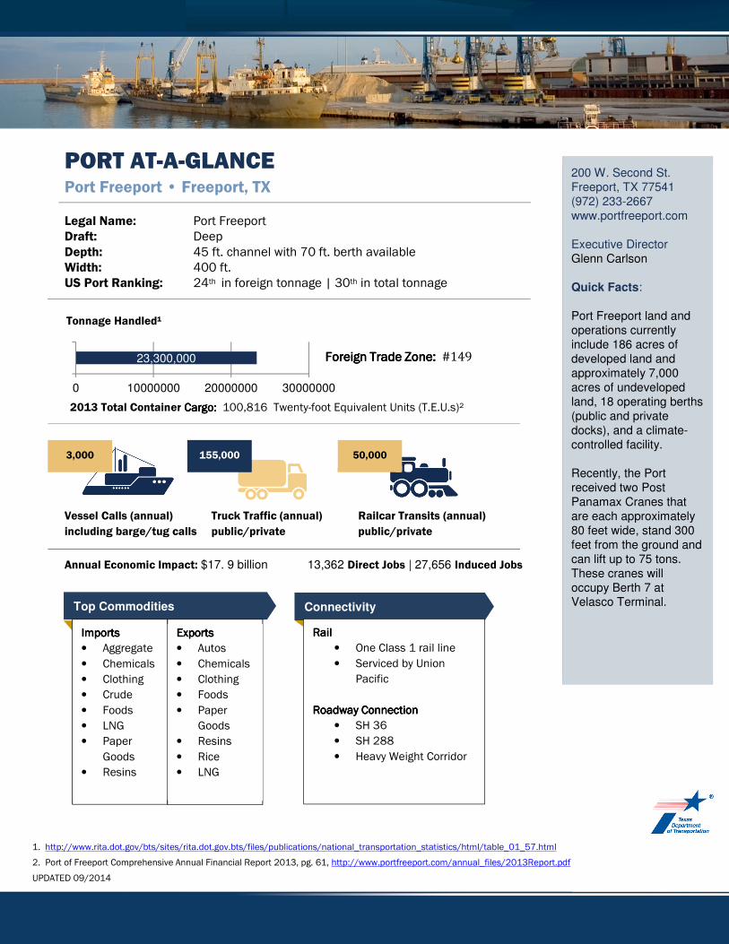
2. Port of Freeport Comprehensive Annual Financial Report 2013, pg. 61, http://www.portfreeport.com/annual_files/2013Report.pdf
UPDATED 09/2014
200 W. Second St. Freeport, TX 77541 (972) 233-2667 www.portfreeport.com Executive Director Glenn Carlson Quick Facts: Port Freeport land and operations currently include 186 acres of developed land and approximately 7,000 acres of undeveloped land, 18 operating berths (public and private docks), and a climate-controlled facility. Recently, the Port received two Post Panamax Cranes that are each approximately 80 feet wide, stand 300 feet from the ground and can lift up to 75 tons. These cranes will occupy Berth 7 at Velasco Terminal.
23,300,000
0 10000000 20000000 30000000
Tonnage Handled¹
Foreign Trade Zone: Foreign Trade Zone: Foreign Trade Zone: Foreign Trade Zone: #149
PORT AT-A-GLANCE Port Freeport • Freeport, TX
Legal Name: Port Freeport
Draft: Deep
Depth: 45 ft. channel with 70 ft. berth available
Width: 400 ft. US Port Ranking: 24th in foreign tonnage | 30th in total tonnage
2013 Total Container CargoCargoCargoCargo: : : : 100,816 Twenty-foot Equivalent Units (T.E.U.s)²
Vessel Calls (annual)
including barge/tug calls
Truck Traffic (annual)
public/private
Railcar Transits (annual)
public/private
Annual Economic Impact: $17. 9 billion 13,362 Direct Jobs | 27,656 Induced Jobs
3,000 155,000 50,000
Connectivity
RailRailRailRail
• One Class 1 rail line
• Serviced by Union
Pacific
Roadway ConnectionRoadway ConnectionRoadway ConnectionRoadway Connection
• SH 36
• SH 288
• Heavy Weight Corridor
Top Commodities
ImportsImportsImportsImports
• Aggregate
• Chemicals
• Clothing
• Crude
• Foods
• LNG
• Paper
Goods
• Resins
ExportsExportsExportsExports
• Autos
• Chemicals
• Clothing
• Foods
• Paper
Goods
• Resins
• Rice
• LNG

1. http://www.rita.dot.gov/bts/sites/rita.dot.gov.bts/files/publications/national_transportation_statistics/html/table_01_57.html
2. Port of Galveston FY 2013, Port of Galveston, September, 2014
UPDATED 08/2014
123 Rosenberg Ave. Galveston, TX 77550 www.portofgalveston.com (409) 766-6105 Port Director Michael Mierzwa Quick Facts: The Port of Galveston is located at the mouth of Galveston Bay along the Upper Texas Coast in Galveston County. Associated by the public as port terminal for cruises, it has historically handled containerized cargo, dry and liquid bulk, break-bulk, roll-on/roll-off cargo, and refrigerated and project cargo. Commodities arriving at the port are often destined for Galveston County, Harris County, Fort Bend County, Brazoria County, the state of Texas, as well as Texas’ neighboring states and the United States Midwest region. The Port offers: Significant Roll-on/Roll-off (RoRo) operation and its matured profile of RoRo operations. Vigorous cruise line port terminal. Proximity to the Port of Houston and Texas City
13,700,000
0 5000000 10000000 15000000
Tonnage Handled¹
PORT AT-A-GLANCE Port of Galveston • Galveston, TX Legal Name: Board of Trustees of the Galveston Wharves Draft: Deep Depth: 45ft. channel Width: 1,200ft. US Port Ranking: 4th busiest cruise port | 40th in total tonnage Foreign Trade Zone: #36
Total Container Cargo: 24,482 Twenty-foot Equivalent Units (T.E.U.s)²
Vessel Calls (annual)
including barge/tug calls
Annual Economic Impact: $3.06 BIL Direct Jobs 3,326| Induced Jobs 3,794
912
Connectivity
Rail Offers two Class 1 rail
lines Union Pacific BNSF Switch yards adjacent
to the Port’s West End. Galveston County Rural
Rail District Roadway Connection
IH 45
Top Commodities
Wind Power Equipment Agricultural Equipment Machinery Vehicles Fertilizer Products Lumber Products Military-related Cargo Bulk Grains Containers Linerboard and Paper Carbon Black Light Fuels

1. Texas Port Report, Texas Department of Transportation, June, 2014, pg. 5
UPDATED 08/2014
Port of Harlingen Authority P.O. Box 2646 Harlingen, TX 78551 (956) 423-0283
www.portofharlingen.com
Port Director (interim) Walker Smith Quick Facts: The Port of Harlingen is a shallow draft barge port located in the geographic center of the lower Rio Grande Valley four miles east of the city of Harlingen, Texas. The Port exports 100 percent of the sugar produced in the Rio Grande Valley. And, the Port imports critical Valley resources, such as 90 percent of fertilizer used by South Texas farmers and 70 percent of the refined petroleum products for the South Texas region. The Port is connected to the Gulf Intracoastal Waterway by means of the Harlingen Channel and offers: 650' (195m) general dry/liquid cargo wharf 100' (30m) dry bulk wharf Five smaller docks (50' X 25' or 7.5m X15m) located near the turning basin and extend into the Harlingen channel Over 150 acres of open storage
900,000
0 200000 400000 600000 800000 1000000
Tonnage Handled ¹
PORT AT-A-GLANCE Port of Harlingen • Harlingen, TX Legal Name: Port of Harlingen Authority Draft: Shallow Depth: 12ft. channel Width: 125ft.
Vessel Calls (annual) including barge/tug calls
Truck Traffic (annual) public/private
Railcar Transits (annual) public/private
Annual Economic Impact: $19.3 million Direct Jobs 40 | Induced Jobs 44
218 939 161
Connectivity
Rail Union Pacific Railroad
Roadway Connection
IH 69 US 77 US 83
Top Commodities
Liquid Fertilizer Sand Aggregates Gasoline Diesel Ethanol Raw Sugar Cotton Sorghum Corn

1. http://www.rita.dot.gov/bts/sites/rita.dot.gov.bts/files/publications/national_transportation_statistics/html/table_01_57.html
2. Port of Houston Authority, FY 2013, September 2014
UPDATED 09/2014
111 E. Loop North Houston, TX 77252-2562 (713) 670-2400 www.portofhouston.com Executive Director
Roger Guenther Quick Facts: The Port of Houston is a 25-mile-long complex of diversified public and private facilities located just a few hours by ship from the Gulf of Mexico. The Port of Houston is
made up of the public
terminals owned,
managed and leased by
the Port of Houston
Authority, and the 150-
plus private industrial
companies along the
52-mile long Houston
Ship Channel.
The port is consistently
ranked 1st in the US in
foreign waterborne
tonnage; 1st in US
imports; 1st in US export
tonnage and 2nd in the
US in total tonnage.
The Port is also the
nation’s leading
breakbulk post,
handling 65 percent of
all major U.S. project
cargo.
237,800,000
0 100000000 200000000 300000000
Tonnage Handled¹
PORT AT-A-GLANCE Port of Houston • Houston, TX
Legal Name: Port of Houston Authority
Draft: Deep
Depth: 45ft. channel
Width: 530ft. US Port Ranking: 1st in U.S. foreign tonnage | 2nd
in U.S. total tonnage
Foreign Trade ZoneForeign Trade ZoneForeign Trade ZoneForeign Trade Zone: #84
Total Container CargoCargoCargoCargo 1,950,071 Twenty-foot Equivalent Units (T.E.U.s)²
Vessel Calls (annual)
including barge/tug calls
Annual Economic Impact: $178.5 billion Direct Jobs 71,065 | Induced Jobs 49,835
208,000
Connectivity
RailRailRailRail
• Three Class 1 railroads
BNSF
Union Pacific
TexMex/KCS
• Gulf Coast Rail District
• Port Terminal Railroad
Association
Roadway ConnectionRoadway ConnectionRoadway ConnectionRoadway Connection
• IH 10
• IH 45 via 610 East
Loop
Top Commodities
• Consumer goods
• Crude fertilizers and
minerals
• Organic chemicals
• Iron
• Steel
• Iron/Steel products
• Beverages
• Cereals and cereal
products
• Plastics
• Misc. Chemical products
• Machinery

1. Texas Port Report, Texas Department of Transportation, June, 2014, pg. 5
UPDATED 08/2014
Port of Port Isabel 250 Industrial Drive Port Isabel, TX 78578 (956) 943-7826 www.portofportisabel.com Port Director Steve Bearden Quick Facts: The Port of Isabel is a deep water port that serves oil service vessels, various seafood processers, concrete manufacturers, and boat construction and repair companies. Waters interfacing with the Port include the Brownsville Ship Channel, Gulf Intracoastal Waterway (GIWW), Gulf of Mexico and Port Isabel Channel. The Port offers: 726 acres of waterfront land Storage: 45 acres open 5 docks (2 cargo, 1 roll-on/roll-off, 2 oil) 1,150 feet of deepwater docks 2,100 feet of deepwater frontage available
500,000
0 200,000 400,000 600,000
Tonnage Handled ¹
PORT AT-A-GLANCE Port of Port Isabel • Port Isabel, TX Legal Name: Port of Isabel/San Benito Navigation District Draft: Deep Depth: 36ft. channel Width: 200ft.
Vessel Calls (annual) including barge/tug calls
Truck Traffic (annual) public/private
Annual Economic Impact: $85.6 million Direct Jobs 605 | Induced Jobs 343
100 500
Connectivity
Roadway Connection
SH 100 IH 69 (US 59)
Top Commodities
Concrete Sand Aggregate

1. Texas Port Report, Texas Department of Transportation, June, 2014, pg. 5
UPDATED 8/2014
Orange County Navigation & Port District 1201 Childers Road Orange, Texas 77632 (409) 883-4363 www.portoforange.com Port Director Gene Bouillion Quick Facts: The Port of Orange is located on the Sabine-Neches waterway and is linked to the “Golden Triangle” ports which include the Port of Port Arthur, Beaumont and Orange. This area has become strategically more important to Texas ports growth since 2003. The Port of Orange has acted as a successful landlord port, complementing activities at larger ports on the Sabine-Neches channel. It is also used for lay berthing.
94,504
0 20,000 40,000 60,000 80,000 100,000
Tonnage¹
Foreign Trade Zone: #117
PORT AT-A-GLANCE Port of Orange • Orange, TX Legal Name: Orange County Navigation and Port District Draft: Deep Depth: 30 ft. channel Width: 200 ft.
Annual Economic Impact: $ 1.9 million
Connectivity
Rail Orange Port Terminal
Railway providing switching service to Union Pacific and agreement with BNSF.
Roadway Connection SH 87 IH 10
Top Commodities
On-site Marine Services which include:
Shipyards that can accommodate new construction
Repairs of tugs, barges and offshore petroleum drilling platforms
Dry dock services for barges and tugs

1. Texas Port Report, Texas Department of Transportation, June, 2014, pg. 5
UPDATED 08/2014
1602 Main Street P O Box 551 Palacios, Tx 77465 Phone: (361) 972-5556 Port Director Debbie Morris Quick Facts: The Port of Palacios is located on the Upper Gulf Coast approximately 110 miles south of Houston in Matagorda County. Traditionally, Palacios’ chief industry has been shrimpingᶾ. Fishing, tourism and shipbuilding, including barges, tugs and commercial and recreational boats of various sizes and configurations are increasing. The Port also provides a safe harbor for commercial fishermen from the three counties around Matagorda Bay – Matagorda, Jackson and Calhoun counties.
PORT AT-A-GLANCE Port of Palacios • Palacios, TX Legal Name: Matagorda County Navigation District #1 Draft: Shallow Depth: 12ft. channel Width: 400ft. Annual Economic Impact: $41.2 million Direct Jobs 541 | Induced Jobs 43
Connectivity
Roadway Connection SH 35
Top Commodities
Shrimping industry
Port of Palacios Offers:
4 Turning basins with 13,000 linear feet of dock
2 Recreational marinas with 55 slips
Over 800 acres of developable land owned by the Port

1. Tonnage of Top 50 U.S. Water Ports, Ranked by Total Tons, U.S Department of Transportation,
http://www.rita.dot.gov/bts/sites/rita.dot.gov.bts/files/publications/national_transportation_statistics/html/table_01_57.html
UPDATED 09/2014
UPDATED 08/2014
221 Houston Avenue Port Arthur, Texas (409) 983-2011 www.portofportarthur.com
Executive Port Director Floyd Gaspard Quick Facts: The Port of Port Arthur is situated directly on the Gulf Intracoastal Waterway (GIWW) and only 19 miles from the Gulf of Mexico. Port Arthur’s strategic location on the GIWW provides easy barge transportation on the U.S. inland waterway system to cities along the Mississippi, Ohio, Arkansas, and Tennessee, Missouri and Illinois Rivers plus its many tributaries. The Port is a military strategic port within the National Port Readiness Network Panamex size vessels began taking advantage of the ports new 2000 terminal expansion for lay berthing. The Port has emerged as a major break-bulk port for forest products, project cargo, steel and military redeployments.
30,300,000
0 10,000,00020,000,00030,000,00040,000,000
Tonnage Handled¹
Foreign Trade Zone: #116
PORT AT-A-GLANCE Port of Port Arthur • Port Arthur, TX Legal Name: Port of Port Arthur Navigation District of Jefferson County Draft: Deep Depth: 40ft. channel Width: 450ft. US Port Ranking: 24th in total tonnage¹
Vessel Calls (annual)
including barge/tug calls
Annual Economic Impact: $128 million
1,183
Connectivity
Rail One Class 1 rail lines Kansas City Southern Provide switching
through agreement with Union Pacific
Roadway Connection
IH 10 US 90A
Top Commodities
Forest Products (wood pellets)
Iron Steel Dry Bulk Bagged Cargo Bailed Cargo Military Cargo Project Cargo

400 W. Hidalgo Suite 200 Raymondville, Tx 78580 (956) 689-3332 www.portofmansfield.com Port Director: Ron Milles Quick Facts: In 2014, Port Mansfield is nominated as one of the top 10 fishing spots in the USA by Sport Fishing Magazine.
Geographically, Port Mansfield is located close to Laguna Madre, which has an abundance of marine wildlife, particularly reds, trout, flounder, and snook.
PORT AT-A-GLANCE Port Mansfield • Port Mansfield, TX Legal Name: Port Mansfield/Willacy County Navigation District Draft: Shallow Depth: 4ft. channel – federally authorized to 16 ft.
Connectivity
Roadway Connection • US 77 • SH 281 • SH 186
International Trade Opportunities:
• NAFTA trade with Mexico • Bulk construction
materials • Agricultural
products/supplies • Container-on-barge
business • South Texas Spaceport
business
Port Mansfield Offers:
• Ideal location for barge industry
• 1,760 port-owned acres for either commercial or residential lease
• Maintains an excellent channel surrounded by available waterfront and nearby off-waterfront property
• Excellent roads connecting to the future Interstate 69 NAFTA highway
UPDATED 09/2014

2425 Hwy 146 North Texas City, Tx 77590 (4409) 945-4461 www.tctrr.com Bill Mathis, President Quick Facts: The Port of Texas City is privately owned facility with stakeholders that include Union Pacific Railroad and BNSF Railway. The Port has won the Texas Safety Association’s Award of Honor in recognition of their outstanding efforts to ensure safety. The port has a man-made breakwater (Texas City Dike) to help prevent silting of the Houston Ship Channel. The Port operates three (3) MP1500 horsepower locomotives and 31 miles (51 km) of tracks as well as a state-of-the-art railroad track scale for customers.
78,000,000
0 50000000 100000000
Tonnage Handled¹
PORT AT-A-GLANCE Port of Texas City • Texas City, TX Legal Name: Texas City Terminal Railway Co. Draft: Deep Depth: 36 – 40 ft. channel US Port Ranking: 8th
Railcar Transits (annual)
public/private
Annual Economic Impact: $919.5 MIL² Direct Jobs 4,452 | Induced Jobs 4,293
Connectivity
Rail • Union Pacific Railroad • BNSF Railway • Switching operations
terminal at two junctions within 6 miles of the main yard
Roadway Connection
• FM 1764 • SH 146 • IH 45
Top Commodities
• Crude petroleum oil
• Refined petroleum
products
25,000¹
1. Port of Texas City website, http://www.tctrr.com/index.html 2. Guide to the Economic Value of Texas Ports, Center for Transportation Research The University of Texas at Austin, Dec. 2008, page 56
UPDATED 08/2014

1. Texas Port Report, Texas Department of Transportation, June, 2014, pg. 5
UPDATED 08/2014
1934 FM 1432 Victoria, Texas 77905 (361) 570-8855 www.portofvictoria.com Executive Director Paul “Skip” Kaup Quick Facts: The Port of Victoria is located approximately 80 miles northeast of Corpus Christi and recent expansions should significantly increase the tonnage operated by the port. The Port is a major player in the Eagle Ford Shale formation. It handles several unit trains of frac sand and millions of barrels of oil per month. The Port offers: New Industrial Park with multi-modal access New fleeting area that will provide a safe place for tow operators to tie off Center for chemical, construction, steel fabrication and agribusiness industries offering access to all transportation modes. New lighting system that allows for 24-hour operations
1 5,288,199
0 2000000 4000000 6000000
Tonnage Handled¹
PORT AT-A-GLANCE Port of Victoria • Victoria, TX Legal Name: Victoria County Navigation District Draft: Shallow Depth: 12ft. channel Width: 125ft. Foreign Trade Zone: #155
Vessel Calls (annual) including barge/tug calls
Railcar Transits (annual) public/private
Annual Economic Impact: $6.6 billion Direct Jobs | Induced Jobs 21,000
5,711 228,205 bbls
crude
Connectivity
Rail Rail spur with service
provided by Union Pacific with track agreements with Union Pacific, Kansas City Southern and BNSF
Roadway Connection
IH 69 (US 59) Heavy Weight Corridor
Top Commodities
Chemicals Petrochemicals Frac Sand Crude Oil Liquid Fertilizers Dry Fertilizers Grain Aggregates

1. Texas Port Report, Texas Department of Transportation, June, 2014, pg. 5
UPDATED 08/2014
402 South Main Street Seadrift, Texas 77983 (361) 785-6492 Chairman Jack Campbell, Jr Quick Facts: The West Side Calhoun County Navigation District (the District) was formed on July 8, 1946 and was approved for $125,000 bond issue for the building of the barge Canal. The District operates the Port of West Calhoun, which is linked to the Gulf Intracoastal Waterway via the Victoria Barge Canal.
PORT AT-A-GLANCE Port of West Calhoun • Seadrift, TX Legal Name: West Side Calhoun County Navigation District Draft: Shallow Depth: 12ft. channel
Port Facilities
Berths for commercial seafood productions
Oil exploration Gas exploration
The waterway is used for:
Barge shipments of industrial products including petroleum coke and chemicals
Connectivity
Highway SH 35 SH 185