pléiades 1a&1b spot 6&7 - plan nacional de teledetección · 1/24/2013 · persistent...
TRANSCRIPT

Pléiades 1A&1B – SPOT 6&7 A new era for constellation services
Alfonso Casado / Tomás Fernandez de Sevilla
Astrium GEO-Information Services
Reunión PNT Alta Resolución. IGN –Madrid – 24-01-2012
Th
is d
ocum
ent and its
conte
nt
is the p
ropert
y o
f A
str
ium
GE
O-I
nfo
rmatio
n S
erv
ices a
nd is s
tric
tly c
onfid
entia
l.
It s
hall
not
be c
om
munic
ate
d to a
ny t
hird p
art
y w
ithout
the w
ritt
en c
onsent
of
Astr
ium
GE
O-I
nfo
rmatio
n S
erv
ices.
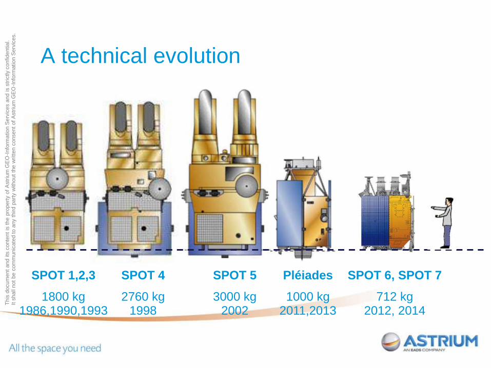
A technical evolution
SPOT 1,2,3
1800 kg 1986,1990,1993
SPOT 4
2760 kg 1998
SPOT 5
3000 kg 2002
SPOT 6, SPOT 7
712 kg 2012, 2014
Pléiades
1000 kg 2011,2013
Date - 3
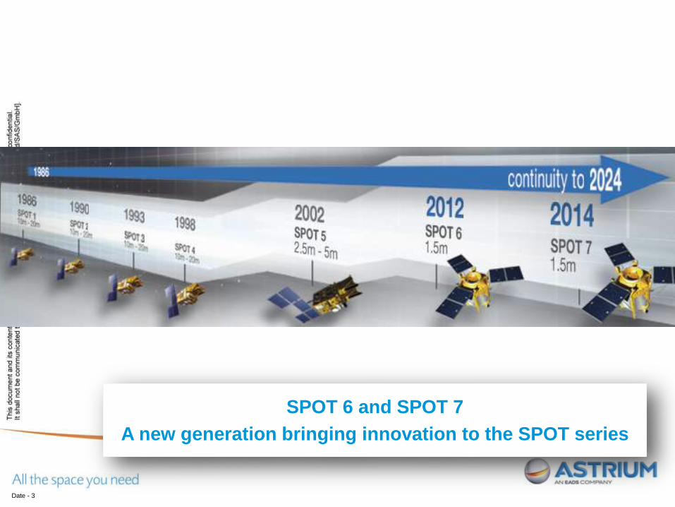
SPOT 6 and SPOT 7
A new generation bringing innovation to the SPOT series

Th
is d
ocum
ent and its
conte
nt
is the p
ropert
y o
f A
str
ium
GE
O-I
nfo
rmatio
n S
erv
ices a
nd is s
tric
tly c
onfid
entia
l.
It s
hall
not
be c
om
munic
ate
d to a
ny t
hird p
art
y w
ithout
the w
ritt
en c
onsent
of
Astr
ium
GE
O-I
nfo
rmatio
n S
erv
ices.
2011
Pléiades 1A
50cm


Th
is d
ocum
ent and its
conte
nt
is the p
ropert
y o
f A
str
ium
GE
O-I
nfo
rmatio
n S
erv
ices a
nd is s
tric
tly c
onfid
entia
l.
It s
hall
not
be c
om
munic
ate
d to a
ny t
hird p
art
y w
ithout
the w
ritt
en c
onsent
of
Astr
ium
GE
O-I
nfo
rmatio
n S
erv
ices.
2011 2012
Pléiades 1A
50cm
SPOT 6
1.5m
Th
is d
ocum
ent and its
conte
nt
is the p
ropert
y o
f A
str
ium
GE
O-I
nfo
rmatio
n S
erv
ices a
nd is s
tric
tly c
onfid
entia
l.
It s
hall
not
be c
om
munic
ate
d to a
ny t
hird p
art
y w
ithout
the w
ritt
en c
onsent
of
Astr
ium
GE
O-I
nfo
rmatio
n S
erv
ices.
Date - 9
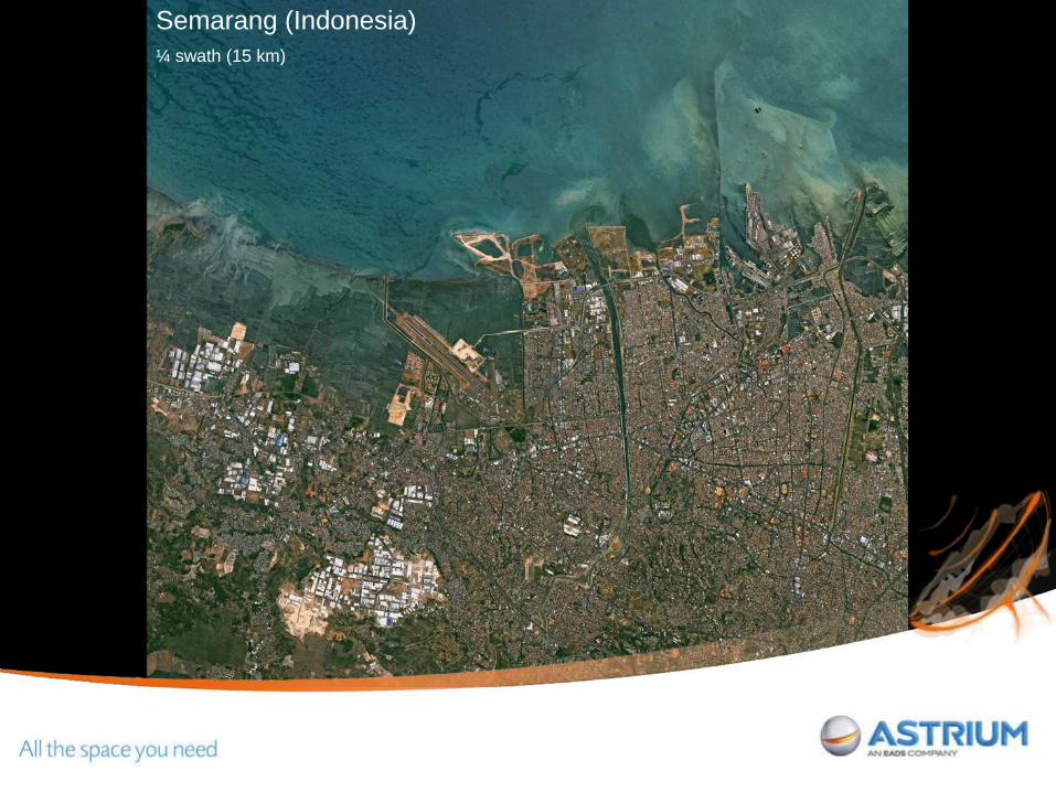
Semarang (Indonesia)
¼ swath (15 km)

Th
is d
ocum
ent and its
conte
nt
is the p
ropert
y o
f A
str
ium
GE
O-I
nfo
rmatio
n S
erv
ices a
nd is s
tric
tly c
onfid
entia
l.
It s
hall
not
be c
om
munic
ate
d to a
ny t
hird p
art
y w
ithout
the w
ritt
en c
onsent
of
Astr
ium
GE
O-I
nfo
rmatio
n S
erv
ices.

Th
is d
ocum
ent and its
conte
nt
is the p
ropert
y o
f A
str
ium
GE
O-I
nfo
rmatio
n S
erv
ices a
nd is s
tric
tly c
onfid
entia
l.
It s
hall
not
be c
om
munic
ate
d to a
ny t
hird p
art
y w
ithout
the w
ritt
en c
onsent
of
Astr
ium
GE
O-I
nfo
rmatio
n S
erv
ices.
Date - 11

Th
is d
ocum
ent and its
conte
nt
is the p
ropert
y o
f A
str
ium
GE
O-I
nfo
rmatio
n S
erv
ices a
nd is s
tric
tly c
onfid
entia
l.
It s
hall
not
be c
om
munic
ate
d to a
ny t
hird p
art
y w
ithout
the w
ritt
en c
onsent
of
Astr
ium
GE
O-I
nfo
rmatio
n S
erv
ices.
Date - 12


Th
is d
ocum
ent and its
conte
nt
is the p
ropert
y o
f A
str
ium
GE
O-I
nfo
rmatio
n S
erv
ices a
nd is s
tric
tly c
onfid
entia
l.
It s
hall
not
be c
om
munic
ate
d to a
ny t
hird p
art
y w
ithout
the w
ritt
en c
onsent
of
Astr
ium
GE
O-I
nfo
rmatio
n S
erv
ices.
2011 2012 2012 2014
Pléiades 1A
50cm
Pléiades 1B
50cm
SPOT 6
1.5m
SPOT 7
1.5m

Th
is d
ocum
ent and its
conte
nt
is the p
ropert
y o
f A
str
ium
GE
O-I
nfo
rmatio
n S
erv
ices a
nd is s
tric
tly c
onfid
entia
l.
It s
hall
not
be c
om
munic
ate
d to a
ny t
hird p
art
y w
ithout
the w
ritt
en c
onsent
of
Astr
ium
GE
O-I
nfo
rmatio
n S
erv
ices. Pléiades 1A&1B, SPOT 6&7
A new era for constellation services
Reactive
Available
Multi-scale
Th
is d
ocum
ent and its
conte
nt
is the p
ropert
y o
f A
str
ium
GE
O-I
nfo
rmatio
n S
erv
ices a
nd is s
tric
tly c
onfid
entia
l.
It s
hall
not
be c
om
munic
ate
d to a
ny t
hird p
art
y w
ithout
the w
ritt
en c
onsent
of
Astr
ium
GE
O-I
nfo
rmatio
n S
erv
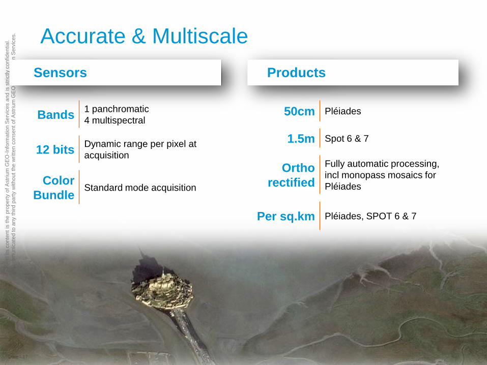
ices. Accurate & Multiscale
Date - 17
Sensors Products
Bands 1 panchromatic
4 multispectral
12 bits Dynamic range per pixel at
acquisition
Color
Bundle Standard mode acquisition
50cm Pléiades
1.5m Spot 6 & 7
Ortho
rectified
Fully automatic processing,
incl monopass mosaics for
Pléiades
Per sq.km Pléiades, SPOT 6 & 7
Th
is d
ocum
ent and its
conte
nt
is the p
ropert
y o
f A
str
ium
GE
O-I
nfo
rmatio
n S
erv
ices a
nd is s
tric
tly c
onfid
entia
l.
It s
hall
not
be c
om
munic
ate
d to a
ny t
hird p
art
y w
ithout
the w
ritt
en c
onsent
of
Astr
ium
GE
O-I
nfo
rmatio
n S
erv
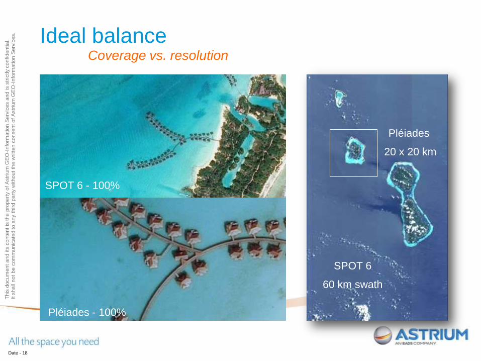
ices. Ideal balance
Date - 18
Coverage vs. resolution
SPOT 6
60 km swath
Pléiades
20 x 20 km
Pléiades - 100%
SPOT 6 - 100%

Th
is d
ocum
ent and its
conte
nt
is the p
ropert
y o
f A
str
ium
GE
O-I
nfo
rmatio
n S
erv
ices a
nd is s
tric
tly c
onfid
entia
l.
It s
hall
not
be c
om
munic
ate
d to a
ny t
hird p
art
y w
ithout
the w
ritt
en c
onsent
of
Astr
ium
GE
O-I
nfo
rmatio
n S
erv
ices. Accurate & Multi-scale
Date - 19
Ideal combination between coverage and resolution
Cost efficiency
Perfect overlay
Th
is d
ocum
ent and its
conte
nt
is the p
ropert
y o
f A
str
ium
GE
O-I
nfo
rmatio
n S
erv
ices a
nd is s
tric
tly c
onfid
entia
l.
It s
hall
not
be c
om
munic
ate
d to a
ny t
hird p
art
y w
ithout
the w
ritt
en c
onsent
of
Astr
ium
GE
O-I
nfo
rmatio
n S
erv
ices.
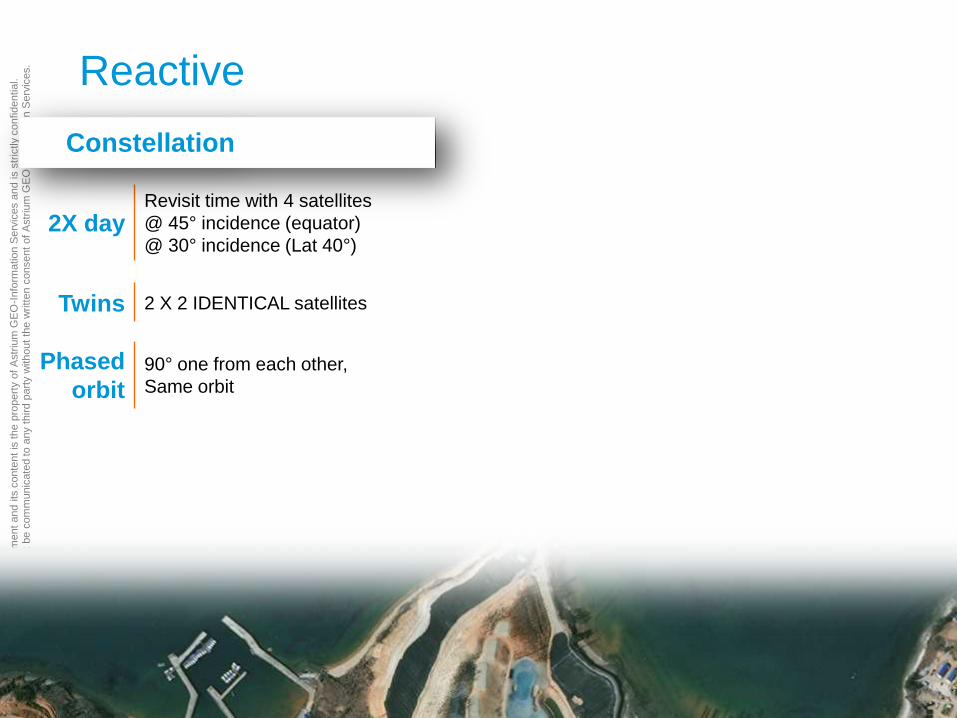
2X day Revisit time with 4 satellites
@ 45° incidence (equator)
@ 30° incidence (Lat 40°)
Twins 2 X 2 IDENTICAL satellites
Phased
orbit 90° one from each other,
Same orbit
Reactive
Date - 20
Constellation

Th
is d
ocum
ent and its
conte
nt
is the p
ropert
y o
f A
str
ium
GE
O-I
nfo
rmatio
n S
erv
ices a
nd is s
tric
tly c
onfid
entia
l.
It s
hall
not
be c
om
munic
ate
d to a
ny t
hird p
art
y w
ithout
the w
ritt
en c
onsent
of
Astr
ium
GE
O-I
nfo
rmatio
n S
erv
ices. Phased orbit
SPOT 7
Two twins satellites, featuring a true constellation:
- providing the same high-quality product,
- coherently operated (180° one from the other on the same orbit)
through a single interface: full leverage of synergies, for
Better reactivity, with an acquisition opportunity every
day whatever the location of a crisis or natural disaster,
Greater change detection, up-to-daily monitoring to
follow activity progress on a given site (industrial, military, civil
engineering piece of work, mining…)
Twofold coverage and acquisition capacity ideal for rapid coverage of large areas with twice more attemps
possible then twice more opportunities for a cloud-free image
Pléiades 1A
Pléiades 1B
SPOT 6

Th
is d
ocum
ent and its
conte
nt
is the p
ropert
y o
f A
str
ium
GE
O-I
nfo
rmatio
n S
erv
ices a
nd is s
tric
tly c
onfid
entia
l.
It s
hall
not
be c
om
munic
ate
d to a
ny t
hird p
art
y w
ithout
the w
ritt
en c
onsent
of
Astr
ium
GE
O-I
nfo
rmatio
n S
erv
ices.
2X day Revisit time with 4 satellites
@ 45° incidence (equator)
@ 30° incidence (Lat 40°)
Twins 2 X 2 IDENTICAL satellites
Phased
orbit 90° one from each other,
Same orbit
Reactive
Date - 22
Constellation Operations
Multiple Tasking plans per day

Th
is d
ocum
ent and its
conte
nt
is the p
ropert
y o
f A
str
ium
GE
O-I
nfo
rmatio
n S
erv
ices a
nd is s
tric
tly c
onfid
entia
l.
It s
hall
not
be c
om
munic
ate
d to a
ny t
hird p
art
y w
ithout
the w
ritt
en c
onsent
of
Astr
ium
GE
O-I
nfo
rmatio
n S
erv
ices. Multiple tasking plans per day
Polar Station Polar Station
North America
18:25 UT
South America
13:10 UT
Europe - Africa – ME
09:30 UT
China India
05:40 UT
Oceania
01:50 UT
Pacific
22:10 UT
Pacific
22:10 UT
Up to two hours before satellite enters into a new tasking area:
Take into account last-minute customer requests
Fine-tune tasking plan according to the most recent weather forecast for
increased success rate

Th
is d
ocum
ent and its
conte
nt
is the p
ropert
y o
f A
str
ium
GE
O-I
nfo
rmatio
n S
erv
ices a
nd is s
tric
tly c
onfid
entia
l.
It s
hall
not
be c
om
munic
ate
d to a
ny t
hird p
art
y w
ithout
the w
ritt
en c
onsent
of
Astr
ium
GE
O-I
nfo
rmatio
n S
erv
ices. Reactive
Date - 24
Constellation Operations
Multiple Tasking plans per day
30 min Pléiades 50 cm color ortho
production of a 20x20 km area … 2-3 h
…for a 60 x 60 km monopass
mosaic
Processing
< 1 h Spot 6 & 7 1,5 m color ortho
production of a 60x60 km area
2X day Revisit time with 4 satellites
Twins 2 X 2 IDENTICAL satellites
Phased
orbit 90° one from each other,
Same orbit
Th
is d
ocum
ent and its
conte
nt
is the p
ropert
y o
f A
str
ium
GE
O-I
nfo
rmatio
n S
erv
ices a
nd is s
tric
tly c
onfid
entia
l.
It s
hall
not
be c
om
munic
ate
d to a
ny t
hird p
art
y w
ithout
the w
ritt
en c
onsent
of
Astr
ium
GE
O-I
nfo
rmatio
n S
erv
ices. Reactive
Date - 25
Real operational reactivity for a first class level of
service
The right information at the right time
Enhanced image quality

Th
is d
ocum
ent and its
conte
nt
is the p
ropert
y o
f A
str
ium
GE
O-I
nfo
rmatio
n S
erv
ices a
nd is s
tric
tly c
onfid
entia
l.
It s
hall
not
be c
om
munic
ate
d to a
ny t
hird p
art
y w
ithout
the w
ritt
en c
onsent
of
Astr
ium
GE
O-I
nfo
rmatio
n S
erv
ices. Available
Date - 26
Up to 6M
sq.km Effective daily acquisition
capacity for SPOT6 & 7
4 CMGs (Control Moment Gyro)
Acquisition capacity
Agility
Cloud cover
optimization
Genuine order book
Full benefit of the
constellation’s agility
20 km Pléiades: widest swath on
the VHR market
60 km Spot 6 & 7 swath
Optimized production
Easier data handling
Maximized information on
target and surroundings
Up to 2M
sq.km Effective daily acquisition
capacity for 2 Pleiades 1A-1B

Th
is d
ocum
ent and its
conte
nt
is the p
ropert
y o
f A
str
ium
GE
O-I
nfo
rmatio
n S
erv
ices a
nd is s
tric
tly c
onfid
entia
l.
It s
hall
not
be c
om
munic
ate
d to a
ny t
hird p
art
y w
ithout
the w
ritt
en c
onsent
of
Astr
ium
GE
O-I
nfo
rmatio
n S
erv
ices. A state of the art agility
Date - 27
Twice as many images
collected as satellites
without CMGs during the
same orbit slot
Increase acquisition
opportunities, and
probability of success:
Shortened average
acquisition window

Th
is d
ocum
ent and its
conte
nt
is the p
ropert
y o
f A
str
ium
GE
O-I
nfo
rmatio
n S
erv
ices a
nd is s
tric
tly c
onfid
entia
l.
It s
hall
not
be c
om
munic
ate
d to a
ny t
hird p
art
y w
ithout
the w
ritt
en c
onsent
of
Astr
ium
GE
O-I
nfo
rmatio
n S
erv
ices.
4 CMGs
Monopass
collection
scenarios
Multi-target,
Mosaic,
Stereo, tristereo,
Border / coastal / corridor
Available
Date - 28
6M sq.km Effective daily acquisition
capacity for 4 satellites
Acquisition capacity Agility
20 km Pléiades: widest swath on
the VHR market
60 km Spot 6 & 7 swath

Th
is d
ocum
ent and its
conte
nt
is the p
ropert
y o
f A
str
ium
GE
O-I
nfo
rmatio
n S
erv
ices a
nd is s
tric
tly c
onfid
entia
l.
It s
hall
not
be c
om
munic
ate
d to a
ny t
hird p
art
y w
ithout
the w
ritt
en c
onsent
of
Astr
ium
GE
O-I
nfo
rmatio
n S
erv
ices. Monopass collection scenarios
Date - 29
Typically 20 targets
over 1,000 km within a
+/-30 deg corridor for
Pléiades, 600 km-long strips with
Spot 6 & 7
Up to 100 x 150km with Pléiades,
240 x 240km with
Spot 6 & 7
To compute
accurate 3D
Models
To enhance photo interpretation
(avoiding hidden items)
To follow
linear targets such as coasts, borders,
roads, pipelines, rivers

Th
is d
ocum
ent and its
conte
nt
is the p
ropert
y o
f A
str
ium
GE
O-I
nfo
rmatio
n S
erv
ices a
nd is s
tric
tly c
onfid
entia
l.
It s
hall
not
be c
om
munic
ate
d to a
ny t
hird p
art
y w
ithout
the w
ritt
en c
onsent
of
Astr
ium
GE
O-I
nfo
rmatio
n S
erv
ices. Persistent surveillance - Pleiades
Date - 30
Assess trajectories,
speed, direction of
moving targets
Detect, characterize and
identify small moving
elements that would be
undetectable elsewhere with
a single shooting at a similar
resolution (e.g. people)
Up to 25 images (8 to
9 secs between each
acquisition)

A PLÉIADES PRODUCT Overview of
Date - 31

Th
is d
ocum
ent and its
conte
nt
is the p
ropert
y o
f A
str
ium
GE
O-I
nfo
rmatio
n S
erv
ices a
nd is s
tric
tly c
onfid
entia
l.
It s
hall
not
be c
om
munic
ate
d to a
ny t
hird p
art
y w
ithout
the w
ritt
en c
onsent
of
Astr
ium
GE
O-I
nfo
rmatio
n S
erv
ices. Processing levels
Primary level (~ 1A SPOT 5 – sensor geometry) - Automatic
Radiometric corrections (radiocorrection and panchro restoration)
Geometric corrections restoring perfect linear conditions of
acquisition Equivalent of a sampled linear single array
Perfect P and MS registration
Corrected attitude: virtual smooth attitude
Corrected ephemeris: perfect datation
Ortho level (georeferenced) - Automatic
Primary level corrections
Projection (most of the current projections)
Terrain corrections Applied thanks to a DTED2-class DEM such as Reference3D (with or w.o. GCPs)
Automatic processing of orthomosaics up to 1 sq degree (seamless)
Tailored Orthos for increased precision Custom DEM, GCPs ingestion available upon request
Date - 32

Th
is d
ocum
ent and its
conte
nt
is the p
ropert
y o
f A
str
ium
GE
O-I
nfo
rmatio
n S
erv
ices a
nd is s
tric
tly c
onfid
entia
l.
It s
hall
not
be c
om
munic
ate
d to a
ny t
hird p
art
y w
ithout
the w
ritt
en c
onsent
of
Astr
ium
GE
O-I
nfo
rmatio
n S
erv
ices. Products resolution and spectral bands
Panchromatic (50 cm)
470 – 830 nm
Multispectral (2 m)
Blue: 430 – 550 nm
Green: 500 – 620 nm
Red: 590 – 710 nm
Near infrared: 740 – 940 nm
Pan & MS acquired simultaneously
On board telemetry coded over 12 bits
Deliverable
Pan only, MS only, Bundle, Pansharpened 3 or 4 bands
Resolution < 1 m up to 30° acquisition angle (combined pitch&roll)
Date - 33
Th
is d
ocum
ent and its
conte
nt
is the p
ropert
y o
f A
str
ium
GE
O-I
nfo
rmatio
n S
erv
ices a
nd is s
tric
tly c
onfid
entia
l.
It s
hall
not
be c
om
munic
ate
d to a
ny t
hird p
art
y w
ithout
the w
ritt
en c
onsent
of
Astr
ium
GE
O-I
nfo
rmatio
n S
erv
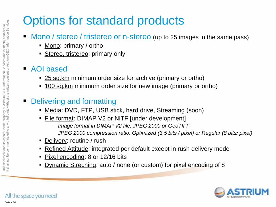
ices. Options for standard products
Mono / stereo / tristereo or n-stereo (up to 25 images in the same pass)
Mono: primary / ortho
Stereo, tristereo: primary only
AOI based 25 sq.km minimum order size for archive (primary or ortho)
100 sq.km minimum order size for new image (primary or ortho)
Delivering and formatting Media: DVD, FTP, USB stick, hard drive, Streaming (soon)
File format: DIMAP V2 or NITF [under development]
Image format in DIMAP V2 file: JPEG 2000 or GeoTIFF
JPEG 2000 compression ratio: Optimized (3.5 bits / pixel) or Regular (8 bits/ pixel)
Delivery: routine / rush
Refined Attitude: integrated per default except in rush delivery mode
Pixel encoding: 8 or 12/16 bits
Dynamic Streching: auto / none (or custom) for pixel encoding of 8
Date - 34
Th
is d
ocum
ent and its
conte
nt
is the p
ropert
y o
f A
str
ium
GE
O-I
nfo
rmatio
n S
erv
ices a
nd is s
tric
tly c
onfid
entia
l.
It s
hall
not
be c
om
munic
ate
d to a
ny t
hird p
art
y w
ithout
the w
ritt
en c
onsent
of
Astr
ium
GE
O-I
nfo
rmatio
n S
erv
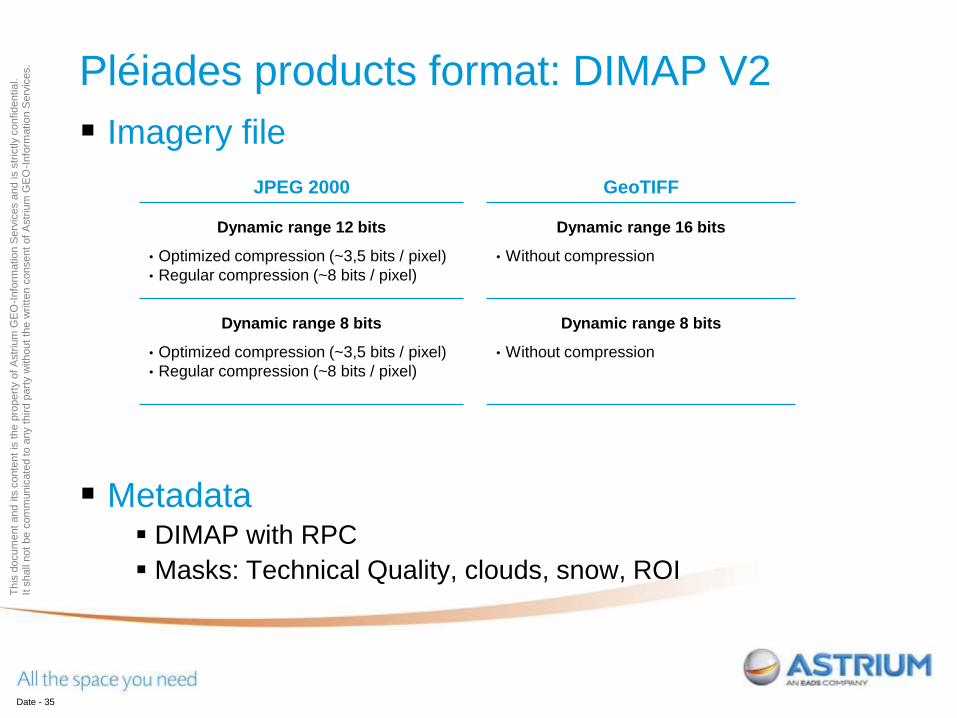
ices. Pléiades products format: DIMAP V2
Imagery file
Metadata DIMAP with RPC
Masks: Technical Quality, clouds, snow, ROI
Date - 35
JPEG 2000 GeoTIFF
Dynamic range 12 bits
• Optimized compression (~3,5 bits / pixel)
• Regular compression (~8 bits / pixel)
Dynamic range 16 bits
• Without compression
Dynamic range 8 bits
• Optimized compression (~3,5 bits / pixel)
• Regular compression (~8 bits / pixel)
Dynamic range 8 bits
• Without compression

Th
is d
ocum
ent and its
conte
nt
is the p
ropert
y o
f A
str
ium
GE
O-I
nfo
rmatio
n S
erv
ices a
nd is s
tric
tly c
onfid
entia
l.
It s
hall
not
be c
om
munic
ate
d to a
ny t
hird p
art
y w
ithout
the w
ritt
en c
onsent
of
Astr
ium
GE
O-I
nfo
rmatio
n S
erv
ices.
DIMAP V2 improvements
Enhanced usability and ease compared to DIMAP V1 Integrates GeoTiff or JPEG 2000
RPCs included:
Ease orthorectification or geometric processing by the user
Addition of a KMZ:
Rapid, easy and user-friendly display of main metadata in Google Earth
Environment
Improvement of the product file naming:
Get the first information about the product (sensor, date, processing level, spectral
band combination) at an immediate glance
More masks:
Image quality mask
Cloud mask
Multisensor DIMAP V2 is SPOT 6 & 7 format too
Date - 36

Th
is d
ocum
ent and its
conte
nt
is the p
ropert
y o
f A
str
ium
GE
O-I
nfo
rmatio
n S
erv
ices a
nd is s
tric
tly c
onfid
entia
l.
It s
hall
not
be c
om
munic
ate
d to a
ny t
hird p
art
y w
ithout
the w
ritt
en c
onsent
of
Astr
ium
GE
O-I
nfo
rmatio
n S
erv
ices. Image format: JPEG 2000 and GeoTIFF
50 cm, Pansharpened 4 bands (R, G, B, NIR), 20 x 20 km
Date - 37
JPEG 2000 Bit-depth12 bits
GeoTIFF Bit-depth 12 bits
(storage 16 bits)
• Optimized: 2.6 GB
• Regular: 6 GB (max)
• 12 GB
Bit-depth 8 bits Bit-depth 8 bits
• Optimized: 2.6 GB
• Regular: 6 GB (max)
• 6 GB
JPEG 2000 optimizes file size (up to 5 times less!), combining excellent
preservation of the information content with high compression rates

SPOT 6-7 Overview of
Date - 38

Th
is d
ocum
ent and its
conte
nt
is the p
ropert
y o
f A
str
ium
GE
O-I
nfo
rmatio
n S
erv
ices a
nd is s
tric
tly c
onfid
entia
l.
It s
hall
not
be c
om
munic
ate
d to a
ny t
hird p
art
y w
ithout
the w
ritt
en c
onsent
of
Astr
ium
GE
O-I
nfo
rmatio
n S
erv
ices.
SPOT 6 | SPOT 7 versus SPOT 5
SPOT 5 SPOT 6 | SPOT 7
Launch mass 3 000 kg 712 kg
Size Body: 3.1 x 3.1 x 5.7 m
Solar array wingspan 8 m
Body: ~ 1.55 x 1.75 x 2.7 m
Solar array wingspan 5,4 m2
Design Lifetime 5 years 10 years
Product resolution / swath 2. 5 m / 2 x 60 km 1.5 m / 60 km + multi-strip in single pass
capacity
Daily image acquisition
capability
in HR mode (i.e. HRG only)
up to 3 Mkm² / day in operation
2 Mkm² / day average
up to 3 Mkm² / day in operation/sat
2.2 Mkm² / day average/sat
Agility Roll only (mirrors), 30° in 8 s All axes (platform), 30° in 14 s
Single pass stereo capability Only through HRS Single pass stereo and tri-stereo
Geolocation 50 m without GCP 35 m without GCP; 10 m with
Reference3D
System tasking reactivity 1 mission plan / day 6 missions plans / day / satellite

Th
is d
ocum
ent and its
conte
nt
is the p
ropert
y o
f A
str
ium
GE
O-I
nfo
rmatio
n S
erv
ices a
nd is s
tric
tly c
onfid
entia
l.
It s
hall
not
be c
om
munic
ate
d to a
ny t
hird p
art
y w
ithout
the w
ritt
en c
onsent
of
Astr
ium
GE
O-I
nfo
rmatio
n S
erv
ices.
A sun-synchronous orbit
Altitude: 694 km
Cycle: 26 days
Orbits per day: 14 + 15/26
Period: 98.64’
Local time at descending node 10:00 (10:30 for Pléiades 1A/ Pléiades 1B )
A phased-constellation:
4 satellites in quadrature
Ground tracks of both constellations are almost overlayed
SPOT 6 | SPOT 7 Constellation
Th
is d
ocum
ent and its
conte
nt
is the p
ropert
y o
f A
str
ium
GE
O-I
nfo
rmatio
n S
erv
ices a
nd is s
tric
tly c
onfid
entia
l.
It s
hall
not
be c
om
munic
ate
d to a
ny t
hird p
art
y w
ithout
the w
ritt
en c
onsent
of
Astr
ium
GE
O-I
nfo
rmatio
n S
erv
ices.
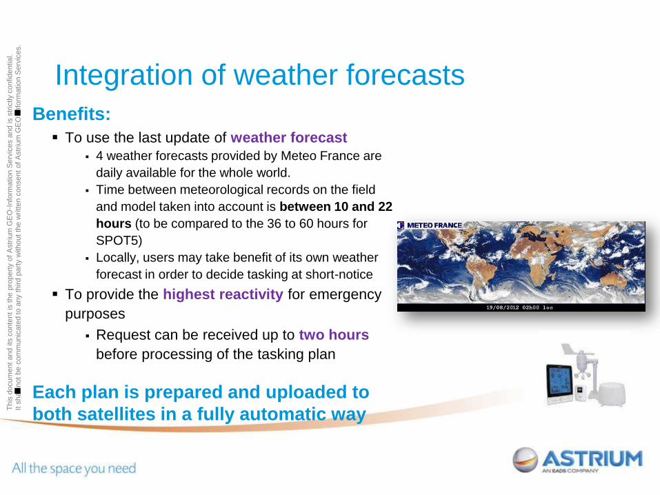
Integration of weather forecasts
Benefits:
To use the last update of weather forecast
4 weather forecasts provided by Meteo France are
daily available for the whole world.
Time between meteorological records on the field
and model taken into account is between 10 and 22
hours (to be compared to the 36 to 60 hours for
SPOT5)
Locally, users may take benefit of its own weather
forecast in order to decide tasking at short-notice
To provide the highest reactivity for emergency
purposes
Request can be received up to two hours
before processing of the tasking plan
Each plan is prepared and uploaded to
both satellites in a fully automatic way

Th
is d
ocum
ent and its
conte
nt
is the p
ropert
y o
f A
str
ium
GE
O-I
nfo
rmatio
n S
erv
ices a
nd is s
tric
tly c
onfid
entia
l.
It s
hall
not
be c
om
munic
ate
d to a
ny t
hird p
art
y w
ithout
the w
ritt
en c
onsent
of
Astr
ium
GE
O-I
nfo
rmatio
n S
erv
ices.
Viewing angle
The agility of SPOT 6 and SPOT 7
allows them to move viewing
angle in roll and pitch: Standard: +/- 30°
Extended: +/- 45°
Nadir view
Standard
Extended
Geometric distortion may occur for extended viewing angles.
This capacity is mainly used in case of emergency requests.
45° 45°
30° 30°

Th
is d
ocum
ent and its
conte
nt
is the p
ropert
y o
f A
str
ium
GE
O-I
nfo
rmatio
n S
erv
ices a
nd is s
tric
tly c
onfid
entia
l.
It s
hall
not
be c
om
munic
ate
d to a
ny t
hird p
art
y w
ithout
the w
ritt
en c
onsent
of
Astr
ium
GE
O-I
nfo
rmatio
n S
erv
ices.
Simulation of coverage over Morocco: completion in less than 6 weeks.
Collection capacity
Date - 43
System fully designed and configured to cover broad areas
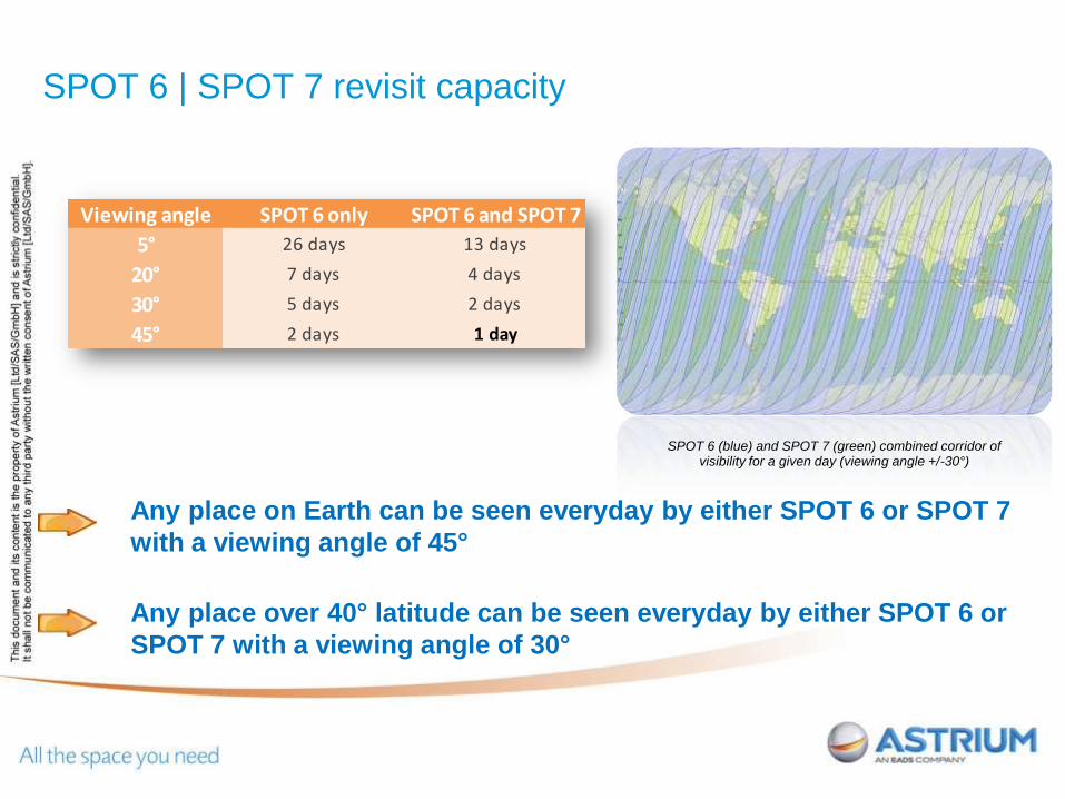
Any place on Earth can be seen everyday by either SPOT 6 or SPOT 7
with a viewing angle of 45°
Any place over 40° latitude can be seen everyday by either SPOT 6 or
SPOT 7 with a viewing angle of 30°
SPOT 6 | SPOT 7 revisit capacity
SPOT 6 (blue) and SPOT 7 (green) combined corridor of visibility for a given day (viewing angle +/-30°)
Viewing angle SPOT 6 only SPOT 6 and SPOT 7
5° 26 days 13 days
20° 7 days 4 days
30° 5 days 2 days
45° 2 days 1 day
Th
is d
ocum
ent and its
conte
nt
is the p
ropert
y o
f A
str
ium
GE
O-I
nfo
rmatio
n S
erv
ices a
nd is s
tric
tly c
onfid
entia
l.
It s
hall
not
be c
om
munic
ate
d to a
ny t
hird p
art
y w
ithout
the w
ritt
en c
onsent
of
Astr
ium
GE
O-I
nfo
rmatio
n S
erv
ices.
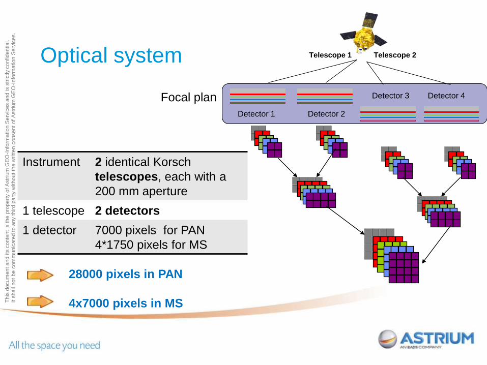
Optical system
28000 pixels in PAN
4x7000 pixels in MS
Instrument 2 identical Korsch
telescopes, each with a
200 mm aperture
1 telescope 2 detectors
1 detector 7000 pixels for PAN
4*1750 pixels for MS
Focal plan
Detector 1 Detector 2
Detector 3 Detector 4
Telescope 1 Telescope 2
Th
is d
ocum
ent and its
conte
nt
is the p
ropert
y o
f A
str
ium
GE
O-I
nfo
rmatio
n S
erv
ices a
nd is s
tric
tly c
onfid
entia
l.
It s
hall
not
be c
om
munic
ate
d to a
ny t
hird p
art
y w
ithout
the w
ritt
en c
onsent
of
Astr
ium
GE
O-I
nfo
rmatio
n S
erv
ices.
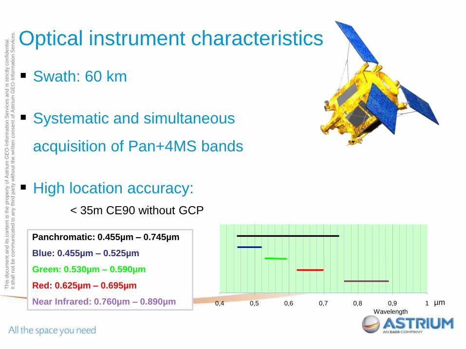
Swath: 60 km
Systematic and simultaneous
acquisition of Pan+4MS bands
High location accuracy:
< 35m CE90 without GCP
0,4 0,5 0,6 0,7 0,8 0,9 1
Wavelength
Optical instrument characteristics
Panchromatic: 0.455µm – 0.745µm
Blue: 0.455µm – 0.525µm
Green: 0.530µm – 0.590µm
Red: 0.625µm – 0.695µm
Near Infrared: 0.760µm – 0.890µm µm
Th
is d
ocum
ent and its
conte
nt
is the p
ropert
y o
f A
str
ium
GE
O-I
nfo
rmatio
n S
erv
ices a
nd is s
tric
tly c
onfid
entia
l.
It s
hall
not
be c
om
munic
ate
d to a
ny t
hird p
art
y w
ithout
the w
ritt
en c
onsent
of
Astr
ium
GE
O-I
nfo
rmatio
n S
erv
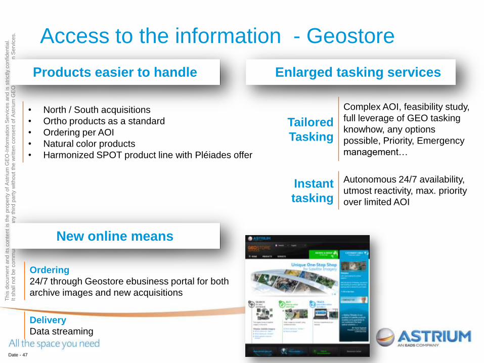
ices. Access to the information - Geostore
Date - 47
Products easier to handle Enlarged tasking services
• North / South acquisitions
• Ortho products as a standard
• Ordering per AOI
• Natural color products
• Harmonized SPOT product line with Pléiades offer
Tailored
Tasking
Complex AOI, feasibility study,
full leverage of GEO tasking
knowhow, any options
possible, Priority, Emergency
management…
Instant
tasking
Autonomous 24/7 availability,
utmost reactivity, max. priority
over limited AOI
New online means
Ordering
24/7 through Geostore ebusiness portal for both
archive images and new acquisitions
Delivery
Data streaming

Th
is d
ocum
ent and its
conte
nt
is the p
ropert
y o
f A
str
ium
GE
O-I
nfo
rmatio
n S
erv
ices a
nd is s
tric
tly c
onfid
entia
l.
It s
hall
not
be c
om
munic
ate
d to a
ny t
hird p
art
y w
ithout
the w
ritt
en c
onsent
of
Astr
ium
GE
O-I
nfo
rmatio
n S
erv
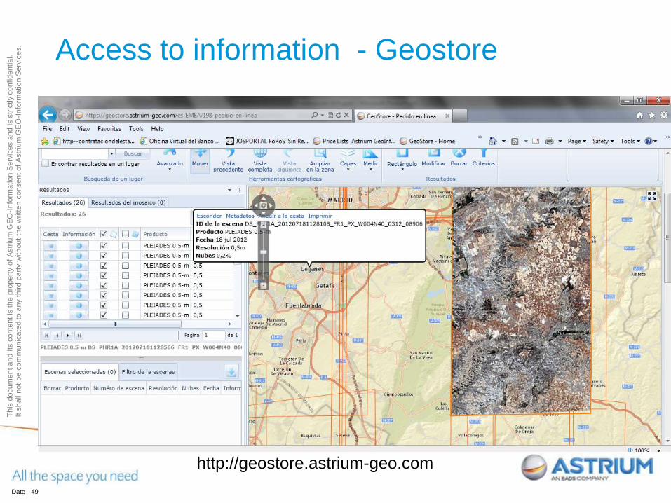
ices. Access to information - Geostore
Date - 48
Th
is d
ocum
ent and its
conte
nt
is the p
ropert
y o
f A
str
ium
GE
O-I
nfo
rmatio
n S
erv
ices a
nd is s
tric
tly c
onfid
entia
l.
It s
hall
not
be c
om
munic
ate
d to a
ny t
hird p
art
y w
ithout
the w
ritt
en c
onsent
of
Astr
ium
GE
O-I
nfo
rmatio
n S
erv
ices. Access to information - Geostore
Date - 49
http://geostore.astrium-geo.com

Th
is d
ocum
ent and its
conte
nt
is the p
ropert
y o
f A
str
ium
GE
O-I
nfo
rmatio
n S
erv
ices a
nd is s
tric
tly c
onfid
entia
l.
It s
hall
not
be c
om
munic
ate
d to a
ny t
hird p
art
y w
ithout
the w
ritt
en c
onsent
of
Astr
ium
GE
O-I
nfo
rmatio
n S
erv
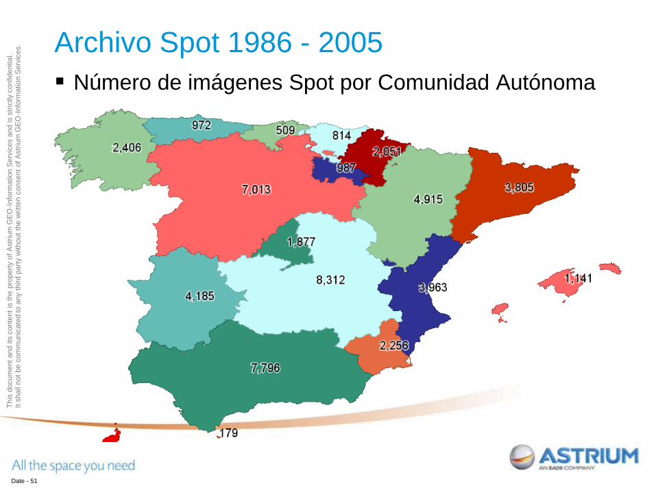
ices. Archivo Spot 1986 - 2005
Date - 50
Astrium-GEO ofrece su archivo de imágenes Spot
1986 – 2005 (año a partir del cual PNT incluye
imágenes Spot).
Incluye imágenes de resoluciones 2.5 m, 5 m, 10 m
y 20 m, tanto en pancromático como multiespectral,
con una cobertura nubosa < del 20%.
El archivo entre los años1986-2005 tiene alrededor
de 55.000 imágenes de España (Península y
Baleares) . El archivo completo entre1986-2012
tiene 95.000 imágenes.
*Canarias también está disponible pero no se ha incluido en este análisis.
Th
is d
ocum
ent and its
conte
nt
is the p
ropert
y o
f A
str
ium
GE
O-I
nfo
rmatio
n S
erv
ices a
nd is s
tric
tly c
onfid
entia
l.
It s
hall
not
be c
om
munic
ate
d to a
ny t
hird p
art
y w
ithout
the w
ritt
en c
onsent
of
Astr
ium
GE
O-I
nfo
rmatio
n S
erv
ices. Archivo Spot 1986 - 2005
Date - 51
Número de imágenes Spot por Comunidad Autónoma
Th
is d
ocum
ent and its
conte
nt
is the p
ropert
y o
f A
str
ium
GE
O-I
nfo
rmatio
n S
erv
ices a
nd is s
tric
tly c
onfid
entia
l.
It s
hall
not
be c
om
munic
ate
d to a
ny t
hird p
art
y w
ithout
the w
ritt
en c
onsent
of
Astr
ium
GE
O-I
nfo
rmatio
n S
erv
ices.
52
Thank you for your attention

Th
is d
ocum
ent and its
conte
nt
is the p
ropert
y o
f A
str
ium
GE
O-I
nfo
rmatio
n S
erv
ices a
nd is s
tric
tly c
onfid
entia
l.
It s
hall
not
be c
om
munic
ate
d to a
ny t
hird p
art
y w
ithout
the w
ritt
en c
onsent
of
Astr
ium
GE
O-I
nfo
rmatio
n S
erv
ices.
www.astrium-geo.com
www.infoterra.es