pleistocene glaciers, lakes, and floods in north …pleistocene glaciers, lakes, and floods in...
TRANSCRIPT

175
The Geological Society of AmericaField Guide 49
Pleistocene glaciers, lakes, and floods in north-central Washington State
Richard B. WaittU.S. Geological Survey, 1300 SE Cardinal Ct. #100, Vancouver, Washington 98683, USA
ABSTRACT
The Methow, Chelan, Wenatchee, and other terrane blocks accreted in late Mesozoic to Eocene times. Methow valley is excavated in an exotic terrane of folded Mesozoic sedimentary and volcanic rocks faulted between crystalline blocks. Repeated floods of Columbia River Basalt ca. 16 Ma drowned a backarc basin to the southeast.
Cirques, arêtes, and U-shaped hanging troughs brand the Methow, Skagit, and Chelan headwaters. The late Wisconsin Cordilleran ice sheet beveled the alpine topography and deposited drift. Cordilleran ice flowed into the heads of Methow trib-utaries and overflowed from Skagit tributaries to greatly augment Chelan trough’s glacier. Joined Okanogan and Methow ice flowed down Columbia valley and up lower Chelan trough. This tongue met the ice-sheet tongue flowing southeast down Chelan valley. Successively lower ice-marginal channels and kame terraces show that the ice sheet withered away largely by downwasting.
Immense late Wisconsin floods from glacial Lake Missoula occasionally swept the Chelan-Vantage reach of Columbia valley by different routes. The earliest debacles, nearly 19,000 cal yr B.P. (= 19.0 k.y.), raged 335 m deep down Columbia valley and built high Pangborn bar at Wenatchee. As Cordilleran ice blocked the northwest of Columbia valley, several giant floods descended Moses Coulee and backflooded up the Columbia. As advancing ice then blocked Moses Coulee, Grand Coulee to Quincy basin became the westmost floodway. From Quincy basin many Missoula floods back-flowed 50 km upvalley past Wenatchee 18–15.5 k.y. ago. Receding ice dammed glacial Lake Columbia centuries more—till it burst ~15 k.y. ago. After Glacier Peak ashfall ~13.6 k.y. ago, smaller great flood(s) swept down the Columbia from glacial Lake Kootenay in British Columbia. A cache of huge fluted Clovis points had been laid atop Pangborn bar (East Wenatchee) after the Glacier Peak ashfall. Clovis people came two and a half millennia after the last small Missoula flood, two millennia after the glacial Lake Columbia flood.
This timing by radiocarbon methods is under review by newer exposure dating—10Be, 26Al, and 36Cl methods.
Waitt, R.B., 2017, Pleistocene glaciers, lakes, and floods in north-central Washington State, in Haugerud, R.A., and Kelsey, H.M., eds., From the Puget Lowland to East of the Cascade Range: Geologic Excursions in the Pacific Northwest: Geological Society of America Field Guide 49, p. 175–205, doi:10.1130/2017.0049(08).
© 2017 The Geological Society of America. All rights reserved. For permission to copy, contact [email protected].
8

176 R.B. Waitt
INTRODUCTION
Geology is eminently an outdoor science. Strata, moun-tains, valleys, volcanoes cannot be taken into a classroom. So opens James Dwight Dana’s 1895 The Geological Story, Briefly Told. But in recent decades, geology has moved more and more indoors—to computers, specialized laboratories, and numeri-cal modeling. Gone are the long field seasons with Brunton and map as the base of a dissertation. Yet a GSA field trip remains an eminently outdoor venture. Here we engage granite and the grus, mountains and moraines. On till we meet again.
From Seattle this field trip crosses the North Cascade Range, explores Columbia valley to the east, and recrosses the Cascades farther south (Fig. 1). In the eastern Cascades we explore effects of late Wisconsin alpine and Cordilleran ice-sheet glaciation in the Methow basin and of ice-sheet glaciation in lower Chelan basin. But the trip focuses on last-glacial megafloods in Columbia valley, in a backflooded tributary, and in the great scabland chan-nels of Moses and Grand Coulees. We touch upon alpine-glacial effects in Wenatchee valley. Megaflood effects have been some-what less known in this northwestern part of the megaflooded
region—the ‘great bend’ of Columbia valley and Moses Cou-lee—than in the Channeled Scabland including Grand Coulee.
This is a partial guide to the field trip. Other trip leaders—Jim O’Connor, Victor Baker, Andrea Balbas—will supplement with handouts including a recent scablands field guide (Baker et al., 2016) and a recent paper on dating flood and glacial depos-its by the beryllium exposure method (Balbas et al., 2017).
Elements of this guide derive from previous Missoula-floods guidebooks (Waitt, 1980b, 1994; Waitt et al., 2009), from sev-eral past papers, from a recent paper (Waitt, 2016), and from in-preparation reports.
Geologic Overview
The Methow, once thought a graben in a stable Earth, has proven to be one of many allochthonous terranes that converging tectonic plates plastered onto the continent (Fig. 2) (Haugerud and Tabor, 2009; Monger and Brown, 2016). The Methow block comprises marine shale, sandstone, conglomerate, and island-arc tuff (Barksdale, 1975) that accumulated in a forearc basin 180–100 Ma. This ocean terrane welded to the continent
Figure 1. Field-trip stops plotted on central part of an online Washington State highway map. Nonstops indicated in guide on Days 1 and 3: R—Rainy Pass; L—Lone Butte; Y—Yeager Rock; P—Pot Hills; E—Esker; F—Foster Creek valley.
1.2
1.1
1.3
1.4
1.5
1.6
4.1
4.2 4.3
4.43.1
3.2
3.3
3.4
3.53.6
3.7
2.2
2.1
2.32.4
2.5
2.6
R
L Y P EF
Winthrop
PaterosBrewster
Grand CouleeDam
Leavenworth
Wenatchee
EntiatChelan
Bridgeport
Marblemount

Pleistocene glaciers, lakes, and floods in north-central Washington State 177
ca. 100–95 Ma—squeezed between the Quesnel gneissic and plutonic terrane on the east and island-arc Wrangellia from the west. Post-orogenic plutons intruded the Methow in Late Cre-taceous time, others in Eocene time. This continent edge hav-ing trended northwest, so does the grain of compressional and right-lateral transpression folds and faults (Tabor and Haugerud, 1999). Modern rivers parallel this pervasive northwest grain of structure and topography—oblique to the north-south trend of the Neogene Cascade Range.
About 55 Ma the offshore basalt plateau Siletzia docked and filled a deep embayment farther south in what is now central and western Washington and Oregon (Wells et al., 2014). About 40 Ma arc volcanism along the southeast-trending Challis line jumped hundreds of kilometers west to the south-trending Cas-cades volcanic arc (Schmandt and Humphreys, 2011).
Columbia River Basalt flows spread from southeast Wash-ington mostly 17–15.5 Ma, filling a broad backarc basin (Reidel et al., 2013). Some of the later flows—upper Grande Ronde and Wanapum flows—spread far west, north, and east, where ca. 16.0–15.8 Ma (Baksi, 2013) they thinned onto higher ground carved in older rocks. The basalt had sloped gently toward the mountains and pinched out against them, drowning the lower reaches of highland rivers like the Okanogan, Methow, Chelan, and Wenatchee. Between basalt flows, these rivers spread clas-tic loads many kilometers out onto the basalt surface—only to be overlapped by the next basalt flow. Basalt meeting mountains made a natural gutter. Draining south, this low became Columbia River—its great northwest arc roughly outlining the basalt edge (Mackin and Cary, 1965).
From unusual and even bizarre topography, J Harlen Bretz argued that Washington’s Channeled Scabland—developed mostly on the Columbia River Basalt—had been shaped by a stupendous Pleistocene “Spokane” flood (Fig. 3) (Bretz, 1923, 1928, 1932). After two decades of doubt by many geologists, Pardee (1942) showed in giant current ripples and high fills in side gulches that huge glacial Lake Missoula in Montana had escaped catastrophically. Bretz et al. (1956) in air photographs showing several fields of giant current ripples proved gigantic flood had indeed coursed the scablands. The flood theory tri-umphed (Bretz, 1959; Richmond et al., 1965).
Baker (1973) showed all scabland features, however large, were quantitatively consistent with hydraulic principles of open-channel flow. With geomorphic evidence Bretz (1969) proposed six last-glacial floods. Yet one huge flood and locally changing flow directions as it subsides could explain such patterns. Argu-ing against needless complication, Baker (1973) cut the great floods back to one.
Waitt (1980a) then found a delicate couplet of Mount St. Helens ash within tall stacks of graded backflood beds in southern Washington. The two ashes must have fallen on dry land. Yet the two enclosing graded beds are identical to dozens of other graded beds in this section. Several other lines of evi-dence—rodent burrows compactly (anciently) filled, loess-like silt atop several flood beds, mammoth skeletons enclosed by flood beds but anciently scattered—showed that each graded bed in several large valleys had been laid by a separate flood. These megafloods issued from a self-dumping Lake Missoula that drained, like some modern ice-dammed lakes, when the lake rose high enough to render its dam of glacier ice incipiently buoyant (Waitt, 1980a).
This actualistic view was soon reinforced by two indepen-dent field studies north of the Channeled Scabland. Varve-form-ing glacial lakes there, with stable ice dams that lasted centuries to millennia, had stood in some of the paths of floods from glacial Lake Missoula. Two such lakes were found to have been invaded or engulfed by periodic floods (Waitt, 1984; Atwater, 1984). In a sequence of 89 of these floods, the interflood period evidenced by varve counts peaks early at a half-century, decreases stepwise to 30–20 years, and concludes at just a few years (Fig. 4). The flood
Methow block
Okanogan block
Chelan block
Wenatchee block
Columbia River
Figure 2. Summary terrane map of North Cascades. Fault-bounded blocks are mostly allochthonous Mesozoic terranes. Only terrane blocks relevant to this paper are labeled: Wenatchee and Chelan blocks (of Wrangellia terrane), Methow block, and Okanogan block (of Ques-nel terrane). Miocene Columbia River Basalt covers bedrock terranes in the southeast. (From Haugerud and Tabor, 2009, their figure 5.)

178 R.B. Waitt
deposits themselves, with notable exceptions perhaps related to ice-sheet maxima of the Columbia River lobe and Okanogan lobe, tend to coarsen and thicken with the number of preceding varves (Atwater, 1986). (The stratigraphic pattern—varved beds alternating with coarser and thicker beds—had puzzled Rich-ard Foster Flint in excavations at Grand Coulee Dam [Flint and Irwin, 1939, p. 666 and plate 1] [Stop 3.2].)
Geomorphic and stratigraphic patterns parcel the late Wisconsin deposits of great flood in the northwest (Methow-Entiat) reach of the Columbia into different ages and routings: (1) Flood(s) including the largest (deeper than 330 m) descended Columbia valley before the Okanogan lobe blocked it. (2) At least one large flood descended the valley just after the Okano-gan ice lobe ceased to block it and scoured downvalley parts of the ‘great’ terrace. (3) At least one much smaller flood descended the Columbia well after the valley deglaciated—making two low bars. Glacial Lake Columbia’s lingering two centuries after its
last invasion by Missoula flood (Stop 3.4) (Atwater, 1987) shows that flood #2 originated not from glacial Lake Missoula but was the demise of glacial Lake Columbia itself. From Brewster to Beverly it overwashed earlier bars as high as 170 m above Columbia River.
Timing by Radiocarbon Method
For late Wisconsin time, Figure 5 is based on selected least-problematic dates, most of them tabulated by Waitt (2016). Most have large analytical errors ranges. They are expressed in this guide as ranges at two standard deviations, in calibrated yr before 1950 C.E. (cal yr B.P.). Most dates being from clasts within flood-laid sand and gravel, they serve as maximum-limiting ages of the flood beds.
Direct radiocarbon dating of Missoula floods includes a stick at 18,400–16,900 cal yr B.P. (= 18.4–16.9 k.y.) in the
CA
SC
AD
E
RA
NG
E
Seattle
Portland
Spokane
C o l u m b i a
R i v e r
S n a k e
R i v e r
Co
lum
b ia
Riv
er
Ok
a no
ga
n
R
iver
C l a r k F o r k
Bi t t e r r oo t R a n g e
Wil
lam
e tte
V
a ll e
y C
on
ti n
e
n t al D
i vi d e
Purcell Trench
Moses
Cou
l ee
Gran
d Cou
lee
Crab Cre ek
Antoine Coulee
Nelson
Coulee City
Methow
R.Glacier Peak
Lake Kootenay
Kootenay flood
LakeColumbia flood
RecessionalGlacial Lake
Kootenay
Flathead Lake
C O R D I L L E R A N I C E S H E E T
Glacial Lake Columbia
Glacial Lake Missoula
Walla WallaValleyYakima
Valley
RathdrumValley
Beverly
Glacial Lake Clark
Wenatchee
Pascobasin
Quincybasin
Malaga
Pasco
OREGON
IDAHO
MONTANA
WASHINGTON
BRITISH COLUMBIA
ALBERTA
Mount St.Helens
Chelan
NN
0 100 Miles
0 200 Kilometers
4 5 °
4 7 °
4 9 °
1 2 4 ° 1 2 2 ° 1 2 0 ° 11 8 ° 11 6 ° 11 4 ° W
Cordilleran Ice Sheet
Glacial lakes
Flooded area
(100
m lo
wer
dur
ing
Mis
soul
a flo
ods)
PA
CIF
IC O
CE
AN
K oote n ai R
iver
Missoula floods
Channeled Scabland
FJ
U.S.A.CANADA
Figure 3. Map showing regional distribution of Cordilleran ice sheet at maximum stand (pale blue), glacial lakes (green), and Missoula-flood erosional and depositional areas (brown). F—Foster Creek drainage; J—Jameson Lake in Moses Coulee. (From Waitt, 2016.)

179
Deposits of last12 Missoula �oods
A
H
L
W
BB
B1 B2
B3
Z
Flood radiocarbon ranges (in text)
Ag
e in
ca
l yr
BP
(x 1
00
0)
Icesheet Lakes & Floods Tephra Clovis Far sites
17
16
15
14
13
12
11
20
19
18
Ad
va
nc
eM
ax
Re
ce
ss
ion
Gla
cia
l L
ak
e
Mis
so
ula
larg
e larg
e
sm
all
er
Mis
so
ula
fl
oo
ds
sm
all
er
Moses Coul.
Pangborn Bonnevilleflood
MSH “S”
Glac. Peak
Clovis
Gla
cia
l L
ak
e C
olu
mb
ia
flood
flood
Gla
cia
l L
ak
e
K
oo
ten
ay
“G” & “B” Ma
nis
Ay
er
Pa
isle
y C
av
es
Me
ad
ow
cro
ft
Mo
nte
Ve
rde
?
Figure 4. Vertical trends in ranges of varve counts between Missoula-flood beds in Sanpoil valley. Vertical scale is di-vided into 89 even parts, one for each flood bed. Differences in thickness make the altitude scale uneven. Altitude scale does not also refer to the Ninemile Creek data. (From Atwa-ter, 1986, his figure 17.)
Figure 5. Schematic, interpretive timing of ice sheet, megafloods, tephra, and Clovis occupation. Radiocarbon-age ranges in lower right are keyed to author initials in “Timing by Radiocarbon Method” in text. (Modified from Waitt, 2016.) The “G & B” and “S” identify teph-ra beds from these volcanoes.

180 R.B. Waitt
lower middle of the detailed section in Sanpoil valley (Atwater, 1986); a wood clast at 16.4–15.8 k.y. in the Columbia above the Spokane confluence (Hanson and Clague, 2016); a mam-moth tusk dated 17.9–17.6 k.y. within high backflood deposits in Yakima valley (Lillquist et al., 2005); shells from rhythmites in lower Yakima valley dated 18.3–15.9 k.y. (Waitt, 1985) or 16.9–16.2 k.y. (Baker and Bunker, 1985); and the youngest three dates 18.4–17.6, 18.3–16.9, and 16.9–16.2 k.y. from Columbia gorge megaflood deposits (Benito and O’Connor, 2003). Deep-sea turbidites thought to stem from the Missoula floods date to ca. 18.9–18.5 k.y. (Zuffa et al., 2000). Relevant tephras are: Mount St. Helens S 16 k.y. old (Clynne et al., 2008) that lies upsection in flood slackwater beds (Waitt, 1980a, 1985; Waitt et al., 2009), and postflood Glacier Peak ~13.6 k.y. ago (Kuehn et al., 2009).
All considered within the present limits of radiocarbon dat-ing, the Missoula floods must have occurred between roughly 19 and 15.4 k.y. ago. In the Chelan-Wenatchee-Trinidad reach of Columbia valley, the high flood bars early in the flood sequence must date to ~18.8 k.y. (Fig. 6A). The later Moses Coulee floods came also before the glacial maximum (Fig. 6B). Grand Cou-lee transmitted all Missoula floods but became the westmost floodway just before, during, and after the glacial maximum, ~18–17 k.y. (Fig. 6C). It was probably the only conduit for a few dozen late, smaller Missoula floods 16.5–15.4 k.y. ago (Fig. 6D). After the last Missoula flood, glacial Lake Columbia lingered more than two centuries, growing larger behind retreating ice tongues. The lake’s demise by flood thus occurred ~ 15 k.y. ago (Fig. 6E). From an up-Columbia source, probably glacial Lake Kootenay, the last flood(s) for which there is clear field evidence swept past Chelan and Wenatchee after Glacier Peak’s eruptions ~13.6 k.y. ago (Fig. 6F).
These Missoula floods dates are roughly compatible with 47 radiocarbon dates between 19.3 and 14.9 k.y. from a sea core off Vancouver Island among sediment sourced at Columbia River (Cosma et al., 2008; Gombiner et al., 2016). But six 36 Cl exposure ages on boulders of the Withrow moraine—the terminal position of the last-glacial Okanogan ice lobe—ranging 22–18 ka (Swan-son and Caffee, 2001) seem a little old by comparison.
Timing by 10Be method. A recent study of surface-expo-sure dating by the 10Be method (Balbas et al., 2017) gives many new ages that help inform the timing of glacial and mega-flood events. Dates on individual boulders range from ~23 to ~12.5 ka, but the dates at most of the sites summarize as mean values between 18.2 and 14.0 ka. These results and their signifi-cance will feature at eight of the planned stops but in this guide the topic barely covered.
Older flood episodes. Megafloods had coursed the scab-lands during earlier glaciations, some perhaps before 780 ka. They are known by scattered deposits identifiably floodlaid by being positioned on a high area or their internal structure show-ing tall foreset beds or containing huge boulders. Their great ages are revealed by being overlain by highly developed soil or thick calcrete, and some by radiometric dating or reversed
magnetic polarity (Baker, 1973, 1978; Bjornstad et al., 2001; Baker et al., 2016). No field-trip stop here explores specifically the older history, yet the extensive late Wisconsin evidence we examine overprints a landscape perhaps largely developed much earlier.
DAY 1 (Wednesday, 18 October). CORDILLERAN ICE
Stop 1.1. Diablo Lake Overlook (Toilet) [N 48.7101; W 121.0962]
Jon Riedel, geologist with North Cascades National Park, may join field trip to help lead Stop 1.1.
From an open valley now occupied by Ross Lake, the Skagit leads down into a 20-km-long gorge that crosses the crystalline core of the North Cascades. Weis (1969) saw glaciers as causing this unusual drainage pattern, suggesting that higher isostatic rebound in the upper watershed steered Skagit River through the gorge. By erosional topography in the Methow east of the Cascade Crest and then in the heads of Skagit tributar-ies just northwest, Waitt (1977a) inferred instead that the Ross Lake trough had filled with an alpine large valley glacier that terminated 3.5 km above us—the head of the gorge where Ross Dam now lies.
But stratigraphy and several radiocarbon dates show that Ross Lake trough mostly remained ice free during the alpine phase (Riedel et al., 2010). Only the end of Beaver glacier from a western sidevalley blocked the main trough. This glacier dammed Lake Skymo in the main valley for most of the roughly 8000 years between about 28.7 and 20.8 k.y. except during an intervening glacier recession ~24.9 k.y.
Watercut channels cross many of the lower Cascade passes—outlets of water dammed in the heads of tributaries north of major divides against north-receding Cordilleran ice. Riedel et al. (2007) explain Skagit gorge as a capture by water over-flowing the divide during ice-sheet deglaciation (Fig. 7). While advancing and receding, Cordilleran ice dammed north-draining valleys to form large proglacial lakes that drained across low spots on divides and breached some of them. This process shifted the postglacial Skagit divide 50 km north of an earlier one here where Skagit gorge now is. Other breached divides shifted water from the Fraser and Okanogan watersheds into the Skagit and its gorge.
West of this site a U-shaped profile hangs above the narrow inner canyon at the bottom of Skagit gorge. Extensive bedrock benches attest to ice-sheet meltwater and glacial erosion. But also remnants of highlands separated west-flowing lower Skagit valley from its north-flowing neighbor (now the upper Skagit). Faulted rocks on the south wall of Skagit gorge may have eroded to become the low point on Skagit crest later exploited by progla-cial drainage of the Cordilleran Ice Sheet. (Adapted from sum-mary Jon Riedel contributed.)
The icesheet-shifted divides made the Skagit a major outlet of glacial meltwater from interior mountain valleys in

181
Figure 6. Synoptic routings of Missoula and other great floods through northwest Columbia valley and major coulees. Timings are inferred partly from Figure 5 summary. (From Waitt, 2016.)

182 R.B. Waitt
southwest British Columbia and the North Cascades. This melt-water likely joined meltwater beneath the east margin of the Puget Lobe to Chehalis River and the sea. Postglacial Skagit basin now carries drainage from the northernmost North Cas-cades and southern British Columbia to Puget Sound. (Adapted from a Riedel summary.)
Rainy Pass (between Stops 1.1 and 1.2) [N 48.5101; W 120.7340]
Generally higher topography of the North Cascades crys-talline core restricted flow of Cordilleran ice into Chelan basin more than into the Methow. Cordilleran ice invaded Chelan trough across the Skagit divide through several passes, the larg-est broad, U-shaped Rainy Pass. The inferred 2260 m ice limit on Tower Mountain to the east (Waitt, 1972) shows that late Wiscon-sin Cordilleran ice at its maximum stand streamed south across Rainy Pass at least 760 m deep.
Stop 1.2. Washington Pass Overlook (Toilet) [N 48.5259; W 120.6474]
In map view many alpine valleys in the Methow curve into headward cirques—west-facing valleys clockwise, east-facing valleys counterclockwise. During several Pleistocene glaciations, local glaciers eroded headward in shaded north and northeast aspects.
The U-shaped cross profile of upper Early Winters valley, hanging tributary cirques, and serrated arêtes are textbook alpine landscape. The heads of east-facing Early Winters valley and of west-facing State valley both had curved into more nearly north-facing heads. But the hanging upper end of Chelan tributary State valley (Washington Pass) descends west-northwest from Early Winters. State valley is headless (Fig. 8).
The northwest-facing high cirque now heading Early Win-ters valley kinks as it drops steeply through a narrows into Early Winters trough. Yet the cirque’s concavity aligns with the gentle curve of State valley, and the cirque-floor gradient coincides with State valley’s floor. The cirque is the missing head of glacial State valley. A north-facing Early Winters cirque eroded back into State valley to capture its cirque (Waitt, 1972, 1975).
The united flow from several large tributary glaciers had over several alpine glaciations eroded Early Winters trough deeper than had the few small glaciers feeding State trough (Fig. 8A). Early Winters cirque not only cut back into State val-ley but undercut it (Fig. 8B). The geomorphic distinctness of the knickpoint and ‘gorge of capture’ suggest it happened in Wis-consin or Illinoian (marine isotope stage [MIS]-2, -4, or -6) time rather than much earlier.
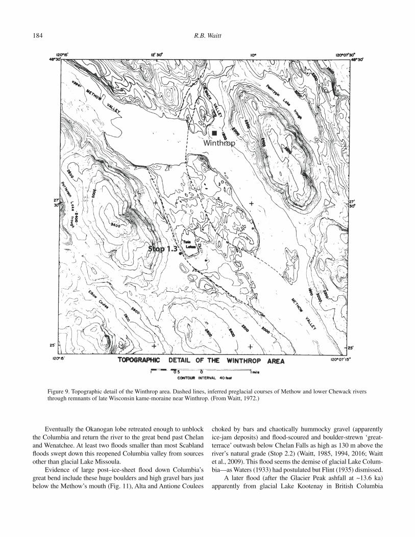
Stop 1.3. Winthrop Moraine at Twin Lakes [N 48.4439; W 120.1982]
The alluvial floors of Chewack and upper Methow valleys narrow to a bedrock reach south of Winthrop. Bedrock pro-tects the north and east sides of the Winthrop kame-moraine from river erosion. But a reëntrant at its northwest end facing upper Methow valley reveals a valley filled by erodible drift. A smaller reëntrant marks where the lower end of the buried val-ley intersects Methow valley. Between these ends a low across the kame-moraine includes a string of kettles (Fig. 9). The floor of the large Twin Lakes kettle is nearly the level of modern Methow River.
The flat-topped surface of the 10 km2 deposit of sandy gravel south of the Methow-Chewack confluence lies 30–60 m above the valley floor (Fig. 9). Drift outliers show this feature was once larger. The Winthrop surface is interrupted by kettles 30–600 m wide and crossed by dozens of eskers 3–15 m high trending south-southeast, parallel to the valley. A knoll possibly cored with bedrock rising 40 m above the north corner exhibits stri-ated erratics as large as 5 m. Except for the knoll, the Winthrop feature is a kame-moraine of glaciofluvial drift with stagnant-ice morphology.
Figure 7. Model of influence of the Cordilleran Ice Sheet (CIS) on drainage of the Skagit watershed. (From Riedel et al., 2007; used with permission.)

Pleistocene glaciers, lakes, and floods in north-central Washington State 183
This is by far the largest moraine-like feature in Methow valley. Widespread at lower levels are small kames, some with kettles, some surmounted by small drift mounds. There are no distinct arcuate moraines to denote temporarily stable marginal positions of a backwasting active-ice tongue. The drift about the lower Methow is that of downwasting, stagnating ice.
Stop 1.4. McClure Mountain Channels: Ice-Marginal versus Submarginal; Alpine Phase versus Ice Sheet [N 48.3421; W 120.0742]
I had inferred a complex of low-level coulees between Win-throp and Carlton to be channels alongside late Wisconsin alpine valley glaciers albeit later smoothed by Cordilleran ice (Waitt, 1972). But similar channels in western Puget lowland were later interpreted as having formed beneath the edge of the Puget lobe of the ice sheet (Booth and Hallet, 1993). I came to regard the broad low-level channels in the Methow as also likely cut beneath or alongside ice-sheet glaciers.
A higher channel network descends along the base of McClure Mountain in several subparallel coulees, the largest and highest Elbow Canyon to Alder Creek (Fig. 10). This channel has steep ragged sides, is locally crooked in plan, and descends continually southeast. It and the others here have the character of ice-marginal rather than sub-marginal channels and cut mainly during the last deglaciation.
Just below Carlton (14 km downvalley), the Methow changes from flat-floored valley to V-shaped canyon. Here the terminal position of a glacier may be drawn hypothetically by erosional topography that includes the channels. But ter-minating an alpine-phase glacier at Carlton makes the glacier much too large (its accumulation-area ratio much too small, its
equilibrium-line altitude too low) compared to more reliably reconstructed Twisp valley glacier and several smaller glaciers. I now infer the topographic change at Carlton and the channel systems ending there to mark stable positions during ice-sheet glaciations.
Stop 1.5. Overview near Brewster of Okanogan-Lobe Blockage Area [N 48.1025; W 119.7219]
The great lobe of Cordilleran ice channeled down Okano-gan valley eventually advanced into Columbia valley. Here at the confluence of Okanogan and Columbia Rivers we see topogra-phy that influenced several related late Wisconsin events.
When advancing Okanogan ice reached the tall bluff south of Columbia River, it began to dam glacial Lake Columbia. As the advancing lobe expanded up Columbia valley, it made a tight seal against this continuous high rock from south Brewster to Bridgeport.
Upon recession a few millennia later, the same setting enforced the seal. Okanogan ice had to wither away greatly to open this seal.
Stop 1.6. Columbia Valley Boulders near the Methow [N 48.0393; W 119.8947]
Late Floods and Source LakesAfter the last Missoula flood, glacial Lake Columbia
remained dammed by Okanogan ice for two centuries (evidence at Stop 3.4) (Atwater, 1987). As this ice receded west downval-ley, and a lobe also receded north up the upper Columbia, the lake’s length and volume grew until it held more than 60 km3 of water, all of it drainable.
Figure 8. Interpretation of cirque capture at Washington Pass. (From Waitt, 1972, 1975.) (A) Before capture. (B) After capture: Washington Pass.
184 R.B. Waitt
Eventually the Okanogan lobe retreated enough to unblock the Columbia and return the river to the great bend past Chelan and Wenatchee. At least two floods smaller than most Scabland floods swept down this reopened Columbia valley from sources other than glacial Lake Missoula.
Evidence of large post–ice-sheet flood down Columbia’s great bend include these huge boulders and high gravel bars just below the Methow’s mouth (Fig. 11), Alta and Antione Coulees
choked by bars and chaotically hummocky gravel (apparently ice-jam deposits) and flood-scoured and boulder-strewn ‘great-terrace’ outwash below Chelan Falls as high as 130 m above the river’s natural grade (Stop 2.2) (Waitt, 1985, 1994, 2016; Waitt et al., 2009). This flood seems the demise of glacial Lake Colum-bia—as Waters (1933) had postulated but Flint (1935) dismissed.
A later flood (after the Glacier Peak ashfall at ~13.6 ka) apparently from glacial Lake Kootenay in British Columbia
Figure 9. Topographic detail of the Winthrop area. Dashed lines, inferred preglacial courses of Methow and lower Chewack rivers through remnants of late Wisconsin kame-moraine near Winthrop. (From Waitt, 1972.)

Pleistocene glaciers, lakes, and floods in north-central Washington State 185
Stop 1.4
Stop 1.3
/
/
McClureMtn
×
Figure 10. Map showing major coulees along both sides of Methow valley. Numbers indicate altitude (in ft) of cou-lee intake. (Labels misspell Carlton.) (From Waitt, 1972.)

186 R.B. Waitt
would have swept lower parts of the flood suite here—though there’s no distinguishing field evidence. We shall see evidence of this late flood at Stops 2.2, 3.7, and 4.2.
Dating by 10Be MethodFrom the tops of large boulders here Balbas et al. (2017)
obtained three 10Be dates: ~15.3, 13.9, and 13.0 ka, an average ~14.1 ka. Methods, results, and significance will be discussed at this stop.
DAY 2 (Thursday, 19 October). THE COLUMBIA— ICE AND FLOODS
Stop 2.1. Tenas George Eddy Bar View from U.S. Highway 2 [N 48.5747; W 120.2503]
Pull off left at “Lake Entiat” viewpoint. The mouth of Tenas George canyon west of the river is filled by a high bar whose top at 269 m altitude slopes back from the Columbia, up the side canyon. This feature is identical to ‘gulch fills’ by which Pardee (1942) inferred a great flood from the gla-cial Lake Missoula basin down lower Flathead River, Mon-tana. The surface of the bar, 185 m above Columbia River, is ornamented by asymmetric (north sides steeper) east-northeast–trending current dunes 2 m high and spaced 20 m. Paleocurrent was up the mouth of Tenas George valley and up Columbia valley. The bar records a high clockwise eddy alongside a huge flood descending Columbia valley.
Turtle Rock just downvalley consists of Swakane Bio-tite Gneiss. This mass probably slid off the east valley side in pre-Wisconsin time. Last-glacial megafloods molded its streamlined form (in plan view) and strew large basalt boulders southward.
Both bedrock and surficial geology have been mapped through the reach of Columbia valley from Chelan down nearly to Vantage (Tabor et al., 1982, 1987).
Stop 2.2. Great Terrace, Boulders, Bar Sequence, Singleton Road Overlook [N 47.7528; W 120.1509]
The ‘great terrace,’ as early reconnaissance geologists called it, is truly extensive compared to others: (1) It is broad and fairly flat and prominent in Columbia valley and in adjacent lower Chelan valley (Stop 2.3). (2) At the ice limit near Chelan Falls and below there it forms a prominent descending outwash terrace traceable far downvalley. (3) It is prominent up Columbia valley and far up Okanogan valley.
Overlook the surface of a descending reach of the ‘great’ outwash terrace (Fig. 12, unit m). Below it lie two gravel bars near the river (Fig. 12, unit l). And two bars lie higher, including where we stand (Fig. 12, unit e). These higher bars have giant current dunes across both levels—dunes truncated by water flow at the ‘great’ terrace level. The high dunes are spaced 160 m, their amplitude 10–12 m. This high surface can be traced only a few miles farther upvalley. So these floods preceded the last-glacial maximum at Chelan Falls.
Below us a scarp cut at altitude 332 m (131 m above natu-ral river grade) shows the level the glacial Lake Columbia flood cut across the ‘great’ terrace, sloping more steeply downvalley than did the flood surface. A flood-scoured fosse along the ‘great’ terrace’s east side is strewn with diverse boulders as large as 3.5 m, evidence of megaflood (many of the boulders were culled about a decade ago from adjacent orchards). Glacier Peak tephra (13.6 k.y.) overlies flood-swept ‘great’ terrace and the higher giant duned surfaces.
The low bars near the river once displayed giant current dunes but all that fubar since the housing development. Unlike higher surfaces, Glacier Peak tephra does not overlie them. Their loess cover is also much thinner than on all higher surfaces. The low bars thus greatly postdate the glacial Lake Columbia flood that swept the ‘great’ terrace from here downvalley. The late flood(s) apparently burst from glacial Lake Kootenay in British Columbia (Fig. 3) (Waitt, 2016).
Stop 2.3. Union Valley Moraine [N 47.8616; W 120.0199]
Surficial geology of lower Chelan trough area (Fig. 13) was part of geologic mapping of the North Cascades in the late 1970s (Waitt, 1987). From Chelan ascend a flight of four outwash-inwash terraces into Union valley. A large moraine overlooks the upper terrace. Survey lower Chelan valley from the top of moraine. Glacier Peak ‘layer-G’ pumice lapilli thinly overlying these surfaces dates to ~13.6 k.y. (Kuehn et al., 2009).
We stand on the last-glacial terminal moraine: hills above us to the north are unglaciated. Draped on bedrock hills, this moraine contains mixed-lithology granitic and gneissic rocks to 1.5 m. An abrupt upward limit of moraines, ice-marginal coulees,
Figure 11. Photograph of huge boulders from Lake Columbia flood run-up on the outside bend of Columbia valley just below the mouth of Methow River.

Pleistocene glaciers, lakes, and floods in north-central Washington State 187
and terraces registers the glacial limit on this north valley side. Small moraines and kettles decorate the frontal edge of some terraces.
The last-glacial drift limit also descends the east side of Columbia valley, merging south with the ‘great terrace’ behind Chelan Butte. And along Chelan Butte a visual boundary sep-arates whaleback, terraces, and moraines below from the non-streamlined stream-eroded landscape above. This glacial limit descends up lower Chelan valley (Fig. 13): the Cordilleran ice lobe down Columbia valley ascended lowermost Chelan valley.
Ice-marginal channels on both sides of lower Chelan val-ley (Fig. 13) descend upvalley-ward to Lakeside (on south-shore tributary fan at the upvalley limit of view from here). But farther up Chelan valley, channels and the drift limit descend down-valley. This drift limit descends from above 2250 m above sea level (a.s.l.) in headward tributaries (see Day 1, “Rainy Pass” between Stops 1.1 and 1.2) southeastward 110 km to 560 m a.s.l. The saddle in the drift limit lies at Lakeside. Water seems to have left Chelan valley by sharp Knapp Coulee (Fig. 13).
The terraces below us—like those of lower Methow val-ley—record a downwasting ice tongue. Outwash from the glacier and inwash from adjacent slopes form fluviatile straths in the ice-margin gutters. The ice occasionally sheds debris directly, and that can form a moraine on the outer edge of the strath.
The high northwestern parts of the upper Chelan drainages head in myriad cirques, most of them leading into Chelan trough via U-shaped valleys. During alpine glaciations—the late Wis-consin and several earlier—these tributary glaciers nourished a large alpine valley glacier in Chelan trough.
But as in Methow valley, Cordilleran ice hundreds of meters thick invaded Chelan basin over several saddles like Rainy Pass. Cordilleran ice flowed from some Chelan cirques across cols into Methow cirques (Waitt, 1972). So the maximal glacier that filled lower Chelan trough from the northwest was fed not just by the cirques, but by invading Cordilleran ice.
Moraines like the one here can be very steep in their inner (proximal) side while the supporting glacier remains. After the ice recedes the moraine crest collapses inward over time. What we now stand on may have been inside the moraine for centuries or more after the ice withered away.
Figure 12. Summary geologic map of Chelan-Trinidad reach of Co-lumbia River valley, Washington, simplified from Waitt (1982, 1987). Mesozoic crystalline and Tertiary sedimentary rock (cs) overlain by Columbia River basalt (b), which has shed large landslides (ls) into Columbia valley. Early Pleistocene megaflood gravel (ePf). Last-glacial Missoula-flood deposits include early megaflood(s) down the valley (e) and from Moses Coulee (mc). Late megaflood deposits from glacial Lake Columbia (m) and the upper Columbia (l). ‘Great’ terrace (GT) is partly unit “m.” C—Chelan; E—Entiat; W—Wenatchee; T—Trinidad. Clovis cache is near the airfield atop Pangborn bar. Field-trip stops are shown. (From Waitt, 2016.)

188 R.B. Waitt
Dating by 10Be MethodFrom the tops of boulders on this moraine, Balbas et al.
(2017) obtained two 10Be exposure dates: ~14.9 and 14.1 ka, an average ~14.5 ka. Methods, results, and significance will be dis-cussed at this stop.
Lower Chelan Basin (between Stops 2.3 and 2.4)
The 1970s field mapping revealed fairly extensive bedded and laminated pale silt plastered on bedrock, till, and outwash on both sides of lower Chelan basin (Waitt, 1980b, 1987). But no other Pleistocene sediment overlies the lacustrine. The late Wisconsin in lower Chelan valley ended with a glaciolacustrine episode.
Stop 2.4. Knapp Coulee [N 47.8254; W 120.1225]
The extensive ‘great’ terrace at level at 350–366 m sug-gests some geomorphic element controlled the whole surface. That control seems to have been here, the floor of Knapp Coulee (Fig. 13). (The coulee is infilled some by latest Wisconsin and Holocene wash and mass wasting off the steep walls and by a tributary fan from the west-down coulee of our stop.) As glacier ice retreated, mainstem Columbia valley must have remained blocked by terminal moraine and outwash. All water upstream, including Columbia River, seems to have drained through Knapp Coulee.
Pale laminated silt, clearly lacustrine, lies extensively about the slopes on both sides of lower Chelan basin up to at least
Figure 13. Map of Chelan area showing limit of Cordilleran ice-sheet tongues, one down Chelan valley, the other down Columbia valley and into Chelan valley, the two ice tongues apparently merging in the lower Chelan. Stipple, upland above or beyond ice limit; large arrows, dominant ice flow; medium arrows, Columbia River and major outwash routes; minute arrows, ice-marginal channels showing direction of flow (thus slope of adjacent glacier); minute dot-dash pattern, moraines; GT—‘great terrace.’ Stops 2.2–2.4 are indicated. (Waitt, inked mylar map ~1979, unpublished.)

Pleistocene glaciers, lakes, and floods in north-central Washington State 189
360 m, seemingly controlled by Knapp Coulee spillway (Waitt, 1980b, 1987). Upvalley of Chelan Falls the lower ¾ of the ‘great’ terrace also consists of laminated lacustrine silt. Lower Chelan valley held an arm of a lake that grew larger and larger in the Columbia in front of ice receding up Columbia and Chelan val-leys. I’ve called this “Lake Brewster” (Waitt and Thorson, 1983; Waitt, 1987).
Columbia River, here a river lake, spilled through Knapp Coulee early during deglaciation. The dam for Lake Brewster was evidently a huge moraine and miles of outwash plugging Columbia valley below Chelan Falls. This voluminous debris may have been cleared out by the Lake Columbia flood. And yet, some evidence such as accordant levels of broad terraces far up the Okanogan, lacustrine silt composing some of it, suggests the lake (or some lake) outlasted the glacial Lake Columbia flood(s).
Stop 2.5. Tenas George Creek Boulder Field and Quarry [N 47.5700; W 120.2620]
An inactive gravel pit exposes round-stone pebble-cobble gravel apparently plastered against the high eddy bar in Tenas George Creek that we viewed from across the river (Stop 2.1). This gravel, at least 15 m thick, in spots shows imbricated clasts revealing downvalley-ward paleocurrent. I interpret this bed as outwash of the ‘great’ terrace.
An overlying coarser gravel bed contains large boulders. This deposit I interpret to be from the glacial Lake Columbia flood—simultaneous with the boulder field below Stop 2.2.
Dating by 10Be MethodOn the coarse gravel bar riverward of the pit, Balbas et al.
(2017) obtained from the tops of boulders two 10 Be exposure dates: ~15.5 and 15.3 ka, an average of ~15.4 ka. Results and significance will be discussed at this stop.
Stop 2.6. Sunnyslope Erratics [N 47.4957; W 120.3322 roughly]
This site north of Wenatchee is a developed neighborhood. Balbas et al. (2017) dated erratics nearby, but the landowner there disallows visitors.
Unweathered angular ice-rafted erratics similar to bedrock far up the Columbia drainage lie as high as altitude 500 m in lower Wenatchee valley and adjacent Columbia valley (Fig. 14). These valleys contain no such bedrock—underlain instead by Tertiary sandstone and shale, capped to the east by Columbia River Basalt.
The erratics show that Missoula floodwater swept down the Columbia past Wenatchee as deep as 335 m (Waitt, 1977b, 1982). Evidence of such high-level megaflood traces sporadically 35 km up the Columbia but not at and upvalley of the glacial limit near Chelan Falls. So the most gigantic last-glacial flood(s) down the Columbia predate the Okanogan lobe’s blocking the valley (Atwater, 1987; Waitt, 1994, 2016).
In the 1960s and late 1980s, Bill Long located dozens of erratics in lower Wenatchee valley and Columbia valley near Wenatchee at all levels up to 500 m. He recorded more of them than Waitt encountered during 1976–1978 field mapping. They range from angular to round, a few glacially striated, a few unmodi-fied joint blocks. Clasts of leucocratic feldspar-megacrystic gran-ite, granite pegmatite, dark-gray meta-argillite, porphyritic dike rocks, and quartzite came from bedrock types that do not crop out in the Wenatchee drainage but do lie far up the Columbia. Many megacrystic granite boulders near Wenatchee resemble bedrock west of Lake Pend Oreille in Idaho (Waitt, 1980a, 1982). The erratics must have floated to their scattered resting spots encased in ice.
An enormous fresh-looking landslide at Malaga heads along a 25-km-long curving scarp in basalt high on Naneum Ridge. It is the most recent of many large landslides that head at basalt cliffs rimming Columbia valley and descend to the river. Many scarcely weathered ice-rafted granitic boulders lie on the Malaga landslide up to at least 250 m above the river.
Exotic clasts of megacrystic granite, granodiorite, and quartzite lie about lower Wenatchee valley. A kilometer north-east of Monitor, granitic stones on a 470 m ridge crest show that floodwater overran the spur. Many granitic boulders as large as 2.5 m lie near Cashmere. A cluster of light-colored megacrystic granite erratics up to 2 m lie half a kilometer southwest of the river bridge at Peshastin. The erratics from the upper Columbia show a deep flood down Columbia valley backflooded far up Wenatchee valley.
Dating by 10Be MethodAt Sunnyslope north of Wenatchee more than 200 above
Columbia River, Balbas et al. (2017) obtained from the tops of three apparently ice-rafted granitic boulders three 10 Be dates: ~18.5, 18.2, and 18.1 ka, an average ~18.2 ka. Results and sig-nificance will be discussed during this stop.
DAY 3 (Friday, 20 October). DIVERTED COLUMBIA
Stop 3.1. Withrow Moraine at Withrow [N 47.7251; W 119.8140]
This abrupt moraine front marks the terminal late Wiscon-sin position of the Okanogan lobe of the Cordilleran ice sheet (Fig. 3). It was noted by reconnaissance surveys of the 1880s to early 1900s, later delineated in more detail (Bretz, 1923, 1928; Waters, 1933; Flint, 1935, 1937; Richmond et al., 1965). Glacial features of the Waterville plateau were mapped in further detail by Hanson (1970), and later with digital topography by Kovanen and Slaymaker (2004).
Drumlin-like lineations across the lobe fan through 140 degrees, from west-southwest at the margin north of Withrow to east-southeast at the east margin near Grand Coulee Dam. By mapping arcing moraines north of this one, Hanson (1970) shows a dozen recessional stillstand positions as the ice lobe receded

190
Figu
re 1
4.

Pleistocene glaciers, lakes, and floods in north-central Washington State 191
north toward Columbia River. During retreat and thinning, the outer several km of ice stagnated in succession, leaving eskers, deltas, and ice-disintegration landforms.
From boulders on this Withrow moraine, Swanson and Caffee (2001) obtained six exposure dates by the 36 Cl method that range from ~22.1–18.1 ka. Balbas et al. (2017) from boul-ders on this moraine 16 km southeast of here obtained four 10 Be dates that average ~15.4 ka. They consider the chlorine ages too old. Results and significance of the beryllium ages will be cov-ered mainly at Stop 3.6.
Between Stops 3.1 and 3.2
Lone Butte [N 47.8148; W 119.7357]. This resistant mound of basalt is studded with haystack basalt boulders and plastered with mixed-lithology till. This mound appears to be in-place bedrock, not a glacially skidded megablock like Pot Hills 13 miles ahead.
Yeager Rock [N 47.8156; W 119.5531]. An 8 m glacial ‘hay-stack’ basalt boulder underlain by mixed-lithology till in roadcut.
Pot Hills glacial megablock [N 47.8155; W 119.4561]. Road-cut shows angular basalt. But this mass 1.6 km long (south-eastward) and 1 km wide is intricately crevassed, its north part seemingly four or five rotated landslide blocks. Hanson (1970, p. 85) interpreted this as a great block of bedrock basalt pushed some distance semi-intact by overriding gla-cier ice. An underlying sandstone-siltstone interbed lubri-cated a plane on which the block could glide.
Esker near Sims Corner [N 47.8155; W 119.4169]. Sinuous ridge of well-sorted pebble gravel, most stones rounded. Some eskers end in a perched delta. Eskers record streams at the bed of a stagnating glacier flowing too slowly to obliter-ate fluvial landforms at its bed. As the ice sheet thinned, its margin stagnated apparently successively.
Foster Creek valley [N 47.9096; W 119.3777]. Bedded gla-ciolacustrine silt overlies the till and kame mounds. North-west-trending Foster Creek remained long dammed as the Okanogan lobe receded. At first a separate lake drained east through the Foster Coulee spillway at altitude ~660 m into Grand Coulee. As Okanogan ice receded, the lake eventually linked directly to glacial Lake Columbia (~500 m) before the ice seal to the northwest (Stop 1.5) released.
Descent into Columbia valley [N 47.9782; W 119.0355]. In the roadcut a sedimentary interbed underlies highest basalt flow. Such beds of quartz-feldspathic sandstone interbedded with the surface basalt flows—from Spokane to Grand Coulee to
Chelan to Vantage—show that the basalt flows pinched out against surrounding highlands, and that the basalt-dammed rivers from the highlands (like the Okanogan, Methow, Chelan, and Wenatchee) spread their loads miles out onto the basalt edges before being buried by the next encroaching basalt flow.Such a fine-grained interbed, saturated by water from over-
lying glacier ice, provides a weak and slippery plane on which the glacier overhead may glide a block some distance—as at Pot Hills.
In lower roadcuts, granite-gneiss pokes through—showing the high-relief erosional Miocene landscape that the ~16 Ma basalt flows buried.
Stop 3.2. Crown Point [N 47.9716; W 118.9856]
Crown Point (altitude 482 m) overlooks Grand Coulee Dam, centerpiece of the Columbia Basin irrigation system. Columbia water pumped up to Banks Lake in Grand Coulee flows to vast areas of Quincy, Othello, and Pasco basins—bringing Columbia water to a region that hasn’t had it since the Missoula floods.
Joseph T. Pardee had identified Pleistocene glacial Lake Missoula in 1910. With field evidence there he later showed where the “Spokane Flood” must have originated (Pardee, 1942). In his reconnaissance of the Colville Indian Reservation (south-west edge just across the river), Pardee (1918) described diverse glacial, outwash, and glacial-lake features along this long reach of the Columbia.
Flint and Irwin (1939) in the excavations of the Grand Coulee dam site and farther downvalley, and Jones et al. (1961) downvalley, recognized a lower and an upper glaciolacustrine period separated by till. This stratigraphy shows glacial Lake Columbia dammed during both the advance and retreat of the Okanogan ice lobe. To explain the alternation of varved inter-vals with beds that are coarser or thicker, Flint and Irwin (1939) invoke waxing and waning of the Okanogan lobe and episodic drainage of glacial lakes upstream. Atwater (1986, 1987) later proved these sedimentary alternations to be from Missoula megafloods from the east, engorging varve-making glacial Lake Columbia.
Grand Coulee, two tandem gorges gouged out by enor-mous receding cataracts (Bretz, 1932), discharged to Quincy basin. We know little of pre-Wisconsin glaciations and cata-strophic Missoula floods that may have effected much of Grand Coulee’s present topography. As Bretz outlined, upper Grand Coulee’s giant cataract eventually ate into Columbia valley and ended the cataract. But when? Bretz (1969) thought during the
Figure 14. Sections through Columbia valley near Wenatchee. (A) Longitudinal profile from Chelan to Potholes cataract; glacial limit, outwash, and flood bars projected from both sides. Former low-water grade of river beneath reservoirs approximated by dashed line drawn through tail races of dams. Arrows distinguish downvalley-ward from upvalley-ward (backflood) flood flow. The section in ‘B’ crosses slightly above Malaga. (B) Cross section through Pangborn and Malaga bars. gLC—glacial Lake Columbia. (From Waitt, 2016.)

192 R.B. Waitt
late Wisconsin. With little relevant data, this field trip’s leaders quibble over the timing.
The scant traces of shorelines at the high level (715 m) of glacial Lake Columbia (Atwater, 1986, p. 6–7), and details of late Wisconsin flood-bed stratigraphy interbedded with glacial Lake Columbia beds in Sanpoil valley (Atwater, 1986, p. 22–23) imply that the lake held its high level only when Okanogan ice blocked the head of upper Grand Coulee—that upper Grand Coulee had cut through to Columbia valley before the late Wisconsin glaciation. In this scenario, Grand Coulee conveyed most—perhaps every—late Wisconsin Missoula flood large and small (Figs. 6B–6D).
Step-Backwater (1-D) ModelingGreat floods down an ice-free Columbia valley had been
calculated by one-dimensional step-backwater routine (HEC-2) (Harpel et al., 2000). In 2017 Austin Rains has redone some of this work with the HEC-RAS program. (HEC-RAS generates model discharges 20% higher than did HEC-2 with identical cross sections and input parameters.)
A HEC-RAS peak model discharge of ~13 million m3/s best fits available field evidence (upper limits of scabland, cut loess scarps, and erratics) for peak flow between Chelan and Vantage,
especially near Wenatchee (Fig. 15). Water then would have been 350 m deep, its surface more than 150 m above our Crown Point perch. Grand Coulee’s intake in its current shape 183 m above Columbia valley (Fig. 16) also received this peak flow more than 153 m deep during this ice-free stage of Columbia valley, a dis-charge step-backwater calculations indicate to have been ~5 mil-lion m3/s.
Maximum flood indicators around the head of Grand Cou-lee—upper limits of scabland, loess scarps, and erratics—are ~747 m (Fig. 16), 107 m above the computed water-surface altitude around 640 m. But if these higher flow depths are used, computed water surface down Columbia valley exceeds the upper limit of field evidence at Wenatchee. The high flood limits near Grand Coulee’s head must have occurred when the Okanogan lobe blocked the Columbia below here and turned all floodwaters into the Channeled Scabland. At that high level, flow down Grand Coulee would have been very steep (4.4 m/km) and discharge down Grand Coulee calculates (1-D) at 12–14 million m3/s.
2-D ModelingA shallow-water 2-D model has been applied to the Mis-
soula floods with Columbia valley below Grand Coulee blocked
Figure 15. Profile of 1-D model flood discharge of 13 million m3/s down northwest ‘great bend’ reach of Columbia valley, from Grand Coulee intake to below Sentinel Gap, when the valley is not blocked by the Okanogan ice lobe. Through 154 measured cross sections, computations with Corps of Engineers HEC-RAS program yield water-surface and energy-line values for hypothetical discharge input. Discharge of ~13 million m3/s (run in June 2017 by Austin Rains) approximates upper limit of ice-rafted erratics near Wenatchee. [In 1994 using the same cross sections and other parameters, input discharge 10.5 million m3 in HEC-2 program generated approximately this profile (Harpel et al., 2000).]
0
100
200
300
400
500
600
700
0 50 100 150 200 250 300
Elev
a�on
(m)
Distance (km)
Columbia 13 million cmsRiver bed Water surface Energy gradient Erra�c
Sent
inel
Gap
Fren
chm
an g
ap
Poth
oles
cat
arac
t
Wen
atch
ee
Pang
born
bar
Fost
er C
reek
Met
how
Riv
er
Chel
an F
alls
Gra
nd C
oule
e D
am
Stub
ble�
eld
Poin
t

Pleistocene glaciers, lakes, and floods in north-central Washington State 193
by the Okanogan lobe (Denlinger and O’Connell, 2010)—the prevailing scenario during most of the last-glacial floods.
At 23 h after dam break, floodwater pours deeper than 200 m into upper Grand Coulee at more than 20 m/s through the relatively narrow 1 km nozzle at coulee’s head (Fig. 17). This scenario brings water about up to the limit of field evidence, including over Steamboat Rock’s scabbed summit later capped by glacial drift during the Okanogan lobe’s maximum late Wis-consin stand. Water in Columbia valley just below Grand Coulee is deeper than 250 m. But flow vectors are almost nil in the dead-end valley against the glacier.
This hydraulic model shows that glacial Lake Missoula con-tained enough water to flood up to the limits of field evidence, no additional water required.
During this writing in August 2017, a new generation of more robust 2-D hydraulic models—David George, Roger Den-
linger, and Charles Cannon (U.S. Geological Survey) collaborat-ing—is being run on closer topographic grids than earlier and for several different configurations of the Okanogan ice lobe and gla-cial Lake Columbia. Some of the spectacular preliminary results will be shown on this GSA 2017 field trip.
Stop 3.3. Northrup Canyon in Upper Grand Coulee [N 47.8668; W 119.0821]
The area about the head of upper Grand Coulee shows the high-relief Miocene topography eroded in underlying granite-gneiss that Columbia River Basalt flows overlapped 16–15.5 Ma. Russell (1893, p. 90) noted that here where the basalt thins, “the granite rock beneath ris[es] through it like islands.” Near Chelan, Waters (1939) found relief on the base of the basalt to exceed 600 m.
Figure 16. Profiles along drainage between Lake Missoula and Wallula Gap [bottleneck below Pasco basin that all Scabland floodwaters passed] during late Wisconsin glaciation. (A) Profile down Columbia via ‘great bend’ past site of Okanogan lobe dam. (Continued on following page.)

194 R.B. Waitt
Dating by 10Be MethodThe middle reach of Northrup Canyon exposes bedrock
granite knolls unroofed by the retreat of Northrup Canyon cataract. From the tops of granitic knolls, Balbas et al. (2017) obtained three 10Be dates: ~16.0, 15.8, and 14.9 ka, an aver-age ~15.6 ka. Results and significance will be discussed at this stop.
Late-Stage Eddy Bars [N 47.8682; W 119.0912]
There is no local stratigraphic record of the several dozen gigantic late Wisconsin floods (and doubtless pre-Wisconsin ones) that did most of the erosional work. Collectively they exca-
vated more of the coulee, finishing carving of scabland about the coulee’s head. Within upper and lower Grand Coulee, the late Wisconsin floods left sporadic big gravel bars and gigantic boul-ders. The sequence near the mouth of Northrup Canyon records only fairly late and fairly small elements of the energetic last-glacial Missoula floods.
Exposed in gravel pits, an eddy bar that had built to lower Northrup Canyon comprises five or six foreset-gravel beds con-taining outsized 1 m boulders. Each gravel bed grades up into a bed of medium to very fine sand, recording a slowing then slack current. The contact between the fine bed and overlying gravel is sharp and erosive. Banked against this bar, a lower bar shows four pebble-gravel beds carrying large boulders, each bed capped by
Figure 16 (Continued ). (B) Profile via the Grand Coulee, Quincy basin, and lower Crab Creek. Relevant stratigraphic sec-tions: LC—Latah Creek; MC—Manila Creek; NC—Ninemile Creek; PG—Paynes Gulch; SR—Steamboat Rock. [Wallula mislocated—plotted as if vertical scale were in ft. Figures cited in A and B are figures within the 1987 report.] (From Atwa-ter, 1987, his figure 2.)

Pleistocene glaciers, lakes, and floods in north-central Washington State 195
laminated medium to very fine sand. The composite exposures show that at least 9–10 separate floods eddied coarse gravel up into lower Northrup Canyon 25–40 m above the floor of Grand Coulee. Each vigorous flood ended in slack water.
Between Stops 3.3 and 3.4
Hundreds of granitic as well as basalt boulders litter an east-side longitudinal flood bar 3 km long [N 47.7853; W 119.2239].
Stop 3.4. Paynes Gulch [N 47.7555; W 119.2239 approximate]
Road to boat ramp. Overlying the toe of the flood-laid gravel is 3 m of silt-clay lake deposit including ~180 varves (Figs. 16B, 18) (Atwater, 1987). We view only the upper beds that show in Atwater’s measured section 1.1 km north-northeast of the boat ramp where he counted ~180 varves.
Slackwater varves at the site of a former stupendous cata-ract imply sequence. Climbing ripples within the varves indicate paleocurrents were south-southwest down coulee, a sluggish out-flow from glacial Lake Columbia. No flood beds interrupt these varves. Thus glacial Lake Columbia lasted more than 180 yr after the last Missoula flood into the lake (Fig. 4) (Atwater, 1986).
Stop 3.5. Dry Falls [N 47.6070; W 119.3634]
Grand Coulee, the deepest of the great scabland channels, consists of two tandem canyons described in Bretz’s (1932) elo-quent report. From the south wall of the Columbia valley, upper Grand Coulee leads to the lip of Dry Falls (Fig. 19). Dry Falls twin cataract, 122 m high and 1.8 km wide—twice Niagara’s height and a third wider—defines the head of lower Grand Cou-lee. Lower cataracts of the group reach 5 km farther east. The continuous high scabland extending 10.5 km east from the rim-rock of the gorge below the cataracts shows that even deep and wide lower Grand Coulee did not contain the largest floods. The widest and deepest scabland channels the floods gouged out by cataract retreat. On the floor of the gorge below Dry Falls, longi-tudinal bars are studded with huge basalt boulders quarried from the cataract walls.
Bretz’s early concept required Dry Falls cataract to retreat 27 km from Soap Lake during just one “Spokane Flood.” The gorge of upper Grand Coulee required that great cataract to recede nearly 40 km. Later evidence for several floods (Bretz et al., 1956; Bretz, 1959, 1969) reduced the recession required of any one flood to several kilometers, but this was still huge. Then came evidence of scores of late Wisconsin megafloods, not to mention erosion by megafloods during earlier glaciations. Now
Figure 17. Depth (colors) and veloc-ity (arrows) of Missoula flood through glacial Lake Columbia and upper Grand Coulee by 2-D hydraulic model of Den-linger and O’Connell (2010) at 23 h af-ter dam break. (From Waitt et al., 2009.)

196 R.B. Waitt
a cataract like Dry Falls needn’t recede more than 1/3 km during any one flood. If there were more than a hundred great floods during several glaciations, the great volume of basalt eroded from the Channeled Scabland becomes understandable.
With apparent geomorphic evidence that there had been sev-eral Missoula floods, Bretz et al. (1956) and Bretz (1969) had suggested sequential development of erosional scabland land-scapes. The incision of some channels like Drumheller and upper Grand Coulee partly or wholly by cataract retreat could cause higher-level scablands like Warden channels and Northrup Can-yon to be abandoned after a cataract had passed headward and left a deep gorge in its wake. There can be little question about this general concept. But in a recent theoretical study, Larsen and Lamb (2016) explore this idea for lower Moses Coulee, suggest-ing that certain flood bars there were likely formed by discharges five- to ten-fold smaller than brimful.
I disagree with their central conclusion that such sequence “impl[ies] much lower flood discharges than previously thought” through the Channeled Scabland. The huge discharges measured by 1-D and 2-D modeling along Rathdrum valley, lower Snake valley, and different reaches of Columbia valley are in channels whose shape and floor levels could have changed little through late Pleistocene times. The high-level erratics along Columbia and lower Wenatchee valleys, for instance (Stop 2.6), can be explained only by berg-rafting flood deeper than 300 m descend-ing 0.8 m/km through an open valley 1.5–5 km wide. Similarly
huge discharges are needed to explain clear field evidence for water flowing 270 m deep down an open Columbia gorge (Benito and O’Connor, 2003). Larsen and Lamb’s “much lower flood discharges than … thought” ignores field evidence throughout Columbia valley and through most of the Channeled Scabland.
Denlinger and O’Connell’s (2010) 2-D model at 23 h after dam break shows lower Grand Coulee and the anastomosis across High Hill running at nearly peak levels (Fig. 20). Greatest flow to Quincy Basin is lower Grand Coulee through Soap Lake, but also large discharge down Dry Coulee and Long Lake Coulee. Steeper flow paths and momentum at the right exiting upper Grand Cou-lee crowds flow to the southeast, encouraging Dry Falls cataract to expand east. Velocities are swift just above Dry Falls. But flow down lower Grand Coulee past Park and Blue Lakes is deep but slower, and lower Grand Coulee may accumulate bars.
Newer and more robust versions of this 2-D model are being run.
Stop 3.6. Moses Coulee below Jameson Lake [N 47.6450; W 119.6781]
Lower Moses Coulee, 1 km wide and ¼ km deep (details in Hanson, 1970), is second in size only to Grand Coulee. We shall see at Stop 4.3 that this coulee passed at least five enormous late Wisconsin Missoula floods before the advancing Okanogan lobe blocked Missoula floods from reaching it (Fig. 6).
A B
Figure 18. Glacial Lake Columbia late varves in Paynes Gulch area of upper Grand Coulee. (A) Measured section along Banks Lake (Atwater, 1987, his figure 6B). (B) Photograph of 20–25 of the upper thin varves. Vertical scale ~15 cm (see embedded 10-cm scale). [Moire pattern re-sulted from scan.] (From Atwater, 1987, his figure 8; used with permission.)

Pleistocene glaciers, lakes, and floods in north-central Washington State 197
Here the midsection coulee is as wide but not so deep. Here the Withrow moraine descends into the coulee from both sides and dams Jameson Lake 4 km above us (Fig. 3). The moraine’s outer edge buries streamlined earlier flood bars. The fairly weak soils on all these deposits show them to be late Wisconsin age.
Dating by 10Be MethodAtop the Withrow moraine near here, Balbas et al. (2017)
from the tops of granitic boulders obtained four 10 Be dates:
~17.1, 15.4, 15.4, and 13.5 ka, average ~15.4 ka. Results and significance will be discussed at this stop.
Stop 3.7. Trinidad (Dinner at Ken Lacy’s) [N 47.2274; W 119.9992]
Across from our overlook at Trinidad, West bar (Figs. 12, 21) lies on the inside of a sharp bend where a bar would re-form under each great flood. The last Missoula floods through
Figure 19. Bretz’s geologic map of Grand Coulee depicting complex of scabland tracts along and east of lower Grand Coulee and flood-gravel bodies in the topographically low and broad Hartline and Quincy basins. (From Bretz, 1959, plate 3.)

198 R.B. Waitt
this reach backflowed from Quincy basin upvalley. But West bar’s asymmetric giant current dunes reveal down-valleyward flow. Though usually attributed to Missoula flood, West bar lies at similar heights above the river as four bars upvalley (Brays, Malaga, Rock Island, north Moses Coulee). West bar would have re-formed under a downvalley flood from glacial Lake Columbia, and this explains its present form (Figs. 14A, 14B).
Along the Columbia still lower round-topped gravel bars of crystalline rocks from upvalley (Fig. 12, bars ‘l’) display huge boulders or giant current dunes. The low bars near Entiat (Stop 2.2) lack Glacier Peak ash that tops higher bars. The low bars long postdate deposits of Lake Columbia’s flood. This includes the boulder-studded low bar riverward of giant-duned West bar. This last flood(s) probably escaped from glacial Lake Kootenay in British Columbia (Fig. 3) (Waitt, 2016).
DAY 4 (Saturday, 21 October). WENATCHEE CONVERGENCE
Stop 4.1. Old Wenatchee Bridge, Boulder Field [N 47.4143; W 120.2951]
Large boulders lie at least as high as 40 m above the river, most of them Swakane Biotite Gneiss from above Wenatchee. At least 15 gneiss boulders in this field exceed 5 m, angular despite 7–25 km of transport. Rounded hornblende quartz-diorite boul-ders as large as 2 m derive from a rock belt 28–38 km upvalley.
The largest boulder of Swakane Biotite Gneiss is 13 m, so big and angular to seem outcrop. But upturned Eocene sandstone near the bluff’s base 75 m upriver is the local bedrock (but now buried by recent rock rubble). The glacial limit near Chelan Falls
Figure 20. Depth and velocity of Missoula flood down Grand Coulee and through labyrinth below by 2-D hydraulic model of Denlinger and O’Connell (2010) at time 23 h (after dam break). (From Waitt et al., 2009.)

Pleistocene glaciers, lakes, and floods in north-central Washington State 199
is well upriver of the two source bedrock belts: the boulders can only have come by colossal flood.
Stop 4.2. Pangborn Bar Stops
Grant Road eastward ascends the foreslope of an enormous crescent bar (Figs. 12, 14B). Topographic waves sliced by grade of road are loess-mantled giant current dunes.
Stop (Rolling) 4.2A. Trough between Giant Current Dunes atop Great Pangborn Bar [N 47.4023; W 120.2231]
The trough (north side now filled) between current pebble-gravel dunes shows a steep (15°) southeast side of dune and 5° backslope of stoss side, an asymmetry revealing downvalley flood flow. Dune crests are spaced ~160 m. The top of Pangborn bar is 215 m above Columbia River—which has not significantly downcut since the floods.
Stop 4.2B. Clovis Archaeologic Site (Grant Road [N 47.4058; W 120.2036 approximate])
A spectacular cache of Clovis points was excavated in 1988 and 1990 just off Grant Road (Fig. 14B) (Mehringer, 1988; Gramly, 1993). Some 13,000 yr ago—a millennia or so after ice retreated from northern Washington—the first known people along Columbia River hunted mammoth, bison, and camel. The archaeologic site lies on the edge of a huge fosse along the val-ley side of this immense early flood bar. The largest five Clovis points measure between 23.3 and 21.5 cm in length (Fig. 22A). Also recovered were numerous smaller points, preforms, scrap-ers, adzes—in all a spectacular tool kit. Twelve bi-beveled bone
Figure 21. Photograph showing West bar on sharp inside of valley bend, view downriver. The higher bar sporting giant current ripples and the lower flatter one riverward are both interpreted as formed by post-Missoula floods. Potholes cataract is the largest of three western outflows of Missoula floodwater from western Quincy basin.
Figure 22. Clovis-culture artifacts from East Wenatchee Clovis cache. (A) One of several large points, evidently knife blades with presumed bison and cervid blood resi-due and with traces of red ocher around hafting area. (B) Two of 12 bi-beveled rods of proboscidean limb bone. (From Gramly [1993]; original drawings by Valerie Wal-dorf; used with permission.)
A
B

200 R.B. Waitt
rods were also recovered (Fig. 22B). They have been inferred as wedges for hafting handles onto the Clovis-model bowie knives (Lyman et al., 1998) or transportable segments of a ceremonial shaft (Meatte, 2013).
Perched on the hills of preflood basaltic landslide debris just north are angular boulders of granite, granodiorite, and gneiss (as at Stop 2.6). They lie as high as 115 m above the top of the bar, or 335 m above Columbia River (Fig. 14). These rocks ice rafted from far north indicate last-glacial catastrophic floods as deep as 335 m flowed down a Columbia valley unblocked by the Okano-gan lobe. This great bar, like the high ones with current dunes near Entiat, records an early episode of great late Wisconsin floods. Capping the flood deposits is a meter of eolian sandy silt, low in which lay the Clovis cache. Adhering to some of the points were grains of Glacier Peak ash (Mehringer and Foit, 1990) dated to 13.6 k.y. (Kuehn et al., 2009). Thus the Clovis came after the ashfall.
En Route to Stop 4.2C: For a mile, 8th Avenue cuts across giant current dunes.
Stop 4.2C. Interior of Great Bar of East Wenatchee [N 47.3867; W 120.2388]
The pit exposes 16 m of cobble gravel of diverse lithology, boulders to 1.5 m size derived from the biotite gneiss and upriver bedrock. The boulders and foreset beds as high as 12 m dip-ping southeast indicate a downvalley-flowing flood. The lack of a textural-B or well-developed calcic horizon in a soil less than a meter deep shows this high-level early bar to be late Wiscon-sin age.
Sandstone underlies several of the Columbia River basalt flows, and on steep slopes the basalt tends to landslide. Across the river 3 km west, the flat high surface (riverward end of Wenatchee Heights) had been mapped as in situ basalt (Chappell, 1936; Huntting et al., 1961). But one finds no real basalt outcrop there, instead coarse basalt rubble that includes gigantic blocks. It seems an ancient (Pliocene?) debris flow that deeply filled a valley graded to a level 350 m above the modern Columbia River (Waitt, 1982). The basaltic rubble is more resistant to erosion than the adjacent friable Eocene and Oligocene sandstone and shale. Over time the topography gradually inverts—the former valley low becoming a ridge crest high.
Also across Columbia River the delta terrace at the mouth of Stemilt Creek indicates a long episode of ponding after the 335-m-deep flood(s). This delta terrace is about the level of Moses Coulee bar downvalley. The lower flood bars at Malaga are not capped by lake silt. So those floods postdate the ponding.
From such geomorphic relations, some highlights of late Wisconsin sequence include:
1. Damming by landslide to as high as 300 m.2. Down-Columbia flood(s) as deep as 335 m.3. Blockage of the upper Columbia by Okanogan lobe.
Floods down Moses Coulee build a great bar that ponds
the valley long enough for deltas to accumulate at the mouths of Stemilt and other tributaries.
4. A flood down the Columbia deep enough to build Malaga bar south of the river—probably the demise of glacial Lake Columbia.
Dating by 10Be MethodFrom low on or even below Pangborn bar ~2 km west of
here, Balbas et al. (2017) from the tops of granitic boulders obtained three 10Be dates: ~15.3, 14.1, and 12.5 ka, an average ~14.0 ka. Results and significance will be discussed at this stop.
Stop 4.3. Rock Island Bar: Binocular-View Stratigraphy [N 47.3510; W 120.0997]
At drowned Rock Island rapids, Columbia River enters a narrows. Having followed the margin of the Columbia River Basalt since below Spokane, here Columbia River crosses into basalt. On the southwest, the Naneum ridge anticline upwarps the basalt hugely.
Rock Island bar, an upvalley part of a huge flood fan built out of Moses Coulee, comprises three main stratigraphic units (Fig. 23). The bottom 33 m comprises five gently upvalley-dip-ping beds of basaltic fine gravel whose tops grade up from fine gravel through sand to silt. The normal grading and upward suc-cession of sedimentary structures resemble rhythmites in south-ern Washington. The graded bed atop the lowest gravel bed is capped by at least 37 graded silt-clay couplets, classic varves. The top of the varved bed is truncated by a scoured disconformity at the base of the next overlying bed. The fan apparently dammed a lake in Columbia valley that lasted nearly four decades in between two separate floods down Moses Coulee.
Figure 23. Photograph showing stratigraphic and geomorphic evidence of sequence of floods along Columbia valley past Wenatchee. Rock Is-land bar: five basalt-gravel beds flooded from Moses Coulee, overlain by slackwater beds from Quincy basin back floods, overlain by duned gravel from glacial Lake Columbia flood; contacts between these three beds are plotted on Figure 14A.

Pleistocene glaciers, lakes, and floods in north-central Washington State 201
The next higher graded interbed is capped by only three varves. Each of the sand-to-silt beds atop the five basalt-gravel beds shows a similar normal grading and an upward succession of sedimentary structures. The gravel beds and their fine graded tops must record five separate enormous floods down Moses Coulee.
The package of basaltic-gravel beds and their rhythmites is overlain by 11 m of thick-bedded very fine sand and silt. This fine floodlaid sediment probably accumulated after the advanc-ing Okanogan lobe blocked Moses Coulee, and the westmost floodway became Grand Coulee and Quincy Basin. Those floods reached Rock Island bar by long-distance backflooding from Pot-holes cataract (Figs. 14B, 21).
This fine bed is in turn thickly overlain by 3.5 m of mixed-lithology upvalley-derived boulder gravel, at its top giant current dunes. This bed reveals at least one very large flood down the val-ley as or after the Okanogan lobe unblocked the ‘great bend.’ This last flood could not have come from glacial Lake Missoula, for glacial Lake Columbia persisted for two varve centuries after the last of the Missoula floods (Stop 3.4) (Atwater, 1986, 1987). The gravel atop Rock Island bar must come from a great flood dur-ing the demise of glacial Lake Columbia. Floodswept surfaces at such heights between Chelan Falls and Entiat (Stop 2.2) are overlain by Glacier Peak tephra.
En Route to Stop 4.4 [N 47.5821; W 120.6172]
Approaching Stop 4.4: A U.S. Highway 2 cut ½ km beyond the Peshastin turnoff exposes weathered boulders of Mount Stu-art granodiorite—the Peshastin drift of Page (1939)—probably early Wisconsin age (Porter and Swanson, 2008) but maybe pre-Wisconsin.
Stop 4.4. Leavenworth Glacial Sequence
In Leavenworth, north on Highway 209 (Chumstick High-way) to North Road.
Stop 4.4A. Leavenworth I Moraine [N 47.6043; W 120.6500]
Sharp moraine, scarcely weathered boulders of Mount Stuart granodiorite—coarser grained and much darker with more mafic minerals like hornblende than the common granite and gneiss in rocks ice-rafted from Columbia valley. By Terry Swanson’s 36 Cl exposure dates on this Leavenworth I moraine (Fig. 24), boulder ages range 15,000–24,700, the mean 19,100 ± 3000, the oldest 24,700 ± 1100 (Porter and Swanson, 2008). Putkonen and Swanson (2003) and Porter and Swanson (2008) argue that there are many reasons why a boulder can date “too young” (Fig. 25). Thus the oldest dates in the population are closer to true age.
From Chumstick Highway, 2.6 miles east on curvy North Road to Nibbelink Road.
Stop 4.4B. Erratic Boulders of Mount Stuart Granodiorite [N 47.5902; W 120.6143]
Page (1939) had mapped a poorly exposed belt of apparent drift outside the last-glacial moraines as a pre–last-glacial drift. The bouldery element he called the Peshastin till. He assumed, but had no exposure to prove, that the silt was an overlay—that the boulders were the highest elements of a drift sheet nearly bur-ied in silt.
Figure 24. Geomorphic map of lower Icicle Creek and part of Wenatchee valley near Leavenworth, Washington, showing sites where moraines and isolated boulders were sampled for 36Cl dating. (From Porter and Swanson, 2008, their figure 10, figure callouts are for their figure 12; used with permission.)

202 R.B. Waitt
Figure 25. Diagrammatic profile (not to scale) across Peshastin lateral moraine on Boundary Butte, showing effects of erosion on exposure history of boulders. Initial profile is assumed to be asym-metric like many recent bouldery Cas-cade moraines. Ravelling back of the oversteep proximal face shifts the crest progressively toward distal side until the lowered moraine achieves angle of repose. This led to exhumation of once-buried boulders. (From Porter and Swanson, 2008, their figure 13.)
Figure 26. Leavenworth moraine dat-ing. (A) Chronology and relative extents of Icicle Creek glaciers compared with Puget lobe of Cordilleran ice sheet. Compared with curve of global ice vol-ume based on marine oxygen-isotope record (now by Lisiecki and Raymo, 2005) and with curve for northern hemi-sphere summer isolation. (From Porter and Swanson, 2008.) (B) Correlation of Icicle Creek alpine glaciations with summer insolation minima at 65° N lati-tude. Note the sag to -570 CU at 111 ka (MIS stage 5d) much deeper than values 0 to –180 CU at 140–150 ka (MIS stage 6). (From Porter and Swanson, 2008, their figure 17.)

Pleistocene glaciers, lakes, and floods in north-central Washington State 203
Extensive deposits of finely laminated silt downvalley near Wenatchee mapped in 1977 made clear that the Columbia and lower Wenatchee Rivers had been physically dammed during the late Wisconsin—first by landslide to 300 m or so, later by the Moses Coulee flood bar possibly as high as 270 m. Waitt (1977c, 1982) inferred that many boulders of Mount Stuart granodiorite lying in a swath 1.5 km wide outside the Leavenworth I moraine were also embedded in such lake silt—that they had been ice rafted into a lake dammed far downvalley. Spotting diverse errat-ics about the lower Wenatchee valley in the 1980s, Bill Long also inferred many of them including these Mount Stuart ones near Peshastin had been ice rafted.
Yet there is no evidence of a lake nearly high enough (400–490 m) to reach Icicle Creek glacier. Kelsay Stanton (2017, Wenatchee Valley College, written commun.), revisiting Mount Stuart granodiorite boulders that Long had tallied among his erratics, now thinks these that lie outside the Leavenworth-I moraine are the tops of an older (Peshastin) drift all but buried in younger silt but not embedded within it. The boulders, that is, were laid by pre-Wisconsin glaciers and later overlain by late Wisconsin silt—basically Page’s (1939) view. Waitt now agrees.
From eight 36 Cl dates (mean 105,400 ± 2200; oldest 112,800 ± 1700) on boulders of the Peshastin lateral moraine on nearby Boundary Butte, Porter and Swanson (2008) infer that the Peshastin correlates with MIS stage 5d rather than with MIS-6.
The calculated Northern Hemisphere isolation minima may be a better guide to the timing of small alpine-glacier advances than oxygen-isotope curves commonly used as a proxy for global ice volume (Fig. 26). Large ice sheets take many millennia to build to peak volume and millennia to wither away. Gillespie and Molnar (1995) show that late Wisconsin alpine glaciers typically reached their maxima well before the ice sheets reached theirs. They also show that many a penultimate alpine-glacial maxima occurred during an early Wisconsin stade like 5d rather than dur-ing MIS-6.
End of field trip.
ACKNOWLEDGMENTS
Peer reviews by William E. Scott and Brian F. Atwater and com-ments by editor Harvey Kelsey improved this guide. Atwater, intimately familiar with reaches of the Columbia and tributar-ies both above and below Grand Coulee Dam, provided further insight into details of his papers and into earlier work nearby.
REFERENCES CITED
Atwater, B.F., 1984, Periodic floods from glacial Lake Missoula into the Sanpoil arm of glacial Lake Columbia, northeastern Washington: Geol-ogy, v. 12, p. 464–467, doi:10.1130/0091-7613(1984)12<464:PFFGLM >2.0.CO;2.
Atwater, B.F., 1986, Pleistocene Glacial-Lake Deposits of the Sanpoil River Valley, Northeastern Washington: U.S. Geological Survey Bulletin 1661, 39 p., http://pubs.er.usgs.gov/publication/b1661.
Atwater, B.F., 1987, Status of glacial Lake Columbia during the last floods from glacial Lake Missoula: Quaternary Research, v. 27, p. 182–201, doi:10.1016/0033-5894(87)90076-7.
Baker, V.R., 1973, Paleohydrology and Sedimentology of Lake Missoula Flooding in Eastern Washington: Geological Society of America Special Paper 144, 79 p., doi:10.1130/SPE144-p1.
Baker, V.R., 1978, Quaternary geology of the Channeled Scabland and adjacent areas, in Baker, V.R., and Nummedal, D., eds., The Channeled Scabland, a Guide to the Geomorphology of the Columbia Basin: Washington, D.C., National Aeronautics and Space Administration, p. 17–35.
Baker, V.R., and Bunker, R.C., 1985, Cataclysmic late Pleistocene flooding from glacial Lake Missoula—A review: Quaternary Science Reviews, v. 4, p. 1–41, doi:10.1016/0277-3791(85)90027-7.
Baker, V.R., Bjornstad, B.N., Gaylord, D.R., Smith, G.A., Meyer, S.E., Alho, P., Breckenridge, R.M., Sweeney, M.R., and Zreda, M., 2016, Pleis-tocene megaflood landscapes of the Channeled Scabland, in Lewis, R.S., and Schmidt, K.L., eds., Exploring the Geology of the Inland Northwest: Geological Society of America Field Guide 41, p. 1–73, doi:10.1130/2016.0041(01).
Baksi, A., 2013, Timing and duration of volcanism in the Columbia River Basalt Group—A review of existing radiometric data and new constraints on the age of the Steens through Wanapum Basalt extrusion, in Reidel, S.P., Camp, V.E., Ross, M.E., Wolff, J.A., Martin, B.S., Tolan, T.L, and Wells, R.E., eds., The Columbia River Basalt Province: Geological Soci-ety of America Special Paper 497, p. 67–85, doi:10.1130/2013.2497(03).
Balbas, A.M., Barth, A.M., Clark, P.U., Clark, J., Caffee, M., O’Connor, J.E., Baker, V.R., Konrad, K., and Bjornstad, B., 2017, 10Be dating of late Pleistocene megafloods and Cordilleran Ice Sheet retreat in northwest-ern United States: Geology, v. 45, p. 583–586; doi:10.1130/G38956.1; includes GSA Data Repository item 2017193.
Barksdale, J.D., 1975, Geology of the Methow Valley, Okanogan County, Washington: Washington Division of Geology and Earth Resources Bul-letin 68, 72 p. + 1:125,000 scale map.
Benito, G., and O’Connor, J.E., 2003, Number and size of last-glacial Mis-soula floods in the Columbia River valley between Pasco Basin, Wash-ington, and Portland, Oregon: Geological Society of America Bulletin, v. 115, p. 624–638, doi:10.1130/0016-7606(2003)115<0624:NASOLM >2.0.CO;2.
Bjornstad, B.N., Fecht, K.R., and Pluhar, C.L., 2001, Long history of pre-Wisconsin, ice-age catastrophic floods—Evidence from southeastern Washington state: The Journal of Geology, v. 109, p. 695–713, doi:10 .1086/323190.
Booth, D.B., and Hallet, B., 1993, Channel networks carved by subglacial water—Observations and reconstruction in the eastern Puget Lowland of Washington: Geological Society of America Bulletin, v. 105, p. 671–683, doi:10.1130/0016-7606(1993)105<0671:CNCBSW>2.3.CO;2.
Bretz, JH., 1923, The Channeled Scabland of the Columbia Plateau: The Jour-nal of Geology, v. 31, p. 617–649, doi:10.1086/623053.
Bretz, JH., 1928, The Channeled Scabland of eastern Washington: Geographi-cal Review, v. 18, p. 446–477, doi:10.2307/208027.
Bretz, JH., 1932, The Grand Coulee: American Geographical Society Special Publication 15, 89 p.
Bretz, JH., 1959, Washington’s Channeled Scabland: Washington Division of Mines and Geology, Bulletin 45, 57 p., 4 pl.
Bretz, JH., 1969, The Lake Missoula floods and the Channeled Scabland: The Journal of Geology, v. 77, p. 505–543, doi:10.1086/627452.
Bretz, JH., Smith, H.T.U., and Neff, G.E., 1956, Channeled Scabland of Wash-ington—New data and interpretations: Geological Society of America Bulletin, v. 67, p. 957–1049, doi:10.1130/0016-7606(1956)67[957: CSOWND]2.0.CO;2.
Chappell, W.M., 1936, Geology of the Wenatchee quadrangle [15-min.], Wash-ington [Ph.D. diss.]: Seattle, University of Washington, 249 p. + geologic map.
Clynne, M.A., Calvert, A.T., Wolfe, E.W., Evarts, R.C., Fleck, R.J., and Lan-phere, M.A., 2008, The Pleistocene eruptive history of Mount St. Helens, Washington, from 300,000 to 12,800 years before present, in Sherrod, D.R., Scott, W.E., and Stauffer, P.H., eds., A Volcano Rekindled: The Renewed Eruption of Mount St. Helens, 2004–2006: U.S. Geological Survey Professional Paper 1750, p. 593–627.
Cosma, T., Hendy, I.L., and Chang, A.S., 2008, Chronological constraints on Cordilleran Ice Sheet glaciomarine sedimentation from core MD02-2496

204 R.B. Waitt
off Vancouver Island (western Canada): Quaternary Science Reviews, v. 27, p. 941–955, doi:10.1016/j.quascirev.2008.01.013.
Denlinger, R.P., and O’Connell, D.R.H., 2010, Simulations of cataclysmic out-burst flood from Pleistocene glacial Lake Missoula: Geological Society of America Bulletin, v. 122, p. 678–689, doi:10.1130/B26454.1.
Flint, R.F., 1935, Glacial features of the southern Okanogan region: Geologi-cal Society of America Bulletin, v. 46, p. 169–194, doi:10.1130/GSAB -46-169.
Flint, R.F., 1937, Pleistocene drift border in eastern Washington: Geological Society of America Bulletin, v. 48, p. 203–232, doi:10.1130/GSAB-48 -203.
Flint, R.F., and Irwin, W.H., 1939, Glacial geology of Grand Coulee Dam, Washington: Geological Society of America Bulletin, v. 50, p. 661–680, doi:10.1130/GSAB-50-661.
Gillespie, A., and Molnar, P., 1995, Asynchronous maximum advances of mountain and continental glaciers: Reviews of Geophysics, v. 33, p. 311–364, doi:10.1029/95RG00995.
Gombiner, J.H., Hemming, S.R., Hendy, I.L., Bryce, J.G., and Blichert-Toft, J., 2016, Isotopic and elemental evidence for scabland flood sediments off Vancouver Island: Quaternary Science Reviews, v. 139, p. 129–137, doi:10.1016/j.quascirev.2016.02.026.
Gramly, R.M., 1993, The Richey Clovis Cache—Earliest Americans along the Columbia River: Buffalo, New York, Persimmon Press, 70 p.
Hanson, L.G., 1970, The origin and deformation of Moses Coulee and other scabland features on the Waterville Plateau, Washington [Ph.D. thesis]: Seattle, University of Washington, 137 p.
Hanson, M.A., and Clague, J.J., 2016, Record of glacial Lake Missoula floods in glacial Lake Columbia, Washington: Quaternary Science Reviews, v. 133, p. 62–76, doi:10.1016/j.quascirev.2015.12.009.
Harpel, C.J., Waitt, R.B., and O’Connor, J.E., 2000, Paleodischarges of the late Pleistocene Missoula floods, eastern Washington, U.S.A. [abs.]: Orkus-tofnun Rept. OS-2000/036, Reykjavík, Extremes of the Extremes Confer-ence, p. 21.
Haugerud, R.A., and Tabor, R.W., 2009, Geologic Map of the North Cascade Range, Washington: U.S. Geological Survey Scientific Investigations Map 2940.
Huntting, M.T., Bennett, W.A.G., Livingston, V.E., Jr., and Moen, W.S., com-pilers, 1961, Geologic Map of Washington: Olympia, Washington Divi-sion of Mines and Geology, map at scale 1:500,000.
Jones, F.O., Embody, D.R., Peterson, W.L., and Hazlewood, R.M., 1961, Land-slides along the Columbia River Valley, Northeastern Washington: U.S. Geological Survey Professional Paper 367, 98 p.; https://pubs.er.usgs .gov/publication/pp367.
Kovanen, D.J., and Slaymaker, O., 2004, Glacial imprints of the Okanogan lobe, southern margin of the Cordilleran Ice Sheet: Journal of Quaternary Science, v. 19, p. 547–565, doi:10.1002/jqs.855.
Kuehn, S.C., Froese, D.G., Carrara, P.E., Foit, F.F., Pearce, N.J.G., and Roth-eisler, P., 2009, The latest Pleistocene Glacier Peak tephra set revis-ited—Major- and trace-element characterization, distribution, and a new chronology in western North America: Quaternary Research, v. 71, p. 201–216.
Larsen, I.J., and Lamb, M.P., 2016, Progressive incision of the Channeled Scablands by outburst floods: Nature, v. 538, p. 229–232, doi:10.1038 /nature19817.
Lillquist, K., Lundblad, S., and Barton, B.R., 2005, The Moxee (Washington) mammoth—Morphostratigraphic, taphonomic, and taxonomic consider-ations: Western North American Naturalist, v. 65, p. 417–428.
Lisiecki, L.E., and Raymo, M.E., 2005, A Pliocene–Pleistocene stack of 57 globally distributed benthic δ18O records: Paleoceanography, v. 20, PA-1003, 17 p.
Lyman, R.L., O’Brien, M.J., and Hayes, V., 1998, A mechanical function of bone rods from the Richey-Roberts Clovis cache, Washington, U.S.A.: Journal of Archaeological Science, v. 25, p. 887–906, doi:10.1006 /jasc.1997.0270.
Mackin, J.H., and Cary, A.S., 1965, Origin of Cascade landscapes: Washington Division of Mines and Geology Information Circular 41, 35 p.
Meatte, D., 2013, A use-wear analysis of Clovis-age beveled bone rods from East Wenatchee site, 45DO482, East Wenatchee, Douglas County, Wash-ington: PaleoOdessey Conference, Santa Fe, New Mexico, abstract and poster (http://csfa.tamu.edu/?page_id=1834).
Mehringer, P.J., Jr., 1988, Clovis cache found—Weapons of ancient Americans: National Geographic, v. 174, p. 500–503.
Mehringer, P., and Foit, F.F., 1990, Volcanic ash dating of the Clovis Cache at East Wenatchee, Washington: National Geographic Research, v. 6, p. 495–503.
Monger, J.W.H., and Brown, E.H., 2016, Tectonic evolution of the southern Coast-Cascade orogen, northwestern Washington and southwestern Brit-ish Columbia, in Cheney, E.S., ed., The Geology of Washington and Beyond—From Laurentia to Cascadia: Seattle, University of Washington Press, p. 101–130.
Page, B.M., 1939, Multiple alpine glaciation in the Leavenworth area, Wash-ington: The Journal of Geology, v. 47, p. 785–815, doi:10.1086/624844.
Pardee, J.T., 1918, Geology and Mineral Deposits of the Colville Indian Reser-vation, Washington: U.S. Geological Survey Bulletin 677, 186 p.; https://pubs.er.usgs.gov/publication/b677.
Pardee, J.T., 1942, Unusual currents in glacial Lake Missoula, Montana: Geo-logical Society of America Bulletin, v. 53, p. 1569–1599, doi:10.1130 /GSAB-53-1569.
Porter, S.C., and Swanson, T.W., 2008, 36Cl dating of the classic Pleistocene glacial record in the northeastern Cascade Range, Washington: American Journal of Science, v. 308, p. 130–166, doi:10.2475/02.2008.02.
Putkonen, J., and Swanson, T.W., 2003, Accuracy of cosmogenic ages for moraines: Quaternary Research, v. 59, p. 255–261, doi:10.1016/S0033 -5894(03)00006-1.
Reidel, S.P., Camp, V.E., Tolan, T.L., and Martin, B.S., 2013, The Columbia River flood basalt province—Stratigraphy, areal extent, volume, and physical volcanology, in Reidel, S.P., Camp, V.E., Ross, M.E., Wolff, J.A., Martin, B.S., Tolan, T.L, and Wells, R.E., eds., The Columbia River Flood Basalt Province: Geological Society of America Special Paper 497, p. 1–43, doi:10.1130/2013.2497(01).
Richmond, G.M., Fryxell, R., Neff, G.E., and Weis, P.L., 1965, The Cordilleran ice sheet of the northern Rocky Mountains, and related Quaternary history of the Columbia Plateau, in Wright, H.E., and Frey, D.G., eds., The Qua-ternary of the United States: Princeton, New Jersey, Princeton University Press, p. 231–242, doi:10.1515/9781400876525-015.
Riedel, J.L., Haugerud, R.A., and Clague, J.J., 2007, Geomorphology of a Cor-dilleran Ice Sheet drainage network through breached divides in the North Cascade Mountains of Washington and British Columbia: Geomorphol-ogy, v. 91, p. 1–18, doi:10.1016/j.geomorph.2007.01.021.
Riedel, J.L., Clague, J.J., and Ward, B.C., 2010, Timing and extent of early marine oxygen isotope stage 2 alpine glaciation in Skagit Valley, Wash-ington: Quaternary Research, v. 73, p. 313–323, doi:10.1016/j.yqres .2009.10.004.
Russell, I.C., 1893, A Geological Reconnoissance in Central Washington: U.S. Geological Survey Bulletin 106, 108 p.
Schmandt, B., and Humphreys, E.D., 2011, Seismically imaged relict slab from the 55 Ma Siletzia accretion to the northwest United States: Geology, v. 39, p. 175–178, doi:10.1130/G31558.1.
Swanson, T.W., and Caffee, M.L., 2001, Determination of 36Cl production rates derived from the well-dated deglaciation surfaces of Whidbey and Fidalgo Islands, Washington: Quaternary Research, v. 56, p. 366–382, doi:10.1006/qres.2001.2278.
Tabor, R.W., and Haugerud, R.A., 1999, Geology of the North Cascades—A Mountain Mosaic: Seattle, The Mountaineers, 143 p.
Tabor, R.W., Waitt, R.B., Frizzell, V.A., Jr., Swanson, D.A., Byerly, G.R., and Bentley, R.D., 1982, Geologic Map of the Wenatchee, 1:100,000 Quad-rangle, Washington: U.S. Geological Survey Miscellaneous Field Inves-tigations Map I-1311.
Tabor, R.W., Frizzell, V.A., Jr., Whetten, J.T., Waitt, R.B., Swanson, D.A., Byerly, G.R., Booth, D.B., Heatherington, M.J., and Zartman, R.E., 1987, Geologic Map of the Chelan 30-Minute by 60-Minute Quadrangle, Wash-ington, scale 1:100,000: U.S. Geological Survey Miscellaneous Investiga-tions Map I-1661.
Waitt, R.B., 1972, Geomorphology and glacial geology of the Methow drainage basin, eastern North Cascade Range, Washington [Ph.D. diss.]: Seattle, University of Washington, 154 p.
Waitt, R.B., 1975, Late Pleistocene alpine glaciers and the Cordilleran Ice Sheet at Washington Pass, North Cascade Range, Washington: Arctic and Alpine Research, v. 7, p. 25–32, doi:10.2307/1550095.
Waitt, R.B., 1977a, Evolution of glaciated topography of upper Skagit drain-age basin, Washington: Arctic and Alpine Research, v. 9, p. 183–192, doi:10.2307/1550580.
Waitt, R.B., 1977b, Missoula flood sans Okanogan lobe [abs.]: Geological Society of America Abstracts with Programs, v. 9, p. 770.

Pleistocene glaciers, lakes, and floods in north-central Washington State 205
Waitt, R.B., 1977c, Guidebook to Quaternary geology of the Columbia, Wenatchee, Peshastin, and upper Yakima valleys, west-central Washing-ton [field trip for Geological Society of America Annual Meeting]: U.S. Geological Survey Open-File Report 77-753, 25 p.
Waitt, R.B., 1980a, About forty last-glacial Lake Missoula jökulhlaups through southern Washington: The Journal of Geology, v. 88, p. 653–679, doi:10 .1086/628553.
Waitt, R.B., 1980b, Cordilleran icesheet and Lake Missoula catastrophic floods, Columbia River valley, Chelan to Walla Walla: Guidebook for 1980 [Pacific] Friends of the Pleistocene Field Conference, 38 p. [privately printed].
Waitt, R.B., 1982, Surficial deposits and geomorphology, in Tabor, R.W., et al., 1982, Geologic Map of the Wenatchee 1:100,000 Quadrangle, Washing-ton: U.S. Geological Survey Miscellaneous Investigations Map I-1311, p. 15–21.
Waitt, R.B., 1984, Periodic jökulhlaups from Pleistocene glacial Lake Missoula; new evidence from varved sediment in northern Idaho and Washington: Quaternary Research, v. 22, p. 46–58, doi:10.1016/0033-5894(84)90005 -X.
Waitt, R.B., 1985, Case for periodic, colossal jökulhlaups from Pleistocene glacial Lake Missoula: Geological Society of America Bulletin, v. 96, p. 1271–1286, doi:10.1130/0016-7606(1985)96<1271:CFPCJF>2.0.CO ;2.
Waitt, R.B., 1987, Erosional landscape and surficial deposits, in Tabor, R.W., et al., 1987, Geologic Map of the Chelan 30-Minute by 60-Minute Quad-rangle, Washington, scale 1:100,000: U.S. Geological Survey Miscella-neous Investigations Map I-1661, p. 21–24.
Waitt, R.B., 1994, Scores of gigantic, successively smaller Lake Missoula floods through Channeled Scabland and Columbia valley, in Swanson, D.A., and Haugerud, R.A., eds., Geologic Field Trips in the Pacific North-west: Department of Geological Sciences, University of Washington (Geological Society of America Annual Meeting), v. 1, chapter K, 88 p.
Waitt, R.B., 2016, Megafloods and Clovis cache at Wenatchee: Quaternary Research, v. 85, p. 430–444, doi:10.1016/j.yqres.2016.02.007.
Waitt, R.B., and Thorson, R.M., 1983, Cordilleran Ice Sheet in Washington, Idaho, and Montana, in Wright, H.E., Jr., general ed., Late-Quaternary Environments of the United States; v. 1, The Late Pleistocene (S.C. Porter, ed.): Minneapolis, University of Minnesota Press, p. 53–70.
Waitt, R.B., Denlinger, R.P., and O’Connor, J.E., 2009, Many monstrous Missoula floods down Channeled Scabland and Columbia Valley, in O’Connor, J.E., Dorsey, R.J., and Madin, I.P., eds., Volcanoes to Vine-yards: Geologic Field Trips through the Dynamic Landscape of the Pacific Northwest: Geological Society of America Field Guide, v. 15, p. 775–844, doi:10.1130/2009.fld015(33).
Waters, A.C., 1933, Terraces and coulees along the Columbia River near Lake Chelan, Washington: Geological Society of America Bulletin, v. 44, p. 783–820, doi:10.1130/GSAB-44-783.
Waters, A.C., 1939, Resurrected erosion surface in central Washington: Geolog-ical Society of America Bulletin, v. 50, p. 635–659, doi:10.1130/GSAB -50-635.
Weis, P.L., 1969, Glacial drainage divide is the Skagit valley, Washington: U.S. Geological Survey Professional Paper, v. 650-C, p. 71–74.
Wells, R.E., Bukry, D., Friedman, R., Pyle, D., Duncan, R., Haeussler, P., and Wooden, J., 2014, Geologic history of Siletzia, a large igneous province in the Oregon and Washington Coast Range—Correlation to the geomag-netic polarity time scale and implications for a long-lived Yellowstone hotspot: Geosphere, v. 10, p. 692–719, doi:10.1130/GES01018.1.
Zuffa, G.G., Normark, W.R., Serra, F., and Brunner, C.A., 2000, Turbidite megabeds in an oceanic rift valley recording jökulhlaups of late Pleis-tocene glacial lakes of western United States: The Journal of Geology, v. 108, p. 253–274, doi:10.1086/314404.
Manuscript accepted by the society 24 July 2017
Printed in the USA
