plate tectonics and earthquakes natural disasters, 5th edition, chapter 3
TRANSCRIPT

Plate Tectonics and Earthquakes
Natural Disasters, 5th edition, Chapter 3

Plate Tectonics
I. The Discovery of Plate Tectonics
II. The Mosaic of Plates
III. Rates and History of Motion
IV. Mantle Convection

I. Discovery of Plate Tectonics
A. Continental Drift
B. Seafloor Spreading

A. Continental Drift
1. Continental drift: large-scale movements of continents

A. Continental Drift (continued)
2. Supporta. Puzzle fit
1. Suess (1900)-Gondwana
2. Wegner (1915)-Pangea

A. Continental Drift (continued)
b. Similar rock ages
c. Similar geologic structures
d. Fossil Evidence
e. Climate Evidence

B. Seafloor Spreading
1. Convection currents move plates around
2. Mantle source3. Post-WWII: Mid-
Atlantic Ridge4. Hess & Dietz
(1960’s) propose new and recycled seafloor

II. The Mosaic of Plates
A. Lithospheric Plates
B. Divergent Boundaries
C. Convergent Boundaries
D. Transform-Fault Boundaries

A. Lithospheric Plates
1. Mosaic of large moving plates
2. Geologic activities occur at plate boundaries
a. Earthquakesb. Volcanoesc. Riftsd. Foldinge. Faulting

B. Divergent Boundaries
1. Narrow rifts2. Continental plate
separation
3. Oceanic plate separation-spreading centers

Divergent BoundariesOceanic Plate Separation
Mid-AtlanticRidge
North Am
erican
PlateNort
h Americ
an
Plate
EurasianPlate
EurasianPlate

Divergent BoundariesOceanic Plate Separation
Mid-AtlanticRidge
North Am
erican
PlateNort
h Americ
an
Plate
EurasianPlate
EurasianPlate
Volcanoes and earthquakes concentrate.

Divergent BoundariesContinental Plate Separation
East AfricanRift Valley
Somali Subplate
Somali SubplateAfric
an Plate
African Pl
ate

Divergent BoundariesContinental Plate Separation
East AfricanRift Valley
Somali Subplate
Somali SubplateAfric
an Plate
African Pl
ate
Parallel valleys; volcanoes and earthquakes.

C. Convergent Boundaries
1. Conservation of Earth’s surface area
2. Ocean-ocean convergence
3. Ocean-continent convergence
4. Continent-continent convergence

Convergent BoundariesOcean-Ocean Convergence
Mariana Islands Marianas Trench
Pacific PlatePacific PlatePhili
ppine
PlatePhili
ppine
Plate

Convergent BoundariesOcean-Ocean Convergence
Mariana Islands Marianas Trench
Pacific PlatePacific PlatePhili
ppine
PlatePhili
ppine
Plate
Deep-sea trench; volcanic island arc.

Convergent BoundariesOcean-Continent Convergence
Nazca Plate
Nazca Plate
AndesMountains
SouthAmericanPlate
SouthAmericanPlate
Peru-Chile Trench

Convergent BoundariesOcean-Continent Convergence
Nazca Plate
Nazca Plate
AndesMountains
SouthAmericanPlate
SouthAmericanPlate
Peru-Chile Trench
A volcanic belt ofmountains forms.

Convergent BoundariesContinent-Continent Convergence
Himalaya
Mainthrustfault
TibetanPlateau
Indian-Australian Plat
eIndian-Aust
ralian Plate
EurasianPlateEurasianPlate

Convergent BoundariesContinent-Continent Convergence
Himalaya
Mainthrustfault
TibetanPlateau
Indian-Australian Plat
eIndian-Aust
ralian Plate
EurasianPlateEurasianPlate
Crust crumbles, creating highmountains and a wide plateau.

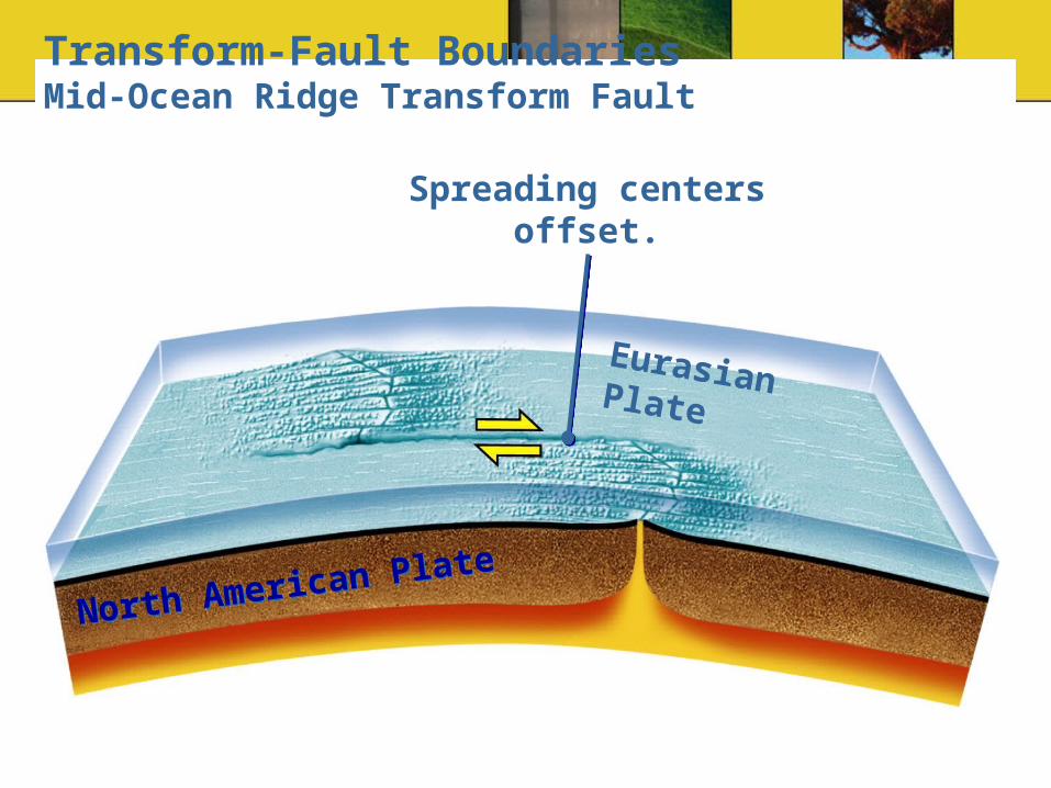
D. Transform-Fault Boundaries
1. Plates slide past one another
2. Fracture with relative displacement

Transform-Fault BoundariesMid-Ocean Ridge Transform Fault
North American P
lateNorth Am
erican Plate
Eurasian Plate
Transform-Fault BoundariesMid-Ocean Ridge Transform Fault
North American P
lateNorth Am
erican Plate
Eurasian Plate
Spreading centers offset.

Transform-Fault BoundariesContinental Transform Fault
North American Plate
North American PlatePacific
PlatePacific
Plate

Transform-Fault BoundariesContinental Transform Fault
North American Plate
North American PlatePacific
PlatePacific
Plate
Offset continental crust.


As platesmove past each other...

As platesmove past each other...
…creek beds are offset

As platesmove past each other...
…creek beds are offset
SanFrancisco
Los Angeles
San Andreas fault

III. Rates and History of Motion
A. Seafloor Magnetic Tape Recorder
B. Geodesy

A. Seafloor Magnetic Tape Recorder
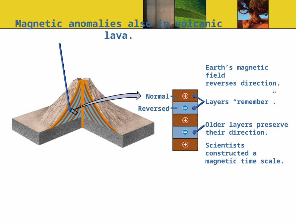
1. Magnetic reversalsa. Switching strength to
the south
b. Preserved in lava
c. Age can be dated
d. Magnetic chrons- ½ million years
e. Magnetic subchrons – 200 000 years

Magnetic anomalies also in volcanic lava.

Magnetic anomalies also in volcanic lava.
Normal
Reversed
Magnetic anomalies also in volcanic lava.
Normal
Reversed
Earth’s magnetic fieldreverses direction.
Layers “remember”.
Older layers preservetheir direction.
Scientists constructed a magnetic time scale.
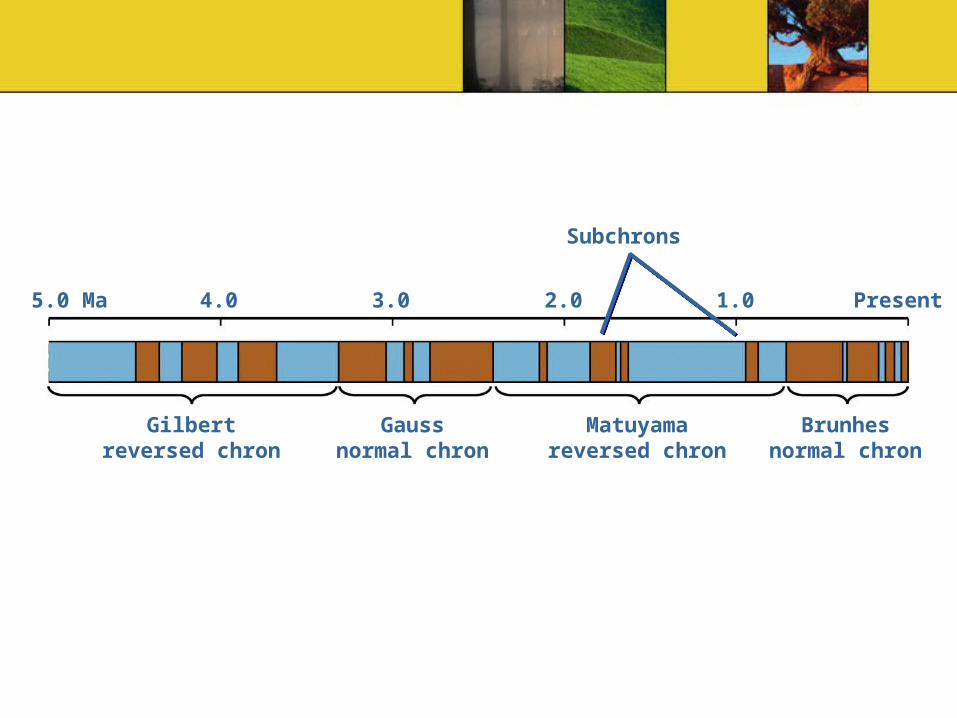
Gilbertreversed chron
Gaussnormal chron
Matuyamareversed chron
Brunhesnormal chron
5.0 Ma Present4.0 3.0 2.0 1.0
Subchrons

Mid-ocean ridge
4.0
3.0
2.0
Oceancrust today
Million years ago (Ma)
5.0
million
years ol
d
3.32.5
0.70 0.7
2.53.3
5.0

A. Seafloor Magnetic Tape Recorder (continued)
2. Magnetic anomalya. Normal-positive
anomaly
b. Reverse-negative anomaly
3. Seafloor agesa. Speed = distance /
time

Magnetic mapping can measure the rate of seafloor spreading
An oceanic survey over the Reykjanes Ridge, part of the Mid-Atlantic Ridge southwest of Iceland, showed an oscillating pattern of magnetic field strength. This figure illustrates how scientists worked out the explanation of this pattern.
Mid-Atlantic RidgeMid-Atlantic RidgeHigh
intensity
Low intensity
A sensitive magnetometerrecords magnetic anomalies,…
Iceland
Mid-AtlanticRidge
…alternating bands of highand low magnetism.
Symmetrical bands on both sides. Why?

B. Geodesy
1. Astronomical Positioning
a. Position with respect to fixed stars
b. 100 m error
2. Global Positioninga. 24 Earth-orbiting
satellitesb. Measure plate
movement

IV. Mantle Convection
A. Driving Forces
B. Plate Recycling
C. Convection Currents

A. Driving Forces
1. Mantle convection
2. Gravitational pull

B. Plate Recyling
1. New lithosphere-ridges
2. Old lithosphere-subduction
3. Recycling within upper and lower mantle-seismic waves

Whole-mantle convection
Uppermantle
Lowermantle
700 km
2900 kmOuter core
Mantle
Outer core
Inner core

Whole-mantle convection
Uppermantle
Lowermantle
700 km
2900 kmOuter core

Stratified convection
Boundary near700 km separatesthe two convectionsystems.
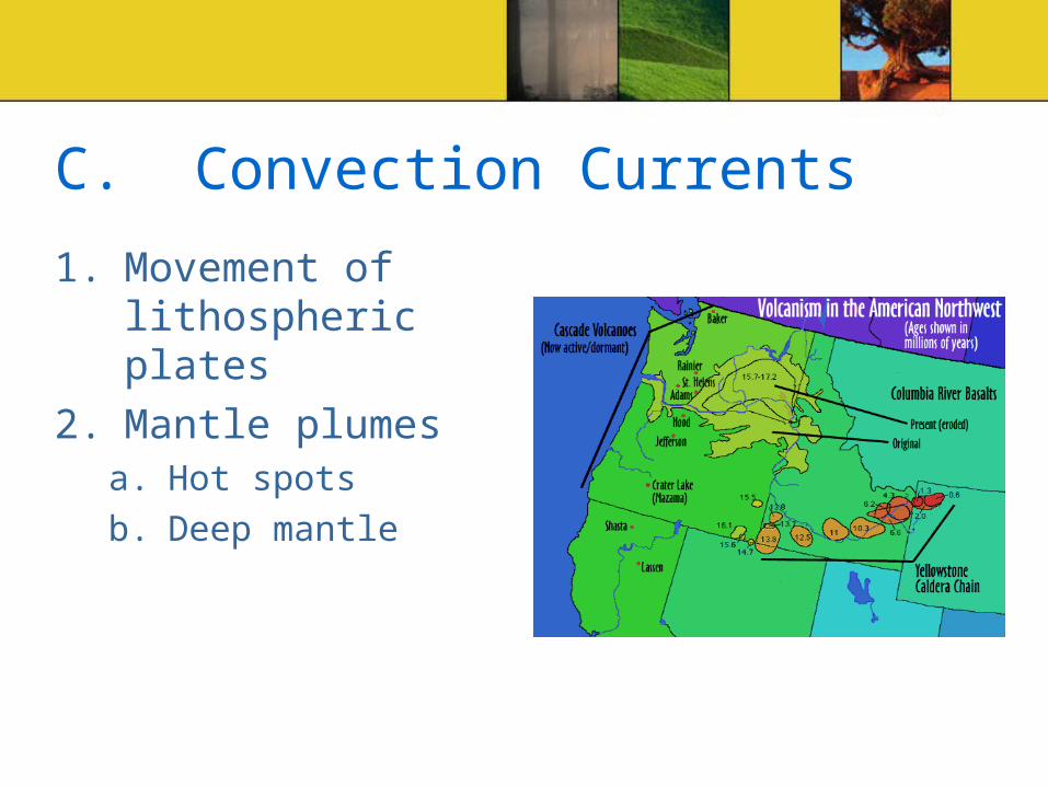
C. Convection Currents
1. Movement of lithospheric plates
2. Mantle plumesa. Hot spots
b. Deep mantle

Plate Tectonics
I. The Discovery of Plate Tectonics
II. The Mosaic of Plates
III. Rates and History of Motion
IV. Mantle Convection