plant association and for the ponderosa pine,
TRANSCRIPT

United StatesDepartment ofAgriculture
Forest Service
PacificNorthwestRegion
R6-EcoI-TP-004-88
1988
Plant Association andManagement Guidefor the Ponderosa Pine,Douglas-fir, andGrand Fir ZonesMt. Hood National Forest

Cover PhotographView of Mount Hood as seen from Mill Creek Ridge within the Mill Creek ResearchNatural Area on the eastern edge of the Mt. Hood National Forest. Foreground sites in-clude some ponderosa pine association communities adjacent to the meadow which was aheavily grazed sheep driw trail during the early 1900's. The background forests include anarrow band of Douglas-fir series associations below the wide expanse of grand fir seriesegetation which blankets most of the Barlow Ranger District from 2500-4500 feet in ele'a-
tion. Photo by Chris Topik.
Peions of any rac color, national ongai, sec age; religion, or with anyhandicapping condition are wekome to use and enjoy all fadiities,progiums, and se,vices of the USDA. Discrimination in any fonn is stnctyagainst agency policy, and should be reponed to the Secretary of A giicul-tu, Washinon, DC 20250.

United States
Department of
Agriculture
Forest Service
PacificNorthwestRegion
R6-ECOL-TP-004-88
October 1988
Plant Association andManagement Guide for the Ponderosa Pine,Douglas-fir, and Grand Fir Zones
Mount Hood National Forest
By Christopher Topik, Associate Area EcologistNancy M. Halverson, Area EcologistTom High, Soil Scientist

Table of Contents
Chapter OneIntroduction 1
Area Cored 1
Why We Classify Plant Associations 1
Plant Association Classification Terminology 1
The Term, "Mnd Conifer" 1
Definition of Forest Zones 2
Ecoclass Codes 2
Overview of Forest Series 2
Methods 5
Climate 7
Soils 10
Timber 14
Snap and Fallen Trees 19
Wildlife and Range 28
Chapter TwoHow to Key Out Sites to Plant Association 33
Key to Forest Series: Mt. Hood National Forest 33
Association Keys:
Grand Fir Series 34
Western Hemlock and Western Redcedar Series . . .35
Douglas-fir Series 35
Ponderosa Pine Series 35
List of Common Plant Species on the Eastern Portion of the Mt. Hood NF . .36
Chapter ThreeExplanation of Data in the Plant Association Descriptions 41
Association Descriptions:
Ponderosa Pine Series
Ponderosa Pine-Oregon White Oak/Arrowlcaf Balsamroot 43
Ponderosa Pine-Oregon White Oak/Bitterbrush 47
Douglas-fir Series
Douglas-fir/Elk Sedge 51
Douglas-fir/Western Fescue 55
Douglas-fir/Oceanspray/E 1k Sedge 59
Douglas-fir/Pinemat Manzanita 63
Douglas-fir/Common Snowberry 67

Grand Fir Series
Grand Fir/Elk Sedge 71
Grand Fir/Oceanspray 75
Grand Fir/Snowberry 79
Grand Fir/Starflower 83
Grand Fir/Twinflower 87
Grand Fir/Vine Maple/Vanillaleaf 91
Grand Fir/Vanillaleaf 95
Grand Fir/Chinkapin 99
Grand Fir/Skunk-leawd Polemonium 103
Grand Fir-Engelmann Spruce/Starry Solomonplurne 107
Western Hemlock Series
Western Hemlock-Grand Fir/Queencup Beadlily 111
Western Redcedar Series
Western Redcedar-Grand FirfVanillaleaf 115
Literature Cited 119
Appendix One, Canopy Cover of Main Plant Species by Association 123
Appendix Two, Comparison Chart for Estimation of Foliage Cover 135
Acknowledgements 136

List of Figures
List of Tables
List of plant associations, Ecoclass codes and codes used in Figures 3-13 3
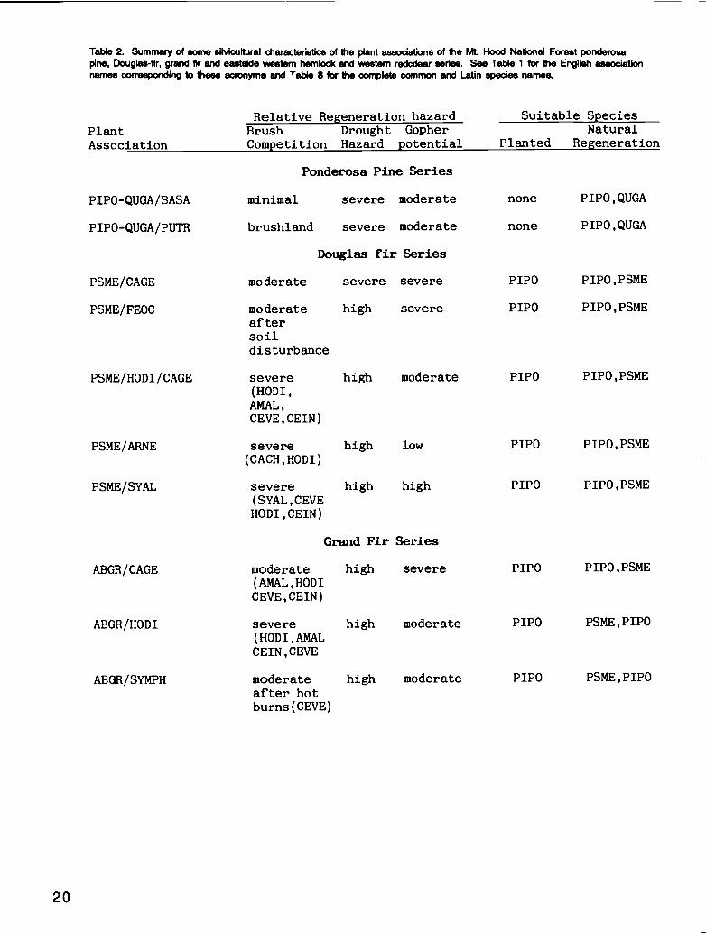
Silvicultural characteristics of plant associations
Summary of snag, down woody material and fine fuels values by association groups . . . .23
Snags per acre by height and decay class and average diameter for association groups .24
Down woody material amounts by diameter and decay condition class 24
Snags per acre by stand seral stage
Down woody material amounts by stand seral stage 26
List of common plant species within the study area
including English and Latin names, computer code and indicator lue 36
1. Idealized distribution of associations within a temperature-moisture grid 4
2. Aerage annual precipitation of the study area 8
3. Average annual precipitation of plots for each association 9
4. Eletion range of plots for each association 9
5. Aspect breakdown of plots for each association 10
6. Soil base saturation for typical soil profiles 11
7. Soil moisture release curves for typical soil profiles 11
& Soil nitrogen content for typical soil profiles 12
9'a. Canopy cover by association for ponderosa pine, grand fir and Douglas-fir 15
9b. Trees per acre by tree size class for each association 15
10. Live tree basal area for each association 16
ha. Site index (100 yrs) for Douglas-fir and ponderosa pine by association 17
lib. Site index (50 yrs) for grand fir by association 17
12. Growth basal area (GBA) for each association 18
13. Potential timber yield at culmination of mean annual increment (based on stand
density index) for each association 18
14. Snags per acre by diameter class and average snag diameter for association groups .. .22
15. Snags per acre by height class for association groups 22
16. Down woody material weight for association groups 27

Chapter 1
Introduction and Background

Introduction
Area CoveredThis publication describes the forested plant associationsof the ponderosa pine, Douglas-fir, and grand fir seriesfound east of the Cascade Crest on the Mt. Hood Na-tional Forest. This classification covers most of the Bar-low Ranger District, and the eastern and lower elevationportions of the Hood River and Bear Springs RangerDistricts. The vegetation varies from dry ponderosapine-Oregon white oak savannas with low stocking, todense, mixed stands of grand fir, Douglas-fir, Engel-mann spruce, western larch, and other conifers. Theterm, mixed conifer zone, is often used for the grand fir,Douglas-fir, and ponderosa pine associations describedherein.
Why We Classify Plant AssociationsPlant associations are groupings of plant species whichre-occur on the landscape within particular environmen-tal tolerances. By knowing the plant association of a sitewe can infer a number of climatic attributes and an-ticipate site response to various treatments. Associa-tions can be used as a basis for inventory of the produc-tive potential of vegetation and other resources whichdepend upon vegetation for their quality or quantity. As-sociations also provide a framework for communicatingmanagement experiences and research results.
Four main uses of associations are:Describing key environmental features of sites.
Providing site specificity for understandingmanagement experience and research results.
Prescription of appropriate management activitiesto Sites, based on better ability to predict siteresponse to treatment.
A natural inventory system of land resources.
This booklet provides a description of what has beencommonly called the mixed conifer zone on the Mt.Hood National Forest. This area is environmentallydiverse, leading to great differences in the productivepotential of timber, wildlife and forage, and in responsesto treatment. Careful attention to vegetation helps us un-derstand environmental gradients and prescribe habitat-specific activities which consider the limitations and op-portunities inherent to the site. Where particular en-vironments exist in unusual geographic settings,knowledge of plant associations reduces the chances ofmaking costly management mistakes or forgoing oppor-tunities.
Plant Association ClassificationTerminologyThe term plant association refers to a stable grouping ofplant species capable of self-perpetuation. Plant associa-tions are climax plant communities. They are namedafter the diagnostic or dominant species in the tree,shrub and herb layers. The name of an association doesnot necessarily describe its vegetation, but merely desig-nates important species. These species help charac-terize that plant community which would occur at astable vegetative condition capable of sustaining itselfrather than being replaced by other species. When werefer to the land on which an association occurs we arereferring to a habitat type (Daubenmire 1968). The col-lection of plant associations having the same species inthe dominant layer is a series. Thus, the grand fir seriesincludes all of the grand fir plant associations. We usethe term forest zone for the land-base on which a par-ticular series is found.
The Term "Mixed Conifer"The term mixed conifer is avoided in this publication be-cause it has such different meanings to various people.To many the term designates any stand havingponderosa pine, Douglas-fir, or grand fir associated withsuch species as western larch, lodgepole pine and Engel-mann spruce. Some think of the mixe4 conifer zone asany place where several conifers, including grand fir orwhite fir, co-exist. This includes mid to high elevationeastern Cascade forests having the species mentionedabove and/or noble fir, subalpine fir, Pacific silver fir,and mountain hemlock. Regionally, the term has beenused to describe the portion of Southern Oregon wheremany conifer species co-exist in small geographic areas.The common link in usage is the co-occurrence of threeto eight conifer species in an area.
An understanding of the environmental tolerances ofvarious conifers and of successional pathways allo usto sub-divide the mixed conifer zone into forest zonesdefined by the occurrence of one or two regeneratingspecies. These forest zones generally reflect the extrememoisture gradient of the area, extending from dry, openponderosa pine forests in sites having only 30 inches ofprecipitation a year, to dense, high elevation grand firstands having over 90 inches of precipitation. The term,mixed conifer, appropriately describes all of the associa-tions described in this paper, but we should recognizethat it is a general concept and subject to misinterpreta-tion.
1

Definition of Forest ZonesForest zones are defined by the dominant species instable, mature stands approximating climax conditions.Most of the stands in the sample area are younger than150 years and have been strongly influenced by fireprevention activities. We can infer stable state forestcomposition of a site from the seedling and saplingpopulations. Thus, in Douglas-fir stands, the presenceof grand fir regeneration indicates that the stand is partof the grand fir zone. If Douglas-fir were the onlyregenerating species, the stand would belong in theDouglas-fir zone. The ponderosa pine zone lacks ap-preciable regeneration of either Douglas-fir or grand fir.
Ecoclass CodesEcoclass codes are 6-digit alphanumeric codes thatdesignate individual plant associations (Hall 1984). Thefirst two digits designate a life-form and series. We use'C" as the first digit to designate coniferous forest. Thesecond digit for the study area is either 'P" (ponderosapine series), 'D" (Douglas-fir series), "W" (white orgrand fir series), "C" (western redcedar series), or "H"(western hemlock series). Ecoclass codes for the as-sociations described in this paper are listed in Table 1.
Overview of Forest SeriesWe have hypothesized the relative placement of theforest series and associations along temperature and ef-fective moisture gradients (see Figure 1). The size ofthe polygons within the ponderosa pine, Douglas-fir, andgrand fir series are roughly representative of the com-monness of the association on the landscape.
Effective soil moisture is far and away the dominant fac-tor affecting the distribution and abundance of theseplant associations. The effective moisture gradient is lar-gely affected by elevation because more precipitationfalls at higher elevations. Precipitation drops off rapidlyeast of the Cascades summit, as well as downwind ofmajor ridges and Mount Hood. Rocky soils andridgetop sites also have lower effective moisture. Thetemperature gradient is also affected most by elevation,but anomalies do occur (for example, flatter sites atmoderate elevations where cold air accumulates). Plantassociations are very helpful to diagnose these areas, asthey reflect local variations in environmental conditions.
Ponderosa pine seriesThis series occurs on hot and dry sites where grand firand Douglas-fir rarely regenerate and grow, if at all,with very poor vigor. Oregon white oak is a common co-dominant in most of this zone. Ponderosa pine-Oregon
2
white oak woodlands include our most sparsely timberedforest-lands. Numerous herb and grass species occur, in-cluding many uncommon species. These are hot and drysites, particularly during the growing season. Precipita-tion tends to be low. Soil moisture is rapidly depletedbecause of shallow soils or because of high evaporativedemand on south slopes. The two associationsdescribed for this series are floristically similar, and oc-cupy the "hot-dry" corner of Figure 1.
Douglas-fir seriesThis series, occurring at higher elevations in hot, dry en-vironments, has sufficient moisture to support Douglas-fir regeneration, but insufficient moisture for grand fir.This series features many attractive ponderosa pineforests. Oregon oak is common, but it is as an early suc-cessional species, gradually being over-topped andeliminated by ponderosa pine and Douglas-fir. Thisseries generally occupies low elevation sites having lowprecipitation, and separates the ponderosa pine seriesfrom the grand fir series on Figure 1.
Five associations are described in the Douglas-fir series.Douglas-fir/western fescue (PSMEIFEOC) is generallyfound on north aspects with low precipitation. Douglas-fir/pinemat manzanita (PSME/ARNE) representsanother extreme. This association occurs on ridges androcky sites at fairly high elevations having high precipita-tion, but south aspects and rocky soils lead to effectivelydry conditions for plant growth. The other associationsare far more widespread. Two include substantial elksedge. Douglas-fir/oceanspray/elk sedge(PSMEIHODI/CAGE) is shrub dominated and occurson rockier sites at slightly higher elevations thanDouglas-fir/elk sedge (PSME/CAGE). The Douglas-fir/common snowberry (PSME/SYAL) association oc-curs on lower slope positions or protected aspects.
Grand fir seriesThis series includes those areas where grand fir is ex-pected to comprise at least ten percent of the canopy instable state (200 years) or climax stands. Forests in thiszone often include several other conifers (notablyDouglas-fir and ponderosa pine), but grand firdominates the regeneration. The upper elevation limitof the grand fir zone occurs where abundant moistureand cool temperatures allow development of standsdominated by Pacific silver fir, subalpine fir, or moun-tain hemlock.
The Grand fir series occupies a large portion of the Bar-low Ranger District and is also common in the eastern,lower elevation portions of the Hood River and the BearSprings Ranger Districts. We have described tcn grand

C)
Table 1. List of plant associations of the ponderosa pine, Douglas-fir, grand fir, western hernlock, and western redcedar series on theeastern Cascade portion of the Mt. Hood National Forest.
111
115
Alpha code Co..on Na.e Scientific Nae ECOCLASS
CODE
Code in
Figures
3-13PONDEROSA PINE SERIES
P1 PO-QUGA/BASA Ponderosa Pine-Oregon White Oak! Pinus ponderosa-Quercus garryana/ CPH2 11 BASA
Arrowleaf Balsamroot Balsamorhiza sagittata
P1 PO-QUGA/PUTR Ponderosa Pine-Oregon White Oak! Pinus ponderosa-Quercus garryana/ CPH2 12 PUTR
Bitterbrush Purshia tridentata
DOUGLAS-FIR SERIES
PSME/CAGE Douglas-fir/Elk sedge Pseudotsuga menziesii/Carex geyeri CDG1 41 CAGE
PSME/FEOC Douglas-fi r/Western Fescue Pseudotsuga menz I cal i/Fes tuca occidentalis CDG3 21 FEOC
PSME/HOD I/CAGE Douglas-fl r/Oceanspray/ Pseudotsuga menziesi i/Holodiscus discolor/ CDS2 31 HODI
Elk Sedge Carex geyeri
PSME/ARNE Douglas-fl r/Pinemat Manzanl ta Pseudotsuga menzies ii/Arctostaphylos
nevadensis
CDS6 62 ARNE
PSME/SYAL Douglas-fir/Common Snowberry Paeudotsuga menziesii/Symphoricarpos albus CDS6 61 SYAL
GRAND FIR SERIES
A 8CR/C AGE Grand Fir/Elk Sedge Abies grandis/Carex geyeri CWG1 21 CAGE
ABGR/HODI Grand Fir/Oceanspray Abies grandis/Holodlscus discolor CWS5 31 HODI
ABGR/SYMPH Grand Fir/Snowberry Abies grandis/Symphoricarpos albus- CWS3 31 SYMPH
Symphoricarpos mollis
ABGR/TRLA2 Grand Fir/Starfiower Abies grandis/Triental is latifol ia CWF5 21 TRLA2
ABGR/LIBO2 Grand Fir/Twinflower Abies grandis/Linnaea borealis CWF3 21 LIBO2
ABGR/ACCl/ACTR Grand Fir/Vine Maple/ Abies grandis/Acer circinatum/ CWS5 32 ACCI
Vani ilaleaf Achlys triphylla
ABGR/ACTR Grand Fir/Vani 1 laleaf Abies grandis/Achlys triphylla CWF5 22 ACTR
ABGR/CACH Grand Fir/Chinkapin Abies grandis/Castanopsis chrysophyl la CWS5 33 CACH
ABGR/POPU Grand Fir/Skunk-leaved Polemonium Abies grandis/Polemonium pulcherrium CWF5 23 POPU
ABGR-PIEN/SMST Grand flr-Engelmann Spruce! Abies grandis-Picea engelmannii/ CWC5 11 PIEN
Starry Solomonpluae Smilacina stellata
WESTERN HEMLOCK SERIES
TSHE-ABGR/CLUN Western Hemlock-Grand Fir! Tsuga heterophylla-Abies grandis/ CHC3 11 CLUN
Queencup Beadlily Clintonia uniflora
WESTERN REDCEDAR SERIES
THPL-ABGR/ACTR Western Redcedar-Grand Fir/ Thuja plicata-Abies grandis/Achlys triphylla CCF2 11 THPL
Vanillaleaf
page
in
book
43
47
51
55
59
63
67
71
75
79
83
87
91
95
99
103
107

SUTALPINE rIFT SERIES
l0UNTAI.N HEMLOO< SERIES
ABCR/POPU
PACIFIC SILVERFIR SERIES
58CR-PIEN/SMST ABCS!
ACTS
TEHE-
auN
A8CR/ A8CR/ACCl/ 1802ACIR
ABOR/CACH
ABCR/TRLA2
ABCR/H 001
ABCR /S 054 PU
ABCR/C ACE
MOISTURE
Figure 1. Idealized disiributlon of associations within a temperature-moisture grid. See Table I for a key to the associationcodes. These axes integrate elevation and aspect-related dimatic phenomena. The moisture axis represents precipitation, aswell as the moisture-holding and supplying capacity of the soil. Wrth4n the Grand Fir, Douglas-fir and Ponderosa pine series,the association polygons are roughly proportional to the association abundance on the landscape.
WET DRYWARM DECREASING EFFECTIVE MOISTURE

fir associations. This series includes most of what is com-monly referred to as the mixed conifer zone. The canopyusually contains Douglas-fir, western larch, andponderosa pine; grand fir commonly grows up frombeneath these early seral tree species. Several other con-ifers also occur in smaller amounts.
At the extreme hot and dry end of this series, the Grandfir/elk sedge (ABGR/CAGE) association is found. Highelevation, moist sites, are represented by the Grand fir-Engelmann spruce/starry solomonpiume (ABGR-PIEN/SMST) association. This association includesgreat plant species diversity, including many conifer andherb species. Similarly cold, but less lush and produc-tive, is the Grand fir/skunk-leaved polemonium(ABGR/POPU) association. Warmer, herb-rich com-munities with abundant vanilaleaf are common in themore productive moist sites (Grand flr/vanillaleaf(ABGR/ACTR) and Grand fir/vine maple/vanillaleaf(ABGR/ACCl/ACTR) associations). The dry end ofthe spectrum within this series includes shrub-rich as-sociations: Grand flr/oceanspray (ABGR/HODI),Grand flr/snowberry (ABGR/SYMPH), and Grandfir/chinkapin (ABGR/CACH). The environmental mid-dieground includes Grand fir/starfiower(ABGRITRLA2) and Grand fir/twinflower(ABGRILIBO2) associations.
Western hemlock and western redcedar seriesOn Barlow and Bear Springs Ranger Districts stands ofwestern hemlock and western redcedar may be found inlow elevation canyon bottoms with abundant soil mois-ture. These sites also have grand fir and Douglas-fir, butthe abundance of western hemlock and western red-cedar indicate substantially different local environmentalconditions. On the Hood River Ranger District, a morewidespread western hemlock zone is found in thewestern portion at low elevations.
The Western hem lock-grand fir/queencup beadlily(TSHE-ABGR/CLUN) association occurs near majorcreeks and the low elevation portion of the Bear SpringsRanger District adjacent to the Warm Springs IndianReservation. The Western redcedar-grand fir/vanillaleaf(THPL-ABGR/ACTR) association also occupies lowelevation, moist sites east of the Cascades crest.
High elevation series not included in thisreportThe Pacific silver fir, mountain hemlock, and subalpinefir series occupy moist, cool to cold sites at high eleva-tions (4000 feet) near the Cascades crest. We have pre-viously described associations from the western Cas-cades in the silver fir and mountain hemlock series
(Hemstrom and others 1982). Our highest elevationforests are included in the subalpine fir series. Thesesites are colder and slightly drier than mountain hemlockseries sites. This series is found at very high elevationson Mt. Hood, at high elevations further east where coldand dry conditions prevail, and in frost pockets whereheavy, cold air pools. The highest elevation ridges onBarlow Ranger District include subalpine fir zone sites.A classification of high elevation forest associations is inpreparation. These zones are not discussed in this paper.
MethodsThis classification is based on data from 196 sampleplots located in relatively undisturbed, mature timberstands throughout the eastern portion of the Mt. HoodNational Forest. Samples include both reconnaissanceplots used primarily to understand vegetation and inten-sive plots with more detailed measurements of timberstocking and growth, snags, coarse woody debris, andfine fuels. Detailed soil profiles were described on a sub-set of both plot types.
Reconnaissance PlotsThese plots were selected subjectively without precon-ceived bias (Muller-Dombois and Elleriberg 1974). Weused aerial photos and our knowledge of the study areato select sites having as little disturbance as possible andyet representative of the area's floristic variation. Onthese 500 m2 circular plots we made complete lists of thevascular flora and ocular estimates of their percent foliarcover (see Appendix 2.) We also noted a variety ofphysical attributes of the site such as elevation, slope,aspect, landform, etc. We sampled one or two site treesrepresentative of the best growth in the plot vicinity andwe did a variable radius basal area measurement at plotcenter using either a 20 or 40 BAF prism. We alsophotographed each plot.
Intensive PlotsEach of these plots included a rcconnai.ssance plot aswell as these additional measurements:
Live Tree Stocking and GrowthWe sampled 3-5 site trees of each major species presenton the plot. These site tree data include height, crownratio, diameter at breast height (DBH), age at breastheight, bark thickness, sapwood thickness, recentdecade's radial growth, and basal area of the surround-ing stand (for growth basal area calculation, Hall 1988).The major species site index curves used arc Curtis(1974) for Douglas-fir, Barrett (1978) for ponderosa
5

pine, and Cochran (1979) for grand fir. The latter is a50 year base curve whereas the former two curves are in-dexed to age 100. Other site index curves used wereCochran (1985) for western larch, Dahms (1975) forlodgepole pine, Brickell (1970) for Engelmann spruceand western white pine, and Barnes (1962) for westernhemlock. Each intensive plot included 5 variable radiusbasal area plots: one at plot center and one at each car-dinal direction 100 feet away (slope corrected distance).In those situations where abrupt ecotones existed, we ad-justed the placement of the outlying plots to be on paral-lel lines within the relatively homogeneous sample area.We measureed the diameter of each "in" tree in the vari-able radius plots so we can calculate number of trees peracre by size class and species, as well as Reineke's(1933) stand density index (SD!).
SnagsStanding snags (minimum size 10 in. DBH and 10 feettall) in three variable radius plots (center, north andsouth) were measured for DBH, height class, decay con-dition class, cavity number class, and species. Theheight classes are 10-30 feet, 31-50 feet and greater than50 feet. The cavities counted are potential nesting open-ings which clearly appear to be animal created. Thecavity classes are: 0; 1-3; 4-7; and greater than 7. Thesnag condition classes used are becoming standard inthe region (Maser and Trappe 1984):
Condition 1: Fine branches and bark intact
Condition 2: A few larger limbs present, bark present
Condition 3: Limb stubs may be present, bark only
partly intact
Condition 4: Bark nearly gone; solid buckskin
Condition 5: Rotted, soft and crumbly
Fallen Trees and Fine FuelsWe utilized the plane transect method of Brown (1974)to quantify down woody debris and fine fuels (less than 3inch diameter). We used two parallel 100 foot long tran-sects for coarse woody debris on each intensive plot andfour short transects for the fine fuels: 10 feet long for 1-3inch diameter pieces, 6 feet long for 1/4-1 inch diameterpieces, and 3 feet long for 1/4 inch diameter pieces.The fine fuels are categorized as 1-hour (1/4 inchdiameter), 10-hour (1/4 to 1 inch diam.), and 100-hour(1-3 inch diam.) fuels (Deeming et al. 1978). Our cal-culations of fine fuel weights used Brown's compositevalues for squared average-quadratic mean diametersand his "others" values for the average secant of non-horizontal particle angle for correcting orientation bias.Coarse woody debris (greater than 3 inch diameter)were tallied according to size and deterioration condi-tion classes. Diameter and length were also recorded,
6
thus allowing us to calculate total volume and weight.The size classes are:
Size 1: Piece does not contain a segment which is atleast 6 in. in diameter for a length of at least 5 feet.
Size 6: Piece contains a segment which is 6 inches indiameter or larger for a length of at least 5 feet.
Size 12: Piece contains a segment which is 12 inches indiameter or larger for a length of at least 5 feet.
Size 20: Piece contains a segment which is 20 inches indiameter or larger for a length of at least 5 feet.
Condition classes indicate relative states of decomposi-tion. We modified the classification of Maser andTrappe (1984):
Condition 1: intact bark and wood, fine branchespresent (Maser and Trappe (1984) condition class 1)
Condition 2: bark loose, fine branches absent, wood in-tact or partly soft. slightly sagging (Maser and Trappe(1984) condition class 2)
Condition 3: bark usually absent, no fine branches,wood soft to powdery, may be somewhat oval in cross-section, all of piece is on the ground (Maser and Trappe(1984) condition classes 3 and 4)
We did not tally highly decomposed pieces (Maser andTrappe (1984) condition class 5).
SoilsSoil profiles (105 total) were described on most intensiveplots and on many reconnaissance plots. A soil pit wasexcavated to a depth of 100 cm or to bedrock if less than100 cm. The soil profile was described in accordancewith standards and methodology contained in the SoilSurvey Manual (Soil Survey Staff 1975) and the NationalSoils Handbook (USDA, Soil Conservation Service).The soil pit was located as close to plot center as pos-sible, except when that location was deemed not repre-sentative.
Determining the ClassificationIndividual plant associations were designated on thebasis of four classification criteria (Hall 1984):
Do they have a distinctive flora?
Do they have different productive potentials?
Are there distinctive management implications?
Are they identifiable on the ground?
We used a combination of subjective and objective clas-sification methods. Computer-based methods involved

construction of initial plot ordering tables (Volland andConnelly 1978) which were compared with results fromdetrended correspondance analysis (DE CORANA)(Gauch 1977 plus supplements; Gauch 1982). Two-stepindicator species analysis (TWINSPAN) was used to ex-amine the classification value of various species and plotgroups. These results were used to re-order the subjec-tive association groupings. Old-growth plots were moreheavily weighted as they reflect the eventual floristiccomposition which define associations.
Similar ecological data from the grand fir zone on theGifford Pinchot National Forest were combined withthese data to evaluate the possibility of using one clas-sification for these zones on both National Forests.Several associations on both National Forests are some-what similar floristically, but substantial differences inproductive potential and therefore, management implica -tions, argues against lumping these data to describesingle associations.
The preliminary association classification and keys werefield-tested for a season to emine their identifiabilityand integrity. Comments from these tests and outsidereview were considered.
ClimateThe climate on the east slope of the Cascades combinesfeatures of maritime and continental regimes (Franklinand Dyrness 1973). Dominant characteristics are therain shadow effects of the Cascade crest, elevation-re-lated temperature differences, and very low summerprecipitation.
The rapid decline in precipitation with distance east ofthe Cascade crest is clearly illustrated in the isohyetalmap (Figure 2), showing a drop from 90 to 20 inches peryear. The actual local patterns are probably much morecomplex. We postulate that the northern portion of theBarlow Ranger District is generally drier than furthersouth because winter storms from the southwest are im-peded by Mt. Hood. The Forest-wide precipitation mapalso may underestimate the importance of the major es-carpment on the eastern edge of the Hood River Valleyleading from Surveyor's Ridge to Gumjuwac Saddle.East of escarpment the climate becomes drier due to in-creasing distance from the Cascade crest, the blocking ef-fect of the escarpment, and because of decreasing eleva-tions.
In general, increasing elevation is associated with lowertemperatures, more precipitation as snowfall, and higherprecipitation levels, because cooler air masses havelower moisture holding capacity. This generalization, inour area, is complicated by the rain shadow effect of Mt.Hood and the Cascade Crest. Thus, low elevations(below 3000 feet) on the Barlow Ranger District arequite dry (largely because these sites are so far east ofthe Cascade crest), while the same elevations on theHood River and Bear Springs Ranger Districts are con-siderably more moist.
The east slope of the Cascades receives only scant sum-mer rainfall from maritime storms. Thundershowers ap-pear to be more prevalent at higher elevations. The east-ern edge of the Mt. Hood National Forest has a muchlonger period of summer drought than elsewhere on theForest. This feature is of primary importance to vegeta-tion composition and productivity.
The effective moisture concept integrates the factorswhich affect water availability for plant growth andevapotranspiration. Though incident moisture variesfrom 20 to 90 inches per year, effective moisture is muchmore variable. It is strongly affected by local soil andtopographic characteristics, such as bedrock fracture,slope, soil depth, stoniness, texture, structure, organicmatter content, and aspect. When we discuss moist- ordry-site plant associations, we are referring to the effec-tive moisture of the site. Plant associations in this areaare strongly influenced by moisture, and thus are goodindicators of differences in moisture between sites.
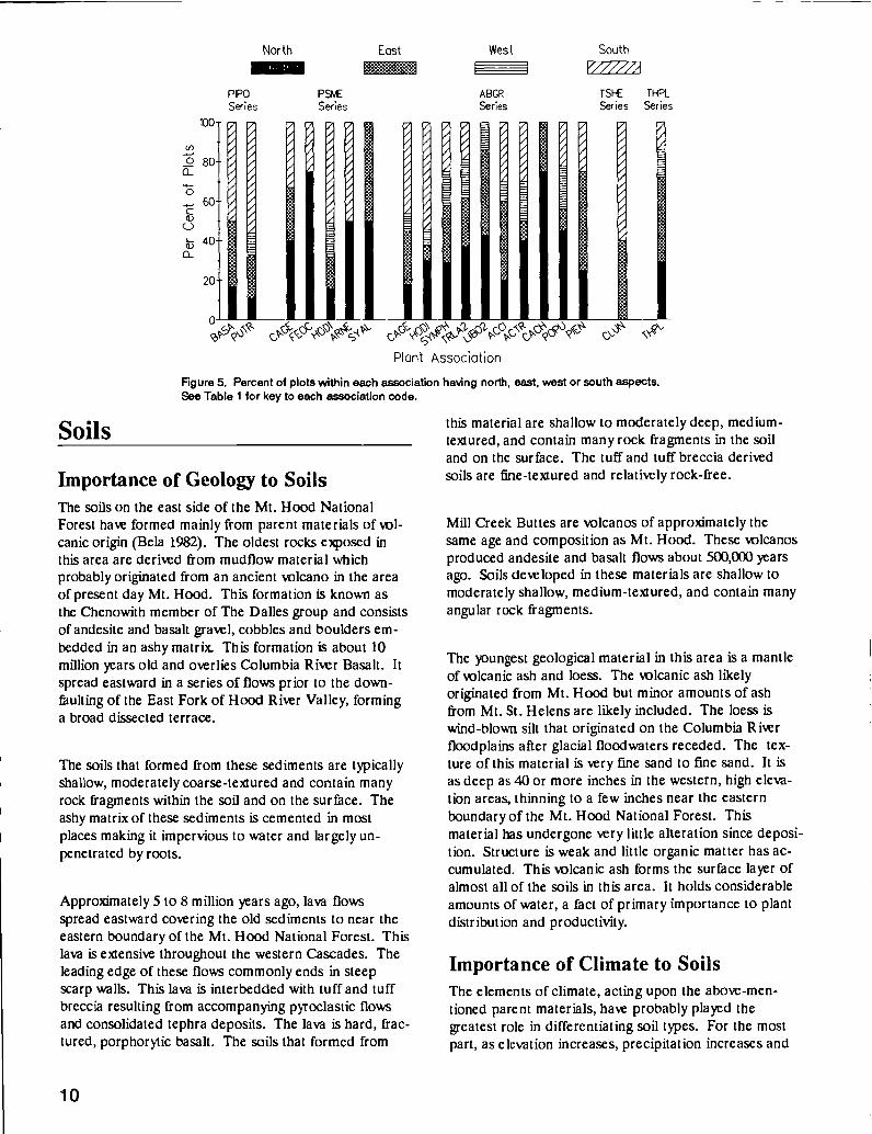
Figure 3 illustrates variation in annual precipitationwithin and among plant associations. These values arebased on plot values estimated from the Mt. Hood Na-tional Forest hyirologist's isohyetal map depicted inFigure 2. The ponderosa pine series associationsaverage less than 30 inches per year, whereas the highelevation grand fir series types, (Grand fir/Skunk-leavedpolemonium (POPU), and Grand fir-Engelmannspruce/Starry solomonseal (PIEN)) range up to 90 in-ches per year. The height of the individual bars inFigure 3 depicts the estimated variability of precipitationwithin an association. For instance, the great variationwithin the Douglas-fir/OceanspraylElk sedge (HOD!) as-sociation indicates that it is found both at sites havingvery low incident rainfall, and high precipitation siteswith very low effective moisture due to soil conditions.
Elevation affects climate greatly and is especially impor-tant as the controlling factor of temperature andprecipitation. A good deal of the precipitation variationof associations is due to elevation effects.
7

Vicinity Map
Mt. Hood NF
8
I
0PINEGROVE
Figure 2. Average annual precipitation (inches per year) for the eastern portion ci' the Mt. Hood National Forest. Constructed by Mt. HoodNF hydrologist, based on U.S. Weather Bureau maps and field stations.

80ci)>'
-.-.-. 7C',ci)
60
Co 500-40
0Q)
20
4000-
2000-
PIPOSeries
I
jI
PS
SeriesABGRSeries
I '''11111111
Figure 4 shows the elevation ranges of plant associationsin this area. There is a clear trend of increasing eleva-tion from the more dry plant associations to the moremoist. The distinctively anomalous association, Douglas-fir/pinemat manzanita (ARNE), may occur at high eleva-tions but is associated with rocky ridgetops having low ef-fective moisture. This association represents an edaphicclimax community (sensu Tansley 1935).
Aspect also greatly affects local climates. The aspectbreak-down of plots in each association is presented in
II
TSHE TI-FLSeries Series
IC:, ccc&t- $O9Plant Assodaton
Figure 3. Fnge in average annual precipitation for sample plots in each plant association.See Table 1 for a key to each association code. The values for each plot come from the Mt.Hood NF precipitation map (Figure 1).
I
\ \_
Figure 5. In general, moisture is most abundant onnorth and east slopes because evaporational demand isless than on south or west slopes. This generalization iscomplicated by the differences in incident precipitation,however. For example, the Douglas-fir/Western fescue(FE CC) association has low rainfall (28-38 in/yr) but oc-curs on north slopes. The protection from direct sun(and lower evaporational demands) leads to better plantgrowth than average for sites with low rainfall. Westernaspects are uncommon throughout the entire study areabecause so much of the landscape is dominated by theeastward declining ridges of the Barlow Ranger District.
9
PIPO PStv[ ABGR TSHE THPL
Series Series Series Series Series
100 ç,Plant Association
Figure 4. nge (midle 75%) in elevation for sample plots in each plant association. SeeTable 1 for a key to each association code. Each bar indicates the middle 75% of the range ofsample plot elevations in that association.
I IU
Soils
10
PIPO
Series
r7
20-
PSME
Series
Importance of Geology to SoilsThe soils on the east side of the Mt. Hood NationalForest have formed mainly from parent materials ofol-canic origin (Bela 1982). The oldest rocks exposed inthis area are derived from mudf]ow material whichprobably originated from an ancient olcano in the areaof present day Mt. Hood. This formation is knowa asthe Chenowith member of The Dalles group and consistsof andesite and basalt gravel, cobbles and boulders em-bedded in an ashy matrix. This formation is about 10million years old and overlies Columbia River Basalt. Itspread eastward in a series of flows prior to the down-faulting of the East Fork of Flood River Valley, forminga broad dissected terrace.
The soils that formed from these sediments are typicallyshallow, moderately coarse-textured and contain manyrock fragments within the soil and on the surface. Theashy matrix of these sediments is cemented in mostplaces making it impervious to water and largely un-penetrated by roots.
Approximately 5 to 8 million years ago, lava flowsspread eastward covering the old sediments to near theeastern boundary of the Mt. Hood National Forest. Thislava is extensive throughout the western Cascades. Theleading edge of these flows commonly ends in steepscarp walls. This lava is interbedded with tuff and tuffbrcccia resulting from accompanying pyroclastic flowsand consolidated tephra deposits. The lava is hard, frac-tured, porphorytic basalt. The soils that formed from
V
4
ABGR
Series
r
A
TSI-E THPLSeries Series
C
Plant Association
Figure 5. Percent of plots within each association having north, east, west or south aspects.See Table 1 for key to each association code.
this material are shallow to moderately deep, medium-textured, and contain many rock fragments in the soiland on the surface. The tuff and tuffbreccia derivedsoils are fine-textured and relatively rock-free.
Mill Creek Buttes are volcanos of approximately thesame age and composition as Mt. Hood. These olcanosproduced andesite and basalt flows about 500,000 yearsago. Soils developed in these materials are shallow tomoderately shallow, medium-textured, and contain manyangular rock fragments.
The youngest geological material in this area is a mantleoflcanic ash and bess. The volcanic ash likelyoriginated from Mt. Hood but minor amounts of ashfrom Mt. St. Helens are likely included. The bess iswind-blown silt that originated on the Columbia Riverfloodplains after glacial floodwaters receded. The tex-ture of this material is very fine sand to fine sand. It isas deep as 40 or more inches in the western, high eleva-tion areas, thinning to a few inches near the easternboundary of the Mt. Hood National Forest. Thismaterial has undergone very little alteration since deposi-tion. Structure is weak and little organic matter has ac-cumulated. This olcanic ash forms the surface layer ofalmost all of the soils in this area. It holds considerableamounts of water, a fact of primary importance to plantdistribution and productivity.
Importance of Climate to SoilsThe elements of climate, acting upon the above-men-tioned parent materials, have probably played thegreatest role in differentiating soil types. For the mostpart, as elevation increases, precipitation increases and
North East West South

temperature decreases. East of the Hood River Valleythis relationship forms a rather distinct east to westgradient.
Soil temperature has an important influence on thebiological, chemical and physical processes in the soil.Soil temperature regimes relate closely to growingseason length. Three classes of soil temperature arerecognized in this area. Mesic soils are the warmest,and range up to about 2500 feet in elevation. Frigid soilshave a cooler mean annual temperature but are warmduring the growing season. This regime ranges up toabout 4000 to 5000 feet. Cryic soils are higher in eleva-tion and are characterized by cool temperatures duringthe growing season.
The soil moisture regime is an index of the supply ofmoisture during the growing season. The Xeric soilmoisture regime is characterized by soils that are dryduring most of this period. These soils range up toabout 5000 feet in elevation. Above this are soils with aUdic moisture regime. These soils usually contain someavailable moisture throughout most of the growingseason.
Soil FertilitySoil fertility depends largely on the soil's ability to supplyroots with moisture, chemical nutrients, and oxygen.Soil organic matter supplies critical nutrients, as well ascation exchange and moisture holding capacity.Precipitation and temperature control the rate at whichorganic matter is produced and incorporated into thesoil. As organic matter incorporation into the soilproceeds, nutrients are released and made available toplants. Water moving through the soil removes basicminerals from upper horizons and increases acidity.Figure 6 illustrates the base saturation of several repre-sentative soils plotted against depth. The level of basesaturation is a rough measure of the soil's chemical fer-tility. Generally, the higher elevation or more moist-sitesoils have fewer nutrients due to leaching losses. Thus,on a chemical basis, the Grand fir/snowberry(ABGR/SYMPH) and Grand fir/vanillaleaf(ABGR/ACTR) soil samples have greater fertility thanthe other two samples from moister sites. The great dif-ference in annual precipitation among these samples is abetter predictor of site fertility than are the chemicalproperties.
The soil moisture retention curves for the surface layerof several representative soils is presented in Figure 7.Total porosity averages about 50 to 60 percent. The soilis situratcd when these pores are filled with water. Un-fortunately, about half of this water is lost through sub-
-20-
-40-ca-U)
-60-
7. Base Saturation0 20 40 60 80 100
0
-80
-100
50
U)
40
>-,
a)30
20
TSHE-ABGR/CLUN
Figure 6. Soil base saturation for four soils from The Dalleswatershed representative of four associations. See Table 1 for keyto association codes. Malysis performed by soils laboratory,
egon State University.
60ABOR/POPU
ABGR/SYMPH
ABCR/SYMPH
11
10ABGR/TRLA2
(Field Copacity) (Wilting Point)
.8 20 50
Pressure (Bars)
Figure 7. Soil moisture release curves for four soils from TheDallas watershed representative of four Grand fir seriesassociations. See Table 1 for key to association codes. Nalysisperformed by soils laboratory, Oregon State University. The watercontent at wilting point indicates that, at most, 10% of soil water isunavailable to plants.
ABCR/POPUABCR/ACTR

surface flow. Moisture held at field capacity averagesabout 25 to 30 percent by wlume. At wilting point themoisture remaining is only about 5 to 10 percent, whichmeans that most of the water retained by these soils isavailable to plants. The four samples illustrate that, ingeneral, the soils of the grand fir series have quitesimilar physical properties.
Soil texture, organic matter content, and rock fragmentcontent strongly influence the total amount of water thatthe soil can store. An index of soil rockiness and depthis called effective soil depth. Values are presented foreach association in the type descriptions. Effective soildepth is calculated by multiplying the soil profile depthby the proportion of the soil consisting of sand or finersize particles. Thus, this index excludes that proportionof the soil occupied by coarse fragments (which do notsupply effective rooting) from the total soil depth.Generally, the higher elevation soils have the thickest ol-
canic ash mantle and the fewest rock fragments in theroot zone, arid, therefore, the highest available watercapacities.
Nitrogen generally is the most limiting nutrient to plantgrowth in western forest soils. Total soil nitrogen levelsare exceptionally low on many of the soils on the
7. Total Nitrogen0.00 0.05 0.10 0.15 0.20 0.25 0.30 0.350
-20
o -60(I)
-80
ABGR/ ABCR/ACTRSYMP.H '
BGR/POPU
ABAM/OXOR_
SHE/POMU-OXOR
-100
Figure 8. Soil nitrogen content for three soils representative of
three Grand fir series associations within The Da1leswatersfed.See Table 1 for key to association codes. Mt. Hood NF (westernCascades) Pacific silver fir zone (ABAM/0X09 and Westernhem lock zone soils (TSHEJPOMU-OXOl are included for reference.
12
eastside of the Mt. Hood National Forest (figure 8). Wehave included two westside samples, Western hem-lockJswordfern-oxalis (TSHEIPOMU-OXOR) andPacific silver fir/o,ailis (ABAM/OXOR), to illustratehow low these eastside values are. Nitrogen content ishighest in the surface layers and generally decreases withincreasing depth. Slight increases in deeper layers aredue to the presence of older, buried surface layers. Thelow level of nitrogen in these soils indicates a likelyresponse to fertilization. Total nitrogen seems to beslightly higher in soils of the higher elevation, cooler andmoister plant associations. The suspected cause is thehigher frequency of fire that occurred in the lower eleva-tion areas before the advent of fire suppression.Repeated burning may have caused considerableamounts of nitrogen to be olatiized.
Soil Management ConsiderationsOf the environmental factors necessary for plant growth,soil moisture, temperature and nutrients are the mostlikely to be impacted by management activities. Soil or-ganic matter, including the forest floor (duff layers),plays a key role in determining soil fertility, and it is alsoeasily impacted by some treatments.
In undisturbed conditions forest soils have a greatcapacity to absorb moisture and the overland flow ofwater rarely occurs. The forest floor (litter or dufflayer) absorbs water readily and transmits it to themineral soil below. This is especially important since theexposed surface of the wlcanic ash topsoil is inherentlywater-repellent. Without a litter layer, raindrops strikingthe ground can detach soil particles and seal the surfacepores of the soil. This can cause overland flow, reducingthe amount of water available to plants, and resulting inerosion and loss of fertility. The litter layer also helps toconserve soil moisture by reducing evaporation from thesoil surtice.
Soil temperatures in the root zone of tree seedlings canreach lethal levels on south-facing slopes with no shadeor litter cover. On these sites leaving shelter trees forshade may be necessary to maintain cooler soil tempera-tures. Maintaining some litter cover insulates themineral soil from high daytime temperatures and helpskeep the soil warm at night.
In addition to moderating soil temperatures and helpingto conserve soil moisture, the forest floor contains mostof the nutrients which are cyeled through the soil. Also,decomposing woody material is important for free-living,nitrogen-fixing bacteria, for the development of myeor-rhizal fungi, and as an excellent water-saturated rootingmedium.

Site preparation objectives often require removal or dis-placement of some of the duff layer to aid in the estab-lishment of tree seedlings. Even where exposure ofmineral soil is desired for natural seedling establishment,the amount should be limited. Twenty to thirty percentmineral soil exposure is usually adequate if it is evenlydistributed throughout the area. Where tree planting isprescribed, removal of the litter and duff should be con-fined to only that which is necessary to plant the trees.
Plant growth can also be limited by disturbance to themineral soil through compaction by heavy equipment.This results in a loss of large pore space which, in turn,reduces the available moisture in the soil. Soil compac-tion also impedes root growth and reduces the gaseousexchanges necessary for healthy roots.
Loss of nutrients through topsoil erosion can reduceplant growth. The surface mineral soil layers are by farthe most critical for root uptake of nutrients. The lowdensity of surface layers is due to the volcanic ashmaterial and high organic matter contents. These sur-face soils can be easily displaced and eroded by overlandflow of water, severely impacting the long-term produc-tive potential of the site.
The key to maintaining soil fertility is conserving and en-hancing soil organic matter, either in the form of surfacelitter layers or humus incorporated into the mineral soilmatrix. Organic matter has high concentrations of readi-ly available nutrients, high moisture-holding capacity andhigh nutrient exchange potential. It fosters soil structuredevelopment which enhances water, air, and root move-ment throughout the soil profile. Soil biological activityis dependent upon a sufficient quantity and quality ofsoil organic matter.
Overview of Soils by Series
Ponderosa pine seriesThe soils of the Ponderosa pine associations are drythrough much of the growing season. These soils havethin litter layers and moderate levels of organic matter inthe topsoil because litter accumulates slowly on thesesites. In the past, frequent fires also regularly removedconsiderable amounts of litter. The soil pH is neutral toslightly acid and the concentration of bases is high dueto low precipitation and leaching rates.
A unique feature of a small portion of this area is pat..terned ground, also known as biscuit-scabland. The bis-cuits are mounds of relatively rock-free soil that supportoak and bitterbrush. The scabs, or intermound areas,
are quite shallow and contain many rock fragments.With much less capacity to supply water, the intermoundareas can support only grasses and forbs.
The soils of the Ponderosa pine associations are clas-sified as tine loamy or loamy-skeletal, mixed, mesicTypic Xerochrepts, Typic Eutrochrepts or TypicHaploxerolls (Soil Survey Staff 1974).
Douglas-fir seriesIn the Douglas-fir zone the litter layers are thicker andinclude a layer of partially decomposed material.Moderately warm temperatures and increasing amountsof moisture favor the incorporation of considerableamounts of organic matter into the topsoil. These soilshave the thickest organic-rich topsoil layers of any onthe eastside of the Mt. Hood National Forest. Soil pH isslightly acid to moderately acid and base saturation isfairly high.
Although these soils are quite fertile, plant growth islimited by low moisture during the growing season.Since the forest floor acts as a mulch (which reducesevaporation of critical soil moisture) and also moderatessoil temperatures, (further reducing moisture stress) itshould be conserved. Also, the litter layer is the sourceof most of the nutrients which are re-cyeled through thesoil, and it protects the the soil from raindrop impactand erosion.
The soils of the Douglas-fir associations are classified asloamy-skeletal, mixed, mesic to frigid, TypicHaploxerolls or Typic Argixerolls.
Grand fir seriesFurther west and higher in elevation the soils have a sig-nificant amount of volcanic ash on the surface. Withmore available soil moisture, grand fir associations areprevalent. These soils have moderately thick litterlayers. The drier grand fir associations (eg. Grandfir/elk sedge, ABGR/CAGE) have fairly thick, organical-ly-enriched topsoil layers, whereas the higher elevationassociations (eg. Grand fir/vanillaleaf, ABGR/ACTR),have thicker litter layers and thinner topsoils. The highelevation Grand fir/skunk-leaved polemonium associa-tion (ABGRIPOPU) generally has a thick forest floor.Soil pH is moderately to strongly acid and base satura-tion is moderate to low.
Fertility of these soils tends to be lower than at lowerelevations or drier sites. However, since the growingseason is fairly long and the volcanic ash surface layerssupply considerable moisture, these plant associations
13

are quite productive. Minimizing the amount of distur-bance to the olcanic ash topsoil is essential to main-tenance of long-term site productivity. This material isweakly structured and will erode readily if unprotected.It is susceptible to compaction by heavy equipmentoperations over a wide range of moisture contents.Thus, heavy equipment use should be minimized even ondry soils.
The soils of the grand fir associations are classified asloamy or medial over loamy skeletal, mixed, frigid AndicXerochrepts, Andic Haplumbrepts, AndicDystrochrepts, or Typic Vitrandepts.
TimberThe plant associations described in this paper include adiverse mixture of 13 conifer species, occurring in agreat variety of combinations. An understanding of theirdifferent ecological tolerances and successional roleshelps us classify this environment into meaningful units,plant associations, which have distinctive implications totimber managers. Although the plant associations aredescribed and named according to their dominant treespecies at long term stable conditions (climax), theseshade tolerant species are frequently less abundant thanearly successional species. Indeed, higher timberproduction or values may be seen in stands composed ofearly successional species.
Successional Status of Tree SpeciesDuring pre-settlement times fire was a critical and con-stant part of eastern Cascade ecosystems. The advent offire suppression has allowed shade tolerant, fire sensitivespecies, such as grand fir, to dominate much of their en-vironmental zone. Without fire supression, the grand firzone would be dominated by ponderosa pine andDouglas-fir, two species with superior fire resistancewhen they attain large size. Never-the-less, the zonewould still be properly termed 'The grand fir zone" be-cause this species is capable of eventually out-competingponderosa pine and Douglas-fir where sufficient mois-ture is available. True climax species are those whichcan persist and reproduce in their own shade in the ab-sence of disturbance.
Individual tree species can serve either pioneer (earlysuccessional) or climax (late successional) roles, depend-log on their adaptation to the environment. Our majorpioneer species are not shade tolerant and play climaxroles only where dry or harsh conditions prevent densecanopy formation. The pioneers include high value tim-
14
bar species: ponderosa pine, Douglas-fir, western larch,noble fir, and western white pine, as well as Oregonwhite oak and lodgepole pine. Several of our speciesare rarely abundant in young, early successional stands.These include shade tolerant species: grand fir, westernhemlock, western redcedar, and Pacific silver fir. Subal-pine fir and mountain hemlock have intermediate shadetolerance. They can be either pioneers in intermediateenvironments, where they would eventually be excludedby grand fir or silver fir, or climax species, where coldand harsh conditions prevent the less cold-adapted treesto persist.
Tree Species DistributionCanopy coverage, by association, of the three main treespecies (ponderosa pine, Douglas-fir and grand fir)shows the replacement of ponderosa pine by grand fir inthe more moist and higher elevation plant associations(Figure 9a). Douglas-fir is widespread in all of these as-sociations. Grand fir is nearly absent from the dryponderosa pine and Douglas-fir series. Ponderosa pinedominates the dry associations, but also occurs as an im-portant seral species throughout the heart of the GrandFir Series.
Western larch and lodgepole pine are also extremely im-portant species on the eastern portion of the Mt. HoodNational Forest. Both are early successional specieswhich, in the absence of fire, would usually be replacedby grand fir in this area. Larch is virtually absent fromthe ponderosa pine and Douglas-fir series. It is an im-portant stand component of the moderately moist tomoist portions of the grand fir zone. During the pastdecade the larch casebearer killed many larch trees onthe Mt. Hood National Forest, particularly in the vicinityof White River. Lodgepole pine is most abundant as apioneer following hot tires. It also dominates variousharsh environments, from very frost-prone pockets tosites having perched water tables. Lodgepole pine alsodominates sites having ultra-xeric soils (such as recentolcanic mudflows).
The other conifer species have much more restrictedeastern Cascades distributions in both time and space(see Appendix one for species abundance by plant as-sociation). Western hemlock and western redcedargrow primarily in well shaded, moist sites where summerdrought is less severe than in other parts of the studyarea. Mountain hemlock, Pacific silver fir and noble firalso are abundant in high precipitation areas, but wherehigh elevations are accompanied by heavy snowfall. Sub-alpine fir co-occurs in many of these cold sites but itdominates where slightly drier conditions prevail.Hence, at a given elevation, subalpine fir increases itsrelative dominance over mountain hemlock as one

60-
50
40-0
Q)
PIPOSeries
Ponderosa pine
PSSeries
k
travels east along a decreasing moisture gradient.Western white pine is never abundant, but occasional in-dividuals are found throughout the more moist portionsof the grand fir zone. It was much more widespread andabundant before the spread of white pine blister rust.The occurrence of some Engelmann spruce is commonin a wide variety of mesic grand fir zone sites and thisspecies dominates cold, moist sites.
Timber StockingTimber stocking (Figure 9b) values for individual plantassociations arc confounded by the various age classes of
Douglas-fir
ABCRSeries
hid ibPlant Association
Figure 9a. Average percent overstory canopy cover, by plant association, for ponderosa pine,Douglas-fir and grand fir. See Table 1 for key to association codes. Note: these are notmean relative cover values as presented in Appendix 1 and the association descriptions.
Plant Association
Figure 9b. Average number of trees per acre, by three size classes, for each plantassociation. See Table 1 for key to association codes.
Grand fir
TSI-E THPISeries Series
DBH
\3 \'-.sS<S
)
our sample plots. In general, the more moist associa-tions have large trees and fairly low stocking levels.Stands having larger diameter trees tend to have fewertrees per acre. The exceptionally high stocking value forthe Grand Fir/Twinflower (ABG RJLIBO2) associationresults from a few sample plots having dense grand firunderstories. Density management in such stands wouldincrease commercial timber yields. The pattern of totallive basal area displayed across the linear association or-dination (Figure 10) also highlights the slightly highertimber values in the more moist associations and the rela-tively similar composition of much of the Grand Fir zone.
15
1-6 DBH 7-19 DBH 20+
1400-Douglas-fir Western WesternGraid firSeries Senes Hemlock Redcedar
1200- Series Series
1000
ci)
0 800-
U)
a)ci, 600-I-
400-
200-

16
PonderosaPineSeries
400-
350-
300-
250-
200-
150-
100-
50 -
0 1
Doug las - firSeries
1
Timber Growth and ProductivitySite indices serve as useful guides to relative site produc-tivity by indexing maximum tree height growth to a com-mon age (either 100 or 50 years). Where both Douglas-fir and ponderosa pine were sampled, Douglas-fir usual-ly had the higher site index (Figure ha). However,other factors, such as unknown differences in age tobreast height or risk of regeneration failure, may bemore important evaluation criteria when deciding whichspecies to plant. The site index chart for grand fir showsthe absence of grand fir site trees in the Douglas-fir andponderosa pine series (Figure lib). Grand fir site indexshows very little variation related to plant associations.
Another productivity index, growth basal area (Hall1988), indexes site stockability. It is defined as thatbasal area at which trees on average increase one inchradially per decade at age 100. Growth basal area moreclearly demonstrates the differences in stand produc-tivity across the moisture gradient separating the associa-tions (Figure 12). In general, ponderosa pine growthbasal area increases from ponderosa pine to grand fir as-sociations, but falls off at the more moist end of thegradient. Douglas-fir growth basal area increases fairlysteadily with increasing moisture (from left to right onthe association ordination). Grand fir growth basal areais highly variable from association to association.
Grand firSeries
T
WesternHemlockSeries
Plant AssociationFIgure 10. Average live tree basal area (square feet per acre) for each association. Thenarrow bars Indicate the mean plus one standard error of the mean. See Table 1 for key toassoctation codes.
WesternRedcedarSeries
Timber volume productivity can be estimated in manyways. We present one method in Figure 13 which ad-justs normal yield tables by site index and stocking(stand density index). This productivity index is usefulprimarily to compare relative values among associations.The values index potential maximum production (totalcubic volume/acre/year) at culmination of mean annualincrement. The range in values (38 to 158) demonstratesthat timber production is an important resource withinthe study area. Though there is some overlap, thesevalues are generally lower than those found in our'vestern hemlock zone (Halverson et al. 1986) andPacific silver fir zone (Hemstrom et al. 1982) plant as-sociations. The wide error bars demonstrate that thereis considerable variability within our estimates. Much ofthis may be due to the varied ages of the sample plotswithin each association.
We did not do intensive timber measurements on theponderosa pine series plots because of their very poortimber stocking. Based on the low site index values forthe ponderosa pine associations (see Figure ha), andthe low stocking, the productivity index values for theseassociations would probably be about 30 cubic feet peracre per year.
<c(flF tLi(LLiJ000Z< 'IDZO0Q<O0F(JO-t z -j0<J
coo <Oa>-oLL<Cf) <OcDoo<o-oi*:<<ooQ- -JC-)
I

140 -
0o 120-100-
080-
xa) 60-
-oC- 40-ci)
20-
0
Douglasfir Ponderoso pine
PIPO PSMESeries Series
aJQ
w U - LU j000Z<<UJO0>-0L I <W
ABGR TSHE THPLSeries Series Series
_I CNN - ci i D0DQ <OO-ocL<O criOU<o-zJC-)
Plant AssociationFigure 11 a. Average site index, base age 100 years, for Douglas-fir (Curtis et ai. 1974) andponderosa pine (Barrett 1978). The narrow bars indicate the mean plus one standard error ofthe mean. See Table 1 for key to association codes.
Grand fir
Plant AssociationFigure 1 lb. Average site index, base age 50 years, for Grand fir (Cochran 1979). The narrowbars indicate the mean plus one standard error of the mean. See Table I for key toassociation codes.
17
LiJOUJ_J000z< 'cIDZoctl<OO_oaLU zD
-JU-<D <0>- <ocijcu<o -JmIL oui< oI<<ucLQ- U H-
1 40 -
0
PSME ABGR TSHE THPLSERIES SERIES SERIES SERIES SERIES
LI) 120-a)1) 100-0 Im- 80- I I
IIII
x I60-0
- 40-0)
20-
0

18
45O--PjP0Series
Q -350-
Q) -
,30O-0
250-
- 200-C/) -0m 150-
100-005Q
cL ç,4coc\-Plant Association
Figure 12. Average growth basal area for each plant association, indexed to 100 years, forDouglas-fir, ponderosa pine, and grand fir. Growth basal area (Hall 1988) is a stockabilityindex. It Is that basal area at which dominant trees have one Inch per decade radial growth.See Table 1 for key to association codes.
- 'CNC'UJCi LLJJ UJ I Z jOO1-Z< (<w-D>- oU<O iOUI<U OQ 0
Plant AssociationFigure 13. Average index of potential timber yield at culmination of mean annual incrementfor each plant association. The narrow bars indicate the mean plus one standard error of themean. See Table 1 for key to association codes. The plot values are based on site indexderived yield tables which are adjusted for percent of normal stocking as defined by standdensity index measurements (Reineke 1933).
Douglas fir Grand fir Western WesternSeries Series Hemlock Redcedar
Series Series200-180-
1 60 - I
IU< 120- I
100-
80-
60-0
40
20 -
0
Douglasfir Ponderosa pine Grand fir
PSME ABGR TSHE THPL
Series Series Series Series

Long-Term Site ProductivityLong-term site productivity refers to the ability of a siteto continue to produce, during the course of multipleharvest rotations, biological products as well as maintainecosystem functions. Biological production includes tim-ber production as well as the maintenance of individualsof many species (biological diversity). Ecosystem func-tions include energy, nutrient, and hydrological cycling.Rates and efficiencies of these cycles determine theability of an ecosystem to convert light into biomass(photosynthesis), reduce erosion, maintain and enhancesoil organic matter and nutritional status, and maintainstream flows.
Plant associations vary considerably in their resilience tomanagement-caused disturbances. The associationdescription text highlights those associations most sensi-tive to such detrimental effects as soil compaction, lossof surface and soil organic matter and depletion ofecosystem nutrients. Because timber management inthis area is still primarily harvesting sites for the firsttime, we have to make extrapolations regarding possibledetrimental effects of various management practices.Heavy equipment used in logging operations and slashpiling, and nutrient depletion from slash burning, mayresult in long-term reductions of site potential. It is pos-sible our stand management practices, such as excludingnatural underburning and reducing plant species diver-sity, may adversely affect timber productive potentialand increase susceptibility to pest outbreaks.
SilvicultureWe have summarized various silvicultural concerns inTable 2. Our recommendations for activities ap-propriate for different associations are based on observa-tion and interpretation of environmental gradients indi-cated by the associations. As we acquire more manage-ment experience of the response of different associationsto treatments, our prescription ability will increase. Theassociation descriptions include more explanatory textconcerning these management concerns. A great deal ofpertinent and useful silvicultural information ispresented by Seidel and Cochran (1981). Details regard-ing those critical reforestation pests, pocket gophers, arereported byTeipner et al. (1983).
Snags and Fallen TreesRecent research has increasingly pointed out the impor-tance of snags and fallen trees as habitat for a miad oforganisms having important ecosystem roles. Snags inthe Blue Mountains of Oregon provide habitat for 62
species of cavity-dwelling birds and mammals (Thomaset al. 1979). In their publication, "The Seen and UnseenWorld of the Fallen Tree", Maser and Trappe (1984) em-phasize down logs as important habitat for nitrogen-fixing bacteria, many wildlife species, fish, and in-streaminvertebrates. Fallen trees are also important rootingsubstrates and provide structure which aids streamstability and habitat quality. Down logs are now knownto be vital to soil properties (Harvey et al. 1987), par-ticularly in sites having poor nutritional status, such asmost of this study area (see soils discussion). In theirpaper summarizing years of research in InlandNorthwest forests fairly similar to the eastern portion ofthe Mt. Hood National Forest, Harvey et al. (198'7)state: t)ur studies show that quantities of orinic matterand their distribution, especially decaying wood andhumus, have integral and sometimes critical roles to playin suppoüng the vwth of forest trees'
Snags and Fallen Trees: relationshipwith plant association groupsWe have summarized our snag and fallen tree data bygroups of plant associations representing substantiallydifferent portions of the environmental gradient.Douglas-fir series associations, indicating hot and dry en-vironments, comprise the first group. We split the grandfir series into three groups: dry associations, mesic as-sociations, and cold (also moist) associations. Themoist, yet fairly warm, western hemlock and westernredcedar associations comprise the fifth group. We didno intensive plots on our ponderosa pine series plots sowe lack snag and down log data there.
There are many snags in the study area, except for theDouglas-fir series, but few are sufficiently large to be use-ful to wildlife and be likely to persist for very many years(Table 3). Figure 14 shows that by far most snags in allassociation groups are less than 20 inches at breastheight. Large diameter snags (30 in. DBH) and tallsnags (50 feet tall, see Figure 15) are most abundant inthe cold grand fir zone associations. Most sampledsnags were not very decomposed (decay classes 1 and 2,see Table 4). This result may reflect the preponderanceof grand fir, a species which decomposes rapidly and isunlikely to remain standing when in the more highlydecomposed condition classes. The low number of high-ly decayed snags may also be due to salvage operations,though we attempted to sample sites lacking such distur-bances. The average snag DBH data reveal largeraverage diameters at both the dry and moist ends of theenvironmental sprectrum. The large diameters for thewestern redcedar and western hemlock group may indi-cate a high productive potential for individual trees.The large diameters for the Douglas-fir series may be
19
20
Table 2. Summasy of some slMcuttural tharacteristics of the plant associations of the Mt. Hood National Forest ponderosapine, Douglas-fir, grand fir and eastelde western hemlock and western redcdear eeuiee. See Table 1 for the English associationnames corresponding to theee acronyms and Table 8 for the complete common and Latin species names.
Grand Fir Series
PlantAssociation
Relative Regeneration hazard Suitable SpeciesBrush Drought GopherCompetition Hazard potential
NaturalPlanted Regeneration
Ponderosa Pine Series
PIPO-QUGA/BASA minimal severe moderate none PIPO,QUGA
PIPO-QUCA/PUTR brushland severe moderate none PIPO,QUGA
Douglas-fir Series
PSME/CAGE moderate severe severe PIPO PIPO,PSME
PSME/FEOC moderateaftersoildisturbance
high severe PIPO PIPO,PSME
PSME/HODI/CAGE severe high moderate PIPO PIPO,PSME
(HODI,ANAL,CEVE,CEIN)
PSME/ARNE severe high low PIPO PIPO,PSME(CACH,HODI)
PSME/SYAL severe high high PIPO PIPO,PSME
(SYAL,CEVEHODI ,CEIN)
ABGR/CAGE moderate high severe PIPO PIPO,PSME(AMAL,HODICEVE,CEIN)
ABGR/HODI severe high moderate PIPO PSME,PIPO
(HODI ,AMALCEIN,CEVE
ABGR/SYMPH moderateafter hotburns(CEVE)
high moderate PIPO PSME,PIPO

Tab'e 2. (Cont)
Relative Regeneration hazard Suitable Species
Plant Brush Drought Gopher Natural
Association Competition Hazard potential Planted Regeneration
ABGR/TRLA2
ABGR/LIBO2
ABGR/ACCl/ACTR
ABGR/ACTR
ABGR/CACH
ABGR/POPU
ABGR-PIEN/SMST
Grand Fir Series (cont.)
only after medium severe PIPO, PIPO,PSME
hot burns if slope PSME ABGR
(CEVE) < 15
moderate medium severe PIPO & PSME,PIPO
after hot if slope PSME in ABGR
burns < 15 % cc's & some LAOC
(CEVE) sh's possible
likely medium high PSME PSME,PIPO
(CEVE,CEIN LAOC LAOC
ACCI,SYNO) PIPO ABOR
severe if medium severe PSME PSME,LAOC
burned hot PIPO ABGR
(CEVE) LAOC some PIMOpossible
moderate medium moderate PSME PSME,ABGR
(CACH) LAOC LAOC, PIMOPIMO
low low severe PIEN ABGR,PIENif slope LAOC LAOC,PSME< 15 % ABPR PIMO,ABPR
PIMO
low low severe PIEN ABGR,PIENABPR LAOC,ABPRLAOC PIMO,PSMEPIMO
Western Heilock Series
TSHE-ABGR/CLUN low low moderate PSME PSME,ABGRLAOC, PIMO
Western Redcedar Series
THPL-ABGR/ACTR low low moderate PSME PSME,ABGRLAOC LAOC,PIMOPIMO PIEN
21

22
10-19.9 DBH
80
70
60
1) 50U
40
*
30-
20-
PSMESeries
DryABGR
Series
20-29.9 DBH
MesicABGR
Series
U
ColdABGRSeries
30 DBH
32
28
-24
-4
0TSHE &
THPLSeries
Figure 14. Average number of snags per acre by diameter classand the average snag diameter for each of five association groups.See Table 1 for key to association codes. The dry grand fir seneeincludes ABOP/CAGE, ABGPIHODI, ABGPISYMPH, ABGRTIR...A2,PiBGP/LIBO2, and ABGP/CPH associations. The mesic grand firseries includes ABGP.IACCl/ACTR and ABGP/ftCTR associations.The cold grand fir series includes ABGR-PIEN/SMST andPBGP/POPU associations. Snag data are unavailable for theponderosa pine series.
due to the occurrence of a few large snags and the rela-tive paucity of small-diameter snags which bring thegroup average down.
The total amount of down woody debris increases direct-ly with the environmental gradient from a low in theDouglas-fir series to a high in the western hemlock and
stern redcedar series (see Tables 3 and 5 and Figure16). The association groups also show differing patternsof down wood accumulations by both diameter sizeclassses and decay condition classes (Table 5). The per-centage of fairly fresh down material (decay condition 1)is much higher in the Douglas-fir series than in the
stern hemlock and western redcedar series. This pat-tern may reflect the past fire history of these sites. Thedry Douglas-fir series sites very likely experienced pre-settlement fires every 20 years or so whereas the moist,
80-
70-
60-
30-
20
10--
0
10-30 ft 31-50 ft:.:.x.:.'
) 50 ft
Douglas-fr Dry ABGR Mesc ABCR Cold ABGR 19-ESTIPLSeries Series Series Series Series
Figure 15. Average number of snags per acre by height class foreach of five association groups. See Table I for key to speciescodes and Figure 14 for a list of associations within each seriesgrouping.
alley bottom sites typical for the western hemlock andvstern redcedar series probably had much longer firereturn periods. Such fires would have large impacts onthe abundance and composition of down wood. Thetotal amounts and relative distribution among the sizeclasses of down wood also reflect fire history as well assite productive potential. The cold grand fir series andvestern hemlock and western recedear associations havemuch more large down material and this large materialis a much larger percentage of the site total than in theother, drier association groups.
Snags and Fallen Trees: relationshipwith stand seral stageWe have also stratified our snag and fallen tree data bysite seral stage. These stages are based on the ages ofthe oldest prevalent tree layer, either early seral (30-100years), mid seral (100-200 years) or late seral (200years). The seral stages have, at most, subtle differen-ces in the amount and type of snags we sampled (Table6).
*
20
CD
16 o0a)>
12
*
8
-qq.....

Table 3. Summary data for snags, down woody material and fine fuels by groups of plant associations. Means and standard error ofthe mean (in parentheses) are presented. See Table 1 for key to species codes. The dry grand fir series includes ABGP/CAGE,PBGP1HODI, ABGPISYMPH, ABGRTrR.A2, ABGP/LIBO2, and ABGPICACH associations. The mesic grand fIr series includesABGRIACCl/ACTR and ABGP/ACT1R associations. The cold grand fir series includes ABGR-PIEN/SMST and ABGP/POPU associations.Data are unavaUable for the ponderosa pine series.
As soc i at ion
Group Samples
Snags/acreAverageSnag DBH
Total Down Woody Debris Fine Fuels Tons/Ac50' tall 30-50' tall
TOTAL & 20" DBH & 2 20" DBH
Vqlume Weight NumberF/AC Ton/Ac Per Ac <l/4in. 1/4-i in. 1-3 in.
Douglas-fir 17 9 2 1 27 402 4.29 214 .48 1.47 1.44series (6) (2) (1) (6) (86) (.94) (44) (.08) (.18) (.22)
Dry Grand 42 34 2 5 23 906 9.35 300 .74 2.27 2.66fir series (6) (1) (2) (2) (112) (1.16) (40) (.07) (.14) (.27)
Mesic Grand 13 28 5 0 i8 1183 12.7 267 .87 2.42 3.66fir series (8) (3) (0) (3) (316) (3.47) (47) (.06) (.25) (.57)
Cold Grand fir 7 82 3 2 21 1493 16.2 259 .80 2.31 2.33series (27) (2) (2) (3) (610) (6.75) (111) (.07) (.28) (.74)
Western hemlock &Western redcedar 5 33 5 2 26 2625 26.2 376 .65 1.78 3.40
series (14) (3) (2) (4) (760) (7.12) (100) (.10) (.61) (.64)

Table 4. Moan and standard error of the mean (in parentheses) number of snags per acre by height, decay condition class(defined in the text), and diameter class for groups of plant associations. See Table 1 for key to species codes and Table 3 fora list of associations within each series grouping.
Association Height Class (ft.) Decay Condition Class Diameter Class (DBH in.)
Group Samples 10-30 31-50 >50 1 2 3 4 5 10-19" 20-29 30-39 >40
Douglas-fir series 17 1 0 8 5 3 0 1 0 6 2 1 0
(1.) (0) (6) (3) (3) (0) (1) (0) (5) (1) (1) (0)
Dry Grand fir 42 12 7 15 17 8 5 2 4 27 6 1 0
series (3) (3) (5) (5) (2) (2) (1) (2) (6) (2) (0) (0)
Mesic Grand fir 13 8 7 13 i6 3 4 3 2 23 4 0 0
series (4) (5) (6) (6) (3) (2) (3) (2) (8) (3) (0) (0)
Cold grand fir & 7 10 23 49 49 28 0 5 0 77 2 3 1
spruce series (6) (21) (21) (20) (14) (0) (4) (0) (28) (2) (2) (1)
Table 5. Mean and standard error of the mean (in parentheses) weight and number of pieces per acre of down woody materialby diameter size class and decay condition class (defined in the te4 for groups of plant associations. See Table I for key tospecies codes and Table 3 for a list of associations within each series grouping.
Association <6"Group Samples Tons/Ac #/Ac
Douglas-fir 17 1.4 185 1.1 25 .6 2 1.2 1.6 .8 7 1.5 72 2.0 134
series (0.4) (42) (0.4) (9) (.3) (1) (0.8) (1.1) (0.8) (4) (0.4) (22) (0.7) (37)
Dry grandfir series
Mesic grandfir series
Western hemlock & 5 9 11 13 15western redcedar (6) (5) (10) (6)
series
Cold grand fir 7 2.2 187 5.2 63 3.0 5 5.8 3.3 3.5& spruce series (1.1) (97) (1.7) (21) (1.9) (3) (3.9) (2.3) (2.5)
Western hemlock & 5western redcedarseries
Diameter Size Class6-11" 12-19"
Ton/Ac #/Ac Tons/Ac #/Ac
17 1 0 0 26 5 3 0
(11) (1) (0) (0) (12) (2) (3) (0)
42 2.2 251 2.7 39 2.5 8 1.9 2.2 .9(0.3) (39) (0.4) (6) (0.5) (2) (0.6) (.8) (0.3)
13 1.8 205 3.5 52 2.5 7 4.9 4.3 1.2(0.4) (39) (1.1) (15) (1.1) (3) (2.8) (2.2) (0.7)
Decay Condition Class>20" 1 2 3
Tons/Ac #/Ac Tons/AC #/Ac Ton/AC #/Ac Ton/Ac #/Ac
34 4.5 134 3.9 132(8) (0.7) (20) (0.7) (29)
16 8.8 159 2.8 92(6) (3.0) (36) (.91) (21)
13 10.3 204 2.3 42(5) (3.6) (89) (1.3) (28)
2.2 246 5.0 80 7.8 33 11.2 18 2.4 19 8.8 170 15.0 187
(0.7) (71) (1.2) (28) (2.9) (16) (5.2) (8.6) (1.7) (11) (3.7) (77) (7.7) (114)

Table 6. Quantity (mean and standard error of the mean (SE)) of snags per acre by seral stage, decay condrilon class (definedIn text) height class, and diameter reaM height) class.
25
early seral
(30-99 yrs.)mean SE
mid seral(100-200 yrs.)mean SE
late seral(>200 yrs.)mean SE
decaycondition
1 15 5 21 7 14 6
2 4 2 12 4 12 8
3 4 2 2 1 3 2
4 2 1 3 2 1 1
5 4 2 1 1 0 0
Height class 10-30' 10 3 7 3 8 5
31-50' 3 2 10 4 14 10
>50' 15 5 22 7 8 5
DBH class 10-19" 24 6 30 7 25 13
20-29" 3 1 7 2 2 1
30-39" 1 0 2 1 3 1
>40" .1 .9 .3 1
average DBH inches 19.6 2 22.1 2 31.7 4
#cavities/ac 1.2 .5 1.3 .6 1.2 1.2
#large snags/ac 2 1 3 1 4 2(>20"DBH and>50' tall)
#large snags/ac 2 1 5 2 1 1
(>20"DBH and31-50' tall)
total snags/ac 29 6 39 8 30 14
# samples 39 30 114

The late seral stands have the largest diameter snags(31.7 in. DBH). The number of large, tall snags, whichprovide the highest quality habitat for a diverse array ofwildlife, was fairly similar among the three seral stagesas was the average number of cavities per acre. The dis-tribution of sizes and decay condition classes of downwoody material also show only weak relationships to dif-fering seral stage (Table 7). This lack of clarity may be
Table 7. Down woody material weight and number of pieces per acre (moan and standard error of the mean (S) by standseral stages, &ze classes, and decay condition.
26
due to the lack of evenness in the distribution of differ-ing types of sites in the seral stages we sampled. Lateseral stands are very uncommon in the study area. Achronosequence approach, in which the data are com-pared from very similar sites differing only in their age,would be a better way to ascertain trends in the develop-ment and decay of snags and down wood over time.
Diameter size
early seral(30-99 yrs.)
mid seral(100-200 yrs.)
late seral(>200 yrs.)
mean SE mean SE mean SE
class <6" Ton/Ac 2.0 .2 2.1 1.6 .5#/Ac 211 23 263 52 177 50
6-li" Ton/Ac 2.8 .5 2.9 .5 2.7 .9#/Ac 39 7 53 9 26 7
12-19" Ton/Ac 1.8 .5 3.0 .7 3.3 1.4#/Ac 5 2 10 3 10 5
>20" Ton/Ac 1.6 .5 5.3 1.8 2.5 1.5#/Ac 2 1 5 2 3 2
Decay conditionclass 1 Ton/Ac .9 .3 1.1 .6 2.5 1.2
#/Ac 22 6 18 6 37 14
2 Ton/Ac 4. .9 7.0 1.4 3.7 1.7#/Ac 119 19 163 29 106 35
3 Ton/Ac 2.8 .6 5.2 1.5 4.0 1.9#/Ac 116 21 151 40 73 24
Total Down Woody Debris
Volume (ft3/Ac) 782 125 1294 214 953 323Weight (Ton/Ac) 8.2 1.4 13.3 2.2 10.2 3.3Number/Ac 258 26 332 55 216 55
# Samples 39 30 14

25-
20-
10-
5-
<6" Dioi. 6-il" Diom. 12-19"Diom. >20" Diam.
U
Ir*4
4'4,4'SI
riiw [ I
DougIas-f Dry Abgr Mesic AB0 Cold ABOR T9IE&THaSeries Series Series Series Series
Figure 16. Average weight of down woody material by diameterclass for each of five association gtoups. See Table 1 for key tospecies codes and Figure 14 for a list of associations within eachseries grouping.
Management of Snags and FallenTreesDuring the recent past our concern for the importanceof snags and down woody material as wildlife habitat hasresulted in specific management standards. The draftForest plan for the Mt. Hood National Forest includesthese standards:
'Dead and defective tme habitai, i.e. a minimum of 4snags per acre, shall be pmvided in peipetuity with suffi-cient habitat improvement quality, quantity, and distpibu-tion to maintain dependent species at, or about 60% oftheir potential population capacity'
'4 minim urn of two do logs per acre, each over 40cubic feet in vss volume; shall be maintained". (Ex-amples of 40 cubic foot Jogs: 12 inch diameter by 36 ftlong; 18 in. by 20 ft.; 24 in. by 12 ft.)
The Blue Mountain wildlife book (Maser et al. 1979) sug-gests a number of management guidelines for downvoody material. Our study area has somewhat similar
habitats as portions of the Blue Mountains. Some ofthese guidelines are:
Woody debris should be retained for wildlife coveron 10% of the area clearcut;
Slash should be reduced to a depth of 8 inches orless on at least 75% of an area with an establishedpriority for livestock grazing and untreated slashshould be retained as wildlife habitat on 25% ofthe area;
Continuous concentrations of slash should beaoided because they restrict the trawl of biggume;
At least 2 uncharred class 1 or 2 logs per acre andall class 3, 4 and 5 class logs should be retained aswildlife habitat.
Our data, obtained from fairly undisturbed sites, indicatethat these standards may be difficult to attain in someforest series. In the Douglas-fir series we found only 3snags per acre which were greater than 30 feet tall andlarger than 20 inch diameter (see Table 3). Althoughmost snags were in the relatively sound decay classes(see Table 4), it is likely that individual snags do not per-sist long enough to remain standing or useable aswildlife habitat through an entire 80 to 150 year rotation.Ponderosa pine, Douglas-fir or western larch are themost desirable snag species because of their ability topersist several decades. Grand fir snags decay muchmore rapidly. Forest managers will have to leave livetrees in harvest units to provide future snags if themanagement standards are to be met. Uneven-agedfbrest management techniques should become increasing-ly useful to attain the desired forest conditions and stillallow timber harvest.
Large down logs are also sparse in the Douglas-fir seriesand the dry portion of the Grand fir series (see Table 5).These areas have fairly low timber productivity and theyprobably have experienced frequent fires before the ad-vent of aggressive fire suppression. Harvest activitiesand fuels treatments will require careful attention todown logs if future stands are to include desirable quan-tities, quality, and distribution of woody debris.
A comparison of the snag and down woody materialdata from this study with those reported from thewestern hemlock zone (Halverson Ct al. 1986) indicatesthat management of this material will be much more of achallenge on our eastside forests than the moist, moreproductive westside. Similar measurement and analysismethods were used for both reports. The western hem-lock zone had generally 2-3 times more snags and downlogs than the Douglas-fir and dry grand fir series associa-tions.
27

Wildlife and RangeDeer, elk, western ground squirrels and Merriam's wildturkey have been selected by planners as management in-dicator species on the eastern portion of the Mt. HoodNational Forest because of their visibility, popularity asgame, and their dependence on ponderosa pine-Oregonwhite oak habitat. The health and abundance of popula-tions of these species are thought to be indicators of theimpacts of management activities on overall ecosystemfunctions.
Overall habitats and flora are fairly similar between thisstudy area and the northern portion of the Blue Moun-tains of Oregon and Washington. The plant associationsdescribed are also fairly similar (Hall 1973). Many ofthe management recommendations included in the BlueMountains wildlife book (Thomas 1979) are appropriatehere as well.
Deer and ElkThere is a large body of literature and knowledge regard-ing these important game and "watchable" wildlifespecies. Individual plant association descriptions in thispublication include discussion of the forage, winterrange value and stand-structure components importantto deer and elk.
Winter forage and thermal protection are critical habitatelements for deer and elk. Because winter forage is socritical, range condition is particularly important in lowsnow-fall areas. Knowledge of plant associations can aidin determining the general climatic setting of sites andevaluations of their winter range value. The ponderosapine series associations remain snow-free for much ofwinter. Furthermore, the abundant grasses and bit-terbrush in these associations are extensively utilized byungulates during winter and spring. Ideal winterhabitats exist at low elevations on the Forest whereDouglas-fir series associations blanket north aspects andponderosa pine series associations lie on the adjacentsouth-facing slopes. The Douglas-fir series sites general-ly can support dense timber which provides vital thermalprotection. The nearby ponderosa pine/Oregon whiteoak stands which prevail on south-facing slopes provideforage and snow-free conditions for much of winter.Careful timber management of winter range provides fora useful mixture of thermal cover and foraging sites.The different plant associations have different timbergrowth and stockabiity, thus plant associations may aidin prescribing appropriate silviculture to provide neces-sary wildlife habitat.
28
EdgesOne major concept emphasized in the Blue Mountainswildlife book (Thomas 1979), the value of 'dge" and'dge contrast" between neighboring plant communities,is now being re-evaluated. The emphasis of "edge" as asurrogate measure for species diversity (Thomas et al.1979) has been re-emined as we learn more regardingthe landscape ecology of patches (eg. Franklin and For-man 1987). Recent work (eg. Lande 1988) emphasizestwo possible negative effects of edges. First, there is adeterioration of habitat quality in the blocks of forestwhich are near the edges of openings. As more andmore of our forest landscape is harvested, the sizes ofremaining patches decreases as does their habitat in-tegrity for forest-requiring species. The second negativeedge effect concerns the increased failure rates of forest-requiring individuals which disperse into unsuitablehabitats. We currently lack information regarding thecrucial patch size of forests for various plant or animalspecies. It is clear that although edges may supportmore species than either openings or forests, many ofthese are disturbance-loving species which are abundantregionally. Regional species diversity may depend onthe maintenance of some habitat representative of pre-settlement conditions.
Western Gray SquirrelThe western gray squirrel (Scwnis iseus) is restrictedto sites having ponderosa pine and some Oregon whiteoak. The two ponderosa pine series associations providethe most important habitat for the western gray squirrel.The Douglas-fir series associations can also be utilized ifOregon white oak is maintained in the stand. This re-quires silvicultural manipulation because without stand-opening disturbance, sites in the Douglas-fir series willeventually support closed stands of conifers lackingOregon white oak.
Recent research on and adjacent to the Mt. Hood Na-tional Forest (S. Foster, personal communication) hasdocumented the habitat and diet of the western graysquirrel. The habitat used by the western gray squirrelincludes a variety of mixed ponderosa pine/Oregonwhite oak forests ranging from fairly open, sparse standsto dense clusters of pole-sized trees which include somelarger pines. There are always a few oak trees in thevicinity of nests. Almost all winter and breeding nestsare in codominant ponderosa pine trees. Nests arenever in lone trees: the squirrels require a continuousaerial canopy to allow movement away from their nests.In summer the squirrels utilize north aspects more thanduring the rest of the year and they make leaf nests inoak trees for loafing. Cover is crucial to protect theanimals from predators: they do not utilize areas greaterthan 100 feet from cover. The squirrels are rarely foundmore than 1/4 mile from a water source.

Food sources on the Mt. Hood National Forest are firlysimilar to those utilized in northern California (Stieneck-er and Browning 1970). Oak acorns, pine cones,hypogeous (subterranean, eg. truffles) fungi and variousberries form the bulk of diets. Other foods include snow-berry, oceanspray, wild rose, hazel, and bitter cherry.Acorn production appears to be highly variable year toyear, though few data are available in the Northwest. Astudy in the Wilamette valley (Coblentz 1980) foundgreater production in open, savannah stands than inclosed canopy stands, yet each of the 3 crop yearssampled were wry different (range: 0 to 525 kg/ha in theclosed canopy stand). Acorn production on the easternportion of the Mt. Hood National Forest may be evenmore variable and probably is much lower in totalamount because of the lower abundance and smaller sizeof the oak trees.
There are several wildlife species which utilize the samefoods as the western gray squirrel. Of particular con-cern are Merriam's turkey (introduced to Oregon in1961) and deer. The turkeys have considerable dietaryoverlap with the squirrels, including the use of acornsand pine nuts. Deer also eat acorns preferentially andare adept at foraging for hypogeous fungi. Managementactivities which help sustain large populations of turkeysand deer may be detrimental to western gray squirrelpopulations. Timber manipulations which leave standstoo open for squirrel movement or which lead to thereduction of oak or ponderosa pine can also bedetrimental to gray squirrels.
Several management recommendations to maintain andenhance western gray squirrel habitat follow (S. Foster,personal communication):
Maintain a contiguous airborne (tree canopy)route for about 200 yards around nests.
Maintain a component of large oak and ponderosapine for both food production and structuralhabitat.
Focus habitat concerns within 1/4 mile of waterand increase potential habitat by building wateringstructures further from streams.
Plant mast-bearing plants such as California hazel.Hazel can grow in the Douglas-fir series associa-tions as can Oregon white oak and ponderosa pine.
Do not create islands of habitat; set-up and main-tain corridors of habitat and leave snags in clusters.
Do not make large timber harvest openings inpotential squirrel habitat; make openings no widerthan 200 feet.
Merriam's Wild TurkeyMerriam's wild turkey (Meleais gallopavo meiiiami)were introduced on the eastern portion of the Mt. HoodNational Forest in 1961 (Lutz 1983). They have since be-come established and are an important game bird. Thisspecies is highly mobile, utilizing much of the easternportion of the Mt. Hood National Forest for at least partof the year. Wintering habitat is critical (Crawford andLutz 1984). Untreated slash in thinned, mixed conifer(ponderosa pine, Douglas-fir and grand fir) standsmakes ideal nesting habitat (Crawford and Lutz 1984).
Recent analysis of Merriam's wild turkey roost sites inour area has demonstrated the importance of maturegrand fir series association forests throughout the year(Lutz and Crawford 1987). These stands correspond towhat Lutz and Crawford (1987) term "mixed conifercover type". Some roosting also occurred in Douglas-firseries association sites (Lutz and Crawford's ponderosapine/Douglas-fir/white oak cover type) and in ponderosapine series associations (Lutz and Crawford's ponderosapine/white oak cover type). Though available in muchsmaller amounts, several cover types were not used forroosting: Oregon white oak, thinned mixed conifer,young mixed conifer, old and recent clearcuts, shelter-woods, and mixed deciduous stands. Winter roost siteswere at lower elevations, almost always on north aspects,and were generally more steep than roost sites usedduring other seasons. Winter roost site selections maybe heavily influenced by the scarcity of the preferred ma-ture mixed conifer stands because of extensive past tim-ber harvest of such sites on more gentle ground at lowelevations (Lutz and Crawford 1987).
Crawford and Lutz (1984) presented the followingmanagement recommendations to enhance Merriam'swild turkey habitat:
Winter roost sites need to be protected. Idealsites include dense conifer cover at low elevations.These sites primarily occur on north aspects.Many are likely to support the Douglas-fir/Western fescue plant association.
Habitats should include an even distribution of ma-ture, mixed conifer stands, older-aged oak stands,and early successional conifer stands.
Forested and open habitats should be interspersed.
Forested stands should be manipulated to have 20-30% overhead cover.
Slash should be left untreated in some thinnedmixed conifer stands to provide nesting areas.
Some mature ponderosa pine should be main-tained at low elevations to provide roosts.
29

RangeThe eastern portion of the Mt. Hood National Forestwas heavily used by both sheep and cattle before theGreat Depression of the 1930's. Federal administrationof this area began in 1893 with the General Land Officeof the Department of Interior. Very little managementwas provided until the establishment of the Forest Reser-ses and the transfer of the Mt. Hood area to the jurisdic-tion of the U.S. Department of Agriculture in 1906. Atthat time there was also extensive settlement of the areaadjacent to the eastern edge of federally managed lands.Several small towns and lumber mills existed in areasthat currently lack settlement. The same grazingresource which attracted settlement was eventually dis-placed by the brushy vegetation and tree regenerationwhich encroached grazing lands following fire suppres-sion activities. The reduction of grazing carryingcapacity is due to this encroachment, to range damagefrom over-grazing, as well as a reduction of the landbase available to livestock. Reductions in the grazing al-lotment land base began in the 1930's with the removalof The Dalles Watershed and the areas near Mt. Hood(because of recreational conflicts).
The abundant and dense stands of grand fir throughoutmuch of the grand fir series is due to fire suppression.During pre-settlement times the vegetation on these sitesincluded open, park-like forests and a patch-work ofmeadows and brush fields. A Forest service report in1922 stated: 'Mixed with the timber, most of the entirearea supports a dense stand of reproduction and bntsh.Snowbnjsh which has no forage value appears to be takingthe ran ge. It may be of interest to note that the old stock-men, who used the range 20 years a, say that the areawas an open tim bere4 grass and weed range with scarcelyany reproduction or bnish at that time" (cited in Williams1978). No doubt, underburning was a frequent visitor toforests of much of this area before 1900.
The legacy of over-grazing is still discernible. We stillsee abundant cheat grass and other annual grasses as theresult of over-grazing along the major sheep drive-trailswhich connected the high elevation summer pastureswith private lands east of the National Forest. Thereprobably has been a general improvement in range condi-
30
Lion following the great reduction in sheep grazing whichoccurred in the 1940's.
Livestock utilization on the study area is currently lowerthan at any other time this century. Today most live-stock activities on the Mt. Hood National Forest arewithin the vegetation zones described in this publication.During 1988 the 10 permittees on the 6 active cattle allot-ments turned out 720 cattle (3726 AUM's). The lonesheep allotment was inactive. In 1983 the 9 allotmentson the Forest were grazed by 1900 cattle (16 permitteeswith 5383 AUM's) and 850 sheep (1 permittee with 893AUM's). In 1922, 4390 cattle (100 permittees) and21,200 sheep (16 permittees) grazed the Mt. Hood Na-tional Forest, and in 1941, 1912 cattle (50 permittees)and 12,575 sheep (9 permittees) officially grazed (Rangemanagement work plan, Mt. Hood National Forest,February 27, 1942).
Most forage for livestock on the Mt. Hood NationalForest is found in transitory range. Non-forest rangelands are not at all abundant now that fire suppressionhas allowed trees to establish throughout most of the Na-tional Forest. Transitory range includes those areaswhere forage grows for a number of years during the suc-cessional transition of a site from grasses, herbs andshrubs following disturbance to closed forest with lowrange value. Transitory range abundance and quality ishighly dependent on management activities. Clearcuttimber harvests allow high forage productivity for a fewyears until timber regrows. The use of forage seed ofnon-native grasses and legumes can enhance forageproductivity, but in the drier plant associations, suchseeding can make reforestation extremely difficult. Weare only beginning to evaluate the use of native foragespecies for seeding projects.
The plant association descriptions in this publication dis-cuss the potential forage productivity for livestock of par-ticular sites. We currently lack quantitative data regard-ing herbage production. However, in this area wheretransitory range is the rule, forage production is depend-ent on cultural treatment, successional status, as well assite potential related to plant associations. Future re-search will deal with forage production in transitoryforest types and production following various silvicul-tural and fuels treatments, such as the underburning con-ducted in our pine/oak area.

Chapter 2
Keys to Forest Series and PlantAssociations
31

How to Key Out Sites to Plant AssociationThe following keys are used to determine the plant as-sociation of relatively undisturbed, mature forest stands.A fairly homogeneous area should be used. Proximity toa road, stand edge or other phenomenon that would in-fluence the vegetation should be a'oided. A good plotconfiguration is a roughly circular area between 40 and50 feet in radius.
Aiter selecting the plot area, list all tree (canopy andregenerating), shrub, forb and grass species. Estimateeach species' percent cover by projecting the total crownperimeter of plants to a plane surface and estimating thepercent of the plot area covered. Use Appendix 2 as aguide for making percent cover estimates.
After thoroughly emining the plot area, begin with theKey to Forest Series. Then use the appropriate Key toPlant Associations being careful to read each couplet ofchoices completely and follow the number sequence forthe more correct choice. Where your site seems to fitboth couplets, work through both branches of the key.
Evaluate your answer by reading the association descrip-tions and checking the vegetation summary data in Ap-pendixi.In some stands the canopy may be so dense that the un-derstory may be severely limited. In such cases, relativedominance rather than actual percentages may be usedto determine plant association.
Much forest-land has had sufficient ground disturbanceto alter the understory plant composition. Be careful tocheck sample plots for skidding tracks or compactedareas which may have plants that increase with distur-bance. Attempt to evaluate whether a plant is abundantbecause of its adaptation to the site or to the distur-bance history. Elk sedge and chinkapin are two such in-creasers, which also occur in undisturbed sites.Familiarity with where different associations occur alongenvironmental gradients will aid in making such inter-pretations.
NOTE: The Key is Not the Classification!Before accepting the results of keying out an association, be surethe vegetation and site fit the association description and are con-sistent with the species tables in Appendix 1.
33
Key to Forest Series: Mt. Hood NF: Barlow, Bear Springs and Hood River Ranger Districts
la Subalpine fir> 2% cover in understory and> 10% cover in overstory Subalpine Fir Series1lb Notasabove . .22a Mountain hemlock> 2% cover in understory or> 10% cover in overstory... Mountain Hemlock Series1' 2
2b Not as above 3
3a Pacific silver fir> 2% cover in understory or> 10% cover in overstory Pacific Silver Fir Series23b Not as above 4
4a Western hemlock> 2% cover in understory or> 10% cover in overstory.....Western Hemlock Series34b Not as above 5
5a Western redcedar> 2% cover in understory or> 10% cover in overstory Western Redcedar Series page 35Sb Not as above 6
6a Grand fir> 2% cover in understoryor> 10% cover in overstory Grand Fir Series page 340, Not as above 7
7a Douglas-fir> 2% cover in understory or> 10% cover in overstory Douglas-fir Series page 357b Not as above S
8a Ponderosa pine> 2% cover in understory and> 10% cover in canopy Ponderosa Pine Series page 35Sb Not as above: Woodland or non-forest not yet described
1. Subalpine Fir and Mountain Hemlock Series classification in preparation, available in 1989.
2 See Plant Association and Management Guide for the Pacific Silver Fir Zone, Mt. Hood and Willamette NF's, 1982,Hemstrom and others.
3. See Plant Association and Management Guide for the Western Hemlock Zone, Mt. 1-food NF, Halverson and others1986 as well as Western hemlock series key that follows.
Key to Plant Associations: Grand Fir (ABGR) Series
Mt. Hood National Forest
la Oceanspray (HODI) cover 10%: Grand flr/Oceanspray (ABGRIHODI). . .CWS5 31. . .Page 75lb Not as above 2
2a Engelmann spruce (PIEN) seedlings present and PIEN overstory cover 10% & Starry solomonpiume (SMST)cover> 2%:
Grand fir.Engelmann spruce/Starry solomonpluine (ABGR-PIEN/SMST). . .CWCS 11.. .Page 1072b Not as above 3
3a Vanillaleaf (ACTR) + Starry solomonpiume (SMST) cover 2 10% 93b Not as above 4
4a Elk sedge (CAGE) cover 10%: Grand fir/Elk sedge (ABGR/CAGE). . .CWG1 21. . .Page 714b Notasabove
5a Skunk-leaved polemonium (POPU) cowr 2%:Grand fir/Skunk-leaved polemonium (ABGR/POPU). . .CWF5 23. . .Page 103
5b Not as above 6
6a Chinkapin (CACH) cover 5%: Grand fir/Chinkapin (ABGR/CACH). . .CWS5 33. . .Page 996b Chinkapin (CACH) cover <5% 7
7a Oceanspray (HOD!) cover 2%: Grand flr/Oceanspray (ABGRIHOD1). . .CWS5 31. . .Page 757b Not as above 8
8a Vaniflaleaf(ACTR) + Starry solomonplume (SMST) cover 2% 98b Not as above 10
9a Vine maple (ACCI) cover 5%: Grand fir/Vine maple/Vanillaleaf (ABGR/ACCl/ACTR). . .CWS5 32. . .Page 919b Vine maple (ACCI) cover < 5%: Grand fir/Vanillaleaf (ABGRJACrR). . .CWF5 22.. .Page 95
lOa Common snowberry + Creeping snowberry (SYAL + SYMO) 10%:Grand fir/Snowberry (ABGR/SYMPH). . .CWS3 31.. .Page 79
lOb Common snowberry + Creeping snowberry (SYAL + SYMO) < 10% 11
ha Elk sedge (CAGE) cover 2%: Grand fir/Elk sedge (ABGR/CAGE). . .CWG1 21. . .Page 71hib Not as above 12
12a Twinflower (LIBO2) 2%: Grand fir ,intloiier (ABGR1UBO2). . .CWF3 21.. .Page 8712b Not as above 13
13a Starfiower (TRLA2) 2%: Grand fir/Starfiowvr (ABGR/TR.LA2).. .CWF5 21.. .Page 8313b Not as above 14
14a Common snowbcrry + Creeping snowberry (SYAL plus SYMO) 2 2%:Grand fir/Snowberry (ABGR/SYMPII). . .CWS3 31.. .Page 79
14b Not as above. . .Go back to Ill and use lower % values for decisions. If key still is not useful, look at the keys forthe other eastsidc forest series.
34

Key to Plant Associations: Western Hemlock and Western Redcedar SeriesMt. Hood National Forest: Barlow, Bear Springs and Hood River Ranger Districts
la Western hemlock (TSHE)> 2% and Grand fir (ABGR) 2% cover in understory with Queencup beadlily
(CLUN) present: Western hemlock-Grand flr/Queencup beadlily (TSHE-ABGR/CLUN). . .CHC3 11.. .Page 111
lb Not as above 2
2a Western redcedar (THPL)> 2% and Grand fir 2% cover in understory with Vanillaleaf (ACTR) present:
Western redcedar-Grand fir/Vaniltaleaf (THPL-ABGR/ACTR). . .CCF2 11.. .Page 115
2b Not as above. . .Try key to other series or likely have Mountain hemlock or Subalpine fir series association, See
forthcoming high elevation forest classification or Pacific silver fir zone guide.
Key to Plant Associations: Douglas-fir (PSME) SeriesMt. Hood National Forest
la Pinemat manzanita (ARNE) cover> 5%: Douglas.fir/Pinemat manzanita (PSMF1ARNE. . .CDS6 62. . .Page 63
lb Not as above 2
2a Elk sedge (CAGE) cover 10%: Douglas-fir/Elk sedge (PSMFICAGE). . .CDG1 41. . .Page 51
2b Elk sedge (CAGE) < 10% 3
3a Oceanspray (HOD!) over 2%: Douglas-fir/Oceanspray/Elk sedge (PSMEIH0DI/CAGE).. .CDS2 31.. .Page 59
3b Not as above 4
4a Western fescue (FEOC) cover> 2%: Douglas-fir/Western fescue (PSME/FEOC).. .CDG3 21. . .Page 55
4b Not as above 5
5a Elk sedge (CAGE) cover 2%: Douglas-fir/Elk sedge (PSME/CAGE). . .CDG1 41. . .Page 51
Sb Not as above 6
6a Common snowberry (SYAL) cover> 5%: Douglas-fir/Common snoviberry (PSMEISYAL). . .CDS6 61.. .Page 67
6b Not as above. . .Go to # 1 and use lower % cover values for decisions, if key is still not useful, try the Grand Fir
series key.
Key to Plant Associations: Ponderosa Pine Series (PIPO)Mt. Hood National Forest
la Bitterbrush (PUTR) cover 5%: Ponderosa pine-OaklBitterbrush (PIl'O-QUGA/PUTR).. .CPI!2 12. . .l'age 47
lb Not as above .2
2a Arrowleafbalsamroot (BASA) cover? 2%: Ponderosa pine-OaWArro'1eafbalsainroot (PIl'O-QUGNBASA).. .43
2b Not as above.. .try key to another series. (CPII2 11)
35

36
Table 8. List of plant species common vithin the ponderosa pine, Douglas-fir and grand fir zones of the ML Hood N.F. SeeGarvieon et al. (1976) for complete lisle of the species codes and Hopkins and Ravlings (1985) for plant Identification.
SPecfesCode
ScientificName
Common Name IndicatorValue
TREES
ABAM * Abies amabilis Pacific silver fir cool/moistABGR * Abtes grandis Grand firABLA2 * Abies lasiocarpa Subalpine fir coldABPR * Abies procera Noble fir coolACMA Acer macrophyliwn Bigleaf mapleALRU Alnus rubra Red alder warm/moistCADE Ca locedrus decurrens Incense-cedar dryLAOC Larix occidentalis Western larchPIEN * Picea engelmannii Engelmann sprucePICO Pinus contorta Lodgepole pinePIMO Pinus monticola Western white pinePIPO * Pinus ponderosa Ponderosa pine dryPOTR Populus tremuloides Quaking aspen moistPOTR2 Populus trichocarpa Black cottonwood wetPSME * Pseudotsuga menzlesi I Douglas- fir
QUGA * Quercus garryana Oregon white oak dryTABR Taxus brevifolia Pacific yewTHPL * Thuja pilcata Western redcedar moistTSHE * Tsuga heterophyl La Western hemlock warm/moistTSME * Tsuga mertens Lana Mountain hemlock cold
SHRUBS
ACCI * Acer clrclnatwn Vine mapleACOLD Acer glabrum var.
douglassi IRocky mountain maple warm
AMAL Ameianchter alnifolia Serviceberry warm/dryARNE * Arc tostaphy los nevadens Is Pinemat manzanita hot/dryARPA Arctostaphy Los patula Greenleaf manzanita hot/dryBEAQ Berberls aquifollwn Tall oregongrape warm/dryBENE Berberts nervosa Dwarf oregongrapeBERE Berberls repens Creeping hollygrape hot/dryCACH * Castanopsis chrysophyl La Golden chinkapinCEIN Ceanothus integerr Linus Deerbrush ceanothusCEPR Ceano thus prostratus Squawcarpet ceanothus hot/dryCEVE Ceanothus ye lut inus Snowbrush ceanothusCHUM Chimaphila umbellata Prince's pineCHNA Chrysothamnus nauseosus Gray rabbitbrush hot/dryCOCO2 Corylus cornuta var.
californicaCalifornia hazel
CONU Cornus nuttallll Pacific dogwoodGASH Gaultheria shallon SalalHODI * Holodiscus discolor Oceanspray warm/dryLOCI Lonicera cillosa Trumpet honeysuckleNONE Not hoche lone nemorosa NothochelonePAMY Pachistlina myrsinites Oregon boxwoodPUTR * Purshia tridentata Bitterbrush hot/dryRHDI Rhus diverslloba Poison oak warm/dryRILA Rlbes lacustre Prickly currantRIVI Rlbes viscoclsslinum Sticky currantROGY Rosa gymnocarpum Baldhip roseRONU Rosa nut kana Nootka rose warm/dryRULA Rubus lasiococcus Dwarf bramble cool/moistRUPA Rubus parvifolius Thimbleberry

Spec jes
CodeSHRUBS CONT.
RUURSASCSOS'SPBESYAL *
SYMO *
SYMPH *
VAME
HERBS
ACMIACTR *
ADBIALACANDEANORANRAAPANARCOARDIARLA
ARMA3BASA *
CASC2CAPU2CLRHCLLACLUN *
COPACOGRCOGR2COUMDENU3DIHOERGRFRVEFRVIFRLAFRPUGAAPGAASGATEGOOBHAELHAUNHIALHIAL2HISCHYCALALA2LANELICO4LIBO2 *
LIGL
ScientificName
Rubus ursinusSalix scoulerianaSorbus sitchensisSpirea betuli/oliaSyrnphoricarpos a ibus
Symphoricarpos mollisSymphorlcarpos spp.Vacciniwn membranacewn
Achillea millefoliumAchlys triphyliaAdenocaulon btcotorAlltwn acwninatwnAnemone deltoideaAnemone oreganaAntennaria racemosaApocynwn androsaem i/o liwnArnica cordi/oliaArnica disco ideaArnica latifoliaArenaria macrophyl laBalsamorhiza .saglttataCampanula scouleriCardamine puicherrimaClarkia rhombo ideaClaytonia lanceo lataClintonia uni/loraColltnsia parvifloraCollinsia grandifloraCol lomia grandifloraComandra wnbellataDelphinium nuttallianumDisporwn hooker IErythroniwn grandiflorwnFragaria vescaFragaria virginianaFriti liaria ianceolataFritillaria pudicaGalium aparineGaltum asperrimumGalium triflorumGoodyera oblongifoliaHabenarta elegansHabenaria una lascensisHieracium albiflorwnHieracium albertinumHieraciwn scouleriHydrophyllum ccrpitatumLathyrus lansz&'ertiiLathyru.s nevadensisLilium colwnbianumLinnaea borealisLi thophragma glabra
Common Name
Trailing blackberryScouler willowSitka mountain-ashWhite spireaCommon snowberryCreeping snowberrySnowberryBig huckleberry
IndicatorValue
burned
cool
Western yarrowVanillaleafPathfinderTapertip onionThree- leaved anemoneOregon anemoneRaceme pusseytoesDogbaneHeartleaf arnicaRayless arnicaMountain arnicaBigleaf sandwortArrowleaf balsamrootScouler' s beliflowerSlender toothwort dry
Common clarkia dry
SpringbeautyQueencup beadlily cool
Littleflower collinsiaBluetips collinsiaLarge-flowered collomiaCommon comandraUpland larkspur dry
Fairy bellsYellow fawnlily, dogtooth violetWoods strawberryBroadpetal strawberryChecker lily, mission bellsYellow fritillary dry
Catchweed bedstrawRough beds trawSweets cented beds trawRattlesnake plantainElegant rein-orchidAlaska rein-orchidWhite hawkweedYellow hairy hawkweed dryScouler' s hawkweedBallhead waterleaf dryThickleaf peavineNuttall's peavineColumbia lilyTwinflower cool
Smooth prairiestar dry
37
mesicmesicwarm/drycool/moist
disturbance
warm/drycool
hot/dry

38
* Species used in the keys to associations and series1 see Garrison and others (1976) for complete list of species codes
SpecfesCode
ScientificName
Common Name IndicatorValue
HERBS cont.
LOMA Lomatium macrocarpum Bigseed lomatium dryLOTR Lomatiwn tn ternatwn Nineleaf lomatium dryLUCA Lupinus caudatus Tailcup lupineLIJLE Lupinus leucophyllus Velvet lupine dryLUNA2 Luina nardosmia Silvercrown luinaMOPE '1ontia perfoliata MinerslettuceNEPA Nemophi la parviflora Small flower nemophilaOSCH Osmorhiza chi lens is Mountain sweet-cicely mesicOSPU Osmorhiza purpurea Purple sweet-cicely moistOSMOR Osmorhiza spp. Sweet-cicelyPERU Pens temon eug laucus Glaucous penstemon dryPOOL Potenti ha glandulosa Gland cinquefoilPOPU * Polemoniwn pulcherrimum Skunk-leaved polemonium coolPTAQ Pteridium aqui htnwn Bracken fernPYPI Pyrola pictcz Whitevein pyrolaPYSE Pyrola secunda Sidebells pyrolaSADO Satureja douglasi I Yerba buenaSESP Sedwn spathuhifohium Spatula-leaf stonecrop hot/drySEST Sedum stenopetaiwn Wormleaf stonecrop hot/drySMRA Smi lacina racernosa False solomonseal mesicSMST * Srni lacina stehlata Starry solomonseal moistTITR Tiarehla trifoliata Coolwort foamflower moistTRLA2 * Trientahis latifohta Star- flowerTROV Trillium ovatum trilliumVASI Valeniana sitchensts Sltka valarian moistVIAM Vicia amenicanum American vetchVISA Vicia sativa Common vetchVIOL Viola glabella Pioneer violet cool/moistVISE Viola sempervirens Redwoods violetXETE Xerophyhlum tenax Beargrass cool/dry
GRASSES AND S EDGES
AGSP Agropyron spicatwn Bluebunch wheatgrsss hot/dryBECA Bromus car Irzatus California brome hot/dryBRMO Brornus mohhis Soft bromeBRTE Bromus tectorum Cheatgrass brome disturbanceBRVU Bromus vulganis Columbia brome cool/moistCARU Calamagrostis rubescens PinegrasS warmCAGE * Carex geyeni Elk sedge harshELGL Elyrnus glaucus Blue wildryeFEID Festuca idahoens is Idaho fescue warm/dryFEOC * F'estuca occidentahis Western fescue mesicFEOV Festuca ovina Sheep fescue, hard fescueKOCR Koelenia cristata Prairie JunegrassLUCA2 Luau ha campestnis Common woodrushMEBU Mehica bulbosa Oniongrass mesicPOBU Poa bulbosa Bulbous bluegrass disturbancePONE Poa nervosa Wheeler bluegrassSIHY Sitanion hystnix Bottlebrush squirreltail drySTOC Stipa occidenta its Western needlegrass hot/dry

Chapter 3
Plant Association Descriptions
Ponderosa Pine SeriesPonderosa Pine-Oregon White Oak/Arrowleaf Balsamroot 43
Ponderosa Pine-Oregon White Oak/Bitterbrush 47
Douglas-fir SeriesDouglas-fir/Elk Sedge 51
Douglas-fir/Western Fescue 55
Douglas-flrfOceansprayfElk Sedge 59
Douglas-fir/Pinemat Manzanita 63
Douglas-fir/Common Snowberry 67
Grand Fr SeriesGrand Fir/Elk Sedge 71
Grand Fir/Oceanspray 75
Grand Fir/Snowberry 79
Grand Fir/Starfiower 83
Grand Fir/Twinflower 87
Grand Fir/Vine Maple/Vanillaleaf 91
Grand Fir/Vanilaleaf 95
Grand Fir/Chinkapin 99
Grand Fir/Skunk-lea'vd Polemonium 103
Grand Fir-Engelmann Spruce/Starry Solomonplume 107
Western Hemlock SeriesWestern Hemlock-Grand Fir/Queencup Beadlily 111
Western Red cedar SeriesWestern Redcedar-Grand Fir/Vanillaleaf 115
39

Explanation of Data in the Plant Association Descriptions
The association descriptions are presented in order ap-proximating a moisture gradient with the dry siteponderosa pine series first, followed by the Douglas-fir,grand fir, western hemlock, and western redcedar series,respectively. Each association description presentssimilar information.
PhotographsThe photos are intended to give the reader a feel for theoverall appearance of a representative stand. Variationin stand appearance is typical within an association. Thepictures should be used as examples of the appearanceof a site with that association, not as guides to what asite with that association should look like.
Environment and DistributionThe plot location maps include all plots, reconnaissanceand intensive. The precipitation values are estimates foreach plot derived from the Mt. Hood forest hydrologist'sisohyetal map (see Figure 1). The other values arebased on all study plots within the association.
Veget. tiot §tncire id CoflflouThe discussion and dominant vegetation table are basedon all study plots within the association. The codes arefrom Garrison et al. (1976'). Percent cover (%Cov) isthe mean cover for that species calculated only for thoseplots within the association where the species waspresent (hence, zero values are excluded from theaveraging). Constancy ("Cons') is the percent of theplots within the association where that species waspresent.
Timber Productivity and ManagementThese data (mean and standard error of the mean, s.e.)are based only on intensive plots. One exception is theuse of recotinaissance plot data for the two ponderosapine associations because we lack intensive plots there.Site index curves used are Curtis (1974) for Douglas-fir,Barrett (1978) for ponderosa pine, and Cochran (1979)for grand fir. The latter is a 50 year base curve whereasthe former two curves are indexed to age 100. Growthbasal area (Hall 1988) is an index of basal area growthand stockability. It is defined as that basal area at whichdominant trees will grow one inch in diameter perdecade at age 100. Ten year radial growth is the mostrecent decadal growth, in tenths of inches, of our Sitetrees which are representative of the best growth on theplot. Yield capacity is an index of potential maximumproductivity at culmination of mean annual increment.
It is based on equations from the Region 6 stand examhandbook. SDI growth estimate is another estimate ofmaximum timber productivity at culmination which isbased on site index and stocking, using the stand densityindex (SDI) of the plot. The trees per acre data arebased on 5 variable radius plots per intensive plot and in-clude all trees greater than 1 inch DBH. Reineke'sstand density index of stocking is defined as the numberof 10 inch DBH trees required to equal the given standbasal area (Reineke 1933). The bar graphs of live basalarea use the tree codes from Garrison (1976) which arealso listed in Table 8. The tree codes are listed in orderapproximating an elevation gradient. These values arebased on the 5 variable radius plots on each intensiveplot within the association.
Wildlife and RangeThe snag data were tabulated from 3 variable radiusbasal area plots on each intensive plot within the associa-tion. Only snags greater than 10 inches DBH andgreater than 10 feet tall were measured.
Fuels ManagementThe woody debris and fine fuels data are calculatedusing the line-intercept technique of Brown (1974). Weused two parallel 100 foot long transects for coarsewoody debris on each intensive plot and four short tran-sects for the fine fuels: 10 feet long for 1-3 inch diameterpieces, 6 feet long for 1/4-1 inch diameter pieces, and 3feet long for 1/4 inch diameter pieces. One ton peracre equals 2242 kilograms per hectare.
SoilsThe soils information comes from a subset of both recon-naissance and intensive plots which includes most of theintensive plots. Effective soil depth is an index of thesoil volume usable by roots. It is calculated by discount-ing the depth of the soil profile by the proportion oc-cupied by coarse fragments (>2 mm).
Similar AssociationsThis section contrasts the similar associations in thisguide and indicates the affinity to associations andhabitat types in the literature.
41

Ponderosa pine-Oregon White OalclArrowleaf BalsamrootPin us ponderosa-Quercus garryana/Balsam orhiza sagittataP1PO-QUGA1BASA CPH2 11
Environment and DistributionThis association occupies hot, dry sites near the east-ern edge of the Forest. These sites have very hightemperatures during the growing season and lowprecipitation. This association is quite common onthe lower elevation, south-facing portions of themajor ridges of the Barlow Ranger District. It isusually found on ridges and upper slope positionswith 20 to 30 per cent slopes.
Common Aspects: South and east
Topographic Positions: Rdgetops and mid slopes
Fnge Average
Bevation (ft): 2100-3300 2477
Precipitation (in/yr): 24-46 29
Sinpe (%): 5-35 22
Number of Plots: 6
P1 PO-QUGNBASA 43

Vegetation: Structure and CompositionThis association includes ponderosa pine-Oregon whiteoak woodlands. Stands have about equal cover ofponderosa pine (PIPO) and Oregon white oak(QUGA). The pine is usually the taller species but rare-lyattains much commercial value or olume. The treesare generally short and sparse and maybe of varied agesat a site. Except for occasional Douglas-fir (PSME),other tree species are absent from this association.Shrub cover is also sparse, generally confined to smallamounts of squawcarpet (CEPR) or snowberry(SYMPH). The herb flora is very diverse. The diagnos-tic species is arrowleaf balsamroot (BASA). Tailcuplupine (LUCA) and nineleaflomatium (LOTR) are al-most always present and conspicuous. Idaho fescue(FEID) and bluebunch wheatgrass (AGSP) dominatethe grass flora.
Dominant Vegetation
44 PIPO-QUGNBASA
Timber Productivity and ManagementTimber production is poor so other resources are ofprimary importance. Ponderosa pine grow to commer-cial size but growth rates and stocking are both low.Sites in this association are too dry for Douglas-fir.Select tree harvest and uneven-aged silvicultural systemsare appropriate. The few large ponderosa pine and oaksare valuable roosting and nesting sites for turkeys andgray squirrels. These data are from reconnaissanceplots; we did no intensive plots in this association.
Ste &owth 10 yr. radial
dex Basal kea Gwth (in/lO)species base mean s.e. mean s.e. mean ae.PIPO 100 65 4.9 119 21.0 9.0 a3
Capacity
ft3/ac/yr
SOt Growth
Estimate
ft3/ac/yr
Trees per
Pcre
N
Sand Density
Index (SD
trees/acre
mean s.e. mean se. mean se. mean ae.41 53 - - - - -
Code %Cov ConsOverstory TreesPonderosa pine PIPO 30 100Oregon white oak QUGA 12 83Douglas-fir PSME 9 33
Understory TreesPonderosa pine PIPO 4 66Oregon white oak QUGA 2 66Douglas-fir PSME 2 33
ShrubsSquawcarpet ceanothus CEPR 1 50Snowberry SYMPH 1 50Deerbrush ceanothus CEIN 2 33
ForbsTailcup lupine LUCA 5 100Western yarrow ACMI 2 100krowleaf balsaniroot BASA 3 83Nineleaf lomatium LOTR 2 83Yellow hairy hawkweed HIAL2 2 83Mlerican vetch \AAM 2 83
Grasses & SedgesIdaho fescue FEI D 10 50Prairie Junegrass KOCR 4 50Bluebunch wheatgrass AGSP 25 16Elk sedge CAGE 3 33
Live Basal Area
ISMEABLA2
PIENABPRPIMOISHETHPLLAOCPicoABGRPSMECADEP1 P0
QUGA
0 40 80 120 160 200
Square Feet per Acre

Wildlife and RangeThis association is found in important winter and springrange. Production of browse and forage is not high, butthe long snow-free season makes the aailable forage im-portant for big game. Livestock use occurs, but this as-sociation provides only a small amount of forage for cat-tle. Good range conditions prevail. Some sites havingthis association are on historic major sheep drivewayslinking Mt. Hood with the eastern lowlands. These siteshave more arrowleafbalsamroot, tailcup lupine (LUCA)and cheatgrass (BRIE) than other areas. The abundantoaks provide mast which is utilized by many wildlifespecies. This association provides quality habitat for the
vstern gray squirrel (Sciwus iseus). Merriam's wildturkey (Me1eais gallopavo meniami) may roost in thelarger ponderosa pine in sites similar to this association(Lutz 1987). Underburning probably enhances forageand mast production, but this association is less respon-sive to treatment than other pine-oak communities.
Fuels ManagementIt is likely that Sites in this association burned frequentlyduring pre-settlement times. Prescribed underburningseems to be an effective method of enhancing forageproduction and maintaining the high diversity of plantspecies.
SoilsOne soil sample in this association was surprisinglydeep. This does not reflect the general pattern of shal-low soils predominating on sites with this association.Further investigation of ponderosa pine-Oregon whiteoak zone soils may clarify this relationship. Forest floororganic matter accumulations are low because of bothpoor productivity of leaf litter and frequent fires.
Number of Soil Pits: 2
Effective Soil Depth (cm): 80
Soil Surface Texture: Silt loani or loam
Parent Materials: Conglomerate or ash
Similar AssociationsThe sparse shrub cover separates this association fromPIPO-QUGAIPUTR. This association is similar to theoak/ bitterbrush/ bluebunch wheatgrass community typedescribed by Williams (1978) for the Badger Allotment,Barlow RD, but has less bitterbrush and moreponderosa pine. The PIPO/AGSP habitat in Montana(Pfister and others 1977) is slightly similar to this associa-tion.
PIPO-QUGNBASA 45

Ponderosa pine-Oregon White OakfBitterbrushPinus ponderosa-Quercus gariyana/Purshia trklentataPIPO-QUGAIPUTR CPH2 12
Environment and DistributionThis is a widespread association of the ponderosapine-Oregon white oak woodlands occurring at lowelevations on the Barlow Ranger District on a varietyof topographic positions. When found on slopes,southerly aspects are the rule, accentuating thedroughty conditions which this association indicates.It is especially widespread south of Rock CreekReser'oir and in the Fivamile Creek area. Ingeneral, this association occurs in the driest areas ofany forested community on the Mt. Hood NationalForest. Precipitation araged 25 inches/year for allplots taken in this association.
Fnge Average
Elevation (ft): 2050-2920 2485
Precipitation (in/yr): 20-30 25
Slope (%): 1-31 9
Number of Plots: 9
Common Aspects: Mostly south
Topographic Positions: Fdgetops and flats
PIPO-QUGNPUTR 47

Vegetation: Structure and CompositionSites having this association are sparsely stocked withtrees. Ponderosa pine (PIPO) and Oregon white oak(QUGA) are almost equally abundant, though the oakoften takes the form of a shrub. The ponderosa pinemaybe of varied ages, including seedlings to as old as160 years. Most sites lack ponderosa pine older than 70years (at breast height) because these sites burned wryfrequently, and perhaps intensely, before the advent offire suppression in the early 1900's. Douglas-fir (PSME)is often present, but in small amounts and with poorgrowth characteristic of a marginal population. Othertree species are absent. Shrub cover may be substantial.Bittrbrush (PUTR) is characteristic and in the absenceof fire will constitute much of the shrub layer. Herb andgrass cover is substantial and diverse. This is the mostgrass-rich association of the dry forests on the Mt. HoodNP. Common herb species characteristic of dry sites in-clude: tailcup lupine (LU CA), nineleaf lomatium(LOTR), smooth prairiestar (LIGL) and yellow hairyhawkweed (HIAL2).
Dom(nant Vegetation
48 PIPO-QUGNPU11R
Timber Productivity and ManagementTimber is a minor resource in this association. Basalarea and site index values are the lowest of any eastsideforested association. Stand management may help meetwildlife objectives (by enhancing browse and forageproduction) but adequate reforestation will be extremelydifficult to achieve, especially in clearcuts. Select treeharvests and uneven-aged silvicultural systems are ap-propriate. Some large ponderosa pine and oaks shouldbe maintained for wildlife use. These data are fromreconnaissance plots; we did no intensive plots in thisassociation.
te
Index
Growth
Basal kea10 yr. radial
Grwth (in/b)species base moan se. moan so. moan se.PIPO 100 63 2.4 124 fl.0 16.0 2.4
yield
Capacity
ft3lac/yr
SOl Growth
Estimate
ft3/ac/yr
Trees per
frcre
Stand Density
Index (SDI)
trees/acre
mean s.e. mean so. moan se. mean s.e.
38 2.5 - - - - - -
Code %Cov ConsOverstory TreesPonderosa pine PIPO 19 100Oregon white oak QUGA 8 88Douglas-fir PSME 6 44
Understory TreesOregon white oak QUGA 6 100Ponderosa pine PIPO 8 55Douglas-fir PSME 2 44
ShrubsBitterbrush PUTR 9 100Snowberry SYMPH 2 44Serviceberry NL 1 33Greenleaf manzanita ARPA 10 11
ForbsWestern yarrow ACMI 3 100Yellow hairy hawkweed HIAL2 1 100Smooth prairiestar UGL 3 77Mierican vetch \AAIA 3 77Tailcup lupine LUCA 3 55
Grasses & SedgesPrairie Junegrass KOCR 3 77Idaho fescue FEID 3 55California brome BRCA 7 44Bluebunch wheatgrass AGSP I 33
Live Basal Area
TSM[ABLA2
PIENABPRPIMOISHETHPLLAOCPico
ABGRPSMEICADEI
QUGAI
0 40 80 120 160 200Square Feet per Acre

Wildlife and RangeThis association provides many vital wildlife features.The snow-free season is relatively long, making thesesites valuable as winter range. The abundant and highquality browse, including bitterbrush and deerbrush,help support substantial deer and elk populations.Much of this association is grazed by cattle. Some areasprobably were over-grazed by sheep during the 1920's,and still have conspicuous amounts of cheatgrass(BRTE). The abundant oaks provide browse as )oungplants and shoots, acorns as mature trees, and even indeath provide high quality nesting hollows and cavities.Sites in this association are vital habitat for western graysquirrels and provide important roosting for wild turkeys.
Fuels ManagementThe wildlife habitat within this association can often beenhanced by underburning. Prescribed underburningemulates the naturally short fire-return cycle prevalentduring pre-settlement times. Burning stimulates youngshoot growth for browse production;prevents im-penetrable brush thickets from developing, and main-tains a wide spacing of trees. Relatively frequent andcool burns do not destroy the larger trees or snags im-portant to wildlife. Hot burns may eliminate bitterbrush.
SoilsSoils are fairly typical for the eastern portion of the Mt.Hood National Forest. Silty loam textured surface layersform from 'volcanic ash and bess. Forest floor organiclayers are also very thin because of low leaf litter produc-tion and frequent fires.
Number of Soil Pits: 1
Effective Soil Depth (cm): 47
Soil Surface Texture: Silt loam
Parent Materials: Breccia or ash
Similar AssociationsThe abundance of bitterbrush (PUTR) and a variety ofother shrubs separates this association from PIPO-QUGA/BASA. This association includes most of thesites in the Badger Allotment, Barlow RD, described byWilliams (1978) as the PIPO-QUGA/PUTRIFEID,PIPOIPUTR/LULE and PIPOIPUTRILUCA com-munity types. The PIPO/PUTR habitat type in Montana(Pfister and others 1977) is analogous but not verysimilar to this association.
P1 PO-QUGNPUT1R 49
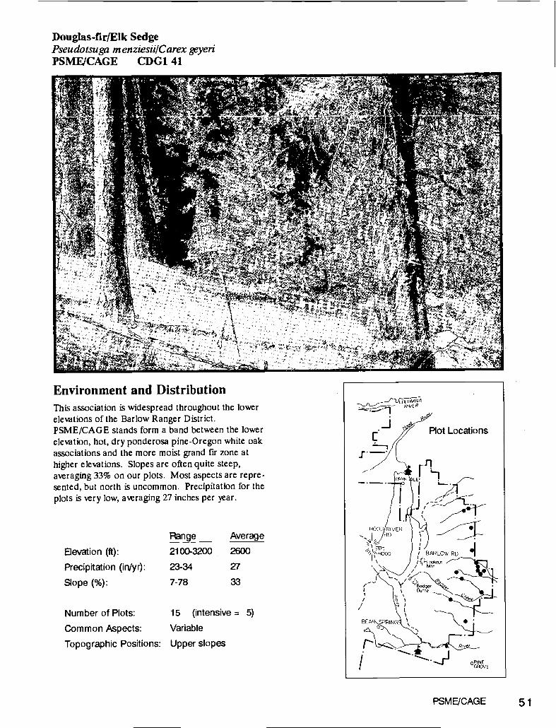
Douglas-fir/Elk SedgePseudotsuga m enziesii/Carex geyeriPSME/CAGE CDG1 41
Environment and DistributionThis association is widespread throughout the lowerelevations of the Barlow Ranger District.PSME/CAGE stands form a band between the lowerelevation, hot, dry ponderosa pine-Oregon white oakassociations and the more moist grand fir zone athigher elevations. Slopes are often quite steep,averaging 33% on our plots. Most aspects are repre-sented, but north is uncommon. Precipitation for theplots is very low, averaging 27 inches per year.
lnge Average
Elevation (ft): 2100-3200 2600
Precipitation (in/yr): 23-34 27
Slope (%): 7-78 33
Number of Plots: 15 (intensive = 5)
Common Aspects: Variable
Topographic Positions: Upper slopes
jI;
-I.
HOOD PIVERHO
HOOt) IL LOW RD
/ Mm
BEA
/
Plot Locations
0PrNEGROVE
PSME,ICAGE 51

Vegetation: Structure and CompositionForests in this association are dominated by ponderosapine (PIPO) and Douglas-fir (PSME). Stands aregenerally well stocked with a continuous canopy of con-ifers. Exclusion of fire has increased the dominance ofDouglas-fir. Oregon white oak (QUGA) is an importantseral species but eventually is excluded by the densestands of Douglas-fir developing in the absence of fire.Douglas-fir is the most common seedling species.Grand fir (ABGR) is usually present in only smallamounts and grows poorly as regeneration. The under-story is usually sparse except for dense swards of elksedge (CAGE), which is always the dominant understoryspecies in the absence of excessive livestock use or densecanopy coverage. Many dry-site herb species, such asyellow hairy hawkweed (HIAL2), smooth prairiestar(LIGL), woods strawberry (FRyE), and thickleafpeavine (LALA2), are common in smaller amounts.Idaho or western fescue (FEID, FEOC) are occasionallyabundant and contribute valuable forage. Shrub cover isslight.
Dominant Vegetation
52 PSME/CAGE
Timber Productivity and ManagementThe hot and dry character of sites with this associationdictates the use of cautious management. Timberproductivity is lower than most areas on the Forest,though stands generally have commercial value. Clear-cutting often leads to drought-induced regeneration
i1ure, but may be the only logical harvest method inareas of concentrated root rot. In such cases use ofsmall clearcuts having shade-providing tree borders isrecommended. Shelterwood and partial cuts are general-ly less risky. Ponderosa pine is the best choice for plan-tation establishment. Stocking control is desirable be-cause these stands can not sustain much tree growth athigh densities, and because they provide transitory rangefor wildlife and livestock.
Site
dex
Growth
Basal kea10 yr. radlai
Grwth (in/b)species base mean s.e. mean se. mean 8.0.
PIPO
PSME
100
100
74
82
6.8
4.8
196
160
44.4
21.4
10.6
9.4
1.9
2.2
"yield
Capacity
ft3Iaclyr
SOl Growth
Eslimate
ft3/ac/yr
Trees per
Pcre
Stand Density
kdex (SDI)
frees/acre
mean so. mean ae. moan s.e. mean ae.55 6.4 37 7.5 337 201 247 43.9
Code %Cov ConsOverstory TreesPonderosa pine PIPO 11 93Douglas-fir PSME 42 86Oregon white oak QUGA 10 66Grand fir ABGR 2 40
Understory TreesDouglas-fir PSME 3 73Grand fir ABGR 2 40Oregon white oak QUGA 2 26Ponderosa pine PIPO 1 13
ShrubsSnowberry SYMPH 3 80Creeping hollygrape BERE 2 53Serviceberry NvIAL 2 46
ForbsSweet-cicely OSMOR 2 66Woods strawberry FRVE 1 66Yellow hairy hawkweed HIAL2 1 66Smooth prairiestar UGL 2 60Tailcup lupine LUCA 6 46
Grasses & SedgesOk Sedge CAGE 25 100Idaho fescue FEID 10 46Western fescue FEOC 17 26
Live Basal Area
TSMEABLA2
PIENABPRP1MGISHETHPLLAOCPICO
ABGRPSMECADEP lPO
QUGA
0 40 80 120 160 200Square Feet per Acre

Wildlife and RangeBig game and livestock utilize the elk sedge and grassesoccurring on sites in this association. Though forageproductivity is not high, this association covers sufficientacreage to be important as early summer range. Be-cause this association includes some of the lowest eleva-tion dense timber stands, it can provide vital thermalcover for deer and elk in winter. Native grass species(Idaho and western fescue) and elk sedge will normallyrevegetate most sites following disturbance. Severe soildisturbance may require seeding cereal ry to preventerosion. Orchardgrass, wheatgrasses or hard fescue caneasily outcompete planted conifers, so they are not ap-propriate for seeding forest regeneration units. Thelarger trees found in this association are very importantas roosting and nesting sites for turkeys, gray squirrelsand other wildlife. Thinned stands of pole-sizedDouglas-fir having considerable amounts of down woodydebris are critical for Merriam's wild turkey nesting.
Fuels ManagementConservation of organic matter, both in the form ofcoarse woody debris and as duff, is especially importantto the long-term productivity of sites as dry as those inthis association. Machine piling and duff displacementcan reduce site productive potential. Wildlife needs forsnags and down wood are important here so coolprescribed burning is essential. Elk sedge sprouts backreadily following broadcast burns.
SoilsThis association has soils of typical fertility for the Mt.Hood National Forest eastside. The fine sandy loam tex-tures result from aerial deposition of fine ash and bess.Relatively small amounts of rocks in the soil matrix leadsto the moderate effective soil depth of 45 cm. These
soils compact readily.
Number of Soil Pits: 4
Effective Soil Depth (cm): 45
Soil Surface Texture: Fine sandy loam
Parent Materials: Ash on conglomerate,
or ash on basalt
Similar AssociationsThis association occurs on hotter, harsher sites thanDouglas-fir/western fescue (PSMEIFEOC) and hasmuch less shrub cover than Douglas-flr/oceanspray/elksedge (PSMEIHODI/CAGE). PSME/CAGE occupiesthe lower elevation, hot and dry fraction of theABGR/CAGE association described by Williams (1978)for the Badger Allotment, Barlow Ranger District.PSME/CAGE is considerably hotter and drier, withgreater management problems, than the average site in-cluded in the Badger version of ABGR/CAGE. TheMixed conifer/snowberry/elk sedge association describedon the Warm Springs Indian Reservation (Marsh 1985)
is much like PSME/CAGE. This association is quitesimilar to PIPO-PSME/CAGE of the Blue Mountains(Hall 1973), and somewhat similar to the PSME/CAGEhabitat types described in Idaho (Steele and others 1981,Cooper and others 198'7) and Montana (Pfister andothers 1977).
Snags - Number/AcreTotalf
Pcre
20+ DBH
50'+ Ht
20"+ DBH
30-49' Hi
13-19" DBH
30'+ Hi
10-12" DBH
1O'+ Hi
18 0 2 6 10
Woody Debris> 3" DiameterVolume
1t3/acre
Weight
ton/acre
Total
N/acre
20'+ Dia.
N/acre
12-19 Dia.
N/acre
593 6.20 308 3.2 3.4
Fine Fuels - Tons/Acre< 1/4" Diameter 1/4 .1. Diameter 1.1 -2.9" Diameter
0.41 1.10 1.36
PSME/CAGE 53

Douglas-fir/Western FescuePseudotsuga m enziesü/Fesruca occidentalisPSMEIFEOC CDG3 21
Environment and DistributionThis association represents the most mesic environ-ments of the Douglas-fir series, but can never-the-less be characterized as relatively hot and dry. It oc-curs throughout the Barlow Ranger District betweenthe drier ponderosa pine-Oregon white oak associa-tions and the more moist grand fir zone at highereletions. North facing and otherwise shaded slopesare most common.
Range Average
Elevation (ft): 2330-3160 2709
Precipitation (in/yr): 24-57 33
Slope (%): 5-45 21
Number of Plots: 8 (intensive = 4)
Common Aspects: Mostly north
Topographic Positions: Lower slopes; flats
PSME/FEOC 55

Vegetation: Structure and CompositionThis association includes grass-rich stands of ponderosapine (PIPO) and Douglas-fir (PSME). When undis-turbed, they are well-stocked and yet may haw substan-tial understory cowr of grasses, herbs and shrubs.Douglas-fir regeneration is common and occasionalponderosa pine regenerate in miced age stands. Old-growth ponderosa pine dominate many stands in this as-sociation. Grand fir occurs sporadically but ner oc-cupies much of the canopy and grows poorly. Oregonwhite oak (QUGA) is nearly always present, but as aminor species. It plays a seral role, being eluded byconifers as the canopy closes. Much of the area havingthis association probably was occupied by openponderosa pine forests which became dominated byDouglas-fir following fire suppression activities early inthis century. Western fescue (FEOC) is found in densepatches along with scattered oniongrass (MEBU). Elksedge is usually present but in small amounts. Many dry-site forb species are common, including miner's lettuce(MOPE), woods strawberry (FRyE), smooth prairiestar
56 PSME/FEOC
Timber Productivity and ManagementTimber productivity is moderate. Once established,Douglas-fir grow well, but because of the dryness ofthese sites, ponderosa pine is the species of choice forplanting. Clearcuts are difficult to regenerate unlessthey are kept small and designed to maximize shade.Douglas-fir should be capable of regenerating shelter-woods either naturally or with planting. Stocking controlis important because dense stands will has stagnatedgrowth. Basal areas abo' 250 ft2/acre likely result inconsiderably reduced individual tree growth.
Live Basal Area
TSMEABLA2
PIENABPRPIMOTSHETHPLLAOCPIC0
ABCRPSMECADEP IPO
QUGA
0 40 80 120 160 200Square Feet per Acre
te
k,dex
Growth
Basal kea10 yr. radiai
&wth (in/lO)
species base mean s.e. mean se. mean s.e.
PIPO
PSME
100
100
81
100
8.6
6.2
175
235
42.2
52.3
8.2
14.2
1.8
3.2
'Yield
Capacity
ft3/ac/yr
SOl Growth
Estimate
ft3/ac/yr
Trees per
Pcre
sand DensityIndex (SDJ)
trees/acre
mean ae. mean se. mean s.e. mean se.79 8.9 90 18.0 876 431 416 57.1
(LIGL), and bigleaf sandwort (ARMA3).generally present but not abundant.
Shrubs are
Dominant VegetationCode %Cov Cons
Overstory TreesDouglas-fir PSME 38 100Ponderosa pine PIPO 13 100Oregon white oak QUGA 3 75
Understory TreesDouglas-fir PSME 4 87Oregon white oak QUGA 1 62Grand fir ABGR 1 37Ponderosa pine PIPO 3 25
ShrubsSnowberry SYMPH 3 100Serviceberry P.MAL 4 75Tall oregongrape BEAQ 4 50
ForbsWoods strawberry FRyE 1 75Sweet-cicely OSMOR 1 75Miners lettuce MOPE 1 62
Grasses & SedgesElk Sedge CAGE 3 75Western fescue FEOC 16 62Oniongrass MEBU 2 37

Wildlife and RangeStands in this association include some of the bestforested rangeland on the Mount Hood National Forest.Production of western fescue is fairly high and is utilizedby cattle and elk. The typical north-facing stands alsoprovide critical thermal protection for elk during winter.The larger ponderosa pine provide essential roostingand nesting habitat for many species, includingMerriam's wild turkey and the western gray squirrel.Thinned stands of pole-sized Douglas-fir may be thebest nesting habitat for Merriam's wild turkeys. Largeponderosa pine snags are quite abundant on the plots inthis association.
Fuels ManagementThe dense stands of pole and whip-sized Douglas-fircommon in stands of this association require treatmentfollowing harwst activities. Machine piling slash candamage potential site productivity by compacting soil,eliminating coarse woody debris, and displacing the dufflar.
SoilsTypical eastern Mt. Hood National Forest ash-ladensoils preail at sites in this association. Sites are moremesic than the rest of the Douglas-fir series becausenorth aspects preil, not because of soil moisture-hold-ing properties. These ashy soils are easily compacted byheavy machinery. The prelence of low nutrient lewissuggests that duff displacement or remoil by burningwill adsersely impact long-term site productivity.
Number of Soil Pits: 4
Effective Soil Depth (cm): 56
Soil Surface Texture: SlIt loam and
fine sandy loam
Parent Matenals: Ash on yarned rock
types
Similar AssociationsThis association is quite similar to PSME/CAGE andPSMEIHODI/CAGE, but has more western fescue andwry little elk sedge. Stands in this association comprisea subset of those included in the ABGR/CAGE associa-tion described for the Badger Allotment (Williams1978). PSMEIFEOC lacks a grand fir component but isotherwise quite similar to the Muccd conifer/Snowberry/Elk sedge type described for the Warm Springs IndianReserwtion (Marsh 1985).
Snags - Number/AcreTotal!
Mre
20'+ DBH50'+ Ht
20'+ DBH30-49' Ht
13-19' DBH
30'+ Ht
10-12 DBH
10+ Ht14 8 0 6 0
Woody Debris> 3' DiameterVolume
ft3/acre
Weight
ton/acre
Total
N/acre
20'+ Dia.N/acre
12-19' Da.
N/acre
435 5.00 145 2.7 0.0
Fine Fuels - Tons/Acre< 1/4Dameter 1/4-1'Diameter 1.1 -2.9'Dameter
0.42 1.48 1.70
PSME/FEOC 57

Douglas-fir/Oceanspray/EIk SedgePseudotsuga m enziesii/Holodiscus diccolor/Carex geyeriPSMEIHODI/CAGE CDS231
Environment and DistributionThis association indicates hot and dry sites. Sites eitherhave very low precipitation levels (on the east edge ofthe Forest) or are on steep, rocky, exposed s'opes whichare effectively dry for plants. This association is com-mon on the north end of Barlow Ranger District and thenortheastern portion of the Hood River RD. Elevationsare typically about 3000 feet with steep slopes beingmost common. Most plots have southerly aspects exceptfor the lowest elevation sample where a similarly dry siteoccurs on a north aspect.
'4
PSMEJHODI/CAGE 59
Fnge Average
Devation (ft): 2740-3600 3130
Precipitation (in/yr): 27-87 49
Slope (%): 20-65 36
Number of Plots: 6 (intensive = 4)
Common Aspects: Mostly south
Topographic Positions: Upper slopes

Vegetation: Structure and CompositionThis association is characterized by brushy stands ofponderosa pine (PIPO) and Douglas-fir (PSME). Theonly other tree species present are small amounts ofOregon white oak (QUGA) and grand fir (ABGR) ofpoor vigor. Ponderosa pines over 200 years old are com-mon. The Douglas-fir is generally younger, usually lessthan 80 years. They became established after fire sup-pression halted the frequent wildflres prevalent in thearea until the early 1900's. Prior to that, ponderosa pinedominated these sites. Now Douglas-fir prevails as theregeneration layer. The relatively continuous treecanopy is occasionally broken by patches of oceanspray(HOD!), serviceberry (AMAL), and snowberry (SYALor SYMO). Other dry-site shrubs are common, includ-ing California hazel (COCO2), tall Oregongrape(BEAQ), and sometimes small amounts of creeping hol-lygrape (BERE). Elk sedge is the dominant herb; it mayform dense swards or merely cover small areas. The restof the herb flora is quite diverse including many speciestypical of dry Cascadian forests: bigleafsandwort(ARMA3), western fescue (FEOC), white hawkweed(HIAL), Nuttall's peavine (LANE), starfiower(TRLA2), sweet cicely (OSCH) and woods strawberry(FRyE). Some herb species of drier sites occasionallyoccur in small amounts: balsamroot arrowleaf (BASA),California brome (BRCA) and pinegrass (CARU).
Dominant Vegetation
60 PSME/HODI/CAGE
Timber Productivity and ManagementTimber productivity is moderate. Stand establishmentfollowing clearcutting can be very difficult because ofdrought and plantabiity. Harvest by either shelterwoodor the select tree method followed by plantingponderosa pine is more likely to succeed than clearcut-ting. Growth basal area values of 245 for Douglas-firand 178 for ponderosa pine indicate that sites in this as-sociation can sustain individual tree growth at stockinglevels up to 250 ft2/acre.
te
kidex
Growth
Basal Area
10 yr. radial
Grwth (In/b)
species base moan se. mean se. moan s.e.
PIPO
PSME
100
100
89
119
5.2
2.6
178
245
39.9
21.1
7.6
15.7
0.8
1.8
"yield SOl Growth Trees per sand DensityCapacity Estimate Pcre ,dex (SDI)
ft3/ac/yr ft3/ac/yr trees/acre
mean so, mean se. mean ae. mean s.e.
107 3.8 117 26.0 579 379 412 96.3
Code %Cov ConsOverstory TreesDouglas-fir PSME 33 100Ponderosa pine PIPO 18 100Oregon white oak QUGA 6 33Grand fir ABGR 2 33
Understory TreesDouglas-fir PSME 6 66Oregon white oak QUGA 2 66Grand fir ABGR 1 33Ponderosa pine P,Po 2 33
ShrubsOceanspray HODI 3 100Serviceberry AMP.L 2 100Snowberry SYMPH 14 83California hazel COCO2 2 83Tall Oregongrape BEAQ 1 66
Forbsar-flower TR_A2 2 100
B4gleaf sandwort Alv1A3 6 83Sweet-cicety OSMOR 1 83Nuttall's peavine LANE 4 66
Grasses & Sedges6k Sedge CAGE 20 100Western fescue FEOC 2 66Pinegrass CARIJ 4 33
Live Basal Area
TSMEABLA2
PIENABPRPIMOISHETHPLLAOCP100
ABCRPSMECADEPIPO
QUGA
0 40 80 120 160 200Square Feet per Acre

Wildlife and RangeVegetation found in this association is highly palatablefor deer and elk. The elk sedge may be grazed, andspecies such as serviceberry, oceanspray and Californiahazel are browsed by deer. Fairly dense timber standsoffer thermal protection during winter, so these sitesreceive year-around wildlife use. Intensive plots in thisassociation lacked snags.
Fuels ManagementThe abundant browse and the shallow soil may bedamaged by burning. The use of heavy machinery topile slash can easily lead to soil compaction. Because ofthe difficulty of seedling establishment at sites in this as-sociation, fuels treatments which allow advance regenera-tion to survive are particularly important.
SoilsTypical Mt. Hood eastern Cascade fine sandy loam tex-tured, ash-laden soils prevail on sites in this association.Though stony conditions do exist, the associationaverage effective soil depth of 49 cm is adequate to holdand supply water for plant growth. Long-term siteproductivity is enhanced by the presence of large woodydebris. Down wood holds soil in place, is the substratefor nitrogen-fixing bacteria, and if incorporated into thesoil to rot, may serve as soil moisture reseroirs for treeroots and mcorrhizae.
Number of Soil Pits: 5
Effective Soil Depth (cm): 49
Soil Surface Texture: Fine sandy loam
Parent Materials: Ash on basalt, or
basalt
Similar AssociationsThis association is similar to PSME/CAGE except thelatter is less shrubby and not restricted to the north endof Barlow Ranger District. The PIPO-PSME/SYAL-HOD! association of the Blue Mountains (Hall 1973) issomewhat similar to this association.
Snags - Number/AcreTotal/
frcre
20"+ DBH
50'i- Hi20"+ DBH
3049' Hi
13-19' DBH
30'+ Hi
10-12" DBH
10+ Hi
0 0 0 0 0
Woody Debris> 3' DiameterVolume
1t3/acre
Weight
ton/acre
Total
#/acre
20"+ Dia.
#/acre
12-19" Dia.
#/acre
310 3.50 177 0.0 1.5
Fine Fuels - TonWAcre< 1/4"Diameter 1/4-lDiameter 1.1 -2.9"Oiameter
0.71 1.54 1.79
PSME/HODI/CAGE 61
Douglas-firfPinemat ManzanitaPseudotsuga m enziesülA rctostaphylos nevadensisPSME/ARNE CDS6 62
Environment and DistributionSteep, rocky slopes near ridgetops which receive in-tense solar radiation are typical sites for this associa-tion. Sample plots are above 4000 feet in elevationon both Barlow and Hood River Ranger Districts.This association occupies small areas which are sur-rounded by more dense forest stands and unforestedridgetops. The rocky, shallow soils have so littlemoisture-holding capacity that these sites are effec-tively very dry for plant growth despite the substan-tial input of precipitation. These sites are exposed tohigh winds. Wind detracts from site moisture statusby blowing off snow, directly desiccating plants, anderoding soil.
nge Average
Devation (ft): 4200-4600 4400
Precipitation (in/yr): 58-90 74
Slope(%): 50 50
Number of Plots: 2 (intensive = 2)
Common Aspects: Variable
Topographic Positions: Upper slopes
PSMEJAJE 63

Vegetation: Structure and CompositionThis association includes sparse, mixed age stands ofponderosa pine (PIPO) and Douglas-fir (PSME), withtrace amounts of grand fir (ABGR). These sites are toohot and exposed for grand fir to thrive. The ponderosapine are generally older than the Douglas-fir. It appearsthat the Douglas-fir are slowly invading these sites nowthat wildflres are suppressed. Shrub growth is patchy,dominated by pinemat manzanita. Other hot-site speciespresent include greenleaf manzanita (ARPA), pinegrass(CARU), and western needlegrass (STOC).Penstemons provide colorful floral displa,s. Sites havingthis association are characterized by a large amount ofopen, rocky gound.
Dominant Vegetation
64 PSME/ARNE
Timber Productivity and ManagementTimber productivity is fairly low. Site index values forDouglas-fir are the lowest of any association describedin this guide. The trees which do occur tend to be inpatches where they have been able to find sufficient soilor cracks in the rocks. Timber harvest may require selec-tive logging because these sites are very difficult toregenerate.
teIndex
Growth
Basal kea10 yr. radial
Grwth (in/b)epecles base mean s.e. mean ee. mean ae.PIPO
PSME
100
100
78
80
0.6
0.6
211
405
38.0
85.5
9.0
20.2
1.8
4.2
Yield 501 Growth Trees per sand DenaltyCapacity Estimate 1Acre Index (SD$)
ft3/ac/yr ft3/ac/yr trees/acremean s.e. mean s.e. mean s.e. mean s.e.63 1.5 64 11.7 180 2.5 378 60.3
Code %Cov ConsOverstory TreesPonderosa pine P,Po 34 100Douglas-fir PSME 4 100Grand fir ABGR 2 50
Understory TreesDouglas-fir PSME 6 100Grand fir ABGR 3 100Ponderosa pine PIPO 2 100
ShrubsPinemat manzanita AE 38 100Golden chinkapin CACH 2 100Greenleaf manzanita AA 1 100White spirea SPBE 2 50
ForbsPenstemon PENST 1 100Western yarrow ACMI 1 100Bracken fern PTAQ 2 50
Grasses & SedgesWestern fescue FEOC 3 50Pinegrass CARU 2 50Elk Sedge CAGE 1 50
Live Basal Area
TSMEABLA2
PIENABPRPIMOISHETHPLLAOCPicoABGRPSMECADEPipoQUGA
0 40 80 120 160 200
Square Feet per Acre

Wildlife and RangeWildlife use is not major in sites of this association. Big-game browse is neither plentiflul nor of high quality.Plots had few snags. This association is non-range fordomestic ungulates.
Fuels ManagementFuel loadings are light. Because few opportunities forclearcut harvests are likely, prescribed burnings aregenerally not required.
SoilsVery shallow soils are characteristic for stands of this as-sociation. Total soil depth and rooting depth (62 cm)and effective soil depth (13 cm) are the shalloweSt of anyassociation described in this guide. The percent of thesurface covered with rock is also highest. Plantability ispoor.
Number of Soil Pits: 1
Effective Soil Depth (cm): 13
Soil Surface Texture: Silt loam
Parent Materials: Breccia or basalt
Similar AssociationsThis association occurs at higher elevations and is moreclosely associated with rocky sites than other Mt. HoodNational Forest Douglas-fir series associations. it is onlyslightly similar to the Mixed conifer/Manzanita associa-tion described by Volland (1985) for the Central OregonPumice zone. PSME/ARNE is restricted to rocky spots,has a less diverse flora, has much more Douglas-fir, andlacks the Shasta red fir found in the type described byVolland. The PSME/ARUV types of the Okanogon Na-tional Forest (Williams and Lillybridge 1983) and Mon-tana (Pfister and others 1977) are analogous but onlyslightly similar to this association.
Snags - Number/AcreToteJ/
ftcre
)"+ DBH
50'+ Ht+ IJBH
30-49' Ht
13-19' DBH
30'+ Ht
10-1 2 DBH
10' Ht2 2 0 0 0
Woody Debris> 3 DiameterVolume
ft3/acre
Weight
ton/acre
Totai
# /acre
20+ Dia.# /acre
12-19 Dia.
# /acre
108 1.00 19 0.0 3.5
Fine Fuels - TonWAcre<1/4 Diameter 1/4 - 1 Diameter 1.1 - 2.9 Diameter
0.16 1.44 0.94
PSMEJARNE 65

Douglas-fir/Common SnowberryPseudotsuga m enziesü/Symphoricarpos albusPSMFISYAL CDS6 61
a
Environment and DistributionThis association indicates hot and dry environments. Itis found only on the Barlow Ranger District, betweenthe more moist grand fir zone at higher elevations andthe drier ponderosa pine-Oregon white oak associationsbelow. Plots are primarily on flats and gentle slopeswith northeastern to eastern aspects. Precipitation is al-ways low, averaging only 28 inches per year. Thoughcovering a small area, this association is important be-cause these dry sites are difficult to regenerate.
Devation (ft):
Precipitation (in/yr):
Slope (%):
Number of Plots:
Common Aspects:
Topographic Positions:
6 (intensive = 2)
North and east
Flats
PSME/SYAL 67
Fnge Average
2370-3050 2640
27-30 28
2-36 10

Vegetation: Structure and CompositionFairly dense stands of Douglas-fir (PSME), with scat-tered ponderosa pine (PIPO), characterize this associa-tion. Mature ponderosa pine are always present but donot typically regenerate in stands. Sampled stands weregenerally less than 80 years old, although individual treesup to 150 years old were found. Grand fir (ABGR) isoften present in small amounts and with poor vigor;sites in this association are at the margins of its environ-mental tolerance. The only other tree species present isOregon white oak (QUGA), which occurs as an earlyseral pioneer, gradually dying off as a canopy of Douglas-fir develops. Understory plant cover is sparse. Com-mon snowberry (SYAL) is the only shrub species toachieve prominence. The frequent appearance of creep-ing hollygrape (BERE) indicates the hot and dry natureof this association. Common herb species include Idahoand western fescue (FEID and FEOC), Sweet cicely(OSCH), yellow hairy hawkweed (HIAL2) and lambs-tongue groundsel (Senecio integenimus r. ochroleucus).
Dominant Vegetation
68 PSME/SYAL
Timber Productivity and ManagementTimber productivity is the highest of the eastsideDouglas-fir series associations. Forests in this associa-tion have good stocking and height growth; Douglas-firsite index averaged 125 on the intensive plots. This as-sociation can be managed for either ponderosa pine or amicture of ponderosa pine and Douglas-fir. Clearcutsshould include some provision to shade seedlings to en-sure prompt regeneration. Shelterwood or group treecutting are are also appropriate silvicultural systems.The droughty conditions indicate that treatments adver-sely affecting soil moisture status, such as competinggrasses, compaction, duff elimination, etc., need to becarefully managed if timber regeneration is desired.
Site
kidex
Growth
Basal ea
10 yr. radial
Grwth (ln/1O)
species base mean s.e. mean se. mean se.PIPO
PSME
100
100
87
125
1.9
6.7
363
278
99.2
35.0
14.3
15.6
3.0
4.8
ield
Capacity
ft3lac/yr
SCI Growth
timate
tt3laclyr
Trees per
Pcre
Stand Density
Index (SDI)
trees/acre
moan se. moan se. mean s.e. moan se.
110 15.7 134 47.6 376 194 440 97.6
Code %Cov ConsOverstory TreesDouglas-fir PSME 55 100Ponderosa pine PIPO 8 100Oregon white oak QUGA 4 66Grand fir ABGR 3 33
Understory TreesDouglas-fir PSME 3 83Grandfir ABGR 2 66
ShrubsCommon Snowberry SYAL 4 100Creeping hollygrape BE 2 50
Forbseet-cicety OSMOR 3 100
Yellow hairy hawkweed HIAL2 2 83Woods strawberry FFIE 2 83Lambstongue (Senecio) SEINO 1 66Western yarrow ACMI 1 66Nuttall's peavine LANE 3 50
Grasses & SedgesWestern fescue FEOC 1 50Idaho fescue FEID 1 50
Live Basal Area
TSMEABLA2
PIENABPRPIMOISHETHPLLAOCPICO
ABGRPSMECADEP lP0
QUGA
0 40 80 120 160 200Square Feet per Acre
Wildlife and RangeUngulates (wild and domestic) do utilize sites in this as-sociation, but browse and forage is sparse and seedingwill provide only small additional gains. These sites dohave considerable value as transitory range, yet grassseeding needs to be carefully coordinated with silvicul-tural activities if timber production is a goal. Seededcereal rye in regeneration units provides forage yet it isnot is so persistent as rhizomatous grasses (eg. hard fes-cue) or orchardgrass. Large ponderosa pine provide im-portant roosting habitat and thinned stands of pole-sizedDouglas-fir, with untreated slash, are the most frequentnesting sites for Merriam's wild turkey.
Fuels ManagementBecause sites in this association are so dry, treatmentswhich remove duff and large logs should be aoided.Large woody debris provides shaded microsites forseedlings, is the substrate for nitrogen-fixing bacteria,and if incorporated into the soil to rot, makes an excel-lent moisture-holding substrate for tree rooting andmycorrhizae. Most sites in this association are flatenough to allow unrestricted tractor use, yet machinepiling of slash can easily lead to compacted soils havinginsufficient water infiltration capacity to support treegrowth.
SoilsSoils are fhirly deep and not rocky, with good moisture-holding capacity due to the loam and fme sandy loamtextures and the deep (average 35 cm) Al soil horizons.Soil compaction can be a big problem, even when equip-ment operates on dry soils. These sites are so droughtythat any reduction in infiltration ability and water-hold-ing capacity can make the sites too dry to support con-tinuous coniferous cover.
Number of Soil Pits: 2
Effective Soil Depth (cm): 63
Soil Surface Texture: Loam, or
fine sandy loam
Parent Materials: Basaft or ash
Similar AssociationsThis association differs from ABGR/SYMPH because ithas almost no grand fir seedlings and is too dry to sup-port mature grand fir. PSME/SYAL is similar to thePIPO-PSME/SYMPH (Mutton Area) associationdescribed for the Warm Springs Indian Reservation(Marsh, personal communication). PSME/SYAL indi-cates considerably drier environments and lacks thegrand fir-white fir component abundant in the Mixedconifer/snowberry/forb and Mixed conifer/Snowber-ryiTwinflower Flatlands associations described by Vol-land (1985) for the northern portion of the DeschutesNational Forest. The PIPO-PSME/SYAL-HODI as-sociation of the Blue Mountains (Hall 1973) is not verysimilar. The PSME/SYAL habitat types for Idaho(Cooper and others 1987) and Montana (Ptister 1977)are quite similar but have additional Rocky Mountainspecies. The PSME/SYAL(OKA) association on theOkanogan NF (Williams and Lillybridge 1983) is alsosomewhat similar to this association.
PSMEJSYAL 69
Snags - Number/AcreTotal!
sAcre
20'+ DBR
50'+ Ht20+ DBH3049' Ht
13.19' DBH
30+ Ht10-12' DBH
10+ Ht0 0 0 0 0
Woody Debris> 3" DiameterVolume
ft3!acre
Weight
ton/acre
Total
ft/acre
20' Dia.#/acre
12-19' Dia.
#/acre
299 3.00 384 0.0 0.0
Fine Fuels - Tons/Acre< 1/4 Diameter 1/4 - 1" Diameter 1.1 - 2.9 Diameter
0.60 2.28 0.94

Grand fir/Elk SedgeAbies grandis/Carex geyeriABGR/CAGE CWG1 21
Environment and DistributionThis association includes the hottest and driest sitesin the grand fir series. This association is widespreadon the Barlow Ranger District but rare elsewhere ex-cept the eastern edge of the Hood River Ranger Dis-trict. Plots are primarily north of Ramsey Creek, atelevations ranging from 2380 to 3600 feet. Aspectsare mostly southerly, from southeast to southwest,but we sampled one very low elevation (2380 feet)plot with a north aspect.
nge Average
Elevation (ft): 2380-3600 2936
Precipitation (inlyr): 28-60 37
Slope (%): 4-45 30
Number of Plots: 11 (intensive = 8)
Common Aspects: Variable
Topographic Positions: Various slopes
4ABGPICAGE 71

Vegetation: Structure and CompositionDouglas-fir (PSME) dominates the mixed conifer standstWical for this association. Both mature and seedlinggrand fir (ABGR) are present, though they comprise aminor portion of the canopy. Large, old ponderosa pine(PIPO) are common, over-topping Douglas-fir which arefrequently about 80 years old. Old growth Douglas-firstands of this association are found. Some stands in thisassociation have a few Douglas-fir seedlings, but in theabsence of disturbance, grand fir eventually dominates.Oregon white oak (QUGA) is the only other treespecies found, but only in small amounts. Elk sedge(CAGE) and snowberry (SYAL or SYMO) dominatethe understory. Dry-site shrubs are common, but insmall amounts, including oceanspray (HOD!) and tallOregongrape (BEAQ). Many herb species occur in thisassociation but with much less cover than elk sedge.Common grass species are Idaho and western fescue(FEID and FEOC), and oniongrass (MEBU).
Dominant Vegetation
72 ABGPICAGE
Timber Productivity and ManagementThis association includes stands moderately low in tim-ber productivity. Stocking, site indices and growth basalarea are generally lower than the other grand fir seriesplant associations. Sites are generally so dry that clear-cuts may be difficult to regenerate. If used, clearcut unitsize and shape should be oriented to maximize shade.When shelterwoods are planted with ponderosa pine,the remaining Douglas-fir overstory will shade the siteand provide seed, thereby re-establishing a mixture ofponderosa pine and Douglas-fir.
te Growth 10 yr. radial
Idex Basal Noa Grwth (in/b)
species base mean s.e. moan s.e. moan s.e.
PIPO 100 91 8.0 204 32.7 6.4 1.4
PSME 100 107 5.1 244 .1 12.1 1.0
4SGR 50 91 6.7 258 38.1 13.9 0.4
\ield SOl Growth Trees per sand DensityCapacity Estimate Pcre index (SDI)
1t3/ac/yr 1t3/ac/yr trees/acre
mean s.e. mean s.e. mean s.e. mean she.
90 7.1 100 13.9 303 82.0 407 42.9
Code %Cov ConsOverstory TreesDouglas-fir PSME 48 100Grand fir ABGR 7 100Ponderosa pine PIPO 7 81
Oregon white oak QUGA 2 27Understory TreesGrand fir ABGR 3 90Oregon white oak QUGA 1 45Douglas-fir PSME 3 36
ShrubsSnowberry SYMPH 15 81Tall oregongrape BEAQ 2 81Oceanspray HODI 2 63Baldhip rose ROGY 1 63
ForbsSweet-cicely OSMOR 2 91Woods strawberry FRyE 2 82Big leaf sandwort Av1A3 2 72Star-flower 1R.A2 3 54
Grasses & SedgesElk Sedge CAGE 24 100Western fescue FEOC 4 72Idaho fescue FEID 1 45Oniongrass MEBU 2 36
Live Basal Area
TSMEABLA2
PIENABPRPIMOISHETHPLLAOCPico
ABGRPSMECADERI P0
QUCA
0 40 80 120 160 200Square Feet per Acre
Wildlife and RangeForage production is fairly high in this association and itserves cattle well. Big game also utilize this forage, aswall as the fairly abundant shrub species, such asoceanspray and baidhip rose (ROGY). The largeponderosa pine and occasional large snags provide im-portant habitat for many wildlife species. Merriam'swild turkey successfully nest in thinned, pole-sizedstands like those common in this association. Becausemoisture is so limiting in this association, tree plantingand forage seeding should be careftilly coordinated. Per-sistent and rhizomatous forage grasses (eg. orchardgrassor hard fescue) can take-over regeneration units andprevent conifer establishment. Minimizing ground distur-bance activities, such as machine piling or slash burning,may be a better way to control erosion than grass seed-ing.
Fuels ManagementLeaving coarse woody debris on-site is desirable when-ever compatible with fire risk evaluations. Long-termsite productivity is reduced when machine-piling of slashdisplaces duff or compacts soils. Fuel loading on plotsin this association was higher than that found in theDouglas-fir series, but lower than that in most of thegrand fir series. Elk sedge resprouts readily followingbroadcast burns.
SoilsSoils are relatively rock-free and deep, composedprimarily of fine sandy loam textured oJcanic ash. Lowincident precipitation levels and low moisture holdingcapacity are the reasons for the low moisture status ofsites in this association. Sample pits had deep Al soilhorizons (average 44 cm), yet the shallow effective soildepth (average 44 cm) negatively impacts the soil mois-ture regime.
Number of Soil Pits: 8
Effective Soil Depth (cm): 44
Soil Surface Texture: Fine sandy loam
Parent Materials: Ash on basalt, or
ash on conglomerate,
or basalt
Similar AssociationsThis association differs from PSMEIHODI/CAGE byhaving abundant grand fir regeneration in existing standsand by the greater vigor of large grand fir individuals.The ABGR/CAGE association for the Badger Allot-ment, Barlow RD. is very similar to this association (Wil-lianis 1978). The Mnccd conifer/SnowberryIElk sedgetype described for the Warm Springs Indian Reservationincludes many stands like this association (Marsh 1985).
ABGP/CAGE 73
Snags - Number/AcreTotal/
Acre
20"+ DBH
50'+ Ht20"+ DBH
30-49' Ht
13-19' DBH
30'+ Ht10-12" DBH
1 O'+ Ht
18 0 2 8 8
Woody Debris> 3" DiameterVolume
ft3/acre
Weight
ton/acre
Total
N/acre
20+ Die.N/acre
12-19 Die.
N/acre
696 7.00 201 1.4 4.4
Fine Fuels - Tons/Acre<1/4" Diameter 1/4-1" Diameter 1.1 -2.9" Diameter
0.86 2.20 2.17

Grand fir/Oceans prayAbies grandis/Holodiscus discolorABGR/HODI CWS5 31
Environment and DistributionSites represented by this association are hot and dry.This association is widespread on the northern halfof Barlow Ranger District and exposed sites on theeastern edge of Hood River RD. Sites are dry eitherbecause they are on south aspects with shallow soils,or they have low precipitation. Most sites having thisassociation are above 3000 feet in elevation. Plotsare as high as 3840 feet, but these are rocky and havesouth or west aspects, both important factors adverse-ly influencing soil moisture supplying capacity. Nor-therly aspects occur at lower elevations where lowprecipitation is the rule. Average precipitation was49 inches/year; this value is inflated by some higherelevation plots (3700) having high rainfall values.
Range Average
Elevation (if): 2375-3840 3132
Precipitation (irilyr): 27-91 49
Slope (%): 4-60 28
Number of Plots: 13 (intensive = 7)
Common Aspects: Variable
Topographic Positions: Mid and upper slopes
IBGPIHODI 75

Vegetation: Structure and CompositionThis association is the most shrub-rich of the grand firseries. Douglas-fir (PSME) and ponderosa pine (PIPO)with lesser amounts of grand fir (ABGR), dominatethese mixed conifer stands. Other tree species are usual-ly absent except for trace amounts of western larch(LAOC) and lodgepole pine (PICO). Grand firdominates the regeneration layer, and even thoughDouglas-fir seedlings occur, grand fir will eventuallydominate in the absence of fire. Samples include severalold-growth Douglas-fir stands having trees up to 275years old. Shrub cover may be dense and tall, includingsuch dry-site species as oceanspray (1-IODI), sriowberry(SYAL and SYMO), baldhip rose (ROGY), Californiahazel (COCO2), serviceberry (AMAL) and white spirea(SPBE). Rocky mountain maple (ACGLD) and creep-ing hollygrape (BERE), two dry-site indicators, are alsocommon. Grasses (western fescue (FEOC) and Colum-bia brome (BRVU)) as well as elk sedge (CAGE) havehigh constancy, but low cover. Forb species characteris-tic of both dry and mesic forests grow in small amounts.The former include Nuttall's peavine (LANE), yellowhairy hawkweed (HIAL2) and tailcup lupine (LUCA),whereas the latter include Scouler's beilflower (CASC2),starfiower (TRLA2), false solomonseal (SMRA) andwhite hawkweed (HIAL).
Dominant Vegetation
76 ABGPIHODI
Timber Productivity and ManagementThis association can be quite productive for timber oncestands are established. Sampled stands have good stock-ing and fairly good tree height growth (average Douglas-fir site index = 118). Intense heat and droughty soilsmake clearcuts difficult to regenerate. Small units withsome shading from surrounding trees can help alleviatetranspirational demands of seedlings. Douglas-fir can besuccessfully regenerated by shelterwood harvest.Ponderosa pine is generally the first choice to plant inclearcuts, especially in exposed sites having this associa-tion.
Live Basal Area
TSMEABLA2
PIENABPRPIMOrSHETHPLLAOCUPICCU
ABGRPSMECADEPipo
QUCA
0 40 80 120 160 200Square Feet per Acre
Site
index
owth
Basal kea10 yr. radial
(3rwth (in/lO)
species base mean s.e. mean ae. mean so.PIPO 100 93 8.8 263 49.2 9.0 1.6
PSME 100 118 2.7 292 27.1 15.6 2.2
ABGR 50 81 4.2 405 101.0 18.5 2.2
'yield 501 owth Trees per Stand Density
Capacity Estimate frcre Index (501)
ft3/ac/yr ft3/ac/yr trees/acre
mean se. mean s.e. mean so. mean s.e.
105 3.9 115 17.7 266 45.8 399 49.4
Code %Cov ConsOverstory TreesDouglas-fir PSME 44 100Grand fir ABGR 9 100Ponderosa pine PIPO 14 84
Understory TreesGrand fir ABGR 5 100Douglas-fir PSME 2 38
ShrubsOceanspray HODI 5 100Snowberry SYMPH 14 92Bald hip rose ROGY 4 92California hazel COCO2 5 61Tall oregongrape BEAQ 3 61Serviceberry AMAL 2 61White spirea SPBE 2 61Rocky mountain maple ACGLD 9 30
ForbsWoods strawberry FRVE 2 92Star-flower TRLA2 2 76Scouler's beilfiower CASC2 2 69Bigleaf sandwort AFv1A3 2 62Sweet-cicely OSMOR I 69False solomonseal SMPA 1 46
Grasses & SedgesWestern fescue FEOC 2 69Elk Sedge CAGE 4 61Columbia brome BRVIJ 1 61

Wildlife and RangeAbundant browse makes this association particularly use-ful to big game and many other wildlife species. Somestands having this association provide winter range.Seeded grass may increase available forage, though per-sistent or rhizomatous species (eg. orchardgrass or hardfescue) may compete vigorously with vung conifers.The native shrub and herb populations re-establish rapid-ly following disturbance and provide excellent browseand forage. Erosion control of severly impacted sitescan be achieved with cereal rye, a non-persistent species.Ponderosa pine and Douglas-fir can grow to large sizesand provide important wildlife habitat as snags.
Fuels ManagementMachine piling and slash burning need to be conductedwith great care in these dry sites. Removal of surface or-ganic matter can reduce the site's ability to infiltrate andhold water. Large woody debris also provides shadedmicrosites for seedlings, helps hold soil in place onsteep slopes, acts as a substrate for nitrogen-fixing bac-teria, and when incorporated into the soil and decayed,provides moisture for mycorrhizae. Fuel loadings werethe lowest of any grand fir series association. Desirablenative browse and forage species resprout following coolbroadcast burns but we suspect they are eliminated byhot burns.
SoilsTypical Mt. Hood National Forest eastside soils of finesandy loam textured iolcanic ash are characteristic ofthis association. The effective soil depth of 61 cm isquite good for the grand fir zone.
Number of Soil Pits: 9
Effective SOil Depth (cm): 61
Soil Surface Texture: Fine sandy loam
Parent Materials: Ash on basaft, or
ash on conglomerate
Similar AssociationsThis association differs from PSME/HODJ/CAGE inthat the latter nearly lacks grand fir. ABGRIHODI ismore rich in tall shrub species, such as oceanspray,California hazel and serviceberry, and more restricted ingeographical distribution than the ABGR/SYMPH as-sociation. Similar Associations were not described forthe Badger Allotment (Williams 1978) nor the WarmSprings Indian Reservation (Marsh 1985).
Snags - Number/AcreTotal!
Pcre
20+ DBH50+ I-ft
20'+ DBH
30-49' Ht
13-19' DBH
30+ I-ft
10-12' DBH
10'+ Ht38 1 4 14 19
Woody Debris> 3N DiameterVolume
ft3/ore
Weight
ton/acre
Total
ft/acre
20'+ Die.ft facre
12-19' Die.
ft/acre396 443 380 0.0 2.6
Fine Fuels - Tons/Acre<1/4'Djameter 1/4-1Diarneter 1.1 -2.9' Diameter
0.72 2.20 Z21
ABGP,/HODI 77

Grand fir/SnowberryA bies grandL/SymphoricarposABGR/SYMPH CWS3 31
Environment and DistributionThis very common association indicates hot and dryenvironments. Elevations are usually between 2600and 3200 feet, but sites occur as higi as 3900 feet inexposed locations. This association is commonacross the lower grand fir zone of the Barlow RangerDistrict and occurs sporadically on the eastern por-tions of Bear Springs and Hood River Ranger Dis-tricts. Slopes are gentle, rarely over 25%. Precipita-tion is low; only a few high elevation plots havevalues greater than 40 inches per year.
Range Average
Elevation (ft): 0-3920 3059
Precipitation (in/yr): 26-92 40
Slope (%): 2-50 14
Number of Plots: 24 (intensive = 12)
Common Aspects: Variable
Topographic Positions: Flats and upper slopes
ABGPISYMPH 79

Vegetation: Structure and CompositionThis association includes mbmd conifer forests havingeither common snowberry (SYAL) or creeping snow-berry (SYMO) as the dominant understory species.Douglas-fir (PSME), grand fir (ABGR), and ponderosapine (PIPO) dominate the overstory. Often the grand fircomprises a minor portion of the overstory, but it is themajor seedling species present. Western larch (LAOC)is at the edge of its environmental tolerance. Samplestands date from the early 1900's, except the ponderosapine are frequently older than the other trees. Thesestands have become more densely stocked than wouldoccur in a natural fire regime with frequent, low inten-sity underburns. The exclusion of fire has allowed grandfir populations to increase. Some stands in this associa-tion have very sparse understories with little other thansnowberry. Other sites have a more diverse flora. Sub-stantial cover of snowberry may be accompanied bysmall amounts of baldhip rose (ROGY), oceanspray(HOD!), serviceberry (AMAL), California hazel(COCO2), tall Oregongrape (BEAQ) and creeping ho!-lygrape (BERE). The forb and grass layer is usuallysparse and patchy, though diverse.
Dominant Vegetation
80 ABGPISYMPH
Timber Productivity and ManagementProductivity is quite substantial for such dry sites. Plotshad both good stocking (average total basal area = 255ft2/acre) and height growth (average Douglas-fir siteindex = 118). Large ponderosa pine are fairly common.Much of the area containing this association has hadsome form of timber entry, either to selectively harvestponderosa pine, or to salvage mortality. Spruce bud-sorms had defoliated the upper 1/3 of many Douglas-firtrees during 1986. Although tree growth is good, tree es-tablishment is difficult. Shelterwood harvests are an ef-fective way to ameliorate the hot and dry environments.Douglas-fir can regenerate in this manner. Plantingponderosa pine is also appropriate. Successful clearcutregeneration is more likely in small units situated to max-imize shade.
Site
index
Growth
Basal kea10 yr. radial
(3iwth (in/lO)
species base mean se. mean s.e. mean s.e.
PIPO 100 101 3.0 240 24.1 9.2 1.2
PSME 100 118 3.7 281 14.5 12.0 0.7
ABGR 50 77 4.1 279 11.6 12.7 1.3
Yield
Capacity
ft3/ac/yr
SOl Growth
timate
ft3/ac/yr
Trees per
frcre
Stand Density
Index (SDI)
trees/acre
mean s.e. mean s.e. mean s.e. mean se.105 5.1 119 8.2 286 34.8 418 .7
Code %Cov ConsOverstory TreesDouglas-fir PSME 39 100Grand fir ABGR 23 100Ponderosa pine PIPO 13 79
Understory TreesGrandfir ABGR 4 83Douglas-fir PSME 2 33
ShrubsSnowberry SYMPH 9 100Bald hip rose ROGY 2 70Oceanspray HODI 2 50Serviceberry AMAL 2 45Creeping hollygrape BE 2 37
ForbsSweet-cicely OSMOR 1 79Woods strawberry FRIE 1 71Bigleafsandwort ARMA3 2 62Scouler's bellflower CASC2 2 50&ar-fiower 1RA2 2 50Oregon anemone ANOR 1 50
Grasses & SedgesWestern fescue FEOC 1 41Elk Sedge CAGE 2 29
Live Basal Area
TSMEABLA2
PIENABPRPIMOISHETHPLLAOCicoABGRPSMECADEP 1P0
QUGA
0 40 80 120 160 200Square Feet per Acre

Wildlife and RangeRange value for wild and domestic ungulates is primarilyas transitory range following site disturbance. Pastureand rhizomatous grasses will grow well and can provideforage for livestock and big game, yet fairly small quan-tities may be sufficient to out-compete conifer seedlingsfor water. Some of the land included in this associationis winter range and has shrub and grass forage of highquality, albeit usually small quantity. Commerciallythinned stands offer a good opportunity for transitoryrange benefiting both livestock and big game. Merriam'swild turkeys nest very successfully in thinned, pole-sizedstands such as those common to this association. Largersnags (> 20 inch diameter), almost all Douglas-fir, werecommon on sample plots.
Fuels ManagementPlots in this association had higher fuel loadings (12ton/ac) than the other dry-site plant associations of thegrand fir or Douglas-fir series. Slash disposal bymachine piling is easy because gentle slopes prevail inthis association, but soil compaction and surface organicmatter displacement detract from long-term site produc-tive potential. Slash provides important shade for see-dlings, nesting sites for wildlife (eg. Merriam's wildturkey), and if incorporated into the soil to decay, vitalmoisture holding capacity for rooting and niyeorrhizae.
SoilsSoils are very typical for the eastern portion of the Mt.Hood National Forest. Relatively deep, volcanic ash offine sandy loam texture prevails. These soils are easilycompacted by heavy equipment because thepredominant gentle slopes allow easy access. Suchdamage is especially harmful in this association becausethe minimum soil moisture threshold allowing tree estab-lishment is easily crossed.
Number of Soil Pits: 12
Effective Soil Depth (cm): 53
Soil Surface Texture: Fine sandy loam
Parent Materials: Ash on basalt
Similar AssociationsThis association is similar to ABGR/I-IODI but the latterhas much more oceanspray. This association is similarto the lower elevation portion of the ABGR/PAMY com-munity described for the Badger Allotment, Barlow RD(Williams 1978). The Mixed conifer/Snowberry associa-tion on the Warm Springs Indian Reservation is quitesimilar but more broadly defined than this association.The Mixed Conifer/SnowberrylForb association of theCentral Oregon Pumice zone occurs at higher elevation,more mesic sites (Volland 1985). The ABGR/SPBEhabitat types of northern Idaho (Cooper and others1987) and Montana (Pfister and others 1977) share en-vironmental and floristic affinities with this association.
ABGPISYMPH 81
Snags - Number/AcreTotal/
Pcre
20'+ DBH
50'+ Ht
20+ DBH30-49' Ht
13-19' DBH
30+ Ht10-12' DBH
10+ Ht35 2 7 10 16
Woody Debris> 3" DiameterVolume
1t3/acre
Weight
ton/acre
Total
N/acre
20"+ Die.
N/acre
12-19' Die.
N/acre
1149 12.0 314 4.7 8.6
Fine Fuels - Tons/Acre< 1/4" Diameter 1/4-1' Diameter 1.1 -2.9" Diameter
0.70 2.39 2.93

Grand firfStarflorAbies grandiA/Trientalis latifoliaABGRIFRL42 CWF5 21
Environment and DistributionThis association indicates fairly dry environments,buthas average moisture relative to the rest of the Grandfir zone. It is widespread throughout the middle por-tion of the Barlow Ranger District, the eastern partof Hood River Ranger District, and near the WhiteRiver on Bear Springs Ranger District. It occurs onall aspects. Slopes less than 20 per cent prevail al-though steep sites do occur. Summer drought islong; snow packs do accumulate each year but meltearly each spring.
Range Average
Elevation (ft): 2650-4100 3384
Precipitation (irilyr): 25-82 45
Slope (%): 3-50 17
Number of Plots: 16 (intensive = 9)
Common Aspects: Variable
Topographic Positions: Various slopes
ABGP,'1RA2 83

Vegetation: Structure and CompositionDouglas-fir (PSME) and grand fir (ABGR) dominatethe upper tree canopy, though ponderosa pine (PIPO)may also be abundant. Western larch (LAOC) andmore rarely, western redcedar (THPL) and western hem-lock (TSHE) also occur. Oregon white oak (QUGA) isvirtually absent. The ponderosa pine are usually mucholder than the grand fir. Before fire suppression ac-tivities began in the early 1900's, stands in this associa-tion were primarily ponderosa pine and Douglas-fir, butincluded some grand fir. Subsequently grand fir havegrown from beneath. The shrub lar may contain densepatches of vine maple (ACCI). Other shrubs are rarelyabundant. All three Oregon grape species (BEAQ,BENE, and BERE) can be found. Western fescue(FEOC) is the only grass species abundant in this as-sociation. Forbs generally cover less than 10% of theground surface. Major forb species are starfiower(TRLA2), Oregon anemone (ANOR), Scouler'sbeliflower (CASC2), woods strawberry (FRyE),twinflower (LIBO2), white hawkweed (HIAL) and rattle-snake plantain (GOOB). The dry-site indicating herb,rayless arnica (ARDI), is common, whereas a moremoist-site indicator, vanillaleaf (ACTR), is nearly absent.
Dominant Vegetation
84 ABGPTFA2
Timber Productivity and ManagementTimber productivity in this association is moderate whencompared to the rest of the grand fir zone. Maturestands are well stocked and have fair to good heightgrowth. Douglas-fir site index averaged 119 but wasquite variable. Stand regeneration can be difficult be-cause of the dry and hot environments. Clearcuts shouldbe designed to maximize shading from surroundingstands. Large down wood also can aid regeneration byproviding many shaded microsites for seedling estab-lishment. Ponderosa pine is the preferred species toplant in clearcuts; Douglas-fir is good in shelterwoods.Douglas-fir seed trees left in shelterwood harvestsshould in many cases provide adequate natural regenera-tion. This is the driest association in which westernlarch is an appropriate species to plant in clearcuts.Pocket gophers may be sufficiently abundant to makeconifer re-establishment difficult.
TSMEABLA2
PIENABPRPIMOISHETHPLLAOCPICO
ABCRPSMECADEP 1P0
QUGA
0
Uve Basal Area
I I I
40 80 120 160 200Square Feet per Acre
Site
Index
(owthBasal kea
10 yr. radial
Cwth (in/b)ecies base mean so. mean se. mean s.e.
PIPO 100 98 5.5 177 15.4 7.8 1.6
PSME 100 119 5.5 298 24.6 13.1 0.7
ABGR 50 78 4.3 337 35.4 14.4 1.4
Yield 501 Gowth Trees per sand Density
Capacity Estimate sAcre Index (SD(i
ft3/ac/yr ft3/ac/yr trees/acre
mean s.e. mean s.e. mean se. mean so.106 7.4 141 13.5 461 99.4 494 32.3
Code %Cov ConsOverstory Treessand fir ABGR 33 100Douglas-fir PSME 28 100Ponderosa pine PIPO 11 75Western redcedar THPL 6 12
Understory TreesGrand fir ABGR 3 87Douglas-fir PSME 9 12
ShrubsSnowberry SYMPH 4 93Bald hip rose GY 1 87Vine maple ACCI 19 50Little prince's pine CHME 1 81Rcky mountain maple ACGLD 4 18Golden chinkapin CACH 2 18
Forbs&ar-flower TA2 2 100Scouler's beliflower CASC2 2 75Oregon anemone ANOR 1 68White hawkweed HIAL 1 68Woods strawberry FR'IE 1 63Twinflower UBO2 1 43
Grasses & SedgesWestern fescue FEOC 1 43

Wildlife and RangeTransitory range offers most of the forage productionfor wildlife and livestock in this association. Few siteshave winter range value. Grass seeding should beavoided or minimized foflowing clearcutting if timber re-establishment is a goal. Plots had abundant snags,primarily Douglas-fir, but also lesser amounts ofponderosa pine and western larch.
Fuels ManagementHigh fuel loadings on sample plots result from self-thin-ning processes of stands as grand fir grow-up frombeneath. Sites in this association are sufficiently dry thatcoarse woody debris serves an important role as shadefor seedlings. Careful machine piling of slash is requiredto minimize soil compaction and protect soil-surface or-ganic matter accumulations.
SoilsThe soils of this association are very typical for this area.Volcanic ash materials of fine sandy loam texturesprovide good moisture holding capacity. Effective soildepth (50 cm) is average for the grand fir zone. Thegentle slopes make use of heavy equipment possible, butsoils are easily compacted.
Number of Soil Pits:
Effective Soil Depth (cm):
Soil Surface Texture:
Parent Materials:
11
50
Fine sandy loam
or silt loam
Ash on basalt
Similar AssociationsThis association is very similar to ABGR/LIBO2 but thelatter has very little vine maple and is more frequentlyfound in cool air drainages. This association includessites which comprise a subset of those in theABGR/PAMY community described for the Badger Al-lotment, Barlow RD (Williams 1978). An associationdescribed on Warm Springs Indian Reservation(ABGRILIBO2) is quite similar (Marsh 1985). TheMixed conifer/snowberry/forb association of the CentralOregon Pumice zone is similar but frequently occurs onhigher elevation, more mesic sites than doesABGRITRLA2 (Volland 1985).
Snags - Number/AcreTotal/
*cre
20"+ DBH
50'+ Ht20'+ DBH
30.49' Ht
13-19' DBH
30'i- I-ft
10-12' DBH
10+ Nt
38 4 7 21 7
Woody Debris> 3" DiameterVolume
&/acreWeight
ton/acre
Totat
H/acre
20'+ Da.
H/acre
12-19 Dia.
H/acre
1237 126 281 2.1 16.2
Fine Fuels - Tons/Acre<1/4' Diameter 1/4-1' Diameter 1.1 -2.9' Diameter
0.66 1.96 3.36
ABGR/TRLA2 85
Grand firiTwinflowerA bies grandis/L innaea borealLABGR1LIBO2 CWF3 21
Environment and DistributionThis association is found at moderate elevations onall three eastside Mt. Hood National Forest RangerDistricts. It is generally restricted to areas below4100 feet in elevation. During the growing season,these sites may experience daily temperature fluctua-tion, with hot, dry days and cold nights (due to coldair accumulation or radiation heat loss). Sitesrece moderate precipitation. Snow accumulationshelp prolong the period of available soil moisture forplant growth.
Range Average
Elevation (ft): 3050-4180 3700
Precipitation (irilyr): 49-73 62
Slope (%): 1-48 21
Number of Plots: 7 (intensive = 3)
Common Aspects: North and east
Topographic Positions: Mid and upper slopes
ABGP/UBO2 87

Vegetation: Structure and CompositionThis association includes relatively shrub-poor, closedcanopy, mimd conifer stands. Nine coniferous specieswere encountered on sample plots. Douglas-fir (PSME)and grand fir (ABGR) dominate the canopies. Westernlarch (LAOC) achieves its greatest average live basalarea in this association of any described in this guide.Lodgepole pine (PICO) is common and may evendominate the canopy in young, fire-initiated stands.Ponderosa pine (PIPO), western white pine (PIMO),western hemlock (TSHE), Engelmann spruce (PIEN),and western redcedar (THPL) add to the coniferous mixtypical for this association. These forests have graduallyhad increases in grand fir abundance since the advent offire suppression early this century. Shrub growth isusually fairly sparse. Twinflower (LIBO2) is the mostabundant herb species, though even it rarely coversmore than 10% of the ground in mature stands. Fre-quently there are traces of several mesic-site herbs (vanil-laleaf (ACTR), and false and starry Solomonseal(SMRA and SMST)). Several species typical for mesic,closed Cascadian forests are common, including Prince'spine (CHUM and CHME), rattlesnake plantain(GOOB), whitevein and sidebells pyrola (PYPI andPYSE) and Oregon boxwood (PAMY). This is thedriest and lowest elevation association where big huck-leberry (VAME) is common, but only in traces.
Dominant Vegetation
88 ABGPIUBO2
Timber Productivity and ManagementTimber productivity is moderate in this association.Sampled stands had the highest stocking, both in termsof number of trees per acre and live basal area, of anygrand fir series association. Small trees (< 6 inch DBH)were particularly abundant. Various silvicultural harvestsystems can be used successfully. Shelterwoods whichleave Douglas-fir as seed trees can frequently beregenerated naturally. Clearcuts may be planted withmictures of ponderosa pine, Douglas-fir and westernlarch. At higher elevations, clearcuts on benches sur-rounded by timber may create frost pockets.
Live Basal Area
TSMEABLA2
PIENABPRP1M0TSHETHPLLAOCPicoABGRPSMECADEPipoQUGA
I I I
0 40 80 120 160 200
Square Feet per Acre
te Growth 10 yr. radial
Index Basal Area Grwth (in/lO)
ecies base mean s.e. mean s.e. mean se.PIPO 100 107 - 318 - 8.7
PSME 100 108 8.2 281 83.9 8.9 1.6
ABOR 50 69 6.1 257 26.4 9.7 1.1
'yield
Capacity
ft3/ac/yr
801 Growth
Entim ate
ft3/ac/yr
Trees perre
N
Stand Den&ty
index (SOt)
trees/acremean se. mean s.e. mean s.e. mean so.
91 11.7 160 6.2 1179 684 676 87.8
Code %Cov ConsOverstory TreesGrand fir ABGR 24 100Douglas-fir PSME 21 100Western larch LAOC 3 71Lodgepole pine P1CC 12 57Ponderosa pine PIPO 11 42Western hemlock ISHE 4 42Western white pine PIMO 3 42
Understory TreesGrand fir ABGR 4 100
ShrubsBaidhip rose FOGY 2 100Little prince's pine CHME 1 100Snowberry SYMPH 5 85Oregon boxwood PAMY 1 85Rcky mountain maple ACGLD 4 71Big huckleberry VAME 1 71Dwarf oregongrape BENE 11 42White spirea SPBE 11 42
ForbsTwinflower UBO2 5 100Vanillaleaf ACTR 1 85
ar-fiower TA2 2 85Oregon anemone ANOR 1 85

Wildlife and RangeForage production in the typical closed forests of this as-sociation is low, but these sites are very productive astransitory range. Few sites are useful as winter range.This association includes many sites near major streamswhere animal migrations may be important. Optimalthermal cover is thus critical. Tree thinning will stimu-late the Rocky Mountain maple (ACGLD) whichprovides good deer browse. Seeded grass, such as hardfescue, timothy, orchardgrass or smooth brome, growswell but can take over regeneration units. Intensiveplots had many snags, but almost all the larger ones(> 20 inch DBH) were grand fir, a species with lowwildlife value and persistence.
Fuels ManagementMinimizing slash burning is less important in this associa-tion than in the drier-site types of the grand fir zone.Never the less, large woody debris and duff conservationis desirable to maintain and enhance long-term siteproductivity. Fuel loading on our sample plots was lowconsidering the exceptionally high live tree stockingvalues. Hot prescribed burns will faor invasion oflodgepole pine over Douglas-fir, lowering future timbervalues.
SoilsRelatively deep, stone-free soils of fine sandy loam tex-tured ash prevail at sites supporting this association.Soils remain moist for longer periods than in much ofthe Grand Fir Zone, so soils are more readily com-pacted from heavy equipment use.
Number of Soil Pits: 6
Effective Soil Depth (cm): 55
Soil Surface Texture: Fine sandy loam
Parent Materials: Ash on varied rock
types
Similar AssociationsThis association is very much like ABGRiTRLA2 butthe latter has much more vine maple and tends to occurmore widely at lower elevations. This association in-cludes sites which are a subset of those included in theABGR/PAMY community described for the Badger Al-lotment, Barlow RD (Willliams 1978). ABGR/LIBO2habitat types in central Idaho (Steele and others 1981)and Montana (PEster 1977) are quite similar to this as-sociation.
Snags - Number/AcreTotal!
Pcre
20'+ DBH
50+ Ht20',- DBH
30-49' Ht
13-19' DBH
30'+ Ht
10-12' DBH
10+ Nt63 6 7 34 17
Woody Debris> 3" DiameterVolume
ft3/acre
Weight
ton/acre
Total
# /acre
20'+ Die.
# /acre
12-19' Dia.
N /acre
711 7.00 427 0 4.0
Fine Fuels - Tons/Acre<1/4' Diameter 1/4-1' Diameter 11.29' Diameter
0.94 3.12 2.52
ABGR'U B02 89

Grand fir/Vine maple/VanillaleafAbies andis/Acer circinatum/Achlys triphyllaABGR/ACCl/ACFR CWSS 32
Environment and DistributionThis association indicates moderate sites for the grandfir zone. Gentle slopes (< 20%) are most common al-though some sites are on steep, exposed slopes. Allaspects occur. This association is firly common on theeastern and northern portions of Hood Riwr RangerDistrict. It also occurs on the low elevation area at thenorth end of Bear Springs RD and occasionally at midelevations on Barlow RD. Sites having this associationare warm but receive more rain and snow than much ofthe grand fir zone.
4-
Common Aspects: Variable
Topographic Positions: Mid and upper slopes
ABGP,'ACCl/ACTR 91
Fnge Average
Elevation (ft): 1760-3800 3056
Precipitation (in/yr): 30-87
Slope (%): 9-40 20
Number of Plots: 10 (intensive = 6)
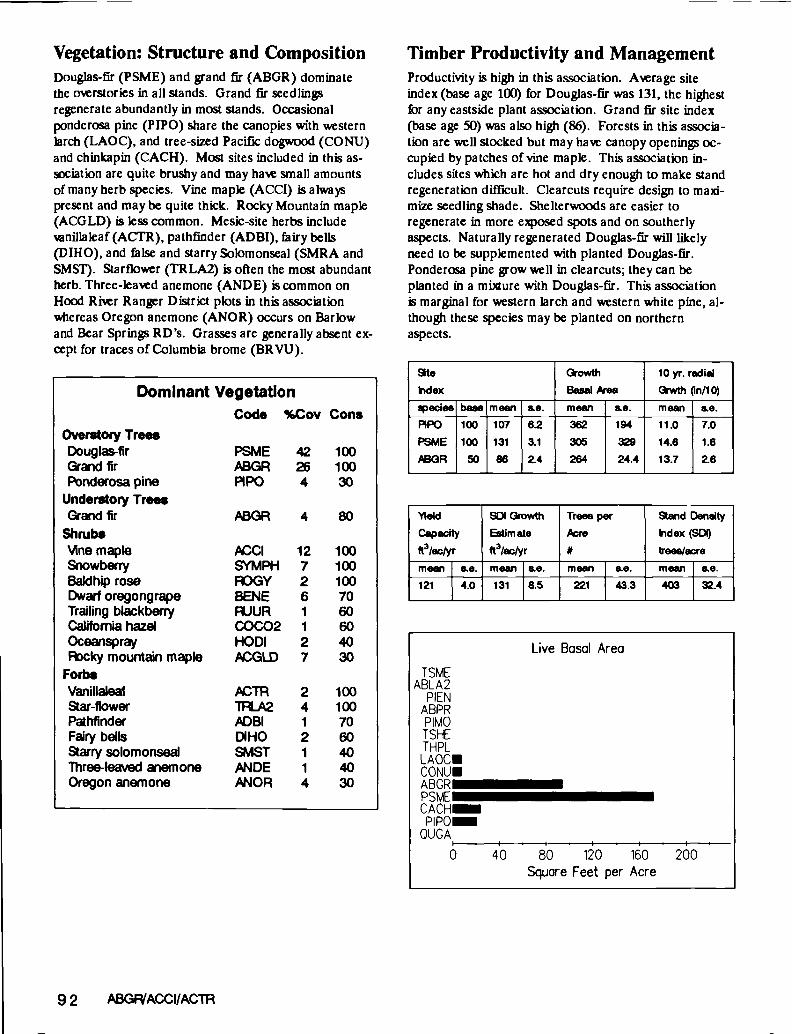
Vegetation: Structure and CompositionDouglas-fir (PSME) and grand fir (ABGR) dominatethe overstories in all stands. Grand fir seedlingsregenerate abundantly in most stands. Occasionalponderosa pine (PIPO) share the canopies with westernlarch (LAOC), and tree-sized Pacific dogwood (CONU)and chinkapin (CACH). Most sites included in this as-sociation are quite brushy and may have small amountsof many herb species. Vine maple (ACCI) is alwayspresent and may be quite thick. Rocky Mountain maple(ACGLD) is less common. Mesic-site herbs includevenilaleaf (ACTR), pathfinder (ADBI), fairy bells(DIHO), and false and starry Solomonseal (SMRA andSMST). Starfiower (TRLA2) is often the most abundantherb. Three-leaved anemone (ANDE) is common onHood River Ranger District plots in this associationwhereas Oregon anemone (ANOR) occurs on Barlowand Bear Springs RD'S. Grasses are generally absent ex-cept for traces of Columbia brome (BRVU).
Dominant Vegetation
92 ABGP/ACCl/ACTR
Timber Productivity and ManagementProductivity is high in this association. Average siteindex (base age 100) for Douglas-fir was 131, the highestfbr any eastside plant association. Grand fir site index(base age 50) was also high (86). Forests in this associa-tion are well stocked but may have canopy openings oc-cupied by patches of vine maple. This association in-cludes sites which are hot and dry enough to make standregeneration difficult. Clearcuts require design to maxi-mize seedling shade. Shelter woods are easier toregenerate in more exposed spots and on southerlyaspects. Naturally regenerated Douglas-fir will likelyneed to be supplemented with planted Douglas-fir.Ponderosa pine grow well in clearcuts; they can beplanted in a mixture with Douglas-fir. This associationis marginal for western larch and western white pine, al-though these species may be planted on northernaspects.
9t0hdex
owth
Basal kea
10 yr. radial
wth (in/lO)
epedes base mean se. mean se. mean so.
PIPO 100 107 6.2 362 194 11.0 7.0
PSME 100 131 3.1 305 329 14.6 1.6
SABGR 50 86 2.4 264 24.4 13.7 2.6
\leldCapacity
ft3/ac/yr
Si) owth
Estimate
ft3lac/yr
Trees per
frcro
Stand Density
dex (SD(i
trees/wemean so, mean so. mean so. mean so.121 4.0 131 8.5 221 43.3 403 32.4
Code %Cov ConsOverstory Tree.Douglas-fir PSME 42 100Grand fir ABGR 26100Poriderosa pine PIPO 4 30
Understoty TreesGrand fir ABGR 4 80
Shrubs'Me maple 12 100Snowberry SYMPH 7 100Baidhip rose FOGY 2 100Dwarf oregongrape BENE 6 70Trailing blackberry RJUR 1 60California hazel COCO2 1 60Oceanspray HODI 2 40R)cky mountain maple PCGLD 7 30
ForbsVanillaleaf CTR 2 100&ar-flower 1LA2 4 100Phfinder 1ADBI 1 70Fairy bells DIHO 2 60
arry solomonseal SMST 1 40Three-leaved anemone IANDE 1 40Oregon anemone ANOR 4 30
Live Basal Area
ISMEABLA2
PIENABPRPIMOTSI-ETHPLLAOCCONUABORPSMECACH
P 1P0QUGA
0 40 80 120 160 200Square Feet per Acre

Wildlife and RangeA diverse and palatable shrub and herb growth is typicalin stands in this association. Deer and elk use is high formuch of the year. Range for livestock is almost entirelytransitory following management activities. Forage seed-ing may prolong the useful range period. Light seeding(2-4 lbs/acre) at most is recommended if conifer estab-lishment and growth is also a resource objective. Somesites in this association receive heavy livestock use wherewater is available nearby. Large (> 20 in DBH)Douglas-fir snags provide abundant wildlife nesting sites.
Fuels ManagementFuel loadings on intensive plots were wry high. Hotbroadcast burns may initiate dense ceanothus(snowbrusb, CEVE) stands. Sites in this association areaided by large wody debris which provide shadedmicrosites, hold topsoil in place on steep slopes, are thesubstrate for nitrogen-fixing bacteria, and when incor-porated into the soil to decay, increase soil moisture-holding capacity.
SoilsSoils may be quite rocky, but also may include a fairamount of ash with good moisture-holding capacity. Theeffective soil depth (60 cm) is good. Several sampleplots have basalt or breccia-derived soils lacking the sur-face olcanic ash layers which are typical in the studyarea.
Number of Soil Pits: 8
Effective Soil Depth (cm): 60
Soil Surface Texture: Fine sandy loam,
or loam
Perent Matedals: Breccia on basalt,
or ash on basalt
Similar AssociationsThis association is much more heavily vegetated withshrub species than is ABGR/ACTR. ABGRILIBO2 andABGRII'RLA2 also lack much shrub cover and lacksuch mesic-site herbs as vanillaleaf and false Solomon-seal which are common in ABGR/ACCl/ACTR. TheABGRIACCI association on Warm Springs IndianReservation is very similar to this association (Marsh1985).
ABGRIACCl/ACTR 93
Snags - Numberb¼reTotal! 20+ 08H 20+ OBH 13-19 D8H 10-12 DBH
Acre 50+ Ht 30-49' Ht 30'+ Ht 10'+ Nt45 6 0 20 19
Woody Debris> 3' DiameterVolume
ft3lacre
Weight
ton/wreTotal
# /acre
20'+ Da.# /acre
12-19 a.
# Iwo1310 14.7 355 2.3 8.7
Fine Fue's - TonWAcre<1/4 Dameter 1/4-1 DIameter 1.1 -2.9' DIameter
0.83 2.49 4.03

Grand fir/VanillaleafAbies grandis/Achlys triphyllaABGRJACFR CWF5 22
a
Environment and DistributionThis association includes warm sites which are moremoist than much of the Grand Fir Zone on theMt.Hood National Forest. Stands are at mid eleva-tions (3200 to 4000 feet) on Barlow, the eastern por-tion of Hood River and the northeastern part of BearSprings Ranger Districts. All aspects were sampledalthough south is rare. Slopes vary', many sites occuron grades greater than 40 per cent. Snow packs ac-cumulate each year, thereby decreasing the period ofsummer drought. Annual precipitation averages 63inches per year on our plots.
nge Average
Devation (ft): 3200-4000 3539
Precipitation (in/yr): 44-88 63
Slope (%): 5-60 27
Number of Plots: 10 (intensive = 7)
Common Aspects: Variable
Topographic Positions: Mid slopes
:1'I
ABGPIACTR 95
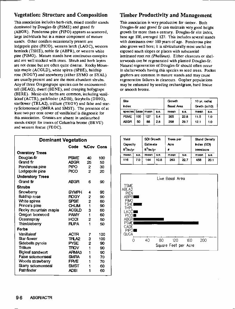
Vegetation: Structure and CompositionThis association includes herb-rich, mixed conifer standsdominated by Douglas-fir (PSME) and grand fir(ABGR). Ponderosa pine (PIPO) appears as scattered,large individuals but is a minor component of maturestands. Other conifers occasionally present arelodgepole pine (PICO), western larch (LAO C), westernhemlock (TSHE), noble fir (ABPR), or western whitepine (PIMO). Mature stands have continuous canopiesand are well stocked with trees. Shrub and herb layersare not dense but are often quite diverse. Rocky Moun-tain maple (ACGLD), white spirea (SPBE), baldhiprose (ROGY) and snowberry (either SYMO or SYAL)are usually present and are the most abundant shrubs.Any of three Oregongrape species can be encountered:tall (BEAQ), dwarf (BENE), and creeping hollygrape(BERE). Mesic-site herbs are common, including vanil-laleaf(ACTR), pathfinder (ADBI), fairybells (DIHO),starflower (TRLA2), trillium (TROV) and false and star-ry Solomonseal (SMRA and SMST). The presence of atleast two per cent cover of vanillaleaf is diagnostic forthis association. Grasses are absent in undisturbedstands eept for traces of Columbia brome (BR VU)and western fescue (FEOC).
Overstory TreesDouglas-firGrand firPonderosa pineLodgepole pine
Understory TreesGrand fir
ShrubsSnowberryBaidhip roseWhite spireaPrince's pineRcky mountain mapleOregon boxwoodOceansprayThim bleberry
ForbsVanillaleaf
ar-fiowerSidebells pyrolaTrilliumBig leaf sandwortFalse solomonsealWoods strawberry&arry solomonsealPathfinder
Dominant VegetationCode %Cov Cons
SYMPH 4ROGY. 2SPBE 2CHUM 1
ACGLD 3PAMY 1
HODI 2RJPA 1
10010090909070706060
96 ABGP/ACTR
Timber Productivity and ManagementThis association is very productive for timber. BothDouglas-fir and grand fir can maintain very good heightgrowth for more than a century. Douglas-fir site index,base age 100, averaged 127. ThiS includes several standswith dominants over 100 years of age. Ponderosa pinealso grows well here; it is silviculturally most useful onexposed south slopes or places with substantiallaminated root rot (Phelimus). Either clearcuts or shel-terwoods can be regenerated with planted Douglas-fir.Natural regeneration of Douglas-fir should often occurin shelterwoods having this species as seed trees. Pocketgophers are common in mature stands and may causeregeneration failures in clearcuts. Gopher populationsmay be enhanced by seeding orchardgrass, hard fescueor smooth brome.
atekdex
Growth
Basal kea10 yr. radial
Grwth (in/b)
species base mean se. mean se. mean se.
PSME
4BGR
100
50
127
88
5.4
28365
298
22.8
29.7
11.5
12.1
1.0
1.0
1eld SO Growth Trees per sand Density
Capacity Estimate cre idex (SDI)
ft3/aclyr ft3Iactyr trees/acre
mean se. mean s.e. moan s.e. moan s.e.
116 7.0 144 10.8 263 22.7 458 20.1PSME 40 100ABGR 25 50PIPO 2 30PICO 2 20
ABGR 6 90
ACTR 7Tfi2 3FYSE 2TROV 1
AA3 1
SMRA 1
FRVE 1
SMST 1
ADBI 1
Live Basal Area
TSMEABLA2
PIENABPRPIMOTSHETHPLLAOCPICO
ABORPSMECADE
QUGA
0 40 80 120 160 200Square Feet per Acre

Wildlife and RangeThis association includes upland forests having highvalue to a broad spectrum of wildlife. The large treesproduced here can provide excellent nesting sites lastingmany decades for many cavity dwellers. Intensive plotshad some large (> 20 inch DBH) ponderosa pine snags.Big game browse is fairly abundant. Commercial thin-ning operations will stimulate brushy growth of RockyMountain maple, baidhip rose and thimbleberry-, all aregood deer browse. Transitory range is excellent for elkas well as livestock. Light seeding of mesic-site grasses(orchardgrass, smooth brome, hard fescue) enhancestransitory range and should not out-compete well estab-lished conifer seedlings. Sites with this association getlittle winter range use.
Fuels ManagementThe high fuel loadings on our intensive plots reflect thehigh timber productivity characteristic of this associa-tion. The productive nature of sites displaying this as-sociation can be damaged by soil compaction from log-ging equipment or machine slash piling. Cool slashburns which do not destroy all of the forest floor are animportant part of efforts to maintain the high long-termsite productivity. Large woody debris provide importantshaded microsites for seedlings, help hold topsoil inplace on steep slopes, are the substrate for nitrogen-fixing bacteria and myeorrhizae, and when decayed inthe soil matrix, enhance soil moisture-holding capacity.Hot broadcast burns are likely to initiate densesnowbrush ceanothus (CE VE) stands.
SoilsSoils are generally deep, not rocky and include fine vl-canic ash with good moisture-holding capacity. Finesandy loam textures prevail near the soil surface. The ef-fective soil depth (55 cm) indicates that soils have goodphysical properties for plant growth. In our chemicallyanalyzed samples from The Dalles watershed, nutrientvalues tended to be low.
Number of Soil Pits: 9
Effective Soil Depth (cm): 55
Soil Surface Texture: Fine sandy loam
Parent Materials: Ash on basalt; breccia,
basalt
Similar AssociationsThis association is quite similar to ABGR/ACCl/ACTRbut the latter has much higher cover of several shrubspecies and soils which are more rocky and shallow.ABGR/ACTR has a greater abundance of mesic-siteherbs, such as vanillaleaf and false Solomonseal, thaneither ABGR/TRLA2 or ABGRILIBO2. TheABGR/ACCI association on Warm Springs IndianReservation has much more vine maple and dwarfOregongrape but otherwise is quite similar to this as-sociation (Marsh 1985). The ABGR/CLUN habitat typeof Montana (Pfister and others 1977) indicates some-what similar environments and has floristic affinities tothis association.
ABGP/ACTIR 97
Snags -Number/AcreTotei/
Pcre
20"+ DBH
50'+ HI
20'+ DBH
30-49' Ht
13-19' DBH
30'+ Ht
10-12' DBH
1O'+ Ht
13 3 0 10 0
Woody Debris> 3" DiameterVolume
ft3/acre
Weight
ton/acre
Total
# /acre
20+ Dia.
# /acre
12.19' Dia.
# /acre
1074 11.0 191 6.0 4.6
Fine Fuels - Tons/Acre<1/4' Diameter 1/4 - 1 Diameter 1.1 -2.9 Diameter
0.91 2.36 3.34

Grand fir/ChinkapinAbies grandis/Castanopsis chrysophyllaABGR/CACH CWS5 33
'4'
I.
Elevation (ft):Precipitation (in/yr):Slope (%):Number of Plots:Common Aspects:Topographic Positions:
c
Environment and DistributionThis association has limited distribution at moderateelevations on Barlow Ranger District, the eastern por-tion of Hood River RD, and the northeastern part ofBear Springs RD. Temperatures are rm andprecipitation is moderate compared to the rest of theGrand fir zone. Snow packs usually persist intospring. Slopes and aspects vary greatly. Our sampleplots were near major sheep drive trails used from1910 to about 1930. These sites are 2-3 miles east ofBrooks Meadow on Barlow RD and near CamasCreek on Bear Springs RD. It is possible that soilcompaction, over-grazing and selective grazing bysheep have influenced the vegetation over the longterm. This grouping may actually be a communitytype (not a climax plant association), but some old-growth stands were sampled so we prefer the "as-sociation" nomenclature.
nge Average3200-4200 380034-69 5810-48 244 (intensive = 1)
Often northMid and upper s'opes
4
ABGPICACH 99

Vegetation: Structure and CompositionThis association includes mUed conifer standsdominated by Douglas-fir (PSME), ponderosa pine(PIPO), and grand fir (ABGR). Lodgepole pine(PICO) is abundant in fire-initiated stands less than 100years of age. This association includes sites near thehot/dry physiological limit for western larch (LAOC)and western white pine (PIMO). Grand fir has grownup from below in older stands following the advent offire suppression earlier this century. A variety of shrubspecies grow, with chinkapin (CACH) or snowberry(either SYAL or SYMO) being dominant. Vine mapleis infrequent but may occur in dense patches.Twinflower is common and may be exlenshe; it is oftenaccompanied by vanilaleaf (ACTR) and other herbs.
Dominant Vegetation
100 ABGP/CACH
Timber Productivity and ManagementTimber productivity is moderate to low in this associa-tion. Stocking and height growth are variable. The fair-ly young grand fir exhibit very good height and diametergrowth. Douglas-fir should perform well when plantedin clearcuts. Ponderosa pine is useful to help regeneratemore exposed aspects and western larch can be used onmore protected sites. Unless shelterwoods are plantedwith Douglas-fir, grand fir may dominate the futurestand. Grand fir regenerates naturally once some con-ifer cover is established, and provides increased stand'olume growth compared to single species stands.
Site
Index
Growth
Basal kea10 yr. radial
Grwth (in/i 0)
species base mean se. mean s.e. mean ae.PSME 100 84 - 214 - 12.7 -
'Yield
Capacity
ft3lac/yr
SDI Growth
Estimate
ft3/ac/yr
Trees per
creStand Density
Index (SD
trees/acremean s.e. mean se. mean se. mean se.58 - 88 - 654 - 563 -
Code %Cov ConsOverstory TreesGrand fir ABGR 22 100Douglas-fir PSME 23 75Lodgepole pine PICO 38 50Western larch LAOC 4 50Ponderosa pine PIPO 15 25
Understory TreesGrand fir ABGR 7 100Douglas-fir PSME 7 75
ShrubsSnowberry SYMPH 6 100Golden chinkapin CACH 5 100Baidhip rose R3GY 4 100Prince's pine CHUM 4 100
ForbsWhite hawkweed HIAL 2 100Twinflower UBO2 6 75Vanillaleaf ACTR 3 75False solomonseal SMRA 1 75Woods strawberry FRVE 1 75&ar-flower TFLA2 3 50
Grasses & SedgesWestern fescue FEOC 1 75Elk Sedge CAGE 1 50
Live Basal Area
TSMEABLA2
PIENABPRPIMOISHETHPLLAOCUpicol
ABGRIPSMEICADEP1P01
QUGA
0 40 80 120 160 200Square Feet per Acre

Wildlife and RangeWildlife use of sites in this association is substantial.Many birds and small mammals eat chinkapin fruits.Mature stands have poor range value. Browse andforage for ungulates, including cattle, is substantial intransitory range following management activities.Seeded grass (such as orchardgrass, smooth brome orhard fescue) can out-compete conifer seedlings inregeneration units. Snags were absent from our inten-sive plots, but both ponderosa pine and Douglas-firsnags occurred on reconnaissance plots.
Fuels ManagementFuel loading was low on our intensive plot in this associa-tion. Sites are sufficiently dry and exposed to benefitfrom surface organic matter which provides shade, soilinsulation, and enhances soil water infiltration and long-term site productivity.
SoilsSoils are typical for the eastern portion of the Mt. HoodNational Forest. Fine sandy loam textured volcanic ashdominates the surface layers. Al horizons were especial-ly deep, averaging 47 cm, at our sample sites.
Number of Soil Pits: 3
Effective Soil Depth (cm): 53
Soil Surface Texture: Fine sandy loam
Parent Materials: Ash on basalt
Similar AssociationsThis association is floristically similar to bothABGR/LJBO2 and ABGR/TRLA2 but it has moreshrub cover, especially chinkapin. It also tends to occurin colder environments closer to the Cascade crest.
ABGP,'CACH 101
Snags - Number/AcreTotal!
4Acre
20+ DBH50' Ht
20' DBH30-49' Ht
13-19' DBH
30 Ht10-12' DBH
10'+ Ht
0 0 0 0 0
Woody Debris> 3N DiameterVolume
ft31'acre
Weight
ton/acre
Total
H/acre
20'+ Dia.
H/acre
12-19' Dia.
H/acre
841 9.00 165 0 0
Fine Fuels - Tons/Acre< 1/4 Diameter 1/4 - 1 Diameter 1.1 -2.9' Diameter
0.51 1.92 0.75

Grand fir/Skunk-leaved PolemoniumAbies grandis/Polemonium puicherrimumABGR/POPU CWF5 23
Environment and DistributionThis association is widespread between 3900 and4800 feet on the Barlow Ranger District and the east-ern portion of the Hood River Ranger District, espe-ciaUy near Dog River. Cold, fairly moist climatestypify sites with this association. Snow packs may bequite dense and last well into spring. The highprecipitation (average 90 inches/year) includes bothmore rain and snow during winter, as well as morefrequent summer thunderstorm showers. Summerdrought does occur, but less severely and more brief-lythan at lower elevations of the grand fir zone. Allaspects and slopes are found.
Range Average
Devation (ft): 3960-4780 4374
Precipitation (in/yr): 70-98 90
Slope (%): 12-60 29
Number of Plots: 9 (intensive = 4)
Common Aspects: Variable
Topographic Positions: Various slopes
ABGP/POPU 103

Vegetation: Structure and CompositionGrand fir (ABGR) dominates the mbd conifer standsfound in this association. Douglas-fir (PSME) andlodgepole pine (PICO) may also be canopy dominants inthe seral stands which establish following wildfire. Theconifer mix is further complicated by occasional westernlarch (LAOC), western white pine (PIMO), ponderosapine (PIPO), western hemlock (TSHE), Engelmannspruce (PIEN), western redcedar (THPL) and eventraces of Pacific silver fir (ABAM). Grand fir seedlingsare the dominant regenerating species in mature standsand should dominate climax stands. Trees may be quitelarge and dense. Several of our plots had grand fir olderthan 200 years, which is unusual for this species in thisarea The shrub lar is very sparse. The herb flora isdiverse and in some stands extensive. Skunk-leavedpolemonium (POPU) is the diagnostic species eventhough it covers at most 4 per cent of the ground. Othercommon herbs are vanilaleaf (ACTR), sidebells pyrola(PYSE), starfiower (TRLA2) and starry Solomonseal(SMS1'). Grasses include traces of Columbia brome(BRVU) and western fescue (FEOC).
Dominant Vegetation
104 ABGP/POPU
Timber Productivity and ManagementStands in this association have moderate timber produc-tivity. Mature forests are well stocked with grand fir andDouglas-fir. Many of the stems are fairly small grand firgrowing up from below. Height growth is moderate.Mixed stands of grand fir, Douglas-fir, Engelmannspruce and western larch will provide maximum siteolume growth. Initial stand establishment may be dil-
ficult because of the prevailing cold climates. Hence, ad-vance regeneration should be carefully conserved when-ever possible. Frost can prevent tree establishment inclearcuts on flat terraces. Grand fir seedlings (plantedor advance regeneration) will likely suffer frost damagein clearcuts. Engelmann spruce and western white pinegrow well and are sufficiently frost hardy to survive infrost pockets. Protected sites in this association may beplanted with noble fir, resulting in stands having high'wood quality and good growth. Shelterwoods shouldnaturally regenerate to mixed stands of grand fir andDouglas-fir. Pocket gophers are often abundant ongentle slopes where they damage yrung plantations.
Site
index
Growth
Basal kea
10 yr. radial
Giwth (in/b)species base mean s.e. mean s.e. mean s.e.
PSME
ABGR
100
50
107
76
15.5
6.4
263
346
53.1
10.6
9.9
13.4
2.8
3.3
'yield SOl Growth Trees per sand Density
Capacity Estimate Acre index (SD1)
ft3/actyr ft3/aclyr trees/acre
mean s.e. mean s.e. mean s.e. mean s.e.
85 14.9 101 31.8 287 35.7 483 24.6
Code %Cov ConsOverstory TreesGrand fir ABGR 34 100Douglas-fir PSME 22 66Lodgepole pine PICO 11 55Western larch LAOC 3 33Engelmann spruce PIEN 3 33Ponderosa pine PIPO 3 22
Understory TreesGrand fir ABGR 6 100
ShrubsBaidhip rose RDGY 1 77Little prince's pine CHME 1 77Snowberry SYMPH 2 44Oregon boxwood PAMY I 44
ForbsSkunkleaf polemonium POPU 2 100Scouler's beilfiower CASC2 2 88Sidebells pyrola PYSE 1 88Van illaleaf ACTR 3 77Woods strawberry FRVE 1 55Starry solomonseal SMST 2 44
Grasses & SedgesColombia brome BRdIJ 2 44Western fescue FEOC 1 44
Live Basal Area
TSMEABLA2
PIENABPRPIMOTSHETHPLLAOCP IC0
ABGRPSMECADE
QUGA
0 40 80 120 160 200Square Feet per Acre

Wildlife and RangeStands in this association are used by big game for sum-mer grazing but forage is generally poor in abundanceand quality. This poor forage maybe a result of exten-sive ungulate utilization of palatable herbs and shrubs.Seeded grass will enhance transitory range only slightly.Cattle forage is at best marginal. Our intensive plotshad abundant large snags, but they were all grand fir, aspecies with low wildlife value and persistence.
Fuels ManagementFuel loadings were high on our intensive plots. Conser-vation of large organic debris plays an important role inefforts to maintain long-term site productivity. Fuelstreatments should aveid burning off the protective,nutrient-rich forest floor layers.
SoilsSoil physical properties are very typical for the grand firzone of the Mt. Hood National Forest. Fine sandy loamsurface layers ofolcanic ash overlay basalt. Soils arcwell drained. The high precipitation levels lead to thepresence of bleached E (A2) soil surface layers. Heavymachinary can easily compact these ash-dominated soils,particularly when they are moist, drastically reducinglong-term site-productivity.
Similar AssociationsThis association is similar to ABGR-PIEN/SMST butthe latter has much more Engelmann spruce and totalherb cover. ABGR/ACTR, ABGRILIBO2 andABGRiTRLA2 can also appear similar but all have lessskunk-leaved polemonium and sidebells pyrola. Many ofthe stands included in the ABGR/PYSE communitydescribed for the Badger Allotment, Barlow RD (Wil-liams 1978) are included in ABGRIPOPU.
ABGPIPOPU 105
Snags - Number/AcreTotal!
6cre
20'+ DBH
50'+ Ht
20'+ DBH
30.49' Ht
13-19' DBH
30'+ Ht
10-12' DBH
l0+ Ht69 4 1 48 15
Woody Debris> 3' DiameterVolume
ft3/acre
Weight
ton/acre
Total
# lacre
20'+ Dia.
# /acre
12-19' Dia.
# /acre
1127 12.0 365 4.7 2.0
Fine Fuels - Tons/Acre< 114'Diameter 1/4-VDiameter 1.1 -2.9Diameter
0.91 2.83 2.64
Number of Soil Pits: 5
Effective Soil Depth (cm): 61
Soil Surface Texture: Fine sandy loam
Parent Materials: Ash on basalt

Grand Fir-Engelmann Spruce/Starry SolomonsealA bies grandis-Picea engehn annülSm llacma stellataABGR-PIEN/SMST CWC5 11
Environment and DistributionThis association occurs on moist, cold sites between4000 and 4500 feet in elevation on the Barlow RangerDistrict and the eastern portion of the Hood RiverRanger District near Dog River. It is notwidespread. These sites are at the cold, upper endof the mixed conifer region. Dense snow packs andhigh rainfall levels shorten summer drought.Precipitation for our plots averaged 85 inches. Sitesare usually fairly flat and in protected micropositions.Many stands are in concavities where soil moistureaccumulations benefit plant growth. Frost may occurat any time of the ar.
nge Average
Devation (ft): 4040-4280 4142
Precipitation (irilyr): 58-98 85
Slope (%): 2-45 17
Number of Plots: 4 (intensive = 3)
Common Aspects: Variable
Topographic Positions: Flats and slopes
HOOD RIVERD
'1 'HOOD I BARLOW RD1,
/ Mtn//'' /'Jt %\çButte
ABGR-PIEN/SMST 107

Vegetation: Structure and CompositionGrand fir, Engelmann spruce and Douglas-fir (PSME)dominate canopies. Other conifers present includelodgepole pine (PICO), western larch (LAOC), andtraces of mountain hemlock (TSME), western hemlock(TSHE), Pacific silver fir (ABAM) and ponderosa pine(PIPO). Undisturbed stands are generally well stockedwith many large trees and some grand fir saplings grow-ing up from below. Shrub cover is generally sparse ex-cept for occasional patches of vine maple (ACCI) orRocky Mountain maple (ACGLD). We speculate thatthis is partly due to heavy deer browsing on choicespecies, such as sitka mountain ash (SOS!). Many mesicand moist-site herb species abound. The more openstands have lush herb carpets, whereas dense, maturestands are dark and have patchy understories. StarrySolomonseal (SMST) is always present. Variillaleaf(ACTR) or Scouler's bellflower (CASC2) are abundant.The herb layer is very sensitive to light, becoming densein patches where individual tree deaths cause small gapsin the coniferous canopy.
Dominant Vegetation
108 ABGR-PIEN/SMST
Timber Productivity and ManagementOnce established, trees grow well on sites with this as-sociation. Height growth is good (site index, base age100, averaged 125 for Douglas-fir). Growth basal area'alues for Douglas-fir (365) and grand fir (352) areamong the highest of any grand fir series association.Frost can cause seedling mortality in plantations, espe-cially clearcuts on flat areas. Shelterwood harvestsprovide a good way to regenerate mixed stands ofDouglas-fir, Engelmann spruce and grand fir throughnatural regeneration. Noble fir should also do well whenplanted on more protected sites. Engelmann sprucegrows well in openings where frost may damage lesshardy species. Pocket gophers are common in maturestands and are a constant menace to young plantationsthroughout this association.
atehdex
Growth
Basal Aea
10 yr. radial
Grwth fin/b)
species base mean s.e. mean s.e. mean s.e.
PSME
ABGR
100
50
125
77
10.1
5.0
365
352
66.6
39.2
14.4
12.1
1.3
0.4
tieId SOl Growth Trees per Stand Density
Capacity Estimate Pcre Index (501)
ft3/ac/yr ft3/ac/yr trees/acre
mean se. mean s.e. mean s.e. mean s.e.
113 12.5 154 7.1 351 129 511 32.3
Code %Cov Cons
Overstory TreesGrand fir ABGR 23 100
Engelmann spruce PIEN 20 100
Douglas-fir PSME 9 100Lodgepole pine PIcO 4 50
Understory TreesGrand fir ABGR 7 100Engelmann spruce PIEN 2 50Mountain hemlock ISME 25
ShrubsLittle prince's pine CHME 1 75Snowberry SYMPH 2 50Vine maple ACCI 15 25R)cky mountain maple ACGLD 15 25
ForbsVanillaleaf ACTR 6 100
Starry solomonseal SMST 2 100
Skunkleaf polemonium POPU 1 100Sidebells pyrola PYSE 2 100Oregon anemone ANOR 1 100
ttlesnake plantain GOOB 1 100
Scouler's belifiower CASC2 14 75Queencup beadlily CLUN 2 75
Live Basal Area
TSMEIUABLA2
PIEN
ABPRPIMOTSHETHPLLAOCPICOABGRPSMECADEPIPOQUGA
0 40 80 120 160 200Square Feet per Acre

Wildlife and RangeThis association includes important summer forage areasfor big game. Cattle use is minimal but transitory rangefollowing logging can be enhanced by seeding orchard-grass, smooth brome and tall fescue. Many species ofwildlife use the dense forests and the large snags com-mon to these forests. The large snags (> 20 in. DBHand 30 ft. tall) on our intensive plots were either Engel-mann spruce or ponderosa pine.
Fuels ManagementFuel loadings on intensive plots were the highest of anygrand fir series association. Because so many sites inthis association are fairly flat, machine piling of slash iseasily accomplished. However, the long period soils staymoist and their compactability dictates that machinepiling be conducted very carefully to minimize soil com-paction.
SoilsSoils are generally deep and not stony. The effective soildepth of 86cm is the deepest of any grand fir series as-sociation. Fine sandy loam textured ash surface layerspredominate on basalt parent materials. The presenceof bleached E (AE) soil horizons is unusual for thegrand fir zone and reflects the high precipitation. Soilcompaction from heavy machinery is a potential problembecause many sites with this association are fairly flat (al-lowing ready machine access) and they retain substantialmoisture well into the summer.
Number of Soil Pits: 3
Effective Soil Depth (cm): 86
Soil Surface Texture: Fine sandy loam
Parent Materials: Ash on basalt
Similar AssociationsThis association is similar to the Grand fir/Skunk-leavedPolemonium Association (ABGRJPOPU) but the latterhas little Engelmann spruce and generally has lowertotal herb cover. The Engelmann spruce bottomlands as-sociation of the Deschutes National Forest (Volland1985) and the PIEN/CLUN association for easternOregon National Forests (Kovalchik 1987) are fairlysimilar to this association. The PICEA/CLUN habitattype of Montana is more similar to this association thanis the Montana PICEA/SMST habitat type (Pflster andothers 1977).
PBGRPIEN/SMST 109
Snags - Number/AcreTotal/
Acre
20'+ DBH
50'+ F-$t
20'+ DBH
30-49' Ht
13-19' DBH
30+ Ht10-12' DBH
10+ Nt99 2 4 52 41
Woody Debris> 3" DiameterVolume
ft3/acre
Weight
ton/acre
Total
H/acre
20'+ Dia.
H/acre
12-19 Dia.
H/acre
1860 20.3 153 4.7 2.0
Fine Fuels - Ton'Acre<1/4' Diameter 1/4 - 1 Diameter 1.1 - 2.9' Diameter
0.69 1.79 201

Western hemlock-Grand fir/Queencup BeadlilyTsuga heterophylla-A bies grandis/Clin ton ia un ifbraTSHE-ABGR/CLUN CHC3 11
Environment and DistributionThis association occurs at low elevations on the Mt.Hood National Forest east of the Cascade Crest. Itoccurs on Bear Springs and Hood River Ranger Dis-tricts, and on Barlow Ranger District in narrowbands near streams below 3200 feet in elevation.Sites having this association are generally nearstreams or in places where cool, moist air flows fromabove. These environments are moderated by thelower solar input found in canyons as well as thegreater soil moisture characteristic of lower slopepositions. Annual precipitation is high (53) consider-ing the low elevations.
nge Average
Elevation (ft): 2600-3300 3080
Precipitation (in/yr): 41-87 53
Slope (%): 2-40 16
Number of Plots: 5 (intensive = 3)
Common Aspects: Variable
Topographic Positions: Lower slopes
TSHE-ABGP/CLUN 111

Vegetation: Structure and CompositionThis association includes herb-rich mied conifer standshaving mature and regenerating western hemlock.Canopies are Douglas-fir (PSME) and grand fir(ABGR) dominated. Substantial cover (up to 20%) ofwestern hemlock (TSHE) is common. Other coniferspresent include western redcedar (THPL), Pacific yew(TABR), western larch (LAOC), and ponderosa pine(PIPO). Our sample plots were more often in older ageclasses (150 years) than the grand fir series associations.The low wildfire risk is probably caused by the generallymoist conditions. Dense understories of dwarfOregongrape (BENE), vine maple (ACCI) and baldhiprose (ROGY) abound. Creeping snowberry (SYMO) isusuafly present and may become abundant where grounddisturbance has occurred in mature stands. The forblayer is densely populated with a variety of speciescharacteristic of mesic eastside conditions: twinflower(LIBO2), vanillaleaf (ACTR), starry Solomonseal(SMST), and queencup headIly (CLUN). Other herbsoccurring characteristic of moist stands include violets(pioneer (VIGL) and redwoods (VISE)) and dogwoodbunchberry (COCA).
Dominant Vegetation
112 TSHE-ABGP/CLUN
Timber Productivity and ManagementTimber productivity in this association is moderate.Both height growth and stocking are about the same asthe grand fir series associations. Average standdiameter on intensive plots was 18.8 inches, much higherthan for grand fir zone associations. Stands aredominated by firly even-aged, large Douglas-fir with
unger grand fir growing up from below. Sites in thisassociation will respond favrabIy to both clearcuts andshelterwood harvests. Regeneration of Douglas-fir is ap-propriate: natural regeneration of Douglas-fir in shelter-woods should commonly be successful if Douglas-fir areleft as seed trees. Western larch, though not abundantin natural stands, is an excellent choice as seed trees inshelterwoods. A possible limitation to the use of clear-cuts is the common occurrence of this association ad-jacent to riparian areas and in critical big game migra-tion routes.
ateIndex
Growth
Basal Area
10 yr. radial
Grwth (in/lO)
ecIes base moan s.e. mean se. mean se.
PIPO
PSME
SABGR
100
100
50
113
106
68
-
8.2
-
224
295
289
-
21.4
-
2.0
7.3
8.0
-
0.2
-
Yield
Capacity
ft3/aciyr
SOl Growth
Estimate
ft3/ac/yr
Trees per
Pcre
&and Density
Index (501)
trees/acre
mean se. moan so. mean so. mean se.
97 6.2 110 7.2 181 38.9 4.62 31.2
Code %Cov ConsOverstory TreesDouglas-fir PSME 35 100Grand fir ABGR 22 100Western hemlock TSHE 15 80Western redcedar THPL 10 20Ponderosa pine PIPO 3 20Western larch LAOC 3 20
Understory TreesGrandfir ABGR 8 80Western hemlock TSHE 5 80
ShrubsDwarf oregongrape BENE 16 100'dine maple ACCI 18 80Prince's pine CHUM 7 100Snowberry SYMPH 4 100Baidhip rose FOGY 2 100
ForbsTwinfiower UBO2 14 100Vanillaleaf ACTR 8 100Queencup beadlilly CLUN 6 80Starry solomonseai SMST 2 100Fttlesnake plaintain GOOB 1 100Star-flower TR..A2 2 80Sidebells pyrola PYSE 1 80
Live Basal Area
TSMEABLA2PIENABPRPIMOTSHETHPLLAOCPICOABGRPSMECADEPIPOOUGA
0 40 80 120 160 200
Square Feet per Acre

Wildlife and RangeStands in this association offer excellent thermal coverand abundant browse and forage for big game. Largesnags, providing excellent cavity nesting habitat, are com-mon because of the characteristic good tree growth andlow wildfire risk. Yet, most of the large snags (> 20 in.DBH) on intensive plots were grand fir, a species withlow wildlife value and persistence. Many sites with thisassociation provide key habitats linking winter rangewith summer foraging areas. Transitory range for bothwildlife and cattle are excellent. Grasses, such as or-chardgrass or smooth brome, seeded on disturbed soilswill grow well so light seeding (2 lbs./acre) is ap-propriate. Competition for moisture between seededgrass and young conifers should generally not be severe.Pocket gophers will likely be abundant in plantationswhere slopes are gentle (< 30%).
Fuels ManagementFuel loadings on our intensive plots were more thantwice as high as those measured in any grand fir seriesassociation. The majority of this extra woody material islarge logs. This heavy loading results from the lack ofwildflres characteristic for sites comprising this associa-tion. The abundance of large material provides impor-tant habitat for many animals which is usually not farfrom streams. Various fuels treatments can be imple-mented without eliminating this valuable, large woodydebris.
SoilsSoil moisture regimes are strongly affected by the lowerslope positions and shaded microsites characteristic ofthis association. Physical properties are typical for thisarea, dominated by fine sandy loam textured surfacelayers of'olcanic ash or breccia on basalt parentmaterials. Soil compaction occurs readily, especially be-cause soils remain moist longer than most eastside lo-cales.
Number of Soil Pits: 4
Effective Soil Depth (cm): 53
Soil Surface Texture: Fine sandy loam
Parent Materials: Breccia on basalt, or
ash on basalt
Similar AssociationsStand structure and floristics are fairly similar to associa-tions found west of the Cascade crest (such asTSHEIBENE), except for the abundance of grand firand some characteristic eastside understory species (eg.creeping hollygrape (BERE) and Oregon anemone(ANOR)). Except for having much more grand fir, thisassociation is similar to both TSHE/LIBO2, describedfor the Badger Allotment (Williams 1978), andTSHE/ACCI on Warm Springs Indian Reservation(Marsh 1985). TSHE/CLUN habitat types in Idaho(Cooper and others 1987) and Montana (Pfister andothers 1977) are similar to this association.
TSHE-ABGPICLUN 113
Snags - Number/AcreTotal!
Pre20+ DBH
50'+ Ht
20+ DBH
3049' Ht
13-19 DBH
30'+ Ht
10-12 DBH
1O'+ Ht
44 3 4 19 17
Woody Debris> 3 DiameterVolume
ft3/acre
Weight
ton/acre
Total
# /acre
20+ Dia.
# /acre
12-19 Dia.
# /acre
3685 35.7 508 29.3 51.3
Fine Fuels - Tons/Acre< 1/4 Diameter 1/4 - 1 Diameter 1.1 - 2.9 Diameter
0.52 0.96 2.52

Western redcedar-Grand fir/VanillaleafThuja plka:a-A bies grandislA chlys triphyllaTIIPL-ABGR/ACFR CCF2 11
.4
- .'. ,-',
it
A
;-Y
Environment and DistributionThis association occurs at moderate elevations (3000-3800 feet) near creeks and in shaded, lower slopepositions. Our plots are mainly on Barlow RangerDistrict, but this grouping also exists on Hood Riverand Bear Springs Ranger Districts. The climate is
rm and mesic, precipitation averaging 71 inchesper year at our plots. Snow packs accumulate eachyear and help delay the period of summer soil mois-ture deficit. All slopes and aspects occur, althoughwe found south aspects only at our higher elevationplot (3800 feet). The moist conditions (for the east-ern Cascades) result from the high incident rainfall,the shaded conditions at lower slope positions, andthe presence of fairly deep soils.
nge Average
Devation (ft): 3180-3820 3563
Precipitation (irVyr): 53-85 71
Slope (%): 8-47 21
Number of Plots: 7 (intensive = 2)
Common Aspects: Variable
THPL-ABGRIACTR
L.
115

Wildlife and RangeWildlife lues are high in this association because of thethermal protection afforded by dense canopies, the abun-dance of quality forage, and because these sites are fre-quently near streams. Transitory range is eelIent fol-lowing timber harvest. Seeded grass, such as or-chardgrass or smooth brome, will grow aggressively. Soilmoisture should be adequate for young conifers unlessthe grass is heavily seeded or established before treeplanting. Large Douglas-fir snags provide importantnesting sites for many wildlife species.
Fuels ManagementFuel loadings on intensive plots were typical for the east-ern Cascades. Various fuels treatments can be imple-mented. Large woody debris provides especially impor-tant wildlife habitat in sites having this association be-cause of their frequent proximity to water courses. Care-ful use of machine slash-piling is required to amid soilcompaction, which adversely affects long-term siteproductivity.
SoilsSoils are typical for the eastern portion of the Mt. HoodNational Forest. Fine sandy loam textured 'olcanic ashsurfce layers predominate on basalt parent materials.These soils are compactable, especially when moist. Soilmoisture-holding properties are good.
Number of Soil Pits: 6
Effective Soil Depth (cm): 57
Soil Surface Texture: Fine sandy loam
Parent Materials: Ash on basalt
Similar AssociationsThis association is similar to ABGR/ACTR but isrestricted to shaded lower slopes, usually near creeks. Itoccurs at much lower eletions than ABGR-PIE N/SMST, and has more western redcedar and muchless western hemlock than TSHE-ABGR/CLUN. TheTHPLILIBO2 community previously described on theBadger Allotment, Barlow RD, is very similar (Williams1978). THPL/CLUN habitat types described in Idaho(Cooper and others 1987) and Montana (Pfister andothers 1977) are slightly similar to this association.
Snags - Number/AcreTotal/
Pcre
20"+ DBH
50'+ Nt
20+ DBH
30-49 Ht
13-19' DBH
30'+ Nt
1O-12 DBH
10'+ I-ft
18 6 0 11 0
Woody Debris> 31 DiameterVolume
ft3/acre
Weight
ton/acre
Tot&
# /acre
20'+ Dia.
# /acre
12-19' Die.
# /acre
1036 12.0 176 0 4.5
Fine Fuels - Tons/Acre<1/4 Diameter 1/4-1" Diameter 1.1 -2.9" Diameter
0.85 3.00 4.72
116 1HPL-ABGP/ACTR

Vegetation: Structure and CompositionThis association includes herb-rich mixed conifer standshaving firly low shrub cover. Either grand fir (ABGR)or Douglas-fir (PSME) dominate canopies. Western red-cedar (THPL) is diagnostic for this association; its covervaries from a minor to major canopy constituent. It andgrand fir are the most abundant seedling species. Otherconifers present in small amounts are western larch(LAOC), western hemlock (TSHE), western white pine(PIMO), noble fir (ABPR), subalpine fir (ABLA2), andEngelmann spruce (PIEN). Ponderosa pine (PIPO) isnearly absent, although it may appear in an early seralrole. Shrubs are not abundant. The common occur-rence of bigleaf huckleberry (VAME) suggests cool,mesic conditions. Forbs dominate the understory. Mostabundant are vanillaleaf(ACTR), twinflower (LIBO2),starry Solomonseal (SMST) and starflower (TRLA2).Dark-forest species are vary abundant, includingsidebells and whitevein pyrola (PYSE and PYPI), rattle-snake plantain (GOOB), and little and tall prince's pine(CHME and CHUM). Grasses are nearly absent.
Dominant Vegetation
Timber Productivity and ManagementThis association has moderate to good timber produc-tivity. Stand stocking varies considerably, although livebasal areas are usually high. Douglas-fir grow well;average site index (base age 100) on intensive plots was119. Overall stand wlume growth is enhanced byspecies mixtures which includes appreciable productivityof grand fir and western redcedar. The mesic environ-ment typical for this association allows many timber har-vast options. Clearcuts are easily regenerated withDouglas-fir and western larch. Shelterwoods shouldresult in a greater species mix in future stands. Possiblelimitations to harvest activities result from the generalproximity of sites with this association to streams and big-
me migration trails. Pocket gophers may often destroyseedlings, especially on gentle sloped sites (< 30%).
Site
Index
Growth
Basal iea10 yr. radial
Grwth (inhlO)
species base mean s.e. mean se. mean s.e.
PSME 100 108 21.5 308 68.4 10.4 5.6
Yield
Capacity
ft3/aclyr
501 Growth
atimateft3/ac/yr
Trees per
creStand Density
Index (SDI)
trees/acre
mean s.e. mean s.e. mean se. mean se.107 . 142 - 162 . 491 -
Code %Cov ConsOverstory TreesGrand fir ABGR 32 100Douglas-fir PSME 22 100Western redcedar Th PL 10 100Western hemlock TSHE 5 71
Western white pine PIMO 11 42Western larch LAOC 3 42Engelmann spruce PIEN 1 42Noble fir ABPR 7 14
Understory TreesWestern redcedar ThPL 5 85Grand fir IABGR 4 85Western hemlock TSHE 4 57
ShrubsBaidhip rose FOGY 2 85Wbite spirea SPBE 2 85Snowberry SYMPH 2 71
Dwart oregongrape BENE 1 71
Big huckleberry VAME 1 71Ttiimbleberry FUPA 1 57
ForbsVanillaleaf ACTR 4 85Twinflower UBO2 5 85Star-flower TFL42 2 100Starry solomonseal SMST 2 85
ThPL-ABGR/ACTR 117
Live Basal Area
TSMEABL A2
PIENABPRPIMOISHETHPLLAOCP100
ABCRPSMECADE
QUCA
0 40 80 120 160 200Square Feet per Acre

Literature Cited
Barrett, J. W. 1978. Height growth and site index cur-es for managed, een-aged stands of ponderosa pine in
the Pacific Northwest. Res. pap. PNW-232. Pac.Northwest For. and Range Expt. Station, Portland OR.
Bela, J. L. 1982. Geologic and neotectonic eluationof North-central Oregon: The DalIes 1 deg X 2 degquadrangle. Or. State Dept. of Geology and Minerals,Salem, OR
Brady, N. C. 1984. Th. Nature Properties f 1.Ninth ed. Cornell Univ. and US A. I. D.; McMillanPub. Co., N.Y.
Brickell, J.E. 1970. Equations and computer sub-routines for estimating site quality of eight rocky moun-tain species. USDA Forest Service Res. Pap. INT-75, In-termountain Forest and Range Experiment STation,Ogden, Utah.
Brown, J.K. 1974. Handbook for inventorying downedwnody material. USDA Forest Service Gen. Tech. Rep.INT-16. Intermountaiñ Forest and Range ExperimentStation, Ogden, Utah.
Coblentz, 1980. Production of Oregon white oak acornsin the Willamette Valley, Oregon. Wildlife Soc. Bull.&348-350.
Cochran, P. H. 1979. Site index and height growth cur-ves for managed, even-aged stands of white or grand fireast of the Cascades in Oregon and Washington. Res.pap. PNW-252. Pac. Northwest For. and Range Expt.Station, Portland OR.
Cochran, P.H. 1985. Site index, height growth, normalyields and stocking curves for larch in Oregon. USDAFor. Service Res. Paper PNW-424, Pacific NorthwestForest and Range Experiment Station, Portland, Or.
Cooper, S.V., K.E. Neiman, R. Steele, and D.W.Roberts. 1987. Forest habitat types of Northern Idaho:A second approximation. Gen. Tech. Rep. INT-236.
Crawford, J.A. and R.S. Lutz. 1984. Merriam's wildturkey habitat use and movements. Oregon Dept. Fishand Wildl. Final Rep. PR-W-79-R-2. 39pp.
Curtis, R. 0., F. R. Herman and D. J. DeMars. 1974.Height growth and site index for Douglas-fir in highelevation forests of Oregon-Washington Cascades.Forest Sci. 20:307-316.
Dahms, W.G. 1975, Gross yield of central Oregonlodgepole pine. IN: Baumgartner, D.M. (ed.), Manage-ment of Lodgepole pine ecosystems: Proceedings of aSymposium. Pullman, Wa. Wash. St. Univ. Vol 1, 208-232.
Daubenmire, R. 1968. Plant Communities: A Textbookof Plant Synecology. Harper and Row, New York, NY.
Deeming, J.E., R.E. Burgan and J.D. Cohen. 1977. TheNational fire-danger rating system - 1978. USDA ForestService Gen. Tech. Rep. INT-39. Intermountain Forestand Range Experiment Station, Ogden, Utah.
Franklin, J. F. and C. T. Dyrness. 1973. Natural vegeta-tion of Oregon and Washington. USDA Forest ServiceGeneral Tech. Report PNW-8, Pac. Northwest For. andRange Expt. Station, Portland OR.
Franklin, J.F. and R.T.T. Forman. 1987. Creatinglandscape patterns by forest cutting: Ecological conse-quences and principles. Landscape Ecol. 1:5-18.
Garrison, G. A., J. M. Skovlin, C. E. Poulton, and A. H.Winward. 1976. Northwest plant names and symbolsfbr ecosystem inventory and analysis. Fourth ed. USDAForest Service Gen. Tech. Rep. PNW-46. Pac.Northwest For. and Range Expt. Station, Portland OR.
Gauch, H.G. Jr. 1977. Ordiilex. A flexible computerprogram for four ordination techniques. (plus amend-ments) Ecology and Systematics, Cornell University,Ithaca, New York.
119
Barnes, G.H. 1962. Yield of ecn-aged stands of Ogden, UT: USDA-Forest Service Intermountainwestern hemlock. USDA Tech. Bull. No. 1273. 52pp. Research Station. 135 p.
Gauch, H.G. Jr. 1982. Multiyariate Ana1is ia Com-munity Ecology. Cambridge University Press, NewYork. 298 pp.
Hall, F. C. 1973. Plant communities of the Blue Moun-tains in eastern Oregon and Southeastern Washington.USDA-Forest Service Area Guide 3-1. Pac. NWRegion, Portland, OR.
Hall, F. C. 1984. Ecoclass coding system for PacificNorthwest plant associations. USDA Forest Service R6-ECOL-173-1984. Pacific Northwest Region, Portland,Or.
Hall, F. C. 1988. Growth basal area handbook. USDAForest Service R6-ECOL-181-b-1985. Pacific NorthwestRegion, Portland, Or.
Halverson, N.M., C. Topik and R. Van Vickle. 1986.Plant association and management guide for the westernhemlock zone, Mt. Hood National Forest. USDAForest Service Area Guide R6-ECOL-232A-1986. Pac.Northwest Region, Portland, OR. 111 pp
Harvey, A.E., M.F. Jurgensen, and MJ. Larsen. 1979.Role of forest fuels in the biology and management ofsoil. USDA Forest Service Gen. Tech. Rep. INT-65. In-termountain Forest and Range Experiment Station,Ogden, Utah
Harvey, A.E., M.F. Jurgensen, MJ. Larsen and R. 1.Graham. 1987. Decaying organic materials and soilquality in the Inland Northwest: A management oppor-tunity. USDA Forest Service Gen. Tech. Rep. INT-225.Intermountain Forest and Range Experiment Station,Ogden, Utah.
Hemstrom, MA., W.H. Emmingham, N.M. Halverson,S.E. Logan and C. Topik. 1982. Plant Association andManagement Guide for the Pacific Silver Fir Zone, Mt.Hood and Wilamette National Forests. USDA ForestService Area Guide R6-ECOL-100-1982a and 19821,.Pac. NW Region, Portland, OR. 104 pp and 92 pp.
Hopkins, W. E. and R. C. Rawlings. 1985. Major in-dicator shrubs and herbs on National Forests of easternOregon. USDA-Forest Service, Pac. Northwest Region,R6.TM-190-1985.
Kovalchik, B. L. 1987. Riparian zone associations. Des-chutes, Ochoco, Fremont, and Winema National Forests.
120
USDA-Forest Service Area Guide R6-ECOL-TP-279-87. Pac. NW Region, Portland, OR. 171 PP.
Lande, R. 1988. Genetics and Demography in Biologi-cal Conservation. Science 241:1455-1460.
Lutz, R.S. 1983. Phantom of the Forest. A biologistlooks at the Merriam's turkey in Oregon. OregonWildlife 38(4)3-6
Lutz, R .S. 1987. Selected life history aspects andhabitat use by Merriam's wild turkeys in Oregon. Ph.D.dissertation, Wildlife Science, Oregon State University.Corvallis, Oregon. 52pgs.
Lutz, R.S. and JA. Crawford. 1987. Seasonal use ofroost sites by Merriam's wild turkey hens and hen-poultflocks in Oregon. Northwest Sci. 61:174-178.
Marsh, Frank. 1985. Preliminary plant associationguide for commercial forests of Warm Springs IndianReservation. Manuscript.
Maser, C., R.G. Anderson, K. Cromack, Jr., J.T. Wil-liams, and R.E. Martin. 1979. Dead and down woodymaterial. Ch. 6 IN Thomas, J.W. (tech. ed.), Wildlifehabitats in managed forests: the Blue Mountains ofOregon and Washington. Agric. Handbook 553.Washington D.C.
Maser, C. and J. M. Trappe (tech. eds.). 1984. Theseen and unseen world of the fallen tree. USDA ForestService Gen. Tech. Rep. PNW-164. Pac. NW Forestand Range ExpL. Station, Portland Or.
Mueller-Dombois, D. and H. Ellenberg. 1974. Aims,ansi Methods f Vegetation. Ecology. John Wiley andSons. New York, N.Y.
Pfister, R. D., B.L. Kovalchik, S.F. Arno, and R. C. Pres-by. 1977. Forest habitat types of Montana. Gen. Tech.Rep. INT-34. Ogden, UT. USDA-Forest Service Inter-mountain Forest and Range Experiment Station. 174 p.
Reineke, L.H. 1933. Perfecting a stand-density indexfix even-aged forests. J. Agric. Res. 46:627-638.
Seidel, K.W. and P.H. Cochran. 1981. Silviculture ofmUd conifer forests in eastern Oregon and

Washington. USDA Forest Service Gen. Tech. Rep.PNW-121. Pacific Northwest Forest and Range Experi-ment Station, Portland, Or.
Soil Survey Staff (compilers). 1975. i1 Tanomy.USDA Soil Consertion Service Agric. Handbook # 436.
Steele, R., R.D. Pfister, R.A. Ryker, and J.A. Kittams.1981. Forest habitat types of central Idaho. Gen. Tech.Rep. INT-114. Ogden, UT. USDA-Forest Service Inter-mountain Forest and Range Experiment Station. 138 p.
Stieneckeer, W. and B.M. Browning. 1970. Food habitsof the western gray squirrel. Calif. Fish and Game 5636-48.
Teipner, C.L., E.O. Garton and L.Nelson, Jr. 1983.Pocket gophers in forest ecosystems. Gen. Tech. Rep.INT-154. Ogden, UT. USDA-Forest Service Intermoun-thin Forest and Range Experiment Station. 53 p.
Tansley, A.G. 1935. The use and abuse of vegetationalconcepts and terms. Ecology 16:284-307.
Thomas, J.W. (tech. ed.) 1979. Wildlife habitats inmanaged forests: the Blue Mountains of Oregon andWashington. USDA Forest Service Agric. Handbook553. Washington D.C. 512 pgs.
Thomas, J.W., R.G. Anderson, C. Maser and E.L. Bull.1979. Snags. Ch. 5 IN Thomas, J.W. (tech. ed.),Wildlife habitats in managed forests: the Blue Mountainsof Oregon and Washington. Agric. Handbook 553.Washington D.C.
Thomas, J.W., C. Maser and J.E. Rodiek. 1979. Edges.Ch. 4 IN Thomas, J.W. (tech. ed), Wildlife habitats inmanaged forests: the Blue Mountains of Oregon andWashington. Agric. Handbook 553. Washington D.C.
Volland, L. and M. Connelly. 1978. Computer analysisof ecological data: methods and programs. USDAForest Service. Pac. NW Region. Pub. No. R6-ECOL-79-003. Portland, Or 382 pp.
Volland, L. 1985. Plant associations of the CentralOregon pumice zone. USDA-Forest Service Region 6Area Guide R6-Ecol-104-1985. 138p.
Williams, C. K. 1978. Vegetation classification for theBadger Allotment, Mt. Hood National Forest. Ph. D.dissertation in Rangeland Resources Program, OregonState Univ., Corvallis OR. 140 p.
Williams, C.K. and T.R. Lillybridge. 1983. Forestedplant associations of the Okanogan National Forest.USDA-Forest Service Area Guide R6-ECOL-132a-1983.Pacific NW Region, Portland, OR. 140 p.
121

Appendix One
Canopy cover of main plant species by association
Percent cover is the average foliar cover for each species in eachassociation calculated only for those plots where the species s present(zero cover values are excluded from the calculations).
Constancy is the percent of plots within an association having that speciespresent.
Species are grouped by life form: Overstory trees, Understory trees,Shrubs, Forbs, Grasses and Sedges.
123

124
#PLOTS:
PIPO-QUGA/BASA
6
PIPO-QUGA/PUTR
9
PSME/CAGE
15
PSME/FEOC
8
PSME/HODI/CAGE
6
PSME/ARNE
2
%COV CONS %COV CONS %COV CONS %COV CONS %COV CONS %COV CONSOvers tory TreesABAM 0 0 0 0 0 0ABGR 0 0 2 40 2 12 2 33 2 50ABLA2 0 0 0 0 0 0ABPR 0 0 0 0 0 0ACMA 0 0 0 0 0 0LAOC 0 0 2 6 0 0 0PICO 0 0 0 0 0 0PIEN 0 0 0 0 0 0PIMO 0 0 0 0 0 0PIPO 30 100 19 100 11 93 13 100 18 100 34 100PSME 9 33 6 44 42 86 38 100 33 100 4 100QUGA 12 83 8 88 10 66 3 75 6 33 0THPL 0 0 0 0 0 0TSHE 0 0 0 0 0 0TSME 0 0 0 0 0 0
Unders tory TreesABAM 0 0 0 0 0 0ABGR 0 0 2 40 1 37 1 33 3 100ABLA2 0 0 0 0 0 0PIEN 0 0 0 0 0 0Pn'o Li 66 8 55 1 13 3 25 2 33 2 100PSME 2 33 2 44 3 73 4 87 5 66 6 100QUGA 2 66 6 100 2 26 1 62 2 66 0THPL 0 0 0 0 0 0TSHE 0 0 0 0 0 0TSME 0 0 0 0 0 0
ShrubsACCI 0 0 0 0 0 0ACOLD 0 0 10 6 0 1 16 0ANAL 2 16 1 33 2 46 4 75 2 100 0ARNE 0 0 0 1 12 0 38100ARPA 0 10 11 1 6 0 0 1100BEAQ 0 0 2 13 L1 50 1 66 1 50BENE 0 0 1 6 0 0 0BERE 1 16 1 22 2 53 1 37 1 50 0CACH 0 0 0 0 1 16 2100CEIN 2 33 1 11 1 20 0 0 0CEPR 1 50 1 22 1 6 1 12 0 0CEVE 0 0 0 0 0 0CHME 0 0 1 6 1 12 1 33 0CHUM 0 0 1 6 1 12 0 1 50CHNA 0 1 11 0 0 0 0
COCO2 0 0 2 13 2 25 2 83 0CONU 0 0 0 0 0 0HODI 0 1 11 1 13 1 25 3 100 1 50LOCI 0 0 2 13 1 25 0 0PAMY 0 0 0 0 0 1 50PUTR 1 33 9100 1 6 0 0 0RIVI 0 0 0 0 0 0

125
Appendix One (cont.)
PIPO- PIPO- PSME/QUGA/ QUGA/ CAGEBASA PUTR
PSME/FEOC
PSME/HODI/CAGE
PSME/ARNE
%COV CONS %COV CONS %COV CONS %COV CONS %COV CONS %COV CONS
ROGY 1 16 1 22 2 26 1 37 1 66 1 50RONU 0 1 11 1 6 0 1 16 0
RULA 0 0 0 0 0 0
RUPA 0 0 0 0 0 0
RUUR o 0 0 0 1 16 0
SASC 0 0 0 0 0 0
SOSI 0 0 0 0 0 0
SPBE 0 0 10 6 3 25 1 50 2 50SYAL 1 33 2 1414 3 60 14 75 8 83 0
SYMO 1 16 0 4 26 2 25 10 50 1 50
SYMPH 1 50 2 44 3 80 3 100 14 83 1 50
VAME 0 0 0 0 0 0
ForbsACMI 2 100 3 100 2 40 1 37 1 33 1 100
ACTR 0 0 0 0 0 0
ADBI 0 0 0 0 0 0
ANDE 0 0 0 0 0 0
ANOR 0 0 2 13 2 12 1 33 0
APAN 0 0 1 20 1 25 1 33 1 50ARDI 0 0 3 13 1 12 2 16 0
ARLA 0 0 0 0 0 0
ARMA3 0 1 11 2 33 1 62 6 83 0
BASA 3 83 7 33 1 13 0 1 50 0
CASC2 0 0 0 1 12 0 0
CLRH 1 16 1 22 0 1 12 0 0
CLUN 0 0 0 0 0 0
COCA 0 0 0 0 0 0
COGR 1 16 1 11 0 1 25 0 0
DENU3 1 33 1 44 1 6 1 12 0 0DIHO 0 0 0 0 0 0FRLA 0 0 0 0 1 16 0
FRPU 1 16 1 11 0 0 0 0
FRVE 3 33 2 144 2 67 1 75 3 66 0
GAAP 0 0 0 1 25 0 0GATR 0 0 0 0 0 0000B 0 0 1 6 1 12 1 33 0
HIAL 1 16 1 11 2 20 2 25 1 66 1 50HIAL2 2 83 1 100 1 66 2 50 1 33 0
HYCA 3 33 2 22 1 6 o 0 0LALA2 4 33 1 33 1 33 1 12 1 16 0LANE 0 1 22 2 13 2 25 4 66 0LAPO 0 0 0 0 0 0LIBO2 0 0 0 0 0 0LIGL 3 66 3 77 2 60 1 62 0 0LOMA 0 1 11 2 13 0 1 16 0LOTR 2 83 2 44 2 33 1 12 0 0LUCA 5 100 3 55 6 46 1 12 1 16 0LULE 1 33 2 11 0 0 0 0LUNA2 2 16 3 22 1 6 1 12 0 0
MOPE 1 33 1 44 2 26 1 62 1 16 oNEPA 0 3 11 1 6 1 25 0 0
OSMOR 2 50 1 22 2 66 1 75 1 83 0

126
Appendix One (cont.)
PIPO- PIPO- PSME/QUGA/ QUGA/ CAGEBASA PUTR
PSME/FEOC
PSME/HODI/CAGE
PSME/ARNE
%COV CONS %COV CONS %COV CONS %COV CONS %COV CONS %COV CONSPEEU 0 0 1 6 0 1 33 0POPU 0 0 0 0 0 0PTAQ 0 0 1 6 0 0 2 50PYPI 0 0 2 6 1 12 0 0PYSE 0 0 0 0 0 0SADO 0 0 0 0 1 33 0SEST 1 16 2 11 2 13 0 1 16 0SMRA 0 2 11 2 6 0 0 0SMST 0 0 0 0 0 0TRLA2 0 0 1 6 1 37 2 100 0TROV 0 0 0 0 0 0VASI 0 0 0 0 0 0VIAM 2 83 3 77 3 13 1 12 1 33 0VIGL 0 0 0 0 0 0VISE 0 0 0 0 0 0
Grasses & SedgesAGSP 25 16 1 33 3 13 0 0 0BRCA 0 7 44 1 20 1 25 2 50 0BRTE 3 16 3 33 0 0 0 0BRVU 0 0 2 20 1 37 1 50 0CAGE 3 33 2 22 25 100 3 75 20 100 1 50CARU 0 0 16 13 0 4 33 2 50ELGL 1 33 1 11 2 13 2 37 1 16 0FEID 10 50 3 55 10 46 11 25 0 0FEOC 0 3 33 17 26 17 100 2 66 3 50KOCR 4 50 3 77 2 6 1 12 1 16 0MEBU 0 0 220 2 37 0 0POBU 0 1 22 1 6 0 0 0PONE 0 0 2 20 2 12 0 0SIHY 0 1 33 1 13 0 0 0STOC 0 2 11 0 0 0 1 50

128
Appendix One (cont.)
# PLOTS:
PSME/SYAL
6
ABGR/CAGE
ii.
ABGR/HODI
13
ABGR/SYMPH
24
ABGR/TRLA2
16
ABGR/LIBO2
7
ABGR/ACCl/ACTR10
%COV CONS %COV CONS %COV CONS %COV CONS %COV CONS %COV CONS %COV CONSOvers tory TreesABAN 0 0 0 0 0 0 0ABGR 3 33 7 100 9 100 23 100 33 100 24 100 26 100ABLA2 0 0 0 0 0 0 0ABPR 0 0 0 0 0 0 0ACMA 0 0 4 7 0 0 0 3 10LAOC 0 0 5 7 5 8 525 371 210PICO 0 0 2 7 0 0 12 57 0PIEN 0 0 0 1 4 3 6 2 28 0PIMO 0 0 2 7 0 0 3 42 4 10PIPO 8 100 7 81 14 84 13 79 11 75 11 42 4 30PSME 55 100 48 100 44 100 39 100 28 100 21 100 42 100QUGA 466 227 1 7 5 8 2 6 0 0THPL 0 0 0 0 6 12 2 28 0TSHE 0 0 0 0 2 6 4 42 5 10TSME 0 0 0 0 0 0 0
Unders tory TreesABAM 0 0 0 0 0 0 0ABGR 2 66 3 90 5 100 4 83 3 87 4 100 4 80ABLA2 0 0 0 0 0 0 0PIEN 0 0 0 0 0 0 0PIPO 0 0 1 7 0 0 0 0PSME 3 83 2 36 2 38 2 33 9 12 0 1 10QUGA 0 1 45 0 1 4 0 0 1 10THPL 0 0 0 0 0 0 0TSHE 0 0 0 1 8 2 6 2 28 210TSME 0 0 0 0 0 0 0
ShrubsACCI 0 3 18 2 7 10 25 19 50 0 12 100ACGLD 0 3 18 9 30 4 20 4 18 4 71 7 30ANAL 2 16 1 45 2 61 2 45 1 18 2 42 1 10ARNE 0 0 1 7 0 0 0 0ARPA 0 0 0 0 0 0 0BEAQ 2 33 2 81 3 61 2 33 5 12 0 1 20BENE 0 0 3 7 2 16 2 18 ii. 42 6 70BERE 2 50 2 36 2 38 2 37 2 18 2 28 1 10CACH 0 0 1 15 1 4 2 18 1 14 2 20CEIN 0 0 0 0 0 0 0CEPR 0 0 0 0 0 0 0CEVE 0 0 0 1 4 0 o 0CHME 0 1 45 1 46 1 54 1 81 1 100 1 60CHUM 0 1 9 2 30 2 20 2 50 2 8 1 30CHNA 0 0 0 0 0 0 10 10COCO2 0 2 36 5 61 3 33 13 12 0 1 60CON1J 0 1 9 0 2 4 25 6 0 2 20HODI 3 33 2 63 6 100 2 50 1 18 3 14 2 40LOCI 0 1 27 1 23 2 20 1 12 1 28 2 30PAMY 0 1 18 1 30 1 25 1 12 1 85 1 40PUTR 0 0 0 0 0 0 0RIVI 0 0 0 0 0 0 0

Appendix One (cont.)
PSME/ ABGR/ ABGR/SYAL CAGE HODI
ABGR/SYMPH
ABGR/TRLA2
ABGR/LIBO2
ABGR/ACCl/ACTR
%COV CONS %COV CONS %COV CONS %COV CONS %COV CONS %COV CONS %COV CONSROGY 4 33 1 63 4 92 2 70 1 87 2 100 2 100RONU 0 0 0 0 0 0 0
RULA 0 0 0 0 0 0 0RUPA o 0 0 1 8 1 6 1 14 1 30
RUUR 0 0 1 7 1 4 1 6 1 14 1 60SASC 0 0 0 0 1 12 1 14 0SOSI 0 0 0 0 0 0 0SPBE 1 16 1 27 2 61 2 20 1 31 11 42 1 30SYAL 4 100 16 72 16 46 8 70 3 31 1 42 6 20
SYMO 2 16 2 54 9 61 7 50 4 75 8 42 7 90SYMPH 4 100 15 81 14 92 9 100 4 93 5 85 7 100VAME 0 0 0 0 0 1 71 0
ForbsACMI 1 66 1 36 1 15 1 4 0 0 0ACTR 0 0 1 15 1 8 1 6 1 85 2 100ADBI 0 1 9 1 7 1 8 1 12 1 14 1 70ANDE 0 0 0 0 1 12 1 28 1 40ANOR 3 33 1 27 2 38 1 50 1 68 1 85 4 30APAN 0 1 9 1 15 1 8 1 18 0 1 10
ARDI 2 16 0 2 53 2 16 1 43 0 0ARLA 0 0 0 1 4 0 0 0ARMA3 1 33 2 72 3 76 2 62 2 56 1 57 1 30BASA 0 2 18 1 7 1 4 0 0 0CASC2 2 16 2 27 2 69 2 50 2 75 2 42 1 20
0 1 18 1 7 0 0 0 0CLUN 0 0 0 1 4 1 6 2 28 0COCA 0 0 0 0 0 0 0COGR 0 0 0 0 0 0 0
DENU3 0 0 0 0 0 0 0DIHO 0 1 27 1 23 1 20 1 31 0 2 60FRLA 1 16 1 36 1 15 1 4 0 0 0FRPU 0 0 0 0 0 0 0FRVE 283 282 292 1 70 1 63 571 140GAAP 0 1 27 1 15 1 25 1 18 0 1 20GATR 0 1 9 0 1 4 1 6 1 42 1 30GOOB 0 1 36 1 30 1 54 1 56 1 85 1 50HIAL 0 1 9 1 46 1 45 1 68 1 57 1 50HIAL2 2 83 2 54 1 30 1 37 0 1 14 0HYCA 0 1 18 0 0 0 0 0LALA2 1 16 0 0 1 8 0 0 0LANE 3 50 1 36 2 30 2 12 2 18 1 14 0LAPO 0 0 1 7 0 0 0 2 10
LIBO2 0 0 1 7 3 12 1 43 5 100 6 30LIGL 2 50 0 0 0 0 0 0
LOMA 0 0 0 0 0 0 0
LOTR 0 1 18 1 7 0 0 0 0LUCA 3 33 3 9 223 1 4 1 12 0 0
LULE 0 0 0 0 0 0 0
LUNA2 0 1 9 1 7 2 8 0 0 0
MOPE 2 16 1 36 1 7 1 12 1 6 0 0
NEPA 0 0 0 1 12 0 0 0
OSMOR 3 100 2 91 1 69 1 79 1 37 1 28 1 50
129

130
PSME/SYAL
ABGR/CAGE
ABGR/HODI
ABGR/SYMPH
ABGR/TRLA2
ABGR/LIBO2
ABGR/ACCl/ACTR
%COV CONS %COV CONS %COV CONS %COV CONS %COV CONS %COV CONS %COV CONSPEEU 0 1 9 1 7 0 0 0 0POPU 0 0 0 0 0 1 28 1 10PTAQ 0 6 9 20 7 1 16 1 43 2 14 2 40PYPI 0 1 9 1 7 1 8 1 50 1 71 1 30PYSE 0 0 0 1 20 1 43 2 85 1 40SADO 0 1 9 1 7 0 1 12 0 0SEST 0 0 0 0 0 0 0SME/t 0 1 18 2 46 1 20 1 43 1 57 1 50SMST 0 0 3 7 1 8 1 25 1 71 1 40TRLA2 1 16 3 54 2 76 2 50 2 100 2 85 4 100mov 0 1 18 1 38 1 29 1 68 1 71 1 60VASI 0 0 0 0 0 0 0VIAM 2 33 2 18 1 23 0 0 0 0VIOL 0 0 0 0 0 1 14 0VISE 0 0 0 0 0 0 1 10
Grasses & SedgesAGSP 0 1 9 0 0 0 0 0BRCA 0 1 9 0 0 0 0 0BRTE 0 0 0 0 0 0 0BRVU 0 6 45 1 61 1 25 1 6 0 1 30CAGE 1 16 24 100 4 61 2 29 1 25 1 14 0CARU 0 1 9 2 15 1 4 0 0 0ELGL 0 1 27 0 0 0 0 0FEID 1 50 1 45 1 7 2 25 0 1 14 0FEOC 1 50 LI 72 2 69 1 41 1 43 1 28 1 20KOCR 2 16 1 9 1 7 0 0 0 0MEBU 2 33 2 36 1 7 1 25 0 1 14 0POBU 0 0 0 0 0 0 0PONE 0 1 9 0 0 0 0 0SIHY 0 0 0 0 0 0 0STOC 0 0 0 0 0 0 0

132
Appendix One (cant.)
#PLOTS:
ABGR/ACTR
10
ABGR/CACH
4
ABGR/POPU
9
ABGR-PIEN/SMST
4
TSHE-ABGR/CLUN
5
THPL-ABGR/ACTR
7
%COV CONS %COV CONS %COV CONS %COV CONS %COV CONS %COV CONSOvers tory Trees
0 0 4 11 3 25 0 0ABGR 25 100 10 100 34 100 23 100 22 100 32 100ABLA2 0 0 0 0 0 0ABPR 0 0 0 0 0 7 14ACMA 0 0 0 0 0 0LAOC 2 10 4 50 3 33 15 25 3 20 3 42PICO 2 20 38 50 11 55 4 50 0 0PIEN 0 0 3 33 20 100 0 1 42PIMO 3 10 1 25 3 11 0 0 11 42PIPO 2 30 15 25 3 22 2 25 3 20 1 14PSME 40 100 23 75 22 66 9 100 35 100 22 100QUGA 0 0 0 0 0 0THPL 0 0 1 11 0 10 20 10 100TSHE 1 10 0 5 11 3 25 15 80 5 71TSME 0 0 1 11 0 0 0
Unders tory TreesABAM 0 0 0 0 0 0ABGR 6 90 7 100 6 100 7 100 8 80 4 85ABLA2 0 0 0 0 0 0PIEN 0 0 1 11 2 50 0 1 28PIPo 0 0 0 0 0 0PSME 0 7 75 1 22 0 0 2 14QUGA 0 0 0 0 0 0THPL 0 0 0 0 0 0TSHE 1 10 0 1 22 0 5 80 4 57TSME 0 0 0 1 25 0 0
ShrubsACCI 2 10 30 25 0 15 25 18 80 0ACGLD 3 60 2 25 3 11 15 25 0 2 57AMAL 2 10 0 2 11 0 1 40 0ARNE 0 0 0 0 0 0ARPA 0 0 0 0 0 0BEAQ 1 40 1 25 2 11 0 0 0BENE 11 30 8 25 1 22 1 25 16 100 1 71BERE 1 30 1 50 0 0 1 40 1 14CACH 1 10 5 100 1 22 0 4 20 0CEIN 0 0 0 0 0 0CEPR 0 0 0 0 0 0CEVE 1 10 0 0 0 0 0CHME 1 60 1 50 1 77 1 75 1 20 1 85CHUM 1 90 4 100 2 44 1 25 7 100 1 85CHNA 0 0 0 0 0 0COCO2 1 20 1 25 0 0 1 20 1
CONIJ 0 0 0 0 1 20 0HODI 2 50 4 25 2 22 0 0 0LOCI 1 30 1 25 1 22 1 25 0 1 14PAMY 1 60 1 75 1 44 1 50 1 60 2 57PUTR 0 0 0 0 0 0

133
Appendix One (cont.)
ABGR/ ABGR/ ABGR/ACTR CACH POPU
ABGR-PIEN/SMST
TSI-IE-
ABGR/CLUN
THPL-ABGR/ACTR
%COV CONS %COV CONS %COV CONS %COV CONS %COV CONS %COV CONS
RIVI 0 0 0 1 25 0 0
ROGY 2 90 4 100 1 77 3 50 2 100 2 85RONU 0 0 0 0 0 0
RULA 0 0 0 1 25 0 0
RUPA 1 50 0 1 33 1 25 0 1 57RUUR 1 30 1 25 0 0 1 60 1 14SASC 0 0 10 11 0 0 0
SOSI 1 10 1 25 0 1 25 0 1 28
SPBE 2 80 2 50 0 0 1 20 2 85SYAL 4 40 3 75 1 33 0 2 20 2 28
SYMO 3 60 8 50 2 22 2 50 3 100 2 42
SYMPH 4 90 6 100 2 44 2 50 4 100 2 71
VAME 0 2 25 1. 22 0 1 60 1 71
ForbsACMI 0 0 0 0 0 0
ACTR 7 100 3 75 3 77 6 100 8 100 4 85ADBI 1 60 3 25 0 3 25 1 60 1 42
ANDE 1 30 3 25 1 33 2 50 1 80 1 42
ANOR 2 40 2 50 1 55 1 100 2 60 2 71
APAN 0 0 0 0 0 0
ARDI 1 30 1 25 0 0 0 0
ARLA 0 0 0 0 0 0
ARMA3 1 90 4 50 2 44 1 50 1 40 1 28
BASA 0 0 0 0 0 0
CASC2 2 50 1 75 2 88 14 75 1 20 1 14
CLRH 0 0 0 0 0 0
CLIJN 1 10 0 3 22 2 75 6 80 3 42
COCA 0 0 0 0 2 20 1. 14
COGR 0 0 0 0 0 0
DENU3 0 0 0 0 0 0
DIHO 1 60 0 0 1 25 1 60 1 28
FRLA 0 0 0 0 0 0
FRPU 0 0 0 0 0 0
FRVE 1 70 1 75. 1 55 2 25 1 60 1 42
OAAP 1 30 0 1 33 0 0 1 42
GATR 1 40 1 25 2 33 1 25 1 40 1 42
GOOB 1 80 1 50 1 33 1 100 1 100 1 100
HIAL 1 80 2 100 1 66 1 50 2 40 1 42
HIAL2 0 1 25 0 0 0 1 14HYCA 0 0 0 0 0 0
LALA2 0 0 0 0 0 0
LANE 1 10 0 0 1 25 1 20 0
LAPO 0 0 0 0 0 0
LIBO2 6 40 6 75 4 22 3 25 14 100 5 85
LIGL 0 0 0 0 0 0
LOMA 0 0 0 0 0 0
LOTH 0 0 0 0 0 0
LIJCA 0 2 50 0 0 0 0
LULE 0 0 0 0 0 0
LUNA2 1 10 0 2 11 1 25 0 0
MOPE 0 0 0 0 0 0

134
Appendix One (cont.)
ABGR/ ABGR/ ABGR/ACTR CACH POPU
ABOR-PIEN/SMST
TSHE-ABGR/CLUN
THPL-ABGR/ACTR
%COV CONS %COV CONS %COV CONS %COV CONS %COV CONS %COV CONSNEPA 0 0 0 0 0 0OSMOR 1 60 1 75 1 144 1 75 1 60 1 114
PEEU 0 1 25 0 0 0 0POPU 1 10 1 25 2 100 1 100 0 1 14PTAQ 2 50 0 0 3 25 1 20 1 28PYPI 1 60 1 25 1 33 0 1 40 1 57PYSE 2 90 3 50 1 88 2 100 1 80 2 100SADO 1 20 0 0 0 0 0SEST 0 0 1 11 0 0 0SMRA 1 70 1 75 1 33 0 1 20 1 57SMST 1 60 0 2 44 2 100 2 100 2 85TRLA2 3 100 3 50 1 44 3 25 2 80 2 100TROV 1 90 1 75 1 33 225 1 80 1 71VASI 0 0 1 11 3 50 0 0VIAM 0 0 0 1 25 0 0VIOL 1 10 0 1 22 1 75 1 60 1 14VISE 0 0 0 0 1 60 0
Grasses & SedgesAGSP 0 0 0 0 0 0BRCA 0 0 0 0 0 0BRTE 0 0 0 0 0 0BRVU 1 50 0 2 44 1 50 1 40 1 14CAGE 0 1 50 1. ii. 0 1 140 0CARU 0 0 3 11 0 0 0ELOL 0 0 0 0 0 0FEID 0 0 0 0 0 0FEOC 1 40 1 75 1 414 1 25 1 20 1 14KOCR 0 0 0 0 0 0MEBU 1 10 1 25 1 22 0 0 0POBU 0 0 0 0 0 0PONE 0 0 0 0 0 0SIHY 0 0 0 0 0 0STOC 0 0 0 0 0 0

Appendix Two
Charts used to estimate percent cover of bothunderstory and overstory species.
u. S DEPARTMENT OF AGRICULTURE SOIL CONSERVATION SERviCE
COMPARISON CHARTS FOR VISUAL
ESTIMATION OF FOLIAGE COVER
15%
50%
1. Developed by Richard D. Terry and George V. Chilingar.Published by the Society of Economic Paleontologist andMinerologist in Its Journal of Sedimentary Petrology 25(3): 229-234, September, 1955.
135
1% 3% 7%
2% 5% 10%

136
Acknowledgements
We want to thank the many persons who helped us with background information, field work,reviews and publication production. The authors are responsible for mistakes, but the fol-lowing persons haw greatly aided this publication. Thanks to Dr. Clint Williams for his wryhelpful Badger allotment plant association work which we ha built upon. We thank DawGross and Drs. Fred Hall, Len Volland and Charlie Johnson for helping familiarize us to thestudy area. Excellent field assistance was performed primarily by forester John Haglundand botanist Barbara Fox, with the assistance of Caroline Wright and Daw Gross as well asseveral other Forest Service employees for brief periods. We thank Len Volland, FrankMarsh, David Tart, Clint Williams, and Terry Lilybridge for reviews of an earlier, incom-plete draft. Diana Nead drew the maps, Anna Clark helped with some of the computergraphs, and John Platz drafted Figure 1. Thanks to Rich Fairbanks for providing training onthe desktop publisher. Special thanks to John Haglund who executed the publication lay-out using the Ventura brand desk-top publishing software.
* U.S. GOVERNMENT PRINTING OFFICE 1992-693-609