planning statement
TRANSCRIPT
NORTHSTOWE PHASE 2 PLANNING APPLICATION
Planning Statement August 2014


Homes and Communities Agency Northstowe Phase 2 Planning ApplicationPlanning Statement
| Issue | August 2014
Contents
Page
1 Introduction 1
2 The Site 2
2.1 Site Description 2
3 Context for Phase 2 4
3.1 Site designations 4
3.2 Planning history 4
3.3 Development Framework Document 6
3.4 A14 Improvements 9
4 Phase 2 10
4.1 Main Phase 2 Development Area 10
4.2 Southern Access Road (West) 15
4.3 Application documents 16
5 Planning Policy Context 18
5.1 The Development Plan 18
5.2 National Planning Policy Framework 18
5.3 Local Planning Policy 19
6 Key Planning Considerations 20
6.1 Introduction 20
6.2 The site 20
6.3 Community and stakeholder engagement 20
6.4 Design 21
6.5 Green Separation from Longstanton 22
6.6 Housing 23
6.7 Employment 25
6.8 Town Centre 26
6.9 Education 27
6.10 Open space and recreation 28
6.11 Natural environment 30
6.12 Heritage and archaeology 31
6.13 Transport and access 32
6.14 Flood risk and surface water drainage 35
6.15 Landscape and visual impact 35
6.16 Ground conditions 36
6.17 Construction 37

Homes and Communities Agency Northstowe Phase 2 Planning ApplicationPlanning Statement
| Issue | August 2014
6.18 Phasing 37
6.19 Utilities 37
6.20 Energy 37
6.21 Sustainability 39
7 Planning Obligations 40
7.1 Traffic and transport 40
7.2 Education 40
7.3 Sports and Play 40
7.4 Affordable housing 40
7.5 Management 41
8 Conclusion and Summary 42
Appendices
Appendix A
Policy Review
Appendix B
Heritage Strategy
Appendix C
Housing Strategy
Appendix D
Framework Ecological Management Plan

Homes and Communities Agency Northstowe Phase 2 Planning ApplicationPlanning Statement
| Issue | August 2014
Page 1
1 Introduction
Northstowe will be a new town of up to 10,000 new dwellings. It will be an exemplar and vibrant 21st century town, built to high environmental standards, and will allow for sustainable patterns of living and lifestyle choices. Northstowe is promoted as a strategic settlement and is well supported by planning policy. It is the focus of an Area Action Plan, as well as a Development Framework Document which outlines the rationale and structure for Northstowe’s delivery as a comprehensive development.
This Planning Statement has been prepared to support the planning application by the Homes and Communities Agency (HCA/the applicant) for Phase 2 of Northstowe, which seeks outline planning permission for up to 3500 new homes with the town centre and the Southern Access Road (West).
The HCA is the national housing and regeneration delivery agency for England. The HCA has been promoting the development for Northstowe as a new town for a number of years in partnership with Gallagher Longstanton Ltd as the Joint Promoters.
In combination with the planning permission for Phase 1 the proposals for Phase 2 will deliver approximately 50% of Northstowe’s projected housing along with significant elements of the town’s required infrastructure, the town centre, the site for the secondary school and the Southern Access Road (West); a new highway link from the south. This will be supported by significant levels of formal and informal open space, and a comprehensive network of cycle and walking routes will be provided throughout the development and to the surrounding area.
Ongoing consultation and stakeholder engagement has been an integral part of the evolution of the scheme design and of the planning application. This has built on the extensive consultation that has been undertaken to secure the site’s policy allocations and for earlier planning applications. The applicant recognises the valuable inputs that have been provided by stakeholders throughout the process.
Homes and Communities Agency Northstowe Phase 2 Planning ApplicationPlanning Statement
| Issue | August 2014
Page 2
2 The Site
2.1 Site Description The application site extends to 216 hectares and comprises two parts: the main Phase 2 development area and the Southern Access Road (West), as shown on Plan 3 - Application Areas Plan. Each of the parts is described below.
2.1.1 Main Phase 2 Development Area
The area of the main Phase 2 development area is approximately 165 hectares. The area is bordered to the east by the route of the Cambridgeshire Guided Busway, and to the west by Longstanton. The area includes the former Oakington Barracks, which currently comprises of three buildings, with no current use; slabs remaining from demolished buildings; remaining facilities associated with the barracks including sports amenities and green space; and a water tower which is the tallest structure on the site and visible feature in the wider landscape. The area surrounds the existing settlement of Rampton Drift, comprised of 92 properties, originally built as part of the barracks complex, although this area is not included in the application. The wider main Phase 2 Development area includes areas of hardstanding and open space associated with the former airfield (much of this currently occupied by agricultural tenants), farmland including Brookfield Farm and Larksfield Farm. The area also includes a section of Rampton Road.
To the south of the main Phase 2 development area, and through which its proposed access routes run, is land that is identified for future phases of development of Northstowe.
Intervening vegetation results in the site being largely screened from surrounding villages and farmsteads. There are groups of trees throughout the former Oakington Barracks including avenues of mature trees around the barracks complex and leading to the station headquarter building. There are also groups of mature trees in the western corner of the site and around Rampton Drift. These all contribute to the setting of the site and adjacent Longstanton.
2.1.2 Southern Access Road (West)
The area for the Southern Access Road (West) runs from the B1050 to the boundary of Northstowe, as shown on the Plan 3 – Application Areas Plan. This area currently comprises arable fields and extends to approximately 51 hectares. Wilson’s Road, a public right of way crosses the area, providing a link from Longstanton towards Bar Hill.
2.1.3 The surrounding area
The area surrounding the application site is dominated by agricultural land, with a few scattered dwellings and small settlements. In additional to the settlements of Longstanton, Oakington and Rampton Drift, the site is also in proximity with Rampton (approximately 1km to the north west) Willingham (approximately 2km to the north), Cottenham (approximately 2.5km to the east).
Homes and Communities Agency Northstowe Phase 2 Planning ApplicationPlanning Statement
| Issue | August 2014
Page 3
Rampton Drift was developed as military housing to support Oakington Barracks. There are 92 properties, which are accessed from Rampton Road. The settlement includes a play area in the south east corner.
Longstanton is a medium sized village that has grown linearly and expanded from the High Street. The village has one Conservation Area that is centred on the two listed churches, St Michaels to the south and All Saints to the north. Historic courtyards and farmhouses, made from flint and brick, align the busy High Street cross roads to form the attractive historic core of the village. All Saints Church spire is a visible landmark as the village sits in a low gravel ridge and is slightly higher than the neighbouring areas. Outside of the Longstanton Conservation Areas are recent developments formed primarily of two storey brick buildings, which are generally set back from the main roads and create a suburban village atmosphere. Orchards and paddocks located at the periphery provide an attractive setting for the village.
Oakington Village is a traditional English village in which the characteristic thatched cottages, front gardens, mature trees and village green are well maintained and create an attractive environment. Oakington Conservation Area includes the Grade II listed St Andrews’s church and churchyard. Mature trees and high hedges line the main road into the village and enclose the built environment at the village periphery from the surrounding area. Outside the conservation area on the eastern side of the village are 20th Century two-storey brick buildings with front gardens. The built environment is surrounded by orchards and paddocks which create an attractive setting for the village.
The A14 runs approximately 3km to the south west of the site. The B1050 Hatton Road/Longstanton western bypass runs from the A14 to a roundabout to the north west of the site.
The nearest water courses are the Beck Brook which meanders along the eastern boundary of the site (50m from the site boundary at its closest point) and Oakington Brook 1km south of the site.
To the north of the main Phase 2 development site is the site of Phase 1 of Northstowe, for which an outline planning permission was granted by South Cambridgeshire District Council in April 2014. Further details on Phase 1 are set out in Section 3.2.2 and in the Design and Access Statement.

Homes and Communities Agency Northstowe Phase 2 Planning ApplicationPlanning Statement
| Issue | August 2014
Page 4
3 Context for Phase 2
3.1 Site designations The principle of development of a new town at Northstowe is well established in planning policy. Historically, the now abolished, Regional Planning Guidance for the East of England (RPG 6) in November 2000 first identified the need for a new settlement to serve growth of the Cambridge Sub-Region following initial proposals in the late 1990s. Following an extensive site search, the Northstowe site was allocated as a location for a new town in the 2003 Cambridgeshire & Peterborough Structure Plan, which previously formed part of the Development Plan for the Cambridgeshire and Peterborough area.
In relation to current adopted planning policy at the local level South Cambridgeshire District Council’s Local Development Framework, including the Core Strategy and Northstowe Area Action Plan (NAAP), identify Northstowe as a new town. The adopted Core Strategy (2007) identifies a new town at Northstowe as central to delivery of housing in the District and functioning as a Strategic Employment Location and as a town centre. The NAAP adopted in July 2007 promotes the site for: ‘a sustainable new town with a target size of 10,000 dwellings and associated development as well as the off-site infrastructure needed to deliver and serve the town’ (NAAP, 2007, para A.1).
The District Council is preparing a Local Plan to replace the LDF. The Northstowe designations have been retained and extended to formalise the inclusion of land to the north for longer-term development as part of the new town.
The adopted and emerging policy framework therefore establishes the principle of development of the site as a new town. Further detail on the development plan and the planning policy context is set out at Section 5.
3.2 Planning history Building on the identification of the site for development several planning applications have been submitted for development of Northstowe, as summarised below.
3.2.1 Previous Applications
An outline and two full off-site infrastructure applications were submitted in July 2005 by Gallagher Longstanton Ltd for approximately 8,000 homes and associated development. The applications were subsequently withdrawn, following a decision to further explore the development capacity of the site, a decision which arose from the transfer of the land holding from Defence Estates to English Partnerships.
In December 2007, English Partnerships (now the HCA) and Gallagher Longstanton Ltd submitted an outline planning application for approximately 9,500 dwellings and associated facilities and infrastructure, together with three full applications for highway infrastructure. These applications were not determined as the Government’s Comprehensive Spending Review in 2010 withdrew support for the A14 road improvement scheme which, at that time, was required to support the proposed development.

Homes and Communities Agency Northstowe Phase 2 Planning ApplicationPlanning Statement
| Issue | August 2014
Page 5
Site Allocation
Homes and Communities Agency Northstowe Phase 2 Planning ApplicationPlanning Statement
| Issue | August 2014
Page 6
Since this time, the Joint Promoters have worked alongside South Cambridgeshire District Council and Cambridgeshire County Council to develop a phased approach to delivering Northstowe, based on a Framework Masterplan contained within the Development Framework Document (see Section 3.3).
3.2.2 Phase 1
In February 2012 an outline application for Phase 1 for up to 1,500 homes was submitted by Gallagher Longstanton Ltd (S/0388/12/OL). Phase 1 is located in the northern part of Northstowe, on the area previously occupied by the Golf Club. The Phase 1 development area extends to 97 hectares supported by an area (of 25 hectares) for flood attenuation ponds off Hattons Road to the southwest of Longstanton.
The Phase 1 proposal includes:
up to 1,500 dwellings, including affordable housing in a mix of tenure types;
a local centre, including space for a community building and provision for retail and other appropriate uses;
a primary school;
5 hectares of employment land including a household waste recycling centre and foul water pumping station;
formal and informal public open space, including a sports hub of over 6hectares and approximately 23 hectares of additional public open space including parks / play space and a network of footpaths and cycle ways;
water bodies of approximately 5.2 hectares including a water park providing a recreational, ecological and drainage resource;
1.57 hectares of allotments and community orchard;
improvements to the existing B1050;
earthworks and cut and fill to enable land raising and re-profiling of the site for sustainable drainage purposes.
An initial resolution to grant permission was made in October 2012 and planning permission was subsequently granted in April 2014 following completion of a Section 106 Agreement.
3.3 Development Framework Document A requirement of the NAAP (Policy NS/2) is that a site-wide masterplan should be approved as part of the application for initial development. Given the change in agreed strategy to phased applications, a standalone Development Framework Document (DFD) for Northstowe was developed by the Joint Promoters and the planning authorities to satisfy the requirements of this policy.
The DFD defines the rationale and structure for Northstowe’s planning and delivery as a comprehensive development, whilst providing placemaking principles and guidance for individual phases of development. Part of the DFD is a Framework Masterplan for the whole of Northstowe, which sets out the broad distribution of different types of development across the Northstowe site, including:

Homes and Communities Agency Northstowe Phase 2 Planning ApplicationPlanning Statement
| Issue | August 2014
Page 7
Development Framework Masterplan

Homes and Communities Agency Northstowe Phase 2 Planning ApplicationPlanning Statement
| Issue | August 2014
Page 8
“up to 10,000 dwellings, a proportion of which will be affordable, at a density of about 40 dwellings per hectare with higher densities at the centre reducing towards the settlement edge;
employment centres equivalent to approximately 20 hectares of dedicated employment land;
town and local centres comprising retail, hotel, leisure, community facilities such as police, fire and ambulance services and residential uses (approximately 11.6 hectares);
four sports hubs equivalent to approximately 39 hectares (including a synthetic turf pitch at the secondary school);
green separation between Longstanton and Oakington and the built development;
education facilities from nurseries and early years to adult education, including one secondary school and seven primary schools;
significant open spaces including informal open space and water park as well as children’s play space (approximately 135 hectares);
allotments and community orchards;
high quality public transport system serving the whole town;
use of renewable energy sources, such as micro-generation, and minimisation of energy consumption through careful design; and
an exemplar drainage strategy.”
This document was endorsed by the Northstowe Joint Development Control Committee in July 2012, as a material consideration for all subsequent planning applications, subject to the Guiding Principles, and provisions set out below (in italics) and subject to review every 3 years or earlier as required.
“1. Written confirmation of the principle land use allocations particularly community uses, as set out in the report and table below, to be broadly illustrated in the Master Plan diagram, which will be reflected in forthcoming planning applications.
Land Use Area (ha)
Public Open Space 135
Sports Hubs 36 – 41.1 *Subject to synthetic pitch provision
Education 27.4 – 34.4 *Subject to agreement of final figure relating to size of secondary school
Burial Grounds 3 – 4 *Municipal facilities in
addition to woodland burial site
Allotments & Community Orchards 4
Combined Emergency Services 0.66
Faith, Voluntary & Community Services
*Number of sites throughout town & local centres.
Other Community Uses (Museum, Library, Health Centres)
*Number of sites throughout town & local centres.

Homes and Communities Agency Northstowe Phase 2 Planning ApplicationPlanning Statement
| Issue | August 2014
Page 9
2. Further detail to demonstrate how Rampton Drift will be successfully integrated into Northstowe with adequate space and landscaping for mitigation” (NJDCC Decisions, 20 July 2012).
In addition, two addendums to the DFD were also produced in 2012. The ‘An Exemplar of Sustainable Living’ addendum (heron referred to as the Exemplar Addendum) sets out the exemplar, unique and special aspects that Northstowe aspires to achieve, focusing on environmental, economic and social aspirations for the town. The ‘Phasing and Delivery Strategy’ addendum (hereon referred to as the Phasing Addendum) presents a broad phasing strategy for the delivery of Northstowe. On 16 October 2012 the NJDCC endorsed the Exemplar Addendum as a framework and material consideration for proposals and endorsed the Phasing Addendum as an outline representation of the proposed phasing and delivery of Northstowe.
The DFD and Framework Masterplan are endorsed as a material consideration in the determination of proposals for Northstowe. Given they are more up to date than the NAAP, where appropriate; the documents have structured the development of the proposals for Phase 2.
3.4 A14 Improvements Although not a part of the HCA Phase 2 proposals the improvement works proposed for the A14 is a relevant consideration. The A14 Cambridge to Huntingdon Improvement Scheme is being promoted by the Highways Agency and includes widening the existing A14 over approximately five-and-a-half miles to provide three lanes in each direction between Swavesey and Bar Hill, and to four lanes in each direction between Bar Hill and Girton as well as improvements to the Bar Hill Junction/B1050. These works will ensure that the strategic highway network has the capacity to support the scale of development proposed at Northstowe.
The improvements will relieve current traffic congestion as well as providing capacity for future development in the area, including Northstowe. They will also deliver economic, environmental, and road safety benefits across the region. The proposals are therefore closely associated with the delivery of Northstowe.
Provision of £1.5 billion of capital investment has already been made for this scheme, funded through a combination of contributions from central and local government and the Local Enterprise Partnership.
The proposals will be submitted for determination as a Development Consent Order (for determination by the Secretary of State) in late 2014. It is anticipated that a decision will be made on the scheme in 2016, and that the works will be complete prior to first occupation of homes in Phase 2.

Homes and Communities Agency Northstowe Phase 2 Planning ApplicationPlanning Statement
| Issue | August 2014
Page 10
4 Phase 2
Planning permission is sought for development of Phase 2 of Northstowe with details of appearance, landscaping, layout, scale and access reserved (save for the matters submitted in respect of the Southern Access Road (West)) comprising:
1) development of the main Phase 2 development area for up to 3,500 dwellings, two primary schools, a secondary school, the town centre including employment uses, formal and informal recreational space and landscaped areas, the eastern sports hub, the remainder of the western sports hub (to complete the provision delivered at Phase 1), the busway, a primary road to link to the southern access, construction haul route, engineering and infrastructure works; and
2) construction of a highway link (Southern Access Road (West)) between the proposed new town of Northstowe and the B1050, improvements to the B1050, and associated landscaping and drainage.
4.1 Main Phase 2 Development Area For the main Phase 2 development area, shown on Plan 3 – Application Area Plan, all matters are reserved (appearance, landscaping, layout, access and scale). For this part of the application the parameter plans listed below set out the proposed parameters for development, including layout and scale.
Plan 5 – Landscape and Open Space Parameter Plan
Plan 6 – Land Use Parameter Plan
Plan 7 – Residential Density Parameter Plan
Plan 8 and Plan 8b – Movement and Access Parameter Plan
Plan 9 – Building Heights Parameter Plan
Plan 10 – Proposed Levels Parameter Plan
These parameter plans have been used to assess the development that would be permitted by the Planning Application for Phase 2. The detailed layout and distribution of land uses as well as appearance, landscaping, access and scale, will be brought forward as subsequent reserved matters applications for determination by the District Council.
4.1.1 Land Use
The land use budget for the main Phase 2 development area as shown on Plan 6 is set out in Table 4.1.
The distribution of the uses as shown on Plans 5 and 6 reflect the principles established by the Framework Masterplan. Further detail on the primary land uses is set out below.

Homes and Communities Agency Northstowe Phase 2 Planning ApplicationPlanning Statement
| Issue | August 2014
Page 11
Table 4.1: Land Uses
Use Hectares
Residential (including land for secondary access roads)
54
Town centre 9.3
Schools 19.4
Sports hubs 10.7
Public open space (excluding water bodies) 41
Primary access roads and water bodies 30.7
TOTAL 165
4.1.2 Residential
The application makes provision for up to 3,500 new dwellings within Phase 2, provided as a range of housing types including terraced, semi-detached, detached, town houses and apartments.
Phase 2 seeks to provide a mix of unit sizes so a wide choice of housing is available for future residents. The indicative housing mix is:
Table 4.2: Indicative Housing Mix
Dwelling size Number of units % of dwelling type
1 bed 275 8%
2 bed 858 24.5%
3 bed 1,447 41%
4 bed 832 24%
5 bed 88 2.5%
TOTAL 3,500 100%
Housing will be located across the main Phase 2 development area, as shown on the Land Use Plan (Plan 6). This includes primary residential areas as well as the town centre; where residential is proposed as dedicated housing blocks and above retail and commercial premises.
Within Phase 2 housing will be provided as a mix of Use Class C3 and C2 (comprising potential student housing or supported housing). The Phase 2 application does not distinguish the mix of housing; this detail will be set out when detailed proposals come forward. It should be noted that for the purposes of assessment, the application has considered all C3 housing.
The Building Heights Parameter Plan (Plan 9) and the Building Densities Parameter Plan (Plan 7) set out the proposed maximum building heights and residential densities across Phase 2. In combination with Plan 7 the Land Use Plan the layout demonstrates how a higher density development can be delivered in and around the town centre and how the proposals for Phase 2 reflect the outline scheme that has been approved for Phase 1.
Affordable housing will be provided as part of Phase 2. The proposals have been assessed on the basis of a 20% provision; however, the precise level will be

Homes and Communities Agency Northstowe Phase 2 Planning ApplicationPlanning Statement
| Issue | August 2014
Page 12
subject to the negotiation with the District Council on the package of planning obligations for Phase 2.
4.1.3 Town Centre and Employment
The area identified for the town centre is shown on Plan 6 – Land Use Parameter Plan. Within the town centre area a range of uses are proposed to provide a mix of convenience and comparison shopping, leisure and entertainment, community facilities including health services and place of worship, employment and homes.
Within the town centre area permission is sought for up to 57,500 sq m of town centre uses (Use Classes A1, A2, A3, A4, A5, D1 and D2), 21,200 sq m of employment uses (Use Class B1) and housing. The table below identifies the floorspace assumptions that have been assessed for this planning application. The mix of uses that will be delivered in the town centre will broadly align with this mix, but the detailed provision will be established in reserved matters applications.
Table 4.3: Town Centre Floorspace (excluding residential)
Use Floorspace (sqm)
Convenience retail 10,000
Comparison /service retail 25,000
B1 employment 21,200
Food and drink 3,500
Leisure 10,000
Health, community, fitness centre 6,000
Youth facility 2,000
Place of worship 1,000
TOTAL 78,700
The town centre will have the highest level of density and provision is made for development of up to five storeys, as illustrated on the Building Heights Plan (Plan 9).
Within the town centre area provision has been made for a town square, as detailed in Section 4.1.5.
4.1.4 Education
Provision has been made for sites for two primary schools (one 2 Form of Entry (FE) and one 3FE) and one secondary school (12FE) plus special education needs (SEN) and sixth form in the Phase 2 application. The locations of land identified for schools are shown on Plan 6 – Land Use Parameter Plan.
One primary school is proposed on the site of the officers’ mess building to the west of Rampton Drift. A school on this site could potentially re-use the existing building (subject to modifications to reflect the heritage of the site) or provide a new build solution. This site is 2.5 hectares.

Homes and Communities Agency Northstowe Phase 2 Planning ApplicationPlanning Statement
| Issue | August 2014
Page 13
A schools area is proposed to the east of the town centre. This area has been identified to make provision for a primary school, secondary school, SEN (if required) and sixth form. The site extends to 16.9 hectares.
For the purposes of Phase 2 it has been assumed that a secondary school of 7FE (11 to 16 including any SEN) and 2 FE (sixth form) is required.
The Building Heights Parameter Plan sets out the proposed maximum building heights on the schools sites, which indicate up to three storeys on the eastern site and two storeys on the former officers’ mess site.
4.1.5 Open Space, Play, Sport and Recreation
Within Phase 2 significant provision has been made for open space, play, sport and recreation, as shown on Plan 5 – Landscape and Open Space Parameter Plan. The network of open spaces are multi-functional to meet the needs of the future residents as well as providing habitats for wildlife, supporting the drainage strategy for Phase 2, maintaining separation from Longstanton and creating a high quality landscape setting for the town. The areas of open space are comprised of:
Green Separation - This is the area that separates Longstanton from the proposed development, in line with the requirements of the NAAP. The Green Separation retains the paddocks adjacent to Woodside and St Michael’s Mount, provides an area for community gardens/allotments, and ties into the Phase 1 proposals in the north, which includes a sports hub. The Green Separation varies in width along its length from approximately 29 m adjacent to Toad Acres to 485 m alongside Woodside.
Informal Greenways - The greenways are a defining feature of Northstowe and provide key east-west links across the development. The informal greenways provide ecological areas that contribute to offsetting the effects of development and also have a recreation and open space function. There are three informal greenways:
At the north to align with the Phase 1 greenway, including retention of the existing hedgerows that define the site boundary. This greenway, when complete (with Phase 1), will range in width from 45 m to 104 m.
Along Rampton Road, to link the Reynolds Drove/Rampton Road open space in Phase 1 with the Green Separation. This greenway will range in width from 19 m to 96 m. Rampton Road will be retained (ideally in its current form) along part of the greenway to maintain access to Rampton Drift, but the western and eastern ends will be fully incorporated into the greenway with only access for pedestrians, cyclists and horse riders.
Along the southern edge of the Phase 2 development, to link the Green Separation and the Water Park. This area will range in width from 39 m to 76 m.
Formal Greenways – The formal greenways are located within the development areas and provide a recreational and open space function, with ecological benefits. These greenways allow for the retention of high value trees. These areas also make provision for a Neighbourhood Equipped Area of Play (NEAP) and three Local Equipped Areas of Plan (LEAPs).
Homes and Communities Agency Northstowe Phase 2 Planning ApplicationPlanning Statement
| Issue | August 2014
Page 14
Water Park – The water park is required to provide an area of flood attenuation for a 1:200 year + climate change flood event. The water park also has an ecological, recreation and open space function.
Town Square – A formal ‘square’ within the town centre area, provision is made for an area of 0.36 hectares. The town square will be the focus for programmed and spontaneous events and activities and as the eventual heart of Northstowe it is expected to be a place that visited by residents and visitors. It is likely that this area will be predominantly hard landscaped as it will be used for a range of activities to support the vitality and vibrancy of the town centre.
Further detail on the composition and design ethos that underpins the open spaces is set out in the Design and Access Statement submitted with the application.
Provision has been made for an eastern sports hub and the remainder of the western sports hub, as shown on Plan 5 – Landscape and Open Space Parameter Plan. The western sports hub extends to 2.44 hectares and will form part of the sports hub that is provided as part of Phase 1 of Northstowe.
The eastern sports hub extends to 8.22 hectares. Given the extent of open space on the eastern edge, it is proposed that the eastern sports hub will share some facilities with the secondary school site, through the provision of synthetic turf pitches. This approach promotes efficient delivery and utilisation of facilities which will be beneficial for all.
4.1.6 Access
Plan 8 – Movement and Access Parameter Plan indicates the area or areas where access points to the development are situated and shows the route of the busway and primary roads within Phase 2, as well as a comprehensive network of pedestrian and cycle routes. These routes link directly to the equivalent routes in Phase 1, noting that a minor change to the alignment of the end of the Phase 1 eastern primary road is proposed (to make a straight line rather than diverting around an existing access lane).
The busway will link to the Cambridgeshire Guided Busway (CGB) at the existing spur located to the north of the Oakington CGB stop and to the busway provided as part of Phase 1. The busway corridor will run through the town centre and will vary in width along its length to accommodate different section typologies, although the busway carriageway itself will generally be 6.5 metres in width. In the early years of development the busway will join the primary access road as a shared route for a short section to the southern end of the town centre.
Access corridors are included to the south of the main Phase 2 development area to allow for the construction of the primary road and busway to their connection points. The primary road will link to the Southern Access Road (West). This road will have a carriageway of 7.3 m, plus footpaths, cycleways and drainage swale.
Provision is also made for utilisation of the existing Airfield Perimeter Road as a construction haul route for Phase 2 development. The route would only be used for construction access. A separate road link is made to the Airfield Perimeter Road as part of the Southern Access Road (West) details – see Section 4.2.

Homes and Communities Agency Northstowe Phase 2 Planning ApplicationPlanning Statement
| Issue | August 2014
Page 15
For initial enabling works and construction of the secondary school, it is proposed that access to the site is through Phase 1. This will allow works to commence prior to construction of the Southern Access Road (West) and will avoid traffic passing through Longstanton and Oakington.
The proposals for Phase 2 include closure of Longstanton Road to vehicles, except where required for access to property and for pedestrians, cyclists and horse riders. From Oakington, access would also be allowed for buses and emergency vehicles. A left only junction with the new primary road is proposed, and details of the junction and crossing point will be provided as part of the reserved matters applications.
4.1.7 Drainage
Combined SuDS (Sustainable Drainage Systems) and landscaping features will provide an enhanced environment without increasing the rate of surface water run-off from the developed site. The proposed drainage strategy is outlined on the Drainage Strategy and the Land Use Parameter Plan, which indicates the location of the water park ponds and key swales.
Surface water drainage for the existing site discharges to on-site ditches and watercourses. The proposed new development will discharge surface water flows into attenuation ponds via swales.
The attenuation ponds will consist of two new large water parks, which will be constructed to the east of the site. Surface water will be stored within the ponds and will be discharged at a controlled rate via a pumping arrangement. The pumping will occur outside of flood events, and the onsite drainage will be designed to accommodate a 1 in 200 year storm event + 30% climate change without flooding. Full details of the proposed approach to drainage are set out in the Flood Risk Assessment and Drainage Strategy.
4.1.8 Levels
Plan 10 – Parameter Levels Plan shows the proposed levels for the main Phase 2 development area. An area of fill is proposed in the north east where there is a requirement to increase levels to minimise flood risk and to link with the Phase 1 development levels. The materials for these works will come from the excavation of the Water Park area. Elsewhere across the site the parameter plan allows for an increase in existing levels of up to 0.5m. Where individual trees or groups of trees are proposed for retention, the existing levels would be maintained to allow for protection of those trees.
4.2 Southern Access Road (West) Full details are submitted for the Southern Access Road (West), which includes the proposed junction with the B1050 and the junction to the west of the Northstowe development area. The proposed road is a dual carriageway, details of which are shown on the following plans:
The proposals in relation to the Southern Access Road (West) comprises the construction of a two lane dual carriageway link for a 300 metres section of the B1050 from a point 450 metres north of the A14 Bar Hill junction, joining with a

Homes and Communities Agency Northstowe Phase 2 Planning ApplicationPlanning Statement
| Issue | August 2014
Page 16
new roundabout junction of the B1050 with the Southern Access Road (West). The dual carriageway will join to and continue the section of dual carriageway proposed north of the Bar Hill junction by the Highways Agency as part of the A14 Cambridge to Huntingdon Scheme.
It is anticipated that a planning condition will require the submission of details of materials for the off-site works. The application assumes:
Black coloured flexible asphalt for the road surfaces;
Red coloured asphalt for the cycleway/footway;
12m, 10m and 8m high lighting columns with post top mounted lantern with 150w SON-T Plus lamp;
All materials will be in accordance with Cambridgeshire County Councils Specification.
Details of the road scheme are shown on Plans PL1100 to P1110, submitted with the application.
4.3 Application documents The documents listed below are submitted with and in support of the planning application for Phase 2. These application documents were agreed with South Cambridgeshire District Council and Cambridgeshire County Council officers in advance of submission. In combination, the documents set out the case for development of Phase 2.
Documents for approval:
1. Plans 1-10 , Plans NS-LND-P1109 & 1110, Plans P1100-1108
2. Design and Access Statement
3. Environmental Statement Main Report
4. Environmental Statement Appendices
5. Environmental Statement Non-Technical Summary
6. Flood Risk Assessment and Drainage Strategy
7. Transport Assessment
Supporting documents:
8. Arboricultural Survey Report
9. Construction Environmental Management Plan
10. Economic Development Strategy
11. Energy Strategy
12. Framework Travel Plan
13. Geo Environmental Assessment and Outline Remedial Strategy
14. Health Impact Assessment

Homes and Communities Agency Northstowe Phase 2 Planning ApplicationPlanning Statement
| Issue | August 2014
Page 17
15. Planning Statement
16. Stakeholder and Community Engagement Report
17. Sustainability Statement
18. Town Centre Strategy
19. Town Centre Retail Impact Assessment
20. Utilities Report
21. Waste Strategy
4.3.1 Overview of EIA Process
The Environmental Impact Assessment (EIA) is an important procedure for ensuring that the likely effects of developments on the environment are understood and taken into account in the planning process. An EIA has been undertaken to identify the likely significant environmental effects (both positive and negative) of the proposed development, reporting these within in the Environmental Statement (ES).
The EIA has been undertaken following the requirements of the EIA Regulations.
A Scoping Report was issued to South Cambridgeshire District Council in March 2014, in order to seek agreement with the planning authority and statutory agencies on the approach to be taken. The Scoping Report identified the issues to be considered in the preparation of the EIA and detailed in the ES, namely effects on:
the landscape and visual amenity of the area;
surrounding habitats and wildlife including European and nationally designated sites and protected species;
land use, socioeconomics, tourism and agriculture;
the water environment - including water flow, groundwater, storage and impact on water bodies, and flood risk to the surrounding area;
known and unknown archaeology, heritage features and the historic landscape;
noise and air quality ‘nuisance’ effects, particularly resulting from the construction phase.
A scoping opinion was adopted by South Cambridgeshire District Council on 03 June 2014.
The findings of the EIA are reported in the ES, submitted as part of the application. The ES has been prepared based on the scoping responses received.
Homes and Communities Agency Northstowe Phase 2 Planning ApplicationPlanning Statement
| Issue | August 2014
Page 18
5 Planning Policy Context
As outlined in Section 3.1 the principle of development at Northstowe and the scale of the new town is well established in adopted and emerging policy.
5.1 The Development Plan Section 70(2) of the Town and Country Planning Act 1990 and Section 38(6) of the Planning and Compulsory Purchase Act 2004 require that planning applications should be determined in accordance with the development plan, unless material considerations indicate otherwise. The development plan for this application comprises:
South Cambridgeshire District: Core Strategy (Adopted, 2007)
South Cambridgeshire District: Development Control Policies (Adopted, 2007)
South Cambridgeshire District: Site Specific Policies DPD (Adopted, 2010)
South Cambridgeshire District: Northstowe Area Action Plan (Adopted, 2007)
This policy framework has informed the development of the proposals for Phase 2. A summary of the relevant development plan policies is provided at Appendix B, with a review of whether the Phase 2 proposals meet the policy requirements or not.
Other material considerations for this application include:
National Planning Policy Framework (2012);
Development Framework Document (Endorsed by NJDCC, 2012)
South Cambridgeshire District Supplementary Planning Documents:
District Design Guide SPD (2010)
Health Impact Assessment SPD (2011)
Affordable Housing SPD (2010)
Landscape in New Developments SPD (2010)
Biodiversity SPD (2009)
Open Space in New Developments SPD (2009)
Trees and Development Sites SPD (2009)
South Cambridgeshire District: Local Plan (Submission Draft, March 2014).
5.2 National Planning Policy Framework The National Planning Policy Framework (NPPF) was published in March 2012 and sets the Government’s planning policies for England. The NPPF puts a strong emphasis on the purpose of the planning system to contribute to sustainable development economically, environmentally and socially.
One of the main tenets of the NPPF is the ‘presumption in favour of sustainable development’ (Paragraph 14). For decision-making, it states ‘this means approving development proposals that accord with the development plan without delay; and where the development plan is absent, silent or relevant policies are

Homes and Communities Agency Northstowe Phase 2 Planning ApplicationPlanning Statement
| Issue | August 2014
Page 19
out-of-date, granting permissions should be granted unless: any adverse impacts of doing so would significantly and demonstrably outweigh the benefits...’
The NPPF also states that local authorities should significantly boost their supply of housing by:
using their evidence base to ensure that they meet the full, objectively assessed needs for housing;
identifying key sites that are critical to the delivery of the housing strategy; and
ensuring there is a supply of deliverable sties sufficient to provide five years’ worth of housing.
The NPPF acknowledges that the supply of new homes can sometimes be best achieved through planning for larger scale development, including new settlements. Housing applications should be considered in the context of the presumption in favour of sustainable development.
5.3 Local Planning Policy The local planning policy framework comprises the adopted Local Development Framework (LDF) and the emerging Local Plan. It is relevant to acknowledge that much of the LDF was adopted in 2007 and is now, in parts, out of date. The emerging policy will eventually replace the LDF, but still requires independent examination before it can be taken forward for adoption.
An Area Action Plan (NAAP) has been prepared for Northstowe and sets out policy direction for the site. Accordingly, this is considered to be the primary policy document against which the application should be determined. When the NAAP was prepared, it was anticipated that the site would be brought forward under a single planning application. Given the agreed approach set out in Section 3, the policies that assume a single phase of development are now outdated.
The proposed South Cambridgeshire Local Plan contains policies and land allocations to 2031. The Local Plan is informed by a series of background studies including the Cambridge Sub‐Regional Strategic Housing Market Assessment, 2013 (SHMA), Strategic Housing Land Availability Assessment, 2013 (SHLAA) and the Cambridgeshire Green Infrastructure Strategy, 2011.
On 28 March 2014, the Local Plan and its supporting documents were submitted to the Planning Inspectorate for independent examination. The examination is scheduled to open in Autumn 2014. As such, the emerging Local Plan is an important consideration in determining the proposals for Northstowe.

Homes and Communities Agency Northstowe Phase 2 Planning ApplicationPlanning Statement
| Issue | August 2014
Page 20
6 Key Planning Considerations
6.1 Introduction This section sets out the key planning considerations that should be taken into account in determining the application for Phase 2. The proposals are considered to be generally in accordance with the development plan, as detailed in Section 5.1.
6.2 The site The application site for the main Phase 2 development area is in accordance with the site set out in the NAAP Policy NS/3 and Policy ST/2 of the Core Strategy. Oakington Barracks on which the main Phase 2 development is located is acknowledged in policy as previously developed land. Accordingly the proposals contribute to delivery of Core Strategy Policy ST/3.
6.3 Community and stakeholder engagement Community and stakeholder engagement has been an integral part of the evolution of scheme design and preparation of the planning application. There is a long history of consultation for development of Northstowe. This goes back to the late 1990s when the site was first proposed as a potential site for development. Accordingly, the consultation strategy that was agreed with the District Council for Phase 2, built on the work that had been completed to date. It also reflected the requirements of the Localism Act (section 122), the District Council’s Statement of Community Involvement and advice received from officers, as well as the key principles set out by the Consultation Institute in its ‘Consultation Charter’ (2010).
The applicant sought public and stakeholder views on its emerging proposals through the routes listed below.
Public Consultation: A public consultation ran from the 21 March 2014 to the 4 April 2014. Members of the community were able to view and comment on the proposals at staffed exhibitions, un-staffed exhibitions, and on the website.
Rampton Drift Consultation: Two community group meetings were held with the residents of Rampton Drift. At these meetings, information on the emerging proposals was shared and views and suggestions for phase two of Northstowe were gathered.
Council and Technical Consultee Engagement: A number of meetings were held with officers from the District and County Councils. Various topic specific meetings with technical stakeholders also took place, including a presentation to Cambridgeshire Quality Panel on the 1 April 2014.
Member engagement: Regular workshops were held with the Members of the Northstowe Parish Forum. The workshops covered a number of topics, including drainage and remediation, the economic development strategy and the emerging design proposals.

Homes and Communities Agency Northstowe Phase 2 Planning ApplicationPlanning Statement
| Issue | August 2014
Page 21
Full details of the approach adopted, the activities completed and how this influenced the design of the scheme contained in this application is set out in the Stakeholder and Community Engagement Report submitted in support of the Phase 2 planning application.
6.4 Design Chapter 7 of the NPPF emphasises the importance of high quality and inclusive design. Great weight is given to outstanding or innovative designs which help raise the standard of design. Paragraphs 58 states that developments should:
“function well and add to the overall quality of the area, not just for the short term but over the lifetime of the development;
establish a strong sense of place, using streetscapes and buildings to create attractive and comfortable places to live, work and visit;
optimise the potential of the site to accommodate development, create and sustain an appropriate mix of uses (including incorporation of green and other public space as part of developments) and support local facilities and transport networks;
respond to local character and history, and reflect the identity of local surroundings and materials, while not preventing or discouraging appropriate innovation;
create safe and accessible environments where crime and disorder, and the fear of crime, do not undermine quality of life or community cohesion; and
be visually attractive as a result of good architecture and appropriate landscaping.”
The Design and Access Statement submitted with the Phase 2 application sets out full details of the design process and the principles and strategies that are proposed. This builds on the guidance set out in the NPPF, District Design Guide SPD, the DFD and the Site Wide and Phase 1 Design Code which was approved for discharge on 12 May 2014. The proposals reflect this guidance, and key aspects of the design for Phase 2 include:
a ‘confident edge’ to the development, onto the green separation and greenways;
an environmentally optimised grid, which reflects the orientation of the former barracks, respects the location of existing hedgerows, and evokes the linear fen landscape;
a development which is integrated into the wider landscape, with landscape acting as one of the main structuring elements;
wide road sections to allow for trees and swales;
making best use of existing eccentricities on the site, including the unique historic features originating from the former barracks;
a linear town centre, reflecting a traditional market town form;
creating ‘spatial exceptions’ where the grid meets the busway, providing particular spaces to support circulation, gathering and orientation of residents and visitors;

Homes and Communities Agency Northstowe Phase 2 Planning ApplicationPlanning Statement
| Issue | August 2014
Page 22
increased buildings heights and higher densities of development along the busway to give a sense of enclosure.
The proposals for Phase 2 seek to include variety and interest within a coherent and legible design, which provides a distinctive sense of place, whilst also responding to the local context. The development delivers a good interrelationship between buildings, routes and spaces, both within the development and with the surrounding area.
The more detailed design for the Southern Access Road (West) has been developed in accordance with the requirements of Design Manual for Roads and Bridges in terms of highway design. The proposed approach to landscaping for this aspect of Phase 2 responds directly to: the surrounding rural context, the opportunity to relocate trees that are suitable for translocation and to enhance the quality of habitats in this area.
Stakeholder engagement has been an integral part of the evolution of design of Phase 2 of Northstowe; ongoing design reviews and workshops have taken place throughout the design process. The design for Phase 2 will be further detailed in a Phase 2 Design Code that will build on the principles established in the Site Wide Design Code and the details set out in the Phase 1 Design Code.
6.5 Green Separation from Longstanton The proposals for Phase 2 respect the principle of Green Separation as set out in the NAAP (Policy NS/4) and as shown on the endorsed Framework Masterplan.. For Phase 2, Green Separation with Longstanton is considered. Plan 5 – Landscape and Open Space Parameter Plan shows the area identified for Green Separation. This runs along the length of the western boundary of the main Phase 2 development area.
The Green Separation will be retained as open space, with enhanced planting to promote the established character and heritage features of the area to the west of Long Lane. Provision is made for an area of community garden/allotments to the south of Rampton Road and provision of the final part of the northern sports hub to the north of Rampton Road. These uses are consistent with NAAP Policy NS/4 and the Framework Masterplan
The Green Separation is narrowest adjacent to Toad Acres, with a width of approximately 29 m. While this is the narrowest part of the Green Separation it includes Long Lane which is a well vegetated linear route that provides an effective visual barrier to new development in Northstowe when viewed from the west.
Plan 8 – Movement and Access Parameter Plan shows the dedicated pedestrian and cycling routes that would pass through the Green Separation to provide routes within Northstowe and to provide links to Longstanton. This is in accordance with NAAP Policy NS/4 which promotes a high degree of public access to green separation areas.
Future phases of development will address Green Separation from Oakington, when development is proposed closer to the village.

Homes and Communities Agency Northstowe Phase 2 Planning ApplicationPlanning Statement
| Issue | August 2014
Page 23
6.6 Housing The need for a new town was identified in order to meet the projected housing need of the Cambridgeshire sub-region. Across South Cambridgeshire, the SHMA projects a population increase of 38,000 people, and increase of 19,000 homes. The delivery of housing at Northstowe will make an important contribution to meeting the future needs of the population of the district.
The NAAP refers to an adequate and continuous supply of land being provided for housing, with at least 4,800 dwellings by 2016. Given the delay in the commencement of development at Northstowe associated with the withdrawal of funding for the A14 scheme in October 2010, it is no longer feasible to deliver 4,800 dwellings on the site by 2016. This application and the permission for Phase 1 demonstrate however the strong commitment of the Joint Promoters to delivering Northstowe and delivery of housing in South Cambridgeshire.
In recognition of the importance of Northstowe to meeting demand for new homes in the sub-region a Housing Strategy for Northstowe, from Phase 2 onwards, has been prepared by the applicant in collaboration with the District Council, Cambridge City Council and the County Council. The strategy sets outs strategic aims and aspirations for delivery of housing at Northstowe, with an implementation plan setting out how the strategy will be delivered. A copy is provided for information at Appendix C.
6.6.1 Housing Numbers
Both the NAAP (Policy NS/7.1) and the DFD set an aspiration for 10,000 dwellings to be delivered across all phases of Northstowe. Phase 2 will make a significant contribution to this aspiration, providing up to 3,500 new homes. In combination with Phase 1, Phase 2 is expected to deliver approximately 50% of all homes in Northstowe by 2031.
As set out in Section 4.1.2, Phase 2 will provide a mix of typologies including terraced, semi-detached, detached, town houses and apartments.
6.6.2 Housing density NAAP Policy NS/7.3 sets out a requirement to meet an average net housing density of at least 40 dwellings per hectare across the town, but also states that a range of densities should be provided in different areas of the development. This includes higher densities in and around the town centre, and lower densities in other areas of the town.
Plan 7 – Residential Density Parameter Plan sets out the three proposed density zones across Phase 2. The approach to density has been design-led, and seeks to make the most effective use of land across both Phase 2 and the wider development site. Higher densities (61 dwellings per hectare and over) around the town centre are proposed to contribute to the design quality of this area. Lower densities (between 35 and 40 dwellings per hectare), are proposed to provide design variety and to reflect the more sensitive areas of the development site, such as the edge shared with Rampton Drift. The remainder of the residential areas will be delivered at between 41 and 60 dwellings per hectare, in order to make the most effective and efficient use of land across the development and to reflect the strong landscape setting for the site.

Homes and Communities Agency Northstowe Phase 2 Planning ApplicationPlanning Statement
| Issue | August 2014
Page 24
The proposed densities allow for the net housing density of at least 40 dwellings per hectare to be met, both across Phase 2 and Northstowe as a whole. The net density of the residential area (excluding all roads, infrastructure and open space) of Phase 2 is 71 dwellings per hectare (54 dwellings per hectare for combined Phase 1 and Phase 2). As Phase 2 includes the town centre, it is natural that its density is higher to reflect the requirements of NAAP Policy NS/7.3.
6.6.3 Housing mix
NAAP Policy NS/7.5 sets out the mix of market properties that should be provided within Northstowe unless it is demonstrated that a different mix would better meet the needs of Northstowe. Phase 2 proposals broadly align with these requirements, as set out below:
Size of homes NAAP NS/7.5 Phase 2 Phase 1 + 2
1 or 2 bedrooms 25% - 30% 33% 30%
3 bedrooms 35% - 40% 41% 43%
4+ bedrooms 30% - 35% 26% 27%
Given Phase 2 includes the town centre area a lower proportion of larger units and a higher proportion of smaller units is appropriate for this area. A slight deviation from the standards set by policy are considered to be reasonable, and should also be considered in the context of Phase 2 only providing a proportion of Northstowe’s housing.
It is noted that the NAAP housing mix differs from that which is included in the Submission Draft Local Plan, reflecting the fact that Northstowe is a new town rather than an existing settlement, where the wider housing mix will be relevant. The NAAP policy is considered to have precedence in this case as it has been developed specifically for the site.
6.6.4 Affordable housing
It is important that the new community of Northstowe achieves a balanced and sustainable community profile; for this reason, it will be important that a full mix of tenures is provided within the town. This includes the delivery of affordable housing.
The policy requirement for the provision of affordable housing in new development in South Cambridgeshire is the 40% target set out in the Development Control Policies DPD (as well as the Submission Local Plan), taking account of any particular costs associated with the development, other viability considerations, as well as any other planning objectives which need to be given priority.
The NAAP (Policy NS/7.6) recognises that Northstowe is a major and complex development with a wide variety of requirements, and that a balance needs to be struck between competing requirements in the light of economic viability. Phase 2 makes provision for an affordable housing contribution of 20% in order to meet this balance. The provision of affordable housing will be discussed further during the determination process.

Homes and Communities Agency Northstowe Phase 2 Planning ApplicationPlanning Statement
| Issue | August 2014
Page 25
Affordable housing will be ‘pepper-potted’ throughout the housing areas in small groups or clusters. The affordable housing will also be tenure blind (in that the affordable housing will be indistinguishable from the market housing).
Section 5 of the Housing Strategy (see Appendix C) confirms that Northstowe has the opportunity to create a new strategic approach to delivery of affordable housing.. The applicant and the Councils’ concur that this approach has the potential to deliver better outcomes for Northstowe, and the implementation plan sets out the programme to update the strategic approach.
6.6.5 Housing quality
There is a clear aspiration for Northstowe to provide high quality housing, with a well-integrated mix of types, tenures and sizes to meet the identified needs of all ages and sectors of the community. The NAAP and the DFD Exemplar Addendum both call for an innovative approach to the architectural design and delivery of homes, including affordable homes and the private rental market.
Northstowe will be home to a broad range of people with different lifestyles and needs, and the homes provided will reflect this variety. All houses in Phase 2 will be delivered to a high standard, which includes:
all houses will meet a minimum of Level 4 of the Code for Sustainable Homes, and the proposed 2016 Zero Carbon standard with a fabric first approach;
a proportion of homes will be built to the Lifetime Homes Standard, meeting the Submission Local Plan requirements of all affordable homes and 5% of market homes, and exceeding this where feasible or viable;
minimum space standards informed by adopted local or national policy
The applicant is willing to agree to a proportion of the housing being delivered as co-housing or self-build and to discuss this as part of the negotiation of the S106 obligation for the site.
Further detail on residential design is set out in the Design and Access Statement submitted as part of the application. Information on sustainability standards is provided in the Sustainability Statement and Energy Strategy.
6.7 Employment The NAAP highlights the ambition for Northstowe to support a mixed economy and provide a range of employment, in order to support the development of a socially inclusive community. It calls for the development of a research and development business district to support the sub-region’s position as a high technology cluster.
A Northstowe-wide Economic Development Strategy (EDS) submitted with this application demonstrates how a mixed economy will be created at Northstowe, in accordance with the requirements of Policy NS/8.2 and the Exemplar Addendum, which states that a clear enterprising and economic role for Northstowe should be
Homes and Communities Agency Northstowe Phase 2 Planning ApplicationPlanning Statement
| Issue | August 2014
Page 26
set. The EDS has been produced in a collaborative fashion, with inputs from the applicant, South Cambridgeshire District Council, Cambridgeshire County Council and Gallagher. It outlines the initial approach to develop the economy of Northstowe, through:
an economic development management strategy, aiming to create a new kind of enterprise community;
an inward investment strategy, to develop a clear investment proposition and establish target markets;
an enterprise development strategy, to establish a collaborative and flexible business environment; and
a sector development strategy, targeting areas of economic growth for Northstowe.
Building on the EDS, within Phase 2 provision is made for 21,200 sqm (GIA) of employment floorspace for Use Class B1, comprising a mix of offices (16,200 sqm), workshops, research and development and light industry (5,000 sqm) appropriate in a town centre. The employment floorspace will be located in the town centre area, consistent with the requirements of Policy NS/8.1.a. the scale of development is in accordance with the site’s allocation as a Strategic Employment Location (Core Strategy Policy ST/8). Consistent with the approach to higher density development in the town centre it is proposed that employment floorspace be provided as a mix of dedicated employment buildings and as floorspace above other commercial uses. This approach is recommended to provide a mix of floorspace that will be attractive to potential occupiers. The specific location and typology of the employment floorspace will be determined as part of subsequent reserved matters applications.
Chapter 8 of the Environmental Statement has estimated that the proposed Phase 2 employment floorspace has the potential to generate 2,088 gross jobs. When combined with the wider provision of employment generating uses, it is estimated that a total of 2,248 gross jobs could be created by Phase 2; this proportion of jobs will make a significant contribution to the target of 22,000 jobs in the district by 2031, set out in the Submission Draft Local Plan (Policy S/5). D4.4 of the NAAP recognises that the town centre has the opportunity to provide employment at higher densities in the town centre and accordingly identifies that the ‘crucial factor is numbers of jobs as opposed to land provision’. As demonstrated in the Environmental Statement, the Phase 2 scheme has been assessed to support a significant number of jobs that will have a significant long term positive effect on the local economy.
6.8 Town Centre Delivering a vibrant and healthy town centre is important. The submitted Town Centre Strategy (required by NAAP Policy NS/5.4) demonstrates how the range of proposed uses will create a heart for the town that is a place to shop, to live, to enjoy and to work.
Phase 2 delivers the entirety of the town centre. The town centre proposals have been developed and phased in order to serve the whole of Northstowe once completed. The location of the town centre is consistent with the endorsed Framework Masterplan (NAAP Policy NS/5.1), with some minor revisions to

Homes and Communities Agency Northstowe Phase 2 Planning ApplicationPlanning Statement
| Issue | August 2014
Page 27
improve the alignment of the busway which runs through Phase 2. Further details of the design principles for the town centre are set out in the Design and Access Statement.
Provision has been made for a variety of uses, including retail, services, cultural, leisure, entertainment, health and community facilities, as well as residential, and employment. This mix is consistent with the objectives of NAAP Policy NS/5.2. Provision is made for approximately 57,500sqm GIA of town centre floorspace (excluding residential and employment see Sections 6.6 and 6.7), of which approximately 10,000 sqm comprises convenience retail and approximately 25,000 sqm comprises comparison/service retail.
It is envisaged that the town centre will be developed to ensure that a number and range of comparison and convenience shops and other units are provided, but that no single store will sell such a range of goods that would threaten the development of the remainder of the town centre. Medium sized foodstores are proposed in the town centre, rather than the very large format foodstores found in locations such as Bar Hill. Comparison goods floorspace will be provided in units of varying sizes to cater for the needs of both multiple and independent traders. The Town Centre Strategy sets an aim to encourage small and medium enterprises to provide retail, service and leisure opportunities in addition to national retailers.
Northstowe is allocated as top of the retail hierarchy of preferred centres in the district as detailed in the Core Strategy (Policy ST/9.2) and the Submission Draft Local Plan (Policy E/21). The proposed level of retail provision at Northstowe is in accordance with this position in the hierarchy and does not seek to compete with Cambridge city centre. As detailed in the Retail Impact Assessment submitted with the application, the scale of development proposed in Northstowe town centre would not affect the sub-regional centre function of Cambridge city centre, nor would there be significant adverse effects on the town centres of St Ives or Huntingdon. While creation of a town centre at Northstowe will have some impact on nearby village centres, it is noted that Bar Hill is already attracting a large proportion of trade.
The non-retail town centre uses proposed (including, food and drink, leisure, entertainment, health and community) will provide for the needs of Northstowe residents as well as the wider area, and will create a vibrant and sustainable town centre. They will also assist in differentiating the offer of the town centre from that in Bar Hill, which is focused on large unit retailing.
Within the town centre a town square is proposed as a point of focus. As detailed in the Design and Access Statement, it is envisaged that the square will be similar in scale to the Market Square in Cambridge or Cathedral Square in Peterborough. This area would be used for a variety of activities throughout the year and will act as a meeting place within the town centre.
6.9 Education Phase 2 provides sites for two primary schools, one of 2FE and one of 3FE, and the site for the secondary school (12 FE), along with land for SEN and sixth form. The secondary school will be the first phase of development in Phase 2, consistent with the approach that was agreed during the determination of Phase 1.
Homes and Communities Agency Northstowe Phase 2 Planning ApplicationPlanning Statement
| Issue | August 2014
Page 28
In the preparation of the application for Phase 2 there has been discussion with the County Council as the body responsible for delivery of schools in Cambridgeshire. The County Council has confirmed that the provision of land in the Phase 2 application is sufficient to meet its requirements. This acknowledges that there are design and operational efficiencies that can be achieved by co-location of education facilities to the east of the town centre, which reduces the overall land requirement.
The applicant believes that there is the potential for further efficiencies to be achieved, given the broad level of detail that has been tabled to date, in relation to SEN and sixth form and also in respect of colocation of community sport and education provision. Accordingly, an area has been identified for residential/schools on Plan 6 – Land Use Parameter Plan, which will be used for either use dependent on the outcome of the detailed design process for the education and sports uses in this area.
The details for the school sites will be brought forward as full planning applications, by the County Council and Cambridge Meridian Academies Trust (CMAT) (the organisation that will operate the school) for the secondary school, and the County Council with yet to be identified providers for the primary schools. In the event that the detailed schools schemes require any revisions to the parameters established by Phase 2, this can be addressed as part of the full planning applications.
The County Council is currently considering a change to its approach to primary schools provision, with a proposed move from 2FE schools to 3FE schools. Northstowe has been planned on the basis of 2FE schools, which allow schools sites to be located within 450 m of the majority of homes (see DFD page 58), which will help to encourage walking to school. The County Council has confirmed that for Phase 2 one 2FE and one 3FE school would be accepted. In the event that the policy is not taken forward, the land take for the 3FE primary school should be reduced to 2.5 hectares and the land released for housing (as indicated on Plan 6 – Land Use Parameter Plan).
6.10 Open space and recreation As shown on Plan 5 – Landscape and Open Space Parameter Plan and detailed in Section 4.1.5 significant areas are provided as open space and for recreation within Phase 2. The variety of open space and recreation typologies provided in Phase 2 will contribute to local character, provide legibility, and meet the recreational needs of residents, workers and visitors. They will allow for a wide variety of recreational activities to be undertaken, including sports, walking, cycling, horse riding, play and horticulture. The detailed design of these areas could allow for provision of trim trails and outdoor gyms. Development Control Policies DPD Policy SF/11 sets a minimum standard for outdoor play space and informal space, comprising:
Outdoor Sport: 1.6ha per 1,000 people;
Children’s Play Space: 0.8ha per 1,000 people; and
Informal Open Space: 0.4ha per 1,000 people.

Homes and Communities Agency Northstowe Phase 2 Planning ApplicationPlanning Statement
| Issue | August 2014
Page 29
It is estimated that Phase 2 will have a resident population of just under 9,000 people (based on a household multiplier of 2.57). This population generates the following requirements for open space and recreation:
Policy requirement Phase 2 provision
Outdoor sport* 14.4 10.66
Children play space 7.2 41.48**
Informal open space 3.6
Total 28.4 52.14
* Outdoor sport provision does not take into account school playing fields, consistent with NAAP
Policy NS/19.3.
** This figure includes the area for the town square, which will be an important open space within
Phase 2. The figure excludes the water bodies within the water park.
The total provision of open space in Phase 2 significantly exceeds the policy requirement.
Playspace in the form of Local Areas of Play (LAPs), LEAPs and a NEAP will be provided across Phase 2 in accordance with the distance thresholds set out in NAAP Policy NS/19.7. Details of indicative distribution are set out in the Design and Access Statement.
Consistent with Policy NS/19.6 all homes within Phase 2 will be within 1,000 m of outdoor sport provision, at either the northern sports hub, the southern part of which is provided in Phase 2, or the eastern sports hub. A strategy for formal sports and play provision for Phase 2 will be prepared following the grant of outline planning permission. The strategy will be undertaken in partnership with Sport England and other appropriate bodies.
Although the proposal for Phase 2 does not meet the minimum standards for sports provision as defined by policy this must be considered in the context of:
Provision of the secondary school within Phase 2. The County Council has confirmed that the secondary school will require 11 outdoor pitches, which are allowed for in the education area. The opportunity for “dual use” of these facilities is being explored with the County Council, through the provision of a number of synthetic turf pitches. This is consistent with the strategy set out in the NAAP (para D10.8).
The scale of sports provision on the eastern edge. The endorsed Framework Masterplan identified an extensive area of secondary school and sports hub in this area. The plans submitted for Phase 2 are consistent with the Framework Masterplan. The NAAP states (para D10.8) ‘Any group of pitches must not be of such a scale that it is detrimental to the design of the town. It is therefore likely that an area of not more than eight pitches will be suitable’. This further promotes the concept of shared facilities.
Viability of Phase 2. This phase of development absorbs a high proportion of the Northstowe-wide costs such as the town centre, secondary school, busway, Southern Access Road (West) and utility upgrades. The scheme is finely balanced in terms of viability and a reduction in housing land to provide further sports facilities would not be viable.

Homes and Communities Agency Northstowe Phase 2 Planning ApplicationPlanning Statement
| Issue | August 2014
Page 30
Further provision in future phases. In the event that there is found to be a lack of sports provision the proposals that are brought forward in Phase 3 could seek to address the shortfall.
The Submission Draft Local Plan includes an additional requirement of 0.4 hectares per 1,000 people for allotments and community orchards. For Phase 2, this would equate to 3.6 hectares. This requirement is at odds with the endorsed Framework Masterplan which NJDCC members required should make total provision of 4 hectares of allotments across Northstowe. The application for Phase 2 makes provision for 1.5 hectares of allotments and/or community gardens/orchards, which will be provided. While this provision is less than that proposed in emerging policy, in combination with Phase 1, the provision of allotments within Phase 2 will provide in excess of 3 hectares of allotments/community orchards.
6.11 Natural environment Policies NS/12(1f) and NS/17(4) of the NAAP requires the Northstowe to include a network of green spaces which are attractive, beneficial to wildlife, and fully integrate with the wider countryside. These areas are also able to contribute to the informal recreational needs of the town and make the best use of the existing environmental resources. New biodiversity features, including the Water Park, are also called for in the NAAP.
A full programme of ecological surveys and monitoring has been undertaken in order to inform the development of the application. This work has been used to identify important ecological features and any species requiring protection. An outline Ecology Management Plan is also provided (see Appendix D). The EMP aims to identify key ecological features at the site and describe how these will be protected and enhanced during the construction and operation of the proposed development. It will continue to be developed as the proposed development details evolve, to provide a strategy for managing the ecological resources at the site and for optimising their value.
The proposal includes a number of new biodiversity features, designed to create new habitat for wildlife as well as act as corridors to provide connectivity between these areas and the wider landscape. The attenuation ponds and wider environment in the Water Park to the east of the site have been carefully designed to provide an extensive wetland habitat and maximise biodiversity value. For example, the gradient of the banks and depths of the waterbodies is varied to enhance the ecological value of the habitats, whilst small peripheral depressions are proposed which will retain water as the main ponds are pumped out in order to provide suitable breeding habitat for great crested newt.
Informal greenways have been established through Phase 2 to connect biodiversity features within and beyond the town and create a network of habitats. Swathes of open, rough grassland will be interwoven with meadows, sporadic tree clusters, shrubs and pedestrian and cycle ways.
In line with the requirements of the NAAP, it is the intention to maximise biodiversity more generally within the built development. Green roofs are proposed on the public buildings, and bat and bird boxes will be installed onto buildings and/or the fabric of building walls. Mammal tunnels and other means of crossing severed routes will allow biodiversity networks to be retained.

Homes and Communities Agency Northstowe Phase 2 Planning ApplicationPlanning Statement
| Issue | August 2014
Page 31
The Submission Local Plan states that new development must aim to aid delivery of the Cambridgeshire Green Infrastructure Strategy. The Phase 2 proposals enhance the ‘Cambridge and surrounding areas’ Strategic Green Infrastructure Network, set out in the Strategy, as it creates new habitats and gateways to green infrastructure within and adjoining the town.
The Development Control Policies DPD states that high quality agricultural land should not be lost. Whilst the application does result in some loss of existing agricultural land, the application site is allocated for development in the Core Strategy and the NAAP and is therefore compliant with this and with Policy NS/10(3) of the NAAP which requires the delivery of new roads into the southern end of Northstowe, in order to support the new town.
The findings of the ecological surveys are reported in the Environmental Statement (Chapter 10), and key ecological mitigation measures are included within the Design and Access Statement, both submitted as part of the application.
6.12 Heritage and archaeology Phase 2 of Northstowe is located primarily on the site of the former Oakington Barracks. The heritage setting of the site has informed the development of the proposals for the site, from the Framework Masterplan (endorsed in July 2012) to the approach set out for Phase 2.
NAAP Policy NS/18 sets out a requirement to propose suitable long-term uses for identified heritage assets. It also states that structures such as pillboxes should be retained and maintained as features in the landscape.
Phase 2 makes provision for:
Retention of the listed pill boxes within the site. Design development has incorporated these structures into public open space, enhancing their setting and providing an opportunity for public access, appreciation and understanding, which does not currently exist. In particular the shape of the water bodies in the Water Park has been designed to ensure that these assets can be retained in situ. Use of the pill boxes is detailed in Section B1.8 of Appendix B, which allows for heritage use, bat hibernacula and temporary arts proejcts.
Retention of the Officers Mess and Guardroom and water towers. Although these buildings are not listed and are identified as having low heritage value they reflect the former use of the site The Officers Mess has been identified as the site of a primary school. A future viability study will determine how the building could be converted to a school. The Guardroom could be used for a range of uses and details will be set out in the reserved matters application for that phase of development.
Preservation in situ of the areas of archaeological interest in the area of Green Separation.
Enhancement of the Longstanton Conservation Area through enhanced landscaping along the western edge of the site.

Homes and Communities Agency Northstowe Phase 2 Planning ApplicationPlanning Statement
| Issue | August 2014
Page 32
More generally, the layout of Phase 2 reflects the military heritage of the area, for example by making use of the boulevard running through the former barracks.
Across the wider Phase 2 site, including the area where the Southern Access Road (West) is proposed, a programme of archaeological investigation will be implemented to enable preservation by record. These works will be undertaken in accordance with the Heritage Strategy set out at Appendix B.
The requirements of paragraph 128 of the NPPF, which requires the applicant to describe the significance of any heritage assets (designated or otherwise) affected by the application, is addressed by Chapter 9 of the Environmental Statement.
6.13 Transport and access Transport and access are key to the success of Northstowe, both within the new town and to the surrounding area and beyond. As set out in Section 3.4 the proposals for A14 improvements are well advanced and should be in place prior to occupation of homes in Phase 2. These improvements will deliver additional capacity to the A14 corridor, thus satisfying the requirements of NAAP Policy NS/10.2.
The NAAP (Policy NS/10.1) states that adequate highway capacity will be required to serve all stages of development, and including a new road into the southern end of Northstowe. The comprehensive Transport Assessment submitted in support of the Phase 2 planning application demonstrates that there is adequate highway capacity.
6.13.1 Southern Access Road (West)
The NAAP recognises the need for new primary road accesses to Northstowe. The proposed Southern Access Road (West) will provide the highway link set out in NAAP Policy NS/10.3.a. The link road has been designed to directly tie into the proposals being brought forward by the Highways Agency for improvements to the A14.
Planning permission is sought for a dual carriageway, however, traffic modelling as detailed in the Transport Assessment has indicated that in early years there may only be a requirement for a single carriageway as the forecast flows are significantly lower than both the capacity of a dual and single carriageway road. The option for an interim solution has been tabled with the County Council and the applicant would welcome the opportunity to further explore how this might be delivered, noting that the scheme has been designed to allow an interim road arrangement.
The road will be provided as one of the early elements of Phase 2 and will be used initially as a construction access to Northstowe Phase 2. This approach is in accordance with NAAP Policy NS/24.2.

Homes and Communities Agency Northstowe Phase 2 Planning ApplicationPlanning Statement
| Issue | August 2014
Page 33
6.13.2 Alternative modes
The NAAP also calls for high quality public transport and associated infrastructure, including a dedicated local busway, to be included within Northstowe, as well as a dedicated, accessible network of non-motorised rights of way. This includes cycle, pedestrian and horse riding routes, both within Northstowe and connecting to the wider rights of way network.
More widely, the County Council’s Third Local Transport Plan (LTP3) sets the existing and future transport issues within Cambridgeshire and how they will be addressed. Following on from this, Draft Transport Strategy for Cambridge and South Cambridgeshire provides a policy framework and programme of schemes to meet LTP3. Interventions relating directly to Northstowe include a busway loop through the town centre, the A14 upgrade, and Northstowe road access works.
A priority busway through the centre of Northstowe will link to the Cambridge Guided Busway, as well as being used by local bus services. High quality bus stops will mean that the majority of residents are within only 400m of a bus stop. During the development of Phase 2, a short section of the route will temporarily be shared with general traffic.
The transport strategy for Phase 2 encourages sustainable travel and aims to lessen the impact of traffic on the road network by making walking and cycling the easiest and most attractive way to get around. There will be a number of key walking and cycling connections within the development, including:
north west to south east following the busway through the centre of the development;
Rampton Drift from Longstanton Village Centre;
around the Water Park;
crossing west to east through the development in a number of locations, connecting homes to the town centre, schools and sports facilities;
alongside the east and west primary roads; and
connecting to Woodside in the west.
The network also provides the connections to the edge of the site to enable good connectivity with the adjacent communities and to longer distance walking and cycling routes. Outside of the development the following new/improved walking and cycling routes are proposed:
alongside the Southern Access Road (West) and the B1050 (eastern side) from the Phase 2 development to connect to the crossing of the A14 and routes alongside the A14 local access roads (as included in the Highways Agency improvements scheme);
following the busway on the eastern and northern side to connect to the Cambridgeshire Guided Busway walking, cycling and bridleway route via a proposed new crossing; and
alongside Cambridge Road between Oakington and Girton (requiring an upgrade of the existing footway to accommodate cyclists).
Homes and Communities Agency Northstowe Phase 2 Planning ApplicationPlanning Statement
| Issue | August 2014
Page 34
Improvements to the Public Rights of Way network are anticipated to be provided as part of the development. Where diversions are required to existing public rights of way these will be secured under the appropriate legislation.
6.13.3 Parking
The proposed development provides cycle parking and storage provision to facilitate cycling as a main mode of travel for residents, shoppers, students and employees at Northstowe. Cycle parking will be provided at least in accordance with standards set out in the Development Control Policies DPD (Appendix 2) to ensure adequate provision, noting that in the town centre area there are likely to be shared trips which should be taken into account in overall provision. The provision for cycle parking will be detailed in future reserved matters applications.
Measures are also set out in the Framework Travel Plan submitted with the application to encourage cycling. The town centre cycle stands would be provided in locations ‘pepper-potted’ throughout the development to enable them to be very convenient to access shops and services.
The overall provision of parking for residential units will average 1.5 spaces per dwelling, in line with the standards set out in the Development Control Policies DPD. Allocated spaces will be in garages or on plot parking; unallocated spaces will be on-street or in parking courts. In addition to the provision for each dwelling, there will be on-street provision for visitors (in marked bays). It is proposed that at least one space will be provided per 1 or 2 bedroom dwelling and at least two spaces for each 3 or more bedroom dwelling.
The level of provision of parking for the town centre, employment and education is proposed based on an assessment of parking demand and consideration of the Development Control Policies DPD standards. Parking for town centre uses will be provided in public car parks and therefore shared across the different uses. Parking for education uses and employment will be provided as part of the school and employment developments, and managed by those occupants.
As the town centre uses will develop over time, there will be a need for an evolving and flexible approach to parking space provision. This will begin with surface car parks, with the opportunity to deck them to increase provision in the medium and longer term. This also enables parking demand to be monitored so that less provision overall is made in the later sub-phases of the town centre if it is not required. The details of parking locations, layout and management will form part of future reserved matters applications. It is assumed that the overall provision will include at least 5% of spaces designated for disabled users in line with parking standards. Parent and child spaces and motorcycle parking will also be provided in line with standards.
6.13.4 Framework Travel Plan
Under the NPPF, all developments which generate significant amounts of movement should be required to provide a Travel Plan. A Framework Travel Plan has been submitted as part of the application, and includes measurable outputs and monitoring and enforcement arrangements. The measures set out in the travel plan address a number of the requirements of NAAP Policy NS/11.

Homes and Communities Agency Northstowe Phase 2 Planning ApplicationPlanning Statement
| Issue | August 2014
Page 35
6.14 Flood risk and surface water drainage A flood risk assessment has been undertaken as part of the application and has informed the proposed development, thus satisfying the requirement at para 103 of the NPPF. The assessment concludes that the proposals can be developed safely without exposing the new development or other areas to an unacceptable degree of flood risk. Indeed, the development will reduce flood risk and provide a benefit to the surrounding area, because of the on-site storage provided.
The Drainage Strategy for Phase 2 allows the site to operate independently of Phase 1. This approach has been adopted to ensure that a resilient strategy is delivered and to aid delivery of Phase 2.
A comprehensive SuDS strategy is included as part of the proposals for both the main Phase 2 development area and the Southern Access Road (West), which combined with landscaping features, provide an enhanced environment without increasing the rate of surface water run-off from the developed site. These SuDS facilities will be provided for the whole development site and locally within each development parcel. The proposed main Phase 2 development will make use of open swales to convey water from the town to the Water Park to the east. The attenuation ponds will store water before being slowly released, and are able to attenuate for a 1 in 200 year event, plus the forecast effects of climate change. This approach is in accordance with the requirements of NAAP Policy NS/21 and Development Control Policies DPD DP/1 and DP/3.
The Southern Access Road (West) also incorporates SuDS that discharge surface water via roadside ditches and eight localised ponds where it will be stored and discharged at a controlled rate of 1 l/s/ha to the local award drains. The arrangement of the ponds is shown on Drawings P1100 to P1104. The proposed storage is based on the 200 year rainfall event with an allowance of 30% for climate change which is in line with requirements for Main Phase 2 Development.
In addition to the rates of discharge, other SuDS methods (such as permeable paving, filter drains and green roofs) will help to improve the water quality of the surface water run-off before it exits the site.
Opportunities have been taken to use the drainage strategy to create amenity, enhance biodiversity and contribute to a network of green and blue open space across the site. The proposals also incorporate minimal land raise in order to maintain current drainage patterns and ensure that surrounding areas are not put at additional risk.
Further information on flood risk and drainage can be found in the Chapter 13 of the Environmental Statement and the Flood Risk Assessment and Drainage Strategy submitted with the application.
6.15 Landscape and visual impact Landscape will be used within the urban area of Northstowe to create a pleasant, attractive environment, in order to provide legibility, contribute to local character and connect Northstowe to its wider setting. The NAAP (Policy NS/12) calls for a network of green spaces which integrate into the built form and contribute to the informal recreational needs of residents, workers and visitors. The proposals set
Homes and Communities Agency Northstowe Phase 2 Planning ApplicationPlanning Statement
| Issue | August 2014
Page 36
out for Phase 2 achieve these requirements, and further details will be set out in reserved matters applications.
Landscape is also key to ensuring that there is an appropriate setting for the new town which contributes to minimising adverse visual effects on the surrounding area, as has been assessed in the Environmental Statement and which is consistent with NAAP Policy NS/12.1.a.
6.15.1 Trees
Trees are important features across the Phase 2 site area and the proposals make best use of the existing tree resource. As detailed in the Arboricultural Impact Assessment submitted with the application, the approach is for retention of trees within the open space/landscape areas of the main Phase 2 development area, unless removal is required for remediation, archaeological investigation or provision of infrastructure. The retention will include Category U trees (unless unsafe) as these make a contribution to the ecological value of these areas. Elsewhere across the main Phase 2 area trees will be retained where allowed for in the detailed design that will be set out at reserved matters stage. The applicant has identified trees that will be retained within this area as they make a particularly strong contribution to the setting of the site (see XX schedule of the Arboricultural Impact Assessment).
Within the Southern Access Road (West) proposals all Category A trees will be retained and four Category A trees will be transplanted, the existing and indicative proposed locations are shown on Plan P1110.
The Arboricultural Impact Assessment has shown that a considerable number of trees on site are Category C or U, indicating that they are of low quality and value or are dead, dying or dangerous. Throughout Phase 2, extensive planting, including native broad-leaved woodland, orchards, shrub and hedgerows, will be implemented to integrate the scheme into the character of the surrounding landscape and to create a setting for Phase 2 the new town.
6.15.2 Southern Access Road (West)
Detailed landscape plans have been submitted for the Southern Access Road (West) area (Plans P1109 and P1110). The proposals will create a landscape setting that is appropriate to the rural context and contribute to enhancing habitats and biodiversity. The proposed approach is in accordance with NAAP Policy NS/12/1.c, f, i. The scheme has been developed to retain trees where possible, as detailed in the Arboricultural Report submitted with the application. This includes transplanting of five trees (including four Category A treesas part of the landscape proposals.
6.16 Ground conditions Paragraphs 120 and 121 of the NPPF states that to prevent unacceptable risks from pollution and land instability planning policies and decisions should ensure that new development is suitable for its location, and that where a site is affected by contamination issues the responsibility for securing a safe development rests with the developer. Adequate site investigation should be presented, and decisions should ensure that after remediation, as a minimum, land should not be

Homes and Communities Agency Northstowe Phase 2 Planning ApplicationPlanning Statement
| Issue | August 2014
Page 37
capable of being determined as contaminated land under Part IIA of the Environmental Protection Act 1990. The Geo Environmental Assessment and Outline Remedial Strategy submitted with the application satisfies this requirement and sets out the approach to remediation of the site.
Remedial measures will be undertaken to ensure the risk to site end users is at an acceptable level. The remedial action will depend on the final design of the proposed development. During site enabling works, a watching brief will be maintained with regards to dealing with unforeseen contamination.
A high level programme of works to address unexploded ordnance, across Northstowe will be submitted to the Council in line with Condition 10 of the Phase 1 planning permission. The works will be carried out in accordance with the approved details.
6.17 Construction Details of how construction will be managed to minimise adverse effects on existing and new residents and the environment, are included in the Site Wide Construction Environmental Management Plan, submitted in support of the planning application. This document outlines the details required under NAAP Policy NS/24 and it is proposed that more detailed CEMP will be prepared for each phase of development. The applicant is committed to ensuring that Phase 2 of Northstowe will be delivered in a way which will minimise adverse impacts.
The CEMP satisfies the requirements of Policy DP6of the Development Control Policies DPD and NAAP Policies NS/24 and NS/26.
6.18 Phasing Phase 2 will be carefully sub-phased to minimise the impacts of construction on the surrounding area as well as the future residents and users of Northstowe. Details of the approach to phasing are set out in the Design and Access Statement.
6.19 Utilities Policy DP/4 of the Development Control Policies DPD requires suitable arrangements for improvement or provision of necessary infrastructure. The Utilities Report submitted with the application details the proposed improvements to utility networks to support the development of Phase 2 and confirms the discussions with utility providers in respect of the site. The report addresses foul drainage, water supply, electricity supply, gas supply and telecommunications.
As detailed in the Utilities Strategy, high speed broadband will be provided in Phase 2 as an integral part of the development and consistent with NAAP Policy NS/22.
6.20 Energy An Energy Strategy has been submitted with the application and demonstrates how the Phase 2 development will meet the ambitious sustainability aspirations

Homes and Communities Agency Northstowe Phase 2 Planning ApplicationPlanning Statement
| Issue | August 2014
Page 38
and priorities set out in policy and the Exemplar Addendum. Given the application is in outline the Energy Strategy has adopted a strategic approach.
As the development will be post-implementation of the 2016 Building Regulations (which are set to implement zero carbon buildings standards), Phase 2 has adopted the following approach:
1. Mandatory Fabric Energy Efficiency (FEE) Level, to ensure energy efficiency by energy efficient building design.
2. Mandatory onsite Carbon Compliance Level, to ensure energy efficiency by energy efficient building design and to reduce carbon emissions through on-site low carbon and renewable energy technologies and near-site heat networks.
3. Mitigation of the remaining carbon emissions through use of ‘Allowable Solutions’.
By adopting enhanced fabric efficiency standards in all residential dwellings, the total energy demand across the site is reduced by circa 2%, which reduces the sites carbon emission by 1%. The 2% improvement over Building Regulations (2013) equates to an approximate reduction of 32% over Building Regulations (2006), and is therefore substantially greater than the 10% required by Policy NE/1 of the Development Control Policies DPD.
The strategy identifies that Solar PV is the most appropriate initial step towards meeting zero carbon. The provision of Solar PV to 26% of the available roof space would meet 13% of the regulated energy demand of the development, which surpasses the 10% Development Control Policies DPD policy requirements, and would reduce Northstowe regulated emissions below the Carbon Compliance Target.
The table below summarises how Phase 2 meets and exceeds policy targets and the strategy that is proposed to address policy aspirations and the requirements of Building Regulations.
Requirement Northstowe Proposals
Policy Target
10% CO2 reduction on 2006 Building Regulations through Fabric Energy Efficiency.
32% CO2 reduction from 2006 Building Regulations.
10% energy provided by on-site renewable technology.
Minimum of 12% regulated energy provided by on-site renewable technology (based upon PV to 26% of available roof space).
10% CO2 reduction through on-site renewable technology.
20% CO2 reduction provided by on-site renewable technology.
CSH Level 4: 25% improvement on 2010 Building Regulations.
100% reduction (Zero Carbon).
BREEAM Very Good: No minimum requirement.
100% reduction (Zero Carbon).
Policy Aspiration
Aspiration to achieve 20% of predicted energy needs from renewable technology.
Potential near site land based PV farm would increase renewables provision to exceed of 20%

Homes and Communities Agency Northstowe Phase 2 Planning ApplicationPlanning Statement
| Issue | August 2014
Page 39
aspirational target.
Building regulations
Zero Carbon from regulated energy.
Fabric Energy Efficiency and Carbon Compliance targets met. Viability study to be undertaken for Town Centre District Heat Network. Remaining reductions through Allowable Solutions.
6.21 Sustainability Sustainability is inextricably woven into the proposals for Phase 2 of Northstowe, as set out in the preceding sections and as detailed in the Sustainability Statement submitted in support of this application. Policy NS/23 of the NAAP promotes exemplar projects in sustainable development, including energy efficient measures. The measures set out in the Energy Strategy demonstrate how this will be achieved for Phase 2, and the Sustainability Statement sets out key objectives, targets and commitments for Phase 2 to deliver a sustainable development, consistent with the objectives of the DFD Exemplar Addendum. The Sustainability Statement covers the themes of community, energy, water, waste and materials, environmental capital, transport, community cohesion and education and employment. The proposed approach is ‘tested’ in the Code for Sustainable Homes Pre-assessment appended to the Sustainability Statement, which demonstrates that 73 credits would be achieved, exceeding the minimum credit score required to achieve Code Level 4.

Homes and Communities Agency Northstowe Phase 2 Planning ApplicationPlanning Statement
| Issue | August 2014
Page 40
7 Planning Obligations
The applicant recognises that planning permission for Phase 2 will be subject to planning conditions and a S106 planning agreement. Set out below, without prejudice to negotiations that will take place during the determination process, is an overview of the areas where obligations are considered to be required for Phase 2.
In considering the obligations it is relevant to reflect on the wider contribution that Phase 2 makes to delivery of the new town and the ‘town-wide’ components that are provided which are unique to this phase, such as the town centre, the secondary school, the Southern Access Road, and the busway.
7.1 Traffic and transport Contribution to traffic mitigation and management to mitigate traffic impact on surrounding road network.
Contribution towards traffic monitoring.
Contribution towards travel planning measures.
Contribution towards Citi 5 bus service extension.
Provision of land and capital funding contribution for construction of the busway to link the CGB to Phase 1.
7.2 Education Provision of land and capital funding contribution for two primary schools and one secondary school. The capital funding contribution to the secondary school to be proportional to Phase 2.
7.3 Sports and Play Provision of land and capital funding contribution towards sports hub and associated facility provision.
Contribution towards provision of one NEAP and three LEAPs.
Contribution towards establishment of allotments and community orchards/gardens.
7.4 Affordable housing Provision of an appropriate level of affordable housing. The exact method of delivery will be discussed and agreed in conjunction with SCDC Planners and Housing staff and will take into account housing need in the area and the overall objective of achieving a mixed town with housing suitable for the widest range of people as possible. The applicant, together with South Cambridgeshire District, Cambridgeshire County and Cambridge City Councils will refresh the Northstowe Housing Strategy Phase 2 onwards in order to develop an approach that achieves the objectives contained in that strategy.

Homes and Communities Agency Northstowe Phase 2 Planning ApplicationPlanning Statement
| Issue | August 2014
Page 41
7.5 Management The management and maintenance arrangements for public realm in Phase 2.

Homes and Communities Agency Northstowe Phase 2 Planning ApplicationPlanning Statement
| Issue | August 2014
Page 42
8 Conclusion and Summary
The proposals for Phase 2 have been prepared in the context of the Development Framework Document, and seek to meet the vision for the new town of Northstowe:
Northstowe will be an exemplar and vibrant 21st century town with a strong local identity. It will combine the best historic characteristics of local settlements with provision for more sustainable patterns of living and lifestyle choices. Northstowe will be built to high environmental standards.
Phase 2 of Northstowe will deliver up to 3,500 homes within a high quality environment, alongside education facilities, the town centre, formal and informal recreational and open space, the eastern sports hub and remainder of the western sports hub, and the busway linking the new town to the Cambridgeshire Guided Busway. It also includes access to the new town from the south.
The scheme has been developed to complement the Phase 1 proposals to the north, neighbouring settlements including Longstanton and Rampton Drift, and the surrounding fen landscape. Sustainability and high quality design are at the heart of the proposals for Phase 2 and this has informed the design decisions for the scheme.
Phase 2 represents a significant portion of the target of 10,000 dwellings as part of a wider sustainable mixed-use development on the site. The delivery of housing at Northstowe will make an important contribution to meeting the future needs of the population of the district as well as the wider Cambridge sub-region. The development will also support the continued economic growth of Cambridge and Cambridgeshire.
As demonstrated throughout this document and the Environmental Statement (along with the other documents submitted as part of or in support of the application), Phase 2 is in generally accordance with local and national planning policy and will not result in significant residual adverse effects. Paragraph 14 of the NPPF states that ‘where development proposals accord with the development plan – they should be approved without delay’.

Appendix A
Policy Review

Homes and Communities Agency Northstowe Phase 2 Planning ApplicationPlanning Statement
| Issue | August 2014
Page A1
A1 Policy Review
Key
ASR Arboricultural Survey Report
CEMP Construction Environmental Management Plan
DAS Design and Access Statement
LP Detailed Landscape Plan
DP Drainage Plan
EDS Economic Development Strategy
En Energy Strategy
ES Environmental Statement
FRA Flood Risk Assessment and Drainage Strategy
FTP Framework Travel Plan
HIA Health Impact Assessment
PS Planning Statement
RS Geo Environmental Assessment and Outline Remedial Strategy
RIA Town Centre Retail Impact Assessment
RCE Stakeholder and Community Engagement Report
SS Sustainability Statement
TCS Town Centre Strategy
TA Transport Assessment
UR Utilities Report
WS Waste Strategy
Environmental Statement Chapters
Ch5 Air quality
Ch6 Noise and vibration
Ch7 Transport and access
Ch8 Socio-economics
Ch9 Archaeology and cultural heritage
Ch10 Ecology
Ch11 Geology, Hydrogeology and Soils

Homes and Communities Agency Northstowe Phase 2 Planning ApplicationPlanning Statement
| Issue | August 2014
Page A2
Ch12 Hydrology and flooding
Ch13 Waste
Ch15 Landscape and visual impact assessment (LVIA)
Core Strategy DPD (2007)
Policy Requirement Compliance/ Doc ref
ST/2 Housing provision PS; DAS
ST/3 Re-use of previously developed land and buildings
PS; DAS
ST/8 Employment provision EDS; PS; ES Ch 8
ST/9 Retail hierarchy RIA; TCS
ST/10 Phasing of housing land PS
Development Control Policies DPD (2007)
Policy Requirement Compliance/ Doc ref
Development Principles
DP/1 (1) Development will only be permitted where it is demonstrated that it is consistent with the principles of sustainable development, as appropriate to its location, scale and form. It should: a. Consistent with sequential approach to development
PS; RIA
b. Minimise need to travel and car dependency TA; FTP
c. Make efficient use of land – priority to brownfield, use of higher densities
PS; DAS
d. Appropriate mixed of uses
e. Sustainable building methods and materials CEMP; SS
f. Minimise use of energy and resources En; SS g. Maximise the use of renewable energy
h. Water conservation SS
i. Minimise flood risk FRA; SS
j. Use SuDS where appropriate FRA; ES Ch12
k. Mitigate against the impacts of climate change
SS; DAS; FRA
l. No unacceptable adverse impact on land, air and water
ES; RS; WS
m. Mixed and socially inclusive communities – provide for health, education, recreation, community and social needs
PS; HIA; ES Ch 8
n. Telecommunications and IT infrastructure SUR
o. Conserve and enhance biodiversity ES Ch10; DAS

Homes and Communities Agency Northstowe Phase 2 Planning ApplicationPlanning Statement
| Issue | August 2014
Page A3
p. Conserve and enhance local landscape character
DAS; ES
q. Involve community and service providers in design process
SCER
r. Conserve and enhance cultural heritage DAS; ES Ch9; PS
(3) Sustainability Statement and Health Impact Statement
SS; HIA
DP/2 (1) New development must be of a high quality design
DAS
(2) Design and Access Statement
(3) Design and Access Statement should demonstrate an inclusive environment that can be used by everyone
DP/3 (1) All development proposals should provide, as appropriate to the nature, scale and economic viability:
PS
a. Affordable housing
b. Appropriate access from the highway network that does not compromise safety, enhanced public and community transport and cycling and pedestrian infrastructure
TA; DAS
c. Car parking, with provision kept to a minimum
d. Cycle parking
e. Outdoor play space DAS; PS
f. Safe and convenient access for all to public buildings and spaces, and to public transport, including those with limited mobility or those with other impairment
High level principles set out in DAS and TA.
g. Screened storage and collection of refuse, including recyclable materials
DAS
h. A design and layout that minimises opportunities for crime
DAS
i. Financial contributions towards the provision and, where appropriate, the maintenance of infrastructure and services
PS
(2) Planning permission will not be granted where the proposed development would have an unacceptable adverse impact:
ES; TA; FRA; HIA
j. On residential amenity DAS; ES
k. From traffic generated TA; ES
l. On village character DAS; ES Ch14
m. On the countryside, and landscape character
DAS; ES Ch14
n. From undue environmental disturbance ES
o. On ecological, wildlife and archaeological interests
ES Ch10
p. On flooding and flood risk FRA; ES Ch12

Homes and Communities Agency Northstowe Phase 2 Planning ApplicationPlanning Statement
| Issue | August 2014
Page A4
q. On the best and most versatile agricultural land
ES Ch11
r. On quality of ground or surface water FRA; ES Ch11/12
s. On recreation or other community facilities PS; DAS; ES Ch8
DP/4 (1) Planning permission only be granted for proposals that have made suitable arrangements for the improvement or provision of infrastructure necessary to make the scheme acceptable in planning terms
UR, PS
(2) Contributions may also be required towards the future maintenance and upkeep of facilities either in the form of initial support or in perpetuity
DP/5 Cumulative development ES
DP/6 (1) Development should: a. Recycle construction waste
CEMP; WS
b. Prepare a ‘Resource Re-Use and Recycling Scheme’
c. Be bound by a ‘Considerate Contractors Scheme’ or similar arrangement
CEMP
d. Where appropriate, accommodate construction spoil within the development
e. Maximise the re-use and recycling of any suitable raw materials
CEMP; WS
(2) Haul roads CEMP; TA; PS
(3) Storage compounds CEMP
(4) Impact on existing residents minimised by routing construction traffic to avoid roads passing through villages
CEMP; TA
Housing
HG/1 Housing density – 40dph in sustainable locations
PS, DAS, SS
HG/2 (1) Residential developments will contain a mix of units providing accommodation in a range of types, sizes and affordability
(2) Affordable housing should be of an appropriate mix to respond to identified needs at the time of the development
(3) In developments of more than 10 dwellings a mix of units will be sought, (including one and two bed dwellings), having regard to economic viability, the local context of the site and the need to secure a balanced community
(4) A proportion of new dwellings should be designed to lifetime mobility standards
HG/3 Affordable housing
Economy and tourism
ET/2 Development proposals in suitable locations will be permitted which support the
EDS

Homes and Communities Agency Northstowe Phase 2 Planning ApplicationPlanning Statement
| Issue | August 2014
Page A5
development of clusters; Northstowe’s suitability for cluster development
Services and facilities
SF/6 Public art DAS
SF/7 Underground pipes, wires, fibres and cables UR
SF/10 (1) All residential developments will be required to contribute towards Outdoor Playing Space and Informal Open Space
PS; DAS
(2) Family dwellings of two or more bedrooms are required to contribute to the provision of Children’s Play Space; sheltered dwellings and residential homes are not required to provide Outdoor Play Space
(5) Contributions may be required to meet maintenance and/or operating costs
(6) A commuted capital sum to construct the facility may be required
SF/11 Open space standards: PS; DAS; ES Ch14
(1) Outdoor Sport – 1.6ha per 1,000 people
(2) Children’s Play Space – 0.8ha per 1,000 people
(3) Informal Open Space – 0.4ha per 1,000 people
Natural Environment
NE/1 (1) Development is required to demonstrate that it would achieve a high degree of measures to increase energy efficiency
En
(2) Developers encouraged to reduce the amount of CO2 m³ / year emitted by 10% compared to the minimum Building Regulation requirement
NE/3 Renewable energy to provide at least 10% of their predicted energy requirements
NE/4 Development will only be permitted where it respects and retains or enhances the local character and distinctiveness of its Landscape Character Area
DAS; ES Ch14
NE/6 Biodiversity ES Ch10
NE/7 Sites of biodiversity or geological importance ES Ch10/11
NE/8 Groundwater quality ES Ch13/14; FRA
NE/9 Water and drainage infrastructure FRA; UR
NE/11 Flood risk will be judged against national policy FRA; ES Ch13
NE/12 Development must incorporate all practicable water conservation measures; a Water Conservation Strategy prior to the commencement of the development should demonstrate how this is to be achieved
SS
NE/14 Lighting proposals ES Ch16

Homes and Communities Agency Northstowe Phase 2 Planning ApplicationPlanning Statement
| Issue | August 2014
Page A6
NE/15 Noise pollution ES Ch6
NE/16 Emissions ES Ch5
NE/17 (1) Protecting high quality agricultural land PS; ES Ch11
Cultural heritage
CH/1 Historic landscapes ES Ch 9; DAS; PS
CH/2 Archaeological sites
CH/4 Development within the curtilage or setting of a listed building
CH/5 Conservation areas
CH/7 Countryside frontages ES Ch 14
Travel
TR/1 (1) Planning permission will not be granted for developments likely to give rise to a material increase in travel demands unless the site has / will attain a sufficient standard of accessibility
TA
(2) Every opportunity should be taken to increase integration of travel modes and accessibility to non-motorised modes by appropriate measures including:
FTP
a. Securing appropriate improvements to public and community transport
TA
b. Securing on-site and / or off-site design proposals that promote integrated travel and access by non-motorised modes and encourage their use
c. Minimising the amount of car parking provision, compatible with their location, by encouraging shared use parking and restricting car parking to the maximum levels
DAS; TA
d. Permeable layouts to facilitate and encourage short distance trips by cycle and walking
DAS
e. Safe and secure cycle parking DAS; TA
(3) The Local Transport Plan road user hierarchy will be taken into account
TA
TR/2 Car and cycle parking standards DAS; TA
TR/3 (1) New developments will be required to mitigate their travel impact, including their environmental impact
TA; CEMP
(2) Financial contributions will be sought towards improvements in transport infrastructure in the wider area affected by increased development
PS;
(3-5) Transport Assessment and Travel Plan TA; FTP
TR/4 Non-motorised modes DAS
Northstowe Area Action Plan (2007)
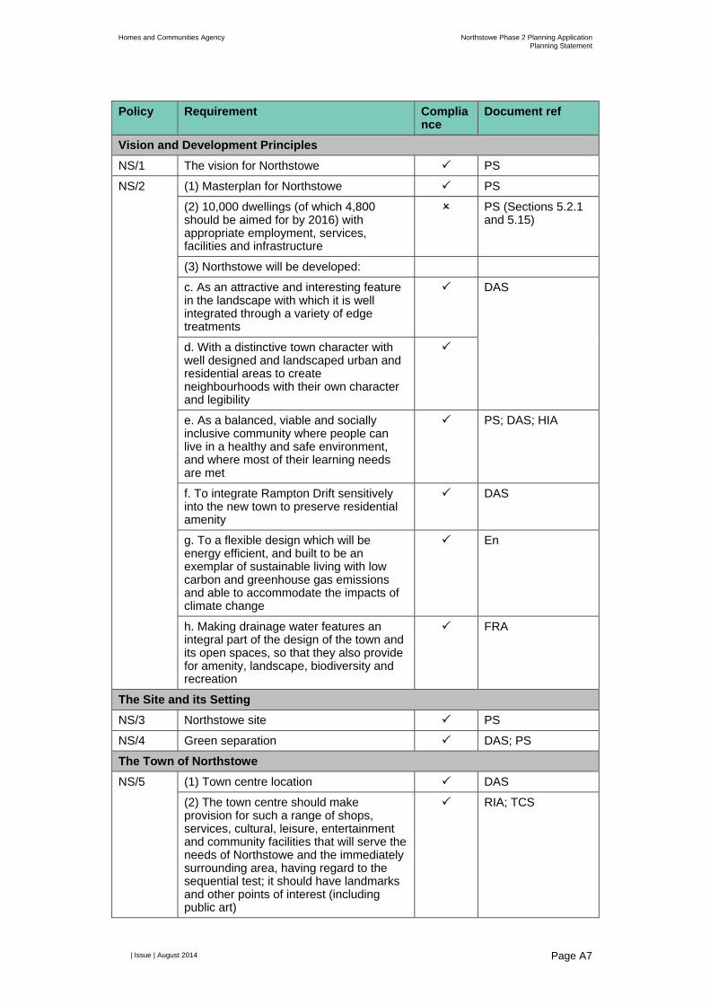
Homes and Communities Agency Northstowe Phase 2 Planning ApplicationPlanning Statement
| Issue | August 2014
Page A7
Policy Requirement Compliance
Document ref
Vision and Development Principles
NS/1 The vision for Northstowe PS
NS/2 (1) Masterplan for Northstowe PS
(2) 10,000 dwellings (of which 4,800 should be aimed for by 2016) with appropriate employment, services, facilities and infrastructure
PS (Sections 5.2.1 and 5.15)
(3) Northstowe will be developed:
c. As an attractive and interesting feature in the landscape with which it is well integrated through a variety of edge treatments
DAS
d. With a distinctive town character with well designed and landscaped urban and residential areas to create neighbourhoods with their own character and legibility
e. As a balanced, viable and socially inclusive community where people can live in a healthy and safe environment, and where most of their learning needs are met
PS; DAS; HIA
f. To integrate Rampton Drift sensitively into the new town to preserve residential amenity
DAS
g. To a flexible design which will be energy efficient, and built to be an exemplar of sustainable living with low carbon and greenhouse gas emissions and able to accommodate the impacts of climate change
En
h. Making drainage water features an integral part of the design of the town and its open spaces, so that they also provide for amenity, landscape, biodiversity and recreation
FRA
The Site and its Setting
NS/3 Northstowe site PS
NS/4 Green separation DAS; PS
The Town of Northstowe
NS/5 (1) Town centre location DAS
(2) The town centre should make provision for such a range of shops, services, cultural, leisure, entertainment and community facilities that will serve the needs of Northstowe and the immediately surrounding area, having regard to the sequential test; it should have landmarks and other points of interest (including public art)
RIA; TCS

Homes and Communities Agency Northstowe Phase 2 Planning ApplicationPlanning Statement
| Issue | August 2014
Page A8
(3) Public car and cycle parks for the town centre of a size consistent with its role as a small market town
TA; DAS; TCS
(4) Town Centre Strategy TCS
NS/7 (1) Provide an adequate and continuous supply of housing land housing to meet the at least 4,800 dwellings by 2106 and an ultimate target beyond that date of 10,000 dwellings.
PS (Sections 5.2.1 and 5.15)
(2) A well designed, high quality, and good mix of house types, sizes and tenure (including affordable housing) attractive to and meeting the needs of all ages and sectors of society including those with disabilities
PS; DAS
(3) Average net housing density of at least 40dph across the town as a whole, with higher densities in and around the town centre, local centres and at public transport stops, and lower densities on sensitive edges
(4) Design guidance to ensure variety in housing types
DAS;
(5) Market properties should provide: 25% to 30% of homes with one or two bedrooms 35% to 40% of homes with three bedrooms 30% to 35% of homes with four or more bedrooms Unless it can be demonstrated that a different mix would better meet needs or is justified having regard to economic viability or an up-to-date SHMA
PS
A proportion of new dwellings should be designed to lifetime mobility standards
(6) Affordable housing provision PS; Details to be negotiated
NS/8 (1) a. A significant high density employment area integrated with the town centre and located close to a stop on the desiccated busway
EDS
(2) Demonstrate how employment development proposals will encourage development of a mixed economy to provide a range of employment
EDS, ES Ch8
NS/10 Road infrastructure TA; ES Ch7
NS/11 (1) Adequate provision for alternative transport modes will be required to serve all stages of development
(2) High quality public transport
(3) Dedicated local busway TA; DAS

Homes and Communities Agency Northstowe Phase 2 Planning ApplicationPlanning Statement
| Issue | August 2014
Page A9
(4) All development will be within 600m easy walking distance of a stop on the dedicated local busway or within 400m walking distance of other local bus stops
TA
(5) Initial subsidy for new residents for a period of 12 months after occupation to encourage bus usage
(7) Financial contribution to the capital cost of the guided bus scheme
(9) Dedicated network of highly accessible, segregated, high quality, safe, direct, connected and convenient rights of way, including cycle, pedestrian and horse riding routes, within Northstowe, connecting with surrounding villages, and the wider rights of way network; complemented with quality infrastructure including signing, seating and lighting where appropriate
TA; DAS
(10) Secure cycle parking
(11) Car pooling and shared use of car parking facilities
NS/12 (1) Landscape Strategy: DAS
a. Create an appropriate setting for the new town, minimising any adverse visual or landscape impacts on the surrounding area including the setting and character of the surrounding settlements
ES Ch15; DAS
b. Ensure a high degree of connectivity between the new town and wider countryside for wildlife and people, including extending the rights of way network
ES Ch7/10; DAS
c. Include appropriate planting and landscaping alongside all new access roads and the parallel distributor roads and substantial planted areas in association with balancing ponds
ES Ch15; DAS; LP
d. Create a quality environment for residents, workers and visitors
DAS
e. Ensure a high degree of connectivity between green areas
f. Create a network of green spaces which contribute to legibility, are pleasant, attractive and beneficial to wildlife, and integrate well with the wider countryside
ES Ch10; DAS
g. Enable landscaped areas to provide an environment suitable to mitigate any adverse wildlife impacts and to maximise the benefits to wildlife
ES Ch10; DAS
h. Enable landscaped areas to contribute to informal recreational needs
DAS; PS
i. Make the best use of the existing tree DAS; ES Ch10
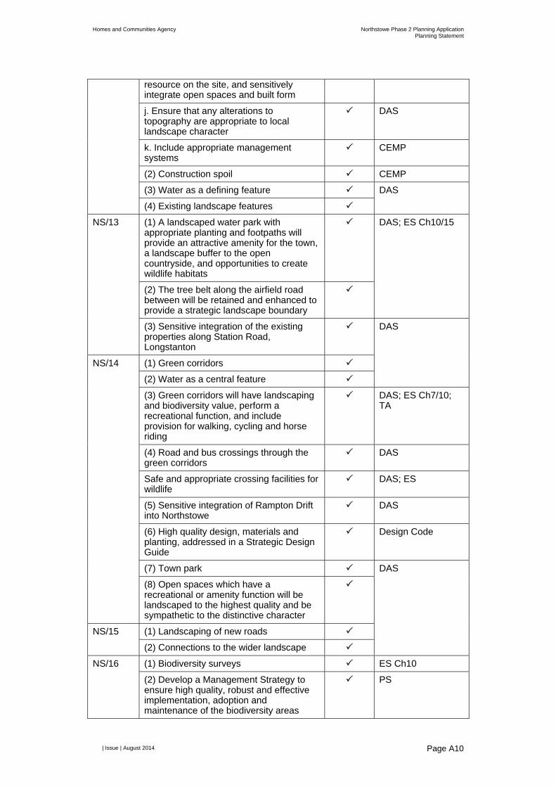
Homes and Communities Agency Northstowe Phase 2 Planning ApplicationPlanning Statement
| Issue | August 2014
Page A10
resource on the site, and sensitively integrate open spaces and built form
j. Ensure that any alterations to topography are appropriate to local landscape character
DAS
k. Include appropriate management systems
CEMP
(2) Construction spoil CEMP
(3) Water as a defining feature DAS
(4) Existing landscape features
NS/13 (1) A landscaped water park with appropriate planting and footpaths will provide an attractive amenity for the town, a landscape buffer to the open countryside, and opportunities to create wildlife habitats
DAS; ES Ch10/15
(2) The tree belt along the airfield road between will be retained and enhanced to provide a strategic landscape boundary
(3) Sensitive integration of the existing properties along Station Road, Longstanton
DAS
NS/14 (1) Green corridors
(2) Water as a central feature
(3) Green corridors will have landscaping and biodiversity value, perform a recreational function, and include provision for walking, cycling and horse riding
DAS; ES Ch7/10; TA
(4) Road and bus crossings through the green corridors
DAS
Safe and appropriate crossing facilities for wildlife
DAS; ES
(5) Sensitive integration of Rampton Drift into Northstowe
DAS
(6) High quality design, materials and planting, addressed in a Strategic Design Guide
Design Code
(7) Town park DAS
(8) Open spaces which have a recreational or amenity function will be landscaped to the highest quality and be sympathetic to the distinctive character
NS/15 (1) Landscaping of new roads
(2) Connections to the wider landscape
NS/16 (1) Biodiversity surveys ES Ch10
(2) Develop a Management Strategy to ensure high quality, robust and effective implementation, adoption and maintenance of the biodiversity areas
PS
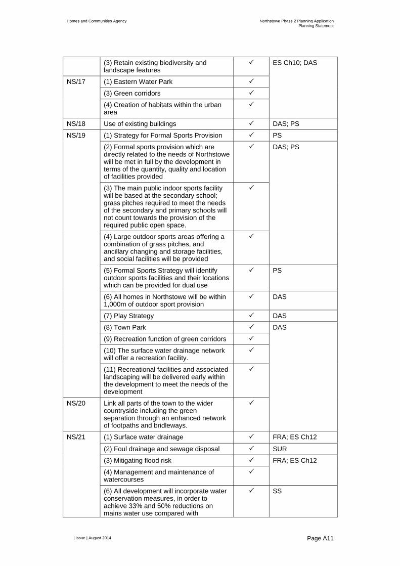
Homes and Communities Agency Northstowe Phase 2 Planning ApplicationPlanning Statement
| Issue | August 2014
Page A11
(3) Retain existing biodiversity and landscape features
ES Ch10; DAS
NS/17 (1) Eastern Water Park
(3) Green corridors
(4) Creation of habitats within the urban area
NS/18 Use of existing buildings DAS; PS
NS/19 (1) Strategy for Formal Sports Provision PS
(2) Formal sports provision which are directly related to the needs of Northstowe will be met in full by the development in terms of the quantity, quality and location of facilities provided
DAS; PS
(3) The main public indoor sports facility will be based at the secondary school; grass pitches required to meet the needs of the secondary and primary schools will not count towards the provision of the required public open space.
(4) Large outdoor sports areas offering a combination of grass pitches, and ancillary changing and storage facilities, and social facilities will be provided
(5) Formal Sports Strategy will identify outdoor sports facilities and their locations which can be provided for dual use
PS
(6) All homes in Northstowe will be within 1,000m of outdoor sport provision
DAS
(7) Play Strategy DAS
(8) Town Park DAS
(9) Recreation function of green corridors
(10) The surface water drainage network will offer a recreation facility.
(11) Recreational facilities and associated landscaping will be delivered early within the development to meet the needs of the development
NS/20 Link all parts of the town to the wider countryside including the green separation through an enhanced network of footpaths and bridleways.
NS/21 (1) Surface water drainage FRA; ES Ch12
(2) Foul drainage and sewage disposal SUR
(3) Mitigating flood risk FRA; ES Ch12
(4) Management and maintenance of watercourses
(6) All development will incorporate water conservation measures, in order to achieve 33% and 50% reductions on mains water use compared with
SS

Homes and Communities Agency Northstowe Phase 2 Planning ApplicationPlanning Statement
| Issue | August 2014
Page A12
conventional housing
NS/22 Telecommunications infrastructure UR
NS/23 An exemplar in sustainability SS, En, DAS
Delivering Northstowe
NS/24 Construction Strategy CEMP
NS/25 (1) Early delivery of strategic landscaping DAS
(2) Planting of green separation and boundary treatment for Rampton Drift to take place in the first planting season after the granting of outline planning permission.
NS/26 (1) Recycling of building materials CEMP
(3) Use of raw materials
(4) Re-use of existing buildings, providing that they are capable of conversion, will not have an adverse effect on the amenity of existing residents or businesses, are conveniently located, and are served by transport routes
DAS; ES Ch9
NS/27 Management strategies for services, facilities, landscape and infrastructure will be submitted to the local planning authority for adoption prior to the granting of outline planning permission
PS
NS/28 Timing and order of service provision DAS


Appendix B
Heritage Strategy
Homes and Communities Agency Northstowe Phase 2 Planning ApplicationPlanning Statement
| Issue | August 2014
Page B1
B1 Outline Heritage Strategy
B1.1 Introduction This document provides a Heritage Strategy for the Northstowe Phase 2 development that is submitted in support of the outline planning application for Phase 2 of Northstowe.
Consistent with the approach that has been adopted for Phase 1 of Northstowe, it is anticipated that that a Historic Environment Management Plan (HEMP) will be a requirement of the planning permission for Phase 2. In response to discussions with officers at the County Council, this document has been prepared to provide the overarching framework that will provide the basis for the preparation of a. HEMP.
B1.2 Context
The proposed development comprises the second phase of development of the new town of Northstowe. The vision for Northstowe as set out in the Northstowe Development Framework Document1 is that:
“Northstowe will be a sustainable high quality settlement which will be an example of excellence in the creation of a sustainable settlement…”
The role that archaeology and cultural heritage can play in the creation of such an exemplar is recognised in the Northstowe Area Action Plan (NAAP)2 which set four objectives in this regard:
D9/a To develop an appropriate Archaeological Strategy which mitigates any adverse effects of the new settlement on the archaeological resource.
D9/b To minimise any adverse impacts on the setting and character of Listed Buildings and Conservation Areas in the surrounding area.
D9/c To develop an appropriate strategy which mitigates any effects of the new settlement on unlisted structures of historic interest within the RAF airfield.
D9/d To provide an educational resource which can be used to inform the local population and the wider academic environment on the archaeological significance of the area.
In 2007 an archaeology and built heritage strategy was prepared on behalf of English Partnerships and Gallagher Longstanton Ltd as part of their proposals for the development of the site. Although never formally adopted or consented the proposed strategy has many elements which remain relevant to the current proposed development.
1 Gallagher /Homes and Communities Agency, 2012 Northstowe Development Framework Document. 2 South Cambridgeshire District Council , 2007, Local Development Framework: Northstowe Area Action Plan. Development Plan Document.

529500 530000 530500 531000 53150018
0000
1805
0018
1000
1815
00
Job No230781-25Drawing No Revision006 P0
Drawing StatusPreliminary
Job Title
Client
!°
© Arup
Homes and Communities Agency
Northstowe Phase 2
A3
MXD Location
17/06
/2014
13:54
:41
Heritage Strategy
Scale at A3
Revision Date By Chkd Appd
P0 2014-07-16 DML DML DML
Drawing Title
Site XII
Site XIII Site XXV
Site XXXV
Site XXIV
Site IV
Site VI
Site XIX
Site IXSite VIII
Site XXII
Site XV
Site XXXVI
Site VII
Site XVIII
Officers' Mess to be retained for educational use
Guard & Firehouse to be retained for non-residential use
Pillbox, air-raid shelter and trench enhanced as heritage feature
Pillboxes adapted as bat roosts
Station HQ not retained
A
B
CC
D
E
Longstanton Paddocks earthworks
F
Source: Esri, DigitalGlobe, GeoEye, i-cubed, Earthstar Geographics, CNES/Airbus DS, USDA, USGS, AEX, Getmapping, Aerogrid,IGN, IGP, swisstopo, and the GIS User Community
±Legend
Sub-Phase FSub-Phase ESub-Phase DSub-Phase CSub-Phase BSub-Phase A
Application Boundary
Archaeological Sites
0 410 820 1,230 1,640205Meters

Homes and Communities Agency Northstowe Phase 2 Planning ApplicationPlanning Statement
| Issue | August 2014
Page B3
In 2014 a Historic Environment Management Plan (HEMP) for Northstowe Phase 1 was prepared by Terence O’Rouke, as required by Planning Condition 12 attached to the outline planning permission for that development.
The purpose of the present document is to outline the approach to archaeology and built heritage that will be adopted as the proposed development at Northstowe Phase 2 goes forward. The strategy addresses the objectives set out in NAAP and takes note of the management plan now in place for Northstowe Phase 1. It is intended that this strategy will, in due course, form the basis of a similar management plan for the Phase 2 development.
The strategy lays out the approach to be taken to known and potential archaeological remains as well as designated and non-designated buildings. It examines the way in which early stage enabling works and off-site improvement works may interact with archaeology and lays out the basis for community engagement with and public participation in the proposed heritage mitigation.
B1.3 Known and suspected archaeology The proposed development is located in an area which has been the subject of a substantial programme of archaeological investigation comprising: aerial photographic interpretation, geophysical survey and trial trenching. These works have revealed a rich and varied archaeological landscape across the entire Northstowe site.
Archaeological sites within the Phase 2 development areas include potential Bronze Age and Iron Age farmsteads, two Romano-British settlements as well as burials and a possible shrine in addition to late- Saxon and medieval remains associated with the earliest phases of Longstanton village.
Two of the archaeological sites identified in the core development area extend across the boundary between Phases 1 and 2. A third site extends beyond the southern access road corridor into the A14 improvement works area.
Notwithstanding the comprehensive nature of the previous programme of investigation, the possibility exists that archaeological remains may be present in areas of the site where they have not hitherto been identified. In order to contribute to the identification and characterisation of such remains a programme of archaeological monitoring will be incorporated into early works, such as geotechnical ground investigation, in order to supplement the results of previous investigations.
B1.4 Early stage enabling works Geotechnical ground investigation, remediation of contaminated land, unexploded ordnance clearance and construction of the proposed waterpark will take place at an early stage in the development process. All of these activities have the potential to have an impact on buried archaeological remains and as a consequence will be subject to archaeological monitoring.
The Northstowe Phase 2 Historic Environment Management Plan will present a methodology for undertaking monitoring of early stage works which, subject to health and safety considerations in respect of contaminated land and unexploded ordnance, which minimises the impact from these activities on known

Homes and Communities Agency Northstowe Phase 2 Planning ApplicationPlanning Statement
| Issue | August 2014
Page B4
archaeological remains and correspondingly allows the greatest possibility of identifying areas of hitherto unknown survival.
B1.5 Southern Access Road construction The Southern Access Road lies in a corridor within which three archaeological sites, Sites3 XII, XIII and XXV, have been identified although the road route bypasses all three sites by a greater or lesser margin. A fourth site – Site XXXV – straddles the existing perimeter road which will be utilised for road construction traffic. No alterations to the existing perimeter road are intended and as a result this site will be preserved in situ.
In view of the possibility that the full extent of the three archaeological sites within the road corridor was not established during previous stages of archaeological works and that hitherto unidentified remains may be present within the corridor a programme of archaeological monitoring will be carried out during site preparation.
Where archaeological remains are encountered during the programme of monitoring provision will be made for controlled excavation of the remains.
Site XII straddles the interface between the Southern Access Road and the A14 improvement corridor. The Northstowe Phase 2 Historic Environment Management Plan will present a protocol for ensuring that archaeological remains at the interface between the two projects are fully and appropriately recorded subject to the requirements of the DCO for the A14 works.
B1.6 Core development area site preparation and construction
The core development covers an area of approximately 165 hectares within which 11 archaeological sites have been identified4. Some of the smaller (and earlier) sites are overlain by two large areas of Romano-British remains. The larger of the two areas of Romano-British remains forms a continuum with an earlier Iron Age site which lies to the west. Taken together the two sites cover an area of approximately 20 hectares. In total the area of identified archaeological remains amounts to approximately 27.6 hectares or nearly 17% of the proposed development area.
Site XXIV (0.37 hectares) falls within an area of proposed green separation and will be preserved in situ. The remaining sites fall within areas proposed for residential, town centre or educational use. Site preparation and construction in these areas will have a significant impact on the surviving remains and the proposed mitigation is preservation by record (excavation, reporting and archive).
An early stage activity within the core area will be the construction of roads and drainage swales. Where this activity falls within areas of known archaeological remains construction will be preceded by controlled excavation. A watching brief
3 See ES Chapter 9 and Appendix E for further details on the nature, extent and location of these sites. 4 The earthworks at Longstanton Paddocks , identified by CHET as a non-designated heritage asset, can be considered as an extension of Site XXIV and like that site will be preserved in situ within the green separation zone.

Homes and Communities Agency Northstowe Phase 2 Planning ApplicationPlanning Statement
| Issue | August 2014
Page B5
will be conducted in all other areas in order to supplement the observations from previous trial works.
The outline construction programme for the core development area envisages that construction will take place in six sub-phases between 2016 and 2029. In order to minimise fragmentation of archaeological observation across phases in those instances where archaeological sites of less than 1 ha straddle more than one sub-phase they will be investigated in their entirety at the earliest sub-phase. In the case of larger sites investigation these will be spread across the relevant phases unless the portion remaining after the initial phase of excavation amounts to less than 10% of the total area.
A summary of phasing and known archaeological sites is shown at Table B1.
Table B1: Development timetable and known archaeological sites
Sub-Phase Projected start Sites affected Comments A 2016 N/A B 2017 VII, VIII and part of
XIX Majority of XIX in sub-phase F
C 2018 XXII and parts of VI, XV and XVIII
XV evenly split between sub-phase C and sub-phase E. Majority of XVIII in sub-phase D or outside of development area. Site VI to be investigated.
D 2021 XXXVI and majority of XVIII
E 2023 XXIV and part of XV Longstanton Paddocks earthworks
XXIV and Longstanton Paddocks earthworks to be preserved in situ.
F 2026 IV, IX and majority of VI and XIX
Site XIX straddles the boundary between Northstowe Phase 1 and Phase 2. The programme of works outlined in Northstowe Phase 1 HEMP indicates that the part of the site which falls within Phase 1 will be excavated in the first half of 2015. The results of this work can be used to refine the detailed methodology for the investigation of that portion of the site which falls within Phase 2.
A substantial portion of Site XVIII falls to the south-east of the Phase 2 development footprint in an area scheduled for subsequent development. Mitigation of impacts in this area will be subject to assessment in due course as part of the development of proposals for this area.

Homes and Communities Agency Northstowe Phase 2 Planning ApplicationPlanning Statement
| Issue | August 2014
Page B6
B1.7 Off-site improvement works The ecology section of the Northstowe Phase 2 Environmental Impact Assessment sets out consideration of off-site compensation. The location and nature of the works has yet to be fully defined. Evaluation works will be carried out in the proposed areas in order to refine knowledge of the archaeological remains present.
The area of possible off-setting has not yet been nominated. Sufficient flexibility will be incorporated in the design of ecological improvements to allow known archaeological sites to be excluded from the areas to be improved.
Archaeological sites which cannot be excluded from the area to be improved will be fully investigated.
B1.8 Listed Structures The listed structures within the proposed Phase 2 development area comprise four FC Construction (cantilevered or Oakington-type) pillboxes. One of the pillboxes (structure 445 in the Francis survey of airfield buildings 5 ) has an associated air-raid shelter and linking trench. Subject to a condition survey to establish suitability, this group of structures will be refurbished and enhanced as a heritage and education feature.
The remaining pillboxes will be adapted to maximise their bat roosting potential and/or be the subject of a programme of temporary art projects. It is acknowledged that listed building consent may be required for either or both of these proposals.
B1.9 Non-listed structures The non-listed structures associated with RAF Oakington fall into two groups. The Station HQ building, air-raid shelters will not be retained in the proposed development. A record will be made of the Station HQ building to English Heritage Level 1 standard6.
As recommended by the Francis survey a selected air-raid shelter will be recorded to English Heritage Level 3 standard. In addition the possibility of offering one of the air–raid shelters to an aviation museum for display will be examined.
The former Officers’ Mess and Guard & Fire House will, subject to confirmation of viability, be retained in the proposed development. The Officers’ Mess may be suitable for conversion to an educational use consistent with its identification as part of a primary schools site in the outline planning application. This proposal will be the subject of a feasibility study and further assessment and will be undertaken alongside CCCC education officers. The Guard & Fire House may be used to provide non-residential, potentially commercial, community or food and drink space. Although the majority of the fabric of these buildings will be retained, where alterations or partial demolition takes place a suitable record will be made of the fabric which will be lost.
5 Francis, P 2004 RAF Oakington: An Operational History & Gazetteer of Surviving Structures. 6 English Heritage, 2006 Understanding Historic Buildings: a guide to good recording practice

Homes and Communities Agency Northstowe Phase 2 Planning ApplicationPlanning Statement
| Issue | August 2014
Page B7
B1.10 Community Engagement and Public Participation
The role which the historic environment can play in developing and enhancing a sense of place has come to be widely recognised in recent years as a significant factor. Initial community engagement with the management of the historic environment has already taken place through a process of community consultation and will continue throughout the development process.
The Northstowe Phase 2 Historic Environment Management Plan will contain a Community Engagement Plan which will address the following:
Public participation in the archaeological investigations to be carried out in connection with the development;
Community projects such as fieldwalking and geophysical survey outside of the development area which might support and enhance the results from development led investigation;
Regular dissemination of information about the results of the investigations through open days, lectures, Northstowe website and social netwoks, blogs, local press and broadcast media;
Engagement with local Primary and Secondary Schools though teaching packs, presentations and site visits; and
Temporary displays of archaeological finds.
Consideration will also be given to establishing a permanent display of material relating to the archaeology and history of Northstowe. Establishment of a permanent display will be subject to finding a suitable venue as well as securing funding for capital and operational costs and embodiment of a managing entity, such as a Heritage Trust, responsible for the curation and maintenance of the display. It is proposed that an appropriate stage of the development process a working party is established to explore the scope of a potential collection alongside an options analysis to identify suitable locations.
B1.11 Managing the Historic Environment The Northstowe Phase 2 Historic Environment Management Plan (HEMP) will be critical in ensuring that the historic environment of the proposed development is appropriately managed. The HEMP will provide the overarching structure for all heritage-related activities which will be supplemented by Written Schemes of Investigation for specific activities.
A key consideration in drafting the HEMP will be how it is made sufficiently flexible to allow modification throughout development process which is programmed to extend over more than 15 years.
In order to focus site based activity the HEMP should define Research Objectives aligned with the revised East of England Research Framework 2011 (and subsequent iterations which emerge as the development proceeds).
The HEMP should recognise that research priorities may change as the results of other projects, in particular those from Northstowe Phase 1, become available.

Homes and Communities Agency Northstowe Phase 2 Planning ApplicationPlanning Statement
| Issue | August 2014
Page B8
Dissemination of the results of archaeological investigations in advance of the proposed development should be as prompt and widespread as possible. As far as possible publication should seek to synthesise the results of investigation across the entire Northstowe site, however it is recognised that practical considerations may militate against this.
B1.12 Conclusion Engagement with cultural heritage is understood to be a key factor in developing place-shaping through shared interests, history, geographical features, key buildings and symbolic events 7 . The result is a strong and empowered community.
The present applicant has supported investigative work which has already added substantially to understanding of the historic environment of Northstowe and is committed to developing the site in a manner which is sensitive to its heritage and maximises opportunities to engage with that heritage by the existing and future population of the area.
This document is an outline which sets out the broad approach which will be taken to the heritage aspects of Northstowe Phase 2. In due course it will provide the basis on which an Historic Environment Management Plan will be prepared which in turn will guide interventions as the development proceeds.
7 See Graham, H, Mason , R and Newman, A 2009 Historic Environment, Sense of Place, and Social Capital, International Centre for Cultural and Heritage Studies (ICCHS) Newcastle University for a review of the literature on the interaction between the historic environment and the development of a sense of place.


Appendix C
Housing Strategy


NORTHSTOWE HOUSING STRATEGY PHASE 2 ONWARDS
June 2014
Contents
Page
Executive Summary 1
Chapter 1: Housing, the need for a strategic Approach 2
Chapter 2: Delivery & the role of Partners 3
Chapter 3: Quality, Sustainability and design 5
Chapter 4: Types of Housing 6
Chapter 5: Affordable Housing 9
Chapter 6: Housing Management & Community Development 11
Chapter 7: Implementation Plan 12

1
Executive Summary
Northstowe will be the first new town in England for many years, and will be the first and only town in the South Cambridgeshire District. Northstowe will comprise a town centre, plus two local centres, education facilities, other community infrastructure, and up to 10,000 new houses. These new houses will provide homes to around 25,000 people.
The overarching vision for Northstowe is for a sustainable and thriving new town where residents can lead happy, healthy lives, and the provision of the right type of housing is integral to support this.
There is significant demand for homes in South Cambridgeshire, and with supply not keeping pace with demand, homes are becoming increasingly unaffordable. Delivery of new homes at Northstowe will help to meet this demand. Delivery of a new town is a challenging process and successful delivery will require all the partners to work closely and collaboratively.
Delivery of high quality homes is vital to support good health and wellbeing, and the strategy sets out how this can be achieved by looking at setting high standards for design, minimum standards for the size of homes, and minimum standards for sustainability, ensuring that homes are fit for the future, and can be flexible to adapt to future needs of residents.
Northstowe will be home to a broad range of people, of different ages and with different lifestyles. In order to meet the needs of a range of people a range of homes will be provided, from apartments and starter homes, to large family homes with private gardens. A strong and sustainable community needs all its members, including those who are older or vulnerable. Meeting the needs of older and vulnerable people can be achieved in a variety of settings, and a holistic approach to provision and service delivery will need to be taken.
Delivery of homes on the scale of Northstowe has the scope to enable a range of types of delivery, including custom build and Co-Operative Housing. It also provides the opportunity to build pockets of homes which are delivered to an exemplar level of sustainability.
Northstowe does not end with the completion of homes and support will be required to enable the new residents to form a community. South Cambridgeshire and Cambridge City have experience of delivering this type of support on other Cambridge growth sites and expertise and best practice will inform this work at Northstowe.
This housing strategy has been produced by the Homes & Communities Agency in collaboration with South Cambridgeshire District Council, Cambridgeshire County Council and Cambridge City Council. The Housing strategy for Northstowe sets out the strategic aims and aspirations of the partners in the delivery of housing at Northstowe from Phase 2 onwards.

2
Chapter 1: Housing, the need for a strategic Approach
Objective: The overall aim for the Northstowe is to be a sustainable and thriving new town where residents can lead happy, healthy lives. The provision of the right type of housing is vital to support this.
The Housing Strategy for Northstowe is designed to provide strategic clarity to the delivery of Housing at Northstowe. With the aim of setting out how the delivery of housing can facilitate a mixed, balanced and sustainable community. A variety of types of accommodation will be required in order to meet the needs of residents, and this will include specialist types of accommodation.
The strategy also places housing delivery within the broader context of project delivery, including that of cost assessment. The strategy also aligns with the Core Northstowe objectives previously set out in the Development Framework Document, and relevant addendums, and the Northstowe Area Action Plan, and to align with the corporate objectives of the project partners; the Homes & Communities Agency (HCA), South Cambridgeshire District Council (SCDC) and Cambridgeshire County Council (CCC).
At the heart of the vision for Northstowe is a town where there is high quality, affordable housing, to meet the needs of a broad range of people, and homes that can adapt to changes in lifestyle.
The aspiration is that Northstowe will be a place for all people, of all ages, and as such will need to provide a range of types of accommodation to suit people at different stages in their life, and provide homes which can adapt as the needs of the occupier change.
The strategy sets out the priorities to meet the housing needs of the future residents of Northstowe, contributing to the overall aim of making Northstowe a healthy and sustainable new town. It is anticipated that the strategy will be reviewed after a period of two years.
South Cambridgeshire District Council (SCDC) alongside Cambridge City Council and Cambridgeshire County Council has been working with The Department for Communities and Local Government to agree a City Deal for Cambridge and South Cambridgeshire. The deal is centred on the provision of infrastructure to enable housing delivery, and also includes a proposal which will enable SCDC and Cambridge City to increase their respective new build programmes within their Housing Revenue Accounts.

3
Chapter 2: Delivery & the Role of Partners
Objective: Deliver new homes at Northstowe to meet market need
The need for a new town was identified through planning policy in order to meet the projected housing need of the Cambridgeshire sub-region. There is a high demand for new homes in Cambridgeshire, with housing in the sub-region becoming increasingly unaffordable. The delivery of housing at Northstowe will help to meet this demand, and it is expected that vales at Northstowe will be more affordable than the other Cambridge growth sites..
In order to maintain a steady rate of delivery on site a range of methods of delivery will be considered. This could include a range of developers and house builders, including Housing Associations, delivering at the same time. There is an aspiration to ensure that small and medium developers and house builders are not disadvantaged through procurement processes so that they have opportunity to deliver homes at Northstowe, therefore consideration will be given to the size and disposal methods of land parcels in order to facilitate a range of housing providers delivering on site.
The scale of delivery will be informed by market demand, but it is anticipated that around 250 – 350 new homes per year will be delivered.
Objective: Public Sector Working together
The Homes & Communities Agency (HCA) has multiple roles in the delivery of Northstowe; alongside the role of Applicant for Phase 2, the HCA is also responsible for the delivery of the Governments’ Affordable Housing Programmes, in line with Government policy objectives. The HCA also has a statutory duty to improve the supply and quality of housing and to contribute to the achievement of sustainable development and good design.
South Cambridgeshire District Council (SCDC) is the planning authority with statutory responsibility for Northstowe. South Cambridgeshire District Council has recently created a Local Housing Company, in order to deliver new Council owned homes for market rent. It is anticipated that SCDC will have a central role to play in the provision of housing at Northstowe.
Cambridgeshire County Council has a broad statutory remit which will relate to Northstowe in a great number of ways. With regard to the provision of housing Cambridgeshire County Council will determine requirements for specialist housing needs at Northstowe. Early determination of requirements will facilitate delivery of specialist housing provision at Northstowe.
Cambridge City Council has a close and strategic relationship with South Cambridgeshire District Council, and whilst the site for Northstowe resides solely within the South Cambridgeshire District Council administrative boundary, Northstowe is considered to be one of the South Cambridgeshire/Cambridge City strategic growth sites. For all of the strategic growth sites there is a joint allocations policy for Affordable Housing, with an agreed proportion of the allocations being made to applicants on the City Council waiting list.

4
This is likely to remain an aspiration for Northstowe, as the policy is working successfully on other growth sites, however it should be noted that this policy will be subject to review by SCDC and CCC. It is expected that Cambridge City Council would be a partner in future strategic approach to the delivery of Affordable Housing at Northstowe.
In order to ensure that the delivery of housing at Northstowe achieves its overarching aim of creating a mixed and balanced, sustainable community the project partners will need to work together to ensure this is achieved. Key to this is the role of all partners in the delivery of the Housing Strategy Implementation Plan
5
Chapter 3: Quality, Sustainability and Design
The Northstowe Development Framework Document states that ‘Quality is the mantra, in building design, building standards and environmental standards’ and the Housing Strategy aims to achieve high quality in standards of design and sustainability.
Objective: Achieve high quality design for homes
Design guidance will ensure that there will be a variety in the housing types provided at Northstowe to offer a range of choice to suit a variety of lifestyles. It is important that homes are built in a range of styles, sizes and architectural styles, to suit different requirements and preferences, and also in order to create quality of place.
Homes will include apartments in the more accessible locations and close to services and facilities, town houses, terraced housing and family housing in forms which embrace the move towards more sustainable ways of living and will include a significant proportion of smaller homes.
Housing density will be focused around the town centre and character districts specified in the Site Wide Strategic Design Code. Density is vital for the creating a sustainable town centre which can support retail and leisure, provide access to facilities and support sustainable transport links. Achieving high quality of design is particularly important for high density housing; therefore a solution which responds to best practice in design will be required.
Proposals will reflect the principles set out in the Cambridge Quality Charter for achieving excellence in new housing developments.
Community - building a sense of community and involving people in the running of their neighbourhoods
Connectivity - enabling easy access for all to jobs and services via sustainable modes of transport
Climate - tackling climate change through imaginative landscaping and innovative approaches to energy use, transport and waste/recycling
Character – creating distinctive neighbourhoods and public spaces that encourage people to walk and cycle.
The proposed plans for the scheme will also be reviewed by the Independent Cambridgeshire Quality Panel. The panel provides ongoing review and scrutiny of the emerging master plans and design codes of the major growth sites in Cambridgeshire. The panel helps to uphold and reinforce the Quality Charter.
Objective: Build homes at Northstowe which are fit for the future
Housing at Northstowe will be delivered to the same standards for all tenure types; this includes a minimum environmental standard and a minimum space standard.

6
Lifetime Homes have the potential to provide for the widest cross section of individuals within the general population, and inclusive design aims to give the widest range of people convenient access into and around the built environment. Lifetime Homes can be simply adapted to meet changing needs over time the design criteria have been carefully considered so that they can be incorporated into a dwelling’s design and construction from the outset with only a marginal cost effect.
A proportion of the homes at Northstowe will be built to the Lifetime Homes Standard, including all Affordable Homes. Lifetime Homes is a set of design principles which seeks to enable general needs housing to meet the existing and future needs of a diverse range of households. The proposed South Cambridgeshire District Council Local Plan requires that all Affordable Homes and five per cent of market homes will be built to the lifetime homes standard. However Northstowe will look to exceed this target where feasible and viable.
Building for Life is an industry standard for well-designed homes and neighbourhoods. Subject to further assessment, Northstowe will aim to achieve 12 Green lights under the Building for Life standard, with the exception of where local constraints on the scheme which prevent a green traffic light being achieved. 12 Greens equal the Building for Life diamond standard. The Building for Life Assessment will be carried out at an appropriate stage in the development.
Objective: Set minimum sizes for all homes at Northstowe
In the United Kingdom we build the smallest homes in Western Europe, at Northstowe we will provide homes with room sizes sufficient to fulfil our needs, and include space to grow into. Space enables homes to be used flexibility by a range of residents, ensure space can be assigned to different functions with adequate room sizes and storage integrated into the planning.
We will set a minimum size for all homes, Market and Affordable, which will be informed by the minimum space standards as contained in the emerging local plan.
Objective: A minimum standard for sustainability with room to grow
All houses at Northstowe will be delivered to a minimum of Level 4 of the Code for Sustainable Homes, and will also be built to meet the proposed 2016 Zero Carbon standard, with a fabric first approach.
It is important to be mindful that there will be industry and policy changes within the development timeframe. Whilst this strategy states that housing at Northstowe will be delivered to a minimum of Level 4 of the Code for Sustainable Homes, it is also intended to allow flexibility for increasing standards, and as such it is expected that future phase of Northstowe will be delivered to meet future best practice standards.
The scale of housing delivery at Northstowe opens up the potential for pockets of exemplar housing delivery, and to test delivery of sustainable design on a large scale. For example the delivery of a percentage of the housing could be delivered to PassivHaus standards.

7
Chapter 4: Types of Housing
Objective: Housing at Northstowe will suit a range of lifestyles and needs
People have different needs, requirements, aspirations and desires at different stages in their lives, and housing at Northstowe should be provided to meet the requirements of as many of its population as possible. This will be done in part by delivering properties in a range of sizes, from homes for single occupation to large family homes. This will also be achieved by building homes which are designed, and have sufficient space to be flexible in their use. In addition housing throughout the site will offer variety in terms of architectural style, but also lifestyle, enabling people to choose to be nearer to the town centre facilities, or closer to the edge of the town and the green separation areas. This choice should also result in a range of house prices.
The strategy for the second phase of Northstowe is to include a mix of terraced housing, semi-detached houses, mews houses with a limited amount of detached houses. There will be a range of homes with mix of private space including terraces or gardens, and homes with larger communal gardens. Parking provision has been designed to be on plot as much as possible.
The Private Rented Sector plays an important role in delivery of delivery of new housing, and helps to provide a flexible tenure choice. Private renting meets the needs of a number of segments of the market including young professionals, students and households in receipt of housing benefit. Consideration should be given to meeting the needs of this area of the market, including developing homes with the rental market specifically in mind.
A strong and sustainable community needs to include all its members, including those who are older or vulnerable. Vulnerable and older people require homes and opportunities that meet their particular needs, foster self-determination and support a good quality of life. The needs of older and vulnerable people can be met in a variety of settings, such as shared specialist supported housing, extra care housing, as well as through floating support in general needs housing.
South Cambridgeshire is one of the fastest ageing districts in the country, and as such consideration should be given to meeting the needs of an ageing population. This includes provision of suitable accommodation for older persons, in terms of lifestyle and the provision of Extra Care where required. Consideration should be given to the provision of a retirement village in close proximity to the Town Centre, enabling easy access to facilities and facilitating an independent lifestyle. Consideration should be given to market need, scale and implications for viability.
The requirement for Extra Care is determined by Cambridgeshire County Council, and a suitable assessment should be carried out to determine possible requirements at Northstowe, including if this could be provided within a retirement village.
The Northstowe Area Action Plan confirms that South Cambridgeshire District Council will prepare a Travellers’ Policy Development Plan Document which will include policies and

8
proposals for the needs of travellers, including site requirements, which may include provision at Northstowe. It will be informed by a sub-regional Travellers’ needs survey. The Document is provided for in the Council’s Local Development Scheme. At the date of completion of this document the GTNA does not currently demonstrate a requirement for additional pitches in South Cabridgeshire.
Objective: Encourage pioneers and promote change in the market place
Self-Build is commonplace in Europe, but limited in scope in the United Kingdom. Northstowe has the potential to test delivery of self-build housing on a larger scale than seen before in the U.K. Enabling delivery of self-build housing on a significant scale has the potential to promote a change in the market, by demonstrating how it can be made possible. Consideration will be given to up to a percentage of the homes at Northstowe being made available for self-build.
A separate strategy will need to be produced, and this will need to understand the market demand for self-build homes, and also consider the impact on the site wide viability. The strategy will also need to include the role of the planning authority, including urban design and planning control Consideration will also be given to the various methods of completing self-build projects, and these could include:
Organised by self-builder and constructed by main contractor Organised by self-builder who hires and manages sub-contractors Self-Build Community Projects Using a package contractor and prefabricated methods of construction
Consideration will also be given to making land available for one or more Co-Operative Housing projects within Northstowe. There are a number of ways in which housing co-operatives could work, but one way is that the residents would own leaseholds on their own homes, with the site freehold retained by a co-housing company, of which all leaseholders own a share. The co-operative could also include the provision of a common house, to be shared by all members of the co-operative. A suitable number of houses to be delivered as part of a co-operative could be 30-40 within each co-operative.

9
Chapter 5: Affordable Housing
Objective: Take a strategic approach to the delivery of Affordable Housing
In order to ensure that Northstowe develops as a sustainable community, affordable housing will be distributed through the development in small groups or clusters, with the appropriate cluster size being determined having regard to the location within the development e.g. town centre and residential neighbourhoods. The Affordable Housing should be ‘tenure blind’ in that the Affordable Housing should be indistinguishable from the Market Housing, In view of the scale of the development and the importance of achieving a sustainable and balanced community, contributions for off-site provision of affordable housing will not be appropriate to Northstowe.
In addition to its role as Landowner, the Homes & Communities Agency is also responsible for the delivery of the Governments’ Affordable Housing Programmes, in line with Government policy objectives. The HCA also has a statutory duty to improve the supply and quality of housing and to contribute to the achievement of sustainable development and good design.
The Housing Corporation, one of the HCA predecessor bodies set the standard in terms of taking a strategic approach to Affordable Housing, with the creation of the Cambridge Challenge initiative. Under the Cambridge Challenge a single Affordable Housing provider was procured through a competitive process. Identifying a single provider had a number of strategic aims, including increasing certainty of delivery and providing a unified approach to housing management. The Affordable Housing on the first phase of Northstowe remains part of the Cambridge Challenge, and as such are being delivered by Bedfordshire Pilgrims Housing Association.
The scale of Northstowe and opportunities arising from the HCA’s role as landowner, provide an opportunity to again take a strategic approach to the delivery of Affordable Housing for the remainder of town. This provides the HCA and partners with an exciting opportunity to create a new strategic approach to the delivery of exemplary Affordable Housing at Northstowe.
Many of the original objectives for the Cambridge Challenge are still relevant, such as; allow procurement efficiencies and procurement innovation; develop stewardship structures to ensure long-term sustainability in new and existing communities; deliver high-quality housing management services to future residents; and promote well-designed communities with functional and high-quality homes.
At an appropriate stage in the development a new strategic approach for Affordable Housing will be created. This will be undertaken in partnership with South Cambridgeshire District Council and Cambridge City Council. Due to the timescales of the development this approach will be taken for the delivery of Affordable Housing on Phase 2 of Northstowe, with a separate strategic approach taken in the future for Phase 3. It is expected that the process for undertaking this exercise would begin two and a half to three years prior to start on site for Phase 2.

10
The HCA is the Agency responsible for delivery of the Government’s Affordable Housing Programme; therefore Affordable Housing at Northstowe will be delivered in line with the relevant Government Policy objectives.
In order to ensure a balanced community it is important that the right tenure mix within the affordable housing is secured. The exact level and mix of Affordable Housing will be agreed with South Cambridgeshire District Council through the planning process. The Northstowe Area Action Plan is mindful of the significant infrastructure requirements of building a new town if there is an issue about whether the development will stand the affordable housing target, that is a matter that needs to be addressed through the planning application process where all the policy calls on the development, together with other development related requirements, can be looked at comprehensively and relative priorities determined.

11
Chapter 6: Housing Management & Community Development
Objective: Deliver a high quality and inclusive Housing Management solution
Housing Management includes management of Affordable Housing, which will be included in the strategic approach to Affordable Housing undertaken by the project partners. Housing Management should be high quality, with a consistent service across the town. There is also the potential to offer the management service for private properties under a single Northstowe Management Company, and this should be considered as part of a broader Management Strategy.
The Management Strategy for Northstowe will be produced in full collaboration with South Cambridgeshire District Council and Cambridgeshire County Council.
Objective: Support the early establishment of a new Community
New communities take time to develop and to establish, in order to establish a strong feeling of community, provision will be made for professional Community Development Workers to help establish a vibrant and sustainable community from the outset of development and also to provide support mechanisms in response to local need.
A Community Development Strategy outlining roles, partnership working and the professional people needed to help establish the new community will need to be created. It is expected that production of the strategy will be led by South Cambridgeshire District Council, drawing on the work and experience gained on the other Cambridge growth sites. It is likely that delivery of the strategy will be managed by a steering group, consisting of members from a variety of relevant organisations including SCDC, CCC, the health sector, police force, children’s centre, parish council and or a residents association. The steering group will also be responsible for the creation and delivery of a community development work plan.
It is anticipated that the work plan will include a community forum for new and existing residents, giving them opportunity to connect to Officers and developers. It is expected that provision will be made for Community Development Workers, who will work with both the existing and new communities. The community development officer should be in place in advance of the first occupation. This work could include support to help establish good communication and information for new residents, establishment of new groups, support mechanisms, sports clubs and community events. The needs of young people should be considered at the earliest stage of development, including the employment of youth workers. Early and on-going development work can help establish a strong feeling of community ownership of facilities and community space.
It is also expected that Affordable Housing providers will be closely involved in the delivery of community development work.

12
Chapter 7: Implementation Plan
Timeline:
2014 2015 2016 2017 2018 Q1 Q2 Q3 Q4 Q1 Q2 Q3 Q4 Q1 Q2 Q3 Q4 Q1 Q2 Q3 Q4 Q1 Q2 Q3 Q4
Quality, Sustainability & Design Design Code for Phase 2 Building for Life Assessment
Types of Housing Assessment of supported housing provision Assessment of extra care provision Assessment of potential for self-build Co-operative & Exemplar Housing
Affordable Housing Affordable Housing Strategic Approach
Housing Management & Community Development Phase 2 Management Strategy
Community Development Strategy
Open Space & Public Realm Strategy

13
Outline Plan:
Quality, Sustainability & Design
Timescale Stages of work: Partners
Design Code: Phase 2 Start: Early 2015 Complete: Late 2015
1. Prepare Draft Code 2. Consultation 3. Testing of Code 4. Revise Content 5. Final Code Approved
Homes & Communities Agency South Cambridgeshire District
Council
Assessment: Building for Life Start: Early 2017 Complete: End 2017
Tbc Homes & Communities Agency
Affordable Housing
Affordable Housing Strategic Approach
Start: End 2015 Complete: End 2018
1. Suitable Approach Identified 2. Brief Produced 3. Procurement Exercise (If
appropriate) 4. Provider Identified
Homes & Communities Agency South Cambridgeshire District
Council Cambridge City Council
Housing Management & Community Development
Timescale Stages of work: Partners
Housing Management Strategy: Phase 2
Start: Mid 2016 Complete: End 2018
1. Strategy Scoping 2. Research 3. Draft Strategy 4. Final Strategy Agreed
Homes & Communities Agency South Cambridgeshire District
Council Cambridgeshire County Council

14
Community Development Strategy Start: Mid 2014 Complete: End 2015
1. Strategy Scoping 2. Research 3. Draft Strategy 4. Final Strategy Agreed
Homes & Communities Agency South Cambridgeshire District
Council Cambridgeshire County Council
Open Space & Public Realm Strategy
Start: Mid 2016 Complete: End 2018
1. Strategy Scoping 2. Research 3. Draft Strategy 4. Final Strategy Agreed
Homes & Communities Agency South Cambridgeshire District
Council
Types of Housing
Timescale Stages of work: Partners
Assessment: Supported Housing Provision
Start: Mid 2015 Complete: Mid 2016
To be led by Cambridgeshire County Council
Cambridgeshire County Council South Cambridgeshire District
Council
Assessment: Extra Care Provision Start: Mid 2015 Complete: End 2016
To be led by Cambridgeshire County Council
Cambridgeshire County Council South Cambridgeshire District
Council
Assessment: Potential for self-build, Co-Operative & Exemplar Housing
Start: Mid 2015 Complete: Mid 2016
1. Scoping 2. Research 3. Market Assessment 4. Viability Assessment
Homes & Communities Agency South Cambridgeshire District
Council

Homes and Communities Agency Northstowe Phase 2 Planning ApplicationPlanning Statement
| Issue | August 2014
Page C1

Appendix D
Framework Ecological Management Plan

Homes and Communities Agency Northstowe Phase 2 Planning ApplicationPlanning Statement
| Issue | August 2014
Page D1
Framework Ecological Management Plan

Homes and Communities Agency Northstowe Phase 2 Planning ApplicationPlanning Statement
| Issue | August 2014
Page D2
D1 Introduction
D1.1 Background Arup was commissioned by the Homes and Communities Agency (HCA) to prepare this draft Ecological Management Plan (EcMP) to support the planning application for Phase 2 of Northstowe. It should be read in conjunction with the Environmental Statement (ES). At this stage, the EcMP provides a framework for detailing future management actions, which will complement the detailed design of Phase 2 which will be progressed as reserved matters applications.
An EcMP for Phase 1 of the Northstowe development has already been prepared8, pursuant to condition 33 of planning permission S/0388/12/OL. This document aligns with that to ensure a consistent approach across the Northstowe site.
D1.2 What is an EcMP? A suite of ecological surveys have been carried out at the Northstowe site over a number of years and have been used to inform the baseline conditions and assessment outlined in the ecology chapter of the ES. This includes embedded ecology measures (EEMs) and additional mitigation measures that will be implemented to avoid or reduce likely adverse effects on sensitive ecological features and ensure adherence to wildlife legislation.
This EcMP has been prepared to facilitate the further development of proposals for mitigation and habitat creation contained in the ES. It is a live document that will be progressed as the development proposals evolve, ultimately incorporating full details regarding these elements, as well as requirements for management. This document will be refreshed prior to the commencement of site preparation and construction works for each sub phase of development. However, the results of monitoring at the site will feed into the EcMP, such that management prescriptions can be altered as required.
D1.3 Broad aims and objectives This document aims to identify key ecological features at the site and describe how these will be protected and enhanced during the construction and operation of the proposed development. It will continue to be developed as the proposed development details evolve, to provide a strategy for managing the ecological resources at the site and for optimising their value.
This EcMP includes the following:
A summary of the results of habitat and species surveys, including a plan showing the habitats at the site;
Identification of habitats and species worthy of management and enhancement together with the setting of appropriate conservation objectives;
Details of measures for the protection and suitable mitigation of all legally protected species and those habitats and species identified as being of importance to biodiversity; and
8 Terence O’Rourke, (2014); ‘Ecological Management Plan. Northstowe Phase 1, Cambridge.’

Homes and Communities Agency Northstowe Phase 2 Planning ApplicationPlanning Statement
| Issue | August 2014
Page D3
Proposals for habitat retention and creation and ecological enhancement measures.
The above items will continue to be developed as the proposals evolve, in conjunction with the addition of the following:
Prescriptions for habitat and species management and enhancement;
A summary work schedule table, including an indication of timings for mitigation and management and identification of those responsible for delivery;
A ten-year strategy for post-development monitoring of the effective implementation of the EcMP and a means for its periodic review with the Local Planning Authority (LPA) to ensure effective implementation; and
Confirmation of suitably qualified personnel responsible for over-seeing implementation of the EcMP commitments, such as an Ecological Clerk of Works (including an outline of the role).
D1.4 Document structure Baseline ecological information and figures pertaining to all baseline surveys can be found in the ES. Section 3 sets objectives and targets for the mitigation and on-going management of the site and Section 4 details the proposal for habitat creation and mitigation. An implementation plan summary is provided in Section D5.
D2 Baseline information
D2.1 Information sources The baseline conditions on the site are described in the ecology chapter of the ES and were derived from a desk study and a series of habitat and protected species surveys. The desk study was undertaken in May 2012, for the site and its immediate surrounds to a 2km radius, extended to 5km for bats. This involved an ecological data search for information on statutory and non-statutory sites and notable and protected species records held by Cambridgeshire & Peterborough Environmental Records Centre (CPERC).
Furthermore, the following documents have also been taken into account:
Northstowe Phase 1 Ecological Management Plan 2014;
South Cambridgeshire District Council (SCDC) Biodiversity Strategy 20099; and
Northstowe Area Action Plan 200710.
Field surveys were undertaken between July 2003 and June 2014, with the principal studies as follows:
Bat inspection survey (January to February 2007);
9 Cambridgeshire and Peterborough Biodiversity Partnership, (2014); ‘Library’. Available at: http://www.cpbiodiversity.org.uk/downloads 10 SCDC, (2007); LDF. Northstowe Area Action Plan Development Plan Document.’
Homes and Communities Agency Northstowe Phase 2 Planning ApplicationPlanning Statement
| Issue | August 2014
Page D4
Extended Phase 1 habitat survey (April to July 2012 and August 2013);
Bat scoping and inspection survey (July to November 2013);
Bat activity and automated survey (May to September 2013);
Bat tree climbing survey (April 2014)
Bat emergence and return surveys (May and June 2014);
Badger Meles meles scoping survey (May to July 2013);
Badger bait-marking survey (March and April 2014);
Breeding bird survey (May and June 2012, May and June 2013 and March and April 2014);
Great crested newt Triturus cristatus survey (May 2012, May and June 2013 and April and May 2014); and
Common toad Bufo bufo survey (March 2014).
D2.2 Habitats The habitats on the site are described in the following sections and shown in the ES.
D2.2.1 Improved grassland
This habitat is low in plant species diversity, dominated by perennial rye grass Lolium perenne, false-oat grass Arrhenatherum elatius, cocksfoot Dactylis glomerata, Yorkshire fog Holcus lanatus, common bent Alopecurus pratensis and white clover Trifolium repens. It is grazed by sheep and cattle and has therefore been generally kept short, although areas of rough grassland were noted. However, as an exception, the field in the northwest corner of the site is typically left to grow long during the spring and summer and was cut for hay and silage.
Although lacking in species diversity, the value of this habitat is increased as it supports notable and protected species. It provides habitat for badgers, farmland birds, reptiles, brown hare Lepus europeaus and notable invertebrates, potentially including grizzled skipper Pyrgus malvae.
D2.2.2 Neutral semi-improved grassland
Discrete areas of semi-improved grassland are managed by grazing or comprise tall, ungrazed swards. Meadow foxtail Alopecurus pratensis, red fescue Festuca rubra, smooth meadow grass Poa pratensis, birds foot trefoil Lotus corniculatus, germander speedwell Veronica chamaedrys, creeping thistle Cirsium arvense, common vetch Vicia sativa and agrimony Agrimonia eupatoria were recorded. These areas of habitat, in particular those that are not managed by grazing, provide habitat for birds, reptiles and brown hare.
D2.2.3 Arable
The northwest corner of the site and the majority of the southern access road route is comprised of arable land that had been sown with cereals, legumes or potatoes. The crops have been generally sown up to the field boundaries with
Homes and Communities Agency Northstowe Phase 2 Planning ApplicationPlanning Statement
| Issue | August 2014
Page D5
few headlands or marginal features; few arable weeds were recorded, which limits the ecological value of this habitat. The arable fields are, however, found to provide important foraging and nesting habitat for a variety of farmland bird species, with brown hare also noted.
D2.2.4 Broad-leaved plantation woodland
Strips of plantation of woodland fall within the road route in the southern part of the barracks, with a small plantation also recorded along the southern road route. The trees are typically mature or semi-mature and mainly comprise willow Salix sp. and hybrid black poplar Poplus x canadensis. The trees have been densely planted and, as such, the ground flora is generally sparse, although bramble Rubus fruticosus, cow parsley Anthriscus sylvestris, cleavers Galium aparine and stinging nettle Urtica diocia have been recorded. Mature trees have a potential to support roosting bats and the woodland edges provide commuting and foraging habitat for pipistrelle Pipistrellus sp. bats. The woodlands provide habitat for badgers, reptiles and amphibians, potentially including great crested newt.
D2.2.5 Broadleaved scattered trees
Numerous scattered trees are found across the site, including around the former barracks buildings and Rampton Drift and along the road route in the southern part of the barracks. Scattered trees are also noted along Wilson’s Road, along the southern road route. A wide variety of other species have been recorded, including lime Tilia sp., poplar Populus sp. Norway maple Acer platanoides, silver birch Betula pendula, apple Malus sp. and wild cherry Prunus avium. The trees provide nesting habitat for birds and some trees potential roosting habitat for bats.
D2.2.6 Standing water
There are two ponds within the site, in the northeast corner of the site (Pond 7); and on an arable field boundary and the end of a wet ditch (Pond 6) (see to the Phase 1 habitat map in Error! Reference source not found.). Pond 6 is flanked by dense scrub on the southern edge, with riparian vegetation, mainly great willowherb Epilobium hirsutum, along the northern edge. Pond 7 is a smaller pond, appearing as a man-made trench, lacking in bankside or aquatic vegetation. These ponds support common amphibians (common frog Rana temporaria and smooth newt Lissotriton vulgaris).
There are ditches along the field boundaries within the southern road route and at the eastern boundary of the barracks site. These are generally less than 1m wide, with steep banks and containing shallow water (less than 50cm in depth). Some emergent vegetation has been recorded along those within the southern road route, including species such as great willowherb, common reed Phragmites australis, yellow iris Iris pseudacorus and bulrush Typha angustifolia. The ditches at the barracks contain no aquatic vegetation and in places are shaded by bramble and hawthorn Crataegus monogyna hedgerows. The ditches have not been found to support notable or protected species.
Homes and Communities Agency Northstowe Phase 2 Planning ApplicationPlanning Statement
| Issue | August 2014
Page D6
D2.2.7 Scrub
Scattered and dense scrub is dominated by bramble, hawthorn, blackthorn Prunus spinosa, goat willow Salix caprea and elder Sambucus nigra. In some areas, the scrub forms continuous blocks of dense vegetation. This habitat provides foraging and nesting opportunities for birds and cover for small mammals, amphibians and reptiles.
D2.2.8 Tall ruderal
This habitat was recorded at the barracks and along field boundaries along the southern road route. With respect to the former, these areas represent an early successional, transient plant community with a diverse range of plants interspersed with areas of bare ground. The dominant plant species are teasel Dipsacus fullonum, bristly ox-tongue Picris echioides, prickly sow thistle Sonchus asper, curled dock Rumex crispus and creeping thistle. To the south are patches of tall ruderal vegetation in areas of unmanaged land along ditches and tracks, including stinging nettle and creeping thistle. Tall ruderal vegetation provides habitat for reptiles, invertebrates and small mammals and foraging opportunities for birds.
D2.2.9 Amenity grassland
Small patches of amenity grassland have been recorded, comprising a low diversity of plant species, including perennial rye-grass, annual meadow grass Poa annua, daisy Bellis perennis, dandelion Taraxacum sp. and hoary plantain Plantago media.
D2.2.10 Hedgerows
Mature species-poor hedgerows form the field boundaries north of Rampton Road, west of Long Lane and within the southern access road route. They are dominated by hawthorn, but some areas had a higher diversity and also contain dog rose Rosa canina, elder, bramble and blackthorn and occasionally mature trees. A species-rich hedgerow has also been recorded along the western side of Long Lane, which qualifies as ‘important’ under the Hedgerow Regulations 1997, because it supports seven ‘woody’ species. The two hedgerows along Long Lane also provide an important foraging habitat for a range of bat species. White-spotted pinion moth Cosmia diffinis and white-letter hairstreak Satyrium w-album have been recorded along hedgerows to the west of Long Lane, where elm species Ulmus sp. are present.
D2.2.11 Buildings
There are residential and farm buildings at Brookfield Farm, along with horticultural and residential buildings at Larksfield Nursery. At the barracks are disused brick buildings and pillboxes. Three small buildings are recorded in arable and pasture fields. A two storey brick residential house has also been recorded adjacent to Hatton’s Road.
Some of the buildings provide habitat for roosting bats or nesting birds.

Homes and Communities Agency Northstowe Phase 2 Planning ApplicationPlanning Statement
| Issue | August 2014
Page D7
B2, B55 and B56 have been found to support roosting bats. B56 also likely supports nesting starlings Sturnus vulgaris;
B5 has a potential to support roosting bats;
B25 supports nesting swallows Hirundo rustica; and
B13 may have been used as a feeding perch for bats, but no signs of an active roost were recorded.
The buildings at Larksfield Nursery have not been assessed since 2007 due to the lack of access. B80 was defined as a likely roost, due to the presence of old droppings in the roof void. B81 to B88 are horticultural buildings that are unlikely to provide important habitat. B89 and B90 have pitched roofs and could offer habitat for bats and/or birds.
D2.2.12 Other habitats
Patches of introduced shrub have been recorded around the former barracks building, comprising non-native ornamental species including roses Rosa sp. Areas of bare ground and hardstanding were recorded, comprising roads and tracks.
D2.3 Species
D2.3.1 Bats
D2.3.1.1 Roosts
Figures in the ES show the potential of buildings and trees within the site, as well as those found to support roosting bats. Some of the bat boxes contained old bat droppings, although no evidence was recorded to indicate the presence of an active roost. Butterfly wings were recorded in B13, but no signs were recorded to indicate the presence of an active roost.
The following provides a summary of bat roosts recorded at the site:
B2 – Likely hibernation and daytime summer roost for common pipistrelle Pipistrellus pipistrelles. Low number of male or non-breeding female bats;
B55 – Likely brown long-eared bat Plecotus auritus roost in roof void, but the status of this roost is to be confirmed; and
B56 - Common pipistrelle bat roost in roof void. Low number of male or non-breeding female bats.
The following provides a summary of possible bat roosts:
B5 – Common pipistrelle bat may have returned to southwest façade of building during emergence and return surveys;
Brookfield Farm agricultural buildings – Signs of roosting bats were recorded in some of these buildings during the inspection in 2007, although none such signs were recorded during the inspection carried out in 2013. It is therefore likely that these buildings no longer support active roosts;

Homes and Communities Agency Northstowe Phase 2 Planning ApplicationPlanning Statement
| Issue | August 2014
Page D8
B80 - Four scattered, small, old bat droppings were recorded within the roof space during the inspection in the winter of 2007; and
WB9 – Early records of soprano pipistrelle Pipistrellus pygmaeus and common pipistrelle during emergence and return surveys in 2014 indicated that these species may roost in trees in the woodland.
D2.3.1.2 Foraging and commuting activity
Key areas of bat activity are summarised below:
Long Lane - The most intense foraging activity has been noted in this part of the site, where common and soprano pipistrelle, noctule Nyctalus noctula, Leisler’s bat Nyctalus leisleri and probable Daubenton’s bat Myotis daubentonii were recorded. A possible serotine Eptesicus serotinus pass has also been recorded. Brown long-eared bat was also recorded by the static detector;
Land west of Long Lane – Common and soprano pipistrelle and Leisler’s bat has been recorded foraging over grassland;
The barracks – Common pipistrelle has been recorded foraging along the access road into the barracks and around the former barracks buildings;
Wilson’s Road and parallel hedgerow – Common pipistrelle foraging activity has been recorded;
Plantation woodland edges – Common, soprano and Nathusius’ pipistrelle Pipistrellus nathusii bats have been recorded foraging and commuting along the edges of the woodland blocks in the southern part of the barracks; and
Brookfield Farm - The track through Brookfield Farm provides foraging and commuting habitat for common pipistrelle.
D2.3.2 Badger
High levels of badger activity have been recorded, although much of this activity was located outside the Phase 2 application site. The badger setts are described below:
Sett 21 – Outlier with one entrance hole, a latrine and fresh spoil;
Sett 22 – Main sett. Ten entrance holes were recorded along a bank covered with dense scrub. Nine of these were active, with fresh bedding and spoil present, as well as a latrine and prints. It is possible that there are additional entrance holes within the dense scrub or under rubble, with some pathways noted along the bank that disappear into impenetrable scrub;
Sett 27 – Subsidiary with fresh bedding and large spoil heap. Entrance hole immediately adjacent to the site;
Sett 28 – Subsidiary with two entrance holes, fresh spoil and bedding material; and
Sett 36 – Outlier with one entrance hole and a latrine.
The territories of four badger clans cross into the site (grey, yellow, orange and blue). One main badger sett has been recorded within the site (sett 22), which is associated with the grey clan. The territory of the grey clan extends across the

Homes and Communities Agency Northstowe Phase 2 Planning ApplicationPlanning Statement
| Issue | August 2014
Page D9
central part of the site, from the northern extent of the barracks to beyond the boundary of the built development to the south, including across the proposed road and temporary access road. It is considered likely that sett 21 is associated with this clan. Strong territorial activity has been recorded along the northern border of the grey clan, to the south of Brookfield Farm. Badger signs have been noted to the north of Rampton Road; as such it is considered that the territory of another badger clan lies within the northern part of the site, likely within the Phase 1 site. Two active setts were recorded in this part of the site (setts 27 and 28).
The grey clan borders the yellow clan to the east, which extends into part of the proposed built development. The main sett of the yellow clan is located outside the site, but the territory crosses the proposed temporary access road, the southern road route and part of the ‘northern road’ connecting the built development with Longstanton Road.
The main setts of the blue and orange clans are located outside the site, but their territories cross the proposed road in the southern part of the barracks, as well as the proposed spine road. The territory of the blue clan also crosses Longstanton Road to the south.
D2.3.3 Brown hare
Brown hare has been incidentally recorded in the arable habitats in the north western part of the site, east and west of the track towards the sewage works. This species has also been noted in other areas of the barracks, particularly the improved and semi-improved grasslands. Of particular note, 12 individuals were recorded displaying breeding behaviour within the rough grassland just outside the boundary of the site in April 2007. Otherwise, only one or two individuals have been recorded at any one time.
D2.3.4 Birds
A total of 73 species of bird have been recorded within areas that could be affected by the proposed development (including areas adjacent to the site), of which 62 were either confirmed as breeding or were considered as probably breeding on the site. A further four species were thought to be possibly breeding at the site. The remaining seven species were thought to be non-breeding and were utilising the site in other ways, including for roosting and/or foraging.
A total of 29 notable and/or protected species have been found to hold breeding territories.

Homes and Communities Agency Northstowe Phase 2 Planning ApplicationPlanning Statement
| Issue | August 2014
Page D10
Table C2 lists these species and indicates their likely breeding status and the estimated number of territories.

Homes and Communities Agency Northstowe Phase 2 Planning ApplicationPlanning Statement
| Issue | August 2014
Page D11
Table C2: Key Bird Species
Common Name
Scientific Name
BoCC Category
Other Designations
Breeding Status
Estimated Territories
Greylag goose Anser anser Amber Confirmed 6
Mallard Anas platyrhynchos
Amber Confirmed 2
Grey partridge Perdix perdix Red Section 41, UK BAP, LBAP
Probable 2
Quail Coturnix coturnix
Amber WCA Schedule 1
Probable 1
Kestrel Falco tinnunculus
Amber - Confirmed 2
Hobby Falco subbuteo
Green WCA Schedule 1
Confirmed 1
Lapwing Vanellus vanellus
Red Section 41, UK BAP
Possible 2
Snipe Gallinago gallinago
Amber - Probable 2
Stock dove Columba oenas
Amber - Confirmed 8
Turtle dove Streptopelia turtur
Red Section 41, UK BAP
Probable 2
Barn owl Tyto alba Amber WCA Schedule 1
Confirmed 1
Swift Apus apus Amber - Probable 1
Green woodpecker
Picus viridis Amber - Confirmed 6
Skylark Alauda arvensis
Red Section 41, UK BAP, LBAP
Confirmed 21
Swallow Hirundo rustica
Amber - Confirmed 3
Common whitethroat
Sylvia communis
Amber - Confirmed 10
Willow warbler Phylloscopus trochilus
Amber - Probable 2
Spotted flycatcher
Muscicapa striata
Red Section 41, UK BAP
Probable
Starling Sturnus vulgaris
Red Section 41, UK BAP
Confirmed 8
Song thrush Turdus philomelos
Red Section 41, UK BAP, LBAP
Confirmed 3
Dunnock Prunella modularis
Amber Section 41, UK BAP
Confirmed 11
House sparrow
Passer domesticus
Red Section 41, UK BAP
Confirmed 5
Homes and Communities Agency Northstowe Phase 2 Planning ApplicationPlanning Statement
| Issue | August 2014
Page D12
Yellow wagtail Motacilla flava
Red Section 41, UK BAP
Confirmed 7
Meadow pipit Anthus pratensis
Amber - Confirmed 3
Linnet Carduelis cannabina
Red Section 41, UK BAP
Confirmed 8
Bullfinch Pyrrhula pyrrhula
Amber Section 41, UK BAP
Probable 1
Yellowhammer Emberiza citrinella
Red Section 41, UK BAP
Confirmed 9
Reed bunting Emberiza schoeniclus
Amber Section 41, UK BAP
Confirmed 1
Corn bunting Emberiza calandra
Red Section 41, UK BAP
Confirmed 1
Twenty of the key species were confirmed as breeding, eight probably bred and one possibly bred. Three Schedule 1 species (quail, hobby and barn owl) held breeding territories within the site. Hobby and barn owl were both confirmed to have bred at the site and quail was thought to be probably breeding. A total of 12 BoCC red list species were recorded, along with 16 that are included on the amber list. Fifteen species listed on Section 41 and the former UK BAP were recorded. Three LBAP species were also recorded. House sparrow, willow warbler and dunnock are of site value and will therefore not be considered further in the assessment.
D2.3.5 Great crested newt
Great crested newt has not been recorded within the site, but has been observed in Ponds 1, 2, 4 and 5, which are located within 500m of the site, also in terrestrial habitat near to these ponds. A peak count of five in 2014 indicates that a small population is present. No great crested newt eggs have been recorded, although the presence of a gravid female during the survey on 7th to 8th May 2014 indicates that this species breeds in ponds near to the site. There is also potential for great crested newt to occur within the terrestrial habitats within the site, particularly the woodlands and scrub. It is likely that breeding populations outside the barracks could supplement the population within the site.
D2.3.6 Common amphibians
Peak counts of four smooth newts and one common toad have been recorded in Pond 7. Furthermore, a peak of two smooth newts was recorded in Pond 6.
Although not within the site, higher numbers of common toad have been recorded in Pond 3, near to the proposed access roads. A peak count of 88 was recorded during the common toad survey on 17th March 2014, which indicates a low population.

Homes and Communities Agency Northstowe Phase 2 Planning ApplicationPlanning Statement
| Issue | August 2014
Page D13
D2.3.7 Reptiles
Adder Vipera berus has been noted within 2km, but has not been recorded at the site, likely on account of the lack of suitable habitat (open heathland and dense woodland). Grass snake Natrix natrix and common lizard have been recorded on the site. The peak count for common lizard was 6, indicating that there is a good population. Only one common lizard was recorded within the offsite infrastructure area (OSIA). All other records relate to the northeastern part of the barracks. It is likely that these populations are distinct, as Longstanton Road dissects the site. As such, the single record would indicate a low population within the OSIA. The peak count for grass snake was 1, indicating a low population. A single grass snake was recorded in two areas within the site, in the northern part of the barracks, near to Rampton Road, and west of Long Lane.
D2.3.8 Invertebrates
The invertebrate assemblage sampled in the ditch along the eastern boundary of the site was characterised by a low diversity (nine taxa with only 7 BMWP scoring families) and the absence of pollution sensitive taxa. Furthermore, no species of nature conservation interest were identified in the sample.
Small heath Coenonympha pamphilus, shaded broad-bar Scotopteryx chenopodiata and cinnabar Tyria jacobaeae were recorded during the butterfly survey in 2012, although it is uncertain as to whether these were recorded along transects within the site. White-letter hairstreak butterfly and white-spotted pinion moth were both recorded along hedges to the west of Long Lane. Grizzled skipper was not recorded at the site, although an area of suitable habitat was noted near to the eastern boundary of the site that could support this species.
Other notable invertebrates have been recorded at the site, to the west of Long Lane and in weedy disturbed ground near to the former barracks buildings. Further details are provided in Table 3.
Table 3: Other Notable Invertebrates
Species Conservation Status
Details
West of Long Lane
Lygus pratensis (a myriad bug)
RDB3 Widespread species that no longer merits its RDB3 status. Associated with ancient woodland, open her-rich areas
Oxytelus piceus (a rove beetle)
RDBK Rare species with a scattered distribution. Specialist on herbivore dung
Cryptophagus schmidtii (a beetle)
RDBK Diverse habitats, occurrence possibly associated with pheasant feed
Longitarsus parvulus (a flea beetle)
Na Widespread species that no longer merits its status. Associated with flax.
Ophonus ardosiacus (a ground beetle)
Nb Restricted to south-eastern England, associated with weedy habitats
Square-spotted clay Nb Foodplants include common nettle and
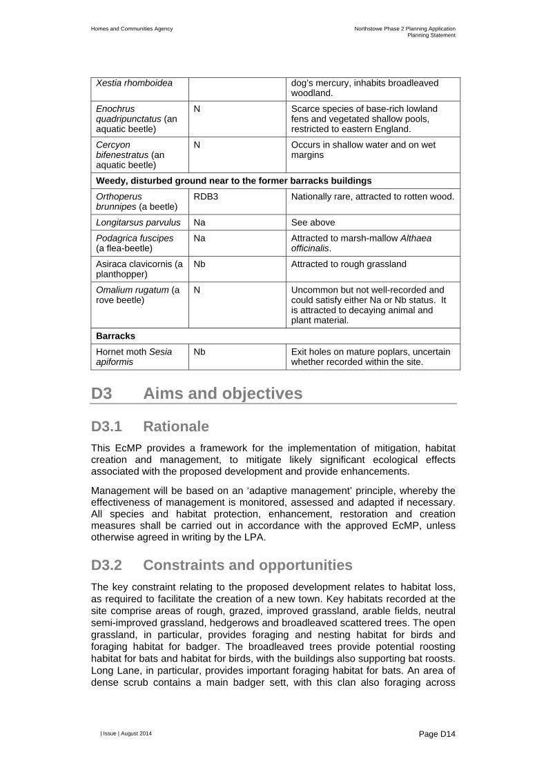
Homes and Communities Agency Northstowe Phase 2 Planning ApplicationPlanning Statement
| Issue | August 2014
Page D14
Xestia rhomboidea dog’s mercury, inhabits broadleaved woodland.
Enochrus quadripunctatus (an aquatic beetle)
N Scarce species of base-rich lowland fens and vegetated shallow pools, restricted to eastern England.
Cercyon bifenestratus (an aquatic beetle)
N Occurs in shallow water and on wet margins
Weedy, disturbed ground near to the former barracks buildings
Orthoperus brunnipes (a beetle)
RDB3 Nationally rare, attracted to rotten wood.
Longitarsus parvulus Na See above
Podagrica fuscipes (a flea-beetle)
Na Attracted to marsh-mallow Althaea officinalis.
Asiraca clavicornis (a planthopper)
Nb Attracted to rough grassland
Omalium rugatum (a rove beetle)
N Uncommon but not well-recorded and could satisfy either Na or Nb status. It is attracted to decaying animal and plant material.
Barracks
Hornet moth Sesia apiformis
Nb Exit holes on mature poplars, uncertain whether recorded within the site.
D3 Aims and objectives
D3.1 Rationale This EcMP provides a framework for the implementation of mitigation, habitat creation and management, to mitigate likely significant ecological effects associated with the proposed development and provide enhancements.
Management will be based on an ‘adaptive management’ principle, whereby the effectiveness of management is monitored, assessed and adapted if necessary. All species and habitat protection, enhancement, restoration and creation measures shall be carried out in accordance with the approved EcMP, unless otherwise agreed in writing by the LPA.
D3.2 Constraints and opportunities The key constraint relating to the proposed development relates to habitat loss, as required to facilitate the creation of a new town. Key habitats recorded at the site comprise areas of rough, grazed, improved grassland, arable fields, neutral semi-improved grassland, hedgerows and broadleaved scattered trees. The open grassland, in particular, provides foraging and nesting habitat for birds and foraging habitat for badger. The broadleaved trees provide potential roosting habitat for bats and habitat for birds, with the buildings also supporting bat roosts. Long Lane, in particular, provides important foraging habitat for bats. An area of dense scrub contains a main badger sett, with this clan also foraging across
Homes and Communities Agency Northstowe Phase 2 Planning ApplicationPlanning Statement
| Issue | August 2014
Page D15
much of the site. The site also provides terrestrial habitat for great crested newt that breeds in nearby ponds.
The greenways, particularly the informal greenways, provide opportunities to improve connectivity across the site and compensate for habitat loss associated with site clearance works. There is also an opportunity to create habitat off-site to mitigate for habitat loss associated with the proposed development, which will be managed to maximise biodiversity. While some species may be disturbed by the proposed development, there is also an opportunity to attract species that are associated with towns, including starling and house sparrow. There are opportunities to enhance the site for notable invertebrates, particularly white-spotted pinion moth and white-letter hairstreak.
D3.3 Objectives
D3.3.1 Protected species mitigation
The following objectives have been set:
Minimise disturbance and prevent harm to roosting bats during construction;
Create replacement bat roosts;
Protect, create, enhance and manage bat foraging habitat;
Minimise disturbance to badgers during construction;
Create an artificial badger sett;
Create, enhance and manage badger foraging habitat;
Maintain connectivity to badger foraging habitat;
Create, enhance and manage habitat for brown hare;
Convert arable fields off-site to semi-improved rough grassland, targeting barn owl, skylark and yellow wagtail, to compensate for the loss of rough, open grassland on site;
Minimise disturbance and prevent harm to nesting birds during construction, particularly with respect to Schedule 1 bird species11;
Create and enhance nesting and foraging habitat for birds on the site;
Prevent harm to amphibians during construction;
Create, enhance and manage habitat for amphibians;
Maintain connectivity of breeding and terrestrial habitats for great crested newt and common toad;
Prevent harm to grass snake and common lizard during construction;
Create, enhance and manage habitat for grass snake and common lizard; and
Create and enhance habitat for notable invertebrates, including grizzled skipper, white-spotted pinion moth and white-letter hairstreak.
11 Her Majesties Stationary Office (HMSO), (1981); ‘Wildlife and Countryside Act 1981.’

Homes and Communities Agency Northstowe Phase 2 Planning ApplicationPlanning Statement
| Issue | August 2014
Page D16
D3.3.2 Habitat creation, enhancement and management
The following general objectives relating to landscaping and management have been set:
Retain and protect trees and hedgerows where possible and enhance these features through additional planting;
Create, enhance and manage the greenways, green separation and Rampton Drift buffer to benefit bats, badger, birds, great crested newt, common lizard, grass snake and invertebrates, particularly grizzled skipper, white-spotted pinion moth and white-letter hairstreak;
Create and manage green roofs to benefit birds and invertebrates, incorporating extensive biodiverse wildflower roofs where possible;
Create and manage the attenuation ponds to benefit mammals, birds, great crested newt and invertebrates;
Maximise the ecological value of the all elements of the landscape strategy, incorporating native species of local origin where possible; and
Maintain and enhance connectivity through the planting of hedgerows and lines of trees, creating links to the surrounding landscape.
D4 Proposed mitigation and management prescriptions
D4.1 Mitigation measures This section will be developed as proposals become more detailed, to also include the following:
Detailed mitigation strategies;
Requirements for post-development monitoring; and
Species lists and prescriptions for habitat creation and management.
D4.1.1 Protected species mitigation
D4.1.1.1 Bats
An EPS Mitigation Licence application will be issued to and approved by Natural England prior to the commencement of work. This licence will cover the destruction of and disturbance to active bat roosts. This would be informed by further surveys but, as a minimum, will cover T158, B2, B55 and B56 (refer to Figures 2a and 2b). The licence will detail precise requirements for mitigation, habitat creation and management, which will be adhered to.
Roosting habitat for brown long-eared bat and pipistrelle bats will be incorporated into the proposed development, comprising suitable accessible roof voids and crevices within the proposed buildings and/or bespoke purpose-built bat houses. The bat house would ideally be cited within the northern informal greenway, near to the existing roost within B55. Features will ideally be incorporated into B2,

Homes and Communities Agency Northstowe Phase 2 Planning ApplicationPlanning Statement
| Issue | August 2014
Page D17
which supports a common pipistrelle bat roost and is being converted into a primary school.
Bat boxes will be installed on mature trees retained within the green separation and informal greenways. These will face a variety of directions, ensuring they receive sun for part of the day. Different box designs will be provided, including the 1FF Schwegler Bat Box, which is suited to crevice-roosting pipistrelles.
Additional precautionary measures for bats will be implemented as follows. Should any additional roosts be recorded, works would halt and these features would be included in the EPS Mitigation Licence application:
Where it is not possible to retain trees supporting bat boxes, these will be inspected by a licensed bat worker, ideally during the spring or autumn. Assuming that they do not support an active roost, they will be relocated to mature trees that will be retained and protected and not be subject to high levels of disturbance. Any damaged boxes will be repaired (or replaced) and fallen boxes reinstalled;
Works to the pillboxes and agricultural buildings will be preceded by an internal inspection by a licensed bat worker; and
Precautionary measures will be employed prior to and during the demolition of B5, comprising a soft-strip overseen by a licensed bat worker, or, to mitigate risk, further survey work will be undertaken.
Three pillboxes within the site (B11, B12 and B13, refer to the ES) will be enhanced to provide improved roosting habitat for bats. This will involve blocking up the gaps between the concrete cap and brick walls, with the exception of narrow gaps (15mm to 20mm) that would be retained to provide access. Bat boxes and crawl spaces will also be installed internally. These pillboxes will not be accessible to the public, to avoid the potential for disturbance to roosting bats. Access may only be permitted to licensed bat workers, to facilitate monitoring and maintenance.
D4.1.1.2 Badger
A badger licence will be obtained from Natural England prior to works commencing at the site. This licence will cover the closing of active setts, creation of an artificial sett and measures associated with works that may cause disturbance. An update badger scoping survey will be undertaken prior to the commencement of site clearance activities, to inform a licence application. The licence will detail precise requirements for mitigation, habitat creation and management, which will be adhered to.
A badger tunnel will be installed under the proposed busway, to maintain connectivity. The siting of this tunnel would consider the layout of the proposed Phase 3 development, to ensure it can be retained in perpetuity. Badgers will be guided to the tunnel with the use of badger-proof fencing along the busway.
D4.1.1.3 Other mammals
Any deep holes and trenches will be covered overnight and planked escape routes provided for any wildlife that may fall in. In addition, any hazardous liquids that are held on site will be stored in a secure lock-up. To avoid unnecessary
Homes and Communities Agency Northstowe Phase 2 Planning ApplicationPlanning Statement
| Issue | August 2014
Page D18
harm to wild mammals, any burrows that are encountered during site clearance works will be excavated sensitively, using hand tools where possible. Excavation will also ideally not occur between March and May inclusive, when female red fox Vulpes vulpes and cubs may be below ground. These mitigation measures have been incorporated into the Construction Environmental Management Plan (CEMP). These measures are not applicable to badger setts (refer to Section D4.1.1.2).
D4.1.1.4 Birds
Clearance of potential breeding bird habitat (vegetation and structures) will ideally occur outside of the main breeding bird season, which falls between March and August inclusive. If this is not possible, a suitably qualified ecologist will check for the presence of breeding birds prior to the commencement of any clearance or construction activities. Where any active nests are found, a buffer zone (of at least 5m radius) will be implemented until the young have fledged and left the immediate area around the nest. Larger buffer zones will be implemented around breeding sites for Schedule 1 species, which will only be lifted when then young are independent. A suitably qualified ecologist will advise on the extent of buffer zones and define when the buffer zone may be lifted. As nesting occurs at other times of the year, vigilance will be applied during clearance works at any time of the year. These measures have been incorporated into the CEMP.
Permanent nesting habitat for barn owl will be incorporated into the proposed development. This will either comprise a barn owl tower, or at least two barn owl boxes, which will be surrounded by rough grassland for foraging, on the periphery of the development to avoid disturbance associated with human activity and lighting:
The barn owl tower would be designed to provide habitat for a wide range of other species, including kestrel, bats (including for hibernation and breeding) and invertebrates. The waterpark could provide a suitable location for a barn owl tower, particularly to the south, considering proximity to the current nest site; or
Barn owl boxes would be integrated into the façades of the proposed buildings, such as the secondary school. These would be integrated to ensure their longevity considering issues associated with vandalism and maintenance.
Nesting opportunities for other bird species will be installed into the proposed buildings. This will include swift bricks and suitable opportunities for starling and house sparrow. In addition, external nest boxes will be fitted for swallow and house martin Delichon urbicum.
D4.1.1.5 Great crested newt
An approved EPS Mitigation Licence will be obtained prior to the commencement of clearance works. Suitable terrestrial habitat will be cleared sensitively under an ecological watching brief between March and October inclusive. Any potential hibernacula will be subject to a destructive search by a suitably qualified ecologist and the vegetation cleared in stages. Following clearance, these areas will be managed to prevent newts from returning to the work areas. Any great crested

Homes and Communities Agency Northstowe Phase 2 Planning ApplicationPlanning Statement
| Issue | August 2014
Page D19
newts that are captured will be translocated to suitable habitat within the site, or the wider barracks site. This work would be combined with an ecological watching brief for common amphibians and reptiles. The EPS Mitigation Licence will detail precise requirements for mitigation, habitat creation and monitoring, which will be adhered to.
Amphibian tunnels will be installed beneath the proposed primary road. Suitable fencing will be installed to direct amphibians to the tunnels and away from the road.
D4.1.1.6 Common amphibians
The ponds affected by the proposed development will ideally be drained outside the amphibian breeding season and therefore between November and February inclusive. The ecological watching brief will incorporate common amphibians.
D4.1.1.7 Reptiles
The ecological watching brief for great crested newt will also include reptiles.
D4.1.1.8 Invertebrates
Further surveys will be undertaken to inform the detailed landscape strategy for the site, to ensure that appropriate plant species and micro-habitat features are selected to support notable invertebrates that have been recorded and have a potential to occur at the site. These surveys will target grizzled skipper, pasture with herbivore dung, weedy, disturbed ground and the arable margins.
D4.1.2 General mitigation
D4.1.2.1 Pollution prevention
Standard pollution prevention measures will be employed at the site to prevent polluted runoff from entering nearby watercourses, including Longstanton Brook and Beck Brook. This includes adherence to the Environment Agency’s pollution prevention guidelines12. These measures are included in the CEMP.
D4.1.2.2 Pumping of water from the attenuation ponds
The pumping mechanism for the waterpark will be sympathetic to wildlife attracted to the waterpark, including amphibians, fish and invertebrates. Suitable measures will be employed to prevent wildlife from being entrained or impinged during pumping. This could be achieved by pumping the water from a groundwater well that is not accessible for most species.
12 Environment Alliance, (2007); ‘Pollution Prevention Guidelines. Works and maintenance in or near water: PPG5.’

Homes and Communities Agency Northstowe Phase 2 Planning ApplicationPlanning Statement
| Issue | August 2014
Page D20
D4.1.2.3 Lighting
During the construction and operation of the proposed development, lighting will be directed away from the informal greenways, green separation (especially Long Lane), waterpark, features installed for bats and birds and woodlands located adjacent to the access roads.
Furthermore, measures will be incorporated to minimise the effects of lighting on wildlife, particularly including bats and insects, in accordance with the Bat Conservation Trust (BCT) guidelines 13 . This may include the use of narrow spectrum lights that emit minimal ultra-violet light and peak higher than 550nm (yellow, orange and red wavelengths) and flat cut-off lanterns or accessories; consideration of the height of lighting columns to minimise spillage; and lowering light levels as far as guidelines permit and turning off lights when not required. Lights are not proposed within the green separation, to maintain these dark areas for wildlife, particularly foraging and commuting bats. The same applies with respect to the informal greenways, apart from where the roads cross.
D4.1.3 Habitat retention
D4.1.3.1 Green separation
The fields, hedgerows and trees to the west of Long Lane, including the hedgerows and trees along both side of Long Lane, will be retained and protected.
D4.1.3.2 Trees
Trees within the informal greenways and Rampton Drift buffer will be retained and protected. The retention of Category A and B trees within the built development will be prioritised over Category C and U trees, as well as those that have a potential to support roosting bats.
D4.1.3.3 Hedgerows
The hedgerows within the informal greenways will be retained. These will be enhanced through planting sections with greater than 5% gaps with whips. Standards of native tree and shrub species that are characteristic to this part of Cambridgeshire will be planted within the proposed and existing hedgerows and informal greenways, incorporating elm species where possible, particularly English elm Ulmus procera and wych elm Ulmus glabra, to encourage white-spotted pinion moth and white-letter hairstreak populations to spread throughout the site. Trees will with planted within the hedgerows to increase diversity.
D4.1.4 Habitat creation
Native species will be planted where possible, particularly within the informal greenway and waterpark. Proposals for habitat creation are described in the following sections.
13 Bat Conservation Trust, (2014); ‘Artificial lighting and wildlife. Interim Guidance: Recommendations to help minimise the impact artificial lighting.’

Homes and Communities Agency Northstowe Phase 2 Planning ApplicationPlanning Statement
| Issue | August 2014
Page D21
D4.1.5 Off-site compensation
Options for the conversion of arable fields to semi-improved rough grassland off-site will be investigated, considering the loss of rough open grassland within the site associated with the proposed development. These grasslands would target a range of bird species currently holding territories within the site, particularly barn owl, skylark and yellow wagtail.
D4.1.5.1 Attenuation ponds
Small depressions/ponds will be created around the periphery of the attenuation ponds, which will not be pumped directly and may occasionally dry out during hot weather. They will be designed to maximise biodiversity and provide suitable breeding habitat for great crested newt. They will be planted with bankside and aquatic vegetation, but maintaining open areas and ensuring they are not too shaded, particularly on the south side. The ponds will be sized to ensure their suitability for great crested newt with suitable vegetation encouraging good populations of invertebrates and other amphibians.
The ponds will be clustered, ensuring connectivity between the ponds via suitable terrestrial habitat. This would include riparian vegetation, including native sedges and reeds, rough grassland, tall ruderal vegetation, scrub and trees within the waterpark and informal greenways. Hibernacula will also be created close to the ponds comprising rubble and log piles and earth banks. Deadwood will also be retained in these areas.
D4.1.5.2 Swales
Engineered swales will flow through the greenways and along the streets. Naturalistic swales will be created, planted with riparian vegetation, particularly within the informal greenways.
D4.1.5.3 Green separation
The green separation will be enhanced, with hedgerows and ha-has used to manage grazing animals and hedgerows, orchards and community gardens created at the eastern edge, bordering the built development.
D4.1.5.4 Greenways
Planted buffers will be created between the built development and informal greenways, comprising lines of trees and planted beds, which will lead into open grassland interspersed with scattered trees. These will supplement existing trees, which will be retained where possible. Swathes of open, rough grassland will be interwoven with meadows, sporadic tree clusters, shrubs and pedestrian and cycle ways. Grazing will be managed to allow certain areas to grow long, while also preventing scrub and trees from encroaching into open grassland areas. Hedgerows, ponds and ha has will be employed to manage the movements of grazing animals. Hibernacula and dead wood habitats will be incorporated into the informal greenways.
Homes and Communities Agency Northstowe Phase 2 Planning ApplicationPlanning Statement
| Issue | August 2014
Page D22
A series of formal greenways will be managed open spaces defined by distinct linear tree, shrub and hedgerow features, including areas of paving, lawns, wildflower meadows, footpaths and cycle ways.
D4.1.5.5 Rampton Drift buffer
The built development will be set back 20m from Rampton Drift, with a green buffer proposed in between. Many of the existing trees will be retained, which will be supplemented with additional woodland trees, orchards and hedgerows.
D4.1.5.6 Built development
Green roofs are proposed on the public buildings, including gardens over parking decks within apartment buildings around the town centre. Office buildings within the town centre, the school buildings and the sports hub could also support green roofs, ideally comprising extensive wildflower biodiverse green roofs.
The majority of the town square is likely to be paved, although the edges may be vegetated, incorporating specimen trees, low shrubs and perennial planting. The edges of the school fields will be left to grow long, to widen buffer zones wherever possible and provide cover for wildlife.
D4.2 Management measures This section will be developed for individual phases as the proposals become more detailed.
D4.3 Adaptive management Adaptive management is extremely important to ensure that the measures outlined in this EcMP are adequate in achieving the objectives set out in this document. Targeted surveys and management triggers will be incorporated, in order to provide a mechanism for feedback into on-going management.
D5 Implementation plan summary
The requirements for mitigation, habitat creation and management are summarised in Table 4. This table will be updated as details regarding the proposed development are finalised for individual phases. This will include prescriptions for the creation and management of habitats. Table 4 Summary
What Where When
Bats
Further bat survey work Site Prior to applying for bat licence
Obtain an approved EPS Mitigation Licence for bats
N/A Prior to the commencement of site work
Installation of a bat house, bat boxes and/or features within the proposed
To be confirmed Prior to undertaking works to buildings supporting bat roosts

Homes and Communities Agency Northstowe Phase 2 Planning ApplicationPlanning Statement
| Issue | August 2014
Page D23
buildings
Inspection of the bat boxes All existing bat box locations in Phase 2
Prior to undertaking works to trees supporting bat boxes
Inspection of the pillboxes and agricultural buildings
Pillboxes and agricultural buildings in Phase 2
Prior to undertaking works to buildings
Further survey work or precautionary soft-strip of B5
B5 Prior to undertaking works to B5
Enhance pillboxes for roosting bats
B11, B12 and B13 To be confirmed
Post-development monitoring for bats
Bat roosting habitat and across the site
Following completion of construction work. Timing to be confirmed.
Badger
Obtain an approved badger licence
N/A Prior to the commencement of site work
Install artificial badger sett To be confirmed Prior to sett closure
Close active badger setts Active badger setts Prior to the commencement of works
Install a badger tunnel under the busway
Proposed busway in south eastern part of the site, near to the Cambridgeshire Guided Busway (CGB)
During construction of the spine road
Post-development monitoring for badger
Artificial badger sett, retained setts and across the site
Following completion of construction work. Timing to be confirmed.
Other mammals
Implementation of mitigation measures in accordance with the CEMP
Site Site clearance and construction
Birds
Vegetation removal and construction in accordance with the CEMP
Site Site clearance and construction
Installation of a barn owl tower or barn owl boxes
To be confirmed To be confirmed
Installation of nesting habitat for other bird species, including swift, starling, house sparrow, swallow and house martin
To be confirmed In conjunction with construction
Great crested newt
Obtain an approved EPS Mitigation Licence for great crested newt
N/A Prior to the commencement of site work
Ecological watching brief for great crested newt
Site During site clearance
Install amphibian tunnels Access road in the southern part of the barracks
During construction of the access road

Homes and Communities Agency Northstowe Phase 2 Planning ApplicationPlanning Statement
| Issue | August 2014
Page D24
Post-development monitoring
Breeding ponds Following completion of construction work. Timing to be confirmed.
Common amphibians
Implementation of mitigation during pond removal
Ponds During site clearance
Ecological watching brief for common amphibians
Site During site clearance
Reptiles
Ecological watching brief for reptiles
Site During site clearance
Invertebrates
Invertebrate survey Pasture with herbivore dung, weedy, disturbed ground and the arable margins
Prior to the commencement of site work and finalisation of landscape strategy
General measures
Implementation of pollution prevention measures in accordance with CEMP
Site During site clearance and construction
Installation of protection measures into pumping mechanism for the attenuation ponds
Attenuation ponds During construction of attenuation ponds
Implementation of lighting mitigation
Site During site clearance, construction and operation
Habitats retention - trees
Protection of retained trees Site During site clearance and construction
Habitat retention - hedgerows
Protection of retained hedgerows
Site During site clearance and construction
Habitat creation – off-site compensation
To be completed
Habitat creation – attenuation ponds
To be completed
Habitat creation – swales
To be completed
Habitat creation – green separation
To be completed
Habitat creation – informal greenways
To be completed
Habitat creation – formal greenways
To be completed

Homes and Communities Agency Northstowe Phase 2 Planning ApplicationPlanning Statement
| Issue | August 2014
Page D25
Habitat creation – Rampton Drift buffer
To be completed
Habitat creation – green roofs
To be completed
Habitat creation – built development
To be completed