planning proposal - cityofparramatta.nsw.gov.au · planning proposal drafts proponent versions: ......
TRANSCRIPT


2
3
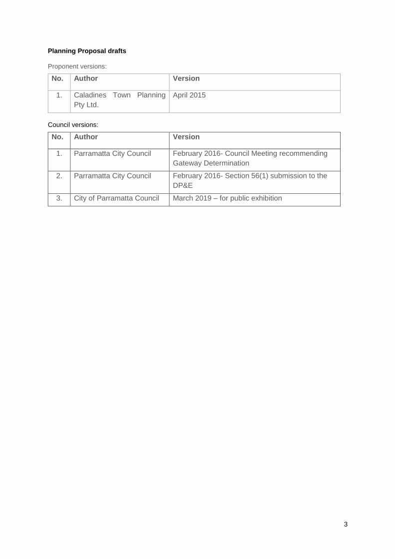
Planning Proposal drafts
Proponent versions:
No. Author Version
1. Caladines Town Planning
Pty Ltd.
April 2015
Council versions:
No. Author Version
1. Parramatta City Council February 2016- Council Meeting recommending
Gateway Determination
2. Parramatta City Council February 2016- Section 56(1) submission to the
DP&E
3. City of Parramatta Council March 2019 – for public exhibition

4
Contents
INTRODUCTION ..................................................................................................................................... 1
Background and context .................................................................................................................. 1
PART 1 – OBJECTIVES OR INTENDED OUTCOMES ......................................................................... 4
PART 2 – EXPLANATION OF PROVISIONS ........................................................................................ 4
2.1 Other relevant matters .......................................................................................................... 4
PART 3 – JUSTIFICATION .................................................................................................................... 5
3.1 Section A - Need for the planning proposal ....................................................................... 5
Section C – Environmental, social and economic impact ........................................................... 10
Section D – State and Commonwealth Interests .......................................................................... 14
PART 4 – MAPPING ............................................................................................................................. 14
4.1 Existing controls ................................................................................................................. 14
4.2 Proposed controls .............................................................................................................. 18
PART 5 – COMMUNITY CONSULTATION ......................................................................................... 20
PART 6 – PROJECT TIMELINE .......................................................................................................... 20
Appendix 1 – Urban Design Report ................................................................................................... 21
Appendix 2 – Flood Enquiry Information .......................................................................................... 22
Appendix 3 – Traffic and Transport Assessment ............................................................................ 23

1
INTRODUCTION
This planning proposal explains the intended effect of, and justification for, the proposed amendment to Parramatta Local Environmental Plan 2011. It has been prepared in accordance with Section 55 of the Environmental Planning and Assessment Act 1979 and the Department of Planning and Environment guides, 'A Guide to Preparing Local Environment Plans' (April 2013) and 'A Guide to Preparing Planning Proposals' (October 2012).
Background and context
On 21 April 2015, Council received a planning proposal and supporting documentation from Caladines Town Planning Pty Ltd on behalf of Bluesky Parramatta Pty Ltd, affecting land at 14-20 Parkes Street, Harris Park. The site is shown in Figure 1.
The site is located on the north-eastern corner of Parkes and Wigram Street, and backs onto a concrete lined stormwater canal generally known as Clay Cliff Creek. It consists of four (4) allotments including:
Lot 10 DP12882
Lot 13 DP1077402
Lot 14 DP107740
Lot 2 DP128524 The subject site is approximately 2,800 m² (see Figure 1). Two (2) commercial buildings (5 storeys at 14-18 Parkes Street, and 2 Storeys at 20 Parkes Street) with at grade and basement car parking currently occupy the subject site.
Figure 1 – Subject Site- 14-20 Parkes Street.
Source – Parramatta City Council

2
View east towards subject site (Corner Parkes and Wigram Street)
View north towards subject site (20 Parkes Street)

3
The precinct in which the site is located is characterised by a mix of residential, retail and commercial built forms that vary in bulk, scale and building form. Buildings within the immediate vicinity range from two storeys, to approximately 15 storeys. Further to the north along Hassall Street approvals have been issued for buildings up to 40 storeys.
Under Parramatta Local Environmental Plan 2011 (PLEP 2011), the site:
is zoned B4 Mixed Use (refer to Figure 4.1 in Part 4 – Mapping);
has a maximum building height of 54 metres (refer to Figure 4.2 in Part 4 – Mapping); and
has a maximum floor space ratio (FSR) of 4:1 (refer to Figure 4.3 in Part 4 – Mapping). This planning proposal does not seek to amend the land use zoning. This Planning Proposal does seeks to:
Increase the maximum floor space ratio (FSR) from 4:1 to 8:1
Increase maximum height from 54 metres to 110 metres
Add a site specific control that applies a maximum car parking rate provision that is in accordance with the CBD Strategic Transport Study.
The Planning Proposal has been amended prior to community consultation to accord with:
Conditions of the DP&E’s Gateway Determination issued on 17 June 2016 and revised Gateway Determinations on 15 August 2016, 29 November 2016 and 21 September 2017;
Updates to planning strategies and policies and amendments to the Environmental Planning and Assessment 1979.

4
PART 1 – OBJECTIVES OR INTENDED OUTCOMES
The objective of this planning proposal is to enable the redevelopment of the land at 14-20 Parkes Street, Harris Park in accordance with the current B4 Mixed Use zone for a high density mixed use development, consisting of residential and commercial uses within the Parramatta City Centre.
PART 2 – EXPLANATION OF PROVISIONS
This planning proposal seeks to amend Parramatta Local Environmental Plan 2011(PLEP 2011) in relation to the height and floor space ratio controls. In order to achieve the desired objectives the following amendments to the PLEP 2011 would need to be made:
1. Amend the maximum building height in the Height of Buildings Map (Sheet HOB_010) from 54 metres to 110 metres (35 Storeys) plus design excellence. Refer Figure 4.2.1 in Part 4 of this planning proposal.
2. Amend the maximum FSR in the Floor Space Ratio Map (Sheet FSR_010) from 4:1 to a base FSR of 8:1 plus design excellence. Refer Figure 4.2.2 in Part 4 of this planning proposal.
3. Apply a maximum car parking rate provision that is in accordance with the CBD Strategic Transport study based on the following:
a) Residential parking rates
b) Commercial parking rates Commercial parking rates If the FSR > 3.5:1 M = (G * A) / (50 * T) where: M = maximum number of parking spaces; G = GFA of all office/business premises in the building (m²); A = Site Area (m²); T = Total GFA of all buildings on the site (m²)
4.
2.1 Other relevant matters
Voluntary Planning Agreement
Type of Apartment
Spaces/unit
3-bedroom 1 space/unit
2-bedroom .7 spaces/unit
1-bedroom .3 spaces/unit
Studio .1 spaces/unit

5
A draft Planning Agreement accompanies and is exhibited in conjunction with the planning proposal.
2.1.1 Planning Proposal on opposite site
Located opposite the subject site is a planning proposal for 12A Parkes Street, formerly known as 122 Wigram Street, Harris Park. This planning proposal seeks a maximum FSR of 8:1. The applicant is also intending to rely on the design excellence clause which can deliver up to an additional 15% to the building height and FSR. Council on 17 December 2018 resolved to endorse the Planning Proposal and forward it to the Department of Planning and Environment for finalisation.
PART 3 – JUSTIFICATION
3.1 Section A - Need for the planning proposal
3.1.1 Is the Planning Proposal a result of any study or report?
This planning proposal is not the direct result of any strategic study or report, however relates to the Draft Parramatta CBD Planning Framework. Council at its meeting of 27 April 2015, resolved to adopt the Parramatta CBD Planning Strategy. This strategy aims to set the vision for growth of the Parramatta CBD as Australia’s next great city, establish principles and actions to guide a new planning framework for the Parramatta CBD, and provide a clear implementation plan for the delivery of the new planning framework for the Parramatta CBD. Whilst this strategy is still a work in progress, key details of the Strategy as they currently apply to this site include a potential Floor Space Ratio (FSR) of 10:1 with an appropriate value sharing/funding mechanism) throughout the majority of the City Centre, and a building height that responds to appropriate built forms. The Framework has informed the indicative scheme presented in the Urban Design Analysis included at Appendix 1. The Strategy identifies the opportunity for significant growth in the Parramatta City Centre and the planning proposal is consistent with the current recommendations of this study.
3.1.2 Is the Planning Proposal the best means of achieving the objectives or
intended outcomes, or is there a better way?
A planning proposal seeking to amend PLEP 2011 is the most effective way of achieving the intended outcome of the development, which is to enable a higher density mixed use residential development on a currently vacant site. The existing height and FSR standards would not permit the form of development envisaged in the planning proposal and would not allow the site to capitalise on its location.
3.2 Section B – Relationship to strategic planning framework

6
3.2.1 Is the planning proposal consistent with the objectives and actions contained within the applicable regional or sub-regional strategy?
A Plan for Growing Sydney
On 14 December 2014, the NSW Government released ‘A Plan for Growing Sydney’ which outlines actions to achieve the Government’s vision for Sydney which is a ‘strong global city and a great place to live’. In achieving this vision, A Plan for Growing Sydney has identified goals that Sydney will be:
A competitive economy with world-class services and transport
A city of housing choice with homes that meet our needs and lifestyles
A great place to live with communities that are strong, healthy and well connected; and
A sustainable and resilient city that protects the natural environment and has a balanced approach to the use of the land and resources
Increased levels of growth in employment and residential sectors have been predicted, with an additional 664,000 new dwellings required in Sydney over the next 20 year period to accommodate for population growth. As Sydney’s second CBD, Growing greater Parramatta will play a large role in delivering the needs for the growing population. This proposal will contribute to delivering these needs by contributing more diversity in housing choice within a well-connected location.
West Central Subregion Draft Subregional Strategy
Parramatta local government area is part of the West Central Subregion. A Plan for Growing Sydney identifies the following priorities for Parramatta and the West Central Subregion that will be relevant to the site and planning proposal:
Greater Parramatta – Sydney’s Second CBD
Recognise and plan Greater Parramatta as a transformational place; Plan Greater Parramatta as Sydney’s second CBD and Western Sydney’s
number one location for employment and health and education services, supported by a vibrant mixture of land uses and cultural activity, with the Parramatta River foreshore as a focus for recreational activities;
provide capacity for long-term employment growth in Greater Parramatta, particularly in its CBD;
provide capacity for additional mixed-use development in Parramatta CBD and surrounding precincts including offices and retail in Parramatta CBD, health services in Westmead, an education hub around the new University of Western Sydney Campus, a technology and education precinct in Rydalmere, arts and culture in Parramatta, a sports precinct around Parramatta Stadium and housing in all precincts;
enhance the role of the Parramatta Transport Interchange as the major bus/rail and future light rail interchange of Western Sydney;
This planning proposal is consistent with these priorities as it will:
Contribute to achieving dwelling and employment targets for Sydney by enabling a residential development containing up to 321 dwellings, with 600 square metres of commercial space on a site located within the Parramatta City Centre that is in close proximity to existing transport infrastructure (including Parramatta Railway Station and bus interchange).

7
Providing up to 321 residential dwellings in proximity to employment opportunities within Parramatta in addition to community, retail, and education and health facilities.
Activate employment uses on the site and revitalise the site within the city centre by enabling a high quality built form outcome that is consistent with the vision for the City Centre.
NSW Long Term Transport Master Plan 2012
The NSW Long Term Transport Master Plan 2012 is an integrated and comprehensive framework aimed at addressing NSW transport challenges over the next 20 years, and indicates support for the Parramatta Light Rail system.
As the site is located within 400 metres of the Parramatta transport interchange, this will allow future occupants and workers to take advantage of existing and potential new transport options. Development located near transit is likely to increase the use of public transport, encouraging non-motorised travel and walkability under the plan.
Development of a high density site will also increase demand for transport services and in the long term improve overall viability.
3.2.2 Is the planning proposal consistent with the local council’s Community Strategic Plan or other local strategic plan?
The following strategic planning documents are relevant to the planning proposal.
Parramatta 2038 Community Strategic Plan
Parramatta 2038 is a long term Community Strategic Plan for the City of Parramatta and it links to the long-term future of Sydney. The plan formalises several transformational ideas for the City and the region associated with the economy, environment, connectivity, people and neighbourhoods, culture and sport and leadership and governance.
The planning proposal is considered to meet the strategies and key objectives identified in the plan in helping to build Parramatta’s vision as a world-class city. The development will provide a high quality, mixed use residential/commercial development supporting the city centre and revitalisation of the site. The development will provide increased housing in proximity to transport nodes and contribute towards dwelling targets within Parramatta, as well as provide employment through the proposed commercial use within the city centre. Parramatta CBD Planning Strategy
On 27 April 2015, Council resolved to adopt the Parramatta CBD Planning Strategy. This strategy aims to set the vision for growth of the Parramatta CBD as Australia’s next great city, establish principles and actions to guide a new planning framework for the Parramatta CBD, and provide a clear implementation plan for the delivery of the new planning framework for the Parramatta CBD.
Whilst the Parramatta CBD Planning Strategy is yet to be finalised, it has been used as the overarching strategy informing this planning proposal. As a result, the planning proposal is consistent with the strategy’s vision and aligns with the current draft recommended built form controls that have been resolved by Council. This proposal will

8
help to facilitate the vision for growth of the Parramatta CBD by allowing the redevelopment of the site for a mixed use residential and commercial development.
3.2.3 Is the planning proposal consistent with the applicable State Environmental
Planning Policies?
The following State Environmental Planning Policies are of relevance to the site.
TABLE 6: RELEVANT STATE ENVIRONMENTAL PLANNING POLICIES
SEPP Relevance Consistency Comments
SEPP 32 Urban
Consolidation
(Redevelopment of
Urban Land)
The land is zoned for
urban development
under the current
Zone B4 Mixed Use.
Yes The draft Planning
Proposal is consistent
with the Policy by
facilitating additional floor
space on an infill site
which is currently
underutilised and is
readily serviced by
utilities, and accessible to
transport, recreational
and commercial land
uses.
SEPP 55 Remediation of
land
The policy states that
land must not be
developed if it is
unsuitable for a
proposed use
because it is
contaminated.
Yes Assessment of the site
indicates that
contamination was not a
constraint on the site and
is suitable for residential
and commercial uses.
SEPP No. 65 – Design
Quality of Residential
Flat Development
Raises the design
quality of residential
apartment
development across
the state through the
application of a series
of design principles.
Yes Detailed testing of SEPP
65 Compliance and
Apartment Design
Guidelines (ADG) was
conducted throughout the
assessment of the
proposal. Detailed
compliance with SEPP 65
will be demonstrated at
the DA stage.
3.2.4 Is the planning proposal consistent with applicable Ministerial Directions
(s.117 directions)
In accordance with Clause 9.1(2) of the EP&A Act 1979 the Minister issues directions for the relevant planning authorities to follow when preparing planning proposals for new LEPs. The directions are listed under the following categories:
Employment and resources
Environment and heritage
Housing, infrastructure and urban development
Hazard and risk
Regional planning
Local plan making
Metropolitan planning
9
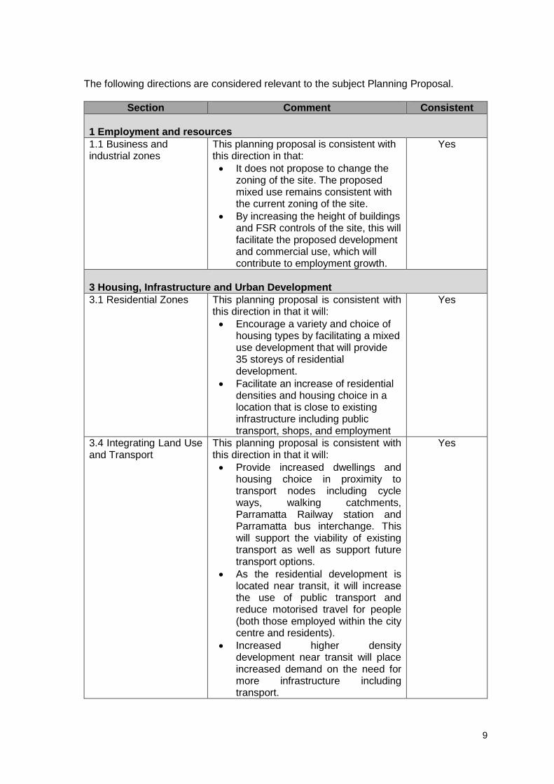
The following directions are considered relevant to the subject Planning Proposal.
Section Comment Consistent
1 Employment and resources
1.1 Business and industrial zones
This planning proposal is consistent with this direction in that:
It does not propose to change the zoning of the site. The proposed mixed use remains consistent with the current zoning of the site.
By increasing the height of buildings and FSR controls of the site, this will facilitate the proposed development and commercial use, which will contribute to employment growth.
Yes
3 Housing, Infrastructure and Urban Development
3.1 Residential Zones This planning proposal is consistent with this direction in that it will:
Encourage a variety and choice of housing types by facilitating a mixed use development that will provide 35 storeys of residential development.
Facilitate an increase of residential densities and housing choice in a location that is close to existing infrastructure including public transport, shops, and employment
Yes
3.4 Integrating Land Use and Transport
This planning proposal is consistent with this direction in that it will:
Provide increased dwellings and housing choice in proximity to transport nodes including cycle ways, walking catchments, Parramatta Railway station and Parramatta bus interchange. This will support the viability of existing transport as well as support future transport options.
As the residential development is located near transit, it will increase the use of public transport and reduce motorised travel for people (both those employed within the city centre and residents).
Increased higher density development near transit will place increased demand on the need for more infrastructure including transport.
Yes

10
Provide 600 square metres of commercial/retail space in proximity to transport.
3.5 Development near licensed aerodromes
This planning proposal is consistent with this direction in that:
The proposed height of 110 metres is below the 156 metre Bankstown Airport Obstacle Limitation Service for Parramatta CBD.
Yes
4. Hazard and Risk
4.1 Acid Sulfate Soils The site under this planning proposal is affected by Class 4 Acid Sulfate soils. This planning proposal does not seek to amend the acid sulfate provisions under the Parramatta LEP 2011. Any further investigation will be addressed at the development assessment stage.
Yes
4.3 Flood Prone Land This site is identified as flood prone under the Parramatta LEP 2011. The supporting flood advice indicates that the development of the site is able to be designed consistently with the Floodplain Development Manual 2005 and relevant Council flood planning controls. The planning proposal is also considered to be consistent with the Section 9.1 Direction 4.3 – Flood Prone Land. Further detailed design features and evacuation measures to respond to the flood affectation can be implemented at the DA stage.
Yes
Section C – Environmental, social and economic impact
This section considers the potential environmental, social and economic impacts which may result from the Planning Proposal.
3.3.1 Is there any likelihood that critical habitat or threatened species, populations or ecological communities, or their habitats, will be adversely affected as a result of the proposal?
The supporting studies accompanying this planning proposal indicate that the subject site does not contain any critical habitat, or threatened species, populations or ecological communities, or their habitats will be adversely affected as a result of this proposal.
3.3.2 Are there any other likely environmental effects as a result of the planning proposal and how are they proposed to be managed?
The main potential environmental impacts to be examined in detail with any future development proposal for the site are:
Urban Design and Built Form
Flooding
Traffic and Transport

11
Urban Design and Built Form
The Urban Design Analysis in Appendix 1 provides an indicative development scheme for the site to reflect the objectives of the planning proposal.
The proposed built form has been designed to respond to the local context, and to ensure impacts on amenity are minimised whilst allowing the site to achieve its maximum development potential.
The table below indicates the development concept for the site investigated in the urban design study provided at Appendix 1.
Site
FSR Height of Buildings
Base With 15% design excellence bonus
Base With 15% design excellence bonus
14-20 Parkes Street, Harris Park
8:1 9.2:1 110 metres 126.5 metres
The built form includes a podium element that includes above ground car parking sleeved with 4 levels of active uses, to lessen its visual impact on the streetscape. The 4 storey height and sleeved car parking will create a street frontage condition that remains consistent with the street and Parramatta DCP 2011 controls. The design concept indicates an acceptable level of compliance with SEPP 65 Apartment Design Guidelines. The concept demonstrates that the development of this site would not unreasonably compromise the potential future development of adjoining sites. The orientation and width of the tower will assist in providing affected properties with reasonable solar access during the hours of 9am-3pm during mid-winter.
The site is not a heritage item in its own right, however is located in proximity to three (3) heritage items to the north-east of the site at 113-115 Wigram Street and 23-25 Hassall Street (see figure 2), although the visibility from and to the subject site is obscured by a 9 storey mixed use building at 111 Wigram Street. The site is also in proximity to the Harris Park Conservation Area. Whilst this proposal has not been required to provide a supporting heritage study, the built form outcome of the proposed development will need to ensure minimal impacts on scale, views and amenity in relation to heritage items, and the Harris Park Heritage Conservation Area.
More detailed site planning and built form assessments would take place as part of the design excellence competition and development application (DA).

12
Figure 2 - Subject site in relation to heritage
Source – Parramatta City Council, 2016
Flooding
The subject site is identified as flood prone under the Parramatta City Centre LEP 2007. The site has a western frontage to Wigram Street and a southern frontage to Parkes Street, while the Clay Cliff Creek open channel is immediately adjacent to the northern boundary. The entire site is inundated in the Probable Maximum Flood (PMF) event, affected by the 100 year Flood event, and partly affected by the 20 year Flood event (See figure 3). The north-eastern part of the site is situated within a high hazard flood risk zone (see figure 4).
Figure 3: Flooding affectation of the site

13
Figure 4: Site in relation to Hazard Flood Risk Zones The Flood Planning Levels (FPL) for the site are:
RL 8.30m AHD for the 1:100 year flood (as at the intersection of Parkes and Wigram Street)
RL 9.91m AHD for the PMF
Supporting flooding advice overall indicates that the development of the site is consistent with the controls for residential development affected by flooding, specifically the Environmental Planning and Assessment Act 1979 Section 9.1, Direction 4.3 Flooding, and is also consistent with the Flood Planning Level for residential development outlined in the Floodplain Development Manual 2005 being the 100 Year ARI (average recurrent interval) flood event. Flooding is addressed in ‘Hazard and risk - 4.3 Flood Prone Land’, Section 3.2.4. The proposal is for a 35 storey predominantly residential mixed use building which includes five levels of above ground car parking. The above ground car parking has been included to respond to the flood constraints of the site. Development of the site is to include screening of raised ground floors accommodating retail and lobby uses, and the activation of their frontages. The provision of a flood refuge area has also been included, and is to be located on the street level towards the lobby. Design features and evacuation measures as part of a future flood evacuation strategy and building management plan will be addressed as part of the design excellence and DA process. A copy of the flooding assessment can be found in Appendix 2. Traffic and Transport A traffic and transport assessment has been prepared by Varga Traffic Planning and can be found at Appendix 3. Any future development under the provision of the revised planning controls will not result in substantially adverse impacts on traffic and the local road network as the site is located in proximity to transit. Rather, it will promote the use of public transport in a highly accessible location.

14
The proposed development indicates ingress/egress at the northern end of the Wigram street frontage. Whilst the desired location of the driveway is further north, the study indicates that relocating the driveway further north it will affect the canal and impede on adequately responding to the sites flood affectation. Detailed design concerning this matter will be resolved at DA stage.
3.3.3 How has the planning proposal adequately addressed any social and economic effects?
There is adequate justification for this planning proposal which will facilitate an increase in density and the future development of housing. The future development will provide approximately 321 dwellings and will likely incorporate a mix of apartment types to respond to the diverse population and contribute to housing choice and affordability. In providing increased dwellings and housing choice in proximity to transport nodes this will support the viability of existing transport as well as support future transport options. Based on the assumed development outcomes the proposal has the potential to generate jobs during the construction phase.
The provision of 600 square metres of commercial floor space consisting of retail will also generate employment, and contribute to the vitality of Parramatta.
A Planning Agreement providing for a contribution towards community infrastructure within the Parramatta CBD will be exhibited concurrently with the planning proposal.
Section D – State and Commonwealth Interests
3.3.4 Is there adequate public infrastructure for the planning proposal?
The subject land is located approximately 400 metres from Parramatta Railway Station/Bus terminal, and within 500 metres from services such as Parramatta Westfield. The site is also in walking distance to educational facilities including Arthur Phillip High school and Parramatta Public school. Civil and utility infrastructure is suitably accessible to service the subject land and support the proposed development. Redevelopment of the subject site and further development within the area can optimise public infrastructure investment.
3.3.5 What are the views of State and Commonwealth public authorities
consulted in accordance with the gateway determination?
State and Commonwealth authorities will be consulted in accordance with the Gateway determination and Section 3.34 of the EP&A Act 1979.
PART 4 – MAPPING
This section contains the mapping for this planning proposal in accordance with the DP&E’s guidelines on LEPs and Planning Proposals.
4.1 Existing controls
This section contains map extracts from PLEP 2011 which illustrate the current controls applying to the site.

15
Figure 4.1 – Existing zoning extracted from the PLEP 2011 Land Zoning Maps
Figure 4.2 – Existing building heights extracted from the PLEP 2011 Height of Buildings Maps

16
Figure 4.3 – Existing floor space ratio extracted from the PLEP 2011 Floor Space Ratio Map

17

18
4.2 Proposed controls
The figures in this section (Figures 4.2.1 and 4.2.2) illustrate the proposed building height and floor space ratio controls sought by this planning proposal. Figure 4.2.1 illustrates proposed maximum building height of 110 metres for the site.
Figure 4.2.1: Proposed Maximum Building Height

19
Figure 4.2.2 illustrates the proposed 8:1 FSR for the site.
Figure 4.2.2: Proposed Maximum Floor Space Ratio

20
PART 5 – COMMUNITY CONSULTATION
In accordance with Section 3.34(2) of the EP&A Act 1979, the Director-General of Planning must approve the form of the planning proposal, as revised to comply with the gateway determination, before community consultation is undertaken. Public exhibition is likely to include:
newspaper advertisement;
display on the Council’s web-site; and
written notification to adjoining landowners. The gateway determination will specify the level of public consultation that must be undertaken in relation to the planning proposal including those with government agencies. Pursuant to Section 3.34(8) of the EP&A Act 1979 the Responsible Planning Authority must consider any submissions made concerning the proposed instrument and the report of any public hearing.
PART 6 – PROJECT TIMELINE
The detail around the project timeline is expected to be prepared following the referral to the Minister for a Gateway Determination. The following steps are anticipated:
Commencement and completion dates for public exhibition period and government agency notification (March/April 2019)
Consideration of submissions (May 2019) Consideration of proposal post exhibition and reporting to Council (June 2019) Submission to the Department to finalise the LEP (July 2019) Notification of instrument (September 2019)

21
Appendix 1 – Urban Design Report

22
Appendix 2 – Flood Assessment

23
Appendix 3 – Traffic and Transport Assessment

24
Prepared by Parramatta City Council