planning proposal - home - midcoast council · planning proposal amendment to the ... a change is...
TRANSCRIPT
Coopernook Planning Proposal Page 1
Macquarie and West Streets, Coopernook
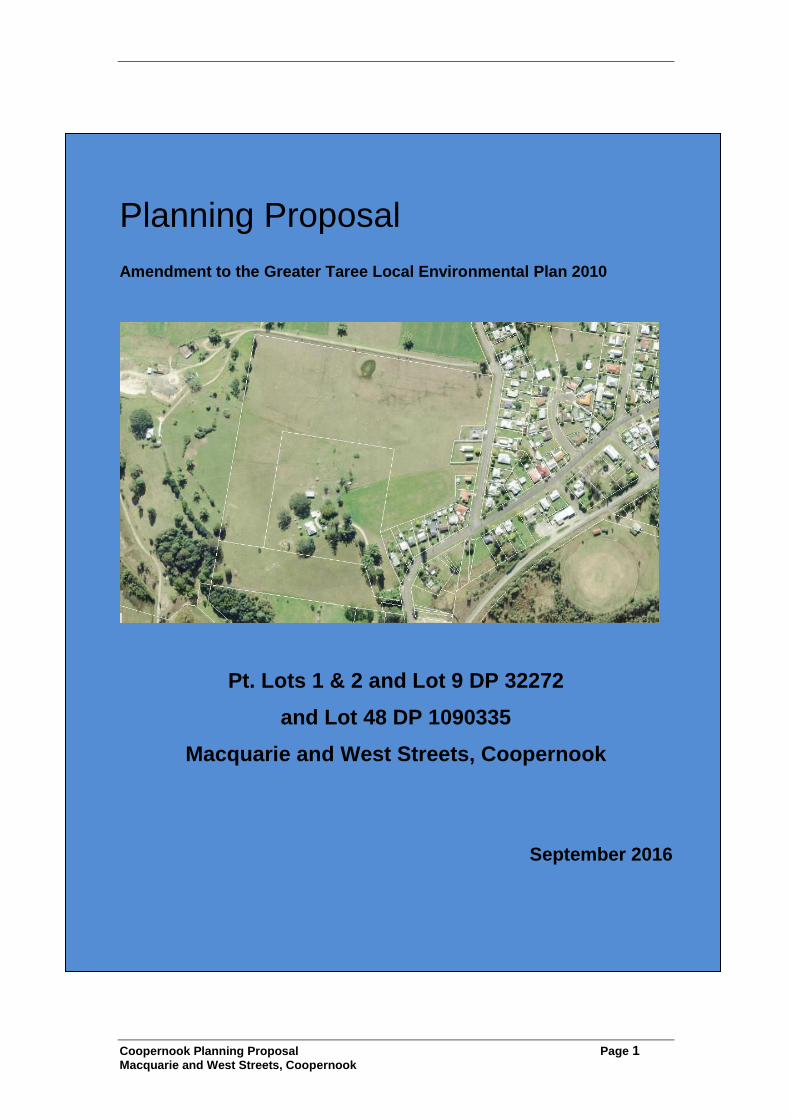
Planning Proposal
Amendment to the Greater Taree Local Environmental Plan 2010
Pt. Lots 1 & 2 and Lot 9 DP 32272
and Lot 48 DP 1090335
Macquarie and West Streets, Coopernook
September 2016

Coopernook Planning Proposal Page 2
Macquarie and West Streets, Coopernook
TABLE of CONTENTS
1.0 Introduction............................................................................................ 3
2.0 Objectives .............................................................................................. 7
3.0 Explanation of provisions ..................................................................... 7
4.0 Justification ........................................................................................... 7
(a) Koala Habitat Protection (SEPP 44) ..................................................... 9
(b) Remediation of Land (SEPP 55) ............................................................ 9
(c) Rural Lands 2008 [SEPP (Rural Lands)] ............................................ 10
(e) Coastal Protection (SEPP 71) ............................................................. 11
5.0 Environmental, social and economic impacts ................................... 13
6.0 State and Commonwealth interests ................................................... 14
7.0 Mapping ................................................................................................ 15
8.0 Community Consultation .................................................................... 18
9.0 Project Timeline ................................................................................... 18

Coopernook Planning Proposal Page 3
Macquarie and West Streets, Coopernook
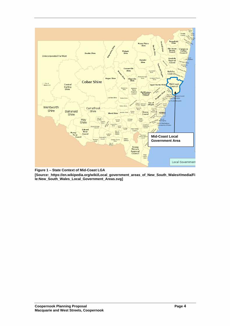
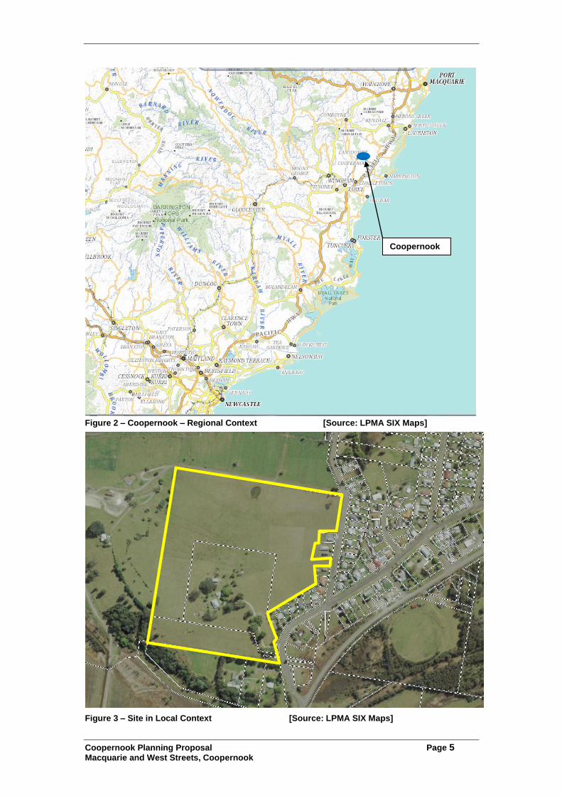
1.0 Introduction This Planning Proposal has been prepared for the subject land to seek changes to Greater Taree Local Environmental Plan 2010 to provide for expansion of Coopernook village over the land. The planning proposal will provide land for primarily residential development to support services in the Coopernook village. The proposal delivers outcomes in the area in a manner consistent with the provisions of the Council’s local development strategies, as well as the provisions of the Mid North Coast Regional Strategy. The subject land is comprised of elevated cleared land which has been used for low intensity agricultural uses in the past. The land is not subject to significant levels of environmental constraints, with flooding over parts of the land being the key constraint to development. To facilitate the development of the land, a change is required to the planning controls affecting the land under Greater Taree Local Environmental Plan 2010. The change involves changing the zoning of parts of the land from its existing RU1 – Primary Production to RU5 - Village. This planning proposal has been prepared consistent with the provisions of the Department’s document A Guide to Preparing Planning Proposals. 1.1 Site details The subject lands are located adjacent to the Coopernook village which is located in the Mid-Coast local government area approximately 250km north east of Sydney within the Mid North Coast region. MidCoast Council was created in May 2016 as an amalgamation of the Greater Taree City, Great Lakes and Gloucester Council local government areas. Figure 1-3 show the location of the land and area in a state, regional and local context.
Coopernook Planning Proposal Page 4
Macquarie and West Streets, Coopernook
Figure 1 – State Context of Mid-Coast LGA
[Source:_https://en.wikipedia.org/wiki/Local_government_areas_of_New_South_Wales#/media/File:New_South_Wales_Local_Government_Areas.svg]
Mid-Coast Local
Government Area
Coopernook Planning Proposal Page 5
Macquarie and West Streets, Coopernook
Figure 2 – Coopernook – Regional Context [Source: LPMA SIX Maps]
Figure 3 – Site in Local Context [Source: LPMA SIX Maps]
Coopernook
Coopernook Planning Proposal Page 6
Macquarie and West Streets, Coopernook
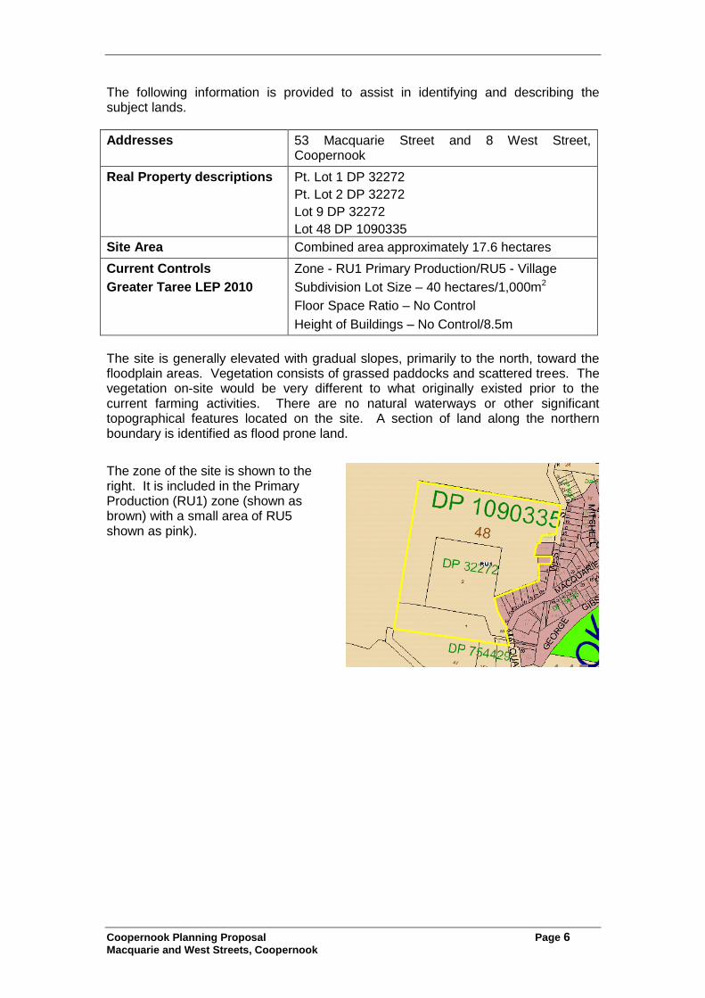
The following information is provided to assist in identifying and describing the subject lands.
Addresses 53 Macquarie Street and 8 West Street, Coopernook
Real Property descriptions Pt. Lot 1 DP 32272
Pt. Lot 2 DP 32272
Lot 9 DP 32272
Lot 48 DP 1090335
Site Area Combined area approximately 17.6 hectares
Current Controls
Greater Taree LEP 2010
Zone - RU1 Primary Production/RU5 - Village
Subdivision Lot Size – 40 hectares/1,000m2
Floor Space Ratio – No Control
Height of Buildings – No Control/8.5m
The site is generally elevated with gradual slopes, primarily to the north, toward the floodplain areas. Vegetation consists of grassed paddocks and scattered trees. The vegetation on-site would be very different to what originally existed prior to the current farming activities. There are no natural waterways or other significant topographical features located on the site. A section of land along the northern boundary is identified as flood prone land.
The zone of the site is shown to the right. It is included in the Primary Production (RU1) zone (shown as brown) with a small area of RU5 shown as pink).
Coopernook Planning Proposal Page 7
Macquarie and West Streets, Coopernook
2.0 Objectives The primary objective of the Planning Proposal is to provide for growth of the village in accordance with the provisions of previous local planning strategies and the Mid North Coast Regional Strategy. The land will provide opportunities for additional residential development in the Coopernook Village supporting existing services and facilities.
3.0 Explanation of provisions To achieve the objectives, the planning proposal will amend Greater Taree Local Environmental Plan 2010. The proposed zones and areas have been determined on the basis of constraints identified for the land. 3.1 Zoning Changes The planning proposal will achieve the objectives by altering the zonings over parts of the land where appropriate and will involve changes over parts of the land from the current RU1 zone to RU5 – Village. The RU1 zone will be retained over parts of the land where it is subject to flooding and to provide a buffer around the adjoining electricity substation. 3.2 Lot Size Controls To facilitate subdivision of the land in a manner consistent with the proposed zonings, the lot size controls over the land will be modified to provide a 1,000m2 lot size control for the RU5 zoned areas. The lot size control over the RU1 zoned area will be subject to a 5,000m2 lot size to allow for small scale agriculture, rather than as a large residue parcel which is unlikely to be used in any sustainable manner. 3.3 Height of Buildings The land is not currently subject to height of building controls. To facilitate building development on the land in a manner consistent with the proposed zonings an 8.5 metre height of building control is proposed to be created over the land, consistent with the control over the rest of the Coopernook village.
4.0 Justification 4.1 Need for the planning proposal The following justifies the need for the planning proposal 4.1.1. Is the planning proposal a result of any strategic study/report? Planning for village expansion at Coopernook has been the subject of Council strategies since before 1996 when Council prepared the Rural Villages Study which examined the potential for growth at various rural villages in the (former) Greater Taree local government area. In 2005 the former Greater Taree City Council prepared the Greater Taree Draft Conservation and Development Strategy for the entire local government area. The Strategy identified the subject land as a proposed village expansion area.

Coopernook Planning Proposal Page 8
Macquarie and West Streets, Coopernook
In 2009 Council and the Coopernook Action Group prepared the Coopernook Village Plan which was prepared to provide for the adjustment of the village following the bypass of the Pacific Highway. The Plan identifies that residential growth in the village is desired and identifies the subject land for village expansion (consistent with previous strategies). The Plan recognises that village expansion and population growth will assist in making existing commercial and public services more viable and possibly providing for an expansion of some commercial services in the town, revitalising its role as a rural community centre. The village expansion in this area is the subject of ongoing strategic studies which have consistently recommended the village expansion in the manner proposed. 4.1.2 Is the planning proposal the best means of achieving the objectives/
outcomes? The planning proposal is the only feasible way to achieve the objectives or intended outcomes of providing village growth at Coopernook. 4.2 Relationship to strategic planning framework 4.2.1 Is the planning proposal consistent with the applicable regional
strategy? The proposal is consistent with the aims and objectives of the Department of Planning and Infrastructure’s Mid North Coast Regional Strategy 2006-31. The Mid North Coast Regional Strategy was prepared in 2009 to guide growth in the Mid North Coast Region. The Strategy includes maps that identify future urban release areas within the region, including those areas in the (former) Greater Taree local government area. The plan for the (former) Greater Taree local government area (map 8) identifies the subject land as a future urban release area.
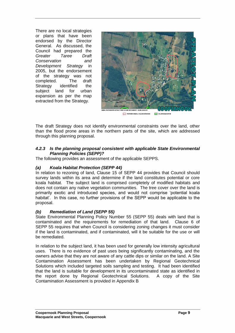
The land does not contain any of the high environmental values identified in the Strategy and will not cause any impacts on such areas. The village zoning of the land will provide for future residential development that is consistent with the character of the village and surrounding area, and is consistent with the objectives of the Strategy for such areas. 4.2.2 Is the planning proposal consistent with a council’s local strategy/plan? There are no local strategies or plans that have been endorsed by the Director General. As discussed, the Council had prepared the Greater Taree Draft Conservation and Development Strategy in 2005, but the endorsement of the strategy was not completed. The draft Strategy identified the subject land for urban expansion as per the map extracted from the Strategy.
Coopernook Planning Proposal Page 9
Macquarie and West Streets, Coopernook
There are no local strategies or plans that have been endorsed by the Director General. As discussed, the Council had prepared the Greater Taree Draft Conservation and Development Strategy in 2005, but the endorsement of the strategy was not completed. The draft Strategy identified the subject land for urban expansion as per the map extracted from the Strategy.
The draft Strategy does not identify environmental constraints over the land, other than the flood prone areas in the northern parts of the site, which are addressed through this planning proposal.
4.2.3 Is the planning proposal consistent with applicable State Environmental Planning Policies (SEPP)?
The following provides an assessment of the applicable SEPPS.
(a) Koala Habitat Protection (SEPP 44) In relation to rezoning of land, Clause 15 of SEPP 44 provides that Council should survey lands within its area and determine if the land constitutes potential or core koala habitat. The subject land is comprised completely of modified habitats and does not contain any native vegetation communities. The tree cover over the land is primarily exotic and introduced species, and would not comprise ‘potential koala habitat’. In this case, no further provisions of the SEPP would be applicable to the proposal.
(b) Remediation of Land (SEPP 55) State Environmental Planning Policy Number 55 (SEPP 55) deals with land that is contaminated and the requirements for remediation of that land. Clause 6 of SEPP 55 requires that when Council is considering zoning changes it must consider if the land is contaminated, and if contaminated, will it be suitable for the use or will be remediated.
In relation to the subject land, it has been used for generally low intensity agricultural uses. There is no evidence of past uses being significantly contaminating, and the owners advise that they are not aware of any cattle dips or similar on the land. A Site Contamination Assessment has been undertaken by Regional Geotechnical Solutions which included targeted soils sampling and testing. It had been identified that the land is suitable for development in its uncontaminated state as identified in the report done by Regional Geotechnical Solutions. A copy of the Site Contamination Assessment is provided in Appendix B

Coopernook Planning Proposal Page 10
Macquarie and West Streets, Coopernook
(c) Rural Lands 2008 [SEPP (Rural Lands)] The aim of this policy is to facilitate the orderly and economic use of rural lands. The SEPP requires consistency with the Rural Planning Principles outlined in the SEPP, which is provided below.
Clause 7 Principles Comment
(a) the promotion and protection of opportunities for current and potential productive and sustainable economic activities in rural areas,
The subject land is not highly productive agricultural land, but does support low intensity agricultural uses including cattle and horse grazing. The change of these lands from agricultural use will not result in significant loss of productive agricultural land or of opportunity for sustainable rural activities.
(b) recognition of the importance of rural lands and agriculture and the changing nature of agriculture and of trends, demands and issues in agriculture in the area, region or State,
The subject land is not highly productive agricultural land and is not important for agricultural production in the locality.
(c) recognition of the significance of rural land uses to the State and rural communities, including the social and economic benefits of rural land use and development,
The planning proposal does not provide for the loss of rural land uses which are important for the social and economic benefits or rural communities. The planning proposal provides for growth of the Coopernook community in accordance with the local and regional strategy and provides for maintenance & enhancement of services for the local community.
(d) in planning for rural lands, to balance the social, economic and environmental interests of the community,
The planning proposal is balanced and provides social and economic benefits for the community through growth to support the existing services within the village.
(e) the identification and protection of natural resources, having regard to maintaining biodiversity, the protection of native vegetation, the importance of water resources and avoiding constrained land,
The planning proposal affects land which has been completely modified from past activities and has minimal biodiversity values, no native vegetation communities and does not impact on water resources.
(f) the provision of opportunities for rural lifestyle, settlement and housing that contribute to the social and economic welfare of rural communities,
The planning proposal provides for housing in a manner identified in local and regional development strategies for the area which adds to the social and economic welfare of the community. Growth in the Coopernook village is important to provide for the ongoing viability of services which serve the local community.
(g) the consideration of impacts on services and infrastructure and appropriate location when providing for rural housing,
The planning proposal will include consultation with relevant service providers. The proposal will have access to reticulated water and sewer. Power and telecommunications are available in the locality and would need to be augmented to supply future development.
(h) ensuring consistency with any applicable regional strategy of the Department of Planning or any applicable local strategy endorsed by the Director-General.
The planning proposal is consistent with the Mid North Coast Regional Strategy and is identified as a future urban area in that strategy. The proposal is consistent with the Coopernook Village Plan which was prepared by Greater Taree City Council.
Coopernook Planning Proposal Page 11
Macquarie and West Streets, Coopernook
While the proposed site is zoned RU1, it is not highly productive agricultural land and the planning proposal provides for uses which have been identified in development strategies for the area. The proposal facilitates growth in a small village which previously serviced the highway and represents a suitable use of land to support the local community.
(e) Coastal Protection (SEPP 71) This policy applies to land in the coastal zone which applies to this site. The proposal has been assessed against the aims of the policy and was considered to be consistent in terms of:
the site is located approximately 11km from the coast and 500m from the Lansdowne River. As such the proposal does not impact on coastal access, views or processes or the marine environment
assessments of heritage, cultural heritage and environmental values are to be undertaken and are outlined in the relevant sections of the planning proposal
the development form will be consistent with established development in the Coopernook village and will maintain the character to the area.
4.2.4 Is the planning proposal consistent with Ministerial Directions (Section 117 directions)? The following Ministerial Directions are applicable to the planning proposal:
Direction 1.2 – Rural Zones – This subject land is zoned rural (RU1) and involves changes in the zone to RU5 and changes to minimum subdivision lot sizes. The objective of the Direction is to protect the agricultural production potential of land. The proposal is identified as in the Coopernook Village Plan 2009 and as future urban area in the Mid North Coast Regional Strategy. The Mid North Coast Regional Strategy includes consideration of protecting agricultural production. The proposal does not impact on highly productive agricultural land. As the proposal is in accordance with the Regional Strategy, the proposal can be inconsistent with this direction.
Direction 1.5 – Rural Lands – This applies as the land involved changes to
rural zoned land. The Direction provides that a rezoning must be consistent with the Rural Planning Principles and Subdivision Principles contained in State Environmental Planning Policy (Rural Lands) 2008. The Rural Planning Principles are discussed within Section 4.2.3, and the proposed rezoning is consistent with the principles. The Direction provides that a planning proposal may be inconsistent with these requirements where it is justified by a strategy which takes into account the objectives of the Direction. The Mid North Coast Regional Strategy is considered to account for the Direction’s objectives and identifies the land as future urban.
Direction 2.1 – Environmental Protection Zones – This Direction applies
when a planning proposal is prepared. The Direction provides that a planning proposal must facilitate protection of environmentally sensitive areas. Given the disturbed nature of the site and surrounding areas, there are no environmentally sensitive areas on the site which would require an environmental protection zone.
Direction Number 2.2 – Coastal Protection – This Direction applies to any
planning proposal prepared for land in the costal zone. The land is located in the coastal zone and the Direction provides that the planning proposal must be consistent with and give effect to the provisions of the Coastal
Coopernook Planning Proposal Page 12
Macquarie and West Streets, Coopernook
Policy, Coastal Design Guidelines and the Coastline Management Manual. The proposal is considered consistent with these documents.
Direction Number 2.3 – Heritage Conservation – This Direction applies
whenever a planning proposal is prepared and provides for the conservation and protection of items of environment heritage and items of indigenous heritage significance. The subject land does not contain any listed heritage items. In relation to indigenous heritage, the Direction provides that items of Aboriginal Heritage should be identified by an Aboriginal Heritage Survey. An Aboriginal Assessment of the land has been undertaken over the land by an archaeologist which included consultation with the Aboriginal community, including the Local Aboriginal Land Council. The assessment did not identify any Aboriginal Heritage values over the land which required protection. A copy of the cultural heritage assessment is provided in Appendix B.
Direction Number 3.1 – Residential Zones – This Direction applies where a
planning proposal will affect land within an existing or proposed residential zone. The proposal affects rural zoned land but does involve the creation of a residential zone. The Direction requires that the planning proposal:
(a) broaden the choice of building types and locations available in the housing market, and (b) make more efficient use of existing infrastructure and services, and (c) reduce the consumption of land for housing and associated urban development on the urban fringe, and (d) be of good design. (5) A planning proposal must, in relation to land to which this direction applies: (a) contain a requirement that residential development is not permitted until land is adequately serviced (or arrangements satisfactory to the council, or other appropriate authority, have been made to service it), and (b) not contain provisions which will reduce the permissible residential
density of land.
The existing planning instruments and development controls that would apply to future development of the land contain provisions consistent with the provisions of the Direction. Greater Taree LEP 2010 includes provisions that residential areas must be adequately serviced before subdivision may occur. The proposal will increase permissible residential density on the land.
Direction Number 3.4 – Integrating Land Use and Transport – This Direction applies as the proposal involves the creation of a residential zone. This Direction requires Council to give effect to policies aimed at improving transport oriented design in urban areas. In the case of the subject land, the housing is in a small village with limited access to public transport. A bus service connects the village with Taree and Harrington and runs three (3) times a day. The subject site is located within 100 metres of this bus route, providing alternatives to cars for transport. In addition, the Direction provides that a planning proposal can be inconsistent with the Direction where it is consistent with a regional strategy (such as the Mid North Coast Regional Strategy).
Coopernook Planning Proposal Page 13
Macquarie and West Streets, Coopernook
Direction Number 4.1 – Acid Sulfate Soils – This Direction applies where land to which the planning proposal applies has a probability of containing acid sulphate soils. The land is identified as Class 5 on the Planning maps which do not have a probability of containing Acid Sulfate Soils but are located within 500 metres of lands with a probability of containing Acid Sulfate Soils. As such, this Direction would not be applicable to this proposal.
Direction 4.3 – Flood Prone Land - This Direction applies as part of the
subject site is identified as flood prone. The Direction applies when a planning proposal creates, removes or alters a zone or provision that effects flood prone land. The proposal would retain flood prone parts of the site in the RU1 zone. Minimum Subdivision Lot Sizes may alter to allow a smaller allotments size, however, it would not introduce the opportunity for significant development in the flood prone parts of the site. Future development of these areas would be subject to the provisions of Council’s Development Control Plans which includes flooding controls developed under the Floodplain Development Manual. Future development will be considered in relation to the latest flooding information, including any allowance for climate change and sea level rise. The assessment will also consider flood affectation of road connecting the site with Coopernook village.
Direction Number 5.1 – Implementation of Regional Strategies – This
Direction provides that a planning proposal must be consistent with the Mid North Coast Regional Strategy. This document is discussed within this report, and the proposal is consistent with the Strategy. The land is identified as future residential land within the maps that accompany the Strategy.
5.0 Environmental, social and economic impacts 5.1 Is there any likelihood that critical habitat or threatened species,
populations or ecological communities, or their habitats, will be adversely affected as a result of the proposal?
The subject land is all highly disturbed and modified lands that do not contain native vegetation communities or significant habitat features. The land is used for low intensity grazing purposes and the vegetation on the site is almost entirely comprised of introduced pasture species, as well as planted exotic trees in the gardens around the existing dwelling. The subject lands are not identified as critical habitat and it is highly unlikely that the proposal would impact on threatened species, populations, ecological communities or their habitats.
5.2 Are there any other likely environmental effects as a result of the planning proposal and how are they proposed to be managed? Given the disturbed nature of the land and the previous use, few significant environmental constraints have been identified for the land. In relation to the issues identified, the following brief discussion is provided:
Visual – The subject site is not highly visible in the surrounding visual catchment. The development outcomes that could result from the planning proposal are consistent with the village character of the area.

Coopernook Planning Proposal Page 14
Macquarie and West Streets, Coopernook
Soils – The site is not mapped as having potential for Acid Sulfate Soils to be present. As discussed in relation to SEPP 55, A Site Contamination Assessment has been undertaken for the site. . It had been identified that the land is suitable for development in its uncontaminated state as identified in the report done by Regional Geotechnical Solutions.
Stormwater – The proposed development will generate increased stormwater run-off from the land. Future subdivision of the land can provide a suitable stormwater drainage system with controls to control flows and water quality.
Traffic – The proposed subdivision will increase traffic generated from the land. The proposal includes new connections to the existing village streets. Given the low volume of traffic likely to be generated, and the capacity of the existing streets, the proposal is unlikely to impact significantly on traffic in the village.
The subject site does adjoin an electricity substation, and consultation with Essential Energy determined that they required a buffer around the substation. A buffer area as required by Essential Energy which extends the unbuilt area for the substation to 75m x 75m has been retained within the RU1 zone. The buffer area will be contained in roadway areas and/or subject to a restrictive covenant limiting the erection of buildings in this area, which will be created over this part of land when subdivision occurs. 5.3 Has the planning proposal adequately addressed any social and
economic effects? The proposal is expected to generally create positive social and economic effects. The planning proposal provides for village growth in the Coopernook area which has been identified as important in the ongoing sustainability of Coopernook as a rural community. The growth in the village has been identified as important to provide for the ongoing viability of the existing businesses and services within the village, especially since the bypass of the highway and the loss to the local economy that occurred with the loss of significant highway trade. The planning proposal therefore provides positive social and economic impacts for the local community. The growth of the village as proposed, was identified in the Coopernook Village Plan prepared by the community is conjunction with Council. The subject land is adjacent to existing heritage items, as well as near an existing heritage conservation area. The proposed lot size controls and village zoning will act to ensure outcomes on the land maintain the village character, while the Council’s DCP and Character Statements for Coopernook will ensure future built forms on the land respect the established village character of the Coopernook village. Aboriginal cultural heritage has been investigated by Jackie Collins and has included consultation with the Aboriginal community. The cultural heritage assessment did not identify any Aboriginal Cultural Heritage materials at the site or identify that the site was likely to contain such materials. The report concluded that the rezoning could proceed.
6.0 State and Commonwealth interests
6.1 Is there adequate public infrastructure for the planning proposal? The proposal provides for a small amount of village expansion and does not involve a significant population increase. These small increases, however, have been identified as important to support existing public services and infrastructure in the area such as schools and other village services.

Coopernook Planning Proposal Page 15
Macquarie and West Streets, Coopernook
Service infrastructure required for the proposed subdivision will be for water, sewer, electricity and telecommunications. Water and sewer will be provided by MidCoast Water’s reticulated water and sewerage systems for the Coopernook village. The water and sewer strategies for the Coopernook Scheme provide for servicing of the subject land, with an allowance made for 100 ETs from the subject land. The concept subdivision layout provides for 87 lots (ET’s) and is within the planned capacity by the service provider. The site adjoins the zone substation and will have excellent access to electricity services, subject to necessary augmentation and reticulation in construction. Telephone services are available in the area and can be extended to future subdivision on the land. 6.2 What are the views of State and Commonwealth public authorities consulted in accordance with the Gateway determination? As per the Gateway Determination, consultation has occurred wit:
Department of Education in regard to the adjoining school.
Essential Energy in regard to the adjoining substation.
Office of Environment and Heritage in regard to Cultural Heritage.
MidCoast Water Responses have been received from the Office of Environment and Heritage, and Essential Energy and their responses are summarized in the table below:
Agency Matters raised Action Taken
Office of Environment and Heritage (OEH)
Proposal will not impact on high environmental values. No further comments required on Biodiversity.
OEH has reviewed Cultural Heritage Investigations and find them satisfactory and has addressed OEH requirements.
Council should consider climate change aspects for flooding at the time of assessment of development of the land.
Noted.
Noted
Noted and changes made in Planning Proposal to reference climate change aspects for flooding.
Essential Energy
Essential Energy is generally satisfied with the buffer proposed surrounding the existing Coopernook ZS although requests details of how the buffer will be enforced
Planning Proposal has been updated to clarify buffer and enforcement methods.
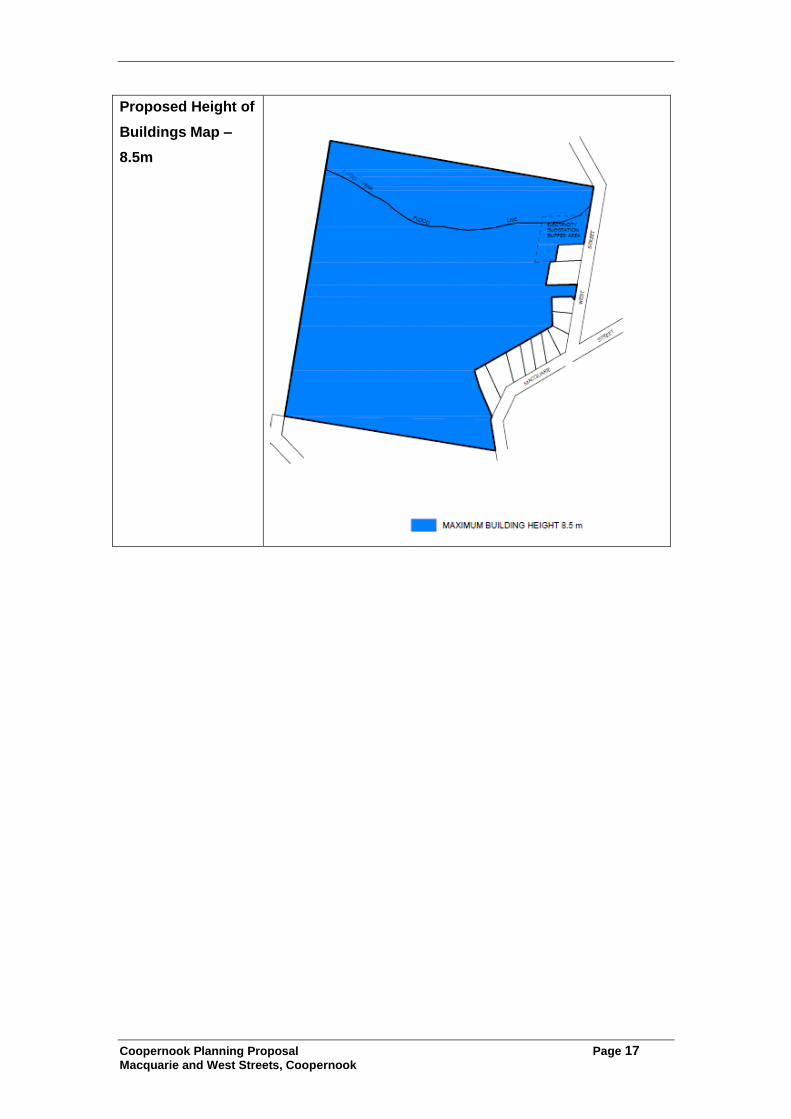
7.0 Mapping
Mapping has been prepared for the planning proposal as shown below. Maps consistent with the LEP will be prepared for exhibition.

Coopernook Planning Proposal Page 16
Macquarie and West Streets, Coopernook
Proposed Zoning
RU1 (Primary
Production) to
RU5 (Village)
Proposed
Subdivision Lot
Size
1,000m2 and
5,000m2
Coopernook Planning Proposal Page 17
Macquarie and West Streets, Coopernook
Proposed Height of
Buildings Map –
8.5m
Coopernook Planning Proposal Page 18
Macquarie and West Streets, Coopernook
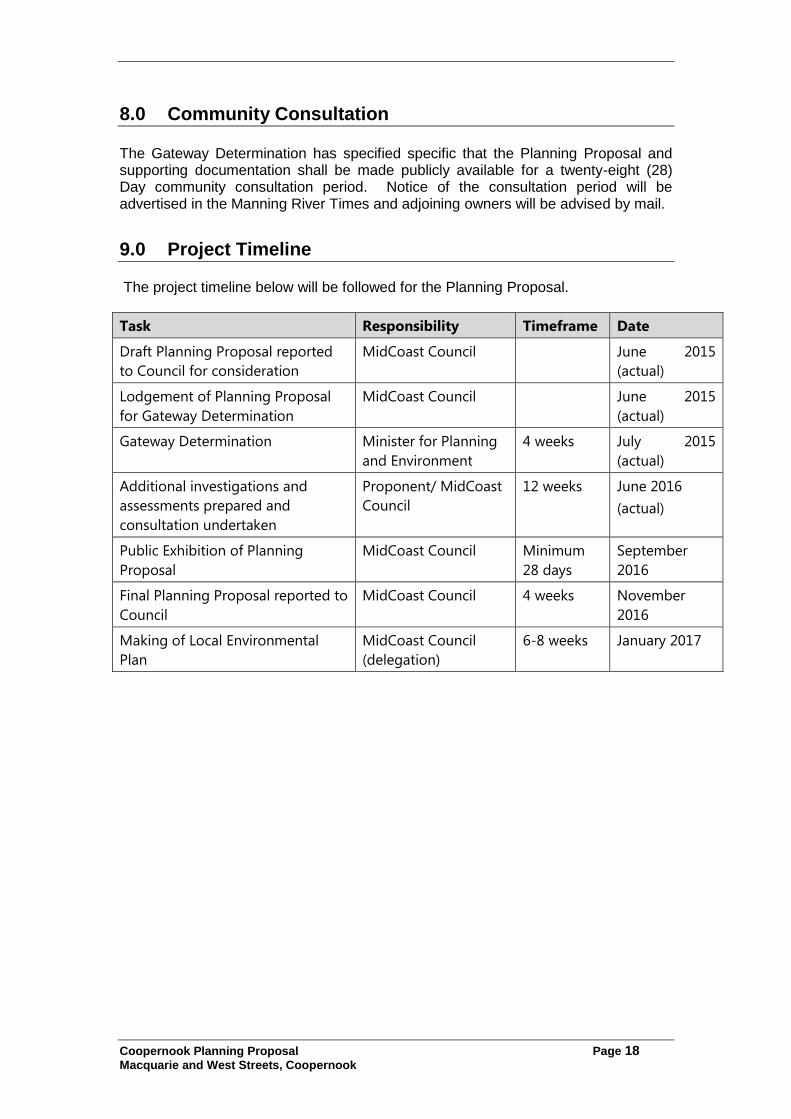
8.0 Community Consultation The Gateway Determination has specified specific that the Planning Proposal and supporting documentation shall be made publicly available for a twenty-eight (28) Day community consultation period. Notice of the consultation period will be advertised in the Manning River Times and adjoining owners will be advised by mail.
9.0 Project Timeline The project timeline below will be followed for the Planning Proposal.
Task Responsibility Timeframe Date
Draft Planning Proposal reported
to Council for consideration
MidCoast Council June 2015
(actual)
Lodgement of Planning Proposal
for Gateway Determination
MidCoast Council June 2015
(actual)
Gateway Determination Minister for Planning
and Environment
4 weeks July 2015
(actual)
Additional investigations and
assessments prepared and
consultation undertaken
Proponent/ MidCoast
Council
12 weeks June 2016
(actual)
Public Exhibition of Planning
Proposal
MidCoast Council Minimum
28 days
September
2016
Final Planning Proposal reported to
Council
MidCoast Council 4 weeks November
2016
Making of Local Environmental
Plan
MidCoast Council
(delegation)
6-8 weeks January 2017