planning of lid–bmps for urban runoff control: the case...
TRANSCRIPT
Seediscussions,stats,andauthorprofilesforthispublicationat:https://www.researchgate.net/publication/251672166
PlanningofLID–BMPsforurbanrunoffcontrol:ThecaseofBeijingOlympicVillage
ARTICLEinSEPARATIONANDPURIFICATIONTECHNOLOGY·JANUARY2012
ImpactFactor:3.09·DOI:10.1016/j.seppur.2011.04.026
CITATIONS
37
READS
292
4AUTHORS,INCLUDING:
HaifengJia
TsinghuaUniversity
83PUBLICATIONS334CITATIONS
SEEPROFILE
Allin-textreferencesunderlinedinbluearelinkedtopublicationsonResearchGate,
lettingyouaccessandreadthemimmediately.
Availablefrom:HaifengJia
Retrievedon:26February2016

This article appeared in a journal published by Elsevier. The attachedcopy is furnished to the author for internal non-commercial researchand education use, including for instruction at the authors institution
and sharing with colleagues.
Other uses, including reproduction and distribution, or selling orlicensing copies, or posting to personal, institutional or third party
websites are prohibited.
In most cases authors are permitted to post their version of thearticle (e.g. in Word or Tex form) to their personal website orinstitutional repository. Authors requiring further information
regarding Elsevier’s archiving and manuscript policies areencouraged to visit:
http://www.elsevier.com/copyright

Author's personal copy
Planning of LID–BMPs for urban runoff control: The case of Beijing Olympic Village
Haifeng Jia a,⇑, Yuwen Lu a, Shaw L. Yu b, Yurong Chen a
a School of Environment, Tsinghua University, Beijing 100084, PR Chinab Department of Civil and Environmental Engineering, University of Virginia, Charlottesville, VA, USA
a r t i c l e i n f o
Article history:Available online 10 May 2011
Keywords:Low impact development (LID)Best management practices (BMP)BMPDSSSWMMOptimization
a b s t r a c t
In this paper, a planning analysis of implementing low impact development (LID) type of stormwater bestmanagement practices (BMPs) for urban runoff control is presented. The Beijing Olympic Village (BOV)residential area in China was used as a case study. The original BOV stormwater system incorporatedsome LID BMPs such as porous pavements, green roofs and rainwater cisterns. After the 2008 Olympics,the BOV was converted to a residential complex and some stormwater facilities were modified for land-scaping purposes. The performance of the original stormwater management system at the BOV residen-tial area was first evaluated by using the model BMPDSS. BMPDSS is a best management practice (BMP)planning and analysis tool, which is capable of simulating BMP performance and optimizing BMP place-ment and design. The Storm Water Management Model (SWMM) was used to simulate pipe networkhydraulics for the BOV. The present study then examined the performance associated with the BMP mod-ifications for landscaping purposes, and then further BMP modifications designed for enhancing runoffcontrol capabilities of the system. Using the 2008 rainfall data for Beijing, peak flow rate and runoff vol-ume reductions under the three scenarios were calculated by using the coupled SWMM–BMPDSS frame-work and compared. Optimization analysis for BMP design aimed at achieving either maximum runoffcontrol or total minimum system cost was then conducted. The results were used to form recommenda-tions to the Beijing authorities for modifying the present stormwater management system in order toachieve more runoff control benefits.
� 2011 Elsevier B.V. All rights reserved.
1. Introduction
Presently, China is experiencing a very rapid process of urbani-zation, which brings adverse impact on the water environment. Asa result, urban runoff quantity and quality control has emerged as akey concern for municipal officials [1,2]. One of the strategies formitigating the impact of urbanization is the use of LID–BMPs forurban stormwater runoff quality and quantity control [3,4]. Beforeimplementing the various BMPs, however, it is important, and nec-essary, to find the most cost-effective selection, design and place-ment of BMPs [5,6].
In the present study, a BMP implementation planning analysiswas conducted using the Beijing Olympic Village (BOV) residentialarea as a case study. The BOV was used to house athletics fromaround the world during the 2008 Beijing Summer Olympic Gamesand has since been converted to a residential complex. Somestormwater management practices were already in place, such asporous pavements, green roofs and rainwater cisterns. In the pres-ent study, various types of BMPs were first assessed to determinetheir suitability for use under local conditions in terms of both
technical and economic considerations. The coupled SWMM–BMPDSS model was then used to calculate runoff peak rate andvolume reductions under the three aforementioned planning sce-narios. Using the local 2008 rainfall data, quantitative estimatesof runoff volume and peak reduction rates under the three plan-ning scenarios were obtained. Comparative reduction rates for se-lected types of LID–BMPs were then calculated. Finally, a BMPoptimization analysis was made to find the type and design spec-ifications of BMPs that would provide the most cost-effective, thebest reduction rate for runoff control at the BOV. Results of thisstudy would be very useful to the authorities in their planning pro-cess for improving the runoff control capabilities of the BOV storm-water management system.
2. Description of the Olympic Village site
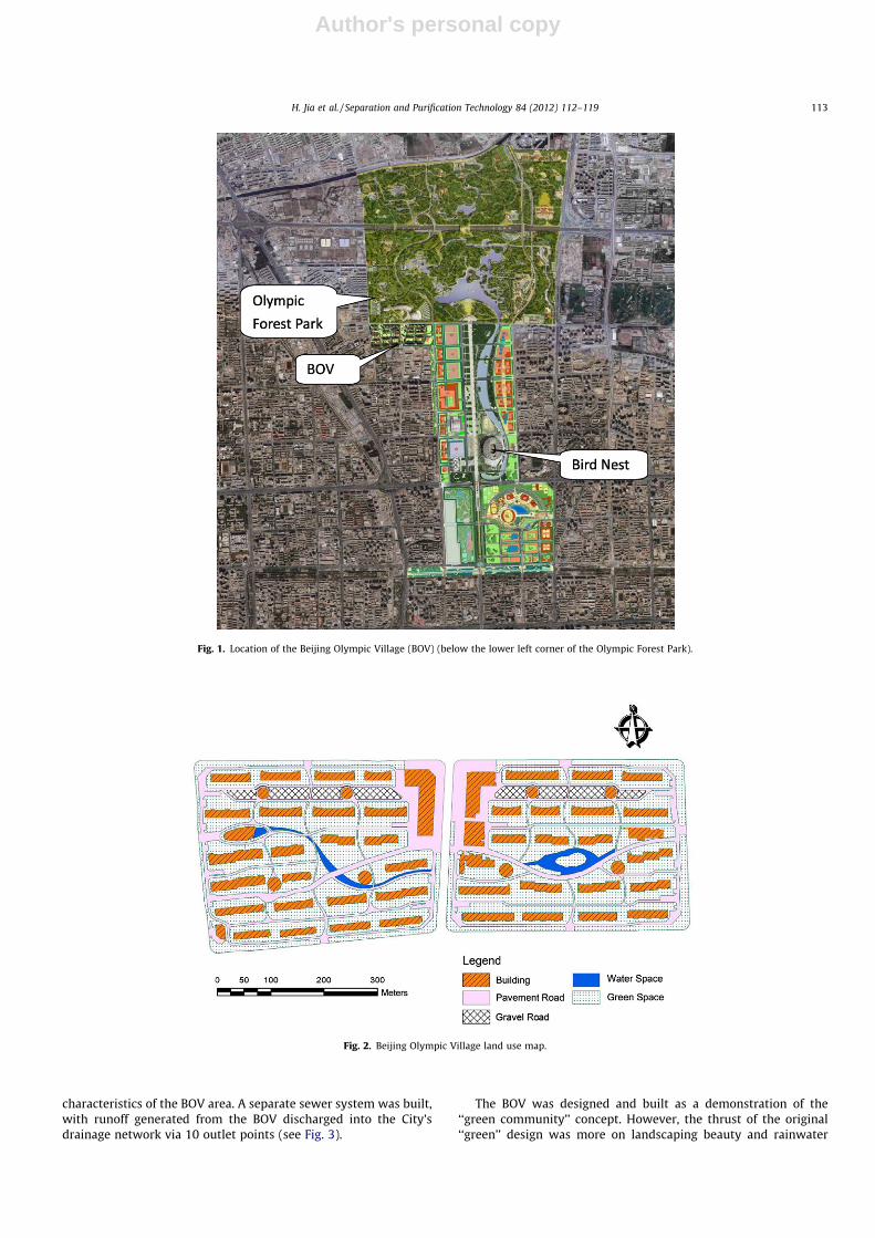
The Beijing Olympic Village is located at the north fringe of themain Olympic Stadium, or ‘‘Bird Nest’’ complex (see Fig. 1), whichlies in the north central part of Beijing City. The BOV occupies anarea of 36 ha, which includes residential, apartments and auxiliaryfacilities. Land uses in the BOV include 40% of the area for greenspaces. There are 42 high-rise residential buildings; five publicbuildings; and a few leisure clubs. Fig. 2 shows the land use
1383-5866/$ - see front matter � 2011 Elsevier B.V. All rights reserved.doi:10.1016/j.seppur.2011.04.026
⇑ Corresponding author. Tel./fax: +86 10 62792642.E-mail address: [email protected] (H. Jia).
Separation and Purification Technology 84 (2012) 112–119
Contents lists available at ScienceDirect
Separation and Purification Technology
journal homepage: www.elsevier .com/locate /seppur
Author's personal copy
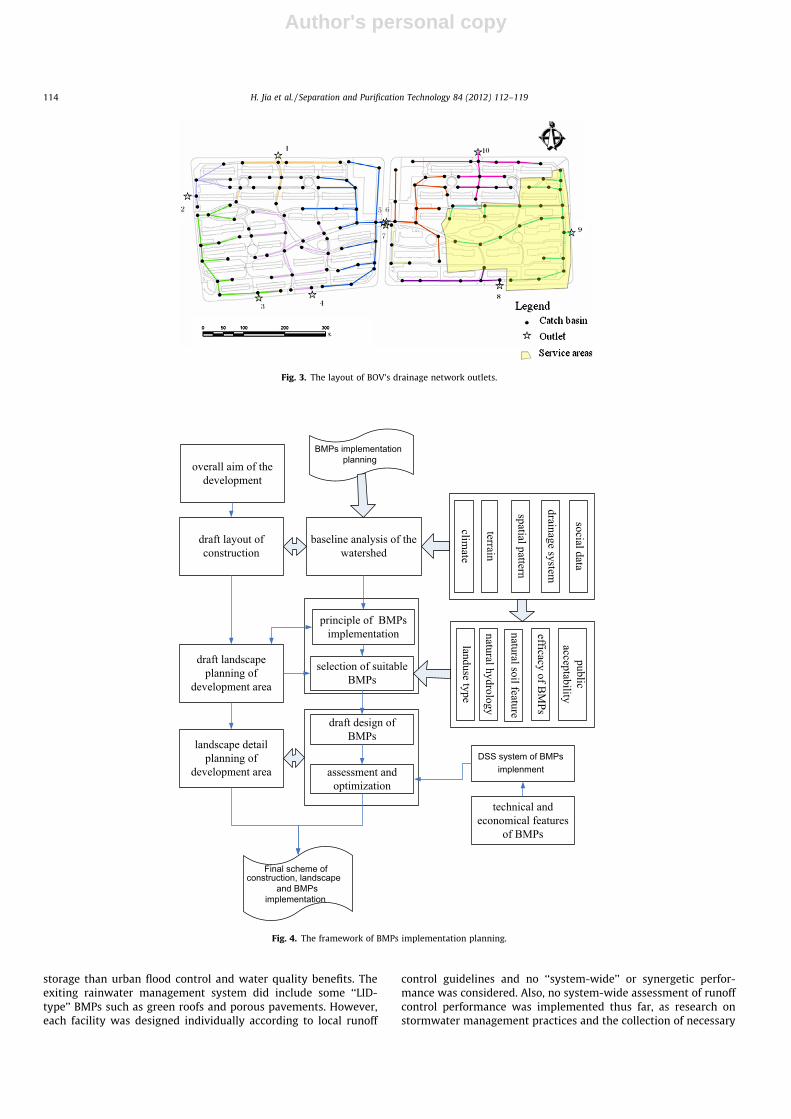
characteristics of the BOV area. A separate sewer system was built,with runoff generated from the BOV discharged into the City’sdrainage network via 10 outlet points (see Fig. 3).
The BOV was designed and built as a demonstration of the‘‘green community’’ concept. However, the thrust of the original‘‘green’’ design was more on landscaping beauty and rainwater
Fig. 1. Location of the Beijing Olympic Village (BOV) (below the lower left corner of the Olympic Forest Park).
Fig. 2. Beijing Olympic Village land use map.
H. Jia et al. / Separation and Purification Technology 84 (2012) 112–119 113
Author's personal copy
storage than urban flood control and water quality benefits. Theexiting rainwater management system did include some ‘‘LID-type’’ BMPs such as green roofs and porous pavements. However,each facility was designed individually according to local runoff
control guidelines and no ‘‘system-wide’’ or synergetic perfor-mance was considered. Also, no system-wide assessment of runoffcontrol performance was implemented thus far, as research onstormwater management practices and the collection of necessary
BMPs implementation planning
DSS system of BMPs implenment
Final scheme of construction, landscape
and BMPs implementation
Fig. 4. The framework of BMPs implementation planning.
Fig. 3. The layout of BOV’s drainage network outlets.
114 H. Jia et al. / Separation and Purification Technology 84 (2012) 112–119
Author's personal copy
urban runoff data are just beginning to receive general attention inChina [7–9]. Consequently, there lies an opportunity to use theBOV study to demonstrate the use of modeling techniques for
the evaluation of urban runoff systems for retrofit and/or expan-sion opportunities in order to gain enhanced runoff controlbenefits.
BMPDSS model
Runoff SWMM runoff
Roof Road Grass Wood land
Landuse information
Drainage areas
Rainwater pipe system
BMPDSS preprocess
BMP facility
Rainwater pipe system
BMPDSS input file
Model computation
BMPDSS output file
BMPDSS post processor
Topology
Landscape
DEM
Rainfall data Weather data
External data External data
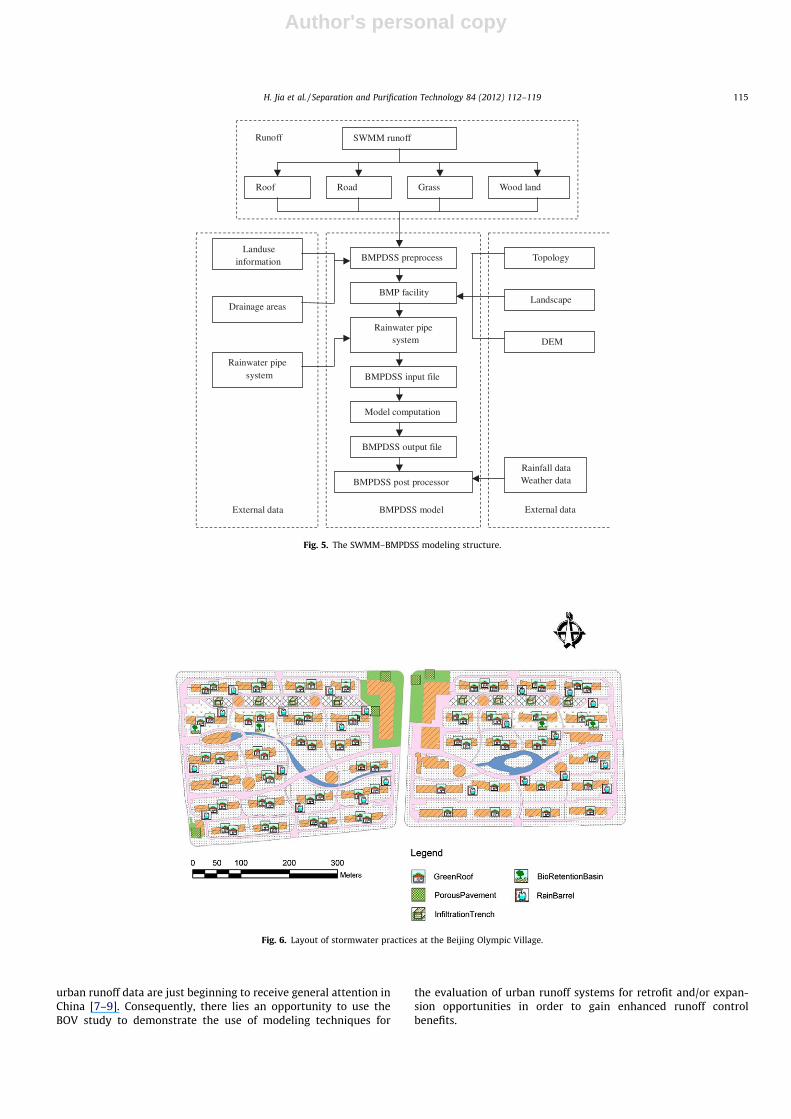
Fig. 5. The SWMM–BMPDSS modeling structure.
Fig. 6. Layout of stormwater practices at the Beijing Olympic Village.
H. Jia et al. / Separation and Purification Technology 84 (2012) 112–119 115
Author's personal copy
3. The LID–BMPs planning analysis framework
The thrust of a watershed-based BMP planning analysis is theevaluation of the ‘‘combined’’, or synergic, effect of all the BMPs in-stalled in the watershed at a prescribed evaluation point or points.The evaluation point could be the outlet of a watershed or anyselected point or points upstream. In general, the planning analysiswould include the following main elements:
� Baseline analysis – watershed climate, terrain, development,etc. and their spatial variations; natural and manmade drainagesystems, and relevant social/economical information.� BMP planning – selection and preliminary placement of BMPs.
Data on the efficacy of various BMPs; construction and mainte-nance costs; watershed hydrology, soil characteristics and landuses, and public acceptance information are needed.� BMP design, assessment and optimization – a preliminary
design of BMPs, in terms of the placement, type and size, isassessed by using an analysis tool such as BMPDSS. The optimi-zation analysis will help determine the final BMP design.
The BMP planning framework is depicted in Fig. 4 and somedetails of the planning process are described in the followingsections.
3.1. Baseline analysis of the watershed
For the purpose of implementing LID practices, appropriateBMPs types, sizes and spatial layout should be designed in concertwith the overall development site construction and associatedlandscape planning. Relevant information for the development
areas need to be collected and analyzed, such as climate, terrain,spatial distribution pattern and the drainage system of the devel-opment area, and social/economic data, etc.
3.2. The principles of LID–BMPs implementation
The LID–BMP implementation should be fully coordinated withthe local construction plan and be integrated, if possible, into the sitelandscaping scheme. The main principles of LID–BMP planning usu-ally include (1) preserve the original terrain, (2) limit the ratio ofimpervious surface areas, (3) avoid the direct connection of impervi-ous areas, (4) select the most suitable BMP types according to localconditions in terms of both technical and social/economic factors,and (5) set an appropriate goal for the LID–BMP implementation.
3.3. Selections of suitable BMPs
The suitability of each BMP for use at any location should bedetermined in accordance to local social/economic conditions.Such conditions include land use, natural hydrology and soil fea-ture, areas of sub-watersheds, slope of the development region,and the desired effects of development. Public acceptability is alsoan important consideration.
3.4. Preliminary design of BMPs
The preliminary design of BMPs in development region could bemade based on the suitability of different BMPs, natural conditionsof the development site and the landscape planning features.
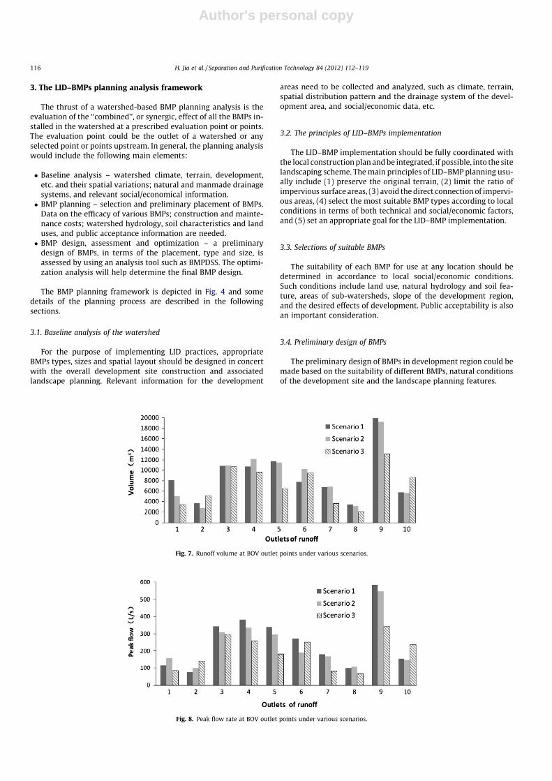
Fig. 7. Runoff volume at BOV outlet points under various scenarios.
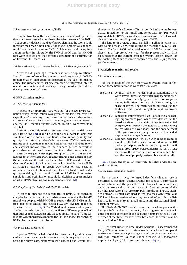
Fig. 8. Peak flow rate at BOV outlet points under various scenarios.
116 H. Jia et al. / Separation and Purification Technology 84 (2012) 112–119
Author's personal copy
3.5. Assessment and optimization of BMPs
In order to achieve the best benefits, assessment and optimiza-tion tools were needed to evaluate the effectiveness of the BMPs.To support the decision making of BMPs planning, the tools shouldintegrate the urban runoff simulation model; economical and tech-nical feature data for various BMPs, GIS database, and the optimi-zation module. In this study, the SWMM model and the BMPDSStool were coupled and used for the assessment and optimizationof different BMP scenarios.
3.6. Final scheme of construction, landscape and BMPs implementation
After the BMP planning assessment and scenario optimization, a‘‘best’’, in terms of cost-effectiveness; control target, etc., LID–BMPsimplementation plan could be proposed to the decision-makingentity. The runoff control scheme can then be integrated into theoverall construction and landscape design master plan at thedevelopment or retrofit site.
4. BMP planning analysis
4.1. Selection of analysis tools
In selecting an appropriate analysis tool for the BOV BMPs eval-uation study, consideration was given to models that have thecapability of simulating storm sewer networks and also variousLID-types of BMPs. The Storm Water Management Model, SWMM,and the BMP Decision Support System, BMPDSS, were eventuallyselected.
SWMM is a widely used stormwater simulation model devel-oped for USEPA [10]. It can be used for single-event to long-termsimulation of the surface runoff/subsurface runoff quantity andquality from primarily urban/suburban areas. SWMM contains aflexible set of hydraulic modeling capabilities used to route runoffand external inflows through the drainage system network ofpipes, channels, storage/treatment units and diversion structures.
BMPDSS was jointly developed to support analysis and decisionmaking for stormwater management planning and design at boththe site scale and the watershed levels by the USEPA and the PrinceGeorge’s County [11]. It is a decision-making tool for placing BMPsat strategic locations in urban watersheds on the basis ofintegrated data collection and hydrologic, hydraulic, and waterquality modeling. It has specific functions of BMP facilities controlsimulation and optimization module for decision support analysisof urban BMPs planning and placement analysis [12].
4.2. Coupling of the SWMM and BMPDSS models
In order to enhance the capabilities of BMPDSS in analyzingcomplex hydraulic conditions in urban sewer networks, the SWMMmodel was coupled with BMPDSS to support the LID–BMP simula-tion and optimization. The coupled SWMM–BMPDSS modelingstructure is shown in Fig. 5. The SWMM module was used to gener-ate the time series data of surface runoff from different types of landuses such as roof, road, grass and wooded areas. The runoff time ser-ies data were then used as input to the BMPDSS Model for analyzingBMPs placement and optimization.
4.3. Input data preparation
Input to SWMM includes local hydro-meteorological data andsurface quantity data such as topography, drainage systems, etc.Using the above data, along with land use, soil and terrain data,
time series data of surface runoff from specific land use can be gen-erated. In addition to the runoff time series data, BMPDSS wouldrequire data for BMP types and specifications, costs and also avail-able locations for installing various types of BMPs.
The long-term average annual rainfall in Beijing is 603.6 mm,with rainfall mostly occurring during the months of May to Sep-tember. The Year 2008 had a total rainfall of 602.6 mm and waschosen as a ‘‘representative’’ year for the present analysis. Dataon topography; the current drainage system, design details forthe existing BMPs and cost were obtained from the Beijing Munici-pal Government.
5. Analysis scenarios and results
5.1. Analysis scenarios
For the analysis of the BOV stormwater system wide perfor-mance, three basic scenarios were set as follows:
Scenario 1: Original scheme – under original conditions, therewere several types of rainwater management prac-tices in place, namely, green roofs; porous pave-ments; infiltration trenches; rain barrels, and greenspace or lawns. The main design objective for thefacilities was flood mitigation and rainwaterutilization.
Scenario 2: Landscape Improvement Plan – under the landscap-ing improvement plan, which was devised for thetransformation of the athletic village to a residentialcomplex, was included the increase of green spaces;the reduction of paved roads, and the enhancementof the green roofs and the green spaces. It aimed atimproving landscape features.
Scenario 3: Recommended Plan – the plan with additional and/ormodified LID BMPs based on consideration of LIDdesign principles, such as re-routing roof runoffthrough green spaces before entering the rain barrels;increasing the detention times of storage facilities,and the use of properly designed bioretention cells.
Fig. 6 depicts the layout of stormwater facilities under the ori-ginal conditions.
5.2. Scenarios simulation results
For the present study, the target index for evaluating systemperformance was runoff quantity, which included total stromwaterrunoff volume and the peak flow rate. For each scenario, thesequantities were calculated at a total of 10 outlet points of theBOV drainage system that are entry points to the Beijing City drain-age network. Rainfall data used in the analyses were from Year2008, which was considered as a ‘representative’’ year for the Bei-jing area in terms of total rainfall amount and the seasonal distri-bution of rainfall.
The SWMM–BMPDSS models were then used to process thehourly rainfall and other necessary data to generate runoff vol-umes and peak flow rates at the 10 outlet points from the BOV un-der each of the three scenarios described above. The results can besummarized as follows:
(1) For total runoff volume, under Scenario 3 (RecommendedPlan), 27% more volume reduction would be achieved comparedto that under Scenario 1 (existing scheme) and 21% more volumereduction compared to that under Scenario 2 (landscapingimprovement plan). The results are shown in Fig. 7.
H. Jia et al. / Separation and Purification Technology 84 (2012) 112–119 117

Author's personal copy
(2) For peak flow rate, under Scenario 3 (Recommended Plan),21% more peak flow rate reduction would be achieved comparedto that under Scenario 1, and a 17% more reduction under Scenario2. The results are shown in Fig. 8.
The results clearly showed that by properly designing andimplementing the LID-type of BMPs for the BOV residential com-plex, significant higher runoff volume and peak flow reductionscould be realized.
5.3. BMP optimization
In the scenario analysis described above, the BMP sizes werekept the same as those of the original installation (Scenario 1). Inorder to demonstrate whether the BMP designs could be revisedfor better system performance or lower costs, the optimizationmodule of BMPDSS was used to assess BMP performance in a sub-area of the BOV. The subarea selected was the service area of Outlet#9 (See Fig. 3). Several BMP types, i.e., infiltration trenches, greenroofs, rain barrels and bioretention cells were placed in this subar-
Table 1The comparison of BMPs sizes before and after optimization.
BMPs Scenario 3 Optimal (best solution 1)
Maximize benefit Minimize cost
Green roof Area 50% 35% 27%Soil depth 0.3 m 0.6 m 0.6 m
Bioretention Area 26% 24% 7%Weir height 0.3 m 1.0 m 0.8 mSoil depth 0.3 m 0.8 m 0.8 m
Infiltration trench Area 100% 67% 40%Soil depth 0.5 m 0.6 m 0.6 m
Rain barrel Diameter 1.8 m 1.0 m 0.4 mWeir height 1.8 m 1.6 m 0.9 m
Fig. 9. Optimization result for minimizing cost.
Fig. 10. Optimization result for maximizing benefit.
118 H. Jia et al. / Separation and Purification Technology 84 (2012) 112–119

Author's personal copy
ea as those under Scenario 3. In the optimization analysis, the sizesof BMPs were allowed to vary in order to provide an optimal solu-tion in terms of system performance and cost.
To formulate an optimization problem, BMPDSS requires theuser to specify four sets of information: decision variables, assess-ment points and evaluation factors, management targets, and theBMP cost functions. The decision variables include length, width,depth of BMPs, e.g., the diameter of a rain barrel, etc. Accordingto information collected for local stormwater facilities, construc-tion costs for on-ground facilities and on-roof ones were estimatedto be 500 and 700 Yuan RMB per cubic meter, respectively [13].
Two optimization targets were set for the present analysis:
(1) Minimizing cost target:
The annual average flow volume was selected as the evaluationfactor, and the control target was set at 20% reduction of the valueunder Scenario 3. The stopping criterion was set as a 100 YuanRMB cost reduction, which means that the search will be stoppedif the cost of the next best solutions found does not show a reduc-tion of at least 100 Yuan RMB. The results are shown in Fig. 9. Inthe figure, the X-axis shows the construction cost and the Y-axisshows the annual average flow volume reduction percent of the va-lue under Scenario 3.
It can be seen that the annual average flow volume reduction ofthe best solution 1 (the ‘‘knee-of-curve’’ point) was 20.02%, andthe corresponding cost was 4.934 million Yuan RMB. The annualaverage flow volume reduction of another possible solution, solu-tion 2 was 20.28%, and the corresponding cost was 4.938million Yuan RMB.
(1) Maximizing benefits as the target:
The annual average flow volume was also selected as the eval-uate factor in this run. The stopping criterion was set as a 1% reduc-tion, which means that the search will be stopped if the controlbenefit of the best solutions found does not show a reduction ofat least 1%. The results are shown in Fig. 10.
The annual average flow volume reduction of the best solution 1(the ‘‘knee-of-curve’’ point) was 23.33%, and the correspondingcost was 5.099 million Yuan RMB. The annual average flow volumereduction of best solution 2 was 23.19%, and the correspondingcost was 5.105 million Yuan RMB.
The results indicate that with an increase of 165 thousand YuanRMB, the system could generate an increase of roughly 3% morerunoff volume reduction. Whether this additional benefit justifiesthe increase in expenditure should be dependent on a furtherexamination of how much impact would a 1% runoff reductioncause. For example, a recent survey conducted in China [14]showed that a majority of potential home buyers would be willingto pay more for ‘‘green’’ features such as scenery ponds, etc. Sincemany LID type of BMPs, e.g., bioretention cells, swales, pond/wetland systems, could ‘‘double-up’’ as waterscapes (e.g., bioreten-tion cells as flower beds), there may be a good justification forenhanced BMP installations.
After the optimization analysis, the optimal sizes of all the BMPswere found. A comparison of the sizes of BMPs between those underScenario 3 and those obtained through the optimization runs is sum-marized in Table 1. It can be seen from Table 1 that the optimal sizesoff BMPs are generally smaller than those under Scenario 3. Forexample, the green roof size was reduced from covering 50% of theroof area to almost half (27%) under the minimum cost scenario,and the rain barrel diameter was reduced from 1.8 m to 0.4 m, etc.
6. Conclusions
Along with the rapid urbanization in China, urban woes have oc-curred and have been great concerns of many city officials and thegeneral public. Among these urban problems, the negative impactof urban runoff on hydrology and water quality is among the mostserious ones. The present study examined the use of low impactdevelopment (LID) practices in mitigating urban runoff impacts.The BOV, which was built as a demonstration of the ‘‘green commu-nity’’ concept, was selected as a case study to analyze the benefits ofoptimized LID BMP implementation on reducing runoff volume andpeak rates. The coupled SWMM–BMPDSS model was used for theanalysis. The results showed that compared to the existing condi-tion, the recommended BMP plan would cause a 27% and 21% reduc-tion for total runoff volume and the peak flow rate, respectively.Using the optimization module of BMPDSS, the sizes of BMPs couldbe further reduced and still meet the target of minimizing cost ormaximizing benefits. The research results could lead to useful rec-ommendations for modifying the present stormwater managementsystem at the BOV, and also at other urban sites, in order to achievemore runoff control benefits.
Acknowledgments
We thank Dr. Yong HE of the Beijing Municipal Urban PlanningInstitute for her assistance in data collection and analysis. Fundingfor the study was provided by the Programme of Introducing Talentsof Discipline to Universities (the 111 Project) (B07002) and the re-search fund of National Water Pollution Control Special Project(No. 2008ZX07526-005). The authors would like to especially thankDr. Mow-Soung Cheng of the Prince George’s County, Maryland, USAfor providing the BMPDSS model and also helpful suggestions.
References
[1] R. Field, R.E. Pitt, Urban storm-induced discharge impacts: US EnvironmentalProtection Agency research program review, Water Sci. Technol. 22 (1990) 1–7.
[2] V.A. Tsihrintzis, R. Hamid, Modeling and management of urban stormwaterrunoff quality: a review, Water Resour. Manage. 11 (1997) 137–164.
[3] USEPA, Preliminary Data Summary of Urban Stormwater Best ManagementPractices, Office of Water, Washington, DC, 1999.
[4] H. Sieker, M. Klein, Best management practices for stormwater runoff withalternative method in a large catchment in Berlin, Germany, Water Sci.Technol. 38 (1998) 91–97.
[5] D.D. Michael, F.R. William, Modeling BMPs to optimize municipal wastewaterland treatment system, J. Environ. Eng. 12 (1998) 178–187.
[6] C. Jefferies, A. Aitken, K. Macdonald, Assessing the performance of urban BMPsin Scotland, Water Sci. Technol. 39 (1999) 123–131.
[7] H.Z. Wang, X.F. Li, Pollution of runoff from Beijing urban area and its control,Urban Environ. Urban Ecol. 15 (2002) 16–18 (in Chinese).
[8] X. Dong, P.F. Du, Z.Y. Li, et al., Parameter identification and validation ofSWMM in simulation of impervious urban land surface runoff, Environ. Sci. 29(2008) 1495–1501 (in Chinese).
[9] X.L. Zeng, Z. Zhang, W.C. Ding, Study on the model of surface storm-waterrunoff at urban gully, J. Chongqing Jianzhu Univ. 26 (2004) 78–90 (in Chinese).
[10] L.A. Rossman, Storm Water Management Model, V5, User’s Manual, USEnvironmental Protection Agency, USA, 2005.
[11] Prince George’s County Department of Environmental Resources, BMP/LIDDecision Support System for Watershed Based Stormwater Management,User’s Guide, Department of Environmental Resources Programs and PlanningDivision, Largo, MD, 2005.
[12] M.S. Cheng, J.X. Zhen, L. Shoemaker, BMP decision support system forevaluating stormwater management alternatives, Front. Environ. Sci. Eng.China 3 (2009) 453–463.
[13] Y.W. Lun, BMP Planning and the Case Study of Urban Stormwater RunoffControl and Management, Dissertation, Tsinghua University, Beijing, 2009 (inChinese).
[14] L.W. Men, Discussion about the Impact of the Real Estate’s Price byWaterscape: as an Example of Hangzhou, Dissertation, Zhejiang University,Hangzhou, 2006 (in Chinese).
H. Jia et al. / Separation and Purification Technology 84 (2012) 112–119 119