planning for the rising tides
TRANSCRIPT

Would you like to find out more about us,
or about your environment?
Then call us on
08708 506 506 (Mon-Fri 8-6)
or visit our website
www.environment-agency.gov.uk
incident hotline 0800 80 70 60 (24hrs)
floodline 0845 988 1188
Environment first: This publication is printed on paper made from
100 per cent previously used waste. By-products from making the
pulp and paper are used for composting and fertiliser, for making cement
and for generating energy.
GENE0308BNRL-E-P
planning for the rising tides
The Humber Flood RiskManagement StrategyMarch 2008

Environment Agency The Humber Flood Risk Management Strategy 1
Contents
Aims and objectives 3
Foreword 4
Introduction 6
Section 1 How we developed the strategy 8
Strategy objectives 8
Drawing up the strategy 8
Keeping people informed 8
Section 2 What’s happened since the consultation draft 9
The public’s reaction 9
What we have done 11
Local and regional initiatives 12
National guidance and government policy 14
Section 3 The Humber Strategy 16
Overall approach 16
Managing the defences 16
Links with the planning system 16
Controlling development on the floodplain 16
Responding to emergencies 17
Planning where the water goes 17
Providing flood storage 17
Complying with the Habitats Regulations 17
Supporting the environment 17
Paying for the works 17
Links with other strategies 18
Reviewing progress 18
Preparing for what’s coming 18
Talking to others 18
Section 4 What happens next 21
Summary of programme and issues 21
Work in the next five years 21
Work in later years 22
Creating new inter-tidal habitat 22
Opportunities for flood storage 22
Withdrawing maintenance 22
Section 5 Proposals for each flood area 26
1. Kilnsea and Easington 26
to
27. Tetney to Saltfleet Haven 52
Published by:
Environment Agency
Rivers House
21 Park Square South
Leeds LS1 2QG
Tel: 08708 506 506
Email: [email protected]
www.environment-agency.gov.uk
© Environment Agency
All rights reserved. This document may be reproduced with
prior permission of the Environment Agency.
We are the Environment Agency. It’s our job to look after your
environment and make it a better place – for you, and for
future generations.
Your environment is the air you breathe, the water you drink
and the ground you walk on. Working with business,
Government and society as a whole, we are making your
environment cleaner and healthier.
The Environment Agency. Out there, making your environment
a better place.

Environment Agency Humber Flood Risk Management Strategy 3
Overall aims
To manage the risk of flooding around the Humber Estuary in ways that are sustainable for the people who
live there, the economy and the environment, taking into account:
– natural estuary processes; and
– future changes in the environment (built or natural), sea levels or the climate.
To ensure that all proposals are:
– technically feasible;
– economically viable;
– environmentally appropriate; and socially beneficial.
Aims and objectives
Within these overall aims the strategy seeks to achieve the following objectives:
Contents (continued)
Studies undertaken 53
Technical reports 54
Consultation and information documents 54
Advisory groups 55
Organisations on the Steering Group 55
Glossary 56
Abbreviations 60
Contact details 61
Boxes and tables in the text
Section 2 Response to points raised on the consultation draft 9
Improving the defences at Kilnsea 11
Flood area reference numbers 12
Changes in national guidance and policy 14
Section 3 Sites for creating new inter-tidal habitat 17
Our approach to managing the defences 19
Information for property owners 20
Section 4 Work planned in next five years 22
Management proposals 24
Maps
Flood risk from the Humber Estuary 7
Flood areas 13
Habitat creation, flood storage and withdrawal of maintenance 23
Detailed objectives Subsidiary objectives
To protect people and their property from the adverse effects
(physical and psychological) of flooding
To minimise adverse effects on wider estuarine processes
To prevent ‘contaminated sites’ having an adverse effect on
the estuary
To protect areas of employment from the adverse effects of flooding
To provide, where appropriate, a secure environment for economic
activity and development
To minimise adverse effects on high quality agricultural land
To minimise adverse effects on navigation (e.g. on channels,
deepwater docks and beacons etc)
To minimise adverse impacts on road and rail infrastructure
To minimise adverse effects on European Site(s) and ensure direct
losses are compensated
To address the adverse effects of ‘coastal squeeze’ on European Site(s)
To support and, where appropriate, enhance biodiversity, including
the delivery of national and local Biological Action Plan (BAP) targets
To minimise adverse effects on undiscovered or buried archaeology
To protect designated archaeological and historic features within
the floodplain
To protect and, where appropriate, enhance the characteristics and
local distinctiveness of all landscapes
To protect and promote, where appropriate, regional and local
recreational and amenity features
To maintain and, where possible,
enhance public safety, health and
security
To respond to natural processes and
to avoid contamination and erosion
To protect and, where appropriate,
provide opportunities for economic
development and employment
(including protection of existing
land uses where appropriate)
To protect existing transport
infrastructure (land and sea)
To protect and, where appropriate,
enhance flora and fauna
(biodiversity)
To protect the historic environment
To protect and, where appropriate,
enhance landscape, amenity and
recreational features
2 Environment Agency The Humber Flood Risk Management Strategy

Environment Agency Humber Flood Risk Management Strategy 54 Environment Agency The Humber Flood Risk Management Strategy
Nearly 400,000 people living near the estuary are at
risk, as are key industries, businesses, agriculture and
the jobs they provide. Our Humber Strategy shows how
we aim to limit the impact on people, property and
industry in ways that won’t damage the area’s
landscape character or its historical or wildlife
importance. This will help safeguard the growth and
prosperity of the Humber’s communities and its
economy, which are vitally important both to the
Yorkshire and Humber and the East Midlands Regions,
and to the country as a whole.
Overall, our Humber Strategy will ensure that more
than 99 per cent of the people living round the estuary
will continue to have a good standard of protection
from tidal flooding. To achieve this, we will start a
major programme of flood defence improvements this
year. There will be losers as well as winners, however,
since we will not be able to raise all the estuary’s
defences in line with sea levels, particularly where
they protect only a few people or businesses. In due
course any defences not raised are likely to fail and the
land behind them to flood. This document identifies
where these defences are and how long they’re likely
to last, so the people affected will have as much
warning as possible about the consequences. It also
describes what they can do to limit the impacts and
what help will be available to them.
Flooding in the area doesn’t only come from the
estuary, as we know from the impact of the very heavy
rain in June and July 2007 and again in January 2008.
We can’t stop all floods from happening and the water
has to go somewhere, so we need to look closely at
how we manage them when they do and how to help
people take preventative action. We’re working with
the local authorities, the emergency services and the
government to review what happened during the
recent floods and will adjust our Humber Strategy in
the light of any changes and lessons learned.
This strategy sets out the Environment Agency’s vision for managing the risk of flooding from the Humber Estuary
as the climate changes and sea levels rise.
Foreword
It has taken 10 years to develop our Humber Strategy and
get it approved by the government. Doing so has involved
much hard work from many people, not only the
Environment Agency’s staff and consultants but also
those who have given their time to think and talk about
the issues it raises. Our thanks to you all, and in particular
to the members of the Steering Group (listed on page 55),
who have met regularly since the work started and have
been unstinting in their support and guidance.
Jeremy Walker
Chairman, Yorkshire Regional Flood Defence
Committee
Robert Caudwell
Chairman, Anglian (Northern) Regional Flood Defence
Committee
Tim Farr
Chairman, Severn-Trent Regional Flood Defence
Committee
Alkborough flood
storage site

Environment Agency The Humber Flood Risk Management Strategy 76 Environment Agency The Humber Flood Risk Management Strategy
After 1953 the defences along the East Coast were
improved and if the same event happened now the
flooding wouldn’t be as extensive, but would be
tremendously damaging. looking to the future, our
climate is changing, causing sea levels to rise and
severe storms to happen more often, and our defences
are ageing. If they are not improved, they will become
less and less effective and in due course they will fail.
Furthermore, more of the land behind them has been
developed, so more homes and more industry will be
affected if it is flooded.
Currently about 90,000 hectares of land around the
Humber is at risk of being flooded by a storm surge in
the North Sea. This area, shown on the map opposite,
contains the homes of about 400,000 people. Most of
them are in cities such as Hull and Grimsby, or in
smaller towns or villages, and the area also contains
major industries, including power stations, refineries
and the country’s largest port complex, handling 80
million tonnes of cargo each year. Most of the
remaining land, over 85 per cent of the total, is farmed
and consequently has relatively few people living on it.
The whole area has an important history and heritage
while the importance of the estuary’s wildlife and
habitats has led to its designation under the Birds and
Habitats Directives, which provides them with legal
safeguards under the Conservation (Natural Habitats
etc) Regulations 1994, otherwise known as the
Habitats Regulations.
In 1997 we began developing a long-term strategy for
managing flood risk around the Humber Estuary and
the lower reaches of its main tributaries, the Ouse and
the Trent. We published a consultation draft of our
On the night of 31st January 1953, the most damaging storm surge on record in the North Sea struck, leading to
the loss of 300 lives, damaging 24,000 homes and flooding almost 100,000 hectares of land between Yorkshire
and the Thames Estuary.
Introduction
proposals for the next 100 years in August 2005 and
received approval for the first 25 years from the
Department for Environment, Food and Rural Affairs
(Defra) in March 2007. This document sets out the
strategy that has resulted. It covers flooding from the
estuary and the lower reaches of the Ouse and the
Trent only; separate strategies are being developed for
flooding from other sources. The first section gives a
brief outline of how it was developed and is followed
by a summary of the comments we received on the
consultation draft and of recent developments in
government policy, in particular its ‘Making Space for
Water’ initiative, which is aimed at ‘managing the risk
from flooding and coastal erosion by employing an
integrated portfolio of approaches which reflect both
national and local priorities’. These are taken into
account in the general description of our Humber
Strategy and the summary of what will happen now it
has been adopted, given in the third and fourth
sections respectively. They are followed by more
detailed descriptions of what will happen in different
areas beside the estuary.
Although we have based our strategy on the best
information we currently have, circumstances can
change and better information may become available
in the future. We will therefore review it regularly,
generally every five years, and will carry out a detailed
assessment before taking final decisions about any
part of the estuary or its defences. During all reviews
and detailed assessments we will consult widely.
If you would like any more information please contact
us using the details inside the back cover.
27
26
25
24
23
222120
19
18
1716
15
14
13
12
11
10
89
7
6
5
4
32
1
HULL
Immingham
Grimsby
Withernsea
Easington
Kilnsea
Sunk Island
Cleethorpes
PaullHessle
NorthFerriby
Ferriby SluiceGoxhill
Brough
AlkboroughSwinefleet
Goole
Saltfleet
Donna Nook
Tetney Haven
N O R T H S E A
H U M B E R E S T U A R Y
The floodplain of the Humber Estuary
km
5 100
Flood area boundary
River
Road
Floodable area
Urban area
Urban area in floodplain
KEY

Environment Agency Humber Flood Risk Management Strategy 9
Points raised Response
See page 11.
The strategy includes managed realignment because
this is the most cost-effective way of creating the new
habitat needed to comply with the Habitats
Regulations. If this wasn’t included the strategy
would not have been approved and none of the work
it covers would go ahead.
As explained later in the document, the national
flood defence budget is limited, so we can only
maintain or improve defences where there is a good
business case for doing so. The defences we can’t
improve will deteriorate and in due course fail, unless
others are willing to take on the responsibility of
managing them and can obtain the appropriate
approvals. Property owners will get no compensation
in these circumstances but we will advise them about
what they can do to minimise the impacts (see page
20). The availability of flood insurance will depend
on individual circumstances, including the resilience
of the property at risk.
The effects of rising sea levels are likely to be felt
most in sparsely populated areas, as these are the
areas where we may not be able to improve the
defences. Many of the people living there are
farmers, who may have not only their homes but also
their livelihoods at risk if they can’t continue working
their land as before. Environmental Stewardship and
similar schemes can help cushion the change from
one type of agriculture to another (see page 21).
We will be placing more emphasis on contacts with
parish councils and individual households,
particularly in the areas likely to be most affected by
our proposals. We will use the approaches tried out in
our Coastal Futures research project (see page 11).
This is happening through the government’s ‘Making
Space for Water’ initiative, discussed later in this
section. We’re now working more closely with both
regional and local authority planners than before, as
discussed in Section 3.
Concern about the coastal defences near Kilnsea.
Too much emphasis placed on ‘green’ issues, in
particular managed realignment. Concern that the
strategy is more about protecting birds rather than
people.
Standards of protection will fall in some areas,
blighting the people who live there and making flood
insurance more difficult to obtain. There is no
compensation for this.
The role of Environmental Stewardship and related
schemes is not properly set out.
Lack of public awareness either about the strategy
or about the drop-in sessions and other public
meetings.
National policy needs to change from managing
flood defences to managing flood risk. Important to
work with planners (at regional and local levels) and
developers.
The public’s reaction
In August 2005 we issued over 3000 copies of the consultation draft and subsequently held drop-in sessions
around the estuary, for members of the public to come and talk about the strategy and the effect it could have on
them. The main points raised and how we are addressing them are summarised in the table below.
Section 2 What’s happened since the consultation draft
8 Environment Agency The Humber Flood Risk Management Strategy
Drawing up the strategy
The first step in drawing up the strategy was to define the
problem; finding out about the people and property at
risk in the area; about the defences protecting them;
about the way the estuary behaves and how this
influences the flooding that can occur; and about the
natural and historic environment this flooding might
affect. With this information we drew up our overall
approach and set it out in the HESMP. We then looked at
the implications in more detail, and in particular
established what we must do to comply with the
Habitats Regulations. This allowed us to draw up a
programme of the work needed to maintain the defences
for the next 100 years and to look in more detail at the
works planned for the first 15 years. From this we
produced the consultation draft for the full strategy.
We submitted our proposals to Defra in May 2006 and
in March 2007 received approval in principle for the
first 25 years at an estimated cost of just under £323
million. The approval drew attention to the changes in
government policy that had occurred since the draft
strategy was published, in particular through the
‘Making Space for Water’ programme and the
publication of Planning Policy Statement (PPS) 25
‘Development and Flood Risk’, both of which had been
strongly influenced by Foresight ‘Future Flooding’
report produced in April 2004. These changes are
described in the next section and have been taken into
account in the current Humber Strategy.
The main studies carried out as the strategy was
developed are outlined on page 53 and a full list of
reports is given on page 54.
Strategy objectives
Our objectives for the Humber Strategy are set out on page 3. They are based on the objectives in our Humber
Estuary Shoreline Management Plan (HESMP), published in September 2000, revised to take into account the
government’s developing policy on managing flood risk.
Section 1 How we developed the strategy
Keeping people informed
Consultation has played an important part in the
strategy’s development. As well as the consultation
draft of the strategy itself, we published two
consultation documents while the HESMP was being
prepared, and two information documents about the
managed realignment of existing defences. We
circulated six newsletters before the strategy
consultation document was produced and have
distributed a further three since then. We have also
held meetings throughout the project, either with
individual stakeholders or open to the public. At every
stage we have invited people to tell us about their
concerns and have taken these into account as the
strategy has developed.
We established a Steering Group when we began to
develop the strategy and this has played a
fundamental role ever since. It contains
representatives from the key stakeholder
organisations listed on page 55 and meets about three
times a year to review progress and discuss the issues
raised. We have also received advice from the Liaison
Panel, a small group of people from outside the
Environment Agency chosen for their knowledge of the
area and understanding of local issues.
Flood defence
at Brough

Environment Agency Humber Flood Risk Management Strategy 11
What we have done since 2005
Since we published the consultation draft we have:
– realigned the coastal defence at Kilnsea using funds
partly raised by the local residents, as described in
the adjacent panel;
– completed repairs to the defences at Saltmarshe,
Goole and north of Keadby as set out in the
consultation draft;
– realigned the defences at Alkborough to provide
flood storage and create 170 hectares of new inter-
tidal habitat, which we expect will allow us to comply
with the Habitats Regulations in this part of the
estuary for many years, with reedbed and other BAP
habitat on the remainder of the site;
– developed our plans for the defence works we said
we would carry out in the five years after the strategy
had been approved, in particular at Brough; Halton
Marshes and Stallingborough near Immingham;
Swinefleet; and Donna Nook, where we are planning
a managed realignment scheme to create new inter-
tidal habitat to help us comply with the Habitats
Regulations in the outer estuary;
– set up the Coastal Futures Humber Community
Project with the RSPB, a scheme to support
communities experiencing coastal change along the
north bank of the estuary (further information can be
obtained from the project website at
www.coastalfutures.org.uk);
– followed up the issues raised by coastal erosion at
Easington, where the coastal lagoons in front of the
defences are being threatened, and are looking at
the long-term flood risk issues in the area at the
same time; and
– reviewed our storm tide forecasting arrangements
and installed new flood warning sirens at Grimsby.
We have also been developing the strategy itself. In
particular we have divided the large management
units considered in the consultation document into
smaller flood areas, where any flooding that occurs
can generally be prevented from spreading to
neighbouring areas, so we can assess the issues in
more detail. These are shown on the map on page 13
and are listed in the accompanying table together with
the references used in the consultation draft.
Although there have been some big storms since the
consultation document was published, there has been
no serious flooding from the estuary. The extensive
flooding in June and July 2007 was caused by extremely
heavy rainfall running off land already saturated by
earlier rain, and was not affected by conditions in the
estuary. We are working with the local authorities, the
emergency authorities and the government to review
what happened and will adjust the Humber Strategy in
the light of any changes to our role as a result. In
particular, we are looking at how we can integrate it
with the strategy being developed for the River Hull,
something Defra mentioned specifically when giving
their approval.
10 Environment Agency The Humber Flood Risk Management Strategy
Points raised Response
Improving the defences at Kilnsea
The consultation draft drew attention to the
erosion taking place at Kilnsea (marked on the
map on page 23), which was threatening to wash
away the coastal defences protecting the village.
While preparing the consultation draft we had
carried out a high-level appraisal, which suggested
that we would not be able to spend money from
the national flood and coastal defence budget on
realigning the defences there. When we looked in
more detail, however, we concluded that we could
carry out the work provided a significant part of the
funding was raised by others, since even though
no money would be available from the national
budget we could make up the balance using
money raised locally by the Yorkshire Regional
Flood Defence Committee.
The residents formed the Kilnsea and Spurn Flood
Defence Group to raise the funds needed and the
grants they obtained, together with a contribution
from East Riding of Yorkshire Council for
infrastructure protection, allowed us to go ahead
and complete the work in time for the 2006/07
winter storms. The Group has taken on the
responsibility for managing the new defence, which
will protect the village for a further 30 years or so.
We understand how important the Humber, its ports
(with their deepwater access) and the land nearby
are, both regionally and nationally. We will work
closely with planners and others to make the best
use of these assets while following the principle that
the developer should pay for any new or improved
defences needed for a development to go ahead.
We are reviewing how the costs of flooding should
be calculated and which ones to include when
we assess whether a flood defence scheme is
worthwhile. The impact on health is one of the
issues being addressed.
The tidal record confirms that sea levels are rising
and the latest research confirms that the rate of rise
will increase significantly in the future. We too are
concerned about the future of Spurn and the pilot
and lifeboat facilities there, so we have commissioned,
with others, a study to look at the risks and
implications.
We agree it is vitally important that defences and
drainage arrangements are properly maintained,
provided the resulting benefits due to the reduced
flood risk are greater than the cost. We describe in
Section 3 how we will do this.
Again, we agree this is very important and describe
in Section 3 what we will do about it.
We will look in more detail at these and other site-
specific environmental issues through the
Environmental Assessment procedures we will follow
as normal when developing proposals for specific
defences.
We are preparing an Appropriate Assessment for the
Humber Strategy and will produce supplementary
assessments for individual schemes as we seek
approval for them.
Need to consider potential as well as current land
use (particularly near Immingham), economic
importance of ports.
Important to consider impact on health
Doubts that sea levels are rising, concerns about
the future of Spurn
Importance of maintenance (of defences and
drainage arrangements)
Links with other strategic initiatives
Limited reference to historic environment, sports,
recreation
Need for Appropriate Assessment
The public’s reaction (continued)

Environment Agency Humber Flood Risk Management Strategy 1312 Environment Agency The Humber Flood Risk Management Strategy
Flood Flood area name Ref. used in area ref. consult. doc.
1 Kilnsea and Easington 1/1
2 Skeffling 1/2
3 Sunk Island 1/3
4 Stone Creek to Paull Holme 1/4
5 Hull East 2/1
6 Hull West 2/2
7 Hessle 2/3
8 North Ferriby 2/4
9 Brough 3/1
10 Brough Haven to 3/2
Weighton Lock
11 Faxfleet to Saltmarshe 4a/1
12 Goole 4b/1
13 Goole Fields and Crowle 4c&d/1
14 Gunness to Flixborough 4e/1
15 Flixborough Grange 4e/2
16 Alkborough Flats 4e/3
17 Whitton to Winteringham 5/1
18 Winteringham Ings 5/2
19 South Ferriby 5/3
20 Barton Cliff to Barton Haven 6/1
21 Barton Haven to 6/2
Barrow Haven
22 Barrow Haven to 6/3
East Halton Skitter
23 Halton and 7/1
Killingholme Marshes
24 Immingham to R Freshney 7/2
25 East Grimsby 7/3
26 Cleethorpes and 8/1
Humberston
27 Tetney to Saltfleet Haven 8/2
Local and regional initiatives
The Yorkshire and Humber Regional Assembly has
published its Regional Spatial Strategy, a core
component of which is that development should be
located so as to secure urban and rural renaissance
and to minimise both the need to travel and the
development of greenfield sites. It highlights the
importance of the Humber ports and the associated
industry to the region while recognising our strategy
and the need to take flood risk into account when
planning future developments. Yorkshire Forward, the
Regional Development Agency responsible for
promoting economic development in the region, has
an extensive programme of urban and rural
regeneration and also regards the estuary as a vitally
important economic asset.
Regeneration and development proposals have been
produced or are being prepared for Hull, Grimsby, the
South Humber Bank (near Immingham), Goole and
Scunthorpe. The four local authorities around the
estuary are all preparing or have produced Strategic
Flood Risk Assessments to help them plan
development in their areas. We are taking a stronger
role in assessing proposals and recommending
rejection for those that don’t take flood risk into
account properly.
27
26
25
24
23
222120
19
18
1716
15
14
13
12
11
10
89
7
6
5
4
32
1
HULL
Immingham
Grimsby
Withernsea
Easington
Kilnsea
Sunk Island
Cleethorpes
PaullHessle
NorthFerriby
Ferriby SluiceGoxhill
Brough
AlkboroughSwinefleet
Goole
N O R T H S E A
H U M B E R E S T U A R Y
Saltfleet
Donna Nook
Tetney Haven
Grey seal pup at Donna Nook
Flood area boundaries
km
5 100
Flood area boundary
Flood defence line
River
Road
KEY

National guidance and
government policy
In October 2006 the government issued new guidance
on the likely effects of climate change, taking into
account the latest output from the UK Climate Impacts
Programme (UKCIP). This was incorporated in the
Planning Policy Statement (PPS) 25, Development and
Flood Risk, which was published in December 2006 to
replace PPG 25 (published in 2001). PPS 25 confirms
our role as the lead authority with regard to flood risk
and flood defences, a role that is further strengthened
by the government’s ‘Making Space for Water’
initiative. We are now responsible for putting into
practice the policies emerging from this initiative and
have been working closely with Defra to determine
what changes are needed to do this.
These changes will affect how we manage our defences
in the future. In the past we have generally carried out
routine maintenance (such as grass-cutting and minor
repairs) each year and, when a defence’s condition or
standard is no longer acceptable, undertaken an
improvement scheme. Each scheme has gone through
a rigorous assessment process, comparing whole life
costs and benefits, to determine whether it’s
worthwhile. Schemes passing this test have been
funded through the national flood and coastal defence
budget. Although this process will remain much the
same as before, the policy changes will affect the way
schemes are funded, how they are delivered and what
happens if the costs of continuing to maintain a
defence are greater than the potential benefits. The
changes are summarised below while their effect on
the strategy is discussed in the next section.
Changes in national guidance and policy
Changes in national guidance and policy (continued)
Environment Agency Humber Flood Risk Management Strategy 1514 Environment Agency The Humber Flood Risk Management Strategy
(a) New guidance on climate change
The rate of sea level rise is now expected to be
slower over the next 20 years than assumed before,
but to get much faster after that. The implications
are that in 50 years from now sea levels will be
about 350 mm (slightly more than one foot) higher
than they are now while in 100 years they will be
more than one metre (over three feet) higher. New
figures are also given for increases in peak rainfall
intensity and river flow, and for extreme offshore
wind speed and wave heights. The estimates are
continually being reviewed as our understanding of
climate change improves and the guidance will be
updated regularly to reflect this. Further information
can be obtained from Defra’s website at
www.defra.gov.uk/environ/fcd
(b) PPS 25, Development and flood risk
PPS 25 aims to ensure that flood risk is taken into
account at all stages in the planning process to
avoid inappropriate development in areas at risk of
flooding and to direct any development away from
areas at highest risk. Where, exceptionally, new
development is necessary in such areas PPS 25
aims to make it safe without increasing flood risk
elsewhere and, where possible, reducing flood risk
overall. It emphasises that flood risk assessments
should be carried out at all levels of the planning
process, sets out the minimum requirements for
them and confirms the Environment Agency’s role
as a statutory consultation body for all issues
concerning flood risk and its management,
including all applications for development in flood
risk areas. Further information can be obtained from
the Communities and Local Government website at
www.communities.gov.uk/planningandbuilding/
planning
(c) Affordability and spending priorities
The national flood and coastal defence budget (the
amount of money the government provides for
spending on the country’s defences each year) is
not enough to keep all our defences in good order.
In view of this we now rank all the proposed defence
schemes across the country on the basis of their
value for money, the number of houses they protect
and their impact on the environment, and direct the
budget we have towards the ones at the top of the
list as they have the highest priority. Any scheme
falling below the point where the budget runs out
won’t be funded that year although it will remain on
the list and be re-considered next time. If it has a
very low priority, however, the chances are against it
ever getting near the top so the work may never be
carried out. Further information can be obtained by
following the links under ‘Grant Aid’ on Defra’s
website at www.defra.gov.uk/environ/fcd
(d) National policy on withdrawing maintenance
Our national policy on managing uneconomic
defences is described in ‘Information for Owners
and Occupiers of Land Adjacent to Sea Defences in
England’. We will withdraw maintenance from a
defence if the whole life cost of continuing to
maintain it is greater than the value of the property
it protects (i.e. it is an uneconomic defence), and
there are no other reasons for carrying on. We will
give property owners reasonable notice of our
intentions, generally between six months and two
years but possibly longer in special circumstances,
and will continue routine maintenance during the
notice period. We will not repair the defence if it is
damaged, for example during a storm. No financial
compensation will be payable as a result of our
decision to withdraw but we will do our best to make
sure all those affected are aware of the implications
and what they can do in the circumstances. This
could range from taking over and maintaining the
defences themselves to making their property more
flood-resilient, so it is easier to recover from a flood.
Further information can be obtained by searching
for ‘sea defences’ on our website at
www/environment-agency.gov.uk/
(e) Contributions from developers and major
beneficiaries
PPS 25 makes it clear that all developers should
take flood risk into account when making their
decisions and, in particular, should expect to pay
the full cost of any new works needed to protect
their development. Other proposals, which could
involve seeking contributions that reflect the
protection that developers and major beneficiaries
receive from existing defences, are also being
considered and policy guidance is being prepared.
(f) Delivery arrangements
We are keen to work with the government and
others to explore different ways of delivering flood
risk management that could lead to savings in time
and money. In particular we will examine whether
the private sector can be involved through public-
private partnerships or similar private finance
initiatives (known collectively as PPP/PFI
arrangements), as have been used for other large
infrastructure projects such as roads and hospitals.

Environment Agency Humber Flood Risk Management Strategy 17
information can be obtained by following the links to
‘Policy’ and ‘Planning’ on our website at
www.environment-agency.gov.uk/aboutus
Responding to emergencies
We will continue to work closely with the emergency
services during and after an extreme event, so we can
bring our knowledge of the area to help manage flood
flows, dispose of flood water and clear up afterwards.
We have reviewed the flood warning arrangements
around the estuary and will work on making them
consistent and updating them as forecasting
capabilities improve. We can give detailed advice about
how to make buildings and their contents more resistant
to flooding and more resilient in coping with flood
incidents, and we are supporting government research
into providing grants for doing this. Further information
is given at the end of this section.
Planning where the water goes
An important aspect of managing flood risk is directing
floodwaters when and where they occur so as to minimise
the damage that occurs. We will not be able to raise the
estuary’s defences enough to prevent all flooding in the
future, so we will look carefully at where they are likely to
be overtopped first and where the water will go when this
happens. When we improve the defences we will do it so
that if any overtopping does occur, it will be where we can
manage it most easily. We will look at the implications of
this flooding, identifying the property and infrastructure
most at risk, reviewing our flood warning arrangements
and discussing the need for additional controls on
development with the local planning authorities.
Providing flood storage
If any defences in the areas 10 to 17 shown on the
map on page 23 are overtopped during an extreme
event, the water stored on the floodplain will result in
lower river levels. When we assess options for raising
defences upstream of the Humber Bridge we will take
this effect into account. We will also look in more detail
at the two sites we previously identified as possible
flood storage schemes, also shown on the map, to
determine whether we can make a good case for
building them.
Complying with the Habitats
Regulations
We will meet our obligations under the Habitats
Regulations by creating new inter-tidal habitat to replace
the losses caused by the strategy, as set out in our
Coastal Habitat Management Plan. We will do this by
acquiring land where we can move the defences back
when new habitat is needed in that part of the estuary.
We have already identified some sites for this purpose,
shown on the map on page 23 and listed in the table
below wih an indication of the dates they are likely to be
built. These dates are based on our current predictions of
the losses that will occur and assume that no other
defences fail or are re-aligned. If they do, either because
we stop maintaining them or for any other reason, we will
adjust the predictions taking into account any impact on
the area of suitable inter-tidal habitat in the estuary. We
are very willing to consider other sites as well, and any
landowner who might be interested in making their land
available should get in contact with us using the details
given inside the back cover.
* Actual completion dates will depend on actual
habitat losses
Supporting the environment
We will continue to monitor the environmental and social
impacts of our strategy and to prepare all the
assessments necessary to get the planning and other
approvals needed to carry out our proposals. We will
work to conserve and enhance both the natural
environment, including the habitats behind the defences
as well as those in front of them, and the historic
environment (known and still buried). We will take
account of the impact our work will have on the
landscape and its character and will look for
opportunities to improve the area’s amenity and
recreational facilities, including access to the coast.
Paying for the work
Initially we expect the bulk of the funding that will be
needed to come from the national flood and coastal
defence budget. We know this is limited, however, and
will become increasingly difficult to obtain as the effects
of climate change cause the demand from other parts of
the country to increase. We will therefore look for funding
from other sources and in particular will seek
contributions to new defence works from major
beneficiaries and developers, liaising with local and
regional planners as appropriate.
16 Environment Agency The Humber Flood Risk Management Strategy
Much of the August 2005 consultation draft was
concerned with managing the estuary’s flood defences.
While this remains a key part of our strategy, the overall
aim is to manage flood risk within the floodplain.
Accordingly we will also help prevent unsuitable
development in the floodplain, taking on the role set
out for us in PPS25, and help limit the amount of
damage caused when a flood does occur, by issuing
warnings and advising people on how to prepare for it.
Managing the defences
The strategy sets the direction for managing the
estuary’s defences but does not make the final decision
about specific defence lengths. We will continue to
maintain the estuary’s defences where this is
sustainable, taking technical, economic, environmental
and social issues into account, and will start a major
programme of improvements this year. We will look at
potentially more efficient ways of doing this, such as
through a PPP/PFI arrangement. Where these are not
suitable we will continue with our current practice of
assessing a full range of options and the likelihood of
getting funds from the national budget when a defence
needs to be improved. If at any time we cannot get the
funds to improve a defence that could fail very soon, we
will stop maintaining it. The areas most likely to be
affected as a result are shown on the map on page 23.
More details about our approach to managing the
defences are given at the end of this section.
Overall approach
We have adapted our overall approach to managing flood risk around the Humber to take the changes described
earlier into account. A summary of our Humber Strategy is given below and is followed by more information about
its main features.
1. We will manage flood risk round the estuary to protect people and property by:
– continuing to maintain existing defences where this is sustainable;
– preventing unsuitable development in the floodplain;
– providing targeted and timely flood warnings.
2. We will withdraw maintenance from defences that are uneconomic but will examine other ways of protecting
people and property where this happens, including:
– building secondary lines of defence;
– advising people on how to prepare for flooding.
3. We will move defences where doing so will:
– provide flood storage to help manage water levels during serious floods and so benefit others;
– allow us to stop maintaining defences that are uneconomic;
– replace inter-tidal habitat lost because of the strategy.
We will manage flood risk round the estuary to protect people and property by:
– continuing to maintain existing defences where this is sustainable;
– identifying potentially unsuitable development in the floodplain;
– providing targeted and timely flood warnings.
We will withdraw maintenance from defences that are uneconomic but will examine other ways
of protecting people and property where this happens, including:
– building secondary lines of defence;
– advising people on how to prepare for flooding.
We will move defences where doing so will:
– provide flood storage to help manage water levels during serious floods and so benefit others;
– allow us to stop maintaining defences that are uneconomic;
– replace inter-tidal habitat lost because of the strategy.
Section 3The Humber Strategy
Links with the planning system
We are building links with planners at both regional
and local levels, to make sure that flood risk is taken
fully into account as their plans are drawn up. We have
contributed to the recently published Regional Spatial
and Economic Strategies for Yorkshire and the Humber
and will work with Yorkshire Forward on any initiatives
that may affect the estuary. We are also liaising with
local planning authorities about the Local Development
Frameworks and the supporting Strategic Flood Risk
Assessments they are required to produce.
Controlling development on the
floodplain
We are working with the local planning authorities to
make sure that applications for development in the
floodplain take flood risk issues into account, as required
by PPS 25, and are accompanied by a Flood Risk
Assessment demonstrating this and identifying any
measures proposed to deal with the problem. We will
provide advice to those proposing developments and
undertaking assessments and, where appropriate, will
review the applications when submitted. While doing this
we will pay particular attention to proposals in areas
where we may withdraw maintenance from the defences
in the future or that have already been identified as
suitable for creating the new inter-tidal habitat we will
need to comply with the Habitats Regulations. Further
Site for creating new Likely completion date*inter-tidal habitat
Paull Holme Strays Completed in 2003
Alkborough Completed in 2006
Donna Nook 2010
Skeffling Between 2010 and 2020
Welwick After 2020
Keyingham After 2030
Goxhill Medium to long term
1
2
3

Environment Agency Humber Flood Risk Management Strategy 1918 Environment Agency The Humber Flood Risk Management Strategy
Links with other strategies
We will continue to keep in touch with the strategies and
other plans, including Catchment Flood Management
Plans, being developed for the rivers discharging into
the Humber; the Ouse, Don, Aire, Trent, Ancholme,
Freshney and the Hull. We will work particularly closely
with the River Hull team as the flood risk in much of Hull
City is strongly affected by a combination of events in
the river and the estuary. We will also work closely with
those responsible for land drainage to ensure that the
impacts of changing sea levels and sedimentation
patterns in the estuary are taken into account. In
addition, we will work closely with the team reviewing
the Humber Estuary Coastal Authorities Group (HECAG)
Shoreline Management Plan (SMP) covering the
coastline between Flamborough Head and Gibraltar
Point including the outer estuary. The conclusions
arrived at within the Humber Strategy may also be
adopted within the SMP in the area where the strategies
overlap (see map on page 23). This team will review our
decisions for these frontages to confirm they are
appropriate in the broader coastal context.
Reviewing progress
We inspect the defences regularly and draw up our
annual maintenance plans on the basis of these
inspections. We will continue to do this and will also
continue to monitor the estuary, recording in particular
the area of inter-tidal habitat to show we are
complying with the Habitats Regulations and the data
needed to confirm our understanding of how the
estuary behaves. The results will be used when we
review our strategy, which will be at intervals of about
five years. We are currently producing a ‘State of the
Estuary’ report, which will describe its condition and
the changes that are taking place, and will produce
another one in time for the next review. Every 15 years
or so we will carry out a detailed review of the scientific
studies that underpin our strategy, making full use of
any improvements in estuary and flood modelling and
forecasting techniques as well as any new data.
Preparing for what’s coming
We are the competent authority for implementing the
Water Framework Directive in England and Wales,
which requires all inland and coastal waters within the
European Community to reach ‘good status’ by 2015.
We will also be involved in implementing the Floods
Directive, which is likely to come into effect within the
next two years. The government’s policy on flooding
and flood risk management will develop as ‘Making
Space for Water’ is put in place. We will follow all these
initiatives to make sure our strategy takes them fully
into account. Further information can be obtained by
following the links at the following websites:
Water Framework Directive
www.environment-agency.gov.uk/subjects/waterquality
Floods Directive
www.defra.gov.uk/environ/fcd/eufldir
Talking to others
We want to strengthen the links between our strategy
and the community. We have a number of advisory
groups with external representatives to review different
aspects of our work and make sure our Humber
Strategy continues to serve the needs of the country
and the community. The key ones are listed on page 55
and further information about them can be obtained
from the contact details given inside the back cover of
this document. We will continue to keep in close
contact with the local authorities around the estuary
(East Riding of Yorkshire Council, Kingston upon Hull
City Council, North Lincolnshire Council (North East),
East Lindsey District Council) and, following the
example of our Coastal Futures research project, will
also aim to work more closely with the Town and Parish
Councils and to make direct contact with people who
might be unfavourably affected by our strategy. These
will include, for example, people living where we are
planning to work on the defences, where we would like
to create new inter-tidal habitat or where we may stop
maintaining the defences. Some of the issues that
might affect these people are summarised at the end of
this section.
We are also keen to work with any others who think our
Humber Strategy might affect them. In particular we
would encourage any developers who are proposing to
build in places where there might be a risk of flooding
from the estuary, or from any other source, to get in
touch with us as early as they can. Our contact details
are given inside the back cover.
Our approach to managing the defences
(a) General
We will continue carrying out routine maintenance
to all the defences around the estuary for which we
are responsible and where it is economically
worthwhile. We will improve the defences as set out
in the strategy programme subject to the review
arrangements described below and the availability
of funding from the national flood and coastal
defence budget. We will review the standard and
condition of defences for which we are not
responsible and if they are below the required
standard will seek to get them improved.
(b) Improving defences
Before we improve any defences we will carry out a
detailed assessment of the case for doing so,
considering a wide range of options and taking
technical, social, environmental and economic
issues into account. If this confirms that funding is
likely to be available we will carry on to design the
works, obtain the appropriate approvals and build
them when the funding comes through. If it is not,
we are likely to withdraw maintenance in the future
so will start the withdrawal process described below.
(c) Withdrawing maintenance
We have looked at all the flood areas and identified
those where, on the basis of the information
currently available, we think we could have difficulty
funding improvement work. If so, the risk of these
defences failing will increase and, when it gets very
high, we will generally stop maintaining them. At the
appropriate stage we will write to all property owners
in these flood areas, advising them about when we
are likely to do this and the possible consequences.
We will issue formal notice of our intentions to
withdraw maintenance in accordance with our
national policy for uneconomic sea defences,
although we will aim to provide up to five years
notice where we can rather than between six months
and two years as it states. Before giving notice we
will assess the case for building secondary defences
or cross-banks to protect part of the area and talk to
property owners about what they can do to help
themselves. Information about some of the options
is given on the next page.
(d) Maintaining third party defences
We will tell everyone who owns or maintains a
defence that their property is part of the protection
system. We will check the condition of these
defences to confirm they are safe and provide a
suitable standard of protection. If they are not
adequate, we will tell the owners and, if possible,
agree what improvements they will make. If this is
not possible we will take whatever steps we think
are needed to make the risk of flooding acceptable
and may take action to recover the costs.
(e) Repairing failed defences
The advisory letters about withdrawing maintenance
from a flood area will set out what we will do if the
defences deteriorate or fail earlier than expected. If
this happens when we have not already sent a
letter, we will carry out temporary repairs to make
the defence safe, review the case for making
permanent repairs and confirm that funding is likely
to be available. If it is, we will carry on to design and
build the work as quickly as we can. If it is not, we
will issue formal notice of our intention to withdraw,
setting out a timetable and describing the process
we will go through. This will include looking at the
possibility of building secondary defences or cross-
banks to protect part of the area and talking to
property owners about how they can help
themselves.
Paull Holme Strays

Environment Agency Humber Flood Risk Management Strategy 2120 Environment Agency The Humber Flood Risk Management Strategy
Information for property owners
The key issues affecting the owners of property
in the estuary floodplain and the main ways they
can manage flood risk are reviewed below.
The information is particularly relevant where we
may withdraw from maintaining the defences in
the future.
(a) Risk of flooding
All the areas shown in the map on page 13 are at
risk of being flooded. The frequency and depth of
flooding at a property depends on its level and
location; the severity of the event; whether the area
has any flood defences; and, if so, on their
condition, standard and future management. Both
the frequency and the depth of flooding will
increase in the future as sea levels rise. More
information about each area can be obtained from
the descriptions following the next section or by
contacting us using the details given inside the
back cover.
(b) Flood warning arrangements
We fund a national Storm Tide Warning System that
uses information from the Meteorological Office to
predict when a combination of high tides and storm
surges might cause tidal flood conditions around
the UK coastline. The results are fed into our
Floodline Warnings Direct service, which is free to
join and is available to everyone living in a flood risk
area. It can be accessed by calling 0845 9881188
or if a warning is in place for your area, you can
arrange to have flood warnings telephoned to you
automatically. More information can be obtained
from our website at www.environment-
agency.gov.uk/subjects/flood/floodwarning
(c) Availability of flood insurance
Insurance companies look at the risk of flooding at
the property being insured rather than at the
standard of protection provided by the defences.
They also consider the amount of damage likely to
be caused if a flood does occur, so will take into
account any flood resistance or resilience measures
that have been installed. Property owners will
therefore need to find out from their insurance
company whether a new policy for their property is
likely to be issued or an existing one renewed. The
insurance industry has, however, agreed with the
government to continue to renew existing policies
where flood defences providing at least a 1.3 per
cent standard of protection (one in 75 years) or
better are in place or planned to be built within the
next five years. Further information can be obtained
by following the links on the Defra website at
www.defra.gov.uk/environ/fcd
(d) Developing or selling property
The Local Planning Authority is responsible for
approving any applications to develop a property,
although we advise each authority about the flood
risk associated with an application. In doing this we
will take into account the nature of the proposed
development, the standard and condition of the
defences and how we expect to manage them in the
future. Inevitably the value of any property will be
affected by the risk of it being flooded.
(e) Standard of defence
The standard of a defence indicates the severity of
the event it will protect against, so a defence with a
20 per cent standard will protect against all events
with a 20 per cent chance or more of happening
each year (i.e. likely to occur once or more every five
years on average). If a more severe event occurs the
structure will be overtopped and is likely to fail,
flooding the area behind. A defence’s standard will
fall as sea levels rise unless it is raised or other
improvements are carried out.
(f) Consequences of withdrawing maintenance
If a defence is not improved the likelihood of it
failing will increase with time and will accelerate
once maintenance is withdrawn. If anyone else
wishes to carry on maintaining it we will not object
provided they comply with the Habitats Regulations
and obtain all the other approvals necessary. If this
doesn’t happen and the defence fails, the risk of
any property in the area behind it being flooded will
increase significantly and may make it difficult to
continue living there. Installing flood resistance or
resilience measures might delay the need to leave
some properties but will not be suitable for all
cases. The areas that may be affected in this way are
shown in the map on page 23.
(g) Flood resistance and flood resilience measures
Flood resistance measures are aimed at preventing
water getting into a property and include such
things as flood boards (installed in doorways or to
close off airbricks), plastic skirts surrounding a
property, permanent earth bunds and free-standing
flood barriers. Their suitability depends on a wide
range of factors, such as ground level and
emergency access, and so needs to be assessed for
each property individually. Flood resilience
measures do not prevent water from entering a
property but limit the damage caused when it does.
They include such things as having solid tiled floors
rather than carpets at ground level, raising electrical
sockets and circuits above flood level, using water-
proof rather than conventional plaster, plans for
Information for property owners (continued)
moving furniture and similar items upstairs. Again,
their suitability needs to be assessed for each
property individually. Further information can be
obtained by following the link to ‘Prepare for
flooding’ on our website at www.environment-
agency.gov.uk/subjects/flood
(h) Changing land use
If the flood risk increases it may no longer be
possible to continue the current land use.
Environmental Stewardship and similar schemes
can help cushion the change from one type of
agriculture to another. Further information can be
obtained by following the link to ‘Grants and
funding’ on Natural England’s website at
www.naturalengland.org.uk/planning/. We may be
interested in buying land that can be used to create
the new inter-tidal habitat we will need to comply
with the Habitats Directive. Further information can
be obtained by contacting us using the details
inside the back cover.
Flood defences at Goole
Environment Agency Humber Flood Risk Management Strategy 2322 Environment Agency The Humber Flood Risk Management Strategy
Summary of programme and issues
Some important features of each flood area covered by
the strategy are listed in the table overleaf together
with an indication of when we expect its defences will
need to be improved. The table also identifies the
areas where:
– there may be habitat creation or flood storage
opportunities;
– some of the defences are managed by others;
– it may be difficult to obtain funding to improve the
defences;
– we may stop maintaining the defences in the future.
Further information about individual flood areas is
given in the next section.
Work in the next five years
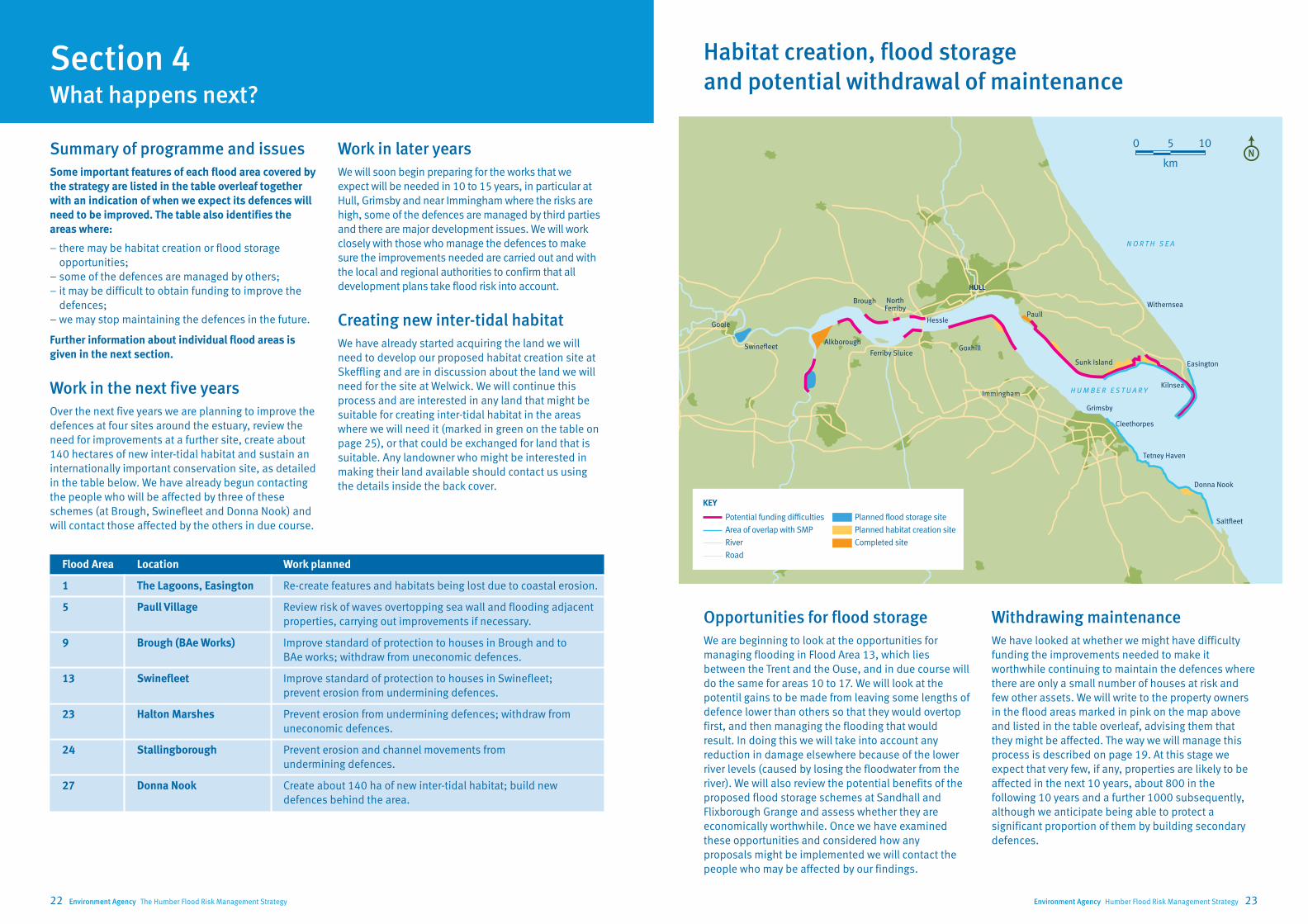
Over the next five years we are planning to improve the
defences at four sites around the estuary, review the
need for improvements at a further site, create about
140 hectares of new inter-tidal habitat and sustain an
internationally important conservation site, as detailed
in the table below. We have already begun contacting
the people who will be affected by three of these
schemes (at Brough, Swinefleet and Donna Nook) and
will contact those affected by the others in due course.
Section 4 What happens next?
Flood Area Location Work planned
1 The Lagoons, Easington Re-create features and habitats being lost due to coastal erosion.
5 Paull Village Review risk of waves overtopping sea wall and flooding adjacent
properties, carrying out improvements if necessary.
9 Brough (BAe Works) Improve standard of protection to houses in Brough and to
BAe works; withdraw from uneconomic defences.
13 Swinefleet Improve standard of protection to houses in Swinefleet;
prevent erosion from undermining defences.
23 Halton Marshes Prevent erosion from undermining defences; withdraw from
uneconomic defences.
24 Stallingborough Prevent erosion and channel movements from
undermining defences.
27 Donna Nook Create about 140 ha of new inter-tidal habitat; build new
defences behind the area.
HULL
Immingham
Grimsby
Withernsea
Easington
Kilnsea
Sunk Island
Cleethorpes
PaullHessle
NorthFerriby
Ferriby SluiceGoxhill
Brough
AlkboroughSwinefleet
Goole
N O R T H S E A
H U M B E R E S T U A R Y
Saltfleet
Donna Nook
Tetney Haven
Work in later years
We will soon begin preparing for the works that we
expect will be needed in 10 to 15 years, in particular at
Hull, Grimsby and near Immingham where the risks are
high, some of the defences are managed by third parties
and there are major development issues. We will work
closely with those who manage the defences to make
sure the improvements needed are carried out and with
the local and regional authorities to confirm that all
development plans take flood risk into account.
Creating new inter-tidal habitat
We have already started acquiring the land we will
need to develop our proposed habitat creation site at
Skeffling and are in discussion about the land we will
need for the site at Welwick. We will continue this
process and are interested in any land that might be
suitable for creating inter-tidal habitat in the areas
where we will need it (marked in green on the table on
page 25), or that could be exchanged for land that is
suitable. Any landowner who might be interested in
making their land available should contact us using
the details inside the back cover.
Opportunities for flood storage
We are beginning to look at the opportunities for
managing flooding in Flood Area 13, which lies
between the Trent and the Ouse, and in due course will
do the same for areas 10 to 17. We will look at the
potentil gains to be made from leaving some lengths of
defence lower than others so that they would overtop
first, and then managing the flooding that would
result. In doing this we will take into account any
reduction in damage elsewhere because of the lower
river levels (caused by losing the floodwater from the
river). We will also review the potential benefits of the
proposed flood storage schemes at Sandhall and
Flixborough Grange and assess whether they are
economically worthwhile. Once we have examined
these opportunities and considered how any
proposals might be implemented we will contact the
people who may be affected by our findings.
Withdrawing maintenance
We have looked at whether we might have difficulty
funding the improvements needed to make it
worthwhile continuing to maintain the defences where
there are only a small number of houses at risk and
few other assets. We will write to the property owners
in the flood areas marked in pink on the map above
and listed in the table overleaf, advising them that
they might be affected. The way we will manage this
process is described on page 19. At this stage we
expect that very few, if any, properties are likely to be
affected in the next 10 years, about 800 in the
following 10 years and a further 1000 subsequently,
although we anticipate being able to protect a
significant proportion of them by building secondary
defences.
Habitat creation, flood storage
and potential withdrawal of maintenance
Potential funding difficulties
Area of overlap with SMP
River
Road
Planned flood storage site
Planned habitat creation site
Completed site
KEY
km
5 100

Environment Agency Humber Flood Risk Management Strategy 2524 Environment Agency The Humber Flood Risk Management Strategy
Key
Habitat creation opportunities (managed realignment)
No suitable land or not needed in this area (unmarked)
Possible if land available ✔
Site already included in Strategy programme ✔
Flood storage opportunities
No suitable land or not needed in this area (unmarked)
Possibly suitable ✔
Probably suitable (includes existing proposals) ✔
Responsibility for managing defences
All defences managed by Environment Agency
Some defences managed by others
Most defences managed by others
All defences managed by others
Other economic assets in flood cell
Limited value (e.g. agricultural land only)
Important value (e.g. major infrastructure etc)
Primary value (e.g. key industrial facilities etc)
Case for improving defences
Probably not difficult to make •
Possibly difficult to make ••
Probably difficult to make •••
Withdrawal warnings (EA defences only)
Environment Agency will not issue warnings None
Warnings may be issued in more than 20 years > 20
Warnings may be issued in 10 to 20 years 10-20
Warnings may be issued in less than 10 years < 10
N.B. Uncertainty about rate of sea level rise means
timings are approximate
Flood Name AreaLength of Estimated Works needed
Habitat FloodCurrently Residential Other Case for Withdrawal Number of
cell (ha)defences residual in years
creation storagemanaged properties economic improving warnings properties
(km) life (years) 1-5 5-15 15-25 by (No) assets defences may be issued affected
1a Kilnsea (Spurn Road) 972.0 (coast)
10-20 9 ••• 10-20 yrs 9
1b Kilnsea (Kilnsea Village) 175.3 (estuary)
< 10 14 ••• None* 14
1c Kilnsea (Easington) 567 10-20 ✔ ✔ ✔ 53 ••• 10-20 yrs# 53
2 Skeffling 411 4.8 10-20 ✔ ✔✔ 10 ••• 10-20 yrs# 10
3 Sunk Island 6,812 11.8 10-20 ✔ ✔ ✔✔ 668 •• 10-20 yrs# 668
4 Stone Creek to Paull Holme 3,300 11.5 10-20 ✔✔ 195 •• None* 195
5a Hull East (Paull Village) 2,61313.2
< 10 ✔ 5,728 •None
5b Hull East (Victoria Dock Village) 12,355 10-20 ✔ 51,356 •
6 Hull West 9,471 8.4 10-20 ✔ 79,974 • None
7 Hessle 35 2.4 < 5 ✔ 24 ••• None* 24
8 North Ferriby 32 3.2 > 20 ✔ 28 •• > 20 yrs# 28
9a Brough (East)389 6.1
< 10 ✔ 0 •••< 10 yrs 0
9b Brough (West) < 10 ✔ 483 •
10 Brough Haven to Weighton Lock 4,259 6.5 < 10 ✔ ✔ 697 • None
11a Saltmarshe (Blacktoft to Yokefleet)14,143 24.4
10-20 ✔ ✔2,821 •† None
11b Saltmarshe (Sandhall) > 20 ✔ ✔ ✔
12 Goole 3,380 8.6 > 20 9,960 • None
13a Goole Fields (Swinefleet) < 10 ✔ ✔ None
13b Goole Fields (Swinefleet to Reedness) 19,626 28.7 10-20 ✔ ✔ 10,654 •† None
13c Crowle (Amcotts to Keadby) > 20 ✔ ✔ None
14 Gunness to Flixborough 1,070 5.9 10-20 ✔ ✔ 2,649 • None
15 Flixborough Grange 365 6.3 > 20 ✔ 7 ••• > 20 yrs# 7
16 Alkborough Flats 427 6.4 > 20 ✔ ✔ Scheme completed in 2006 • None
17 Whitton to Winteringham 636 4.6 10-20 ✔ ✔ 59 ••• 10-20 yrs# 59
18 Winteringham Ings 4,760 4.5 < 10 ✔ ✔ 536 • None
19 South Ferriby 6,170 3.2 > 20 ✔ 1,107 • None
20a Barton Cliff to Barton Haven (West)206 2.9 > 20
10 •• > 20 yrs#
1020b Barton Cliff to Barton Haven (East) 429 • None
21 Barton Haven to Barrow Haven 442 3.3 > 20 ✔ 958 • None
22 Barrow Haven to East Halton Skitter 2,551 10.5 > 20 ✔ ✔✔ 634 •• > 20 yrs# 634
23a Halton Marshes876 7.3
< 10 ✔ ✔ ✔ 0 ••• < 10 yrs 0
23b Killingholme Marshes < 10 ✔ ✔ 26 • None
24 Immingham to River Freshney 3,613 12.6 < 10 ✔ ✔ ✔ 11,687 • None
25 East Grimsby 802 3.9 10-20 ✔ 18,909 • None
26 Cleethorpes and Humberston 1,669 9.2 > 20 ✔ 2,243 • None
27 Tetney to Saltfleet Haven 13,138 17.4 > 20 ✔ ✔ ✔ ✔✔ 2,928 • None
Notes: *No EA defences, so no withdrawal warning. #Further
study may show building secondary defences to protect some
groups of properties is economically worthwhile. †Although all
the defences will continue to be maintained, some of them are
likely to be raised earlier and to a higher standard than others.
ManagementProposals

Environment Agency Humber Flood Risk Management Strategy 2726 Environment Agency The Humber Flood Risk Management Strategy
About 25 of the properties at risk are in Kilnsea but
most of the rest are in Easington, at the edge of the
floodplain. The area is used almost entirely for
agriculture but contains important wildlife habitats,
particularly at Spurn and The Lagoons. The habitats at
The Lagoons are threatened by erosion, which is
causing the coastline to retreat by two to three metres
each year on average. Spurn Peninsula is a Heritage
Coast site and the estuary’s main pilotage and
lifeboat facilities are at Spurn Head.
Existing flood defences
The area is protected by two sets of defences, beside
the estuary and the sea. The sea defences are
threatened by the retreating coastline; those
protecting Kilnsea have recently been replaced and are
expected to last for between 20 and 30 years before
the retreating coastline reaches them, while those
protecting Easington are expected to last for between
30 and 40 years. The estuary defences are expected to
need minor repairs every few years and major
improvement in about 20 years.
Proposed management approach
At present we are continuing to maintain the defences
and are looking at how to provide replacement habitat
Section 5 Proposals for each flood area
for The Lagoons. In the future we will not maintain the
new flood defence embankment built near to the sea at
Kilnsea. We are continuing to maintain the other
defences. Uncertainty about the rate at which sea
levels will rise and the defences deteriorate means we
cannot say exactly when this might happen but
currently we expect it to be in between 10 and 20 years.
We will re-assess the situation each time we review the
strategy and tell all property owners in the area about
the outcome.
Although we may not be able to carry on maintaining
the defences, others may wish to. Provided they can
comply with the Habitats Regulations and obtain the
approvals needed, we will provide all the advice and
information we can to help them. If not, we will look at
building a secondary bank to protect properties in
Easington. Without further study we cannot confirm this
will be possible or say exactly where the bank might be
located. The owners of any property not protected may
wish to consider other options, which in some cases
might include flood-proofing individual houses. Again
we will provide all the advice and information we can.
Key information
Size of flood area 681 ha
Number of properties 76
in floodplain
Area of agricultural land 597 ha
Length of defences (a) sea 2.0 km
(b) estuary 5.3 km
Current standard of protection Varies, minimum
20 % (1 in 5)
Remaining life of defence Varies, generally
10 to 40 years
Defences managed by Environment
Agency, apart from
new sea defences
at Kilnsea which
are managed by
the villagers
H U M B E R E S T U A R Y
N O R T H S E A
Spurn Peninsula
Skeffling
Easington
Kilnsea
The Lagoons
Flood area boundary
Flood defence line
Floodable area
Urban area
Urban area in floodplain
Road
Lagoons SSSI
Planned habitat creation site
KEYkm
1 20
Most of the properties at risk are in Weeton (at the
edge of the floodplain), there are none in Skeffling
itself. The area contains farms and high-grade
agricultural land and is drained to the estuary, either
by gravity or by being pumped. A large part of the area
has been identified as suitable for creating the new
inter-tidal habitat we will need to replace the losses
caused by our flood defence improvements and sea
level rise. We have already bought some of the land
and plan to buy more so we can develop the site
between 2010 and 2020.
Existing flood defences
The defences are generally in good condition. They are
expected to need minor repairs every few years and
major improvement in about 20 years.
Proposed management approach
At present we are continuing to maintain the existing
defences. However, in the future the relatively small
number of properties at risk means that we could find
it difficult to justify spending public money on the
existing defences and so may have to withdraw from
them. Uncertainty about the rate at which sea levels
will rise and the defences deteriorate means we
cannot say exactly when this might happen but
currently expect it to be in between 10 and 20 years.
We will re-assess the situation each time we review the
strategy and tell all property owners in the area about
the outcome.
Flood area 2 – Skeffling
Withdrawing from the existing defences will not affect
properties behind the habitat creation site, as this will
include new defences to protect them. The defences
either side of the site will not be improved, however, so
once we withdraw they will deteriorate and in due course
fail. Although we may not be able to carry on maintaining
the existing defences, others may wish to. Provided they
comply with the Habitats Regulations and can obtain the
approvals needed, we will provide all the advice and
information we can to help them. The owners of any
property not protected may wish to consider other
options, which in some cases could include flood-
proofing individual houses. Again we will provide all the
advice and information we can.
Key information
Size of flood area 411 ha
Number of properties 10
in floodplain
Area of agricultural land 403 ha
Length of defences 4.8 km
Current standard of Varies, generally about
protection 5% (1 in 20) but 50%
(1 in 2) locally
Remaining life of Varies, generally 10 to
defence 20 years
Defences managed by Environment Agency
H U M B E R E S T U A R Y
Welwick
Patrington Haven
Weeton
Skeffling
Flood area boundary
Flood defence line
Floodable area
Road
Associated British Ports completed habitat creation site
Planned habitat creation site
KEYkm
0.5 10
Flood area 1 – Easington and Kilnsea

Environment Agency Humber Flood Risk Management Strategy 2928 Environment Agency The Humber Flood Risk Management Strategy
Most of the properties are at the edge of the floodplain,
in the villages of Keyingham, Ottringham, Patrington or
Patrington Haven. It contains scattered farms and high-
grade agricultural land. The land is drained to the
estuary by a system of ditches leading either to the
Winestead Drain (which is pumped) or to Keyingham
Drain (which flows by gravity). Although this and the
neighbouring area of Stone Creek to Paull Holme Strays
(Flood Area 4) are separated by Keyingham Drain,
flooding in one can affect the other. Therefore the two
areas should be considered together.
Associated British Ports has created a new inter-tidal
habitat at a site near Welwick to compensate for losses
due to their development at Immingham. We have
identified land behind this site for creating the inter-
tidal habitat we will need to replace the losses caused
by our flood defence improvements and sea level rise.
We plan to develop it after 2020.
Existing flood defences
Some work is needed to protect the defences against
erosion and this will probably need to be repeated
every few years. Major improvements are likely to be
needed in 20 to 30 years.
Flood area 3 – Sunk Island (Winestead Drain to Stone Creek)
Proposed management approach
Currently, the banks in this part of the estuary are
mostly owned by the Crown. It will become increasingly
expensive to maintain the existing defences in the
future as sea levels rise and at some point the owners
may decide it is not worthwhile carrying on. We think
this is unlikely to be within the next 20 years.
If maintenance is withdrawn from the existing
defences, we will look at building secondary banks to
protect the villages at the edge of the floodplain.
Without further study we cannot confirm this is
possible or say exactly where the banks might be
located. The owners of any property not protected may
wish to consider other options, which in some cases
might include flood-proofing individual houses. We will
provide all the advice and information we can to help.
Key information
Size of flood area 6812 ha
Number of properties 668
in floodplain
Area of agricultural land 6733 ha
Length of defences 11.8 km
Current standard of Varies, generally about
protection 10% (1 in 10) or better
but 50% (1 in 2) locally
Remaining life of Varies, generally 10 to 20
defence years
Defences managed by Mostly Crown Estate but
also Associated British
Ports, Environment Agency
completed habitat creation site
completed habitat creation site
H U M B E R E S T U A R Y
N O R T H
S E A
Hedon
ThorngumbaldCamerton
Paull HolmeStrays Ryehill
Keyingham
Ottringham
Patrington
PatringtonHaven
Sunk Island
Stone Creek
Hawkins PointImmingham Docks
Immingham
KillingholmeMarshes
Welwick
Withernsea
Weeton
Skeffling
Roos Drain
Bur
s twic
kD
rain
Ke
yinghamD
rain
North ChannelWinestead Drain
Flood area boundary
Flood defence line
Floodable area
Urban area
Urban area in floodplain
Power line
Railway line
Road
River
Associated British Ports completed habitat creation site
Completed habitat creation site
Planned habitat creation site
KEYkm
2 40
Most of the properties at risk are at the edge of the
floodplain, in the villages of Ryehill or Camerton
(Thorngumbald, the village next door, is in Flood
Area 5). It contains scattered farms and high-grade
agricultural land. The land is drained to the estuary
by a system of ditches leading to Keyingham Drain.
Although this and the neighbouring area of Sunk
Island (Flood Area 3) are separated by Keyingham
drain, flooding in one can affect the other. Therefore
the two areas should be considered together.
In 2004 we completed a scheme at Paull Holme Strays
that created new inter-tidal habitat to replace the
losses due to flood defence improvements and sea
level rise. We have identified another site near
Keyingham as suitable for creating additional habitat
but are unlikely to develop it until after 2030.
Existing flood defences
The defences are generally in good condition. Major
improvements are likely to be needed in 40 years or so.
Proposed management approach
We have looked at the costs and benefits of continuing
to maintain the existing defences in the future and
concluded that this will become increasingly
expensive as sea levels rise. In the long term those
responsible may decide it is not worthwhile carrying
Flood area 4 – Stone Creek to Paull Holme Strays
on. Uncertainty about the rate at which sea levels will
rise and the defences deteriorate means we cannot say
when this might happen, although we think it is
unlikely to be within the next 20 years. We will re-
assess the situation when we review the strategy and
keep in touch with those responsible for the defences.
If maintenance is withdrawn from the existing
defences, we will look at building secondary banks to
protect the villages at the edge of the floodplain.
Without further study we cannot confirm this will be
possible or say exactly where the banks might be
located. The owners of any property not protected may
wish to consider other options, which in some cases
might include flood-proofing individual houses. We will
provide all the advice and information we can to help.
Key information
Size of flood area 3300 ha
Number of properties 195
in floodplain
Area of agricultural land 3268 ha
Length of defences 11.5 km
Current standard of About 12.5% (1 in 80) or
protection better
Remaining life of Varies, generally 10 to 20
defence years
Defences managed by Environment Agency
responsible for defences
at Paull Holme Strays,
other defences managed
by Crown Estate
H U M B E R E S T U A R Y
N O R T H
S E A
Hedon
Thorngumbald Camerton
Paull HolmeStrays
RyehillKeyingham
Ottringham
Patrington
PatringtonHaven
Sunk IslandStone Creek
Hawkins PointImmingham Docks
Imminngham
KillingholmeMarshes
Welwick
Withernsea
Weeton
Roos Drain
Bur
s twic
kD
rain
Ke
yinghamD
rain
North ChannelWinestead Drain
Flood area boundary
Flood defence line
Floodable area
200 year floodplain in 2055
Urban area
Urban area in floodplain
Power line
Railway line
Road
Rivers
Associated British Ports completed habitat creation site
Completed habitat creation site
Planned habitat creation site
KEYkm
2 40

Environment Agency Humber Flood Risk Management Strategy 3130 Environment Agency The Humber Flood Risk Management Strategy
Most of the properties at risk are in Hull, although there
is a significant number in the smaller communities east
of the city including Hedon, Burstwick, Thorngumbald
and Paull. The area also contains major industrial and
commercial facilities, including petro-chemical and
port-related developments. Surface water is drained by
a combination of sewers (mostly managed by Yorkshire
Water) and open channels, all of which flow or are
pumped to the estuary. An independent review of these
arrangements has been carried out following the
extensive flooding in June 2007. Hull City Council has
prepared a Strategic Flood Risk Assessment to inform
their planning decisions and the future development of
the city.
Existing flood defences
The estuary defences are in good condition. We are
reviewing the standard provided at the Victoria Dock
development and may improve the defences there in
the next 10 years if necessary. We are also looking at
the Paull defences, in particular how to manage the
large volumes of spray from waves that can occur
during severe storms.
The city of Hull is also at risk of flooding from the River
Hull and from surface water overwhelming the
drainage system. We are developing a separate
strategy for the River Hull defences that takes into
account the crucial role of the Hull Barrier and are
working closely with the other relevant authorities to
develop effective approaches for dealing with the
complex flooding issues in the city.
Flood area 5 – Hull East (including Paull Village)
Proposed management approach
We will continue to protect this area and will work with
the local and regional authorities, property owners and
developers to make sure flood risk is taken into
account at all stages of the planning process. The
defences will need to be improved as sea levels rise.
This will be expensive so we will seek to supplement
public funds with contributions from major
beneficiaries and from developers, who will be
expected to pay the full cost of any new works needed
to protect their development.
Key information
Size of flood area 14,968 ha
Number of properties 57,084
in floodplain
Area of agricultural land 9,328 ha
Length of defences 13.2 km
Current standard of Hull, 0.5% (1 in 200) or
protection better. Paull, 1% (1 in 100)
Remaining life of 10 to 20 years
defence
Defences managed by Mixed; Hull City Council,
Associated British Ports
and Environment Agency
Beverley
Cottingham
Hessle Haven
Paull
Salt End
Hedon
KeyinghamThorngumbald
Hull
Holderness Drain
Keyi
ngha
m D
rain
Roos Drain
Burstwick Drain
River Hull
H U M B E R E S T U A R Y
N O R T H
S E A
Docks
Docks
Hull Barrier
Flood area boundary
Flood defence line
Floodable area
Urban area
Urban area in floodplain
Power line
Railway line
Road
River
Completed habitat creation site
Planned habitat creation site
KEYkm
2 40
The properties at risk are in Hull and further inland
(e.g. at Beverley). The area also contains major
infrastructure, industrial and commercial facilities.
Surface water is drained by a combination of sewers
(mostly managed by Yorkshire Water) and open
channels, all of which flow or are pumped to the
estuary. An independent review of these arrangements
has been carried out following the extensive flooding
in June 2007. Hull City Council has prepared a Strategic
Flood Risk Assessment to inform their planning
decisions and the future development of the city.
Existing flood defences
The estuary defences are generally in good condition
and provide a good standard of protection, except
from the Hull Barrier to Victoria Pier and from Albert
Dock to St Andrews Quay, where the standard needs to
be improved.
The area is also at risk of flooding from the River Hull
and from surface water that overwhelms the drainage
system. We are developing a separate strategy for the
River Hull defences that takes into account the crucial
role of the Hull Barrier and are working closely with the
other relevant authorities to develop effective
approaches for dealing with the complex flooding
issues in the city.
Flood area 6 – Hull West (Hull Barrier to Hessle Haven)
Proposed management approach
We will continue to protect this area and will work with
the local and regional authorities, property owners and
developers to make sure flood risk is taken into
account at all stages of the planning process. The
improvements needed to the defences will be
expensive so we will seek to supplement public funds
with contributions from major beneficiaries and from
developers, who will be expected to pay the full cost of
any new works needed to protect their development.
Key information
Size of flood area 9,471 ha
Number of properties 79,974
in floodplain
Area of agricultural land 5,191 ha
Length of defences 8.4 km
Current standard of Generally 0.5% (1 in 200)
protection but locally 5% (1 in 20)
Remaining life of Generally 10 to 20 years,
defence locally 5 years
Defences managed by Mixed; Hull City Council,
Associated British Ports
and Environment Agency
Beverley
Cottingham
HessleNorth Ferriby
DocksDocks
Paull
Salt EndHull
Ho
ldern
ess Drain
Stream Dyke
Beverley and B
armston D
rain
River Hull
H U M B E R E S T U A R Y
Flood area boundary
Flood defence line
Floodable area
Urban area
Urban area in floodplain
Power line
Railway line
Road
River
Completed habitat creation site
Planned habitat creation site
KEYkm
2 40

Environment Agency Humber Flood Risk Management Strategy 3332 Environment Agency The Humber Flood Risk Management Strategy
Clive Sullivan Way separates this small area from the
main part of Hessle and Hull (which is included in
Flood Area 6). As well as residential properties, it
contains recreational areas and some commercial and
industrial premises. Surface water is drained by a
combination of sewers (mostly managed by Yorkshire
Water) and open channels, all of which flow or are
pumped to the estuary.
Existing flood defences
The defences are generally in a poor condition and
provide a low standard of protection. The shoreline is
being worn away by tides and waves in places, which
in time will threaten some of the defences.
Proposed management approach
We expect that continuing to maintain these defences
in the future will become increasingly expensive as sea
levels rise. In the long term those responsible may
decide it is not worthwhile carrying on. Other ways of
managing the flood risk may need to be considered. We
will review the situation regularly and keep in touch
with those responsible for the defences.
Flood area 7 – Hessle Frontage (Hessle Haven To Hessle Country Park Hotel)
Key information
Size of flood area 35 ha
Number of properties 24
in floodplain
Area of agricultural land 8 ha
Length of defences 7.4 km
Current standard of Varies, locally 20%
protection (1 in 5) or less
Remaining life of Varies, locally 5 years
defence
Defences managed by East Riding of Yorkshire
and others
Hessle
Hessle Haven
Chowder Ness Far Ings Nature Reserve
Humber BridgeH U M B E R E S T U A R Y
Flood area boundary
Flood defence line
Floodable area
Urban area
Urban area in floodplain
Power line
Railway line
Road
Associated British Ports completed habitat creation site
KEYkm
0.5 10
The area is mainly residential, although there is some
farmland and a old landfill site at the eastern end. The
edge of this site is being eroded by tides and waves,
which could release contaminants into the estuary.
Part of the main railway to Hull is on the edge of the
area but is above the level of flood risk.
Existing flood defences
There are two lines of flood defences protecting this
area both of which are in reasonable condition and
provide a good standard of protection.
Proposed management approach
At present we are continuing to maintain the defence
along the edge of the estuary. As sea levels rise we
may find it difficult to justify spending public money
doing this, in which case we may have to withdraw.
Before doing so we will consider other options for
protecting the area. Uncertainty about the rate at
which sea levels will rise and the defences deteriorate
means we cannot say when this might happen,
although we think it is unlikely to be within the next 20
years. We will re-assess the situation each time we
review the strategy and tell all property owners in the
area about the outcome.
We are reviewing the risk of allowing the erosion of the
landfill site to continue. Any work needed as a result
will be separate from the flood defence strategy.
Flood area 8 – North Ferriby
Key information
Size of flood area 32 ha
Number of properties 28
in floodplain
Area of agricultural land 8 ha
Length of defences 3.2 km
Current standard of Generally 1% (1 in 100) or
protection better, locally 20 % (1 in 5)
Remaining life of 10 to 20 years
defence
Defences managed by Environment Agency
North Ferriby
H U M B E R E S T U A R Y
Flood area boundary
Flood defence line
Floodable area
Urban area
Urban area in floodplain
Railway line
Road
KEY metres
250 5000