planning commission -...
TRANSCRIPT

MEETING DATE June 22, 2017 LOCAL EFFECTIV E DATE July 6, 2017 APPROX. FINAL EFFECTIVE DATE July 27, 2017
CONTACT/PHONE Airlin M. Singewald, Senior Planner / [email protected] (805) 781-5198
APPLICANT Cayucos Sanitary District
FILE NO.
DRC2016-00063
SUBJECT Hearing to consider a request by the Cayucos Sanitary District for a Conditional Use Permit and Development Plan / Coastal Development Permit for the Cayucos Sustainable Water Facility (CSWP). The proposed CSWP consists of: 1) a Water Resource Recovery Facility (WRRF), solar array, and landscaping in an approximately 8-acre development area; and 2) related pipelines and conveyance infrastructure. The Proposed Project would have an annual average daily flow (AADF) capacity of 0.30 and 0.40 million gallons per day (MGD) serving the existing and build-out population in Cayucos, and would produce tertiary treated water to be made available for agriculture. The Proposed Project would result in approximately 9.7 acres of site disturbance in the unincorporated areas of the county. The proposed WRRF is located on Toro Creek Road, approximately 0.75 mile inland of State Route 1, and the new pipelines and conveyance infrastructure would be located in the County right-of-way for Toro Creek Road. The site is in the Estero and North County (Adelaida sub-area) planning areas. RECOMMENDED ACTION Staff recommends the Planning Commission take the following actions in this order:
1. Consider and rely on the Final Environmental Impact Report, including the Mitigation Monitoring and Reporting Program, previously certified on April 20, 2017 by the Cayucos Sanitary District.
2. Approve Conditional Use Permit and Development Plan / Coastal Development Permit DRC2016-00063 based on the findings in Exhibit A and Exhibit B and conditions of approval in Exhibit D.
ENVIRONMENTAL DETERMINATION The County, as a Responsible Agency, finds that the Final Environmental Impact Report (FEIR) previously certified by the Cayucos Sanitary District Board of Directors on April 20, 2017, is adequate for the purposes of the County's compliance with CEQA (pursuant to Public Resources Code Section 21000 et seq., and CA Code of Regulations Section 15000 et seq.) for this project. The County also finds that no substantial changes are proposed in the project which will require major revision of the previously certified FEIR, no substantial changes have occurred with respect to the circumstances under which the project is undertaken which will require major revision of the previously certified FEIR, and no new information of substantial importance has been identified which was not known at the time that the previous FEIR was certified. Mitigation measures are proposed to reduce potentially significant impacts to a less than significant level as related to agriculture, air quality, biological resources, cultural resources, drainage, geology, growth-inducing effects, hazards and hazardous materials, noise, traffic, and visual resources. The Cayucos Sanitary District adopted overriding considerations based on significant and unavoidable impacts associated with Agricultural Resources, Geology (Tsunami Inundation), and Noise (construction-related) for all elements of the project (including components in the City of Morro Bay). For elements of the project in the unincorporated areas (County jurisdiction), overriding considerations are proposed for significant and unavoidable impacts associated with Agricultural Resources.
COUNTY OF SAN LUIS OBISPO DEPARTMENT OF PLANNING AND BUILDING
STAFF REPORT
PLANNING COMMISSION Promoting the Wise Use of Land Helping to Build Great Communities

Planning Commission Cayucos Sanitary District CUP and DP/CDP DRC2016-00063 Page 2
LAND USE CATEGORY Agriculture
COMBINING DESIGNATION Geologic Study Area; Flood Hazard
ASSESSOR PARCEL NUMBER 073-077-035 and 073-092-056
SUPERVISOR DISTRICT(S)
2
PLANNING AREA STANDARDS: Adelaida and Estero Planning Area (compliance is discussed in the “Ordinance Compliance/Land Use Consistency” section, below) EXISTING USES:
Grazing land, fallowed crops, right-of-way SURROUNDING LAND USE CATEGORIES AND USES: North: Agriculture/ rural residence, grazing land East: Agriculture / grazing South: Agriculture/ grazing land West: Agriculture/ dry farming OTHER AGENCY / ADVISORY GROUP INVOLVEMENT: The Proposed Project was referred to: Environmental Health, Agricultural Commissioner, Public Works, Cal Fire, Caltrans, Regional Water Quality Control Broad, Air Pollution Control District, Building Division, California Department of Fish and Wildlife, U.S. Fish and Wildlife Service, Northern Chumash Council, Salinan Tribe of San Luis Obispo and Monterey Counties, and the Cayucos Citizens Advisory Council TOPOGRAPHY:
Nearly level VEGETATION:
Fallowed crops, non-native grasslands PROPOSED SERVICES:
Water: Cayucos Sanitary District Sewage Disposal: Cayucos Sanitary District Fire Protection: Cal Fire
ACCEPTANCE DATE: April 20, 2017
SUMMARY The Proposed Project consists of two main components: 1) a new Water Resource Recovery Facility (WRRF), and 2) two new pipelines along Toro Creek Road connecting the WRRF to the CSD’s existing conveyance infrastructure. The new pipelines would tie into the existing infrastructure at Lift Station 5, which is located in the Morro Bay city-limits on the southeast corner of State Route 1 and Toro Creek Road. The WWRF is located in the Inland portion of the county (i.e. outside of the Coastal Zone) and requires a Conditional Use Permit. An approximately half-mile segment of the new pipelines is located in the Coastal Zone and requires a Development Plan / Coastal Development Permit. See Figure 1, below.
The Proposed Project site is located in the Toro Creek Valley on Toro Creek Road approximately 0.75 miles inland from State Route 1 between Cayucos and Morro Bay. The site consists of two lots totaling 221 acres: APN 073-092-034 is 76 acres and APN 073-092-050 is 145 acres.
The CSD’s Environmental Impact Report for the project also describes a new pipeline that would deliver recycled water from the WRRF to the CSA 10 Water Treatment Facility on Cabrillo Street in Cayucos. Since current regulations do not allow for direct potable reuse of recycled water and since the CSD is not a water purveyor, this second phase of the project would have to be implemented in the future by one of the community water purveyors and is not included in the Proposed Project. Additionally, the proposed pipeline to deliver treated wastewater from the Toro Creek Road/ State Route 1 intersection to the existing ocean outfall in the City of Morro Bay is located entirely within the City jurisdiction and is not part of the Proposed Project evaluated in this land use permit.

Planning Commission Cayucos Sanitary District CUP and DP/CDP DRC2016-00063 Page 3
Table 1, below, shows the amount of site disturbance for each project component in the unincorporated area (Inland and Coastal Zone) and the City of Morro Bay (not part of this permit). Table 1: Cayucos Sustainable Water Facility (Phase 1) Site Disturbance Component Inland (unincorp.) Coastal Zone (unincorp.) Morro Bay (city limits)2
WRRF 5.60 acres 0 0 Solar Array1 3.00 acres 0 0 Conveyance Infrastructure
0.45 acres / 1,800 linear feet
0.65 acres / 1,630 linear ft. 0.02 acres / 320 linear ft.
Total 9.05 acres 0.65 acres / 1,630 linear ft. 0.02 acres / 320 linear ft. 1Solar array will be constructed in a subsequent phase to the WRRF; however, the proposed location of the Solar Array will be used for staging during the construction of the WRRF. 2Outside County jurisdiction; not covered by this permit.
Figure 1: Project Overview
BACKGROUND Sewage generated in Cayucos is currently conveyed to and treated at the shared Morro Bay Cayucos Sanitary District Wastewater Treatment Plant (MBCSD WWTP), located in the City of Morro Bay, about 3 miles south of Cayucos. This existing treatment plant was constructed in 1954 under a joint powers agreement between the CSD and Morro Bay Sanitary District (now the City of Morro Bay). The MBCSD WWTP was expanded and reconstructed in 1964 and again in 1984. The CSD and the City of Morro Bay worked collaboratively to upgrade the treatment processes and improve the discharged water quality at the shared MBCSD WWTP for nearly a decade. The
Planning Commission Cayucos Sanitary District CUP and DP/CDP DRC2016-00063 Page 4
purpose of the proposed upgrade to the MBCSD WWTP was to improve discharged water quality to at least full secondary treatment and eliminating the need for the Clean Water Act section 301(h) modified discharge permit based on a Settlement Agreement with the Central Coast Regional Water Quality Control Board (RWQCB). The 2005 Settlement Agreement provided a nine and one half year timeline for the completion of the upgrade at the MBCSD WWTP. At their January 10, 2013 meeting, the California Coastal Commission determined that upgrading and maintaining wastewater facilities at the location of the existing MBCSD WWTP would be inconsistent with the Coastal Act. Since upgrading the existing MBCSD WWTP was no longer a viable option, the District Board determined at its April 30, 2015 meeting that the best way to secure the community’s water future was the pursuit of a standalone WRRF by developing the proposed CWSF. The mission of the CWSF is to deliver a sustainable and cost effective water resource recovery system for the community of Cayucos within the streamlined schedule necessitated by the status of the current MBCSD WWTP National Pollution Discharge Elimination System (NPDES) permit and the RWQCB Settlement Agreement. The project site was selected by the District Board of Directors from five candidate sites as superior in meeting the project objectives and for environmental sustainability.
PROPOSED PROJECT Water Resource Recovery Facility The proposed Water Resource Recovery Facility (or “wastewater treatment facility”) would be located on the south side of Toro Creek Road, about 0.75-mile inland of State Route 1, outside of the Coastal Zone. The WRRF consists of approximately 45,021 square feet of building floor area, an equalization basin, a 3-acre solar array, landscaping, and related facilities in an 8 acre development area. The project, which is designed to serve the existing and build-out population in Cayucos, would have an annual average daily flow (AADF) capacity of 0.30 and 0.40 million gallons per day (MGD).
In addition to treatment process infrastructure, the WRRF site will include supporting facilities necessary to operate, maintain, secure and preserve the site, including emergency back-up power supply, security fence, domestic and non-potable (recycled water storage tanks), office buildings, landscape screening, stormwater conveyances and a spill containment basin.
Tertiary Treated Water for Agricultural Irrigation The influent will be treated to disinfected tertiary standards, with a portion available for recycled water irrigation on nearby agricultural lands, and remaining treated effluent discharged to the existing ocean outfall in Morro Bay.
Infrastructure Required Recycled Water pump station at the treatment plant location requires 6,800 KWh/year for pumping.
The details of the pipeline to irrigation customers within Toro Creek Valley is not known at this time. Therefore the pipeline infrastructure will extend only to the boundary of the facility until such time as the route for the conveyance pipeline is determined. On-site storage facility for irrigation water storage will be a tank or pond at approximately 300,000 gallons.

Planning Commission Cayucos Sanitary District CUP and DP/CDP DRC2016-00063 Page 5
Storage of Materials Chemicals will be added throughout the wastewater treatment process to provide an alkalinity source, control odors, improve sludge conditioning, disinfect the water, and clean the MBR membranes.
The secondary treatment process will require chemicals to adjust the water chemistry and chemicals to clean the MBRs. Alkalinity chemicals such as sodium hydroxide or magnesium hydroxide will be used during daily operations to stabilize the pH in the aeration tanks of the secondary treatment process. The alkalinity chemical will be stored in two identical double-walled tanks and delivered to the aeration basins through a peristaltic pump system. Citric acid, Sodium hypochlorite, Sodium Hydroxide or similar cleaning chemicals will be used intermittently to perform preventive maintenance cleanings on the MBR units by removing organic and inorganic matter. Similarly, these chemicals would be stored in a chemical drum or a double walled plastic tote when it is not in use.
The CSD currently adds calcium ammonium nitrate (CAN-17) to their terminal lift station to control odors from the raw influent wastewater and the use of CAN-17 at Lift Station 5 is expected to continue. CAN-17 is currently stored at Lift Station 5 in a 55-gallon drum. With the Proposed Project the need for CAN-17 treatment will likely not be necessary, but if continued it would not be a change in the baseline condition. The on-site solids handling processes will require a water-soluble polymer to be used as a flocculant for conditioning of the sludge stream. Polymers are delivered in double-walled plastic totes from the manufacturer and will be stored inside a building in close proximity to the sludge thickening and dewatering equipment. Polymers are introduced to the solids handling process through a metering pump.
The disinfection process associated with Phase 1 of project construction will include sodium hypochlorite for chlorine disinfection and sodium bisulfite for de-chlorination. Both of these chemicals will be stored outdoors under a shade structure in double-walled plastic tanks. These chemicals would be introduced to the disinfection process continuously through a peristaltic pump system. In Phase 2 of the CSWP, the disinfection processes will be upgraded to advanced oxidation and disinfection which requires hydrogen peroxide for oxidation of pathogens
Risks associated with handling these chemicals will be managed by using concrete secondary containment structures at chemical storage locations, providing adequate access and egress space for chemical delivery trucks, developing hazardous material business response plans, and installing eye-wash and shower stations at each chemical storage and feed location.
Disposal of Biosolids The biosolids produced at the new treatment facility would be considered CFR 40 Part 503 Sub-Class B biosolids. The biosolids will be transported to private composting in Santa Barbara or Kern County for beneficial reuse. Alternatively, the biosolids will be transported to Kettleman Hills or McKittrick Landfill for disposal. The volume of biosolids exported from the WRRF would be less than two 10 cubic yard capacity trucks per week.
Effluent to Existing Outfall (Outside of County jurisdiction) Discharge Permit Status: The existing WWTF outfall operates under a NPDES permit originally issued for a five year term in 2009 (CRWQCB Central Coast Region order # R3-2008-0065, NPDES No. CA0047881). This permit expired in 2014 and the RWQCB has placed the renewal application for the permit on administrative hold while the City and CSD pursue plans for new facilities.

Planning Commission Cayucos Sanitary District CUP and DP/CDP DRC2016-00063 Page 6
Daily discharge Volume: During wet periods or when there is no demand for tertiary treated recycled water, the average annual daily flow (AADF) will be discharged to the outfall. This is anticipated to be approximately 350 AFY. With production of recycled water for the tertiary irrigation, the estimated anticipated discharge to the outfall will be approximately 270 AFY. At the time that community water purveyors determine recycled water is advantageous to be developed as a water source, the estimated anticipated discharge to the outfall will be reduced to approximately 75 AFY. Water quality: Water will be treated to disinfected tertiary standards and will meet anticipated NPDES Permit discharge limitation listed in the table below.
Table 2: Water Quality Parameters Parameter BOD TSS Average Monthly (mg/L) 30 30 Average Weekly (mg/L) 45 45 30-Day Average Percent Removal (%) > 85% > 85% Instantaneous Maximum (mg/L) 50 50 30-Day Average Percent Removal (%) 85 85
RO Discharge Disposal: Daily discharge of RO production water will be blended with tertiary treated effluent discharge. Anticipated discharge to the outfall will be 49 acre-feet per year. Discharge from the RO membrane is anticipated to meet future Ocean Plan amendment requirements and RQWCB discharge permit requirements. Increased Total Dissolved Solids (TDS)/salt concentrations in the brine stream would still be far below seawater concentrations.
Collection and Conveyance Infrastructure The proposed WRRF is located south of Cayucos and, for the most part, would rely on existing collection and conveyance infrastructure that currently transports sewage to the shared Morro Bay and Cayucos treatment plant. The only new pipelines needed in the County jurisdiction include the influent line from a lift station at State Route 1 and Toro Creek Road to the WRRF and a new line sending treated wastewater back to the lift station. Both lines would run parallel to each other along Toro Creek Road in the County right-of-way.
All other wastewater conveyance infrastructure (from Toro Creek Road to the ocean outfall in Morro Bay) would be located in the City jurisdiction and is not covered by this permit. Treated wastewater would be conveyed to the south in an existing force main to the intersection of Island Street and Main Street where a new force main or modifications to the existing gravity pipeline would be constructed from that point down Main Street to Highway 41/ Atascadero Road to the existing Morro Bay Cayucos treatment plant.
Also not part of this permit, Phase 2 of the project would construct a pipeline from the WRRF to the CSA 10 Water Treatment Facility on Cabrillo Street in Cayucos. At some point in the future when direct potable reuse regulations are established and an additional water source is determined by the community water purveyors as advantageous, such as for a drought buffer, advanced treated water will be conveyed to the CSA 10 Water Treatment Facility on Cabrillo Street in Cayucos. The routes would run west on Toro Creek Road then north along SR 1 in the CSD easement in the right
Planning Commission Cayucos Sanitary District CUP and DP/CDP DRC2016-00063 Page 7
of way to Chaney Street. The pipeline will then run along Ocean Boulevard, past the cemetery on Cabrillo Avenue, crossing the existing footbridge over Old Creek to the CSA 10 site. The pipeline will be capped at that location.
ENVIRONMENTAL IMPACT REPORT (EIR) As the Lead Agency under CEQA, the CSD prepared an EIR for the Cayucos Sustainable Water Project. Lead Agency is defined as the agency that would carry out, or implement the proposed project even if the project is in the jurisdiction of another public agency. The County is considered a Responsible Agency, which is defined under CEQA as another agency with permitting authority over a project.
The CSD certified the Final EIR (FEIR) for the Cayucos CSWP on April 20, 2017. The CSD’s EIR for the Proposed Project consists of two volumes: 1) the Draft EIR, which evaluates the project’s environmental impacts and identifies alternatives and mitigation measures to reduce impacts to the greatest extent feasible; and 2) the Final EIR which includes responses to comments received on the Draft EIR during the 45-day public review period as well as resulting changes to the text of Draft EIR. The Draft EIR identified significant and unavoidable (Class I) impacts resulting from construction noise (temporary), risk of infrastructure damage due to tsunami inundation, and loss of prime agricultural soils converted to other uses. Of these Class I impacts, only the loss of prime agricultural land would result from elements of the project in the unincorporated area. The Class I impacts regarding tsunami inundation and construction noise relate to the proposed conveyance infrastructure in the City of Morro Bay. The proposed pipelines along Toro Creek Road and the WRRF are located far from sensitive noise receptors and outside of the tsunami inundation zone. The Draft EIR was circulated for public review in January 2017 with the 45-day public comment period ending on March 29, 2017. The CSD received six comment letters from the following entities:
• Northern Chumash Tribal Council
• County of San Luis Obispo Department of Planning and Building
• County of San Luis Obispo Department of Public Works
• County of San Luis Obispo Air Pollution Control District • Caltrans
• The City of Morro Bay Community Development Department
The CSD made several revisions to the Draft EIR in response to these comment letters. The most significant revision was a change in the project description to directionally bore pipelines for approximately 800 feet under Toro Creek and an archaeological site, rather than constructing a pipeline bridge over Toro Creek. This change avoids impacts to biological and archaeological resources and is consistent with Local Coastal Plan (LCP) policies and standards because it is the least environmentally damaging alternative for installing pipelines to the proposed treatment plant. Other revisions made in response to public comment on the Draft EIR include:
• Additional clarifying text was added to DEIR section IV-L Land Use and Planning to detail consistency with the City of Morro Bay General Plan and Local Coastal Plan. More detail has been added to the discussion of the CEQA required “No Project” alternative.

Planning Commission Cayucos Sanitary District CUP and DP/CDP DRC2016-00063 Page 8
• The County Public Works Department requested adding mitigation measure TR-2 to further ensure no significant impacts to the condition and safety of public roads during, and as a result of, construction identified in Impact TR-1. This added measure is not in response to a new impact.
For each environmental issue area, the FEIR analyzes the impacts of the Proposed Project on Toro Creek Road as well as an “Alternative Site” about 1.2 miles east of Cayucos between Old Creek Road and Montecito Road, adjacent to Willow Creek. The analysis in this staff report is for the Proposed Project only because it is the project the CSD is pursuing and what is described in the Conditional Use Permit application.
Environmental Issues The most noteworthy environmental impacts associated with the Proposed Project include:
Agriculture The CSD would develop the proposed WRRF and solar array on approximately 8 acres of a 221 acre agricultural property and would lease the remainder of the acreage for farming. While the land is currently fallow, it has supported a variety of agricultural operations over the years, including grazing, dry farming and irrigated cultivation.
The proposed site plan includes adequate on-site buffers between the proposed WRRF and adjacent agricultural operations. To the south are grazing lands which will be separated from the developed area of the site by a fence and drainage swale; the solar array will be approximately 120 feet from the southern property boundary. There are about 67 acres of prime agricultural soils on the north side of Toro Creek Road currently owned by the CSD which will be separated from the WRRF by the road right-of-way, a landscaped area and driveway. The closest WWRF facilities will be about 110 feet from the farmland to the north. The site plan was reviewed by the Agricultural Commissioner’s office and was determined to be consistent with County Agricultural Buffer Policies and Procedures.
Construction of the proposed WRRF and solar array would result in the direct loss of 8 acres of prime farmland; the temporary loss of 3 acres of prime farmland for a construction staging area; and industrial / agricultural land use conflicts.
The CSD would be required to mitigate the permanent loss of 8 acres of prime farmland by recording a conservation easement or similar mechanism to permanently conserve similarly agricultural land at a ratio of 2:1. However, this impact would remain significant and unavoidable, since the project would result in the permanent loss of prime farmland. The temporary loss of agricultural land for a construction staging area is not considered a significant impact.
The Proposed Project would introduce an industrial land use to an agricultural area, potentially burdening local agricultural operations. The dust, noise, odor, chemicals, and machinery, and hours of operation associated with agricultural operations may be perceived as a minor nuisance to employees at the WRRF. This could give rise to complaints and lead to an increase in public support for the conversion of surrounding agricultural lands to non-agricultural uses.
The potential for the WRRF to result in the conversion of Prime Farmland or Farmland of Statewide Importance to a non-agricultural use, or for conflicts to arise with surrounding agricultural uses is considered less than significant because:
A wastewater treatment plant is considered a conditionally allowed use on land zoned Agriculture.

Planning Commission Cayucos Sanitary District CUP and DP/CDP DRC2016-00063 Page 9
The project site is located in a rural agricultural area which is sparsely populated.
The area devoted to an industrial use will be limited to about 8 acres, leaving the remainder of the parcel owned by the CSD to continue to be farmed.
A minimum of 16 acres of Prime Agricultural land will be placed in a permanent agricultural conservation easement.
Under the County’s “Right to Farm” policies, impacts from customary agricultural operations on adjacent lands are considered normal and acceptable conditions of rural living.
The project incorporates an agricultural buffer around the WRRF to minimize conflicts with ongoing agricultural operations, consistent with the County’s Agricultural Buffer Policies and Procedures.
The Proposed Project will also have a beneficial impact on agricultural land as it would apply approximately 40 acre-feet of tertiary treated water to agricultural lands adjoining or near the WRRF.
Cultural Resources Assembly Bill (AB) 52 – Native American Consultation and Tribal Cultural Resource Impacts
Enacted on July 1, 2015, AB 52 requires lead agencies to consult with Native American tribes during the CEQA review process. According to the legislative intent for AB 52, “tribes may have knowledge about land and cultural resources that should be included in the environmental analysis for projects that may have a significant impact on those resources.” PRC Section 21074 also defines a new category of resources under CEQA called “tribal cultural resources.” Tribal cultural resources are defined as “sites, features, places, cultural landscapes, sacred places, and objects with cultural value to a California Native American tribe” and is either listed on or eligible for the California Register of Historical Resources or a local historic register, or if the lead agency chooses to treat the resource as a tribal cultural resource.
The CSD met onsite with representatives from the Northern Chumash Tribal Council and the yak tityu tityu Northern Chumash tribes to discuss the Proposed Project. While the tribal representatives did not formalize a statement that the project site and pipeline route is a Tribal Cultural Resource, the CSD inferred this conclusion based on conversations with the tribal representatives.
The tribal representatives expressed concern that all the portions of the lands owned by the CSD that contain archaeological sites be protected whether affected by the Proposed Project or not. While the EIR concludes that impacts to tribal cultural resources would be less than significant, it proposes a mitigation measure (CUL-1) to place portions of land owned by the CSD between Toro Creek Road and Toro Creek in a conservation easement in favor of an appropriate entity to protect and manage the land for the type of historic agriculture uses that have occurred on the property, and preclude deep ripping agricultural activities such as those used for vineyard installation. Impacts to Archaeological and Historic Resources
Treatment Plant Location and Pipeline Routes (Inland Area)
The archaeological assessment for the project included Phase II (subsurface) archaeological testing within the boundaries of the proposed treatment plant location and the pipeline route in the Inland area (i.e. outside the Coastal Zone), and no cultural deposits were discovered. Also, the inventory survey did not identify any previously unknown sites or historic properties within the project boundaries in the Inland area.

Planning Commission Cayucos Sanitary District CUP and DP/CDP DRC2016-00063 Page 10
Coastal Zone Pipeline Routes
In the Coastal Zone (roughly between State Route 1 and Toro Creek), the proposed pipelines would pass through the recorded boundaries of archaeological site CA-SLO-879/H. Results of the subsurface archaeological testing suggests that most of the pipeline corridor either lacks cultural materials or contains intact cultural material buried under deep layers of fill deposited during road construction.
Without special design considerations, installation of the new pipelines to and from the WRRF along Toro Creek Road would have the potential to significantly and adversely impact CA-SLO-879/H, a significant historical resource and a tribal cultural resource. To avoid any adverse effect on CA-SLO-879/H, the proposed pipelines along Toro Creek Road shall be placed only on the north side of the road and shall be directionally drilled under the maximum depth of cultural deposits (CUL-2).
Geology The EIR evaluated geologic impacts related to landslide, liquefaction, and seismic hazards. With nearly level topography in the Toro Creek valley floor, the project site is not located in a high landslide hazard or Geologic Study Area. However, certain pipeline sections cross mapped landslides or are located near the downslope margins of mapped landslides, which have a “Very High” potential for slope movement according to the County’s landslide hazard potential map. Slope movements that affect pipelines could result in a pipeline leak or rupture.
Within the project area, the Safety Element identifies geologic units such as beach sand, dune sand, and younger alluvial deposits as having high potential to contain sediments that may be prone to liquefaction. However, the geologic testing of the site concluded that, based on the subsurface conditions encountered, the project site is not considered vulnerable to liquefaction or loss of strength in response to an earthquake.
Any impacts related to landslide or liquefaction hazards would be mitigated through implementation of the recommendations of the design-level geotechnical reports for the project.
Traces of the Cayucos and Cambria faults have been mapped in the project area. The Cayucos fault is considered inactive and the Cambria fault is considered potentially active. No fault traces have been mapped on the project site. Within the unincorporated area, the proposed pipelines cross the mapped trace of the Cambria fault roughly midway between Toro Creek and the proposed WRRF. The most common method of mitigating the hazard of surface fault rupture is to avoid the fault traces. However, due to the locations of critical infrastructure sites that will be connected via pipelines, certain pipeline sections will not be able to avoid crossing traces of the potentially active Cambria fault.
To mitigate this impact, the design-level geotechnical report would include appropriate geologic fault evaluations of the Cambria fault to develop project-specific design parameters for pipeline sections crossing the fault. Furthermore, pipeline crossings of fault traces shall be designed to accommodate potential flexure and horizontal and vertical offsets based on the results of the geologic fault evaluations.
Air Quality / Odor Impacts Wastewater treatment processes at the WRRF could generate objectionable odors. Therefore, the facility would have an odor control system that would be enclosed in a building that would collect and treat foul air from the treatment process. Nevertheless, because the nearest sensitive receptors occur less than one mile from the WRRF (a few residences at approximately 3,300 feet

Planning Commission Cayucos Sanitary District CUP and DP/CDP DRC2016-00063 Page 11
from the WRRF), potential odor nuisance impacts on nearby residents would be potentially significant without mitigation. To mitigate this impact, the CSD would be required to submit an Odor Monitoring and Complaint Response Plan for review and approval by the SLOAPCD (Mitigation Measure AIR-5).
Growth-inducing Effects CEQA requires an EIR to discuss how a proposed project could directly or indirectly lead to economic, population, or housing growth. A project may be growth-inducing if it removes obstacles to growth, extends community service facilities or infrastructure, or encourages other activities or precedents that cause significant growth. Based on this definition, the Proposed Project would be growth-inducing since it would “remove obstacles to population growth” by constructing infrastructure to serve development anticipated for the next 20 – 30 years.
The wastewater treatment component (Phase 1) of the project is not expected to have a growth-inducing effect because the community’s existing wastewater collection and treatment capacity is not currently a constraint to development in Cayucos. According to the 2014-2016 Resource Summary Report, the joint Morro Bay-Cayucos wastewater treatment plant currently serving the community of Cayucos was operating at 39 percent in 2015 (combined flows from Morro Bay and Cayucos) and no Level of Severity was recommended.
Phase 2 of the project (not part of the requested permit) would construct pipelines and conveyance infrastructure to deliver up to 500 AFY of safe drinking water to the community of Cayucos. This water could potentially be used to serve new development beyond the growth assumptions in the County General Plan. For example, the existence of a new water source could create pressure to extend water service to existing antiquated residential subdivisions. The CSD service area contains 464 single family residential lots in an antiquated subdivision on the north side of the State Route 1 which lies outside a water service area. Another area of about 1,080 residential lots is located on the south side of Old Creek Road at the south end of the community which lies outside the CSD service area and outside the URL. Together, the two areas could consume about 566 AFY if completely built out with single family residences.
Although the availability of water could remove a barrier to the development of some or all of these lots, a number of significant environmental and regulatory constraints would remain that could limit the actual amount of growth. For example, the proposed treatment plant is only sized to serve the buildout population within the Cayucos URL, and the extension of water and other services to these areas would require an amendment of the spheres of influence for the various service providers by the Local Agency Formation Commission. The current Sphere of Influence for the CSD shows the northern antiquated subdivision provided for detachment from the Sanitary District.
To avoid potentially significant growth inducing effects, the CSD would limit the sale of tertiary treated water for domestic use to water purveyors serving lots within the Cayucos URL for Cayucos as set by the County and LAFCO (Mitigation Measure GRO-1).
Biological Resources Treatment Plant Location and Pipeline Routes (Inland Area)
The proposed treatment plant and solar array would be developed in an approximately 8-acre building area on the southeast side of Toro Creek Road. The project is about 300 feet east of Toro Creek, a perennial stream, and will not impact riparian vegetation. The site has historically been used for various forms of agriculture and is currently vegetated with non-native annual grasses.
The Proposed Project would not permanently impact any special status vegetative communities or sensitive habitat areas. Club-haired Mariposa lily, a species of special concern, was discovered at

Planning Commission Cayucos Sanitary District CUP and DP/CDP DRC2016-00063 Page 12
the southern tip of the proposed building envelope, but would not be directly impacted by the project.
While the Proposed Project is not anticipated to permanently impact biological resources, construction and grading activities could inadvertently impact nesting birds and special status plant and animal species, such as the California red-legged frog, steelhead and tidewater goby, Monarch butterfly, and Club-haired mariposa. Mitigation measures, such as pre-construction surveys, biologist monitoring, worker education, sedimentation and erosion control, and various avoidance measures, would be implemented to ensure project activities do not result in significant adverse impacts to these resources.
Pipelines in the Coastal Zone
The Proposed Project will involve approximately ½-mile of new pipelines along Toro Creek Road in the Coastal Zone. To reach the WRRF the proposed pipelines would have to cross Toro Creek and the associated riparian corridor, which is considered an Environmentally Sensitive Habitat Area (ESHA). The project evaluated in the CSD’s Draft EIR proposed to span the proposed pipelines across Toro Creek adjacent to the existing Toro Creek Bridge, which would have required some trimming of riparian canopy above the banks of the stream. However, the CSD subsequently determined that it would be feasible to bore pipeline conduit a distance of about 800 feet under Toro Creek and archaeological site CA-SLO-879/H. This would eliminate ESHA impacts.
The Proposed Project is consistent with applicable ESHA policies and standards because it would avoid the identified resource, and the biological assessment determined that the Proposed Project will not significantly disrupt the habitat. The project will be subject to mitigation measures to ensure that construction activities do not adversely impact special status fish and wildlife species that depend on the creek and associated riparian habitat.
ORDINANCE COMPLIANCE/LAND USE CONSISTENCY The Proposed Project includes work both within the Inland area and Coastal Zone of the unincorporated County jurisdiction. Portions of the Proposed Project in the Inland area are subject to Title 22 of the County Code, the Inland Land Use Ordinance, including North County (Adelaida sub-area) planning area standards. Portions of the Proposed Project in the Coastal Zone are subject to Title 23 of the County Code, the Coastal Zone Land Use Ordinance, as well as the Estero Area Plan, and Coastal Plan Policies.
The following discussion summarizes the Proposed Project’s consistency with key ordinance provisions. Refer to Section IV-L (Land Use Planning) of the Draft EIR for a complete analysis of ordinance, General Plan, and LCP compliance.
Inland Area – Title 22, Land Use Ordinance, Compliance The proposed WRRF and solar array would be located within an 8-acre building envelope on a 221 acre property in the Agriculture land use category. This land use is defined in Title 22 as a “Public Utility Facility,” which is allowed in the Agriculture land use category subject to Conditional Use Permit approval and the specific use standards in Section 22.30.370.
This section of the Land Use Ordinance establishes the permit level, application content requirements, and development standards for a proposed Public Utility Facility. Table 3, below, describes the Proposed Project’s compliance with these requirements.

Planning Commission Cayucos Sanitary District CUP and DP/CDP DRC2016-00063 Page 13
Table 3: Compliance with Section 22.30.370 – Public Utility Facilities Application Content Requirement Compliance
The proposed design capacity of the facility; the operating schedule; and how the proposed facility interacts with incoming and outgoing utility services.
The Proposed Project would have an annual average daily flow (AADF) capacity of 0.30 and 0.40 million gallons per day (MGD) serving the existing and build-out population in Cayucos. The facility would connect to existing conveyance infrastructure.
Plans for any overhead or underground transmission lines, transformers, inverters, switchyards or any required new or upgraded off-site transmission facilities.
The application describes the proposed pipelines and conveyance infrastructure necessary to connect the project to existing infrastructure.
Proposed erosion control measures, revegetation, screening and landscaping during construction and operation.
As conditioned, the Proposed Project will be required to submit an erosion and sedimentation control plan.
An oil and hazardous material spill contingency plan, including a demonstration that all materials can be contained on-site.
The wastewater treatment process requires the use of numerous chemicals to provide an alkalinity source, control odors, improve sludge conditioning, disinfect the water, and clean the membranes. Based on the volume and type of chemicals to be used, the project will be required to complete a Hazardous Materials Business Plan (HMBP). In the event of an accidental release of hazardous materials, the project will be required to implement those aspects of the HMBP to protect life and property on the project site and surrounding properties.
The number and identification by trades of estimated construction and operation forces. If construction is estimated to take over six months, the construction workforce shall be estimated for each six-month period. The estimates shall include numbers of locally hired employees and employees who will move into the area, and a discussion of the estimated impact that employees moving into the area will have on housing, schools and traffic.
The number of construction workers will range from 20 to 40 for construction of the project. Once constructed, the facility would employee 6 people.
Development Standards Compliance An environmental quality assurance program covering all aspects of construction and operation shall be submitted prior to construction of any project component. This program will include a schedule and plan for monitoring and demonstrating compliance with all conditions required by the Conditional Use Permit. Specific requirements of this environmental quality assurance program will be determined during the environmental
The CSD has adopted the attached Project Mitigation Monitoring Program (MMP) that identifies required environmental mitigation measures. The Project has been conditioned to include these mitigation measures in a final MMP for review by County.

Planning Commission Cayucos Sanitary District CUP and DP/CDP DRC2016-00063 Page 14
review process and Conditional Use Permit review and approval process. Clearing and revegetation. The land area exposed and the vegetation removed during construction shall be the minimum necessary to install and operate the facility. Topsoil will be stripped and stored separately. Disturbed areas no longer required for operation will be regraded, covered with topsoil and replanted during the next appropriate season.
The land area exposed and the vegetation removed during construction shall be the minimum necessary to install and operate the facility. Topsoil will be stripped and stored separately. Disturbed areas no longer required for operation will be re-graded, covered with topsoil and re-planted during the next appropriate season.
Fencing and screening. Public Utility Facilities shall be screened on all sides. An effective visual barrier will be established through the use of a solid wall, fencing and/or landscaping. The adequacy of the proposed screening will be determined during the land use permitting process.
Landscaping with a berm is proposed along the frontage of Toro Creek Road. Additionally, the facility must blend in with the agricultural context. Where the WRRF abuts grading lands, wire fencing will be provided.
In addition to the Public Utility Facility standards, the Proposed Project is subject to the Land Use Ordinance standards described in Table 4, below. Table 4: Compliance with Additional Land Use Ordinance Requirements Ordinance Section Requirement Compliance Building Height (22.10.090)
Maximum height of 35 feet Treatment plant buildings and structures will not exceed 35 feet
Setbacks (22.10.140)
The required setbacks for the Agriculture land use category are as follows:
Front: 25 feet Side: 30 feet Rear: 30 feet
As shown on the site plan, the proposed treatment plant meets or exceeds these required setbacks.
Landscaping (22.16)
Setbacks and disturbed areas should be planted with water efficient landscaping. This reduces runoff, reduces glare and noise, and enhances appearance of development.
The Proposed Project includes a landscape plan to substantially screen the proposed wastewater treatment plant from public view.
Exterior Lighting Standards (22.10.060)
Exterior lighting shall be the minimum necessary for security and shall be directed downward and shielded.
While technically this section does not apply to the Agriculture land use category, the proposed exterior lighting is designed and located to minimize off-site illumination and glare.
Parking and Loading Standards (22.18)
No specified number of parking spaces provided sufficient usable area is available for employees and visitor vehicles.
The Preliminary Facility Layout Plan shows seven on-site parking spaces. According to the applicant, this is a sufficient number of parking spaces for employees, visitors, and deliveries.
Planning Commission Cayucos Sanitary District CUP and DP/CDP DRC2016-00063 Page 15
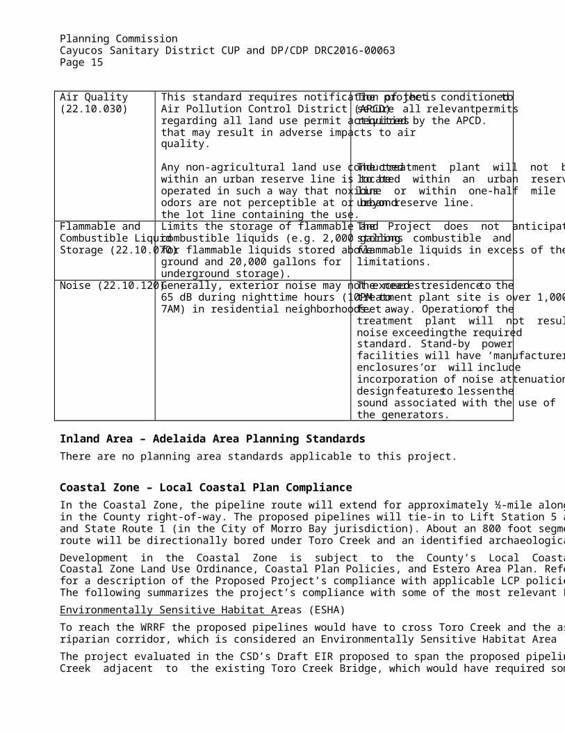
Air Quality (22.10.030)
This standard requires notification of the Air Pollution Control District (APCD) regarding all land use permit activities that may result in adverse impacts to air quality. Any non-agricultural land use conducted within an urban reserve line is to be operated in such a way that noxious odors are not perceptible at or beyond the lot line containing the use.
The project is conditioned to secure all relevant permits required by the APCD. The treatment plant will not be located within an urban reserve line or within one-half mile of an urban reserve line.
Flammable and Combustible Liquid Storage (22.10.070)
Limits the storage of flammable and combustible liquids (e.g. 2,000 gallons for flammable liquids stored above ground and 20,000 gallons for underground storage).
The Project does not anticipate storing combustible and flammable liquids in excess of the limitations.
Noise (22.10.120) Generally, exterior noise may not exceed 65 dB during nighttime hours (10PM to 7AM) in residential neighborhoods.
The nearest residence to the treatment plant site is over 1,000 feet away. Operation of the treatment plant will not result in noise exceeding the required standard. Stand-by power facilities will have ‘manufacturer’s enclosures’ or will include incorporation of noise attenuation design features to lessen the sound associated with the use of the generators.
Inland Area – Adelaida Area Planning Standards There are no planning area standards applicable to this project.
Coastal Zone – Local Coastal Plan Compliance In the Coastal Zone, the pipeline route will extend for approximately ½-mile along Toro Creek Road in the County right-of-way. The proposed pipelines will tie-in to Lift Station 5 at Toro Creek Road and State Route 1 (in the City of Morro Bay jurisdiction). About an 800 foot segment of the pipeline route will be directionally bored under Toro Creek and an identified archaeological site.
Development in the Coastal Zone is subject to the County’s Local Coastal Plan, including the Coastal Zone Land Use Ordinance, Coastal Plan Policies, and Estero Area Plan. Refer to Exhibit E for a description of the Proposed Project’s compliance with applicable LCP policies and standards. The following summarizes the project’s compliance with some of the most relevant LCP provisions:
Environmentally Sensitive Habitat Areas (ESHA)
To reach the WRRF the proposed pipelines would have to cross Toro Creek and the associated riparian corridor, which is considered an Environmentally Sensitive Habitat Area (ESHA).
The project evaluated in the CSD’s Draft EIR proposed to span the proposed pipelines across Toro Creek adjacent to the existing Toro Creek Bridge, which would have required some trimming of

Planning Commission Cayucos Sanitary District CUP and DP/CDP DRC2016-00063 Page 16
riparian canopy above the banks of the stream. However, the CSD subsequently determined that it would be feasible to bore pipeline conduit a distance of about 800 feet under Toro Creek and archaeological site CA-SLO-879/H. This would eliminate ESHA impacts.
While use of directional boring is the least invasive and disruptive option to ESHA as it avoids all direct disturbance, there is the possibility of a “frack out” resulting in a spill of drilling fluids in the area of Toro Creek ESHA. Measures including additional drilling procedures (e.g. monitoring for loss of fluid pressure) and visual monitoring in the area of the creek reduce the chance of a “frack out” and avoid disturbance and impact to ESHA.
Visual Resources
Section 23.04.210 (Visual Resources) applies within Critical Viewsheds, Scenic Corridors, and Sensitive Resource Areas (SRAs) that are intended to protect visual resources. All development within the Coastal Zone is subject to Visual and Scenic Resources LCP policies.
The Proposed Project would involve development within the viewshed of State Route 1, a nationally designated scenic byway and State scenic highway. However, the proposed work in the Coastal Zone would consist of underground pipelines that would not be visible from State Route 1. Additionally, all areas that are temporarily disturbed due to construction and utility boring activities would be revegetated. The proposed WRRF would be located about 0.75 mile inland of State Route 1 and, due to intervening topography and landscaping, will not be visible from the highway.
Archaeological Resources
Section 23.04.200 (Protection of Archaeological Resources Not within the Archaeologically Sensitive Areas Combining Designation) applies archaeological resource protection standards and LCP policies to all development within 100 feet of the bank of a coastal stream. These standards require development projects to include a preliminary archaeological survey and to implement a mitigation plan when resources are discovered.
As described under the Environmental Issues section of this staff report, the proposed pipelines would pass through the recorded boundaries of archaeological site CA-SLO-879/H in the Coastal Zone. To avoid any adverse effect on CA-SLO-879/H, the proposed pipelines along Toro Creek Road shall be placed only on the north side of the road and shall be directionally drilled under the maximum depth of cultural deposits. Non-Agricultural Uses in the Agriculture Land Use Category
Section 23.04.050 establishes permit requirements and standards for non-agricultural uses in the Agriculture category consistent LCP Agricultural policies 3, 4, and 5. Non-agricultural uses in the Agriculture land use category are subject to required findings including:
For prime soils, it has been demonstrated that no alternative project site exists except on prime soils; and
The least amount of prime soils will be converted; and
The proposed use will not conflict with surrounding agricultural lands and uses.
The Proposed Project will involve approximately ½-mile of new pipelines along Toro Creek Road in the Coastal Zone. According to Coastal Table “O”, Pipelines and Transmission lines are considered an allowable use in the Agriculture land use category. While portions of the pipeline route are on lands considered prime agricultural soils, the proposed pipelines are located underground in the County right-of-way, and therefore will not convert agricultural land or conflict

Planning Commission Cayucos Sanitary District CUP and DP/CDP DRC2016-00063 Page 17
with agricultural operations. The proposed WRRF is located outside of the Coastal Zone and is not subject these requirements.
COMMUNITY ADVISORY GROUP COMMENTS/PUBLIC PARTICIPATION: The Proposed Project was referred to the Cayucos Citizens Advisory Council (CCAC). On February 1, 2017, CCAC voted unanimously to support the project.
AGENCY REVIEW The following agencies provided comments on the subject application:
Department of Public Works – See attached referral response dated January 5, 2017. The response recommends several standard conditions, including a requirement for the applicant to maintain Toro Creek Road during construction and to restore it, if necessary, after construction. The response also indicates that an encroachment permit is needed to plant vegetation in the County right-of-way, a drainage plan will be needed at the time of construction permit submittal, and that the project does not meet the applicability criteria for storm water management.
Cal Fire – See attached Fire Safety Plan dated January 12, 2017.
ATTACHMENTS/EXHIBITS
Attachment 1: Exhibit A – Findings for Conditional Use Permit
Attachment 2: Exhibit B – Findings for Development Plan / Coastal Development Permit
Attachment 3: Exhibit C – CEQA Findings Attachment 4: Exhibit D – Conditions of Approval
Attachment 5: Exhibit E – Project Graphics
Attachment 6: Exhibit F – Agency Referral Responses
Attachment 7: Exhibit G – Final Environmental Impact Report (submitted to commissioners under separate cover)