planning and implementing local infrastructure … · planning and implementing local...
TRANSCRIPT

Planning and ImplementingLocal Infrastructure Works
Guidelines forTambon Administrations
International Labour Organization

Copyright @ International Labour Organization 2004First published 2004
Publications of the International Labour Office enjoy copyright under Protocol 2 of the UniversalCopyright Convention. Nevertheless, short excerpts from them may be reproduced withoutauthorisation, on condition that the source is indicated. For rights of reproduction or translation,application should be made to the Publications Bureau (Rights and Permissions), InternationalLabour Office, CH-12ll Geneva 22, Switzerland. The International Labour Office welcomes suchapplications.
Libraries, institutions and other users registered in the United Kingdom with the CopyrightLicensing Agency, 90 Tottenham Court Road, London WI T 4LP [Fax: (+44) (0) 20 7631 5500;email: [email protected]], in the United States with the Copyright Clearance Center, 222 RosewoodDrive, Danvers, MA 01923 [Fax: (+1) (978) 750 4470; email: [email protected]] or in othercountries with associated Reproduction Rights Organisations, may make photocopies inaccordance with the licences issued to them for this purpose.
Text by ASIST AP
Planning and Implementing Local Infrastructure Works - Guidelines for TambonAdministrative in Thailand
Bangkok, International Labour Office, 2004
Poverty alleviation, rural infrastructure planning and construction,maintenance, decentralisation, good governance.
ISBN: 92-2-115460-2 ILO Cataloguing in Publication Data
The designations employed in ILO publications, which are in conformity with United Nationspractice, and the presentation of material therein do not imply the expression of any opinionwhatsoever on the part of the International Labour Office concerning the legal status of anycountry, area or territory or of its authorities, or concerning the delimitation of its frontiers.
The responsibility for opinions expressed in signed articles, studies and other contributions restssolely with their authors, and publication does not constitute an endorsement by the InternationalLabour Office of the opinions expressed in them.
Reference to names of firms and commercial products and processes does not imply theirendorsement by the International Labour Office, and any failure to mention a particular firm,commercial product or process is not a sign of disapproval.
ILO publications can be obtained through major booksellers or ILO local offices in many countries,or direct from ILO Publications, International Labour Office, CH-1211 Geneva 22, Switzerland.Catalogues or lists of new publications are available free of charge from the above address, or byemail: [email protected]
For further information: www.ilo.org/publns
Printed in Thailand

Planning and ImplementingLocal Infrastructure Works
Guidelines forTambon Administrations
CTP 168
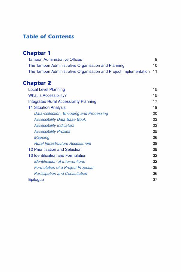
Chapter 1Tambon Administrative Offices 9
The Tambon Administrative Organisation and Planning 10
The Tambon Administrative Organisation and Project Implementation 11
Chapter 2Local Level Planning 15
What is Accessibility? 15
Integrated Rural Accessibility Planning 17
T1 Situation Analysis 19
Data-collection, Encoding and Processing 20
Accessibility Data Base Book 23
Accessibility Indicators 23
Accessibility Profiles 25
Mapping 26
Rural Infrastructure Assessment 28
T2 Prioritisation and Selection 29
T3 Identification and Formulation 32
Identification of Interventions 32
Formulation of a Project Proposal 35
Participation and Consultation 36
Epilogue 37
Table of Contents
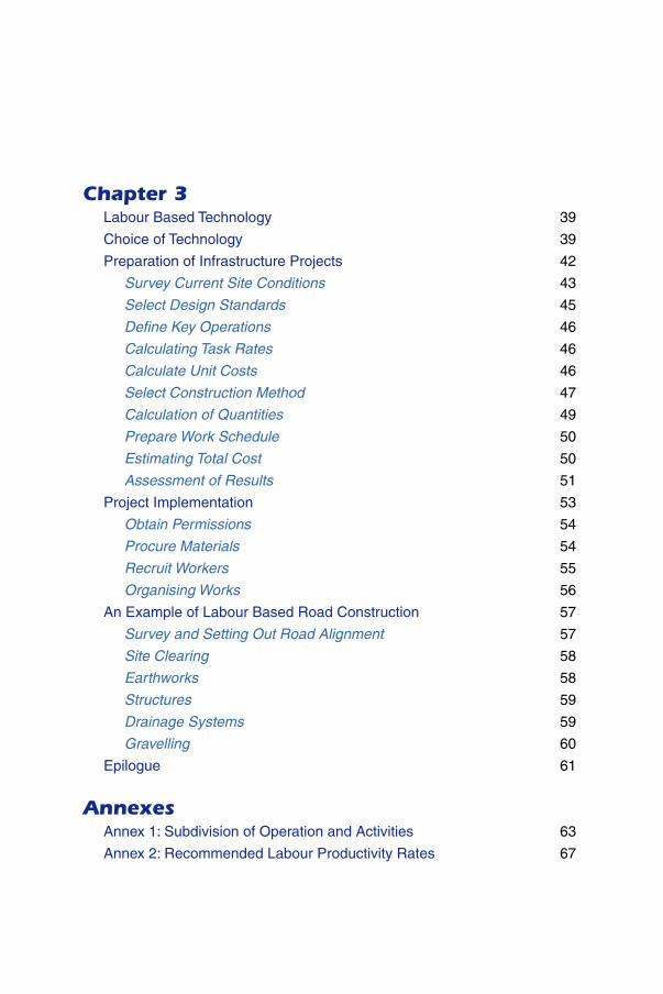
Chapter 3Labour Based Technology 39
Choice of Technology 39
Preparation of Infrastructure Projects 42
Survey Current Site Conditions 43
Select Design Standards 45
Define Key Operations 46
Calculating Task Rates 46
Calculate Unit Costs 46
Select Construction Method 47
Calculation of Quantities 49
Prepare Work Schedule 50
Estimating Total Cost 50
Assessment of Results 51
Project Implementation 53
Obtain Permissions 54
Procure Materials 54
Recruit Workers 55
Organising Works 56
An Example of Labour Based Road Construction 57
Survey and Setting Out Road Alignment 57
Site Clearing 58
Earthworks 58
Structures 59
Drainage Systems 59
Gravelling 60
Epilogue 61
AnnexesAnnex 1: Subdivision of Operation and Activities 63
Annex 2: Recommended Labour Productivity Rates 67

Chapter 16
Introduction
These guidelines have been prepared for the engineers and techni-cians in the Tambon Administrative Organisations. These guidelinesdeal with the practical day to day activities of the engineers andtechnicians who are involved in the development and maintenanceof public facilities for the tambons.
Chapter 1 introduces the basic set-up of the Tambon AdministrativeOrganisation. It deals with amongst others the organisational structure,division of responsibilities, budgets and classification of tambons.
Chapter 2 introduces the concept of Local Level Planning (LLP) com-prising rural infrastructure planning, accessibility and participation.It introduces the “Integrated Rural Accessibility Planning” process(IRAP), a set of tools that can be used by TAO officials to identifyand prioritise interventions that will improve rural access throughconstructing, operating and maintaining rural infrastructure facilities.
Chapter 3 introduces the concept of Labour Based Technology(LBT), defined as the construction technology which, while main-taining cost competitiveness and engineering quality standards,maximises the opportunities for employment, supported by lightequipment. Special consideration is given to the cost effectiveness,technical design standards and employment generating aspects, tobest fit the specific country needs and long term capacities, whilesimultaneously supporting decentralisation efforts. The annexesprovide some examples of work norms applicable to common tasksin labour based works.
Finally, the video CD inserted at the back of these guidelines showsthe application of labour based technology in practice in Thailand.
7Planning and Implementing Local Infrastructure Works
Guidelines for Tambon Administrations
Acknowledgments
These guidelines have been prepared for and in collaboration withthe Ministry of Interior and the Department of Public Works Tech-nical Training Institute of the Royal Thai Government. The originalversion was prepared by consultants Narong Leungbootak andAniruth Thongchai and Paul Munters from ILO ASIST AP and firstpublished in Thai language. The current version has undergonefurther developments carried out by the technical team in ASIST APwith substantial editing inputs from Chris Donnges, BjornJohannessen, Chloe Pearse and Pisit Tusanasorn. Acknowledgmentsare also due to the Public Works Department which contributedheavily to the production of the training video included in thisdocument.

Chapter 1Tambon Administrative Offices

9Planning and Implementing Local Infrastructure Works
Guidelines for Tambon Administrations
Tambon Administrative Offices
The Thai Government Policy of Decentralization under theSub-district Council and Sub-district Administration Act of 1994 (BE2537) established the Tambon Administrative Organisation in aneffort to improve decentralised governance and to introduceparticipatory planning and decision making at local level. TheTambon Administrative Offices are expected to increase thecapacity of the Tambons to generate income by the creation ofjobs, to promote the effective use of local resources, to createopportunities for the local communities to participate in solvingtypical local problems, with initiatives taken by and for the people.This all in order to improve the quality of life at local level.
A tambon is the smallest unit of local governance in Thailand.There are around 7000 tambons. The average size of a tambon isabout 6 by 6 km, and the average number of households isaround 1000. Tambons are sub-divided into 5 classes (see Figure1) according to their annual income. Most of the tambons fall intocategory V and have an annual income of less than 3 million Baht.
Figure 1: TAO Classification
Generally, half of the income is available for development andmaintenance of infrastructure (roads, water, etc) within the tambon.However, the TAO budgets will become increasingly important forpublic investment because they are expected to expand in combi-nation with more administrative responsibilities in the future. Thecurrent responsibilities are given in Figure 2.
Of all the TAO responsibilities, the technical services to be pro-vided are under the responsibility of the technicians and engineers(see Figure 3). These include development and maintenance ofpublic facilities and infrastructure works, that are specified underthe Act BE 2537 and Building Control Act BE 2522.

Chapter 110
Figure 2: Responsibilities of the Tambon AdministrativeOrganisations
The Tambon Administrative Organisationand Planning
The TAO Councils make decisions, set priorities and give approv-als, while the TAO officials prepare the plans. The engineers andtechnicians play an important role in providing the councils withsound technical information as a basis for good planning and thusmust be able to obtain data necessary for the planning process.
Figure 3: Typical Tambon Administrative Structure
11Planning and Implementing Local Infrastructure Works
Guidelines for Tambon Administrations
In order to provide the councils with sound technical informationfor public facilities, such as schools, healthcare centers, religiouscenters, TAO centers, bus-stops, solid waste dumps, sports grounds,parks, etc, surveys on the location and design of these facilitiesmust be carried out by the TAO engineer or technician. This datashould then be checked against the planning norms prescribed bycentral government for such facilities. Generally, service ratios “fa-cilities/person” or “number of person/facilities” versus the nationalservice ratio norms are used for the planning of facilities.
The planning and management of infrastructure such as rural roads,water supply, waste disposal, waste water treatment, storm drain-age systems, etc are the responsibilities of the TAO. TAO technicalofficers must not only assist and participate in the planning, butalso in the management, operation and maintenance of all theseassets. For this propose it is useful to maintain a map showing thelocations of existing infrastructure in the tambon.
TAO planning should involve all stakeholders, the TAO council,the communities (Mooban) and the TAO officers. This is best doneby applying a participatory approach, involving all stakeholders inthe processes of identification, prioritisation, planning, implemen-tation, monitoring and evaluation of infrastructure.
As described in Chapter 2, early inclusion of all stakeholders in theplanning process will facilitate access to most of the needed data,will create a sense of local ownership of the assets and generate agreater community feeling and awareness of the living environ-ment. The TAO technician or engineer has a key role to play incoordinating all activities from the beginning of data collection tothe completion of project works. The tools to do so is discussed inChapter 2.
Tambon Administrative Organisation andProject Implementation
After the TAO Council approves a project proposal, the detaileddesign of the infrastructure works is required. At this stage thetechnician needs to define all technical elements needed. Duringthis process it is also necessary to define how to build the infra-structure - by which combination of which resources. An impor-tant issue in this matter is the choice of construction technology.
By properly addressing this choice of technology from the start,the overall cost of the works can be reduced and the relative use oflocal resources (labour, materials and equipment) can be increased

Chapter 112
without increasing cost or decreasing quality. In both cases thelocal community can benefit from proper analysis of the technol-ogy choice to be made.
In Chapter 3 specific attention is given to the choice of technologyand its inclusion in the preparations of infrastructure works. Exam-ples of the effective use of labour based technology in Thailandrelated to the construction of bamboo reinforced concrete are given.Also alternative designs of a bridge, a building and an irrigationchannel are discussed, which show the effectiveness of appropri-ate choice of technology to reduce costs and increase the use oflocal resources, while maintaining quality.
After the detailed project preparations have been completed andthe TAO council has approved them, the actual implementation ofthe works can commence. In a separate section, specific issuesrelated to the use of labour based technology are discussed andpractical advice on the proper organisation and implementation ofthe works is given.
Finally, as an addition to the video CD included in the back ofthese guidelines, the key features the labour based construction ofgravel roads is discussed in a bird’s eye view.

13Planning and Implementing Local Infrastructure Works
Guidelines for Tambon Administrations

Chapter 2Local Level Planning

15Planning and Implementing Local Infrastructure Works
Guidelines for Tambon Administrations
Local Level Planning
All households, rural and urban, poor and rich, need to have ac-cess to public facilities, goods and services in order to fulfill theirbasic, social and economic needs and be able to enjoy a social andeconomically productive life. Access can be defined as the ease ordifficulty of reaching locations where facilities, goods and servicesare available.
What is Accessibility?
While it is difficult to give a complete definition of accessibility, itis much easier to explain accessibility by comparing the two situa-tions as depicted in Figure 4.
Figure 4: Accessibility Comparison

Chapter 216
The left hand side of this figure depicts good accessibility resultingfrom a good road including good bridges and good transport facili-ties (taxis, buses). The right hand side describes poor accessibilitydue to a road in poor condition, poor or broken bridges and noaccess to public transport services. Due to these differences inaccessibility, people need to apply different efforts to achieve thesame result: to travel or transport their goods from location A to B.This is reflected in the time needed to travel or the cost involved intraveling.
In the example in Figure 4, points A and B represent the point ofdeparture and point of destination. As can be seen from Figure 5,these points could relate to facilities, goods and services on whichhouseholds depend.
Figure 5: Accessibility of Services and Goods
17Planning and Implementing Local Infrastructure Works
Guidelines for Tambon Administrations
Since the households’ welfare depends on the availability of thesegoods and services, it is important that the TAO serves the popula-tion by properly addressing accessibility in their planning system.
Two factors are of overriding importance. Firstly, planning for fa-cilities and services should be done at the tambon level whereknowledge about the present conditions and constraints is best.
Secondly, planning should involve all stakeholders, the TAO coun-cil, the Mooban and the TAO officers, during the identification,prioritisation and selection of interventions.
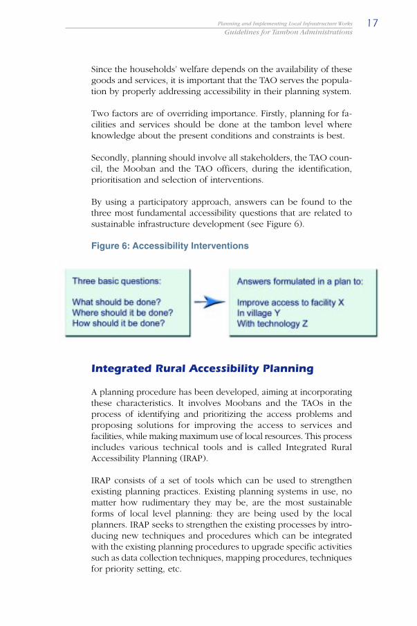
By using a participatory approach, answers can be found to thethree most fundamental accessibility questions that are related tosustainable infrastructure development (see Figure 6).
Figure 6: Accessibility Interventions
Integrated Rural Accessibility Planning
A planning procedure has been developed, aiming at incorporatingthese characteristics. It involves Moobans and the TAOs in theprocess of identifying and prioritizing the access problems andproposing solutions for improving the access to services andfacilities, while making maximum use of local resources. This processincludes various technical tools and is called Integrated RuralAccessibility Planning (IRAP).
IRAP consists of a set of tools which can be used to strengthenexisting planning practices. Existing planning systems in use, nomatter how rudimentary they may be, are the most sustainableforms of local level planning: they are being used by the localplanners. IRAP seeks to strengthen the existing processes by intro-ducing new techniques and procedures which can be integratedwith the existing planning procedures to upgrade specific activitiessuch as data collection techniques, mapping procedures, techniquesfor priority setting, etc.
Chapter 218
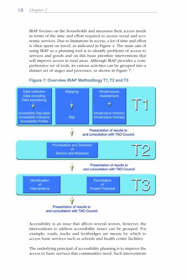
IRAP focuses on the households and measures their access needsin terms of the time and effort required to access social and eco-nomic services. Due to limitations in access, a lot of time and effortis often spent on travel, as indicated in Figure 4. The main aim ofusing IRAP as a planning tool is to identify problems of access toservices and goods and on this basis prioritize interventions thatwill improve access in rural areas. Although IRAP provides a com-prehensive set of tools, its various activities can be grouped into adistinct set of stages and processes, as shown in Figure 7.
Figure 7: Overview IRAP Methodilogy T1, T2 and T3
Accessibility is an issue that affects several sectors, however, theinterventions to address accessibility issues can be grouped. Forexample, roads, tracks and footbridges are means by which toaccess basic services such as schools and health centre facilities.
The underlying principal of accessibility planning is to improve theaccess to basic services that communities need. Such interventions
19Planning and Implementing Local Infrastructure Works
Guidelines for Tambon Administrations
may improve living conditions and make it easier for people tofulfill their basic social and economic needs. Time-savings as aresult of improved access could be used for alternative social andeconomic activities.
IRAP is designed for use at the tambon and mooban level. Re-sources at this level are limited and consequently the planningtechniques should not make intensive demands on the financialresources available. Since IRAP activities can be carried out bytambon staff, the cost of carrying out the planning exercise is there-fore limited to field allowances and travel costs and initially somelimited costs related to training.
T1 Situation Analysis
The aim of this activity is to produce a situation analysis that iden-tifies the access problems in the moobans, both relating to themobility of the population and the location and use of services andfacilities. T1 comprises various activities that can be done simulta-neously, so the whole situation analysis should not take more than1 month.
Chapter 220
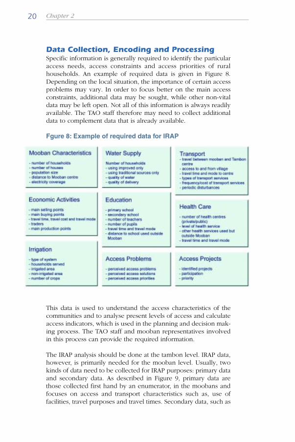
Data Collection, Encoding and ProcessingSpecific information is generally required to identify the particularaccess needs, access constraints and access priorities of ruralhouseholds. An example of required data is given in Figure 8.Depending on the local situation, the importance of certain accessproblems may vary. In order to focus better on the main accessconstraints, additional data may be sought, while other non-vitaldata may be left open. Not all of this information is always readilyavailable. The TAO staff therefore may need to collect additionaldata to complement data that is already available.
Fgure 8: Example of required data for IRAP
This data is used to understand the access characteristics of thecommunities and to analyse present levels of access and calculateaccess indicators, which is used in the planning and decision mak-ing process. The TAO staff and mooban representatives involvedin this process can provide the required information.
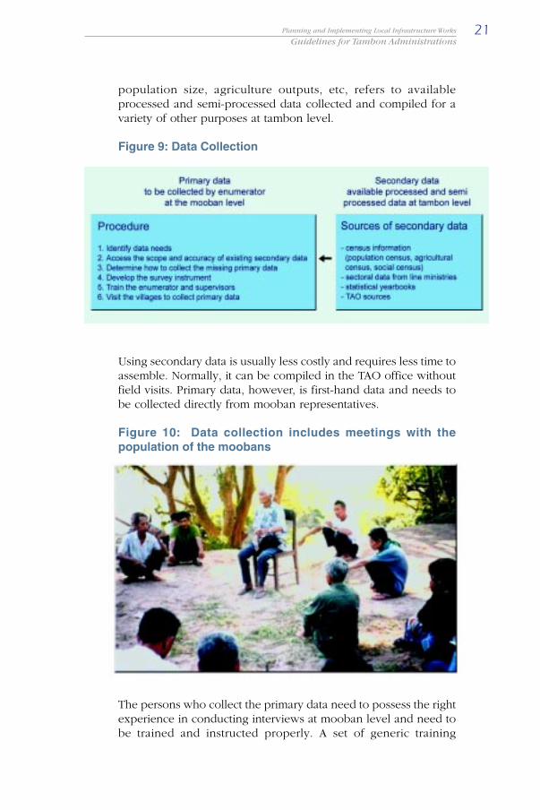
The IRAP analysis should be done at the tambon level. IRAP data,however, is primarily needed for the mooban level. Usually, twokinds of data need to be collected for IRAP purposes: primary dataand secondary data. As described in Figure 9, primary data arethose collected first hand by an enumerator, in the moobans andfocuses on access and transport characteristics such as, use offacilities, travel purposes and travel times. Secondary data, such as
21Planning and Implementing Local Infrastructure Works
Guidelines for Tambon Administrations
population size, agriculture outputs, etc, refers to availableprocessed and semi-processed data collected and compiled for avariety of other purposes at tambon level.
Figure 9: Data Collection
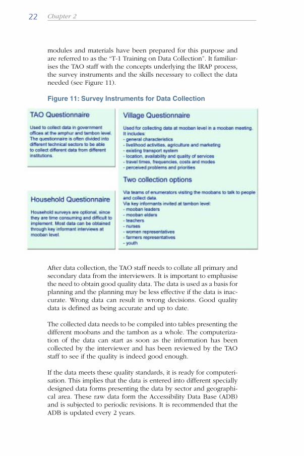
Using secondary data is usually less costly and requires less time toassemble. Normally, it can be compiled in the TAO office withoutfield visits. Primary data, however, is first-hand data and needs tobe collected directly from mooban representatives.
Figure 10: Data collection includes meetings with thepopulation of the moobans
The persons who collect the primary data need to possess the rightexperience in conducting interviews at mooban level and need tobe trained and instructed properly. A set of generic training
Chapter 222
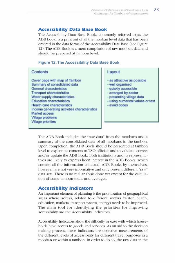
modules and materials have been prepared for this purpose andare referred to as the “T-1 Training on Data Collection”. It familiar-ises the TAO staff with the concepts underlying the IRAP process,the survey instruments and the skills necessary to collect the dataneeded (see Figure 11).
Figure 11: Survey Instruments for Data Collection
After data collection, the TAO staff needs to collate all primary andsecondary data from the interviewers. It is important to emphasisethe need to obtain good quality data. The data is used as a basis forplanning and the planning may be less effective if the data is inac-curate. Wrong data can result in wrong decisions. Good qualitydata is defined as being accurate and up to date.
The collected data needs to be compiled into tables presenting thedifferent moobans and the tambon as a whole. The computeriza-tion of the data can start as soon as the information has beencollected by the interviewer and has been reviewed by the TAOstaff to see if the quality is indeed good enough.
If the data meets these quality standards, it is ready for computeri-sation. This implies that the data is entered into different speciallydesigned data forms presenting the data by sector and geographi-cal area. These raw data form the Accessibility Data Base (ADB)and is subjected to periodic revisions. It is recommended that theADB is updated every 2 years.
23Planning and Implementing Local Infrastructure Works
Guidelines for Tambon Administrations
Accessibility Data Base BookThe Accessibility Data Base Book, commonly referred to as theADB book, is a print out of all the mooban level data that has beenentered in the data forms of the Accessibility Data Base (see Figure12). The ADB Book is a mere compilation of raw mooban data andshould be prepared at tambon level.
Figure 12: The Accessibility Data Base Book
The ADB Book includes the “raw data” from the moobans and asummary of the consolidated data of all moobans in the tambon.Upon completion, the ADB Book should be presented at tambonlevel to explain its contents to TAO officials and to validate, correctand/or update the ADB Book. Both institutions and its representa-tives are likely to express keen interest in the ADB Books, whichcontain all the information collected. ADB Books by themselves,however, are not very informative and only present different “raw”data sets. There is no real analysis done yet except for the calcula-tion of some tambon totals and averages.
Accessibility IndicatorsAn important element of planning is the prioritization of geographicalareas where access, related to different sectors (water, health,education, markets, transport system, energy) needs to be improved.The main tool for identifying the priorities for improvingaccessibility are the Accessibility Indicators.
Accessibility Indicators show the difficulty or ease with which house-holds have access to goods and services. As an aid to the decisionmaking process, these indicators are objective measurements ofthe different levels of accessibility for different travel purposes in amooban or within a tambon. In order to do so, the raw data in the

Chapter 224
Accessibility Data Base is refined into a set of Accessibility Indica-tors which relate to the various sectors under consideration.
Accessibility Indicators are derived for different levels: moobanand tambon. For the mooban level they can be used to identifymooban interventions. For the tambon level, indicators are oftenuse to identify moobans that are most disadvantaged in relation tobasic needs and level of social and economic services.
A first step in the process of developing indicators is to decide onthe variables to be used. Accessibility indicators generally relate tothe number of households affected and levels of accessibility ex-pressed in travel distances and travel times. The indicators are afunction of different variables such as the number of households ina tambon, the average time spent to reach each facility/service, thefrequency of travel to a facility and selected qualitative variables(see Figure 13).
Figure 13: Accessibility Indicators
It is recommended to keep the indicators as simple as possible. Itis, however, possible to have indicators that are more complicatedin that they include quality elements and perceived values. Morecomplex indicators are not necessarily more accurate in identifyingpriority areas and risk to unnecessarily complicating the process.
At mooban level, the indicators can tell us something about thelevel of accessibility compared with national standards, averagesand norms. At tambon level they show, for different sectors, whichmoobans should be assisted to improve access.

25Planning and Implementing Local Infrastructure Works
Guidelines for Tambon Administrations
The available information in the database enables a planner to makean initial assessment of the total time, cost and effort required for acommunity to access certain goods, services or facilities. The indi-cators translate the actual level of access into numerical values.The indicators define the degree of access in a community as awhole. The larger the value of the Accessibility Indicators, the worsethe access problem is. Indicators can then be used to rank moobanson an ordinal scale.
The TAO staff responsible for the development and calculations ofindicators needs to understand the role of the indicators in theplanning process and needs to be able to “construct” the indicators.It is important to differentiate between two groups of people: TAOstaff responsible for calculating the indicators and the members ofthe TAO Council who will use the indicators to make decisions.The two groups of people are normally not the same. It is there-fore important that both groups communicate with each other.
Once it has been agreed which variables make up the indicatorsand the relative importance of the different variables, the processof calculating indicators can start. From the existing AccessibilityData Base (ADB), the accessibility indicators are determined toprovide a simple assessment of access conditions in a certain areaand help to pinpoint problems and needs. Ideally to save time,this process is computerised. A simple function could use the datadirectly from the Accessibility Data Base to calculate the value ofthe different indicators. Once established, the indicators can beincorporated in Tambon Accessibility Profiles.
Note: If not all variables are considered equally important or ifthe planner wants to involve people to assess the importance ofdifferent variables, it is necessary to prepare weighting factors. Indoing this the entire process of calculating indicators become moreparticipatory, but unfortunately also more complicated. How todetermine the correct weighting factors is beyond the scope ofthese guidelines.
Accessibility ProfilesA separate document, the Tambon Accessibility Profile, is preparedto briefly describe the tambon and summarise its access condi-tions. The Accessibility Profile is more of a descriptive character,more reader-friendly and can be disseminated on a larger scale. Itprovides aggregate and average mooban conditions. The TambonAccessibility Profile, together with the indicators, will reflect levelsof access in the tambon.

Chapter 226
The preparation of the Tambon Accessibility Profile requires proc-essed data, a standard format and people capable of analyzing theraw data and transferring data into meaningful statistics. The Ac-cessibility Profile can be a one-page document summarizing somekey statistics by sector or, alternatively, a short report describingthe tambon, complete with a map and a short analysis of eachsector. An example is given in Figure 14.
Figure 14: Example of a Tambon Accessibility Profile
TAO staff are often only involved in data collection and submittingthis information to higher authorities. Decentralisation efforts, how-ever, aim to strengthen the TAO capacity to interpret and use datafor planning purposes at tambon level.
MappingAccessibility mapping is an integral part of the IRAP procedures. Itallows the TAO staff to visualise the location of moobans and infra-structure within a tambon and can help in the identification andprioritisation of access problems. It also facilitates the formulationof interventions and provides guidance in the selection of the bestdevelopment alternatives (see Figure 15).
Figure 15: Accessibility Mapping

27Planning and Implementing Local Infrastructure Works
Guidelines for Tambon Administrations
Colourful, large size maps, immediately attract the attention of theaudience while visualising access conditions and access prioritiesin a given area. Maps also facilitate discussions and reactions fromthe audience since they allow reviewing issues on common grounds.
Maps enable integration of different sector analyses and provide atechnical tool to demonstrate how improvement interventions(projects) can be used to solve access problems. Equally, mappingprovides a monitoring mechanism for the levels of access in atambon.
IRAP maps need to be based on existing topographic or otherofficial base maps. It is necessary for the TAO mapping team tovisit the areas for which the maps are prepared to collect addi-tional information and to verify base maps.
Handmade accessibility mapping has been developed as a “user-friendly” process that can be easily understood. The TAO staff canprepare good quality maps using inexpensive materials that arelocally available.
Note: If the maps are produced manually, it is difficult and labori-ous to make changes. It is recommended that after the necessarycapacity has been established in the tambon to produce, read anduse access maps, the TAO moves to the next level where the map-ping process is computerised. How to use this so-called GeographicInformation System (GIS) software is beyond the scope of theseguidelines.

Chapter 228
Figure 16: Preparation of maps and overlays that show thelevels of access to various services in the tambon.
Rural Infrastructure AssessmentRural infrastructure includes local roads, bridges, schools, healthcenters, markets, electricity networks, irrigation schemes, watersupply, sanitation, storm water drainage and telecommunications.In order to plan for additional or improved infrastructure, the TAOstaff first needs to know what is already there. The TAO staff needsto prepare an inventory of the existing rural infrastructure assets.This inventory has two main elements: the inventory form and theinventory overlays.
(i) Infrastructure Inventory FormThe infrastructure inventory is primarily based on a set of forms torecord data for individual road links, water supply, schools andhealth centres, irrigation schemes, markets, electricity networks andrural telecommunications. The inventory includes all infrastructureassets in the tambon.
Figure 17: Infrastructure Survey
29Planning and Implementing Local Infrastructure Works
Guidelines for Tambon Administrations
The infrastructure inventory includes the IRAP road inventory. Theaim of the road inventory is to carry out an overall assessment ofthe condition and geographic distribution of the road network inthe tambon. The IRAP road inventory does not provide any techni-cal information on the specific condition of each road link norprovide data on the cost of maintaining or improving existing links.It is a first inventory to generate a general picture on the overallstatus of the (rural) road network. The road inventory togetherwith the mooban data can be used to prioritise individual roadlinks for maintenance or rehabilitation/improvement purposes.
(ii) The Infrastructure OverlaysThe infrastructure overlays are transparent overlays for the existingIRAP tambon map. Different types of infrastructure are identifiedon these overlays by different colours and different shaped linesand dots. The overlays are produced manually.
It is recommended to have different overlays for the transport sec-tor, the point sources (markets, health facilities and schools) andthe water, electricity, sewage, storm water and telecommunicationdistribution systems.
The road key map overlay is in fact a simple road map identifyingthe different road links and areas served. The road key map canalso identify areas that have trail or river access. Roads are shownby different shaped lines with different colours to identify theirclassification.
T2 Prioritisation and Selection
The main objective of this activity is to identify priorities for im-proving access in selected villages in the tambon. This activity,resulting in priority listings of villages by sector, should be donethrough a participatory prioritisation workshop. It involves the analy-sis of data, indicators and maps to allow a comparison of differentlevels of accessibility between moobans and across sectors and toidentify mooban priorities based on the existing levels of access tovarious services.
Chapter 230
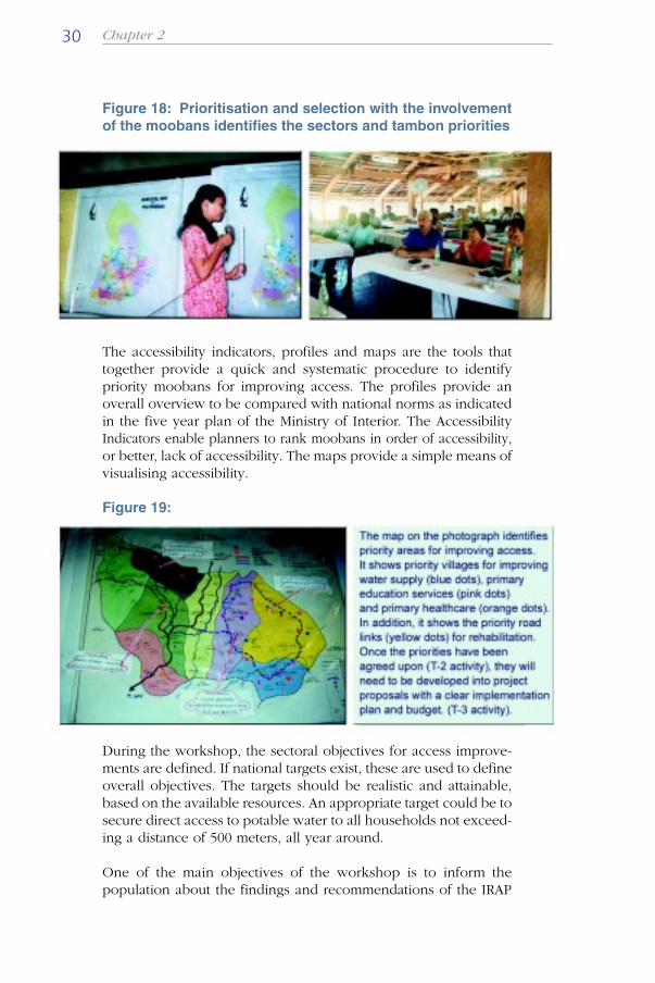
Figure 18: Prioritisation and selection with the involvementof the moobans identifies the sectors and tambon priorities
The accessibility indicators, profiles and maps are the tools thattogether provide a quick and systematic procedure to identifypriority moobans for improving access. The profiles provide anoverall overview to be compared with national norms as indicatedin the five year plan of the Ministry of Interior. The AccessibilityIndicators enable planners to rank moobans in order of accessibility,or better, lack of accessibility. The maps provide a simple means ofvisualising accessibility.
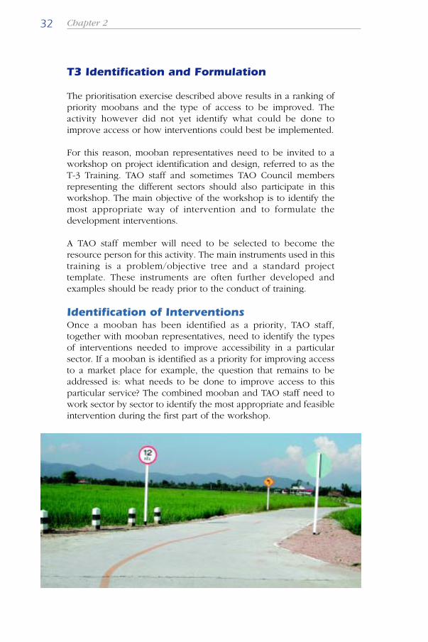
Figure 19:
During the workshop, the sectoral objectives for access improve-ments are defined. If national targets exist, these are used to defineoverall objectives. The targets should be realistic and attainable,based on the available resources. An appropriate target could be tosecure direct access to potable water to all households not exceed-ing a distance of 500 meters, all year around.
One of the main objectives of the workshop is to inform thepopulation about the findings and recommendations of the IRAP

31Planning and Implementing Local Infrastructure Works
Guidelines for Tambon Administrations
application in the tambon and to solicit further support forimproving access. The typical participants are TAO staff togetherwith TAO Council members.
The end result is a list of priorities by mooban and by sector, rankedaccording to their levels of inaccessibility. The priority moobanswould be moobans that have a relatively large population affectedby poor (or a lack of) access and have generally poor access tocertain facilities, goods or services. All information such as statis-tics, maps, indicators and priorities are now available. The outputs,findings and recommendations should be presented to the TAOCouncil and thus provide the initial support for the interventions tobe prepared in the next planning stage.
The identification of priorities can never be an entirely mechanical,computer programmed process based only on indicator. The indi-cators and maps are merely tools to be used as a guide duringprioritisation. The TAO staff knowledge and understanding of localcharacteristics, constraints and realities also have an essential roleto play in this process.
Due to the importance of this part of the planning process, astandard training course (referred to as the T2) has been developedand as part of this a set of training materials and modules havebeen prepared. This training is conducted for key people at thetambon level, including TAO staff and the TAO Council. The mainobjective of this training is to strengthen the TAO capacity to usemaps, data and indicators to identify priority access improvements.As a last activity of the training, participants are instructed andguided in how to present the outputs, findings and recommenda-tions to the TAO Council.
Chapter 232
T3 Identification and Formulation
The prioritisation exercise described above results in a ranking ofpriority moobans and the type of access to be improved. Theactivity however did not yet identify what could be done toimprove access or how interventions could best be implemented.
For this reason, mooban representatives need to be invited to aworkshop on project identification and design, referred to as theT-3 Training. TAO staff and sometimes TAO Council membersrepresenting the different sectors should also participate in thisworkshop. The main objective of the workshop is to identify themost appropriate way of intervention and to formulate thedevelopment interventions.
A TAO staff member will need to be selected to become theresource person for this activity. The main instruments used in thistraining is a problem/objective tree and a standard projecttemplate. These instruments are often further developed andexamples should be ready prior to the conduct of training.
Identification of InterventionsOnce a mooban has been identified as a priority, TAO staff,together with mooban representatives, need to identify the typesof interventions needed to improve accessibility in a particularsector. If a mooban is identified as a priority for improving accessto a market place for example, the question that remains to beaddressed is: what needs to be done to improve access to thisparticular service? The combined mooban and TAO staff need towork sector by sector to identify the most appropriate and feasibleintervention during the first part of the workshop.
33Planning and Implementing Local Infrastructure Works
Guidelines for Tambon Administrations
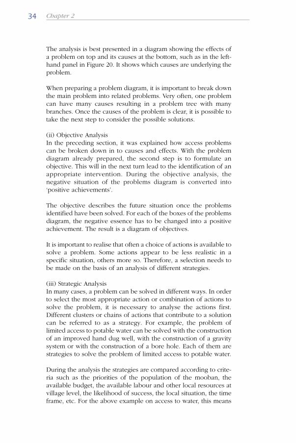
It is important that this identification process is based on the IRAPstrategy of having two main categories of access interventions,namely interventions that improve mobility such as roads, bridges,tracks and trails, transport services and low-cost means oftransport and interventions that improve the distribution offacilities and services such as water supply, schools, markets andhealth centers. Therefore, an accurate analysis of the existingsituation is important. A good approach to such an analysis forselecting a suitable intervention is to use a Logical Framework(see Figure 20).
(i) Problem AnalysisA part of the problem analysis has already been carried out duringthe situation analysis (T1) and the prioritisation and selection (T2)and resulted in a set of access problems that needs to be addressed.What has not yet been done is a proper analysis of the causes ofthese access problems. A thorough problem analysis forms thebase of any action to solve a problem. In a problem analysis, cause-effect relations are examined. In the analysis the involved parties,mooban and TAO staff, identify the real access bottlenecks to whichthey attach priority.
Figure 20: Logical Framwork Situation Analysis
Chapter 234
The analysis is best presented in a diagram showing the effects ofa problem on top and its causes at the bottom, such as in the left-hand panel in Figure 20. It shows which causes are underlying theproblem.
When preparing a problem diagram, it is important to break downthe main problem into related problems. Very often, one problemcan have many causes resulting in a problem tree with manybranches. Once the causes of the problem is clear, it is possible totake the next step to consider the possible solutions.
(ii) Objective AnalysisIn the preceding section, it was explained how access problemscan be broken down in to causes and effects. With the problemdiagram already prepared, the second step is to formulate anobjective. This will in the next turn lead to the identification of anappropriate intervention. During the objective analysis, thenegative situation of the problems diagram is converted into‘positive achievements’.
The objective describes the future situation once the problemsidentified have been solved. For each of the boxes of the problemsdiagram, the negative essence has to be changed into a positiveachievement. The result is a diagram of objectives.
It is important to realise that often a choice of actions is available tosolve a problem. Some actions appear to be less realistic in aspecific situation, others more so. Therefore, a selection needs tobe made on the basis of an analysis of different strategies.
(iii) Strategic AnalysisIn many cases, a problem can be solved in different ways. In orderto select the most appropriate action or combination of actions tosolve the problem, it is necessary to analyse the actions first.Different clusters or chains of actions that contribute to a solutioncan be referred to as a strategy. For example, the problem oflimited access to potable water can be solved with the constructionof an improved hand dug well, with the construction of a gravitysystem or with the construction of a bore hole. Each of them arestrategies to solve the problem of limited access to potable water.
During the analysis the strategies are compared according to crite-ria such as the priorities of the population of the mooban, theavailable budget, the available labour and other local resources atvillage level, the likelihood of success, the local situation, the timeframe, etc. For the above example on access to water, this means
35Planning and Implementing Local Infrastructure Works
Guidelines for Tambon Administrations
that the solution of an improved hand dug well would be the beststrategy in case the available budget is limited. The improved handdug well is the cheapest option. It would also be the best strategyin case there is no road access for the drilling machinery and incase of flat land area where no gravity system is viable.
After the analysis of problems and formulation of objectives andstrategies, one can identify the preferred strategy to be formulatedin a project proposal
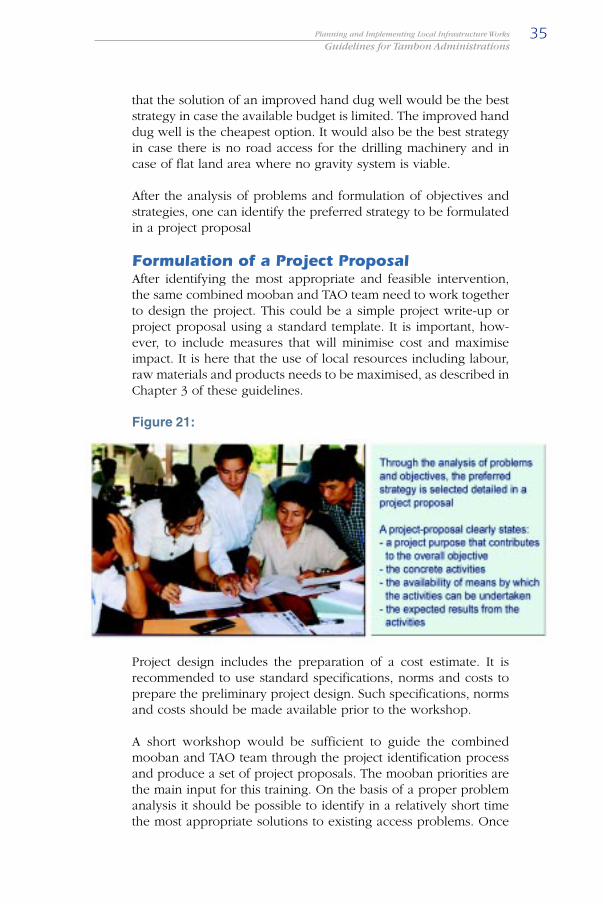
Formulation of a Project ProposalAfter identifying the most appropriate and feasible intervention,the same combined mooban and TAO team need to work togetherto design the project. This could be a simple project write-up orproject proposal using a standard template. It is important, how-ever, to include measures that will minimise cost and maximiseimpact. It is here that the use of local resources including labour,raw materials and products needs to be maximised, as described inChapter 3 of these guidelines.
Figure 21:
Project design includes the preparation of a cost estimate. It isrecommended to use standard specifications, norms and costs toprepare the preliminary project design. Such specifications, normsand costs should be made available prior to the workshop.
A short workshop would be sufficient to guide the combinedmooban and TAO team through the project identification processand produce a set of project proposals. The mooban priorities arethe main input for this training. On the basis of a proper problemanalysis it should be possible to identify in a relatively short timethe most appropriate solutions to existing access problems. Once
Chapter 236
these solutions and the objectives of a possible project are known,the participants can formulate the activities to achieve theobjectives as a project.
The three main training documents therefore include a module onidentifying interventions, a module on designing interventions anda module on cost guidelines and technology.
Participation and ConsultationAs shown in Figure 7, the separate parts of T1, T2 and T3 arelinked by presentations and consultations with the TAO Councils.These presentations and consultations are vital for the success ofthe project. They not only ensure that the community via the TAOCouncil will see their real needs being addressed, but will also givethe local communities full responsibility and ownership, evenbefore the assets are created.
The indicated presentations and consultations are however notenough. During the processes T1, T2 and T3, full participation ofthe local communities is needed. This will be a challenge and willrequire the full consent of the TAO Council, the planners and tech-nicians. It includes the sharing of all the information and ideas thatexist, discussing them with experts and non-experts. The plannersneed to develop skills to moderate the workshops and to increasethe involvement of the local population and TAO staff in the projects.

37Planning and Implementing Local Infrastructure Works
Guidelines for Tambon Administrations
Epilogue
In all activities, the different stakeholders of the mooban need towork together with the Tambon Administrative Organisation tofind the most appropriate answers to the “what, where and how”questions.
Integrated Rural Accessibility Planning covers several sectors. Inparticular, it provides detailed data on the level of access that ruralhouseholds have to services and facilities. These include thetransport system, water, energy, health, education, markets,agricultural inputs, agricultural outputs, crop marketing and post-harvest facilities.
Accessibility Planning is gender sensitive and involves both menand women in the local level planning process and takes accountof the clear distinction between the sexes in terms of transportneeds and patterns. In doing so, gender specific perspectives andneeds are incorporated into the planned interventions and theburden of transport may be reduced for both sexes.
IRAP has been designed to assist local-level planners to makeappropriate investments of the limited funds available to them.The focus on the local level also provides a basis for developingthe capacity of local-level planners. Two points are necessary toraise here. The IRAP procedure is not a planning system. It providesa basis for establishing priorities for access improvement in thesectors that it deals with. It is a tool for rural development planningthat captures access problems and identifies a set of prioritisedinterventions that address these problems in rural communities. Itcan be easily integrated into existing local level planning structuresand procedures.
IRAP is useful not just because it provides an effective local planningtool. Its real importance lies in its potential to bring together thetwo aspects of accessibility - mobility and proximity - in a sensiblemanner. It suggests that access, rather than transport, should beconsidered as the main facilitator of development.

Chapter 3Labour Based Technology

39Planning and Implementing Local Infrastructure Works
Guidelines for Tambon Administrations
Labour Based Technology
The construction or rehabilitation of infrastructure such as roads,bridges, dams, irrigation channels, public utility buildings and manyothers, can be done in numerous ways. Before commencing works,the engineer and the TAO decision-makers have to choose notonly on what or where to build the asset, but also decide how tobuild the asset i.e. the method of construction and the technologyto be used. These decisions are important when the potentialexists to make use of local resources, which may have manyadvantages for the local population.
The underlying principles for doing this are explained in Figure 22,and can be used as guidance. Since the use of appropriate technol-ogy can have a major influence on the success of a project, thischapter emphasises the choice of technology.
Figure 22: Rural Infrastructure Construction
Choice of Technology
Construction technologies can be classified into three groups onthe basis of their use of labour and equipment: equipmentintensive, labour based and labour intensive technologies. Thechoice of the technology affects the overall cost, the overall dura-tion of the works and the overall quality of the asset produced.Some works allow only one type of technology, while other workscan be done in various ways.
In selecting the most appropriate technology, it is important thatefficient use of resources is being made, quality standards aremaintained and time limitations are observed. Labour basedtechnology, defined as the construction technology whichmaximises opportunities for employment, while supported by lightequipment, should only be used under the strict condition of costcompetitiveness, acceptable engineering quality standards and timelycompletion of works. If they are well prepared and supervised.

Chapter 340
Labour based work methods can be competitive and moreeconomical while still providing lasting benefits.
Figure 23: Potential shift in labour contents by using labour-based methods
As described in Figure 23, some types of works allow a switchfrom equipment based to labour based technology thus allowingfor a significant increase in the use of local labour. Besides theoverall cost, the overall duration of the works and the overallquality of the outputs, there are other factors that influence thechoice of technology. The choice of technology not only determinesthe amount of labour needed and which tools can be used, butalso what role local contractors can play, what locally availablematerials can be used and finally how much the local communitycan be involved.
Local involvement in the construction of assets is very important,because it can create a sense of ownership of the assets and enablesthe local community to acquire some technical or managerial skills.Through its involvement, the community may gain experience inproject management and work organisation. This may form a goodbasis for future cooperation in development activities, such as
41Planning and Implementing Local Infrastructure Works
Guidelines for Tambon Administrations
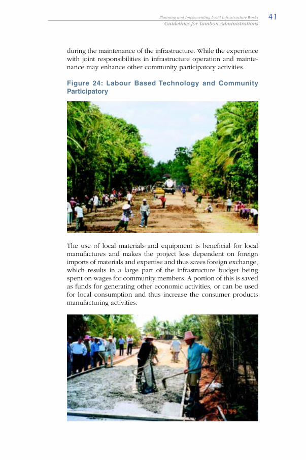
during the maintenance of the infrastructure. While the experiencewith joint responsibilities in infrastructure operation and mainte-nance may enhance other community participatory activities.
Figure 24: Labour Based Technology and CommunityParticipatory
The use of local materials and equipment is beneficial for localmanufactures and makes the project less dependent on foreignimports of materials and expertise and thus saves foreign exchange,which results in a large part of the infrastructure budget beingspent on wages for community members. A portion of this is savedas funds for generating other economic activities, or can be usedfor local consumption and thus increase the consumer productsmanufacturing activities.
Chapter 342
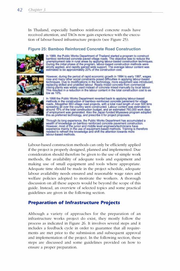
In Thailand, especially bamboo reinforced concrete roads havereceived attention, and TAOs now gain experience with the execu-tion of labour-based infrastructure projects (see Figure 25).
Figure 25: Bamboo Reinforced Concrete Road Construction
Labour-based construction methods can only be efficiently appliedif the project is properly designed, planned and implemented. Dueconsideration should therefore be given to the use of simple workmethods, the availability of adequate tools and equipment andmaking use of small equipment and tools where appropriate.Adequate time should be made in the project schedule, adequatelabour availability needs ensured and reasonable wage rates andwelfare policies adopted to motivate the workers. A thoroughdiscussion on all these aspects would be beyond the scope of thisguide. Instead, an overview of selected topics and some practicalguidelines are given in the following section.
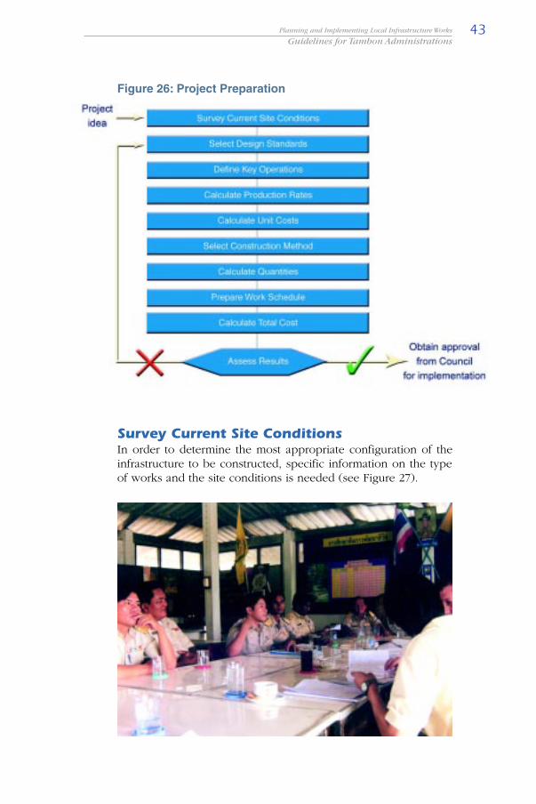
Preparation of Infrastructure Projects
Although a variety of approaches for the preparation of aninfrastructure works project do exist, they mostly follow theprocess as indicated in Figure 26. It involves several steps and itincludes a feedback cycle in order to guarantee that all require-ments are met prior to the submission and subsequent approvaland implementation of the project. In the following section, thesesteps are discussed and some guidelines provided on how toensure a proper preparation.
43Planning and Implementing Local Infrastructure Works
Guidelines for Tambon Administrations
Figure 26: Project Preparation
Survey Current Site ConditionsIn order to determine the most appropriate configuration of theinfrastructure to be constructed, specific information on the typeof works and the site conditions is needed (see Figure 27).

Chapter 344
Figure 27: Required Information for Designing Infrastructure
For common infrastructure such as buildings, existing structurescan be studied as examples. Information on functional andoperational problems could then be acquired from these structuresin order to compare advantages and disadvantages of variousdesigns. For complicated structures such as bridges and weirs,technical advise should be sought from qualified personnel.

45Planning and Implementing Local Infrastructure Works
Guidelines for Tambon Administrations
Select Design StandardsThe selection of appropriate design standards should be carriedout by a technician or engineer. If there is no technician or engi-neer available, assistance should be sought from technical units ofother authorities.
Designs standards for various types of community infrastructureare available from some government agencies e.g. a bridge designof ARD, a weir design from Ministry of Interior.
With the appropriate design standards, a qualified engineer or tech-nician can start preparing the design of the desired infrastructure.Since designs of infrastructure should be related to the specificconditions of the work site, the information collected in the firststep will be of vital importance and more field surveys might beneeded. As shown in Figure 28, other considerations may be takeninto account, such as social and environmental effects. In the finalparagraphs on the assessment of the results a few examples will begiven of improvements used in Thailand.
Figure 28: Example of Design for a Building
Chapter 346
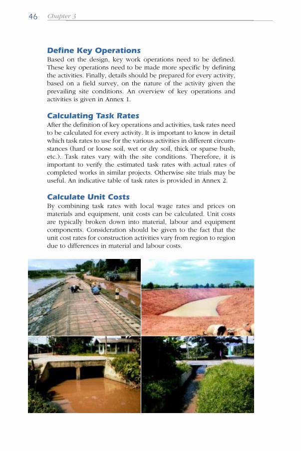
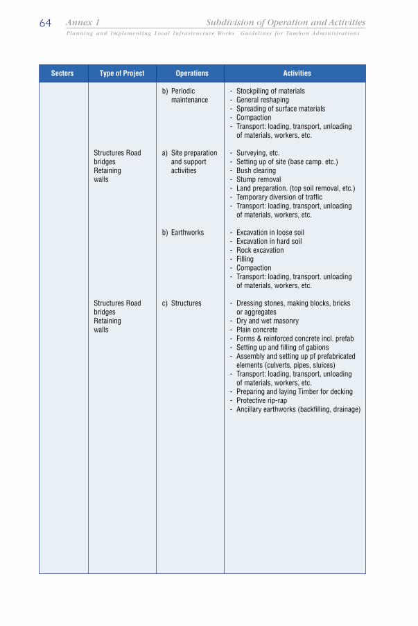
Define Key OperationsBased on the design, key work operations need to be defined.These key operations need to be made more specific by definingthe activities. Finally, details should be prepared for every activity,based on a field survey, on the nature of the activity given theprevailing site conditions. An overview of key operations andactivities is given in Annex 1.
Calculating Task RatesAfter the definition of key operations and activities, task rates needto be calculated for every activity. It is important to know in detailwhich task rates to use for the various activities in different circum-stances (hard or loose soil, wet or dry soil, thick or sparse bush,etc.). Task rates vary with the site conditions. Therefore, it isimportant to verify the estimated task rates with actual rates ofcompleted works in similar projects. Otherwise site trials may beuseful. An indicative table of task rates is provided in Annex 2.
Calculate Unit CostsBy combining task rates with local wage rates and prices onmaterials and equipment, unit costs can be calculated. Unit costsare typically broken down into material, labour and equipmentcomponents. Consideration should be given to the fact that theunit cost rates for construction activities vary from region to regiondue to differences in material and labour costs.

47Planning and Implementing Local Infrastructure Works
Guidelines for Tambon Administrations
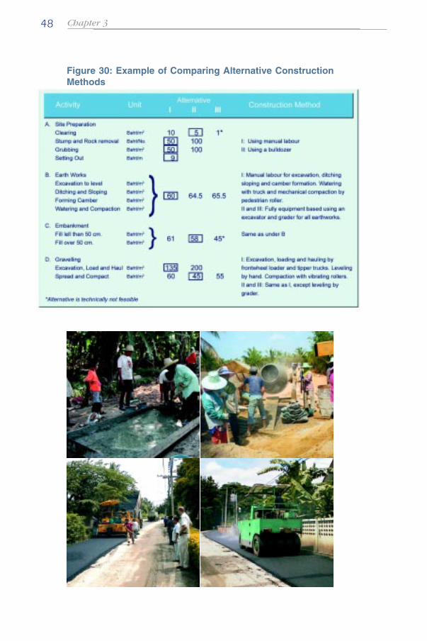
Select Construction MethodAfter having estimated the construction quantities, the constructionmethod applied in each work activity can be selected. In order tomaximise benefits to the local community, attempts should be madeto avoid using large construction equipment and imported materi-als, and to maximize the cost effective use of local constructionmaterials and create local employment. This should be taken intoconsideration when selecting the construction methods. Indicationof the suitability of certain activities for labour-based technologyfor a given wage level for unskilled labour is provided in Figure 29.
Figure 29: Suitability of Activities for Labour Based Technology
Alternative construction methods are compared based on the unitcost for every activity. On the basis of these comparisons, a finalchoice of construction method is made for every activity. An exampleis shown in Figure 30. For all activities, the existing alternativeconstruction methods and related unit costs are stated. The alterna-tives that turn out to be more expensive or less suitable technicallywill be replaced by the cheapest solution that will still deliver thesame quality of works as required by the set design standards.
Chapter 348
Figure 30: Example of Comparing Alternative ConstructionMethods

49Planning and Implementing Local Infrastructure Works
Guidelines for Tambon Administrations
Calculation of QuantitiesWhen all details of the construction plan and choice of technologyhave been prepared the detailed quantities of work need to beestimated. These quantities form the basis of the total cost analysisand ultimately determine the future inputs of labour, materials,tools and equipment. An example for a road construction project isgiven in Figure 31.
Figure 31: Example of Estimated Quantities
Chapter 350
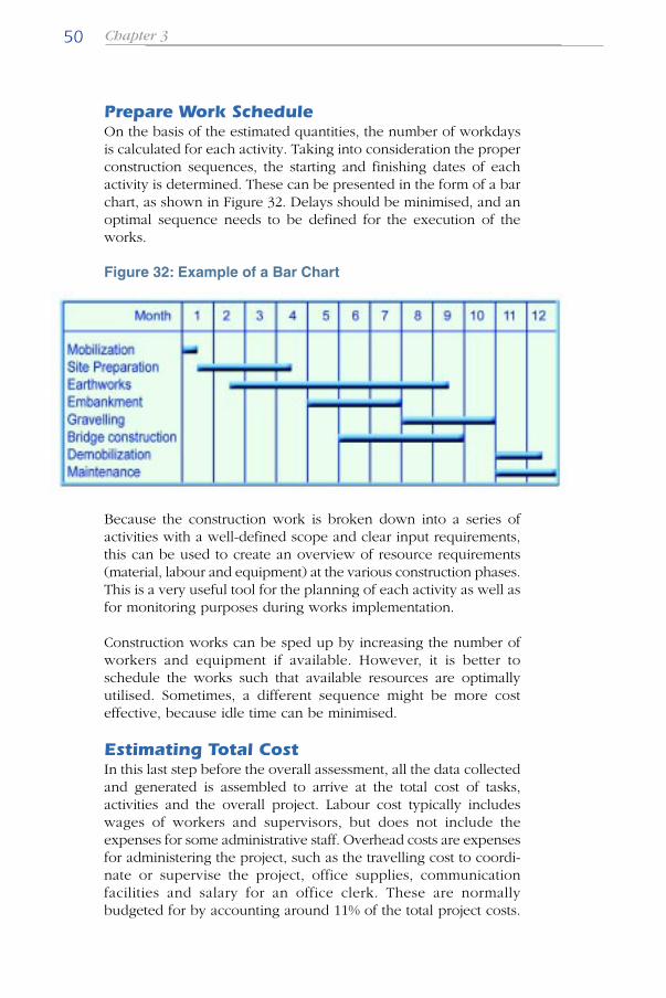
Prepare Work ScheduleOn the basis of the estimated quantities, the number of workdaysis calculated for each activity. Taking into consideration the properconstruction sequences, the starting and finishing dates of eachactivity is determined. These can be presented in the form of a barchart, as shown in Figure 32. Delays should be minimised, and anoptimal sequence needs to be defined for the execution of theworks.
Figure 32: Example of a Bar Chart
Because the construction work is broken down into a series ofactivities with a well-defined scope and clear input requirements,this can be used to create an overview of resource requirements(material, labour and equipment) at the various construction phases.This is a very useful tool for the planning of each activity as well asfor monitoring purposes during works implementation.
Construction works can be sped up by increasing the number ofworkers and equipment if available. However, it is better toschedule the works such that available resources are optimallyutilised. Sometimes, a different sequence might be more costeffective, because idle time can be minimised.
Estimating Total CostIn this last step before the overall assessment, all the data collectedand generated is assembled to arrive at the total cost of tasks,activities and the overall project. Labour cost typically includeswages of workers and supervisors, but does not include theexpenses for some administrative staff. Overhead costs are expensesfor administering the project, such as the travelling cost to coordi-nate or supervise the project, office supplies, communicationfacilities and salary for an office clerk. These are normallybudgeted for by accounting around 11% of the total project costs.

51Planning and Implementing Local Infrastructure Works
Guidelines for Tambon Administrations
For construction projects executed by external contractors, addi-tional costs should be calculated of around 20-30% of the projectcost to cover for contingencies, profits, taxes and risk.
Since the content of labour is higher in labour-based projects thanin an equipment based project and thus will rely more on themotivation of the workers, it is very important to assure that wagepayments are made on time. The payments should be planned inadvance in order to avoid a cash-flow problem. Payments andother time related variables could therefore be indicated in the barchart, in order to keep a close eye on upcoming events.
Equally important is to assure the availability of resources, to takeinto consideration the difficulty of the works and to allow someflexibility in timing to minimise materials, machines and workersstanding idle.
Apart from scheduling the various construction activities, a con-struction plan should also give a summary of resource utilisation,such as budget allocation and timing of disbursements, and man-power and equipment utilisation. During the implementation ofthe project, these issues need to be carefully monitored.
Assessment of ResultsAfter all these preparations, an assessment needs to be made tojustify the execution, based on past experience or by comparisonwith projects elsewhere. If for some reason the project is too ex-pensive, creates too little employment or for other reasons doesnot meet the expectations as formulated in the project proposal,the process may need to start all over from the selection of thedesign. Only after a positive assessment should the approval forimplementation be obtained from the TAO council.

Chapter 352
An example showing how considerable cost savings can be madeby proper assessment of the results and redesigning of the project,is given in Figure 33.
Figure 33: Example of Recommended Design of an IrrigationChannel
In another example, a bridge (see Figure 34) with prefabricatedconcrete piles were replaced by concrete spread footings

53Planning and Implementing Local Infrastructure Works
Guidelines for Tambon Administrations
manufactured on site, thereby avoiding the use of a driving crane,and instead use labour to excavate the abutment foundations. Theresulting total cost is only slightly cheaper, but increases the use oflocal labour.
Figure 34: Example of Recommended Design of a Bridge
These improved designs illustrate the importance of good prepara-tions, the resulting lower costs and the potential for replacing heavyequipment with labour and replacing imported materials withlocally produced materials, while maintaining or improving quality.
Project Implementation
After securing the approval of the TAO Council for the implemen-tation of the project, the construction works can commence, eitherby the community or a local contractor. Infrastructure projects canbe completely contracted out, but can also be executed partly bythe Tambon Administrative Offices. For those parts that are notcontracted out, the technician will act as the supervisor, ratherthan the inspector. The following section provides some generalguidelines for implementation.

Chapter 354
For more detailed or technical information, the ILO has developedappropriate guidelines for various stages of the project cycle (plan-ning, implementation and maintenance), for different functions tobe performed (execution, contracting, supervising, monitoring) andfor different types of works involved. It is however beyond thescope of this guide, to elaborate in detail on such issues so only afew indications will be given.
Obtain PermissionsBefore construction can start, all necessary construction permitsneed to be obtained. For this, the detailed project documents needto be submitted to the authorities concerned (see Figure 35).
Figure 35: Special Permits
Certain types of construction works are required by law to be de-signed and supervised by accredited engineers to ensure publicsafety and to secure prescribed professional standards.
Besides the involvement of all community members during theplanning stage, they should also be informed about the proposedconstruction plan before the work starts. Community meetingsshould be organized for this purpose. Permission to use land nearthe construction site for working areas has to be negotiated withthe owners.
Procure MaterialsInquiries on sources and prices of construction materials shouldhave already been made during the planning stage. Decisions onwhere to buy and at what prices should be made prior to the startof the construction in order that procurement can proceed in time.
For construction materials used in large quantities, supply con-tracts may need to be signed. In these contracts delivery schedulesneed to be included. Make sure that construction materials aredelivered on site prior to their scheduled usage in order to avoiddisruption of works.
55Planning and Implementing Local Infrastructure Works
Guidelines for Tambon Administrations
Although some construction materials can be stored outdoors, asheltered area is required for storing delicate materials, for instancecement bags. Proper and secure storage space of adequate size istherefore required. Due consideration should be given to what andhow much to be stored, in order to optimize storage space. Forconvenience, storage facilities should be as close as possible to theconstruction site.
Delivery of construction materials needs to be checked by a qualifiedperson to ensure compliance with design and quality specifications.Also, records on receiving and disbursing construction materials needto be kept.
Recruit WorkersThe workers should be recruited by public announcement of theworks and by informing villagers well in advance about employ-ment opportunities. Villagers from the communities served by theinfrastructure projects should be given first priority for works. Aquota system can be used to distribute employment opportunityamong the various community factions.
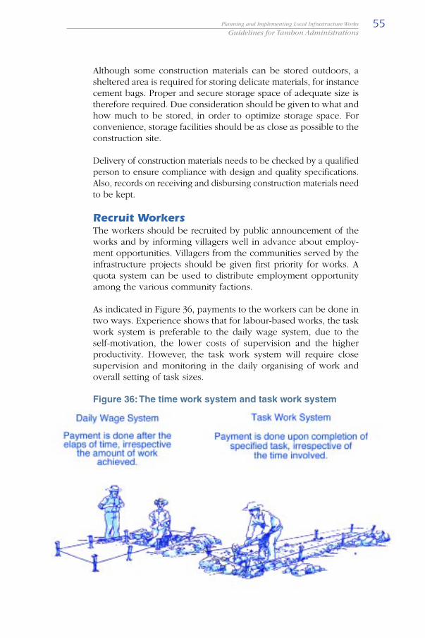
As indicated in Figure 36, payments to the workers can be done intwo ways. Experience shows that for labour-based works, the taskwork system is preferable to the daily wage system, due to theself-motivation, the lower costs of supervision and the higherproductivity. However, the task work system will require closesupervision and monitoring in the daily organising of work andoverall setting of task sizes.
Figure 36: The time work system and task work system
Chapter 356
Contractors can be engaged to undertake not only large or compli-cated construction works, but also small and simple works. Whenengaging contractors, certain conditions can be stipulated in thecontract document to ensure maximum benefits to the community.Such conditions typically try to avoid the use of large constructionequipment and to maximize local labour employment.
Organising WorksWith all resources available at the project site, it is necessary toassign tasks to workers and to coordinate the works. Attentionshould be given to assign suitable tasks to workers which fit theircapacities and to properly balance the number of workers amongthe various tasks according to their level of difficulty. Also, thelimitations of the workspace as well as the availability of toolsshould be taken into consideration at this stage.
Balancing of gang sizes, i.e. ensuring that labour is used in themost efficient way and that each of the operations on averageproceed at the same pace, is the daily task of the technician. Theoptimal size of the gang varies according to the work being under-taken and depends on the volume of work in each operation, thetask rates being used, the available labour and the sequence ofoperations. Good gang balancing is important because it alsodetermines the length of the construction site.
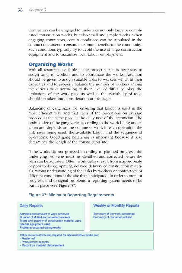
If the works do not proceed according to planned progress, theunderlying problems must be identified and corrected before theplan can be adjusted. Often, work delays result from inappropriateor poor tools/ equipment, delayed delivery of construction materi-als, wrong understanding of the tasks by workers or contractors, ordifferent conditions at the site than anticipated. In order to monitorprogress, and to signal problems, a reporting system needs to beput in place (see Figure 37).
Figure 37: Minimum Reporting Requirements

57Planning and Implementing Local Infrastructure Works
Guidelines for Tambon Administrations
An Example of Labour Based Road Construction
A large amount of the projects developed and implemented byTAOs consist of road construction. Labour based bamboo rein-forced concrete roads have been mentioned in an earlier section.But another surfacing option, probably more suitable to the budgetand traffic intensity of an average TAO and equally suitable forlabour based construction, is the use of gravel.
For this purpose, a set of video CDs on the construction of labourbased road construction has been developed by the ILO incollaboration with the Public Works Department of Thailand anddistributed to the TAO provincial offices. The introductory videoCD has been included in the back of these guidelines to explainthe main principles. The following sections are derived from thestep-wise setup on this video CD as a point of reference.
Survey and Setting Out Road AlignmentBy conducting a topographic-survey, the alignment of the road isestablished, which describes where the roads will run. When thealignment has been established, the detailed setting out can beginby determining the road width and designing the slopes and drainsalong the side of the road.
Figure 38: Surveying and setting out of road aligment
Particular attention needs to be given to the alignment. The hori-zontal alignment is set out of the plane of the road and includesbends or curves. The vertical alignment covers the levels (usuallyat the centerline of the road) and the cross-section profiles of theroad.
Finally, the full cross-section needs to be set out. This shows theactual shape of the road, the dimension of the camber, the sideslopes and the drains.

Chapter 358
Site ClearingClearing is the first work activity after setting out the alignment.Trees, vegetation and other obstacles must to be removed from theroadway. The clearing operation involves the removal of bush,grass and other vegetation (grubbing), trees, stumps and boulders.Big boulders can be demolished before they are removed orburied well below the road levels.
Figure 39: Site Clearing
EarthworksThis is often the most significant work operation in road construc-tion. Earthworks basically consist of shaping a stable terrace orfoundation for the road.
Earthworks include activities such as excavation (leveling, cut tofill, cut to spoil and borrow), soil transport (loading, hauling andunloading of the soil) and the filling, spreading and compaction.After each layer is unloaded, it needs to be spread and compacted.Compaction is very important to ensure the embankment is strongand durable. Measurement of the degree of compaction is animportant quality monitoring tool.
Figure 40: Earthworks

59Planning and Implementing Local Infrastructure Works
Guidelines for Tambon Administrations
StructuresSpecial structures need to be built in case the road must cross awaterway as well as for drainage purposes. Common structures arebridges, drifts and culverts.
Figure 41: Structures
Drainage SystemsIt is important that water is drained away as quickly as possiblefrom the road surface and its border zones. This is to make surethat the water does not damage the road, its foundations and struc-tures. Water should be drained in a controlled way so that drainageflows do not become too large or too fast and causes erosion.Drainage of water from one side of the road to the other side of theroad must also be made possible.
There are different drainage components used for roads, such ascamber, catch water drains, side drains, scour checks, mitre drains,and culverts. In some terrain, the road requires only three or fourof these drainage components. In other sections it may require allsix. In any case, all components of the drainage system shouldwork together to allow the water to flow “off the road”, as well as“away from the road”.
Figure 42: Drainage Systems
Chapter 360
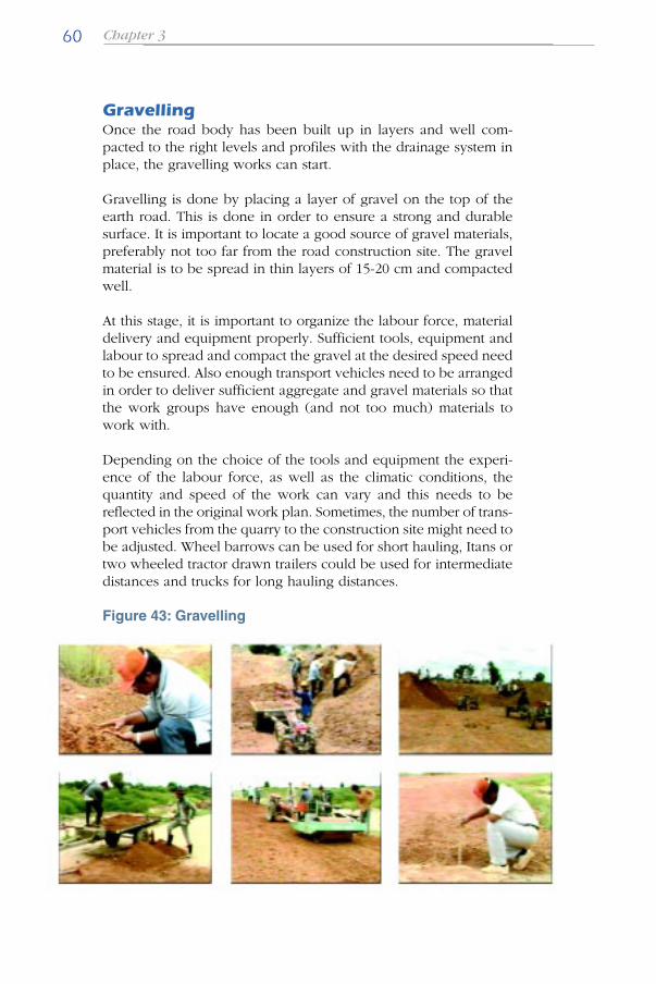
GravellingOnce the road body has been built up in layers and well com-pacted to the right levels and profiles with the drainage system inplace, the gravelling works can start.
Gravelling is done by placing a layer of gravel on the top of theearth road. This is done in order to ensure a strong and durablesurface. It is important to locate a good source of gravel materials,preferably not too far from the road construction site. The gravelmaterial is to be spread in thin layers of 15-20 cm and compactedwell.
At this stage, it is important to organize the labour force, materialdelivery and equipment properly. Sufficient tools, equipment andlabour to spread and compact the gravel at the desired speed needto be ensured. Also enough transport vehicles need to be arrangedin order to deliver sufficient aggregate and gravel materials so thatthe work groups have enough (and not too much) materials towork with.
Depending on the choice of the tools and equipment the experi-ence of the labour force, as well as the climatic conditions, thequantity and speed of the work can vary and this needs to bereflected in the original work plan. Sometimes, the number of trans-port vehicles from the quarry to the construction site might need tobe adjusted. Wheel barrows can be used for short hauling, Itans ortwo wheeled tractor drawn trailers could be used for intermediatedistances and trucks for long hauling distances.
Figure 43: Gravelling
61Planning and Implementing Local Infrastructure Works
Guidelines for Tambon Administrations
Epilogue
The reliance on equipment-based, high technology, constructionmethods has evolved for a number of reasons. A particularlyimportant factor has been the educational background of thetechnical leadership in most developing countries. Often acquiredin engineering schools that advocated the latest technology andproduction methods, this background conditioned planners andengineers to favour the use of heavy equipment in all circum-stances. Equipment- based methods were perceived to haveproductivities, costs and performance that were predictable; theywere associated with high quality results; and they were surroundedby an aura of technological progress.
At the same time, the substitution of labour for machines appearedas an attractive alternative to engineers and planners. Largenumbers of labour are needed to approach the output of a singlepiece of equipment. Doubts were entertained about the ability ofunskilled workers to produce high quality work. Labourers wereregarded as being undisciplined, unruly, unreliable and conse-quently, requiring extensive supervision. In sum, the extensive useof labour was judged to increase the risk of higher costs, to bringabout longer construction periods and to produce results ofdubious technical quality. These risks tended to make publicsectors in most developing countries - the front line of potentialusers of labour-based works technology - resist the use of unskilledlabour in construction.
Reliance on equipment has shown to have some disadvantages.Equipmentbased operations entails heavy expenditures of foreignexchange. Such costs might be an unavoidable burden for urgentlyneeded high technology projects, but for the construction of smaller,more scattered and technically less demanding rural projects,politicians and administrators need to consider alternativesolutions and put local resources to work. If much of the workcould be done by hand, the rural population would not onlyreceive the benefits of the finished product but would in additionsecure much needed income from its construction, considerableemployment from its maintenance and a sense of participation,civic pride and unity.

AnnexesSubdivision of Operation and ActivitiesRecommended Labour Productivity Rates

63Planning and Implementing Local Infrastructure Works Guidelines for Tambon Administrations
Annex 1 Subdivision of Operation and Activities
Sectors
Roads &Bridges
Type of Project
Road ConstructionRoad Rehabilitation
Road Maintenance(earth & gravelroads)
Activities
- Surveying and setting out- Setting up site (base camp, etc.)- Bush clearing- Stump removal- Land preparation (topsoil removal, etc.)- Temporary traffic diversion- Motorised transport: loading, transport,
unloading of materials, workers, etc.
- Excavation in soft soil- Excavation in hard soil- Rock excavation- Filling- Compaction- Motorised transport: loading, transport,
unloading of materials, workers, etc.
- Opening and operation of borrow areas- Gravel excavation- Spreading and leveling- Compaction- Motorised transport: loading, transport,
unloading of materials, workers, etc.
- Excavation, culvert laying and backfilling,(culvert diam < 1,000 mm.)
- Masonry for small structures & ditch lining(box-cutverts, dry wells, wing walls, smalldrifts, retaining walls)
- Plain concrete- Reinforced concrete incl. prefabrication
(culverts)- Slope stabilisation and protection- Setting up and filling of gabions- Motorised transport: loading, transport,
unloading of materials, workers, etc.
- Stockpiling of selected materials- Filling potholes and gullies- Localised regraveling- Motorised transport: loading, transport,
unloading of materials, workers, etc.- Sloping and clearing of ditches- Clearing culverts- Repairs to masonry for small structures
and ditch lining (box-culverts, dry wells,wingwalls, small drifts, retaining walls)
- Concrete. (plain or reinforced) for repairsto structures
- Slope stabilisation and protection- Repairing gabions
Operations
a) Site preparationand supportOperations
b) Earthworks
c) Graveling
d) Structures
a) Rouutinemaintenance
64Planning and Implementing Local Infrastructure Works Guidelines for Tambon Administrations
Annex 1 Subdivision of Operation and Activities
Sectors Type of Project
Structures RoadbridgesRetainingwalls
Structures RoadbridgesRetainingwalls
Operations
b) Periodicmaintenance
a) Site preparationand supportactivities
b) Earthworks
c) Structures
Activities
- Stockpiling of materials- General reshaping- Spreading of surface materials- Compaction- Transport: loading, transport, unloading
of materials, workers, etc.
- Surveying, etc.- Setting up of site (base camp. etc.)- Bush clearing- Stump removal- Land preparation. (top soil removal, etc.)- Temporary diversion of traffic- Transport: loading, transport, unloading
of materials, workers, etc.
- Excavation in loose soil- Excavation in hard soil- Rock excavation- Filling- Compaction- Transport: loading, transport. unloading
of materials, workers, etc.
- Dressing stones, making blocks, bricksor aggregates
- Dry and wet masonry- Plain concrete- Forms & reinforced concrete incl. prefab- Setting up and filling of gabions- Assembly and setting up pf prefabricated
elements (culverts, pipes, sluices)- Transport: loading, transport, unloading
of materials, workers, etc.- Preparing and laying Timber for decking- Protective rip-rap- Ancillary earthworks (backfilling, drainage)
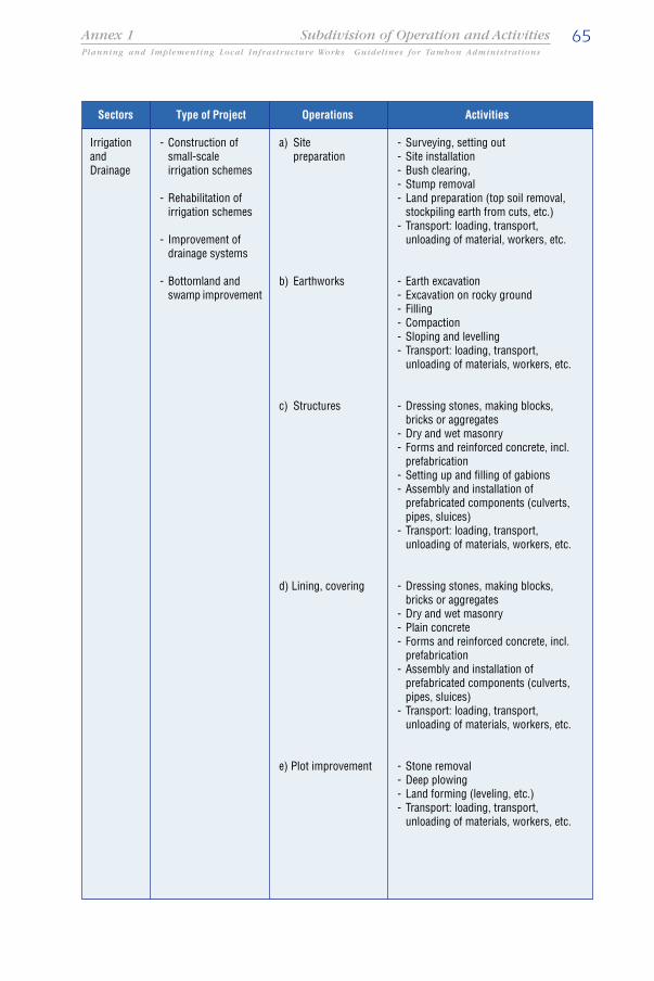
65Planning and Implementing Local Infrastructure Works Guidelines for Tambon Administrations
Annex 1 Subdivision of Operation and Activities
Sectors
IrrigationandDrainage
Type of Project
- Construction ofsmall-scaleirrigation schemes
- Rehabilitation ofirrigation schemes
- Improvement ofdrainage systems
- Bottomland andswamp improvement
Operations
a) Sitepreparation
b) Earthworks
c) Structures
d) Lining, covering
e) Plot improvement
Activities
- Surveying, setting out- Site installation- Bush clearing,- Stump removal- Land preparation (top soil removal,
stockpiling earth from cuts, etc.)- Transport: loading, transport,
unloading of material, workers, etc.
- Earth excavation- Excavation on rocky ground- Filling- Compaction- Sloping and levelling- Transport: loading, transport,
unloading of materials, workers, etc.
- Dressing stones, making blocks,bricks or aggregates
- Dry and wet masonry- Forms and reinforced concrete, incl.
prefabrication- Setting up and filling of gabions- Assembly and installation of
prefabricated components (culverts,pipes, sluices)
- Transport: loading, transport,unloading of materials, workers, etc.
- Dressing stones, making blocks,bricks or aggregates
- Dry and wet masonry- Plain concrete- Forms and reinforced concrete, incl.
prefabrication- Assembly and installation of
prefabricated components (culverts,pipes, sluices)
- Transport: loading, transport,unloading of materials, workers, etc.
- Stone removal- Deep plowing- Land forming (leveling, etc.)- Transport: loading, transport,
unloading of materials, workers, etc.
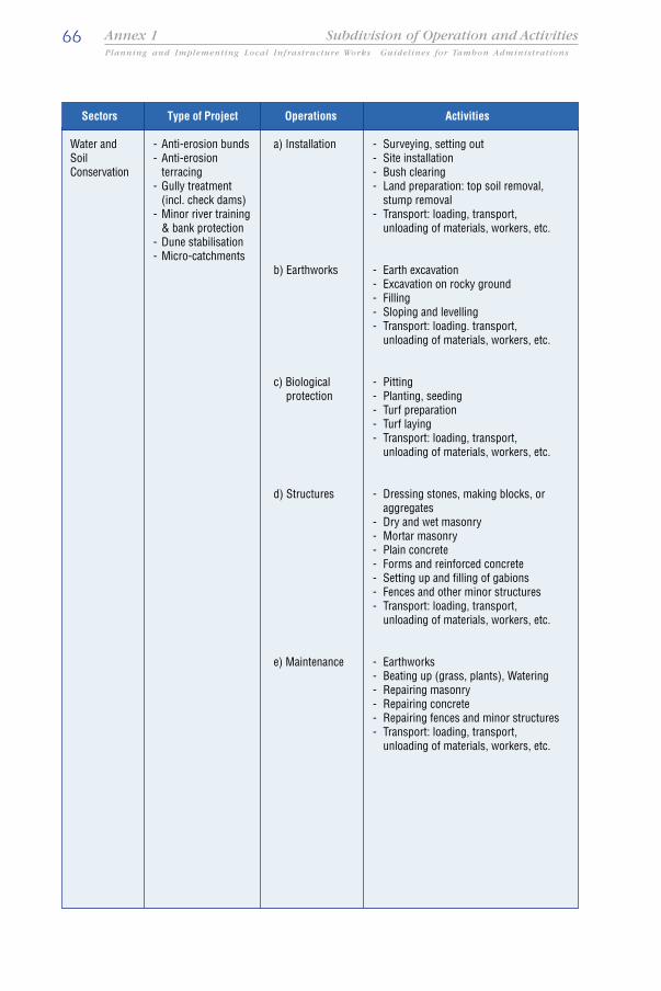
66Planning and Implementing Local Infrastructure Works Guidelines for Tambon Administrations
Annex 1 Subdivision of Operation and Activities
Sectors
Water andSoilConservation
Type of Project
- Anti-erosion bunds- Anti-erosion
terracing- Gully treatment
(incl. check dams)- Minor river training
& bank protection- Dune stabilisation- Micro-catchments
Operations
a) Installation
b) Earthworks
c) Biologicalprotection
d) Structures
e) Maintenance
Activities
- Surveying, setting out- Site installation- Bush clearing- Land preparation: top soil removal,
stump removal- Transport: loading, transport,
unloading of materials, workers, etc.
- Earth excavation- Excavation on rocky ground- Filling- Sloping and levelling- Transport: loading. transport,
unloading of materials, workers, etc.
- Pitting- Planting, seeding- Turf preparation- Turf laying- Transport: loading, transport,
unloading of materials, workers, etc.
- Dressing stones, making blocks, oraggregates
- Dry and wet masonry- Mortar masonry- Plain concrete- Forms and reinforced concrete- Setting up and filling of gabions- Fences and other minor structures- Transport: loading, transport,
unloading of materials, workers, etc.
- Earthworks- Beating up (grass, plants), Watering- Repairing masonry- Repairing concrete- Repairing fences and minor structures- Transport: loading, transport,
unloading of materials, workers, etc.

67Planning and Implementing Local Infrastructure Works Guidelines for Tambon Administrations
Annex 2 Recommended Labour Productivity Rates
Clearing & GrubbingBush Clearing (Light)
(Medium)(Dense)
Grubbing (Top Soil Removal)
Boulder Removal (Loose)Tree and Trump Removal(0.25 m. Dia.)
Excavation, Spreading &Compaction of Soil MaterialExcavate & Load/ Throw
(Soil)
(Heavy Soil)(Rock)
UnloadSpread, Shape & WaterCompaction by Roller(150 mm. thickness)Compaction by Roller(150 mm. thickness)
Hauling by Wheel BarrowHauling Distance: 0 - 25 mHauling Distance: 26 - 50 mHauling Distance: 51 - 100 m
Sub-Base PreparationExcavate & Stockpile
LoadExcavate & Load
UnloadSpread, Shape & WaterCompact by RollerBase PreparationExcavate & Stockpile
LoadExcavate & Load
UnloadSpread, Shape & WaterCompact by Roller
Concreting (Roads)
Screening of Aggregates (Gravel)
ROADS
Brush Hook, Grass Cutter
Hoe, Forked Hoe, PickMattock Crow Bar, SledgeHammer & Cold ChiselAxe, Bow Saw
Hoe, Forked HoeMattock, Pickaxe & Shovel
Shovel & WheelbarrowRakeSpreader, Shovel & Hoe Roller
Roller
Wheel Barrow
Hoe, Forked Hoe, Mattock,Pickaxe & ShovelShovel Wheel BarrowHoe, Forked Hoe, Mattock,Pickaxe & ShovelShovel & Wheel BarrowRake, Shovel & Hoe Roller
Hoe, Forked Hoe, Mattock,Pickaxe & ShovelShovel Wheel BarrowHoe, Forked Hoe, Mattock,Pickaxe & ShovelShovel & Wheel BarrowRake, Shovel & Hoe Roller
Screening Equipment
1 worker 1 foreman1 worker1 worker1 worker
1 worker1 worker
1 worker 1 foreman
1 worker1 worker1 worker1 worker1 worker
1 worker
1 worker 1 foreman1 worker 1 foreman1 worker 1 foreman
1 worker 1 foreman
1 worker1 worker
1 worker1 worker1 worker
1 worker
1 worker1 worker
1 worker1 worker1 worker
1 worker 1 foreman
250 sq.m.125 sq.m.
65 sq.m.150 sq.m.
150 sq.m.1 tree
2 cu.m.
1.5 cu.m.0.5 cu.m.30 cu.m.5 cu.m.50 sq.m
1.500 sq.m.
10 cu.m.7 cu.m.4 cu.m.
25 cu.m.
5 cu.m.25 cu.m
30 cu.m.5 cu.m.
2,000 sq.m.
2.5 cu.m.
5 cu.m.2.5 cu.m.
30 cu.m.12 cu.m.
1.500 sq.m.
4 cu.m
Operation / Activity Tools RequiredOutputPer Day
Required Manpower
Worker Supervisor
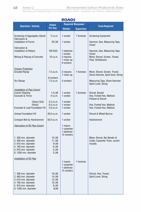
68Planning and Implementing Local Infrastructure Works Guidelines for Tambon Administrations
Annex 2 Recommended Labour Productivity Rates
Screening of Aggregates (Sand)Fabrication &Installation of Forms
Fabrication &Installation of Rebars
Mixing & Placing of Concrete
Erosion ProtectionGrouted Riprap
Dry Riprap
Installation of Pipe CulvertCulvert CleaningExcavate & Throw
(Heavy Soil)(Rock)
Excavate & Load Foundation Fill
Unload Foundation Fill
Compact Bed by Handrammer
Fabrication of RC Pipe Culvert
1. 300 mm. diameter2. 460 mm. diameter3. 610 mm. diameter4. 760 mm. diameter5. 910 mm. diameter6. 1200 mm. diameter
Installation of RC Pipe
1. 300 mm. diameter2. 460 mm. diameter3. 610 mm. diameter4. 760 mm. diameter5. 910 mm. diameter6. 1200 mm. diameter
ROADS
Screening Equipment
Hammer, Saw, Measuring Tape,Chisel
Hammer, Saw, Measuring Tape,ChiselMixer, Shovel, Screen, Trowel,Float, Strikeboard
Mixer, Shovel, Screen, Trowel,Stone Hammer, Spirit level, String
Measuring Tape, Stone HammerSpirit Level, String
Shovel, BucketHoe, Forked Hoe, MattockPickaxe & Shovel
Hoe, Forked Hoe, MattockHoe, Forked Hoe, Mattock
Shovel & Wheel Barrow
Handrammer
Mixer, Shovel, Bar Bender &Cutter, Carpenter Tools, culvertmoulds
Shovel, Hoe, Trowel,Spirit Level, String
1 worker 1 foreman
1 worker
1 steelman1 worker2 masons1 mixer op.8 workers
2 masons 1 foreman1 mixer op.
5 workers
1 worker 1 foreman1 worker
1 worker1 worker1 worker
1 worker
1 worker
1 mason1 carpenter1 steelman12 workers
1 mason 1 foreman1 carpenter1 steelman12 workers
2 cu.m.
20 LM
100 KGS.
10 cu.m.
7.5 cu.m.
8 workers7.5 cu.m.
1.0 LM4 cu.m.
2.5 cu.m.0.5 cu.m.3.0 cu.m.
30.0 cu.m.
50.0 cu.m.
15 LM11 LM
9 LM6 LM5 LM3 LM
16 LM14 LM12 LM10 LM
8 LM6LM
Operation / Activity Tools RequiredOutputPer Day
Required Manpower
Worker Supervisor
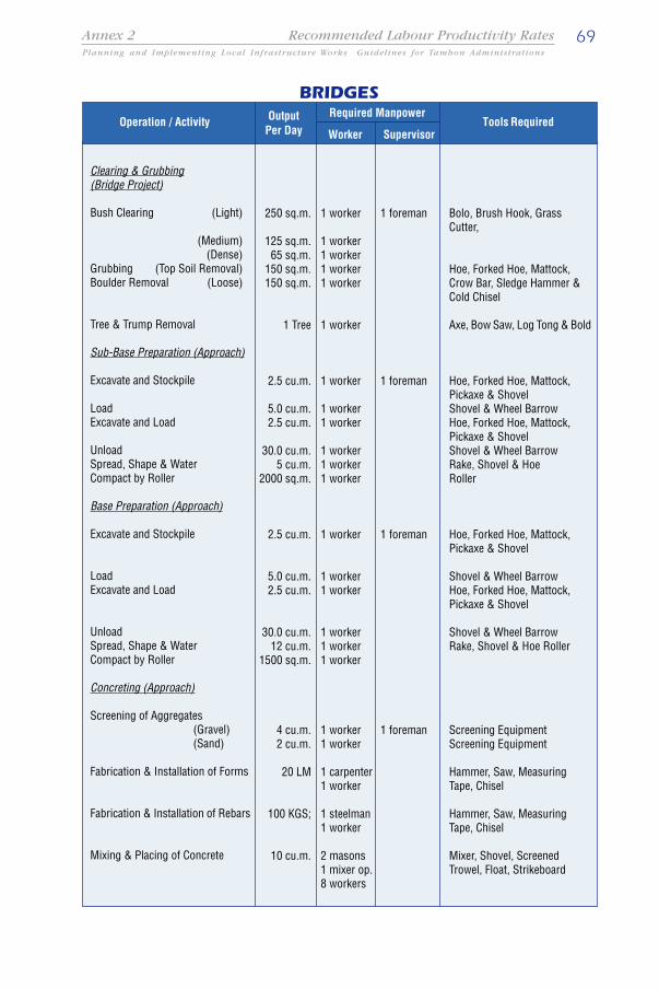
69Planning and Implementing Local Infrastructure Works Guidelines for Tambon Administrations
Annex 2 Recommended Labour Productivity Rates
Clearing & Grubbing(Bridge Project)
Bush Clearing (Light)
(Medium)(Dense)
Grubbing (Top Soil Removal)Boulder Removal (Loose)
Tree & Trump Removal
Sub-Base Preparation (Approach)
Excavate and Stockpile
LoadExcavate and Load
UnloadSpread, Shape & WaterCompact by Roller
Base Preparation (Approach)
Excavate and Stockpile
LoadExcavate and Load
UnloadSpread, Shape & WaterCompact by Roller
Concreting (Approach)
Screening of Aggregates(Gravel)(Sand)
Fabrication & Installation of Forms
Fabrication & Installation of Rebars
Mixing & Placing of Concrete
1 worker 1 foreman
1 worker1 worker1 worker1 worker
1 worker
1 worker 1 foreman
1 worker1 worker
1 worker1 worker1 worker
1 worker 1 foreman
1 worker1 worker
1 worker1 worker1 worker
1 worker 1 foreman1 worker
1 carpenter1 worker
1 steelman1 worker
2 masons1 mixer op.8 workers
250 sq.m.
125 sq.m.65 sq.m.
150 sq.m.150 sq.m.
1 Tree
2.5 cu.m.
5.0 cu.m.2.5 cu.m.
30.0 cu.m.5 cu.m.
2000 sq.m.
2.5 cu.m.
5.0 cu.m.2.5 cu.m.
30.0 cu.m.12 cu.m.
1500 sq.m.
4 cu.m.2 cu.m.
20 LM
100 KGS;
10 cu.m.
Bolo, Brush Hook, GrassCutter,
Hoe, Forked Hoe, Mattock,Crow Bar, Sledge Hammer &Cold Chisel
Axe, Bow Saw, Log Tong & Bold
Hoe, Forked Hoe, Mattock,Pickaxe & ShovelShovel & Wheel BarrowHoe, Forked Hoe, Mattock,Pickaxe & ShovelShovel & Wheel BarrowRake, Shovel & HoeRoller
Hoe, Forked Hoe, Mattock,Pickaxe & Shovel
Shovel & Wheel BarrowHoe, Forked Hoe, Mattock,Pickaxe & Shovel
Shovel & Wheel BarrowRake, Shovel & Hoe Roller
Screening EquipmentScreening Equipment
Hammer, Saw, MeasuringTape, Chisel
Hammer, Saw, MeasuringTape, Chisel
Mixer, Shovel, ScreenedTrowel, Float, Strikeboard
Operation / Activity Tools Required
BRIDGESOutput
Per DayRequired Manpower
Worker Supervisor
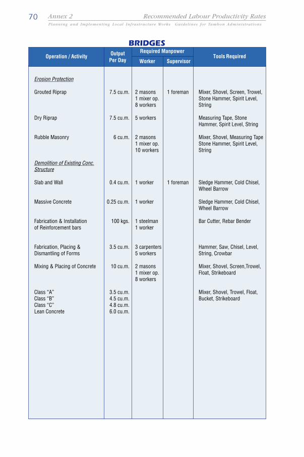
70Planning and Implementing Local Infrastructure Works Guidelines for Tambon Administrations
Annex 2 Recommended Labour Productivity Rates
BRIDGES
Erosion Protection
Grouted Riprap
Dry Riprap
Rubble Masonry
Demolition of Existing Conc.Structure
Slab and Wall
Massive Concrete
Fabrication & Installationof Reinforcement bars
Fabrication, Placing &Dismantling of Forms
Mixing & Placing of Concrete
Class “A”Class “B”Class “C”Lean Concrete
Mixer, Shovel, Screen, Trowel,Stone Hammer, Spirit Level,String
Measuring Tape, StoneHammer, Spirit Level, String
Mixer, Shovel, Measuring TapeStone Hammer, Spirit Level,String
Sledge Hammer, Cold Chisel,Wheel Barrow
Sledge Hammer, Cold Chisel,Wheel Barrow
Bar Cutter, Rebar Bender
Hammer, Saw, Chisel, Level,String, Crowbar
Mixer, Shovel, Screen,Trowel,Float, Strikeboard
Mixer, Shovel, Trowel, Float,Bucket, Strikeboard
2 masons 1 foreman1 mixer op.8 workers
5 workers
2 masons1 mixer op.10 workers
1 worker 1 foreman
1 worker
1 steelman1 worker
3 carpenters5 workers
2 masons1 mixer op.8 workers
7.5 cu.m.
7.5 cu.m.
6 cu.m.
0.4 cu.m.
0.25 cu.m.
100 kgs.
3.5 cu.m.
10 cu.m.
3.5 cu.m.4.5 cu.m.4.8 cu.m.6.0 cu.m.
Operation / Activity Tools RequiredOutputPer Day
Required Manpower
Worker Supervisor
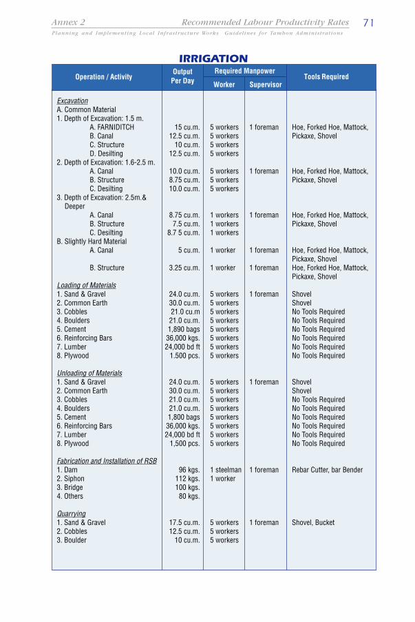
71Planning and Implementing Local Infrastructure Works Guidelines for Tambon Administrations
Annex 2 Recommended Labour Productivity Rates
Required Manpower
Worker SupervisorOperation / Activity Tools Required
ExcavationA. Common Material1. Depth of Excavation: 1.5 m.
A. FARNIDITCHB. CanalC. StructureD. Desilting
2. Depth of Excavation: 1.6-2.5 m.A. CanalB. StructureC. Desilting
3. Depth of Excavation: 2.5m.&Deeper
A. CanalB. StructureC. Desilting
B. Slightly Hard MaterialA. Canal
B. Structure
Loading of Materials1. Sand & Gravel2. Common Earth3. Cobbles4. Boulders5. Cement6. Reinforcing Bars7. Lumber8. Plywood
Unloading of Materials1. Sand & Gravel2. Common Earth3. Cobbles4. Boulders5. Cement6. Reinforcing Bars7. Lumber8. Plywood
Fabrication and Installation of RSB1. Dam2. Siphon3. Bridge4. Others
Quarrying1. Sand & Gravel2. Cobbles3. Boulder
IRRIGATION
Hoe, Forked Hoe, Mattock,Pickaxe, Shovel
Hoe, Forked Hoe, Mattock,Pickaxe, Shovel
Hoe, Forked Hoe, Mattock,Pickaxe, Shovel
Hoe, Forked Hoe, Mattock,Pickaxe, ShovelHoe, Forked Hoe, Mattock,Pickaxe, Shovel
ShovelShovelNo Tools RequiredNo Tools RequiredNo Tools RequiredNo Tools RequiredNo Tools RequiredNo Tools Required
ShovelShovelNo Tools RequiredNo Tools RequiredNo Tools RequiredNo Tools RequiredNo Tools RequiredNo Tools Required
Rebar Cutter, bar Bender
Shovel, Bucket
5 workers 1 foreman5 workers5 workers5 workers
5 workers 1 foreman5 workers5 workers
1 workers 1 foreman1 workers1 workers
1 worker 1 foreman
1 worker 1 foreman
5 workers 1 foreman5 workers5 workers5 workers5 workers5 workers5 workers5 workers
5 workers 1 foreman5 workers5 workers5 workers5 workers5 workers5 workers5 workers
1 steelman 1 foreman1 worker
5 workers 1 foreman5 workers5 workers
15 cu.m.12.5 cu.m.
10 cu.m.12.5 cu.m.
10.0 cu.m.8.75 cu.m.10.0 cu.m.
8.75 cu.m.7.5 cu.m.
8.7 5 cu.m.
5 cu.m.
3.25 cu.m.
24.0 cu.m.30.0 cu.m.21.0 cu.m21.0 cu.m.1,890 bags36,000 kgs.24,000 bd ft
1.500 pcs.
24.0 cu.m.30.0 cu.m.21.0 cu.m.21.0 cu.m.1,800 bags36,000 kgs.24,000 bd ft
1,500 pcs.
96 kgs.112 kgs.100 kgs.80 kgs.
17.5 cu.m.12.5 cu.m.
10 cu.m.
OutputPer Day

72Planning and Implementing Local Infrastructure Works Guidelines for Tambon Administrations
Annex 2 Recommended Labour Productivity Rates
Required Manpower
Worker SupervisorOperation / Activity Tools Required
Demolition of Concrete1. Slab & Walls2. Massive Concrete
Screening of Aggregates1. Gravel2. Sand
Manual BackfillBackfillingLaying of Materials: Cobbles
Boulders
Spreading of Gravel & Sandon Filter Drain and GravelBlanketSpreading of GranularMaterials
ConcretingGrouted Riprap (With Mixer)
Grouted Riprap (Without Mixer)
Rubble Masonry
CHB Setting1. Fence A. 4" CHB
B. 6" CHB2. Building A. 4" CHB
B. 6" CHB
Concrete Lining
Installation of Steel Gates1. 16 X 16 TO 24 X 242. Above 24 X 24
Fabrication, Placing &Dismantling of Forms:1. 3000 PSI Concrete
2. Canal Lining
IRRIGATION
Sledge Hammer, Cold Chisel,Wheel Barrow
Screening EquipmentScreening Equipment
ShovelNo Tools RequiredNo Tools Required
Shovel, Rake, Hoe
Mixer, Shovel, Trowel,Measuring Tape, StoneHammer, Spirit Level, String
Shovel, Trowel,Measuring Tape, StoneHammer, Spirit Level, String
Mixer, Shovel, Trowel,Measuring Tape, StoneHammer, Spirit Level, String
Shovel, Trowel, String, Level,Hammer
Shovel, Trowel, String, Level,Hammer
Level, WeldingMachine,Hammer, Blow Torch
Hammer, Saw, Chisel, Level,String, CrowbarHammer, Saw, Chisel, Level,String, Crowbar
2 cu.m.1.25 cu.m.
20 cu.m.30 cu.m.
15 cu.m.10 cu.m.
7.54 cu.m.
12.5 cu.m.
7.5 cu.m.
5.5 cu.m.
6.0 cu.m.
14 sq.m.10 sq.m.10 sq.m.
8 sq.m.
4.5 cu.m.
2 Assembly1 Assembly
3.5 cu.m.
4.5 cu.m.
5 workers 1 foreman5 workers
5 workers 1 foreman5 workers
1 worker 1 foreman1 worker1 worker
1 worker 1 foreman
2 masons 1 foreman1 mixer op.8 workers
2 masons 1 foreman10 workers
2 masons 1 foreman1 mixer op.8 workers
1 mason 1 foreman2 workers
2 masons 1 foreman1 mixer op.10 workers
1 Mason5 Workers
3 carpenters 1 foreman5 workers1 carpenter1 worker
OutputPer Day

73Planning and Implementing Local Infrastructure Works Guidelines for Tambon Administrations
Annex 2 Recommended Labour Productivity Rates
Mixing and Placing of Concrete
1. With Concrete Mixer
Class “A”
Class “B”Class “C”Lean Concrete
Class “A”Class “B”Class “C”Lean Concrete
Plastering of CHB Wall
Fabrication of RC Pipe
1. 300 mm. Diameter2. 460 mm. Diameter3. 610 mm. Diameter4. 760 mm. Diameter5. 910 mm. Diameter6. 1200 mm. Diameter
Installation of RC Pipe
1. 300 mm. Diameter2. 460 mm. Diameter3. 610 mm. Diameter4. 760 mm. Diameter5. 910 mm. Diameter6. 1200 mm. Diameter
Mixer, Shovel, Trowel, Float,Bucket, Strikeboard
Shovel, Trowel, Float, Bucket
Shovel, Trowel, String
Mixer, Shovel, Bar Bender &Cutter, Carpentry Tools
Shovel, Hoe, Trowel, SpiritLevel, String
3.5 cu.m.
4.5 cu.m.4.8 cu.m.6.0 cu.m.
2.5 cu.m.3.2 cu.m.4.8 cu.m.4.5 cu.m.
12 sq.m.(1 Side only)
15 LM11 LM9 LM6 LM5 LM3 LM
16 LM14 LM12 LM10 LM8 LM6 LM
2 masons 1 foreman1 mixer op.10 workers
2 masons 1 foreman
1 mason 1 foreman1 carpenter1 steelman12 workers
1 mason 1 foreman1 carpenter1 steelman12 workers
Operation / ActivityOutput
Per Day Tools Required
IRRIGATIONRequired Manpower
Worker Supervisor

ASIST AP is a regional programme of the Employment Intensive Investments Programme (EIIP) ofthe ILO, concerned with developing and mainstreaming poverty alleviation strategies throughsustainable infrastructure development. The programme is implemented through four major fieldsof operation, viz: accessibility planning, labour-based works technology, small-scale contractingand infrastructure maintenance, thus providing a comprehensive approach to infrastructuredevelopment covering all stages from planning and construction to maintenance and operation.
Based in Bangkok, ASIST AP provides a full range of expert support to all stages of the projectcycle from formulation, implementation, monitoring to final review and evaluation. These servicesinclude activities such as:
• planning, policy development and design of infrastructure programmes,• influencing public investments in infrastructure towards the greater use of local
resources,• technical and managerial support to project implementation,• information services,• preparation of planning and implementation guidelines,• developing appropriate methods for increased involvement of the domestic
construction industry in infrastructure works,• design and conduct of tailor-made training programmes, and• design of appropriate maintenance management systems.
This document forms part of a range of publications from ASIST AP, in its efforts to develop anddisseminate general and country specific guidelines, best practices and lessons learned in thecontext of planning and implementing rural infrastructure works programmes.
More information about ASIST AP can be found at www.iloasist.org or by contacting us at
ASIST Asia Pacific, P.O. Box 2-349 Bangkok 10200 ThailandTel: 66 2 288 2303; Fax: 66 2 288 1062E-mail: [email protected]

The Thai Government Policy of Decentralisation as defined under the SubdistrictCouncil and Sub-district Administration Act of 1994 established the TambonAdministrative Organisation (TAO) in an effort to improve decentralized governance,and introduce participatory planning and decision making at local level. The TAOsare now tasked with the provision of public utilities such as local roads, walkways,water transportation facilities, market places, recreation facilities, water supply,sanitation, storm water drainage and other local infrastructure. Equally, the TAOs areexpected to increase the capacity of the tambons to generate income by the creationof jobs and promoting economic development. One of the strategies to achieve thisgoal is by promoting the effective use of local resources and by creating opportunitiesfor the local communities to participate in solving typical local problems with initiativestaken by and for the people.
The TAOs are the smallest unit in local government in Thailand. There are approximately7000 tambons, covering on average of 1000 households. Financial and humanresources are therefore limited. Although tambons have various sources for revenuecollection, their annual income is fairly limited. With the recent drive to transferauthority to this level of local government, there is obviously a strong demand forstrengthening the capacity of the TAOs to carry out their newly acquired responsibilities.These guidelines have been prepared for the TAO engineers and technicians whoare involved in the development and maintenance of local public facilities.
These guidelines attempt to provide TAO technical staff with an introduction toappropriate planning and works implementation methods. The first section introducesthe basic concept of integrated rural accessibility planning, a set of tools that can beused by TAO officials to identify and prioritize interventions in a participatory manner.The second part of the guidelines introduces the concept of labour-based workstechnology and explains how this technology can be effectively applied to the typeof works commonly carried out by the tambon administrative organisations.
International Labour OrganizationRegional Office for Asia and the Pacific
ASIST Asia PacificBangkok Thailand