planning & development committee meeting agenda
TRANSCRIPT
PLANNING & DEVELOPMENT COMMITTEE MEETING
AGENDA
9 APRIL 2014
Your attendance is required at a meeting of the Planning & Development Committee to be held in the Council Chambers, 232 Bolsover Street, Rockhampton on 9 April 2014 commencing at 10:00am for transaction of the enclosed business.
CHIEF EXECUTIVE OFFICER
2 April 2014
Next Meeting Date: 23.04.14

Please note:
In accordance with the Local Government Regulation 2012, please be advised that all discussion held during the meeting is recorded for the purpose of verifying the minutes. This will include any discussion involving a Councillor, staff member or a member of the public.

PLANNING & DEVELOPMENT COMMITTEE AGENDA 9 APRIL 2014
Page (i)
TABLE OF CONTENTS
ITEM SUBJECT PAGE NO
1 OPENING................................................................................................................... 1
2 PRESENT .................................................................................................................. 1
3 APOLOGIES AND LEAVE OF ABSENCE ............................................................... 1
4 CONFIRMATION OF MINUTES ................................................................................ 1
5 DECLARATIONS OF INTEREST IN MATTERS ON THE AGENDA ........................ 1
6 BUSINESS OUTSTANDING ..................................................................................... 2
6.1 BUSINESS OUTSTANDING TABLE FOR PLANNING AND DEVELOPMENT COMMITTEE ................................................................... 2
7 PUBLIC FORUMS/DEPUTATIONS .......................................................................... 5
NIL ............................................................................................................................. 5
8 OFFICERS' REPORTS .............................................................................................. 6
8.1 D/440-2013 - DEVELOPMENT APPLICATION FOR A MATERIAL CHANGE OF USE FOR TELECOMMMUNICATION FACILITY/TOWER ....................................................................................... 6
8.2 D/441-2013 - DEVELOPMENT APPLICATION FOR A MATERIAL CHANGE OF USE FOR A TELECOMMUNICATION FACILITY / TOWER ...................................................................................................... 25
8.3 D/564-2013 DEVELOPMENT APPLICATION FOR A MATERIAL CHANGE OF USE FOR A MULTI UNIT DWELLING (FOUR UNITS) ....... 46
8.4 D/574-2013 DEVELOPMENT APPLICATION FOR A MATERIAL CHANGE OF USE FOR A SHOWROOM, RECONFIGURING A LOT (SIX LOTS INTO TWO LOTS) AND OPERATIONAL WORKS FOR ADVERTISING SIGNS ............................................................................... 65
8.5 D/648-2012 - REQUEST FOR A NEGOTIATED DECISION NOTICE FOR A DEVELOPMENT PERMIT FOR PUBLIC FACILITY (WASTE DISPOSAL STATION) AND AN ENVIRONMENTALLY RELEVANT ACTIVITY (ERA 60 - WASTE DISPOSAL) ................................................ 91
9 STRATEGIC REPORTS ........................................................................................ 105
NIL ......................................................................................................................... 105
10 NOTICES OF MOTION .......................................................................................... 106
NIL ......................................................................................................................... 106
11 URGENT BUSINESS/QUESTIONS ...................................................................... 107
12 CLOSED SESSION ............................................................................................... 108
13.1 STOCKLAND ELLIDA INFRASTRUCTURE AGREEMENT .................... 108
13 CONFIDENTIAL REPORTS .................................................................................. 109

PLANNING & DEVELOPMENT COMMITTEE AGENDA 9 APRIL 2014
Page (ii)
13.1 STOCKLAND ELLIDA INFRASTRUCTURE AGREEMENT .................... 109
14 CLOSURE OF MEETING ...................................................................................... 110

PLANNING & DEVELOPMENT COMMITTEE AGENDA 9 APRIL 2014
Page (1)
Contents
1 OPENING
2 PRESENT
Members Present:
The Mayor, Councillor M F Strelow (Chairperson) Councillor C E Smith Councillor C R Rutherford Councillor S J Schwarten Councillor A P Williams Councillor N K Fisher
In Attendance:
Mr E Pardon – Chief Executive Officer
3 APOLOGIES AND LEAVE OF ABSENCE
Leave of Absence for the meeting was previously granted to Councillor Rose Swadling Leave of Absence for the meeting was previously granted to Councillor Greg Belz
4 CONFIRMATION OF MINUTES
Minutes of the Planning & Development Committee held 26 March 2014
5 DECLARATIONS OF INTEREST IN MATTERS ON THE AGENDA

PLANNING & DEVELOPMENT COMMITTEE AGENDA 9 APRIL 2014
Page (2)
Business Outstanding
6 BUSINESS OUTSTANDING 6.1 Business Outstanding Table for Planning and Development Committee
6.1 BUSINESS OUTSTANDING TABLE FOR PLANNING AND DEVELOPMENT COMMITTEE
File No: 10097
Attachments: 1. Business Outstanding Table for Planning and Development Committee
Responsible Officer: Evan Pardon - Chief Executive Officer
Author: Evan Pardon - Chief Executive Officer
SUMMARY
The Business Outstanding table is used as a tool to monitor outstanding items resolved at previous Council or Committee Meetings. The current Business Outstanding table for the Planning and Development Committee is presented for Councillors’ information.
Recommendation
OFFICER’S RECOMMENDATION
THAT the Business Outstanding Table for the Planning and Development Committee be received.

PLANNING & DEVELOPMENT COMMITTEE AGENDA 9 APRIL 2014
Page (3)
Business Outstanding Table for Planning and Development Committee
BUSINESS OUTSTANDING TABLE FOR PLANNING AND DEVELOPMENT
COMMITTEE
Business Outstanding Table for Planning and Development Committee
Meeting Date: 9 April 2014
Attachment No: 1

PLANNING & DEVELOPMENT COMMITTEE AGENDA 9 APRIL 2014
Page (4)
Date Report Title Resolution Responsible
Officer Due Date Notes
26 March 2014 D/329-2013 Request for a
Negotiated Adopted
Infrastructure Charges
Notice for a Material
Change of Use for an
Accommodation Building
(seventeen units)
THAT in relation to the request for a Negotiated Adopted Infrastructure Charges Notice for Development Permit D/329-2013, made by Flinders Group Pty ltd, on behalf of JN Palmer on land described as Lot 8 on RP603210 and Lot 9 on RP603210, Parish of Rockhampton, located at 106 Gladstone Road and 2 Larnach Street, Allenstown, Council resolves that: 1. The Adopted Infrastructure Charges Notice
issued on 16 December 2013 remains unchanged.
Rebecca De Vries
09/04/2014
26 March 2014 D/600-2013 Development
Application for Material
Change of Use for a Kennel
As per Committee Resolution, regarding 5 Shannen Road, Dalma.
Rebecca De Vries
09/04/2014
26 March 2014 D/291-2013 Request for a
Negotiated Adopted
Infrastructure Charges
Notice for a Development
Permit for Material Change
of Use for a Major Shopping
Outlet and Operational
Works for Advertising Signs
THAT in relation to the request for a Negotiated Adopted Infrastructure Charges Notice for Development Permit D/291-2013, made by Flinders Group Pty Ltd, on behalf of Croakybill Limited on land described as Lot 101 and Lot 102 on SP252937, Parish of Murchison, and located at Lot 101 and Lot 102 Springfield Drive, Norman Gardens, Council resolves that: 1. The Adopted Infrastructure Charges Notice
issued on 17 December 2013 remains unchanged.
Rebecca De Vries
09/04/2014
26 March 2014 Non-Compliant Home
Based Business
THAT Council resolve to issue a PIN if possible, and should that not be possible that action be taken in line with Option 4 as detailed in the report.
Judith Noland 09/04/2014
26 March 2014 Complaint lodged with
Queensland Building
Services Authority
THAT in view of the corrective action now being taken by the Certifiers, the complaint to the Queensland Building Services Authority, reference 3-2661-13 in respect of the Eton Street approvals be withdrawn.
Phillip Gall 09/04/2014
26 March 2014 Residential Building Works
that are assessable against
the Planning Scheme
THAT the Development Assessment Unit prepare a fact sheet and web page on the overlays under Rockhampton City Plan 2005 that trigger residential building works to be assessable against the planning scheme to better inform the community about the relationship between residential building works and the planning scheme.
Tarnya Fitzgibbon
09/04/2014

PLANNING & DEVELOPMENT COMMITTEE AGENDA 9 APRIL 2014
Page (5)
7 PUBLIC FORUMS/DEPUTATIONS
Nil

PLANNING & DEVELOPMENT COMMITTEE AGENDA 9 APRIL 2014
Page (6)
Officers' Reports
8 OFFICERS' REPORTS 8.1 D/440-2013 - Development Application for a Material Change of Use for Telecommmunication Facility/Tower
8.1 D/440-2013 - DEVELOPMENT APPLICATION FOR A MATERIAL CHANGE OF USE FOR TELECOMMMUNICATION FACILITY/TOWER
File No: D/440-2013
Attachments: 1. Locality Plan 2. Site Layout 3. Elevation Plan
Authorising Officer: Tarnya Fitzgibbon - Coordinator Development Assessment Robert Holmes - General Manager Regional Services
Author: Petrus Barry - Senior Planning Officer
SUMMARY
Development Application Number: D/440-2013
Applicant: Telstra Corporation Ltd
Real Property Address: Lot 1 on RP 864505, Parish of Archer
Common Property Address: 239 Rockonia Road, Koongal
Area of Site: 3.3343 hectares
Planning Scheme: Rockhampton City Plan 2005
Rockhampton City Plan Area: Berserker Heights Residential Area
Existing Development: Public Open Space
Existing Approvals: Nil
Approval Sought: Development Permit for a Telecommunication Facility/Tower
Level of Assessment: Impact Assessable
Submissions: One and one petition
Referral Agency(s): Not Applicable
Adopted Infrastructure Charges Area: Charge Area one
Application Progress:
Application Lodged: 19 September 2013
Request for extension to start public notification 26 November 2013
Submission period commenced: 4 February 2014
Submission period end: 25 February 2014
Last receipt of information from applicant: 21 March 2013
Statutory determination date: 22 April 2014
Recommendation
OFFICER’S RECOMMENDATION
RECOMMENDATION A
THAT in relation to the application for a Development Permit for a Telecommunication Facility/Tower, made by Telstra Corporation Ltd on behalf of Rockhampton City Council, on Lot 1 on RP864505, Parish of Archer, located at 239 Rockonia Road, Koongal, Council resolves to Approve the application despite the conflict with the planning scheme and

PLANNING & DEVELOPMENT COMMITTEE AGENDA 9 APRIL 2014
Page (7)
provides the following grounds to justify the decision despite the conflict:
(a) The proposed facility is a response to an essential community need and regarded as a necessity for improved wireless telecommunication infrastructure and will provide essential data transmission in the growing telecommunications sector to the benefit of the area and the wider community;
(b) Assessment of the development against the relevant planning scheme codes demonstrates that the proposed development will not cause significant adverse impact on the surrounding natural environment, built environment and infrastructure, community facilities or local character and amenity;
(c) Assessment of the development demonstrates that the Planning Scheme Wide Desired Environmental Outcomes will not be compromised; and
(d) The proposed development does not compromise the relevant State Planning Policy.
RECOMMENDATION B
That in relation to the application for a Development Permit for a Telecommunication Facility/Tower, made by Telstra Corporation Ltd on behalf of Rockhampton City Council, on Lot 1 on RP864505, Parish of Archer, located at 239 Rockonia Road, Koongal, Council resolves to Approve the application subject to the following conditions:
1.0 ADMINISTRATION
1.1 The Developer is responsible for ensuring compliance with this approval and the Conditions of the approval by an employee, agent, contractor or invitee of the Developer.
1.2 Where these Conditions refer to “Council” in relation to requiring Council to approve or to be satisfied as to any matter, or conferring on the Council a function, power or discretion, that role of the Council may be fulfilled in whole or in part by a delegate appointed for that purpose by the Council.
1.3 All conditions of this approval must be undertaken and completed to the satisfaction of Council, at no cost to Council.
1.4 All conditions, works, or requirements of this approval must be undertaken and completed prior to the commencement of the use, unless otherwise stated.
1.5 Where applicable, infrastructure requirements of this approval must be contributed to the relevant authorities, at no cost to Council prior, to the commencement of the use, unless otherwise stated.
1.6 The following further Development Permits must be obtained prior to the commencement of any works associated with its purposes:
1.6.1 Buildings Works.
1.7 Unless otherwise stated, all works must be designed, constructed and maintained in accordance with the relevant Council policies, guidelines and standards.
1.8 All engineering drawings/specifications, design and construction works must comply with the requirements of the relevant Australian Standards and must be approved, supervised and certified by a Registered Professional Engineer of Queensland.
2.0 APPROVED PLANS AND DOCUMENTS
2.1 The approved development must be completed and maintained generally in accordance with the approved plans and documents, except where amended by the conditions of this permit:
PLANNING & DEVELOPMENT COMMITTEE AGENDA 9 APRIL 2014
Page (8)
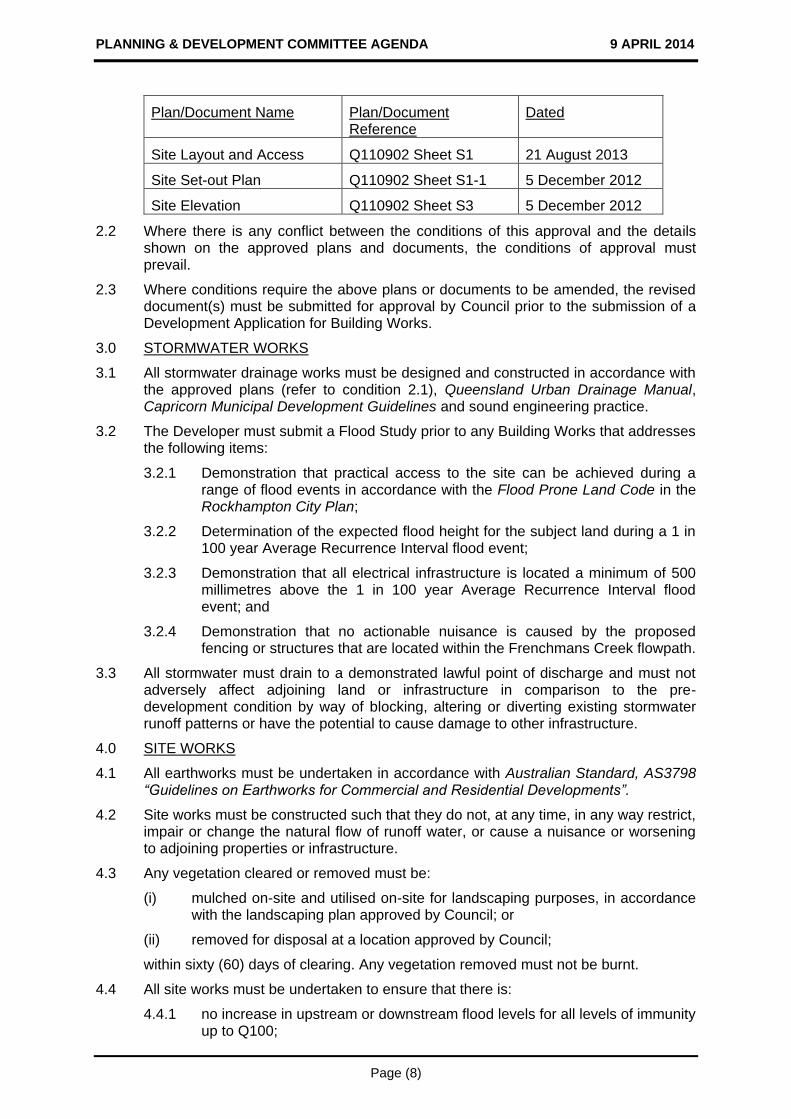
Plan/Document Name Plan/Document Reference
Dated
Site Layout and Access Q110902 Sheet S1 21 August 2013
Site Set-out Plan Q110902 Sheet S1-1 5 December 2012
Site Elevation Q110902 Sheet S3 5 December 2012
2.2 Where there is any conflict between the conditions of this approval and the details shown on the approved plans and documents, the conditions of approval must prevail.
2.3 Where conditions require the above plans or documents to be amended, the revised document(s) must be submitted for approval by Council prior to the submission of a Development Application for Building Works.
3.0 STORMWATER WORKS
3.1 All stormwater drainage works must be designed and constructed in accordance with the approved plans (refer to condition 2.1), Queensland Urban Drainage Manual, Capricorn Municipal Development Guidelines and sound engineering practice.
3.2 The Developer must submit a Flood Study prior to any Building Works that addresses the following items:
3.2.1 Demonstration that practical access to the site can be achieved during a range of flood events in accordance with the Flood Prone Land Code in the Rockhampton City Plan;
3.2.2 Determination of the expected flood height for the subject land during a 1 in 100 year Average Recurrence Interval flood event;
3.2.3 Demonstration that all electrical infrastructure is located a minimum of 500 millimetres above the 1 in 100 year Average Recurrence Interval flood event; and
3.2.4 Demonstration that no actionable nuisance is caused by the proposed fencing or structures that are located within the Frenchmans Creek flowpath.
3.3 All stormwater must drain to a demonstrated lawful point of discharge and must not adversely affect adjoining land or infrastructure in comparison to the pre-development condition by way of blocking, altering or diverting existing stormwater runoff patterns or have the potential to cause damage to other infrastructure.
4.0 SITE WORKS
4.1 All earthworks must be undertaken in accordance with Australian Standard, AS3798 “Guidelines on Earthworks for Commercial and Residential Developments”.
4.2 Site works must be constructed such that they do not, at any time, in any way restrict, impair or change the natural flow of runoff water, or cause a nuisance or worsening to adjoining properties or infrastructure.
4.3 Any vegetation cleared or removed must be:
(i) mulched on-site and utilised on-site for landscaping purposes, in accordance with the landscaping plan approved by Council; or
(ii) removed for disposal at a location approved by Council;
within sixty (60) days of clearing. Any vegetation removed must not be burnt.
4.4 All site works must be undertaken to ensure that there is:
4.4.1 no increase in upstream or downstream flood levels for all levels of immunity up to Q100;

PLANNING & DEVELOPMENT COMMITTEE AGENDA 9 APRIL 2014
Page (9)
4.4.2 no increase in velocity profiles, for which no remedy exists to prevent erosion and/or scouring. In the event that modelling shows non-compliance with the above, works must be undertaken within the system to satisfy the above criteria for development; and
4.4.3 a lawful point of discharge to which the developed flows from the land drain. Easements will be required over any other land to accommodate the flows.
5.0 BUILDING WORKS
5.1 The proposed equipment shelter must have a minimum floor level that is 500 millimetres above the 1 in 100 year Average Recurrence Interval flood level.
5.2 All engineering drawings/specifications, design and construction works must comply with the requirements of the relevant Australian Standards and must be approved, supervised and certified by a Registered Professional Engineer of Queensland.
5.3 Any lighting devices associated with the development, such as sensory lighting, must be positioned on the site and shielded so as not to cause glare or other nuisance to nearby residents and motorists. Night lighting must be designed, constructed and operated in accordance with ‘Australian Standard AS4282 – Control of the obtrusive effects of outdoor lighting’.
6.0 ELECTRICITY AND TELECOMMUNICATIONS
6.1 Underground electricity connections must be provided to the proposed development to the standards of the relevant authorities.
6.2 Evidence must be provided of a certificate of supply with the relevant service providers to provide the development with live electricity connections, in accordance with the requirements of the relevant authorities prior to the commencement of the use.
7.0 ASSET MANAGEMENT
7.1 Any alteration necessary to electricity, telephone, water mains, sewerage mains, and/or public utility installations resulting from the development or in connection with the development, must be at full cost to the Developer.
7.2 Any damage to existing kerb and channel, pathway or roadway (including removal of concrete slurry from public land, pathway, roads, kerb and channel and stormwater gullies and drainage lines) which may occur during any works carried out in association with the approved development must be repaired. This must include the reinstatement of the existing traffic signs and pavement markings which may have been removed.
8.0 ENVIRONMENTAL
8.1 An Erosion Control and Stormwater Control Management Plan must be implemented and maintained on-site for the duration of the works, and until all exposed soil areas are permanently stabilised (for example, turfed, hydromulched, concreted, landscaped). The prepared Erosion Control and Stormwater Control Management Plan must be available on-site for inspection by Council Officers during those works.
9.0 OPERATING PROCEDURES
9.1 All fencing must be maintained to the satisfaction of Council, at no cost to Council.
9.2 The telecommunication facility must at all times comply with the Australian Communications and Media Authority mandatory limits for general public exposure to radiofrequency and electronic energy.
9.3 All construction materials, waste, waste skips, machinery and contractors’ vehicles must be located and stored or parked within the site. No storage of materials, parking of construction machinery or contractors’ vehicles will be permitted in Elphinstone Street.

PLANNING & DEVELOPMENT COMMITTEE AGENDA 9 APRIL 2014
Page (10)
ADVISORY NOTES
NOTE 1. Aboriginal Cultural Heritage
It is advised that under Section 23 of the Aboriginal Cultural Heritage Act 2003, a person who carries out an activity must take all reasonable and practicable measures to ensure the activity does not harm Aboriginal Cultural Heritage (the “cultural heritage duty of care”). Maximum penalties for breaching the duty of care are listed in the Aboriginal Cultural Heritage legislation. The information on Aboriginal Cultural Heritage is available on the Department of Aboriginal and Torres Strait Islander and Multicultural Affairs website www.datsima.qld.gov.au
NOTE 2. General Environmental Duty
General environmental duty under the Environmental Protection Act prohibits unlawful environmental nuisance caused by noise, aerosols, particles, dust, ash, fumes, light, odour or smoke beyond the boundaries of the property during all stages of the development including earthworks, construction and operation.
NOTE 3. General Safety Of Public During Construction
The Workplace Health and Safety Act and Manual of Uniform Traffic Control Devices must be complied with in carrying out any construction works, and to ensure safe traffic control and safe public access in respect of works being constructed on a road.
RECOMMENDATION C
That in relation to the application for a Development Permit for a Telecommunication Facility/Tower, made by Telstra Corporation Ltd on behalf of Rockhampton City Council, on Lot 1 on RP864505, Parish of Archer, located at 239 Rockonia Road, Koongal, Council resolves to not issue an Adopted Infrastructure Charges Notice.
BACKGROUND
Proposal in Detail
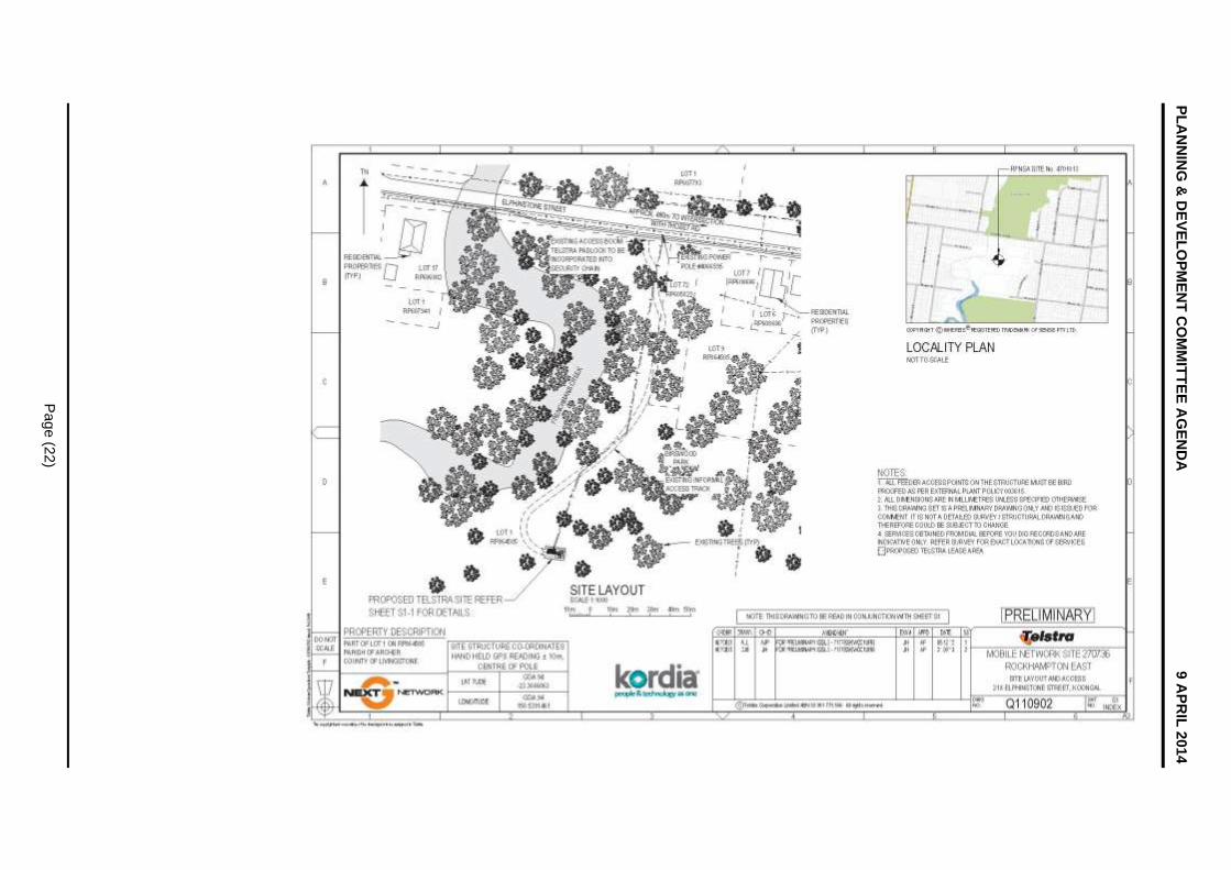
The proposal is to install a Telecommunications Facility to be referred to by Telstra as the Rockhampton East facility. The monopole tower will not exceed 26.5 metres above ground and is comprised of:
one twenty five (25) metre high monopole;
three (3), 2.5 metre panel antennas attached to the top of the monopole;
one (1) low impact equipment hut (3.2 x 2.3 metres) to house associated equipment; and
conduits and cable tray for the feeder cables.
All equipment will be located within a sixty (60) square metre compound (lease area) enclosed by a security fence with double access gates. The telecommunication tower will be located towards the middle of the park (more than 150 metres from Elphinstone Street) and close to Frenchmans Creek. Access will be via the existing Council access point off Elphinstone Street. The design is such that additional panels could be added in future without affecting the footprint or height of the facility.
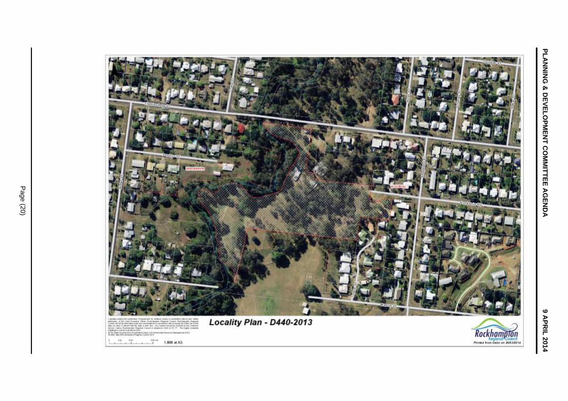
Site and Locality
The subject site is known as Bill Crane Park and comprises a total area of 3.334 hectares, although this is made up of a larger green corridor. The topography is generally flat with the lowest point on site being towards Frenchmans Creek in the west. The site has an irregular shape, is predominantly wooded with mature vegetation scattered across the site and is currently used as a public park with informal walking tracks through the park. It has frontage to Elphinstone Street to the north with residential beyond that. It is further surrounded by Frenchmans Creek to the west with houses beyond that; public open space (Birdwood Park)

PLANNING & DEVELOPMENT COMMITTEE AGENDA 9 APRIL 2014
Page (11)
to the south; and to the east it is buffered by approximately 150 metres of vegetation to the closet residential dwelling.
Area and Site Selection for network capacity and coverage
Telstra uses a number of methods to identify those parts of the network that require improvements. These include the availability of existing network hardware and capacity for improvements. Network optimisation is the preferred alternative as it does not require additional infrastructure. If optimisation cannot deliver an outcome the deployment of new sites are considered. This includes defining the scope of the deficiency and performance objective of a new facility.
Opportunities for co-location could not be found within the search ring area and the new Rockhampton East facility will relieve the capacity of the existing network and absorb increased communication traffic and continual requirements to improve data accessing as a result of smart technology. Three possible locations were identified and assessed. The assessment not only includes operational and geographical aspects, but also visual amenity, potential co-location opportunities, availability and suitability of land, ownership, occupational health and safety, construction issues, access, topographical issues affecting line of sight, and legislative, environmental and cost issues. The mentioned factors determine the number, type and height of required facilities which also restricts the available search area. In the search area a number of candidate sites are identified and assessed, arriving at this preferred site.
PLANNING ASSESSMENT
Matters for Consideration
This application has been assessed by relevant Council planning, engineering, environmental health, and other technical officers as required. The assessment has been in accordance with the Integrated Development Assessment System provisions of the Sustainable Planning Act 2009, based on consideration of the relevant State Planning Policy; State Government guidelines; the Council’s Town Planning Scheme, Planning Policies and other general policies and procedures, as well as other documents as considered relevant.
Infrastructure Operations Unit’s Comments – (30 September 2013 and 25 March 2014)
Support, subject to conditions.
Infrastructure Operations Unit’s (sewer and water) Comments – (24 September 2013)
Support, subject to conditions.
Public and Environmental Health Comments – (30 September 2013)
Support, subject to conditions.
Rockhampton Regional Airport – (18 February 2014)
Support, no conditions
Town Planning Comments
Central Queensland Regional Plan 2013
The Central Queensland Regional Plan is a statutory document which came into effect on 18 October 2013. The development is not required to be assessed against the regional plan if this document is appropriately reflected in the local planning scheme. It is considered that the regional plan is appropriately reflected in the current local planning scheme.
State Planning Policy 2013
This policy came into effect on 2 December 2013 and replaced all former State Planning Policies. This policy requires development applications to be assessed against its requirements until the identified state interests have been appropriately reflected in the local planning scheme.

PLANNING & DEVELOPMENT COMMITTEE AGENDA 9 APRIL 2014
Page (12)
Mining and extractive resources
Not Applicable.
Biodiversity
Not Applicable
Coastal environment
Not Applicable.
Water quality
Not Applicable.
Emissions and hazardous activities
Not Applicable.
Natural hazards
Not Applicable.
State transport infrastructure
Not Applicable.
Strategic airports and aviation facilities
Not Applicable.
Other Acts
Telecommunications Act, 1997
The act is the principal Act that governs the activities of telecommunications carriers and the proposal is required to comply with the requirements of this Act. Under this Act, some telecommunications carriers are no longer exempt from State planning laws. Given the height and extent of the proposal, it cannot be considered under the exemptions for low impact uses and thus requires a Development Permit.
Telecommunications Code of Practice, 1997
The code sets the conditions under which the telecommunications carriers must operate. The application has considered the siting, design, planning and installation requirements in the Code of Practice.
Telecommunications (Low-Impact Facilities) Determination, 1997
The proposed facility is not regarded as low impact as identified in this legislation and is therefore subject to State and Territory Planning Laws and Regulations; In this case the Sustainable Planning Act 2009 and the Rockhampton Planning Scheme 2005.
The Environment Protection and Biodiversity Conservation (EPBC) Act, 1999
The Act obliges telecommunications carriers to consider matters of national environmental significance. The application has considered all relevant matters and is not considered to be within an area of heritage or environmental significance and not anticipated to have an impact on local biodiversity values.
The Applicant has identified that the site selection criteria is in accordance with the above regulatory frameworks of Commonwealth and State legislation, codes, policies and guidelines. Acknowledgement has also been given to the operation of the proposed facility, which it has been advised will be conducted within current and relevant standards regulated by the Australian Communications and Media Authority.
Rockhampton City Plan Strategic Framework
This application is situated within the Residential designation under Council’s Strategic Framework Map.
PLANNING & DEVELOPMENT COMMITTEE AGENDA 9 APRIL 2014
Page (13)
The following Desired Environmental Outcomes, as identified within Chapter 2 of the Rockhampton City Plan 2005 are applicable:
Rockhampton City Plan 2005
Rockhampton City Plan Strategic Framework
This application is situated within the Residential designation under Council’s Strategic Framework Map.
The following Desired Environmental Outcomes, as identified within Chapter 2 of the Rockhampton City Plan 2005 are applicable:
(1) Rockhampton continues to consolidate its ‘Capital of Central Queensland’ role in the region.
Complies: The provision of high level communications and increased coverage will enhance the role of Rockhampton within the region through increased lifestyle and business functions.
(2) Valuable natural resources are conserved or, where required to support economic growth in Rockhampton, used sustainably.
Not applicable: The subject site is not within proximity of any natural resources.
(3) Important natural assets are, as far as is practically possible, retained in a natural state to maximise biodiversity and to maintain their scenic and biological value.
Complies: The proposal is located within an existing open space network and utilises existing vegetation to reduce visual impact. The proposal is not expected to impact on any important natural assets.
(4) New development in Rockhampton City is designed and managed to minimise adverse impacts on the environment, and biodiversity.
Complies: The proposal only occupies a lease area of sixty (60) square metres and the small footprint is not expected to impact upon the environment or the region’s biodiversity. The equipment shelter will be appropriately designed and raised to be above flood levels to satisfy council’s flood modelling.
(5) Commercial and retail development is accommodated in a hierarchy of centres throughout Rockhampton, which provide for a range of services, retail, commercial, entertainment and employment activities.
Not applicable: The proposal is not situated in a commercial centre and does not entail commercial development.
(6) Rockhampton’s commercial centres are safe, attractive and readily accessible spaces for all members of the community.
Not applicable: The proposal is not situated in a commercial centre and does not entail commercial development.
(7) Rockhampton’s industrial development is consolidated in identified industrial locations throughout the City.
Not applicable: The proposal is not situated in an industrial area and does not entail industrial development.
(8) Rockhampton’s cultural and urban heritage, both indigenous and post European, is retained and conserved for future generations.
Complies: The proposal does not impinge on any known cultural or urban heritage and not likely to compromise any aboriginal artefacts. Typical duty of care guidelines will be followed in the event of discovery of any artefact.
(9) Residential communities are attractive places to live, providing a range of housing types at different densities that positively contributes to the built environment, satisfies the needs of all members of the community in terms of life stages, lifestyle
PLANNING & DEVELOPMENT COMMITTEE AGENDA 9 APRIL 2014
Page (14)
choices and affordability, are free from incompatible development and have access to a range of compatible urban services and facilities.
Not applicable: The proposal is not located on a site zoned for residential development and does not entail residential development, nevertheless is located in an area characterised by residential development. This proposal will improve the attractiveness of the residential community thorough improved communications.
(10) Rockhampton’s important community uses and health care facilities are provided and maintained in locations where they are readily accessible to all members of the community.
Not applicable: The proposed telecommunications facility is not located in an area designated for community uses or health care facilities and will not affect the provision of these services.
(11) New residential land subdivision and development occurs in identified areas within the City where environmentally valuable features are retained and protected, and urban services, recreational opportunities and parks are provided, along with a range of allotment sizes.
Not applicable: The proposal is not a residential development or situated in an emerging community but in an established urban area and will not affect residential development in the city.
(12) Infrastructure is provided and augmented in a sequenced manner in Rockhampton, resulting in appropriate, efficient, affordable, reliable, timely and lasting infrastructure provision that is not compromised by new development and is sensitive to the environment.
Complies: The proposal will not affect the provision of any infrastructure. The intention of the application is to improve essential telecommunication infrastructure now and make provision for future upgrades.
(13) Safe, accessible, efficient and convenient transport systems are provided in Rockhampton.
Complies: The proposal will not affect the existing transport systems in Rockhampton.
(14) Readily accessible and safe Open Space and facilities for active and passive recreational purposes are accommodated within Rockhampton City.
Complies: The proposal is located in an existing public open space. Despite this, no clearing is required and it will not impact on any existing public open space networks as the location of the facility is close to the creek where the useable space for recreation is limited and furthermore existing vegetation surrounding the site will provide partial screening to reduce the visual impacts. Overall the green space is maintained.
The performance assessment of the proposal demonstrates that the development will not compromise the Rockhampton City Plan Desired Environmental Outcomes.
Berserker Heights Residential Area Intent
The subject site is situated within the Berserker Heights Residential Area under the Rockhampton City Plan. The intent of the Area identifies that: -
“The area will retain a residential character, dominated by houses on individual allotments or other similar low density housing options that are consistent with the residential character of the area. … duplex development is compatible as long as it does not proliferate, and does not compromise the primary residential character of the Area, which is houses on individual allotments.”
The proposed use cannot be considered a consistent use within the Berserker Heights Residential Area. Council should note, however, that pursuant to Section 326(1)(b) of the

PLANNING & DEVELOPMENT COMMITTEE AGENDA 9 APRIL 2014
Page (15)
Sustainable Planning Act 2009, the assessment manager’s decision may conflict with the Planning Scheme if there are sufficient grounds to justify the decision despite the conflict.
In response to the above, the assessment of this application concludes that the proposed development, subject to conditions, is not likely to conflict with Council’s Desired Environmental Outcomes. Furthermore, there are considered to be ‘sufficient grounds’ in this instance, to justify Council approving the development despite its conflict with the Area Intent.
Sufficient grounds of justification are as follows:
(a) The proposed facility is a response to an essential community need and regarded as a necessity for improved wireless telecommunication infrastructure and will provide essential data transmission in the growing telecommunications sector to the benefit of the area and the wider community;
(b) Assessment of the development against the relevant planning scheme codes demonstrates that the proposed development will not cause significant adverse impact on the surrounding natural environment, built environment and infrastructure, community facilities or local character and amenity;
(c) Assessment of the development demonstrates that the Planning Scheme Wide Desired Environmental Outcomes will not be compromised; and
(d) The proposed development does not compromise the relevant State Planning Policy.
Having regard to all of the above, it is recommended Council, from a land use perspective, consider the proposed development favourably as, pursuant to Section 326(1)(b) of Sustainable Planning Act 2009, there are considered to be sufficient grounds to justify a decision that favours the alternative land uses proposed herein and the development is capable of occurring in a manner that is not likely to conflict with Council’s Desired Environmental Outcomes.
Rockhampton City Plan Codes
The following codes are applicable to this application:
Telecommunications Code
Airport Code
An assessment has been made against the requirement of the abovementioned codes and the proposal generally complies with the relevant specific outcomes of the relevant codes and where there is deviation from the codes sufficient justification has been provided.
Infrastructure Charges
Adopted Infrastructure Charges Resolution (No. 3) 2014 for non-residential development applies to the application and it falls within Charge Area 1. The Adopted Infrastructure Charges are as follows:
Column 1
Use Schedule
Column 2
Charge Area
Column 3
Adopted Infrastructure
Charge
Column 4
Adopted Infrastructure
Charge for stormwater network
Calculated Charge
($) Unit ($) Unit
Minor Uses All Areas Nil Charge
Therefore, as a telecommunications facility is considered a ‘minor use’ the development does not attract any charges.

PLANNING & DEVELOPMENT COMMITTEE AGENDA 9 APRIL 2014
Page (16)
Consultation
The proposal was the subject of public notification between 4 February 2014 and 25 February 2014, as per the requirements of the Sustainable Planning Act 2009, and two (2) properly made submissions, of which one was a petition, were received.
In addition to the public notification Telstra also conducted additional consultation, as follows:
14 February 2013 A newsletter was sent to 130 residents in the area immediately surrounding the proposed development site. The newsletter sought to provide information to the community and provide an opportunity to seek additional information regarding the proposal.
30 January 2014 A second newsletter was sent to the same 130 residents to advise that a development application had formally been lodged with Rockhampton Regional Council. The newsletter also advised of the upcoming public notification period.
13 March 2014 A community drop-in session was held at Bauhinia House from 5:00pm to 7:30pm. There were eleven (11) residents who attended the session, which was also attended by three (3) Councillors and the assessment manager.
The following is a summary of the submissions lodged, with Council officer comments:
Issue Officer Comment
Risk of public exposure to electromagnetic energy levels
Australia’s Electromagnetic Emissions (EME) standard is based on extensive national and international research, and guidelines from the World Health Organization (WHO). The EME safety standard applies to all radio services, not just mobile base stations.
In Australia, the standards for human exposure to Electromagnetic Emissions are set by the Australian Radiation Protection and Nuclear Safety Agency (ARPANSA), an agency of the Commonwealth Department of Health and Ageing. This facility is to be operated in compliance with the mandatory standard for human exposure to Electromagnetic Emissions - currently the Radio Communications (Electromagnetic Radiation Human Exposure) Standard 2003. The standards, which are the safety standards recommended by the WHO, are set out in the ARPANSA Radiation Protection Standard-Maximum Exposure Levels to Radiofrequency Fields - 3 kHz to 300 GHz. The EME Report for the proposed facility concludes that the maximum EME emissions for this site are 0.25% of the maximum emissions allowed by ARPANSA. This is close to 500 times below the allowable limit and is substantially less than one percent (1%) of the maximum allowable exposure limit (where 100 percent (100%) of the limit is still considered to be safe).
PLANNING & DEVELOPMENT COMMITTEE AGENDA 9 APRIL 2014
Page (17)
Issue Officer Comment
The loss of public amenity owing to the location being in a public park
The consideration of visual impacts and amenity is a key part of the criteria for site selection. The application has given considerable weight to the potential for visual impact of this facility and aimed to achieve the best possible outcome through best practice methods. The chosen site represents the most suitable location for the proposed facility in the area. The facility will only take up sixty (60) square metres of the park and is also positioned a fair distance away from dwelling houses.
A monopole facility has been proposed on the site, designed to retain a thin profile in order to reduce its physical presence in the environment. Further, there is existing vegetation within the site, which will provide some screening of the proposed equipment shelter and security fencing at the base of the monopole.
Located in a community sensitive area The proposed site was selected following an extensive analysis of the local area and the identification of a number of potential options of the facility. These options were all assessed from the perspective of town planning, site acquisition, radio frequency coverage and civil design. If the proposal does not meet minimum standards for each of these categories the option will not be viable and may lead to more facilities being required to compensate for ineffective services.
The proposed facility is a response to an essential community need for improved wireless telecommunication infrastructure within the immediate and surrounding area. The intention for this new facility is to provide increased coverage and capacity to residents and businesses within the larger Berserker and Koongal area. This site was chosen as the most suitable alternative in order to provide for the growing need for reliable services to the community in the area. It should be noted that residential areas are not the preferred choice for these facilities, however, they must be located in or nearby the areas they are designed to service. This section of open space is one of the few areas of relief from residential uses in the area. It is noted that existing vegetation will assist in screening the facility from surrounding residents.
The facility will be securely fenced and locked to reduce dangers to the community. In order to achieve the desired network coverage
PLANNING & DEVELOPMENT COMMITTEE AGENDA 9 APRIL 2014
Page (18)
Issue Officer Comment
requirements, the proposed facility is required to be appropriately elevated at twenty-five (25) metres.
Potential for devaluation of surrounding properties.
The issue of property value is an extremely complex one, with fluctuations in price being subject to a vast number of factors - many of which are subjective, such as the amount of light, access to services, the condition of houses, views, amenity of the local area and the availability of high quality services such as telecommunications.
The submitters have not provided credible evidence from a reputable professional that the values are likely to decrease if the facility is erected. Limited studies have been undertaken to assess whether there is a direct correlation between the location of the telecommunications facilities and properties values. All research undertaken to date indicates that there is no credible evidence to support a reduction in property values when telecommunications facilities are located in proximity. Since the mid 1990’s there have been thousands of telecommunications facilities (currently approximately 10,000 throughout Australia) erected in metropolitan and regional areas with the majority in urban areas. During this period, property values across the board have continued to increase, showing no sign of deterioration as a result of specific factors such as the location of telecommunication base stations. It is also noted that property values are not a relevant ground when deciding development applications.
Referrals
The application did not trigger any referral agencies.
CONCLUSION
The proposal for a telecommunications facility/tower cannot be considered consistent with the intent of the residential area within which it is situated. It is thus recognised that the proposal conflicts with the planning scheme. However, the proposed development does not conflict with Council’s Desired Environmental Outcomes and generally complies with the requirements of the relevant Codes. In addition, all issues raised by the submitters have been addressed. The height and position of the facility in the locality and on the particular site have been determined to be the most suitable for the area.
The proposal is regarded as having sufficient grounds to approve and the application is, therefore, considered reasonable and is recommended for approval subject to conditions outlined in the Recommendation.

PLANNING & DEVELOPMENT COMMITTEE AGENDA 9 APRIL 2014
Page (19)
Locality Plan
D/440-2013 - DEVELOPMENT APPLICATION FOR A MATERIAL
CHANGE OF USE FOR TELECOMMMUNICATION
FACILITY/TOWER
Locality Plan
Meeting Date: 9 April 2014
Attachment No: 1
PL
AN
NIN
G &
DE
VE
LO
PM
EN
T C
OM
MIT
TE
E A
GE
ND
A
9 A
PR
IL 2
014
Pa
ge
(20
)

PLANNING & DEVELOPMENT COMMITTEE AGENDA 9 APRIL 2014
Page (21)
Site Layout
D/440-2013 - DEVELOPMENT APPLICATION FOR A MATERIAL
CHANGE OF USE FOR TELECOMMMUNICATION
FACILITY/TOWER
Site Layout
Meeting Date: 9 April 2014
Attachment No: 2
PL
AN
NIN
G &
DE
VE
LO
PM
EN
T C
OM
MIT
TE
E A
GE
ND
A
9 A
PR
IL 2
014
Pa
ge
(22
)

PLANNING & DEVELOPMENT COMMITTEE AGENDA 9 APRIL 2014
Page (23)
Elevation Plan
D/440-2013 - DEVELOPMENT APPLICATION FOR A MATERIAL
CHANGE OF USE FOR TELECOMMMUNICATION
FACILITY/TOWER
Elevation Plan
Meeting Date: 9 April 2014
Attachment No: 3

PLANNING & DEVELOPMENT COMMITTEE AGENDA 9 APRIL 2014
Page (24)
PLANNING & DEVELOPMENT COMMITTEE AGENDA 9 APRIL 2014
Page (25)
8.2 D/441-2013 - Development Application for a Material Change of Use for a Telecommunication Facility / Tower
8.2 D/441-2013 - DEVELOPMENT APPLICATION FOR A MATERIAL CHANGE OF USE FOR A TELECOMMUNICATION FACILITY/TOWER
File No: D/441-2013
Attachments: 1. Locality Plan 2. Site Layout Plan 3. Elevation Plan
Authorising Officer: Tarnya Fitzgibbon - Coordinator Development Assessment Robert Holmes - General Manager Regional Services
Author: Petrus Barry - Senior Planning Officer
SUMMARY
Development Application Number: D/441-2013
Applicant: Telstra Corporation Ltd
Real Property Address: Lot 5 on RP616382, Parish of Murchison
Common Property Address: 362 Moores Creek Road, Norman Gardens
Area of Site: 2.879 hectares
Planning Scheme: Rockhampton City Plan 2005
Rockhampton City Plan Area: Richardson Road Residential Area
Existing Development: Public Open Space
Existing Approvals: Nil
Approval Sought: Development Permit for a Telecommunication Facility/Tower
Level of Assessment: Impact Assessable
Submissions: Eight
Referral Agency(s): Not Applicable
Adopted Infrastructure Charges Area: Charge Area one
Application Progress:
Application Lodged: 19 September 2013
Request for extension to start public notification 26 November 2013
Submission period commenced: 4 February 2014
Submission period end: 25 February 2014
Last receipt of information from applicant: 21 March 2013
Statutory determination date: 22 April 2014
Recommendation
OFFICER’S RECOMMENDATION
RECOMMENDATION A
THAT in relation to the application for a Development Permit for a Telecommunication Facility/Tower, made by Telstra Corporation Ltd on behalf of Rockhampton Regional Council, on Lot 5 on RP616382, Parish of Murchison, located at 362 Moores Creek Road, Norman Gardens, Council resolves to Approve the application subject to the following conditions:

PLANNING & DEVELOPMENT COMMITTEE AGENDA 9 APRIL 2014
Page (26)
1.0 ADMINISTRATION
1.1 The Developer is responsible for ensuring compliance with this approval and the Conditions of the approval by an employee, agent, contractor or invitee of the Developer.
1.2 Where these Conditions refer to “Council” in relation to requiring Council to approve or to be satisfied as to any matter, or conferring on the Council a function, power or discretion, that role of the Council may be fulfilled in whole or in part by a delegate appointed for that purpose by the Council.
1.3 All conditions of this approval must be undertaken and completed to the satisfaction of Council, at no cost to Council.
1.4 All conditions, works, or requirements of this approval must be undertaken and completed prior to the commencement of the use, unless otherwise stated.
1.5 Where applicable, infrastructure requirements of this approval must be contributed to the relevant authorities, at no cost to Council prior, to the commencement of the use, unless otherwise stated.
1.6 The following further Development Permits must be obtained prior to the commencement of any works associated with its purposes:
1.6.1 Operational Works:
(i) Road Works;
(ii) Access Works; and
(iii) Site Works
1.6.2 Buildings Works.
1.7 All Development Permits for Operational Works must be obtained prior to the issue of a Development Permit for Building Works.
1.8 Unless otherwise stated, all works must be designed, constructed and maintained in accordance with the relevant Council policies, guidelines and standards.
1.9 All engineering drawings/specifications, design and construction works must comply with the requirements of the relevant Australian Standards and must be approved, supervised and certified by a Registered Professional Engineer of Queensland.
2.0 APPROVED PLANS AND DOCUMENTS
2.1 The approved development must be completed and maintained generally in accordance with the approved plans and documents, except where amended by the conditions of this permit:
Plan/Document Name Plan/Document Reference
Dated
Site Layout and Access Q110913 Sheet S1 7 December 2012
Site Set-out Plan Q110913 Sheet S1-1 7 December 2012
Site Elevation Q110913 Sheet S3 7 December 2012
2.2 Where there is any conflict between the conditions of this approval and the details shown on the approved plans and documents, the conditions of approval must prevail.
2.3 Where conditions require the above plans or documents to be amended, the revised document(s) must be submitted for approval by Council prior to the submission of a Development Application for Operational Works.

PLANNING & DEVELOPMENT COMMITTEE AGENDA 9 APRIL 2014
Page (27)
3.0 ROAD WORKS
3.1 A Development Permit for Operational Works (road works) must be obtained prior to the commencement of any road works on the site.
3.2 All works must be designed and constructed in accordance with the approved plans (refer to condition 2.1), Capricorn Municipal Development Guidelines, relevant Australian Standards and the provisions of a Development Permit for Operational Works (road works).
3.3 The proposed verge widening must be designed and constructed in accordance with the Capricorn Municipal Development Guidelines and relevant Austroads requirements.
3.4 The developer must install suitable signage where the proposed access to the site crosses the existing asphalt bikeway/footpath such that all vehicular traffic must give way to pedestrian and cyclist traffic. Details of this signage must be submitted with the Operational Works application (road works).
3.5 The section of existing asphalt bikeway/footpath where the new access to the site crosses the path must be removed and replaced with a suitable pavement that is designed to withstand the forces associated with the maintenance vehicles and equipment that will access the site.
3.6 Traffic signs and pavement markings must be provided in accordance with the Manual of Uniform Traffic Control Devices – Queensland. Where necessary, existing traffic signs and pavement markings must be modified in accordance with the Manual of Uniform Traffic Control Devices – Queensland.
4.0 ACCESS WORKS
4.1 A Development Permit for Operational Works (access works) must be obtained prior to the commencement of any access works on the site.
4.2 All works must be designed and constructed in accordance with the approved plans (refer to condition 2.1), Capricorn Municipal Development Guidelines, Australian Standard AS2890 “Parking Facilities” and the provisions of a Development Permit for Operational Works (access works).
4.3 The access to the proposed telecommunications facility must be constructed to a sealed or equivalent standard from the edge of Moores Creek Road to the perimeter of the fenced compound. Construction must be either reinforced concrete not less than hundred (100) millimetre deep or a compacted gravel pavement not less than hundred (100) millimetres deep sealed with either twenty-five (25) millimetres of asphaltic concrete, or hot sprayed bitumen consisting of a primer and two (2) seal coats.
5.0 STORMWATER WORKS
5.1 All stormwater drainage works must be designed and constructed in accordance with the approved plans (refer to condition 2.1), Queensland Urban Drainage Manual, Capricorn Municipal Development Guidelines and sound engineering practice.
5.2 All stormwater must drain to a demonstrated lawful point of discharge and must not adversely affect adjoining land or infrastructure in comparison to the pre-development condition by way of blocking, altering or diverting existing stormwater runoff patterns or have the potential to cause damage to other infrastructure.
6.0 SITE WORKS
6.1 Any application for a Development Permit for Operational Works (site works) must be accompanied by an earthworks’ plan which clearly identifies the following:
6.1.1 the location of cut and/or fill;
6.1.2 the type of fill to be used and the manner in which it is to be compacted;
PLANNING & DEVELOPMENT COMMITTEE AGENDA 9 APRIL 2014
Page (28)
6.1.3 the quantum of fill to be deposited or removed and finished cut and/or fill levels;
6.2 All earthworks must be undertaken in accordance with Australian Standard AS3798 “Guidelines on Earthworks for Commercial and Residential Developments”.
6.3 Site works must be constructed such that they do not, at any time, in any way restrict, impair or change the natural flow of runoff water, or cause a nuisance or worsening to adjoining properties or infrastructure.
6.4 Vegetation must not be cleared unless and until written approval has been provided by Council. A Development Permit for Operational Works constitutes written approval, only for the purposes of clearing vegetation directly pertinent to the operational works which are the subject of the Development Permit.
6.5 Any vegetation cleared or removed must be:
(i) mulched on-site and utilised on-site for landscaping purposes, in accordance with the landscaping plan approved by Council; or
(ii) removed for disposal at a location approved by Council;
within sixty (60) days of clearing. Any vegetation removed must not be burnt.
6.6 All site works must be undertaken to ensure that there is:
6.6.1 no increase in upstream or downstream flood levels for all levels of immunity up to Q100;
6.6.2 no increase in velocity profiles, for which no remedy exists to prevent erosion and/or scouring. In the event that modelling shows non-compliance with the above, works must be undertaken within the system to satisfy the above criteria for development; and
6.6.3 a lawful point of discharge to which the developed flows from the land drain. Easements will be required over any other land to accommodate the flows.
7.0 BUILDING WORKS
7.1 All engineering drawings/specifications, design and construction works must comply with the requirements of the relevant Australian Standards and must be approved, supervised and certified by a Registered Professional Engineer of Queensland.
7.2 Any lighting devices associated with the development, such as sensory lighting, must be positioned on the site and shielded so as not to cause glare or other nuisance to nearby residents and motorists. Night lighting must be designed, constructed and operated in accordance with ‘Australian Standard AS4282 – Control of the obtrusive effects of outdoor lighting’.
8.0 ELECTRICITY AND TELECOMMUNICATIONS
8.1 Underground electricity connections must be provided to the proposed development to the standards of the relevant authorities.
8.2 Evidence must be provided of a certificate of supply with the relevant service providers to provide the development with live electricity connections, in accordance with the requirements of the relevant authorities prior to the commencement of the use.
9.0 ASSET MANAGEMENT
9.1 Any alteration necessary to electricity, telephone, water mains, sewerage mains, and/or public utility installations resulting from the development or in connection with the development, must be at full cost to the Developer.
9.2 Any damage to existing kerb and channel, pathway or roadway (including removal of concrete slurry from public land, pathway, roads, kerb and channel and stormwater gullies and drainage lines) which may occur during any works carried out in

PLANNING & DEVELOPMENT COMMITTEE AGENDA 9 APRIL 2014
Page (29)
association with the approved development must be repaired. This must include the reinstatement of the existing traffic signs and pavement markings which may have been removed.
10.0 ENVIRONMENTAL
10.1 Any application for a Development Permit for Operational Works must be accompanied by an Erosion and Sediment Control Plan which addresses, but is not limited to, the following:
(i) objectives;
(ii) site location / topography;
(iii) vegetation;
(iv) site drainage;
(v) soils;
(vi) erosion susceptibility;
(vii) erosion risk;
(viii) concept;
(ix) design; and
(x) implementation, for the construction and post construction phases of work.
10.2 The Erosion Control and Stormwater Control Management Plan must be implemented and maintained on-site for the duration of the works, and until all exposed soil areas are permanently stabilised (for example, turfed, hydromulched, concreted, landscaped). The prepared Erosion Control and Stormwater Control Management Plan must be available on-site for inspection by Council Officers during those works.
11.0 OPERATING PROCEDURES
11.1 All fencing must be maintained to the satisfaction of Council, at no cost to Council.
11.2 The telecommunication facility must at all times comply with the Australian Communications and Media Authority mandatory limits for general public exposure to radiofrequency and electronic energy.
11.3 All construction materials, waste, waste skips, machinery and contractors’ vehicles must be located and stored or parked within the site. No storage of materials, parking of construction machinery or contractors’ vehicles will be permitted in Moores Creek Road.
ADVISORY NOTES
NOTE 1. Aboriginal Cultural Heritage
It is advised that under Section 23 of the Aboriginal Cultural Heritage Act 2003, a person who carries out an activity must take all reasonable and practicable measures to ensure the activity does not harm Aboriginal Cultural Heritage (the “cultural heritage duty of care”). Maximum penalties for breaching the duty of care are listed in the Aboriginal Cultural Heritage legislation. The information on Aboriginal Cultural Heritage is available on the Department of Aboriginal and Torres Strait Islander and Multicultural Affairs website www.datsima.qld.gov.au
NOTE 2. General Environmental Duty
General environmental duty under the Environmental Protection Act prohibits unlawful environmental nuisance caused by noise, aerosols, particles, dust, ash, fumes, light, odour or smoke beyond the boundaries of the property during all stages of the development including earthworks, construction and operation.
PLANNING & DEVELOPMENT COMMITTEE AGENDA 9 APRIL 2014
Page (30)
NOTE 3. General Safety Of Public During Construction
The Workplace Health and Safety Act and Manual of Uniform Traffic Control Devices must be complied with in carrying out any construction works, and to ensure safe traffic control and safe public access in respect of works being constructed on a road.
RECOMMENDATION C
That in relation to the application for a Development Permit for a Telecommunication Facility/Tower, made by Telstra Corporation Ltd on behalf of Rockhampton Regional Council, on Lot 5 on RP616382, Parish of Murchison, located at 362 Moores Creek Road, Norman Gardens, Council resolves to not issue an Adopted Infrastructure Charges Notice.
BACKGROUND
Proposal in Detail
The proposal is to install a Telecommunications Facility to be referred to by Telstra as the Norman Gardens facility. The monopole tower will not exceed 26.5 metres above ground and is comprised of:
one twenty five (25) metre high monopole;
three (3), 2.63 metre panel antennas attached to the top of the monopole;
one (1) low impact equipment hut (3.2 x 2.3 metres) to house associated equipment; and
conduits and cable tray for the feeder cables.
All equipment will be located within a sixty (60) square metre compound (lease area) enclosed by a security fence with double access gates. The telecommunication tower will be located approximately fifty (50) metres from Moores Creek Road. Access will be via a new verge widening and discrete access from Moores Creek Road. The design is such that additional panels could be added in future without affecting the footprint or height of the facility.
Site and Locality
The subject site is known as Col. Austin Park and comprises a total area of 2.88 hectares, and is part of a larger open space system associated with the low lying land. The topography is undulating and generally slopes towards Moores Creek. The lot has a long narrow shape and is one of a range of lots forming the open space network to the north towards Kerrigan Street and beyond and also southwards and includes a walking/cycle track that generally follows the alignment of the creek. Moores Creek is directly east of the proposed location and the densest vegetation is in this area with the closet dwelling being approximately 100 metres from the location on the other side of the creek. Moores Creek Road is to the west of the proposed location with residential dwellings further west across the road. The site is semi cleared, mostly turfed and with mature vegetation scattered across the site.
Area and Site Selection for network capacity and coverage
Telstra uses a number of methods to identify those parts of the network that require improvements. These include the availability of existing network hardware and capacity for improvements. Network optimisation is the preferred alternative as it does not require additional infrastructure. If optimisation cannot deliver an outcome the deployment of new sites are considered. This includes defining the scope of the deficiency and performance objective of a new facility.
Opportunities for co-location could not be found within the search ring area and the new Norman Gardens facility will relieve the capacity of the existing network and absorb increased communication traffic and continual requirements to improve data accessing as a result of smart technology. Seven possible locations were identified and assessed. The assessment not only includes operational and geographical aspects, but also visual amenity,

PLANNING & DEVELOPMENT COMMITTEE AGENDA 9 APRIL 2014
Page (31)
potential co-location opportunities, availability and suitability of land, ownership, occupational health and safety, construction issues, access, topographical issues affecting line of sight, and legislative, environmental and cost issues. The mentioned factors determine the number, type and height of required facilities which also restricts the available search area. In the search area a number of candidate sites are identified and assessed, arriving at this preferred site.
PLANNING ASSESSMENT
Matters for Consideration
This application has been assessed by relevant Council planning, engineering, environmental health, and other technical officers as required. The assessment has been in accordance with the Integrated Development Assessment System provisions of the Sustainable Planning Act 2009, based on consideration of the relevant State Planning Policy; State Government guidelines; the Council’s Town Planning Scheme, Planning Policies and other general policies and procedures, as well as other documents as considered relevant.
Infrastructure Operations Unit’s Comments – (8 October 2013)
Support, subject to conditions.
Infrastructure Operations Unit’s (sewer and water) Comments – (20 September 2013)
Support, subject to conditions.
Public and Environmental Health Comments – (30 September 2013)
Support, subject to conditions
Rockhampton Regional Airport – (18 February 2014)
Support, no conditions
Town Planning Comments
Central Queensland Regional Plan 2013
The Central Queensland Regional Plan is a statutory document which came into effect on 18 October 2013. The development is not required to be assessed against the regional plan if this document is appropriately reflected in the local planning scheme. It is considered that the regional plan is appropriately reflected in the current local planning scheme.
State Planning Policy 2013
This policy came into effect on 2 December 2013 and replaced all former State Planning Policies. This policy requires development applications to be assessed against its requirements until the identified state interests have been appropriately reflected in the local planning scheme.
Mining and extractive resources
Not Applicable.
Biodiversity
Not Applicable
Coastal environment
Not Applicable.
Water quality
Not Applicable.
Emissions and hazardous activities
Not Applicable.

PLANNING & DEVELOPMENT COMMITTEE AGENDA 9 APRIL 2014
Page (32)
Natural hazards
Not Applicable.
State transport infrastructure
Not Applicable.
Strategic airports and aviation facilities
Not Applicable.
Other Acts
Telecommunications Act, 1997
The act is the principal Act that governs the activities of telecommunications carriers and the proposal is required to comply with the requirements of this Act. Under this Act, some telecommunications carriers are no longer exempt from State planning laws. Given the height and extent of the proposal, it cannot be considered under the exemptions for low impact uses and thus requires a Development Permit.
Telecommunications Code of Practice, 1997
The code sets the conditions under which the telecommunications carriers must operate. The application has considered the siting, design, planning and installation requirements in the Code of Practice.
Telecommunications (Low-Impact Facilities) Determination, 1997
The proposed facility is not regarded as low impact as identified in this legislation and is therefore subject to State and Territory Planning Laws and Regulations; In this case the Sustainable Planning Act 2009 and the Rockhampton Planning Scheme 2005.
The Environment Protection and Biodiversity Conservation (EPBC) Act, 1999
The Act obliges telecommunications carriers to consider matters of national environmental significance. The application has considered all relevant matters and is not considered to be within an area of heritage or environmental significance and not anticipated to have an impact on local biodiversity values.
The Applicant has identified that the site selection criteria is in accordance with the above regulatory frameworks of Commonwealth and State legislation, codes, policies and guidelines. Acknowledgement has also been given to the operation of the proposed facility, which it has been advised will be conducted within current and relevant standards regulated by the Australian Communications and Media Authority.
Rockhampton City Plan Strategic Framework
This application is situated within the Residential designation under Council’s Strategic Framework Map.
The following Desired Environmental Outcomes, as identified within Chapter 2 of the Rockhampton City Plan 2005 are applicable:
Rockhampton City Plan 2005
Rockhampton City Plan Strategic Framework
This application is situated within the Residential designation under Council’s Strategic Framework Map.
The following Desired Environmental Outcomes, as identified within Chapter 2 of the Rockhampton City Plan 2005 are applicable:
(1) Rockhampton continues to consolidate its ‘Capital of Central Queensland’ role in the region.

PLANNING & DEVELOPMENT COMMITTEE AGENDA 9 APRIL 2014
Page (33)
Complies: The provision of high level communications and increased coverage will enhance the role of Rockhampton within the region through increased lifestyle and business functions.
(2) Valuable natural resources are conserved or, where required to support economic growth in Rockhampton, used sustainably.
Not applicable: The subject site is not within proximity of any natural resources.
(3) Important natural assets are, as far as is practically possible, retained in a natural state to maximise biodiversity and to maintain their scenic and biological value.
Complies: The proposal is located within an existing open space network and utilises existing vegetation to reduce visual impact. The proposal is not expected to impact on any important natural assets.
(4) New development in Rockhampton City is designed and managed to minimise adverse impacts on the environment, and biodiversity.
Complies: The proposal only occupies a lease area of sixty (60) square metres and the small footprint is not expected to impact upon the environment or the region’s biodiversity.
(5) Commercial and retail development is accommodated in a hierarchy of centres throughout Rockhampton, which provide for a range of services, retail, commercial, entertainment and employment activities.
Not applicable: The proposal is not situated in a commercial centre and does not entail commercial development.
(6) Rockhampton’s commercial centres are safe, attractive and readily accessible spaces for all members of the community.
Not applicable: The proposal is not situated in a commercial centre and does not entail commercial development.
(7) Rockhampton’s industrial development is consolidated in identified industrial locations throughout the City.
Not applicable: The proposal is not situated in an industrial area and does not entail industrial development.
(8) Rockhampton’s cultural and urban heritage, both indigenous and post European, is retained and conserved for future generations.
Complies: The proposal does not impinge on any known cultural or urban heritage and not likely to compromise any aboriginal artefacts. Typical duty of care guidelines will be followed in the event of discovery of any artefact.
(9) Residential communities are attractive places to live, providing a range of housing types at different densities that positively contributes to the built environment, satisfies the needs of all members of the community in terms of life stages, lifestyle choices and affordability, are free from incompatible development and have access to a range of compatible urban services and facilities.
Not applicable: The proposal is not located on a site zoned for residential development and does not entail residential development, nevertheless is located in an area characterised by residential development. This proposal will improve the attractiveness of the residential community thorough improved communications.
(10) Rockhampton’s important community uses and health care facilities are provided and maintained in locations where they are readily accessible to all members of the community.
Not applicable: The proposed telecommunications facility is not located in an area designated for community uses or health care facilities and will not affect the provision of these services.

PLANNING & DEVELOPMENT COMMITTEE AGENDA 9 APRIL 2014
Page (34)
(11) New residential land subdivision and development occurs in identified areas within the City where environmentally valuable features are retained and protected, and urban services, recreational opportunities and parks are provided, along with a range of allotment sizes.
Not applicable: The proposal is not a residential development or situated in an emerging community but in an established urban area and will not affect residential development in the city.
(12) Infrastructure is provided and augmented in a sequenced manner in Rockhampton, resulting in appropriate, efficient, affordable, reliable, timely and lasting infrastructure provision that is not compromised by new development and is sensitive to the environment.
Complies: The proposal will not affect the provision of any infrastructure. The intention of the application is to improve essential telecommunication infrastructure now and make provision for future upgrades.
(13) Safe, accessible, efficient and convenient transport systems are provided in Rockhampton.
Complies: The proposal will not affect the existing transport systems in Rockhampton.
(14) Readily accessible and safe Open Space and facilities for active and passive recreational purposes are accommodated within Rockhampton City.
Complies: The proposal is located in an existing public open space. Despite this, no clearing is required and it will not impact on any existing public open space networks as the location of the facility is close to the creek where the useable space for recreation is limited and furthermore existing vegetation surrounding the site will provide partial screening to reduce the visual impacts. Overall the green space is maintained.
The performance assessment of the proposal demonstrates that the development will not compromise the Rockhampton City Plan Desired Environmental Outcomes.
Richardson Road Residential Area Intent
The subject site is situated within the Richardson Road Residential Area under the Rockhampton City Plan. The intent of the Area identifies that: -
“the Area will primarily accommodate houses, however, due to the Area’s proximity to the University, other forms of accommodation, including student accommodation, will also be consistent with the intent for the Area in selected locations. Similarly, aged care accommodation will also be consistent with the intent for the Area in selected locations. Duplex development is a compatible form of residential development throughout the Area, as long as it does not dominate, and does not compromise the primary residential character of the Area, which is houses on individual allotments.”
The proposed use cannot be considered a consistent use within the Richardson Road Residential Area, Council should note, however, that pursuant to Section 326(1)(b) of the Sustainable Planning Act 2009, the assessment manager’s decision may conflict with the Planning Scheme if there are sufficient grounds to justify the decision despite the conflict.
In response to the above, the assessment of this application concludes that the proposed development, subject to conditions, is not likely to conflict with Council’s Desired Environmental Outcomes. Furthermore, there are considered to be ‘sufficient grounds’ in this instance, to justify Council approving the development despite its conflict with the Area Intent.
Sufficient grounds of justification are as follows:
(a) The proposed facility is a response to an essential community need and regarded as a necessity for improved wireless telecommunication infrastructure and will provide
PLANNING & DEVELOPMENT COMMITTEE AGENDA 9 APRIL 2014
Page (35)
essential data transmission in the growing telecommunications sector to the benefit of the area and the wider community;
(b) Assessment of the development against the relevant planning scheme codes demonstrates that the proposed development will not cause significant adverse impact on the surrounding natural environment, built environment and infrastructure, community facilities or local character and amenity;
(c) Assessment of the development demonstrates that the Planning Scheme Wide Desired Environmental Outcomes will not be compromised; and
(d) The proposed development does not compromise the relevant State Planning Policy.
Having regard to all of the above, it is recommended Council, from a land use perspective, consider the proposed development favourably as, pursuant to Section 326(1)(b) of Sustainable Planning Act 2009, there are considered to be sufficient grounds to justify a decision that favours the alternative land uses proposed herein and the development is capable of occurring in a manner that is not likely to conflict with Council’s Desired Environmental Outcomes.
Rockhampton City Plan Codes
The following codes are applicable to this application:
Telecommunications Code
Airport Code
An assessment has been made against the requirement of the abovementioned codes and the proposal generally complies with the relevant specific outcomes of the relevant codes and where there is deviation from the codes sufficient justification has been provided.
Infrastructure Charges
Adopted Infrastructure Charges Resolution (No. 3) 2014 for non-residential development applies to the application and it falls within Charge Area 1. The Adopted Infrastructure Charges are as follows:
Column 1
Use Schedule
Column 2
Charge Area
Column 3
Adopted Infrastructure
Charge
Column 4
Adopted Infrastructure
Charge for stormwater
network
Calculated Charge
($) Unit ($) Unit
Minor Uses All Areas Nil Charge
Therefore, as a telecommunications facility is considered a ‘minor use’ the development does not attract any charges.
Consultation
The proposal was the subject of public notification between 4 February 2014 and 25 February 2014, as per the requirements of the Sustainable Planning Act 2009, and eight (8) submissions were received, three (3) of which were properly made.
In addition to the public notification Telstra also conducted additional consultation, as follows:
14 February 2013 A newsletter was sent to ninety (90) residents in the area immediately surrounding the proposed development site. The newsletter sought to provide information to the community and provide an opportunity to seek additional information regarding the proposal.

PLANNING & DEVELOPMENT COMMITTEE AGENDA 9 APRIL 2014
Page (36)
30 January 2014 A second newsletter was sent to the same ninety (90) residents to advise that a development application had formally been lodged with Rockhampton Regional Council. The newsletter also advised of the upcoming public notification period.
13 March 2014 A community drop-in session was held at Bauhinia House from 5:00pm to 7:30pm. There were eleven (11) residents who attended the session, which was also attended by three (3) Councillors and the assessment manager.
The following is a summary of the submissions lodged, with Council officer comments:
Issue Officer Comment
This is a dedicated park and the use of the park will be affected; and
It is the wrong choice of site for this facility
The proposed site was selected following an extensive analysis of the local area and the identification of a number of potential options of the facility. These options were all assessed from the perspective of town planning, site acquisition, radio frequency coverage and civil design. If the proposal does not meet minimum standards for each of these categories the option will not be viable and may lead to more facilities being required to compensate for ineffective services.
The proposed facility is a response to an essential community need for improved wireless telecommunication infrastructure within the immediate and surrounding area. The intention for this new facility is to provide increased coverage and capacity to residents and businesses within the larger Norman Gardens area. This site was chosen as the most suitable alternative in order to provide for the growing need for reliable services in the area. It should be noted that residential areas are not the preferred choice for these facilities, however, they must be located in or nearby the areas they are designed to service. This section of open space is one of the few areas of relief from residential uses in the area. It is noted that existing vegetation will assist in screening the facility from surrounding residents and the overall use of the park will not be affected.
In order to achieve the desired network coverage requirements, the proposed facility is required to be appropriately elevated at twenty-five (25) metres.
Loss of Parks in the region The facility has been located within a large open space and positioned to not be disruptive. This park and the parks network are still available to be used as intended and the land is not inaccessible for recreational enjoyment as a result of the facility.

PLANNING & DEVELOPMENT COMMITTEE AGENDA 9 APRIL 2014
Page (37)
Issue Officer Comment
Speed limit concerns; and
congestion on Moores Creek Road will worsen.
The traffic impacts of the proposed telecommunications facility will be very limited. During construction, there will be some very minor disruptions on Moores Creek Road. Given that the proposal is setback in the site, there will not be ongoing disruptions on Moores Creek Road during construction. During operation, the proposal is for an unmanned telecommunications facility that will require access for maintenance on a sporadic basis, but this is unlikely to exceed three times per annum. Therefore, traffic impacts of the proposal will be negligible and the operations will not affect speed limits on the adjoining roads at all.
Disrespect to Col. Austen and his family The intention of naming a park in honour of a respected resident will not diminish. The facility will not be dishonouring to his name or the family as the park will still function as intended. It is noted that this is not a relevant ground when deciding development applications.
Property values The issue of property value is an extremely complex one, with fluctuations in price being subject to a vast number of factors - many of which are subjective, such as the amount of light, access to services, the condition of houses, views, amenity of the local area and the availability of high quality services such as telecommunications.
The submitters have not provided credible evidence from a reputable professional that the values are likely to decrease if the facility is erected. Limited studies have been undertaken to assess whether there is a direct correlation between the location of the telecommunications facilities and properties values. All research undertaken to date indicates that there is no credible evidence to support a reduction in property values when telecommunications facilities are located in proximity. Since the mid 1990’s there have been thousands of telecommunications facilities (currently approximately 10,000 throughout Australia) erected in metropolitan and regional areas with the majority in urban areas. During this period, property values across the board have continued to increase, showing no sign of deterioration as a result of specific factors such as the location of telecommunication base stations. It is also noted that property values are not a relevant ground when deciding development applications.

PLANNING & DEVELOPMENT COMMITTEE AGENDA 9 APRIL 2014
Page (38)
Issue Officer Comment
The ambience and aesthetics of the area and park will be affected
The consideration of visual impacts and amenity is a key part of the criteria for site selection. The application has given considerable weight to the potential for visual impact of the facility and aimed to achieve the best possible outcome through best practice methods. The chosen site represents the most suitable location for the proposed facility in the area. The facility will only take up sixty (60) square metres of the park and the position within the park is also such that it is separated from residences.
A monopole facility has been proposed on the site, designed to retain a thin profile in order to reduce its physical presence in the environment. Further, there is existing vegetation within the site, which will provide some screening of the proposed equipment shelter and security fencing at the base of the monopole.
Position of public notification (signage); and
the matter should have been widely debated
The Sustainable Planning Act 2009 and Sustainable Planning Regulation 2009 prescribe the requirements for content of notices and placing public notices on land. In this case and having regard to the requirements, the public notices were placed by the applicant and not by Council and it is regarded that the notification took place in accordance with the requirements. The applicant also employed a number of additional means to notify the public of the intended application, which included newsletters and a community drop-in session.
Possible health risks Australia’s Electromagnetic Emissions (EME) standard is based on extensive national and international research, and guidelines from the World Health Organization (WHO). The EME safety standard applies to all radio services, not just mobile base stations.
In Australia, the standards for human exposure to Electromagnetic Emissions are set by the Australian Radiation Protection and Nuclear Safety Agency (ARPANSA), an agency of the Commonwealth Department of Health and Ageing. This facility is to be operated in compliance with the mandatory standard for human exposure to Electromagnetic Emissions - currently the Radio Communications (Electromagnetic Radiation Human Exposure) Standard 2003. The standards, which are the safety standards recommended by the WHO, are set out in the ARPANSA Radiation Protection Standard-Maximum Exposure Levels to Radiofrequency Fields - 3 kHz to 300 GHz. The EME Report for the proposed facility concludes that the maximum EME emissions for this site are 0.21% of the maximum emissions

PLANNING & DEVELOPMENT COMMITTEE AGENDA 9 APRIL 2014
Page (39)
Issue Officer Comment
allowed by ARPANSA. This is close to 500 times below the allowable limit and is substantially less than one percent (1%) of the maximum allowable exposure limit (where 100 percent (100%) of the limit is still considered to be safe).
Rezoning of the land It has been mistaken by some submitters that the proposal seeks to rezone the land at 362 Moores Creek Road, Norman Gardens. The proposal is to locate a telecommunications facility in a small ten (10) metre by six (6) metre area within the existing open space area. The proposal does not seek to rezone the land and the primary use of the site will remain for public open space.
Referrals
The application did not trigger any referral agencies.
CONCLUSION
The proposal for a telecommunications facility/tower cannot be considered consistent with the intent of the residential area within which it is situated. It is thus recognised that the proposal conflicts with the planning scheme. However, the proposed development does not conflict with Council’s Desired Environmental Outcomes and generally complies with the requirements of the relevant Codes. In addition, all issues raised by the submitters have been addressed. The height and position of the facility in the locality and on the particular site have been determined to be the most suitable for the area.
The proposal is regarded as a response to an essential community need and therefore has sufficient grounds to approve and the application is, therefore, considered reasonable and is recommended for approval subject to conditions outlined in the Recommendation.
PLANNING & DEVELOPMENT COMMITTEE AGENDA 9 APRIL 2014
Page (40)
Locality Plan
D/441-2013 - DEVELOPMENT APPLICATION FOR A MATERIAL
CHANGE OF USE FOR A TELECOMMUNICATION
FACILITY/TOWER
Locality Plan
Meeting Date: 9 April 2014
Attachment No: 1
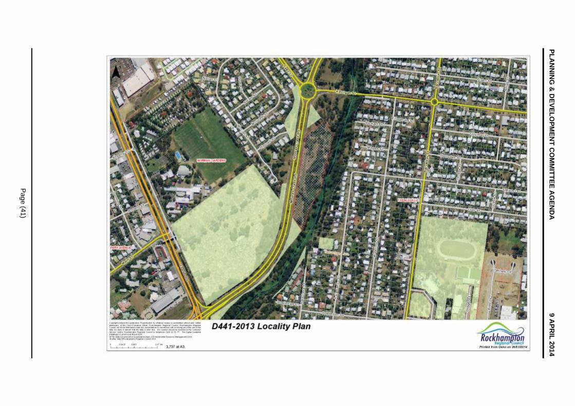
PL
AN
NIN
G &
DE
VE
LO
PM
EN
T C
OM
MIT
TE
E A
GE
ND
A
9 A
PR
IL 2
014
Pa
ge
(41
)

PLANNING & DEVELOPMENT COMMITTEE AGENDA 9 APRIL 2014
Page (42)
Site Layout Plan
D/441-2013 - DEVELOPMENT APPLICATION FOR A MATERIAL
CHANGE OF USE FOR A TELECOMMUNICATION
FACILITY/TOWER
Site Layout Plan
Meeting Date: 9 April 2014
Attachment No: 2
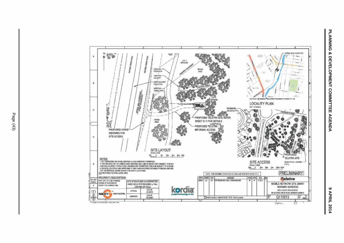
PL
AN
NIN
G &
DE
VE
LO
PM
EN
T C
OM
MIT
TE
E A
GE
ND
A
9 A
PR
IL 2
014
Pa
ge
(43
)

PLANNING & DEVELOPMENT COMMITTEE AGENDA 9 APRIL 2014
Page (44)
Elevation Plan
D/441-2013 - DEVELOPMENT APPLICATION FOR A MATERIAL
CHANGE OF USE FOR A TELECOMMUNICATION
FACILITY/TOWER
Elevation Plan
Meeting Date: 9 April 2014
Attachment No: 3

PLANNING & DEVELOPMENT COMMITTEE AGENDA 9 APRIL 2014
Page (45)
PLANNING & DEVELOPMENT COMMITTEE AGENDA 9 APRIL 2014
Page (46)
8.3 D/564-2013 Development Application for a Material Change of Use for a Multi Uni t Dwelling (four units)
8.3 D/564-2013 DEVELOPMENT APPLICATION FOR A MATERIAL CHANGE OF USE FOR A MULTI UNIT DWELLING (FOUR UNITS)
File No: D/564-2013
Attachments: 1. Locality Plan 2. Site and Landscaping Plan 3. Elevations
Authorising Officer: Tarnya Fitzgibbon - Coordinator Development Assessment Robert Holmes - General Manager Regional Services
Author: Corina Hibberd - Planning Officer
SUMMARY
Applicant: Bell Business Co Pty Ltd & Hooper Constructions Pty Ltd
Real Property Address: Lot 3 on RP608464, Parish of Archer
Common Property Address: 153 Kerrigan Street, Frenchville
Area of Site: 1,313 square metres
Planning Scheme: Rockhampton City Plan 2005
Rockhampton City Plan Area: Frenchville Residential Area
Existing Development: Single Dwelling House
Existing Approvals: 2013 Demolition Permit for the house
Approval Sought: Development Permit for a Material Change of Use for a Multi Unit Dwelling (four units)
Level of Assessment: Impact Assessable
Submissions: Nil
Referral Agency(s): Nil
Adopted Infrastructure Charges Area: Charge Area One
Application Progress:
Application Lodged: 12 December 2013
Request for Further Information sent: 8 January 2014
Request for Further Information responded to: 14 February 2014
Submission period commenced: 17 February 2014
Submission period end: 7 March 2014
Last receipt of information from applicant: 14 March 2014
Statutory determination date: 11 April 2014
Recommendation
OFFICER’S RECOMMENDATION
THAT in relation to the application for a Development Permit for a Material Change of Use for a Multi Unit Dwelling (four units), made by Bell Business Co Pty Ltd & Hooper Constructions Pty Ltd, on Lot 3 on RP608464, Parish of Archer, located at 153 Kerrigan Street, Frenchville, Council resolves to Approve the application despite its conflict with the planning scheme and provides the following grounds to justify the decision despite the conflict:
PLANNING & DEVELOPMENT COMMITTEE AGENDA 9 APRIL 2014
Page (47)
(a) The proposal is located within an area designated to accommodate Rockhampton’s residential growth;
(b) The use is for residential purposes and contributes to providing a mix of accommodation options within Rockhampton which is supported through the Desired Environmental Outcomes in the Rockhampton City Plan 2005;
(c) Having regard to the size of the allotment which is subject to the proposal, being 1,313 square metres (providing an average area of approximately 330 square metres per unit); it is considered reasonable to accommodate the proposed use when compared with the minimum lot size of 300 square metres achievable for this area;
(d) The proposed use does not compromise the achievements of the Desired Environmental Outcomes in the Rockhampton City Plan 2005;
(e) Assessment of the development against the relevant planning scheme codes, demonstrates that the proposed development will not cause significant adverse impact on the surrounding natural environment, built environment and infrastructure, community facilities or local character and amenity; and
(f) The proposed development does not compromise the relevant State Planning Policy.
RECOMMENDATION B
That in relation to the application for a Development Permit for a Multi Unit Dwelling (four units), made by Bell Business Co Pty Ltd & Hooper Constructions Pty Ltd, on Lot 3 on RP608464, Parish of Archer, located at 153 Kerrigan Street, Frenchville, Council resolves to Approve the application subject to the following conditions:
1.0 ADMINISTRATION
1.1 The Developer is responsible for ensuring compliance with this approval and the Conditions of the approval by an employee, agent, contractor or invitee of the Developer.
1.2 Where these Conditions refer to “Council” in relation to requiring Council to approve or to be satisfied as to any matter, or conferring on the Council a function, power or discretion, that role of the Council may be fulfilled in whole or in part by a delegate appointed for that purpose by the Council.
1.3 All conditions of this approval must be undertaken and completed to the satisfaction of Council, at no cost to Council.
1.4 All conditions, works, or requirements of this approval must be undertaken and completed prior to the commencement of the use, unless otherwise stated.
1.5 Where applicable, infrastructure requirements of this approval must be contributed to the relevant authorities, at no cost to Council prior, to the commencement of the use, unless otherwise stated.
1.6 The following further Development Permits must be obtained prior to the commencement of any works associated with its purposes:
1.6.1 Plumbing and Drainage Works;
1.6.2 Building Works;
1.6.3 Operational Works:
(i) Road Works;
(ii) Access Works;
(iii) Roof and Allotment Drainage Works; and

PLANNING & DEVELOPMENT COMMITTEE AGENDA 9 APRIL 2014
Page (48)
(iv) Site Works.
1.7 All Development Permits for Operational Works and Plumbing and Drainage Works must be obtained prior to the issue of a Development Permit for Building Works.
1.8 Unless otherwise stated, all works must be designed, constructed and maintained in accordance with the relevant Council policies, guidelines and standards.
1.9 All engineering drawings/specifications, design and construction works must comply with the requirements of the relevant Australian Standards and must be approved, supervised and certified by a Registered Professional Engineer of Queensland.
2.0 APPROVED PLANS AND DOCUMENTS
2.1 The approved development must be completed and maintained generally in accordance with the approved plans and documents, except where amended by the conditions of this permit:
Plan/Document Name Plan/Document Reference Dated
Site and Landscaping Plan T13-0802-01 Sheet 1 of 7, Rev 03
23 January 2014
Floor Plan – Unit 1 (Unit 4 Similar)
T13-0802-02 Sheet 2 of 7, Rev 03
23 January 2014
Floor Plan – Unit 2 (Unit 3 Similar)
T13-0802-03 Sheet 3 of 7, Rev 03
23 January 2014
Elevation 1 (West) and Elevation 2 (South)
T13-0802-04 Sheet 4 of 7, Rev 03
23 January 2014
Elevation 3 (East) and Elevation 4 (North)
T13-0802-05 Sheet 5 of 7, Rev 03
23 January 2014
Site Works Plan T13-0802-07 Sheet 7 of 7, Rev 03
23 January 2014
2.2 Where there is any conflict between the conditions of this approval and the details shown on the approved plans and documents, the conditions of approval must prevail.
2.3 Where conditions require the above plans or documents to be amended, the revised document(s) must be submitted for approval by Council prior to the submission of a Development Application for Operational Works.
3.0 ROAD WORKS
3.1 A Development Permit for Operational Works (road works) must be obtained prior to the commencement of any road works on the site.
3.2 All works must be designed and constructed in accordance with the approved plans (refer to condition 2.1), Capricorn Municipal Development Guidelines, relevant Australian Standards and the provisions of a Development Permit for Operational Works (road works).
3.3 A concrete pathway, with a minimum width of 1.2 metres, must be constructed on the northern side of Kerrigan Street for the full frontage of the site.
3.4 All pathways and access ramps must be designed and constructed in accordance with Australian Standard AS1428 "Design for Access and Mobility".
3.5 All pathways located within a road reserve or public use land must be provided with public space lighting in accordance with Australian Standard AS1158 "Lighting for Roads and Public Spaces".
PLANNING & DEVELOPMENT COMMITTEE AGENDA 9 APRIL 2014
Page (49)
4.0 ACCESS WORKS
4.1 A Development Permit for Operational Works (access works) must be obtained prior to the commencement of any access works on the site.
4.2 All works must be designed and constructed in accordance with the approved plans (refer to condition 2.1), Capricorn Municipal Development Guidelines, Australian Standard AS2890 “Parking Facilities” and the provisions of a Development Permit for Operational Works (access works).
4.3 The new driveway crossover must be a minimum of 5.5 metres wide for 5.5 metres, measured from the Kerrigan Street kerb and channel toward the front property boundary and taper to 4.5 metres at the site boundary to allow two vehicles to pass each other whilst entering/exiting the site.
4.4 All redundant driveway crossovers must be removed and replaced with Council’s standard kerb and channel.
5.0 SEWERAGE WORKS
5.1 All works must be designed and constructed in accordance with the approved plans (refer to condition 2.1), Capricorn Municipal Development Guidelines, Water Supply (Safety and Reliability) Act, and Plumbing and Drainage Act.
5.2 The development must be connected to Council’s reticulated sewerage network.
5.3 The existing sewerage connection point(s) must be retained and upgraded, if necessary, to service the development.
5.4 Sewer connections located within trafficable areas must be raised or lowered to suit the finished surface levels and must be provided with trafficable lids.
6.0 WATER WORKS
6.1 All works must be designed and constructed in accordance with the approved plans (refer to condition 2.1), Capricorn Municipal Development Guidelines, Water Supply (Safety and Reliability) Act, and Plumbing and Drainage Act.
6.2 The development must be connected to Council’s reticulated water network.
6.3 The existing water connection point(s) must be retained and upgraded, if necessary, to service the development.
6.4 The development must be provided with a master meter at the property boundary and sub meters for each sole occupancy building in accordance with the Queensland Plumbing and Drainage Code and Council’s Sub-metering Policy.
6.5 Water meter boxes located within trafficable areas must be raised or lowered to suit the finished surface level and must be provided with heavy duty trafficable lids.
7.0 PLUMBING AND DRAINAGE WORKS
7.1 All works must be designed and constructed in accordance with the approved plans (refer to condition 2.1), Capricorn Municipal Development Guidelines, Water Supply (Safety and Reliability) Act, Plumbing and Drainage Act and Council’s Plumbing and Drainage Policies.
7.2 Alteration or relocation of internal sanitary drainage works associated with the former building must be in accordance with regulated work under the Plumbing and Drainage Act.
8.0 ROOF AND ALLOTMENT DRAINAGE WORKS
8.1 A Development Permit for Operational Works (roof and allotment drainage works) must be obtained prior to the commencement of any drainage works on the site.
8.2 All roof and allotment drainage must be in accordance with the requirements of the
PLANNING & DEVELOPMENT COMMITTEE AGENDA 9 APRIL 2014
Page (50)
Queensland Urban Drainage Manual and the Capricorn Municipal Development Guidelines.
8.3 The development must not increase peak stormwater runoff for a selected range of storm events up to and including the one in one hundred year storm event (100 year Average Recurrence Interval) for the post development condition.
8.4 All roof and allotment drainage must be discharged such that it does not restrict, impair or change the natural flow of runoff water or cause a nuisance to adjoining properties or infrastructure.
9.0 SITE WORKS
9.1 A Development Permit for Operational Works (site works) must be obtained prior to the commencement of any site works.
9.2 Any application for a Development Permit for Operational Works (site works) must be accompanied by an earthworks’ plan which clearly identifies the following:
9.2.1 the location of cut and/or fill;
9.2.2 the type of fill to be used and the manner in which it is to be compacted;
9.2.3 the quantum of fill to be deposited or removed and finished cut and/or fill levels;
9.2.4 details of any proposed access routes to the site which are intended to be used to transport fill to or from the site; and
9.2.5 the maintenance of access roads to and from the site so that they are free of all cut and/or fill material and cleaned as necessary.
9.3 All earthworks must be undertaken in accordance with Australian Standard AS3798 “Guidelines on Earthworks for Commercial and Residential Developments”.
9.4 Site works must be constructed such that they do not, at any time, in any way restrict, impair or change the natural flow of runoff water, or cause a nuisance or worsening to adjoining properties or infrastructure.
9.5 The structural design of all retaining walls above one (1) metre in height must be separately and specifically certified by a Registered Professional Engineer of Queensland as part of an Operational Works submission. A Registered Professional Engineer of Queensland must on completion certify that all works are compliant with the approved design.
9.6 Any vegetation cleared or removed must be:
(i) mulched on-site and utilised on-site for landscaping purposes, in accordance with the landscaping plan approved by Council; or
(ii) removed for disposal at a location approved by Council;
within sixty (60) days of clearing. Any vegetation removed must not be burnt.
9.7 All site works must be undertaken to ensure that there is:
9.7.1 no increase in upstream or downstream flood levels for all levels of immunity up to Q100;
9.7.2 no increase in velocity profiles, for which no remedy exists to prevent erosion and/or scouring. In the event that modelling shows non-compliance with the above, works must be undertaken within the system to satisfy the above criteria for development; and
9.7.3 a lawful point of discharge to which the developed flows from the land drain. Easements will be required over any other land to accommodate the flows.
PLANNING & DEVELOPMENT COMMITTEE AGENDA 9 APRIL 2014
Page (51)
10.0 BUILDING WORKS
10.1 All external elements, such as air conditioners, must be adequately screened from public view, to Council’s satisfaction. Noise from any external elements, such as air conditioners, must not exceed five (5)dB(A) above the background ambient noise level, measured at the boundaries of the subject site.
10.2 Any lighting devices associated with the development, such as sensory lighting, must be positioned on the site and shielded so as not to cause glare or other nuisance to nearby residents and motorists. Night lighting must be designed, constructed and operated in accordance with Australian Standard AS4282 “Control of the obtrusive effects of outdoor lighting”.
10.3 The private open space area between Unit 2 and Unit 3 must be fenced with a 1.8 metre high fence, of appropriate material.
10.4 All fencing on side and rear boundaries must be a minimum 1.8 metres in height. The fencing may be graduated down to 1.2 metres towards the road frontage. All side and rear boundaries, and internal fencing must ensure privacy and security to adjoining residential properties. The fencing must be constructed of materials and finishes that prevent light spillage of vehicle headlights and are commensurate with the surrounding residential area.
10.5 All structures must maintain a clearance of two (2) metres to any sewerage infrastructure including connection point in accordance with Council’s Building Over/Adjacent to Local Government Sewerage Infrastructure Policy.
11.0 LANDSCAPING WORKS
11.1 All landscaping must be established generally in accordance with the approved plans (refer to condition 2.1).
11.2 The three existing street trees along the Kerrigan Street frontage must not be removed.
11.3 Large trees must not be planted within one (1) metre of the centreline of any sewerage infrastructure. Small shrubs and groundcover are acceptable.
11.4 Landscaping, or any part thereof, upon reaching full maturity, must not:
(i) obstruct sight visibility zones as defined in the Austroads ‘Guide to Traffic Engineering Practice’ series of publications;
(i) adversely affect any road lighting or public space lighting; or
(ii) adversely affect any Council infrastructure, or public utility plant.
11.5 The landscaped areas must be subject to an ongoing maintenance and replanting programme (if necessary).
12.0 ELECTRICITY AND TELECOMMUNICATIONS
12.1 Underground electricity and telecommunication connections must be provided to the proposed development to the standards of the relevant authorities.
12.2 Evidence must be provided of a certificate of supply with the relevant service providers to provide each unit with live electricity and telecommunication connections, in accordance with the requirements of the relevant authorities prior to commencement of the use.
13.0 ASSET MANAGEMENT
13.1 Any alteration necessary to electricity, telephone, water mains, sewerage mains, and/or public utility installations resulting from the development or in connection with the development, must be at full cost to the Developer.
13.2 Any damage to existing kerb and channel, pathway or roadway (including removal of concrete slurry from public land, pathway, roads, kerb and channel and stormwater

PLANNING & DEVELOPMENT COMMITTEE AGENDA 9 APRIL 2014
Page (52)
gullies and drainage lines) which may occur during any works carried out in association with the approved development must be repaired. This must include the reinstatement of the existing traffic signs and pavement markings which may have been removed.
14.0 ENVIRONMENTAL
14.1 Any application for a Development Permit for Operational Works must be accompanied by an Erosion and Sediment Control Plan which addresses, but is not limited to, the following:
(i) objectives;
(i) site location / topography;
(ii) vegetation;
(iii) site drainage;
(iv) soils;
(v) erosion susceptibility;
(vi) erosion risk;
(vii) concept;
(viii) design; and
(ix) implementation, for the construction and post construction phases of work.
14.2 An Erosion Control and Stormwater Control Management Plan must be implemented and maintained on-site for the duration of the works, and until all exposed soil areas are permanently stabilised (for example, turfed, hydromulched, concreted, landscaped). The prepared Erosion Control and Stormwater Control Management Plan must be available on-site for inspection by Council Officers during those works.
15.0 OPERATING PROCEDURES
15.1 All construction materials, waste, waste skips, machinery and contractors’ vehicles must be located and stored or parked within the site. No storage of materials, parking of construction machinery or contractors’ vehicles will be permitted in Kerrigan Street.
15.2 All waste storage areas must be kept in a clean, tidy condition in accordance with Environmental Protection (Waste Management) Regulations.
ADVISORY NOTES
NOTE 1. Aboriginal Cultural Heritage
It is advised that under Section 23 of the Aboriginal Cultural Heritage Act 2003, a person who carries out an activity must take all reasonable and practicable measures to ensure the activity does not harm Aboriginal Cultural Heritage (the “cultural heritage duty of care”). Maximum penalties for breaching the duty of care are listed in the Aboriginal Cultural Heritage legislation. The information on Aboriginal Cultural Heritage is available on the Department of Aboriginal and Torres Strait Islander and Multicultural Affairs website www.datsima.qld.gov.au
NOTE 2. Asbestos Removal
Any demolition and/or removal works involving asbestos materials must be undertaken in accordance with the requirements of the Workplace Health and Safety legislation and Public Health Act 2005.
NOTE 3. General Environmental Duty
General environmental duty under the Environmental Protection Act prohibits unlawful environmental nuisance caused by noise, aerosols, particles, dust, ash, fumes, light, odour or smoke beyond the boundaries of the property during all stages of the development including earthworks, construction and operation.

PLANNING & DEVELOPMENT COMMITTEE AGENDA 9 APRIL 2014
Page (53)
NOTE 4. General Safety Of Public During Construction
The Workplace Health and Safety Act and Manual of Uniform Traffic Control Devices must be complied with in carrying out any construction works, and to ensure safe traffic control and safe public access in respect of works being constructed on a road.
NOTE 5. Works in Road Reserve Permit
It is advised that a Works in Road Reserve Permit (including a fee for the vehicle crossover and compliant with Standard Capricorn Municipal Development Guideline Drawings) may be accepted in place of the Development Permit for Operational Works (access works).
NOTE 6. Adopted Infrastructure Charges Notice
This application is subject to infrastructure charges in accordance with Council policies. The charges are presented on an Adopted Infrastructure Charges Notice.
RECOMMENDATION C
That in relation to the application for a Development Permit for a Multi Unit Dwelling (four units), made by Bell Business Co Pty Ltd & Hooper Constructions Pty Ltd, on Lot 3 on RP608464, Parish of Archer, located at 153 Kerrigan Street, Frenchville, Council resolves to issue an adopted infrastructure charges notice.
BACKGROUND
Proposal in Detail
The proposal is for four (4) multi unit dwellings. Each unit will contain three (3) bedrooms, an ensuite and bathroom, an open plan kitchen, living, and dining room, a patio, courtyard garden and two car parks, one of which is enclosed and one which is open. Each unit has a gross floor area of approximately 155 square metres, with a total site cover of 46.1 per cent. The units will share a single drive way and letterbox facility. Landscaping plans are provided to enhance the street frontage, and the existing and established street trees will remain.
Site and Locality
The site is 1,313 square metres and is located within the Frenchville Residential Area. The site is relatively flat and is not affected by bushfire risk or Q100 flooding. The site currently contains three (3) large Poinciana trees. A house was approved to be demolished and was recently removed from the site. The trees will be removed. The area is generally characterised by single dwellings on larger lots, however a number of units exist at nearby sites. The lot is approximately 200 metres from the commercial precinct on Dean Street and is proximal to local bus stops.
PLANNING ASSESSMENT
Matters for Consideration
This application has been assessed by relevant Council planning, engineering, environmental health, and other technical officers as required. The assessment has been in accordance with the Integrated Development Assessment System provisions of the Sustainable Planning Act 2009, based on consideration of the relevant State Planning Policy; State Government guidelines; the Council’s Town Planning Scheme, Planning Policies and other general policies and procedures, as well as other documents as considered relevant.
Infrastructure Operations Unit’s Comments – 16 December 2013
Support, subject to conditions.
Infrastructure Operations Unit’s (sewer and water) Comments – 13 December 2013
Support, subject to conditions.

PLANNING & DEVELOPMENT COMMITTEE AGENDA 9 APRIL 2014
Page (54)
Environmental and Public Health Unit’s Comments - 17 December 2013
Support, subject to conditions.
Town Planning Comments
Central Queensland Regional Plan 2013
The Central Queensland Regional Plan is a statutory document which came into effect on 18 October 2013. The development is not required to be assessed against the regional plan if this document is appropriately reflected in the local planning scheme. It is considered that the regional plan is appropriately reflected in the current local planning scheme.
State Planning Policy 2013
This policy came into effect on 2 December 2013 and replaced all former State Planning Policies. This policy requires development applications to be assessed against its requirements until the identified state interests have been appropriately reflected in the local planning scheme.
Mining and extractive resources
Not Applicable.
Biodiversity
Not Applicable.
Coastal environment
Not Applicable.
Water quality
Not Applicable.
Emissions and hazardous activities
Not Applicable.
Natural hazards
Not Applicable.
State transport infrastructure
Not Applicable.
Strategic airports and aviation facilities
Not Applicable.
Rockhampton City Plan Strategic Framework This application is situated within the residential designation under Council’s Strategic Framework Map.
The following Desired Environmental Outcomes, as identified within Chapter 2 of the Rockhampton City Plan 2005 are applicable:
Rockhampton City Plan 2005
Rockhampton City Plan Strategic Framework
This application is situated within the Residential designation under Council’s Strategic Framework Map.
The following Desired Environmental Outcomes, as identified within Chapter 2 of the Rockhampton City Plan 2005 are applicable:
(a) Rockhampton continues to consolidate its ‘Capital of Central Queensland’ role in the region.

PLANNING & DEVELOPMENT COMMITTEE AGENDA 9 APRIL 2014
Page (55)
Complies: The proposal supports continued population growth within Rockhampton through residential consolidation within established urban areas that enjoy all standard services.
(b) Valuable natural resources are conserved or, where required to support economic growth in Rockhampton, used sustainably.
Not Applicable: The subject site is not within proximity of any significant natural resources considered vital to economic growth within the region.
(c) Important natural assets are, as far as is practically possible, retained in a natural state to maximise biodiversity and to maintain their scenic and biological value.
Complies: The proposal will not adversely impact any natural assets.
(d) New development in Rockhampton City is designed and managed to minimise adverse impacts on the environment, and biodiversity.
Complies: The proposal does not adversely impact the environment, or the region’s biodiversity as the subject site is located within an existing urban area with limited biodiversity values.
(e) Commercial and retail development is accommodated in a hierarchy of centres throughout Rockhampton, which provide for a range of services, retail, commercial, entertainment and employment activities.
Not Applicable: The proposal is not for a commercial or retail development.
(f) Rockhampton’s commercial centres are safe, attractive and readily accessible spaces for all members of the community.
Complies: The development provides easy access for residents to the nearby commercial precinct on Dean Street. This is an appropriate area to locate higher density residential uses as it is in an ideal location for accessibility to commercial centres.
(g) Rockhampton’s industrial development is consolidated in identified industrial locations throughout the City.
Not Applicable: The proposal does not relate to industrial development.
(h) Rockhampton’s cultural and urban heritage, both indigenous and post European, is retained and conserved for future generations.
Complies: The proposal does not impact upon any cultural or urban heritage values.
(i) Residential communities are attractive places to live, providing a range of housing types at different densities that positively contributes to the built environment, satisfies the needs of all members of the community in terms of life stages, lifestyle choices and affordability, are free from incompatible development and have access to a range of compatible urban services and facilities.
Complies: The proposal adopts some design elements compatible with adjoining residential uses and will contribute to the range of housing types and densities within an established residential area. The proposal also retains the existing and established street trees which will provide an aesthetic buffer between the street and the development which will soften the impact of new brick dwellings in a typically timber house area. As such, the proposal supports a diversity of residents and lifestyle choices with compatible urban services and facilities within proximity of the site.
(j) Rockhampton’s important community uses and health care facilities are provided and maintained in locations where they are readily accessible to all members of the community.
Not Applicable: The proposal does not include any current or future community uses or health care facilities.
PLANNING & DEVELOPMENT COMMITTEE AGENDA 9 APRIL 2014
Page (56)
(k) New residential land subdivision and development occurs in identified areas within the City where environmentally valuable features are retained and protected, and urban services, recreational opportunities and parks are provided, along with a range of allotment sizes.
Complies: The proposal does not involve residential subdivision, nor will it impact on environmentally valuable features within Rockhampton.
(l) Infrastructure is provided and augmented in a sequenced manner in Rockhampton, resulting in appropriate, efficient, affordable, reliable, timely and lasting infrastructure provision that is not compromised by new development and is sensitive to the environment.
Complies: The subject site is connected to all standard urban infrastructure services.
(m) Safe, accessible, efficient and convenient transport systems are provided in Rockhampton.
Complies: The site has access to a constructed road, and is along a bus route for North Rockhampton. Therefore, the development will contribute to efficiency of the transport system.
(n) Readily accessible and safe Open Space and facilities for active and passive recreational purposes are accommodated within Rockhampton City.
Complies: The site is within 700 metres of four open space and parks, including Kerrigan Street Park, Velodrome/Aquatic Centre at Janet Pajolas Park, Apex Park Frenchville, and Col Austin Park.
The performance assessment of the proposal demonstrates that the development will not compromise the Rockhampton City Plan Desired Environmental Outcomes.
Frenchville Residential Area Intent
The subject site is situated within the Frenchville Residential Area under the Rockhampton City Plan. The intent of the Area identifies that:
“It is intended that the Frenchville Residential Area will retain a residential character, dominated by houses on individual allotments. More intense forms of residential development, such as multi-unit dwelling development, is inconsistent with the intent for the Area, however, duplex development is compatible, as long as it does not dominate, and does not compromise the primary residential character of the Area, which is houses on individual allotments.”
The proposed use cannot be considered a consistent use within the Frenchville Residential Area. Council should note however, that pursuant to Section 326(1)(b) of the Sustainable Planning Act 2009, the assessment manager’s decision may conflict with the Planning Scheme if there are sufficient grounds to justify the decision despite the conflict.
In response to the above, the assessment of this application concludes that the proposed development, subject to conditions, is not likely to conflict with Council’s Desired Environmental Outcomes. Furthermore, there are considered to be ‘sufficient grounds’ in this instance, to justify Council approving the development despite its conflict with the Area Intent.
Sufficient grounds of justification are as follows:
(a) The proposal is located within an area designated to accommodate Rockhampton’s residential growth;
(b) The use is for residential purposes and contributes to providing a mix of accommodation options within Rockhampton which is supported through the Desired Environmental Outcomes in the Rockhampton City Plan 2005;
(c) Having regard to the size of the allotment which is subject to the proposal, being 1,313 square metres (providing an average area of approximately 330 square metres

PLANNING & DEVELOPMENT COMMITTEE AGENDA 9 APRIL 2014
Page (57)
per unit); it is considered reasonable to accommodate the proposed use when compared with the minimum lot size of 300 square metres achievable for this area;
(d) The proposed use does not compromise the achievements of the Desired Environmental Outcomes in the Rockhampton City Plan 2005;
(e) Assessment of the development against the relevant planning scheme codes, demonstrates that the proposed development will not cause significant adverse impact on the surrounding natural environment, built environment and infrastructure, community facilities or local character and amenity; and
(f) The proposed development does not compromise the relevant State Planning Policy.
Having regard to all of the above, it is recommended that Council, from a land use perspective, consider the proposed development favourably as, pursuant to Section 326(1)(b) of the Sustainable Planning Act 2009, there are considered to be sufficient grounds to justify a decision that favours the alternative land uses proposed herein and the development is capable of occurring in a manner that is not likely to conflict with Council’s Desired Environmental Outcomes.
Rockhampton City Plan Codes
The following codes are applicable to this application:
Multi Unit Dwelling, Accommodation Building and Duplex Code;
Parking and Access Code;
Landscaping Code;
Crime Prevention through Environmental Design Code; and
External Works and Servicing Code.
An assessment has been made against the requirement of the abovementioned codes and the following has not been met:
Multi Unit Dwelling, Accommodation Building and Duplex Code
Performance Criteria Officer’s Response
P1 The density of the development is consistent with the scale and density of development expected and intended for an Area.
Although Multi Unit Dwellings are not considered a consistent use within the area, the scale and density of the development is considered sympathetic to the adjoining uses in terms of building orientation and layout. In addition, the development incorporates building articulation which will soften the built form. The proposal achieves a site density of approximately forty-six (46) per cent which is consistent with the scale of development in this area. Furthermore, the average lot area per unit is approximately 330 square metres, which is reasonable, considering the minimum lot size is 300 square metres in this area and would be achievable for this lot.
PLANNING & DEVELOPMENT COMMITTEE AGENDA 9 APRIL 2014
Page (58)
Infrastructure Charges
Adopted Infrastructure Charges Resolution (No.3) 2014 for residential development applies to the application and it falls within Charge Area 1. The Adopted Infrastructure Charges are as follows:
Column 1
Use Schedule
Column 2
Charge Area
Column 3
Adopted Infrastructure Charge for residential
development
($/dwelling unit)
Column 4
Unit
Calculated Charge
1 or 2 bedroom dwelling
3 or more bedroom dwelling
Residential Area 1 15,000 21,000 per dwelling
$84,000.00
This is based on the following calculations:
(a) A charge of $84,000.00 applies for four (4) three-bedroom units;
(b) A credit of $21,000.00 applies for the existing allotment
A total Adopted Infrastructure Charge of $63,000.00 is payable and will be reflected in an Adopted Infrastructure Charges Notice for the development.
Consultation
The proposal was the subject of public notification between 17 February 2014 and 7 March 2013, as per the requirements of the Sustainable Planning Act 2009, and no submissions were received.
Referrals
The application did not trigger any referral agencies.
CONCLUSION
It is recognised that the proposal is not a consistent use within Frenchville Residential Area under the Rockhampton City Plan 2005. However, the assessment of this application concludes that the proposed development, subject to conditions, is not likely to conflict with the Planning Scheme’s Desired Environmental Outcomes. As demonstrated in the above report, the proposal is generally consistent with the code requirements prescribed by the planning scheme and the use will not compromise the intent of the area. It is located on a site which is suited to the proposed development and which is able to be serviced by all necessary services.
PLANNING & DEVELOPMENT COMMITTEE AGENDA 9 APRIL 2014
Page (59)
Locality Plan
D/564-2013 DEVELOPMENT APPLICATION FOR A MATERIAL
CHANGE OF USE FOR A MULTI UNIT DWELLING (FOUR UNITS)
Locality Plan
Meeting Date: 9 April 2014
Attachment No: 1

PL
AN
NIN
G &
DE
VE
LO
PM
EN
T C
OM
MIT
TE
E A
GE
ND
A
9 A
PR
IL 2
014
Pa
ge
(60
)
PLANNING & DEVELOPMENT COMMITTEE AGENDA 9 APRIL 2014
Page (61)
Site and Landscaping Plan
D/564-2013 DEVELOPMENT APPLICATION FOR A MATERIAL
CHANGE OF USE FOR A MULTI UNIT DWELLING (FOUR UNITS)
Site and Landscaping Plan
Meeting Date: 9 April 2014
Attachment No: 2

PL
AN
NIN
G &
DE
VE
LO
PM
EN
T C
OM
MIT
TE
E A
GE
ND
A
9 A
PR
IL 2
014
Pa
ge
(62
)

PLANNING & DEVELOPMENT COMMITTEE AGENDA 9 APRIL 2014
Page (63)
Elevations
D/564-2013 DEVELOPMENT APPLICATION FOR A MATERIAL
CHANGE OF USE FOR A MULTI UNIT DWELLING (FOUR UNITS)
Elevations
Meeting Date: 9 April 2014
Attachment No: 3

PL
AN
NIN
G &
DE
VE
LO
PM
EN
T C
OM
MIT
TE
E A
GE
ND
A
9 A
PR
IL 2
014
Pa
ge
(64
)
PLANNING & DEVELOPMENT COMMITTEE AGENDA 9 APRIL 2014
Page (65)
8.4 D/574-2013 Development Application for a Material Change of Use for a Showroom, Reconfiguring a Lot (six lots into two lots) and Operational Works for Advertising Signs
8.4 D/574-2013 DEVELOPMENT APPLICATION FOR A MATERIAL CHANGE OF USE FOR A SHOWROOM, RECONFIGURING A LOT (SIX LOTS INTO TWO LOTS) AND OPERATIONAL WORKS FOR ADVERTISING SIGNS
File No: D/574-2013
Attachments: 1. Locality Plan 2. Site Plan - DA102 3. E1 Elevations - DA201 4. E2 Elevations - DA202
Authorising Officer: Tarnya Fitzgibbon - Coordinator Development Assessment Robert Holmes - General Manager Regional Services
Author: Amanda O'Mara - Planning Officer
SUMMARY
Development Application Number: D/574-2013
Applicant: Rocky Motors Property Partnership
Real Property Address: Lot 21 on SP263875 (previously Lot 6 on RP603013 and Lot 11 on RP603013), Lot 7 on RP603013, Lot 8 on RP603013, Lot 9 on RP603013, Lot 10 on RP603013, Parish of Rockhampton
Common Property Address: 66 Derby Street, 68 Derby Street, 70 Derby Street, 72 Derby Street and 74 Derby Street, Rockhampton City
Area of Site: 1,131 square metres
Planning Scheme: Rockhampton City Plan 2005
Rockhampton City Plan Area: Depot Hill Residential Area, Precinct 2 – Residential Precinct, Western Depot Hill
Existing Development: Four Dwelling Houses and Commercial Premises with Caretaker’s Residence
Existing Approvals: Various building permits for the existing houses
Approval Sought: Development Permit for a Material Change of Use for a Showroom, Reconfiguring of a Lot (six lots into two lots) and Operational Works for Advertising Signs
Level of Assessment: Impact Assessable (Material Change of Use and Operational Works)
Code Assessable (Reconfiguring a Lot)
Submissions: One submission
Referral Agency(s): Nil
Adopted Infrastructure Charges Area: Charge Area 1
Application Progress:
Application Lodged: 11 December 2013
Application properly made: 6 January 2014
Acknowledgement Notice issued: 9 January 2014

PLANNING & DEVELOPMENT COMMITTEE AGENDA 9 APRIL 2014
Page (66)
Submission period commenced: 6 February 2014
Notice of commencement of public notification: 7 February 2014
Submission period end: 28 February 2014
Notice of compliance of public notification: 3 March 2014
Council request for additional time: 18 March 2014
Statutory determination date: 1 May 2014
Recommendation
OFFICER’S RECOMMENDATION
RECOMMENDATION A
That in relation to the application for a Development Permit for a Material Change of Use for a Showroom, Reconfiguring a Lot (six lots into two lots) and Operational Works for an Advertising Sign (plyon sign), made by Rocky Motors Property Partnership, on Lot 21 on SP263875 (previously Lot 6 on RP603013 and Lot 11 on RP603013), Lot 7 on RP603013, Lot 8 on RP603013, Lot 9 on RP603013, Lot 10 on RP603013, Parish of Rockhampton, located at 66 Derby Street, 68 Derby Street, 70 Derby Street, 72 Derby Street and 74 Derby Street, Rockhampton City, Council resolves to approve the application despite the conflict with the planning scheme and provides the following grounds to justify the decision despite the conflict:
a) The proposed development will reduce residential densities within a flood affected area;
b) The proposal has been designed to ensure the surrounding residential amenity will not be negatively impacted in terms of noise, light, traffic, odours, visual impact or the like;
c) The proposed use can be considered compatible with the surrounding uses in the area;
d) The proposed use is an expansion of an existing showroom which is neighbouring and adjacent to the site.
e) The proposed use does not compromise the achievements of the Desired Environmental Outcomes in the Rockhampton City Plan 2005;
f) Assessment of the development against the relevant area intent, planning scheme codes and planning scheme policies demonstrates that the proposed development will not cause significant adverse impacts on the surrounding natural environment, built environment and infrastructure, community facilities, or local character and amenity; and
g) The proposed development does not compromise the relevant State Planning Policy.
RECOMMENDATION B
That in relation to the application for a Development Permit for a Material Change of Use for a Showroom, Reconfiguring a Lot (six lots into two lots) and Operational Works for Advertising Signs, made by Rocky Motors Property Partnership, on Lot 21 on SP263875 (previously Lot 6 on RP603013 and Lot 11 on RP603013), Lot 7 on RP603013, Lot 8 on RP603013, Lot 9 on RP603013, Lot 10 on RP603013, Parish of Rockhampton, located at 66 Derby Street, 68 Derby Street, 70 Derby Street, 72 Derby Street and 74 Derby Street, Rockhampton City, Council resolves to Approve the application subject to the following conditions:

PLANNING & DEVELOPMENT COMMITTEE AGENDA 9 APRIL 2014
Page (67)
MATERIAL CHANGE OF USE
1.0 ADMINISTRATION
1.1 The Developer is responsible for ensuring compliance with this approval and the Conditions of the approval by an employee, agent, contractor or invitee of the Developer.
1.2 Where these Conditions refer to “Council” in relation to requiring Council to approve or to be satisfied as to any matter, or conferring on the Council a function, power or discretion, that role of the Council may be fulfilled in whole or in part by a delegate appointed for that purpose by the Council.
1.3 All conditions of this approval must be undertaken and completed to the satisfaction of Council, at no cost to Council.
1.4 All conditions, works, or requirements of this approval must be undertaken and completed prior to the commencement of the use, unless otherwise stated.
1.5 Where applicable, infrastructure requirements of this approval must be contributed to the relevant authorities, at no cost to Council prior to the commencement of the use, unless otherwise stated.
1.6 The following further Development Permits must be obtained prior to the commencement of any works associated with their purposes:
1.6.1 Operational Works:
(i) Road Works;
(ii) Access and Parking Works;
(iii) Stormwater Works; and
(iv) Roof and Allotment Drainage Works.
1.6.2 Plumbing and Drainage Works; and
1.6.3 Building Works:
(i) Demolition and
(ii) Building works.
1.7 All Development Permits for Operational Works and Plumbing and Drainage Works must be obtained prior to the issue of a Development Permit for Building Works.
1.8 Unless otherwise stated, all works must be designed, constructed and maintained in accordance with the relevant Council policies, guidelines and standards.
1.9 All engineering drawings/specifications, design and construction works must comply with the requirements of the relevant Australian Standards and must be approved, supervised and certified by a Registered Professional Engineer of Queensland.
2.0 APPROVED PLANS AND DOCUMENTS
2.1 The approved development must be completed and maintained generally in accordance with the approved plans and documents, except where amended by the conditions of this permit:
Plan/Document Name Plan/Document Number Dated
Site Plan DA102, Issue 04 21 October 2013
E1 Elevations DA201, Issue 04 21 October 2013
E2 Elevations DA202, Issue 04 21 October 2013

PLANNING & DEVELOPMENT COMMITTEE AGENDA 9 APRIL 2014
Page (68)
2.2 Where there is any conflict between the conditions of this approval and the details shown on the approved plans and documents, the conditions of approval must prevail.
2.3 Where conditions require the above plans or documents to be amended, the revised document(s) must be submitted for endorsement by Council prior to the submission of a Development Application for Operational Works.
3.0 ROAD WORKS
3.1 A Development Permit for Operational Works (road works) must be obtained prior to the commencement of any road works on the site.
3.2 All works must be designed and constructed in accordance with the approved plans (refer to condition 2.1), Capricorn Municipal Development Guidelines, relevant Australian Standards and the provisions of a Development Permit for Operational Works (road works).
3.3 A concrete pathway, with a minimum width of 1.2 metres, must be constructed for the full frontage of the development to George Street and Derby Street.
3.4 All pathways and access ramps must be designed and constructed in accordance with Australian Standard AS1428 "Design for Access and Mobility". All pathways located within a road reserve or public use land must be provided with public space lighting in accordance with Australian Standard AS1158 "Lighting for Roads and Public Spaces".
3.5 All pathways must incorporate kerb ramps at all road crossing points.
3.6 Traffic signs and pavement markings must be provided in accordance with the Manual of Uniform Traffic Control Devices – Queensland. Where necessary, existing traffic signs and pavement markings must be modified in accordance with the Manual of Uniform Traffic Control Devices – Queensland.
4.0 ACCESS AND PARKING WORKS
4.1 A Development Permit for Operational Works (access and parking works) must be obtained prior to the commencement of any access and parking works on the site.
4.2 All works must be designed and constructed in accordance with the approved plans (refer to condition 2.1), Capricorn Municipal Development Guidelines, Australian Standard AS2890 “Parking Facilities” and the provisions of a Development Permit for Operational Works (access and parking works).
4.3 A new access and egress point must be constructed for the proposed development generally in accordance with the approved drawings (refer to condition 2.1).
4.4 All redundant vehicle crossovers must be removed and replaced with Council’s standard kerb and channel.
5.0 SEWERAGE WORKS
5.1 All works must be designed and constructed in accordance with the approved plans (refer to condition 2.1), Capricorn Municipal Development Guidelines, Water Supply (Safety and Reliability) Act and Plumbing and Drainage Act.
5.2 The development must be connected to Council’s reticulated sewerage network.
5.3 All works must be undertaken in accordance with a Council Building Over/Adjacent to Local Government Sewerage Infrastructure Policy.
5.4 Easements must be provided over all sewerage infrastructure located within private property. The easement location(s) and width(s) must be in accordance with the requirements of the Capricorn Municipal Development Guidelines.
5.5 Sewerage access chambers located within a park or reserve, or below a Q100 flood event, must be provided with bolt down lids.

PLANNING & DEVELOPMENT COMMITTEE AGENDA 9 APRIL 2014
Page (69)
5.6 The finished sewerage access chamber surface must be at a sufficient level to avoid ponding of stormwater above the top of the chamber. A heavy duty trafficable lid must be provided in the trafficable area.
5.7 Sewer connections located within trafficable areas must be raised or lowered to suit the finished surface levels and must be provided with trafficable lids.
6.0 WATER WORKS
6.1 All works must be designed and constructed in accordance with the approved plans (refer to condition 2.1), Capricorn Municipal Development Guidelines, Water Supply (Safety and Reliability) Act and the Plumbing and Drainage Act.
6.2 The development must be connected to Council’s reticulated water network.
6.3 The existing water connection point(s) must be retained and upgraded, if necessary, to service the development.
6.4 Water meter boxes located within trafficable areas must be raised or lowered to suit the finished surface level and must be provided with heavy duty trafficable lids.
7.0 PLUMBING AND DRAINAGE WORKS
7.1 Alteration or relocation of internal plumbing and sanitary drainage works associated with the existing buildings must be in accordance with regulated work under the Plumbing and Drainage Act, Australian Plumbing and Drainage Standard AS3500 section 3 and 4 and the provisions of a Development Permit for Plumbing and Drainage Works.
7.2 Internal Plumbing and Sanitary Drainage of existing buildings must be contained within the lot it serves.
8.0 STORMWATER WORKS
8.1 A Development Permit for Operational Works (stormwater works) must be obtained prior to the commencement of any stormwater works on the site.
8.2 All stormwater drainage works must be designed and constructed in accordance with the approved plans (refer to condition 2.1), Queensland Urban Drainage Manual, Capricorn Municipal Development Guidelines, sound engineering practice and the provisions of a Development Permit for Operational Works (stormwater works).
8.3 All stormwater must drain to a demonstrated lawful point of discharge and must not adversely affect adjoining land or infrastructure by way of blocking, altering or diverting existing stormwater runoff patterns or have the potential to cause damage to other infrastructure.
8.4 The proposed development must not increase peak stormwater runoff for a selected range of storm events up to and including the one in one hundred year storm event (100 year Average Recurrence Interval) for the post development condition.
8.5 Easements must be provided over all land assessed to be within the one in one hundred year rainfall event (100 year Average Recurrence Interval) inundation area.
9.0 ROOF AND ALLOTMENT DRAINAGE WORKS
9.1 A Development Permit for Operational Works (roof and allotment drainage works) must be obtained prior to the commencement of any drainage works on the site.
9.2 All roof and allotment drainage must be in accordance with the requirements of the Queensland Urban Drainage Manual and the Capricorn Municipal Development Guidelines.
9.3 All roof and allotment drainage must be discharged such that it does not restrict, impair or change the natural flow of runoff water or cause a nuisance to adjoining properties or infrastructure.

PLANNING & DEVELOPMENT COMMITTEE AGENDA 9 APRIL 2014
Page (70)
10.0 SITE WORKS
10.1 All earthworks must be undertaken in accordance with Australian Standard AS3798 “Guidelines on Earthworks for Commercial and Residential Developments”.
10.2 Site works must be constructed such that they do not, at any time, in any way restrict, impair or change the natural flow of runoff water, or cause a nuisance or worsening to adjoining properties or infrastructure.
10.3 Any vegetation cleared or removed must be:
(i) mulched on-site and utilised on-site for landscaping purposes, in accordance with the landscaping plan approved by Council; or
(ii) removed for disposal at a location approved by Council;
within sixty (60) days of clearing. Any vegetation removed must not be burnt.
10.4 All site works must be undertaken to ensure that there is:
10.4.1 no increase in upstream or downstream flood levels for all levels of immunity up to Q100;
10.4.2 no increase in velocity profiles, for which no remedy exists to prevent erosion and/or scouring. In the event that modelling shows non-compliance with the above, works must be undertaken within the system to satisfy the above criteria for development; and
10.4.3 a lawful point of discharge to which the developed flows from the land drain. Easements will be required over any other land to accommodate the flows.
11.0 BUILDING WORKS
11.1 All structures must maintain a clearance of two (2) metres to any sewerage infrastructure.
11.2 The existing dwelling houses on the subject land must be demolished. A development permit for building works (demolition) must be obtained prior to the demolition of the existing dwelling houses.
11.3 All waste storage areas must be:
11.3.1 Aesthetically screened from any frontage or adjoining property.
11.4 All external elements, such as air conditioners, must be adequately screened from public view, to Council’s satisfaction. Noise from any external elements, such as air conditioners, must not exceed five (5) dB (A) above the background ambient noise level, measured at the boundaries of the subject site.
11.5 Any lighting devices associated with the development, such as sensory lighting, must be positioned on the site and shielded so as not to cause glare or other nuisance to nearby residents and motorists. Night lighting must be designed, constructed and operated in accordance with Australian Standard AS4282 “Control of the obtrusive effects of outdoor lighting”.
11.6 Provide a 1.8 metre high acoustic screen fence along the common boundary of the subject site and any adjoining residential properties.
11.7 A minimum of thirty percent (30%) of the gross floor area must be at least 500 millimetres above the level of the one in one hundred year flood event (100 year Average Recurrence Interval).
12.0 LANDSCAPING WORKS
12.1 Landscaping of the development must be generally in accordance with the approved plans (refer to condition 2.1).

PLANNING & DEVELOPMENT COMMITTEE AGENDA 9 APRIL 2014
Page (71)
12.2 All landscaping must predominantly contain plant species that are locally native to the Central Queensland region due to their low water dependency.
12.3 Landscaping, or any part thereof, upon reaching full maturity, must not:
(i) obstruct sight visibility zones as defined in the Austroads ‘Guide to Traffic Engineering Practice’ series of publications;
(ii) adversely affect any road lighting or public space lighting; or
(iii) adversely affect any Council infrastructure, or public utility plant.
12.4 Large trees must not be planted within one (1) metre of the centreline of any sewerage infrastructure. Small shrubs and groundcover are acceptable.
12.5 The landscaped areas must be subject to an ongoing maintenance and replanting programme (if necessary).
13.0 ELECTRICITY AND TELECOMMUNICATIONS
13.1 Above-ground electricity and telecommunication connections must be provided to the proposed development to the standards of the relevant authorities.
14.0 ASSET MANAGEMENT
14.1 Any alteration necessary to electricity, telephone, water mains, sewerage mains, and/or public utility installations resulting from the development or in connection with the development, must be at full cost to the Developer.
14.2 Any damage to existing kerb and channel, pathway or roadway (including removal of concrete slurry from public land, pathway, roads, kerb and channel and stormwater gullies and drainage lines) which may occur during any works carried out in association with the approved development must be repaired. This must include the reinstatement of the existing traffic signs and pavement markings which may have been removed.
14.3 ‘As constructed’ information pertaining to assets to be handed over to Council and those which may have an impact on Council’s existing and future assets must be provided prior to the commencement of the use. This information must be provided in accordance with the Manual for Submission of Digital As Constructed Information.
15.0 ENVIRONMENTAL
15.1 Any application for a Development Permit for Operational Works must be accompanied by an Erosion and Sediment Control Plan which addresses, but is not limited to, the following:
(i) objectives;
(ii) site location / topography;
(iii) vegetation;
(iv) site drainage;
(v) soils;
(vi) erosion susceptibility;
(vii) erosion risk;
(viii) concept;
(ix) design; and
(x) implementation, for the construction and post construction phases of work.
15.2 The Erosion Control and Stormwater Control Management Plan must be implemented and maintained on-site for the duration of the works, and until all exposed soil areas are permanently stabilised (for example, turfed, hydromulched, concreted, landscaped). The prepared Erosion Control and Stormwater Control

PLANNING & DEVELOPMENT COMMITTEE AGENDA 9 APRIL 2014
Page (72)
Management Plan must be available on-site for inspection by Council Officers during those works.
16.0 OPERATING PROCEDURES
16.1 All construction materials, waste, waste skips, machinery and contractors’ vehicles must be located and stored or parked within the site. No storage of materials, parking of construction machinery or contractors’ vehicles will be permitted in George Street or Derby Street.
16.2 The hours of operations must be limited to:
16.2.1 0800 hours to 1800 hours on Monday to Saturday, and
16.2.2 no operations on Sunday or Public Holidays.
16.3 All waste storage areas must be kept in a clean, tidy condition in accordance with Environmental Protection (Waste Management) Regulations.
RECONFIGURING A LOT
17.0 ADMINISTRATION
17.1 The Developer is responsible for ensuring compliance with this approval and the Conditions of the approval by an employee, agent, contractor or invitee of the Developer.
17.2 Where these Conditions refer to “Council” in relation to requiring Council to approve or to be satisfied as to any matter, or conferring on the Council a function, power or discretion, that role of the Council may be fulfilled in whole or in part by a delegate appointed for that purpose by the Council.
17.3 All conditions of this approval must be undertaken and completed to the satisfaction of Council, at no cost to Council.
17.4 All conditions, works, or requirements of this approval must be undertaken and completed prior to the issue of the Compliance Certificate for the Survey Plan, unless otherwise stated.
17.5 Where applicable, infrastructure requirements of this approval must be contributed to the relevant authorities, at no cost to Council, prior to the issue of the Compliance Certificate for the Survey Plan, unless otherwise stated.
17.6 Unless otherwise stated, all works must be designed, constructed and maintained in accordance with the relevant Council policies, guidelines and standards.
17.7 All engineering drawings/specifications, design and construction works must comply with the requirements of the relevant Australian Standards and must be approved, supervised and certified by a Registered Professional Engineer of Queensland.
17.8 No development application for Building Works associated with this approval can be submitted unless and until the Compliance Certificate for the Survey Plan for proposed Lot 111 and Lot 110 has been issued.
17.9 A three-chord truncation must be provided to the intersection of the property boundaries of proposed Lot 111 on the corner of George Street and Derby Street.
18.0 APPROVED PLANS AND DOCUMENTS
18.1 The approved development must be completed and maintained generally in accordance with the approved plans and documents, except where amended by the conditions of this permit:
Plan/Document Name Plan/Document Reference Dated
Site Survey Plan DA101, Issue 04 21 October 2013
PLANNING & DEVELOPMENT COMMITTEE AGENDA 9 APRIL 2014
Page (73)
18.2 Where there is any conflict between the conditions of this approval and the details shown on the approved plans and documents, the conditions of approval must prevail.
19.0 SEWERAGE WORKS
19.1 All works must be designed and constructed in accordance with the approved plans (refer to condition 2.1), Capricorn Municipal Development Guidelines, Water Supply (Safety and Reliability) Act and Plumbing and Drainage Act.
19.2 All lots within the development must be connected to Council’s reticulated sewerage network.
19.3 The existing sewerage connection point located within the proposed Lot 110 must be retained to service Lot 110.
19.4 Proposed Lot 111 must be connected to the reticulated sewerage network via a single sewerage service connection point and all other existing sewerage service connections must be disconnected.
19.5 Sewerage access chambers located below a Q100 flood event, must be provided with bolt down lids.
19.6 The finished sewerage access chamber surface must be at a sufficient level to avoid ponding of stormwater above the top of the chamber. A heavy duty trafficable lid must be provided in the trafficable area.
19.7 Easements must be provided over all sewerage infrastructure located within private property. The easement location(s) and width(s) must be in accordance with the requirements of the Capricorn Municipal Development Guidelines.
20.0 WATER WORKS
20.1 All works must be designed and constructed in accordance with the approved plans (refer to condition 2.1), Capricorn Municipal Development Guidelines, Water Supply (Safety and Reliability) Act and Plumbing and Drainage Act.
20.2 All lots within the development must be connected to Council’s reticulated water network.
20.3 The existing water connection point located within the proposed Lot 110 must be retained to service Lot 110.
20.4 Proposed Lot 111 must be connected to the reticulated water supply network via a single water service connection point and all other existing water service connections must be disconnected.
21.0 PLUMBING AND DRAINAGE WORKS
21.1 Alteration, disconnection or relocation of internal plumbing and sanitary drainage works associated with the existing building must be in accordance with regulated work under the Plumbing and Drainage Act and Australian Plumbing and Drainage Standard AS3500 section 3 and 4.
22.0 ELECTRICITY AND TELECOMMUNICATIONS
22.1 Above-ground electricity and telecommunication connections must be provided to each lot within the proposed development to the standards of the relevant authorities.
22.2 Evidence must be provided of a certificate of supply with the relevant service providers to provide each lot with live electricity and telecommunication connections, in accordance with the requirements of the relevant authorities prior to the issue of the Compliance Certificate for the Survey Plan.
23.0 ASSET MANAGEMENT
23.1 Any alteration necessary to electricity, telephone, water mains, sewerage mains, and/or public utility installations resulting from the development or in connection with
PLANNING & DEVELOPMENT COMMITTEE AGENDA 9 APRIL 2014
Page (74)
the development, must be at full cost to the Developer.
23.2 Any damage to existing kerb and channel, pathway or roadway (including removal of concrete slurry from public land, pathway, roads, kerb and channel and stormwater gullies and drainage lines) which may occur during any works carried out in association with the approved development must be repaired. This must include the reinstatement of the existing traffic signs and pavement markings which may have been removed.
23.3 ‘As constructed’ information pertaining to assets to be handed over to Council and those which may have an impact on Council’s existing and future assets must be provided prior to the issue of the Compliance Certificate for the Survey Plan. This information must be provided in accordance with the Manual for Submission of Digital As Constructed Information.
24.0 OPERATING PROCEDURES
24.1 All construction materials, waste, waste skips, machinery and contractors’ vehicles must be located and stored or parked within the site. No storage of materials, parking of construction machinery or contractors’ vehicles will be permitted in Derby Street or George Street.
OPERATIONAL WORKS
25.0 ADMINISTRATION
25.1 The Developer is responsible for ensuring compliance with this approval and the Conditions of the approval by an employee, agent, contractor or invitee of the Developer.
25.2 Where these Conditions refer to “Council” in relation to requiring Council to approve or to be satisfied as to any matter, or conferring on the Council a function, power or discretion, that role of the Council may be fulfilled in whole or in part by a delegate appointed for that purpose by the Council.
25.3 All conditions of this approval must be undertaken and completed to the satisfaction of Council, at no cost to Council.
25.4 All conditions, works, or requirements of this approval must be undertaken and completed prior to the commencement of the use.
25.5 The following further development permits are required prior to the commencement of any works on the site:
1.6.1 Building Works.
25.6 Unless otherwise stated, all works must be designed, constructed and maintained in accordance with the relevant Council policies, guidelines and standards.
26.0 APPROVED PLANS
26.1 The approved use and development must be completed and maintained generally in accordance with the approved drawings and documents, except where amended by the conditions of this permit.
Plan/Document Name Plan/Document Number Dated
Site Plan DA102, Issue 04 21 October 2013
E1 Elevations DA201, Issue 04 21 October 2013
E2 Elevations DA202, Issue 04 21 October 2013
PLANNING & DEVELOPMENT COMMITTEE AGENDA 9 APRIL 2014
Page (75)
26.2 A set of the above approved plans are returned to you as the Consultant. The Consultant is to supply one (1) Approved set to the contractor to be retained on site at all times during construction.
26.3 Where there is any conflict between the conditions of this approval and the details shown on the approved plans and documents, the conditions of approval must prevail.
26.4 Where conditions require the above plans or documents to be amended, the revised document(s) must be submitted for endorsement by Council prior to the submission of a Development Application for Building Works.
27.0 ASSET MANAGEMENT
27.1 Any alteration necessary to electricity, telephone, water mains, sewerage mains, and/or public utility installations resulting from the development or in connection with the development, must be at full cost to the Developer.
28.0 OPERATING PROCEDURE
28.1 All signage must only display or advertise a matter associated with the primary purpose for which the premises is used.
28.2 All signage must be maintained at all times on the premises by the owner of the premises to the same standard as it was when it was installed.
28.3 Any lighting devices associated with the signage, such as sensory lighting, must be positioned on the site and shielded so as not to cause glare or other nuisance to nearby residents or motorists. Night lighting must be designed, constructed and operated in accordance with ‘Australian Standard AS4282 – Control of the obtrusive effects of outdoor lighting’.
29.0 CONSTRUCTION PROCEDURES
29.1 Council reserves the right for uninterrupted access to the site at all times during construction.
29.2 All Construction work and other associated activities are permitted only between 0630 hours and 1800 hours Monday to Saturday. No work is permitted on Sundays or public holidays. All requirements of the Environmental Protection Act and Environmental Protection Regulations must be observed at all times.
29.3 Any proposed works within the vicinity (or zone of influence) of existing Council infrastructure must not adversely affect the integrity of the infrastructure. Any restoration works required on existing Council infrastructure as a result of proposed works will be at developer’s expense.
29.4 All construction materials, waste, waste skips, machinery and contractors’ vehicles must be located and stored or parked within the site. No storage of materials, parking of construction machinery or contractors’ vehicles will be permitted in George Street or Derby Street.
ADVISORY NOTES
NOTE 1. Aboriginal Cultural Heritage
It is advised that under Section 23 of the Aboriginal Cultural Heritage Act 2003, a person who carries out an activity must take all reasonable and practicable measures to ensure the activity does not harm Aboriginal Cultural Heritage (the “cultural heritage duty of care”). Maximum penalties for breaching the duty of care are listed in the Aboriginal Cultural Heritage legislation. The information on Aboriginal Cultural Heritage is available on the Department of Aboriginal and Torres Strait Islander and Multicultural Affairs website www.datsima.qld.gov.au

PLANNING & DEVELOPMENT COMMITTEE AGENDA 9 APRIL 2014
Page (76)
NOTE 2. Asbestos Removal
Any demolition and/or removal works involving asbestos materials must be undertaken in accordance with the requirements of the Workplace Health and Safety legislation and Public Health Act 2005.
NOTE 3. General Environmental Duty
General environmental duty under the Environmental Protection Act prohibits unlawful environmental nuisance caused by noise, aerosols, particles dust, ash, fumes, light, odour or smoke beyond the boundaries of the property during all stages of the development including earthworks, construction and operation.
NOTE 4. General Safety Of Public During Construction
The Workplace Health and Safety Act and Manual of Uniform Traffic Control Devices must be complied with in carrying out any construction works, and to ensure safe traffic control and safe public access in respect of works being constructed on a road.
RECOMMENDATION C
That in relation to the application for a Development Permit for a Material Change of Use for a Showroom, Reconfiguring a Lot (six lots into two lots) and Operational Works for Advertising Signs, made by Rocky Motors Property Partnership, on Lot 21 on SP263875 (previously Lot 6 on RP603013 and Lot 11 on RP603013), Lot 7 on RP603013, Lot 8 on RP603013, Lot 9 on RP603013, Lot 10 on RP603013, Parish of Rockhampton, located at 66 Derby Street, 68 Derby Street, 70 Derby Street, 72 Derby Street and 74 Derby Street, Rockhampton City, Council resolves that an Adopted Infrastructure Charges Notice will not be issued.
BACKGROUND
Proposal in Detail
The proposal is for a Material Change of Use for a Showroom, Reconfiguring a Lot (six lots into two lots) and Operational Works for Advertising Signs.
The proposed showroom will be a single building that will accommodate the indoor display of vehicles, three (3) sales offices, a reception area and customer lounge, which will equate to a 220 square metre enclosed area. The building is oriented towards the primary road frontage being Derby Street and incorporates 62 square metres of open awning.
The reconfiguring of the subject lots is being undertaken to incorporate Lot 11 on RP603013 into the development site. A portion of Lot 11 on RP603013 will be amalgamated with Lots 6-9 on RP603013 to form a large parcel of land that will accommodate the proposed showroom. The remaining portion of Lot 11 on RP603013 will be amalgamated with Lot 10 which accommodates an existing commercial use and caretaker’s residence. (Note: Lot 11 on RP603013 was amalgamated with Lot 6 on RP603013 creating Lot 21 on SP263875 during the application process).
The proposed pylon sign is to be located along the Derby Street frontage. The sign will be seven (7) metres in height and appropriately two (2) metres in width. In addition flush wall signs will be placed along the awnings facing the street frontages.
Vehicle access to the site is to be via George Street, whilst exit only will be undertaken via Derby Street. In addition, six (6) car parks will be provided on the site.
Site and Locality
The subject site consists of six (6) allotments. Lots 6-9 on RP603013 are occupied by four (4) dwelling houses and Lot 10 on RP603013 accommodates an existing commercial use and caretaker’s residence. Lot 11 on RP603013 is vacant land which was previously an unformed laneway and which recently has been amalgamated with Lot 6. All allotments are relatively flat and are affected by the Q100 flood overlay.
PLANNING & DEVELOPMENT COMMITTEE AGENDA 9 APRIL 2014
Page (77)
The surrounding area is characterised by a mix of uses, including residential, low impact industry and showrooms. The uses to the northwest of the subject site are predominantly residential, while a number of commercial and industrial uses occupy land to the northeast and southeast of the subject site.
PLANNING ASSESSMENT
Matters for Consideration
This application has been assessed by relevant Council planning, engineering, environmental health, and other technical officers as required. The assessment has been in accordance with the Integrated Development Assessment System provisions of the Sustainable Planning Act 2009, based on consideration of the relevant State Planning Policy; State Government guidelines; the Council’s Town Planning Scheme, Planning Policies and other general policies and procedures, as well as other documents as considered relevant.
Infrastructure Operations Unit’s Comments – 6 January 2014
Support, subject to conditions.
Infrastructure Operations Unit’s (sewer and water) Comments – 9 December 2013
Support, subject to conditions.
Public and Environmental Health Comments – 20 December 2013
Support, subject to conditions.
Town Planning Comments
Central Queensland Regional Plan 2013
The Central Queensland Regional Plan is a statutory document which came into effect on 18 October 2013. The development is not required to be assessed against the regional plan if this document is appropriately reflected in the local planning scheme. It is considered that the regional plan is appropriately reflected in the current local planning scheme.
State Planning Policy 2013
This policy came into effect on 2 December 2013 and replaced all former State Planning Policies. This policy requires development applications to be assessed against its requirements until the identified state interests have been appropriately reflected in the local planning scheme.
Mining and extractive resources
Not Applicable.
Biodiversity
Not Applicable.
Coastal environment
Not Applicable.
Water quality
Not Applicable.
Emissions and hazardous activities
Not Applicable.
Natural hazards
The proposal triggers assessment against the State Planning Policy Code – Natural Hazards due to the site being within a flood hazard area. An assessment has been made against the requirements of the policy and the proposal complies with the applicable components.

PLANNING & DEVELOPMENT COMMITTEE AGENDA 9 APRIL 2014
Page (78)
State transport infrastructure
Not Applicable.
Strategic airports and aviation facilities
Not Applicable.
Rockhampton City Plan Strategic Framework
This application is situated within the Residential designation under Council’s Strategic Framework Map.
The following Desired Environmental Outcomes, as identified within Chapter 2 of the Rockhampton City Plan 2005 are applicable:
(1) Rockhampton continues to consolidate its ‘Capital of Central Queensland’ role in the region.
Complies: Commercial and business development assists in supporting Rockhampton’s role as a key regional centre by way of increasing economic development.
(2) Valuable natural resources are conserved or, where required to support economic growth in Rockhampton, used sustainably.
Not applicable: The subject site is not within proximity of any natural resources.
(3) Important natural assets are, as far as is practically possible, retained in a natural state to maximise biodiversity and to maintain their scenic and biological value.
Not applicable: The subject site is not within proximity of any important natural assets.
(4) New development in Rockhampton City is designed and managed to minimise adverse impacts on the environment, and biodiversity.
Complies: The proposal does not impact upon the environment, nor the region’s biodiversity. The subject site is located within an existing urbanised area.
(5) Commercial and retail development is accommodated in a hierarchy of centres throughout Rockhampton, which provide for a range of services, retail, commercial, entertainment and employment activities.
Complies: The proposal is located near existing centres which accommodate the proposed use, in addition the use is an expansion of an existing showroom which is neighbouring and adjacent to the site.
(6) Rockhampton’s commercial centres are safe, attractive and readily accessible spaces for all members of the community.
Complies: The proposed use will visually improve the area from its existing state. Design aspects of the development will ensure minimal impacts to sensitive adjoining land uses. The site is readily accessible with frontage to Derby Street and George Street.
(7) Rockhampton’s industrial development is consolidated in identified industrial locations throughout the City.
Not applicable: The proposal does not entail industrial development.
(8) Rockhampton’s cultural and urban heritage, both indigenous and post European, is retained and conserved for future generations.
Complies: The proposal does not impact upon any cultural or urban heritage.
(9) Residential communities are attractive places to live, providing a range of housing types at different densities that positively contributes to the built environment, satisfies the needs of all members of the community in terms of life stages, lifestyle

PLANNING & DEVELOPMENT COMMITTEE AGENDA 9 APRIL 2014
Page (79)
choices and affordability, are free from incompatible development and have access to a range of compatible urban services and facilities.
Complies: The proposal has been designed to ensure the surrounding residential amenity will not be negatively impacted in terms of noise, light, traffic, odours, visual impact or the like.
(10) Rockhampton’s important community uses and health care facilities are provided and maintained in locations where they are readily accessible to all members of the community.
Not applicable: The proposal does not entail community uses or development of health care facilities.
(11) New residential land subdivision and development occurs in identified areas within the City where environmentally valuable features are retained and protected, and urban services, recreational opportunities and parks are provided, along with a range of allotment sizes.
Not applicable: The proposal does not involve residential subdivision.
(12) Infrastructure is provided and augmented in a sequenced manner in Rockhampton, resulting in appropriate, efficient, affordable, reliable, timely and lasting infrastructure provision that is not compromised by new development and is sensitive to the environment.
Complies: The subject site is connected to the full suite of urban infrastructure services.
(13) Safe, accessible, efficient and convenient transport systems are provided in Rockhampton.
Complies: The proposal ensures that the traffic movements generated by the use are safe and efficient and the road network will continue to function in a proper manner with respect to all transport systems.
(14) Readily accessible and safe Open Space and facilities for active and passive recreational purposes are accommodated within Rockhampton City.
Not applicable: The proposal does not form part of, nor compromise any future open space and associated facilities.
The performance assessment of the proposal demonstrates that the development will not compromise the Rockhampton City Plan 2005 Desired Environmental Outcomes.
Depot Hill Residential Area Precinct 2 – Residential Precinct, Western Depot Hill Intent
The subject site is situated within the Western Depot Hill Residential Precinct under the Rockhampton City Plan 2005. The intent of the Western Depot Hill Residential Precinct identifies that: -
“The development of a house on an allotment is consistent with the intent of this Precinct only when it complies with the relevant development requirements of this City Plan. Any house that existed prior to the commencement of this City Plan may be replaced with a new house, subject to compliance with the same development requirements of this City Plan. Any existing more intensive residential use on land affected by flooding, if abandoned, would not be permitted to re-commence. Likewise, any new intensive residential use such as multi-unit dwelling developments or small lot housing, would be inconsistent with the intent of this Precinct.
Extensions to existing houses and community uses are consistent with the intent of this Precinct, subject to compliance with the relevant development requirements. However, any extensions are not to have a detrimental impact on the residential amenity of the Precinct. Extensions to other uses are not appropriate as they are

PLANNING & DEVELOPMENT COMMITTEE AGENDA 9 APRIL 2014
Page (80)
already at a scale appropriate to the Precinct (eg a corner store) or are uses inconsistent with the character and the intent of the Precinct.
The intent of this Precinct is not to increase the number of allotments that are located within the High Hazard Fringe Area or Floodway, which is defined in the Flood Prone Land Code and Planning Scheme Policy 6.14 – Flood Plain Management for a 1 in 100 year flood event. New allotments created in the Low Hazard Fringe Area for a 1 in 100 year flood event, however, are consistent with the intent of this Precinct, subject to compliance with the relevant development requirements set out in this City Plan. Boundary realignments that would result in an allotment being more adversely affected by flooding are not consistent with the intent of this Precinct.”
The proposed development cannot be considered consistent with the Rockhampton City Plan 2005. Council should note, however, that pursuant to Section 326(1)(b) of the Sustainable Planning Act 2009, the assessment manager’s decision may conflict with the planning scheme if there are sufficient grounds to justify the decision despite the conflict.
In response to the above, there are considered to be ‘sufficient grounds’ in this instance, to justify Council approving the development despite its conflict with the Rockhampton City Plan 2005. Sufficient grounds are as follows:
a) The proposed development will reduce residential densities within a flood affected area;
b) The proposal has been designed to ensure the surrounding residential amenity will not be negatively impacted in terms of noise, light, traffic, odours, visual impact or the like;
c) The proposed use can be considered compatible with the surrounding uses in the area;
d) The proposed use is an expansion of an existing showroom which is neighbouring and adjacent to the site.
e) The proposed use does not compromise the achievement of the Desired Environmental Outcomes in the Rockhampton City Plan 2005;
f) Assessment of the development against the relevant area intent, planning scheme codes and planning scheme policies demonstrates that the proposed development will not cause significant adverse impacts on the surrounding natural environment, built environment and infrastructure, community facilities, or local character and amenity; and
g) The proposed development does not compromise the relevant State Planning Policy.
Having regard to all of the above, it is recommended Council, from a land use perspective, consider the proposed development favourably as, pursuant to Section 326(1)(b) of Sustainable Planning Act 2009, there are considered to be sufficient grounds to justify a decision that favours the alternative land uses proposed herein and the development is capable of occurring in a manner that is not likely to conflict with Council’s Desired Environmental Outcomes.
Rockhampton City Plan Codes
The following codes are applicable to this application: -
Activity Centres Code;
Reconfiguring a Lot Code;
Signage Code;
Crime Prevention through Environmental Design Code;
Landscape Code;
Parking and Access Code;
PLANNING & DEVELOPMENT COMMITTEE AGENDA 9 APRIL 2014
Page (81)
Flood Prone Land Code; and
External Works and Servicing Code.
Based on a performance assessment of the abovementioned codes it is determined that the proposal is acceptable, as it generally complies with the relevant Performance Criteria.
Rockhampton City Plan – Planning Policies
Policy Staff Comment
PSP 9 Signage An assessment has been made against the requirements of the policy and the proposal complies with the applicable components.
PSP 14 Flood Plain Management An assessment has been made against the requirements of the policy and the proposal complies with the applicable components.
Infrastructure Charges
Adopted Infrastructure Charges Resolution (No.3) 2014 for reconfiguring a lot and for non-residential development applies to the application and it falls within Charge Area 1. The Adopted Infrastructure Charges are as follows:
Column 1
Charge Area
Column 2
Infrastructure Charge
($/lot)
Column 3
Unit
Calculated Charge
Charge Area 1 21,000 per lot $42,000.00
The proposal is reducing the number of lots from six (6) lots into two (2), therefore no infrastructure charges are applicable for the reconfiguring a lot component of the development.
Column 1
Use Schedule
Column 2
Charge Area
Column 3
Adopted Infrastructure
Charge
Column 4
Adopted Infrastructure Charge for stormwater
network
Calculated Charge
($) Unit ($) Unit
Commercial (Bulk Goods)
Areas 1 140 per m2 of GFA (220m2)
10 per m2 of impervious area (1,004m2)
$40,804.00
Based on the following calculations:
(a) $30,800.00 – Gross Floor Area being 220 square metres (showroom);
(b) $10,004.00 – Impervious Area being 1,004 square metres (access, parking and roof area); and
(c) $105,000.00 – Infrastructure Credit applicable for the existing five (5) allotments.
The total infrastructure charges are $40,804.00 with an infrastructure credit of $105,000.00. The infrastructure credits exceed the new charges, therefore no infrastructure charges are payable.
Consultation
The proposal was the subject of public notification between 6 February 2014 and 28 February 2014, as per the requirements of the Sustainable Planning Act 2009, and one (1) properly made submission was received.

PLANNING & DEVELOPMENT COMMITTEE AGENDA 9 APRIL 2014
Page (82)
The following is a summary of the submission lodged, with Council officer comments:
Issue Officer Comment
Concerns were raised that the proposed fence of 2.3 metres high will block light into the adjoining house and affect the established gardens along the fence line.
The proposed fence will only be 1.8 metres in height and will assist in protecting the amenity of the adjoining house.
CONCLUSION
The proposed use and signage is not consistent with the Western Depot Hill Residential Precinct under the Rockhampton City Plan 2005. However, the proposed development does not conflict with Council’s Desired Environmental Outcomes and generally complies with the requirements of the relevant Codes.
Having regard to all of the above, it is recommended Council, from a land use perspective, consider the proposed development favourably as pursuant to Section 326(1)(b) of Sustainable Planning Act 2009, there is considered to be sufficient grounds to justify a decision which favours the alternative land uses proposed herein and the development is capable of occurring in a manner which is not likely to conflict with Council’s Desired Environmental Outcomes. Consequently, the proposal is reasonable, therefore, the application is recommended for approval, subject to the conditions outlined in the recommendation.
PLANNING & DEVELOPMENT COMMITTEE AGENDA 9 APRIL 2014
Page (83)
Locality Plan
D/574-2013 DEVELOPMENT APPLICATION FOR A MATERIAL
CHANGE OF USE FOR A SHOWROOM, RECONFIGURING A LOT (SIX LOTS
INTO TWO LOTS) AND OPERATIONAL WORKS FOR ADVERTISING SIGNS
Locality Plan
Meeting Date: 9 April 2014
Attachment No: 1
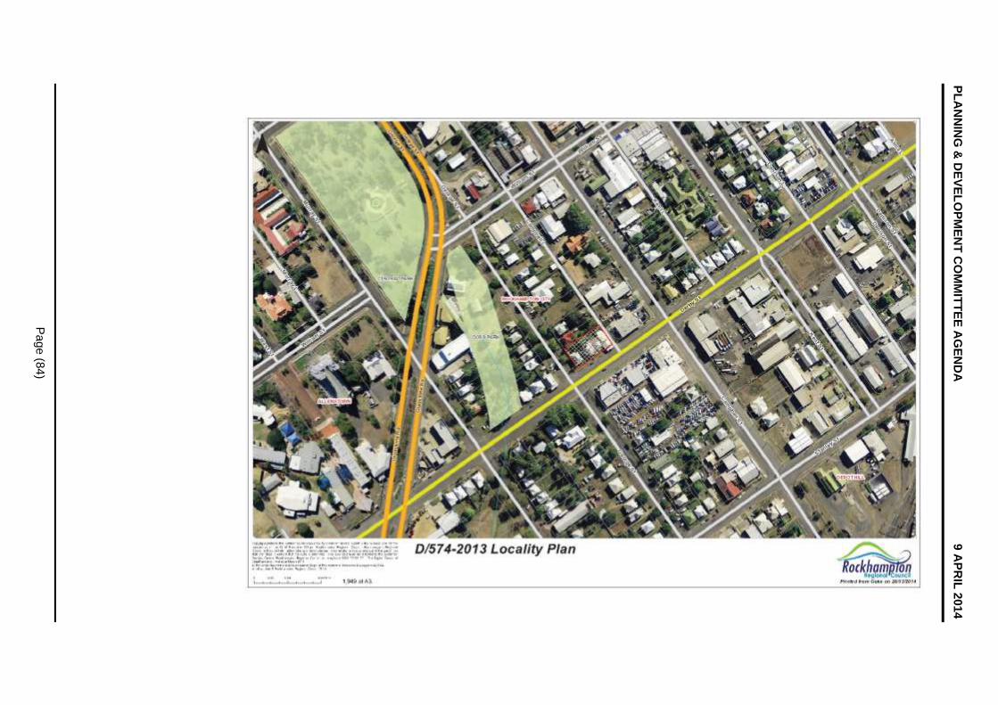
PL
AN
NIN
G &
DE
VE
LO
PM
EN
T C
OM
MIT
TE
E A
GE
ND
A
9 A
PR
IL 2
014
Pa
ge
(84
)

PLANNING & DEVELOPMENT COMMITTEE AGENDA 9 APRIL 2014
Page (85)
Site Plan - DA102
D/574-2013 DEVELOPMENT APPLICATION FOR A MATERIAL
CHANGE OF USE FOR A SHOWROOM, RECONFIGURING A LOT (SIX LOTS
INTO TWO LOTS) AND OPERATIONAL WORKS FOR ADVERTISING SIGNS
Site Plan - DA102
Meeting Date: 9 April 2014
Attachment No: 2

PL
AN
NIN
G &
DE
VE
LO
PM
EN
T C
OM
MIT
TE
E A
GE
ND
A
9 A
PR
IL 2
014
Pa
ge
(86
)
PLANNING & DEVELOPMENT COMMITTEE AGENDA 9 APRIL 2014
Page (87)
E1 Elevations - DA201
D/574-2013 DEVELOPMENT APPLICATION FOR A MATERIAL
CHANGE OF USE FOR A SHOWROOM, RECONFIGURING A LOT (SIX LOTS
INTO TWO LOTS) AND OPERATIONAL WORKS FOR ADVERTISING SIGNS
E1 Elevations - DA201
Meeting Date: 9 April 2014
Attachment No: 3

PL
AN
NIN
G &
DE
VE
LO
PM
EN
T C
OM
MIT
TE
E A
GE
ND
A
9 A
PR
IL 2
014
Pa
ge
(88
)

PLANNING & DEVELOPMENT COMMITTEE AGENDA 9 APRIL 2014
Page (89)
E2 Elevations - DA202
D/574-2013 DEVELOPMENT APPLICATION FOR A MATERIAL
CHANGE OF USE FOR A SHOWROOM, RECONFIGURING A LOT (SIX LOTS
INTO TWO LOTS) AND OPERATIONAL WORKS FOR ADVERTISING SIGNS
E2 Elevations - DA202
Meeting Date: 9 April 2014
Attachment No: 4

PL
AN
NIN
G &
DE
VE
LO
PM
EN
T C
OM
MIT
TE
E A
GE
ND
A
9 A
PR
IL 2
014
Pa
ge
(90
)

PLANNING & DEVELOPMENT COMMITTEE AGENDA 9 APRIL 2014
Page (91)
8.5 D/648-2012 - Request for a Negotiated Decision Notice for a Development Permit for Public Facility (Waste Disposal Station) and an Environmentally Relevant Activity (ERA 60 - Waste Disposal)
8.5 D/648-2012 - REQUEST FOR A NEGOTIATED DECISION NOTICE FOR A DEVELOPMENT PERMIT FOR PUBLIC FACILITY (WASTE DISPOSAL STATION) AND AN ENVIRONMENTALLY RELEVANT ACTIVITY (ERA 60 - WASTE DISPOSAL)
File No: D/648-2012
Attachments: 1. Locality Plan
Authorising Officer: Tarnya Fitzgibbon - Coordinator Development Assessment Robert Holmes - General Manager Regional Services
Author: Hayley Tiegs - Compliance Assessment Administrator
SUMMARY
Development Application Number: D/648-2012
Applicant: JRT Equipment Hire
Real Property Address: Lot 1 on RP604651, Parish of Gracemere
Common Property Address: 231 Lucas Street, Gracemere
Area of Site: 3.81 hectares
Planning Scheme Fitzroy Shire Planning Scheme 2005
Planning Scheme Zoning: Town Zone – Utilities Precinct
Planning Scheme Overlays: Bushfire Hazard (Low Risk), within 8 kilometres of the Rockhampton Airport
Existing Development: Extractive Industry
Existing Approvals: D/11-2011 – Earthworks
Approval Sought Development Permit for a Material Change of Use for a Public Facility (Waste Disposal Station) and an Environmentally Relevant Activity (ERA 60 – Waste Disposal)
Level of Assessment: Impact assessable
Submissions: Forty-one (41) properly made submissions and four (4) not properly made submissions were received
Referral Agency(s): Department of Environment and Heritage Protection
Application Progress:
Application lodged: 15 December 2012
Not Properly Made letter sent: 18 December 2012
Owner’s Consent received: 20 December 2012
Further plans received, application properly made: 7 January 2013
Acknowledgement Notice issued: 16 January 2013
Information Request issued: 31 January 2013
Response to Information Request received: 28 February 2013
Information Request issued by Department of Environment and Heritage Protection:
11 March 2013

PLANNING & DEVELOPMENT COMMITTEE AGENDA 9 APRIL 2014
Page (92)
Extension of Information Request period issued by Department of Environment and Heritage Protection:
2 April 2013
Information Request issued by Department of Environment and Heritage Protection:
4 April 2013
Response to Information Request from Department of Heritage Protection received:
5 July 2013
Notice of Commencement of Public Notification received: 15 July 2013
Notice of Compliance received: 6 August 2013
Referral Agency’s Assessment Period ended: 30 August 2013
Extension to Decision Making Period issued: 3 September 2013
Conditions received by Department of Environment and Heritage Protection:
11 September 2013
Applicant’s Appeal Period for Referral Agency’s Response ended: 25 September 2013
Council decision to approve application: 8 October 2013
Decision notice issued: 15 October 2013
Applicant suspended appeal period: 24 October 2013
Request for Negotiate Decision Notice received: 18 November 2013
Recommendation
OFFICER’S RECOMMENDATION
RECOMMENDATION A
THAT in relation to the request for a Negotiated Decision Notice for Development Permit D/648-2012, made by JRT Equipment Hire, on land described as Lot 1 on RP604651, Parish of Gracemere and located at 231 Lucas Street, Gracemere, Council resolves that:
1. Condition 1.10 be replaced with the following condition:
The approval is limited to a period of twenty (20) years from the approval effective date. Thereafter the use shall cease to be lawful.
2. Condition 3.7 remains unchanged.
3. Condition 4.3 remains unchanged.
4. Condition 8.3 remains unchanged.
5. Condition 8.4 remains unchanged.
RECOMMENDATION B
THAT to reflect the above amendments, JRT Equipment Hire be issued with a Negotiated Decision Notice for Development Permit D/648-2012 for a Public Facility (Waste Disposal Station) and an Environmentally Relevant Activity (ERA 60 - Waste Disposal), subject to the following conditions:
1.0 ADMINISTRATION
1.1 The Developer is responsible for ensuring compliance with this approval and the Conditions of the approval by an employee, agent, contractor or invitee of the Developer.
1.2 Where these Conditions refer to “Council” in relation to requiring Council to approve or to be satisfied as to any matter, or conferring on the Council a function, power or discretion, that role of the Council may be fulfilled in whole or in part by a delegate appointed for that purpose by the Council.

PLANNING & DEVELOPMENT COMMITTEE AGENDA 9 APRIL 2014
Page (93)
1.3 All conditions of this approval must be undertaken and completed to the satisfaction of Council, at no cost to Council.
1.4 All conditions, works, or requirements of this approval must be undertaken and completed prior to the commencement of the use, unless otherwise stated.
1.5 Where applicable, infrastructure requirements of this approval must be contributed to the relevant authorities, at no cost to Council prior to the commencement of the use, unless otherwise stated.
1.6 The following further Development Permits must be obtained prior to the commencement of any works associated with its purposes:
1.6.1 Operational Works:
(i) Road Works;
(ii) Access Works;
(iii) Stormwater Works;
(iv) Site Works;
(v) Landscaping Works;
1.6.2 Building Works; and
1.6.3 Plumbing and Drainage Works.
1.7 All Development Permits for Operational Works and Plumbing and Drainage Works must be obtained prior to the issue of a Development Permit for Building Works.
1.8 Unless otherwise stated, all works must be designed, constructed and maintained in accordance with the relevant Council policies, guidelines and standards.
1.9 All engineering drawings/specifications, design and construction works must comply with the requirements of the relevant Australian Standards and must be approved, supervised and certified by a Registered Professional Engineer of Queensland.
1.10 The approval is limited to a period of twenty (20) years from the approval effective date. Thereafter the use shall cease to be lawful.
2.0 APPROVED PLANS AND DOCUMENTS
2.1 The approved development must be completed and maintained generally in accordance with the approved plans and documents, except where amended by the conditions of this permit:
Plan/Document Name Plan/Document Reference
Dated
Cover Sheet D12.42 Undated
Site Plan D12.42-01 Revision 1 June 2012
Waste Disposal Facility Plan D12.42-02 Revision 1 June 2012
Stormwater Management D12.42-06 Revision 2 March 2013
Waste Disposal Facility Plan D12.42-08 Revision 1 March 2013
Waste Acceptance Policy Un-numbered 20 September 2012
Environmental Noise Level Study for Proposed Waste Disposal Facility
Page 11 of 28
R13059/D2804/Rev.0
3 July 2013
2.2 Where conditions require the above plans or documents to be amended, the revised document(s) must be submitted for approval by Council prior to the submission of a

PLANNING & DEVELOPMENT COMMITTEE AGENDA 9 APRIL 2014
Page (94)
Development Application for Operational Works.
3.0 ROAD WORKS
3.1 A Development Permit for Operational Works (road works) must be obtained prior to the commencement of any road works on the site.
3.2 All works must be designed and constructed in accordance with the approved plans (refer to condition 2.1), Capricorn Municipal Development Guidelines, relevant Australian Standards and the provisions of a Development Permit for Operational Works (road works).
3.3 Lucas Street must be widened on the development side with kerb and channel, asphalt sealed pavement and stormwater drainage to a minimum standard of six (6) metres of sealed pavement from the road centreline to the kerb invert for the full frontage of the site. Tapers must be provided at either end.
3.4 A Basic Right Turn Treatment in accordance with the Department of Main Roads Planning and Design Manual must be provided on the western side of Lucas Street. Widening must consist of an asphalt sealed pavement and appropriate stormwater drainage.
3.5 Parking on both sides of Lucas Street must be restricted in the vicinity of the development access to ensure vehicles entering and exiting the site do not obstruct through traffic.
3.6 Traffic signs and pavement markings must be provided in accordance with the Manual of Uniform Traffic Control Devices – Queensland. Where necessary, existing traffic signs and pavement markings must be modified in accordance with the Manual of Uniform Traffic Control Devices – Queensland.
3.7 Category P3 street lighting must be provided for the full frontage of the site.
4.0 ACCESS WORKS
4.1 A Development Permit for Operational Works (access works) must be obtained prior to the commencement of any access works on the site.
4.2 All works must be designed and constructed in accordance with the approved plans (refer to condition 2.1), Capricorn Municipal Development Guidelines, Australian Standard AS2890 “Parking Facilities” and the provisions of a Development Permit for Operational Works (access works).
4.3 All trafficable areas within the Waste Transfer Area must be sealed and drained.
4.4 Any application for a Development Permit for Operational Works (access and parking works) must be accompanied by detailed and scaled plans which demonstrate that the access is of suitable dimensions for a single articulated (nineteen (19) metre) design vehicles to lawfully enter and exit the site.
4.5 Any application for a Development Permit for Operational Works (access and parking works) must be accompanied by details of how transportation of soil/ sediment into the road reserve by vehicles leaving the site will be prevented.
5.0 PLUMBING AND DRAINAGE WORKS
5.1 On-site water supply for domestic and fire fighting purposes must be provided and may include the provision of a bore, dams, water storage tanks or a combination of each.
5.2 On-site sewerage treatment and disposal must be in accordance with the Queensland Plumbing and Wastewater Code and Council’s Plumbing and Drainage Policies.
5.3 All internal plumbing and sanitary drainage works must be in accordance with regulated work under the Plumbing and Drainage Act.
6.0 STORMWATER WORKS

PLANNING & DEVELOPMENT COMMITTEE AGENDA 9 APRIL 2014
Page (95)
6.1 A Development Permit for Operational Works (stormwater works) must be obtained prior to the commencement of any stormwater works on the site.
6.2 Any application for a Development Permit for Operational Works (stormwater works) must be accompanied by a report prepared by a Registered Professional Engineer of Queensland, demonstrating how the stormwater harvesting proposed will be carried out in accordance with the requirements of the Australian Guidelines for Water Recycling: Managing Health and Environmental Risks (Phase 2) Stormwater Harvesting and Reuse.
6.3 All stormwater drainage works must be designed and constructed in accordance with the approved plans (refer to condition 2.1), the Queensland Urban Drainage Manual, the Capricorn Municipal Development Guidelines, sound engineering practice and the provisions of a Development Permit for Operational Works (stormwater works).
6.4 All stormwater not collected and harvested on the site must drain to a demonstrated lawful point of discharge and must not adversely affect adjoining land or infrastructure by way of blocking, altering or diverting existing stormwater runoff patterns or have the potential to cause damage to other infrastructure.
6.5 Any application for a Development Permit for Operational Works (stormwater works) must include an assessment of how the development meets the water quality objectives of the State Planning Policy 4/10 – Healthy Waters.
6.6 The proposed development must not increase peak stormwater runoff for a selected range of storm events up to and including the one in one hundred year storm event (100 year Average Recurrence Interval) for the post development condition.
6.7 Any application for a Development Permit for Operational Works (stormwater works) must be accompanied by a Stormwater Drainage Report, prepared and certified by a Registered Professional Engineer of Queensland, which as a minimum includes:
6.7.1 identification of drainage catchment and drainage sub-catchment areas for the pre-development and post-development scenarios including a suitably scaled stormwater master plan showing the aforementioned catchment details and lawful point(s) of discharge that comply with the requirements of the Queensland Urban Drainage Manual;
6.7.2 an assessment of the peak discharges for all rainfall events up to and including the one in one hundred year rainfall event (100 year Average Recurrence Interval) for the pre-development and post-development scenarios;
6.7.3 details of any proposed on-site detention / retention systems and associated outlet systems required to mitigate the impacts of the proposed development on downstream lands and existing upstream and downstream drainage systems;
6.7.4 identification and conceptual design of all new drainage systems, and modifications to existing drainage systems required to adequately manage stormwater collection and discharge from the proposed development;
6.7.5 demonstration of how major design storm flows are conveyed through the subject development to a lawful point of discharge in accordance with the Queensland Urban Drainage Manual and the Capricorn Municipal Development Guidelines;
6.7.6 identification of the area of land inundated as a consequence of the minor and major design storm events in the catchment for both the pre-development and post-development scenarios;
6.7.7 identification of all areas of the proposed development, and all other land (which may include land not under the control of the developer), which needs to be dedicated to, or encumbered in favour of Council or another

PLANNING & DEVELOPMENT COMMITTEE AGENDA 9 APRIL 2014
Page (96)
statutory authority, in order to provide a lawful point of discharge for the proposed development. The areas identified must satisfy the requirements of the Queensland Urban Drainage Manual. All land proposed as major overland flow paths must include appropriate freeboard, access and maintenance provisions consistent with the Queensland Urban Drainage Manual; and
6.7.8 details of all calculations, assumptions and data files (where applicable).
7.0 SITE WORKS
7.1 A Development Permit for Operational Works (site works) must be obtained prior to the commencement of any site works.
7.2 Any application for a Development Permit for Operational Works (site works) must be accompanied by a site based management plan which clearly addressed the following:
7.2.1 Dust suppression
7.2.2 Compaction method suitable for future use of the site.
7.2.3 Site filling sequence
7.2.4 Stormwater flow paths and storage during the operational and post operational stages of the development.
7.2.5 Finished surface levels
7.2.6 Cleaning of access roads to and from the site.
7.3 Any application for a Development Permit for Operational Works (site works) must be accompanied by a preliminary site investigation into acid sulphate soils in accordance with State Planning Policy 2/02 – Planning and Managing Development Involving Acid Sulfate Soils. If preliminary testing indicates that acid sulphate soils are present in the areas to be excavated, a more detailed acid sulphate soil investigation must be completed, and an appropriate management plan submitted to Council as part of any application for a Development Permit for Operational Works (site works).
7.3.1 Should preliminary testing demonstrate that acid sulphate soils are present in the areas to be excavated or filled, an acid sulphate soils investigation following the procedure outlined in Step 2 in Section 6 of the guideline should be carried out and a report provided.
7.3.2 Investigation boreholes should be to a depth of one (1) metre below the anticipated depth of disturbance and to at least three (3) metres depth in areas to be filled. Boreholes should be drilled within areas where the road works, water reticulation, sewerage reticulation, and electricity distribution and telecommunications infrastructures will be located.
7.3.3 If there will be groundwater extraction activities (including drainage, pumping or other activity that removes groundwater) carried out in association with excavation activities, then a groundwater investigation will need to be undertaken in accordance with Section 7 of the State Planning Policy 2/02 guideline.
7.3.4 Sampling associated with the acid sulfate soils investigation should follow the Guidelines for Sampling and Analysis of Lowland Acid Sulfate Soils in Queensland (Ahern et al 1998). Laboratory analysis associated with the acid sulphate soils investigation should follow the Laboratory Methods Guidelines of the Queensland Acid Sulphate Soil Technical Manual.
7.4 Site works must be constructed such that they do not, at any time, in any way restrict, impair or change the natural flow of runoff water, or cause a nuisance or worsening to adjoining properties or infrastructure.
PLANNING & DEVELOPMENT COMMITTEE AGENDA 9 APRIL 2014
Page (97)
7.5 All site works must be undertaken to ensure that there is:
7.5.1 no increase in upstream or downstream flood levels for all levels of immunity up to Q100;
7.5.2 no increase in velocity profiles, for which no remedy exists to prevent erosion and/or scouring. In the event that modelling shows non-compliance with the above, works must be undertaken within the system to satisfy the above criteria for development; and
7.5.3 a lawful point of discharge to which the developed flows from the land drain. Easements will be required over any other land to accommodate the flows.
8.0 LANDSCAPING WORKS
8.1 A Development Permit for Operational Works (landscaping works) must be obtained prior to the commencement of any landscaping works on the site.
8.2 Landscaping must be provided along the frontage of the site in accordance with the approved plans (refer to condition 2.1) and a Development Permit for Operational Works (Landscaping).
8.3 Landscape buffering must be provided along the length of the western boundary on the eastern side of the access easement. The landscaping buffer must be of a minimum width of five (5) metres and must comprise a mixture of trees (minimum mature height of six metres) and shrubs/hedging (minimum mature height of 1.8 metres).
8.4 The landscape buffer as required in condition 8.3 must be planted on a 1.2 metre earth mound.
8.5 The Landscape buffering required in Condition 8.3 must achieve a minimum level of seventy-five (75) per centum opacity within two (2) years of being planted.
8.6 Trees, as required in condition 8.3 must incorporate a minimum of thirty (30) per centum advanced plant stock, to create an immediate effect.
Note: Trees a minimum of two (2) metres in height constitute ‘advanced plant stock’.
8.7 The plantings selected for the buffers must incorporate a minimum of seventy (70) per centum species native to the Central Queensland Region.
8.8 As part of the Development Permit for Operational Works (landscaping works) a landscaping plan must be submitted addressing the post operational phase of the development.
8.9 Landscaping, or any part thereof, upon reaching full maturity, must not:
(i) obstruct sight visibility zones as defined in the Austroads ‘Guide to Traffic Engineering Practice’ series of publications;
(ii) adversely affect any road lighting or public space lighting; or
(iii) adversely affect any Council infrastructure, or public utility plant.
8.10 The landscaped areas must be subject to an ongoing maintenance and replanting programme (if necessary).
9.0 BUILDING WORKS
9.1 An acoustic barrier must be constructed in accordance with the approved plans (refer condition 2.1) and must be:
9.1.1 located behind the landscaping buffer as conditioned in condition 8.2 to improve the visual impact of the barrier;
9.1.2 at least 2.4 metres higher than the level of activities on the subject site, both with respect to the landfill and truck movements relative to the waste stockpiles;
PLANNING & DEVELOPMENT COMMITTEE AGENDA 9 APRIL 2014
Page (98)
9.1.3 continuous and gap free (excluding the access);
9.1.4 have a minimum surface area density of 10 kilograms per square metre; and
9.1.5 constructed of suitable materials which may include:
(i) reinforced concrete;
(ii) concrete block;
(iii) brick;
(iv) hebel panel;
(v) sheet metal at least two (2) millimetres thick;
(vi) minimum 7.5 millimetre thick fibrous cement sheets;
(vii) earth mound;
(viii) lapped timber palings, for example kiln dried softwood palings at least fifteen (15) millimetres thick and overlapped a minimum of twenty-five (25) millimetre or at least nineteen (19) millimetres thick and overlapped a minimum of fifteen (15) millimetres.
10.0 ELECTRICITY AND TELECOMMUNICATIONS
10.1 Electricity and telecommunication connections must be provided to the proposed development to the standards of the relevant authorities.
10.2 Evidence must be provided of a certificate of supply with the relevant service providers to provide each lot with live electricity and telecommunication connections, in accordance with the requirements of the relevant authorities prior to the commencement of the use.
11.0 ASSET MANAGEMENT
11.1 Any alteration necessary to electricity, telephone, water mains, sewerage mains, and/or public utility installations resulting from the development or in connection with the development, must be at full cost to the Developer.
11.2 Any damage to existing kerb and channel, pathway or roadway (including removal of concrete slurry from public land, pathway, roads, kerb and channel and stormwater gullies and drainage lines) which may occur during any works carried out in association with the approved development must be repaired. This must include the reinstatement of the existing traffic signs and pavement markings which may have been removed.
11.3 ‘As constructed’ information pertaining to assets to be handed over to Council and those which may have an impact on Council’s existing and future assets must be provided prior to the commencement of the use. This information must be provided in accordance with the Manual for Submission of Digital As Constructed Information.
12.0 ENVIRONMENTAL
12.1 Any application for a Development Permit for Operational Works must be accompanied by a detailed Environmental Management Plan, which addresses, but is not limited to, the following matters:
(i) water quality and drainage;
(ii) erosion and silt/sedimentation management;
(iii) acid sulphate soils;
(iv) fauna management;
(v) vegetation management and clearing;
(vi) top soil management;

PLANNING & DEVELOPMENT COMMITTEE AGENDA 9 APRIL 2014
Page (99)
(vii) interim drainage plan during construction;
(viii) construction programme;
(ix) geotechnical issues;
(x) weed control;
(xi) bushfire management;
(xii) emergency vehicle access;
(xiii) noise and dust suppression; and
(xiv) waste management.
12.2 Any application for a Development Permit for Operational Works must be accompanied by an Erosion and Sediment Control Plan which addresses, but is not limited to, the following:
(i) objectives;
(ii) site location / topography;
(iii) vegetation;
(iv) site drainage;
(v) soils;
(vi) erosion susceptibility;
(vii) erosion risk;
(viii) concept;
(ix) design; and
(x) implementation for the construction and post construction phases of work.
12.3 The Environmental Management Plan approved as part of a Development Permit for Operational Works must be part of the contract documentation for the development works.
12.4 The Erosion and Stormwater Control Management Plan must be implemented and maintained on-site for the duration of the works, and until all exposed soil areas are permanently stabilised (for example, turfed, hydromulched, concreted, landscaped). The prepared Erosion Control and Stormwater Control Management Plan must be available on-site for inspection by Council Officers during those works.
13.0 OPERATING PROCEDURES
13.1 All construction materials, waste, waste skips, machinery and contractors’ vehicles must be located and stored or parked within the site. No storage of materials, parking of construction machinery or contractors’ vehicles will be permitted in Lucas Street.
13.2 The use must operate in accordance with the waste acceptance policy (refer condition 2.1).
13.3 All waste management systems must be in accordance with the Environmental Protection (Water) Policy and regulations and Council’s water management policies.
13.4 The hours of operations must be limited to:
(i) 0700 hours to 1800 hours on Monday to Friday, and
(ii) 0800 hours to 1700 hours on Saturday; with
(iii) no operations on Sunday or Public Holidays.
13.5 Appropriate dust suppression methods, such as water trucks and sprinkler systems

PLANNING & DEVELOPMENT COMMITTEE AGENDA 9 APRIL 2014
Page (100)
must be utilised during the operation of the facility to ensure no increase in dust nuisance to surrounding residents.
ADVISORY NOTES
NOTE 1. Aboriginal Cultural Heritage
It is advised that under Section 23 of the Aboriginal Cultural Heritage Act 2003, a person who carries out an activity must take all reasonable and practicable measures to ensure the activity does not harm Aboriginal Cultural Heritage (the “cultural heritage duty of care”). Maximum penalties for breaching the duty of care are listed in the Aboriginal Cultural Heritage legislation. The information on Aboriginal Cultural Heritage is available on the Department of Aboriginal and Torres Strait Islander and Multicultural Affairs website: www.datsima.qld.gov.au.
NOTE 2. Asbestos Removal
Any demolition and/or removal works involving asbestos materials must be undertaken in accordance with the requirements of the Workplace Health and Safety legislation and Public Health Act 2005.
NOTE 3. General Environmental Duty
General environmental duty under the Environmental Protection Act prohibits unlawful environmental nuisance caused by noise, aerosols, particles, dust, ash, fumes, light, odour or smoke beyond the boundaries of the property during all stages of the development including earthworks, construction and operation.
NOTE 4. General Safety Of Public During Construction
The Workplace Health and Safety Act and Manual of Uniform Traffic Control Devices must be complied with in carrying out any construction works, and to ensure safe traffic control and safe public access in respect of works being constructed on a road.
NOTE 5. Adopted Infrastructure Charges Notice
This application is subject to infrastructure contributions in accordance with Council policies. The contributions are presented on an Adopted Infrastructure Charges Notice which has been supplied with this decision notice.
BACKGROUND
At its meeting of 8 October 2013, Council approved a Development Application for a Material Change of Use for a Public Facility (Waste Disposal Station) and an Environmentally Relevant Activity (ERA 60 – Waste Disposal) over Lot 1 on RP604651, Parish of Gracemere and located at 231 Lucas Street, Gracemere (Development Permit D/648-2012).
The applicant has made representations in accordance with Section 361 of the Sustainable Planning Act 2009 for a Negotiated Decision Notice. The representations relate to conditions surrounding access and road works, the relevant period for the approval and landscaping.
SITE AND LOCALITY
The site is a large rectangular allotment measuring 3.81 hectares in area and is currently characterised by a large pit formed by an existing lawful quarry operation on the site. Surrounding land uses include the Gracemere Landfill facility directly to the east, larger rural lots with single dwellings to the south and east and low density residential subdivisions further north and west of the site.
PLANNING ASSESSMENT
TOWN PLANNING COMMENTS
The applicant has requested the following conditions be either amended or deleted:

PLANNING & DEVELOPMENT COMMITTEE AGENDA 9 APRIL 2014
Page (101)
Condition 1.10
The approval is limited to a period of ten (10) years from the approval effective date. Thereafter the use shall cease to be lawful.
Applicant’s response:
The applicant argues that this condition is unreasonable if it is having regard to the potential future zone as per the draft Rockhampton Regional Council Plan. The applicant identifies that Council may give weight to a newer instrument (such as a planning scheme), however as the document is not yet adopted or even advanced to the stage where it has been advertised to the public, that this is not a reasonable expectation for the site. The application was made under the current planning scheme and the proposed development is consistent with the Town Zone – Urban Utilities Precinct.
The condition is considered an unreasonable imposition given a condition must be final and must not defer an important aspect of the approval for future consideration.
Council response:
This condition was imposed taking into consideration the land development patterns in the locality, the creeping of residential development towards the subject site and the likelihood of future zoning allowing urban development into this area (subject to the operations of the landfill). The Applicant’s comments are however valid in that under the current planning scheme, the site is appropriately zoned and considers this use a consistent land use and the new planning scheme is not at a stage where Council can give weight to it.
Consideration has been given to the lifetime of the Waste Disposal Station continuing for a further ten years (a total of twenty (20) years) which the Applicant is in support of. This will allow the pit to be sufficiently filled, will make the provision of infrastructure worthwhile for the Applicant and will more realistically coincide with the timing of the adjoining Council Landfill which will operate as a Waste Transfer Station indefinitely after a few more years in a Landfill capacity. This timeframe is considered fair and reasonable.
Recommendation:
That the condition be amended to read as:
The approval is limited to a period of twenty (20) years from the approval effective date. Thereafter the use shall cease to be lawful.
Condition 3.7
Category P3 street lighting must be provided for the full frontage of the site.
Applicant’s response:
Condition 3.7 is considered onerous, given that Council are operating their adjoining facility without street lighting. Given the proposed facility is to operate during day time hours only, it is requested that this condition be removed. Further, with a limit to the use of ten (10) years, the Applicant feels it is unfair to be required to provide the extent of infrastructure conditioned.
Council response:
It has been conditioned that the frontage of the subject site be upgraded with road widening, kerb, and channel and a basic right turn treatment. It is appropriate that road lighting be installed to a standard that is consistent with the level of service provided as a result of the upgrades. Upon further discussion with the Applicant, provided the use is no longer limited to a period of ten (10) years, the Applicant agrees to the provision of the infrastructure.
Recommendation:
This condition is to remain unchanged.

PLANNING & DEVELOPMENT COMMITTEE AGENDA 9 APRIL 2014
Page (102)
Condition 4.3
All trafficable areas within the Waste Transfer Area must be sealed and drained.
Applicant’s response:
Given there will be no stormwater leaving the site, it is proposed to provide compacted gravel areas that are effectively controlled to ensure no adverse impacts in relation to dust. Given the nature of the proposed use, this is considered a reasonable outcome. It is requested that the above condition be amended as follows:
All trafficable areas within the Waste Transfer Area are to be appropriately drained and maintained to ensure a dust free surface.
Council response:
The requirement for the sealing of trafficable areas was conditioned to reduce the potential for dust impacts. This has been discussed with the Applicant and it has been agreed to leave the condition.
Recommendation:
This condition is to remain unchanged.
Condition 8.3 and 8.4
Landscape buffering must be provided along the length of the western boundary on the eastern side of the access easement. The landscaping buffer must be of a minimum width of five (5) metres and must comprise a mixture of trees (minimum mature height of six metres) and shrubs/hedging (minimum mature height of 1.8 metres).
The landscape buffer as required in condition 8.3 must be planted on a 1.2 metre earth mound.
Applicant’s response:
It is physically impractical to provide the 5 metre width buffer along the western boundary of the site, as the edge of the existing pit is located approximately 2-3 metres from the boundary. It is requested that this condition either be removed or amended to provide a practical option in terms of buffer to the adjoining land to the west.
Council response:
The Applicant has since withdrawn the request to negotiate this condition and will resolve the issue on-site.
Recommendation:
This condition is to remain unchanged.
CONCLUSION
The representations made by JRT Equipment Hire have been assessed and taken into consideration when making the recommendation as detailed below. The applicant accepted these changes on 24 March 2014.

PLANNING & DEVELOPMENT COMMITTEE AGENDA 9 APRIL 2014
Page (103)
Locality Plan
D/648-2012 - REQUEST FOR A NEGOTIATED DECISION NOTICE FOR
A DEVELOPMENT PERMIT FOR PUBLIC FACILITY (WASTE DISPOSAL
STATION) AND AN ENVIRONMENTALLY RELEVANT
ACTIVITY (ERA 60 - WASTE DISPOSAL)
Locality Plan
Meeting Date: 9 April 2014
Attachment No: 1

PL
AN
NIN
G &
DE
VE
LO
PM
EN
T C
OM
MIT
TE
E A
GE
ND
A
9 A
PR
IL 2
014
Pa
ge
(10
4)

PLANNING & DEVELOPMENT COMMITTEE AGENDA 9 APRIL 2014
Page (105)
9 STRATEGIC REPORTS
Nil
PLANNING & DEVELOPMENT COMMITTEE AGENDA 9 APRIL 2014
Page (106)
10 NOTICES OF MOTION
Nil

PLANNING & DEVELOPMENT COMMITTEE AGENDA 9 APRIL 2014
Page (107)
11 URGENT BUSINESS/QUESTIONS
Urgent Business is a provision in the Agenda for members to raise questions or matters of a genuinely urgent or emergent nature, that are not a change to Council Policy and can not be delayed until the next scheduled Council or Committee Meeting.

PLANNING & DEVELOPMENT COMMITTEE AGENDA 9 APRIL 2014
Page (108)
12 CLOSED SESSION
In accordance with the provisions of section 275 of the Local Government Regulation 2012, a local government may resolve to close a meeting to the public to discuss confidential items, such that its Councillors or members consider it necessary to close the meeting.
RECOMMENDATION
THAT the meeting be closed to the public to discuss the following items, which are considered confidential in accordance with section 275 of the Local Government Regulation 2012, for the reasons indicated.
13.1 Stockland Ellida Infrastructure Agreement
This report is considered confidential in accordance with section 275(1)(e) (g) (h), of the Local Government Regulation 2012, as it contains information relating to contracts proposed to be made by it; AND any action to be taken by the local government under the Planning Act, including deciding applications made to it under that Act; AND other business for which a public discussion would be likely to prejudice the interests of the local government or someone else, or enable a person to gain a financial advantage .
PLANNING & DEVELOPMENT COMMITTEE AGENDA 9 APRIL 2014
Page (109)
Confidential Reports
13 CONFIDENTIAL REPORTS 13.1 Stockland Ellida Infrastructure Agreement
13.1 STOCKLAND ELLIDA INFRASTRUCTURE AGREEMENT
File No: D36-2013
Attachments: 1. Stockland Ellida Correspondence 2. Stockland Ellida Email
Authorising Officer: Robert Holmes - General Manager Regional Services
Author: Martin Crow - Manager Engineering Services
This report is considered confidential in accordance with section 275(1)(e) (g) (h), of the Local Government Regulation 2012, as it contains information relating to contracts proposed to be made by it; AND any action to be taken by the local government under the Planning Act, including deciding applications made to it under that Act; AND other business for which a public discussion would be likely to prejudice the interests of the local government or someone else, or enable a person to gain a financial advantage.
SUMMARY
This report seeks Council’s direction in relation to negotiation of an Infrastructure Agreement for the Stockland Ellida Development.

PLANNING & DEVELOPMENT COMMITTEE AGENDA 9 APRIL 2014
Page (110)
14 CLOSURE OF MEETING