pinme: tracking a smartphone user around the world - … · pinme: tracking a smartphone user...
TRANSCRIPT

1
PinMe: Tracking a Smartphone User around theWorld
Arsalan Mosenia, Student Member, IEEE, Xiaoliang Dai, Prateek Mittal, Member, IEEE, and Niraj K. Jha, Fellow,IEEE
Abstract—With the pervasive use of smartphones that sense,collect, and process valuable information about the environment,ensuring location privacy has become one of the most importantconcerns in the modern age.
A few recent research studies discuss the feasibility of pro-cessing sensory data gathered by a smartphone to locate thephone’s owner, even when the user does not intend to sharehis location information, e.g., when the user has turned offthe Global Positioning System (GPS) on the device. Previousresearch efforts rely on at least one of the two followingfundamental requirements, which impose significant limitationson the adversary: (i) the attacker must accurately know either theuser’s initial location or the set of routes through which the usertravels and/or (ii) the attacker must measure a set of features,e.g., device acceleration, for different potential routes in advanceand construct a training dataset.
In this paper, we demonstrate that neither of the above-mentioned requirements is essential for compromising the user’slocation privacy. We describe PinMe, a novel user-locationmechanism that exploits non-sensory/sensory data stored on thesmartphone, e.g., the environment’s air pressure and device’stimezone, along with publicly-available auxiliary information,e.g., elevation maps, to estimate the user’s location when alllocation services, e.g., GPS, are turned off. Unlike previously-proposed attacks, PinMe neither requires any prior knowledgeabout the user nor a training dataset on specific routes. Wedemonstrate that PinMe can accurately estimate the user’slocation during four activities (walking, traveling on a train,driving, and traveling on a plane). We also suggest severaldefenses against the proposed attack.
Index Terms—Air pressure, auxiliary information, elevationmap, , navigational map, privacy, sensor, smartphone, tracking.
I. INTRODUCTION
With widespread use of smartphones that can sense andcollect environment-related data and process them to extractvaluable information about the environment, ensuring privacyhas become one of the most important challenges in the mod-ern era. Indeed, rapid technological advances in electronicsand mobile devices have led (and will continue to lead) toserious concerns about privacy in general, and location privacyin particular [1].
Modern smartphones are equipped with many compactsensors, e.g., accelerometers and barometers, and powerfulcommunication capabilities in order to offer a variety ofservices. Although the numerous smartphone applicationsmake the user’s life convenient, they can also intention-ally/unintentionally reveal personal or corporate secrets [2]–[9]. In particular, they can leak valuable data about the user’s
Arsalan Mosenia, Xiaoliang Dai, Prateek Mittal, and Niraj K. Jha are withthe Department of Electrical Engineering, Princeton University, Princeton, NJ08544, USA (e-mail: arsalan||xdai||pmittal||[email protected]).
whereabouts, which can be processed to extract contextualinformation about his habits, regular activities, and evenrelationships [10], [11]. Moreover, disclosure of the user’slocation may expose him to location-based spams, scams, andadvertisements, or make him a victim of blackmail or violence[1], [12].
With the emergence of enormous privacy concerns in thelast decade, several privacy policies have been put in place toforce organizations to take their users’ privacy into account.In particular, the U.S. Congress introduced the GeolocationPrivacy and Surveillance Act in 2011 to provide a legal frame-work for giving government agencies, commercial entities, andprivate citizens clear guidelines for when and how geolocationinformation can be accessed and used [13]. As a result, in allmodern smartphones, an application must explicitly ask forthe user’s permission if it wants to access location services,e.g., GPS [14], [15].
A few recent research efforts have demonstrated the feasibil-ity of locating smartphone owners without accessing GPS [9],[16]–[18]. For instance, Michalevsky et al. proposed PowerSpy[17], a mechanism that locates the user by processing thepower consumption of the smartphone, when the user travelsthrough a known set of routes. PowerSpy was able to detect45% of driving trajectories in the best-case scenario. Han etal. showed that accelerometer readings can be used to estimatethe trajectory and starting point of an individual who is driving[19]. They were able to return two clusters of possible startingpoints (each including five points) such that the starting pointwas within one of the clusters.
The successful demonstration of such attacks against lo-cation privacy suggests that revealing the user’s location byprocessing presumably non-critical data is feasible. How-ever, all previously-suggested attacks against location privacymainly rely on at least one of the three following fundamentalrequirements.
• Req. 1: The attacker must either know the user’s initiallocation (the exact GPS coordinates) or has substantialprior knowledge of the area through which the victimis traveling, e.g., the attacker assumes that the victim istraveling through a small set of known routes.
• Req. 2: The attacker must measure a set of features, e.g.,power consumption [17], for different potential routes inadvance and construct an attack-specific training dataset.
• Req. 3: The sensory data must be continuously collectedat a high sampling rate, e.g., 30Hz [19], [20], which issignificantly higher than the sampling rate needed for amajority of benign applications.
arX
iv:1
802.
0146
8v1
[cs
.CR
] 5
Feb
201
8
2
The first two requirements significantly limit the attacker’sability to locate the user in realistic scenarios, and the thirdcan raise suspicion, making it easier to detect the attack [21].Even with these requirements, previous attacks offer a roughestimation of the user’s trajectory, as discussed later in SectionVI.
This paper aims to demonstrate that none of the above-mentioned requirements is needed to accurately track the userwhen all location services, e.g., GPS, are off. We proposean attack on location privacy in which: (i) the attacker needsneither the user’s initial location nor a small set of potentialtravel routes, (ii) he is not burdened with the construction ofan attack-specific database, and (iii) he does not collect dataat a high sampling rate, e.g., as demonstrated later, a samplingrate of 0.1Hz is sufficient to track the user when he is driving.The first two characteristics of the proposed scheme enablean attacker to launch an attack on a large scale, when he hasno prior knowledge about users’ initial locations or the set ofroutes through which he travels. The third one makes the attackinvisible to known defenses that detect the maliciousness ofan application based on its high sampling frequency, e.g., thedefense in [21].
Our main contributions can be summarized as follows:
1) We develop PinMe, a location mechanism that en-ables an attacker to accurately locate the user usingsensory/non-sensory data along with publicly-availableauxiliary information.
2) We demonstrate how different types of seemingly-benign non-sensory data, e.g., the smartphone’s time-zone and network status, and sensory data, e.g., airpressure and heading, can offer sensitive information tothe attacker who aims to locate the user.
3) We introduce five sources of publicly-available auxiliaryinformation (public maps, transportation time tables,airports’ specification databases, weather reports, andtrains’ heading dataset) that can be used in conjunctionwith smartphone’s data to develop an attack againstlocation privacy.
4) Unlike previously-proposed attacks [17], [19] that arefocused on a single activity, e.g., driving, we demon-strate how a user can be located when he is: (i) travelingon a plane, (ii) walking, (iii) traveling on a train, and(iv) driving. As far as we know, PinMe is the firstsmartphone-based user location mechanism that aims tolocate the user while undertaking different activities.
5) In order to evaluate the accuracy of the proposed loca-tion mechanism, we collect real-world data using threedevices (iPhone 6, iPhone 6S, and Galaxy S4 i9500).
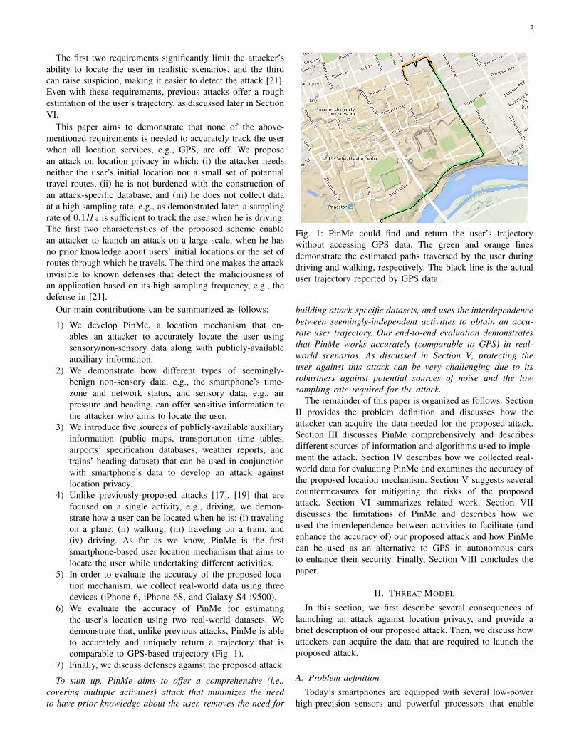
6) We evaluate the accuracy of PinMe for estimatingthe user’s location using two real-world datasets. Wedemonstrate that, unlike previous attacks, PinMe is ableto accurately and uniquely return a trajectory that iscomparable to GPS-based trajectory (Fig. 1).
7) Finally, we discuss defenses against the proposed attack.
To sum up, PinMe aims to offer a comprehensive (i.e.,covering multiple activities) attack that minimizes the needto have prior knowledge about the user, removes the need for
Fig. 1: PinMe could find and return the user’s trajectorywithout accessing GPS data. The green and orange linesdemonstrate the estimated paths traversed by the user duringdriving and walking, respectively. The black line is the actualuser trajectory reported by GPS data.
building attack-specific datasets, and uses the interdependencebetween seemingly-independent activities to obtain an accu-rate user trajectory. Our end-to-end evaluation demonstratesthat PinMe works accurately (comparable to GPS) in real-world scenarios. As discussed in Section V, protecting theuser against this attack can be very challenging due to itsrobustness against potential sources of noise and the lowsampling rate required for the attack.
The remainder of this paper is organized as follows. SectionII provides the problem definition and discusses how theattacker can acquire the data needed for the proposed attack.Section III discusses PinMe comprehensively and describesdifferent sources of information and algorithms used to imple-ment the attack. Section IV describes how we collected real-world data for evaluating PinMe and examines the accuracy ofthe proposed location mechanism. Section V suggests severalcountermeasures for mitigating the risks of the proposedattack. Section VI summarizes related work. Section VIIdiscusses the limitations of PinMe and describes how weused the interdependence between activities to facilitate (andenhance the accuracy of) our proposed attack and how PinMecan be used as an alternative to GPS in autonomous carsto enhance their security. Finally, Section VIII concludes thepaper.
II. THREAT MODEL
In this section, we first describe several consequences oflaunching an attack against location privacy, and provide abrief description of our proposed attack. Then, we discuss howattackers can acquire the data that are required to launch theproposed attack.
A. Problem definition
Today’s smartphones are equipped with several low-powerhigh-precision sensors and powerful processors that enable
3
them to continuously collect and process environment-relateddata. As a result, a modern smartphone carries several types ofvaluable data. Such data can be processed to reveal sensitiveinformation about the phone’s user. For example, the contex-tual information attached to movement traces conveys muchabout the user’s interests, activities, and even relationships [1].
Launching an attack against location privacy can expose theuser to unwanted advertisement, spams, or scams. Moreover,it can lead to several consequences, ranging from the uncom-fortable feeling of being monitored to unwanted disclosureof personal activities or even actual physical harm [22]. Forexample, it may be embarrassing for a user if his/her relativesfind out that he/she went to certain places, e.g., an HIVclinic or an abortion clinic. While these consequences are adirect result of manual inspection of leaked location-relatedinformation, several recent research efforts have investigatedthe feasibility of extracting other valuable information fromthe user’s location-related information. For example, earlyresearch work in this area [23] explored the possibility ofinferring information about the user’s habits and detectingplaces important to him, e.g., his home and office, from GPStraces.
Although the importance of preventing location services,e.g., GPS, from leaking unwanted information has becomeclear, the extent of location-related information that can beinferred from presumably non-critical data, such as movement-related data, e.g., acceleration and heading, and environment-related data, e.g., air pressure, is neither well-known nor well-understood. This paper aims to demonstrate the possibility ofaccurately locating the smartphone’s user using such presum-ably non-critical data stored on the phone.
B. Acquiring dataThe attacker can obtain the smartphone’s non-sensory and
sensory data, which are required for the proposed attack,using one of the two following approaches:Approach 1: Utilizing a malicious application
Smartphones are characterized by their ability to run third-party applications. Both Android and iOS offer hundreds ofthousands of applications through their application markets.Such markets benefit developers by simplifying applicationsales and distribution. The existence of huge applicationmarkets might also enable cyber criminals to distributea malicious application in an attempt to steal personalinformation stored on the phone, e.g., credit card numbersand personal photos. Fortunately, such critical information iscommonly protected by the smartphone’s operating system,and users are also very careful about sharing their personalinformation with third parties. However, several types of non-sensory/sensory data, which are stored on the smartphone,are either loosely-protected or not protected at all, e.g.,gyroscope, accelerometer, barometer, and magnetometermeasurements are accessible by an application installed onthe smartphone without requiring user’s approval. As a result,a malicious application that is installed on the smartphoneand runs in the background can continuously capture suchdata without arousing suspicion.
Approach 2: Accessing a presumably-trusted applicationserver
Several trusted applications upload their data to the cloud.For example, the majority of fitness monitoring applicationscontinuously collect and upload the user’s data to the cloud.The collection of the data in the cloud enables the user toaccess and share his fitness statistics with his family, friends,and peer groups. A recent report by the mHealth developmentindustry [24] estimates that there are about 100,000 applica-tions dedicated to health and fitness. Such applications can,without arousing suspicion, collect and upload a significantamount of valuable non-sensory/sensory data, which can bepost-processed to infer critical information about the user. Inparticular, as we demonstrate later, an attacker, who can accesssuch application databases, e.g., the application developmentcompany or an individual who has access to the data sharedby the user, can post-process such data to estimate the pastlocations of the user.
Our approach: In this paper, we assume that the proposedlocation mechanism obtains the required non-sensory/sensorydata using the first approach. In fact, we installed an ap-plication on the smartphone that continuously collects therequired data. We assume that the application does not haveaccess to GPS. Moreover, the application has no permissionto query the identity of visible cellular base stations or theservice set identifier (SSID) of visible WiFi networks. Tosum up, we assume that the attacker only uses presumablynon-critical data collected by a malicious application alongwith publicly-available auxiliary information to reveal theuser’s location. The proposed attack does not rely on carelessbehaviors of the user (e.g., a careless user may just acceptall permission requests, including a request to access GPSdata, without carefully reviewing them). In fact, PinMe aimsto demonstrate the feasibility of a privacy attack againstcareful users (for example, a user who checks what he shareswith third-party applications, minimizes the access level ofuntrusted applications, and even turns off all location serviceswhen he travels through sensitive routes to ensure his locationprivacy). The introduction of this attack sheds light on thepossibility that a third party, which has an application on theuser’s smartphone, can potentially extract his sensitive locationinformation without asking for any permission (except Internetconnectivity that is needed for sending either raw data orinferred location to the third party).
III. THE PROPOSED LOCATION MECHANISM
In this section, we describe PinMe, the proposed locationmechanism. First, we introduce the main sources of informa-tion that are given to PinMe as inputs. Second, we describevarious algorithms that we have designed and implemented tolocate the user in scenarios involving different activities.
A. Sources of information
PinMe exploits two main sources of information: (i) non-sensory/sensory data collected by the smartphone, and (ii)publicly-available auxiliary information. Next, we describeeach source in more detail.

4
TABLE I: Smartphone’s Non-Sensory Data
Non-sensory data DescriptionTimezone (TZ) Specifies the device’s current timezone (i.e., a region including the
cities/states that have the same time)Device’s address (IP) Provides the phone’s IP address when it is connected to the InternetNetwork status (NS) Specifies whether the smartphone is connected to a WiFi or a cellular network
TABLE II: Smartphone’s Sensory Data
Sensor Sensory dataAccelerometer Magnitudes of the acceleration in three-dimensional spaceMagnetometer Angle between device’s actual orientation relative to true north (heading)Barometer The environment’s air pressure
1) Smartphone’s non-sensory/sensory data: An applicationinstalled on the smartphone can obtain several types of non-sensory and sensory data without requesting user’s approval.Non-sensory data provide general information about the de-vice, e.g., the version of the device’s operating system, currenttimezone, IP address, the amount of available storage, andnetwork status. Table I summarizes different forms of non-sensory data that PinMe uses to locate the user during differentactivities, along with a short description of each.
In addition to the non-sensory data, sensory data collectedby the smartphone’s built-in sensors provide valuable infor-mation about the user’s movements and the environment inwhich the smartphone is located. Table II includes differentsensors that are accessed by PinMe and sensory data providedby each sensor.
2) Publicly-available auxiliary information: The proposeduser location mechanism uses several types of auxiliaryinformation to narrow the area of interest. In particular, itutilizes five main types of information: (i) public maps, (ii)weather reports, (iii) airports’ specifications database, (iv)trains’ heading dataset, and (v) transportation timetables.Next, we describe each information type.
Public maps: The proposed mechanism uses two widely-known map types:1. Navigational map: A navigational map mainly depictsroads, highways, and transportation links. Such a map canspecify a large set of possible routes through which theuser can travel. PinMe uses OpenStreetMap (OSM) [25]maps. OSM maps can be downloaded as Extensible MarkupLanguage (XML) files that can be easily processed andmodified.2. Elevation map: An elevation map contains the elevation,i.e., the height above or below the Earth’s sea level, ofall points on the Earth’s surface. Several commercial, e.g.,Google Map API [26], and governmental services, e.g.,U.S. Geological Survey Maps [27], provide comprehensiveelevation data of the world surface. For instance, the GoogleMap API offers a free and publicly-available interface thatcan be used by developers to fetch the elevation of a point ofinterest, given its longitude and latitude.
Weather reports: Weather reports offer different types ofinformation collected by weather stations. We use weather
reports provided by The Weather Channel [28]. They includetemperature, humidity, and air pressure readings at weatherstations, and the actual elevation of the weather station.PinMe uses weather reports to estimate the elevation ofthe smartphone using its air pressure reading. The use ofweather reports is essential for accurately estimating theelevation of the smartphone since the air pressure readingsare highly dependent on both elevation and weather conditions.
Airports’ specifications databases: PinMe uses OpenFlights[29], the most comprehensive freely-available airports’specifications database, which includes elevation information,GPS coordinates, and timezone of 9541 different airportsaround the world.
Trains’ heading databases: Trains’ heading database isa simple database that includes the trains’ directions ateach station. We have constructed this database based onGoogle Map [30]. For each train station considered inour experiments, we extract different potential movementdirections based on the illustration of the stations’ trackson Google Map. Note that each track in a station can havetwo possible headings corresponding to a train entering andleaving the station.
Transport timetables: Transport timetables containinformation about service times to assist passengers inplanning their trip. A timetable lists the times when a serviceis scheduled to arrive (depart) at (from) specified locations1.The two most common types of transport timetables are flightand train timetables. These timetables are often availablein a variety of electronic formats, e.g., PDF files, and arecommonly posted on airports’/stations’ websites. They arealso accessible through various APIs.
B. Main Algorithms
Next, we describe the main algorithms that we havedesigned and implemented for estimating the user’s location.PinMe is implemented using Python and Matlab, and our
1The actual destination/departure time may vary from the scheduleddestination/departure time due to transportation delays. However, accurateinformation about the service is added to transport timetables after departure.

5
prototype implementation includes about 2000 lines ofcode. It has three main steps: (i) pre-processing, (ii) activityclassification, and (iii) location estimation. Algorithm I:PinMe provides a simplified pseudo-code of the proposedlocation mechanism. Next, we describe each step in moredetail.
Algorithm I: PinMe
Given: The smartphone’s sensory data (D), non-sensory data(IP, NS, and TZ), and all sources of publicly-available aux-iliary information (allAux: public maps, weather reports,airports’ specifications databases, trains’ heading databases,transport timetables)
//Step 1: Pre-processinglastWiFiIP ← findLastWiFiIP (NS, IP )city ← IPGeolocation(lastWiFiIP )aux← getAux(allAux, city)chunks[]← streamPartitioning(D)
//Step 2: Activity classificationacts[]← activityClassifier(chunks[])
//Step 3: Location estimationfor each activity in acts[]
[city, loc[i]]← Estimator(chunks[i], acts[i], aux, city)endreturn loc[]
1) Pre-processing: In this step, PinMe first recognizes thelast city in which the user was connected to a WiFi networkand gets the required sources of auxiliary information for thepotential city of interest. Second, it breaks the sensory datainto several chunks so that each chunk is associated with asingle activity.1. Inferring the city: When the smartphone is connectedto a WiFi network, IP geolocation techniques can processthe device’s current IP address and return the city in whichthe smartphone is located. Although such techniques canaccurately locate the smartphone when it is connected to aWiFi network, they usually fail to locate it when connected toa cellular Internet network [31], [32].
Both iOS and Android allow an installed application todetermine whether the smartphone is connected to a WiFi ora cellular network. In order to find the last city in which theuser was connected to a WiFi network, PinMe processes theprevious readings of smartphone’s Network Status (NS) andIP address to find the last IP address of the smartphone when itwas connected to a WiFi network, and feeds that IP address toIPGeolocation(...). Then, PinMe obtains different types ofauxiliary information about the city, e.g., its maps. PinMe doesnot assume that the user remains in the same city. However, itstarts tracking the user from that city. In fact, the user’s currentcity becomes regularly updated based on his past movements.2. Data stream partitioning: In the pre-processing step,PinMe also breaks the long data stream collected over a longtime period, e.g., a day, into data chunks so that each chunkonly includes the data associated with one activity. Based onour empirical analyses, a simple pattern in the acceleration
data can indicate that a new activity has commenced: inthe transition from one activity to another, the accelerometermeasures a series of large absolute acceleration readings(larger than 25 m/s2) in a short time frame due to the factthat there is always a transition from standing (sitting) positionto sitting (standing) position between two activities. This isthe pattern PinMe uses to break the data stream into smalldata chunks. Unfortunately, a similar pattern might be presentin the acceleration data collected during a single activity,e.g., when the user suddenly moves or falls. Therefore, it ispossible that PinMe falsely detects the start of a new activityeven when the user’s activity has not changed. However,this does not negatively impact the accuracy of the locationmechanism because as described later, for all activities, theactivity classifier accurately detects the user’s activity andPinMe can merge consecutive data chunks into one data chunkwhen the user’s activity has not changed.
2) Activity classification: In this step, the activity classifieraims to specify the user’s activities. Throughout the paper, weassumed that the user takes part in one of the four activitiesmentioned earlier: driving, traveling on a plane, travelingon a train, and walking. To classify these activities, wehave implemented two classification methods: (i) a traditionalmachine learning-based method that relies on building modelsto label the user’s activities, and (ii) a tailored algorithmdesigned to deduce the user’s activities based on the physicalcharacteristics of each activity.
To the best of our knowledge, the activity classifiers utilizedin PinMe are the first activity classification mechanisms thatuse air pressure data as a primary source of data for activityclassification, and the first to use macro-level features, e.g.,the number of turns and the rate of change during a turn,of heading data. Our examination of real-world data showsthat air pressure and heading can offer valuable discriminatoryinformation for activity classification.
Fig. 2 illustrates how the smartphone’s heading changes infour data chunks collected during different activities. Amongall activities, traveling on a train is the only one in which thesmartphone observes no significant change in heading data.Note that heading data are measured clockwise from true northand vary from 0◦ to 359◦.
Fig. 3 shows how air pressure changes during differentactivities. Traveling on a plane is the only activity in whicha fast significant drop in the environment’s air pressure wasnoticed.
Next, we describe each of the above-mentioned methods.Method 1: Machine learning-based classification
A classical approach to implementing an activity classi-fication mechanism is to devise a scheme based on a su-pervised machine learning algorithm, which builds a modelusing labeled training data. The training dataset used foractivity classification is not attack-specific (attacker can collectthe required data using his own smartphone while travelingthrough unknown paths). This mechanism consists of threesteps: feature extraction, binary classification, and decisionmaking. Upon receiving a data chunk, the feature extractionstep generates a feature vector. This vector is then sent tofour binary classifiers, each trained to only detect a single

6
Fig. 2: Heading data collected during four different activities.Heading data are measured clockwise from true north andvaries from 0◦ to 359◦. The smartphone’s heading only slightlychanges when the user is traveling on the train (within a 30-degree range).
Fig. 3: Air pressure data collected during four different activ-ities.
activity. Finally, the decision making step returns the user’sactivity based on the outputs of the binary classifiers. Next,we discuss how each of these steps is implemented in ourproposed scheme.1. Feature extraction: Previous research efforts [33]–[36]have suggested a variety of features that can be extracted fromacceleration data and be used to classify various user activities.In our mechanism, we use several features extracted fromheading and air pressure data along with a few previously-proposed acceleration-related features. Each feature vectorincludes: time-domain features (mean, median, and standarddeviation) and frequency-domain features (principal frequencyand spectral energy) extracted from each dimension of ac-celeration readings, time-domain features (mean, median, andstandard deviation, and range) from air pressure, and macro-level features (number of turns and maximum rate of change inheading over 1-second windows) from magnetometer readings.2. Binary classifiers: In order to implement binary classi-fiers, we use Linear Support Vector Machine (LSVM) [37].LSVM is one of the simplest, yet powerful, binary classi-fication methods. The basic concept behind an LSVM is tofind a hyperplane that separates the n-dimensional data intotwo classes. When no prior knowledge about the dataset isavailable, LSVMs usually demonstrate promising results andgeneralize well. They construct a decision boundary with the
largest possible distance to data points. The binary classifiersused in the proposed scheme are trained so that each classifiercan only recognize a single activity.3. Final decision making: The final decision making stepreceives the classifiers’ outputs, and returns an output asfollows: if only one classifier detects the activity, it returnsthe activity associated with that classifier, otherwise, it returnsa message stating that the activity is not recognized.Method 2: Tailored algorithmIn addition to the machine-learning based method, we havedeveloped a simple, yet accurate, classification algorithm. Thesimple tailored algorithm classifies the user’s activities basedon each activity’s physical characteristics. We examine severaldata streams collected by the smartphone during different useractivities. For each activity, we extract a set of characteristicsthat only pertains to that activity. Table III summarizes thesecharacteristics.
3) Location estimation: In order to estimate the user’slocation, we have implemented four algorithms, referred toas location estimators. Upon detection of the user’s activ-ities (acts[]) using the activity classifier, for each activity,PinMe calls Estimator(...) that executes one of the fourlocation estimators to find the user’s locations. For eachlocation estimator, Table IV summarizes the required non-sensory/sensory data and auxiliary information given to it andthe outputs provided by each algorithm. Next, we describe thefour proposed location estimators in more detail.Algorithm 1: carTracker: Unlike the method in [19] thatuses very noisy accelerometer measurements, this algorithmrelies on the sensory data collected by the magnetometer andbarometer (heading and air pressure) to provide a very accuratetracking mechanism. It has three main steps:
Step 1: Map construction: Prior to tracking the user, PinMeconstructs a labeled directed graph G using both elevation andnavigational maps of the city so that its vertices and edgesrepresent the intersections and roads between intersections,respectively. Labels of vertices are the elevation of the in-tersections extracted from the navigational map and the anglebetween roads connecting to that intersection.
Step 2: Pruning set of probable candidates: At each momentof time, the algorithm has an array of trees (the set ofprobable paths with different starting points, referred to asP ) where each tree represents a sequence of intersections onthe navigational map. Prior to the attack, this array containsall vertices of G, indicating that the first turn can be at anyintersection. Upon the detection of a turn (e.g., an almost 90-degree change in the heading data), the algorithm prunes andupdates the set of trees as follows. For each probable path(each tree in set P ), it drops the path if all neighbors of itslast vertex do not meet the following conditions: the elevationor relative changes in the heading direction of all neighbors(represented as labels of vertices in graph G) do not matchtheir values extracted from sensory data.
Step 3: Updating the remaining candidates: At each turn,if a tree is not dropped from the set, the algorithm addsall neighbors (intersections) that meet the above-mentionedconditions to the tree. Eventually, it sorts paths in P based ontheir error, defined as the weighted sum of absolute differences

7
TABLE III: Discriminatory characteristics of each activity
Activity CharacteristicsDriving Irregular positive (negative) accelerations as the driver accelerates (brakes)
Specific changes (around 90 degrees) in the smartphone’s heading as the car turnsTraveling on a plane Rapid changes in the timezone
Significant increase/decrease of air pressure in a short time frameTraveling on a train Regular positive (negative) accelerations in one direction as the train leaves (reaches) a station
No significant changes in the smartphone’s headingWalking Very frequent periodic acceleration changes in one direction, no matter how the device is held
TABLE IV: The required non-sensory/sensory data and auxiliary information given to each location estimator and the outputsprovided by each algorithm
Location estimator Inputs OutputsAlgorithm 1: carTracker Air pressure, heading, public maps, The initial and last locations and cities,
and weather reports and the car’s estimated trajectoryAlgorithm 2: planeTracker Air pressure, acceleration, TZ, weather reports, The destination and departure airports
airports’ specifications databases,and flight timetables
Algorithm 3: trainTracker Acceleration, heading, train timetables, The destination and departure stationsand trains’ heading databases
Algorithm 4: walkingUserTracker Air pressure, acceleration, heading, weather reports, and public maps The user’s last location and trajectory
between the extracted features from the sensory data andtheir actual values reported in navigational/elevation data, andreturns the most probable path from the set (the path with thelowest error).
Although the number of intersections of a city is large,we observe based on experimental results that the number ofintersections that can be a part of a candidate path dropsextremely fast from thousands to only a few after the first fewturns. As a result, the size of set P is reduced quickly asthe algorithm removes many impossible candidates when theybecome inconsistent with new data. This is demonstrated laterin Section IV.Note: Although there is a well-known physics equation [38]for estimating elevation (relative to sea level) based on airpressure measurements alone, it does not provide an accu-rate estimation of the elevation in practice since barometermeasurements significantly depend on weather conditions. Toaccurately estimate the elevation (Hturn) of a turn point,given the air pressure measured at the point (Pturn), PinMefirst extracts the air pressure (Pstation), elevation (Hstation),temperature information (T ), and humidity (indicated by aconstant C) at city’s weather station, provided by its weatherreport, and then uses the following physics equation [39]:
Hturn = Hstation +T
Cln(
Pturn
Pstation) (1)
Algorithm 2: planeTracker: planeTracker first extracts threefeatures from the raw data provided by the smartphone: (i)flight time data (takeoff and landing times and flight duration),(ii) TZ and elevation of the departure airport, and (iii) TZ andelevation of the destination airport. In order to extract thesefeatures from the raw data, the algorithm first recognizes dif-ferent aviation phases of the flight (pre-flight, takeoff, cruising,descending, landing, and taxiing to the gate) by processingacceleration and elevation data collected by the smartphoneduring the flight. Then, it calculates the flight duration as
the time difference between the pre-flight phase (i.e., whenthe plane leaves the gate at the departure airport) and taxiingphase (i.e., when the plane reaches the gate at the destinationairport). Moreover, it stores the device’s air pressure andTZ in both the pre-flight and taxiing phases. Afterwards, itcalculates the elevations of both departure and destinationairports, given the weather report (including the air pressurereading at city’s weather station and its elevation data). Then,it searches through the airports’ specifications database to findthe flight routes, which have the following characteristics: (i)the TZ of both destination and departure airports reported bythe smartphone matches the ones reported in the database, (ii)the difference between elevation measured from air pressuredata and elevation extracted from the database is less than asmall threshold, e.g., Televation = 5m, and (iii) the differencebetween flight duration measured from acceleration data andflight duration extracted from the database is less than a certainthreshold, e.g., Tduration = 1h.
Given timetables of probable departure/destination airports,planeTracker returns the routes for which both takeoff timeand landing time almost match their corresponding times pro-vided by timetables, e.g., ∆Tlanding,∆Ttakeoff < 1h, where∆Tlanding/takeoff is the difference between landing/takeofftimes extracted from sensory data and their expected valuesin timetables.Algorithm 3: trainTracker: Acceleration data can revealdifferent transportation phases, e.g., when the train leaves orapproaches a station, and the combination of acceleration andheading data provides an approximation of the train’s heading.This algorithm has two main steps:
Step 1: Extracting features: It first extracts three featuresfrom the raw acceleration and heading data: (i) travel intervals(an array T ), defined as the difference between the time thetrain leaves a station and the time it reaches the next station,(ii) departure time Tdeparture that represents when the train left

8
the first station, and (iii) train’s heading, i.e., an approximationof the direction of the train’s movement at the first station.
Step 2: Searching through the timetable: After extracting theabove-mentioned features from the raw data, this algorithmsearches the timetables of city′s stations to find the mostprobable route. It first constructs Ttrain for all trains thatalready left or will leave the current city around the departuretime (within Tdeparture − 1h to Tdeparture + 1h) as follows:each Ttrain is itself an array including travel intervals for asingle train. Then, for each Ttrain in the list, it computes thedifference between travel intervals extracted from the sensorydata (T ) and Ttrain, i.e., D =
∑length(T )n=1 |T [i] − Ttrain[i]|.
If the difference between T and Ttrain is below a certainthreshold (i.e., D < 2mins × length(T )), the route corre-sponding to Ttrain is added to the set of probable routes (P ).Then, the algorithm prunes P by removing routes for whichthe difference between the trains’ heading extracted from thesensory data and the actual value of heading reported in trains’heading database is above a certain threshold (30 degrees).Finally, from the remaining routes, it returns a single routecorresponding to the lowest D in the set.Algorithm 4: walkingUserTracker: This algorithm assumesthat the user walks through the walking areas (roads orsidewalks) of the navigational map. We have implemented twodifferent versions of the algorithm. The first version searchesthrough the whole map to find the user’s trajectory. However,to find the initial location of this activity, the second versiononly considers a small area (300m × 300m) on the maparound a given location (in real-world scenarios, this locationis determined by a previous activity). Next, we describe thefirst version that has three steps (the second version is similar,however, it only considers a smaller set of nodes to find theinitial point).
Step 1: Map construction: Prior to the attack, walkingUser-Tracker constructs a graph G similar to the one generated forAlgorithm 1: carTracker, with a slight difference: the graphalso has a label on each edge that represents the length ofthe corresponding road extracted from the navigational map.Similar to carTracker, the algorithm maintains an array oftrees (the set of probable paths with different starting points,referred to as P ) where each tree represents a sequence ofintersections on the navigational map.
Step 2: Pruning the set of probable candidates: The al-gorithm extracts the steps and their direction from the rawacceleration and heading data and elevation of intersectionsfrom air pressure readings. Upon the detection of a turn (e.g.,an almost 90-degree change in the heading data), the algorithmupdates the set of trees as follows. For each probable path, itdrops the path if all neighbors of its last vertex do not meet atleast one of the following conditions: (i) all labels of edges thatconnect the last vertex to it neighbors (D[i]s) do not matchthe estimation of the travelled distance calculated based onthe number of steps (for example, all D[i]s are not withinthe range of 0.4m × #steps to 1.2m × #steps), or (ii) theelevation or relative changes in heading direction of neighborsdo not match their values extracted from sensory data.
Step 3: Updating the remaining candidates: At each turn, ifa tree is not eliminated, the algorithm extends it by adding all
neighbors (intersections) that meet the above conditions. Thisalgorithm sorts paths P based on their error, defined as theweighted sum of absolute differences between the extractedfeatures from the sensory data and their actual values givenby maps, and returns the path with the lowest error.
Note: Although this algorithm uses an estimation of thedistance walked by the user to find the trajectory, it can alsoaccurately estimate the user’s step size upon the detectionof a unique path. It uses the information gathered in thelast sidewalk/road (e.g., total number of steps) along withinformation offered by the navigational map (e.g., the totallength of the last sidewalk/road) to adaptively estimate theuser’s step size. Upon the detection of a unique trajectory, theestimation of the step size enables the algorithm to accuratelyestimate the user’s location on the road.
IV. EVALUATION OF THE PROPOSED MECHANISM
In this section, we first describe our data collection proce-dure. Then, we examine the accuracy of PinMe using real-world data.
A. Data collection procedure
We start with the description of the data collection proce-dure.
1) Device characteristics and experimental configurations:The proposed location mechanism is evaluated on three smart-phones (Galaxy S4 i9500, iPhone 6, and iPhone 6S). Eachdevice is equipped with an internal GPS device and severalhigh-precision sensors including, but not limited to, a 3/6-axisaccelerometer, magnetometer, and barometer.
As mentioned earlier in Section III, PinMe processes varioustypes of sensory data (air pressure, heading, and acceleration)and non-sensory data (the device’s TZ, IP, and NS). In orderto collect the required data using Galaxy S4 i9500, wedeveloped an Android application that continuously recordsthe non-sensory/sensory readings of the device. Moreover, weinstalled a sensor data logger application on both iPhone 6and iPhone 6s, called SensorLog [40], which continuouslyrecords the required non-sensory/sensory data. In our datacollection procedure, sensory data are collected at the samplingfrequency of 5Hz. In addition to the above-mentioned data,the applications installed on the smartphones also collect GPSreadings. GPS data are only used to evaluate the accuracy ofPinMe in estimating the user’s location (PinMe does not accessGPS data).
2) Datasets: We constructed two datasets using real-worlddata. The first dataset consists of several data chunks, i.e.,sequences of consecutive readings of non-sensory/sensorydata collected during one activity. The second dataset includesthree non-sensory/sensory data streams collected by the threeunder-experiment smartphones for a whole day. Next, webriefly describe each dataset. During the collection of eachdata chunk, the smartphone’s orientation was almost fixed,however, the actual orientation of the smartphone wasunknown in all cases.
Dataset #1: This dataset consists of 405 data chunks

9
collected during different user activities where each datachunk contains consecutive readings of air pressure, heading,acceleration, and the device’s TZ, IP, and NS during eachactivity. Table V shows the number of collected chunks foreach activity. Next, for each activity, we briefly describe howwe collected real-world data.
TABLE V: Number of data chunks in Dataset #1 for eachactivity
Activity Number of data chunksDriving 271Traveling on a plane 4Traveling on a train 30Walking 100
1. Driving: A user, carrying an iPhone 6, drove in threedifferent cities. 271 data chunks were collected, where eachchunk contains the smartphone’s data during one drivingperiod. Table VI shows the cities in which the user drove,their populations, the state in which each city is located, andthe number of collected data chunks for each city. To providea fair evaluation, we tried to collect data chunks from differentareas of these cities (both dense and sparse areas).
TABLE VI: Cities, their populations and state, and the numberof driving chunks for each city
City name Population State ChunksPrinceton 12307 NJ 105Trenton 84308 NJ 111Philadelphia 1.5 million PA 55
2. Traveling on a plane: We collected four data chunks whenthe user traveled on four different airplanes on four differentflight routes: (i) from Philadelphia to Dallas, (ii) from Dallasto New York, (iii) from College Station to Dallas, and (iv)from Dallas to College Station. All four data chunks werecollected using iPhone 6S.3. Traveling on a train: We collected 30 data chunks usingan iPhone 6s when the user traveled on a train (10 chunksfor Princeton Junction Station to New York, 10 chunks forBaltimore Penn Station to New York, and 10 chunks forWashington D.C. Union Station to New York).4. Walking: We collected 100 data chunks when the userwalked carrying an iPhone 6. These data chunks weregathered in Princeton.
Dataset #2: This dataset includes three data streamscollected by three users while going through their regulardaily activities. Two users were located in Princeton, NJ andone user was located in Baltimore, MD. In order to constructthis dataset, we asked the users to choose and carry one ofthe three under-experiment smartphones (Galaxy S4 i9500,iPhone 6, and iPhone 6S).
B. Accuracy evaluation
In the following, we first evaluate the accuracy of thetwo main steps of PinMe (activity classification and location
estimation) using Dataset #1. Then, we use Dataset #2 toprovide an end-to-end evaluation.
1) Step-by-step evaluation: Next, we evaluate the accuracyof the activity classifier and location estimators using Dataset#1.Evaluating the activity classifierWe evaluated the two activity classification methods discussedin Section III using Dataset #1. In the machine-learning basedapproach, we used 50% of the collected data chunks fortraining the binary classifiers, and tested the accuracy of thescheme using data not used in the training phase. In the otherapproach, we used all data chunks to test the accuracy ofthe tailored algorithm. Both methods provided a classificationaccuracy of 100%, where classification accuracy is definedas the ratio of correctly recognized activities to the totalnumber of activities processed by the activity classifier. Ahigh classification accuracy was expected since each of thesupported activities (driving, traveling on a plane, travelingon train, and walking) has unique physical characteristics thatdifferentiate it from other activities.Evaluating the location estimatorsNext, we examine how accurately the four location estimatoralgorithms discussed in Section III can estimate the user’slocation.Algorithm 1: carTracker: In order to evaluate the accuracy ofcarTracker, we used 271 data chunks from Dataset #1, whichwere collected in three different cities (Table VI). Next, weexamine how accurately this algorithm can locate the userwhen it returns the most probable driving path from the setof probable driving paths and how the size of the set changeswith respect to the length of the driving path.
Fig. 4 shows the average approximation error with respectto the length of the driving path, i.e., the number of routesthe driver traverses in one driving period that is equal to thenumber of turns plus one. The approximation error is definedas the distance between the actual location (as provided byGPS sensor) and the estimated location (as estimated byPinMe) of the user, divided by the total traveled distance(computed by processing GPS readings). In our experiments,the length of the driving path varies between 5 and 18. Ascan be seen from this figure, as the length of the driving pathincreases, the approximation error of the estimator typicallydecreases.
We examined how the number of possible driving pathsdecreases when the length of the driving path increases. Fig. 5illustrates the number of possible driving paths with respectto the length of the driving path. As can be seen, the numberof possible driving paths drops rapidly as the length of thedriving path increases.
To sum up, as the length of the driving path increases,PinMe collects more information about the user’s environment,and as a result, it is more likely to find a unique driving pathon the map.Algorithm 2: planeTracker: We examined the accuracy ofplaneTracker in finding departure and destination airportsusing Dataset #1. As shown in Table V, we collected fourdata chunks while traveling on a plane. Despite the existenceof potential differences between the approximated values of

10
Fig. 4: Average approximation error with respect to the lengthof the driving path. The average approximation error is lessthan 1.5% in all cases.
Fig. 5: Number of possible driving paths with respect to thelength of the driving path
takeoff time, landing time, and elevation, and their expectedvalues reported in airports’ specification database and flighttimetables, planeTracker was able to accurately and uniquelyreturn both departure and destination airports for all four flightroutes.
For each of the four data chunks, we examined how muchthe approximated takeoff time, landing time, and elevationreadings extracted by processing the smartphone’s sensorydata differ from their expected values calculated by process-ing publicly-available auxiliary data (airports’ specificationdatabase and flight timetables), and noticed that: (i) the averagedifference between estimated elevation reported by the smart-phone and the elevation extracted from airports’ specificationdatabase was 2.3 m, (ii) the average difference betweenthe estimated flight duration and the actual flight durationwas 4% of the actual duration, (iii) the difference betweenapproximated takeoff time and the takeoff time reported inthe flight timetable (flight delay) was 17 minutes.
In addition to the above-mentioned analyses, we also ex-amined the discriminatory power of the features extractedby planeTracker (flight duration, TZs, and elevations of bothdestination and departure airports) using Monte Carlo sim-ulation methodology [41]. We considered two scenarios: (i)similar to above-mentioned real-world cases, both departureand destination airports are unknown and planeTracker returnsthe flight route (departure and destination airports), and (ii)attacker knows the departure airport from a previous activity,
e.g., driving to the airport, and he only wants to identifythe destination airport. For each scenario, we generated 500random flight routes assuming that (i) for each route, thedifference between the estimated flight duration and actualflight duration varies between 0% and 10% of the actual du-ration, and (ii) the difference between the estimated elevationreported by the smartphone and the elevation extracted fromairports’ specification database varies between 0 m and 5m. We slightly modified planeTracker so that it returns thethree most probable flight routes using the extracted features(without even using flight timetables). After finding a set ofprobable flight routes, it sorts the routes based on their error,defined as the weighted sum of absolute differences betweenthe features (elevation and flight duration) calculated fromsensory data and their expected values extracted from airports’specifications database.
Fig. 6 demonstrates how accurately planeTracker is ableto find the actual flight route without knowing the departureairport, where accuracy is defined as the number of cases inwhich the actual flight route was among the three returnedflight candidates divided by the total number of trials (500).Similarly, Fig. 7 shows how accurately planeTracker can findthe destination airport, given the departure airport. Despitethe presence of potential differences between the approxi-mated duration and elevation and their expected values, inthe majority of cases, planeTracker was able to find a set ofthree routes/destination airports that includes the actual flightroute/destination airport, as illustrated in Fig. 6 and Fig. 7,respectively.
Fig. 6: Accuracy of planeTracker in providing a set of threepotential candidates so that the actual flight route is in the set.
Algorithm 3: trainTracker: As mentioned earlier, train-Tracker returns both departure and destination stations. Weexamined the accuracy of the tracking mechanism in findingactual traveling routes using the 30 data chunks collected bythe smartphone (10 chunks for Princeton Junction Station toNew York, 10 chunks for Baltimore Penn Station to New York,and 10 chunks for Washington D.C. Union Station to NewYork). Our experimental results demonstrated that trainTrackerwas able to accurately identify the user’s travel route in alltrials.Algorithm 4: walkingUserTracker: As mentioned earlier,two different versions of Algorithm 4: walkingUserTrackerhave been implemented: one that searches the whole map,and the other one that assumes the initial location is within

11
Fig. 7: Accuracy of planeTracker in providing a set of threepotential destination airports (given the departure airport) sothat the actual destination airport is in the set.
a small area (300m × 300m) around the final location ofthe last activity. Fig. 8 shows how the number of possiblewalking paths will change with respect to the number ofwalking steps for the first version of the algorithm. Basedon our empirical results, although the possible number ofcandidates is reduced quickly, the possibility of each of themat each moment of time is similar to the others (i.e., when thenumber of steps is small, uniquely distinguishing the actualpath is not feasible). As shown in Fig. 8, in order to return aunique accurate path, the first version of the algorithm requiresa long stream of sensory data (i.e., the user should walk over2500 steps). We observed that, in real-world scenarios, usersusually walk shorter distances (including only a few differentroads) preceded by other activities (commonly driving). Thus,to accurately track the user in real-world scenarios duringmultiple activities, we suggest using the second version ofthe algorithm that utilizes the data provided by the previousactivity.
Fig. 8: Number of potential candidates with respect to thenumber of walking steps
We examined how accurately the second version ofwalkingUserTracker estimates the user’s location. Fig. 9 showsthe approximation error for all walking trials with respect tothe number of steps, where approximation error is definedas the distance between the user’s actual location and theuser’s estimated location (as estimated by PinMe), dividedby the total walking distance. As shown in the figure, theapproximation error was less than 2.5% for all data chunks.
Fig. 9: Approximation error with respect to the number ofwalking steps.
2) End-to-end evaluation: In order to provide an end-to-endevaluation, we evaluated the accuracy of PinMe using Dataset#2. As discussed in Section III-B3, we have implemented twodifferent versions of walkingUserTracker. For this evaluation,we used the second version, which assumes that the useris within a small area around his vehicle after he leavesthe vehicle. Fig. 10 demonstrates the actual trajectories ofthe users’ movements (as provided by GPS sensor) alongwith the estimated trajectories (as provided by PinMe). Asillustrated in this figure, for all three data streams, which werecollected by three different users while carrying three differentsmartphones, the actual trajectories of the users’ movementswere very similar to the estimated ones provided by PinMe.However, we observed four mismatch areas (bounded byred/blue boxes in Fig. 10). In the first and last areas (M1and M4), the starting point of the actual driving path wasslightly different from the point discovered by PinMe due tothe similarities between two nearby intersections marked onthe map. In two other mismatch areas, PinMe more accuratelylocated the user than GPS. The GPS trajectory shows that theuser’s vehicle was off the road (M2). Furthermore, it indicatesthat the user was off the sidewalk when he was walking(M3). In these two cases, we checked the validity of PinMe’strajectories with the users, and they confirmed that the resultsprovided by PinMe show the actual trajectory in M2 and M3.
Based on our experimental results, we can say that thelocation estimation accuracy of carTracker was independentof the user’s smartphone and vehicle. This was expectedfor two reasons. First, PinMe utilizes sensory data, whichdo not correlate with the smartphone model (air pressure,heading, and acceleration), as opposed to PowerSpy [17]that uses power consumption, which highly correlates withthe smartphone model. Second, as described in Section III,carTracker mainly relies on air pressure and heading to trackthe vehicle when the user is driving – these data are notcorrelated with the vehicle model, as opposed to accelerationdata that are correlated with the vehicle model due to theexistence of vibrations caused by the engine of the runningvehicle [19].
V. COUNTERMEASURES
In this section, we briefly describe several countermeasures(along with their shortcomings) for mitigating the risks of

12
M2
M1
M3
M4
Fig. 10: Trajectories of three different users. Starting from the left and moving to right: (a) the first user was located inPrinceton and carried a Galaxy S4 i9500, (b) the second user was located in Princeton and carried an iPhone 6, and (c) thethird user was located in Baltimore and carried an iPhone 6S. The green and orange lines demonstrate the estimated user’spaths during driving and walking, respectively. The black line is the actual user’s trajectory reported by GPS data.
attacks against location privacy.
A. Adaptive sampling rate
Limiting the sampling rate of sensors can potentially limitthe amount of information leaked by the smartphone. Inorder to briefly discuss how the accuracy of PinMe mightbe negatively impacted if the sampling rate decreases, weexamined carTracker using sensory data collected at differentsampling rates. Fig. 11 shows how the average approximationerror of carTracker changes with respect to the samplingrate. As we decrease the sampling rate, the approximationerror only slightly increases for this algorithm (even whenthe sampling rate is around 0.1Hz). However, based on ourempirical results, the accuracy of carTracker suddenly dropswhen the sampling rate becomes very low (i.e., below 0.02Hz)since the algorithm cannot detect the intersection (when thecar turns) anymore. Many benign applications (for example,fitness tracker [42] and fall detection [43]) require a samplingfrequency larger than 0.1Hz, and thus decreasing the samplingrate of sensors below 0.1Hz, to prevent a PinMe attack,would reduce the efficiency, efficacy, and utility of trustedapplications as well.
Utilizing context-aware sampling mechanisms, which canadaptively control sensor sampling rates, may be an alternativeapproach to maximizing utility and minimizing informationleakage. For example, consider a mechanism that changesthe maximum allowable sampling rate of the sensors basedon user’s current activity. Such a mechanism can allow afitness tracking application to obtain very frequent samplesfrom the accelerometer when the user is running and onlyallow infrequent sampling when the user is driving.
B. Risk-evaluation mechanism
Generally, a risk-evaluation mechanism aims to share thesmartphone’s data in such a way that certain kinds of infer-ences cannot be drawn. It examines if a set of sensory/non-sensory data collected by an application can leak sensitiveinformation about the user, and blocks an application upon
Fig. 11: Average approximation error of carTracker withrespect to the sampling frequency.
the detection of a potential information leakage. A few recentresearch efforts have been geared towards risk-evaluationmechanisms that can be implemented on the smartphone toensure user privacy [21], [44], [45]. For instance, Chakrabortyet al. [45] have proposed ipShield, a framework to controlthe sensory data that are accessible by various applicationsinstalled on a smartphone. Their risk-evaluation mechanismcontinuously examines what inferences can be made from theshared sensory/non-sensory information.
Zhang et al. [21] proposed a defense against runtime-information-gathering attacks in which a malicious app runsside-by-side with a target application (a victim) and performsruntime information gathering (RIG). They suggested tem-porarily stopping the applications that are potentially ableto collect data from a sensitive application or killing appli-cations that may be collecting side-channel information inthe background while the foreground application performssensitive tasks. They discuss two suspicious activities that canreveal maliciousness of an application: (1) a high samplingrate needed for continuous monitoring, (2) the presence of acorrelation between an application’s activity and the activityof a sensitive application. The location estimation algorithms

13
described in our paper need a much lower sampling frequency(for example, as shown earlier, 0.1Hz led to accurate resultsfor carTracker) than the frequency used in many previousattacks (for example, ACComplice [19] uses a sampling rate of30Hz). Therefore, sampling rate cannot be solely used to re-veal the malicious activity of PinMe. Furthermore, PinMe doesnot require any data from other applications since it directlycollects permission-free data, therefore, there is no correlationbetween its activity and other applications’ activities. Finally,their defense relies on monitoring application-specific files,which are no longer accessible in Android M [46]. Thus, theapproach discussed in [21] does not address PinMe.
C. Sensor data manipulation
Sensor data manipulation enables the user to manipulate oradd noise to the content of collected sensory data when heis apprehensive about sensor data abuse in certain sensingapplications. Typical data manipulation approaches includerounding the values in the sensory data to approximate values,replacing particular sensor readings by previously-recordedreadings, and adding random noise to the sensory data.However, as mentioned earlier, unlike many previous attacks,PinMe relies on several macro-level features extracted fromsensory data. As a result, it is robust against several potentialsources of noise. For example, for planeTracker described inSection III-B3, it only extracts the aviation phases of the planefrom noisy acceleration readings (as apposed to the actualdisplacement) from which it estimates the flight duration. Asshown in Fig. 6 (Fig. 7), planeTracker was able to find a setof three routes (airports) that includes the actual flight route(destination airport), with a high level of accuracy, even whenthe approximated duration and elevation are assumed to beinaccurate due to the presence of noise (up to 10% for flightduration and 5m for elevation).
Adding significant noise to sensory readings or replacingdata with previously-recorded data may significantly reducethe utility of trusted applications relying on such sensory data.
D. Turn-off switch
A hardware turn-off switch that lets the user quickly andeasily turn off all sensors or a sensor-free mode implementedin the operating system in which no application can obtainsensory information enables the user to easily stop informationleakage when he suspects that there might be privacy risks. Forexample, the user can turn off all sensors when he is drivingto ensure that no application can track him.
VI. RELATED WORK
Several prior research studies have demonstrated the use ofsmartphone sensors in diverse application domains. The useof accelerometer for activity monitoring has been widely dis-cussed in the literature [48]–[51]. Furthermore, recent researcharticles have discussed the feasibility of using air pressuremeasurements for indoor positioning [52], [53], in particular,floor detection.
Moreover, as briefly mentioned in Section I, a few recentresearch efforts have demonstrated the feasibility of obtaining
valuable information about the smartphone’s location withoutaccessing the GPS. In the following, we discuss them in moredetail.
PowerSpy [17] demonstrated that an adversary can estimatethe user’s location by processing the power consumption infor-mation of the device when he is driving through a known setof routes. As mentioned in [17], this user location mechanismhas the following limitations: (i) it requires a massive trainingdataset of power profiles associated with GPS coordinates,(ii) since the power profiles of different smartphones varysignificantly from each other, in order to construct the trainingdataset, the attacker needs to measure the power consumptionof many devices while driving, (iii) it assumes that there isenough variability in the device’s power consumption alonga route such that it exhibits unique features, (iv) it is onlyapplicable to Android devices, and (v) it is able to detectthe complete driving path in only 45% of the trials in thein the best-case scenario using HTC Desire for data collectionand a small set of possible routes (the estimation accuracysignificantly worsened when other smartphones were used inthe experiment).
ACComplice [19] showed that continuous measurements ofacceleration in smartphones can reveal user location whiledriving. It has four main limitations: (i) it requires a train-ing dataset that contains data on multiple car trips througheach potential traveling route, with the smartphone constantlycollecting motion sensor data, (ii) since it mainly relies onsmartphone’s acceleration data, the noise in sensor readings,e.g, due to different road conditions, can significantly affectits accuracy, (iii) it returns several (usually more than 10)potential driving paths, and (iv) device acceleration needs to bemeasured at a relatively high frequency (30Hz). We attemptedto implement ACComplice [19]. However, we observed thatthe accelerometer measurements alone were extremely noisyand led to results that were much weaker than those reported in[19]. Hence, for a fair comparison, we simply use the accuracyreported in that paper in our comparison. In [19], ACCompliceis evaluated using only two driving paths. When the initialpoint was not given to the algorithm, for each test, it wasable to return two clusters of possible starting points (eachincluding five points) such that the starting point was withinone of the clusters. Knowing the initial location, it could onlypartially find the driving paths (it correctly found 18 out of 23routes for one test case and 9 out of 12 routes for the other).
Narain et al. [47] demonstrated that an Android app caninfer traveled routes, without the users’ knowledge, usinggyroscope, accelerometer, and magnetometer readings. In theirattack, gyroscope readings have been used as the main sourceof data. Further, accelerometer and magnetometer readingshave been utilized to reduce noise and refine the results. Theirproposed approach has four main limitations: (i) the attack re-turns 10 potential driving paths, (ii) in real-world experiments,they report a probability of only 30% of inferring a list of 10routes containing the true route, (iii) the proposed algorithmonly works for driving, and (iv) since this attack requires avery high sampling rate (20 − 100Hz), their application canbe easily marked as “malicious” using the approach describedin [21].

14
TABLE VII: Comparison of different user-tracking mechanisms
Tracking mechanism #Activity Prior info. Training OS Sampling freq. Device/Vehicle dependencePowerSpy [17] 1 Y Y Andorid N/A Y
ACComplice [19] 1 Y Y Android and iOS 30Hz Y
Tracking Metro [18] 1 Y Y Android and iOS 10Hz N/A
From Pressure [20] 1 Y N N/A 30Hz N
Narain et al. [47] 1 N N Android 20-100 Y
RIG [9] 1 Y N Android 50Hz N
PinMe 4 N N Android and iOS 5Hz (0.1Hz for driving) N
Zhou et al. [9] discussed an attack based on acousticinformation leakage from another application. Their approachprocesses the sequence of acoustic data generated by thesmartphone’s speaker when the user is driving and using anavigational application. This attack does not depend on thevehicle and device, and constructing real-world attack-specificdataset (it constructs a dataset based on simulations). However,they assume that attacker knows the user’s start location or aplace on his route and the rough area he goes (e.g., city) tofind some points of interest and implicitly ignore the possibleloops/rerouting. Furthermore, if the user goes to unlabeledplaces that is not likely to be included in the constructeddataset of points of interest (for example, if he parks hisvehicle far from a point of interest), the approach discussed in[9] is unable to return the user’s trajectory. In addition, usingthe approach described in [21], this attack can be detecteddue to its high high sampling rate (50Hz). Finally, if theuser simply turns off the speech guidance mechanism of thenavigation application, this attack is not applicable anymore.
Ho et al. [20] presented an approach that uses dynamictime warping (DTW) algorithms (i.e., a time-series alignmentalgorithm in which two signals are compared against eachother by means of a cost matrix) to track a vehicle usingair pressure readings sampled at 30Hz. DTW is used tocompare the sequence of air pressure data samples with thatof different candidate paths. However, in real-world scenarios,unfortunately, the search space of all candidate paths canbe very large. If path loops are included, the search spacemay be infinite. They assumed that the path does not containany loop and examined two DTW-based methods. For thefirst one, the median error is reported to be around 800m(when median error for a random walk was only 1600m).Considering prior knowledge about the user to limit the areaof interest and reduce search complexity, the second algorithmoffers a median error of 60m. However, as mentioned in [20],the second approach does not scale well for large maps.
Hua et al. [18] demonstrated that acceleration data canprovide valuable location-related information when the user istraveling on a train. As mentioned in [18], the tracking methodhas two main limitations: (i) similar to the above-mentionedmethods, it requires a large training dataset collected by theattacker while traveling through different potential paths, and(ii) it is difficult to provide a high level of location estimationaccuracy due to various types of noise in the training data.
Table VII compares different location mechanisms andhighlights the advantages of PinMe. Our experimental resultsindicate that, without knowing the initial location, PinMe was
able to return a single accurate driving path that is very similarto the trajectory provided by GPS readings. We believe thatPinMe is able to return very accurate results since it mainlyrelies on noise-robust features extracted from barometer andmagnetometer measurements. Moreover, unlike previously-proposed mechanisms, PinMe does not require measurementson a set of possible routes in advance. Therefore, our pro-posed attack is also more scalable. Unlike PinMe, the above-mentioned attacks only estimate the user’s location duringa single activity. Moreover, they commonly assume that theadversary has substantial prior information about the user’s ini-tial location. This knowledge is required because the attackerneeds to collect a set of sensory data for different potentialroutes in advance and construct an attack-specific trainingdatabase (e.g., in [17]) or the location estimation algorithmdoes not scale well for a large area of interest (e.g., in [20]).
VII. DISCUSSION
In this section, we discuss three items not yet explainedin detail. First, we discuss limitations of the proposed mech-anism. Second, we describe how we took advantage of theinterdependence between activities in our algorithms. We thendiscuss how PinMe can also be used as a stand-alone locationmechanism, and how it can be used to enhance the securityof autonomous vehicles.
A. LimitationsNext, we briefly discuss four potential limitations of PinMe.PinMe uses the history of smartphone IP addresses to infer
the last city in which the user was connected to a WiFinetwork. In fact, it assumes that the user is directly connectedto the Internet. Thus, if the user utilizes an anonymous com-munication service, e.g., Tor [54], PinMe may fail to locatethe user. However, as mentioned later, the interdependencebetween activities can be used to resolve this limitation.
Moreover, PinMe relies significantly on the variability ofelevations and route directions. Therefore, PinMe might beunable to estimate the user’s location if the user only movesin grid routes, e.g., some parts of Manhattan, NY, in which theroads are almost flat and parallel to each other. Furthermore,since PinMe relies on publicly-available datasets, the existenceof erroneous data in auxiliary datasets given to PinMe mayreduce the location estimation accuracy. For example, OSMnavigational maps do not typically include very recent con-structions/detours. Therefore, if the user travels through a newroad that has not been added to the map, PinMe may fail totrack the user.

15
Despite the above-mentioned limitations, PinMe presents asignificant advance in state-of-the-art smartphone-based userlocation, since it enables an attacker to scale up the attackagainst location privacy by minimizing attack requirementsand offers a high location estimation accuracy.
B. Interdependence of activities
As described earlier in Section III-B3, we designed fourdifferent independent algorithms for tracking the user duringfour different activities. Although the user’s activities mayseem independent of each other at first glance, there existsan interdependence between them due to physical constraintsimposed by the world and the user’s movement.
In particular, we make two observations. First, the usersalways walk between other activities (driving, traveling ona train, and traveling on a plane), and therefore, certainsequences of activities are not feasible. For example, the usercannot get on a plane as soon as he stops driving. This helpsour tailored classifier algorithm to remove impossible cases.
Second, the final location of the user after performingeach activity roughly determines the initial location of thenext activity. However, since the precision of the estimatedlocation determined by different algorithms might differ fromeach other, combining the results from different algorithmsto get an accurate trajectory is not usually straightforward.For example, consider the following scenario: a user takesa flight that lands at airport A, then walks for a few hun-dred meters to reach his car, and eventually drives to hishome from the airport. In order to track the user, PinMeutilizes flightTracker, walkingUserTracker, and carTracker,respectively. flightTracker returns departure and destinationairports, whereas carTracker and walkingUserTracker returna trajectory with an accuracy comparable to GPS. If PinMerelies on the assumption that the initial location for eachactivity is accurately determined by the previous activity, thenit fails to provide an accurate estimation of the user’s trajectoryin the above-mentioned scenario since the location returnedby the first activity provides an inaccurate initial point forcarTracker (the whole airport area is marked as a single pointwith fixed GPS coordinates on navigational maps). However,the interdependence between activities still provides valuablepieces of information in this scenario. First, flightTrackerreturns the destination airport from which the current citycan be identified even if the user has not connected to anyWiFi network yet or is using an anonymous communicationservice, e.g., Tor [54]. Second, the final location of the userafter performing each activity can significantly bound our areaof interest. This has been used in our end-to-end evaluation,where the walkingUserTracker algorithm assumes that theuser’s initial location, when he starts walking, is within asmall area around the final location of the user estimated bycarTracker.
C. PinMe as an alternative to GPS
Next, we first describe drawbacks of traditional GPS sys-tems. We then describe why PinMe can offer a more securenavigation mechanism for autonomous vehicles.
With the widespread use of GPS receivers in modernvehicles, ranging from yachts to autonomous cars, the securityof GPS has garnered ever-increasing attention in recent years.GPS receivers compare timestamped signals from a constella-tion of satellites, inferring their position through computationson the lightspeed lag from each signal. Several researchstudies [55]–[57] have demonstrated the feasibility of fakingthe satellite signals needed for positioning and mentioned thatsecurity attacks against the GPS signals used in autonomousvehicles may lead to disastrous consequences.
Unfortunately, protecting GPS signals against spoofing isdifficult for three reasons. First, the computational load as-sociated with cryptographic signatures on the signal is high.Second, it is impossible to use a challenge-response protocolsince the communication channel between the satellites andGPS receiver is unidirectional, i.e., the receiver cannot trans-mit data to the satellites. Third, the implementation of newalgorithms/mechanisms, which need modifications to the GPSinfrastructure, is difficult and costly.
As demonstrated in Section IV, PinMe was able to ac-curately (comparable to GPS) locate the user during differ-ent activities. A slightly modified version of PinMe can beimplemented on autonomous vehicles, e.g., driverless cars,as a stand-alone in-vehicle positioning system. For example,air pressure and heading sensors can be added to driverlessvehicles, enabling sensory data to be processed by on-vehicleprocessing units. Odometer readings are easily accessible toin-vehicle processing units and can be used to further improvethe accuracy of PinMe. Since PinMe does not collect sensorydata from any remote sources, it is resilient against remoteattacks, assuming that navigational/elevation maps providedby Google [26] and weather reports given by The WeatherChannel [28] are accurate.
VIII. CONCLUSION
This paper highlighted the unintended consequences of let-ting third-party applications access smartphone’s presumablynon-critical data. We proposed an attack on location privacyin which the attacker (i) needs no prior knowledge of thearea of interest, (ii) does not need to construct an attack-specific training dataset, and (iii) does not collect data at ahigh sampling rate.
We demonstrated that there is no need to construct an attack-specific dataset to compromise location privacy. Evaluation ofthe proposed user-location mechanism demonstrated that it isfeasible to gain sensitive information about the user’s locationwithout accessing location services, e.g., GPS. It suggests thatthe threat of unintended information leakage on the locationof smartphone owners is far beyond what is currently thoughtpossible. Indeed, even seemingly benign sensory/non-sensorydata gathered by a smartphone can leak critical informationabout the user. Therefore, they should be proactively protectedfrom third-party applications.
REFERENCES
[1] R. Shokri, G. Theodorakopoulos, J.-Y. Le Boudec, and J.-P. Hubaux,“Quantifying location privacy,” in Proc. IEEE Symp. Security andPrivacy, 2011, pp. 247–262.

16
[2] E. Owusu, J. Han, S. Das, A. Perrig, and J. Zhang, “ACCessory:Password inference using accelerometers on smartphones,” in Proc.ACM Wkshp. Mobile Computing Systems & Applications, 2012, p. 9.
[3] L. Cai and H. Chen, “TouchLogger: Inferring keystrokes on touch screenfrom smartphone motion,” in Proc. HotSec, 2011.
[4] E. Miluzzo, A. Varshavsky, S. Balakrishnan, and R. R. Choudhury,“Tapprints: Your finger taps have fingerprints,” in Proc. ACM Int. Conf.Mobile Systems, Applications, and Services, 2012, pp. 323–336.
[5] Z. Xu, K. Bai, and S. Zhu, “Taplogger: Inferring user inputs onsmartphone touchscreens using on-board motion sensors,” in Proc. ACMConf. Security and Privacy in Wireless and Mobile Networks, 2012, pp.113–124.
[6] A. J. Aviv, K. Gibson, E. Mossop, M. Blaze, and J. M. Smith, “Smudgeattacks on smartphone touch screens,” in Proc. USENIX Wkshp. Offen-sive Technologies, vol. 10, 2010, pp. 1–7.
[7] Y. Wang, K. Streff, and S. Raman, “Smartphone security challenges,”Computer, vol. 45, no. 12, pp. 52–58, 2012.
[8] S. Jana and V. Shmatikov, “Memento: Learning secrets from processfootprints,” in Proc. IEEE Symp. Security and Privacy, 2012, pp. 143–157.
[9] X. Zhou, S. Demetriou, D. He, M. Naveed, X. Pan, X. Wang, C. A.Gunter, and K. Nahrstedt, “Identity, location, disease and more: Inferringyour secrets from Android public resources,” in Proc. ACM SIGSACConf. Computer & Communications Security, 2013, pp. 1017–1028.
[10] A. Papliatseyeu and O. Mayora, “Mobile habits: Inferring and predictinguser activities with a location-aware smartphone,” in Proc. Symp. Ubiq-uitous Computing and Ambient Intelligence, vol. 13, 2009, pp. 343–352.
[11] D. He, “Security threat to Android apps,” Master’s thesis, Dept. Com-puter Science, University of Illinois at Urbana-Champaign, 2014.
[12] R. Shokri, P. Papadimitratos, G. Theodorakopoulos, and J.-P. Hubaux,“Collaborative location privacy,” in Proc. IEEE Int. Conf. Mobile Adhocand Sensor Systems, 2011, pp. 500–509.
[13] “Geolocation Privacy,” http://www.gps.gov/policy/legislation/gps-act/,accessed: 2016-10-20.
[14] K. W. Y. Au, Y. F. Zhou, Z. Huang, P. Gill, and D. Lie, “Short paper: Alook at smartphone permission models,” in Proc. ACM Wkshp. Securityand Privacy in Smartphones and Mobile Devices, 2011, pp. 63–68.
[15] A. P. Felt, H. J. Wang, A. Moshchuk, S. Hanna, and E. Chin, “Per-mission re-delegation: Attacks and defenses,” in Proc. USENIX SecuritySymposium, 2011.
[16] T. Watanabe, M. Akiyama, and T. Mori, “RouteDetector: Sensor-basedpositioning system that exploits spatio-temporal regularity of humanmobility,” in Proc. USENIX Wkshp. Offensive Technologies, 2015.
[17] Y. Michalevsky, A. Schulman, G. A. Veerapandian, D. Boneh, andG. Nakibly, “Powerspy: Location tracking using mobile device poweranalysis,” in Proc. USENIX Security Symposium, 2015, pp. 785–800.
[18] J. Hua, Z. Shen, and S. Zhong, “We can track you if you take themetro: Tracking metro riders using accelerometers on smartphones,”arXiv preprint arXiv:1505.05958, 2015.
[19] J. Han, E. Owusu, L. T. Nguyen, A. Perrig, and J. Zhang, “ACComplice:Location inference using accelerometers on smartphones,” in Proc. IEEEInt. Conf. Communication Systems and Networks, 2012, pp. 1–9.
[20] B.-J. Ho, P. Martin, P. Swaminathan, and M. Srivastava, “From pressureto path: Barometer-based vehicle tracking,” in Proc. ACM Int. Conf.Embedded Systems for Energy-Efficient Built Environments, 2015, pp.65–74.
[21] N. Zhang, K. Yuan, M. Naveed, X. Zhou, and X. Wang, “Leave mealone: App-level protection against runtime information gathering onAndroid,” in Proc. IEEE Symp. Security and Privacy, 2015, pp. 915–930.
[22] H. Zhu, S. Du, M. Li, and Z. Gao, “Fairness-aware and privacy-preserving friend matching protocol in mobile social networks,” IEEETrans. Emerging Topics in Computing, vol. 1, no. 1, pp. 192–200, 2013.
[23] B. Hoh, M. Gruteser, H. Xiong, and A. Alrabady, “Enhancing securityand privacy in traffic-monitoring systems,” Pervasive Computing, vol. 5,no. 4, pp. 38–46, 2006.
[24] “mHealth App Developer Economics 2014,” http://mhealtheconomics.com/mhealth-developer-economics-report/, accessed: 2016-10-20.
[25] “Openstreetmap,” https://www.openstreetmap.org, accessed: 2016-10-20.
[26] “Google Maps API,” https://developers.google.com/maps, accessed:2016-10-20.
[27] “Maps, Imagery, and Publications,” http://www.usgs.gov/pubprod/maps.html, accessed: 2016-10-20.
[28] “The weather channel,” https://weather.com/, accessed: 2016-10-20.[29] “Airport and Route Data,” http://openflights.org/data.html, accessed:
2016-10-20.
[30] “Google maps,” https://www.google.com/maps, accessed: 2016-10-20.[31] M. Balakrishnan, I. Mohomed, and V. Ramasubramanian, “Where’s that
phone?: Geolocating IP addresses on 3G networks,” in Proc. ACMSIGCOMM Internet Measurement Conference, 2009, pp. 294–300.
[32] S. Triukose, S. Ardon, A. Mahanti, and A. Seth, “Geolocating IPaddresses in cellular data networks,” in Proc. Passive and ActiveMeasurement, 2012, pp. 158–167.
[33] J. Parkka, M. Ermes, P. Korpipaa, J. Mantyjarvi, J. Peltola, and I. Korho-nen, “Activity classification using realistic data from wearable sensors,”IEEE Trans. Information Technology in Biomedicine, vol. 10, no. 1, pp.119–128, 2006.
[34] S. J. Preece, J. Y. Goulermas, L. P. Kenney, and D. Howard, “Acomparison of feature extraction methods for the classification ofdynamic activities from accelerometer data,” IEEE Trans. BiomedicalEngineering, vol. 56, no. 3, pp. 871–879, 2009.
[35] A. M. Khan, Y. Lee, S. Lee, and T.-S. Kim, “Human activity recogni-tion via an accelerometer-enabled-smartphone using kernel discriminantanalysis,” in Proc. IEEE Int. Conf. Future Information Technology, 2010,pp. 1–6.
[36] P. Siirtola and J. Roning, “Recognizing human activities user-independently on smartphones based on accelerometer data,” Int. J.Interactive Multimedia and Artificial Intelligence, vol. 1, no. 5, pp. 39–45, 2012.
[37] J. A. Suykens and J. Vandewalle, “Least squares support vector machineclassifiers,” Neural Processing Letters, vol. 9, no. 3, pp. 293–300, 1999.
[38] “Atmospheric pressure at different altitudes,” https://www.avs.org/AVS/files/c7/c7edaedb-95b2-438f-adfb-36de54f87b9e.pdf, accessed: 2016-10-20.
[39] D. Jacob, Introduction to Atmospheric Chemistry. Princeton UniversityPress, 1999.
[40] “Sensorlog,” https://itunes.apple.com/us/app/sensorlog, accessed: 2016-10-20.
[41] C. Z. Mooney, Monte Carlo Simulation. Sage Publications, 1997, vol.116.
[42] T. M. Do, S. W. Loke, and F. Liu, “Healthylife: An activity recognitionsystem with smartphone using logic-based stream reasoning,” in Proc.Int. Conf. Mobile and Ubiquitous Systems: Computing, Networking, andServices, 2012, pp. 188–199.
[43] P. Kostopoulos, A. I. Kyritsis, M. Deriaz, and D. Konstantas, “F2D: alocation aware fall detection system tested with real data from daily lifeof elderly people,” Procedia Computer Science, vol. 98, pp. 212–219,2016.
[44] J. Tan, U. Drolia, R. Martins, R. Gandhi, and P. Narasimhan,“STOVEPipe: Observable access control of user data for untrusted appli-cations on mobile devices,” in Proc. IEEE Int. Conf. Cloud ComputingTechnology and Science, 2014, pp. 680–683.
[45] S. Chakraborty, C. Shen, K. R. Raghavan, Y. Shoukry, M. Millar,and M. Srivastava, “ipShield: A framework for enforcing context-aware privacy,” in Proc. USENIX Symp. Networked Systems Design andImplementation, 2014, pp. 143–156.
[46] L. Simon, W. Xu, and R. Anderson, “Don’t interrupt me while I type:Inferring text entered through gesture typing on Android keyboards,”Proc. Privacy Enhancing Technologies Symposium, vol. 2016, no. 3,pp. 136–154, 2016.
[47] S. Narain, T. D. Vo-Huu, K. Block, and G. Noubir, “Inferring user routesand locations using zero-permission mobile sensors,” in Proc. 2016 IEEESymp. Security and Privacy, 2016, pp. 397–413.
[48] O. D. Lara and M. A. Labrador, “A survey on human activity recognitionusing wearable sensors,” IEEE Communications Surveys and Tutorials,vol. 15, no. 3, pp. 1192–1209, 2013.
[49] X. Su, H. Tong, and P. Ji, “Activity recognition with smartphonesensors,” Tsinghua Science and Technology, vol. 19, no. 3, pp. 235–249, 2014.
[50] N. D. Lane, E. Miluzzo, H. Lu, D. Peebles, T. Choudhury, and A. T.Campbell, “A survey of mobile phone sensing,” IEEE CommunicationsMagazine, vol. 48, no. 9, pp. 140–150, 2010.
[51] S. Hemminki, P. Nurmi, and S. Tarkoma, “Accelerometer-based trans-portation mode detection on smartphones,” in Proc. ACM Conf. Embed-ded Networked Sensor Systems, 2013, p. 13.
[52] H. Xia, X. Wang, Y. Qiao, J. Jian, and Y. Chang, “Using multiplebarometers to detect the floor location of smart phones with built-inbarometric sensors for indoor positioning,” IEEE Sensors, vol. 15, no. 4,pp. 7857–7877, 2015.
[53] B. Li, B. Harvey, and T. Gallagher, “Using barometers to determinethe height for indoor positioning,” in Proc. IEEE Int. Conf. IndoorPositioning and Indoor Navigation, 2013, pp. 1–7.

17
[54] R. Dingledine, N. Mathewson, and P. Syverson, “Tor: The second-generation onion router,” in Proc. USENIX Security Symp., 2004.
[55] A. J. Kerns, D. P. Shepard, J. A. Bhatti, and T. E. Humphreys,“Unmanned aircraft capture and control via GPS spoofing,” J. FieldRobotics, vol. 31, no. 4, pp. 617–636, 2014.
[56] J. S. Warner and R. G. Johnston, “GPS spoofing countermeasures,”Homeland Security Journal, vol. 25, no. 2, pp. 19–27, 2003.
[57] S. M. Giray, “Anatomy of unmanned aerial vehicle hijacking withsignal spoofing,” in Proc. IEEE Int. Conf. Recent Advances in SpaceTechnologies, 2013, pp. 795–800.
Arsalan Mosenia is currently a postdoctoral re-search associate, jointly working with Profs. MungChiang (Purdue University) and Prateek Mittal(Princeton University). He received the B.Sc. degreein Computer Engineering from Sharif University ofTechnology in 2012, and the M.A. and Ph.D. inElectrical Engineering from Princeton University, in2014 and 2016, respectively, under the supervisionof Prof. Niraj K. Jha.
He is broadly interested in investigating and ad-dressing emerging security and privacy challenges
in IoT. His research lies at the intersection of Internet of Things (IoT) andcyber-physical systems, machine learning, and information security. His workhas uncovered fundamental security/privacy flaws in the design of multiplewidely-used Internet-connected systems. His research impact includes severalpublications that are among the most popular papers of top-tier IEEE Trans-actions, multiple prestigious awards (including Princeton X, Princeton Inno-vation Fund, French-American Doctoral Exchange Fellowship, and PrincetonIP Accelerator Fund), and extensive press coverage. Furthermore, at OpenFogConsortium, he is actively collaborating with Security Work Group, where hedefines domain-specific security standards for fog computing, and TestbedWork Group, where he designs, builds, and examines novel fog-inspired real-world systems.
Xiaoliang Dai received the B.Physics degree fromPeking University, China, in 2014. He is currently aPh.D. student in the Electrical Engineering Depart-ment at Princeton University. His research interestsinclude machine learning for healthcare and security,Internet of Things, and novel mathematical modelsfor TCAD simulations.
Prateek Mittal is an assistant professor in thedepartment of Electrical Engineering at PrincetonUniversity. His research aims to build secure andprivacy-preserving communication systems. His re-search interests include the domains of privacy en-hancing technologies, trustworthy social systems,and Internet/network security.
His work has influenced the design of severalwidely used anonymity systems, and is the recipientof several awards including an ACM CCS outstand-ing paper. He served as the program co-chair for
the FOCI and the HotPETs workshops. He is the recipient of the NSFCAREER Award, the Google Faculty Research Award, the M. E. VanValkenburg research Award, and Princeton Engineering Commendation Listfor Outstanding Teaching.
Prior to joining Princeton University, he was a postdoctoral scholar atUniversity of California, Berkeley. He obtained his Ph.D. in Electrical andComputer Engineering from University of Illinois at Urbana-Champaign in2012.
Niraj K. Jha (S’85-M’85-SM’93-F’98) receivedhis B.Tech. degree in Electronics and ElectricalCommunication Engineering from Indian Instituteof Technology, Kharagpur, India in 1981, M.S.degree in Electrical Engineering from S.U.N.Y. atStony Brook, NY in 1982, and Ph.D. degree inElectrical Engineering from University of Illinoisat Urbana-Champaign, IL in 1985. He is a Profes-sor of Electrical Engineering at Princeton Univer-sity.
He is a Fellow of IEEE and ACM. He receivedthe Distinguished Alumnus Award from I.I.T., Kharagpur in 2014. He is therecipient of the AT&T Foundation Award and NEC Preceptorship Award forresearch excellence, NCR Award for teaching excellence, Princeton UniversityGraduate Mentoring Award, and six Outstanding Teaching Commendationsfrom the School of Engineering and Applied Sciences.
He has served as the Editor-in-Chief of IEEE Transactions on VLSI Systemsand an Associate Editor of IEEE Transactions on Circuits and Systems I andII, IEEE Transactions on VLSI Systems, IEEE Transactions on Computer-Aided Design, IEEE Transactions on Computers, ournal of Electronic Testing:Theory and Applications, and Journal of Nanotechnology. He is currently serv-ing as an Associate Editor of IEEE Transactions on Multi-Scale ComputingSystems and Journal of Low Power Electronics. He has served as the ProgramChairman of the 1992 Workshop on Fault-Tolerant Parallel and DistributedSystems, the 2004 International Conference on Embedded and UbiquitousComputing, and the 2010 International Conference on VLSI Design. He hasserved as the Director of the Center for Embedded System-on-a-chip Designfunded by New Jersey Commission on Science and Technology. He has alsoserved as an Associate Director of the Andlnger Center for Energy and theEnvironment.
He has co-authored or co-edited five books that include two textbooks:Testing of Digital Systems (Cambridge University Press, 2003) and Switchingand Finite Automata Theory, 3rd edition (Cambridge University Press, 2009).He has co-authored 15 book chapters and more than 430 technical papers. Hehas coauthored 14 papers that have won various awards, and another six thathave received best paper award nominations. He has received 16 U.S. patents.He has served on the program committees of more than 150 conferencesand workshops. His research interests include embedded computing, securecomputing, machine learning, smart healthcare, monolithic 3D IC design,low power hardware/software design, and computer-aided design of integratedcircuits and systems. He has given several keynote speeches in the area ofnanoelectronic design/test and embedded systems.