pima county flood control district behalf of the board of directors of pima county flood control...
TRANSCRIPT

Pima County
Flood Control District
1998/99
Annual Report
Santa Cruz River
Gateway to River Park
Park Avenue Detention Basin
Cienega Creek
Ajo Detention Basin

Pima County Flood Control District
Annual ReportFiscal Year 1998/99
Prepared byPima County Flood Control District
201 North Stone AvenueTucson, Arizona 85701
February 2000

Board of Directors (Board of Supervisors)
Flood Control District Advisory Committee
General Manager (County Administrator)
Chief Engineer (Director)
Division Managers
Mike Boyd, District 1Dan Eckstrom, District 2Sharon Bronson, District 3Raymond J. Carroll, District 4Raúl M. Grijalva, District 5
Mike Zeller, Chair, City of TucsonPaul Cella, Vice-Chair, District 4Jim DeGrood, 2nd Vice-Chair, SahuaritaBrent Cluff, Oro ValleyRobert Condit, MaranaAntonio Figueroa, City of TucsonRene Gastelum, City of South TucsonMary Horvath, District 3Herb Osborn, City of TucsonPhil Pearthree, District 5Doug Shakel, District 1Vacant, District 2
C. H. Huckelberry
Brooks A. Keenan
Leo R. Smith, Floodplain ManagementZbigniew Osmolski, Flood Control EngineeringKathy Black, Administrative ServicesTom Kilargis, Field EngineeringDavid Cummings, OperationsThomas E. Burke, Real PropertyRichard G. Harrington, Technical Services
FLOOD CONTROL DISTRICT ADMINISTRATION

TABLE OF CONTENTS
Flood Control District Administration ................................................................................................ 2
Board of Supervisors and Flood Control District Advisory Committee ................................................ 4
Message from the Chief Engineer (Director) ...................................................................................... 5
District Finances ............................................................................................................................... 6
Revenues ........................................................................................................................................... 6
Expenditures ...................................................................................................................................... 6
Capital Improvement Project Expenditures ........................................................................................ 7
Capital Improvement Projects Map ................................................................................................. 8-9
Financial Highlights .................................................................................................................... 10-11
Overview of the District ................................................................................................................... 12
Establishment of the District ........................................................................................................... 12
Goals and Objectives........................................................................................................................ 13
Flood Control District Organization ................................................................................................. 14
Floodplain Management Division ..................................................................................................... 15
Floodplain Management Section ...................................................................................................... 15
Flood Control Planning Section ........................................................................................................ 17
Flood Control Engineering Division .................................................................................................. 24
Other Divisions ................................................................................................................................ 27
Coordination with Other Agencies .................................................................................................... 28
Office Locations ........................................................................................................ inside back cover

PIMA COUNTY BOARD OF SUPERVISORS
FLOOD CONTROL DISTRICT ADVISORY COMMITEE FY 98/99*
Mike Zeller, ChairCity of Tucson
Paul Cella, Vice-ChairDistrict 4
Jim DeGrood, 2nd Vice-ChairSahuarita
Brent CluffOro Valley
Robert ConditMarana
Antonio FigueroaCity of Tucson
Rene GastelumCity of South Tucson
Mary HorvathDistrict 3
Herb OsbornCity of Tucson
Phil PearthreeDistrict 5
Doug ShakelDistrict 1
District 1SupervisorMike Boyd
District 2SupervisorDan Eckstrom
District 3SupervisorSharon Bronson
District 5Supervisor
Raúl M. Grijalva
District 4Supervisor
Raymond J. Carroll
*District 2 committee position is currently vacant.4 Flood Control District

MESSAGE FROM THE CHIEF ENGINEER (DIRECTOR)
On behalf of the Board of Directors of Pima County Flood Control District, I ampleased to present the District’s Annual Report for Fiscal Year 1998/1999.
This past year, the District made important strides toward minimizing flood anderosion hazards and decreasing overall flood-related costs for Pima County resi-dents. Progress was made in both the District’s structural and nonstructural floodcontrol programs. The District’s structural flood control program saw the plan-ning, design and construction of bank stabilization projects, detention basins,and design and construction of river parks.
This past year also brought an increase in activity in the District’s FloodplainManagement Program. Staff responded to a record number of floodplain informa-tion requests, coupled with extensive permitting activity and resolution of manydrainage complaints. Long-range planning activities, groundwater recharge projects and natural resource preser-vation work rounded out the District’s efforts. A few highlights of the District’s activities in FY 98/99 include:
• Completed design work and began construction of the 7.3-mile Lower Santa Cruz River Levee. Theproject will protect over 4,500 acres of floodprone property in the Town of Marana and northern PimaCounty.
• Processed 55 modifications to the Flood Insurance Rate Maps. The changes will remove manyPima County property owners from designated floodplains and will result in substantial savings inflood insurance premiums paid by these residents.
• Responded to over 8,900 requests for floodplain status information, a record number for the District.Staff also provided floodplain assistance to 5,800 walk-in customers and issued over 600 FloodplainUse Permits.
• In cooperation with the Federal Emergency Management Agency, the District became one of thefirst flood control agencies in the country to begin using new computer-based flood insurancerate maps. Use of the digital maps has resulted in significant productivity and accuracy enhance-ments in floodplain mapping and customer service response.
• Continued participation in the National Flood Insurance Program’s Community Rating System.This past year, the program saved Pima County property owners an estimated $121,346. PimaCounty ranks in the top ten percent of almost 1,000 communities across the country that takepart in this program.
District efforts in FY 98/99 made an important contribution in minimizing flood and erosion hazards for PimaCounty residents. I hope you’ll take a moment to peruse this year’s Annual Report for a closer look at the District’smany accomplishments.
Flood Control District 5
Brooks A. KeenanDirector

DISTRICT FINANCES
RevenuesAlthough the District receives assistance from state andfederal agencies to construct major capital facilities,most of the District’s funding is generated from the prop-erty tax levy, along with general obligation bond salesauthorized by the electorate. Approximately one-half ofthe annual levy revenue is devoted to the Capital Im-provement Program, with the remainder allocated tooperating expenses.
This past fiscal year, the District’s annual levy rate wasless than the previous year although total revenue ob-tained from the levy increased slightly. This results froman increasing number of taxable properties in the countyand increases in assessed valuations. Information onthe District levy rate and revenues is shown in the tableat right.
ExpendituresThe table on the following page provides informationon capital project expenditures for FY 98/99. Projectnumbers shown in the table correspond to the projectsshown on the map on pages 8 and 9. The remainder ofDistrict expenditures goes toward operating expenses,which include funds allocated for maintenance of floodcontrol structures, engineering and design services,floodplain management, and planning and administra-tion activities. A detailed breakdown of the District’sfinances is provided on pages 10 and 11.
Fiscal YearEnding Levy Rate* Tax Revenue**
1980 0.1302 $1,126,000
1981 0.5143 $4,637,000
1982 0.4683 $5,342,000
1983 0.5072 $6,882,000
1984 0.4739 $7,652,000
1985 0.5269 $9,243.000
1986 0.5102 $9,969,000
1987 0.5346 $11,713,000
1988 0.7630 $17,272,000
1989 0.5592 $13,730,000
1990 0.5985 $14,663,000
1991 0.5985 $14,058,000
1992 0.5871 $13,689,000
1993 0.5871 $13,767,000
1994 0.5398 $12,678,000
1995 0.4623 $11,379,000
1996 0.3596 $9,368,000
1997 0.3596 $9,467,000
1998 0.3296 $10,392,000
1999 0.3246 $10,411,000
* Per $100 assessed valuation** Unaudited
Flood Control DistrictTax Levy Rate 1980 to 1999
6 Flood Control District
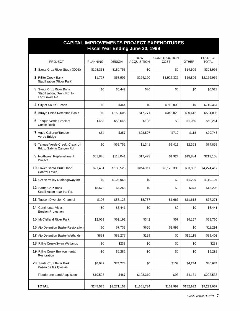
ROW CONSTRUCTION PROJECTPROJECT PLANNING DESIGN ACQUISITION COST OTHER TOTAL
1 Santa Cruz River Study (COE) $108,331 $180,758 $0 $0 $14,909 $303,998
2 Rillito Creek Bank $1,727 $58,906 $164,190 $1,922,326 $19,806 $2,166,955 Stabilization (River Park)
3 Santa Cruz River Bank $0 $6,442 $86 $0 $0 $6,528 Stabilization, Grant Rd. to Fort Lowell Rd.
4 City of South Tucson $0 $364 $0 $710,000 $0 $710,364
5 Arroyo Chico Detention Basin $0 $152,605 $17,771 $343,020 $20,612 $534,008
6 Tanque Verde Creek at $463 $58,645 $103 $0 $1,050 $60,261 Castle Rock
7 Agua Caliente/Tanque $54 $357 $98,507 $710 $118 $99,746 Verde Bridge
8 Tanque Verde Creek, Craycroft $0 $69,751 $1,341 $1,413 $2,353 $74,858 Rd. to Sabino Canyon Rd.
9 Northwest Replenishment $61,846 $118,041 $17,473 $1,924 $13,884 $213,168 Project
10 Lower Santa Cruz Flood $21,451 $185,526 $854,111 $3,179,336 $33,993 $4,274,417 Control Levee
11 Green Valley Drainageway #9 $0 $108,968 $0 $0 $1,229 $110,197
12 Santa Cruz Bank $8,572 $4,263 $0 $0 $373 $13,208 Stabilization near Ina Rd.
13 Tucson Diversion Channel $106 $55,123 $8,757 $1,667 $11,618 $77,271
14 Continental Vista $0 $6,441 $0 $0 $0 $6,441 Erosion Protection
15 McClelland River Park $2,069 $62,192 $342 $57 $4,157 $68,760
16 Ajo Detention Basin–Restoration $0 $7,738 $655 $2,898 $0 $11,291
17 Ajo Detention Basin–Wetlands $881 $83,277 $129 $0 $15,115 $99,402
18 Rillito Creek/Swan Wetlands $0 $233 $0 $0 $0 $233
19 Rillito Creek Environmental $0 $9,282 $0 $0 $0 $9,282 Restoration
20 Santa Cruz River Park $8,047 $74,274 $0 $109 $4,244 $86,674 Paseo de las Iglesias
Floodprone Land Acquistion $19,528 $467 $198,319 $93 $4,131 $222,538
TOTAL $245,575 $1,271,153 $1,361,784 $152,992 $152,992 $9,223,057
CAPITAL IMPROVEMENTS PROJECT EXPENDITURESFiscal Year Ending June 30, 1999
Flood Control District 7

8 Flood Control District
SAGUARONATIONAL
PARK
SAGUARONATIONAL
PARK
BOPP RD.
SNYDER HILL RD.
SAN JOAQUIN RD.
KINNEY RD.
del
Oro
Cañada
Pegler
Was
h
CruzRiver
Santa
Bra
wle
y
TORTOLITAMOUNTAIN PARK
PINAL COUNTY
PIMA COUNTY
Cr e ek
CORONADONATIONALFOREST
✈
�
D.M.A.F.B.
0
Scale in Miles
1 2
�
MANVILLE RD.
AvraValleyAirport
SILVERB
ELLRD.
MAGEE RD.
INA RD.
PICTURE ROCKS RD.ORANGE GROVE RD.
RUDASILL RD.
FT. LOWELL RD.
MILE WIDE RD.
SWEET
W
ATER
CM
O. D
E
LAM
AN
AN
A
TUCSONMOUNTAIN
PARK
TOHONOO'ODHAMNATION
CATALINASTATEPARK
AV
RA
RD
.
TULA
LN
.
SUNSET RD.
EL CAMINO DEL CERRO
DR.
HARDY RD.HARDY RD.
GE
RH
AR
T R
D.
BELMONT RD.
MO
NA
LIS
A R
D.
MAGEE RD.
RD
.
RD
.
RD.
PIMA FARMS RD.
SA
ND
ER
S R
D.
RD
.
OLD
FATH
ER
RD
.
RD
.
CENTRAL ARIZONA PRO
JECT
CEN
TRAL AR
IZON
A PRO
JECT
Big
Was
h
Pima County Flood Control District
CAPITAL IMPROVEMENT PROJECTSFY 98/99
Was
h
VentanaC
anyon
SabinoC
reek
Agua
Calient
eW
ash
Verde Creek
Pantano
Wash
Black
Wash
See table on page 7 for project descriptions.
PC
GD
S 1
2/28
/99
ep
��10
��19
��10
Rill i t o
Tanque
SILVERBELL R
AN
WA
Y
RD
.
TR
ICO
RD
.
EL TIRO RD.
LUC
KE
TT
RD
.
MOORE RD.
GRIER RD.
SA
ND
ER
S R
D.
BARNETT RD.
WE
NT
Z
RD
.
HARDIN RD.C
OC
CIO
RD
.
DE
RR
ING
ER
RD
.
PU
MP
ST
AT
ION
RD
.
TRICO MARANA RD.
EMIGH RD.
SA
ND
AR
IO R
D.
CLA
YT
ON
RD
.
AVRA VALLEY RD.
TWIN PEAKS RD.
LAMBERT LN.
CM
O. D
E O
ES
TE
TANGERINE RD.
TH
OR
NY
DA
LE
RD
.
TO
RT
OLI
TA
RD
.
NARANJA RD.CMO.DEL NORTE
POTVIN RD.
LAMBERT LN.
OASIS RD.
GO
LDE
N L
N.
LINDA VISTA RD.
CORTARO FARMS RD.
OVERTON RD.
HARDY RD.
PO
ST
VA
LE R
D.
R
ANCH
VISTOSOB
LVD.
LAG
OD
EL
OR
OP
KW
GOLDER RANCH
LA C
HO
LLA
BLV
D.
MOORE RD.
LA C
ANAD
A D
R.
CO
LUM
BU
SB
LVD
.
HAWSER ST.
MAINSAIL BLVD.
SUNSET RD.
CM
O. D
E L
A T
IER
RA
HARDY RD.
SH
AN
NO
N R
D.
WILDS
FIR
ST
AV
E.
KIN
GA
IR D
R.
CALLE CONCORDIA
SW
AN
RD
.
SKYLINE
DR.
HA CIEN
DA
DELSO
L
PO
NT
AT
OC
RD
.
CATALINA
HWY.
CA
NY
ON
SABIN
OCA
NYON
INA RD.
ORANGE GROVE RD.
SUNRISE DR.
CA
MP
BE
LL A
VE
.
RIVER RD.
TANQUE
VERDEROAD
HA
RR
ISO
N R
D.
BE
AR
RD
.
KO
LB
LAR
RE
A L
N.
SNYDER RD.
HA
RR
ISO
N R
D.
PA
NTA
NO
RD
.
KO
LB R
D.
CR
AY
CR
OFT
R
D.
SA
HU
AR
A A
VE
.
RO
SE
MO
NT
BLV
D.
CO
LUM
BU
S B
LVD
.
FIR
ST
AV
E.
STO
NE
AV
E.
FAIR
VIE
W A
VE
.
6TH
AV
E.
CHULA VISTA ALV
ER
NO
N W
AY
RUDASILL RD.
CALLEBARRIL
WIL
MO
T R
D.
MO
UN
TAIN
AV
E.
TUC
SO
N B
LVD
.
CO
UN
TRY
CLU
B R
D.
DO
DG
E B
LVD
.A
LVE
RN
ON
WA
Y
RO
ME
RO
RD
.
OR
AC
LE
HO
UG
HTO
N R
D.
BROADWAY
PIMA ST.
GRANT RD.
FT. LOWELL RD.
GLENN ST.
6TH ST.
BROADWAY
SPEEDWAY BLVD..
PRINCE RD.
ROGER RD.
WETMORE RD.
CA
MIN
O
SE
CO
SPEEDWAY BLVD.
SILVERLAKE RD.
22ND. ST.
29TH. ST.
GOLF LINKS
IRVINGTON RD.
22ND. ST.
29TH. ST.
ESCALANTE
AJO WAY
IRVINGTON RD.
CM
O. D
E O
ES
TE
EL
MO
RA
GA
PL.
OE
ST
EC
MO
.D
E
PA
INT
ED
HIL
LS R
D.
ANKLAM RD.
IRONWOOD HILLS RD.
GORET
SC
EN
IC D
R.
RD.
RD.
CM
O. V
ER
DE
BA JADA
LO OPDR
.
KINNEYRD.
GOLDEN GATER
D .
MC
C AIN
LOO
P
GATES PASS RD.
9 10
12
66
88
5
33
13131
71919
16161717
1818
221515
2020
44
PIMA COUNTY
SANTA CRUZ COUNTY
MINERAL HILL RD
HELMET PEAK RD
TWIN BUTTES RD
CONTINENTAL RD
MISSIO
NRD
LAC
ANAD
AD
R
PIMA MINE RD
DUVAL MINERD
GREENVALLEY
TOWN OFSAHUARITA
ARIV ACA RD
19
WHI TE HOUSE CANYON RD
GREEN VALLEY AREA INSET
OLD
NO
GAL
ESHW
Y
San
taC
ruz
Riv
er
11
14
CAM
INO
DEL
SOL
Flood Control District 9
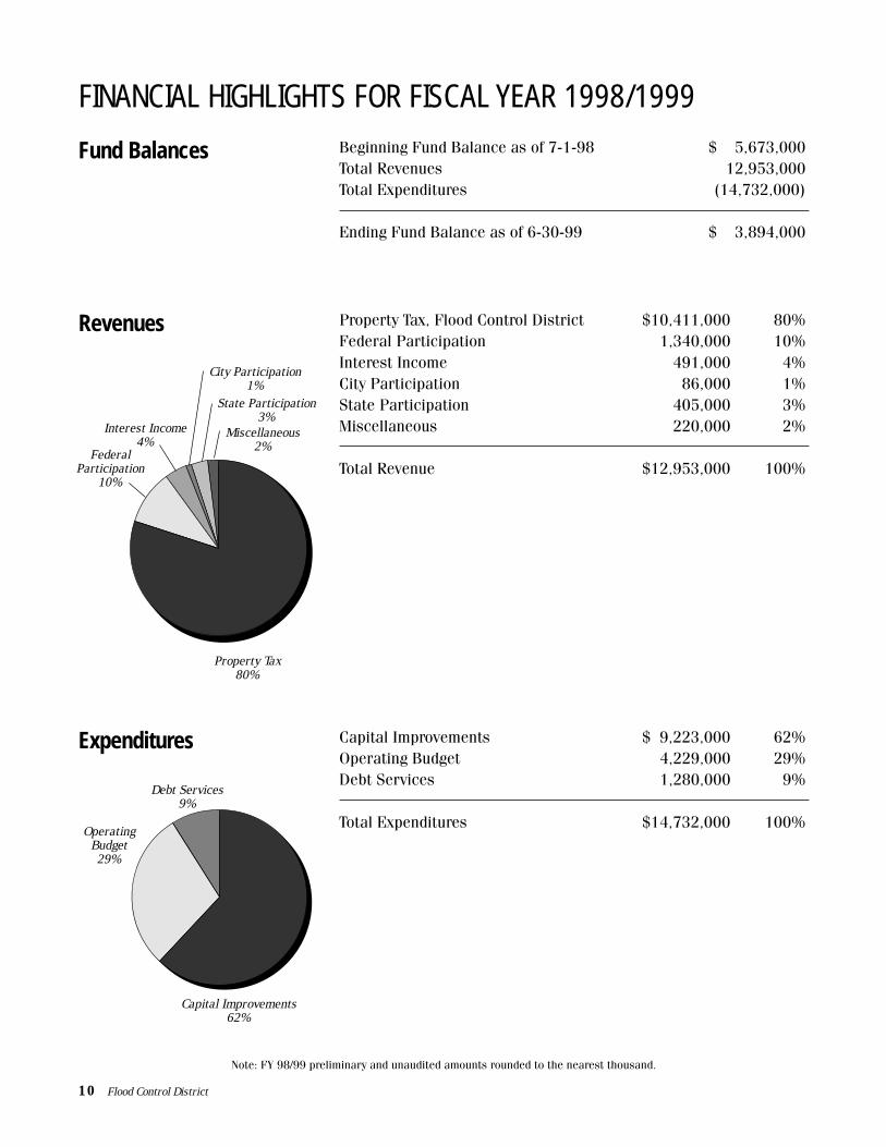
FINANCIAL HIGHLIGHTS FOR FISCAL YEAR 1998/1999
Fund Balances Beginning Fund Balance as of 7-1-98 $ 5,673,000Total Revenues 12,953,000Total Expenditures (14,732,000)
Ending Fund Balance as of 6-30-99 $ 3,894,000
Revenues
Expenditures
Property Tax, Flood Control District $10,411,000 80%Federal Participation 1,340,000 10%Interest Income 491,000 4%City Participation 86,000 1%State Participation 405,000 3%Miscellaneous 220,000 2%
Total Revenue $12,953,000 100%
Capital Improvements $ 9,223,000 62%Operating Budget 4,229,000 29%Debt Services 1,280,000 9%
Total Expenditures $14,732,000 100%
Note: FY 98/99 preliminary and unaudited amounts rounded to the nearest thousand.
Property Tax80%
City Participation1%
State Participation3%
FederalParticipation
10%
Interest Income4%
Miscellaneous2%
Capital Improvements62%
OperatingBudget29%
Debt Services9%
10 Flood Control District

Capital Improvements
Operating Budget
Planning $ 246,000 3%Design 1,271,000 14%ROW Acquisition & Improvements 1,362,000 15%Construction 6,191,000 67%Other 153,000 1%
Total Capital Improvements $9,223,000 100%
Planning & Development $2,569,000 60%Drainage & Structure Maintenance 1,173,000 28%Engineering (278,000) -7%PAG Payments 35,000 1%Management & Administration 730,000 17%
Total Operating Expenses $4,229,000 100%
Breakdown of Expenditures
Debt Services Annual Payment $ 1,280,000 100%
Total Expenditures $14,732,000 100%
Construction67%
Planning3%
Design14%
ROW Acquisition& Improvements
15%
Other1%
Planning & Development60%
Drainage &Structure
Maintenance28%
PAGPayments
1%
Management &Administration
17%
Flood Control District 11
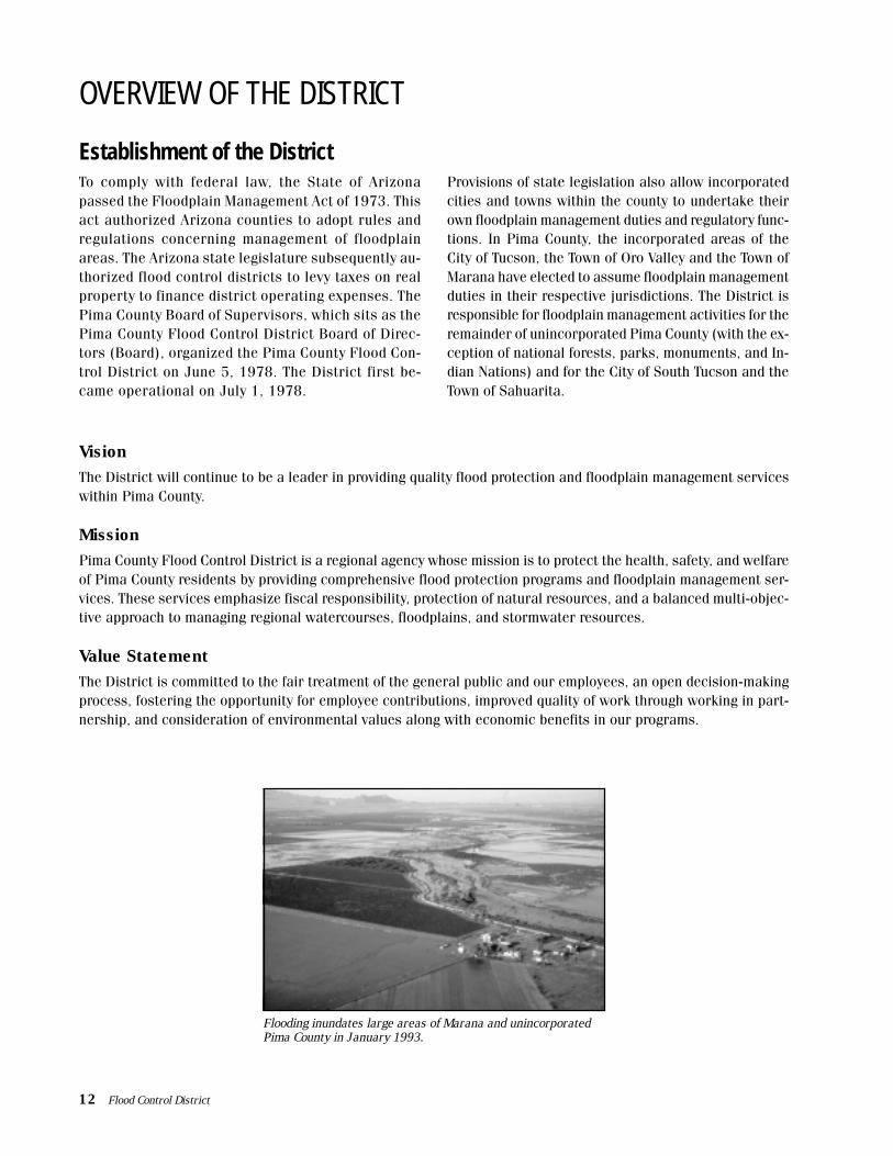
Establishment of the DistrictTo comply with federal law, the State of Arizonapassed the Floodplain Management Act of 1973. Thisact authorized Arizona counties to adopt rules andregulations concerning management of floodplainareas. The Arizona state legislature subsequently au-thorized flood control districts to levy taxes on realproperty to finance district operating expenses. ThePima County Board of Supervisors, which sits as thePima County Flood Control District Board of Direc-tors (Board), organized the Pima County Flood Con-trol District on June 5, 1978. The District first be-came operational on July 1, 1978.
OVERVIEW OF THE DISTRICT
Provisions of state legislation also allow incorporatedcities and towns within the county to undertake theirown floodplain management duties and regulatory func-tions. In Pima County, the incorporated areas of theCity of Tucson, the Town of Oro Valley and the Town ofMarana have elected to assume floodplain managementduties in their respective jurisdictions. The District isresponsible for floodplain management activities for theremainder of unincorporated Pima County (with the ex-ception of national forests, parks, monuments, and In-dian Nations) and for the City of South Tucson and theTown of Sahuarita.
VisionThe District will continue to be a leader in providing quality flood protection and floodplain management serviceswithin Pima County.
MissionPima County Flood Control District is a regional agency whose mission is to protect the health, safety, and welfareof Pima County residents by providing comprehensive flood protection programs and floodplain management ser-vices. These services emphasize fiscal responsibility, protection of natural resources, and a balanced multi-objec-tive approach to managing regional watercourses, floodplains, and stormwater resources.
Value StatementThe District is committed to the fair treatment of the general public and our employees, an open decision-makingprocess, fostering the opportunity for employee contributions, improved quality of work through working in part-nership, and consideration of environmental values along with economic benefits in our programs.
12 Flood Control District
Flooding inundates large areas of Marana and unincorporatedPima County in January 1993.
Goals and ObjectivesThe goals and objectives of the District represent both flood control and resource protection views and vary fromtraditional flood control approaches because of a multi-benefit public philosophy. The District recognizes that it isnecessary and desirable to maintain a balanced relationship between human communities and the land and re-sources that sustain them. To that end, the following twelve specific policy goals and objectives have been adoptedby the Board as part of the District’s Floodplain and Erosion Hazard Management Ordinance:
• To minimize flood and erosion damages
• To meet or exceed state and federal requirementsrelating to floodplain management – thereby en-abling Pima County residents to purchase low-cost flood insurance, to receive disaster relief,should the need arise, and to seek residentialand commercial real estate loans
• To establish minimum flood protection elevationsand damage protection requirements for struc-tures and other types of development, which maybe vulnerable to flood and erosion damage
• To regulate encroachment and building devel-opment within areas subject to flooding or ero-sion, and to ensure that the flood-carrying ca-pacity within the altered and/or relocated por-tion of any watercourse is maintained
• To encourage the most effective expendituresof public money for flood control projects
• To protect, preserve, and enhance groundwa-ter recharge
• To minimize the need for rescue and reliefefforts associated with flooding and erosion,usually undertaken at the expense of thegeneral public
• To minimize damage to public facilities and utili-ties such as water and gas mains, electric, tele-phone and sewer lines, and streets located inregulatory floodplain and erosion hazard areas
• To help maintain a stable tax base by providingfor the protection of regulatory floodplain anderosion hazard areas
• To inform the public when property is in a regu-latory floodplain or erosion hazard area
• To ensure that those who occupy the areaswithin a regulatory floodplain and erosion haz-ard area assume responsibility for their actions
• To encourage the preservation of naturalwashes and enhance the riverine environment
Flood Control District 13
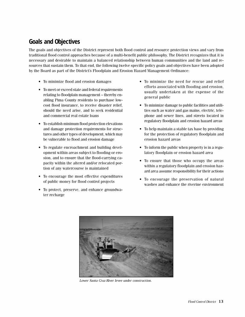
Lower Santa Cruz River levee under construction.

District OrganizationThe District is organized into two main divisions basedon the major functions of each group: 1) the Flood-plain Management Division; and 2) the Flood ControlEngineering Division. The District receives substan-tial support from other divisions within the PimaCounty Department of Transportation and Flood Con-trol District (PCDOT/FCD). These include Administra-tive Support Services, Maintenance Operations, FieldEngineering, Real Property, and Technical Services.Further assistance is received from other county de-partments, including Development Services, Depart-ment of Environmental Quality and the Pima CountyAttorney’s Office. The District pays for services ren-dered by PCDOT and other departments through in-terdepartmental fund transfers from the District toPima County.
Although District employees are part of the PimaCounty Department of Transportation and Flood Con-
District Organizational Chart
trol District, their positions are funded entirely fromDistrict revenues. The District funded 38 full-timeequivalent (FTE) staff positions in FY 98/99.
As noted, the Pima County Board of Supervisors, sit-ting as the Flood Control District Board of Directors,governs the Flood Control District. The Board also hearsrequests for variances and appeals to the Floodplainand Erosion Hazard Management Ordinance (FPMO).In 1988, the Board formed the Flood Control DistrictAdvisory Committee (FCDAC) to advise on flood-relatedmatters and to increase public participation in the de-cision-making process. The 12-member FCDAC includesfive members appointed by the Board (one for eachBoard member), three representatives from the City ofTucson, and one representative each from the City ofSouth Tucson, the towns of Marana, Oro Valley andSahuarita. One position, in an ex-officio capacity, is avail-able for appointment by the Tohono O’odham Nation.
BOARD OF DIRECTORS FLOOD CONTROL DISTRICTADVISORY COMMITTEE
COUNTY ADMINISTRATOR
CHIEF ENGINEER(DIRECTOR)
DEPUTY DIRECTOR
MANAGERFLOOD CONTROL
ENGINEERING DIVISION
MANAGERFLOODPLAIN
MANAGEMENT DIVISION
FLOODPLAINMANAGEMENT SECTION
FLOOD CONTROLPLANNING DIVISION
14 Flood Control District
FLOODPLAIN MANAGEMENT DIVISION
Work of the Floodplain Management Division generally falls into two main areas of responsibility corresponding toits two sections: the Floodplain Management Section and the Flood Control Planning Section. Major activities forthese two sections are highlighted below.
Floodplain Management SectionThe main responsibility of the Floodplain Management Section is to enforce provisions of the Pima County Flood-plain and Erosion Hazard Management Ordinance (FPMO). This ordinance, prepared in accordance with the Na-tional Flood Insurance Program, includes regulations and requirements designed to minimize flood damage andlosses throughout the community. This important goal is accomplished largely through review and issuance ofFloodplain Use Permits and the dissemination of floodplain-related information through the District’s public ser-vice counter. Section staff also respond to drainage and flood-related complaints and prepare updates and revi-sions to the FEMA Flood Insurance Rate Maps (FIRMs). Public education and awareness programs are also animportant part of this program. Section accomplishments during FY 98/99 are highlighted below.
Floodplain Use PermitsVirtually every development or other improvement madein floodplains or erosion hazard areas requires issu-ance of a Floodplain Use Permit by the District prior tobeginning construction. The permit process is designedto ensure compliance with the District’s FPMO and al-low for development in floodprone areas in as safe amanner as possible. In FY 98/99, the District received794 permit applications and issued 603 Floodplain UsePermits. Information on these and other floodplainmanagement activities is summarized in the tableon the following page.
Site Reviews and Floodplain Status RequestsFloodplain Management staff is involved in a variety ofactivities that assist new home buyers and land pur-chasers in understanding the hydrologic conditions thataffect their property. Staff provides detailed site reviewsto identify potential flood hazards and any floodplainrestrictions that may be associated with the parcels. InFY 98/99, District staff completed 142 detailed site re-views and responded to 8,905 requests for the flood-plain status of individual properties – a record number.The floodplain status of each parcel, as indicated onthe FEMA FIRMs, is provided to each requestor.
Drainage Complaints, Violations andMaintenance RequestsDrainage complaints, which may involve floodplain useviolations, are thoroughly investigated by the District.Investigation of drainage complaints allows the Districtto identify potential problems that may warrant furtherattention or possible mitigation. If it is determined that
a violation has occurred, the property owner is notifiedand corrective actions are requested. Staff also evalu-ates conditions on drainageways that are either ownedor maintained by Pima County. The District coordinateswith DOT’s Maintenance Operations Division to ensurethat any needed maintenance, such as clearing of de-bris or excessive vegetation in a channel, is performed.During this past fiscal year, 498 drainage complaintswere processed.
Flood Insurance Studies and FIRM RevisionsThe District works in conjunction with FEMA under theFlood Insurance Study Program (FIS) to identifyfloodprone areas and set insurance rates in flood haz-ard areas within the county. A key work product of thiseffort is a set of official maps called Flood InsuranceRate Maps. These maps show flood hazard zones and
Flood Control District 15
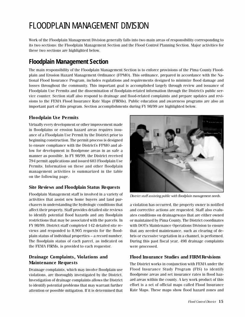
District staff assisting public with floodplain management needs.

other relevant hydrological information. Federal, state,and local floodplain management regulations applyto development and other activities that take placein designated flood hazard zones.
FIRMs have been prepared for most of the major water-courses and many of the smaller watercourses withinPima County. These maps are updated periodically whenstructural improvements are implemented or whenfloodplain characteristics are altered due to modifica-tions to channel geometry, etc. The Floodplain Manage-ment Division is the local map repository for the FIRMs.
A significant milestone this past year was completionof remapping of the county and converting this infor-mation to Digital Flood Insurance Rate Maps (d-FIRMs).Pima County is one of the first jurisdictions to utilized-FIRMs, which now constitute the official FEMA infor-mation for the county. The d-FIRM data has been inte-grated into the county’s geographic information systemand is used by District staff in such tasks as providingflood status determinations, performing site reviews, andissuing Floodplain Use Permits.
In conjunction with the d-FIRMs, the District maintains amap repository for unincorporated Pima County whichcontains all Letters of Map Amendments, Letters of MapRevisions, or Letters of Map Change issued by FEMA.Last fiscal year, the District processed 55 modificationsto the Flood Insurance Rate Maps.
Community Rating System ProgramFor the past nine years, the District has participated inFEMA’s Community Rating System (CRS), a program thatrecognizes and rewards floodplain management activi-ties undertaken by local jurisdictions.
The program emphasizes floodplain management ac-tivities that serve to:
• Reduce flood damages to existing buildings
• Manage development in hazard areas not mappedby the National Flood Insurance Program (NFIP)
• Institute a greater level of flood protection thanthe minimum required by NFIP
• Facilitate residents and other agencies in ob-taining information about area flooding condi-tions and flood insurance
The District’s involvement in the CRS program has re-sulted in a 15 percent reduction in insurance premi-ums that county residents pay every year. In FY 98/99,District-sponsored CRS activities saved property own-ers in unincorporated portions of Pima County a totalof $121,346. Pima County ranks in the top ten percentof almost 1,000 communities across the country thatare involved in this program.
Brawley Wash Primary Flood Corridor StudyCompleted in June 1999, the Brawley Wash Primary FloodCorridor Study was prepared to address two issues: 1)Current FEMA maps (which identify a floodplains onlyand not floodways) were based largely on approximatemapping methods that have limited use when applied tobroad floodplain areas with shallow flow depths, highlyerodible soils and relatively high flow velocities; and 2)an increase in the number of Floodplain Use Permit ap-plications submitted for development in the study area,which indicates increasing interest in developing parcelsin the Brawley Wash floodplain.
When used together with other available informa-tion showing flow depths and velocities near theupper permissible limits for habitable structures, anengineering study may be required to demonstratethat the proposed development can be constructedin accordance with provisions of the Floodplain andErosion Hazard Management Ordinance. The BrawleyWash study is pending review by the Flood ControlDistrict Advisory Committee.
Floodplain Use Permit(FPUP) Activities
FY FY FY FY95/96 96/97 97/98 98/99
FPUP Applications 577 724 836 794Received
FPUP’s Issued 448 528 609 603
Drainage Complaints 432 605 559 498Received
Floodplain Status 5,960 6,778 8,240 8,905Letters Written
Counter Service 4,882 5,113 5,436 5,885
Central Permit 10,880 11,204 11,989 14,135Reviews
Site Reviews 267 178 132 142
16 Flood Control District

Flood Control Planning SectionThis section is involved with medium and long-term planning activities that help decrease flood and erosion dam-ages in the community. Some of the major activities of the section include conducting river and basin managementstudies, operating the District’s flood warning system, researching and acquiring floodprone land, groundwaterrecharge and replenishment programs, riparian habitat protection, habitat enhancement efforts and preparationof the District’s Capital Improvement Program. Other special projects are undertaken as resources allow. Majoractivities during FY 98/99 include the following:
Floodprone Land Acquisition ProgramThe Floodprone Land Acquisition Program (FLAP) be-gan in 1984, funded by bond monies authorized by PimaCounty voters and by an annual allocation from theDistrict’s tax levy. FLAP is an effective nonstructuralfloodplain management tool that yields a number of com-munity benefits. Some of these include removing resi-dences and structures from vulnerable areas, preserv-ing natural floodplain characteristics (and attenuationof downstream flood peaks), providing recreationalopportunities, maintaining open space, and protectinggroundwater quality and riparian habitat resources. TheDistrict administers FLAP solely on a voluntary basiswithout utilizing its land condemnation authority.Floodprone parcels have been acquired along the TanqueVerde, Rillito, Cienega, and Agua Verde Creeks, theCanada del Oro, Pantano, Pegler and Black Washes,and along the Santa Cruz River. During FY 98/99, theDistrict purchased six parcels of land totaling approxi-mately 41 acres at a cost of $143,000.
Pima County Flood Warning ProgramThe Flood Warning Program encompasses the District’sAutomated Local Evaluation in Real Time Warning Sys-tem (ALERT), along with the District’s Flood ResponsePlan and Flood Hazard Mitigation efforts.
The ALERT System consists of approximately 65 auto-matic self-reporting precipitation gauges, 24 streamgauges, 4 weather stations, and 4 radio repeater sta-tions. The system automatically transmits hydrometeo-rological data via radio telemetry to the District’s basestation and to the Tucson office of the National WeatherService (NWS). During storm events, District staff evalu-ate incoming data to monitor changing flood conditions.The NWS also uses the information when issuing flashflood warnings and advisories. Finally, Pima County De-partment of Transportation, Maintenance OperationsDivision relies on District ALERT data to determinestorm-related road closures. Over the past year, there
were several significant storm events that prompted is-suance of NWS advisories, road closures and intensiveALERT system monitoring by District staff.
A special highlight this year was receipt of the NationalHydrologic Warning Council/ALERT Users Group’s Pio-neer Award at the group’s annual conference. This awardrecognizes significant advances in the flood warning fieldand was presented to District staff and planning commit-tee members attending the conference.
Flood Preparedness ActivitiesOver the past fiscal year, District staff continued itswork with the U.S. Army Corps of Engineers, ArizonaDepartment of Water Resources and other state andlocal agencies in developing a state-wide flood warningsystem. Plans for the system include installation of ad-ditional rainfall and stream gauges in the District’sALERT network and enhanced communication links,both in Pima County and state-wide.
Staff also undertook a project with the Tucson-PimaCounty Office of Emergency Management to design a
ALERT staff proudly displays Pioneer Award.
Flood Control District 17

ing the District’s World Wide Web site. Free brochures,fliers, and other information on flooding hazards withinPima County is provided to fair goers, along with infor-mation on a variety of flood-related topics.
This past year, District staff participated in the annualStudents Against Drunk Driving Conference and EarthDay for Kids. Flood awareness, flood preparedness, andsafety are major themes of these presentations. Ground-
Earth Day for kids presentation.
A series of exhibits documenting historical flood eventsand highlighting flood safety information are on displayin the customer service counter area of the FloodplainManagement Division offices.
This same display, along with video presentations, com-puter demonstrations and other flood-related exhibitsis featured every year at the District’s information boothduring the ten-day Pima County Fair. The exhibit fea-tures over 70 feet of colorful, informative displays andincludes a hands-on computer demonstration showcas-
flood exercise for emergency response agencies. Thiseffort – in conjunction with other elements of theDistrict’s Flood Warning Program – resulted in improvedflood emergency preparedness for the community andallows credits to be applied toward the District’s ratingin the National Community Rating System (CRS) Pro-gram. CRS activities by the District have produced sig-nificant reductions in flood insurance premiums paidby Pima County property owners.
Public Awareness, Education and OutreachDistrict staff has developed a variety of brochures, pre-sentations and displays that help educate the public
and raise awareness of flood hazards within PimaCounty. Numerous free publications on flood and ero-sion hazards, floodplain regulations and information onhow to safely develop property in floodprone areas areavailable in the lobby area of the District offices. Thispast year, District staff researched and prepared a newbrochure on how residents can incorporate water har-vesting concepts on their property.
Traveling flood safety display in action.
Flood Control display at the Pima County Fair.
18 Flood Control District

water recharge information, water quality and water-shed protection topics are covered. The District contin-ued its annual contract with local meteorologist Dr. Ri-chard Wood, to provide presentations at area elemen-tary schools. Since its inception in 1992, the programhas introduced thousands of students and their parentsto flooding and erosion issues, and provide informationon various flood safety topics.
A recent addition to its public outreach and educationprogram, the District worked with local television sta-tions during last year’s summer monsoon season to airthree 30-second public service announcements (PSAs)dealing with flash flooding. Prepared by the NationalWeather Service, Office of Hydrology, the PSAs were madeavailable to eight television stations in the Tucson area.
District World Wide Web SiteThe District continued work on its World-Wide Web site,which provides public information on a variety of floodcontrol and floodplain management topics. During thepast year, a District Overview section was completedwith detailed information on the formation of the Dis-trict, a summary of its activities, District funding data,and information on the District’s Advisory Committeeand Board of Directors.
The Web page information is used frequently by realestate agents, insurance agencies, engineering consult-ants and the general public. This past year, the Districtagain provided a hands-on computer demonstration atthe Pima County Fair to showcase the Web site. Webpage development is an on-going effort with future sec-tions planned on historic flood events within PimaCounty and flood warning and flood preparedness top-ics. The Internet address of the District’s Web site iswww.dot.co.pima.az.us/flood/.
Basin and River Management StudiesSahuarita Basin Management Plan – At the time ofits incorporation in 1995, the Town of Sahuarita choseto have the Pima County Flood Control District retainresponsibility for the Town’s floodplain management. Inorder to define floodplain management guidelines forthe rapidly expanding Town, the District is preparing aBasin Management Plan that will quantify the area’shydrology and identify strategies for mitigating poten-tial flood hazards within the community. Phase I of the
study is expected to be completed in December 1999.
Flood Control District Advisory CommitteeDuring FY 98/99, the Advisory Committee studied andmade recommendations on major policy issues andother concerns related to the District and flood controlconcerns within the community. One of the committee’smain tasks was to work with staff to modify certain pro-visions of the District’s Floodplain and Erosion HazardManagement Ordinance. Recommendations on the Or-dinance changes were forwarded to the Board of Direc-tors who subsequently approved the modifications.Other issues addressed by the Advisory Committee in-cluded review of sand and gravel standards, develop-ment of a draft Capital Improvement Project rating sys-tem, discussion of District funding and tax levy rates,review of the Floodprone Land Acquisition Program, andhearing and preparing recommendations on FloodplainUse Permits.
Riparian Habitat Ordinance RevisionsIn July 1998, the Board amended the District’s Water-course and Riparian Habitat Protection and MitigationRequirements Ordinance 1994-FC2 (Ordinance) so thatmitigation requirements now apply to all propertieswithin unincorporated Pima County, not just those en-tering the rezoning or subdivision process. Otherchanges in the Ordinance language include: 1) distur-bance to any Hydro/Mesoriparian habitat requires amitigation plan to be approved by the Board; and 2) thetrigger for mitigation requirements for xeroriparianclasses was changed from 10 percent or one acre ofdisturbance of the mapped habitat (whichever was less)to any disturbance of 1/3 acre or more now requires amitigation plan.
The Ordinance modifications were written to encour-age property owners to avoid disturbing riparianareas, but it does not prohibit development withinthose areas. If a property owner demonstrates thatdisturbance of riparian habitat is not possible, thenmitigation of affected habitat areas is mandated.Onsite mitigation is preferred since it helps providecontinuity of habitat. Offsite mitigation and mitiga-tion banking options are also available as alterna-tive approaches to habitat conservation.
Flood Control District 19

BOND PROJECT / DESCRIPTION
FC-1: Santa Cruz River Bank Stabilization, Grant Roadto Fort Lowell Road – Design and construct 100-yearbank stabilization along both banks.
FC-2: Santa Cruz River Bank Stabilization, ValenciaRoad to Irvington Road – Design and construct 100-yearbank stabilization along both banks.
FC-3: Lower Santa Cruz River Levee, I-10 to SandersRoad – Design and construct 7.4 miles of earthen leveewith soil-cement stabilization along the north bank, riverside.
FC-4: Mission View Wash Detention Basin – Design andconstruct a regional detention basin east of Park Avenueand south of 36th Street.
FC-5: City of Tucson, Urban Drainage Improvements –Design and construct high priority projects.
FC-6: City of South Tucson, Urban Drainage Improve-ments – Design and construct several projects, consistingmostly of storm drains.
FC-7: Town of Sahuarita, Urban Drainage Improve-ments – Design and construct drainage improvements atLa Cañada Drive, Camino de las Quintas, and south of ElToro Road.
FC-8: Town of Oro Valley, Urban Drainage Improve-ments – Design and construct drainage improvementprojects, consisting mostly of roadway drainage crossings.
FC-9: Green Valley Drainageway No. 9 ChannelImprovements – Design and construct improvements toreduce the flood and erosion hazard to adjacent residen-tial areas.
FC-10: Continental Vistas Drainageway Improvements– Design and construct bank stabilization to reduce theflood and erosion hazard to adjacent residential areas.
FC-11: South Tucson Fourth Avenue DrainageImprovements – Design and construct storm drains inconjunction with roadway improvements.
PROJECT STATUS(as of 6/99)
Design plans nearly completed.
Project to be combined with U.S. ArmyCorps of Engineers (COE) Paseo de lasIglesias.
Levee under construction as of March1999. Completion anticipated in June2000.
Planning phase complete. Design tobegin.
Project selection discussion underwaybetween City and County staff.
Funds were used for South FourthAvenue drainage improvements(combined with funds for FC-11).Projects completed.
Project discussions underway betweenTown and County staff.
Project discussions underway betweenTown and County staff.
Design underway. Public meeting heldMay 1999 to discuss proposed projectand solicit input. Construction antici-pated to begin in April 2000.
Planning complete. Design to begin.
Funds were combined with those for FC-6, and storm drains were constructed inconjunction with South Fourth Avenueimprovements. Projects completed.
IMPLEMENTATIONPERIOD & BOND
FUNDING
2001/02 - 2002/03$3,500,000
1999/2000 - 2002/03$4,000,000
1997/98 - 2000/01$6,000,000
1999/2000 - 2000/01$1,000,000
1997/98 - 2006/07$2,000,000
1999/2000 - 2000/01$900,000
1999/2000 - 2000/01$500,000
1999/2000 - 2002/03$350,000
1999/2000 - 2000/01$1,000,000
1999/2000 - 2000/01$250,000
1997/98 - 1998/99$500,000
May 1997 Special Bond Election
May 1997 Special Bond Election Project Update In May 1997, Pima County voters approved a wide-ranging county bond issue that included 14 flood controlprojects throughout the community. The table below provides a status update for each of the flood controlbond projects.
20 Flood Control District

PROJECT STATUS(as of 6/99)
Concept report completed with City ofTucson to resolve area drainageproblems. Project on hold until imple-mentation period. COT to reviewsources of funding for their additions tothe project.
Preliminary planning to begin.
Preliminary planning to begin.
IMPLEMENTATIONPERIOD & BOND
FUNDING
2001/02 - 2002/03$500,000
1999/2000 - 2002/03$500,000
2001/02 - 2002/03$500,000
BOND PROJECT / DESCRIPTION
FC-12: Fairview Avenue and Limberlost DriveDrainage Improvements – Design and construct adrainage channel to alleviate flooding in this area.
FC-13: Holladay Street and Forrest Avenue DrainageImprovements – Design and construct roadway andassociated drainage improvements to reduce flooding inthis residential area.
FC-14: Tucson Diversion Channel (TDC) DrainageImprovements – Design and construct improvements tothe TDC and tributary channels to improve local drainageconditions.
May 1997 Special Bond Election (cont.)
Flood Control Bond Project Locations
Vent ana
Canyon
Wash
S abi n
oC
ree k
Panta
no
Wash
BlackWas h
Rincon Creek
TanqueVerde
Creek
RillitoRiver
Cañadadel
Oro
Santa CruzRiver
SAGUARO
NATIONAL
PARK
TUCSON
SAGUARO
NATIONAL
PARK
TOHONO O'ODHAM
NATION
SAN XAVIER DISTRICT
PARK
MTN.
CATALINASTATEPARK
TORTOLITAMTN.
PARK
T U C S O N
ORO VALLEYMARANA
CORONADO
NATIONAL
FOREST
MOORE RD
TANGERINE RD
AVRA VALLEY RD
MOORE RD
SA
ND
ER
S R
D
SA
ND
AR
IO R
D
WAD
E R D
GE
RH
AR
T R
D.
HA
RTM
AN
LN
.
INA RD.
SO
LDIE
R
T
RA
IL
SNYDER RD.
SKYLINE DR.
1ST
AV
E.
PICTURE ROCKS RD
SAN JOAQUIN RD
WIL
MO
T R
D.
SW
AN
RD
.
RIT
A R
D.
LOS REALES
ALV
ER
NO
N W
AY
HUGHES ACCESS RD.
OLD VAIL CONNECTION
LOS REALES RD.
CM
O. V
ERD
E
VALENCIA RD.
SNYDER HILL RD
BOPP RD
SA
ND
AR
IO R
D
CA
MIN
O L
OM
A A
LTA
STO
NE
AV
E.
LAGO
DEL O
ROP
AR
KW
AY
CA
MP
BEL
LA
VE
R IVER RD.
BE
AR
CA
NY
ON
RD
.
HA
RR
ISO
N R
D.
MEL
POM
ENE
WAY
IRVINGTON RD.IRVINGTON RD.
GORET RD.
SWEETWATER DR.
HO
UG
HTO
N R
D.
22ND ST.
PA
RK
AV
E.
ALV
ER
NO
N W
AY
KO
LB R
D.
PA
NTA
NO
RD
.
CA
MIN
O S
EC
O
CR
AY
CR
OF
T R
D.
SW
AN
RD
.
COLOSSAL CAVE RD
OLDSP
ANISHTRAIL
KOL B
RD
.
SUNRISE DR.
CORTARO FARMS
RD.
THO
RN
YD
ALE
RD
.
SH
AN
NO
N R
D.
KINNEY
RD
JOS
EP
HR
D.
PALO
V
ERDE
B
LVD.BENSON HWY.
HACIENDA
DEL SO
L
REDIN
GTO
NR
D
NO
GA
LES
HW
Y.
TWIN PEAKS RD
CA
RD
INA
L
S AB
INO
CAN
YON
RD
.
CM
O. D
E O
ESTE
GATES PASS RD.C
MO
. DE
OE
STE
HARDY RD.
ORANGE GROVE RD.
IRONWOOD HILLS DR.
BROADWAY
CO
UN
TRY
CLU
B R
D.
WIL
MO
T R
D.
FORT LOWELL RD.
PRINCE RD.
GRANT RD.
LA C
AN
AD
A
DR
.
TANGERINE RD.
NARANJA DR.
LAMBERT LN.
WETMORE RD.
SPEEDWAY BLVD.
SUNSET RD
PAR
K A
VE.
AJO ESCALANTE RD.
GOLF LINKS RD.
DREXEL RD.6TH
A
VE
.
12T
H
AV
E.
EL CAMINO DEL CERRO
VALENCIA RD.
RUTHRAUFF
FRE
EM
AN
RD
.
TANQUE VERDE RD.
PON
TATO
C
MAGEE
RD.
LINDA VISTA
GRE
ASEW
OO
D R
D.
19
CATALINA
HWY.
LA C
HO
LLA
BLV
D.
10
10
77
MIS
SIO
NRD.
WE
NTW
OR
TH
WA
DE
RD
OR
AC
LERD
.
RANC
HO
VISTOSO BLVD.
FC-12
FC-13
FC-1
FC-4
FC-2
FC-8
FC-11FC-6
FC-14
FC-3
AB
RE
GO
D
R.
Sa
nt a
Cr u
zR
i ve r
19TOWN OFSAHUARITA
GREENVALLEY
TWIN BUTTES R D.
CONTINENTAL RD .
CMO. D
EL
SOL
WHITE HOUSE CANYON RD.
LAC
AN
AD
AD
R.
OLD
NO
GAL
ES
HW
Y.
DUVALMIN
ERD.
FC-7
FC-10
FC-9
PC
GD
S 1
2/28
/99
ep
Flood Control District 21
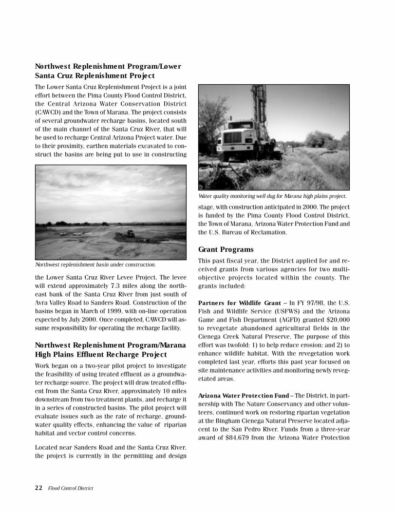
Northwest Replenishment Program/LowerSanta Cruz Replenishment ProjectThe Lower Santa Cruz Replenishment Project is a jointeffort between the Pima County Flood Control District,the Central Arizona Water Conservation District(CAWCD) and the Town of Marana. The project consistsof several groundwater recharge basins, located southof the main channel of the Santa Cruz River, that willbe used to recharge Central Arizona Project water. Dueto their proximity, earthen materials excavated to con-struct the basins are being put to use in constructing
the Lower Santa Cruz River Levee Project. The leveewill extend approximately 7.3 miles along the north-east bank of the Santa Cruz River from just south ofAvra Valley Road to Sanders Road. Construction of thebasins began in March of 1999, with on-line operationexpected by July 2000. Once completed, CAWCD will as-sume responsibility for operating the recharge facility.
Northwest Replenishment Program/MaranaHigh Plains Effluent Recharge ProjectWork began on a two-year pilot project to investigatethe feasibility of using treated effluent as a groundwa-ter recharge source. The project will draw treated efflu-ent from the Santa Cruz River, approximately 10 milesdownstream from two treatment plants, and recharge itin a series of constructed basins. The pilot project willevaluate issues such as the rate of recharge, ground-water quality effects, enhancing the value of riparianhabitat and vector control concerns.
Located near Sanders Road and the Santa Cruz River,the project is currently in the permitting and design
stage, with construction anticipated in 2000. The projectis funded by the Pima County Flood Control District,the Town of Marana, Arizona Water Protection Fund andthe U.S. Bureau of Reclamation.
Grant ProgramsThis past fiscal year, the District applied for and re-ceived grants from various agencies for two multi-objective projects located within the county. Thegrants included:
Partners for Wildlife Grant – In FY 97/98, the U.S.Fish and Wildlife Service (USFWS) and the ArizonaGame and Fish Department (AGFD) granted $20,000to revegetate abandoned agricultural fields in theCienega Creek Natural Preserve. The purpose of thiseffort was twofold: 1) to help reduce erosion; and 2) toenhance wildlife habitat. With the revegetation workcompleted last year, efforts this past year focused onsite maintenance activities and monitoring newly reveg-etated areas.
Arizona Water Protection Fund – The District, in part-nership with The Nature Conservancy and other volun-teers, continued work on restoring riparian vegetationat the Bingham Cienega Natural Preserve located adja-cent to the San Pedro River. Funds from a three-yearaward of $84,679 from the Arizona Water Protection
Northwest replenishment basin under construction.
Water quality monitoring well dug for Marana high plains project.
22 Flood Control District

Fund were used this year to plant Sacaton grass andriparian trees on retired farmland, and to restore his-torical habitat and preserve a rare spring-fed wetland.
Sonoran Desert Conservation PlanThe Sonoran Desert Conservation Plan (SDCP) is a largescale initiative that seeks to address conservation ofboth cultural and natural resources in eastern PimaCounty. The plan contains six major elements: 1) ranchconservation; 2) historic and cultural preservation; 3)riparian restoration; 4) mountain parks; 5) conserva-tion of habitat, biological resources and ecological cor-ridors; and 6) critical and sensitive habitat preserva-tion. Since December 1998, District staff has beenclosely involved with the riparian restoration elementof the plan, and has supported the work of the Scienceand Technical Advisory Team (STAT). Further detailsabout the SDCP project, including riparian habitat res-toration activities, threatened and endangered specieswithin the county, STAT meeting minutes, as well asother information is available from the SDCP Web siteat www.co.pima.az.us/cmo/sdrp/index.html.
Revegetation underway: Volunteers plant sacaton grass onretired farm parcel.
Illustration by Bill Singleton
Flood Control District 23

jacent to Craycroft Road Bridge. The project also includespreservation of riparian habitat along the north bank.
Levee ProjectsWhen bank stabilization is constrained due to inad-equate channel size, shape, or alignment, levees canbe constructed to minimize flood and erosion hazards.
Lower Santa Cruz River Levee – During the October1983 event, extensive flooding resulted in three fatali-ties and catastrophic damages to residences, busi-nesses, agricultural fields, transportation facilities, andother public infrastructures within northern Pima Countyand Marana. The same area also sustained damage dur-ing the 1990 and 1993 flood events.
In seeking to resolve flood and erosion hazards in thisarea, in March 1999 the District began construction ofa 7.3-mile long earthen levee armored with soil cement.Designed to provide protection from a 100-year floodevent, the levee project is scheduled to be completed byJune 2000.
Flood Control Engineering DivisionThe Flood Control Engineering Division oversees design and construction of flood control and drainage improve-ment projects within Pima County. Projects are completed by in-house staff or through outside consultants, withstaff administering the contracts. Major projects in FY 98/99 are outlined below.
Bank Stabilization ProjectsThe District constructs bank stabilization along majorwatercourses within the county where flood and ero-sion hazards threatened public or private developmentand infrastructure. Bank stabilization designs are tai-lored to meet the needs of each specific project. Bankstabilization projects along major watercourses typi-cally employ soil cement, which is a mixture of cementand local soil materials. Soil cement is a cost-effectiveflood and erosion control solution that has many of thestrength characteristics of concrete. It also retains muchof the appearance and textural quality of a naturalriverbank. Bank stabilization projects undertaken in FY98/99 include:
Tanque Verde Creek at Castle Rock – The Flood Con-trol District developed plans to place approximately2,000 linear feet of gabion mattress bank protectionalong Tanque Verde Creek near Lakes of Castle Rocksubdivision and the Fountain Hill subdivision. Theproject is awaiting final permits, and construction isexpected to begin in March 2000.
Green Valley Drainageway #9 – Funded through theMay 1997 bond issuance, the District is currently plan-ning improvements that will reduce flood and erosionhazards along this drainageway. The project featuresadditional cells for the box culverts at Camino Portilloand Camino Holgado, as well as various types of bankprotection based on adjacent improvements. Construc-tion is anticipated to begin in the summer of 2000.
Tanque Verde Creek, Sabino Canyon to Craycroft –The District has started work with Pima County Waste-water Management and the ACOE to design and con-struct soil cement bank protection along portions ofTanque Verde Creek. Phase I of the project will protectthe sanitary sewer facilities constructed by Pima CountyWastewater Management along the south bank nearTucson Country Club. Phase 2 will involve bank protec-tion extending along the south bank to the confluence ofPantano Wash and improvements on the north bank ad-
Soil-cement being placed on Lower Santa Cruz River levee.
24 Flood Control District

acres of wetlands and construction of a seven-acre lake.The lake will support wildlife habitat and supply waterfor irrigation needs at Kino Sports Park. Constructionis expected to begin in January 2000.
Avra Valley Road Extension – During the 1983 flood,residences located south of Avra Valley Road betweenQuarry Road and Wasson Road were inundated, mak-ing Avra Valley Road impassable from this area to theSanta Cruz River bridge. To resolve this problem, thePima County Department of Transportation replaced thebridge with a new structure that will accommodate a100-year flood event. In conjunction with the bridgeimprovement, the District began work to elevate AvraValley Road adjacent to the bridge so that the roadwaywill also be passable during a 100-year event on theSanta Cruz River. As a result of this work, residentslocated south of Avra Valley Road will be removed from100-year floodplain designation stemming from theSanta Cruz River. Construction will be completed in Sep-tember 1999.
Detention BasinsAnother structural flood control strategy used by theDistrict is construction of detention basins. Detentionbasins allow for the temporary storage and meteredrelease of flood waters. Control of flows exiting a de-tention basin during a storm event significantly de-creases downstream flood peaks and, in turn, minimizesthe potential for downstream inundation. Detention ba-sin projects currently underway include:
Arroyo Chico/Tucson Arroyo Project – Working in con-junction with the City of Tucson and the ACOE, the Dis-trict continued planning work on a series of detentionbasins located near Park Avenue and Arroyo Chico.Phase 1 of this $27.5 million project involved the plan-ning and construction of the Randolph South DetentionBasin, which was completed in March 1996. Phase II ofthis project will entail a series of linked detention ba-sins and other improvements near Park Avenue/ArroyoChico. The project also calls for the replacement of ex-isting sections of storm drains near the High SchoolWash and the Tucson Arroyo confluence.
Ajo Detention Basin – The Ajo Detention Basin wasconstructed by the ACOE in the early 1960s to addressa number of urban flooding problems. Using FederalEnvironmental Restoration funds, the Flood Control Dis-trict, Pima County Wastewater Management and theACOE will reconstruct the basin to incorporate wet-lands, groundwater recharge and flood control features.The restoration element of the project will involve 20
Concept plan for Ajo Detention Basin restoration project.
Environmental Restoration ProjectsIn recent years, the District, the ACOE, and others haveincreasingly emphasized design and construction ofmulti-objective flood control projects. In this vein, theDistrict and the ACOE have embarked on a number offlood control facilities that also entail environmentalrestoration, mitigation and recreation components.Major projects include:
Rillito Creek Bank Stabilization/River Park – Follow-ing completion of the bank stabilization portion of this$39 million multi-phase effort, the District and the ACOEbegan construction of the final phase of this project.Sixteen pedestrian bridges and various linear park im-provements, extending from the Santa Cruz River to LaCholla Boulevard and from Alvernon Way to CraycroftRoad, are currently under construction. Completion ofthe project will provide a continuous river park path-
Flood Control District 25

way along Rillito Creek from the Santa Cruz River toCraycroft Road. This phase of the project is expected tobe completed by April 2000.
Santa Cruz River Park: Paseo de las Iglesias Res-toration – Working in cooperation with the City of Tuc-son and the ACOE, the District has started a feasibilitystudy to evaluate the possibility of restoring the SantaCruz River in an area from the San Xavier Mission todowntown Tucson. This $40 million environmental res-toration and mitigation project will be partially fundedunder the Challenge XXI Initiative for Flood Hazard Miti-gation and Riverine Ecosystem Restoration. Design isscheduled to begin in fiscal year 2000/2001 with con-struction expected to begin in fiscal year 2002/2003.
Rillito/Swan Wetlands – In conjunction with the ACOE,the District is preparing a feasibility study to determinethe costs and benefits of developing wetlands and en-hancing riparian habitat along Rillito Creek. This projectwill be partially funded by the Corps’ Section 1135, Eco-system Restoration Program.
Other ProjectsSanta Cruz River Watershed Study – The Flood Con-trol Engineering Division is participating with the ACOE,the City of Tucson, and Pima County Wastewater Man-agement in a $2.4 million Santa Cruz River Basin Study.The study area includes the entire main stem of the SantaCruz River within Pima County. The intent of the studyis to identify flood and erosion hazards, evaluate hydro-logic, hydraulic and geologic processes, identify po-tential development pressures, assess physical and cul-tural resources or constraints, evaluate flood and ero-sion control alternatives and establish recommendedfloodplain management policies.
McClelland River Park – The District has started workon designing river park improvements in an area eastof La Cholla Boulevard. The project will also includenew parking and staging areas. Construction is expectedto begin in March 2000.
Brand new pedestrian bridge ready for installation along RillitoCreek River Park.
26 Flood Control District
FarmlandRehabilitation
Project
Wetlandsat
Valencia
CAP Surface Flow Optionfrom Pima Mine to Feed
Recharge Lake
Santa
Cru
zR
iver
I-19
Concept plan for proposed restoration on Paseo de las Iglesias project.

Administrative Services DivisionThe Administration Services Division staff plays a keyrole in helping prepare and monitor the District’s an-nual budget and its Capital Improvement Program. Thedivision also provides various accounting services, per-sonnel and employee support work, procurement ac-tivities and contract administration for goods and ser-vices required by the District.
Field Engineering DivisionThe Field Engineering Division administers construc-tion of all District Capital Improvement Projects to en-sure that flood control facilities are constructed in ac-cordance with contract specifications and that they arecompleted within specified time and budget allocations.Typical activities include field inspection, materials test-ing and compliance, and resolving any construction-re-lated discrepancies that may arise. The division’s Sur-vey Section provides surveying and technical land infor-mation to the District for right-of-way determinations,drainageway alignments and flood control improvements.
Maintenance Operations DivisionThe Maintenance Operations Division staff inspects,maintains and repairs publicly-owned watercourses andrelated improvements within unincorporated PimaCounty. The division also maintains major watercoursesand certain improvements located within the City of Tuc-son, and towns of Oro Valley, Marana and Sahuarita.
Maintenance operations include repairing constructedimprovements, removing sediment buildup, clearing veg-etation and debris, regrading channels and maintain-ing drainageway access roads. When flooding occurs,staff responds promptly, prioritizes repair and mainte-nance needs and works diligently to ensure that anydamage is repaired as soon as possible.
Real Property DivisionThe Real Property Division assists the District with anarray of real property appraisal, acquisition and inven-tory management needs. Major activities of the divi-
Other DivisionsThe District works cooperatively with other divisions within the Department of Transportation and Flood ControlDistrict. These divisions make important contributions to the District’s overall work product.
sion include helping to negotiate acquisition of parcelsunder the District’s Floodprone Land Acquisition Pro-gram, right-of-way dedications and abandonments forcapital facilities, and maintaining property inventoryrecords for District-owned parcels.
Technical Services DivisionThe Technical Services Division provides an array ofservices for the District. The division’s Illustration Sec-tion provides illustration and graphic design servicesfor numerous printed and electronic publications thatthe District develops. The GIS Database Services Sec-tion maintains various public works information usingArcInfo and AutoCad computer software. This sectionperforms geographic information system analyses andproduces maps and supporting data for many Districtprojects. The Engineering Information ManagementSection houses, catalogues and disseminates engineer-ing information, such as maps and records of streetrights-of-way, easements, subdivision plats, construc-tion plans, etc. Finally, the Network Operations Sec-tion provides computer technical support to ensure thatall hardware and software systems are operational andsupport the computer needs of the District.
Flood Control District 27

COORDINATION WITH OTHER AGENCIES
Pima County Department of TransportationThe District contracts with Pima County for servicesfrom divisions within the Department of Transportation,as follows:
• Field Engineering Division• Maintenance Operations Division• Real Property Division• Technical Services Division• Administrative Services Division
Other Pima County DepartmentsThe District cooperates with several other Pima CountyDepartments on various projects and exchanges infor-mation as needed.
• Development Services Department• Wastewater Management Department (WWM)• Department of Environmental Quality• Parks and Recreation Department• County Attorney’s Office• Tucson-Pima County Office of Emergency
Management• Health Department
Local GovernmentsThe District has entered into intergovernmental agree-ments (IGAs) to provide specific flood control or flood-plain management services to, or to jointly fund floodcontrol activities with, the following:
• City of Tucson• City of South Tucson• Town of Oro Valley• Town of Marana• Town of Sahuarita
Pima Association of Governments (PAG)PAG facilitates coordination among local governmentagencies, including the District, on environmental mat-ters affecting the community.
State AgenciesThe District coordinates activities with the followingstate agencies:
• Arizona Department of Water Resources(ADWR)
• Arizona Department of Environmental Quality(ADEQ)
• Arizona Game and Fish Department (AGFD)• Arizona State Land Department
Federal GovernmentSeveral federal agencies participate in local flood con-trol projects, as listed below:
• U. S. Army Corps of Engineers (ACOE)• Federal Emergency Management Agency
(FEMA)• Federal Highway Administration (FHWA)• U. S. Bureau of Reclamation (USBR)• U. S. Natural Resources Conservation Service
(NRCS)• National Weather Service (NWS)• U. S. Geological Survey (USGS)• U. S. Fish and Wildlife Service (USFWS)
Non Government OrganizationsOther non-governmental agencies that the Districtworks with include:
• The Nature Conservancy (TNC)• Cortaro-Marana Irrigation District (CMID)• Central Arizona Water Conservation District
(CAWCD)• Metropolitan Domestic Water Improvement
District (MDWID)• University of Arizona (U of A)
28 Flood Control District

Office LocationsPublic Works Building201 North Stone Avenue, 4th FloorTucson, Arizona 85701-1215
Floodplain Management Division(520) 740-6350
Flood Control Engineering Division(520) 740-6371
Public Works Building201 North Stone AvenueTucson, Arizona 85701-1215
Administrative Services Division(520) 740-6433
Real Property Division(520) 740-6313
Transportation Systems Division(520) 740-6458
Technical Services Division(520) 740-6670
Mission Road Office1313 South Mission RoadTucson, Arizona 85713
Operations Division(520) 740-2639
Field Engineering Division(520) 740-2635
Pima County Department of Transportation
Pima County Flood Control District