pikialasorsuaq oil spills and the big...
TRANSCRIPT

© C
AM
ER
ON
DU
EC
K /
WW
F
In the Arctic winter, cracks and holes in the sea ice are essential to air-breathing animals. Seals, walruses, whales, and bears all rely on these hot-spots of life in a cold ocean. None of these hot-spots is bigger than the open-water area known as the North Water Polynya, or Pikialasorsuaq (the great upwelling) in Greenlandic. Pikialasorsuaq lies near the heart of the “Last Ice Area”. As climate change in the Arctic shrinks summer sea ice, the Last Ice Area represents the last best hope for a home for animals that live on and around the sea ice. At the same time, this area is attracting the attention of international companies that want to explore for oil and minerals.
Next to Pikialasorsuaq, in Melville Bay off the coast of Western Greenland, there are areas that have been licensed for offshore oil & gas exploration. Although no company is exploring there right now, the licenses show that development here is possible.
People have asked “what happens if there is an accident here that spills oil?”. WWF has worked to show some answers to that question. This fact sheet is a plain language version of that work – for the whole report on what might happen if there is an oil spill in this region, see panda.org/arctic/polynya.
FACTSHEET
PIKIALASORSUAQ OIL SPILLS AND THE BIG POLYNYA

Oil spill modelling
By looking at how oil moves through the ocean, including through partly or fully ice-covered water, and by looking at the type of oil most likely to come from a well in the region, consultants working for WWF looked into how a major blowout might affect Pikialasorsuaq. WWF contracted an environmental consulting firm, Shoal’s Edge Consulting (SEC) to lead this work.
SEC developed what they thought might be considered a typical rate of flow for a well drilled in the area, and a typical type of oil that might be spilled. They then looked at the local information including air and wind, currents, temperatures, and ice cover. Information from the oil industry was used to work out how it would respond a major spill. All of this was put together to estimate oil impacts below the ocean’s surface, on the surface, and on the surrounding shoreline.

Currents, Ice, Wind: examples of changing conditions that change where oil spills spread

The blowout scenarioThe place we chose to look at the result of a possible oil well blowout in Melville Bay is located in the “Pitu Block” of Cairn En-ergy’s exploration license area. It is next to the Pikialasorsuaq and the Melville Bay Nature Reserve. The water depth at the selected site is 808 metres. The oil-type is assumed to be similar to oil that has been found in other exploration wells in the region.
We assumed that if a blowout happened, oil would flow at a rate of 3,340 m3 per day. That is about 100 twenty-foot ship-ping containers full. This flow rate is based on other studies in the region. In the first scenario, we assumed that the flow is stopped naturally, by sand and mud from the bottom of the ocean. This is
what happens in about 84% of blowouts within half a day to five days. For this sce-nario, we looked at what would happen if it flowed for one day.
In about 16% of cases, people need to act to stop the oil from continuing to flow into the water. To show what might happen in this case, we assumed an extra well would need to be drilled, and that this would take 34 days. This is similar to Cairn Energy’s 2011 Oil Spill Contingency Plan. The amount of oil released over the 34 days of this blowout would total 113,560m3 (about 3,400 twenty-foot ship-ping containers full) making it the fourth largest oil blowout in history.
We assumed any blowout would take place during the open water season,
which is when drilling would be done. Based on available ice data, average monthly ice cover in this region is less than 30% from July to the end of October.
The movements of ice, winds, and tides can all affect where the oil might spread. To help account for these changing condi-tions, we looked at what would happen over 200 different sets of conditions, with different ice movements, winds, and tides. That way, we can talk about the how likely it might be that oil would reach any particular place. If oil would land in a place twenty times out of two hundred, then we can say that the probability of oil reaching that location is 10%.
1-day blowoutThese maps show where oil might spread from a blowout lasting one day. The red, orange and yellow colours show the areas most likely to be oiled, while the green colours show the areas that might become oiled, but where the probability is relatively low. The upper and lower maps show different amounts of oil. The top map shows an amount of oil that is equal to one hundredth of a gram per square metre. With this much oil in the water, it would either be only just visible on the surface of the water, or scattered balls of tar. At this amount, fisheries might be closed. The lower map shows oil at a level of ten grams per square metre. At this level, it could kill birds and other wildlife on the surface of the water.
It is important to remember that these maps are based on 200 individual spills traveling in different directions, depending on different winds, ice conditions, and currents. The area oiled by any particular (single) blowout will be much smaller than the oiled area shown in these maps. The large areas of dark green (1-5% probability) and light green (5-25% probability) tell us that the actual path of a particular spill will vary greatly based on the environmental conditions at the time of the blowout. The table on the following page shows that there is a wide range between the average area that might be covered by oil, and the maximum area that might be covered.
Spill Event Total Volume Spilled (m3)
Water Surface Area Oiled Above 0.01 g/m2 (km2)
Water Surface Area Oiled Above 10 g/m2 (km2)
Volume of Oil in Water Column (m3)
Max. Avg. Max. Avg. Max. Avg.
Melville Bay 1-Day Blowout
3,340 11,023 1,619 86 74 2,046 582
Melville Bay 34-Day Blowout
113,560 118,260 34,780 1,545 1,145 6,041 3,229

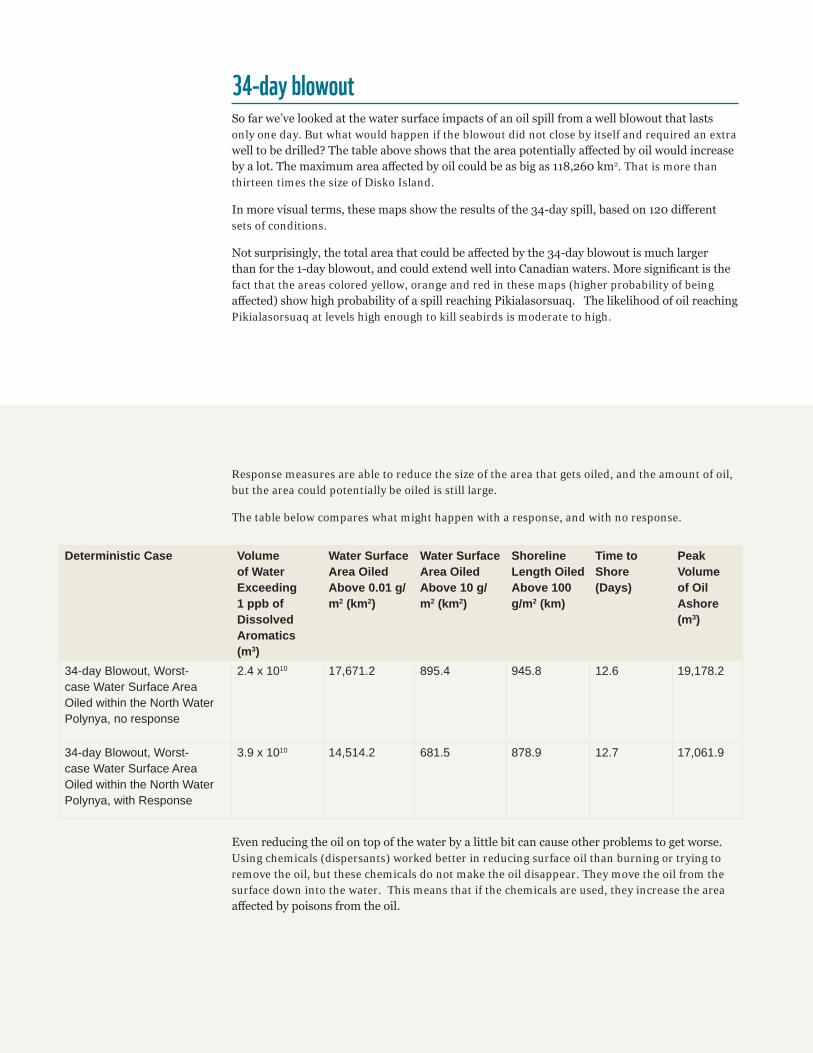
34-day blowoutSo far we’ve looked at the water surface impacts of an oil spill from a well blowout that lasts only one day. But what would happen if the blowout did not close by itself and required an extra well to be drilled? The table above shows that the area potentially affected by oil would increase by a lot. The maximum area affected by oil could be as big as 118,260 km2. That is more than thirteen times the size of Disko Island.
In more visual terms, these maps show the results of the 34-day spill, based on 120 different sets of conditions.
Not surprisingly, the total area that could be affected by the 34-day blowout is much larger than for the 1-day blowout, and could extend well into Canadian waters. More significant is the fact that the areas colored yellow, orange and red in these maps (higher probability of being affected) show high probability of a spill reaching Pikialasorsuaq. The likelihood of oil reaching Pikialasorsuaq at levels high enough to kill seabirds is moderate to high.
Deterministic Case Volume of Water Exceeding 1 ppb of Dissolved Aromatics (m3)
Water Surface Area Oiled Above 0.01 g/m2 (km2)
Water Surface Area Oiled Above 10 g/m2 (km2)
Shoreline Length Oiled Above 100 g/m2 (km)
Time to Shore (Days)
Peak Volume of Oil Ashore (m3)
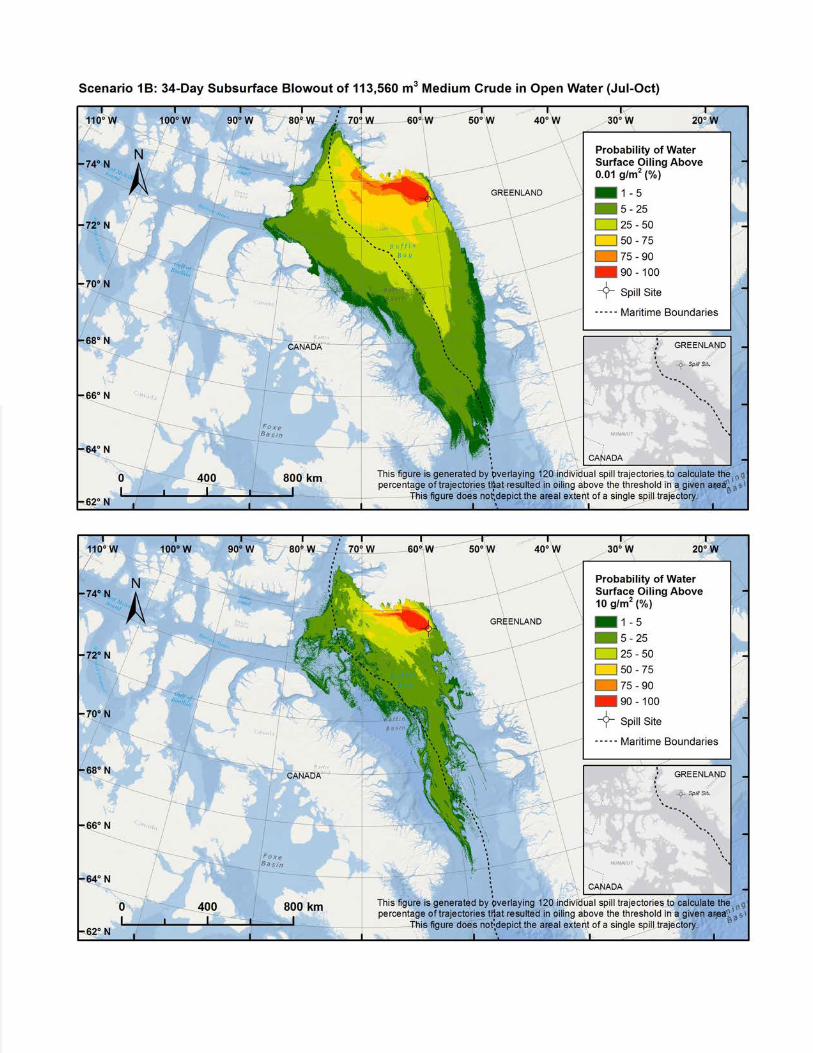
34-day Blowout, Worst-case Water Surface Area Oiled within the North Water Polynya, no response
2.4 x 10¹⁰ 17,671.2 895.4 945.8 12.6 19,178.2
34-day Blowout, Worst-case Water Surface Area Oiled within the North Water Polynya, with Response
3.9 x 10¹⁰ 14,514.2 681.5 878.9 12.7 17,061.9
Even reducing the oil on top of the water by a little bit can cause other problems to get worse. Using chemicals (dispersants) worked better in reducing surface oil than burning or trying to remove the oil, but these chemicals do not make the oil disappear. They move the oil from the surface down into the water. This means that if the chemicals are used, they increase the area affected by poisons from the oil.
Response measures are able to reduce the size of the area that gets oiled, and the amount of oil, but the area could potentially be oiled is still large.
The table below compares what might happen with a response, and with no response.

An individual spillSo far we’ve been looking only at results that put together a whole variety of conditions. This is useful for informing planning but does not show what a single actual spill might look like.
To show that, we have selected what a worst case oil spill might look like, focus-ing on a blowout that would substantially affect the water surface within Pikiala-sorsuaq. This case is based on modeled weather, ice and sea conditions from August 27, 2012.
The map shows the total area affected by oil in these conditions over the course of 120 days from the start of the blowout. In this case, the colours show the maxi-mum amount of floating oil that passed through a given area at some point during those 120 days. The areas shaded in orange or red had oil levels above the amount that could kill seabirds. The yel-low and green areas would be where there was enough oil to stop fishing. The map also shows (in grey) the approximate area under the water where poisons from the oil could hurt life in the water.
The spill initially heads to the west of the spill site, then turning to the north of the spill site (within the Melville Bay Nature Reserve) after 12 days. After that, the spill continues to travel northwest along the coast of Greenland and north into Piki-alasorsuaq, oiling additional shoreline areas including along the settlement of Savissivik. Floating oil continues to travel westward and southwestward, reaching the shoreline of Bylot Island (mostly cov-ered by Sirmilik National Park) at about 61 days after the spill start. The remain-ing floating oil generally travels south-eastward in Baffin Bay for the rest of the simulation. By about 65 days into the spill, most of the remaining surface oil is mixed in with sea ice and moving with the ice currents. At the end of the 120-day simulation, 17,583.2 m3 of oil (about 15% of the volume spilled) remains on the wa-ter surface in Baffin Bay, mostly bound in sea ice. Over time, this oil would continue to move with the ice currents, potentially oiling other areas.
In general, the area below the water where poisons from the oil were present
went in the same direction as the oil, but went further north into Pikialasorsuaq. The peak volume of water exceeding 1 ppb of dissolved aromatics (a screening threshold for impacts on sensitive water column organisms) was 2.9 x 10¹⁰ m3.
When we look at this spill, we did not consider anything that people might do to try to remove the oil. To see what might happen if people did try to remove the oil, we looked at Cairn Energy’s 2011 Oil Spill Response Plan. This was developed for a different West Greenland license area to the south of the Pitu Block, but is the best available information about what response measures might be in place. Response measures include removing the oil with oi skimmers, putting chemicals in the water to break up the oil, and burning the oil. These methods do not always work well and in some cases can cause other problems. We discuss this in the full report.
Wildlife impactsWithin the area of a potential oil spill, there are several places important to life. The North Water Polynya, Melville Bay Na-ture Reserve, Disko Bay and the Avanersuaq region of Green-land and on the Canadian side Lancaster Sound, and Coburg, Devon and Bylot Islands are places Arctic wildlife use a lot.
The North Water Polynya is important to Arctic marine mam-mals and seabirds throughout the year. At least 11 species of whales, including Narwhals, Bowhead whales and Beluga whales, polar bears, ringed, bearded and harp seals, Atlantic walruses and millions of seabirds have been observed in or around the Polynya. Each summer in West Greenland, there are two major gatherings of around 14,000 (6,600 - 39,300) Narwhals in Melville Bay and Inglefield Bredning. In the Cana-dian high Arctic, as many as 60,000 Narwhals move through the west side of the North Water Polynya. Females raise their calves in summer and individuals are known to return to the
same locations year after year. In winter, 50,000 (at least half the world population) Narwhals move to central Baffin Bay to feed intensively on Greenland halibut, a commercially har-vested fish that lives in the fjords along Greenland’s west coast up to a latitude of 77° N. Beluga whales and Bowhead whales spend summer in the Canadian high Arctic and are regularly observed in the North Water Polynya in winter months.
Ringed, bearded and harp seals and Atlantic walruses use the North Water Polynya and surrounding ice floes to give birth to and raise their pups and feed intensively in summer. Ringed and bearded seals are an important food source for Inuit of the Avanersuaq region in Greenland and the Jones Sound area of Canada, who together take 5,000 – 10,000 ringed seals annu-ally. Ringed seals are also the main prey of polar bears, who use the North Water Polynya as a hunting ground in spring, and the coast of Baffin Island to the west of the Polynya and

Figure 1. Important areas for Arctic species around Melville Bay, (A) throughout the year, (B) in summer, and (C) in summer with an oil spill event, showing where the oil is on the ocean’s surface, how much oil is on the surface, and where the poisons are under the water.
Melville Bay Nature Reserve to the east to den over winter. Atlantic walruses are found in the North Water Polynya year-round, between northwest Greenland and eastern Ellesmere Island.
Millions of seabirds of at least 14 different species breed close to the North Water Polynya in summer months, along the coasts of West Greenland and the Eastern Canadian Arctic. After the short breeding season, birds return to sea and the Polynya and Baffin Bay are very important feeding grounds. As much as three quarters of the global population (30 mil-lion birds) of Little Auks breed in the Avanersuaq region and 350,000 pairs of Thick-Billed Murres nest in six colonies around the edge of the North Water Polynya.
The sheer number of marine animals that use this region of the Arctic to breed and raise young, use nearby rich feeding grounds, and gain protection from predators, means that an oil spill could have significant impacts on a number of Arctic species. Evidence from previous oil spills suggests that whales and seals are unlikely to move away from spilled oil, at least in the short term. Although the most seabirds breed on cliffs or inland from the coast, they are exposed to oil when feeding at sea. Oiling of skin, fur and feathers, breathing in oil, or eating food poisoned by oil all have serious impacts on wildlife. As well as short-term effects, lasting effects on wildlife popula-tions continue to be reported decades after major oil spills in the marine environment.
FIGURE 1.A

FIGURE 1.B
FIGURE 1.C

Why we are here
panda.org/arctic
To stop the degradation of the planet’s natural environment andto build a future in which humans live in harmony with nature.
© 1986 Panda symbol WWF-World Wide Fund For Nature (formerly known as World Wildlife Fund)® “WWF” is a WWF Registered Trademark
© 1986 Panda symbol WWF-World Wide Fund For Nature (formerly known as World Wildlife Fund)® “WWF” is a WWF Registered Trademark
PANDA.ORG/ARCTIC
FURTHER INFORMATION To see the full report that this is based on, go to: panda.org/arctic/polynya
ConclusionsMajor oil platform blowouts are rare events. But they can and do happen, so the risk of a blowout happening at any future Arctic offshore oil development is a possibility that must be consid-ered before the development proceeds. The frigid temperatures, harsh winds, and unpredictable ice of the Arctic make safe operations more difficult. If a spill does occur, these conditions also make cleanup a lot more difficult and less effective. In addi-tion, most of the people and gear required to deal with a spill are housed a long way from the coast of Greenland, so getting them there would take a long time.
Arctic environments are already under stress from changing temperatures and ice conditions. Areas such as Pikialasorsuaq that provide critically important support for Arctic wildlife, are
especially important to conserve. People in the northern-most communities in Greenland and Canada depend on the wildlife that needs a healthy Pikialasorsuaq.
Tools exist that could help to conserve Pikialasorsuaq and the species that depend on it. Governments, Inuit and communi-ties on both sides of the national boundary that cuts through Pikialasorsuaq are beginning to look at those tools. This is the time for Inuit in Canada and Greenland to collectively decide on a future for this area, to decide what sort of environment, and what sort of lives their descendants will inherit. WWF believes that if Pikialasorsuaq is to be preserved for those future genera-tions, then oil and gas development in the region is not worth the risks it brings.